iB50000 Data Dictionary - Lands D
109
Land Information Centre Survey and Mapping Office, Lands Department © The Government of the Hong Kong Special Administrative Region Copyright reserved – reproduction by permission only iB50000 Data Dictionary Digital Topographic Map GML (Version 1.0) Endorsed By: Signed Date of Release: September 2020 YEUNG Cheuk-man (CLS/LIC) Version: 1.0 Date: 10 September 2020
Transcript of iB50000 Data Dictionary - Lands D

Land Information Centre Survey and Mapping Office, Lands Department
© The Government of the Hong Kong Special Administrative Region Copyright reserved – reproduction by permission only
iB50000 Data Dictionary Digital Topographic Map
GML (Version 1.0)
Endorsed By: Signed
Date of Release: September 2020 YEUNG Cheuk-man (CLS/LIC) Version: 1.0 Date: 10 September 2020

(This page is intentionally left blank)

Data Dictionary Digital Topographic Map - iB50000
Version 1.0 Survey and Mapping Office Lands Department
Amendment History
Version Page Amendments

Data Dictionary Digital Topographic Map - iB50000
Version 1.0 Survey and Mapping Office Lands Department
(This page is intentionally left blank)

Data Dictionary Digital Topographic Map - iB50000
Version 1.0 Survey and Mapping Office Lands Department
Table of Content
Specification Scope Page Part I iB50000 Map Index ............................................................................................................ I-1
Part II Notes of iB50000 Digital Topographic Map ...................................................................... II-1
Part III Summary of iB50000 Features ......................................................................................... III-1
Part IV Entity Relationship Diagrams ........................................................................................... IV-1
Boundary Class Relationships....................................................................................... IV-3
Buildings Class Relationships ....................................................................................... IV-4
Facility Class Relationships .......................................................................................... IV-5
Hydrography Class Relationships ................................................................................. IV-6
Landcover Class Relationships ..................................................................................... IV-7
PlaceName Class Relationships .................................................................................... IV-8
Relief Class Relationships ............................................................................................ IV-9
Transportation Class Relationships ............................................................................. IV-10
Feature Catalog Part V Description of iB50000 Features ....................................................................................... V-1
Feature BDRYANNO .................................................................................................... V-3
Feature BDRYLINE ....................................................................................................... V-5
Feature BDRYPOLY ..................................................................................................... V-9
Feature BLDGPOLY ................................................................................................... V-13
Feature FACIANNO .................................................................................................... V-17

Data Dictionary Digital Topographic Map - iB50000
Version 1.0 Survey and Mapping Office Lands Department
Feature FACILINE ...................................................................................................... V-19
Feature FACIPOLY ..................................................................................................... V-23
Feature FACISYMBOL ............................................................................................... V-27
Feature HYDRANNO .................................................................................................. V-29
Feature HYDRLINE .................................................................................................... V-31
Feature HYDRPOLY ................................................................................................... V-35
Feature LANDPOLY ................................................................................................... V-39
Feature PLACANNO .................................................................................................. V-43
Feature ELEVANNO .................................................................................................. V-45
Feature ELEVLINE ..................................................................................................... V-47
Feature ELEVPOLY .................................................................................................... V-51
Feature ELEVSYMBOL .............................................................................................. V-55
Feature TERRLINE ..................................................................................................... V-57
Feature TERRSYMBOL.............................................................................................. V-61
Feature TSPTANNO .................................................................................................... V-63
Feature TSPTLINE ...................................................................................................... V-65
Feature TSPTPOLY ..................................................................................................... V-69
Feature TSPTSYMBOL ............................................................................................... V-73
Table GeoName ........................................................................................................... V-75
Table Relationship_Table ............................................................................................ V-79

Data Dictionary Digital Topographic Map - iB50000
Version 1.0 I-1 Survey and Mapping Office Lands Department
Part I - iB50000 Map Index

Data Dictionary Digital Topographic Map - iB50000
Version 1.0 I-2 Survey and Mapping Office Lands Department
(This page is intentionally left blank)

Data Dictionary Digital Topographic Map - iB50000
Version 1.0 I-3 Survey and Mapping Office Lands Department
iB50000 Map Index
Note: Ground coverage X = 65,440m Y = 46,360m
Y
X

Data Dictionary Digital Topographic Map - iB50000
Version 1.0 I-4 Survey and Mapping Office Lands Department
(This page is intentionally left blank)
Data Dictionary Digital Topographic Map - iB50000
Version 1.0 II-1 Survey and Mapping Office Lands Department
Part II - Notes of iB50000 Digital Topographic Map

Data Dictionary Digital Topographic Map - iB50000
Version 1.0 II-2 Survey and Mapping Office Lands Department
(This page is intentionally left blank)

Data Dictionary Digital Topographic Map - iB50000
Version 1.0 II-3 Survey and Mapping Office Lands Department
Notes of iB50000 Digital Topographic Map Grid System and Vertical Datum Coordinates of the Digital Maps are in Hong Kong 1980 Grid (HK 1980 Grid) and which is a local rectangular grid system based on the HK80 Datum and Transverse Mercator projection. Heights are shown in metres above the Hong Kong Principal Datum (HKPD). For general reference, the Mean Sea Level is about 1.3 metres above the HKPD. Data Source The spatial features of the small scale topographic data are mainly derived from the large scale topographic maps (e.g. 1:1000) with cartographic generalisation according to the respective map scales. The relevant attribute information is widely sourced from different government departments. GeoName GeoName table stores a collection of names used in the iB50000 data. These names include place names, road names and facility names. The names are linked to feature classes and their annotations via a relationship table using GraphicID, GraphicDataset, AnnoSymID and GeoNameID. The xy coordinates, full English name, full Chinese name and GEOREFCODE are also stored in the GeoName table. For the details, please refer to the ER-diagrams. Geo-reference Code Geo-reference code stored the code of street/ village/ estate of the relevant address is recorded in the field of ‘GEOREFCODE’. It is classified as follows:
GEOREFCODE Description 10001 - 29999 Gazetted street 30001 - 39999 Flyover, tunnel, by-pass or street with ungazetted name 40001 - 59999 Road centerline without street name 60001 - 69999 Village 70001 - 89999 Estate/ Site of particular usage or public facility
Other geo-reference codes like the spatial information of Buildings and Facilities are also stored in this field.

Data Dictionary Digital Topographic Map - iB50000
Version 1.0 II-4 Survey and Mapping Office Lands Department
Physical Status The Physical Status field describes the status of presence of structural features or the availability of service associated with facilities features. For the values of this field, please refer to the relevant field values. Priority The Priority field of features assigned with different code describes the relative vertical order of features. For the description of the codes, please refer to the relevant field values.
Code Name -1 Underground 0 On Ground 1 Suppressed 2 Under Structure/Under 3 Elevated / Over 4 Over Podium 5 Above Service Reservoir 6 Playground Above
23 Under Structure + Elevated 24 Under Structure + Over Podium 33 Elevated + Elevated
Hong Kong Special Administrative Region Boundary The boundary of Hong Kong Special Administrative Region is shown for general information only. Description is given in the Order of State Council of the People’s Republic of China No. 221.

Data Dictionary Digital Topographic Map - iB50000
Version 1.0 III-1 Survey and Mapping Office Lands Department
Part III - Summary of iB50000 Features

Data Dictionary Digital Topographic Map - iB50000
Version 1.0 III-2 Survey and Mapping Office Lands Department
(This page is intentionally left blank)

Data Dictionary Digital Topographic Map - iB50000
Version 1.0 III-3 Survey and Mapping Office Lands Department
Summary of iB50000 Feature Classes
FEATURE NAME
CLASS CLASS DESCRIPTION
TYPE TYPE DESCRIPTION
BDRYANNO ENC Enclosed Area CLA Closed Area Boundary ENC Enclosed Area FRB Firing Range Boundary ENC Enclosed Area MCA Military Installation Closed Area ENF Enforcement Limit HBL Harbour Limit BDRYLINE ADM Boundary Line SAR HKSAR Boundary ENC Enclosed Area CLA Closed Area Boundary ENC Enclosed Area FRB Firing Range Boundary ENF Enforcement Limit HBL Harbour Limit BLDGPOLY BLP Building Structure BLD Building (Built-up) MBD Minor Building CGA Cottage Area / Temporary Structure FACIANNO AQU Aquatics YAC Boating / Yachting / Water Sports Centre BGD Burial Ground CEM Cemtery CUF Cultural Facility SCU Sculpture / Statue DRS Drainage Service PIP Water Pipeline GAS Fuel Service
Installation TNK Gas Tank / Oil Tank / Kerosene Store
RSF Leisure Facility AMK Theme Park RSF Leisure Facility GCO Golf Course RSF Leisure Facility PAR Park RSF Leisure Facility RCO Racecourse RSF Leisure Facility STD Stadium RSF Leisure Facility ZOO Zoo SCH Educational TEI Post-Secondary FACILINE CEI Cable/Electricity
Installation POW Power Line with Pylon
DRS Drainage Service PIP Water Pipeline DRS Drainage Service WTL Water Tunnel FACIPOLY DRS Drainage Service WTK Water Tank / Treatment Works FAF Facility Furniture GCO Golf Course FAF Facility Furniture PAR Park FAF Facility Furniture SGD Sports Ground / Football Field FAF Facility Furniture SGT Racetrack GAS Fuel Service
Installation TNK Gas Tank / Oil Tank / Kerosene Store

Data Dictionary Digital Topographic Map - iB50000
Version 1.0 III-4 Survey and Mapping Office Lands Department
FEATURE NAME
CLASS CLASS DESCRIPTION
TYPE TYPE DESCRIPTION
FACISYMBOL CEI Cable/Electricity Installation
POW Electricity Pylon
UTI Utility/Installation SGN Radio Transmitting Station / Television Transmitting Station / Signal Station / Wireless Station / Microwave Station
HYDRANNO EWB Water Body Name RES Reservoir Name SLN Shore Alignment RLE Reclamation Limit Annotation STC Stream CAT Catchwater HYDRLINE HYF Hydrography
Furniture DAM Dam
HYF Hydrography Furniture
JET Jetty
HYF Hydrography Furniture
MAR Floating Jetties
SLN Shore Alignment BKW Breakwater SLN Shore Alignment RLE Reclamation Limit SLN Shore Alignment COA Coastline STC Stream CAT Catchwater STC Stream STM Stream Course (major) STC Stream STO Stream Course (open) HYDRPOLY EWB Water Body PON Pond / Moat EWB Water Body RES Reservoir EWB Water Body SEF Sea Fill SLN Shore Alignment BKW Breakwater SLN Shore Alignment RLE Reclamation Limit STC Stream STO Stream Course (open) LANDPOLY BRL Barren Land MUD Mud Flat BRL Barren Land SAN Sand VEG Vegetation CUL Cultivation VEG Vegetation MAN Mangrove VEG Vegetation SWA Swamp / Marsh VEG Vegetation WOO Woodland PLACANNO HYN Hydrographic Name BAY Bay HYN Hydrographic Name RES Reservoir Name HYN Hydrographic Name RIV River Name ISN Island_Name ISL Island MAS Macro_Set_Name DIS District MAS Macro_Set_Name TOW Town / New Town / Sub-district SET Micro_Set_Name EST Estate SET Micro_Set_Name IST Local Industrial Compound SET Micro_Set_Name SIT Cargo handling Basin / Shipyard / Site Name SET Micro_Set_Name VIL Village TON Terrain_Name HIL Hill TON Terrain_Name ROC Rock
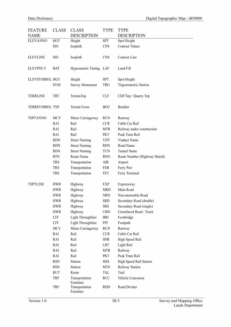
Data Dictionary Digital Topographic Map - iB50000
Version 1.0 III-5 Survey and Mapping Office Lands Department
FEATURE NAME
CLASS CLASS DESCRIPTION
TYPE TYPE DESCRIPTION
ELEVANNO HGT Height SPT Spot Height ISO Isopleth CNS Contour Values ELEVLINE ISO Isopleth CNS Contour Line ELEVPOLY BAT Hypsometric Tinting LAF Land Fill ELEVSYMBOL HGT Height SPT Spot Height SVM Survey Monument TRG Trigonometric Station TERRLINE TRT TerrainTop CLF Cliff Top / Quarry Top TERRSYMBOL TNF Terrain Form BOU Boulder TSPTANNO MCY Minor Carriageway RUN Runway RAI Rail CCR Cable Car Rail RAI Rail MTR Railway under construction RAI Rail PKT Peak Tram Rail RDN Street Naming VDT Viaduct Name RDN Street Naming RDN Road Name RDN Street Naming TUN Tunnel Name RTN Route Name RNO Route Number (Highway Shield) TRS Transportation AIR Airport TRS Transportation FER Ferry Pier TRS Transportation FET Ferry Terminal TSPTLINE HWR Highway EXP Expressway HWR Highway MRD Main Road HWR Highway NRD Non-motorable Road HWR Highway SRD Secondary Road (double) HWR Highway SRS Secondary Road (single) HWR Highway URD Unsurfaced Road / Track LTF Light Throughfare BRI Footbridge LTF Light Throughfare FPI Footpath MCY Minor Carriageway RUN Runway RAI Rail CCR Cable Car Rail RAI Rail HSR High Speed Rail RAI Rail LRT Light Rail RAI Rail MTR Railway RAI Rail PKT Peak Tram Rail RSN Station HSS High Speed Rail Station RSN Station MTS Railway Station RUT Route TAL Trail TRF Transportation
Furniture RCC Vehicle Concourse
TRF Transportation Furniture
RDD Road Divider

Data Dictionary Digital Topographic Map - iB50000
Version 1.0 III-6 Survey and Mapping Office Lands Department
FEATURE NAME
CLASS CLASS DESCRIPTION
TYPE TYPE DESCRIPTION
TSPTPOLY RSN Station PTI Public Transport Interchange TSPTSYMBOL RTN Route Name RNO Route Number (Highway Shield) TRF Transportation
Furnitiure NAU Nautical Navigation Beacon
TRF Transportation Furnitiure
REA Vehicular Restricted Access
TRF Transportation Furniture
TPO Tunnel Portal

Data Dictionary Digital Topographic Map - iB50000
Version 1.0 IV-1 Survey and Mapping Office Lands Department
Part IV - Entity Relationship Diagrams

Data Dictionary Digital Topographic Map - iB50000
Version 1.0 IV-2 Survey and Mapping Office Lands Department
(This page is intentionally left blank)

Data Dictionary Digital Topographic Map - iB50000
Version 1.0 IV-3 Survey and Mapping Office Lands Department
Boundary Class Relationships
BDRYLINE BDRYANNO
gml:id gml:id
GRAPHICID AnnotationClassID
GRAPHICDATASET Status
EASTING TextString
NORTHING FontName
CLASS FontSize
TYPE Bold
SUBCAT Italic
PRIORITY Underline
PHYSICALSTATUS Angle
SOURCE FontLeading
LASTUPDATEDATE WordSpacing
gml:curveProperty CharacterWidth
gml:multiCurveProperty CharacterSpacing
FlipAngle
ANNOSYMID
CLASS
TYPE
BDRYPOLY SUBCAT
gml:id LASTUPDATEDATE
GRAPHICID gml:pointProperty
GRAPHICDATASET gml:multiPointProperty
EASTING
NORTHING
CLASS
TYPE
SUBCAT
PRIORITY
PHYSICALSTATUS
SOURCE
LASTUPDATEDATE
gml:surfaceProperty
gml:multiSurfaceProperty

Data Dictionary Digital Topographic Map - iB50000
Version 1.0 IV-4 Survey and Mapping Office Lands Department
Buildings Class Relationships
BLDGPOLY
gml:id
GRAPHICID
GRAPHICDATASET
EASTING
NORTHING
CLASS
TYPE
SUBCAT
PRIORITY
PHYSICALSTATUS
SOURCE
LASTUPDATEDATE
gml:surfaceProperty
gml:multiSurfaceProperty
Data Dictionary Digital Topographic Map - iB50000
Version 1.0 IV-5 Survey and Mapping Office Lands Department
Facility Class Relationships
FACILINE FACISYMBOL FACIANNO GEONAME
gml:id gml:id gml:id GEONAMEID
GRAPHICID ANNOSYMID AnnotationClassID CLASS
GRAPHICDATASET CLASS Status TYPE
EASTING TYPE TextString SUBCAT
NORTHING SUBCAT FontName PHYSICALSTATUS
CLASS PHYSICALSTATUS FontSize SOURCE
TYPE LASTUPDATEDATE Bold PRIORITY
SUBCAT gml:pointProperty Italic EASTING
PRIORITY gml:multiPointProperty Underline NORTHING
PHYSICALSTATUS Angle ENGLISHNAME
SOURCE FontLeading CHINESENAME
LASTUPDATEDATE WordSpacing LASTUPDATEDATE
gml:curveProperty CharacterWidth Relationship Table GEOREFCODE
gml:multiCurveProperty CharacterSpacing GRAPHICID
FlipAngle GRAPHICDATASET
ANNOSYMID ANNOSYMID
CLASS GEONAMEID
TYPE
FACIPOLY SUBCAT
gml:id LASTUPDATEDATE
GRAPHICID gml:pointProperty
GRAPHICDATASET gml:multiPointProperty
EASTING
NORTHING
CLASS
TYPE
SUBCAT
PRIORITY
PHYSICALSTATUS
SOURCE
LASTUPDATEDATE
gml:surfaceProperty
gml:multiSurfaceProperty
Lookup
0/m
1Lookup

Data Dictionary Digital Topographic Map - iB50000
Version 1.0 IV-6 Survey and Mapping Office Lands Department
Hydrography Class Relationships
HYDRLINE HYDRANNO
gml:id gml:id
GRAPHICID AnnotationClassID
GRAPHICDATASET Status
EASTING TextString
NORTHING FontName
CLASS FontSize
TYPE Bold
SUBCAT Italic
PRIORITY Underline
PHYSICALSTATUS Angle
SOURCE FontLeading
LASTUPDATEDATE WordSpacing
gml:curveProperty CharacterWidth
gml:multiCurveProperty CharacterSpacing
FlipAngle
ANNOSYMID
CLASS
HYDRPOLY TYPE
gml:id SUBCAT
GRAPHICID LASTUPDATEDATE
GRAPHICDATASET gml:pointProperty
EASTING gml:multiPointProperty
NORTHING
CLASS
TYPE
SUBCAT
PRIORITY
PHYSICALSTATUS
SOURCE
LASTUPDATEDATE
gml:surfaceProperty
gml:multiSurfaceProperty

Data Dictionary Digital Topographic Map - iB50000
Version 1.0 IV-7 Survey and Mapping Office Lands Department
Landcover Class Relationships
LANDPOLY
gml:id
GRAPHICID
GRAPHICDATASET
EASTING
NORTHING
CLASS
TYPE
SUBCAT
PRIORITY
PHYSICALSTATUS
SOURCE
LASTUPDATEDATE
gml:surfaceProperty
gml:multiSurfaceProperty
Data Dictionary Digital Topographic Map - iB50000
Version 1.0 IV-8 Survey and Mapping Office Lands Department
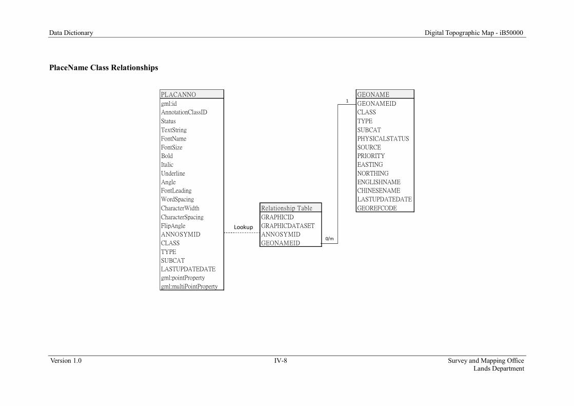
PlaceName Class Relationships
PLACANNO GEONAME
gml:id GEONAMEID
AnnotationClassID CLASS
Status TYPE
TextString SUBCAT
FontName PHYSICALSTATUS
FontSize SOURCE
Bold PRIORITY
Italic EASTING
Underline NORTHING
Angle ENGLISHNAME
FontLeading CHINESENAME
WordSpacing LASTUPDATEDATE
CharacterWidth Relationship Table GEOREFCODE
CharacterSpacing GRAPHICID
FlipAngle GRAPHICDATASET
ANNOSYMID ANNOSYMID
CLASS GEONAMEID
TYPE
SUBCAT
LASTUPDATEDATE
gml:pointProperty
gml:multiPointProperty
Lookup
0/m
1

Data Dictionary Digital Topographic Map - iB50000
Version 1.0 IV-9 Survey and Mapping Office Lands Department
Relief Class Relationships
ELEVLINE TERRLINE TERRSYMBOL ELEVSYMBOL ELEVANNO
gml:id gml:id gml:id gml:id gml:id
GRAPHICID GRAPHICID ANNOSYMID ANNOSYMID AnnotationClassID
GRAPHICDATASET GRAPHICDATASET CLASS CLASS Status
EASTING EASTING TYPE TYPE TextString
NORTHING NORTHING SUBCAT SUBCAT FontName
CLASS CLASS PHYSICALSTATUS PHYSICALSTATUS FontSize
TYPE TYPE LASTUPDATEDATE HEIGHT Bold
SUBCAT SUBCAT gml:pointProperty LASTUPDATEDATE Italic
PRIORITY PRIORITY gml:multiPointProperty TRIGNAME Underline
PHYSICALSTATUS PHYSICALSTATUS gml:pointProperty Angle
HEIGHT SOURCE gml:multiPointProperty FontLeading
SOURCE LASTUPDATEDATE WordSpacing
LASTUPDATEDATE gml:curveProperty CharacterWidth
gml:curveProperty gml:multiCurveProperty CharacterSpacing
gml:multiCurveProperty FlipAngle
ANNOSYMID
CLASS
ELEVPOLY TYPE
gml:id SUBCAT
GRAPHICID LASTUPDATEDATE
GRAPHICDATASET gml:pointProperty
EASTING gml:multiPointProperty
NORTHING
CLASS
TYPE
SUBCAT
PRIORITY
PHYSICALSTATUS
SOURCE
LASTUPDATEDATE
gml:surfaceProperty
gml:multiSurfaceProperty

Data Dictionary Digital Topographic Map - iB50000
Version 1.0 IV-10 Survey and Mapping Office Lands Department
Transportation Class Relationships
TSPTLINE TSPTSYMBOL TSPTANNO GEONAME
gml:id gml:id gml:id GEONAMEID
GRAPHICID ANNOSYMID AnnotationClassID CLASS
GRAPHICDATASET CLASS Status TYPE
EASTING TYPE TextString SUBCAT
NORTHING SUBCAT FontName PHYSICALSTATUS
CLASS PHYSICALSTATUS FontSize SOURCE
TYPE LASTUPDATEDATE Bold PRIORITY
SUBCAT gml:pointProperty Italic EASTING
PRIORITY gml:multiPointProperty Underline NORTHING
PHYSICALSTATUS Angle ENGLISHNAME
SOURCE FontLeading CHINESENAME
LASTUPDATEDATE WordSpacing LASTUPDATEDATE
gml:curveProperty CharacterWidth Relationship Table GEOREFCODE
gml:multiCurveProperty CharacterSpacing GRAPHICID
FlipAngle GRAPHICDATASET
TSPTPOLY ANNOSYMID ANNOSYMID
gml:id CLASS GEONAMEID
GRAPHICID TYPE
GRAPHICDATASET SUBCAT
EASTING LASTUPDATEDATE
NORTHING gml:pointProperty
CLASS gml:multiPointProperty
TYPE
SUBCAT
PRIORITY
PHYSICALSTATUS
SOURCE
LASTUPDATEDATE
gml:surfaceProperty
gml:multiSurfaceProperty
Lookup0/m
1
Lookup
Data Dictionary Digital Topographic Map - iB50000
Version 1.0 V-1 Survey and Mapping Office Lands Department
Part V - Description of iB50000 Features

Data Dictionary Digital Topographic Map - iB50000
Version 1.0 V-2 Survey and Mapping Office Lands Department
(This page is intentionally left blank)

Data Dictionary Digital Topographic Map - iB50000
Version 1.0 V-3 Survey and Mapping Office Lands Department
Feature BDRYANNO Geometry File BDRYANNO.gml Schema File BDRYANNO.xsd Description Chinese and English descriptions of boundary features. Geometry Type Point Field DataType Length Byte Description Default Value Is Null gml:id String 64 A gml:id is a unique, not null string column used to identify record in table -- False
AnnotationClassID Int 4 Subtype for the annotation feature class NULL True
Status Short 2 Flag indicating whether the annotation is placed or not 0 True
TextString String 255 Display string of the annotation NULL True
FontName String 255 Name of the font NULL True
FontSize Double 8 Size of the font NULL True
Bold Short 2 Flag indicating whether the font is bold or not NULL True
Italic Short 2 Flag indicating whether the font is italic or not NULL True
Underline Short 2 Flag indicating whether the font is underlined or not NULL True
Angle Double 8 Rotation angle of the annotation NULL True
FontLeading Double 8 Adjusts the spacing between lines NULL True
WordSpacing Double 8 Adjusts the spacing between words NULL True
CharacterWidth Double 8 Adjusts the character width NULL True
CharacterSpacing Double 8 Adjusts the spacing between characters NULL True
FlipAngle Double 8 Adjusts the angle at which point rotated text is flipped in place NULL True

Data Dictionary Digital Topographic Map - iB50000
Version 1.0 V-4 Survey and Mapping Office Lands Department
Field DataType Length Byte Description Default Value Is Null ANNOSYMID Int 4 An integer to identify annotation record in the feature dataset NULL True
CLASS String 5 An attribute for feature classification NULL True
TYPE String 5 An attribute for feature classification NULL True
SUBCAT String 10 An attribute for sub-classification of feature into a precise type NULL True
LASTUPDATEDATE String 20 Creation or last modification date of the record NULL True
gml:pointProperty Geometry The geometry type of the feature NULL True
gml:multiPointProperty Geometry The geometry type of the feature NULL True
List of Field Values Field Code Name STATUS 0 Placed
1 Unplaced
BOLD 0 No
1 Yes
ITALIC 0 No
1 Yes
UNDERLINE 0 No
1 Yes

Data Dictionary Digital Topographic Map - iB50000
Version 1.0 V-5 Survey and Mapping Office Lands Department
Feature BDRYLINE Geometry File BDRYLINE.gml Schema File BDRYLINE.xsd Description A curve geometry storing the lines for boundary lines, enclosed areas and enforcement limits. Geometry Type Curve Field DataType Length Byte Description Default Value Is Null gml:id String 64 A gml:id is a unique, not null string column used to identify record in table -- False
GRAPHICID Int 4 An integer to identify line record in the feature dataset NULL True
GRAPHICDATASET String 25 Graphical data from which feature dataset NULL True
EASTING Double 8 Easting coordinate in HK 1980 Grid NULL True
NORTHING Double 8 Northing coordinate in HK 1980 Grid NULL True
CLASS String 5 An attribute for feature classification NULL True
TYPE String 5 An attribute for feature classification NULL True
SUBCAT String 10 An attribute for sub-classification of feature into a precise type NULL True
PRIORITY short 2 An attribute to indicate level priority of the feature NULL True
PHYSICALSTATUS Int 4 An attribute to indicate the physical status of the feature NULL True
SOURCE short 2 Source of data in data collection or conversion NULL True
LASTUPDATEDATE String 20 Creation or last modification date of the record NULL True
gml:curveProperty Geometry The geometry type of the feature NULL True
gml:multiCurveProperty Geometry The geometry type of the feature NULL True
Data Dictionary Digital Topographic Map - iB50000
Version 1.0 V-6 Survey and Mapping Office Lands Department
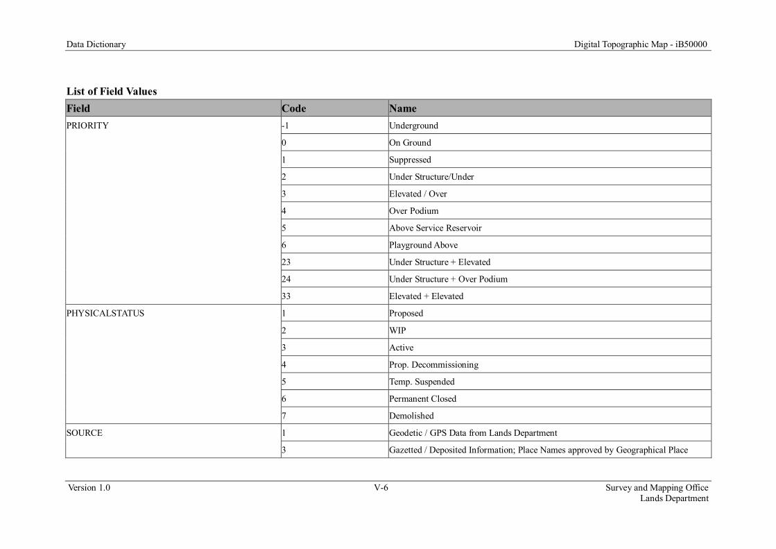
List of Field Values Field Code Name PRIORITY -1 Underground
0 On Ground
1 Suppressed
2 Under Structure/Under
3 Elevated / Over
4 Over Podium
5 Above Service Reservoir
6 Playground Above
23 Under Structure + Elevated
24 Under Structure + Over Podium
33 Elevated + Elevated
PHYSICALSTATUS 1 Proposed
2 WIP
3 Active
4 Prop. Decommissioning
5 Temp. Suspended
6 Permanent Closed
7 Demolished
SOURCE 1 Geodetic / GPS Data from Lands Department
3 Gazetted / Deposited Information; Place Names approved by Geographical Place

Data Dictionary Digital Topographic Map - iB50000
Version 1.0 V-7 Survey and Mapping Office Lands Department
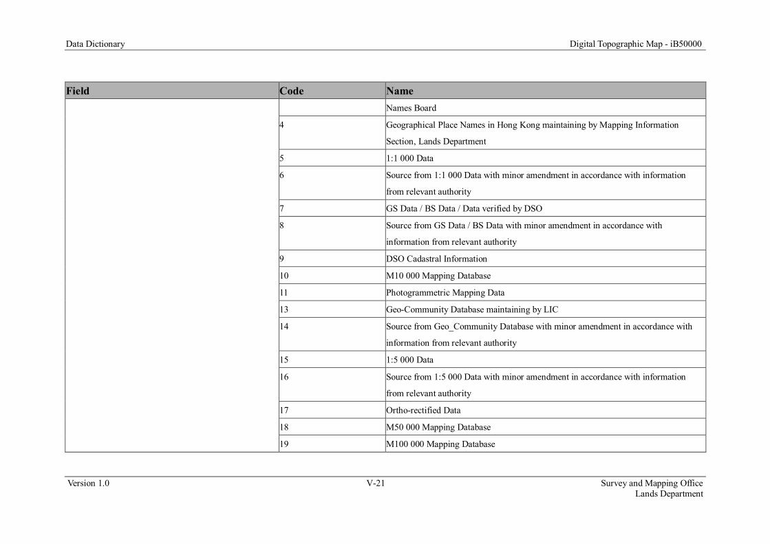
Field Code Name Names Board
4 Geographical Place Names in Hong Kong maintaining by Mapping Information
Section, Lands Department
5 1:1 000 Data
6 Source from 1:1 000 Data with minor amendment in accordance with information
from relevant authority
7 GS Data / BS Data / Data verified by DSO
8 Source from GS Data / BS Data with minor amendment in accordance with
information from relevant authority
9 DSO Cadastral Information
10 M10 000 Mapping Database
11 Photogrammetric Mapping Data
13 Geo-Community Database maintaining by LIC
14 Source from Geo_Community Database with minor amendment in accordance with
information from relevant authority
15 1:5 000 Data
16 Source from 1:5 000 Data with minor amendment in accordance with information
from relevant authority
17 Ortho-rectified Data
18 M50 000 Mapping Database
19 M100 000 Mapping Database
Data Dictionary Digital Topographic Map - iB50000
Version 1.0 V-8 Survey and Mapping Office Lands Department
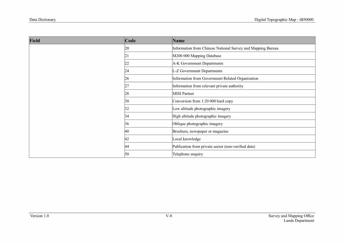
Field Code Name 20 Information from Chinese National Survey and Mapping Bureau
21 M200 000 Mapping Database
22 A-K Government Departments
24 L-Z Government Departments
26 Information from Government Related Organization
27 Information from relevant private authority
28 MISI Partner
30 Conversion from 1:20 000 hard copy
32 Low altitude photographic imagery
34 High altitude photographic imagery
36 Oblique photographic imagery
40 Brochure, newspaper or magazine
42 Local knowledge
44 Publication from private sector (non-verified data)
50 Telephone enquiry

Data Dictionary Digital Topographic Map - iB50000
Version 1.0 V-9 Survey and Mapping Office Lands Department
Feature BDRYPOLY Geometry File BDRYPOLY.gml Schema File BDRYPOLY.xsd Description A surface geometry storing the polygons for boundary features. Geometry Type Surface Field DataType Length Byte Description Default Value Is Null gml:id String 64 A gml:id is a unique, not null string column used to identify record in table -- False
GRAPHICID Int 4 An integer to identify polygon record in the feature dataset NULL True
GRAPHICDATASET String 25 Graphical data from which feature dataset NULL True
EASTING Double 8 Easting coordinate in HK 1980 Grid NULL True
NORTHING Double 8 Northing coordinate in HK 1980 Grid NULL True
CLASS String 5 An attribute for feature classification NULL True
TYPE String 5 An attribute for feature classification NULL True
SUBCAT String 10 An attribute for sub-classification of feature into a precise type NULL True
PRIORITY Short 2 An attribute to indicate level priority of the feature NULL True
PHYSICALSTATUS Int 4 An attribute to indicate the physical status of the feature NULL True
SOURCE Short 2 Source of data in data collection or conversion NULL True
LASTUPDATEDATE String 20 Creation or last modification date of the record NULL True
gml:surfaceProperty Geometry The geometry type of the feature NULL True
gml:multiSurfaceProperty Geometry The geometry type of the feature NULL True

Data Dictionary Digital Topographic Map - iB50000
Version 1.0 V-10 Survey and Mapping Office Lands Department
List of Field Values Field Code Name PRIORITY -1 Underground
0 On Ground
1 Suppressed
2 Under Structure/Under
3 Elevated / Over
4 Over Podium
5 Above Service Reservoir
6 Playground Above
23 Under Structure + Elevated
24 Under Structure + Over Podium
33 Elevated + Elevated
PHYSICALSTATUS 1 Proposed
2 WIP
3 Active
4 Prop. Decommissioning
5 Temp. Suspended
6 Permanent Closed
7 Demolished
SOURCE 1 Geodetic / GPS Data from Lands Department
3 Gazetted / Deposited Information; Place Names approved by Geographical Place

Data Dictionary Digital Topographic Map - iB50000
Version 1.0 V-11 Survey and Mapping Office Lands Department
Field Code Name Names Board
4 Geographical Place Names in Hong Kong maintaining by Mapping Information
Section, Lands Department
5 1:1 000 Data
6 Source from 1:1 000 Data with minor amendment in accordance with information
from relevant authority
7 GS Data / BS Data / Data verified by DSO
8 Source from GS Data / BS Data with minor amendment in accordance with
information from relevant authority
9 DSO Cadastral Information
10 M10 000 Mapping Database
11 Photogrammetric Mapping Data
13 Geo-Community Database maintaining by LIC
14 Source from Geo_Community Database with minor amendment in accordance with
information from relevant authority
15 1:5 000 Data
16 Source from 1:5 000 Data with minor amendment in accordance with information
from relevant authority
17 Ortho-rectified Data
18 M50 000 Mapping Database
19 M100 000 Mapping Database

Data Dictionary Digital Topographic Map - iB50000
Version 1.0 V-12 Survey and Mapping Office Lands Department
Field Code Name 20 Information from Chinese National Survey and Mapping Bureau
21 M200 000 Mapping Database
22 A-K Government Departments
24 L-Z Government Departments
26 Information from Government Related Organization
27 Information from relevant private authority
28 MISI Partner
30 Conversion from 1:20 000 hard copy
32 Low altitude photographic imagery
34 High altitude photographic imagery
36 Oblique photographic imagery
40 Brochure, newspaper or magazine
42 Local knowledge
44 Publication from private sector (non-verified data)
50 Telephone enquiry

Data Dictionary Digital Topographic Map - iB50000
Version 1.0 V-13 Survey and Mapping Office Lands Department
Feature BLDGPOLY Geometry File BLDGPOLY.gml Schema File BLDGPOLY.xsd Description A surface geometry storing the polygons for building structures and minor buildings. Geometry Type Surface Field DataType Length Byte Description Default Value Is Null gml:id String 64 A gml:id is a unique, not null string column used to identify record in table -- False
GRAPHICID Int 4 An integer to identify polygon record in the feature dataset NULL True
GRAPHICDATASET String 25 Graphical data from which feature dataset NULL True
EASTING Double 8 Easting coordinate in HK 1980 Grid NULL True
NORTHING Double 8 Northing coordinate in HK 1980 Grid NULL True
CLASS String 5 An attribute for feature classification NULL True
TYPE String 5 An attribute for feature classification NULL True
SUBCAT String 10 An attribute for sub-classification of feature into a precise type NULL True
PRIORITY Short 2 An attribute to indicate level priority of the feature NULL True
PHYSICALSTATUS Int 4 An attribute to indicate the physical status of the feature NULL True
SOURCE Short 2 Source of data in data collection or conversion NULL True
LASTUPDATEDATE String 20 Creation or last modification date of the record NULL True
gml:surfaceProperty Geometry The geometry type of the feature NULL True
gml:multiSurfaceProperty Geometry The geometry type of the feature NULL True

Data Dictionary Digital Topographic Map - iB50000
Version 1.0 V-14 Survey and Mapping Office Lands Department
List of Field Values Field Code Name PRIORITY -1 Underground
0 On Ground
1 Suppressed
2 Under Structure/Under
3 Elevated / Over
4 Over Podium
5 Above Service Reservoir
6 Playground Above
23 Under Structure + Elevated
24 Under Structure + Over Podium
33 Elevated + Elevated
PHYSICALSTATUS 1 Proposed
2 WIP
3 Active
4 Prop. Decommissioning
5 Temp. Suspended
6 Permanent Closed
7 Demolished
SOURCE 1 Geodetic / GPS Data from Lands Department
3 Gazetted / Deposited Information; Place Names approved by Geographical Place

Data Dictionary Digital Topographic Map - iB50000
Version 1.0 V-15 Survey and Mapping Office Lands Department
Field Code Name Names Board
4 Geographical Place Names in Hong Kong maintaining by Mapping Information
Section, Lands Department
5 1:1 000 Data
6 Source from 1:1 000 Data with minor amendment in accordance with information
from relevant authority
7 GS Data / BS Data / Data verified by DSO
8 Source from GS Data / BS Data with minor amendment in accordance with
information from relevant authority
9 DSO Cadastral Information
10 M10 000 Mapping Database
11 Photogrammetric Mapping Data
13 Geo-Community Database maintaining by LIC
14 Source from Geo_Community Database with minor amendment in accordance with
information from relevant authority
15 1:5 000 Data
16 Source from 1:5 000 Data with minor amendment in accordance with information
from relevant authority
17 Ortho-rectified Data
18 M50 000 Mapping Database
19 M100 000 Mapping Database

Data Dictionary Digital Topographic Map - iB50000
Version 1.0 V-16 Survey and Mapping Office Lands Department
Field Code Name 20 Information from Chinese National Survey and Mapping Bureau
21 M200 000 Mapping Database
22 A-K Government Departments
24 L-Z Government Departments
26 Information from Government Related Organization
27 Information from relevant private authority
28 MISI Partner
30 Conversion from 1:20 000 hard copy
32 Low altitude photographic imagery
34 High altitude photographic imagery
36 Oblique photographic imagery
40 Brochure, newspaper or magazine
42 Local knowledge
44 Publication from private sector (non-verified data)
50 Telephone enquiry

Data Dictionary Digital Topographic Map - iB50000
Version 1.0 V-17 Survey and Mapping Office Lands Department
Feature FACIANNO Geometry File FACIANNO.gml Schema File FACIANNO.xsd Description Chinese and English descriptions of facility features. Geometry Type Point Field DataType Length Byte Description Default Value Is Null gml:id String 64 A gml:id is a unique, not null string column used to identify record in table -- False
AnnotationClassID Int 4 Subtype for the annotation feature class NULL True
Status Short 2 Flag indicating whether the annotation is placed or not 0 True
TextString String 255 Display string of the annotation NULL True
FontName String 255 Name of the font NULL True
FontSize Double 8 Size of the font NULL True
Bold Short 2 Flag indicating whether the font is bold or not NULL True
Italic Short 2 Flag indicating whether the font is italic or not NULL True
Underline Short 2 Flag indicating whether the font is underlined or not NULL True
Angle Double 8 Rotation angle of the annotation NULL True
FontLeading Double 8 Adjusts the spacing between lines NULL True
WordSpacing Double 8 Adjusts the spacing between words NULL True
CharacterWidth Double 8 Adjusts the character width NULL True
CharacterSpacing Double 8 Adjusts the spacing between characters NULL True
FlipAngle Double 8 Adjusts the angle at which point rotated text is flipped in place NULL True

Data Dictionary Digital Topographic Map - iB50000
Version 1.0 V-18 Survey and Mapping Office Lands Department
Field DataType Length Byte Description Default Value Is Null ANNOSYMID Int 4 An integer to identify annotation record in the feature dataset NULL True
CLASS String 5 An attribute for feature classification NULL True
TYPE String 5 An attribute for feature classification NULL True
SUBCAT String 10 An attribute for sub-classification of feature into a precise type NULL True
LASTUPDATEDATE String 20 Creation or last modification date of the record NULL True
gml:pointProperty Geometry The geometry type of the feature NULL True
gml:multiPointProperty Geometry The geometry type of the feature NULL True
List of Field Values Field Code Name STATUS 0 Placed
1 Unplaced
BOLD 0 No
1 Yes
ITALIC 0 No
1 Yes
UNDERLINE 0 No
1 Yes

Data Dictionary Digital Topographic Map - iB50000
Version 1.0 V-19 Survey and Mapping Office Lands Department
Feature FACILINE Geometry File FACILINE.gml Schema File FACILINE.xsd Description A curve geometry storing the lines for cable / electricity installations and drainage services. Geometry Type Curve Field DataType Length Byte Description Default Value Is Null gml:id String 64 A gml:id is a unique, not null string column used to identify record in table -- False
GRAPHICID Int 4 An integer to identify line record in the feature dataset NULL True
GRAPHICDATASET String 25 Graphical data from which feature dataset NULL True
EASTING Double 8 Easting coordinate in HK 1980 Grid NULL True
NORTHING Double 8 Northing coordinate in HK 1980 Grid NULL True
CLASS String 5 An attribute for feature classification NULL True
TYPE String 5 An attribute for feature classification NULL True
SUBCAT String 10 An attribute for sub-classification of feature into a precise type NULL True
PRIORITY short 2 An attribute to indicate level priority of the feature NULL True
PHYSICALSTATUS Int 4 An attribute to indicate the physical status of the feature NULL True
SOURCE short 2 Source of data in data collection or conversion NULL True
LASTUPDATEDATE String 20 Creation or last modification date of the record NULL True
gml:curveProperty Geometry The geometry type of the feature NULL True
gml:multiCurveProperty Geometry The geometry type of the feature NULL True

Data Dictionary Digital Topographic Map - iB50000
Version 1.0 V-20 Survey and Mapping Office Lands Department
List of Field Values Field Code Name PRIORITY -1 Underground
0 On Ground
1 Suppressed
2 Under Structure/Under
3 Elevated / Over
4 Over Podium
5 Above Service Reservoir
6 Playground Above
23 Under Structure + Elevated
24 Under Structure + Over Podium
33 Elevated + Elevated
PHYSICALSTATUS 1 Proposed
2 WIP
3 Active
4 Prop. Decommissioning
5 Temp. Suspended
6 Permanent Closed
7 Demolished
SOURCE 1 Geodetic / GPS Data from Lands Department
3 Gazetted / Deposited Information; Place Names approved by Geographical Place
Data Dictionary Digital Topographic Map - iB50000
Version 1.0 V-21 Survey and Mapping Office Lands Department
Field Code Name Names Board
4 Geographical Place Names in Hong Kong maintaining by Mapping Information
Section, Lands Department
5 1:1 000 Data
6 Source from 1:1 000 Data with minor amendment in accordance with information
from relevant authority
7 GS Data / BS Data / Data verified by DSO
8 Source from GS Data / BS Data with minor amendment in accordance with
information from relevant authority
9 DSO Cadastral Information
10 M10 000 Mapping Database
11 Photogrammetric Mapping Data
13 Geo-Community Database maintaining by LIC
14 Source from Geo_Community Database with minor amendment in accordance with
information from relevant authority
15 1:5 000 Data
16 Source from 1:5 000 Data with minor amendment in accordance with information
from relevant authority
17 Ortho-rectified Data
18 M50 000 Mapping Database
19 M100 000 Mapping Database

Data Dictionary Digital Topographic Map - iB50000
Version 1.0 V-22 Survey and Mapping Office Lands Department
Field Code Name 20 Information from Chinese National Survey and Mapping Bureau
21 M200 000 Mapping Database
22 A-K Government Departments
24 L-Z Government Departments
26 Information from Government Related Organization
27 Information from relevant private authority
28 MISI Partner
30 Conversion from 1:20 000 hard copy
32 Low altitude photographic imagery
34 High altitude photographic imagery
36 Oblique photographic imagery
40 Brochure, newspaper or magazine
42 Local knowledge
44 Publication from private sector (non-verified data)
50 Telephone enquiry

Data Dictionary Digital Topographic Map - iB50000
Version 1.0 V-23 Survey and Mapping Office Lands Department
Feature FACIPOLY Geometry File FACIPOLY.gml Schema File FACIPOLY.xsd Description A surface geometry storing the polygons for drainage services, facility furniture and fuel service installations. Geometry Type Surface Field DataType Length Byte Description Default Value Is Null gml:id String 64 A gml:id is a unique, not null string column used to identify record in table -- False
GRAPHICID Int 4 An integer to identify polygon record in the feature dataset NULL True
GRAPHICDATASET String 25 Graphical data from which feature dataset NULL True
EASTING Double 8 Easting coordinate in HK 1980 Grid NULL True
NORTHING Double 8 Northing coordinate in HK 1980 Grid NULL True
CLASS String 5 An attribute for feature classification NULL True
TYPE String 5 An attribute for feature classification NULL True
SUBCAT String 10 An attribute for sub-classification of feature into a precise type NULL True
PRIORITY Short 2 An attribute to indicate level priority of the feature NULL True
PHYSICALSTATUS Int 4 An attribute to indicate the physical status of the feature NULL True
SOURCE Short 2 Source of data in data collection or conversion NULL True
LASTUPDATEDATE String 20 Creation or last modification date of the record NULL True
gml:surfaceProperty Geometry The geometry type of the feature NULL True
gml:multiSurfaceProperty Geometry The geometry type of the feature NULL True

Data Dictionary Digital Topographic Map - iB50000
Version 1.0 V-24 Survey and Mapping Office Lands Department
List of Field Values Field Code Name PRIORITY -1 Underground
0 On Ground
1 Suppressed
2 Under Structure/Under
3 Elevated / Over
4 Over Podium
5 Above Service Reservoir
6 Playground Above
23 Under Structure + Elevated
24 Under Structure + Over Podium
33 Elevated + Elevated
PHYSICALSTATUS 1 Proposed
2 WIP
3 Active
4 Prop. Decommissioning
5 Temp. Suspended
6 Permanent Closed
7 Demolished
SOURCE 1 Geodetic / GPS Data from Lands Department
3 Gazetted / Deposited Information; Place Names approved by Geographical Place

Data Dictionary Digital Topographic Map - iB50000
Version 1.0 V-25 Survey and Mapping Office Lands Department
Field Code Name Names Board
4 Geographical Place Names in Hong Kong maintaining by Mapping Information
Section, Lands Department
5 1:1 000 Data
6 Source from 1:1 000 Data with minor amendment in accordance with information
from relevant authority
7 GS Data / BS Data / Data verified by DSO
8 Source from GS Data / BS Data with minor amendment in accordance with
information from relevant authority
9 DSO Cadastral Information
10 M10 000 Mapping Database
11 Photogrammetric Mapping Data
13 Geo-Community Database maintaining by LIC
14 Source from Geo_Community Database with minor amendment in accordance with
information from relevant authority
15 1:5 000 Data
16 Source from 1:5 000 Data with minor amendment in accordance with information
from relevant authority
17 Ortho-rectified Data
18 M50 000 Mapping Database
19 M100 000 Mapping Database

Data Dictionary Digital Topographic Map - iB50000
Version 1.0 V-26 Survey and Mapping Office Lands Department
Field Code Name 20 Information from Chinese National Survey and Mapping Bureau
21 M200 000 Mapping Database
22 A-K Government Departments
24 L-Z Government Departments
26 Information from Government Related Organization
27 Information from relevant private authority
28 MISI Partner
30 Conversion from 1:20 000 hard copy
32 Low altitude photographic imagery
34 High altitude photographic imagery
36 Oblique photographic imagery
40 Brochure, newspaper or magazine
42 Local knowledge
44 Publication from private sector (non-verified data)
50 Telephone enquiry

Data Dictionary Digital Topographic Map - iB50000
Version 1.0 V-27 Survey and Mapping Office Lands Department
Feature FACISYMBOL Geometry File FACISYMBOL.gml Schema File FACISYMBOL.xsd Description A point geometry storing the points for cable / electricity installations and utility installation. Geometry Type Point Field DataType Length Byte Description Default Value Is Null gml:id String 64 A gml:id is a unique, not null string column used to identify record in table -- False
ANNOSYMID Int 4 An integer to identify point record in the feature dataset NULL True
CLASS String 5 An attribute for feature classification NULL True
TYPE String 5 An attribute for feature classification NULL True
SUBCAT String 10 An attribute for sub-classification of feature into a precise type NULL True
PHYSICALSTATUS Int 4 An attribute to indicate the physical status of the feature NULL True
LASTUPDATEDATE String 20 Creation or last modification date of the record NULL True
gml:pointProperty Geometry The geometry type of the feature NULL True
gml:multiPointProperty Geometry The geometry type of the feature NULL True

Data Dictionary Digital Topographic Map - iB50000
Version 1.0 V-28 Survey and Mapping Office Lands Department
List of Field Values Field Code Name PHYSICALSTATUS 1 Proposed
2 WIP
3 Active
4 Prop. Decommissioning
5 Temp. Suspended
6 Permanent Closed
7 Demolished

Data Dictionary Digital Topographic Map - iB50000
Version 1.0 V-29 Survey and Mapping Office Lands Department
Feature HYDRANNO Geometry File HYDRANNO.gml Schema File HYDRANNO.xsd Description Chinese and English descriptions of hydrographic features. Geometry Type Point Field DataType Length Byte Description Default Value Is Null gml:id String 64 A gml:id is a unique, not null string column used to identify record in table -- False
AnnotationClassID Int 4 Subtype for the annotation feature class NULL True
Status Short 2 Flag indicating whether the annotation is placed or not 0 True
TextString String 255 Display string of the annotation NULL True
FontName String 255 Name of the font NULL True
FontSize Double 8 Size of the font NULL True
Bold Short 2 Flag indicating whether the font is bold or not NULL True
Italic Short 2 Flag indicating whether the font is italic or not NULL True
Underline Short 2 Flag indicating whether the font is underlined or not NULL True
Angle Double 8 Rotation angle of the annotation NULL True
FontLeading Double 8 Adjusts the spacing between lines NULL True
WordSpacing Double 8 Adjusts the spacing between words NULL True
CharacterWidth Double 8 Adjusts the character width NULL True
CharacterSpacing Double 8 Adjusts the spacing between characters NULL True
FlipAngle Double 8 Adjusts the angle at which point rotated text is flipped in place NULL True

Data Dictionary Digital Topographic Map - iB50000
Version 1.0 V-30 Survey and Mapping Office Lands Department
Field DataType Length Byte Description Default Value Is Null ANNOSYMID Int 4 An integer to identify annotation record in the feature dataset NULL True
CLASS String 5 An attribute for feature classification NULL True
TYPE String 5 An attribute for feature classification NULL True
SUBCAT String 10 An attribute for sub-classification of feature into a precise type NULL True
LASTUPDATEDATE String 20 Creation or last modification date of the record NULL True
gml:pointProperty Geometry The geometry type of the feature NULL True
gml:multiPointProperty Geometry The geometry type of the feature NULL True
List of Field Values Field Code Name STATUS 0 Placed
1 Unplaced
BOLD 0 No
1 Yes
ITALIC 0 No
1 Yes
UNDERLINE 0 No
1 Yes

Data Dictionary Digital Topographic Map - iB50000
Version 1.0 V-31 Survey and Mapping Office Lands Department
Feature HYDRLINE Geometry File HYDRLINE.gml Schema File HYDRLINE.xsd Description A curve geometry storing the lines for hydrographic furniture, shore alignments and streams. Geometry Type Curve Field DataType Length Byte Description Default Value Is Null gml:id String 64 A gml:id is a unique, not null string column used to identify record in table -- False
GRAPHICID Int 4 An integer to identify line record in the feature dataset NULL True
GRAPHICDATASET String 25 Graphical data from which feature dataset NULL True
EASTING Double 8 Easting coordinate in HK 1980 Grid NULL True
NORTHING Double 8 Northing coordinate in HK 1980 Grid NULL True
CLASS String 5 An attribute for feature classification NULL True
TYPE String 5 An attribute for feature classification NULL True
SUBCAT String 10 An attribute for sub-classification of feature into a precise type NULL True
PRIORITY short 2 An attribute to indicate level priority of the feature NULL True
PHYSICALSTATUS Int 4 An attribute to indicate the physical status of the feature NULL True
SOURCE short 2 Source of data in data collection or conversion NULL True
LASTUPDATEDATE String 20 Creation or last modification date of the record NULL True
gml:curveProperty Geometry The geometry type of the feature NULL True
gml:multiCurveProperty Geometry The geometry type of the feature NULL True

Data Dictionary Digital Topographic Map - iB50000
Version 1.0 V-32 Survey and Mapping Office Lands Department
List of Field Values Field Code Name PRIORITY -1 Underground
0 On Ground
1 Suppressed
2 Under Structure/Under
3 Elevated / Over
4 Over Podium
5 Above Service Reservoir
6 Playground Above
23 Under Structure + Elevated
24 Under Structure + Over Podium
33 Elevated + Elevated
PHYSICALSTATUS 1 Proposed
2 WIP
3 Active
4 Prop. Decommissioning
5 Temp. Suspended
6 Permanent Closed
7 Demolished
SOURCE 1 Geodetic / GPS Data from Lands Department
3 Gazetted / Deposited Information; Place Names approved by Geographical Place

Data Dictionary Digital Topographic Map - iB50000
Version 1.0 V-33 Survey and Mapping Office Lands Department
Field Code Name Names Board
4 Geographical Place Names in Hong Kong maintaining by Mapping Information
Section, Lands Department
5 1:1 000 Data
6 Source from 1:1 000 Data with minor amendment in accordance with information
from relevant authority
7 GS Data / BS Data / Data verified by DSO
8 Source from GS Data / BS Data with minor amendment in accordance with
information from relevant authority
9 DSO Cadastral Information
10 M10 000 Mapping Database
11 Photogrammetric Mapping Data
13 Geo-Community Database maintaining by LIC
14 Source from Geo_Community Database with minor amendment in accordance with
information from relevant authority
15 1:5 000 Data
16 Source from 1:5 000 Data with minor amendment in accordance with information
from relevant authority
17 Ortho-rectified Data
18 M50 000 Mapping Database
19 M100 000 Mapping Database

Data Dictionary Digital Topographic Map - iB50000
Version 1.0 V-34 Survey and Mapping Office Lands Department
Field Code Name 20 Information from Chinese National Survey and Mapping Bureau
21 M200 000 Mapping Database
22 A-K Government Departments
24 L-Z Government Departments
26 Information from Government Related Organization
27 Information from relevant private authority
28 MISI Partner
30 Conversion from 1:20 000 hard copy
32 Low altitude photographic imagery
34 High altitude photographic imagery
36 Oblique photographic imagery
40 Brochure, newspaper or magazine
42 Local knowledge
44 Publication from private sector (non-verified data)
50 Telephone enquiry

Data Dictionary Digital Topographic Map - iB50000
Version 1.0 V-35 Survey and Mapping Office Lands Department
Feature HYDRPOLY Geometry File HYDRPOLY.gml Schema File HYDRPOLY.xsd Description A surface geometry storing the polygons for water bodies, shore alignments and streams. Geometry Type Surface Field DataType Length Byte Description Default Value Is Null gml:id String 64 A gml:id is a unique, not null string column used to identify record in table -- False
GRAPHICID Int 4 An integer to identify polygon record in the feature dataset NULL True
GRAPHICDATASET String 25 Graphical data from which feature dataset NULL True
EASTING Double 8 Easting coordinate in HK 1980 Grid NULL True
NORTHING Double 8 Northing coordinate in HK 1980 Grid NULL True
CLASS String 5 An attribute for feature classification NULL True
TYPE String 5 An attribute for feature classification NULL True
SUBCAT String 10 An attribute for sub-classification of feature into a precise type NULL True
PRIORITY Short 2 An attribute to indicate level priority of the feature NULL True
PHYSICALSTATUS Int 4 An attribute to indicate the physical status of the feature NULL True
SOURCE Short 2 Source of data in data collection or conversion NULL True
LASTUPDATEDATE String 20 Creation or last modification date of the record NULL True
gml:surfaceProperty Geometry The geometry type of the feature NULL True
gml:multiSurfaceProperty Geometry The geometry type of the feature NULL True

Data Dictionary Digital Topographic Map - iB50000
Version 1.0 V-36 Survey and Mapping Office Lands Department
List of Field Values Field Code Name PRIORITY -1 Underground
0 On Ground
1 Suppressed
2 Under Structure/Under
3 Elevated / Over
4 Over Podium
5 Above Service Reservoir
6 Playground Above
23 Under Structure + Elevated
24 Under Structure + Over Podium
33 Elevated + Elevated
PHYSICALSTATUS 1 Proposed
2 WIP
3 Active
4 Prop. Decommissioning
5 Temp. Suspended
6 Permanent Closed
7 Demolished
SOURCE 1 Geodetic / GPS Data from Lands Department
3 Gazetted / Deposited Information; Place Names approved by Geographical Place

Data Dictionary Digital Topographic Map - iB50000
Version 1.0 V-37 Survey and Mapping Office Lands Department
Field Code Name Names Board
4 Geographical Place Names in Hong Kong maintaining by Mapping Information
Section, Lands Department
5 1:1 000 Data
6 Source from 1:1 000 Data with minor amendment in accordance with information
from relevant authority
7 GS Data / BS Data / Data verified by DSO
8 Source from GS Data / BS Data with minor amendment in accordance with
information from relevant authority
9 DSO Cadastral Information
10 M10 000 Mapping Database
11 Photogrammetric Mapping Data
13 Geo-Community Database maintaining by LIC
14 Source from Geo_Community Database with minor amendment in accordance with
information from relevant authority
15 1:5 000 Data
16 Source from 1:5 000 Data with minor amendment in accordance with information
from relevant authority
17 Ortho-rectified Data
18 M50 000 Mapping Database
19 M100 000 Mapping Database

Data Dictionary Digital Topographic Map - iB50000
Version 1.0 V-38 Survey and Mapping Office Lands Department
Field Code Name 20 Information from Chinese National Survey and Mapping Bureau
21 M200 000 Mapping Database
22 A-K Government Departments
24 L-Z Government Departments
26 Information from Government Related Organization
27 Information from relevant private authority
28 MISI Partner
30 Conversion from 1:20 000 hard copy
32 Low altitude photographic imagery
34 High altitude photographic imagery
36 Oblique photographic imagery
40 Brochure, newspaper or magazine
42 Local knowledge
44 Publication from private sector (non-verified data)
50 Telephone enquiry

Data Dictionary Digital Topographic Map - iB50000
Version 1.0 V-39 Survey and Mapping Office Lands Department
Feature LANDPOLY Geometry File LANDPOLY.gml Schema File LANDPOLY.xsd Description A surface geometry storing the polygons for barren land and vegetation. Geometry Type Surface Field DataType Length Byte Description Default Value Is Null gml:id String 64 A gml:id is a unique, not null string column used to identify record in table -- False
GRAPHICID Int 4 An integer to identify polygon record in the feature dataset NULL True
GRAPHICDATASET String 25 Graphical data from which feature dataset NULL True
EASTING Double 8 Easting coordinate in HK 1980 Grid NULL True
NORTHING Double 8 Northing coordinate in HK 1980 Grid NULL True
CLASS String 5 An attribute for feature classification NULL True
TYPE String 5 An attribute for feature classification NULL True
SUBCAT String 10 An attribute for sub-classification of feature into a precise type NULL True
PRIORITY Short 2 An attribute to indicate level priority of the feature NULL True
PHYSICALSTATUS Int 4 An attribute to indicate the physical status of the feature NULL True
SOURCE Short 2 Source of data in data collection or conversion NULL True
LASTUPDATEDATE String 20 Creation or last modification date of the record NULL True
gml:surfaceProperty Geometry The geometry type of the feature NULL True
gml:multiSurfaceProperty Geometry The geometry type of the feature NULL True

Data Dictionary Digital Topographic Map - iB50000
Version 1.0 V-40 Survey and Mapping Office Lands Department
List of Field Values Field Code Name PRIORITY -1 Underground
0 On Ground
1 Suppressed
2 Under Structure/Under
3 Elevated / Over
4 Over Podium
5 Above Service Reservoir
6 Playground Above
23 Under Structure + Elevated
24 Under Structure + Over Podium
33 Elevated + Elevated
PHYSICALSTATUS 1 Proposed
2 WIP
3 Active
4 Prop. Decommissioning
5 Temp. Suspended
6 Permanent Closed
7 Demolished
SOURCE 1 Geodetic / GPS Data from Lands Department
3 Gazetted / Deposited Information; Place Names approved by Geographical Place

Data Dictionary Digital Topographic Map - iB50000
Version 1.0 V-41 Survey and Mapping Office Lands Department
Field Code Name Names Board
4 Geographical Place Names in Hong Kong maintaining by Mapping Information
Section, Lands Department
5 1:1 000 Data
6 Source from 1:1 000 Data with minor amendment in accordance with information
from relevant authority
7 GS Data / BS Data / Data verified by DSO
8 Source from GS Data / BS Data with minor amendment in accordance with
information from relevant authority
9 DSO Cadastral Information
10 M10 000 Mapping Database
11 Photogrammetric Mapping Data
13 Geo-Community Database maintaining by LIC
14 Source from Geo_Community Database with minor amendment in accordance with
information from relevant authority
15 1:5 000 Data
16 Source from 1:5 000 Data with minor amendment in accordance with information
from relevant authority
17 Ortho-rectified Data
18 M50 000 Mapping Database
19 M100 000 Mapping Database

Data Dictionary Digital Topographic Map - iB50000
Version 1.0 V-42 Survey and Mapping Office Lands Department
Field Code Name 20 Information from Chinese National Survey and Mapping Bureau
21 M200 000 Mapping Database
22 A-K Government Departments
24 L-Z Government Departments
26 Information from Government Related Organization
27 Information from relevant private authority
28 MISI Partner
30 Conversion from 1:20 000 hard copy
32 Low altitude photographic imagery
34 High altitude photographic imagery
36 Oblique photographic imagery
40 Brochure, newspaper or magazine
42 Local knowledge
44 Publication from private sector (non-verified data)
50 Telephone enquiry

Data Dictionary Digital Topographic Map - iB50000
Version 1.0 V-43 Survey and Mapping Office Lands Department
Feature PLACANNO Geometry File PLACANNO.gml Schema File PLACANNO.xsd Description Chinese and English descriptions of place names. Geometry Type Point Field DataType Length Byte Description Default Value Is Null gml:id String 64 A gml:id is a unique, not null string column used to identify record in table -- False
AnnotationClassID Int 4 Subtype for the annotation feature class NULL True
Status Short 2 Flag indicating whether the annotation is placed or not 0 True
TextString String 255 Display string of the annotation NULL True
FontName String 255 Name of the font NULL True
FontSize Double 8 Size of the font NULL True
Bold Short 2 Flag indicating whether the font is bold or not NULL True
Italic Short 2 Flag indicating whether the font is italic or not NULL True
Underline Short 2 Flag indicating whether the font is underlined or not NULL True
Angle Double 8 Rotation angle of the annotation NULL True
FontLeading Double 8 Adjusts the spacing between lines NULL True
WordSpacing Double 8 Adjusts the spacing between words NULL True
CharacterWidth Double 8 Adjusts the character width NULL True
CharacterSpacing Double 8 Adjusts the spacing between characters NULL True
FlipAngle Double 8 Adjusts the angle at which point rotated text is flipped in place NULL True

Data Dictionary Digital Topographic Map - iB50000
Version 1.0 V-44 Survey and Mapping Office Lands Department
Field DataType Length Byte Description Default Value Is Null ANNOSYMID Int 4 An integer to identify annotation record in the feature dataset NULL True
CLASS String 5 An attribute for feature classification NULL True
TYPE String 5 An attribute for feature classification NULL True
SUBCAT String 10 An attribute for sub-classification of feature into a precise type NULL True
LASTUPDATEDATE String 20 Creation or last modification date of the record NULL True
gml:pointProperty Geometry The geometry type of the feature NULL True
gml:multiPointProperty Geometry The geometry type of the feature NULL True
List of Field Values Field Code Name STATUS 0 Placed
1 Unplaced
BOLD 0 No
1 Yes
ITALIC 0 No
1 Yes
UNDERLINE 0 No
1 Yes

Data Dictionary Digital Topographic Map - iB50000
Version 1.0 V-45 Survey and Mapping Office Lands Department
Feature ELEVANNO Geometry File ELEVANNO.gml Schema File ELEVANNO.xsd Description Chinese and English descriptions of elevation features. Geometry Type Point Field DataType Length Byte Description Default Value Is Null gml:id String 64 A gml:id is a unique, not null string column used to identify record in table -- False
AnnotationClassID Int 4 Subtype for the annotation feature class NULL True
Status Short 2 Flag indicating whether the annotation is placed or not 0 True
TextString String 255 Display string of the annotation NULL True
FontName String 255 Name of the font NULL True
FontSize Double 8 Size of the font NULL True
Bold Short 2 Flag indicating whether the font is bold or not NULL True
Italic Short 2 Flag indicating whether the font is italic or not NULL True
Underline Short 2 Flag indicating whether the font is underlined or not NULL True
Angle Double 8 Rotation angle of the annotation NULL True
FontLeading Double 8 Adjusts the spacing between lines NULL True
WordSpacing Double 8 Adjusts the spacing between words NULL True
CharacterWidth Double 8 Adjusts the character width NULL True
CharacterSpacing Double 8 Adjusts the spacing between characters NULL True
FlipAngle Double 8 Adjusts the angle at which point rotated text is flipped in place NULL True

Data Dictionary Digital Topographic Map - iB50000
Version 1.0 V-46 Survey and Mapping Office Lands Department
Field DataType Length Byte Description Default Value Is Null ANNOSYMID Int 4 An integer to identify annotation record in the feature dataset NULL True
CLASS String 5 An attribute for feature classification NULL True
TYPE String 5 An attribute for feature classification NULL True
SUBCAT String 10 An attribute for sub-classification of feature into a precise type NULL True
LASTUPDATEDATE String 20 Creation or last modification date of the record NULL True
gml:pointProperty Geometry The geometry type of the feature NULL True
gml:multiPointProperty Geometry The geometry type of the feature NULL True
List of Field Values Field Code Name STATUS 0 Placed
1 Unplaced
BOLD 0 No
1 Yes
ITALIC 0 No
1 Yes
UNDERLINE 0 No
1 Yes

Data Dictionary Digital Topographic Map - iB50000
Version 1.0 V-47 Survey and Mapping Office Lands Department
Feature ELEVLINE Geometry File ELEVLINE.gml Schema File ELEVLINE.xsd Description A curve geometry storing the lines for contour lines. Geometry Type Curve Field DataType Length Byte Description Default Value Is Null gml:id String 64 A gml:id is a unique, not null string column used to identify record in table -- False
GRAPHICID Int 4 An integer to identify line record in the feature dataset NULL True
GRAPHICDATASET String 25 Graphical data from which feature dataset NULL True
EASTING Double 8 Easting coordinate in HK 1980 Grid NULL True
NORTHING Double 8 Northing coordinate in HK 1980 Grid NULL True
CLASS String 5 An attribute for feature classification NULL True
TYPE String 5 An attribute for feature classification NULL True
SUBCAT String 10 An attribute for sub-classification of feature into a precise type NULL True
PRIORITY short 2 An attribute to indicate level priority of the feature NULL True
PHYSICALSTATUS Int 4 An attribute to indicate the physical status of the feature NULL True
HEIGHT Short 2 Elevation value for contour lines NULL True
SOURCE short 2 Source of data in data collection or conversion NULL True
LASTUPDATEDATE String 20 Creation or last modification date of the record NULL True
gml:curveProperty Geometry The geometry type of the feature NULL True
gml:multiCurveProperty Geometry The geometry type of the feature NULL True

Data Dictionary Digital Topographic Map - iB50000
Version 1.0 V-48 Survey and Mapping Office Lands Department
List of Field Values Field Code Name PRIORITY -1 Underground
0 On Ground
1 Suppressed
2 Under Structure/Under
3 Elevated / Over
4 Over Podium
5 Above Service Reservoir
6 Playground Above
23 Under Structure + Elevated
24 Under Structure + Over Podium
33 Elevated + Elevated
PHYSICALSTATUS 1 Proposed
2 WIP
3 Active
4 Prop. Decommissioning
5 Temp. Suspended
6 Permanent Closed
7 Demolished
SOURCE 1 Geodetic / GPS Data from Lands Department
3 Gazetted / Deposited Information; Place Names approved by Geographical Place

Data Dictionary Digital Topographic Map - iB50000
Version 1.0 V-49 Survey and Mapping Office Lands Department
Field Code Name Names Board
4 Geographical Place Names in Hong Kong maintaining by Mapping Information
Section, Lands Department
5 1:1 000 Data
6 Source from 1:1 000 Data with minor amendment in accordance with information
from relevant authority
7 GS Data / BS Data / Data verified by DSO
8 Source from GS Data / BS Data with minor amendment in accordance with
information from relevant authority
9 DSO Cadastral Information
10 M10 000 Mapping Database
11 Photogrammetric Mapping Data
13 Geo-Community Database maintaining by LIC
14 Source from Geo_Community Database with minor amendment in accordance with
information from relevant authority
15 1:5 000 Data
16 Source from 1:5 000 Data with minor amendment in accordance with information
from relevant authority
17 Ortho-rectified Data
18 M50 000 Mapping Database
19 M100 000 Mapping Database

Data Dictionary Digital Topographic Map - iB50000
Version 1.0 V-50 Survey and Mapping Office Lands Department
Field Code Name 20 Information from Chinese National Survey and Mapping Bureau
21 M200 000 Mapping Database
22 A-K Government Departments
24 L-Z Government Departments
26 Information from Government Related Organization
27 Information from relevant private authority
28 MISI Partner
30 Conversion from 1:20 000 hard copy
32 Low altitude photographic imagery
34 High altitude photographic imagery
36 Oblique photographic imagery
40 Brochure, newspaper or magazine
42 Local knowledge
44 Publication from private sector (non-verified data)
50 Telephone enquiry

Data Dictionary Digital Topographic Map - iB50000
Version 1.0 V-51 Survey and Mapping Office Lands Department
Feature ELEVPOLY Geometry File ELEVPOLY.gml Schema File ELEVPOLY.xsd Description A surface geometry storing the hypsometric tinting. Geometry Type Surface Field DataType Length Byte Description Default Value Is Null gml:id String 64 A gml:id is a unique, not null string column used to identify record in table -- False
GRAPHICID Int 4 An integer to identify polygon record in the feature dataset NULL True
GRAPHICDATASET String 25 Graphical data from which feature dataset NULL True
EASTING Double 8 Easting coordinate in HK 1980 Grid NULL True
NORTHING Double 8 Northing coordinate in HK 1980 Grid NULL True
CLASS String 5 An attribute for feature classification NULL True
TYPE String 5 An attribute for feature classification NULL True
SUBCAT String 10 An attribute for sub-classification of feature into a precise type NULL True
PRIORITY Short 2 An attribute to indicate level priority of the feature NULL True
PHYSICALSTATUS Int 4 An attribute to indicate the physical status of the feature NULL True
SOURCE Short 2 Source of data in data collection or conversion NULL True
LASTUPDATEDATE String 20 Creation or last modification date of the record NULL True
gml:surfaceProperty Geometry The geometry type of the feature NULL True
gml:multiSurfaceProperty Geometry The geometry type of the feature NULL True

Data Dictionary Digital Topographic Map - iB50000
Version 1.0 V-52 Survey and Mapping Office Lands Department
List of Field Values Field Code Name PRIORITY -1 Underground
0 On Ground
1 Suppressed
2 Under Structure/Under
3 Elevated / Over
4 Over Podium
5 Above Service Reservoir
6 Playground Above
23 Under Structure + Elevated
24 Under Structure + Over Podium
33 Elevated + Elevated
PHYSICALSTATUS 1 Proposed
2 WIP
3 Active
4 Prop. Decommissioning
5 Temp. Suspended
6 Permanent Closed
7 Demolished
SOURCE 1 Geodetic / GPS Data from Lands Department
3 Gazetted / Deposited Information; Place Names approved by Geographical Place

Data Dictionary Digital Topographic Map - iB50000
Version 1.0 V-53 Survey and Mapping Office Lands Department
Field Code Name Names Board
4 Geographical Place Names in Hong Kong maintaining by Mapping Information
Section, Lands Department
5 1:1 000 Data
6 Source from 1:1 000 Data with minor amendment in accordance with information
from relevant authority
7 GS Data / BS Data / Data verified by DSO
8 Source from GS Data / BS Data with minor amendment in accordance with
information from relevant authority
9 DSO Cadastral Information
10 M10 000 Mapping Database
11 Photogrammetric Mapping Data
13 Geo-Community Database maintaining by LIC
14 Source from Geo_Community Database with minor amendment in accordance with
information from relevant authority
15 1:5 000 Data
16 Source from 1:5 000 Data with minor amendment in accordance with information
from relevant authority
17 Ortho-rectified Data
18 M50 000 Mapping Database
19 M100 000 Mapping Database

Data Dictionary Digital Topographic Map - iB50000
Version 1.0 V-54 Survey and Mapping Office Lands Department
Field Code Name 20 Information from Chinese National Survey and Mapping Bureau
21 M200 000 Mapping Database
22 A-K Government Departments
24 L-Z Government Departments
26 Information from Government Related Organization
27 Information from relevant private authority
28 MISI Partner
30 Conversion from 1:20 000 hard copy
32 Low altitude photographic imagery
34 High altitude photographic imagery
36 Oblique photographic imagery
40 Brochure, newspaper or magazine
42 Local knowledge
44 Publication from private sector (non-verified data)
50 Telephone enquiry

Data Dictionary Digital Topographic Map - iB50000
Version 1.0 V-55 Survey and Mapping Office Lands Department
Feature ELEVSYMBOL Geometry File ELEVSYMBOL.gml Schema File ELEVSYMBOL.xsd Description A point geometry storing the points for height and survey monument. Geometry Type Point Field DataType Length Byte Description Default Value Is Null gml:id String 64 A gml:id is a unique, not null string column used to identify record in table -- False
ANNOSYMID Int 4 An integer to identify point record in the feature dataset NULL True
CLASS String 5 An attribute for feature classification NULL True
TYPE String 5 An attribute for feature classification NULL True
SUBCAT String 10 An attribute for sub-classification of feature into a precise type NULL True
PHYSICALSTATUS Int 4 An attribute to indicate the physical status of the feature NULL True
HEIGHT Short 2 Elevation value rounded to the nearest metre NULL True
LASTUPDATEDATE String 20 Creation or last modification date of the record NULL True
TRIGNAME String 150 Trigonometric station number NULL True
gml:pointProperty Geometry The geometry type of the feature NULL True
gml:multiPointProperty Geometry The geometry type of the feature NULL True

Data Dictionary Digital Topographic Map - iB50000
Version 1.0 V-56 Survey and Mapping Office Lands Department
List of Field Values Field Code Name PHYSICALSTATUS 1 Proposed
2 WIP
3 Active
4 Prop. Decommissioning
5 Temp. Suspended
6 Permanent Closed
7 Demolished

Data Dictionary Digital Topographic Map - iB50000
Version 1.0 V-57 Survey and Mapping Office Lands Department
Feature TERRLINE Geometry File TERRLINE.gml Schema File TERRLINE.xsd Description A curve geometry storing the lines for terrain features. Geometry Type Curve Field DataType Length Byte Description Default Value Is Null gml:id String 64 A gml:id is a unique, not null string column used to identify record in table -- False
GRAPHICID Int 4 An integer to identify line record in the feature dataset NULL True
GRAPHICDATASET String 25 Graphical data from which feature dataset NULL True
EASTING Double 8 Easting coordinate in HK 1980 Grid NULL True
NORTHING Double 8 Northing coordinate in HK 1980 Grid NULL True
CLASS String 5 An attribute for feature classification NULL True
TYPE String 5 An attribute for feature classification NULL True
SUBCAT String 10 An attribute for sub-classification of feature into a precise type NULL True
PRIORITY short 2 An attribute to indicate level priority of the feature NULL True
PHYSICALSTATUS Int 4 An attribute to indicate the physical status of the feature NULL True
SOURCE short 2 Source of data in data collection or conversion NULL True
LASTUPDATEDATE String 20 Creation or last modification date of the record NULL True
gml:curveProperty Geometry The geometry type of the feature NULL True
gml:multiCurveProperty Geometry The geometry type of the feature NULL True

Data Dictionary Digital Topographic Map - iB50000
Version 1.0 V-58 Survey and Mapping Office Lands Department
List of Field Values Field Code Name PRIORITY -1 Underground
0 On Ground
1 Suppressed
2 Under Structure/Under
3 Elevated / Over
4 Over Podium
5 Above Service Reservoir
6 Playground Above
23 Under Structure + Elevated
24 Under Structure + Over Podium
33 Elevated + Elevated
PHYSICALSTATUS 1 Proposed
2 WIP
3 Active
4 Prop. Decommissioning
5 Temp. Suspended
6 Permanent Closed
7 Demolished
SOURCE 1 Geodetic / GPS Data from Lands Department
3 Gazetted / Deposited Information; Place Names approved by Geographical Place

Data Dictionary Digital Topographic Map - iB50000
Version 1.0 V-59 Survey and Mapping Office Lands Department
Field Code Name Names Board
4 Geographical Place Names in Hong Kong maintaining by Mapping Information
Section, Lands Department
5 1:1 000 Data
6 Source from 1:1 000 Data with minor amendment in accordance with information
from relevant authority
7 GS Data / BS Data / Data verified by DSO
8 Source from GS Data / BS Data with minor amendment in accordance with
information from relevant authority
9 DSO Cadastral Information
10 M10 000 Mapping Database
11 Photogrammetric Mapping Data
13 Geo-Community Database maintaining by LIC
14 Source from Geo_Community Database with minor amendment in accordance with
information from relevant authority
15 1:5 000 Data
16 Source from 1:5 000 Data with minor amendment in accordance with information
from relevant authority
17 Ortho-rectified Data
18 M50 000 Mapping Database
19 M100 000 Mapping Database

Data Dictionary Digital Topographic Map - iB50000
Version 1.0 V-60 Survey and Mapping Office Lands Department
Field Code Name 20 Information from Chinese National Survey and Mapping Bureau
21 M200 000 Mapping Database
22 A-K Government Departments
24 L-Z Government Departments
26 Information from Government Related Organization
27 Information from relevant private authority
28 MISI Partner
30 Conversion from 1:20 000 hard copy
32 Low altitude photographic imagery
34 High altitude photographic imagery
36 Oblique photographic imagery
40 Brochure, newspaper or magazine
42 Local knowledge
44 Publication from private sector (non-verified data)
50 Telephone enquiry

Data Dictionary Digital Topographic Map - iB50000
Version 1.0 V-61 Survey and Mapping Office Lands Department
Feature TERRSYMBOL Geometry File TERRSYMBOL.gml Schema File TERRSYMBOL.xsd Description A point geometry storing the points for terrain features. Geometry Type Point Field DataType Length Byte Description Default Value Is Null gml:id String 64 A gml:id is a unique, not null string column used to identify record in table -- False
ANNOSYMID Int 4 An integer to identify point record in the feature dataset NULL True
CLASS String 5 An attribute for feature classification NULL True
TYPE String 5 An attribute for feature classification NULL True
SUBCAT String 10 An attribute for sub-classification of feature into a precise type NULL True
PHYSICALSTATUS Int 4 An attribute to indicate the physical status of the feature NULL True
LASTUPDATEDATE String 20 Creation or last modification date of the record NULL True
gml:pointProperty Geometry The geometry type of the feature NULL True
gml:multiPointProperty Geometry The geometry type of the feature NULL True

Data Dictionary Digital Topographic Map - iB50000
Version 1.0 V-62 Survey and Mapping Office Lands Department
List of Field Values Field Code Name PHYSICALSTATUS 1 Proposed
2 WIP
3 Active
4 Prop. Decommissioning
5 Temp. Suspended
6 Permanent Closed
7 Demolished

Data Dictionary Digital Topographic Map - iB50000
Version 1.0 V-63 Survey and Mapping Office Lands Department
Feature TSPTANNO Geometry File TSPTANNO.gml Schema File TSPTANNO.xsd Description Chinese and English descriptions of transportation features. Geometry Type Point Field DataType Length Byte Description Default Value Is Null gml:id String 64 A gml:id is a unique, not null string column used to identify record in table -- False
AnnotationClassID Int 4 Subtype for the annotation feature class NULL True
Status Short 2 Flag indicating whether the annotation is placed or not 0 True
TextString String 255 Display string of the annotation NULL True
FontName String 255 Name of the font NULL True
FontSize Double 8 Size of the font NULL True
Bold Short 2 Flag indicating whether the font is bold or not NULL True
Italic Short 2 Flag indicating whether the font is italic or not NULL True
Underline Short 2 Flag indicating whether the font is underlined or not NULL True
Angle Double 8 Rotation angle of the annotation NULL True
FontLeading Double 8 Adjusts the spacing between lines NULL True
WordSpacing Double 8 Adjusts the spacing between words NULL True
CharacterWidth Double 8 Adjusts the character width NULL True
CharacterSpacing Double 8 Adjusts the spacing between characters NULL True
FlipAngle Double 8 Adjusts the angle at which point rotated text is flipped in place NULL True

Data Dictionary Digital Topographic Map - iB50000
Version 1.0 V-64 Survey and Mapping Office Lands Department
Field DataType Length Byte Description Default Value Is Null ANNOSYMID Int 4 An integer to identify annotation record in the feature dataset NULL True
CLASS String 5 An attribute for feature classification NULL True
TYPE String 5 An attribute for feature classification NULL True
SUBCAT String 10 An attribute for sub-classification of feature into a precise type NULL True
LASTUPDATEDATE String 20 Creation or last modification date of the record NULL True
gml:pointProperty Geometry The geometry type of the feature NULL True
gml:multiPointProperty Geometry The geometry type of the feature NULL True
List of Field Values Field Code Name STATUS 0 Placed
1 Unplaced
BOLD 0 No
1 Yes
ITALIC 0 No
1 Yes
UNDERLINE 0 No
1 Yes

Data Dictionary Digital Topographic Map - iB50000
Version 1.0 V-65 Survey and Mapping Office Lands Department
Feature TSPTLINE Geometry File TSPTLINE.gml Schema File TSPTLINE.xsd Description A curve geometry storing the lines for highway, light thoroughfare, minor carriageway, rail, stations, route and
transportation features. Geometry Type Curve Field DataType Length Byte Description Default Value Is Null gml:id String 64 A gml:id is a unique, not null string column used to identify record in table -- False
GRAPHICID Int 4 An integer to identify line record in the feature dataset NULL True
GRAPHICDATASET String 25 Graphical data from which feature dataset NULL True
EASTING Double 8 Easting coordinate in HK 1980 Grid NULL True
NORTHING Double 8 Northing coordinate in HK 1980 Grid NULL True
CLASS String 5 An attribute for feature classification NULL True
TYPE String 5 An attribute for feature classification NULL True
SUBCAT String 10 An attribute for sub-classification of feature into a precise type NULL True
PRIORITY short 2 An attribute to indicate level priority of the feature NULL True
PHYSICALSTATUS Int 4 An attribute to indicate the physical status of the feature NULL True
SOURCE short 2 Source of data in data collection or conversion NULL True
LASTUPDATEDATE String 20 Creation or last modification date of the record NULL True
gml:curveProperty Geometry The geometry type of the feature NULL True
gml:multiCurveProperty Geometry The geometry type of the feature NULL True

Data Dictionary Digital Topographic Map - iB50000
Version 1.0 V-66 Survey and Mapping Office Lands Department
List of Field Values Field Code Name PRIORITY -1 Underground
0 On Ground
1 Suppressed
2 Under Structure/Under
3 Elevated / Over
4 Over Podium
5 Above Service Reservoir
6 Playground Above
23 Under Structure + Elevated
24 Under Structure + Over Podium
33 Elevated + Elevated
PHYSICALSTATUS 1 Proposed
2 WIP
3 Active
4 Prop. Decommissioning
5 Temp. Suspended
6 Permanent Closed
7 Demolished
SOURCE 1 Geodetic / GPS Data from Lands Department
3 Gazetted / Deposited Information; Place Names approved by Geographical Place

Data Dictionary Digital Topographic Map - iB50000
Version 1.0 V-67 Survey and Mapping Office Lands Department
Field Code Name Names Board
4 Geographical Place Names in Hong Kong maintaining by Mapping Information
Section, Lands Department
5 1:1 000 Data
6 Source from 1:1 000 Data with minor amendment in accordance with information
from relevant authority
7 GS Data / BS Data / Data verified by DSO
8 Source from GS Data / BS Data with minor amendment in accordance with
information from relevant authority
9 DSO Cadastral Information
10 M10 000 Mapping Database
11 Photogrammetric Mapping Data
13 Geo-Community Database maintaining by LIC
14 Source from Geo_Community Database with minor amendment in accordance with
information from relevant authority
15 1:5 000 Data
16 Source from 1:5 000 Data with minor amendment in accordance with information
from relevant authority
17 Ortho-rectified Data
18 M50 000 Mapping Database
19 M100 000 Mapping Database

Data Dictionary Digital Topographic Map - iB50000
Version 1.0 V-68 Survey and Mapping Office Lands Department
Field Code Name 20 Information from Chinese National Survey and Mapping Bureau
21 M200 000 Mapping Database
22 A-K Government Departments
24 L-Z Government Departments
26 Information from Government Related Organization
27 Information from relevant private authority
28 MISI Partner
30 Conversion from 1:20 000 hard copy
32 Low altitude photographic imagery
34 High altitude photographic imagery
36 Oblique photographic imagery
40 Brochure, newspaper or magazine
42 Local knowledge
44 Publication from private sector (non-verified data)
50 Telephone enquiry

Data Dictionary Digital Topographic Map - iB50000
Version 1.0 V-69 Survey and Mapping Office Lands Department
Feature TSPTPOLY Geometry File TSPTPOLY.gml Schema File TSPTPOLY.xsd Description A surface geometry storing the polygons for stations. Geometry Type Surface Field DataType Length Byte Description Default Value Is Null gml:id String 64 A gml:id is a unique, not null string column used to identify record in table -- False
GRAPHICID Int 4 An integer to identify polygon record in the feature dataset NULL True
GRAPHICDATASET String 25 Graphical data from which feature dataset NULL True
EASTING Double 8 Easting coordinate in HK 1980 Grid NULL True
NORTHING Double 8 Northing coordinate in HK 1980 Grid NULL True
CLASS String 5 An attribute for feature classification NULL True
TYPE String 5 An attribute for feature classification NULL True
SUBCAT String 10 An attribute for sub-classification of feature into a precise type NULL True
PRIORITY Short 2 An attribute to indicate level priority of the feature NULL True
PHYSICALSTATUS Int 4 An attribute to indicate the physical status of the feature NULL True
SOURCE Short 2 Source of data in data collection or conversion NULL True
LASTUPDATEDATE String 20 Creation or last modification date of the record NULL True
gml:surfaceProperty Geometry The geometry type of the feature NULL True
gml:multiSurfaceProperty Geometry The geometry type of the feature NULL True

Data Dictionary Digital Topographic Map - iB50000
Version 1.0 V-70 Survey and Mapping Office Lands Department
List of Field Values Field Code Name PRIORITY -1 Underground
0 On Ground
1 Suppressed
2 Under Structure/Under
3 Elevated / Over
4 Over Podium
5 Above Service Reservoir
6 Playground Above
23 Under Structure + Elevated
24 Under Structure + Over Podium
33 Elevated + Elevated
PHYSICALSTATUS 1 Proposed
2 WIP
3 Active
4 Prop. Decommissioning
5 Temp. Suspended
6 Permanent Closed
7 Demolished
SOURCE 1 Geodetic / GPS Data from Lands Department
3 Gazetted / Deposited Information; Place Names approved by Geographical Place

Data Dictionary Digital Topographic Map - iB50000
Version 1.0 V-71 Survey and Mapping Office Lands Department
Field Code Name Names Board
4 Geographical Place Names in Hong Kong maintaining by Mapping Information
Section, Lands Department
5 1:1 000 Data
6 Source from 1:1 000 Data with minor amendment in accordance with information
from relevant authority
7 GS Data / BS Data / Data verified by DSO
8 Source from GS Data / BS Data with minor amendment in accordance with
information from relevant authority
9 DSO Cadastral Information
10 M10 000 Mapping Database
11 Photogrammetric Mapping Data
13 Geo-Community Database maintaining by LIC
14 Source from Geo_Community Database with minor amendment in accordance with
information from relevant authority
15 1:5 000 Data
16 Source from 1:5 000 Data with minor amendment in accordance with information
from relevant authority
17 Ortho-rectified Data
18 M50 000 Mapping Database
19 M100 000 Mapping Database

Data Dictionary Digital Topographic Map - iB50000
Version 1.0 V-72 Survey and Mapping Office Lands Department
Field Code Name 20 Information from Chinese National Survey and Mapping Bureau
21 M200 000 Mapping Database
22 A-K Government Departments
24 L-Z Government Departments
26 Information from Government Related Organization
27 Information from relevant private authority
28 MISI Partner
30 Conversion from 1:20 000 hard copy
32 Low altitude photographic imagery
34 High altitude photographic imagery
36 Oblique photographic imagery
40 Brochure, newspaper or magazine
42 Local knowledge
44 Publication from private sector (non-verified data)
50 Telephone enquiry

Data Dictionary Digital Topographic Map - iB50000
Version 1.0 V-73 Survey and Mapping Office Lands Department
Feature TSPTSYMBOL Geometry File TSPTSYMBOL.gml Schema File TSPTSYMBOL.xsd Description A point geometry storing the points for route name and transportation features. Geometry Type Point Field DataType Length Byte Description Default Value Is Null gml:id String 64 A gml:id is a unique, not null string column used to identify record in table -- False
ANNOSYMID Int 4 An integer to identify point record in the feature dataset NULL True
CLASS String 5 An attribute for feature classification NULL True
TYPE String 5 An attribute for feature classification NULL True
SUBCAT String 10 An attribute for sub-classification of feature into a precise type NULL True
PHYSICALSTATUS Int 4 An attribute to indicate the physical status of the feature NULL True
LASTUPDATEDATE String 20 Creation or last modification date of the record NULL True
gml:pointProperty Geometry The geometry type of the feature NULL True
gml:multiPointProperty Geometry The geometry type of the feature NULL True

Data Dictionary Digital Topographic Map - iB50000
Version 1.0 V-74 Survey and Mapping Office Lands Department
List of Field Values Field Code Name PHYSICALSTATUS 1 Proposed
2 WIP
3 Active
4 Prop. Decommissioning
5 Temp. Suspended
6 Permanent Closed
7 Demolished

Data Dictionary Digital Topographic Map - iB50000
Version 1.0 V-75 Survey and Mapping Office Lands Department
Table GeoName Table File GeoName.xml Schema File GeoName.xsd Description An XML storing the attributes for names, coordinates and geo-referencing identifier. Field DataType Length Byte Description Default Value Is Null GEONAMEID Int 4 An integer to identify Geoname record in the feature dataset -- False CLASS String 5 An attribute for feature classification NULL True TYPE String 50 An attribute for feature classification NULL True SUBCAT String 10 An attribute for sub-classification of feature into a precise type NULL True PHYSICALSTATUS Int 4 An attribute to indicate the physical status of the feature NULL True SOURCE Short 2 Source of data in data collection or conversion NULL True PRIORITY Short 2 An attribute to indicate level priority of the feature NULL True EASTING Double 8 Easting coordinate in HK 1980 Grid NULL True NORTHING Double 8 Northing coordinate in HK 1980 Grid NULL True ENGLISHNAME String 255 Name of feature in English NULL True CHINESENAME String 180 Name of feature in Chinese NULL True LASTUPDATEDATE String 20 Creation or last modification date of the record NULL True GEOREFCODE String 40 An identifier for spatial referencing NULL True

Data Dictionary Digital Topographic Map - iB50000
Version 1.0 V-76 Survey and Mapping Office Lands Department
List of Field Values Field Code Name PRIORITY -1 Underground
0 On Ground
1 Suppressed
2 Under Structure/Under
3 Elevated / Over
4 Over Podium
5 Above Service Reservoir
6 Playground Above
23 Under Structure + Elevated
24 Under Structure + Over Podium
33 Elevated + Elevated
PHYSICALSTATUS 1 Proposed
2 WIP
3 Active
4 Prop. Decommissioning
5 Temp. Suspended
6 Permanent Closed
7 Demolished
SOURCE 1 Geodetic / GPS Data from Lands Department
3 Gazetted / Deposited Information; Place Names approved by Geographical Place

Data Dictionary Digital Topographic Map - iB50000
Version 1.0 V-77 Survey and Mapping Office Lands Department
Field Code Name Names Board
4 Geographical Place Names in Hong Kong maintaining by Mapping Information
Section, Lands Department
5 1:1 000 Data
6 Source from 1:1 000 Data with minor amendment in accordance with information
from relevant authority
7 GS Data / BS Data / Data verified by DSO
8 Source from GS Data / BS Data with minor amendment in accordance with
information from relevant authority
9 DSO Cadastral Information
10 M10 000 Mapping Database
11 Photogrammetric Mapping Data
13 Geo-Community Database maintaining by LIC
14 Source from Geo_Community Database with minor amendment in accordance with
information from relevant authority
15 1:5 000 Data
16 Source from 1:5 000 Data with minor amendment in accordance with information
from relevant authority
17 Ortho-rectified Data
18 M50 000 Mapping Database
19 M100 000 Mapping Database

Data Dictionary Digital Topographic Map - iB50000
Version 1.0 V-78 Survey and Mapping Office Lands Department
Field Code Name 20 Information from Chinese National Survey and Mapping Bureau
21 M200 000 Mapping Database
22 A-K Government Departments
24 L-Z Government Departments
26 Information from Government Related Organization
27 Information from relevant private authority
28 MISI Partner
30 Conversion from 1:20 000 hard copy
32 Low altitude photographic imagery
34 High altitude photographic imagery
36 Oblique photographic imagery
40 Brochure, newspaper or magazine
42 Local knowledge
44 Publication from private sector (non-verified data)
50 Telephone enquiry

Data Dictionary Digital Topographic Map - iB50000
Version 1.0 V-79 Survey and Mapping Office Lands Department
Table Relationship_Table Table File Relationship_Table.xml Schema File Relationship_Table.xsd Description An XML storing the relationship among GRAPHICID, GRAPHICDATASET, ANNOSYMID and GEONAMEID. Field DataType Length Byte Description Default Value Is Null GRAPHICID Int 4 An integer to identify line or polygon record in the feature dataset NULL True GRAPHICDATASET String 30 Graphical data from which feature dataset NULL True ANNOSYMID Int 4 An integer to identify annotation or point record in the feature dataset -- False GEONAMEID Int 4 An integer to identify Geoname record in the feature dataset -- False


![(eBook-PDF) - Mathematics - Encyclopedia Dictionary of Mathematics [Section D]](https://static.fdocuments.us/doc/165x107/553eeb774a7959c30f8b4642/ebook-pdf-mathematics-encyclopedia-dictionary-of-mathematics-section-d.jpg)