IASbaba’s 60 Days Plan – Day 11 (Geography) · IASbaba’s 60 Days Plan – Day 11 (Geography)...
25
IASbaba’s 60 Days Plan – Day 11 (Geography) 2018 1 Q.1) Which of the following soils found in India are poor in nitrogen, phosphorous and humus? 1. Red and Yellow Soil 2. Black Soil 3. Laterite Soil 4. Peaty Soil Select the correct answer using the codes given below: a) 1, 2 and 3 only b) 2, 3 and 4 only c) 1, 3 and 4 only d) All the above Q.1) Solution (a) The fine-grained red and yellow soils are normally fertile, whereas coarse-grained soils found in dry upland areas are poor in fertility. They are generally poor in nitrogen, phosphorous and humus. Chemically, the black soils are rich in lime, iron, magnesia and alumina. They also contain potash. But they lack in phosphorous, nitrogen and organic matter . The color of the soil ranges from deep black to grey. Humus content of the laterite soil is removed fast by bacteria that thrives well in high temperature. These soils are poor in organic matter, nitrogen, phosphate and calcium, while iron oxide and potash are in excess. Peaty soils are found in the areas of heavy rainfall and high humidity, where there is a good growth of vegetation. Thus, large quantity of dead organic matter accumulates in these areas, and this gives a rich humus and organic content to the soil. Do you know? In ancient times, soils used to be classified into two main groups – Urvara and Usara, which were fertile and sterile, respectively. THINK! Soil amendment. Q.2) Consider the following statements about soil erosion:
Transcript of IASbaba’s 60 Days Plan – Day 11 (Geography) · IASbaba’s 60 Days Plan – Day 11 (Geography)...

IASbaba’s 60 Days Plan – Day 11 (Geography) 2018
1
Q.1) Which of the following soils found in India are poor in nitrogen, phosphorous and
humus?
1. Red and Yellow Soil
2. Black Soil
3. Laterite Soil
4. Peaty Soil
Select the correct answer using the codes given below:
a) 1, 2 and 3 only
b) 2, 3 and 4 only
c) 1, 3 and 4 only
d) All the above
Q.1) Solution (a)
The fine-grained red and yellow soils are normally fertile, whereas coarse-grained soils
found in dry upland areas are poor in fertility. They are generally poor in nitrogen,
phosphorous and humus.
Chemically, the black soils are rich in lime, iron, magnesia and alumina. They also contain
potash. But they lack in phosphorous, nitrogen and organic matter. The color of the soil
ranges from deep black to grey.
Humus content of the laterite soil is removed fast by bacteria that thrives well in high
temperature. These soils are poor in organic matter, nitrogen, phosphate and calcium,
while iron oxide and potash are in excess.
Peaty soils are found in the areas of heavy rainfall and high humidity, where there is a good
growth of vegetation. Thus, large quantity of dead organic matter accumulates in these
areas, and this gives a rich humus and organic content to the soil.
Do you know?
In ancient times, soils used to be classified into two main groups – Urvara and Usara,
which were fertile and sterile, respectively.
THINK!
Soil amendment.
Q.2) Consider the following statements about soil erosion:
IASbaba’s 60 Days Plan – Day 11 (Geography) 2018
2
1. Sheet erosion takes place on level lands after a heavy shower and the soil removal is
not easily noticeable.
2. Gully erosion is common on steep slopes. Gullies deepen with rainfall, cut the
agricultural lands into small fragments and make them unfit for cultivation.
Which of the above statements is/are correct?
a) 1 only
b) 2 only
c) Both 1 and 2
d) None
Q.2) Solution (c)
Water erosion which is more serious and occurs extensively in different parts of India, takes
place mainly in the form of sheet and gully erosion.
Sheet erosion takes place on level lands after a heavy shower and the soil removal is not
easily noticeable. But it is harmful since it removes the finer and more fertile top soil.
Gully erosion is common on steep slopes. Gullies deepen with rainfall, cut the agricultural
lands into small fragments and make them unfit for cultivation.
Do you know?
Soil erosion is a serious problem for Indian agriculture and its negative effects are
seen in other spheres also. Eroded materials are carried down to rivers and they
lower down their carrying capacity and cause frequent floods and damage to
agricultural lands.
THINK!
Soil Conservation.
Q.3) Which of the following methods are best suitable to prevent gully erosion?
1. Finger gullies can be eliminated by terracing.
2. In bigger gullies, the erosive velocity of water may be reduced by constructing a
series of check dams.
3. Head ward extension of gullies can be controlled planting cover vegetation.
Select the correct answer using the codes given below:
a) 1 and 3 only
b) 2 and 3 only
c) 3 only

IASbaba’s 60 Days Plan – Day 11 (Geography) 2018
3
d) All the above
Q.3) Solution (d)
The Efforts should be made to prevent gully erosion and control their formation are as
follows. Finger gullies can be eliminated by terracing. In bigger gullies, the erosive velocity
of water may be reduced by constructing a series of check dams. Special attention should
be made to control head ward extension of gullies. This can be done by gully plugging,
terracing or by planting cover vegetation.
Do you know?
Contour bunding, Contour terracing, regulated forestry, controlled grazing, cover
cropping, mixed farming and crop rotation are some of the remedial measures which
are often adopted to reduce soil erosion.
Q.4) Government of India had launched Soil Health card Scheme for farmers. Which of the
following statements regarding Soil Health Card Scheme are correct?
1. It will contain the status of his soil with respect to Macro-nutrients, Secondary-
nutrient, Micro - nutrients and Physical parameters.
2. The SHC will indicate fertilizer recommendations and soil amendment required for
the farm.
3. It is mandatory for the farmer to follow the recommendations of SHC.
Select the code from below:
a) 1 and 2
b) 2 and 3
c) 1 and 3
d) All of the above
Q.4) Solution (a)
Soil Health Card (SHC) is a Government of India’s scheme promoted by the Department of
Agriculture & Co-operation under the Ministry of Agriculture and Farmers' Welfare. It is
being implemented through the Department of Agriculture of all the State and Union
Territory Governments.
Soil Health Card
IASbaba’s 60 Days Plan – Day 11 (Geography) 2018
4
SHC is a printed report that a farmer will be handed over for each of his holdings. It will
contain the status of his soil with respect to 12 parameters, namely N,P,K (Macro-nutrients)
; S (Secondary- nutrient) ; Zn, Fe, Cu, Mn, Bo (Micro - nutrients) ; and pH, EC, OC (Physical
parameters). Based on this, the SHC will also indicate fertilizer recommendations and soil
amendment required for the farm.
The card will contain an advisory based on the soil nutrient status of a farmer’s holding. It
will show recommendations on dosage of different nutrients needed. Further, it will advise
the farmer on the fertilizers and their quantities he should apply, and also the soil
amendments that he should undertake, so as to realize optimal yields.
It will be made available once in a cycle of 3 years, which will indicate the status of soil
health of a farmer’s holding for that particular period. The SHC given in the next cycle of 3
years will be able to record the changes in the soil health for that subsequent period.
Q.5) Which of the following factors controls the soil formation?
1. Climate
2. Parent material
3. Topography
4. Biological factors
Select the correct answer using the codes given below.
a) 1, 2 and 3 only
b) 2, 3 and 4 only
c) 2 and 4 only
d) All the above
Q.5) Solution (d)
FACTORS RESPONSIBLE FOR SOIL FORMATION
Soil formation is the combined effect of physical, chemical, biological, and anthropogenic
processes on soil parent material.
Parent material
This is the material from which the soil has developed.
The parent material can influence the soil in a number of ways: colour; texture; structure;
mineral composition and permeability/drainage.

IASbaba’s 60 Days Plan – Day 11 (Geography) 2018
5
Climate
The absorption of the solar radiation at the soil surface is affected by many variables such as
soil color, vegetation cover, and aspect. In general, the darker the soil color, the more
radiation is absorbed and the lower the albedo. The absorption differs in areas with
deciduous trees (soil surface is shaded by trees most of the year) and arable land (soil
surface is not shaded throughout the year).
Biological processes are intensified by rising temperatures. Reaction rates are roughly
doubled for each 10°C rise in temperature, although enzyme-catalyzed reactions are
sensitive to high temperatures and usually attain a maximum between 30 and 35°C.
Biological Factors
The soil and the organisms living on and in it comprise an ecosystem. The active
components of the soil ecosystem are the vegetation, fauna, including microorganisms, and
man.
Earthworms are the most important of the soil forming fauna in temperate regions, being
supported to a variable extent by the small arthropods and the larger burrowing animals
(rabbits, moles).
Time
Time is a factor in the interactions of all the above factors as they develop soil.
Topography/Relief
Relief is not static; it is a dynamic system (its study is called geomorphology). Relief
influences soil formation in several ways.
It influences soil profile thickness i.e. as angle of slope increases so does the erosion
hazard.
It has an effect on climate which is also a soil forming factor.
Gradient affects run-off, percolation and mass movement.
It influences aspect which creates microclimatic conditions.
Do you know?
The soils of the Extra-Peninsula are formed due to the depositional work of rivers
and wind. They are very deep. They are often referred to as transported or azonal
soils.
THINK!
Sedentary soils.
IASbaba’s 60 Days Plan – Day 11 (Geography) 2018
6
Q.6) Which of the following methods can be useful in soil conservation?
1. Use of Early Maturing Varieties of crops.
2. Contour Ploughing
3. Strip cropping
4. Crop rotation
Select the correct answer using the codes given below.
a) 1, 2 and 3 only
b) 2, 3 and 4 only
c) 1, 3 and 4 only
d) All the above
Q.6) Solution (d)
Soil conservation is the prevention of soil from erosion or reduced fertility caused by
overuse, acidification, salinization or other chemical soil contamination.
Use of Early Maturing Varieties
Early maturing varieties of crops take less time to mature and thus put lesser pressure on
the soil. In this way it can help in reducing the soil erosion.
Contour Ploughing
If ploughing is done at right angles to the hill slope, the ridges and furrows break the flow of
water down the hill.
This prevents excessive soil loss as gullies are less likely to develop and also reduce run-off
so that plants receive more water.
Strip Cropping
Crops may be cultivated in alternate strips, parallel to one another. Some strips may be
allowed to lie fallow while in others different crops may be sown.
Various crops are harvested at different intervals. This ensures that at no time of the year
the entire area is left bare or exposed.
The tall growing crops act as wind breaks and the strips which are often parallel to the
contours help in increasing water absorption by the soil by slowing down run off.
Crop Rotation
Adopting sustainable agricultural practices is the most important measure to conserve soil.

IASbaba’s 60 Days Plan – Day 11 (Geography) 2018
7
In many parts of India, a particular crop is sown in the same field year after year. This
practice leads to exhaustion of certain nutrients in the soil making it infertile.
Crop rotation is a practice in which a different crop is cultivated on a piece of land each
year.
This helps to conserve soil fertility as different crops require different nutrients from the
soil. Crop rotation will provide enough time to restore lost nutrients.
For example, potatoes require much potash, but wheat requires nitrate. Thus, it is best to
alternate crops in the field.
Legumes such as peas, beans, and many other plants, add nitrates to the soil by converting
free nitrogen in the air into nitrogenous nodules on their roots. Thus, if they are included in
the crop rotation nitrogenous fertilizers can be dispensed with.
Do you know?
Overgrazing accentuates erosion. During the dry period, there is shortage of fodder
and the grass is grazed to the ground and torn out to the roots by animals. Soil is
pulverized (reduce to fine particles) by the hoofs of animals. All this leads to weak
top layer.
So overgrazing needs to be checked to prevent soil erosion.
This can be done by creating separate grazing grounds and producing larger
quantities of fodder.
THINK!
Sand fences.
Q.7) Which of the following schemes of the union government helps to conserve the soil?
1. National Mission for Sustainable Agriculture.
2. Pradhan Mantri Krishi Sinchayee Yojana.
3. Paramparagat Krishi Vikas Yojna.
4. Pradhan Mantri Fasal Bima Yojana
Select the correct answer using the codes given below.
a) 1, 2 and 3 only
b) 2, 3 and 4 only
c) 1, 3 and 4 only
d) All the above
Q.7) Solution (a)

IASbaba’s 60 Days Plan – Day 11 (Geography) 2018
8
National Mission for Sustainable Agriculture
Aims at making agriculture more productive, sustainable and remunerative and climate
resilient by promoting location specific integrated/composite farming systems; soil and
moisture conservation measures; comprehensive soil health management; efficient water
management practices and mainstreaming rainfed technologies.
PMKSY (Watershed Development)
Effective management of runoff water and improved soil & moisture conservation activities
such as ridge area treatment, drainage line treatment, rain water harvesting, in - situ
moisture conservation and other allied activities on watershed basis.
Paramparagat Krishi Vikas Yojna (PKVY)
Aim of the project is to maximize the utilization of natural resources through eco-friendly
cultivation.
Organic farming is a method of farming system which primarily aimed at cultivating the land
and raising crops in such a way, as to keep the soil alive and in good health by use of
organic wastes (crop, animal and farm wastes, aquatic wastes) and other biological
materials along with beneficial microbes (bio-fertilizers) to release nutrients to crops for
increased sustainable production in an eco-friendly pollution free environment.
Pradhan Mantri Fasal Bima Yojana
Pradhan Mantri Fasal Bima Yojana was launched in January 2016. This scheme replaced the
existing two crop insurance schemes viz. National Agricultural Insurance Scheme (NAIS) and
Modified NAIS and is being implemented since Kharif season of 2016 (June 2016).
The scheme covers Kharif, Rabi, annual commercial as well as horticultural crops
For Kharif crops, the farmer’s part of premium is 2% of sum assured.
For Rabi crops, the farmer’s part of premium is 1.5% of the sum assured.
For annual commercial and horticultural crops, the farmer’s part of premium is 5%.
The remaining part of premium is paid equally by the central and respective state
governments.
Do you know?
Mera Gaon, Mera Gaurav
This scheme is being launched involving agricultural experts of agricultural
universities and ICAR institutes for effective and deeper reach of scientific farming to
the villages.

IASbaba’s 60 Days Plan – Day 11 (Geography) 2018
9
A group of experts will be associated with one particular village to create awareness
and adoption of new technologies including farm investment, loans, availability of
inputs and marketing.
All the scientists from ICAR and agricultural universities will participate in this
initiative.
THINK!
Krishi Dak.
Q.8) Which of the following statements are correct regarding the process of Crop
rotation?
1. It is the process of growing different crops in a field simultaneously.
2. It helps in natural pest control
3. It prevents depletion of a particular nutrient from soil and helps in maintaining soil
fertility for a longer time.
Select the code from following:
a) 1 and 2
b) 2 and 3
c) 1 and 3
d) All of the above
Q.8) Solution (b)
Crop Rotation
This system is the practice of growing several dissimilar or different crop types (or no crop at
all) in the same area and in sequential seasons.
Historians believe that farmers in the Middle East already practiced crop rotation as early as
6,000 B.C, although they didn’t fully understand the science behind it. The logic behind crop
rotation is when the same crop is grown at the same place for several years the soil is
depleted of certain nutrients.
Doing rotation, a crop that draws one kind of nutrient from the soil is followed during the
consequent season by a crop that returns the nutrient to the soil or draws a distinct ratio of
nutrients.

IASbaba’s 60 Days Plan – Day 11 (Geography) 2018
10
IASbaba’s 60 Days Plan – Day 11 (Geography) 2018
11
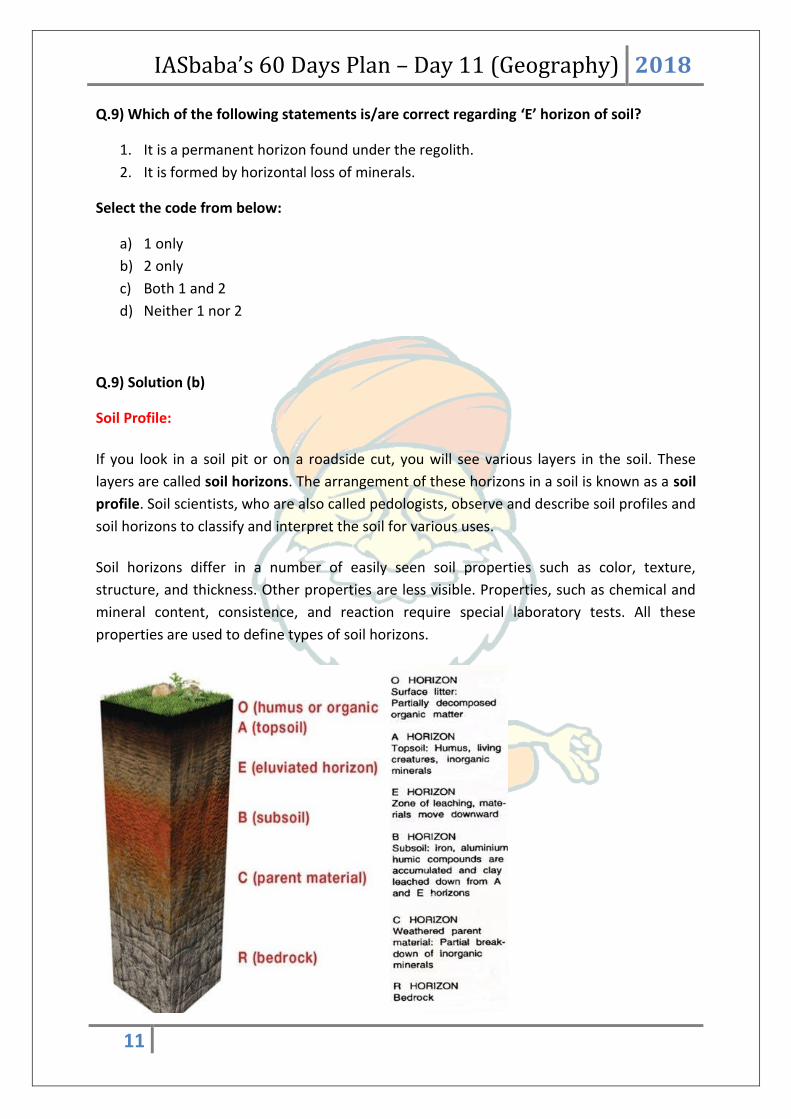
Q.9) Which of the following statements is/are correct regarding ‘E’ horizon of soil?
1. It is a permanent horizon found under the regolith.
2. It is formed by horizontal loss of minerals.
Select the code from below:
a) 1 only
b) 2 only
c) Both 1 and 2
d) Neither 1 nor 2
Q.9) Solution (b)
Soil Profile:
If you look in a soil pit or on a roadside cut, you will see various layers in the soil. These
layers are called soil horizons. The arrangement of these horizons in a soil is known as a soil
profile. Soil scientists, who are also called pedologists, observe and describe soil profiles and
soil horizons to classify and interpret the soil for various uses.
Soil horizons differ in a number of easily seen soil properties such as color, texture,
structure, and thickness. Other properties are less visible. Properties, such as chemical and
mineral content, consistence, and reaction require special laboratory tests. All these
properties are used to define types of soil horizons.
IASbaba’s 60 Days Plan – Day 11 (Geography) 2018
12
Soil scientists use the capital letters O, A, B, C, and E to identify the master horizons, and
lowercase letters for distinctions of these horizons. Most soils have three major horizons --
the surface horizon (A), the subsoil (B), and the substratum (C). Some soils have an organic
horizon (O) on the surface, but this horizon can also be buried. The master horizon, E, is
used for subsurface horizons that have a significant loss of minerals (eluviation). Hard
bedrock, which is not soil, uses the letter R.
Q.10) What is the correct sequence of the processes of soil erosion?
1. Splash erosion
2. Sheet erosion
3. Ril erosion
4. Gully erosion
Select the code from following:
a) 1 – 2 – 3 – 4
b) 2 – 3 – 4 – 1
c) 4 – 3 – 2 – 1
d) 3 – 4 – 1 – 2
Q.10) Solution (a)
Soil Erosion
Soil erosion refers to the removal of Top soil by an external agent.
Water erosion takes place in following states:
Splash erosion:
The impact of raindrops on the soil surface can break down soil aggregates and disperse the
aggregate material. Lighter aggregate materials such as very fine sand, silt, clay and organic
matter are easily removed by the raindrop splash and runoff water; greater raindrop energy
or runoff amounts are required to move larger sand and gravel particles.
Soil movement by rainfall (raindrop splash) is usually greatest and most noticeable during
short-duration, high-intensity thunderstorms.

IASbaba’s 60 Days Plan – Day 11 (Geography) 2018
13
Sheet Erosion
Sheet erosion is the movement of soil from raindrop splash and runoff water. It typically
occurs evenly over a uniform slope and goes unnoticed until most of the productive topsoil
has been lost. Deposition of the eroded soil occurs at the bottom of the slope or in low
areas.
Rill Erosion
Rill erosion results when surface water runoff concentrates, forming small yet well-defined
channels. These distinct channels where the soil has been washed away are called rills when
they are small enough to not interfere with field machinery operations. In many cases, rills
are filled in each year as part of tillage operations.
Gully Erosion
Gully erosion is an advanced stage of rill erosion where surface channels are eroded to the
point where they become a nuisance factor in normal tillage operations
Q.11) Soil structure refers to the way soil particles are grouped together into larger
masses called peds. Which of the following statements regarding soil structure is/are
correct?
1. It determines the workability of soil i.e. how easily it can be ploughed.
2. Peds are bound by soil colloids.
Select the code from below:
a) 1 only
b) 2 only
c) Both 1 and 2
d) Neither 1 nor 2
Q.11) Solution (c)
Soil Structure:

IASbaba’s 60 Days Plan – Day 11 (Geography) 2018
14
Soil Structure
It refers to the way soil particles are grouped together into larger masses called peds. These
are bound by soil colloids.
This defines the workability of the soil. i.e. How easily one can plough/turn it.
Q.12) Which of the following soils can be cut and directly used as a brick in construction?
a) Black soil
b) Alluvial Soil
c) Laterite Soil
d) Red Soil
Q.12) Solution (c)

IASbaba’s 60 Days Plan – Day 11 (Geography) 2018
15
Laterite soil is primarily found in the tropical regions which receive heavy seasonal rainfall.
High rainfall encourages the leaching of soil where lime and silica are leached away and a
soil rich in oxides of aluminium predominate and abundance laterite is called bauxite. Due
to the presence of iron oxides the colour of laterite soil is basically red. This soil is poor in
lime content and hence it is acidic. Laterite soils are found on the high level plateau and hilly
areas that receive high rainfall and are specifically well developed on the Eastern Ghats in
Orissa. It is also found in the southern regions of the Western Ghats including the adjoining
coastal regions in Ratnagiri District and Malabar.
Because of intense rainfall the soil becomes hard and can be directly cut into bricks.
Q.13) Consider the following statements regarding Coconut crop:
1. It is a tropical crop which can be grown only in sandy soil.
2. Coconut requires saline water to grow.
3. There are two major varieties of coconut – tall and dwarf.
Which of the above statements are NOT correct?
a) 1 and 2
b) 3 only
c) 1 and 3
d) None of the above
Q.13) Solution (a)
Coconut Palm
IASbaba’s 60 Days Plan – Day 11 (Geography) 2018
16
The coconut palm (Cocos nucifera linn.) is the most useful palm in the world. Every part of
the tree is useful to human life for some purpose or the other.
The copra obtained by drying the kernel of coconut is the richest source of vegetable oil
containing 65 to 70 per cent oil.
The coconut palm is found to grow under varying climatic and soil conditions. It is
essentially a tropical plant growing mostly between 20oN 20oS latitudes. However, a
rainfall of about 2000 mm per year, well distributed throughout, is ideal for proper
growth and maximum production.
Coconut is grown under different soil types such as loamy, laterite, coastal sandy,
alluvial, clayey and reclaimed soils of the marshy low lands. The ideal soil conditions for
better growth and performance of the palm are proper drainage, good water-holding
capacity, presence of water table within 3m and absence of rock or any hard substratum
within 2m of the surface.
Note: Coconut requires fresh water. In coastal areas it is dependent on underground fresh
water. And it is found above littoral zone.
There are only two distinct varieties of coconut, the tall and the dwarf.
The tall cultivars that are extensively grown are the West Coast Tall and East Coast
Tall. The dwarf variety is shorter in stature and its life span is short as compared to the
tall. Tall x Dwarf (TxD), Dwarf x Tall (DxT) are the two important hybrids.
Coconut is propagated through seedlings raised from selected seednuts. Generally 9 to 12
month old seedlings are used for planting. Select seedlings, which have 6-8 leaves and 10-12
cm collar girth when they are 9-12 month old. Early splitting of leaves is another criteria in
the selection of coconut seedling.
THINK!
Mangroves
Q.14) Consider the following about Laterite Soils:
1. These soils are found in hot and humid areas.
2. High temperature and heavy rainfall with alternate wet and dry periods are
important conditions for the formation of these soils.
3. These soils are rich in nutrients and fertile.
Which of the statements given above is/are correct?

IASbaba’s 60 Days Plan – Day 11 (Geography) 2018
17
a) 2 only
b) 2 and 3 only
c) 1 and 2 only
d) 1, 2 and 3
Q.14) Solution (c)
Laterite Soils are formed under conditions of high temperature and heavy rainfall with
alternate wet and dry periods (especially monsoonal regions).
Laterite soils are found in regions of very high rainfall. Due to rains the minerals get leached
to lower horizons. These soils are found in hot and humid areas.
Heavy rainfall promotes leaching (nutrients gets washed away by water) of soil whereby
lime and silica are leached away and a soil rich in oxides of iron and aluminium compounds
is left behind. They lack fertility due to intensive leaching. Hence, statement (3) is incorrect.
Q.15) Which among the following statements are true in regard to Arecanut in India?
1. It is one of the major plantation crops, well grown in clay loamy soils
2. India is the world’s largest producer of arecanut
3. Largely grown in the Western Ghats, Eastern Ghats and North Eastern region
4. Arecanut flourishes well in tracts with high rainfall and with a wide range of
temperature, from a minimum of 4°C to maximum of 40°C
Choose the appropriate code:
a) 3 and 4 only
b) 1, 2 and 3 only
c) 1, 3 and 4 only
d) All of the above
Q.15) Solution (d) Arecanut
India is the world’s largest producer of arecanut contributing nearly 74 % towards
world production.
Arecanuts/Betel Nuts are largely grown in the Western Ghats, Eastern Ghats and
North Eastern region.

IASbaba’s 60 Days Plan – Day 11 (Geography) 2018
18
Arecanut flourishes well in tracts with high rainfall and with a wide range of
temperature, from a minimum of 4°C to maximum of 40°C.
Arecanuts can grow and thrive best in well drained soils with good organic matter.
The largest area under the crop is found in gravelly laterite soils of red clay type. It
can also be grown on fertile clay loam soils. Sticky clay, sandy, alluvial, brackish and
calcareous soils are not suitable for arecanut cultivation.
Q.16) Thick deposits of glacial clay and other materials embedded with moraines, are
called as –
a) Kankars
b) Pats
c) Karewas
d) Regurs
Q.16) Solution (c)
Karewas are lacustrine deposits (deposits in lake) in the Valley of Kashmir and in Bhadarwah
Valley of the Jammu Division. These are the flat topped mounds that border the Kashmir
Valley on all sides. They are characterized with fossils of mammals and at places by peat.
Karewas are thick deposits of glacial clay and other material embedded with moraine. It is
found only in Kashmir region and very suitable for saffron cultivation.
Karewas were formed during the Pleistocene Period (1 million years ago), when the entire
Valley of Kashmir was under water. Due to the rise of Pirpanjal, the drainage was
impounded and a lake of about 5000 sq. km area was developed and thus a basin was
formed. Subsequently, the lake was drained through Bramulla gorge. The deposits left in the
process are known as karewas. The thickness of karewas is about 1400 m.
Q.17) Which of the statements given below is/are correct in regard to Jute, considered as
the golden fibre of India?
1. Jute cultivation requires a warm and humid climate with acidic to neutral soils.
2. Jute grows well on the new alluvial soils having higher silt content.
3. Jute cultivation is mainly concentrated in the eastern and north eastern India.
Choose the correct answer from the code given below:
a) 2 and 3 only
b) 1 and 2 only
c) 1 and 3 only
IASbaba’s 60 Days Plan – Day 11 (Geography) 2018
19
d) 1, 2 and 3
Q.17) Solution (d)
Jute is considered as the golden fibre of India. It is the commercially available natural fibre
which is utilized mostly as packaging material, nowadays facing a steep competition from
cheap synthetics in packaging sector. Besides the traditional packaging sector, jute has been
used in both textile and non-textile sectors in large and small industries.
Jute is eco-friendly, biodegradable and has much higher CO2 assimilation rate which is
creating an opportunity for the survival and growth of jute industry in the era of
environmental concern. Global production of jute and allied fibres is around 3.0 million
tonnes, 92.5% of which comes from India and Bangladesh alone. India ranks first in area and
production of jute followed by Bangladesh and earns approximately Rs. 1400 crores/annum
through export of jute goods mainly Jute diversified products (JDPs).
Climatic requirement and soil
Jute requires a warm and humid climate and can be grown within a temperature range of 24
to 37oC and a relative humidity of 57 to 97%. Jute crop thrives well with alternate rains and
sunshine. The crop can grown in both moisture stress and water stagnating condition.
The amount of rainfall and its distribution have marked effects on the growth of crop and
ultimately yield of fibre. In the ideal situation, 120-150 mm pre monsoon rain followed by a
dry period of 30-40 days and 1200 to 1500 mm of precipitation over last 75-80 days is
considered to be the most ambient condition for growth of jute crop.
Jute grows well on the new alluvial soils having higher silt content but can also grow on
various other types of soil. In India, it is grown in mainly colluviums, red and lateritic,
calcareous soils. Acidic to neutral soils are suitable for jute cultivation. Jute cultivation is
mainly concentrated in the eastern and north eastern India.
Q.18) Consider the below statements:
1. Peaty – Marshy Soils are soils with large amount of organic matter and considerable
amount of soluble salts.
2. The most humid regions have this type of soil.
3. Since they are not acidic, this type of soil is good for paddy cultivation.
Which of the statements given above are correct?
IASbaba’s 60 Days Plan – Day 11 (Geography) 2018
20
a) 1 and 2 only
b) 1 and 3 only
c) 2 and 3 only
d) 1, 2 and 3 only
Q.18) Solution (a)
Peaty – Marshy Soils are soils with large amount of organic matter and considerable amount
of soluble salts. The most humid regions have this type of soil. They are black, heavy and
highly acidic. Hence statement (3) is incorrect. They are deficient in potash and phosphate.
Most of the peaty soils are under water during the rainy season but as soon the rains cease,
they are put under paddy cultivation.
Q.19) Consider the following statements:
1. The soils are covered with a thick brown mantle which inhibits soil growth.
2. They are coarse and alkaline, rich in soluble salts.
3. They are poor in organic matter and have a varying percentage of lime.
4. These soils are derived from the adjoining rocks and the coastal regions.
Which of the soil possess the above characteristics?
a) Laterite soil
b) Peaty soil
c) Desert soil
d) Loamy soils
Q.19) Solution (c)
Desert soils posses all the characteristics provided in the statements. Hence (c) is correct
answer.
Desert soils are grey in colour in temperate region and red in hot deserts of the tropics. The
soils are unleached and alkaline but very much lacking in humus because of little vegetation
found.
Q.20) In which of the following areas ravines are present in India?
1. Along the banks of Narmada
2. Along the foothills of Shivalik

IASbaba’s 60 Days Plan – Day 11 (Geography) 2018
21
3. Chambal
4. Chota Nagpur region
Select the correct code:
a) 1, 2 and 3 only
b) 2, 3 and 4 only
c) 1, 3 and 4 only
d) 1, 2, 3 and 4
Q.20) Solution (d)
A ravine is generally a fluvial slope landform of relatively steep (cross-sectional) sides, on
the order of twenty to seventy percent in gradient.
Ravines may or may not have active streams flowing along the downslope channel which
originally formed them; moreover, often they are characterized by intermittent streams,
since their geographic scale may not be sufficiently large to support a perennial
watercourse. A ravine is a deep valley which is formed due to linear/dendritic fluvial erosion
of loose unconsolidated and bare soils byes.
In all the given areas - along the banks of Narmada and foothills of Shivalik, Chambal and
Chota Nagpur region – Ravines are found.
Q.21) ‘Dree Festival’ is concerned with which of the following tribes?
a) Nyishi
b) Apatanis
c) Shompen
d) Onge
Q.21) Solution (b)
The Apatani tribe, which is located in a small Ziro valley town in Arunachal Pradesh,
celebrates the three-day Dree Festival in July every year for good harvest season.
The Apatani tribe is known for their colourful culture, festivals, intricate handloom designs,
skills in cane, bamboo crafts, and vibrant traditional village councils called bulyañ. The
Apatani tribe is located in Arunachal Pradesh's small town named Ziro valley.

IASbaba’s 60 Days Plan – Day 11 (Geography) 2018
22
The tribe practices their own religion, which is known as Donyi-Polo. They pray to the Sun
(Donyi) and the Moon (Polo).
The tribe has four major festivals namely Dree, Yapung, Myoko and Murung. While Dree
festival is celebrated in July, Yapung is celebrated in September or October, Myoko is
celebrated in March and Murung is celebrated in January.
These festivals are celebrated to ensure better cultivation, protection of the grains from
hailstone, storms, insects and wild animals.
Q.22) Which of the following countries is/are partners of the ‘Equator Initiative’
1. Sweden
2. Norway
3. Finland
Select the correct statements
a) 1 and 2
b) 2 and 3
c) 1 and 3
d) All of the above
Q.22) Solution (a)
Partners of the Equator Initiative include the governments of Germany, Norway, and
Sweden, as well as Conservation International, the Convention on Biological Diversity,
EcoAgriculture Partners, Fordham University, the International Union for Conservation of
Nature, The Nature Conservancy, PCI Media Impact, Rainforest Foundation Norway, Rare,
UN Environment, UNDP, UN Foundation, USAID, and the Wildlife Conservation Society.
Read More - https://www.equatorinitiative.org/about/partners/
The Equator Prize, organized by the Equator Initiative within the United Nations
Development Programme, is awarded biennially to recognize outstanding community
efforts to reduce poverty through the conservation and sustainable use of biodiversity.
The Equator Prize recognizes innovative community initiatives that promote nature-based
solutions for local sustainable development.
Swayam Shikshan Prayog (SSP), a Pune-based NGO, has won the 2017 United Nations
Development Programme (UNDP)’s Equator Prize for its women led climate resilient agro-

IASbaba’s 60 Days Plan – Day 11 (Geography) 2018
23
ecological farming model and innovative solutions in climate resilient farming in the
Marathwada region of India.
Source: http://www.thehindu.com/news/national/other-states/pune-ngo-wins-un-prize-
for-sustainable-farming-model/article19205990.ece
Q.23) Consider the following statements about ‘World Petroleum Congress’
1. It is organised by Organization of the Petroleum Exporting Countries
2. It is to be held every three years
3. The inaugural World Petroleum Congress was held in United Arab Emirates in 2017
Select the correct statements
a) 1 Only
b) 1 and 2
c) 2 and 3
d) Only 2
Q.23) Solution (d)
The World Petroleum Council (WPC) is an oil and gas industry forum and international
organization representing the petroleum sector worldwide.
WPC has been called "the world’s premier oil & gas forum since 1933." It is widely
recognised to "include the most prestigious national oil and gas companies and agencies of
the world".
The premier conference that is organized by the World Petroleum Council is called the
World Petroleum Congress. Starting in 1933, the congress was held every four years until
1991, with a 14-year hiatus in between 1937 and 1951 because of World War II. After 1991,
it was held every three years until the year 2000. There was a move to have it hosted every
two years after the 2000 edition, with Rio de Janeiro hosting one in 2002, but the cycle
returned to every three years after that. In order to host a congress, there is a bidding
process by interested cities for one in a particular year.
22nd WPC (2017) – Istanbul
23rd WPC (2018) – Houston
Source: http://pib.nic.in/newsite/PrintRelease.aspx?relid=167253
IASbaba’s 60 Days Plan – Day 11 (Geography) 2018
24
Q.24) Consider the following statements about ‘Saola’
1. It is native to CLMV countries
2. World's first centre for breeding Saola is being constructed in Vietnam
Select the correct statements
a) 1 Only
b) 2 Only
c) Both 1 and 2
d) Neither 1 nor 2
Q.24) Solution (b)
The world's first centre for breeding Saola, a critically endangered hoofed mammal, is being
constructed in Vietnam's central region.
Saola is recognised by two parallel horns with sharp ends, which can reach 51 centimetres in
length and are found on both males and females.
Meaning "spindle horns" in Vietnamese, Saola is a cousin of cattle but resembles an
antelope.
This species occurs only in the Annamite Mountains region of Laos and Vietnam.
Source: http://www.business-standard.com/article/news-ians/world-s-1st-saola-
breeding-centre-in-vietnam-117071100340_1.html
Q.25) ‘Technology and Innovation Support Centres’ is often seen in news. It is associated
with which of the following?
a) World Intellectual Property Organization
b) World Trade Organization
c) World Economic Forum
d) World Bank
Q.25) Solution (a)
WIPO's TISC programme provides innovators in developing countries with access to locally
based, high-quality technology information and related services, helping them to exploit
their innovative potential and to create, protect and manage their IPRs.

IASbaba’s 60 Days Plan – Day 11 (Geography) 2018
25
Services offered by TISCs include access to online patent and non-patent (scientific and
technical) resources and IP-related publications, assistance in searching and retrieving
technology information, training in database search, on-demand searches (novelty, state of
the art and infringement), monitoring technology and competitors, basic information on
industrial property laws, management and strategy and technology commercialisation and
marketing.
The Cell for IPR Promotion and Management (CIPAM) is designated as the National Focal
Point for the TISC national network. As the national focal point, CIPAM shall identify
potential host institutions, assess their capacities and support them in joining the TISC
programme.
Source: http://www.business-standard.com/article/news-ians/dipp-to-set-up-india-s-
first-innovation-support-centre-in-punjab-117071300872_1.html