
Mobile Tower Radiation Health and Hazards -Gobar Times -Magzine
Upload
trinhxuyenCategory
view
213download
0
IASbaba’s 60 Days Plan – Day 10 (Geography) 2018
1
Q.1) Consider the following statements.
1. The western cyclonic disturbances are weather phenomena of the winter months
brought in by the easterly flow from the Mediterranean region.
2. Western cyclonic disturbances usually influence the weather of the north and north
western regions of India.
3. Tropical cyclones occur during the monsoon as well as in October-November and are
part of the westerly flow.
4. Tropical cyclones disturbances affect the coastal regions of the country.
Which of the above statements is/are correct?
a) 2 and 4 only
b) 1, 2 and 3 only
c) 1 and 3 only
d) All the above
Q.1) Solution (a)
The western cyclonic disturbances are weather phenomena of the winter months brought in
by the westerly flow from the Mediterranean region. They usually influence the weather of
the north and north-western regions of India. Tropical cyclones occur during the monsoon
as well as in October -November and are part of the easterly flow. These disturbances
affect the coastal regions of the country.
Do you know?
An easterly jet stream, called the sub-tropical easterly Jetstream blows over
peninsular India, approximately over 14°N during the summer months.
THINK!
Subtropical westerly jet.
Q.2) Consider the following statements about Cold Weather Season (winter):
1. During this season, the northeast trade winds prevail over the country.
2. The weather is normally marked by clear sky, low temperatures and low humidity.
Choose the correct answer using the codes given below.
a) 1 only
b) 2 only
c) Both 1 and 2

IASbaba’s 60 Days Plan – Day 10 (Geography) 2018
2
d) None of the above
Q.2) Solution (c)
The cold weather season begins from mid-November in northern India and stays till
February. December and January are the coldest months in the northern part of India. The
temperature decreases from south to the north. Days are warm, and nights are cold. Frost
is common in the north and the higher slopes of the Himalayas experience snowfall.
During this season, the northeast trade winds prevail over the country. They blow from
land to sea and hence, for most part of the country, it is a dry season. Some amount of
rainfall occurs on the Tamil Nadu coast from these winds as, here they blow from sea to
land. (In northwestern India, some weak temperate cyclones from the Mediterranean Sea
cause rainfall in Punjab, Haryana, Delhi and western Uttar Pradesh.)
In the northern part of the country, a feeble high-pressure region develops, with light winds
moving outwards from this area. Influenced by the relief, these winds blow through the
Ganga
valley from the west and the northwest. The weather is normally marked by clear sky, low
temperatures and low humidity.
Do you know?
The peninsular region does not have a well-defined cold season. There is hardly any
noticeable seasonal change in temperature pattern during winters due to the
moderating influence of the sea.
THINK!
Hot weather season.
Q.3) Which of the following is/are the implications of the shift of monsoon trough closer
to Himalayas?
1. There are longer dry spells in the plains.
2. The situation of drought establishes in the plains.
3. Widespread rain occurs in the mountainous catchment areas of the Himalayan
rivers.
Choose the correct answer using the codes given below.
a) 1 and 3 only
b) 1 and 2 only
c) 1 only

IASbaba’s 60 Days Plan – Day 10 (Geography) 2018
3
d) All the above
Q.3) Solution (a)
The Unique phenomenon associated with the monsoon is its tendency to have ‘breaks’ in
rainfall. Thus, it has wet and dry spells. In other words, the monsoon rains take place only
for a few days at a time. They are interspersed with rainless intervals. These breaks in
monsoon are related to the movement of the monsoon trough. For various reasons, the
trough and its axis keep on moving northward or southward, which determines the spatial
distribution of rainfall. When the axis of the monsoon trough lies over the plains, rainfall is
good in these parts. On the other hand, whenever the axis shifts closer to the Himalayas
there are longer dry spells in the plains, and widespread rain occur in the mountainous
catchment areas of the Himalayan rivers. These heavy rains bring in their wake, devastating
floods causing damage to life and property in the plains.
Do you know?
The frequency and intensity of tropical depressions too, determine the amount and
duration of monsoon rains.
THINK!
October Heat.
Q.4) Consider the Climatic Regions of India According to Koeppen’s Scheme.
Type of climate Areas
1. Amw- Monsoon with short dry
season
Most of the Peninsular plateaus, south of
the Tropic of Cancer
2. Aw – Tropical savannah West coast of India south of Goa
3. Dfc – Cold humid winter with short
summer
Arunachal Pradesh
4. Bwhw – Semi-arid steppe climate North-western Gujarat, some parts of
western Rajasthan and Punjab
Which of the above pairs is/are correctly matched?
a) 1 and 2 only
b) 1 and 3 only
c) 3 and 4 only

IASbaba’s 60 Days Plan – Day 10 (Geography) 2018
4
d) All the above
Q.4) Solution (c)
Climatic Regions of India According to Koeppen’s Scheme
Type of Climate
Areas
Amw- Monsoon with short dry season
West coast of India south of Goa
As – Monsoon with dry summer
Coromandel coast of Tamil Nadu
Aw – Tropical savannah
Most of the Peninsular plateaus, south of
the Tropic of Cancer
Bwhw – Semi-arid steppe climate
North-western Gujarat, some parts of
western Rajasthan and Punjab
Bwhw – Hot desert
Extreme western Rajasthan
Cwg – Monsoon with dry winter
Ganga plain, eastern Rajasthan, northern
Madhya Pradesh, most of North-east India
Dfc – Cold humid winter with short summer
Arunachal Pradesh
E – Polar type
Jammu and Kashmir, Himachal Pradesh and
Uttaranchal
Do you know?
Except Himalayas all the parts of the country have temperature above the threshold
level to grow the crops or plants throughout the year.
THINK!
Annual rainfall variability of India.

IASbaba’s 60 Days Plan – Day 10 (Geography) 2018
5
Q.5) Consider the following about statements about ‘Coal’ found in India.
1. The coal blocks found in northeastern India are much older than that found in
Damodar valley (West Bengal-Jharkhand), Jharia, Raniganj, Bokaro.
2. The coal blocks found in Damodar valley (West Bengal-Jharkhand), Jharia, Raniganj,
Bokaro are much superior in quality than the coal found in northeastern India.
Which of the above statement is/are correct?
a) 1 only
b) 2 only
c) Both 1 and 2
d) None
Q.5) Solution (b)
In India coal occurs in rock series of two main geological ages, namely Gondwana, a little
over 200 million years in age and in tertiary deposits which are only about 55 million years
old. Gondwana (200 million years old) coal forms India’s metallurgical grade as well as
superior quality coal.
The major resources of Gondwana coal, which are metallurgical coal, are located in
Damodar valley (West Bengal-Jharkhand). Jharia, Raniganj, Bokaro are important coalfields.
The Godavari, Mahanadi, Son and Wardha valleys also contain coal deposits.
Tertiary coal 55 million years old. Carbon content is very low. Coal generally has low
carbon and high percentage of moisture and Sulphur. [It takes few hundred million years for
the carbon content to improve]
Tertiary coals occur in the north eastern states of Meghalaya, Assam, Arunachal Pradesh
and Nagaland.
Do you know?
First coal mine was opened in 1774 at Raniganj in West Bengal. India is now the third
largest coal producer in the world after China and the USA.
THINK!
Privatization of coal mining.
Q.6) Consider the following statements
1. Dolomite, mica and gypsum are some of minor minerals as per Mines and Minerals
(Development and Regulation) Act, 1957 (MMDR Act 1957).

IASbaba’s 60 Days Plan – Day 10 (Geography) 2018
6
2. Major minerals are those minerals which are defined in Mines and Minerals
(Development and Regulation) Act, 1957 (MMDR Act 1957).
Which of the above statement is/are correct?
a) 1 only
b) 2 only
c) Both 1 and 2
d) None
Q.6) Solution (a)
In India, the minerals are classified as minor minerals and major minerals.
According to section 3(e) of the Mines and Minerals (Development and Regulation) Act,
1957 “Minor Minerals” means building stones, gravel, ordinary clay, ordinary sand other
than sand used for prescribed purposes, and any other mineral which the Central
Government may, by notification in the Official Gazette, declare to be a minor mineral. (For
the purposes of this Act, the word "minerals” includes all minerals except mineral oils-
natural gas and petroleum).
Major minerals are those specified in the first schedule appended in the Mines and
Minerals (Development and Regulation) Act, 1957 (MMDR Act 1957) and the common
major minerals are Lignite, Coal, Uranium, iron ore, gold etc. It may be noted that there is
no official definition for “major minerals” in the MMDR Act. Hence, whatever is not
declared as a “minor mineral” may be treated as the major mineral.
Ministry of Mines, on 10 February 2015, notified 31 additional minerals, hitherto under the
list of major minerals, as minor minerals. These 31 minerals account for over 55% of the
total number of leases and nearly 60% of total leased area. This was done with the
intention to “devolve more power to the States, and consequently, expedite the process of
mineral development in the country”. The 31 additional minerals notified as minor minerals
are:
Agate; Ball Clay; Barytes; Calcareous Sand; Calcite; Chalk; China Clay; Clay (Others);
Corundum; Diaspore; Dolomite; Dunite/pyroxenite; Felsite; Felspar; Fireclay; Fuschite
Quartzite; Gypsum; Jasper; Kaolin; Laterite; Limekankar; Mica; Ochre; Pyrophyllite; Quartz;
Quartzite; Sand (Others); Shale; Silica Sand; Slate; Steatite/Talc/Soapstone.
Do you know?
The power to frame policy and legislation relating to minor minerals is entirely
delegated to the State Governments while policy and legislation relating to the

IASbaba’s 60 Days Plan – Day 10 (Geography) 2018
7
major minerals are dealt by the Ministry of Mines under Union /Central
Government.
THINK!
District Mineral foundation.
Q.7) Arrange the following in increasing order of their petroleum production.
1. Mumbai High
2. Gujarat
3. Assam
Choose the correct answer using the codes given below.
a) 3-2-1
b) 3-1-2
c) 2-1-3
d) 1-2-3
Q.7) Solution (a)
About 63 per cent of India’s petroleum production is from Mumbai High, 18 per cent
from Gujarat and 16 per cent from Assam. Ankeleshwar is the most important field of
Gujarat. Assam is the oldest oil producing state of India. Digboi, Naharkatiya and Moran-
Hugrijan are the important oil fields in the state.
Do you know?
The plants using cattle dung are known as ‘Gobar gas plants’ in rural India. These
provide twin benefits to the farmer in the form of energy and improved quality of
manure.
THINK!
Tidal energy.
Geothermal energy.
Q.8) India’s third stage Nuclear Program will use Thorium – Uranium cycle. Which of the
following statements is/are correct regarding availability of Thorium in India?
1. Thorium is found in Monazite ore.
2. The largest quantity of Thorium in India ore is found in Kerala.

IASbaba’s 60 Days Plan – Day 10 (Geography) 2018
8
3. Thorium is not found on the East Coast of India.
Select the code from following:
a) 1 only
b) 2 and 3
c) 1 and 2
d) All of the above
Q.8) Solution (a)
Thorium
India has reserves of thorium in sufficient quantity as compared to other parts of world.
The Atomic Minerals Directorate for Exploration and Research (AMD), a constituent unit of
Department of Atomic Energy (DAE), has so far established 11.93 million tonnes of in situ
resources Monazite (Thorium bearing mineral) in the country, which contains about 1.07
million tonnes of thorium. The state-wise resources of in situ monazite established by AMD
as of September 2014 are as follows:
State Monazite
(Million tonnes)
Odisha 2.41
Andhra Pradesh 3.72
Tamil Nadu 2.46
Kerala 1.90
West Bengal 1.22
Jharkhand 0.22
Total 11.93
Do you know?
Uranium and Thorium have got distinctive characteristics governing their utilisation in
nuclear reactors. Unlike uranium, thorium alone cannot be directly used as nuclear fuel in a
reactor. Utilisation of Thorium with either uranium or plutonium, without going through
the second stage of Fast Breeder Reactors, to build sufficient inventory of plutonium first,
will be counter-productive by limiting thorium utilisation to a very small fraction of the total
available resources in the country. Utilisation of Thorium in the third stage makes it
available as a sustainable energy resource for centuries. With this mode of utilisation,

IASbaba’s 60 Days Plan – Day 10 (Geography) 2018
9
Thorium offers not only a sustainable energy resource, but also excellent fuel performance
characteristic in a reactor, better than Uranium with respect to lower inventory of long lived
nuclear waste.
THINK!
Three stage nuclear program of India
Q.9) Consider the following statements:
1. Anthracite is the purest and metamorphosed form of Coal.
2. It is found only in Jammu and Kashmir in India.
3. Generally it is used in Iron and steel plants and thermal power plants.
Which of the above statements are correct?
a) 1 and 2
b) 2 and 3
c) 1 and 3
d) All of the above
Q.9) Solution (a)
Anthracite Coal
This is the best quality of coal and contains over 85 per cent carbon. It is very hard, compact,
jet black coal having semi-metallic luster.
Anthracite coal ignites slowly and burns with a nice short blue flame. In India, it is found
only in Jammu and Kashmir and that too in small quantity.
Do you know?
Depending upon its grade from highest to lowest following, The coal found in India can be
classified as Anthracite Coal, Bituminous Coal, Lignite (Brown Coal) and Peat.
Bituminous Coal
This is the most widely used coal and contains 50 to 85 per cent carbon. It is dense,
compact, and brittle and is usually of black colour.
A good bituminous coal is composed of alternate dull and bright bands. Its calorific value is
very high due to high proportion of carbon and low moisture content. Most of the

IASbaba’s 60 Days Plan – Day 10 (Geography) 2018
10
bituminous coal is found in Jharkhand, Orissa, West Bengal, Chattisgarh and Madhya
Pradesh.
Bituminous is generally used for industrial purposes.
Q.10) Consider the following statements about Easterly jet streams:
1. They are formed over Indian Subcontinent during winter.
2. They are thermally formed.
3. They are helpful in pushing South East monsoon branch over India.
Which of the above statements are correct?
a) 1 and 2
b) 2 and 3
c) 1 and 3
d) All of the above
Q.10) Solution (b)
Jet Streams:
Jet streams are high speed winds that occur in narrow bands of upper air westerlies. The
width of this air band can be 160-480km wide and 900-2150m thick, with core speed
exceeding 300km/hr. such is their strength that aircraft routes which run counter to jet
movements are generally avoided. Jets are coincident with major breaks in the tropopause.
Jet streams can be classified as follows:
1) Polar front jet stream: this is a thermally induced jet stream and it flows parallel to
surface fronts. They flows west to east in a sinusoidal fashion. It is strongest at 200-
300mb level and swings between 40o-60o latitude. It is found in both the
hemispheres. Its band is non continuous but flows all round the year. It can reach up
to 160-200 km/hr.
2) Tropical westerly jet streams: they also flow all round the year. They flow to
conserve the angular momentum in upper atmosphere. They are found at the
poleward limit of Hadley cell around 30oN and S latitude. It follows a more fixed
pattern than polar jet stream. It is strongest on Indian sub continent. The maximum
speed can reach upto 300km/hr. the subtropical westerly jet do not seem to affect
surface weather as much as the polar fronts jets do.
IASbaba’s 60 Days Plan – Day 10 (Geography) 2018
11
3) Tropical easterly jet: they are seasonal jet streams flowing east to west. These are
only found in northern hemisphere and generates only in summer season. These are
also thermally induced.
THINK!
Indian Monsoon
Q.11) Which of the following is/ are responsible to cause winter rainfall in South Eastern
coast of India?
1. Westerlies
2. Retreating monsoon
3. South west Monsoon
4. Tropical Cyclone
Select the code from following:
a) 1 and 2
b) 2 only
c) 1 only
d) 2,3 and 4
Q.11) Solution (b)
Note: The question is specifically asking about Tamil Nadu coast.
There are two phenomenon responsible for winter rainfall in India – Western Disturbances
and Retreating monsoon.
Westerlies – these are a branch of Temperate cyclone forming over East Atlatic during
winter. These winds capture moisture from Mediterranean sea and cause rainfall in Punjab,
Haryana and western UP.
Retreating Monson – As ITCZ shifts towards south in the winter season, the monsoon starts
retreating. Retreating monsoon winds capture some moisture from Bay of Bengal and cause
rainfall on Tamil Nadu coast.
Q.12) Which of the following statements is/are correct regarding Madden Julian
Oscillation?

IASbaba’s 60 Days Plan – Day 10 (Geography) 2018
12
1. It is an eastward moving disturbance of clouds, rainfall and changing pressure which
encircles the tropical area.
2. It has two phases of enhanced rainfall and suppressed rainfall.
Select the code from below:
a) 1 only
b) 2 only
c) Both 1 and 2
d) Neither 1 nor 2
Q.12) Solution (c)
Madden-Julian Oscillation
While the MJO is a lesser-known phenomenon, it can have dramatic impacts in the mid-
latitudes.
Unlike ENSO, which is stationary, the MJO is an eastward moving disturbance of clouds,
rainfall, winds, and pressure that traverses the planet in the tropics and returns to its initial
starting point in 30 to 60 days, on average. This atmospheric disturbance is distinct from
ENSO, which once established, is associated with persistent features that last several
seasons or longer over the Pacific Ocean basin. There can be multiple MJO events within a
season, and so the MJO is best described as intraseasonal tropical climate variability (i.e.
varies on a week-to-week basis).
The MJO consists of two parts, or phases: one is the enhanced rainfall (or convective) phase
and the other is the suppressed rainfall phase. Strong MJO activity often dissects the planet
into halves: one half within the enhanced convective phase and the other half in the
suppressed convective phase. These two phases produce opposite changes in clouds and
rainfall and this entire dipole (i.e., having two main opposing centers of action) propagates
eastward. The location of the convective phases are often grouped into geographically
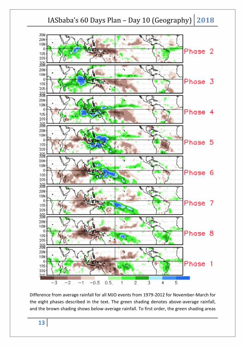
based stages that climate scientists number 1-8 as shown in Figure below.
IASbaba’s 60 Days Plan – Day 10 (Geography) 2018
13
Difference from average rainfall for all MJO events from 1979-2012 for November-March for
the eight phases described in the text. The green shading denotes above-average rainfall,
and the brown shading shows below-average rainfall. To first order, the green shading areas

IASbaba’s 60 Days Plan – Day 10 (Geography) 2018
14
correspond to the extent of the enhanced convective phase of the MJO and the brown
shading areas correspond to the extent of the suppressed convective phase of the MJO.
Note eastward shifting of shaded areas with each successive numbered phase as you view
the figure from top to bottom.
Q.13) Which of the following phenomenon is responsible for excessive pollution and smog
in Delhi in winters?
a) Loo
b) Low pressure over Delhi
c) Temperature inversion
d) Monsoon winds
Q.13) Solution (c)
Temperature Inversion:
Usually as we move up in troposphere from the surface, the temperature decreases with
increase in altitude. But sometimes due to local conditions, the temperature, instead of
decreasing, increases with height. This phenomenon is called temperature inversion. This is
also known as negative lapse rate. The different types of inversions may be classified as –
Fig: graphs comparing normal condition and condition of temperature inversion.
1) Low level or ground surface inversion: this is the condition where temperature near the
ground increases, rather than decreasing with elevation. This type of inversion occurs
generally in tropical and sub- tropical regions during the period of long winter nights.
IASbaba’s 60 Days Plan – Day 10 (Geography) 2018
15
This inversion however, disappears with sunrise. The duration and height of surface
inversion increases pole wards. Following conditions are required for ground surface
inversion:
Long winter nights
Cloudless calm skies
Dry air and low relative humidity
Calm atmosphere or slow movement of air
Snow covered surface
2) Upper air inversion: it occurs when the warm air is transported upwards into the cold air
due to eddies. It may be caused due to compression of the descending air as it happens
in the case of subtropical high pressure belts.
3) Frontal inversion: it is caused by horizontal and vertical movement of air. The temperate
cyclones are formed by convergence of warm westerlies and cold polar air, and thus the
warm air overlies the cold air. The presence of warm air above and cold air below
reverses the normal lapse rate and inversion of temperature occurs.
Social relevance of temperature inversion:
The inversion of temperature and its duration affects adversely the society and economy of
the region of its occurrence. Some of the important consequences of temperature inversion
are-
1) Occurance of fog: there develops clouds in contact with the ground(fog) with visibility
usually restricted less than 1km. in the urban areas, the fog mixed with smoke takes the
shape of smog. While fog is injurious to crops, the smog is considered as a health hazard.
In 1952, about 4000 people died of smog in London. Breathing problems, asthma and
bronchitis etc are common problem in Delhi and big cities of the northern india during
the winter season.
2) Road accidents: the frequency of road, railways and air accidents increases during foggy
conditions due to low visibility. The trains and flights are often delayed.
3) Damage of crops: the winter crops like wheat, barley, mustard, vegetables, chilies,
potato etc are seriously damaged. The sugarcane crop in the northern plains of India.
Especially in UP, Punjab and Haryana develops the disease of red rod which reduces the
sugar content.
4) Vegetation: Orchards are closely influenced by the inversion of temperature. The lower
valleys of alps mountains are almost without settlements, while the upper slopes are
inhabited.
Q.14) Which of the following mines are NOT correctly matched with the mineral?

IASbaba’s 60 Days Plan – Day 10 (Geography) 2018
16
1. Khetri – Zinc
2. Zawar – Copper
3. Kudremukh – Aluminium
4. Hazaribagh – Mica
Select the code from below:
a) 1,2 and 3
b) 3 and 4
c) 1,2 and 4
d) 4 only
Q.14) Solution (a)
Note: Incorrect options have been asked.
India is the largest producer of Mica in the world. The biggest mine of mica in India is at
Hazaribagh
Khetri mine – Copper
Zawar Mine – Zinc
Kudremukh – Iron
THINK!
Locations of mineral should be practiced by marking them on a map of India.
Q.15) Which among the following statements is true with regard to monsoons?
1. Southwest monsoon brings rain during summer whereas Northeast monsoon brings
rain during winter.
2. During Southwest monsoon, Indian Subcontinent has high pressure and the direction
of air movement is from Australia to Indian subcontinent.
3. Direction of Northeast monsoon is land to sea so it doesn’t contains moisture and
brings dryness and coldness after blowing through Bay of Bengal and brings rainfall
only in Tamil Nadu.
Choose the appropriate code:
a) 1 only
b) 2 only

IASbaba’s 60 Days Plan – Day 10 (Geography) 2018
17
c) 2 and 3 only
d) 1 and 2 only
Q.15) Solution (a)
During Southwest monsoon, Indian Subcontinent has low pressure and the direction of air
movement is from Australia(high) to Indian subcontinent(low)
Third statement is wrong as Northeast monsoon also brings rainfall in Andhra Pradesh,
Puducherry apart from Tamil Nadu.
Q.16) Consider the following statements in regard to Aluminium:
1. Aluminium production starts with the raw material bauxite.
2. Three different raw materials are needed to make aluminium - aluminium oxide,
electricity and carbon.
3. Aluminium is known for its ductile nature and can be recycled over and over again
with 100 percent efficiency.
Which of the statements given above is/are correct?
a) 2 and 3 only
b) 1 and 3 only
c) 1 and 2 only
d) 1, 2 and 3
IASbaba’s 60 Days Plan – Day 10 (Geography) 2018
18
Q.16) Solution (d)
Aluminium production starts with the raw material bauxite, a clay like soil type found in a
belt around the equator.
Alumina is separated from the bauxite by using a hot solution of caustic soda and lime.
Three different raw materials are needed to make aluminium, they are – aluminium oxide,
electricity and carbon.
Aluminium is known for its ductile nature and can be recycled over and over again with 100
percent efficiency.
Q.17) Consider the following statements:
1. Peneplains are associated with humid conditions, whereas Pediplains are associated
with arid and semi-arid conditions
2. Dissected plateaux are associated with humid areas, whereas Mesas and Buttas are
associated with arid areas
Which of the statements given above is/are correct?
a) 1 only
b) 2 only
c) Both 1 and 2
d) Neither 1 nor 2
Q.17) Solution (c) Both the statements are correct.
Peneplains are associated with humid conditions, whereas Pediplains are associated with
arid and semi-arid conditions.
Dissected plateaux are associated with humid areas, whereas Mesas and Buttas are
associated with arid areas.

IASbaba’s 60 Days Plan – Day 10 (Geography) 2018
19
Q.18) Sikkim and Darjeeling Himalayas are best suitable for tea plantations due to –
1. Moderate slope
2. Thick soil cover with high organic content
3. Well distributed rainfall throughout the year
4. Mild winters
Choose the correct answer from the code given below:
a) 1 and 3 only
b) 2 and 4 only
c) 2, 3 and 4 only
d) 1, 2, 3 and 4
Q.18) Solution (d)
Sikkim and Darjeeling Himalayas physical conditions such as moderate slope, thick soil cover
with high organic content, well distributed rainfall throughout the year and mild winters
makes it very much suitable for tea plantations. The British took advantage of these physical
conditions and introduced tea plantations.
Q.19) Consider the following statements about Mica:
1. India secures the world’s top position both in reserve and production of mica.
2. It is found only in igneous and metamorphic regions.
3. It is chemically inert, stable and does not absorb water.
Which of the statements given above is/are correct?
a) 2 and 3 only
b) 1 and 2 only
c) 1 and 3 only
d) 1, 2 and 3

IASbaba’s 60 Days Plan – Day 10 (Geography) 2018
20
Q.19) Solution (c)
Mica is widely distributed and occurs in igneous, metamorphic and sedimentary regimes.
India secures the world’s top position both in reserve and production of mica.
It has a unique combination of elasticity, toughness, flexibility and transparency. It
possesses resistance to heat and sudden change in temperature and high dielectric
strength. It is chemically inert, stable and does not absorb water.
For over hundred years, India has enjoyed the monopoly in the production and export of
sheet mica in the world. Of late, there has been a steady downfall in the production of mica.
This declining trend could be attributed to fall in the demand of natural mica in the world
market due to technological improvements that facilitate use of reconstituted mica and
emergence of mica substitutes. However, there are sufficient resources in the country to
meet the domestic requirement and export demand.
Andhra Pradesh leads with 41% share in country's total resources followed by Rajasthan
(21%), Odisha (20%), Maharashtra (15%), Bihar (2%) and the remaining 1% is in Jharkhand
and Telangana together.
Q.20) Consider the below statements:
1. It does not occur free in nature and is found in association with copper, uranium and
other metals.
2. It is used as an important alloying material and when alloyed with iron, rust proof
stainless steel of superior quality is obtained.
3. It is used for manufacturing armoured plates, bullet jackets and in naval
construction.
Identify the correct mineral resource from below which has the above characteristics:
a) Lead
b) Pyrite
c) Chromite
d) Nickel
Q.20) Solution (d)
Nickel does not occur free in nature and is found in association with copper, uranium and
other metals.

IASbaba’s 60 Days Plan – Day 10 (Geography) 2018
21
It is used as an important alloying material and when alloyed with iron, rust proof stainless
steel of superior quality is obtained, from which utensils are made. Because of its greater
hardness and tensile strength nickel steel is used for manufacturing armoured plates, motor
cars, bullet jackets and naval construction.
When alloyed with copper or silver, it is used for making coins. Nickel-aluminium alloys are
used for manufacturing aeroplanes and internal combustion engines.
Most of the reserves are found in Orissa, Jharkhand, Rajasthan, Karnataka, Nagaland,
Jammu and Kashmir and Kerala.
Q.21) Lignite coal reserves in India can be found in which among the following state/s:
1. Tamil Nadu
2. Rajasthan
3. Gujarat
4. Jammu and Kashmir
Choose appropriate answer from the codes given below:
a) 1 only
b) 1 and 3 only
c) 1 and 2 only
d) All of the above
Q.21) Solution (d)
Lignite, which is also known as brown coal, is a lower grade coal. It contains about 45 to 55
per cent carbon.
Lignite coal is mainly produced in two states – Tamil Nadu and Gujarat. Small lignite coal
fields are also found in Rajasthan and Jammu and Kashmir. Neyveli is the lignite field in
Tamil Nadu which is located in South Arcol district. Neyveli is the largest lignite coal mine of
India. This field supplies fuel for thermal power generation in Tamil Nadu.
Q.22) Consider the following statements about The Global Foreign Exchange Committee
(GFXC)
1. It is a forum of central bankers and experts working towards promotion of a robust
and transparent forex market
2. India is a member of the GFXC
IASbaba’s 60 Days Plan – Day 10 (Geography) 2018
22
3. It was constituted during the Bretton Woods
Select the correct statements
a) 1 Only
b) 1 and 2
c) 1 and 3
d) 1, 2 and 3
Q.22) Solution (b)
GFXC is a newly-constituted forum of central bankers and experts working towards
promotion of a robust and transparent forex market.
The Global Foreign Exchange Committee (GFXC) was established in May 2017 as a forum
bringing together central banks and private sector participants with the aim to promote a
robust, liquid, open, and appropriately transparent FX market in which a diverse set of
participants, supported by resilient infrastructure, are able to confidently and effectively
transact at competitive prices that reflect available information and in a manner that
conforms to acceptable standards of behaviour.
Members - https://www.globalfxc.org/membership.htm?m=61%7C370
THINK!
Bank for International Settlements (BIS)
Financial Stability Board (FSB)
Source: https://economictimes.indiatimes.com/news/economy/foreign-trade/india-to-
join-new-global-foreign-exchange-committee/articleshow/59512863.cms
Q.23) Global Cybersecurity Index (GCI) is released by the
a) International Telecommunication Union (ITU)
b) International Cybersecurity Institute (ICSI)
c) World Economic Forum
d) International Information System Security Certification Consortium (ISC)²
Q.23) Solution (a)

IASbaba’s 60 Days Plan – Day 10 (Geography) 2018
23
Global Cybersecurity Index (GCI) is released by the UN telecommunications agency
International Telecommunication Union (ITU)
India is ranked 23rd on the index with a score of 0.683 and has been listed in the "maturing"
category, which refers to 77 countries that have developed complex commitments to
cybersecurity and engage in cybersecurity programmes and initiatives.
The index has been topped by Singapore with a 0.925 score.
The survey is divided into three stages, “initiating stage” — of countries started to make
commitments in cybersecurity — this category has 96 countries that score less than the
50th percentile. “Maturing stage” — that have developed complex commitments, and
engage in cybersecurity programmes and initiatives – it has 77 countries that score between
the 50th and 89th percentile and the “leading stage” – 21 countries scoring in the 90th
percentile with high commitment in all five pillars of the index.
Source: https://economictimes.indiatimes.com/tech/internet/india-ranks-23rd-among-
165-nations-in-cybersecurity-index/articleshow/59478111.cms
Q.24) Tadoba-Andhari Tiger Reserve is spread across which of the following states?
1. Maharashtra
2. Andhra Pradesh
3. Telangana
Select the correct code:
a) 1 Only
b) 1 and 2
c) 1 and 3
d) 1, 2 and 3
Q.24) Solution (a)
Tadoba Andhari Tiger Reserve is a tiger reserve in Chandrapur district of Maharashtra state
in central India. It is notable as Maharashtra's oldest and largest national park. It is one of
India's 50 "Project Tiger" - tiger reserves.
Do You Know?
Telangana is the first state to have eco-friendly bridges for the movement of tigers
over a canal, cutting across the tiger corridor.

IASbaba’s 60 Days Plan – Day 10 (Geography) 2018
24
The bridge links Tadoba-Andhari Tiger Reserve (TATR) in Maharashtra with the
forests in Telangana.
It requires laying of fertile soil to raise grass and plants over the structure, so that
fragmentation of the reserve forest is camouflaged.
Source: http://www.thehindu.com/news/national/telangana/eco-bridges-for-the-
movement-of-tigers/article19297462.ece
Q.25) ‘Brasilia Declaration’ is concerned with
a) Women and Trade
b) Road Safety
c) Industrial Development and Co-operation
d) Sustainable Cities and Human Settlements for All
Q.25) Solution (b)
Global High-Level Conference on Road Safety hosted by Brazil and WHO adopted Brasilia
Declaration on Road Safety. The member countries have agreed to reduce the number of
accidents and deaths to half by the year 2020.
India is a signatory
THINK!
IBSA
Source: https://www.dailyo.in/politics/road-safety-motor-vehicles-amendment-bill-
accidents-traffic-solutions/story/1/18548.html
Q.26) Consider the following statements about Pant-Mirza Agreement
1. It is an agreement between India and Pakistan under the ‘Bilateral Protocol on Visits
to Religious Shrines’, 1974
2. It is the obligation of the concerned country to make every effort to ensure that the
places of worship in the agreed list of shrines under the Protocol are properly
maintained and their sanctity preserved
3. Ministry of External Affairs solely looks into the matters related to the agreement
Select the correct statements

IASbaba’s 60 Days Plan – Day 10 (Geography) 2018
25
a) 1 and 2
b) 2 and 3
c) 1 and 3
d) All of the above
Q.26) Solution (a)
Pant-Mirza Agreement
Visits by nationals of India and Pakistan to mutually agreed list of religious shrines in
each other’s country are facilitated under the ‘Bilateral Protocol on Visits to Religious
Shrines’ signed in September 1974.
This includes visits to shrines of Hazrat Moinuddin Chishti (Ajmer), Hazrat
Nizamuddin Auliya (Delhi), Hazrat Amir Khusro (Delhi), Hazrat Mujaddid Alf Sani
(Sirhind Sharif) and Hazrat Khwaja Alauddin Ali Ahmed Sabir (Kalyar Sharif) in India
and Shadani Darbar (Hyat Pitafi), Shri Katasraj Dham (Lahore), Gurudwaras of Shri
Nankana Sahib (Rawalpindi), Shri Panja Sahib (Rawalpindi) and Shri Dera Sahib
(Lahore) in Pakistan.
Under the Protocol it is the obligation of the concerned country to make every effort
to ensure that the places of worship in the agreed list of shrines under the Protocol
are properly maintained and their sanctity preserved.
Government of India ensures that these Shrines in India are properly maintained and
their sanctity preserved.
Ministry of Minority Affairs is involved with protection and preservation of non-
Muslim shrines in Pakistan and Muslim shrines in India in terms of the Pant-Mirza
Agreement of 1955, in consultation with the Ministry of External Affairs.
Source: http://pib.nic.in/newsite/mbErel.aspx?relid=168666