IASbaba’s 60 Days Plan – Day 31 (Geography) · 2018-04-12 · IASbaba’s 60 Days Plan – Day...
32
IASbaba’s 60 Days Plan – Day 31 (Geography) 2018 1 Q.1) Consider the following pairs. Types of volcano Example 1. Composite Hawaiian 2. Shield Mt. Vesuvius 3. Fissure type Deccan traps 4. Caldera Krakatoa Which of the above pairs is correctly matched? a) 1 and 3 only b) 1, 2 and 3 only c) 3 and 4 only d) All the above Q.1) Solution (c) Composite Type Volcanic Landforms They are conical or central type volcanic landforms. Along with andesitic lava, large quantities of pyroclastic material and ashes find their way to the ground. Andesitic lava along with pyroclastic material accumulates in the vicinity of the vent openings leading to formation of layers, and this makes the mounts appear as composite volcanoes. The highest and most common volcanoes have composite cones. They are often called strato – volcanoes. Stromboli ‘Lighthouse of the Mediterranean’, Mt. Vesuvius, Mt. Fuji etc. are examples. Shield Type Volcanic Landforms The Hawaiian volcanoes are the most famous examples. These volcanoes are mostly made up of basalt, a type of lava that is very fluid when erupted. These volcanoes are not steep. They become explosive if somehow water gets into the vent; otherwise, they are less explosive. Example: Mauna Loa (Hawaii).
Transcript of IASbaba’s 60 Days Plan – Day 31 (Geography) · 2018-04-12 · IASbaba’s 60 Days Plan – Day...

IASbaba’s 60 Days Plan – Day 31 (Geography) 2018
1
Q.1) Consider the following pairs.
Types of volcano Example
1. Composite Hawaiian
2. Shield Mt. Vesuvius
3. Fissure type Deccan traps
4. Caldera Krakatoa
Which of the above pairs is correctly matched?
a) 1 and 3 only
b) 1, 2 and 3 only
c) 3 and 4 only
d) All the above
Q.1) Solution (c)
Composite Type Volcanic Landforms
They are conical or central type volcanic landforms.
Along with andesitic lava, large quantities of pyroclastic material and ashes find their
way to the ground.
Andesitic lava along with pyroclastic material accumulates in the vicinity of the vent
openings leading to formation of layers, and this makes the mounts appear as
composite volcanoes.
The highest and most common volcanoes have composite cones.
They are often called strato – volcanoes.
Stromboli ‘Lighthouse of the Mediterranean’, Mt. Vesuvius, Mt. Fuji etc. are
examples.
Shield Type Volcanic Landforms
The Hawaiian volcanoes are the most famous examples.
These volcanoes are mostly made up of basalt, a type of lava that is very fluid when
erupted.
These volcanoes are not steep.
They become explosive if somehow water gets into the vent; otherwise, they are less
explosive.
Example: Mauna Loa (Hawaii).

IASbaba’s 60 Days Plan – Day 31 (Geography) 2018
2
Fissure Type Flood Basalt Landforms [Lava Plateaus]
Sometimes, a very thin magma escapes through cracks and fissures in the earth’s
surface and flows after intervals for a long time, spreading over a vast area, finally
producing a layered, undulating (wave like), flat surface.
Example: Deccan traps (peninsular India), Snake Basin, U.S.A, Icelandic Shield,
Canadian Shield etc.
Caldera Lake
After the eruption of magma has ceased, the crater frequently turns into a lake at a
later time. This lake is called a ‘caldera’. Example: Krakatao in Indonesia.
Do you know?
Andesitic or Acidic or Composite or Stratovolcanic lava
These lavas are highly viscous with a high melting point.
They are light-colored, of low density, and have a high percentage of silica.
They flow slowly and seldom travel far before solidifying. The resultant cone is
therefore steep sided.
The rapid solidifying of lava in the vent obstructs the flow of the out-pouring lava,
resulting in loud explosions, throwing out many volcanic bombs or pyroclasts.
Sometimes the lavas are so viscous that they form a spine or plug at the crater like
that of Mt. Pelee in Martinique.
THINK!
Basic or Basaltic or Shield lava.
Q.2) Consider the following statements about earthquakes.
1. The foci of earthquakes along mid-ocean ridges are deep seated one.
2. The foci of earthquakes along alpine-Himalayan belt are at shallow depth.
Which of the above statements is/are correct?
a) 1 only
b) 2 only
c) Both 1 and 2
d) None
Q.2) Solution (d)

IASbaba’s 60 Days Plan – Day 31 (Geography) 2018
3
Shallow focus earthquakes are called crustal earthquakes as they exist in the earth’s crustal
layer. Shallow focus earthquakes (most common at submarine ridges. Hardly felt). Examples
are earth quakes at mid-ocean ridges.
Deep focus earthquakes are known as intra plate earthquakes, as they are triggered off by
collision between plates. Benioff zone is a zone of seismicity corresponding with the down-
going slab in a subduction zone (Convergent Boundary). Deep focus earthquakes (Occurs at
trenches – convergent boundary. Very powerful. Japan lies along trench line. Hence it faces
devastating earthquakes). Examples are alpine-Himalayan belt
Shallow-focus earthquakes occur at depths less than 70 km, while deep-focus earthquakes
occur at greater focal depths of 300 – 700 km.
Shallow focus earthquakes are found within the earth’s outer crustal layer, while deep focus
earthquakes occur within the deeper subduction zones of the earth.
Shallow focus earthquakes are of smaller magnitudes, of a range 1 to 5, while deep focus
earthquakes are of higher magnitudes, 6 to 8 or more.
Do you know?
Isoseismic Line A line connecting all points on the surface of the earth where the
intensity is the same.
THINK!
Seismic waves.
Q.3) Which of the following are the chemical weathering processes?
1. Solution
2. Carbonation
3. Hydration
4. Salt weathering
Select the correct answer using the codes given below.
a) 1, 2 and 3 only
b) 2, 3 and 4 only
c) 1 and 2 only
d) All the above
Q.3) Solution (a)

IASbaba’s 60 Days Plan – Day 31 (Geography) 2018
4
Chemical Weathering Processes
A group of weathering processes viz; solution, carbonation, hydration, oxidation and
reduction act on the rocks to decompose, dissolve or reduce them to a fine state.
Water and air (oxygen and carbon dioxide) along with heat speed up all chemical
reactions.
Physical Weathering Processes
Physical or mechanical weathering processes depend on some applied forces like (i)
gravitational forces (ii) expansion forces due to temperature changes, crystal growth
or animal activity; (iii) water pressures controlled by wetting and drying cycles.
Salt Weathering is a physical weathering process
Salts in rocks expand due to thermal action, hydration and crystallization.
Many salts like calcium, sodium, magnesium, potassium and barium have a tendency
to expand.
High temperature ranges in deserts favour such salt expansion.
Salt crystals in near-surface pores cause splitting of individual grains within rocks,
which eventually fall off. This process of falling off of individual grains may result in
granular disintegration or granular foliation.
Do you know?
Significance of weathering
Weathering is the first step in formation of soils.
Weathering of rocks and deposits helps in the enrichment and concentrations of
certain valuable ores of iron, manganese, aluminium, copper etc.
Weathering helps in soil enrichment.
Without weathering, the concentration of the same valuable material may not be
sufficient and economically viable to exploit, process and refine. This is what is
called enrichment.
THINK!
Mass movement
Q.4) Which of the following are the necessary conditions for the formation of deltas?
1. The river must have large load.
2. Presence of large lakes on the river course.
3. Presence of shallow adjoining sea or continental shelf.

IASbaba’s 60 Days Plan – Day 31 (Geography) 2018
5
4. Strong currents running at right angles to the mouth of the river.
Select the correct answer using the codes given below.
a) 1 and 4 only
b) 1 and 3 only
c) 1, 2 and 3 only
d) All the above
Q.4) Solution (b)
The following are necessary conditions for formation of river delta
The river must have large load. This will be possible if there is active erosion in the
upper and middle stages.
There should not be extensive deposition in the middle stage e.g. presence of lake in
between or high evaporation rate (first).
The river’s load must be deposited faster than it can be removed by the action of
currents and tides i.e no strong current should be at right angle to the mouth of the
river.
Presence of shallow adjoining sea or continental shelf.
The velocity of a river must be sufficiently low to allow most of its load to be
deposited in the river’s mouth.
Do you know?
A delta is formed by a combination of two processes:
load-bearing capacity of a river is reduced as a result of the check to its speed as it
enters a sea or lake, and
clay particles carried in suspension in the river coagulate in the presence of salt
water and are deposited.
The finest particles are carried farthest to accumulate as bottom-set beds.
THINK!
Types of deltas.

IASbaba’s 60 Days Plan – Day 31 (Geography) 2018
6
Q.5) Consider the following pairs.
Plateau types Examples
1. Intermontane Tibetan plateau
2. Volcanic Columbian-snake plateau
3. Dissected Bolivian plateau
Which of the above pairs/is are correctly matched?
a) 1 only
b) 1 and 3 only
c) 1 and 2 only
d) All the above
Q.5) Solution (c)
Plateaus enclosed by mountains are called as Intermontane Plateaus, they include the
highest, largest and in many respects most complex plateaus of the world.
Examples: Tibetan plateau, Bolivian plateau, Mexican plateau.
Volcanoes also form several varieties of plateaus. The largest are built by the lava flow.
Smaller, degraded plateaus are formed by the resistant lava caps that protect the land from
erosion and maintain its high elevation after the surrounding land has been worn away.
Examples: Antrium plateau, north-western part of Deccan plateau, Columbia-snake
plateau.
A dissected plateau is a plateau area that has been severely eroded so that the relief is
sharp.
Examples: Scottish Highlands etc.
Do you know?
Deccan Plateau
Deccan Plateau is a large plateau which forms most of the southern part of India.
It is bordered by two mountain ranges, the Western Ghats and the Eastern Ghats.
The plateau includes the Deccan Traps which is the largest volcanic feature on Earth.
Made of multiple basalt layers or lava flows, the Deccan Traps covers 500,000 square
kilometers in area.
The Deccan Traps are known for containing some unique fossils.

IASbaba’s 60 Days Plan – Day 31 (Geography) 2018
7
The Deccan is rich in minerals. Primary mineral ores found in this region are mica and
iron ore in the Chotanagpur region, and diamonds, gold and other metals in the
Golconda region.
THINK!
Plateaus and Minerals.
Q.6) consider the following pairs.
Plateaus Major mineral
1. Kimberley Gold
2. Katanga Copper
3. Laurentian Iron ore
4. Mexican Silver
Which of the above pairs/is are correctly matched?
a) 1 and 3 only
b) 1 and 4 only
c) 2 and 4 only
d) All the above
Q.6) Solution (d)
Kimberley Plateau
Lies in the northern part of Australia.
This plateau is made of volcanic eruption.
Many minerals like iron, gold, lead, zinc, silver and diamond are found here.
Diamond is also found here.
Katanga Plateau
It is lying in Congo.
It is famous for copper production.
Other minerals like Cobalt, Uranium, Zinc, Silver, Gold and Tin are also mined here.
Laurentian Plateau
Lying in the eastern part of Canada, it is a part of Canadian Shield.
Fine quality of iron-ore is found here.

IASbaba’s 60 Days Plan – Day 31 (Geography) 2018
8
Mexican Plateau
It is called as ‘Mineral Store’. Different types of metallic minerals like silver, copper
etc. are obtained from here.
World’s biggest silver mine Chihuahua is situated in the plateau.
Do you know?
Patagonian Plateau
It is a Piedmont plateau (Arid Landforms) lying in southern part of Argentina.
It is a rain shadow desert plateau.
It is an important region for sheep rearing.
THINK!
Types of plains
Q.7) Consider the following statements.
1. Wular Lake (Jammu & Kashmir) is the largest freshwater lake in India, formed by
tectonic activity.
2. Lonar in Maharashtra is a volcanic lake.
3. Lake Chilka is an erosional lake.
4. Nagarjun Sagar lake is man-made lake.
Which of the above statements is/are correct?
a) 1, 2 and 3 only
b) 2 and 4 only
c) 1 and 4 only
d) All the above
Q.7) Solution (c)
Tectonic lakes
Due to the warping (simple deformation), subsidence (sliding downwards), bending
and fracturing (splitting) of the earth’s crust, tectonic depressions occur. (We have
studied all these terms in previous posts)
Such depressions give rise to lakes of immense sizes and depths.
They include Lake Titicaca, and the Caspian Sea.
Wular lake in India formed by tectonic activity.

IASbaba’s 60 Days Plan – Day 31 (Geography) 2018
9
Lakes Formed by Volcanic Activity
Crater and caldera lakes
During a volcanic explosion the top of the cone may be blown off leaving behind a
natural hollow called a crater.
This may be enlarged by subsidence into a caldera.
In dormant or extinct volcanoes, rain falls straight into the crater or caldera which
has no superficial outlet and forms a crater or caldera lake.
Example: Krakatao in Indonesia.
Man-made lakes
Besides the natural lakes, man has now created artificial lakes by erecting a concrete
dam across a river valley so that the river water can be kept back to form reservoirs.
Example: Lake Mead above the Hoover Dam on the Colorado River, U.S.A.,
Nagarjun Sagar Lake.
Man’s mining activities, e.g. tin mining in West Malaysia, have created numerous
lakes. Inland fish culture has necessitated the creation of many fishing-lakes.
Lakes due to Marine deposits
Also called Lagoons.
Example: Lake Chilka
Note- Lonar lake initially believed to be of volcanic origin was created by a meteor impact
during the Pleistocene Epoch and it is the only known hyper velocity impact crater in
basaltic rock anywhere on Earth.
Do you know?
Rift valley lakes
A rift valley is formed when two blocks of earth move apart letting the ‘in between’
block slide downwards. Or, it’s a sunken land between two parallel faults.
Rift valleys are deep, narrow and elongated. Hence the lakes formed along rift
valleys are also deep, narrow and very long.
Water collects in troughs (Valley in the rift) and their floors are often below sea level.
The best-known example is the East African Rift Valley which runs through Zambia,
Malawi, Tanzania, Kenya and Ethiopia, and extends along the Red Sea to Israel and
Jordan over a total distance of 3,000 miles.
It includes such lakes as Lakes Tanganyika, Malawi, Rudolf, Edward, Albert, as well
as the Dead Sea 1,286 feet below mean sea level, the world’s lowest lake.
THINK!

IASbaba’s 60 Days Plan – Day 31 (Geography) 2018
10
Fresh water lakes of India.
Q.8) Which of the following statements regarding Rift Valleys are correct?
1. They are formed due to Continental – continental divergence.
2. They have flat bottom topography.
3. Himalayan rivers make Rifts Valleys in their old age.
Select the code from following:
a) 1 and 2
b) 2 and 3
c) 1 and 3
d) All of the above
Q.8) Solution (a)
Rift Valley
A rift valley is linear-shaped lowland between several highlands or mountain ranges created
by the action of a geologic rift or fault. A rift valley is formed on a divergent plate boundary,
a crustal extension or spreading apart of the surface, which is subsequently further
deepened by the forces of erosion. When the tensional forces were strong enough to cause
the plate to split apart, a center block dropped between the two blocks at its flanks, forming
a graben. The drop of the center creates the nearly parallel steeply dipping walls of a rift
valley when it is new. That feature is the beginning of the rift valley, but as the process
continues, the valley widens, until it becomes a large basin that fills with sediment from the
rift walls and the surrounding area. One of the best known examples of this process is the
East African Rift.
Note: Himalayan rivers do not form a rift valley. Rift valley is a secondary landform and is
formed because of endogenic forces and not due to erosion.
Q.9) Which of the following are evidences of Continental Drift provided by Wegener?
1. Jig Saw fit of the continents across Atlantic.
2. Similar age and crystal structure of rocks found on East of S. America and West coast
of Africa.
3. Similar fossils of Aquatic animals found on the East coast of S. America and West
Coast of Africa.

IASbaba’s 60 Days Plan – Day 31 (Geography) 2018
11
4. Presence of Periglacial landforms in Polar Regions.
Select the code from following:
a) 1 and 2
b) 3 and 4
c) 1, 2 and 3
d) All of the above
Q.9) Solution (a)
Evidences in support of continental Drift
(i) “Jig saw” fit- Wegener was struck by the geographical similarity between the
opposite coasts of the atlantic ocean.the outlines of the two coasts appears to be
the detached portion of the other ie. The east coast of north and South America
can be exactly fit into the left coast of Africa and Europe.
Fig: showing the Jig – saw fit
(ii) Geological structure- there is remarkable similarity in geological structure along
the two coasts of Atlantic. The best example is provided by the Appalachian
mountains of north America which come right up to the coast and continue their
trend across the ocean in old Hercynian mountains of south west Ireland, Wales
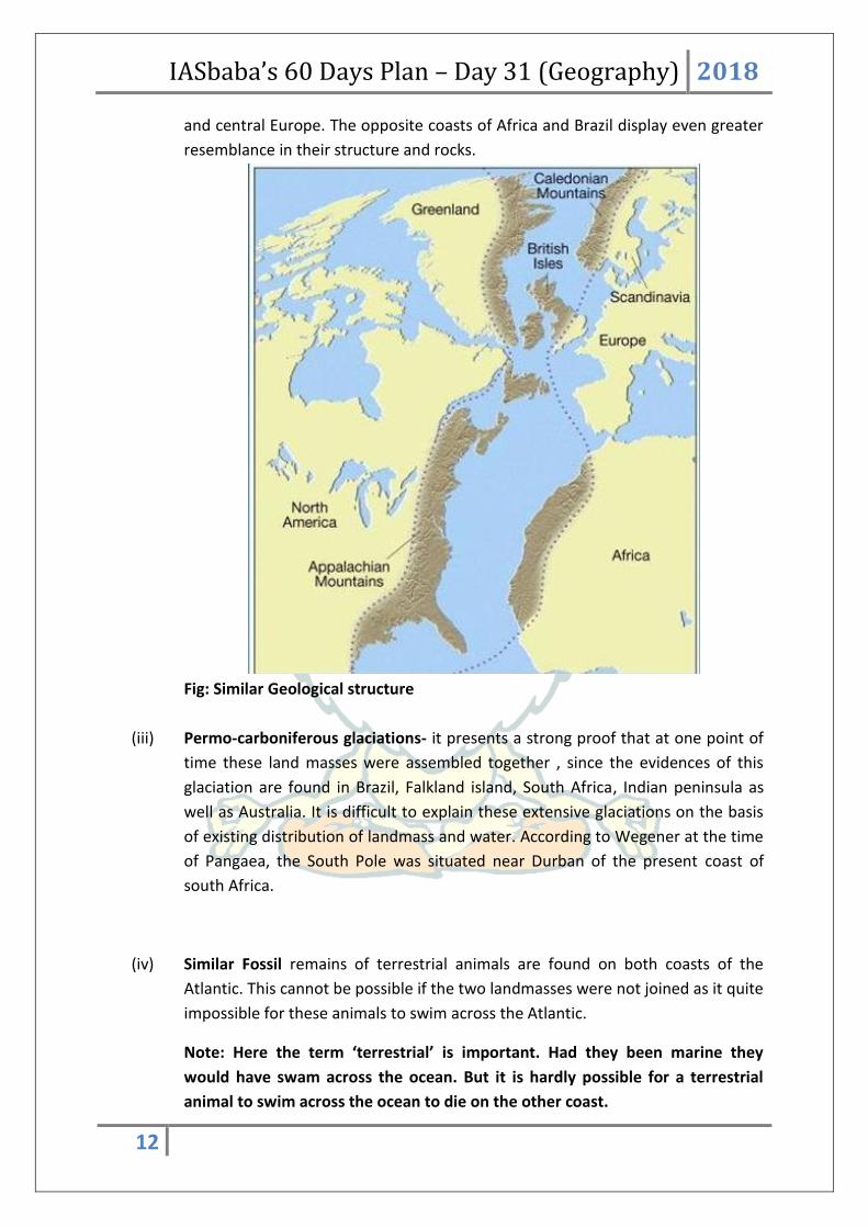
IASbaba’s 60 Days Plan – Day 31 (Geography) 2018
12
and central Europe. The opposite coasts of Africa and Brazil display even greater
resemblance in their structure and rocks.
Fig: Similar Geological structure
(iii) Permo-carboniferous glaciations- it presents a strong proof that at one point of
time these land masses were assembled together , since the evidences of this
glaciation are found in Brazil, Falkland island, South Africa, Indian peninsula as
well as Australia. It is difficult to explain these extensive glaciations on the basis
of existing distribution of landmass and water. According to Wegener at the time
of Pangaea, the South Pole was situated near Durban of the present coast of
south Africa.
(iv) Similar Fossil remains of terrestrial animals are found on both coasts of the
Atlantic. This cannot be possible if the two landmasses were not joined as it quite
impossible for these animals to swim across the Atlantic.
Note: Here the term ‘terrestrial’ is important. Had they been marine they
would have swam across the ocean. But it is hardly possible for a terrestrial
animal to swim across the ocean to die on the other coast.

IASbaba’s 60 Days Plan – Day 31 (Geography) 2018
13
(v) The migratory pattern of some animal species also hints towards the joined land
mass. For example the entire lemming (a rodent) population crosses the North
America and falls in the Atlantic. This is estimated that they have not forgotten
their route, when the landmasses were joined, the might have travelled to
Europe and central Asia.
Note: 3rd and 4th statements are incorrect because in 3rd statements ‘Aquatic’ animals are
given. It should be terrestrial animals. In 4th statement the region should be equatorial and
not polar.
Q.10) Continental drift theory is currently the most accepted theory to explain the shape
of earth’s surface and formation of landforms. Which of the following statements
according to Plate Tectonic theory are correct?
1. The lithosphere is broken in fragments called plates and they are moving with
respect to each other over Aesthenosphere.
2. The forces responsible for movement of plates are gravitational pull of the moon and
earth’s rotation.
Select the code from following:
a) 1 only
b) 2 only

IASbaba’s 60 Days Plan – Day 31 (Geography) 2018
14
c) Both 1 and 2
d) Neither 1 nor 2
Q.10) Solution (a)
Plate Tectonic Theory:
The term plate tectonics was first used by Tuzo Wilson of the University of Toronto but the
theory of plate tectonics was first published by W. J. Morgan of the Princeton University in
1962. This theory is based on the concept of ‘sea- floor spreading’ advocated by Hess. It is
an improvement over the Wegener’s continental drift theory and has been considered as
the most sophisticated and comprehensive theory about the drift of continents and
expansion of sea floors.
According to this theory the lithosphere is believed to have been broken into fragments
which are in constant movement with respect to each other. The movement of these
plates is attributed to the convention currents being generated in upper mantle. The
margins of the plates are the sites of considerable geologic activity such as sea floor
spreading, volcanic eruptions, crustal deformation, mountain building and continental drift.
Q.11) Which of the following landforms are associated with Oceanic – Oceanic plate
convergence?
1. Oceanic trench
2. Oceanic ridge
3. Volcanic island chain
4. Folding mountains
Select the code from following:
a) 1 and 2
b) 2,3 and 4
c) 1 and 3
d) All of the above
Q.11) Solution (c)
Note: Study the following table very carefully. If you can understand and remember the
following table, you will be able to explain the formation of all the secondary reliefs.
IASbaba’s 60 Days Plan – Day 31 (Geography) 2018
15
Plate boundary Plate
movement
seafloor Events
observed
examples
Divergent plate
boundaries
Ocean -
ocean
apart Forms by
seafloor
spreading
Ridge forms at
spreading
centre. Plate
area increases.
Many small
volcanoes and
earthquakes
Mid
atlantic
ridge, east
pacific rise
Continent
-continent
New ocean
basin may
form as the
continent
split
Continent drifts
apart, ocean
may intrude.
Formation of
rift valleys and
block
mountains
East
African rift.
Convergent plate
boundary
Ocean -
continent
together Destroyed
at
subduction
zones
Dense oceanic
lithosphere
plunges
beneath less
dense
continental
crust.
Earthquake
traces path of
down moving
plate as it
descends into
asthenosphere.
A trench is
formed.
Subducted
plate partially
melts and
magma rises to
form
continental
volcanoes.
Western
South
america
Ocean -
ocean
Destroyed
at
Denser crust
plunges into
Aleutians

IASbaba’s 60 Days Plan – Day 31 (Geography) 2018
16
subduction
zone
lighter crust
and is
subducted
forming a
curved trench
and a volcanic
arc.
Continent-
continent
NA Collision
between
masses of
gigantic
continental
lithosphere.
Neither mass is
subducted.
Plate edges are
compressed,
folded and
uplifted
Himalayas,
alps
Transform plate
boundary
Past each
other
Neither
created
nor
destroyed
A transform
fault is formed
where plates
move past each
other. Strong
earthquakes
along the fault
San
Andreas
fault.
Q.12) Which of the following are necessary conditions for generation of Tsunami waves?
1. Earthquake
2. Vertical displacement of water in ocean
3. Fast wind speed on the surface of the ocean
Select the code from following:
a) 1 only
b) 1 and 2
c) 1 and 3
d) All of the above

IASbaba’s 60 Days Plan – Day 31 (Geography) 2018
17
Q.12) Solution (b)
Tsunamis:
The seismic waves travelling through the ocean and sea water results into high sea waves
which are known as tsunamis. ‘Tsunami’ is a Japanese term which has been universally
adopted to describe a large seismically generated sea wave. These waves are responsible for
causing considerable destruction in certain coastal areas where submarine earthquakes
occur.
Pre – conditions for Tsunami:
For a Tsunami to occur, two conditions are required:
There should be an earthquake from which energy can be transferred.
There should be a vertical displacement of the water. i.e. during earthquake the
crust should move vertically. That’s why Tsunamis are originated near oceanic
trenches where plates are being subducted. In Atlantic Ocean, a number of
earthquakes occur on Mid – Oceanic ridge but since there is no sudden vertical
movement, Tsunamis are not formed. Tsunamis can also be triggered if seamounts
break. This can cause vertical displacement of water.
Q.13) Which of the following statements is/are correct regarding Reverse Faulting?
1. It occurs due to compression force.
2. There is net destruction of surface in case of Reverse faulting.
Select the code from following:
a) 1 only
b) 2 only
c) Both 1 and 2
d) Neither 1 nor 2
Q.13) Solution (c)
Faults:
A fault is a fracture in the earth’s crust due to tension force. It can also occur due to
compression in hard and brittle rocks.
When there is tension the crust ruptures. One block is thrown upwards and the
other downwards. The upthrown block is called Horst while the downthrown block is
called Graben. The line along which the fault occurs is called strike. This fault is

IASbaba’s 60 Days Plan – Day 31 (Geography) 2018
18
called normal fault and is most common. In case of a normal fault, new surface is
generated in the form of scarp.
When there is compression, in case of hard rocks instead of folding, the faulting
occurs. The block with hanging wall is thrown upwards while the one with footwall is
thrown downwards. This is called a reverse fault. In case of a reverse fault there is
net destruction of the surface.
When the forces are acting parallel to each other, along the line of fault the blocks
move past each other without being upthrown or downthrown. This is called lateral
fault.
The landforms formed due to faulting of land are block mountains, rift
valleys, step mountains, hinge faults, scissors fault etc.
Q.14) Which of the following landforms are formed by the erosional action of Glaciers?
1. Fjords
2. Areti
3. Cirque
4. V – shape Valley
5. Moraines
Select the code from following:
IASbaba’s 60 Days Plan – Day 31 (Geography) 2018
19
a) 1,2 and 3
b) 2,3 and 4
c) 2,3 and 5
d) All of the above
Q.14) Solution (a)
Erosional landforms of Glaciers
Cirque/Corrie
Hollow basin cut into a mountain ridge.
It has steep sided slope on three sides, an open end on one side and a flat bottom.
When the ice melts, the cirque may develop into a tarn lake.
Glacial Trough
Original stream-cut valley, further modified by glacial action.
It is a ‘U’ Shaped Valley. It at mature stage of valley formation.
Since glacial mass is heavy and slow moving, erosional activity is uniform –
horizontally as well as vertically.
A steep sided and flat bottomed valley results, which has a ‘U’ shaped profile.
Hanging Valley
Formed when smaller tributaries are unable to cut as deeply as bigger ones and
remain ‘hanging’ at higher levels than the main valley as discordant tributaries.
A valley carved out by a small tributary glacier that joins with a valley carved out by a
much larger glacier.
Arete
Steep-sided, sharp-tipped summit with the glacial activity cutting into it from two
Horn
Ridge that acquires a ‘horn’ shape when the glacial activity cuts it from more than
two sides.
D-Fjord
Steep-sided narrow entrance-like feature at the coast where the stream meets the
coast.
Fjords are common in Norway, Greenland and New Zealand.

IASbaba’s 60 Days Plan – Day 31 (Geography) 2018
20
THINK!
Why fjords are very good fishing grounds?
Q.15) Match the following in correct sequence:
Land forms Features
1. Rivers A. Interlocking Spurs
2. Desert B. Bergschrund
3. Glacier C. Stacks
4. Karsts D. Yardangs
E. Stalagmite
1-2-3-4
a) C-B-D-E
b) A-D-B-E
c) A-B-C-E
d) A-C-D-B
Q.15) Solution (b)
Interlocking Spurs:
Spurs are ridges of hard rock, which a river is forced to wind around as it passes
downstream in the upper course as is cannot erode the hard rock.
Interlocking spurs are formed when the river is forced to swing side to side around the spurs
of hard rock which interlock as you look at the river.

IASbaba’s 60 Days Plan – Day 31 (Geography) 2018
21
Bergschrund
Bergschrund, (German: “mountain crevice”), a crevasse or series of crevasses often found
near the head of a mountain glacier. The erosion of the rock beneath a bergschrund
contributes to the formation of a cirque.
Stacks:
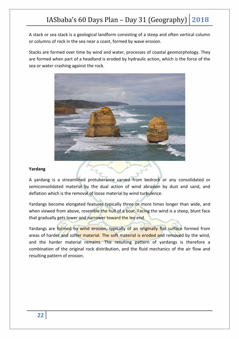
IASbaba’s 60 Days Plan – Day 31 (Geography) 2018
22
A stack or sea stack is a geological landform consisting of a steep and often vertical column
or columns of rock in the sea near a coast, formed by wave erosion.
Stacks are formed over time by wind and water, processes of coastal geomorphology. They
are formed when part of a headland is eroded by hydraulic action, which is the force of the
sea or water crashing against the rock.
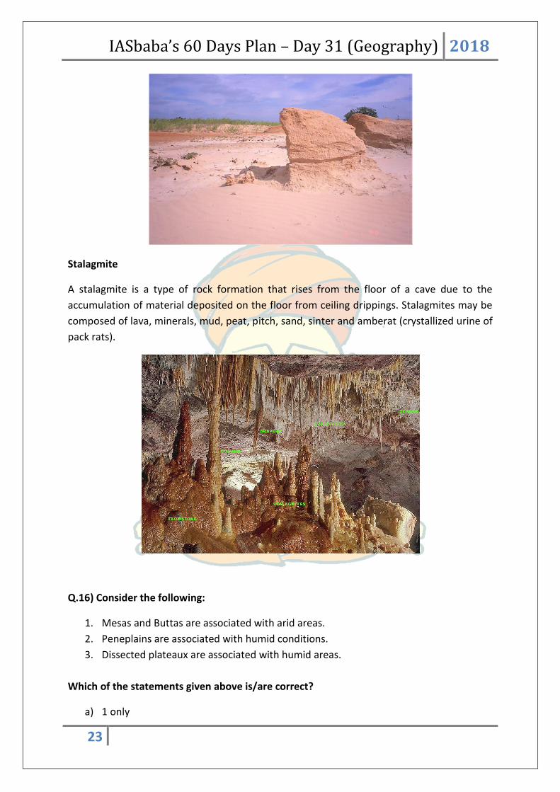
Yardang
A yardang is a streamlined protuberance carved from bedrock or any consolidated or
semiconsolidated material by the dual action of wind abrasion by dust and sand, and
deflation which is the removal of loose material by wind turbulence.
Yardangs become elongated features typically three or more times longer than wide, and
when viewed from above, resemble the hull of a boat. Facing the wind is a steep, blunt face
that gradually gets lower and narrower toward the lee end.
Yardangs are formed by wind erosion, typically of an originally flat surface formed from
areas of harder and softer material. The soft material is eroded and removed by the wind,
and the harder material remains. The resulting pattern of yardangs is therefore a
combination of the original rock distribution, and the fluid mechanics of the air flow and
resulting pattern of erosion.
IASbaba’s 60 Days Plan – Day 31 (Geography) 2018
23
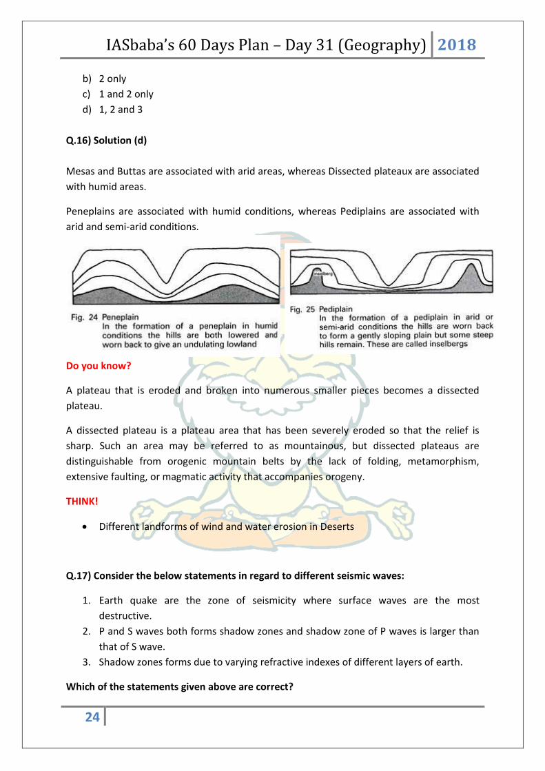
Stalagmite
A stalagmite is a type of rock formation that rises from the floor of a cave due to the
accumulation of material deposited on the floor from ceiling drippings. Stalagmites may be
composed of lava, minerals, mud, peat, pitch, sand, sinter and amberat (crystallized urine of
pack rats).
Q.16) Consider the following:
1. Mesas and Buttas are associated with arid areas.
2. Peneplains are associated with humid conditions.
3. Dissected plateaux are associated with humid areas.
Which of the statements given above is/are correct?
a) 1 only
IASbaba’s 60 Days Plan – Day 31 (Geography) 2018
24
b) 2 only
c) 1 and 2 only
d) 1, 2 and 3
Q.16) Solution (d)
Mesas and Buttas are associated with arid areas, whereas Dissected plateaux are associated
with humid areas.
Peneplains are associated with humid conditions, whereas Pediplains are associated with
arid and semi-arid conditions.
Do you know?
A plateau that is eroded and broken into numerous smaller pieces becomes a dissected
plateau.
A dissected plateau is a plateau area that has been severely eroded so that the relief is
sharp. Such an area may be referred to as mountainous, but dissected plateaus are
distinguishable from orogenic mountain belts by the lack of folding, metamorphism,
extensive faulting, or magmatic activity that accompanies orogeny.
THINK!
Different landforms of wind and water erosion in Deserts
Q.17) Consider the below statements in regard to different seismic waves:
1. Earth quake are the zone of seismicity where surface waves are the most
destructive.
2. P and S waves both forms shadow zones and shadow zone of P waves is larger than
that of S wave.
3. Shadow zones forms due to varying refractive indexes of different layers of earth.
Which of the statements given above are correct?

IASbaba’s 60 Days Plan – Day 31 (Geography) 2018
25
a) 1 and 2 only
b) 1 and 3 only
c) 2 and 3 only
d) 1, 2 and 3
Q.17) Solution (b)
P and S waves both forms shadow zones, however, shadow zone of S wave is larger than
that of P wave. Hence, statement (2) is wrong.
P-waves move faster and are the first to arrive at the surface. These waves are of high
frequency. They can travel in all mediums.
Statement (1) and (2) are correct. Surface Waves also called as long period waves. They are
low frequency, long wavelength, and transverse vibration. These waves are responsible for
most the destructive force of earthquake.
Q.18) Which of the following is/are the characteristic features of the convergent plate
boundary?
1. Formation of zone of progressively deeper earthquakes.
2. Formation of chain of volcanic islands.
3. Shortening and thickening of the plates within the collision zone.
Choose the correct answer using the codes below:
a) 1 and 2 only
b) 2 and 3 only
c) 2 only
d) 1, 2 and 3

IASbaba’s 60 Days Plan – Day 31 (Geography) 2018
26
Q.18) Solution (d)
Do you know?
Effects that are found at convergent plate boundary (oceanic) include: a zone of
progressively deeper earthquakes, an oceanic trench, a chain of volcanic islands, and the
destruction of oceanic lithosphere.
Effects found at a convergent boundary between continental plates include: intense folding
and faulting, a broad folded mountain range, shallow earthquake activity, shortening and
thickening of the plates within the collision zone.
THINK!
Plate Boundaries: Convergent, Divergent, and Transform Boundaries
Q.19) Which of the following statements is/are not correct?
1. Ash and cinder cones are built where eruptions are of the explosive type with a
predominance of pyroclastic material.
2. The ash and cinder cones seldom attain heights in excess of a few hundred metres.
Choose the appropriate answer:
a) 1 only
b) 2 only
c) Both 1 and 2
d) Neither 1 nor 2
Q.19) Solution (d)
Both the given statements are correct. However, since the question asks for ‘not correct’,
answer is option (d).
On the basis of material ejected, the volcanoes may be classified into four major types: (i)
basalt cones, (ii) basalt domes or shield, (iii) ash or cinder cones, and (iv) composite or strato
cones.
(i) Basalt cones

IASbaba’s 60 Days Plan – Day 31 (Geography) 2018
27
Basalt cones are rare. They are likely to be low rather than high cones because of the fluidity
of basaltic lava. The Rangitoo (New Zealand) and Skjaldbreit( Iceland) are the most suitable
examples of basalt cone volcanoes.
(ii) Basalt domes or shield
The Hawaiian volcanoes are the excellent examples of basalt domes or shield volcanoes as
are Mt. Etna and many of the volcanoes of Iceland. Basalt domes are formed where fluid
basaltic lava is extruded. They often attain great heights (e.g., Mauna Loa has an altitude of
4,219 metres).
(iii) Ash or cinder cones
Ash and cinder cones are built where eruptions are of the explosive type with a
predominance of pyroclastic material. Growth of an ash or cinder cone begins around a
crater. The ash and cinder cones seldom attain heights in excess of a few hundred metres
(iv) Composite or strato cones
A strato volcano is characterized by alternating sheet of lava and pyroclastric material. Its
structure attests to alternating periods of explosive and quiet eruptions. Lava intruded into
fissures solidifies to form dykes (dikes), if injected between layers of fragmental ejecta it
forms sills.
THINK!
Different types of Volcanoes
Q.20) Which of the following pair of rocks do not lead to formation of caves in Karst
Topography?
a) Shale and limestone
b) Limestone and sandstone
c) Shale and sandstone
d) None of the above
Q.20) Solution (c)
Limestone and chalk are sedimentary rocks of organic origin and in its pure state, limestone
is made up of calcite or cacium carbonate.

IASbaba’s 60 Days Plan – Day 31 (Geography) 2018
28
Limestone is soluble in rain-water, which, with carbon-di-oxide from the air, forms a weak
acid. A region with a large stretch of limestone therefore possesses a very distinct type of
topography – Karst topography.
Karst regions have a bleak landscape. In areas where there are alternating beds of rocks
(shales, sandstones, quartzites) with limestones or dolomites in between or in areas where
limestones are dense, massive and occurring as thick beds, cave formation is prominent.
Water percolates down either through the materials or through cracks and joints and moves
horizontally along bedding planes. It is along these bedding planes that the limestone
dissolves and long and narrow to wide gaps called caves result.
THINK!
Characteristic features of a Karst Region
Q.21) What types of erosion cause the undercutting of a waterfall?
a) Abrasion and hydraulic action
b) Abrasion and attrition
c) Attrition and hydraulic action
d) Eskar and attrition
Q.21) Solution (a)
Abrasion and hydraulic action erode the soft rock so the hard rock is left as an overhang.
Attrition breaks down the river's load.
Erosion involves the wearing away of rock and soil found along the river bed and banks.
Erosion also involves the breaking down of the rock particles being carried downstream by
the river.
The four main forms of river erosion
Hydraulic action - the force of the river against the banks can cause air to be trapped in
cracks and crevices. The pressure weakens the banks and gradually wears it away.
Abrasion - rocks carried along by the river wear down the river bed and banks.
Attrition - rocks being carried by the river smash together and break into smaller, smoother
and rounder particles.
Solution - soluble particles are dissolved into the river.
IASbaba’s 60 Days Plan – Day 31 (Geography) 2018
29
THINK!
Difference between Abrasion and Attrition
Q.22) Consider the following statements about ‘Balfour Declaration’
1. It stated that the British government supported the establishment in Palestine of a
national home for the Jewish people
2. It was issued post 1948 Palestinian exodus
Select the correct statements
a) 1 Only
b) 2 Only
c) Both 1 and 2
d) Neither 1 nor 2
Q.22) Solution (a)
The Balfour Declaration was a public statement issued by the British government during
World War I announcing support for the establishment of a "national home for the Jewish
people" in Palestine, then an Ottoman region with a minority Jewish population (around 3–
5% of the total).
Source: http://www.thehindu.com/news/international/100-years-on-uks-balfour-
declaration-stirs-celebration-and-mourning-in-west-asia/article19976491.ece
Q.23) ‘Global Financial Development Report’ is published by
a) World Economic Forum
b) World Bank
c) World Trade Organization
d) None of the above
Q.23) Solution (b)
It is published by World Bank.

IASbaba’s 60 Days Plan – Day 31 (Geography) 2018
30
Global Financial Development Report 2017/2018: Bankers without Borders is the fourth in a
World Bank series. It provides a unique contribution to financial sector policy debates,
building on novel data, surveys, research, and wide-ranging country experience, with
emphasis on emerging markets and developing economies.
The report‘s findings and policy recommendations are relevant for policy makers, staff of
central banks, ministries of finance, and financial regulation agencies.
The report tracks financial systems in more than 200 economies before and during the
global financial crisis.
Source: http://www.thehindu.com/business/international-banking-must-for-better-
growth-prospectsworld-bank/article20002840.ece
Q.24) Which of the following is/are correctly matched?
1. Tholpavakoothu – Andhra Pradesh
2. Mamallapuram stone sculptures - Tamil Nadu
3. Ravanachhaya – Maharashtra
Select the correct statements
a) Only 2
b) 1 and 2
c) 2 and 3
d) 1, 2 and 3
Q.24) Solution (a)
Shadow Puppetry
Tholpavakoothu – Kerala
Ravanachhaya – Odisha
Tholu Bommalata – Andhra Pradesh
Togalu Gombeyatta – Karnataka
Mamallapuram stone sculptures - Tamil Nadu
Source: http://www.thehindu.com/entertainment/art/puppetry-in-odisha-who-is-pulling-
the-strings/article20781988.ece

IASbaba’s 60 Days Plan – Day 31 (Geography) 2018
31
Q.25) New research has revealed that the oldest water in the ocean in the North Pacific
has remained trapped in a shadow zone around 2 kilometres below the sea surface for
over 1,000 years. Consider the following statements about this zone.
1. Oxygenation of the zone is very low
2. Marine life is restricted
3. The zone traps millennia old nutrients and carbon
Select the correct statements
a) 1 Only
b) 1 and 2
c) 1 and 3
d) 1, 2 and 3
Q.25) Solution (d)
It was found is that at around 1.2 miles (2km) below the surface of the Indian and Pacific
Oceans there is a 'shadow zone' with barely any vertical movement that suspends ocean
water in an area for centuries.
The research found that water at the bottom of the ocean, heated by geothermal energy
deep within the planet, was unable to rise above1.5 miles (2.5km) below the surface.
Instead of travelling upwards, currents loop back on themselves horizontally, leaving the
layer directly above untouched.
Carbon-14 dating had already told us the most ancient water lied in the deep North Pacific.
The lack of contact with the ocean's surface means oxygenation of the zone is very low. That
means marine life is restricted, but not completely absent.
The 'shadow zone' covers an area 3,700 by 1,250 (6,000 by 2,000 km) where the North
Pacific meets the Indian Ocean, between 0.6 and 1.5 miles (one and 2.5 km) below the
surface
It could help understand the capacity of the oceans to absorb heat trapped by rising
greenhouse gases.
When this isolated shadow zone traps millennia old ocean water it also traps nutrients and
carbon.

IASbaba’s 60 Days Plan – Day 31 (Geography) 2018
32
Source: http://www.thehindu.com/sci-tech/science/what-is-the-pacific-shadow-
zone/article20236733.ece
Q.26) ‘Deen Dayal SPARSH Yojana’ is associated with
a) Numismatics
b) Philately
c) Rural Digital Literacy
d) Empowerment of scheduled tribes based on sustainable S&T activities/applications
Q.26) Solution (b)
SPARSH - Scholarship for Promotion of Aptitude & Research in Stamps as a Hobby
It is a pan India Scholarship programme to children of Standard VI to IX having good
academic record and also pursuing Philately as a hobby.
Launched by Ministry of Communication
Source: http://pib.nic.in/newsite/PrintRelease.aspx?relid=173212


![IASbaba’s AY PLAN UPSC POLITY [ AY x] 2021](https://static.fdocuments.us/doc/165x107/617af8ebf2b24a60a516d1a7/iasbabas-ay-plan-upsc-polity-ay-x-2021.jpg)