![CHAPTER 2.1 BEACHES AND FORESHORES - Reef Catchmentsreefcatchments.com.au/files/2015/02/SORR_Chapter2_Coasts.pdfforest on coastal dunes, regional ecosystem [RE] 8.2.2) (Accad et al.,](https://static.fdocuments.us/doc/165x107/5e9f4b24fb90860d6932ca8d/chapter-21-beaches-and-foreshores-reef-catc-forest-on-coastal-dunes-regional.jpg)
IAHR2015 - Natural foreshores as an alternative to traditional dike re-enforecements, Penning,...
28
Ellis Penning, Henk Steetzel, Robbin van Santen, Jasper Fiselier, Marieke de Lange, Vincent Vuik, Sonja Ouwerkerk, Jaap van Thiel de Vries NATURAL FORESHORES AS AN ALTERNATIVE TO TRADITIONAL DIKE RE-ENFORECEMENTS: A FIELD PILOT IN THE LARGE SHALLOW LAKE MARKERMEER, THE NETHERLANDS
-
Upload
delftsoftwaredays -
Category
Science
-
view
11 -
download
1
Transcript of IAHR2015 - Natural foreshores as an alternative to traditional dike re-enforecements, Penning,...

Ellis Penning, Henk Steetzel, Robbin van Santen, Jasper Fiselier,
Marieke de Lange, Vincent Vuik, Sonja Ouwerkerk, Jaap van Thiel de
Vries
NATURAL FORESHORES AS AN ALTERNATIVE
TO TRADITIONAL DIKE RE-ENFORECEMENTS:
A FIELD PILOT IN THE LARGE SHALLOW LAKE MARKERMEER,
THE NETHERLANDS

What are natural foreshores?
Long term safety:
Marshes grow
with SLR
reefs
Marshes, mangroves, reedbeds
Foreshore & beach sand nourishments
Use & produce
ecosystem services
Limited wave reduction
Enhanced wave reduction
Maximized wave reduction
What are natural foreshores?
Long term safety:
Marshes grow
with SLR
reefs
Marshes, mangroves, reedbeds
Foreshore & beach sand nourishments
Use & produce
ecosystem services
Limited wave reduction
Enhanced wave reduction
Maximized wave reduction

What are natural foreshores?
Long term safety:
Marshes grow
with SLR
reefs
Marshes, mangroves, reedbeds
Foreshore & beach sand nourishments
Use & produce
ecosystem services
Limited wave reduction
Enhanced wave reduction
Maximized wave reduction

From coastal to inland applications
Markermeer: 700 km2 Fetch: up to 40 km Avg. Depth: 2-4 meters No tides, substantial waves and water level fluctuations due to wind Managed unnatural water level: -0,4 NAP winter -0,2 NAP summer Houtridbijk splits lake Markermeer from lake IJsselmeer Houtribdijk needs maintenance (26 km)

Considerations during design phase Pilot under the National High water protection programme – innovation funds:
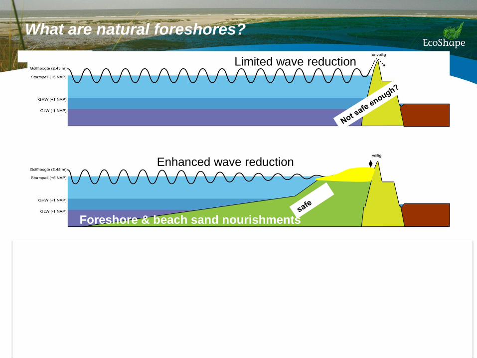
• Only sand nurishments applied from water - cheaper and faster
• Stable slope – steeper is cheaper
• Account for sediment consolidation of the underground
• Can vegetation aid the stability of
the construction during normal
and extreme situations
• Legal requirements

Details design
Section 1 en 4 : sand
Section 2 en 3: top layer mixed with clay
Vak 1 Vak 2 Vak 4 RestvakVak 3
zand
zand
zand
zand
holoceen+zand holoceen + zand
zand
zand

• Each section half planted, half empty
• Willow mats with reeds (section 3 and 4)
• Exclosures to define effect of grazing
Role of vegetation
Section 1 Section 2 Section 4 Section 3
zand
zand
zand
zand
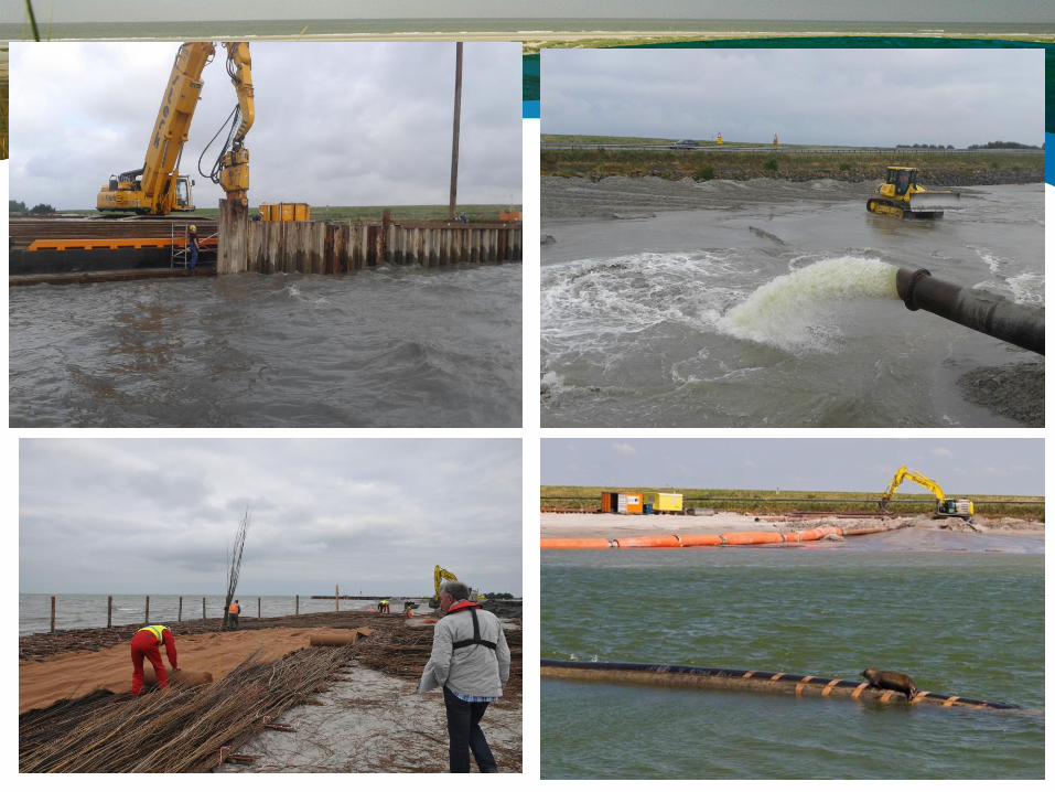

Monitoring
4 years
• Hydrodynamics and meteorology (continuous)
wave- and flow patterns as forcing factor
• Morfodynamics (monthly)
consolidation, erosion/sedimentation due to hydrodynamics and vegetation
• Vegetation development (2x year)
safety and biodiversity

Hs = 0.9 m

Water levels under influence of wind

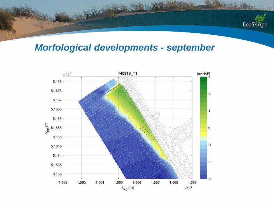
Morfological developments - september

Morfological developments - october

Morfological developments - november

Morfological developments - december
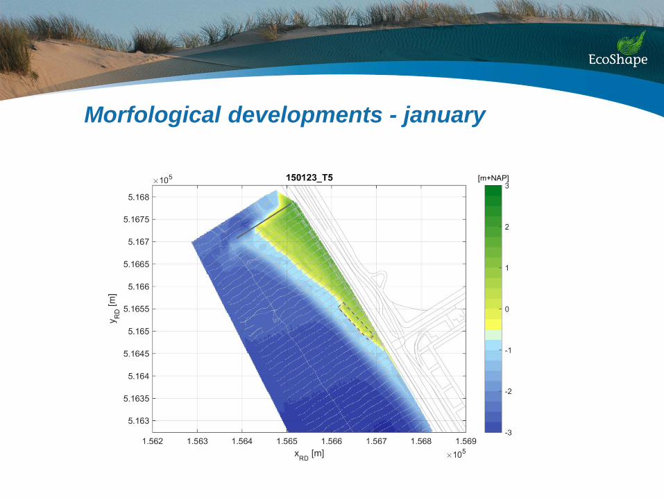
Morfological developments - january
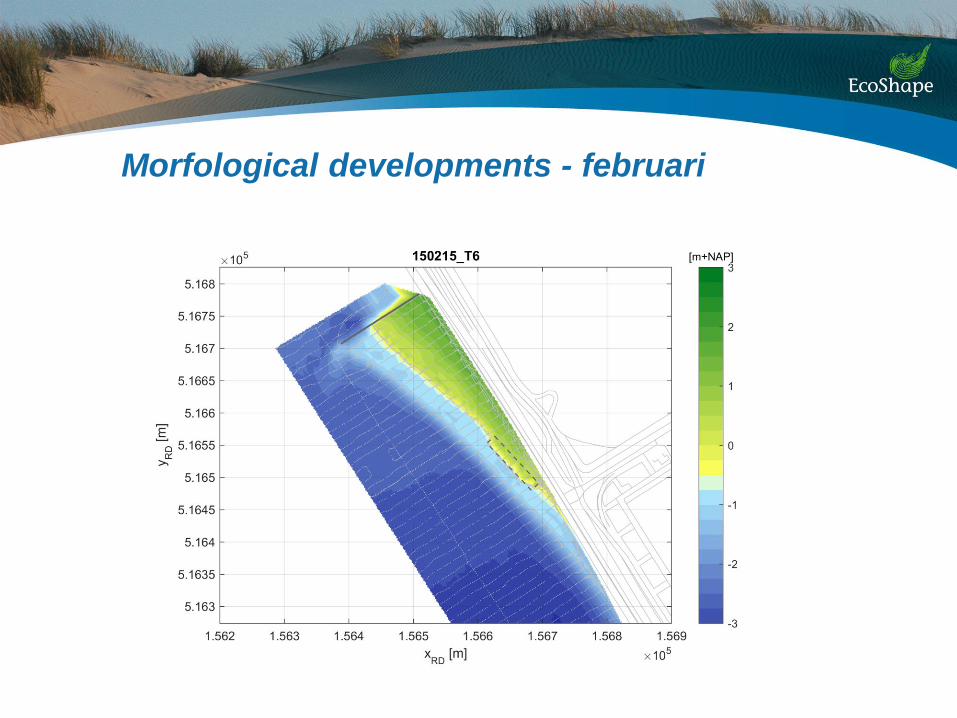
Morfological developments - februari

Morfological developments - march

Morfological developments- april
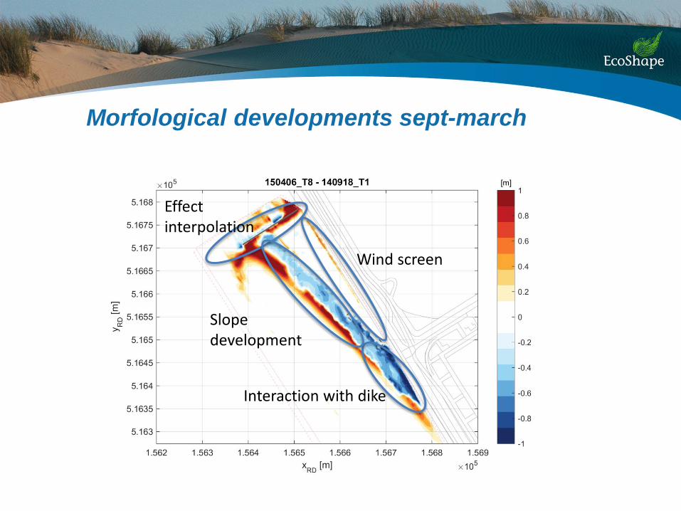
Morfological developments sept-march
Wind screen
Effect interpolation
Interaction with dike
Slope development
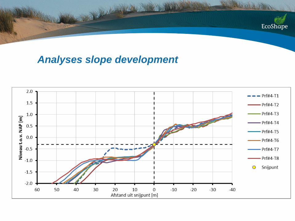
Analyses slope development
Analyses morphological developments
First impressions
• A stable, yet dynamic foreshore
• Steep slope (1 : 10) along the waterline
• Swash-berm up to NAP+0,5 m
• Underwater plateau nearly flat at -1m NAP
• Effect of coarse sand?

Sediment grain size
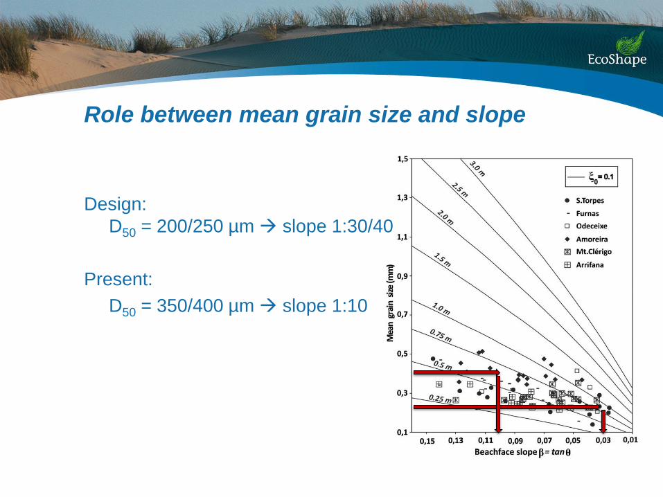
Role between mean grain size and slope
Design:
D50 = 200/250 µm slope 1:30/40
Present:
D50 = 350/400 µm slope 1:10

Next steps
• Monitoring until 2018
• Use of data for improvement and validation of models
• Extrapolation to other locations
• Need for testing of extreme conditions in controlled
flume experiment