I ~ I THE · NAUGATUCK QUADRANGLE
30
. , STATE GEOLOGICAL , NATURAL HISTORY SURVEY OF CONNECTICUT I THE BEDROCK GEOLOGY OF THE · NAUGATUCK QUADRANGLE / With Map Open Map By v MICHAEL H. CARR QUADRANGLE REPORT No. '9 1960
Transcript of I ~ I THE · NAUGATUCK QUADRANGLE

. ,
STATE GEOLOGICAL ,
NATURAL HISTORY SURVEY
OF
CONNECTICUT
I THE ~ BEDROCK GEOLOGY ~
~ I OF THE ~
· NAUGATUCK QUADRANGLE / With Map
Open Map
By
v MICHAEL H. CARR
QUADRANGLE REPORT No. '9
1960
STATE GEOLOGICAL AND NATURAL HISTORY SURVEY
OF CONNECTICUT
QuADRANGLE REPORT No. 9
THE BEDROCK GEOLOGY OF THE
NAUGATUCK QUADRANGLE With Map
By
MICHAEL H. CARR
Middletown
Printed hy the State Geological and Natural History Survey
1960

State Geological and Natural
History Survey of Connecticut
COMMISSIONERS
HoN. ABRAHAM RIBICOFF, Governor of Connecticut J. WENDELL BURGER, Ph.D., Professor of Biology, Trinity College RICHARD H. GooDWIN, Ph.D., Professor of Botany, Connecticut College G. EVELYN HUTCHINSON, Ph.D., Professor of Biology, Yale University JoHN B. LucKE, Ph.D., Professor of Geology, University of Connecticut JoE WEBB PEOPLES, Ph.D., Professor of Geology, Wesleyan University
DIRECTOR
JoE WEBB PEOPLES, Ph.D.
Wesleyan University, Middletown, Connecticut
EDITOR
ELIZABETH G. WEINMAN
DISTRIBUTION AND EXCHANGE AGENT
RoBERT C. SALE, State Librarian
State Library, Hartford
ii
TABLE OF CONTENTS
Abstract Introduction .................................................... . General Geology . . . . . . . . . . . . . . . . . . . .............................................. . Discussion of Rock Types ........................... ..
The Waterbury gneiss . . . . . . . . . . . . . . . . . ............................... . Name................................................................ . .................. . Lithology ................... .
Waterbury phase .............. . Oxford phase . . . . . . . . . . . . . . . . . . . . . . ...... .
The Hartland formation . . . . .. .......................... . Name ................................................. .. The Straits schist member
Name ..................................... . Lithology ................... . Petrography . . . . .............. .
Undifferentiated Hartland formation ............................ . Name... . ....................... . Lithology ................................................... . Petrography
Biotite-muscovite gneisses
1 1 3 4 4 4 4 4 6 6 6 7 7 7 7 8 8 8
10 10
Biotite-muscovite schists ................... . . .............................. 10 Calcareous schists and marbles
Quartzitic member Name. Distribution Lithology Petrography
The Orange phyllite Name Distribution Lithology Petrography
The Prospect gneiss Name Distribution . Lithology Petrography Origin .
The Ansonia granite Name Distribution Lithology Petrography
The dolerite dikes Distribution Lithology .... Petrography
The pegmatites Structure Metamorphism References ................ .
iii
10 11
. ... 11 11 11 12 12 12 12 12 13 14 14 14 15 15 17 18 18 18
....................... 18 18 19 19 19 19 19 20 23 25

ILLUSTRATIONS
Fig. 1. Map of Connecticut showing areas covered by previous quadrangle reports
and location of the Naugatuck quadrangle ................ 2
Fig. 2. Waterbury gneiss. Shows the separation of the dark and light constituents.
The dark bands are biotitic and the light areas are composed of quartz, microdine,
and plagioclase 5
Fig. 3. Undifferentiated Hartland formation on Peat Swamp Road. Biotite mus
covite schists with hornblendic bands intruded by pegmatite and later isoclinally
folded ............. .. ............... 9
Fig. 4. Quartzitic member of the Hartland formation. Mica quartzites interbanded
with veins of quartz ... 13
Fig. 5. Prospect gneiss, porphyritic eastern border fades. Megacrysts of micro-
cline in a medium-grained groundmass of quartz, plagioclase, and garnet 16
Plate 1. Quadrangle Map (in pocket).
iv

The Bedrock Geology of the Naugatuck Quadrangle
By Michael H. Carr
ABSTRACT
The Naugatuck quadrangle is underlain largely by metamorphic rocks of preTriassic age. The oldest unit is the metasedimentary Waterbury gneiss, which occurs as a late structural dome in the northern part of the area; a different phase formerly mapped as Hartland formation is included in the Waterbury along the west side of the area. Doming probably is later than folding. The Hartland formation of metasedimentary origin occupies the central portion of the map area: The Straits schist member at the base is the key mapping unit, delineating folds and folded folds; the undifferentiated schistose member is partly replaced by the Prospect gneiss, presumably the result of mobilization of part of the undifferentiated member; the quartzitic member at the top was formerly mapped as part of the overlying Orange phyllite. The Orange phyllite is the youngest metasedimentary rock in the mapped area.
Small bodies of pegmatite and Ansonia granite are intrusive, probably after major metamorphism. Faulting and intrusion of dolerite dikes in Triassic time was the latest igneous-tectonic event.
INTRODUCTION
The Naugatuck quadrangle is in the Western Connecticut Highlands, the eastern boundary of the highlands being approximately two miles east of the eastern boundary of the quadrangle (figure 1). Within the quadrangle are the population centers of Seymour and Naugatuck, both on the Naugatuck River, which runs south through the center of the areas and drains the whole quadrangle.
No previous detailed work has been done on the geology of the quadrangle. The general bedrock geology has been discussed in reports by Percival ( 1842), Rice and Gregory ( 1906), and Stewart ( 1935). Dale and Gregory ( 1911) described some of the granites found in this quadrangle but discussed no localities within the quadrangle. A detailed report (Gates, 1954) has been published on the bedrock geology of the Woodbury quadrangle northwest of the Naugatuck quadrangle. No detailed work has been done on the adjoining quadrangles to the south and west, but work is in progress on the next quadrangles east (Mount Carmel) and northeast ( Southington) by C. E. Fritts of the U. S. Geological Survey.
1

t-o
M A s s n• A c H u s E T T 72• s kJ~ I ~ ~-9 9 ,_y 1ft i~
9?-Qc,,'v "~ ~ Q"?- </;' ,P"> ~v"> s~~ .f' psv ~~ if o~ ~~ "~qj ff ~QJ~'<.~+·~\oqY~+">oJi- -1..,.CYv_ __ #--- J --?:-?-+--~-- --- &-- -"--
p ,o .:t & "n I "
& ---!142'
.,. I ! "' .. """' " ct " b.,. ,f°"" ,l .l~l {CY<- ,/>,{,> 4_,.f j•-""'v if,} ~IJl' ~lo'<' j' /l ~l1 ::C
:IJ
~.;y ,;f ,y ~ ~ ,,.. ~.. v " '
I ,~ I v ""I ,<Y" ~v<,.,i !! A..<-...,_¢ -i!;y ,,__o~ .!J& ~'#-.:;. 0 *" J o.. ~"" $iP ;,.~ ,/ J"' V ,,,.,.,, ,_,o~"" p /' ~<; '"v-->'. I ~<,; : ~~ rf"' ~~Of. ~q:.; N.:; } ? ~'tl" ~"lt~c vo 4'<' ~ Q"'l' ~ I 0
'It ~- c; JI:' ... o c.Ss .: A,..:_+--\-J;;rn-m(il-""''-"\---t----:j----1--:::-r -~ -"] "; S> I 4.t ~~ [i)"1' .:;:- ~.,. ~ t.0 1
cYCJ ~ ~~ ~"1' ""-" # ~<c;, ~q ~*' vo,J~.'1:- ~ ">vo q_v.q; c J qj ; ~4.,, V ~ I
: .(._ " .I. ~' ) :e ",'3" v4.,,<:)v-?: 6' Q~ e;. ~ <v~ " ::..~ ~ ~" .... ~I ~ $1 u{-'v d'~c~ ¢• ;J o.Y~/ ./f CJov ,,_~ .:.t-v -i!- ( ~o l J (fl
" ' (> I I / I o<P ~c,, ..:i:' ~'v .$-v_;,I ,J.,C:,~ ~~ i;:;~v I ~(j. ~<$> .t:-::.." J"' <) ~ c-,<--:.· .f.~.:; .,i.? ~ ~ -'V? /J? .i'
~
a:: l'T1
0
>-
r
~
:i: z
L&JI i<v \I Iv Iv I - l""v'-J 'ij;,"' .....-l,,,;.~~=iy.;- - I W/ i'Jf'= \ __ I"" 10 r r • 1 1 1 'ti v~ __ ... ,
z
.. '------'----1~1 ~m····Ai~ ~ ·,. I
~~· -----N E n· W Y 0 R K 72•
Fig. l. Map of Connecticut showing areas covered by previous quadrangle reports and location of the Naugatuck quadrangle.

The purpose of the present study was to determine the structure of the area and its stratigraphic implications, and to make a more detailed study of the heterogeneous sequence of rocks all previously mapped as Prospect gneiss. The mapping was done during the summers of 1957 and 1958, using as a base U.S. Geological Survey topographic maps on a scale of 1:24,000. Most of the petrographic work was done in the intervening period, during which approximately 80 sections were examined under the microscope.
Financial support from the Connecticut Geological and Natural History Survey, then under the direction of Dr. John B. Lucke, is gratefully acknowledged. Thanks are also due to Dr. John Rodgers of Yale University, Dr. R. M. Gates of the University of Wisconsin, and Mr. C. E. Fritts of the U.S. Geological Survey for their help and criticism in the field, and to Dr. Rodgers for his criticism of this report.
GENERAL GEOLOGY The area is m large part underlain by a sequence of metamorphic
rocks derived from detrital sediments and belonging to three formations: from southeast to northwest, the Orange phyllite, the Hartland formation, and the Waterbury gneiss. The Prospect gneiss may be a metamorphic derivative of part of the Hartland formation. Some possibly intrusive rocks are also present. No evidence concerning the age of the sediments or the direction in which they face has been obtained from the study of this quadrangle. In Massachusetts, however, the Hoosac, Rowe, and Savoy sequence occupies the same structural position as the Hartland formation, (Rogers et al, 1959) both being just to the east of the Berkshire Highlands. Analogy with the Massachusetts sequence would date the Hartland formation as pre-Middle Ordovician. On the basis of this analogy and on similarities in lithology, The Straits schist member of the Hartland formation is tentatively correlated with the lowest part of the Hoosac schist. If this correlation is valid, then the Waterbury gneiss, which forms the core of the Waterbury foliation dome, occupies the same structural position as the cores of the domes in southeast Vermont (Rodgers et al, 1959) and is the oldest unit in the quadrangle. If the Waterbury gneiss is the oldest unit in the quadrangle, then the rocks are progressively younger to the southeast, and the structural position corresponds to the stratigraphic position.
The metamorphic grade increases from southeast to northwest, the lowest-grade rocks being in the cordierite-anthophyllite subfacies and the highest in the staurolite-kyanite subfacies of the amphibolite facies. The highest-grade mineral found in the area is kyanite, which is abundant in The Straits schist member of the Hartland formation.
The whole sequence is isoclinally folded, the form of the folds being indicated by the outcrop pattern of The Straits schist. . In the northern part of the quadrangle these folds have been refolded in association with the formation of the Waterbury dome. Later, probably in Triassic times, the rocks were faulted and dolerite dikes intruded.
3

DISCUSSION OF ROCK TYPES
THE WATERBURY GNEISS
NAME
The name Waterbury gneiss was given by Rice and Gregory ( 1906) to the mixed gneisses around Waterbury and extending into the northern part of this quadrangle; it is here also applied to the rocks to the west of the belt of The Straits schist member of the Hartland formation. The Waterbury gneiss in the northern part of the area forms the core of the Waterbury foliation dome around which The Straits schist wraps, and the center of which lies in Waterbury north of the Naugatuck quadrangle. This dome is one of a series on a line from Long Island Sound to the Massachusetts border (Rodgers et al, 1959) along the eastern side of the main belt of the Hartland formation (and near the eastern border of the Western Highlands.) The Waterbury gneiss has been divided into two phases, the Waterbury phase including those gneisses in the Waterbury dome, and the Oxford phase including those west of the belt of The Straits schist. The two phases have not, however, been separated on the map. Gneisses similar to the Oxford phase north along the strike in the Woodbury quadrangle have been described by Gates ( 1954), who included them in the Hartland formation although he stated that they differ from the typical Hartland formation. The difference is here thought sufficient to exclude them from the Hartland formation and include them in the Waterbury gneiss, as they resemble, and are found in the same stratigraphic position as the gneisses in the Waterbury dome.
LITHOLOGY
WATERBURY PHASE
The Waterbury phase of the Waterbury gneiss is poorly exposed in the low-lying land north of The Straits schist ridge, which extends south of Naugatuck from Andrews Hill to Beacon Cap. The dominant rock is a light gray, medium-to-fine-grained mica quartz gneiss, here called mica quartzite. The quartz and mica are in separate anastomosing bands normally about 4 mm wide. The micas weather more easily than the quartz, leaving ridges of quartz on the weathered surface. Micas constitute between 10 and 20 percent of the rock; biotite and muscovite are approximately equal in abundance.
In places, especially northwest of Straitsville, the rocks are more feldspathic, the grain is coarser, the alternating bands of dark and light minerals are thicker, and the rock is more deformed (figure 2). These rocks weather brown and are chloritic, the chlorite and micas commonly forming knots. The feldspathic bands may be white or pink. These feldspathic gneisses grade into a pinkish white, poorly foliated, coarse-grained gneiss in which micas are less common and form isolated bands and knots within a matrix of microline, plagioclase, and quartz. Hornblende is also present but rare.
4

Fig. 2. 'Vaterbury gneiss. Shew~
the separation of the dark and light
con tituents. The dark bands are bi
otitic and the light areas are composed
of qua1tz, microcline, and plagioclase.
Brown-weathering muscovite-biotite schists occur on Rubber Road west of Naugatuck and also north of the Old Naugatuck Reservoir. They typically have plagioclase with a composition of An26• Potassium feldspar is absent, and the dark and light minerals are not in separate bands. These schists are in places garnetiferous, but garnet is not common.
Interbanded with the mica quartzites south of Old augatuck Reservoir are rocks composed of microcline and diopside with minor amounts of plagioclase and pyrite. They show a faint banding caused by the alternation of layers of diopside and microcline. They are fine-grained, greenish gray when fresh and brown when weathered.
Within the town of Naugatuck just west of the high school is a light gray biotite-oligoclase gneiss. It has the following composition: quartz 27 percent, microcline 36 percent, oligoclase 20 percent, and biotite 7 percent, with minor amounts of muscovite and apatite. The composition is uniform and it shows no gradational relations with the other parts of the unit. This rock was mapped as Thomaston granite gneiss by Rice and Gregory ( 1906).
5

OXFORD PHASE
The Oxford phase resembles the Waterbury phase in that the main rock types are mica quartzites and feldspathic schists, but it includes gneisses not found in the Waterbury phase. The rocks of the two phases also differ texturally. The marked alternation of dark and light bands that characterizes the Waterbury phase is less evident in the Oxford phase. The schists and quartzites are interbanded with granite gneisses that are parallel to the foliation. There are two main types of interbanded gneiss with considerable variation in composition within each type.
Within a quarter of a mile of the contact of Oxford-type gneisses with The Straits schist, from Conn. Route 67 to the northern boundary of the quadrangle, there is found a relatively homogeneous medium-to coarsegrained dark gray muscovite-biotite gneiss, weathering to a dark brown or gray. In most places the dark minerals are in bands about 5 mm apart, but where there is less mica this separation is less marked. The proportion of micas ranges from 8 to 15 percent, muscovite and biotite being approximately equal in abundance. Microcline forms about 5 percent of the rock, oligoclase about 35 percent, and quartz 50 percent, but there is a considerable range in these percentages. This gneiss is also found south of Conn. Route 67, and between Bee Mountain Road and Park Road the amount of microcline reaches 15 percent. Here the microcline forms megacrysts ranging in size up to 2 cm.
The dominant gneisses farther west have more microcline, are less micaceous, and are interbanded with more schist and quartzite than those close to The Straits schist contact. They are light gray when fresh, and weather to a dull gray. A gneiss from Towantic Hill, typical of this group, contains 27 percent quartz, 29 percent microcline, 39 percent plagioclase of composition An22, 3 percent biotite, and 2 percent muscovite. These gneisses are fine-to medium-grained and well foliated.
Although each of these gneisses is dominant in parts of the Oxford phase, both are found throughout. To the south of Conn. Route 67 the distinction between the more homogeneous gneisses near The Straits schist and the conspicuously interbanded gneisses to the west is no longer valid.
THE HARTLAND FORMATION
NAME
The Hartland formation is named after the town of Hartland in northern Connecticut (Rice and Gregory, 1906). It is a sequence of mica quartzites, calcareous rocks, and micaceous schists found in a belt of varying width from the Massachusetts border to Long Island Sound. This belt lies west of the Waterbury gneiss. The metasediments in this quadrangle between the Orange phyllite and the Waterbury gneiss are here assigned to the Hartland formation on the basis of their lithologic resemblance to the rocks of the main Hartland belt to the west, and on the basis of the assumption that the Waterbury gneiss forms the core of a dome. In this case the Hartland formation should be
6

found on either side of the dome. The term excludes the Prospect gneiss and other possibly intrusive rocks.
The Hartland formation has been divided into three parts arranged in probable order of decreasing age as follows:
( 1) The Straits schist member
( 2) undifferentiated Hartland formation
( 3) quartzitic member
The Hartland is in most places intruded and interbanded with granites and granite gneisses of varied compositions. The only parts of the unit relatively free from these gneisses are The Straits schist member and the quartzitic member, though gneisses have been found interbanded with The Straits schist in a few places.
THE STRAITS SCHIST MEMBER
NAME
The Straits schist member is named (Rodgers et al, 1959) after a defile, formerly known as The Straits, where Conn. Route 63 crosses the eastern boundary of the quadrangle east of Straitsville.
LITHOLOGY
The Straits schist is the most resistant unit in the area and forms most of the high ground, for example, Beacon Cap, Hunters Mountain, and Rock Rimmon. Its lithology is uniform except at the southern end of Chestnut Hill where the schist is interbanded with and modified by a series of gneisses. The schist is a coarse to very coarse, flaky, brownweathering, biotite-bearing muscovite schist. The quartz has a granular appearance, and the micas wrap around quartz grains and garnets so that the foliation is never perfectly planar. The foliation is commonly folded, forming a good lineation; the extent of the folding differs in different parts of the area. The schist is in most places interbanded with quartz veins containing little or no feldspar. Pegmatites are less common. Kyanite occurs throughout the unit in this area. West of the Naugatuck River it is always present; though less common east of the river, it has been found as far east as The Straits. Staurolite has been found at The Straits but not in the rest of the area, nor was it seen in any of the sections examined under the microscope. Tourmaline is seen in places.
At the southern end of Chestnut Hill the lithology of the schist is different. Here gradations are found between the typical schist and a gneissic rock in which the dark and light minerals form alternating bands up to an inch in thickness.
PETROGRAPHY
The chief differences within the unit are in the proportions of the various minerals and the extent of their alteration. Quartz constitutes 35 to 65 percent of the rock, and the grains range in size up to 1 cm. All have undulose extinction. Plagioclase forms 10 to 15 percent of the rock and has a composition of An26• It is poorly twinned, and where twin
7

planes are present they are commonly deformed. All the plagioclase has undergone alteration to sericite. Muscovite forms 17 to 24 percent of the rock and biotite between 12 and 15 percent. The biotite is pleochroic from dark brown to straw-yellow; in sections showing intense folding it is partially altered to chlorite. Garnet forms 3 to 5 percent of the rock and occurs as poikiloblastic subhedral crystals, partially altered in most sections to chlorite and minor amounts of sericite and magnetite. The alteration is most intense where the rock is most deformed, the garnets here being reduced to knots of chlorite, sericite, and magnetite, around which the micas wrap. Kyanite occurs as bladed crystals, several millimeters long and commonly bent; it is pleochroic from pale yellow to colorless.
UNDIFFERENTIATED HARTLAND FORMATION
NAME
All the rocks between the main body of Prospect gneiss and The Straits schist except the small outcrop areas of Ansonia granite, Prospect gneiss, pegmatite, and dolerite are mapped as undifferentiated Hartland formation. Schists resembling the Hartland formation are found within the area mapped as Prospect gneiss. Similarly gneisses related to the Prospect gneiss were mapped within the area of undifferentiated Hartland formation: thus the boundary between the Hartland formation and the Prospect gneiss is gradational.
The area here mapped as undifferentiated Hartland formation was formerly mapped as part of the Prospect gneiss (Rice and Gregory, 1906). The proportion of schists and of gneisses other than typical Prospect gneiss in this area, however, is thought large enough to exclude this sequence from the Prospect gneiss and to include it in the Hartland formation.
The boundary between the undifferentiated Hartland and The Straits schist member is very sharp from Beacon Falls south, for it is a fault contact. Where the boundary is east-west, however, it is less distinct for two reasons: first, the rocks are poorly exposed, and second, the dominant schists within the undifferentiated Hartland near the contact resemble The Straits schist but are a little more siliceous.
In the cores of the isoclinal folds in the center of the area some metasediments are found between the Prospect gneiss and The Straits schist. These are mostly amphibolites, but some micaceous schists and a quartz-diopside-garnet band are also present. These metasediments range in thickness from 10 to 100 feet and are here included in the undifferentiated Hartland formation.
LITHOLOGY
Where exposures are good, as in the eastern part of Seymour and on either side of Blackberry Hill Road, the sequence is seen to consist of a heterogeneous series of garnetiferous muscovite-biotite gneisses interbanded with two-mica schists, mica quartzites, diopside-tremolite schists, and amphibolites (figure 3). This sequence is interbanded with Ansonia
8

Fig. 3. Undifferentiated Hartland formation on Peat Swamp Road. Biotite- muscovite schists with hornblendic bands intruded by pegmatite and later isoclinally folded.
granite, gneisses resembling the Prospect gneiss, pegmatites, and doierites. There appear to be two generations of pegmatites at least, the earlier ones being foliated and the later ones non-foliated.
Where exposures are poor, as between Skokorat Road and Rock Rimrnon, Prospect gneiss appears on c1.irsory inspection to be the dominant rock type, and only minor amounts of metasediments are visible. Even in this area, however, a good section across the strike in Rimmon Brook reveals much more schistose material than is apparent from examination of exposures on either side of the brook. The author therefore believes that only minor amounts of Prospect gneiss are present, and that this is dominantly a schist sequence.
Gneisses not resembling the Prospect gneiss are also present in the sequence. Where these dominate over the schists, as just west of the north-south section of Blackberry Hill Road, the rocks are commonly complexly folded, suggesting flowage. Individual bands vary in thickness along their length; pinch and swell structures and boudinage are common. The schistose parts of the unit are more regularly folded.
9
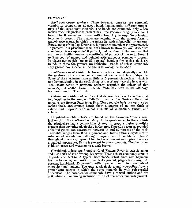
PETROGRAPHY
Biotite-muscovite gneisses. These two-mica gneisses are extremely variable in composition, adjacent bands having quite different proportions of the constituent minerals. The bands are commonly only a few inches thick. Plagioclase is present in all the gneisses, ranging in amount from 10 to 60 percent and in composition from An24 to An28• No potassium feldspar is present. The plagioclase together with the quartz forms a granoblastic matrix in which the micas lie with subparallel orientation. Biotite ranges from 0 to 40 percent, but most commonly it is approximately 15 percent. It is pleochroic from dark brown to straw yellow. Muscovite commonly makes up about 6 percent, but in some of the gneisses that are free of biotite, muscovite constitutes 20 percent of the rock. From 1 to 3 percent of ragged and poikiloblastic garnet is commonly present. In places garnet-rich (up to 25 percent) bands a few inches thick are found; in these the garnets are subhedral. Bands of schist, commonly very garnetiferous, occur in the gneiss following the foliation.
Biotite-muscovite schists. The two-mica schists mineralogically resemble the gneisses but are commonly more micaceous and less feldspathic. Some of the specimens have as little as 5 percent plagioclase, which is not distinguishable in the field. Some of the schists near the border with The Straits schist in northern Bethany resemble the schists of that member, but neither kyanite nor staurolite has been found, although both are found in The Straits.
Calcareous schists and marbles. Calcite marbles have been found at two localities in the area, on Falls Road, and east of Skokorat Road just north of the Beacon Falls town line. These marble beds are only a few inches thick, and contain bands about a quarter of an inch thick of calcite and diopside with minor amounts of microcline, garnet, and sphene.
Diopside-tremolite schists are found on the Seymour-Ansonia road just north of the southern boundary of the quadrangle. In these schists the plagioclase has a composition of An45 to An48, a higher anorthite content than any other plagioclase in the area. Diopside occurs as rounded anhedral grains and constitutes between 14 and 22 percent of the rock. Tremolite ranges from 0 to 5 percent and forms fibrous crystals with sub-parallel orientation. Although diopside and tremolite are found throughout the rock, layers richer in these two minerals give the rock a banded appearance. Pyrite is present in minor amounts. The fresh rock is bluish green and weathers to a dark brown.
Hornblende schists are found south of Bladens River in east Seymour and just north of Peat Swamp Reservoir. These schists commonly contain diopside and biotite. A typical hornblende schist from east Seymour has the following composition: quartz 43 percent, plagioclase ( An48 ) 26 percent, hornblende 25 percent, biotite 3 percent, and minor amounts of microcline and sphene. The quartz, plagioclase, and microcline from a granoblastic matrix in which the other minerals lie with sub-parallel orientation. The hornblendes commonly have a ragged outline and are poikiloblastic, containing inclusions of all of the other minerals present.
10
------ ---------------------------

They are pleochroic from pale green to colorless. Diopside where present occurs as rounded anhedral grains and is always associated with the hornblende.
All these calcareous rocks are more massive than the biotite schists, but all have a good foliation formed by the oriented hornblende, tremolite, and biotite, and by the alternation of bands of dark and light minerals. The farthest east that calcareous rocks have been found is on Luke Road near the eastern boundary of the quadrangle in the area mapped as Prospect gneiss. Here is a light green plagioclase-microcline-diopside schist is found. Between Luke Road and Skokorat Road (in the valley of Hopp Brook) exposure is poor, but a light green diopsidic rock similar to that found on Luke Road is found here in some of the till, suggesting that this area may be underlain in part by calcareous rocks.
As can be seen from the descriptions above, the undifferentiated Hartland formation consists of a wide variety of rock types which can rarely be traced more than a few hundred yards along strike because of drift 'cover. This is especially true where the unit is interbanded with Prospect gneiss; the more resistant Prospect gneiss is well exposed on the high ground, and the less resistant Hartland is poorly exposed in the low-lying lands.
QUARTZITIC MEMBER
NAME
The mica quartzites to the east of the Prospect gneiss have previously been included in the Orange phyllite (Rice and Gregory, 1906). They are here distinguished from the Orange phyllite and included in the Hartland formation because they resemble the rocks of the typical Hartland formation as described by Gates ( 1951). They are sufficiently distinct to be classed as a separate mappable unit.
DISTRIBUTION
The quartzitic member lies between the Orange phyllite and the Prospect gneiss. The boundary between the member and the Prospect gneiss parallels the foliation of both the gneiss and mica quartzite. There is a transitional zone of mixed gneisses and quartzites approximately 100 yards wide at the contact; on the map the mixed zone is included in the Prospect gneiss. The distinction between the Orange phyllite and the quartzitic member is based mainly on grain size and texture. Mineralogically the two units are similar, but the distinction between the two in the field is marked and the boundary sharp.
LITHOLOGY
The quartzitic member consists of a uniform sequence of well-foliated or gneissic muscovite-biotite quartzites. The foliation strikes N 30° -40° E and stands nearly vertical. There is commonly a well-marked lineation caused by folding of the micas which plunges 30°-60° SW. Near the boundary with the Orange phyllite the foliation surfaces have a greenish tinge due to chlorite and green biotite. In places the dark and light . minerals are in separate bands. One amphibolite band, 10 to 20 ft thick.
11
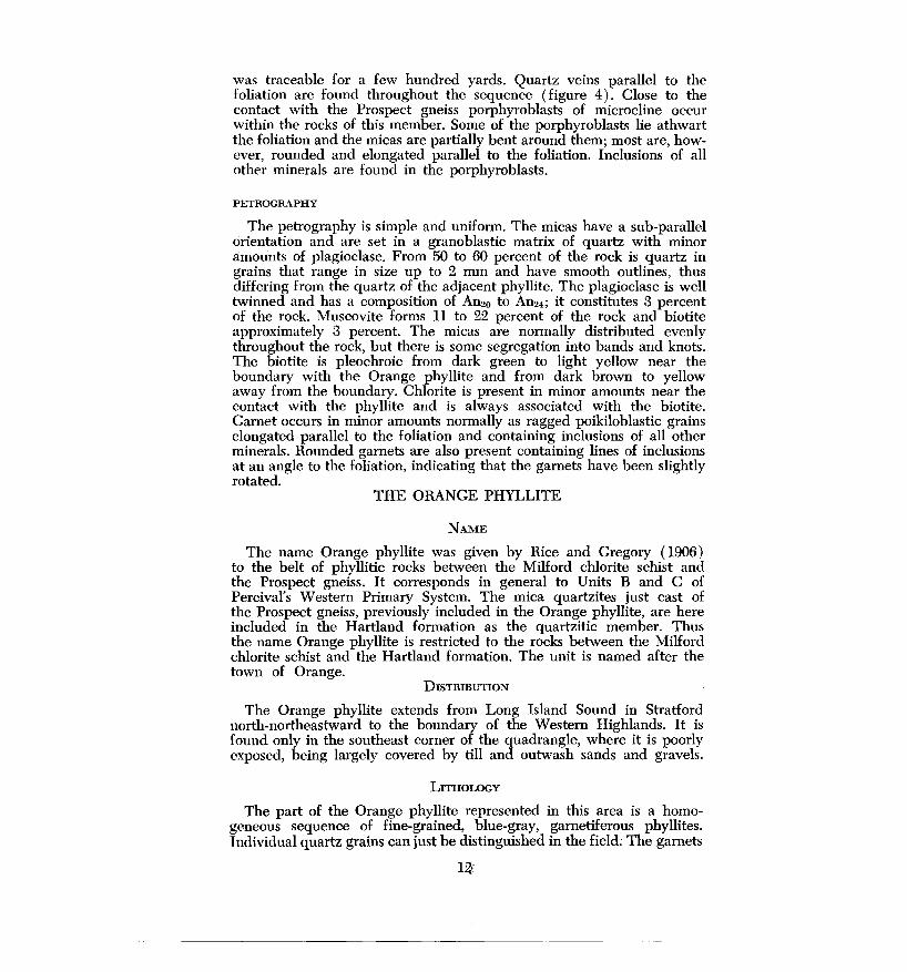
was traceable for a few hundred yards. Quartz veins parallel to the foliation are found throughout the sequence (figure 4). Close to the contact with the Prospect gneiss porphyroblasts of microcline occur within the rocks of this member. Some of the porphyroblasts lie athwart the foliation and the micas are partially bent around them; most are, however, rounded and elongated parallel to the foliation. Inclusions of all other minerals are found in the porphyroblasts.
PETROGRAPHY
The petrography is simple and uniform. The micas have a sub-parallel orientation and are set in a granoblastic matrix of quartz with minor amounts of plagioclase. From 50 to 60 percent of the rock is quartz in grains that range in size up to 2 mm and have smooth outlines, thus differing from the quartz of the adjacent phyllite. The plagioclase is well twinned and has a composition of An20 to An24; it constitutes 3 percent of the rock. Muscovite forms 11 to 22 percent of the rock and biotite approximately 3 percent. The micas are normally distributed evenly throughout the rock, but there is some segregation into bands and knots. The biotite is pleochroic from dark green to light yellow near the boundary with the Orange phyllite and from dark brown to yellow away from the boundary. Chlorite is present in minor amounts near the contact with the phyllite and is always associated with the biotite. Garnet occurs in minor amounts normally as ragged poikiloblastic grains elongated parallel to the foliation and containing inclusions of all other minerals. Rounded garnets are also present containing lines of inclusions at an angle to the foliation, indicating that the garnets have been slightly rotated.
THE ORANGE PHYLLITE
NAME
The name Orange phyllite was given by Rice and Gregory ( 1906) to the belt of phyllitic rocks between the Milford chlorite schist and the Prospect gneiss. It corresponds in general to Units B and C of Percival's Western Primary System. The mica quartzites just east of the Prospect gneiss, previously included in the Orange phyllite, are here included in the Hartland formation as the quartzitic member. Thus the name Orange phyllite is restricted to the rocks between the Milford chlorite schist and the Hartland formation. The unit is named after the town of Orange.
DISTRIBUTION
The Orange phyllite extends from Long Island Sound in Stratford north-northeastward to the boundary of the Western Highlands. It is found only in the southeast corner of the quadrangle, where it is poorly exposed, being largely covered by till and outwash sands and gravels.
LITHOLOGY
The part of the Orange phyllite represented in this area is a homogeneous sequence of fine-grained, blue-gray, garnetiferous phyllites. Individual quartz grains can just be distinguished in the field; The garnets
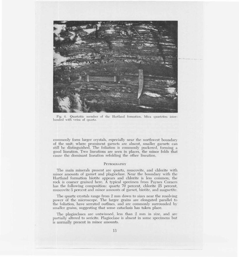
Fig. 4. Quartzitic member of the Hartland formation. Mica quartzites interbanded with veins of quartz.
commonly form larger crystals, especially near the northwest boundary of the unit; where prominent garnets are absent, smaller garnets can still be distinguished. The foliation is commonly puckered, forming a good lineation. Two lineations are seen in places, the minor folds that cause the dominant lineation refolding the other lineation.
PETROGRAPHY
The main minerals present are quartz, muscovite, and chlorite with minor amounts of garnet and plagioclase. Near the boundary with the Hartland formation biotite appears and chlorite is less common; the rock is coarser grained here. A typical specimen from Paynes Corners has the following composition: quartz 70 percent, chlorite 25 percent, muscovite 3 percent and minor amounts of garnet, biotite, and magnetite.
The quartz crystals range from 2 mm down to sizes near the resolving power of the microscope. The larger grains are elongated parallel to the foliation , have serrated outlines, and are commonly surrounded by smaller grains, suggesting that some cataclasis has taken place.
The plagioclases are untwinned, less than 2 mm in size, and are partially altered to sericite. Plagioclase is absent in some specimens but is normally present in minor amounts.
13

Chlorite, muscovite, and biotite are always in close association, and their parallel orientation gives the rock its schistosity. The muscovites are commonly fractured and bent. Chlorite is present as minute grains smaller than the resolving power of the microscope. Toward the boundary with the Hartland formation chlorite becomes less abundant and biotite more so. The biotite is pleochroic from yellow brown to dark brown and ranges in size up to 3 mm.
The garnet grains are subhedral to anhedral, and the micas wrap around them. Garnets contain inclusions of quartz and muscovite.
THE PROSPECT GNEISS
NAME
The first published description of the Prospect gneiss is that by Percival ( 1842), who named it the Porphyritic formation or Formation D of his Western Primary System. The term Prospect porphyritic gneiss was first used by Rice and Gregory ( 1906). The gneiss is named after the town of Prospect. Included in this unit were all the rocks between the present quartzitic member and The Straits schist member of the Hartland formation. The gneiss was also described by Barrell and Loughlin ( 1910) and by Dale and Gregory ( 1911). Stewart ( 1935) restricted the use of the term Prospect gneiss to the "dark gray foliated rock containing prominent feldspars" and mentioned the abundance of schistose material within the gneiss. The schists he included in the Hartland formation but made no distinction on the map between the Prospect gneiss and the Hartland formation east of The Straits schist member. Percival also noted the schists within the gneiss and commented on the difficulty of drawing a boundary between the gneiss and the schists to the west.
In this report the term Prospect gneiss is restricted to the dark gray biotite augen gneiss and excludes the interbanded schists, which are considered to be part of the undifferentiated Hartland formation.
DISTRIBUTION
The Prospect gneiss is always found at the same stratigraphic position, that is, between The Straits schist member and the quartzitic member of the Hartland formation. In the eastern body of Prospect gneiss the only schists present are bands a few inches thick parallel to the foliation. Farther west the proportion of schists present increases and the gneiss is found interbanded with the schists, gneisses, and calcareous rocks of the undifferentiated Hartland formation. A boundary has been drawn separating the area where the Hartland formation is dominant from that where the Prospect gneiss is dominant, but the two are gradational. Prospect gneiss is also found in the cores of the isoclinal folds in the center of the quadrangle. In these, schists and amphibolites are found near the contact with The Straits schist. Away from the contact schistose material is rare; where present it is in the form of disoriented bodies.
14
-- ----- --------------------------

LITHOLOGY
The Prospect gneiss is a medium-to coarse-grained dark gray biotite augen gneiss, in places porphyritic. It is poorly foliated, the foliation being partially destroyed by the augen. Where the gneiss is not foliated it commonly has a lineation formed by the elongation of the augen and by the folding of the micas around the augen. The gneiss at its eastern border is markedly porphyritic; megacrysts of euhedral to subhedral microcline up to several centimeters in length are distributed throughout the rock (figure 5). Some megacrysts in section have concentric rings of inclusions of magnetite and biotite. Carlsbad twinning of the microcline is commonly conspicuous in hand specimen. Many of the megacrysts are sheared, the shearing becoming more intense away from the border zone. Microcline is found in every gradation from euhedral megacrysts through rounded augen to veins parallel to the foliation. The westward extent of the prominent porphyroblasts is shown on the map. Megacrysts of microcline are also found in places in the gneiss of the isoclinal folds in the central part of the map.
Away from the eastern border zone occasional megacrysts of microcline and plagioclase occur but they are rare. The gneiss is more typically a n:on-porphyritic augen gneiss. Clusters of quartz, phlgioclai,se, and microcline constitute the augen, but normally they are exclusively of quartz. Hornblende is found in various proportions, as shown by the compositions of the specimens listed below. Hornblendic and nonhornblendic layers are interbanded, and no systematic regional variation is apparent. Interbanding of the two kinds is shown in the section along Russell Road in Bethany, also farther west where the gneiss is interbanded with the Hartland formation. In the gneiss found in the cores of the isoclinal folds hornblende is absent.
PETROGRAPHY
The range of composition of the gneiss is indicated by Table 1 below. This indicates the dominance of quartz, plagioclase, and biotite, and the wide range in the proportion of microcline and hornblende.
TABLE 1
Specimen 8 9 16 21 25 26 29 40
Quartz 28.l 39.4 40.1 40.4 33.2 ' 39.1 37.8 31.2
Plagioclase 32.2 30.7 27.8 29.8 44.8 18.8 23.2 30.9
Microcline 4.7 2.0 8.0 12.l tr 0.5
Biotite 27.6 19.2 31.1 17.8 21.5 24.5 32.2 31.7
Hornblende 6.1 5.9 1.2 2.0 4.5 3.4
Garnet tr 1.3 1.0 2.1 0.5 3.1 tr 1.4
Sphene tr 0.2 tr 0.7 tr tr tr
The figures in Table 1 are percentages obtained by modal and are based on approximately 1000 counts per section.
analyses
15

I .
tt' I • ..
,..-:t' ~··': .
i . . ,.
, .. , ~.;.\1} i( t ~t ~
Y. · , ~· . . '
~ ~ .
~'. '. :~.
' . . \.
Fig. 5. Prospect gneiss, porphyri
tic eastern border facies. Megacrysts
of microcilne in a medium-grained
groundmass of quartz, plagioclase,
and garnet.
The plagioclase is anhedral and ranges in composition from An22 to An32. It is well twinned according to the albite, pericline, and Carlsbad laws. The grains are commonly approximately 2 mm across, but occasional small porphyroblasts up to 6 mm across are found. The grains are commonly cracked, and the twin lamellae are bent and commonly slightly displaced along these cracks. Nearly all the plagioclase has undergone partial alteration to sericite.
The quartz grains are commonly 2 to 3 mm across, but smaller ones are found as inclusions in the feldspar, hornblende, and garnet. The augen are normally segregations of the larger quartz crystals, some of these being up to 6 mm across. Nearly all the quartz h~s undulose extinction.
Except at the border zone the microcline is anhedral and rarely occurs as megacrysts. It is finely cross-twinned and has inclusions of quartz, plagioclase, and biotite. At the border zone near the contact with the quartzitic member of the Hartland formation the proportion of microcline is greater than in the rest of the body. Microcline 1s also more abundant in the gneiss found in the cores of the isoclinal folds to the west, where it commonly forms about 12 percent of the rock.
16
Biotite is pleochroic from dark brown to straw yellow. The biotite forms grains oriented at random, but in places they are sub-parallel. The grains range in size up to 3 mm, generally occurring as clusters or bands together with the other dark minerals; sphene and zircon are common inclusions. Partial alteration to chlorite is seen in some sections.
Hornblende is pleochroic from dark green to blue green to pale yellow, commonly has a ragged outline, and contains inclusions of all other minerals. Orientation of hornblende follows that of biotite, the long axes being sub-parallel to the length of the biotites.
In places pyrite and chalcopyrite are found disseminated throughout the gneiss, for example just north of Swamp Brook west of Pine Bridge and in the roadcut along Conn. Route 8 west of Rock Rimmon. At Pine Bridge the gneiss is reputed to have been prospected for copper during the Civil War.
ORIGIN
The origin of the Prospect gneiss is in doubt. Rice and Gregory ( 1906) believed that a porphyritic granite intruded the Hartland formation and that this was later modified by metamorphism to form the Prospect gneiss. Dale and Gregory ( 1911) also suggested that the gneiss was igneous and that the megacrysts of microcline are phenocrysts formed before the crystallization of the rest of the rock. Megacrysts of microcline similar to those found in the Prospect gneiss are found, however, in the mica quartzites of the quartzitic member of the Hartland formation adjacent to the contact with the gneiss. These latter megacrysts are undoubtedly porphyroblasts, yet they are indistinguishable from the megacrysts found in the gneiss. Thus the megacrysts of microcline within the gneiss may also be porphyroblasts.
In the Mount Carmel quadrangle to the east bodies of schist lie athwart the foliation of the gneiss and completely surround the gneiss. Similar inclusions are found in the gneiss west of Rock Rimmon. Such relations indicate that at least some parts of the gneiss have been mobile at some stage in their paragenesis. Within the Hartland formation, however, the Prospect gneiss occurs as bands ranging in thickness from a few inches to tens of feet and is parallel to the foliation of the schists. Bands of schist parallel to the foliation of the gneiss are also found in the eastern body of Prospect gneiss. These bands may be only a few inches thick but are persistent along the strike. Further, the gneiss is restricted to a consistent stratigraphic position; it is always found in the belt of undifferentiated Hartland formation. These facts suggest that the gneiss may be of local origin and formed by the metamorphism of the Hartland formation, the metamorphism resulting in partial mobilization. Such an origin would account for the intimate relation between the Hartland and the Prospect gneiss. If the gneiss is igneous, then lit-par-lit injection on a large scale would be necessary to explain the relation between the gneiss and the Hartland.
17

THE ANSONIA GRANITE
NAME
The Ansonia granite was first discussed by Dale and Gregory ( 1911) who described its occurrence in Potter's quarry in Ansonia. The granite js named for the town of Ansonia.
DISTRIBUTION
The Ansonia granite is found intrusive into the undifferentiated Hartland formation. It also intrudes the Prospect gneiss east of the undifferentiated Hartland formation but is here rarer. It is not found west of the undifferentiated Hartland. The granite is best exposed in this quadrangle in a quarry just north of Peat Swamp Reservoir at the southern end of the quadrangle. The intrusives range in thickness from a few inches to several hundred feet. They are a separated unit where they are of sufficient size to be mapped. Single outcrops within drift-covered areas are not marked, as the extent of the intrusive under the drift cover is unknown. No relation between the extent of intrusion of the granite into the Hartland and the proximity to the larger intrusives has been established.
Normally the granite is intruded parallel to the foliation of the enclosing rocks, but locally it cuts across the foliation, or a dike-like body connects two intrusives parallel to the foliation. The foliation of the granite is always parallel to the foliation of the enclosing rocks, even in the crosscutting dikes.
LITHOLOGY
The Ansonia granite is a light gray biotite-musco~ite granite gneis<>. The micas are normally distributed evenly throughout the rock with parallel orientation giving the rock a good foliation. Knots of biotite occur elongated parallel to the foliation. The composition is fairly uniform, but the grain size ranges from 6 mm in the larger intrusives to 0.5 mm in the narrow sills. There is no decrease in grain size toward the margins of the intrusives.
PETROGRAPHY
The range in composition of the Ansonia granite is indicated by the list of modal analyses below (Table 2).
TABLE 2
Specimen 20 24 35 38
Quartz . 34.3 36.l 32.7 31.7 Microcline 36.1 41.5 39.8 35.2 Plagioclase 21.7 14.8 20.2 28.7 Muscovite 3.5 1.4 3.1 2.3 Biotite 4.2 4.8 1.9 1.7 Garnet 0.2 tr 0.5 Apatite tr tr tr tr
18

The granite has a granoblastic texture and is equigranular. The quartz is anhedral with undulose extinction and in places occurs as inclusions in the plagioclase and microcline. The microcline is in most cases of the same grain size as the quartz and plagioclase, but a few grains are up to three times as large as the enclosing minerals. All the mircocline is anhedral. The plagioclase ranges in composition from An18 An24, but some albite occurs at the junction of some plagioclase and microcline grains. There is no systematic regional variation in the composition of the plagioclase. It is twinned according to the albite and Carlsbad laws, hut in some specimens up to 40 percent of the plagioclase is untwinned. The twinning is usually simple, only one twin law being represented in any one grain, and the twin planes are undeformed. Nearly all the plagioclase has undergone partial alteration to sericite. The biotite is pleochroic from dark brown to straw yellow, and its uniform orientation gives the rock its foliation. The micas are commonly evenly distributed throughout the rock, but clusters of biotite occur elongated parallel to the foliation. In these clusters the biotite is more randomly oriented than in the rest of the rock. The garnets are ragged and poikiloblastic and contain inclusions of all of the other minerals.
The granite cuts the rocks of both the Hartland formation and the Prospect gneiss and is thus later than these units. The foliation of the granite is parallel to the regional foliation, however, and bears no relation to the form of the intrusive. This suggests that recrystallisation took place after the intrusion of the granite.
THE DOLERITE DIKES
DISTRIBUTION
The main dolerite dike in the area, that found in the valley just east of Rock Rimmon, lies in the plane of a fault which strikes N 30°E and dips 65° SE. The dike maintains a constant thickness of approximately 20 feet over a distance of more than four miles. The other dikes in the area are less constant in thickness and more difficult to trace. For example, the dike in the eastern part of Seymour becomes thinner to the north and splits into several branches, ranging in thickness from two to fifteen feet, which die out to the north. The southward extent of this dike is not known because of the lack of exposures.
LITHOLOGY
The lithology of the dolerite is uniform throughout the area. The dolerite is fine grained, dark blue-grey to black when fresh, and weathers to a light brown. Although the rock is resistant to erosion and commonly forms slight mounds above the surrounding topography, the dike east of Rock Rimmon is found in the bottom of a valley for most of its length.
PETROGRAPHY
Two sections of the dolerite were examined, one from the dike east of Rock Rimmon, and one from the dike in the eastern part of Seymour. There were no significant differences in composition between these two,
19

and the following composition is the average of the two: augite 43.2 ·percent, plagioclase 53.2 percent, magnetite 1.5 percent, aphanitic material 5.0 percent, and minor amounts of chlorite and muscovite. The size of the grains ranges from a size below the resolving power of the microscope up to 0.6 mm. However, in the dolerite at the northern end of the main dike rounded phenocrysts of plagioclase several millimeters in diameter have been found. The rounded anhedral grains of augite lie in a matrix of plagioclase laths with aphanitic intergranular material.
AGE
The fault and dike east of Rock Rimmon and the other dolerite dikes in the southern part of the quadrangle are considered to be of Triassic date. Direct evidence for this assignment is lacking, but there are two strong bases for it. First, the dike rock is petrographically very similar, as to both composition and texture, to dikes associated with known Triassic rocks a few miles east in the Central Lowlands. Second, the trend of the fault and dikes is about the same as that of numerous faults and dikes associated with the rocks of the Central Lowlands.
THE PEGMATITES
There appear to be at least two generations of pegmatites; the older ones are foliated, the younger non-foliated. The pegmatites were not studied in detail for this report, and only the larger ones (in Seymour) are represented on the map.
STRUCTURE Where the bedding can be seen it is always parallel to the foliation.
This is true even at the noses of isoclinal folds where the foliation follows the form of the folds except that the foliation is folded on a small scale, the axial planes of the minor folds being parallel to the axial planes of the larger folds. The bedding can be seen well in the undifferentiated Hartland formation, which is composed of units of very different composition. Wherever the contact of The Straits schist with other units can be seen, the foliation parallels the contact. In the gneisses to the north and west of The Straits schist belt the bedding can rarely be distinguished, but it is assumed that here, and in other parts of the area where bedding cannot be distinguished, the foliation is parallel to the bedding.
The major structural features are known or are here interpreted, but because of the paucity of outcrop most of the details of the structure remain unknown. The key to the structure is provided by The Straits schist member, which is well exposed and forms most of the high land in the area. In the southern part of the quadrangle the dips are normally to the east at various angles, yet The Straits schist is repeated several times. Between the western bodies of Prospect gneiss and The Straits schist there is a sequence of yellow-weathering two-mica schists including layers of amphibolite and diopsidic schist. The sequence ranges in thickness from 10 to 100 feet and is found on either side of the tongue of The Straits schist just west of the Naugatuck River wherever the
20

boundary is exposed. This indicates that isoclinal folding and not faulting is the cause of the repetition of The Straits schist.
The amphibolitic sequence has been mapped only where the Straits schist member is in normal contact with the Prospect gneiss and appears to represent the "stratigraphically" lowest part of the Prospect gneiss. Since the interpretation is that the Prospect gneiss is a metamorphic derivative of part of the undifferentiated member of the Hartland formation, it follows that the basal part of the Prospect gneiss is equated with the basal part of the undifferentiated member of the Hartland. The amphibolitic sequence is then the only part of the latter left in the central area, the remainder having been convertd to Prospect gneiss.
The amphibolitic sequence has been included in the undifferentiated Hartland formation. If this interpretation is valid, the sequence should be found at the normal contact of 'The Straits with the main body of undifferentiated Hartland. This contact is a fault contact from Beacon Road south, and the amphibolite sequence is not found here. To the north and east where the contact is east-west it is poorly exposed, and the amphibolite sequence has not been found. In the Mount Carmel quadrangle amphibolites have been found, however, at the contact of The Straits schist and the undifferentiated Hartland ( C. E. Fritts, personal communication). This helps to justify the inclusion of the amphibolitic sequence in the undifferentiated Hartland formation.
West of the central tongue of schist the amphibolite sequence is not found at The Straits schist contact, but the only place where the actual contact is exposed is just west of Seymour Reservoir No. 4. Here an amphibolite band a few inches thick was found, but no intervening micaceous schists and diopsidic schists. This absence could be due to stratigraphic thinning or to crosscutting by the gneiss.
If the inclusion of the amphibolitic sequence in the undifferentiated Hartland formation is valid and if The Straits schist is the basal member of the Hartland formation, then the Prospect gneiss west of Rock Rimmon must lie in the cores of isoclinal synclines with The Straits schist exposed on the anticlinal crests between.
This interpretation of the structure is substantiated by the presence of isoclinal drag folds, which are especially common in the amphibolites at The Straits schist contact. Drag folds with axial planes dipping east parallel to the axial planes of the major folds· are seen on two scales: folds spanning several feet, and folds on the scale of about a centimeter. The smallest folds are found only in the amphibolites and gre visible becau~e of the alternation of bands of plagioclase a few millimeters thick with bands of hornblende. They are apparent only at the noses of larger isoclinal drag folds. The axial planes of the small folds form a planar structure which is parallel to the axial planes of the larger folds.
Drag folds occur in the amphibolite sequence on the east side of the tongue of The Straits schist in the western part of Seymour. These folds indicate that a syncline lies to the east, thus substantiating the structural interpretation above. Folding of veins in the Prospect gneiss on Conn.
21

Route 8 west of Rock Rimmon indicates a syncline to the west, but this evidence is less satisfactory.
All the postulated synclines close to the north indicating that, in the northern part of the area at least, the synclines plunge to the south. Similarly, the anticline west of Seymour Reservoir No. 2, indicated by The Straits schist, plunges to the south. The tongue of The Straits schist just south of Beacon Falls terminates to the east. If the schist is exposed on the crest of an anticline, then some indication of the fold should be found at the boundary between the Prospect gneiss and The Straits schist just east of Burton Road. No indication is found, however, so it is suggested that the fold dies out to the east.
According to the above interpretation of the structure, the westernmost band of The Straits schist forms the western limb of an isoclinal syncline. The near horizontal dips of the foliation in The Straits schist on top of Rock Rimmon suggest that The Straits schist is exposed along the crest of an isoclinal anticline, the east limb of which is cut by a fault.
The origin of the gneiss in the cores of the folds is in doubt. That this is not an igneous body cutting through The Straits schist is indicated by the nature of the contact. However, if the gneiss had been intruded parallel to the foliation of the enclosing rocks, then the whole sequence could have been folded to give the presently postulated configuration in which The Straits schist underlies the gneiss.
The extent to which the units on either side of The Straits schist are isoclinally folded is not known as there are no traceable marker horizons to outline the folds. Isoclinal folds, which may be drag folds on the limbs of larger folds, are found in the undifferentiated Hartland formation just north of Peat Swamp Reservoir. These folds differ from the isoclinal folds to the west in that their axial planes dip to the west. In the main body of undifferentiated Hartland formation and in the Waterbury gneiss the foliation does not, however, dip consistently in one direction, as it does in the central belt of isoclinal folds. This suggests that isoclinal folding is less common on either side of the central belt than within it.
To the north the structure is complicated by the Waterbury dome. Uplift in the northern part of the area has caused the north-trending isoclinal folds to swing round in such a way that the dips of the foliation are all away from the dome, southeast on the west side of the Naugatuck River and south on the east side of the river. Thus the large tongue of The Straits schist west and southwest of Naugatuck is in the form of a syncline plunging to the southeast. This is, however, not a simple syncline, for the original isoclinal folds have been folded so that their axial planes form synclines. Farther east the effect of the Waterbury dome is less marked and results only in the changing of the strike from north-south to east-west.
The structure in the southeast part of the quadrangle appears simple. The foliation strikes N 30° - 40° E and the dips are nearly vertical. A lineation caused by the folding of the micas plunges 30° to 60° to the
22
southwest. In the Orange phyllite a second lineation can commonly be seen which has been refolded by the folds causing the dominant lineation. Within the Prospect gneiss the foliation is commonly masked by the augen, but where the foliation is absent there is in most places a near horizontal lineation which follows the trend of the foliation.
In the undifferentiated Hartland formation in Seymour there is a marked lineation which plunges to the north at angles between 10° and 20°. North of Seymour the mineral lineation plunges northeast parallel to the plunges of some folds in the the schists at angles up to 20°. The general trend of the foliation is parallel to the contact with The Straits schist, being north-south at the southern edge of the quadrangle ancl east-west to the east of Beacon Falls.
A good foliation can always be seen in The Straits schist. It is commonly folded to such an extent that the strike cannot be measured directly, in which case what is shown on the map is a generalized foliation with the plunges of the minor folds. The extent to which the schist is folded varies. In the tongue of The Straits schist southwest of Naugatuck and the band just west of the Naugatuck River the foJiation has a uniform strike, but the schists at the southern end of Chestnut Hill, west of Beacon Hill and on Rock Rimmon are complexly folded. The Straits schist at the southern end of Chestnut Hill is the only part of The Straits schist that is interbanded with gneisses.
The strike of the foliation of the gneisses in the Waterbury dome, where the strike is sufficiently constant to be measured, tends to follow the form of the dome. The foliation of the Waterbury gneisses to the west of The Straits schist strik~s parallel to the contact with The Straits schist, that is, in a general north-south direction. The foliation generally stands vertical or dips steeply to the east. At the southern end of Towantic Hill, however, the foliation strikes east-west and dips 0-40° to the north.
The latest structural event in the history of the area is the faulting. Slickensides are found in many parts of the area, but only the fault to the east of Rock Rimmon can be traced for any distance. This fault strikes N 30° E and dips 65° to the east; on the eastern side the undifferentiated Hartland formation is interpreted to have been thrown down. Slickensides have been found on the foot wall plunging parallel to the dip of the fault plane, and the fault is filled with quartz on which slickensides also occur. Thus the evidence suggests it is a normal fault. A dolerite dike has been intruded along the fault plane, but the fault may extend north of the termination of the dolerite dike and form the contact between the Waterbury gneiss and The Straits schist.
METAMORPHISM
The rocks showing the lowest grade of metamorphism are found in the southeast part of the quadrangle. The mineral assemblage of the Orange phyllite corresponds to that of a semi-pelitic rock in the cordierite-anthophyllite subfacies of the amphibolite fades (Turner, 1948), except that chlorite is present instead of biotite in much of the
23

unit. Where biotite is present the textural relations suggest that chlorite has replaced biotite, for chlorite is found along the cleavage of the biotite and also as aggregates cutting across the biotite crystals. Thus the chlorite may be retrogressive. This is substantiated by the cataclastic texture of the phyllite in this area and by the absence of chlorite in adjacent rocks of similar composition but which have no cataclastic texture.
The mineral assemblages of the rocks of the undifferentiated Hartland formation also correspond to those expected in this subfacies, for example, muscovite-biotite-oligoclase-microcline-quartz in the pelitic rocks and diopside-garnet-andesine-microcline-quartz in the calcareous rocks, with tremolite appearing in places.
In The Straits schist kyanite and staurolite appear, indicating that the schist is in the staurolite-kyanite subfacies. The boundary between rocks of the two subfacies must be near the contact of The Straits schist with the main body of the undifferentiated Hartland formation. No sillimanite has been found in the area.
The date of the metamorphism is in doubt. Several estimates have been made of the age of an undeformed pegmatite at the western edge of the main belt of Hartland formation at Branchville, Conn. Some of these estimates (Rodgers, 1952) have been based on standard gravimetric analyses of uraninite, and others (Wasserburg, Hayden, and Jensen, 1956) are based on lead isotope analyses of uraninite. All of these agree on a figure of about 360 million years for the age of the uraninite, thus giving an upper limit for the date of the metamorphism. A lower limit cannot be established as the age of the Hartland formation is unknown.
24

REFERENCES
Barrell, Joseph, and Loughlin, G. F., 1910, The lithology of Connecticut: Connecticut Geo!. and Nat. History Survey Bull. 13.
Dale, T. N., and Gregory, H. E., 1911, The granites of Connecticut: U. S. Geo!. Survey Bull. 484.
Gates, R. M., 1951, The bedrock geology of the Litchfield quadrangle: Connecticut Geo!. and Nat. History Survey Misc. Ser. 3 (Quad. Rept. 1).
----- 1954, The bedrock geology of the Woodbury quadrangle: Connecticut Geo!. and Nat. History Survey Quad. Rept. 3.
Gates, R. M., and Bradley, W. C., 1952, The geology of the New Preston quadrangle: Connecticut Geo!. and Nat. History Survey Misc. Ser. 5 (Quad. Rept. 2).
Percival, J. G., 1842, Report on the geology of the State of Connecticut: New Haven.
Rice, W. N., and Gregory, H. N., 1906, Manual of the geology of Connecticut: Connecticut Geo!. and Nat. History Survey Bull. 6.
Rodgers, John, 1952, Absolute ages of radioactive minerals from the Appalachian region: Am. Jour. Sci., v. 250, p. 411-427.
Rodgers, John, Gates, R. M., and Rosenfeld, J. L., 1959 Explanatory text for preliminary geological map of Connecticut, 1956: Connecticut Geo!. and Nat. History Survey Bull. 84.
Stewart, Lincoln, 1935, The petrology of the Prospect porphyritic gneiss of Connecticut: Connecticut Geo!. and Nat. History Survey Bull. 55.
Turner, F. J., 1948, Evolution of the metamorphic rocks: Geo!. Soc. America Mem. 30.
Wasserburg, G. J., Hayden, R. J., and Jensen, K. J., 1956, A,.-K,0 dating of igneous rocks and sediments: Geochim. et Cosmochim. Acta, v. 10, p. 153-165.
25