I B ---yOther cultural practices on Maunakea include deposition of a baby’s piko, or umbilical...
376
UH Hilo Administration Office of the Chancellor Katherine Puma Kealoha, Esq. Director Office of Environmental Quality Control 235 South Beretania Street, Room 702 Honolulu, Hawai' i 968 1 3 " I Final Environmental Impact Statement ! , Thirty Meter Telescope (TMT) Project k++d Maunakea, Hawai'i Island \ B ---y 3:. . -. . . Subject: Dear Ms. Kealoha: The University of Hawai'i at Hilo in its capacity as the proposing agency for the Final Environmental Impact Statement for the Thirty Meter Telescope Project requests publication of Environmental Notice. Enclosed are the following items: the Notice of Availability of the Final Environmental Impact Statement in the next issue of the One (1) copy in pdf format and one (1) hardcopy of the Final EIS Completed Office of Environmental Quality Control (OEQC) publication form Completed Final EIS distribution list If you have any questions, please call Helen Rogers at (808) 974-7444. Sincerely, Rose Tseng Chancellor Enclosures 200 W. Kawili Street, Hilo. Hawai'i 96720-4091 Telephone: (808) 974-7444, Facsimile: (808) 974-7622, www.uhh.hawaii.edu An Equal OpportunityIAffirmative Action Institution
Transcript of I B ---yOther cultural practices on Maunakea include deposition of a baby’s piko, or umbilical...
UH Hilo Administration Office of the Chancellor
Katherine Puma Kealoha, Esq. Director Office of Environmental Quality Control 235 South Beretania Street, Room 702 Honolulu, Hawai' i 968 1 3
" I Final Environmental Impact Statement ! , Thirty Meter Telescope (TMT) Project k++d Maunakea, Hawai'i Island \ B ---y 3:. . - . . .
Subject:
Dear Ms. Kealoha:
The University of Hawai'i at Hilo in its capacity as the proposing agency for the Final Environmental Impact Statement for the Thirty Meter Telescope Project requests publication of
Environmental Notice. Enclosed are the following items: the Notice of Availability of the Final Environmental Impact Statement in the next issue of the
One (1) copy in pdf format and one (1) hardcopy of the Final EIS
Completed Office of Environmental Quality Control (OEQC) publication form
Completed Final EIS distribution list
If you have any questions, please call Helen Rogers at (808) 974-7444.
Sincerely,
Rose Tseng Chancellor
Enclosures
200 W. Kawili Street, Hilo. Hawai'i 96720-4091 Telephone: (808) 974-7444, Facsimile: (808) 974-7622, www.uhh.hawaii.edu
An Equal OpportunityIAffirmative Action Institution

FINAL ENVIRONMENTAL IMPACT
STATEMENT Volume 1
Thirty Meter Telescope Project
Island of Hawai‘i
Proposing Agency: University of Hawai‘i at Hilo
This Environmental Document was Prepared Pursuant to Hawai‘i Revised Statutes, Chapter 343, Environmental Impact Statement Law and Chapter 200 of Title 11, Hawai‘i Administrative
Rules, Department of Health, Environmental Impact Statement Rules
May 8, 2010


Preface Final EIS: TMT Observatory Page P-1
Preface Standing 13,796 feet above sea level, Maunakea1 – often translated into English as White Mountain for its snowy summit in the winter season – is the highest volcanic peak in the Hawaiian Islands. The now dormant Maunakea, together with Mauna Loa – a volcanic peak just to the south – left a saddling plateau built up from the abundant lava flows.
Traditional knowledge handed down over the generations reveals that Maunakea is of profound importance in Hawaiian culture. Also, due to its unique setting, Maunakea is the world’s foremost location for astronomical observation and research. The observations conducted by the existing observatories contribute extensively to the advancement of science worldwide and to America’s leadership in astronomy research.
“In Hawaiian culture, natural and cultural resources are one and the same.”2 The formation of the Hawaiian Islands and the presence of life on and around them are described by Native Hawaiian traditions. These traditions explain that all forms of the natural environment, from the oceans to the mountain peaks and the valleys and plains in between, are believed to be embodiments of Hawaiian gods and deities. The significance of Maunakea, and in particular its summit, is revealed through the direct application of meaningful place names to its landscapes and natural features. According to Native Hawaiian tradition, the “Kea” in Maunakea, is an abbreviation for Wākea, the great sky god, who, together with Papa-hānau-moku, the Earth mother, and various gods and natural forces, gave birth to the islands. Hawaiian tradition records that Hawai‘i, the largest island in its archipelago, is also the first born of these islands, and Maunakea is known as “ka piko o ka moku” meaning “the navel of the island.” Other natural features of the landscape, such as the cinder cones of the mountain, were named after ancient ancestors, many of whom were regarded as gods and goddesses. Some of the most prominent among these include Kūkahau‘ula, the husband of Līlīnoe; Poli‘ahu, goddess of the snows of Maunakea; Waiau, goddess of the lake; and Līlīnoe, the goddess of mists.
The cultural attachment to the environment and nature bears direct relationship to the beliefs, practices, cultural evolution, and identity of a people. Maunakea bears much significance because it is believed that the points of highest altitude are sacred and open the gateways to Heaven. Six main zones can be found on the slopes of Maunakea; Kuahiwi, the core summit area, is the highest and most sacred. Tradition tells us that access to the summit was limited to high chiefs and priests, where prayers could be offered in the utmost reverence to their gods, akua.
The sacred zone next to the Kuahiwi is known as Kualono and consists of the near-summit lands where few trees grow. As early as AD 1100, adze makers came in reverence to the Maunakea
1 Maunakea is spelled as one word in this document because it is considered the traditional Hawaiian spelling (Ka Wai Ola, Vos. 25 No. 11). Maunakea is a proper noun, therefore spelled as one word in Hawaiian. This spelling is found in original Hawaiian language newspapers dating back to the late 1800s when the Hawaiian language was the medium of communication. In more recent years Maunakea has been spelled as two words, which literally mean “white mountain.” Spelled as two words it is a common noun that could refer to any white mountain verses the proper name of this particular mountain on Hawai'i Island. The common “Mauna Kea” spelling is only used in this document where Mauna Kea is used in a proper name, such as the “Mauna Kea Science Reserve.” 2 Mauna Kea Science Reserve Master Plan, June 2000.
Page P-2 Final EIS: TMT Observatory Preface
adze quarry, Keanakāko‘i (most of which is located in the Mauna Kea Ice Age Natural Area Reserve) and this practice continued through the 1700s up until the time of Western contact. In this area of the mountain, large deposits of a very hard, fine grained volcanic rock, known as basalt, were found that were used to produce high-quality adzes, or tools, for woodworking, canoe-making, and construction of other structures like shelters.
As part of the ritual associated with quarrying, craftsmen erected shrines (as evidenced by unique upright stone structures) to their gods. The two uppermost sacred zones were also used for burials, with one pu‘u, or cinder cone, having been confirmed to contain burials and four others considered likely to contain burials. Historical documents reveal that most shrines are located on the summit plateau (mostly on the north and northeast side of the mountain), not the core summit region or the tops of cinder cones, suggesting that the area was likely avoided because of its high degree of sacredness.
Other cultural practices on Maunakea include deposition of a baby’s piko, or umbilical cord. In an account by Pualani Kanaka‘ole Kanahele, the symbolism of this practice was described as:
…the part of the child that connected the child back to the past. Connected the child back to the mama. And the mama’s piko is connected back to her mama and so on. So it takes it back, not only to the wā kahiko [ancient times], but all the way back to Kumu Lipo…So it’s not only the piko, but it is the extension of the whole family that is taken and put up in a particular place, that again connects to the whole family line. And it not only gives mana or life to that piko and that child, but life again to the whole family.3
For some families, the practice of piko deposition on Maunakea is a long-standing traditional cultural practice, requiring proper means for depositing and maintaining cleanliness and purity.
Following the summit and near summit lands are four zones in descending order: wao ma‘u kele, a wet area of large koa; wao akua, an area of more varied forest – also referred to as the region of the gods for its remote desolate location where benevolent or malevolent spirits lived and people did not; wao kanaka, the lowest forested area most used as a cultural resource; and kula, the upland grassy plains. Hawaiians used the lower zones for everyday purposes, however, wao ma‘u kele and wao akua are currently a part of the Conservation District.
The year 1778 marked the first European contact with the islands upon the arrival of Captain James Cook. Since this contact, Maunakea’s environment and cultural practices have significantly changed. For example, adze quarrying phased out shortly after Western contact when iron tools were introduced to the Hawaiians and replaced those made from basalt. New species of animals such as cattle and sheep were also introduced to the island, and upon the arrival of the Christian missionaries, the kapu system was abolished and certain traditional cultural practices were discouraged. The early 1900s brought additional changes in the landscape with the importation of trees and early road construction by the Civilian Conservation Corps (CCC) and U.S. Army around World War II. Improvement of the roads enhanced access to the mountain, especially with Saddle Road connecting Hilo and Waimea.
It wasn’t until the early 1960s that interest grew in using the summit for Western astronomical observations. Prior to the introduction of astronomical observatories, Native Hawaiians used the 3 Kumu Pono, 1999:A-376.

Preface Final EIS: TMT Observatory Page P-3
stars, (in addition to knowledge of the wind, waves, currents, weather, fish, and birds) to navigate the open oceans through a skillful art known as wayfinding. Advancing this history and practice, the U.S. Air Force developed the first optical observatory on the mountain in 1964. Today, there are 11 observatories in the summit region; the VLBA radio antenna is located at an elevation of roughly 12,200 feet. The observatories provide valuable teaching and research resources to the University of Hawai‘i, and employ more than 600 County of Hawai‘i residents.
Maunakea’s unique setting and beauty also make it a popular recreation and tourism destination. Approximately 270 240 visitors per day ascend the mountain for sightseeing, hiking, and amateur astronomy. Many come to the mountain with guided commercial tours while some visit in personal vehicles. During the periods when the summit is covered with snow, visitors are drawn to Maunakea to sled, ski, snowboard, and enjoy the unique conditions.
The increased access to the mountain brought forward an awareness of the need to evaluate the effects, and a number of environmental studies, including archaeological, cultural, and natural resource surveys, have been conducted. Those studies have recorded a number of findings, including the discovery of the wēkiu bug, and have led to listing three areas of cultural importance as Traditional Cultural Properties Historic Properties by the State Historic Preservation Division. Also, 222 263 historic properties, including 147 141 ancient shrines, have been identified within the Mauna Kea Science Reserve.
The recent development of the Mauna Kea Comprehensive Management Plan (CMP), including its for sub plans, is an important step in UH’s continuing and ongoing efforts to protect and conserve Maunakea’s cultural and natural resources. The CMP provides a framework for managing current and potential future uses and activities within UH’s Management Areas on Maunakea.

Executive Summary Final EIS: TMT Observatory Page S-1
Executive Summary This Final Environmental Impact Statement (Final EIS) has been prepared to provide the University of Hawai‘i (UH), State decision makers, the public, and interested parties with information regarding the potential impacts of locating the Thirty Meter Telescope (TMT) Project in Hawai‘i. The Final EIS has been prepared by the Proposing Agency, the University of Hawai‘i at Hilo (UH Hilo). The Final EIS discusses the natural environment, economic environment, social and community environment, and cultural and historical environment. The Final EIS presents the existing environmental conditions, analyzes the potential effects of the Project, and identifies proposed measures to minimize potential adverse impacts. Reasonable alternatives to the Project are also discussed.
The State of Hawai‘i Governor is the Accepting Authority of this Final EIS.
The Action and Project The proposed action is the issuance by the Board of Land and Natural Resources (BLNR) of a Conservation District Use Permit (CDUP) and approval of a sublease to State land allowing construction and operation of select Project components within the State of Hawai‘i Conservation District, resource subzone. The Project consists of the construction, operation, and ultimate decommissioning of the TMT Observatory and ancillary facilities. The TMT Observatory will be sited on the northern plateau of Maunakea at a location known as the 13N site within “Area E.” Area E is part of the 525-acre Astronomy Precinct and was identified in the 2000 Mauna Kea Science Reserve Master Plan as the preferred location for the future development of a Next Generation Large Telescope (NGLT). This area was also identified for future observatory development in the 1983 Mauna Kea Science Reserve Complex Development Plan. This location is considered preferred for a NGLT by UH because it provides suitable observation conditions with minimum impact on existing facilities, Wēkiu bug habitat, archaeology/historic sites, and viewplanes. The 13N site is at an elevation of roughly 13,150 feet and 1/2-mile northwest of the eight existing optical/infrared observatories located near the summit.
The TMT Observatory will consist of the telescope, adaptive optics (AO) system, and instruments all contained in a dome; support building; and parking area. These facilities will all be clustered within an approximately 5-acre site. The primary component of the telescope is the 98-foot (30-meter) segmented primary mirror, with 492 individual mirror segments that will function as a single mirror. The focal ratio (f/) of the telescope will be f/1.0, which translates to a shorter telescope and allows for a smaller dome size relative to a telescope with a larger focal ratio. The dome housing the telescope will be a Calotte-type enclosure with a total height of 180 feet, will appear rounded and smooth, and will have an aluminum-like exterior coating. The support building will be attached to the dome and have an area of roughly 35 18,000 square feet. A small visitor viewing platform and visitor restrooms are included in the design.
The Access Way, a permanent Project facility, will include a 0.6-mile road and utility improvements from existing facilities to the TMT Observatory. The Access Way will extend

Page S-2 Final EIS: TMT Observatory Executive Summary
from a point across the road from the Smithsonian Astrophysical Observatory Submillimeter Array (SMA) building to the TMT Observatory. The Access Way will follow existing roads to the extent possible. Three Access Way Options through or around the core of the SMA facility were considered in the Draft EIS: (1) through the SMA core, (2) near the SMA core, and (3) following the existing 4-wheel drive road around the SMA core. Option 1 is no longer being considered due to conflicts with SMA operations. Access Way Options 2 and 3 remain under consideration but both Options have been refined since the Draft EIS was completed. Option 2 has been refined to address the operational needs of the SMA; the TMT Access Way remains on the same alignment but this Option now includes a provision for SMA’s internal circulation by providing a new SMA road (there are three approaches that would allow for SMA antenna movements). Option 3 has been modified to reduce its potential impact; the TMT Access Way remains on the same alignment but now includes only a single lane road (instead of a two lane road) on the cinder cone so that a retaining wall is no longer required.
The potential TMT Mid-Level Facility would be located near and within Hale Pōhaku. Within Hale Pōhaku, the potential TMT Mid-Level Facility would consist of personnel facilities to initially support TMT Observatory construction, and those facilities would ultimately be turned over to UH for general use under the management of Mauna Kea Observatories Support Services (MKSS). Near Hale Pōhaku, the TMT Mid-Level Facility improvements will consist of adding a transformer upgrading two transformers within the Hawaiian Electric Light Company (HELCO) enclosure across Mauna Kea Access Road from Hale Pōhaku. Electric conducting cables from the HELCO enclosure to the summit region will also be upgraded.
The Project action also includes the TMT Headquarters on State-owned land within the UH Hilo campus. The Headquarters would be a roughly 20,000 to 35,000 square-foot office building located within the UH Hilo University Park development where most other observatories have their headquarters. The TMT Observatory and potential TMT Mid-Level Facility will be managed from the Headquarters in Hilo.
The temporary facilities associated with the Project include a construction staging area near the summit (known as the “Batch Plant Staging Area”), a construction staging area at the potential TMT Mid-Level Facility, and a construction staging area near the port where Project components will be received.
The Project also consists of the eventual decommissioning of the TMT Observatory and restoration of the 13N site per the CMP and the Decommissioning Plan, a sub plan of the CMP. Decommissioning funds will be set aside annually, and decommissioning/restoration will meet the requirements identified at the time of undertaking decommissioning activities.
Project Purpose, Need, and Objectives The Project’s overall purpose is to provide a 30-meter ground-based telescope, which was identified in the 2001 National Academy of the Sciences Decadal Survey for Astronomy as the most critical need for ground-based astronomy. Such a telescope would be a critical part of future astronomy facilities planned for 2015 and beyond.
The Project’s primary objectives are to:

Executive Summary Final EIS: TMT Observatory Page S-3
1. Locate the TMT in Hawai‘i to help the U.S. maintain its 150-year-long leadership position in astronomy research, discovery, and innovation by leveraging the capacity and abilities of the TMT partners’ existing astronomy facilities in Hawai‘i, including the Keck, Canada-France-Hawai‘i Telescope (CFHT), and Subaru observatories. Leveraging, or pulling together, these facilities on Maunakea would provide opportunities to coordinate and create synergies in scientific programs and instrumentation that would otherwise not be possible.
2. From a scientific viewpoint, the Project’s objective is to provide astronomers with a powerful and precise tool capable of exploring almost every aspect of the Universe, as identified in the Decadal Survey. The Project could advance the pursuit to answer fundamental questions about the nature and workings of the universe. The TMT Observatory could enable discoveries about the nature and origins of the physical world, from the first formation of galaxies in the distant past and distant regions of the Universe to the formation of planets and planetary systems today in our Milky Way Galaxy.
3. Utilize the TMT Project as an important educational tool to attract students to the science and technology fields, and to UH and the TMT partner institutions. Astronomy is well known as a “gateway” science. Many students get their introduction to the scientific method and tools of science in astronomy classes and then continue into technical and science careers.
4. Integrate science, culture, sustainability, and education. The Project would help develop science, technology, engineering, and math (STEM) proficiencies among members of the local communities in collaboration with the local public, charter, and private K-12 schools, UH Hilo, and Hawai‘i Community College (HawCC). The TMT partner institutions are also committed to proper environmental stewardship and the concept of sustainability planning for operations of the observatory.
Existing Conditions at Project Locations The Project is comprised of five four distinct components: the TMT Observatory, the Access Way, the potential TMT Mid-Level Facility, and the Headquarters, and the Satellite Office.
Mauna Kea Science Reserve – TMT Observatory and Access Way The 11,288-acre Mauna Kea Science Reserve (MKSR) has been identified as having sensitive cultural and natural resources.
Native Hawaiian traditions describe the Island of Hawai‘i as the first-born island child of Wākea (referred to as the Sky Father) and Papa (referred to as the Earth Mother). The union of Wākea and Papa also gave rise to the other Hawaiian Islands and Hāloa, the first man and ancestor of the Native Hawaiian people. Maunakea is understood to be symbolic of the piko (umbilical cord) of the island-child Hawai‘i that connects the land to the heavens; Maunakea, is known as “ka piko o ka moku” meaning “the navel of the island.” Within the MKSR there are 222 263 historic properties, most of them shrines, but also burials. The majority of the MKSR and these historic properties are located within the Mauna Kea Summit Region Historic District. Two cinder cones within the MKSR and one within the neighboring Mauna Kea Ice Age Natural Area Reserve (NAR) have been designated State Historic Properties and are commonly referred to as

Page S-4 Final EIS: TMT Observatory Executive Summary
traditional cultural properties – Kūkahau‘ula, Pu‘u Līlīnoe, and Waiau – and are within the Historic District. Due to the spiritual and sacred attributes of Maunakea in Native Hawaiian traditions, traditional and customary cultural practices are performed in the summit region, including:
• Performance of prayer and ritual observances important for the reinforcement of an individual’s Hawaiian spirituality.
• Collection of water from Lake Waiau for a variety of healing and other ritual uses.
• Deposition of piko (umbilical cords) at Lake Waiau and the summit peaks of Maunakea.
• Use of the summit region as a repository for human remains by means of releasing ashes from cremations.
• Practices associated with the belief in that the upper mountain region of Maunakea, from the Saddle area up to the summit, is a sacred landscape, personifying the spiritual and physical connection between one’s ancestors, history, and the heavens.
• Practices associated with the unspecified traditional navigation practices and customs.
There are two ecosystems within the MKSR, the Alpine Stone Desert above 12,800 feet and the Alpine Shrublands and Grasslands from roughly 9,500 feet (the tree line) to 12,800 feet. The Alpine Stone Desert ecosystem supports lichens, mosses, and vascular plants, including ferns. The only resident faunal species in the Alpine Stone Desert ecosystem are arthropods, including at least 10 confirmed indigenous Hawaiian species, among them wēkiu bugs (Nysius wekiuicola). Wēkiu bugs are generally concentrated on the cinder cones in the summit area down to roughly 11,700 feet, but also utilize other habitats. There are no currently-listed threatened or endangered species known to occur in the Astronomy Precinct. The Mauna Kea silversword (Argyroxiphium sandwicense), an endangered species, is known to occur at lower elevations within the MKSR. The wēkiu bug is currently a candidate for listing and the Douglas’ bladderfern (Cystopteris douglasii) plant is currently considered a species of concern by the U.S. Fish and Wildlife Service (USFWS).
The MKSR is designated as part of a State of Hawai‘i Conservation District resource subzone. The climate, elevation, remoteness, and other qualities make Maunakea one of the premier locations for astronomy on Earth. In 1968, the State created the MKSR in recognition of Maunakea’s scientific potential and leased the area to UH. Since that time, there have been a number of management plans and master plans for the management of activities on the mountain and development of observatories to advance Maunakea’s scientific potential. The current plans are:
• Mauna Kea Comprehensive Management Plan for UH Management Areas (CMP), January 2009 (UH, 2009a), including its four sub plans.
• Mauna Kea Science Reserve Master Plan (2000 Master Plan), June, 16, 2000 (UH, 2000).
As the CMP, which was approved by the BLNR in 2009, states “For the Hawaiian people Mauna Kea is their cultural connection or piko (umbilical cord) to Papa and Wākea, it is the beginning and the end. For the astronomical community Mauna Kea is the scientific umbilical cord to the mysteries of the universe.” The CMP also explains that its goal is for “these two cultures [to] coexist in such a way that is mutually respectful and yet honors the unique cultural and natural

Executive Summary Final EIS: TMT Observatory Page S-5
resources of Mauna Kea.” The 2000 Master Plan, which was accepted by the UH Board of Regents (BOR) in 2000, “provides the policy framework for the responsible stewardship and use of University-managed lands on Mauna Kea through the year 2020.” It provides for “a new paradigm for the University’s leased lands as a natural and Hawaiian cultural reserve in addition to being a Science Reserve.” The 2000 Master Plan delineated two areas within the MKSR, a 525-acre Astronomy Precinct and a 10,763-acre Cultural/Natural Preservation Area. Currently, there are 11 observatories4 and one separate telescope5 within the MKSR – eight optical/infrared observatories, three millimeter/submillimeter observatories, and one radio wavelength antenna telescope – only the radio antenna is outside of the Astronomy Precinct.
The TMT Observatory and Access Way locations are within the MKSR and Astronomy Precinct on the northern plateau of Maunakea.
Hale Pōhaku – Potential Mid-Level Facility Similar to the MKSR, 19.3-acre Hale Pōhaku is designated as part of a State of Hawai‘i Conservation District resource subzone, and leased by UH. MKSS operates facilities at Hale Pōhaku, which provide food and lodging for scientists and staff working at the observatories, operates the Visitor Information Station (VIS), and stores equipment needed for road maintenance, snow removal, and water delivery. The lower portion of Hale Pōhaku has been used for the staging of construction activities near the summit, and Keck and Subaru construction dorms and cabins are located within this area and tour groups use the parking area for evening star gazing.
At an elevation of 9,200 feet, Hale Pōhaku is considered by some to be within the spiritual and sacred realm of Maunakea. Hale Pōhaku is just below the tree line in the māmane subalpine woodlands ecosystem. This ecosystem is home to some threatened and endangered species; the area is designated critical habitat for the palila bird. Few of these species have been observed within Hale Pōhaku; no palila were observed near Hale Pōhaku during a survey in 2007. The endangered Mauna Kea silversword and other native species have been outplanted within the exclosure just outside of Hale Pōhaku behind the VIS.
Headquarters The Headquarters will be located in Hilo on the UH Hilo campus, within the University Park of Science and Technology development where most existing observatories have their headquarters. Hilo is an urban area and land use plans and policies allow for the continued growth of the area. There are no known cultural, historic, or natural resources of significance in the areas being considered for the Headquarters.
4 An observatory includes the telescope(s), the dome(s) that contain the telescope(s), and the instrumentation and support facilities for the telescopes that fall under a common ownership. 5 A telescope is defined as a movable structure and optics and/or reflectors used to select a viewing position on the sky, capture the radiation (visible light, infrared, or radio) from astronomical objects and focus that radiation into a focal plane.

Page S-6 Final EIS: TMT Observatory Executive Summary
Potential Environmental Impacts Hawai‘i Administrative Rules (HAR) Title 11 Chapter 200, EIS Rules, direct the focus of the environmental analysis, whereby “special emphasis shall be placed on environmental resources that are rare or unique to the region and the project site (including natural or human-made resources of historic, archaeological, or aesthetic significance).” Pursuant to this guidance, this Final EIS places the emphasis of the environmental analysis on the TMT Observatory and Access Way below the summit of Maunakea because of the summit region’s rare and unique qualities and resources. The areas that could be affected by the potential Mid-Level Facility, and will be affected by the Headquarters, are also discussed, but to a lesser degree unless a potential significant impact is identified.
The potential Project impacts are evaluated within the framework of compliance with all applicable rules, regulations, and requirements for the project type and location. Within the MKSR and Hale Pōhaku, this includes the CMP and its sub plans. To ensure compliance, the Project will (a) design its facilities to comply and/or facilitate compliance, (b) obtain all necessary permits, and (c) develop and implement a range of plans and programs as outlined in this Final EIS. These plans and programs will include policies and procedures to be employed during long-term operation as well as construction of the Project.
The design features, plans, and programs will include, but are not limited to:
• Cultural and Natural Resources Training Program
• Invasive Species Prevention and Control Program
• Waste Minimization Plan
• Materials Storage/Waste Management Plan and component Spill Prevention and Response Plan
• Designing the TMT Observatory to limit its visual and other potential impact.
• Installing a zero-discharge wastewater system at the TMT Observatory.
Permits required of the Project will include, but are not limited to: Conservation District Use Permit (CDUP); National Pollutant Discharge Elimination System Permit (NPDES), with associated best management practices (BMP) plan; Community Noise Permit and Noise Variance, and Oversize and Overweight Vehicles Permit (OOVP). The Project will comply with all permit conditions.
Investigations conducted during the preparation of this Final EIS have confirmed initial beliefs based on work done for MKSR Master Plans: siting the TMT Observatory within Area E will result in minimal impact on existing facilities, wēkiu bug habitat, archaeology sites, and viewplanes. The TMT Observatory and Access Way, with slight variations depending on which Access Way Option is selected, will disturb roughly 9 8.7 acres, of which roughly 2.5 acres have previously been disturbed by roads and other activity. There are no historic properties in the area. The TMT Observatory and Access Way are within the Mauna Kea Summit Region Historic District. The Access Way, with slight variations depending on which Access Way Option is selected, will disturb a roughly 0.6-acre portion of Kūkahau‘ula, of which a roughly 0.4-acre portion has previously been disturbed by roads. Therefore, the Access Way will result

Executive Summary Final EIS: TMT Observatory Page S-7
in a new disturbance of roughly 0.2 acre, or about four-one-hundredths of one percent, of the 480-acre Kūkahau‘ula Historic Property.
In addition, the “find spots” in the area will be displaced but have been examined and determined to not be historic properties; one initially appeared similar to a historic shrine but is believed to have been constructed in the last 10 years, and the other appeared to be temporary habitations but was determined to likely be a natural geologic feature. Natural resources, such as habitat, species, and geology, in the Project area are not unique or critical to the survival of any species in that area.
The operation of the Project, in accordance with the CMP and other applicable rules, regulations, and requirements, will not result in a significant adverse impact. Cumulative impacts are discussed separately below.
During the construction and decommissioning of the Project there will be temporary adverse impacts due to noise, traffic, dust, visual intrusion, and the increase in human presence on the mountain; possible adverse impacts during construction and decommissioning also include potential disturbance beyond the Project limits. As with other activities, there is a potential for accidents, including fire and the accidental release of hazardous materials or solid waste, including trash and construction materials. Through compliance with all applicable rules, regulations, and requirements for the project type and location, these potential temporary impacts associated with construction and decommissioning will be less than significant.
Potential Project impacts are summarized in Table ES-1.
Potential Beneficial Effects The studies and analyses conducted for this Final EIS provide additional documentation of Area E’s current conditions. The archaeological, historical, biological, and geological characteristics of the area, along with its cultural significance, have been carefully studied and findings of these studies can now be used to expand upon the baseline data of Maunakea, and future decision making.
Other potential benefits are primarily related to the employment opportunities created by the Project and to realizing the Project objectives. Project employment will generate direct and indirect socioeconomic benefits to the Island of Hawai‘i and the State. Construction jobs will be created during the anticipated 8-year construction period, and additional jobs will be created through materials, goods, and services that will be purchased and contracted locally for this work. It is estimated that during its operations, the Project will employ up to 140 full-time employees, and would create additional employment because the Project will contract with local companies for work and services, including precision machine shop work, among others. The employees of the Project will purchase local goods and services, as well as pay local and state taxes, which will provide additional benefits to the community. Also, during any decommissioning and site restoration, construction-related jobs will again be created. The Project will also pay local and state taxes and fees, as well as pay for utilities and other services for the TMT facilities, benefiting the community and the State.
The sublease between UH and the TMT Observatory Corporation will also provide benefits in the form of sublease rent and telescope viewing time for UH. The sublease rent will be used to
Page S-8 Final EIS: TMT Observatory Executive Summary
assist in the management of Maunakea lands within the UH Management Area and the viewing time will assist UH in advancing its top caliber astronomy program.
The Project would partner with UH Hilo, HawCC, the Department of Education (DOE), and local union training centers to help develop, implement, and sustain a comprehensive, proactive, results-oriented Workforce Pipeline Program that would lead to a highly qualified pool of local workers who could be considered for hiring into all Project job classes and salary levels. This effort would support one of the Project objectives and include activities to develop STEM proficiencies among members of the local communities.
In addition, a higher education benefit package to provide funding for selected educational initiatives of UH Hilo and HawCC on the Island of Hawai‘i, as well as a community benefit package to provide funding for locally-chosen and managed educational programs, would be negotiated between UH and TMT. These packages would provide additional benefits to the Island of Hawai‘i. They would be negotiated and would become part of a lease or sublease, if TMT decides to come to Hawai‘i. Provided an agreement is reached, details of the packages will be described in the Final EIS.
The siting of the Project at Maunakea will also contribute to furthering Hawai‘i’s goal of diversifying its economy, focusing on more sustainable market areas such as science and technology, and lessening its dependence on the volatile tourism market. The Project could add a point of focus to the Island of Hawai‘i’s efforts to encourage educational excellence that could form the basis for technology-based, innovation driven job-producing activities around complementary activities in energy, agriculture, and information technologies and scientific research and support. The skills and expertise developed for a large modern observatory like TMT will be readily applicable to many areas of technology-based industries.
Cumulative Environmental Impacts From a cumulative perspective, the impact of past and present actions on cultural, archaeological, and historic resources is substantial, significant, and adverse; these impacts would continue to be substantial, significant, and adverse with the consideration of the Project and other reasonably foreseeable future actions.
The cumulative impact of past and present actions to geologic resources in the astronomy precinct has been substantial, significant, and adverse, primarily due to the reshaping of the summit cinder cones. The cumulative impact to the alpine shrublands and grasslands and māmane subalpine woodlands has also been substantial, significant, and adverse, primarily due to grazing by hoofed animals and establishment of invasive plants. These impacts would continue to be substantial, significant, and adverse with the consideration of the Project and other reasonably foreseeable future actions.
The magnitude or significance of cumulative impact to the alpine stone desert ecosystem from activities to date is not yet fully determined.
The cumulative impact of past and present actions to other resources, such as water resources, the sonic environment, and traffic, has been less than significant.

Executive Summary Final EIS: TMT Observatory Page S-9
The cumulative socioeconomic impact has been substantial and beneficial; the substantial and beneficial impact would continue should the Project and other reasonably foreseeable future actions occur.
In general, the Project will add a limited increment to the current level of cumulative impact. Therefore, those resources that have been substantially, significantly, and adversely impacted by past and present actions would continue to have a substantial, significant, and adverse impact with the addition of the Project. For those resources that have been impacted to a less than significant degree by past and present actions, the Project would not tip the balance from a less than significant level to a significant level and the less than significant level of cumulative impact would continue.
Mitigation Measures To ensure compliance with applicable rules, regulations, and requirements, the Project will (a) design its facilities to comply and/or facilitate compliance, and (b) develop and implement a range of plans and programs outlined in this Final EIS, including, but not limited to, those listed above. In addition, the Project will implement a number of mitigation measures that go beyond compliance with existing rules, regulations, and requirements. Mitigation measures include, but are not limited to the following:
• A Community Benefits Package (CBP), which will commence upon the start of Project construction and continue for the term of the sublease so long as the CDUP is not invalidated or construction stayed by court order. As part of the CBP, the TMT Observatory Corporation will provide $1 million annually during such period; the dollar amount will be adjusted annually using an appropriate inflation index (the baseline from when inflation index will be applied will be the date of start of construction). The CBP will be administered via The Hawai‘i Island New Knowledge (THINK) Fund Board of Advisors.
• The TMT outreach office, in coordination with OMKM and ‘Imiloa, will support the development of exhibits regarding cultural, natural, and historic resources that could be used at the VIS, ‘Imiloa, TMT facilities, and/or other appropriate locations. Exhibits will include informational materials that explore the connection between Hawaiian culture and astronomy.
• TMT will earmark operation funds to help support and partner with existing institutions to help develop, implement, and sustain a comprehensive, proactive, results-oriented Workforce Pipeline Program (WPP) that will lead to a highly qualified pool of local workers who could be considered for hiring into most job classes and salary levels; special emphasis will be given to those programs aimed at preparing local residents for science, engineering, and technical positions commanding higher wages.
• TMT will implement a Ride-Sharing Program. This program will reduce the number of vehicle trips a day to the summit, including pickup and deliveries. This will reduce the presence of vehicles on the mountain, in turn reducing the amount of dust and noise generated by vehicles.
• provide informational signs to manage public access

Page S-10 Final EIS: TMT Observatory Executive Summary
• TMT will furnish Project facilities with items to provide a sense of place and remind personnel of Maunakea’s cultural sensitivity and spiritual quality.
• help fund the palila recovery effort
• use approved soil-binding stabilizers to control dust.
• TMT will pave the portion of the Access Way near or around the SMA core to control dust.
Compatibility with Land Use Plans and Policies The Project will comply with all applicable land use plans and policies, including: Hawai‘i Revised Statutes (HRS) Chapter 205, State Land Use Law, which includes rules related to Conservation District resource subzone areas; HRS Chapter 344, State Environmental Policy; the Hawai‘i State Plan; the 2000 Mauna Kea Science Reserve Master Plan; the 2009 Mauna Kea Comprehensive Management Plan (CMP), and County of Hawai‘i General Plan.
The building and operation of the TMT Observatory on Maunakea will require a sublease from UH, which leases this ceded land from the DLNR. TMT must negotiate a sublease agreement with UH, and the sublease will be subject to approval first by the UH BOR and the TMT Board followed by approval by the BLNR. The sublease will likely include benefits for the Island of Hawai‘i monetary rent payments that will be used to assist in the management of Maunakea lands within the UH Management Area, observing time for UH, and payment of TMT’s share of common costs. The current UH lease expires in 2033 and the TMT Observatory will be required to be decommissioned and restore the site at that time, unless a new lease is obtained from the BLNR.
Unresolved Issues Unresolved issues include:
• Selection of the Access Way Option near or around the SMA core. Two Access Way Options are still being considered, and one of these options will be selected prior to the Final EIS one of these options will be selected based on continued coordination with UH, DLNR, and other stakeholders.
• Selection of the Headquarters location. A specific location within the UH Hilo University Park development will be selected prior to the Final EIS through future negotiations with UH. Those negotiations will occur when the time to break ground on the Headquarters nears; at that time TMT and UH will work together to determine the best location for the Headquarters within University Park that accommodates TMT requirements and other planned or foreseeable facilities.
• UH has not yet negotiated a sublease agreement with the TMT Observatory Corporation; a sublease will be negotiated after the Project obtains a CDUP.
• The level of decommissioning and site restoration cannot be selected until OMKM, Kahu Kū Mauna, and other stakeholders evaluate conditions and needs and a cost/benefit analysis is performed as the decommissioning approaches. This Final EIS evaluates the potential impacts associated with all three levels of site restoration.
Executive Summary Final EIS: TMT Observatory Page S-11
Alternatives to the Project Two alternatives were considered in Hawai‘i. The first, which could have attained the objectives of the action, was locating the TMT Observatory at another nearby site on Maunakea referred to as E2. The second was a no action alternative: not locating the TMT observatory at Maunakea or in Hawai‘i. Either of these alternatives could have been reviewed and selected in this environmental review process consistent with Hawai‘i law and regulation.
The No Action alternative would have resulted in no construction, installation, or operation of the TMT Observatory and its ancillary facilities. Therefore, none of the potential impacts or potential benefits associated with the Project would occur. However, since Area E is identified for NGLT development in the 2000 Master Plan, it is possible that another observatory could be developed in Area E pursuant to the 2000 Master Plan in the future absent the Project.
The Maunakea E2 site is approximately 500 feet south-southeast of, and 50 feet higher than, the Project, 13N site. The only previous disturbance to the E2 site is a 600-foot segment of the existing 4-wheel drive road. There are only a few differences in environmental impacts between the E2 site and the Project, 13N site, and none of those differences are significant.
Page S-12 Final EIS: TMT Observatory Executive Summary
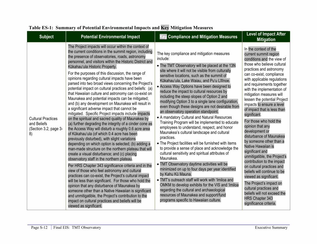
Table ES-1: Summary of Potential Environmental Impacts and Key Mitigation Measures
Subject Potential Environmental Impact Key Compliance and Mitigation Measures Level of Impact After Mitigation
Cultural Practices and Beliefs (Section 3.2, page 3-8)
The Project impacts will occur within the context of the current conditions in the summit region, including the presence of observatories, roads, astronomy personnel, and visitors within the Historic District and Kūkahau‘ula Historic Property. For the purposes of this discussion, the range of opinions regarding cultural impacts have been parsed into two broad views concerning the Project’s potential impact on cultural practices and beliefs: (a) that Hawaiian culture and astronomy can co-exist on Maunakea and potential impacts can be mitigated; and (b) any development on Maunakea will result in a significant adverse impact that cannot be mitigated. Specific Project impacts include impacts on the spiritual and sacred quality of Maunakea by (a) further degrading the integrity of a cinder cone as the Access Way will disturb a roughly 0.6 acre area of Kūkahau‘ula (of which 0.4 acre has been previously disturbed), with slight variations depending on which option is selected; (b) adding a man-made structure on the northern plateau that will create a visual disturbance; and (c) placing observatory staff in the northern plateau. Per HRS Chapter 343 significance criteria and in the view of those who feel astronomy and cultural practices can co-exist, the Project’s cultural impact will be less than significant. For those who hold the opinion that any disturbance of Maunakea by someone other than a Native Hawaiian is significant and unmitigatible, the Project’s contribution to the impact on cultural practices and beliefs will be viewed as significant.
The key compliance and mitigation measures include: • The TMT Observatory will be placed at the 13N
site where it will not be visible from culturally sensitive locations, such as the summit of Kūkahau‘ula, Lake Waiau, and Pu‘u Līlīnoe.
• Access Way Options have been designed to reduce the impact to cultural resources by including the steep slopes of Option 2 and modifying Option 3 to a single lane configuration, even though these designs are not desirable from an observatory operation standpoint.
• A mandatory Cultural and Natural Resources Training Program will be implemented to educate employees to understand, respect, and honor Maunakea’s cultural landscape and cultural practices.
• The Project facilities will be furnished with items to provide a sense of place and acknowledge the cultural sensitivity and spiritual attributes of Maunakea.
• TMT Observatory daytime activities will be minimized on up to four days per year identified by Kahu Kū Mauna.
• TMT’s outreach staff will work with ‘Imiloa and OMKM to develop exhibits for the VIS and ‘Imiloa regarding the cultural and archaeological resources of Maunakea and support/fund programs specific to Hawaiian culture.
In the context of the current summit region conditions and the view of those who believe cultural practices and astronomy can co-exist, compliance with applicable regulations and requirements together with the implementation of mitigation measures will lessen the potential Project impacts to ensure a level of impact that is less than significant. For those who hold the opinion that any development or disturbance of Maunakea by someone other than a Native Hawaiian is significant and unmitigatible, the Project’s contribution to the impact on cultural practices and beliefs will continue to be viewed as significant. The Project’s impact on cultural practices and beliefs will not exceed the HRS Chapter 343 significance criteria.

Executive Summary Final EIS: TMT Observatory Page S-13
Subject Potential Environmental Impact Key Compliance and Mitigation Measures Level of Impact After Mitigation
Archaeologic/Historic Resources (Section 3.3, page 3-39)
No archaeological or historical properties were identified within Project area or within 200 feet of areas that would be disturbed by the Project. The Access Way will result in the disturbance of a roughly 0.6 acre area (0.4 acre previously disturbed) of the Kūkahau‘ula Historic Property, with slight variations depending on which Option is selected. The TMT Observatory and Access Way will be located within the Mauna Kea Summit Region State Historic District. Project effects on Kūkahau‘ula and the Summit Region Historic District are closely related to Project’s impacts on the spiritual and sacred quality of Maunakea, as discussed in Section 3.2 and above. The Project will result in an “effect with treatment/mitigation commitments.” Because the Project will not result in the loss or complete destruction of any archaeologic/historic resource within the Maunakea summit region or elsewhere, this impact is considered to be less than significant.
The key compliance and mitigation/treatment measures include: • Access Way Options have been designed to
reduce the impact to historic resources by including the steep slopes of Option 2 and modifying Option 3 to a single lane configuration, even though these designs are not desirable from an observatory operation standpoint.
• The TMT Observatory will be placed at the 13N site where it will not be visible from culturally sensitive locations, such as the summit of Kūkahau‘ula, Lake Waiau, and Pu‘u Līlīnoe.
• A mandatory Cultural and Natural Resources Training Program will be implemented to educate employees regarding historic properties and their sensitivity to damage, and the rules and regulations regarding the protection of historic properties.
• TMT Observatory daytime activities will be minimized on up to four days per year.
• TMT’s outreach staff will work with ‘Imiloa and OMKM to develop exhibits for the VIS and ‘Imiloa regarding the cultural and archaeological resources of Maunakea and support/fund programs specific to Hawaiian archaeological resources.
• The portion of the Access Way that will be paved will use a reddish color pavement to better blend with the surroundings.
No expected impact. Because the Project will (a) have facilities in a Historic District, (b) affect a Historic Property in the district, and (c) provide treatments/mitigations to address those effects, the Project will result in an “effect with treatment/mitigation commitments.” The implementation of the treatment/mitigation measures will ensure Project will not result in the loss or complete destruction of an archaeologic/historic resource within the summit region, and, therefore, will have a less than significant impact on historic resources.

Page S-14 Final EIS: TMT Observatory Executive Summary
Subject Potential Environmental Impact Key Compliance and Mitigation Measures Level of Impact After Mitigation
Biologic Resources (Section 3.4, page 3-58)
Potential long-term impacts include displacement of existing species and habitat; dust generated by vehicle traffic along the unpaved Project areas; and paving approximately 300 750 feet of the Access Way. The Access Way will displace roughly 0.2 acre of wēkiu bug habitat on the lower slopes of the Kūkahau‘ula cluster of cinder cones, with slight variations depending on which Access Way Option is selected. The Access Way and TMT Observatory will displace roughly 6 acres of alpine stone desert lava flow habitat, with slight variations depending on which Option is selected. Other Project areas have previously been disturbed. These impacts are all expected to be less than significant. As with other similar activities, the potential for accidents may include the introduction of invasive species and vehicles potentially striking fauna.
The key compliance and mitigation measures include: • Access Way Options have been designed to
reduce the impact to wēkiu bug habitat by including the steep slopes of Option 2 and modifying Option 3 to a single lane configuration, even though these designs are not desirable from an observatory operation standpoint.
• A Cultural and Natural Resources Training Program and an Invasive Species Control Program will be implemented. These programs will educate employees regarding the status, condition, diversity, and protection afforded the natural resources present on the mountain.
• TMT and the Project staff will also work with OMKM and ‘Imiloa to develop exhibits regarding natural resources.
• A Ride-Sharing Program will be implemented and reduce traffic, dust, and noise in the summit region.
• Arthropod monitoring will be performed prior to, during, and for two years following construction of the Access Way through the cinder cone habitat.
• A Habitat Restoration Plan would be implemented should Access Way Option 3 be selected. Dust control measures and participation in habitat restoration measures near Hale Pōhaku are also being considered. Work with OMKM on the development and implementation of a habitat restoration study.
• TMT will plant two new māmane trees for each māmane tree directly impacted by possible Project activities at Hale Pōhaku.
Implementation of the identified mitigation measures and compliance with regulations will ensure that impacts will be less than significant.

Executive Summary Final EIS: TMT Observatory Page S-15
Subject Potential Environmental Impact Key Compliance and Mitigation Measures Level of Impact After Mitigation
Visual and Aesthetic Resources Section 3.5, page 3-79)
The TMT Observatory will be visible from 14% of the island area, restricted to the northern side of the island, including portions of Honoka‘a, Waimea, and Waikoloa. Currently, from approximately 43% of the island area, at least one existing observatory is visible, with the Project that will increase by less than 1.2% of the island area. Residents in the TMT viewshed represent approximately 15.4% of the island’s population. Others, including visitors and island residents that reside outside the viewshed, will be able to see the TMT Observatory when they travel through and visit locations within the viewshed. The Project will not block or substantially obstruct the identified views and viewplanes of the mountain, thus the Project’s visual impact will be less than significant.
The siting of the TMT Observatory is the primary impact avoidance measure, as it is north of and below the summit. The design of the observatory also mitigates the visual impact. The dome has been designed to fit very tightly around the telescope, and the telescope has been designed to be much shorter than usual. In addition, the support building has been reduced in size since the Draft EIS was completed, which further reduces its visibility. Also, the coating of the dome will be a reflective aluminum-like coating, which during the day reflects the sky and reduces the visibility of the structure.
Implementation of the identified mitigation measures will ensure that impacts will be less than significant.
Geology, Soils, and Slope Stability (Section 3.6, page 3-104)
Hawai‘i is a seismically active area and the Project could be affected by earthquakes. Surface geologic structures present in the Project areas, such as lava flow morphology and glacial features, will unavoidably be removed. These geologic features are neither unique nor exceptional and better examples exist elsewhere on Maunakea. Associated impacts will be less than significant.
The Project will comply with all applicable seismic safety regulations and standards. The Observatory will minimize the seismic risk to the telescope and equipment through extra design measures. Additional mitigation may include identifying noteworthy examples of glacial features near the Access Way, as well as working with OMKM and ‘Imiloa to develop exhibits to reflect the natural resources of the MKSR.
Mitigation will further reduce the level of impact which will be less than significant prior to any mitigation.
Water Resources and Wastewater (Section 3.7, page 3-114)
Potential impacts could occur from new impervious surfaces, additional consumption of fresh (potable) water, and additional wastewater discharges. However, due to design features and mandatory compliance with existing requirements and regulations, those impacts are expected to be less than significant.
Compliance measures will include collecting and transporting all wastewater down the mountain for treatment; no wastewater will be released to subsurface in the summit area. Items such as dry wells will be included to maximize groundwater recharge. Water efficient fixtures will be used and the Waste Minimization Plan (WMP) will also include audits of water use to reduce potable water use.
No mitigation necessary. Project impacts are expected to be less than significant.
Page S-16 Final EIS: TMT Observatory Executive Summary
Subject Potential Environmental Impact Key Compliance and Mitigation Measures Level of Impact After Mitigation
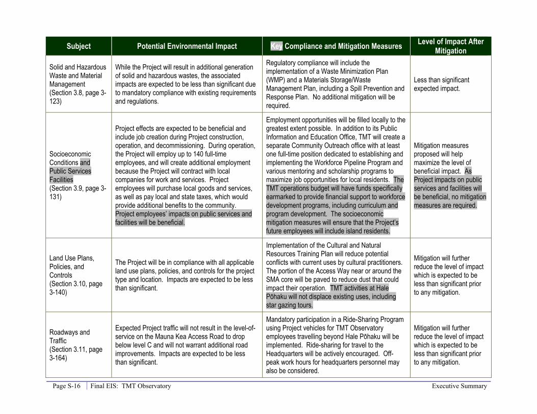
Solid and Hazardous Waste and Material Management (Section 3.8, page 3-123)
While the Project will result in additional generation of solid and hazardous wastes, the associated impacts are expected to be less than significant due to mandatory compliance with existing requirements and regulations.
Regulatory compliance will include the implementation of a Waste Minimization Plan (WMP) and a Materials Storage/Waste Management Plan, including a Spill Prevention and Response Plan. No additional mitigation will be required.
Less than significant expected impact.
Socioeconomic Conditions and Public Services Facilities (Section 3.9, page 3-131)
Project effects are expected to be beneficial and include job creation during Project construction, operation, and decommissioning. During operation, the Project will employ up to 140 full-time employees, and will create additional employment because the Project will contract with local companies for work and services. Project employees will purchase local goods and services, as well as pay local and state taxes, which would provide additional benefits to the community. Project employees’ impacts on public services and facilities will be beneficial.
Employment opportunities will be filled locally to the greatest extent possible. In addition to its Public Information and Education Office, TMT will create a separate Community Outreach office with at least one full-time position dedicated to establishing and implementing the Workforce Pipeline Program and various mentoring and scholarship programs to maximize job opportunities for local residents. The TMT operations budget will have funds specifically earmarked to provide financial support to workforce development programs, including curriculum and program development. The socioeconomic mitigation measures will ensure that the Project’s future employees will include island residents.
Mitigation measures proposed will help maximize the level of beneficial impact. As Project impacts on public services and facilities will be beneficial, no mitigation measures are required.
Land Use Plans, Policies, and Controls (Section 3.10, page 3-140)
The Project will be in compliance with all applicable land use plans, policies, and controls for the project type and location. Impacts are expected to be less than significant.
Implementation of the Cultural and Natural Resources Training Plan will reduce potential conflicts with current uses by cultural practitioners. The portion of the Access Way near or around the SMA core will be paved to reduce dust that could impact their operation. TMT activities at Hale Pōhaku will not displace existing uses, including star gazing tours.
Mitigation will further reduce the level of impact which is expected to be less than significant prior to any mitigation.
Roadways and Traffic (Section 3.11, page 3-164)
Expected Project traffic will not result in the level-of-service on the Mauna Kea Access Road to drop below level C and will not warrant additional road improvements. Impacts are expected to be less than significant.
Mandatory participation in a Ride-Sharing Program using Project vehicles for TMT Observatory employees travelling beyond Hale Pōhaku will be implemented. Ride-sharing for travel to the Headquarters will be actively encouraged. Off-peak work hours for headquarters personnel may also be considered.
Mitigation will further reduce the level of impact which is expected to be less than significant prior to any mitigation.
Executive Summary Final EIS: TMT Observatory Page S-17
Subject Potential Environmental Impact Key Compliance and Mitigation Measures Level of Impact After Mitigation
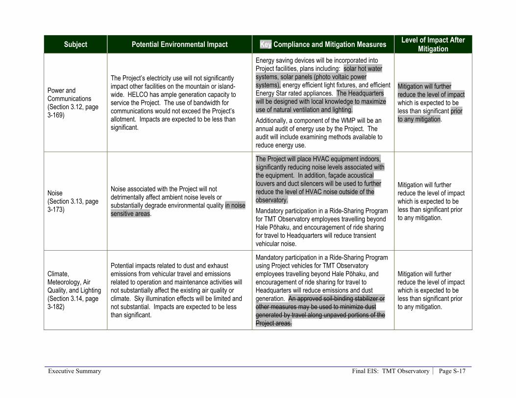
Power and Communications (Section 3.12, page 3-169)
The Project’s electricity use will not significantly impact other facilities on the mountain or island-wide. HELCO has ample generation capacity to service the Project. The use of bandwidth for communications would not exceed the Project’s allotment. Impacts are expected to be less than significant.
Energy saving devices will be incorporated into Project facilities, plans including: solar hot water systems, solar panels (photo voltaic power systems), energy efficient light fixtures, and efficient Energy Star rated appliances. The Headquarters will be designed with local knowledge to maximize use of natural ventilation and lighting. Additionally, a component of the WMP will be an annual audit of energy use by the Project. The audit will include examining methods available to reduce energy use.
Mitigation will further reduce the level of impact which is expected to be less than significant prior to any mitigation.
Noise (Section 3.13, page 3-173)
Noise associated with the Project will not detrimentally affect ambient noise levels or substantially degrade environmental quality in noise sensitive areas.
The Project will place HVAC equipment indoors, significantly reducing noise levels associated with the equipment. In addition, façade acoustical louvers and duct silencers will be used to further reduce the level of HVAC noise outside of the observatory. Mandatory participation in a Ride-Sharing Program for TMT Observatory employees travelling beyond Hale Pōhaku, and encouragement of ride sharing for travel to Headquarters will reduce transient vehicular noise.
Mitigation will further reduce the level of impact which is expected to be less than significant prior to any mitigation.
Climate, Meteorology, Air Quality, and Lighting (Section 3.14, page 3-182)
Potential impacts related to dust and exhaust emissions from vehicular travel and emissions related to operation and maintenance activities will not substantially affect the existing air quality or climate. Sky illumination effects will be limited and not substantial. Impacts are expected to be less than significant.
Mandatory participation in a Ride-Sharing Program using Project vehicles for TMT Observatory employees travelling beyond Hale Pōhaku, and encouragement of ride sharing for travel to Headquarters will reduce emissions and dust generation. An approved soil-binding stabilizer or other measures may be used to minimize dust generated by travel along unpaved portions of the Project areas.
Mitigation will further reduce the level of impact which is expected to be less than significant prior to any mitigation.

Page S-18 Final EIS: TMT Observatory Executive Summary
Subject Potential Environmental Impact Key Compliance and Mitigation Measures Level of Impact After Mitigation
Construction and Decommissioning (Section 3.15, page 3-188)
Through compliance with existing rules, regulations, and policies, Project construction is not expected to have a substantial adverse impact, as impacts will be temporary and less than significant.
Most of the plans and programs will be active during construction and decommissioning, with some additional ones, including: • A Ride-Sharing Program all workers at the TMT
Observatory site • Cultural and Natural Resources Training Program • Cultural and Archaeological Monitoring Plan • Fire Prevention and Response Plan • Invasive Species Prevention and Control Program • Construction Best Management Practices (BMP)
Plan TMT will arrange for more frequent grading of the unpaved Mauna Kea Access Road in order to maintain it in good condition. The Project will endeavor to reduce noise in the vicinity of cultural practices. Connection to HELCO-supplied power will be sought early in the process to eliminate the need for generators, except for limited emergency use. In addition to the NPDES BMP plan that will require flagging of the planned limits of disturbance, the location of nearby property boundaries will be surveyed to ensure that the limits of disturbance do not encroach on neighboring parcels.
Mitigation will further reduce the level of impact which is expected to be less than significant prior to any mitigation.
Executive Summary Final EIS: TMT Observatory Page S-19
Subject Potential Environmental Impact Key Compliance and Mitigation Measures Level of Impact After Mitigation
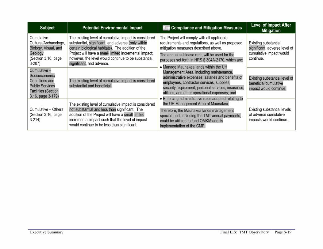
Cumulative – Cultural/Archaeology, Biology, Visual, and Geology (Section 3.16, page 3-207)
The existing level of cumulative impact is considered substantial, significant, and adverse (only within certain biological habitats). The addition of the Project will have a small limited incremental impact; however, the level would continue to be substantial, significant, and adverse.
The Project will comply with all applicable requirements and regulations, as well as proposed mitigation measures described above. The annual sublease rent, will be used for the purposes set forth in HRS § 304A-2170, which are: • Manage Maunakea lands within the UH
Management Area, including maintenance, administrative expenses, salaries and benefits of employees, contractor services, supplies, security, equipment, janitorial services, insurance, utilities, and other operational expenses; and
• Enforcing administrative rules adopted relating to the UH Management Area of Maunakea.
Therefore, the Maunakea lands management special fund, including the TMT annual payments, could be utilized to fund OMKM and its implementation of the CMP.
Existing substantial, significant, adverse level of cumulative impact would continue.
Cumulative – Socioeconomic Conditions and Public Services Facilities (Section 3.16, page 3-179)
The existing level of cumulative impact is considered substantial and beneficial.
Existing substantial level of beneficial cumulative impact would continue.
Cumulative – Others (Section 3.16, page 3-214)
The existing level of cumulative impact is considered not substantial and less than significant. The addition of the Project will have a small limited incremental impact such that the level of impact would continue to be less than significant.
Existing substantial levels of adverse cumulative impacts would continue.


Table of Contents Final EIS: TMT Observatory Page i
Table of Contents Section Page
Volume 1 1.0 INTRODUCTION ............................................................................................................ 1-1
1.1 Purpose of this Final EIS ................................................................................................. 1-1 1.2 Legal Requirements ......................................................................................................... 1-1 1.3 Project Action .................................................................................................................. 1-1 1.4 Scope of the Project ......................................................................................................... 1-2 1.5 Scope of Chapter 343 Environmental Analysis ............................................................... 1-2 1.6 Summary of EIS Scoping Activities ................................................................................ 1-3
1.6.1 Summary of Public Involvement ............................................................................... 1-3 1.6.2 Agencies, Organizations, and Individuals Consulted ................................................ 1-4 1.6.3 Issues Raised During the Scoping Process ................................................................ 1-4
1.7 Draft EIS Public Review and Comment .......................................................................... 1-5 1.8 Final EIS and Responses to Comments ........................................................................... 1-6
2.0 PROJECT DESCRIPTION ............................................................................................ 2-1 2.1 Project Background .......................................................................................................... 2-1 2.2 Purpose and Need ............................................................................................................ 2-1 2.3 Project Objectives ............................................................................................................ 2-4 2.4 Project Components ......................................................................................................... 2-5 2.5 Project Location and Design ............................................................................................ 2-5
2.5.1 TMT Observatory ...................................................................................................... 2-5 2.5.2 Access Way .............................................................................................................. 2-18 2.5.3 Potential TMT Mid-Level Facility ........................................................................... 2-23 2.5.4 Headquarters ............................................................................................................ 2-27 2.5.5 Satellite Office – No Longer Considered ................................................................. 2-27
2.6 Construction Areas ......................................................................................................... 2-28 2.7 Project Phases and Activities ......................................................................................... 2-29
2.7.1 Planning and Design ................................................................................................ 2-30 2.7.2 Construction and Testing ......................................................................................... 2-30 2.7.3 Operation.................................................................................................................. 2-31 2.7.4 Decommissioning .................................................................................................... 2-31
2.8 References ...................................................................................................................... 2-34
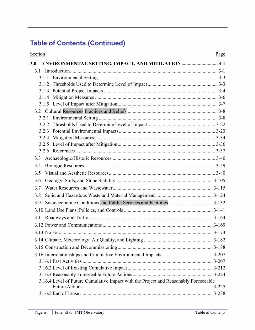
Table of Contents (Continued) Section Page
Page ii Final EIS: TMT Observatory Table of Contents
3.0 ENVIRONMENTAL SETTING, IMPACT, AND MITIGATION ............................. 3-1 3.1 Introduction ...................................................................................................................... 3-1
3.1.1 Environmental Setting ............................................................................................... 3-3 3.1.2 Thresholds Used to Determine Level of Impact ........................................................ 3-3 3.1.3 Potential Project Impacts ........................................................................................... 3-4 3.1.4 Mitigation Measures .................................................................................................. 3-6 3.1.5 Level of Impact after Mitigation ................................................................................ 3-7
3.2 Cultural Resources Practices and Beliefs ........................................................................ 3-8 3.2.1 Environmental Setting ............................................................................................... 3-8 3.2.2 Thresholds Used to Determine Level of Impact ...................................................... 3-22 3.2.3 Potential Environmental Impacts ............................................................................. 3-23 3.2.4 Mitigation Measures ................................................................................................ 3-34 3.2.5 Level of Impact after Mitigation .............................................................................. 3-36 3.2.6 References ................................................................................................................ 3-37
3.3 Archaeologic/Historic Resources ................................................................................... 3-40 3.4 Biologic Resources ........................................................................................................ 3-59 3.5 Visual and Aesthetic Resources ..................................................................................... 3-80 3.6 Geology, Soils, and Slope Stability ............................................................................. 3-105 3.7 Water Resources and Wastewater ................................................................................ 3-115 3.8 Solid and Hazardous Waste and Material Management .............................................. 3-124 3.9 Socioeconomic Conditions and Public Services and Facilities ................................... 3-132 3.10 Land Use Plans, Policies, and Controls ....................................................................... 3-141 3.11 Roadways and Traffic .................................................................................................. 3-164 3.12 Power and Communications ........................................................................................ 3-169 3.13 Noise ............................................................................................................................ 3-173 3.14 Climate, Meteorology, Air Quality, and Lighting ....................................................... 3-182 3.15 Construction and Decommissioning ............................................................................ 3-188 3.16 Interrelationships and Cumulative Environmental Impacts ......................................... 3-207
3.16.1 Past Activities ........................................................................................................ 3-207 3.16.2 Level of Existing Cumulative Impact .................................................................... 3-212 3.16.3 Reasonably Foreseeable Future Actions ................................................................ 3-224 3.16.4 Level of Future Cumulative Impact with the Project and Reasonably Foreseeable
Future Actions ........................................................................................................ 3-225 3.16.5 End of Lease .......................................................................................................... 3-238

Table of Contents (Continued) Section Page
Table of Contents Final EIS: TMT Observatory Page iii
3.16.6 Cumulative Impact Conclusions ............................................................................ 3-243 3.16.7 References .............................................................................................................. 3-243
3.17 Relationship of Short-Term Uses and Long-Term Productivity.................................. 3-254 3.18 Irreversible and Irretrievable Commitments of Resources .......................................... 3-255 3.19 Required Approvals and Permits ................................................................................. 3-256 3.20 Unavoidable Adverse Impacts ..................................................................................... 3-258 3.21 Unresolved Issues ........................................................................................................ 3-260
4.0 ALTERNATIVES TO THE PROJECT ........................................................................ 4-1 4.1 Project Background and History ...................................................................................... 4-1
4.1.1 Location Evaluation ................................................................................................... 4-1 4.1.2 Selection of Maunakea for Further Consideration ..................................................... 4-5
4.2 Alternatives to the Project ................................................................................................ 4-5 4.2.1 No Action Alternative ................................................................................................ 4-5 4.2.2 Maunakea Alternative E2 Site ................................................................................... 4-7
5.0 ADDITIONAL INFORMATION IN RESPONSE TO SCOPING COMMENTS ..... 5-1
6.0 LIST OF PREPARERS ................................................................................................... 6-1
7.0 REFERENCES ................................................................................................................. 7-1
Volume 2 8.0 RESPONSES TO COMMENTS ..................................................................................... 8-1

Table of Contents (Continued) Section Page
Page iv Final EIS: TMT Observatory Table of Contents
Volume 3 APPENDIX A. MAILING LIST ........................................................................................ A-1
APPENDIX B. SUMMARY OF SCOPING COMMENTS .............................................B-1
APPENDIX C. DRAFT EIS COMMENT FORM ........................................................... C-1
APPENDIX D. CULTURAL IMPACT ASSESSMENT REPORT ................................ D-1
APPENDIX E. CULTURAL IMPACT STATEMENT (2000 MASTER PLAN) ..........E-1
APPENDIX F. MAUNA KEA-KA PIKO KAULANA O KA ‘ĀINA (MAUNA KEA—THE FAMOUS SUMMIT OF THE LAND) ............................................................... F-1
APPENDIX G. ARCHAEOLOGICAL INVENTORY SURVEY, MAUNAKEA SUMMIT AREA ........................................................................................................... G-1
APPENDIX H. ARCHAEOLOGICAL ASSESSMENT REPORT, HALE PŌHAKU H-1
APPENDIX I. ARCHAEOLOGICAL INVENTORY SURVEY OF THE ASTRONOMY PRECINCT IN THE MAUNA KEA SCIENCE RESERVE ...................................... I-1
APPENDIX J. MAUNA KEA HISTORIC PRESERVATION PLAN ........................... J-1
APPENDIX K. BIOLOGICAL RESOURCES TECHNICAL REPORT ...................... K-1
APPENDIX L. GEOLOGICAL TECHNICAL REPORT ...............................................L-1
APPENDIX M. VISUAL IMPACT ASSESSMENT TECHNICAL REPORT ............. M-1
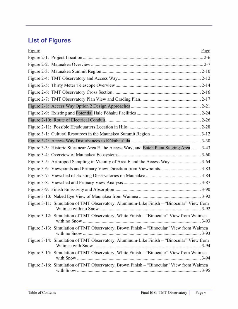
Table of Contents Final EIS: TMT Observatory Page v
List of Figures Figure Page Figure 2-1: Project Location ....................................................................................................... 2-6 Figure 2-2: Maunakea Overview ................................................................................................ 2-7 Figure 2-3: Maunakea Summit Region ..................................................................................... 2-10 Figure 2-4: TMT Observatory and Access Way ....................................................................... 2-12 Figure 2-5: Thirty Meter Telescope Overview ......................................................................... 2-14 Figure 2-6: TMT Observatory Cross Section ........................................................................... 2-16 Figure 2-7: TMT Observatory Plan View and Grading Plan .................................................... 2-17 Figure 2-8: Access Way Option 2 Design Approaches ............................................................ 2-21 Figure 2-9: Existing and Potential Hale Pōhaku Facilities ....................................................... 2-24 Figure 2-10: Route of Electrical Conduit .................................................................................. 2-26 Figure 2-11: Possible Headquarters Location in Hilo ............................................................... 2-28 Figure 3-1: Cultural Resources in the Maunakea Summit Region ........................................... 3-12 Figure 3-2: Access Way Disturbances to Kūkahau‘ula ............................................................ 3-30 Figure 3-3: Historic Sites near Area E, the Access Way, and Batch Plant Staging Area ......... 3-43 Figure 3-4: Overview of Maunakea Ecosystems ...................................................................... 3-60 Figure 3-5: Arthropod Sampling in Vicinity of Area E and the Access Way .......................... 3-64 Figure 3-6: Viewpoints and Primary View Direction from Viewpoints ................................... 3-83 Figure 3-7: Viewshed of Existing Observatories on Maunakea ............................................... 3-84 Figure 3-8: Viewshed and Primary View Analysis .................................................................. 3-87 Figure 3-9: Finish Emissivity and Absorption .......................................................................... 3-90 Figure 3-10: Naked Eye View of Maunakea from Waimea ..................................................... 3-92 Figure 3-11: Simulation of TMT Observatory, Aluminum-Like Finish – “Binocular” View from
Waimea with no Snow ....................................................................................... 3-92 Figure 3-12: Simulation of TMT Observatory, White Finish – “Binocular” View from Waimea
with no Snow ..................................................................................................... 3-93 Figure 3-13: Simulation of TMT Observatory, Brown Finish – “Binocular” View from Waimea
with no Snow ..................................................................................................... 3-93 Figure 3-14: Simulation of TMT Observatory, Aluminum-Like Finish – “Binocular” View from
Waimea with Snow ............................................................................................ 3-94 Figure 3-15: Simulation of TMT Observatory, White Finish – “Binocular” View from Waimea
with Snow .......................................................................................................... 3-94 Figure 3-16: Simulation of TMT Observatory, Brown Finish – “Binocular” View from Waimea
with Snow .......................................................................................................... 3-95
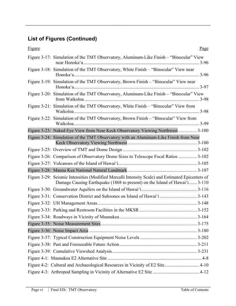
List of Figures (Continued) Figure Page
Page vi Final EIS: TMT Observatory Table of Contents
Figure 3-17: Simulation of the TMT Observatory, Aluminum-Like Finish – “Binocular” View near Honoka‘a .................................................................................................... 3-96
Figure 3-18: Simulation of the TMT Observatory, White Finish – “Binocular” View near Honoka‘a ............................................................................................................ 3-96
Figure 3-19: Simulation of the TMT Observatory, Brown Finish – “Binocular” View near Honoka‘a ............................................................................................................ 3-97
Figure 3-20: Simulation of the TMT Observatory, Aluminum-Like Finish – “Binocular” View from Waikoloa ................................................................................................... 3-98
Figure 3-21: Simulation of the TMT Observatory, White Finish – “Binocular” View from Waikoloa ............................................................................................................ 3-98
Figure 3-22: Simulation of the TMT Observatory, Brown Finish – “Binocular” View from Waikoloa ............................................................................................................ 3-99
Figure 3-23: Naked Eye View from Near Keck Observatory Viewing Northwest ................ 3-100 Figure 3-24: Simulation of the TMT Observatory with an Aluminum-Like Finish from Near
Keck Observatory Viewing Northwest ............................................................ 3-100 Figure 3-25: Overview of TMT and Dome Design ................................................................ 3-102 Figure 3-26: Comparison of Observatory Dome Sizes to Telescope Focal Ratios ................ 3-102 Figure 3-27: Volcanoes of the Island of Hawai‘i .................................................................... 3-105 Figure 3-28: Mauna Kea National Natural Landmark ............................................................ 3-107 Figure 3-29: Seismic Intensities (Modified Mercalli Intensity Scale) and Estimated Epicenters of
Damage Causing Earthquake (1868 to present) on the Island of Hawai‘i ....... 3-110 Figure 3-30: Groundwater Aquifers on the Island of Hawai‘i ................................................ 3-116 Figure 3-31: Conservation District and Subzones on Island of Hawai‘i ................................ 3-143 Figure 3-32: UH Management Areas ...................................................................................... 3-148 Figure 3-33: Parking and Restroom Facilities in the MKSR .................................................. 3-152 Figure 3-34: Roadways in Vicinity of Maunakea ................................................................... 3-164 Figure 3-35: Noise Measurement Sites ................................................................................... 3-175 Figure 3-36: Noise Impact Area ............................................................................................. 3-180 Figure 3-37: Typical Construction Equipment Noise Levels ................................................. 3-202 Figure 3-38: Past and Foreseeable Future Action ................................................................... 3-211 Figure 3-39: Cumulative Viewshed Analysis ......................................................................... 3-231 Figure 4-1: Maunakea E2 Alternative Site ................................................................................. 4-8 Figure 4-2: Cultural and Archaeological Resources in Vicinity of E2 Site .............................. 4-10 Figure 4-3: Arthropod Sampling in Vicinity of Alternative E2 Site ........................................ 4-12
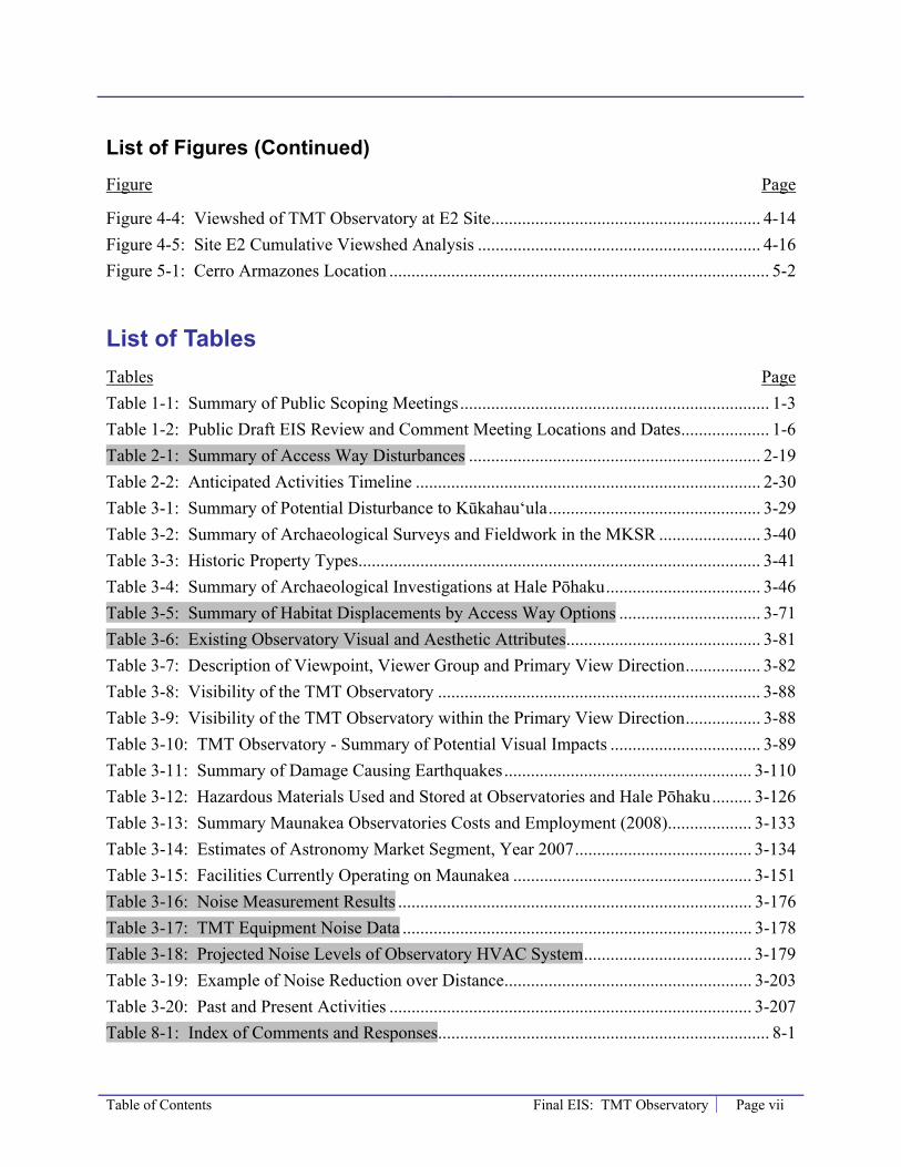
List of Figures (Continued) Figure Page
Table of Contents Final EIS: TMT Observatory Page vii
Figure 4-4: Viewshed of TMT Observatory at E2 Site ............................................................. 4-14 Figure 4-5: Site E2 Cumulative Viewshed Analysis ................................................................ 4-16 Figure 5-1: Cerro Armazones Location ...................................................................................... 5-2
List of Tables Tables Page Table 1-1: Summary of Public Scoping Meetings ...................................................................... 1-3 Table 1-2: Public Draft EIS Review and Comment Meeting Locations and Dates .................... 1-6 Table 2-1: Summary of Access Way Disturbances .................................................................. 2-19 Table 2-2: Anticipated Activities Timeline .............................................................................. 2-30 Table 3-1: Summary of Potential Disturbance to Kūkahau‘ula ................................................ 3-29 Table 3-2: Summary of Archaeological Surveys and Fieldwork in the MKSR ....................... 3-40 Table 3-3: Historic Property Types ........................................................................................... 3-41 Table 3-4: Summary of Archaeological Investigations at Hale Pōhaku ................................... 3-46 Table 3-5: Summary of Habitat Displacements by Access Way Options ................................ 3-71 Table 3-6: Existing Observatory Visual and Aesthetic Attributes ............................................ 3-81 Table 3-7: Description of Viewpoint, Viewer Group and Primary View Direction ................. 3-82 Table 3-8: Visibility of the TMT Observatory ......................................................................... 3-88 Table 3-9: Visibility of the TMT Observatory within the Primary View Direction ................. 3-88 Table 3-10: TMT Observatory - Summary of Potential Visual Impacts .................................. 3-89 Table 3-11: Summary of Damage Causing Earthquakes ........................................................ 3-110 Table 3-12: Hazardous Materials Used and Stored at Observatories and Hale Pōhaku ......... 3-126 Table 3-13: Summary Maunakea Observatories Costs and Employment (2008) ................... 3-133 Table 3-14: Estimates of Astronomy Market Segment, Year 2007 ........................................ 3-134 Table 3-15: Facilities Currently Operating on Maunakea ...................................................... 3-151 Table 3-16: Noise Measurement Results ................................................................................ 3-176 Table 3-17: TMT Equipment Noise Data ............................................................................... 3-178 Table 3-18: Projected Noise Levels of Observatory HVAC System ...................................... 3-179 Table 3-19: Example of Noise Reduction over Distance ........................................................ 3-203 Table 3-20: Past and Present Activities .................................................................................. 3-207 Table 8-1: Index of Comments and Responses ........................................................................... 8-1

Page viii Final EIS: TMT Observatory Table of Contents
Acronyms and Abbreviations Acronyms Meaning ACURA Association of Canadian Universities for Research in Astronomy ALMA Atacama Large Millimeter Array AO Adaptive optics ADT Average Daily Traffic ATV All Terrain Vehicles BLNR Board of Land and Natural Resources BMP Best Management Practice BOR Board of Regents Caltech California Institute of Technology CARA California Association of Research in Astronomy CBP Community Benefit Package CCC Civilian Conservation Corps CDUA Conservation District Use Application CDUP Conservation District Use Permit CFD Computational Fluid Dynamics CFHT Canada-France-Hawai‘i Telescope CFR Code of Federal Regulations CIA Cultural Impact Assessment CMP Comprehensive Management Plan CRMP Cultural Resources Management Plan CSO Caltech Submillimeter Observatory CWRM Commission on Water Resource Management dB Decibels DIA Declaractión de Impacto Ambiental DLNR Department of Land and Natural Resources (State of Hawai‘i) DP Decommissioning Plan DOE Department of Education DOE Department of Energy DOFAW Division of Forestry and Wildlife EA Environmental Assessment E-ELT European Extremely Large Telescope EIS Environmental Impact Statement
Table of Contents Final EIS: TMT Observatory Page ix
EISPN Environmental Impact Statement Preparation Notice EPA Environmental Protection Agency EPCRA Emergency Planning and Community Right-To-Know Act ESA Endangered Species Act ESO European Southern Observatory GMT Giant Magellan Telescope GPS Global Positioning System GSMT Giant Segmented Mirror Telescope HAR Hawai‘i Administrative Rules HawCC Hawai‘i Community College HDOH State of Hawai‘i Department of Health HDOT State of Hawai‘i Department of Transportation HELCO Hawaiian Electric and Light Company HPS High Pressure Sodium HRS Hawai‘i Revised Statutes HVAC Heating, Ventilating, and Air Conditioning IfA Institute for Astronomy IRH Indoor and Radiological Health IRTF Infrared Telescope Facility JAC Joint Astronomy Center JCMT James Clerk Maxwell Telescope kV Kilovolt kW Kilowatt LLC Limited Liability Company LOS Level-Of-Service LPS Low Pressure Sodium LSST Large Synoptic Survey Telescope LUPAG Land Use Pattern Allocation Guide MEK Methyl Ethyl Ketone MKMB Mauna Kea Management Board MKSR Mauna Kea Science Reserve MKSS Mauna Kea Observatories Support Services MSDS Material Safety Data Sheets MSL Mean sea level MW Megawatt NAAQS National Ambient Air Quality Standards
Page x Final EIS: TMT Observatory Table of Contents
NAR Natural Area Reserve NASA National Aeronautics and Space Administration NAOC National Astronomical Observatories of the Chinese Academy of Sciences NAOJ National Astronomical Observatory of Japan NEPA National Environmental Policy Act NGLT Next Generation Large Telescope NGST Next Generation Space Telescope NNTT National New Technology Telescope NPDES National Pollutant Discharge Elimination System Permit NRAO National Radio Astronomy Observatory NREL National Renewable Energy Laboratory NRMP Natural Resources Management Plan NSF National Science Foundation OCCL Office of Conservation and Coastal Lands OEQC Office of Environmental Quality OHA Office of Hawaiian Affairs OMKM Office of Mauna Kea Management OOVP Oversize and Overweight Vehicles Permit OSHA Occupational Safety and Health Administration Pan-STARRS Panoramic Survey Telescope and Rapid Response System PAP Public Access Plan PCSI Pacific Consulting Services, Inc. PICHTR Pacific International Center for High Technology Research RCRA Resource Conservation and Recovery Act RDP Research and Development Plan SDP Site Decommissioning Plan SDRP Site Decommissioning and Removal Plan SHO Safety and Health Officer SHPD State Historic Preservation Division SHPO State Historic Preservation Officer SIHP State Inventory of Historic Places SPRP Spill Prevention and Response Plan SRP Site Restoration Plan STEM Science, technology, engineering, and math SMA Submillimeter Array TCP Traditional Cultural Property
Table of Contents Final EIS: TMT Observatory Page xi
THINK The Hawai‘i Island New Knowledge TMK Tax Map Key TMT Thirty Meter Telescope UC University of California UH University of Hawai‘i UH Hilo University of Hawai‘i at Hilo UIC Underground Injection Control UKIRT United Kingdom Infrared Telescope USFWS United States Fish and Wildlife Service USGS United States Geological Survey UST Underground Storage Tanks VLBA Very Long Baseline Array VLT Very Large Telescope VIS Visitor Information Station VOG Volcanic smog WMP Waste Minimization Plan WPP Workforce Pipeline Program


Chapter 1 – Introduction Final EIS: TMT Observatory Page 1-1
1.0 Introduction 1.1 Purpose of this Final EIS This Final Environmental Impact Statement (Final EIS) has been prepared to provide the University of Hawai‘i (UH), State decision makers, the public, and interested parties with information regarding the potential environmental effects of locating the Thirty Meter Telescope (TMT) Project in Hawai‘i. The potential environmental impacts discussed in the Final EIS encompass the natural environment, as well as economic welfare, social welfare, cultural practices of the community and State, and effects of the economic activities arising out of the Project as proposed. Measures proposed to minimize potential adverse effects and alternatives to the Project are also addressed.
The potential benefits and environmental impacts of the Project are analyzed and disclosed in this Final EIS. The potential impacts are evaluated, and mitigation measures to address the identified substantial impacts are outlined. Measures to avoid, minimize, or rectify, the potential substantial adverse environmental impacts have been considered throughout the Project planning process and incorporated into the Project design and construction plans.
1.2 Legal Requirements This Final EIS has been prepared pursuant to Hawai‘i Revised Statutes (HRS) Chapter 343, Environmental Impact Statement Law and Chapter 200 of Title 11, Hawai‘i Administrative Rules (HAR), Department of Health, Environmental Impact Statement Rules by the Proposing Agency, the University of Hawai‘i at Hilo (UH Hilo). An EIS Preparation Notice/Environmental Assessment (EISPN/EA) prepared pursuant to HRS Chapter 343 was issued for the Project on September 23, 2008. The Draft EIS was issued for the Project on May 23, 2009, for public and agency review, and public meetings were held to receive comments from the public and agencies during the 45-day review period, which ended on July 7, 2009. This Final EIS was prepared to respond to the comments received during the Draft EIS review period. Following publication, the Accepting Authority, the Governor of Hawai‘i, will act on this EIS.
1.3 Project Action The proposed action is the issuance by the Board of Land and Natural Resources (BLNR) of a Conservation District Use Permit (CDUP) and approval of a sublease to State land allowing: (a) the construction and operation of the TMT Observatory and associated ancillary facilities within the Mauna Kea Science Reserve (MKSR; tax map key [TMK] 4-4-15: 9), (b) construction and operation of the potential TMT Mid-Level Facility within Hale Pōhaku (TMK 4-4-15: 12), and (c) construction of electrical and communications infrastructure near Hale Pōhaku, within the Mauna Kea Forest Reserve (TMK 4-4-15: 1) and Mauna Kea Ice Age Natural Area Reserve (NAR) (TMK 4-4-15: 10). The entire MKSR, Hale Pōhaku, and the portions of the Mauna Kea Forest Reserve (on State land) near Hale Pōhaku, are designated as part of the State of Hawai‘i Conservation District, resource subzone, and therefore, a CDUP is required before construction can begin.
Page 1-2 Final EIS: TMT Observatory Chapter 1 – Introduction
In addition, the proposed action includes building the Project’s Headquarters facility on State-owned land within the UH Hilo University Park development (TMK 2-4-1: 7 or 2-4-1: 122).
1.4 Scope of the Project The TMT Project, referred to as the “Project,” will consist of the construction and operation, and ultimately decommissioning, of the TMT Observatory, with a 30-meter optical/infrared telescope, below the summit of Maunakea6 and the associated permanent and temporary ancillary facilities. The permanent ancillary facilities will include an Access Way to the observatory; a Headquarters facility in Hilo to manage operation of the observatory; and , potentially, a TMT Mid-Level Facility consisting of personnel facilities and infrastructure near and within Hale Pōhaku to support TMT Observatory operation. Temporary facilities during construction will include a construction staging area below the summit, may include a construction staging area and housing for construction workers within Hale Pōhaku, and will include construction staging areas near the port where Project components will be received.
1.5 Scope of Chapter 343 Environmental Analysis HAR Title 11 Chapter 200 directs the focus of the environmental analysis, whereby “special emphasis shall be placed on environmental resources that are rare or unique to the region and the project site (including natural or human-made resources of historic, archaeological, or aesthetic significance).” Accordingly, the emphasis of the environmental analysis in this Final EIS is placed on the TMT Observatory and Access Way below the summit of Maunakea due to this area’s rare and unique resources, including cultural, biological, and visual resources. Other areas that will be affected, such as areas within and near Hale Pōhaku and in the vicinity of the Headquarters, are also discussed, but to a lesser degree unless a potential significant impact is identified.
The purpose and need of the Project, the Project’s objectives, and a Project description are provided in Chapter 2.0. The environmental analysis in Chapter 3.0 contains a discussion of potential Project impacts, including those on cultural and archaeological resources; biological resources, including the wēkiu bug; visual and aesthetic resources; and geologic resources. Potential Project effects on a range of other resources are also discussed in Chapter 3.0, including land use plans and policies, water resources and wastewater, socioeconomic conditions, air quality, traffic, noise, solid and hazardous waste management, and power and communications.
Alternatives to the Project are discussed in Chapter 4.0 of this Final EIS. The alternatives to the Project include (1) a no action alternative: not constructing the TMT observatory at Maunakea; and (2) locating the TMT Observatory at another nearby site on Maunakea referred to as E2.
6 Maunakea is spelled as one word in this document because it is considered the traditional Hawaiian spelling (Ka Wai Ola, Vos. 25 No. 11). Maunakea is a proper noun, therefore spelled as one word in Hawaiian. This spelling is found in original Hawaiian language newspapers dating back to the late 1800s when the Hawaiian language was the medium of communication. In more recent years Maunakea has been spelled as two words, which literally mean “white mountain.” Spelled as two words it is a common noun that could refer to any white mountain versus the proper name of this particular mountain on Hawai'i Island. The common “Mauna Kea” spelling is only used in this document where Mauna Kea is used in a proper name, such as the “Mauna Kea Science Reserve.”

Chapter 1 – Introduction Final EIS: TMT Observatory Page 1-3
1.6 Summary of EIS Scoping Activities On September 23, 2008, UH published the EISPN/EA for the TMT Project (UH, 2008). The publication was announced by the Office of Environmental Quality (OEQC) in The Environmental Notice, also dated September 23, 2008 (OEQC, 2008). The publication in The Environmental Notice opened the 30-day scoping period. Copies of the EISPN/EA were distributed to governmental agencies and parties that expressed interest and signed up on the TMT environmental process mailing list.
1.6.1 Summary of Public Involvement Prior to the opening of the 30-day scoping period, the forthcoming EISPN/EA was advertised and interested people and organizations were solicited to sign up on the TMT environmental process mailing list. Advertisements were run in the Hawai‘i Tribune Herald, West Hawai‘i Today, Honolulu Advertiser, Honolulu Star-Bulletin, The Hawai‘i Filipino Chronicle, and Ka Wai Ola (Office of Hawaiian Affairs’ newspaper). More than 110 people and organizations signed up to be on the mailing list prior to the publication of the EISPN/EA. Copies of the EISPN/EA were sent to the people and organizations on the mailing list, as well as to other organizations and people known to have an interest in Maunakea due to their involvement in previous projects.
During the 30-day scoping period, multiple ways to submit input on the Project’s environmental review process were provided, including:
• The TMT environmental process website (www.TMT-HawaiiEIS.org) included a comment feature;
• A TMT environmental process toll-free hotline (1-866-284-1716) where comments could be recorded;
• Direct mail to the Chancellor of UH Hilo; and
• Public meetings where the public oral comments were either captured by facilitators or recorded privately and written comments were collected. Public meetings were held as summarized in Table 1-1.
Table 1-1: Summary of Public Scoping Meetings
Date Location Approx. Number
of Public in Attendance
Number of Speakers
Oct. 6, 2008 Kohala High School Cafeteria 15 1 Oct. 8, 2008 Kahilu Town Hall (Waimea Family YMCA) 70 13 Oct. 9, 2008 Kealakehe Elementary School Cafeteria 20 9 Oct. 13, 2008 Ka‘ū High/Pāhala Elementary School Cafeteria 15 4 Oct. 14, 2008 Keaukaha Elementary School Cafeteria 90 22 Oct. 15, 2008 Pāhoa High School Cafeteria 50 20 Oct. 16, 2008 Neal S. Blaisdell Center Pīkake Room 30 9
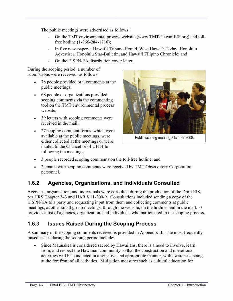
Page 1-4 Final EIS: TMT Observatory Chapter 1 – Introduction
The public meetings were advertised as follows: - On the TMT environmental process website (www.TMT-HawaiiEIS.org) and toll-
free hotline (1-866-284-1716); - In five newspapers: Hawai‘i Tribune Herald, West Hawai‘i Today, Honolulu
Advertiser, Honolulu Star-Bulletin, and Hawai‘i Filipino Chronicle; and - On the EISPN/EA distribution cover letter.
During the scoping period, a number of submissions were received, as follows:
• 78 people provided oral comments at the public meetings;
• 68 people or organizations provided scoping comments via the commenting tool on the TMT environmental process website;
• 39 letters with scoping comments were received in the mail;
• 27 scoping comment forms, which were available at the public meetings, were either collected at the meetings or were mailed to the Chancellor of UH Hilo following the meetings;
• 3 people recorded scoping comments on the toll-free hotline; and
• 2 emails with scoping comments were received by TMT Observatory Corporation personnel.
1.6.2 Agencies, Organizations, and Individuals Consulted Agencies, organization, and individuals were consulted during the production of the Draft EIS, per HRS Chapter 343 and HAR § 11-200-9. Consultations included sending a copy of the EISPN/EA to a party and requesting input from them and collecting comments at public meetings, at other small group meetings, through the website, on the hotline, and in the mail. 0 provides a list of agencies, organization, and individuals who participated in the scoping process.
1.6.3 Issues Raised During the Scoping Process A summary of the scoping comments received is provided in Appendix B. The most frequently raised issues during the scoping period include:
• Since Maunakea is considered sacred by Hawaiians, there is a need to involve, learn from, and respect the Hawaiian community so that the construction and operational activities will be conducted in a sensitive and appropriate manner, with awareness being at the forefront of all activities. Mitigation measures such as cultural education for
Public scoping meeting, October 2008.

Chapter 1 – Introduction Final EIS: TMT Observatory Page 1-5
construction and operation workers were suggested. These issues are addressed in Section 3.2, Cultural Resources.
• There is a concern for archaeological/historic sites of reverence on the mountain, including sacred and spiritual places such as the pu‘u, Lake Waiau, and the Adze Quarry. It was suggested that mitigation measures be developed, such as visitor education, so that impacts to such sites would be minimized. These issues, including archeological sites in the vicinity of the TMT Observatory, are addressed in Section 3.3, Archaeologic/Historic Resources.
• There was concern regarding the plant and animal species, such as the wēkiu bug, palila bird, U‘au (Hawaiian Petrel), and silversword. These issues, including the species and habitats in the project area, are addressed in Section 3.4, Biologic Resources.
• It is important to consider the potential visual impact of the Project on cultural and natural landscape of Maunakea. These issues are addressed in Section 3.5, Visual and Aesthetic Resources.
• There is strong interest in the impact of the Project on the socioeconomic landscape of the island and the potential for local residents to work for the Project during construction and operation. This issue is addressed in Section 3.9, Socioeconomic Conditions.
• While the Project is the construction, operation, and the ultimate decommissioning of the TMT Observatory below the summit of Maunakea, there was interest and request for information concerning Chile as a potential location. Available information, including an evaluation of environmental issues pursuant to the laws and requirements of Chile is provided in Chapter 5.0.
1.7 Draft EIS Public Review and Comment The announcement of the Draft EIS by OEQC in The Environmental Notice on May 23, 2009, opened the 45-day review period. The Draft EIS review and comment process was accessible to all. To ensure accessibility to all, the review and comment process included the following elements and features:
• Direct mail of the Draft EIS to the people, organizations, and agencies on the mailing list (0);
• Placing the Draft EIS for public review at all public libraries in the state;
• Interactive website (www.TMT-HawaiiEIS.org) that included a Project fact sheet and frequently asked questions, an electronic copy of Draft EIS that could be downloaded, a tool to input and upload comments, and contact information;
• A toll-free hotline (1-866-284-1716) where information was available about the public meetings and locations where the Draft EIS could be reviewed and comments could be recorded; and
• Public meetings, accessible to people with handicaps, were held and included six meetings on the Island of Hawai‘i and one on the Island of O‘ahu. These meetings were held as shown in Table 1-2.

Page 1-6 Final EIS: TMT Observatory Chapter 1 – Introduction
Table 1-2: Public Draft EIS Review and Comment Meeting Locations and Dates
Date Location Approx. Number of Public in Attendance
Number of Speakers
June 16, 2009 Waimea Elementary School Cafeteria 49 16 June 17, 2009 Hilo High School Cafeteria 177 37 June 18, 2009 Pāhoa High School Cafeteria 68 23 June 22, 2009 Ka‘ū High/Pāhala Elementary School Cafeteria 23 9 June 23, 2009 Kohala Cultural Center 26 10 June 24, 2009 Kealakehe Elementary School Cafeteria 35 7 June 25, 2009 Farrington High School Cafeteria 38 14
The public meetings were advertised as follows: - On the website (www.TMT-HawaiiEIS.org) and toll-free hotline (1-866-284-
1716); - In five newspapers: Hawai‘i Tribune Herald, West Hawai‘i Today, Honolulu
Advertiser, Honolulu Star-Bulletin, and Hawai‘i Filipino Chronicle; and - On the Draft EIS distribution cover letter.
During the Draft EIS review period, a number of submissions were received, as follows:
• 7 people had oral statements recorded at the public meetings;
• 52 individuals or organizations submitted comments via the commenting tool on the TMT environmental process website;
• 48 letters with comments on the Draft EIS were received in the mail;
• 83 comment forms, which were available at the public meetings, or other written statement were either collected at the meetings or were mailed to the Chancellor of UH Hilo following the meetings;
• 11 people recorded comments on the toll-free hotline; and
• 147 emails with comments on the Draft EIS were received by the Chancellor of UH Hilo or TMT Observatory Corporation personnel.
An example of the comment form included with the Draft EIS and available at the public meetings is provided in Appendix C.
1.8 Final EIS and Responses to Comments Responses to the substantive comments contained in the 348 submissions received during the Draft EIS public review period are included in Chapter 8.0 of this Final EIS along with the submitted comments themselves. In addition, modifications were made to the text that appeared in the Draft EIS to address the comments received during the Draft EIS review period. Shading indicates substantial additions to the text and shading with a strikeout indicate deletions. Minor modifications, such as grammatical changes, that did not affect the meaning of the text, finding of the studies, or assessment of potential Project impacts are not indicated.

Chapter 1 – Introduction Final EIS: TMT Observatory Page 1-7
The announcement of the Final EIS’ availability will appear in The Environmental Notice, a bi-monthly publication by OEQC. In addition to the OEQC announcement of the Final EIS’ availability, the Final EIS is:
• Being mailed directly to the people, organizations, and agencies on the mailing list (0), which includes all those who submitted comments on the Draft EIS during the public review period. Those who submitted comments on the Draft EIS during the review period will receive responses to their comments in the cover letter accompanying the Final EIS;
• Being placed in all public libraries in the state; and
• Available for download on the Project’s EIS website (www.TMT-HawaiiEIS.org).


Chapter 2 – Project Description Final EIS: TMT Observatory Page 2-1
2.0 Project Description This chapter presents the purpose and need of the Project, the Project’s objectives, and a Project description. Reasonable alternatives to the Project are discussed in Chapter 4.0 of this Final EIS.
2.1 Project Background The critical need for an optical/infrared7 telescope8 with a 30-meter primary mirror to continue the scientific advancement of the last decades was both identified by the U.S. scientific community and assigned a priority by the Canadian scientific community. In response to this need, the TMT Observatory Corporation was formed to manage initial planning, and then design, build, and operate the TMT Observatory9 housing a 30-meter primary mirror telescope.
The TMT Observatory Corporation is a non-profit partnership of the University of California (UC), the California Institute of Technology (Caltech), and the Association of Canadian Universities for Research in Astronomy (ACURA). The National Astronomical Observatory of Japan (NAOJ) is a participant and potential partner, and the National Astronomical Observatories of the Chinese Academy of Sciences (NAOC) is an observer and potential partner. This private partnership will fund Project construction and manage Project operations. No State of Hawai‘i funds are currently involved.
2.2 Purpose and Need The Project’s primary purpose is to locate the TMT in Hawai‘i and provide the most advanced and powerful ground-based observatory in the history of science for carrying out astronomical research to enable discoveries about the nature and origins of the physical world, from the first formation of galaxies in the distant past and distant regions of the Universe to the formation of planets and planetary systems today in our Milky Way Galaxy.
7 Optical or visual light encompasses the wavelengths from 320 nanometers (blue/ultra-violet) to 950 nanometers (red) (0.32 to 0.95 microns) including the U, B, V R, I, and Z bands in astronomy. Infrared can be divided into near, mid, and far infrared wavelengths, generally as follows: Near – 1,000 to 2,200 nanometers (1.0 to 2.2 micrometers or microns); includes the J, H, and K bands in astronomy Mid – 2,500 to 30,000 nanometers (2.5 to 30 microns); includes L M, N and Q astronomy bands Far – 30,000 to 400,000 nanometers (30 to 400 microns); also referred to as submillimeter 8 A telescope is defined as a movable structure and optics and/or reflectors used to select a viewing position on the sky, capture the radiation (visible light, infrared, or radio) from astronomical objects and focus that radiation into a focal plane. 9 An observatory includes the telescope(s), the dome(s) that contain the telescope(s), and the instrumentation and support facilities for the telescope(s) that fall under a common ownership.
Analyzing the Central Milky Way supermassive black hole.
A. Ghez, UCLA

Page 2-2 Final EIS: TMT Observatory Chapter 2 – Project Description
The United States has been the leader in astronomy research for the last 150 years, and locating the TMT in Hawai‘i will help maintain the U.S.’ leadership in astronomy research, discovery, and innovation. One Project purpose is to maintain this leadership by leveraging the capacity of the existing observatories on Maunakea, including the Keck and the Canada-France-Hawai‘i Telescope (CFHT). While these observatories are world-leading observatories today, their future scientific productivity could be broadened by co-location with a next generation observatory, such as the TMT. Additionally, by bringing the Project to Hawai‘i, the potential significant socioeconomic benefits, including employment and education, of the Project will be realized by the people of Hawai‘i.
Since the dawn of human existence, people have been looking up into the sky and wondering about our universe. The quest to answer fundamental questions about the nature and workings of the universe has been pursued through the ages, and continues today. The Project will continue this quest. The TMT concept was developed to address the need to overcome the limitations of
Example Spiral Galaxy Chauvin et al. 2004
This image from the Hubble Space Telescope shows a portion of sky that is smaller than the largest impact crater on the Moon. All but a few of the sources seen are galaxies, some nearby, some in the distant reaches of the Universe. The currently-available 8- and 10-meter observatories can analyze the brighter objects in the image. With a 30-meter observatory, the fainter objects, that are the first to form after the Big Bang, could be analyzed.
Hubble news release STScl-2004-07. Image taken between Sept. 24, 2003 and Jan. 16, 2004.
A 30-meter observatory could peer back in time much further than current 8- and 10-meter observatories, or space-based telescopes. This ability could help answer questions related to how the very first galaxies formed and evolved. Source: NASA/WMAP Science Team 30 meter
8 & 10 meter
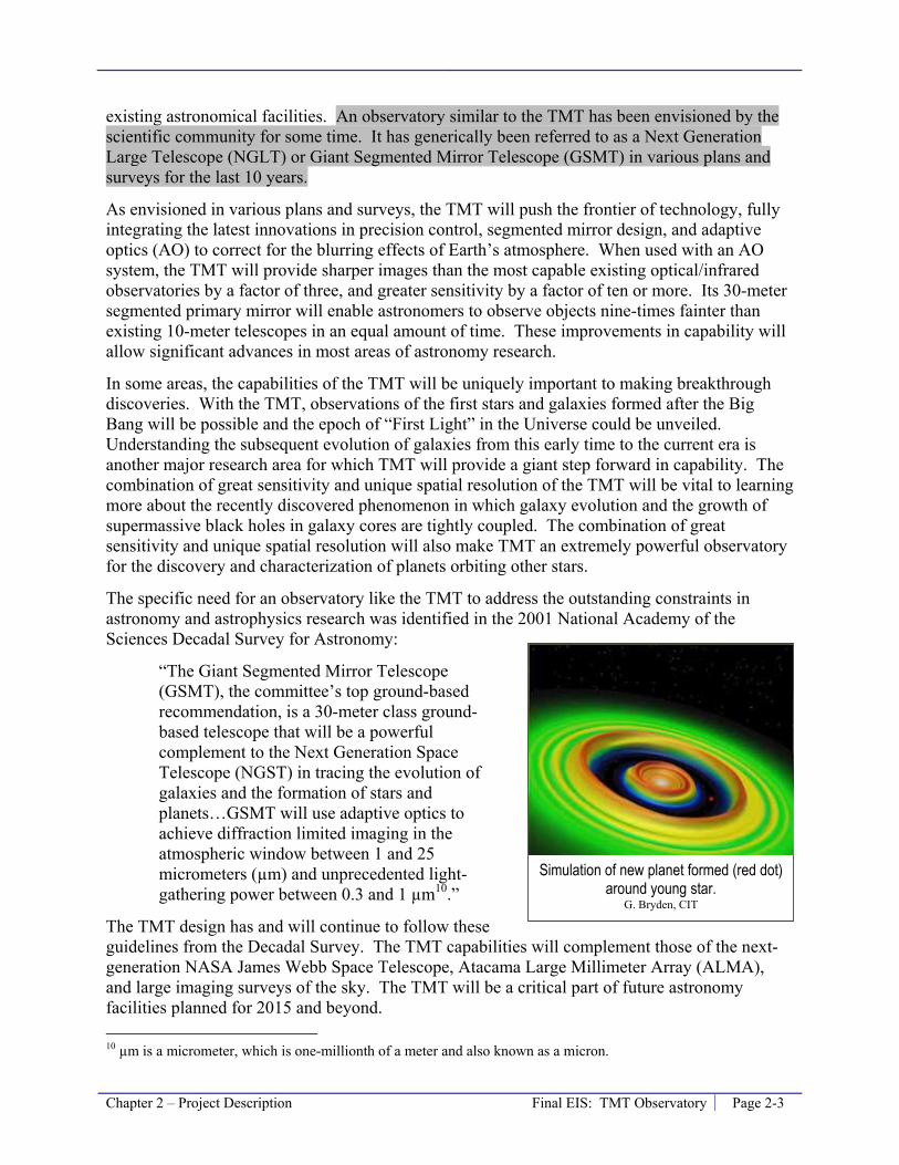
Chapter 2 – Project Description Final EIS: TMT Observatory Page 2-3
existing astronomical facilities. An observatory similar to the TMT has been envisioned by the scientific community for some time. It has generically been referred to as a Next Generation Large Telescope (NGLT) or Giant Segmented Mirror Telescope (GSMT) in various plans and surveys for the last 10 years.
As envisioned in various plans and surveys, the TMT will push the frontier of technology, fully integrating the latest innovations in precision control, segmented mirror design, and adaptive optics (AO) to correct for the blurring effects of Earth’s atmosphere. When used with an AO system, the TMT will provide sharper images than the most capable existing optical/infrared observatories by a factor of three, and greater sensitivity by a factor of ten or more. Its 30-meter segmented primary mirror will enable astronomers to observe objects nine-times fainter than existing 10-meter telescopes in an equal amount of time. These improvements in capability will allow significant advances in most areas of astronomy research.
In some areas, the capabilities of the TMT will be uniquely important to making breakthrough discoveries. With the TMT, observations of the first stars and galaxies formed after the Big Bang will be possible and the epoch of “First Light” in the Universe could be unveiled. Understanding the subsequent evolution of galaxies from this early time to the current era is another major research area for which TMT will provide a giant step forward in capability. The combination of great sensitivity and unique spatial resolution of the TMT will be vital to learning more about the recently discovered phenomenon in which galaxy evolution and the growth of supermassive black holes in galaxy cores are tightly coupled. The combination of great sensitivity and unique spatial resolution will also make TMT an extremely powerful observatory for the discovery and characterization of planets orbiting other stars.
The specific need for an observatory like the TMT to address the outstanding constraints in astronomy and astrophysics research was identified in the 2001 National Academy of the Sciences Decadal Survey for Astronomy:
“The Giant Segmented Mirror Telescope (GSMT), the committee’s top ground-based recommendation, is a 30-meter class ground-based telescope that will be a powerful complement to the Next Generation Space Telescope (NGST) in tracing the evolution of galaxies and the formation of stars and planets…GSMT will use adaptive optics to achieve diffraction limited imaging in the atmospheric window between 1 and 25 micrometers (µm) and unprecedented light-gathering power between 0.3 and 1 µm10.”
The TMT design has and will continue to follow these guidelines from the Decadal Survey. The TMT capabilities will complement those of the next-generation NASA James Webb Space Telescope, Atacama Large Millimeter Array (ALMA), and large imaging surveys of the sky. The TMT will be a critical part of future astronomy facilities planned for 2015 and beyond. 10 µm is a micrometer, which is one-millionth of a meter and also known as a micron.
Simulation of new planet formed (red dot) around young star.
G. Bryden, CIT

Page 2-4 Final EIS: TMT Observatory Chapter 2 – Project Description
2.3 Project Objectives The primary objects of the Project include:
Knowledge Growth. From a scientific standpoint, the Project’s objective is to provide for astronomers a tool that is powerful and precise enough to explore virtually every aspect of the Universe, from the formation of the first star following the Big Bang to the current state of the Milky Way Galaxy. With TMT, many of the most fundamental questions of the coming decades could be addressed, including:
• What is the nature and composition of the Universe?
• When did the first galaxies form and how did they evolve?
• What is the relationship between black holes and galaxies?
• How do stars and planets form?
• What is the nature of extra-solar planets?
• Is there life elsewhere in the Universe?
Education. The TMT partners and UH are all universities or closely allied with universities and have a primary mission to education in all subject areas, but especially science and technology education. Astronomy is well known as a “gateway” science. Many students get their introduction to the scientific method and tools of science in astronomy classes and then continue into technical and science careers. Therefore, maintaining the U.S.’ leadership in astronomy promotes not just astronomy but the larger science community. The objectives of the Project, therefore, include utilizing the TMT as an important educational tool and to attract top students and scholars in science to our institutions.
Synergy with Existing Hawai‘i Observatories. An important objective of the Project is to leverage the capacity and abilities of the TMT partners’ existing observatories, including the Keck, CFHT, and Subaru. While these observatories, all located on Maunakea, are world-leading observatories today, their future scientific productivity could be increased through teaming with a next generation observatory, such as the TMT. For observatories co-located at the same mountain there will be many opportunities to integrate science programs and to develop complementary instrumentation.
Outreach and Community. Integrate science and education with culture and sustainability in the Project is also a core objective of the Project. The TMT partnership is committed to working with UH in achieving this objective. Sharing the scientific knowledge gained through the Project and using the wide interest in astronomy to introduce students and the general public to science, technology, engineering, and math (STEM), are core objectives. In addition, in order to develop and maintain capable personnel in Hawai‘i, the Project will help foster STEM proficiencies among members of the local communities in collaboration with the local public, charter, and
AO image of a planet 4 times the mass of Jupiter orbiting a brown dwarf star.
Chauvin et al. 2004
Chapter 2 – Project Description Final EIS: TMT Observatory Page 2-5
private K-12 schools, and with UH Hilo and Hawai‘i Community College (HawCC). The TMT partner institutions are also committed to proper environmental stewardship and the concept of sustainability planning for operations of the observatory.
2.4 Project Components An astronomical observatory encompasses a number of components. This section outlines the various components of the Project and provides explanation for certain terms used throughout this document. The Project is the sum of the following proposed components:
• “TMT Observatory” refers to the components of the Project located below the summit, in the upper elevations of Maunakea. The TMT Observatory generally consists of the 30-meter telescope, instruments, dome, attached building, and parking; it is discussed in Section 2.5.1.
• The “Access Way” refers to the road and other infrastructure improvements that will be provided to access and operate the TMT Observatory. Improvements in the Access Way will generally include a surface roadway and underground utilities; it is discussed in Section 2.5.2.
• “Potential TMT Mid-Level Facility” refers to facilities and improvements located within or near Hale Pōhaku. This will include (a) upgrading electrical and communications equipment near Hale Pōhaku and may include (b) a level of activity within Hale Pōhaku ranging from construction and operation staff staying in existing Hale Pōhaku dormitories to replacing two existing construction dormitory/dining/recreation buildings, refurbishing existing construction cabins, and grading areas for parking and construction staging areas. The potential Mid-Level Facility is discussed in Section 2.5.3.
• “Headquarters” refers to the facility located in Hilo to manage activities at and support operation of the TMT Observatory and potential TMT Mid-Level Facility. This includes an office building with a parking area; it is discussed in Section 2.5.4.
2.5 Project Location and Design The following sections describe the Project components’ location and design.
2.5.1 TMT Observatory
Location
The TMT Observatory will be located on Maunakea within the MKSR on Hawai‘i Island in the State of Hawai‘i (Figure 2-1). The Island of Hawai‘i is made up of five volcanoes, one of them actively erupting. The island is politically the County of Hawai‘i and had a population of approximately 149,000 during the 2000 census. The summit of Maunakea is situated at a distance of approximately 27 miles (40 miles by road) from Hilo and 20 miles (45 miles by road) from Waimea. Hilo is the seat of County government and a port town of roughly 41,000 residents, and Waimea is a town of approximately 7,000 residents11 in the saddle between
11 United States Census, 2000.
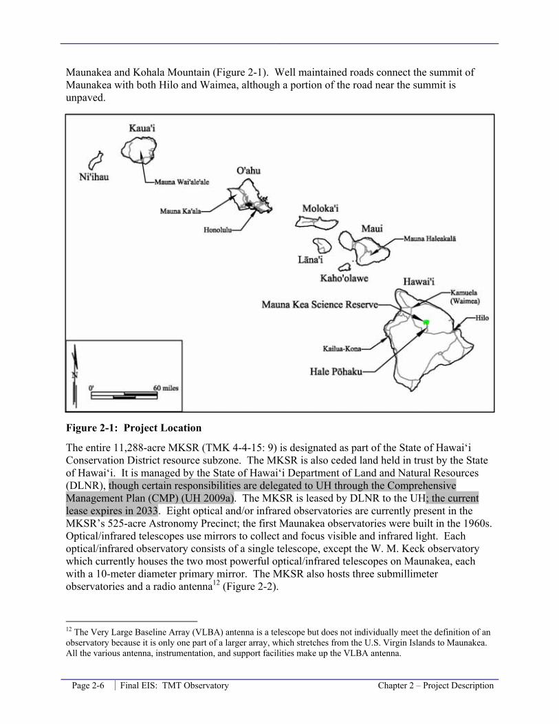
Page 2-6 Final EIS: TMT Observatory Chapter 2 – Project Description
Maunakea and Kohala Mountain (Figure 2-1). Well maintained roads connect the summit of Maunakea with both Hilo and Waimea, although a portion of the road near the summit is unpaved.
Figure 2-1: Project Location
The entire 11,288-acre MKSR (TMK 4-4-15: 9) is designated as part of the State of Hawai‘i Conservation District resource subzone. The MKSR is also ceded land held in trust by the State of Hawai‘i. It is managed by the State of Hawai‘i Department of Land and Natural Resources (DLNR), though certain responsibilities are delegated to UH through the Comprehensive Management Plan (CMP) (UH 2009a). The MKSR is leased by DLNR to the UH; the current lease expires in 2033. Eight optical and/or infrared observatories are currently present in the MKSR’s 525-acre Astronomy Precinct; the first Maunakea observatories were built in the 1960s. Optical/infrared telescopes use mirrors to collect and focus visible and infrared light. Each optical/infrared observatory consists of a single telescope, except the W. M. Keck observatory which currently houses the two most powerful optical/infrared telescopes on Maunakea, each with a 10-meter diameter primary mirror. The MKSR also hosts three submillimeter observatories and a radio antenna12 (Figure 2-2).
12 The Very Large Baseline Array (VLBA) antenna is a telescope but does not individually meet the definition of an observatory because it is only one part of a larger array, which stretches from the U.S. Virgin Islands to Maunakea. All the various antenna, instrumentation, and support facilities make up the VLBA antenna.

Chapter 2 – Project Description Final EIS: TMT Observatory Page 2-7
Figure 2-2: Maunakea Overview
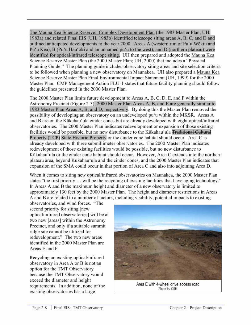
Page 2-8 Final EIS: TMT Observatory Chapter 2 – Project Description
The Mauna Kea Science Reserve: Complex Development Plan (the 1983 Master Plan; UH, 1983a) and related Final EIS (UH, 1983b) identified telescope siting areas A, B, C, and D and outlined anticipated developments to the year 2000. Areas A (western rim of Pu‘u Wēkiu and Pu‘u Kea), B (Pu‘u Hau‘oki and an unnamed pu‘u to the west), and D (northern plateau) were identified for optical/infrared telescope siting. UH then prepared and adopted the Mauna Kea Science Reserve Master Plan (the 2000 Master Plan; UH, 2000) that includes a “Physical Planning Guide.” The planning guide includes observatory siting areas and site selection criteria to be followed when planning a new observatory on Maunakea. UH also prepared a Mauna Kea Science Reserve Master Plan Final Environmental Impact Statement (UH, 1999) for the 2000 Master Plan. CMP Management Action FLU-1 states that future facility planning should follow the guidelines presented in the 2000 Master Plan.
The 2000 Master Plan limits future development to Areas A, B, C, D, E, and F within the Astronomy Precinct (Figure 2-3); 2000 Master Plan Areas A, B, and E are generally similar to 1983 Master Plan Areas A, B, and D, respectively. By doing this the Master Plan removed the possibility of developing an observatory on an undeveloped pu‘u within the MKSR. Areas A and B are on the Kūkahau‘ula cinder cones but are already developed with eight optical/infrared observatories. The 2000 Master Plan indicates redevelopment or expansion of those existing facilities would be possible, but no new disturbance to the Kūkahau‘ula Traditional Cultural Property (TCP) State Historic Property or the cinder cone habitat should occur. Area C is already developed with three submillimeter observatories. The 2000 Master Plan indicates redevelopment of those existing facilities would be possible, but no new disturbance to Kūkahau‘ula or the cinder cone habitat should occur. However, Area C extends into the northern plateau area, beyond Kūkahau‘ula and the cinder cones, and the 2000 Master Plan indicates that expansion of the SMA could occur in that portion of Area C and also into adjoining Area D.
When it comes to siting new optical/infrared observatories on Maunakea, the 2000 Master Plan states “the first priority … will be the recycling of existing facilities that have aging technology.” In Areas A and B the maximum height and diameter of a new observatory is limited to approximately 130 feet by the 2000 Master Plan. The height and diameter restrictions in Areas A and B are related to a number of factors, including visibility, potential impacts to existing observatories, and wind forces. “The second priority for siting [new optical/infrared observatories] will be at two new [areas] within the Astronomy Precinct, and only if a suitable summit ridge site cannot be utilized for redevelopment.” The two new areas identified in the 2000 Master Plan are Areas E and F.
Recycling an existing optical/infrared observatory in Area A or B is not an option for the TMT Observatory because the TMT Observatory would exceed the diameter and height requirements. In addition, none of the existing observatories has a large
Area E with 4-wheel drive access road Photo by CSH
Chapter 2 – Project Description Final EIS: TMT Observatory Page 2-9
enough footprint for the development of the TMT Observatory without additional disturbance to Kūkahau‘ula or the cinder cone habitat. Therefore, the TMT Observatory will be sited in Area E, consistent with the second priority.
The 2000 Master Plan provided a number of criteria to assist in the selection of an appropriate site for the Next Generation Large Telescope (NGLT). The TMT Observatory fits the definition of a NGLT: a ground-based telescope with a primary mirror of 25 to 50 meters in diameter. The site selection criteria include:
• Minimize visual impacts from significant cultural areas.
• Avoid archaeologic sites.
• Minimize impact of wēkiu bug habitat.
• Avoid or minimize view from Waimea, Honoka‘a, or Hilo.
• Proximity to roads and existing infrastructure.
• Minimize impact on existing facilities.
In addition, the 2000 Master Plan indicates that Areas E and F have not been thoroughly tested to establish if potential observatory sites within them provide suitable astronomical “seeing” conditions. Therefore, site selection is contingent on positive findings during site testing to evaluate seeing conditions for the telescope.
The 2000 Master Plan specifies Area E as a preferred location for a NGLT. Area E was identified as a preferred location because it was anticipated to provide suitable observation seeing conditions with the minimum impact on existing facilities, wēkiu bug habitat, archaeological sites, and viewplanes. Area E ranges in elevation from 13,100 to 13,300 feet; the summit of Maunakea is at elevation 13,796 feet. Area E is located approximately 1/2-mile northwest of the eight existing optical/infrared observatories located near the summit, at elevations of 13,600 to 13,775 feet (Figure 2-3).
The same general area is identified in the 1983 Master Plan as Area D. Area D in the 1983 Master Plan is generally similar to Area E in the 2000 Master Plan, but encompassed a larger portion of the northern plateau. The 1983 Master Plan states Area D is “very suitable for future optical/infrared telescopes. Three to four telescopes can be accommodated on the flatter portions within the area, with some flexibility in choice of sites based on technical site selection criteria such as laminar wind flow and obscuration.” The 1983 Master Plan identified similar potential benefits of siting observatories on the Northern Plateau instead of on the summit ridge, including fewer potential impacts to cultural/archaeological resources, fewer potential impacts to arthropods, and better geotechnical conditions.

Page 2-10 Final EIS: TMT Observatory Chapter 2 – Project Description
Figure 2-3: Maunakea Summit Region
Within Area E, the TMT Observatory will be located on a roughly 5-acre site near the end of the existing 4-wheel drive road, at an elevation of approximately 13,150 feet (Figure 2-4). This site is known as 13N in reference to its elevation and its location on the northern plateau. Consideration of the 13N site for siting an observatory dates back to the 1960s, when both the 13N site and a site near the summit (the site of the existing UH 2.2 meter observatory) were tested for the placement of a new observatory. In the mid-1960s UH selected the summit site because “seeing indicators at the summit [were] slightly superior.” 13
13 http://www.ifa.hawaii.edu/users/jefferies/Selecting_a_specific_site.htm

Chapter 2 – Project Description Final EIS: TMT Observatory Page 2-11
Figure 2-3: Maunakea Summit Region with Aerial Photograph Background
Site testing performed by TMT (Section 4.1) confirmed that the 13N site has good astronomical seeing characteristics. Analysis performed by TMT indicates that areas closer to the Kūkahau‘ula cinder cones, including the location within Area E specified for the NGLT in the 2000 Master Plan, likely have inferior seeing characteristics. Therefore, the 13N site is proposed was chosen for the TMT Observatory.
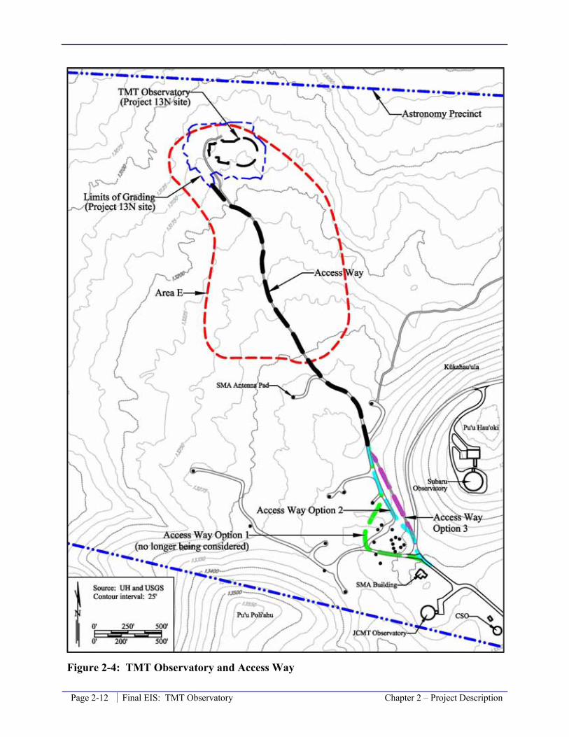
Page 2-12 Final EIS: TMT Observatory Chapter 2 – Project Description
Figure 2-4: TMT Observatory and Access Way

Chapter 2 – Project Description Final EIS: TMT Observatory Page 2-13
Figure 2-4: TMT Observatory and Access Way with Aerial Photograph Background

Page 2-14 Final EIS: TMT Observatory Chapter 2 – Project Description
The building and operation of the TMT Observatory on Maunakea will require a sublease of the area from UH, which leases this ceded land from the DLNR. The sublease will be subject to approval first by the TMT Board and UH BOR followed by approval by the BLNR. The sublease consideration will include benefits for the Island of Hawai‘i, as well as observing time for UH. The sublease is discussed in Section 3.10.3. The sublease will initially expire in 2033 when the UH master lease expires; however, it is very probable that TMT, along with some of the existing observatories, would request UH seek a new lease beyond 2033 allowing operation to continue.
Telescope Design
The core of the TMT Observatory is the 30-meter aperture telescope, referred to as the TMT. The telescope will consist of the following primary components:
1. The primary mirror – the “eye” of telescope– will be 98 feet (30 meters) in diameter. This mirror will be made up of 492 individual mirror segments operating as one.
2. The secondary mirror sits above the primary mirror and will direct the light collected by the primary mirror to the tertiary mirror.
3. The tertiary mirror sits in the middle of the primary mirror and will direct the collected light into different instruments for analysis.
Figure 2-5 illustrates the telescope assembly, with the numbered list above corresponding to the numbers on the figure.
Figure 2-5: Thirty Meter Telescope Overview

Chapter 2 – Project Description Final EIS: TMT Observatory Page 2-15
TMT Observatory Design
The TMT Observatory design is being and will continue to be developed in consultation with OMKM through their design review process. Whenever possible, the Project will incorporate sustainable technologies and energy efficient technologies into facility design and operations, per CMP Management Action IM-11. The design details provided here represent the current design. The OMKM design review process is not complete and parallels the Chapter 343 EIS process. No significant design changes, such as Project site or dome and support building size and height, are anticipated; however, adjustments to finer details could still take place. The observatory will include the following:
• The telescope, described above. The surface of the primary mirror will be located approximately 66 feet above the ground surface.
• The instruments mounted around the primary mirror used to see and analyze both the visible part of the spectrum and the infrared spectrum (number 4 in Figure 2-5).
• The TMT AO system. The TMT also will be the first optical/infrared observatory of its size to integrate AO into its original design. AO systems correct for the image distortion that is caused by the atmosphere. The AO system will project up to eight laser beams into the atmosphere to create an asterism, or group, of “guide stars” that are used to determine the atmospheric distortion of the visible and infrared light from distant objects and thus correct for it. The TMT AO system will generate each of these eight beams using a 25-watts laser; the laser light will appear yellow (0.589 microns – the sodium D2 line).
• The dome housing the telescope will be a Calotte14 type enclosure with the following characteristics (Figure 2-6 and Figure 2-7):
- Total height of roughly 180 feet above the current ground surface, with an exterior radius of 108 feet.
- The dome shutter will be 102.5 feet in diameter and it will retract inside the dome when opened.
- The dome will rotate on two planes, one horizontal at the base structure 25 feet above the ground and the other at roughly 25 degrees as the cap structure, enabling the telescope to view from straight up into the sky to 65 degrees downwards toward the horizon.
- The Calotte dome base, cap, and shutter structures will appear rounded and smooth and have a reflective aluminum-like exterior coating.
- The fixed cylindrical structure below the rotating base will enclose 35,000 square feet, and extend to 25 feet above grade. The structure will be lava-colored.
- The dome base structure and dome fixed structure will have a combination of 98 vents that will be closed during the day and will open at night. The vents will be
14 A Calotte type dome features a circular shutter and two planes of rotation. Standard observatory domes include a rectangular shutter and one plane of rotation. Benefits of a Calotte type dome include (a) overall smaller dome size, (b) improved air flow profile reducing air turbulence around the dome, (c) mechanically less complex, and (d) sheds snow better.
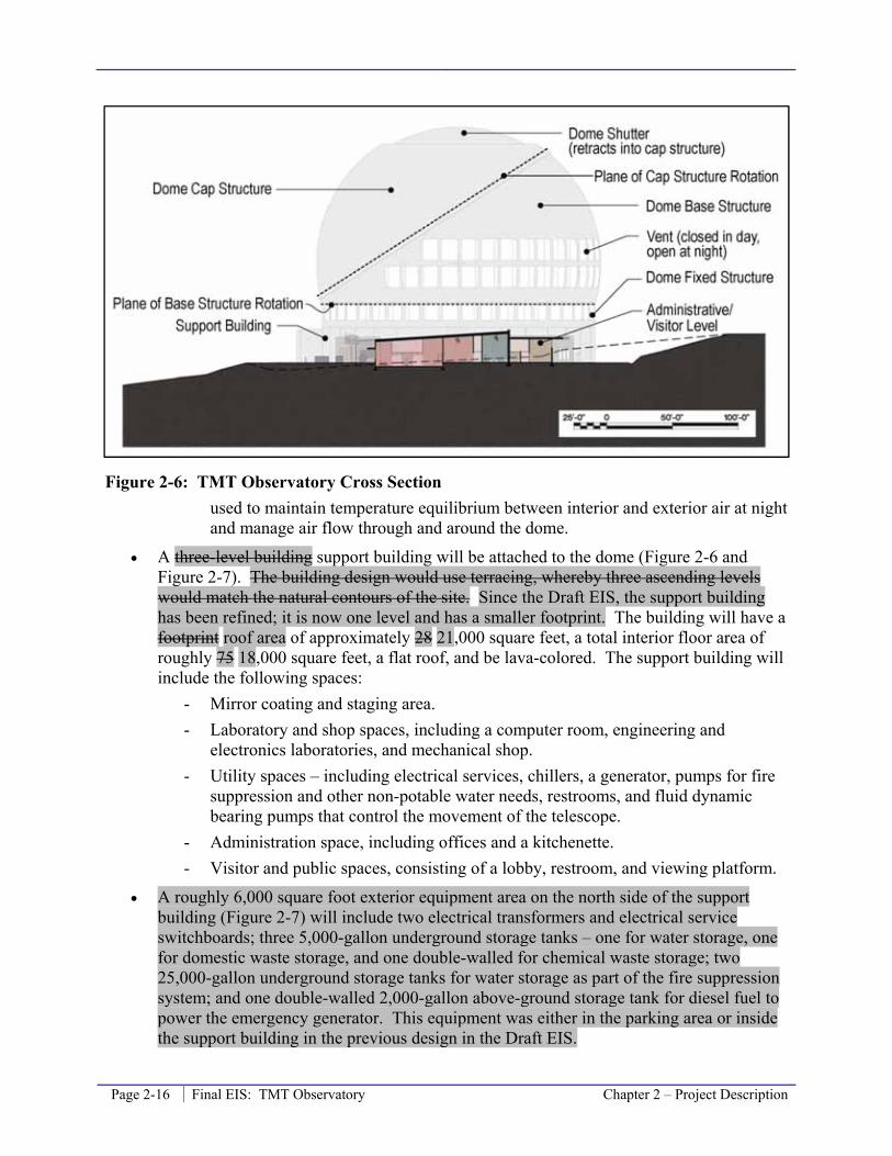
Page 2-16 Final EIS: TMT Observatory Chapter 2 – Project Description
Figure 2-6: TMT Observatory Cross Section used to maintain temperature equilibrium between interior and exterior air at night and manage air flow through and around the dome.
• A three-level building support building will be attached to the dome (Figure 2-6 and Figure 2-7). The building design would use terracing, whereby three ascending levels would match the natural contours of the site. Since the Draft EIS, the support building has been refined; it is now one level and has a smaller footprint. The building will have a footprint roof area of approximately 28 21,000 square feet, a total interior floor area of roughly 75 18,000 square feet, a flat roof, and be lava-colored. The support building will include the following spaces:
- Mirror coating and staging area. - Laboratory and shop spaces, including a computer room, engineering and
electronics laboratories, and mechanical shop. - Utility spaces – including electrical services, chillers, a generator, pumps for fire
suppression and other non-potable water needs, restrooms, and fluid dynamic bearing pumps that control the movement of the telescope.
- Administration space, including offices and a kitchenette. - Visitor and public spaces, consisting of a lobby, restroom, and viewing platform.
• A roughly 6,000 square foot exterior equipment area on the north side of the support building (Figure 2-7) will include two electrical transformers and electrical service switchboards; three 5,000-gallon underground storage tanks – one for water storage, one for domestic waste storage, and one double-walled for chemical waste storage; two 25,000-gallon underground storage tanks for water storage as part of the fire suppression system; and one double-walled 2,000-gallon above-ground storage tank for diesel fuel to power the emergency generator. This equipment was either in the parking area or inside the support building in the previous design in the Draft EIS.

Chapter 2 – Project Description Final EIS: TMT Observatory Page 2-17
Figure 2-7: TMT Observatory Plan View and Grading Plan • A tunnel that will serve as an exhaust duct for heating, ventilation, and air conditioning
(HVAC) equipment will be present on the northwestern portion of the graded area (Figure 2-7).
• Parking area for observatory staff and delivery vehicles (Figure 2-7). Parking areas will be unpaved and located outside of the support facility. A guard rail will be placed along the top of the slope on the north and west sides of the graded area where there is a drop off.
• An atmospheric turbulence monitor will be mounted on a roughly 30 foot tall tower and that tower located on the north side of the graded area, just beyond the guard rail (Figure 2-7). The monitor is a roughly 8-foot square weather station.
The footprint of the TMT Observatory dome, support building, parking area, and area disturbed during construction will be roughly five acres. A small 0.5-acre portion of this area has previously been disturbed by the existing 4-wheel drive road and site testing equipment; the original disturbance occurred during site testing in the 1960s, site testing was also performed in this area for the TMT Project in the 2000s.
Page 2-18 Final EIS: TMT Observatory Chapter 2 – Project Description
2.5.2 Access Way The Access Way will include a road and utility services to the TMT Observatory from existing facilities. Currently, utility services exist along the Mauna Kea Access Road to a point across the road from the SMA building. The Access Way will start at that point and extend to the TMT Observatory (Figure 2-4). The necessary switch boxes to provide power and communication to the TMT Observatory will be placed above ground next to the existing ones across the road from the SMA building. To the extent possible utilities from that point will be placed beneath the road to reduce the footprint of disturbance. Hawaiian Electric and Light Company (HELCO) will be granted an easement to maintain electrical service to the TMT Observatory.
As with the TMT Observatory design, the Access Way design is being and will continue to be developed in consultation with OMKM through their design review process. The existing SMA facility to the west and the unnamed Pu‘u Hau‘oki to the east (on which the Subaru Observatory sits) create a challenge to the route of the Access Way. Three options for the Access Way through or around the core of the SMA facility were considered in the Draft EIS: (1) through the SMA core, (2) near the SMA core, and (3) following the existing 4-wheel drive road around the SMA core. Option 1 is no longer being considered due to conflicts with SMA operations. Access Way Options 2 and 3 are still being considered but both Options have been refined since the Draft EIS was completed. The two options are discussed individually below.
Beyond the core of the SMA facility the route of the Access Way will follow the existing SMA roads and existing 4-wheel drive road to the extent possible. The roughly 0.5-mile long Access Way beyond the SMA core will have the following general characteristics:
• Maximum slope of 10 percent;
• Twenty-four foot wide travel surface (two lanes) with 1-foot wide shoulders for a total width of 26 feet;
• Banks graded to achieve a 2.5:1 slope; and
• Underground conduit with pull boxes and the necessary electric and communication cables.
The two Access Way Options still being considered would be paved in the vicinity of the SMA core to avoid generating dust that could accumulate on the SMA antennas. Pavement would extend from where the pavement currently ends near the SMA entrance to a point just beyond where Access Way Option 2 and Option 3 join, a distance of roughly 750 feet. The two options are illustrated in Figure 2-4 and described in the following sections.
The footprint of the common TMT Access Way and the Access Way Options areas are summarized in Table 2-1. Portions of these areas were previously disturbed by the existing 4-wheel drive and SMA roads as indicated in the table.

Chapter 2 – Project Description Final EIS: TMT Observatory Page 2-19
Table 2-1: Summary of Access Way Disturbances
Common Access
Way
Access Way
Option 2A
Access Way
Option 2B
Access Way
Option 2C
Access Way
Option 3A
Access Way
Option 3B Total Disturbance (acres) 2.5 1.2 1.3 1.6 1.1 0.8 Portion of Total that has Previously been Disturbed (acres) 1.1 1.0 0.9 0.9 0.8 0.8
Option 1 – Through SMA
This option would follow the primary SMA road off the Mauna Kea Access Road, and then proceed through the lava flow before reconnecting with the SMA road. It is not possible to use the SMA road entirely because the first turn is too tight for large vehicles, such as construction trucks. This Access Way Option would be roughly 1,400 feet (quarter mile) long. Approximately 600 feet would be new road, with the remaining 800 feet using the existing SMA roads. The maximum slope of the road would be 6 percent. Option 1 is no longer being considered due to conflicts with SMA operations.
Option 2 – Near SMA Core
To address the SMA’s operational needs this Option has been refined since the Draft EIS was completed. Currently three design approaches within Option 2 are being considered, all based on a TMT Access Way similar to that identified in the Draft EIS, that would have the following characteristics:
• Cut off the Mauna Kea Access Road between the SMA road and the currently at the blocked old 4-wheel drive road (the same location as Option 3) and connect with the SMA road once beyond the SMA core.
• Be roughly 1,000 feet long with approximately 275 feet of new road and the remaining 725 feet overlying existing SMA roads.
• Have a 20-foot wide travel way (2 lanes) that widens to the 26-foot wide configuration once reaching relatively level ground.
• Have a wire guardrail, similar to other roads in the summit region, and a drainage channel on the downslope side, where necessary.
• Have a maximum slope of 15 percent.
SMA Core
Blocked 4-wheel drive road (left) and SMA road (right) with Access Way alignment shown.
Page 2-20 Final EIS: TMT Observatory Chapter 2 – Project Description
• Underground conduit with pull boxes and the necessary electric and communication cables would be installed along the Access Way.
• Be paved for a distance of roughly 300 750 feet, from the current end of pavement at the intersection of the Mauna Kea Access Road and the SMA road to a location just beyond the intersection of the SMA road and the blocked old 4-wheel drive road.
The refined design approaches within Option 2 would allow safe SMA operations. The refined design approaches include a realigned SMA road that would provide routes and grades suitable for the SMA antenna transporter that was not accommodated by Option 2 prior to refinement. These realigned SMA roads would also allow the transporter to reach as many of the SMA pad as possible on roads separate from the TMT Access Way. The three design approaches are discussed in the following sections and illustrated in Figure 2-8 and Table 2-1 summarizes the disturbances associated with each approach.
Option 2, Design Approach A (2A)
Option 2A would involve a road for SMA movements parallel to the TMT Access Way between the SMA core and the SMA pad just north of the SMA core (pad 16). The SMA road would have the following characteristics:
• Be roughly 200 feet long and 18 feet wide,
• Have a dirt surface,
• Be located as close to the TMT Access Way Option 2 road as possible, and
• Have a slope of 12 percent, the maximum that can be traversed by the SMA antenna transporter.
Because the two roads (TMT Access Way and new SMA road) would be on different grades, a retaining wall between them would be necessary. The wall would be roughly 250 feet long and have a maximum height of roughly 6 feet.
This Option would allow SMA to access all its antenna pads without interference with TMT operations, except the four pads in the northeast portion of the SMA area.
Option 2, Design Approach B (2B)
Option 2B would involve a road for SMA movements parallel to the TMT Access Way between the SMA core and the SMA pad just north of the SMA core (pad 16) similar to Option 3A, however, the road would be just west of the TMT Access Way. The SMA road would have similar characteristics as the Option 2A SMA road except that it would be a sufficient distance from the TMT Access Way that a retaining wall would not be necessary between the two roads.
This Option would allow SMA to access all its antenna pads without interference with TMT operations, except the four pads in the northeast portion of the SMA area.
Option 2, Design Approach C (2C)
Option 2C would involve building two new SMA roads:
1. A 390 foot long road between antenna pads 14 and 24, and
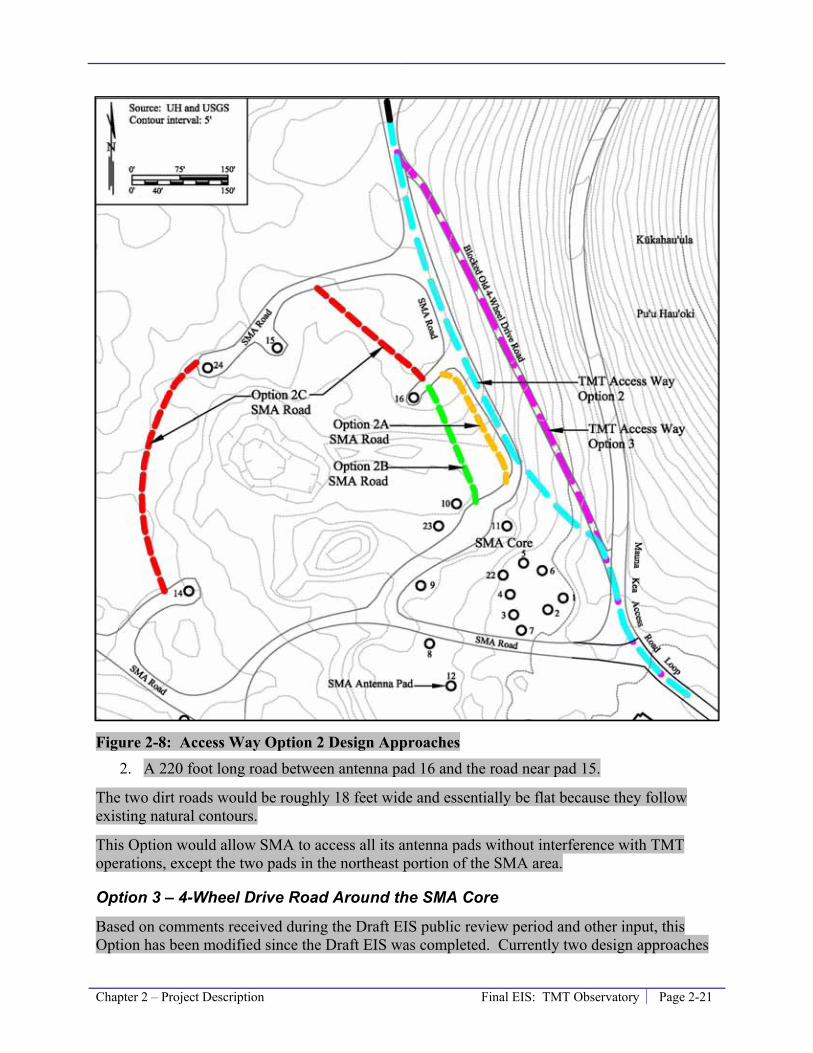
Chapter 2 – Project Description Final EIS: TMT Observatory Page 2-21
Figure 2-8: Access Way Option 2 Design Approaches 2. A 220 foot long road between antenna pad 16 and the road near pad 15.
The two dirt roads would be roughly 18 feet wide and essentially be flat because they follow existing natural contours.
This Option would allow SMA to access all its antenna pads without interference with TMT operations, except the two pads in the northeast portion of the SMA area.
Option 3 – 4-Wheel Drive Road Around the SMA Core
Based on comments received during the Draft EIS public review period and other input, this Option has been modified since the Draft EIS was completed. Currently two design approaches
Page 2-22 Final EIS: TMT Observatory Chapter 2 – Project Description
within Option 3 are being considered. All the design approaches include a TMT Access Way alignment similar to that identified in the Draft EIS (Figure 2-8); however, Access Way Option 3 has been refined to have the following characteristics:
• Cut off the Mauna Kea Access Road at the blocked old 4-wheel drive road, follow the currently blocked old 4-wheel drive road and connect with the SMA road once beyond the SMA core.
• Be roughly 1,000 feet long and require widening improving the old 4-wheel drive road over a distance of roughly 750 feet, with the remaining 250 feet following an existing SMA road.
• Where it coincides with the currently blocked old 4-wheel drive road, the Access Way would consist of only a single 12-foot wide travel lane with a single 4-foot wide shoulder (total width of 18 feet), instead of two 12-foot wide travel lanes with two 1-foot wide shoulders (total width of 26 feet). Due to the steepness of the pu‘u, a retaining wall up to 8 feet high would be built along a 700-foot long portion of the road to avoid grading a large portion of the Pu‘u. This design modification eliminates the need for a retaining wall on the upslope side of the road, as opposed to requiring a retaining wall up to 8 feet tall necessary for the 26 feet wide road.
• Widen to the 26-foot wide configuration once it joins the existing SMA road.
• Have a maximum slope of nine percent.
• Have a wire guardrail, similar to other roads in the summit region, and a drainage channel on the downslope side, where necessary.
• Be paved for a distance of roughly 300 750 feet, from the current end of pavement at the intersection of the Mauna Kea Access Road and the SMA road to a location just beyond the intersection of the SMA road and the blocked old 4-wheel drive road.
The design approaches within Option 3 consist of different methods to improve the blocked old 4-wheel drive road, specifically, the slope of the bank on the downslope side of the improvements. The two design approaches are:
• Option3, Design Approach A (3A). The bank of the slope would be a roughly 2.5 to 1 slope. This would result in a slope similar to the natural slope of the cinder cone. The fill material needed to build the road could be obtained from the TMT Observatory site.
• Option 3, Design Approach B (3B). The bank of the slope would be a roughly 1 to 1 slope. Some sort of structural fill would be required to attain this slope and a facing of some type would be necessary to prevent erosion of the slope; however, this would minimize disturbance to the cinder cone.
Table 2-1 summarizes the disturbances associated with both approaches. Both Options 3A and 3B would allow SMA to access all its antenna pads without interference from TMT operations, except the two pads in the northeast portion of the SMA area.
With either design approach, the underground conduit with pull boxes for the necessary electric and communication cables could be placed either under the TMT Access Way Option 3 alignment or along the Access Way Option 2 alignment, or along the existing SMA roads.
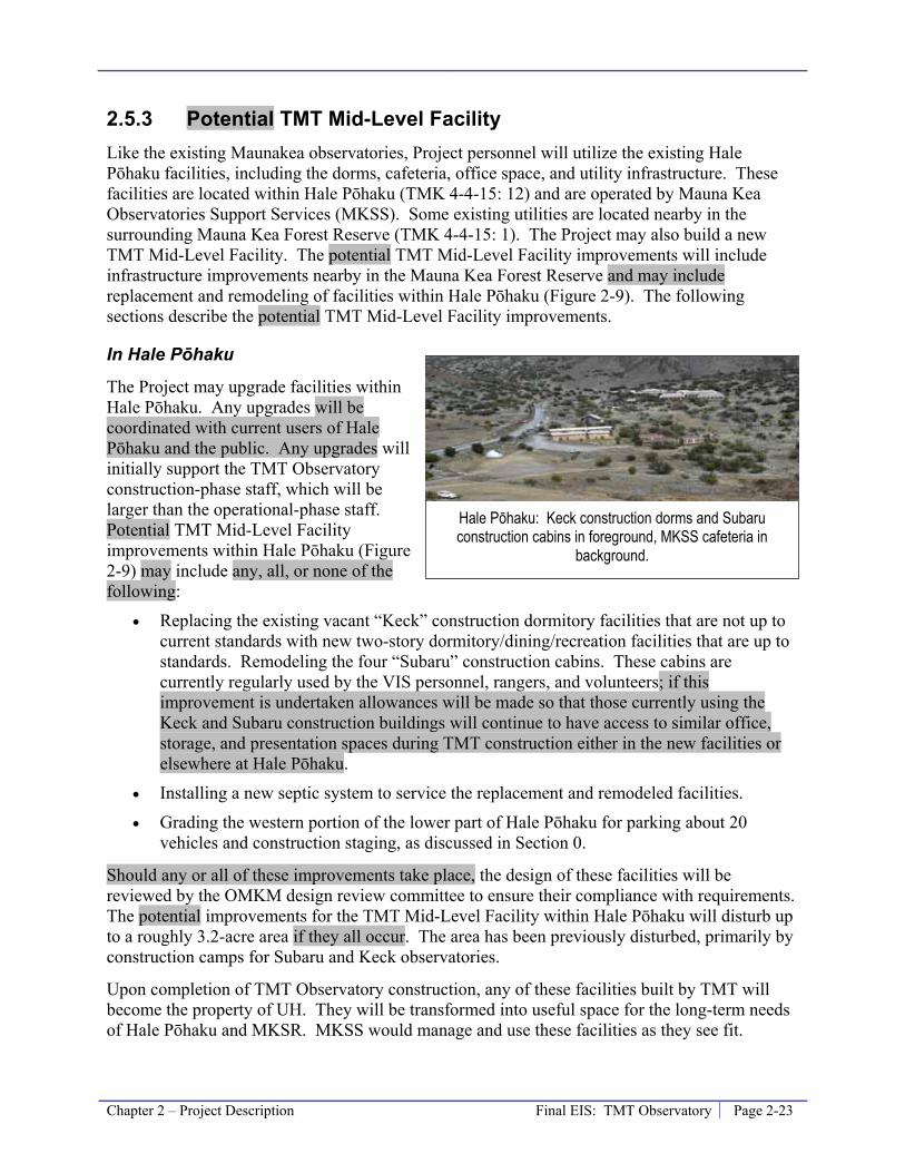
Chapter 2 – Project Description Final EIS: TMT Observatory Page 2-23
2.5.3 Potential TMT Mid-Level Facility Like the existing Maunakea observatories, Project personnel will utilize the existing Hale Pōhaku facilities, including the dorms, cafeteria, office space, and utility infrastructure. These facilities are located within Hale Pōhaku (TMK 4-4-15: 12) and are operated by Mauna Kea Observatories Support Services (MKSS). Some existing utilities are located nearby in the surrounding Mauna Kea Forest Reserve (TMK 4-4-15: 1). The Project may also build a new TMT Mid-Level Facility. The potential TMT Mid-Level Facility improvements will include infrastructure improvements nearby in the Mauna Kea Forest Reserve and may include replacement and remodeling of facilities within Hale Pōhaku (Figure 2-9). The following sections describe the potential TMT Mid-Level Facility improvements.
In Hale Pōhaku
The Project may upgrade facilities within Hale Pōhaku. Any upgrades will be coordinated with current users of Hale Pōhaku and the public. Any upgrades will initially support the TMT Observatory construction-phase staff, which will be larger than the operational-phase staff. Potential TMT Mid-Level Facility improvements within Hale Pōhaku (Figure 2-9) may include any, all, or none of the following:
• Replacing the existing vacant “Keck” construction dormitory facilities that are not up to current standards with new two-story dormitory/dining/recreation facilities that are up to standards. Remodeling the four “Subaru” construction cabins. These cabins are currently regularly used by the VIS personnel, rangers, and volunteers; if this improvement is undertaken allowances will be made so that those currently using the Keck and Subaru construction buildings will continue to have access to similar office, storage, and presentation spaces during TMT construction either in the new facilities or elsewhere at Hale Pōhaku.
• Installing a new septic system to service the replacement and remodeled facilities.
• Grading the western portion of the lower part of Hale Pōhaku for parking about 20 vehicles and construction staging, as discussed in Section 0.
Should any or all of these improvements take place, the design of these facilities will be reviewed by the OMKM design review committee to ensure their compliance with requirements. The potential improvements for the TMT Mid-Level Facility within Hale Pōhaku will disturb up to a roughly 3.2-acre area if they all occur. The area has been previously disturbed, primarily by construction camps for Subaru and Keck observatories.
Upon completion of TMT Observatory construction, any of these facilities built by TMT will become the property of UH. They will be transformed into useful space for the long-term needs of Hale Pōhaku and MKSR. MKSS would manage and use these facilities as they see fit.
Hale Pōhaku: Keck construction dorms and Subaru construction cabins in foreground, MKSS cafeteria in
background.

Page 2-24 Final EIS: TMT Observatory Chapter 2 – Project Description
Figure 2-9: Existing and Potential Hale Pōhaku Facilities
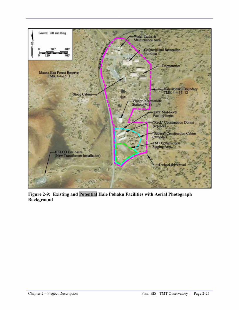
Chapter 2 – Project Description Final EIS: TMT Observatory Page 2-25
Figure 2-9: Existing and Potential Hale Pōhaku Facilities with Aerial Photograph Background

Page 2-26 Final EIS: TMT Observatory Chapter 2 – Project Description
Near Hale Pōhaku
Two transformers within the HELCO compound will be upgraded by the local electrical utility company. The HELCO compound is located across Mauna Kea Access Road from Hale Pōhaku (Figure 2-9). The new transformers will be placed next to in the same location as the existing transformers and the existing fenced compound will not be expanded slightly to make room for the new transformer.
In addition, electrical service from the transformer compound near Hale Pōhaku to the existing utility boxes across the road from the SMA building will be upgraded by the local electrical utility company to support the TMT Observatory’s power requirements. This will be done by removing existing conducting wire and placing new electric conducting wire in existing spare underground conduits.
The existing conduit is located approximately 50 feet west of the Mauna Kea Access Road within UH Management Areas for portions of the distance to the summit area; however, in areas the electrical conduit is located along a former access road alignment that is now within the Ice Age NAR (Figure 2-10).
Figure 2-10: Route of Electrical Conduit

Chapter 2 – Project Description Final EIS: TMT Observatory Page 2-27
There are pull boxes located approximately every 300 feet along the conduit. Installing new wire in the conduit will not result in any new disturbance but the local utility company will need to access the pull boxes to install the new cable.
2.5.4 Headquarters Due to the rigors of living and working at high elevation, observatories build headquarter facilities at lower elevations for the majority of their administrative and operations staff. Most of the staff does not need to directly access the telescope on a daily basis. TMT has planned its operation to minimize the number of activities needing to be done by staff at the TMT Observatory and plans to maintain and operate much of the equipment remotely from the Headquarters. This reduces the number of trips to and people at the TMT Observatory.
The Headquarters will be located in Hilo on the UH Hilo campus, within the University Park of Science and Technology (University Park) development. University Park consists of portions of TMK 2-4-1: 7, all of TMK 2-4-1: 41, and a mauka expansion on portions of TMK 2-4-1: 122. Some existing observatories have their headquarters in University Park. The options being considered for the Project Headquarters within University Park are all within either TMK 2-4-1: 7 or 2-4-1: 122 (Figure 2-11). The Headquarters will be an approximately 20,000 to 35,000 square foot office building; and it is planned to include solar hot water systems for domestic water use, photo voltaic power systems to partially offset the general electrical power usage, maximum use of natural lighting, and all office lighting will use energy efficient light fixtures controlled by occupancy sensors. The Headquarters will be designed with local knowledge to make maximum use of the climate and natural ventilation.
2.5.5 Satellite Office – No Longer Considered The Draft EIS considered a Satellite Office; however, it is no longer planned as part of the Project and all discussion related to it in Chapters 3 and 4 have been removed in the Final EIS.
The Satellite Office, in coordination with the Headquarters, would support operation of the TMT Observatory. The options being considered in Waimea include commercially-zoned vacant lots behind the Parker Ranch Center (Figure). The design of the Satellite Office would depend upon the selected location. The Satellite Office would be smaller than the Headquarters, and is currently estimated to be an office building of approximately 10,000 to 25,000 square feet.
Figure 2-10: Possible Satellite Office Locations in Waimea
HELCO compound near Hale Pōhaku. Photo by CSH
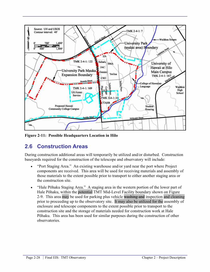
Page 2-28 Final EIS: TMT Observatory Chapter 2 – Project Description
Figure 2-11: Possible Headquarters Location in Hilo
2.6 Construction Areas During construction additional areas will temporarily be utilized and/or disturbed. Construction baseyards required for the construction of the telescope and observatory will include:
• “Port Staging Area.” An existing warehouse and/or yard near the port where Project components are received. This area will be used for receiving materials and assembly of those materials to the extent possible prior to transport to either another staging area or the construction site.
• “Hale Pōhaku Staging Area.” A staging area in the western portion of the lower part of Hale Pōhaku, within the potential TMT Mid-Level Facility boundary shown on Figure 2-9. This area may be used for parking plus vehicle washing and inspection and cleaning prior to proceeding up to the observatory site. It may also be utilized for the assembly of enclosure and telescope components to the extent possible prior to transport to the construction site and the storage of materials needed for construction work at Hale Pōhaku. This area has been used for similar purposes during the construction of other observatories.

Chapter 2 – Project Description Final EIS: TMT Observatory Page 2-29
Figure 2-11: Possible Headquarters Location in Hilo with Aerial Photograph Background • “Batch Plant Staging Area.” A roughly 4-acre
area northwest of where the Mauna Kea Access Road forks near the summit (Figure 2-3). This area will primarily be used for storing bulk materials and a concrete batch plant, as it has been in the past during construction of other observatories.
• The area within the TMT Observatory, potential TMT Mid-Level Facility, and Headquarters sites not occupied by structures will also be utilized as staging areas during construction of those facilities. These areas will be utilized for materials needed in the short term and final pre-assembly of components prior to installation.
2.7 Project Phases and Activities The TMT Observatory Project involves four major phases: planning and design, construction and testing, operation, and decommissioning of the TMT Observatory after it reaches the end of its planned useful life. Table 2-2 presents the overall conceptual phasing framework for the Project that will be updated on an ongoing basis and refined as the process moves forward. The following sections discuss activities anticipated during the various phases of the Project.
Batch Plant Staging Area
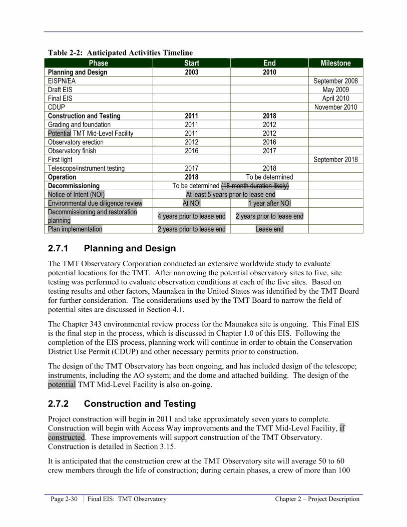
Page 2-30 Final EIS: TMT Observatory Chapter 2 – Project Description
Table 2-2: Anticipated Activities Timeline Phase Start End Milestone
Planning and Design 2003 2010 EISPN/EA September 2008 Draft EIS May 2009 Final EIS April 2010 CDUP November 2010 Construction and Testing 2011 2018 Grading and foundation 2011 2012 Potential TMT Mid-Level Facility 2011 2012 Observatory erection 2012 2016 Observatory finish 2016 2017 First light September 2018 Telescope/instrument testing 2017 2018 Operation 2018 To be determined Decommissioning To be determined (18-month duration likely) Notice of Intent (NOI) At least 5 years prior to lease end Environmental due diligence review At NOI 1 year after NOI Decommissioning and restoration planning 4 years prior to lease end 2 years prior to lease end
Plan implementation 2 years prior to lease end Lease end
2.7.1 Planning and Design The TMT Observatory Corporation conducted an extensive worldwide study to evaluate potential locations for the TMT. After narrowing the potential observatory sites to five, site testing was performed to evaluate observation conditions at each of the five sites. Based on testing results and other factors, Maunakea in the United States was identified by the TMT Board for further consideration. The considerations used by the TMT Board to narrow the field of potential sites are discussed in Section 4.1.
The Chapter 343 environmental review process for the Maunakea site is ongoing. This Final EIS is the final step in the process, which is discussed in Chapter 1.0 of this EIS. Following the completion of the EIS process, planning work will continue in order to obtain the Conservation District Use Permit (CDUP) and other necessary permits prior to construction.
The design of the TMT Observatory has been ongoing, and has included design of the telescope; instruments, including the AO system; and the dome and attached building. The design of the potential TMT Mid-Level Facility is also on-going.
2.7.2 Construction and Testing Project construction will begin in 2011 and take approximately seven years to complete. Construction will begin with Access Way improvements and the TMT Mid-Level Facility, if constructed. These improvements will support construction of the TMT Observatory. Construction is detailed in Section 3.15.
It is anticipated that the construction crew at the TMT Observatory site will average 50 to 60 crew members through the life of construction; during certain phases, a crew of more than 100
Chapter 2 – Project Description Final EIS: TMT Observatory Page 2-31
will be working at the site. Some of the TMT Observatory construction crew may be housed at the existing dormitories at Hale Pōhaku, and, if built, the TMT Mid-Level Facility. Construction is expected to take place six days a week, 10 hours a day; however, some special operations or construction phases will require longer work hours. It is also expected that winter weather conditions at the TMT Observatory site will interrupt construction at times, until the dome is completed.
First light, or the time when the TMT is first used to take an astronomical image, is expected in 2018. Tests will then be conducted and adjustments to the telescope and instruments made for a period of time to gain optimum efficiency and seeing.
2.7.3 Operation The first scientific results using the TMT Observatory are expected in 2018. During the life of the TMT Observatory astronomical observations will be made by scientists from around the world. A staff of up to 140 people will be necessary to operate and maintain the observatory. It is expected that an average of 24 employees will work at the TMT Observatory during daytime operations, with a minimum of 15 and a maximum of 43 possible depending on activities. Each night, approximately 6 system operators will be present at the TMT Observatory, while observers and support astronomers will observe remotely from the Headquarters. All other members of the staff will work at the Headquarters. an estimated 44 members of the staff would work at the TMT Observatory, with approximately 60 members of the staff working at the Headquarters and approximately 30 members of the staff working at the Satellite Office.
2.7.4 Decommissioning The TMT Observatory and the extent of the Access Way exclusively used to access the TMT Observatory will be dismantled and the site restored at the end of the TMT Observatory’s life in compliance with the Decommissioning Plan for the Mauna Kea Observatories, a Sub-Plan of the Mauna Kea Comprehensive Management Plan (OMKM, 2010a). Deconstruction and site restoration efforts will be managed by TMT with oversight by OMKM. A process similar to the MKMB-approved Project Review Process will be established to review, guide, and recommend the disposition of a site, including site restoration. Reviewers will include OMKM, Kahu Kū Mauna, and the MKMB Environment Committee, with MKMB approval required.
Site Decommissioning Plan
A Site Decommissioning Plan (SDP), as described in the Decommissioning Plan (OMKM, 2010a) will be required from TMT to document the condition of the observatory site, outline its approach to decommissioning, and propose a plan for site restoration. The TMT SDP will be developed in stages consisting of the following four components.
Notice of Intent (NOI)
The purpose of the NOI is for the sublessee to propose whether their site will be removed, continued for use as an observatory by a third party, or retrofitted for a different use. The NOI will also contain the intentions for site restoration, and a site description that summarizes the

Page 2-32 Final EIS: TMT Observatory Chapter 2 – Project Description
overall condition and land use, including a description of all structures, equipment, and other appurtenances.
Environmental Due Diligence Review
For all cases of potential future use described in the NOI, a Phase I Environmental Site Assessment of the observatory property will be conducted and the results submitted to UH and DLNR, Office of Conservation and Coastal Lands (OCCL). The goal of this is to identify any hazardous substances or petroleum products that may have been released into the ground, groundwater, or surface water of the property. If recognized environmental conditions are identified in the Phase I, a more in-depth Phase II may be required.
Site Deconstruction and Removal Plan (SDRP)
The SDRP will document the proposed methods for demolishing, in part or total, any and all observatory structures and related infrastructure; grading and grubbing the site; stockpiling fill materials; and solid waste recovery, reuse, and disposal. A SDRP will not be required if ownership of the observatory is intended to simply be transferred and no deconstruction/construction activities are proposed.
Specific factors that need to be considered during the development of the SDRP include:
• Cultural Sensitivity. Cultural considerations with respect to deconstruction will be identified as part of the SDRP assessment and evaluation.
• Extent of Infrastructure Removal and Deconstruction. The foundation will extend below grade and will require considerable excavation to remove and significant material to backfill the voids. There are two possibilities with regard to the removal of the TMT facility and infrastructure:
a. Complete infrastructure removal – the entire facility, including all underground utilities, pilings, and foundation would be removed to the extent practicable; or
b. Infrastructure capping – all or part of the underground portion of the facility would be left in place, capped with an impermeable material, and topped with materials similar to the surroundings.
Site Restoration Plan (SRP)
The SRP will present specific targets for site restoration and describe the methodology for restoring disturbed areas after the demolition/construction activities described in the SDRP are completed. The Decommissioning Plan (OMKM, 2010a) states that the two primary objectives of site restoration are (1) restoring the look and feel of the summit prior to construction of the observatories, and (2) providing habitat for the aeolian arthropod fauna.
The level of restoration to be performed and the potential impact of the restoration activities on natural and cultural resources during and post-activity must be carefully evaluated in the SRP. Specific factors that need to be considered during the development of the SRP include cultural sensitivity.
Three levels of site restoration have been set forth in the CMP (UH, 2009a) and the Decommissioning Plan (OMKM, 2010a). Establishing three levels recognizes that in addition to
Chapter 2 – Project Description Final EIS: TMT Observatory Page 2-33
the potential benefits of site restoration, there are also potential impacts. The three levels of site restoration are:
1. Minimal – would include the removal of all man-made materials and the grading of the site.
2. Moderate – would include the removal of all man-made materials, grading of the site, and enhancing the structure of the physical habitat to benefit the arthropod (insect) community.
3. Full – would include return of the site to its original topography and restoration of the arthropod habitat.
The level of restoration to be done at the TMT Observatory site would be determined at a later time and would be determined based on an environmental cost/benefit analysis overseen by OMKM, Kahu Kū Mauna, and other stakeholders. The level of restoration to be performed by TMT will be negotiated between TMT, UH, and DLNR according to the sublease terms.
Site restoration activities may involve using cinder or materials similar to the surroundings either to fill holes or to reconstruct topography. Consideration will be given to where fill material will come from, how excavation and removal of materials will impact the collection area and any habitat surrounding the restoration area, and what the cultural considerations are for bringing materials from a different place to Maunakea.
Upon the completion of site restoration, monitoring of the restoration activities will begin and continue for at least three years. Results of monitoring activities will be submitted to OMKM.
Management Actions
The CMP also lays out several decommissioning management actions, they are:
1. Consider future decommissioning during project planning and include provisions in subleases that require funding of full restoration (CMP Management Action SR-3).
2. Once the observatory’s useful life has ended, develop a recycling and/or demolition plan (referred to as a SDRP and SRP in the Decommissioning Sub Plan) that considers items such as waste management and demolition best management practices (BMPs) (CMP Management Action SR-1).
3. CMP Management Action FLU-3 requires cataloguing the initial site conditions for use when conducting site restoration in the future.
4. Once the observatory’s useful life has ended, develop a SRP in association with the SDRP, which will include an environmental cost-benefit analysis and a cultural assessment (CMP Management Action SR-2). The cost-benefit analysis of the three levels of restoration will consider restoration costs and related impacts, including the cultural assessment. In compliance with CMP Management Action FLU-4, the site restoration plan would include visual renderings of the site setting pre- and post-restoration for each of the three levels of restoration to facilitate analysis of potential impacts to view planes.
To address the first management action, the Project has (a) included in the design of the TMT Observatory and Access Way the use of almost all excavated material on those sites so that it
Page 2-34 Final EIS: TMT Observatory Chapter 2 – Project Description
will be available for use again during site restoration, and (b) included in the planned Project operation budget annually setting aside funds that will be used for decommissioning of the TMT Observatory. The Project anticipates decommissioning and site restoration requirements will be included in the sublease. TMT is committed to preparing the necessary plans, such as the SDP, SDRP, and SRP, in accordance with the general timeline presented in the Decommissioning Plan and providing an opportunity for the public to comment on the plans. The current UH lease of the MKSR expires in 2033 and the TMT Observatory and the portion of the Access Way exclusively used to access the TMT Observatory will be decommissioned and the site restored by that time, unless a new lease has been obtained from the BLNR.
2.8 References National Research Council (NRC), 2001. Astronomy and Astrophysics in the New Millennium.
By NRC; Commission on Physical Sciences, Mathematics, and Applications; Board on Physics and Astronomy-Space Studies Board; Astronomy and Astrophysics Survey Committee. National Academy Press, Washington D.C. 2001.
NRC-Canada, 1999. Canadian Astronomy and Astrophysics in the 21st Century, The Origins of Structures in the Universe. NRC-Canada, Natural Sciences and Engineering Research Council of Canada, and Canadian Astronomical Society.
Office of Mauna Kea Management (OMKM), 2010b. Public Access Plan for the UH Management Areas on Mauna Kea; A Sub-Plan of the Mauna Kea Comprehensive Management Plan. January 2010. Prepared by Sustainable Resources Group International, Inc., Island Planning, and Island Transitions, LLC, approved by BLNR on March 25, 2010.
OMKM, 2010a. Decommissioning Plan for Mauna Kea Observatories; A Sub-Plan of the Mauna Kea Comprehensive Management Plan. January 2010. Prepared by Sustainable Resources Group International, Inc., approved by BLNR on March 25, 2010.
OMKM, 2009b. A Cultural Resource Management Plan for the University of Hawai‘i Management Areas on Mauna Kea, Ka‘ohe Ahupua‘a, Hāmākua District, Island of Hawai‘i, State of Hawai‘i. TMK: (3) 4-4-015: 09, 12; A Sub-Plan for the Mauna Kea Comprehensive Management Plan. October 2009. Prepared by Pacific Consulting Services, Inc., approved by BLNR on March 25, 2010.
OMKM, 2009a. Natural Resources Management Plan for the UH Management Areas on Mauna Kea; A Sub-Plan of the Mauna Kea Comprehensive Management Plan. September 2009. Prepared by Sustainable Resources Group International, Inc., approved by BLNR on March 25, 2010.
University of Hawai‘i (UH), 2009c. Draft Environmental Impact Statement, Thirty Meter Telescope Project. May 23, 2009.
UH, 2009b. Mauna Kea Comprehensive Management Plan Final Environmental Assessment. Prepared by Pacific Consulting Services, Inc. for UH. April 2009.
UH, 2009a. Mauna Kea Comprehensive Management Plan. January, 2009. Approved by BLNR on April 9, 2009.

Chapter 2 – Project Description Final EIS: TMT Observatory Page 2-35
UH, 2000. Mauna Kea Science Reserve Master Plan. Available on the web http://www.hawaii.edu/maunakea/. Prepared by Group 70 International, Inc., adopted by the UH Board of Regents on June 16, 2000.
UH, 1999. Mauna Kea Science Reserve Master Plan Final Environmental Impact Statement. Prepared by Group 70 International Inc. for UH. December 1999.
UH, 1983a. Mauna Kea Science Reserve: Complex Development Plan. Prepared by Group 70 International, Inc. for Research Corporation of the University of Hawai‘i. February 1983 (amended May 1987).
UH, 1983b. Mauna Kea Science Reserve: Complex Development Plan Final Environmental Impact Statement. Prepared by Group 70 International, Inc. for Research Corporation of the University of Hawai‘i. January 1983.


Section 3.1 – Introduction Final EIS: TMT Observatory Page 3-1
3.0 Environmental Setting, Impact, and Mitigation
Maunakea is one of the most significant cultural and astronomical sites in the world. Hawaiians feel a cultural kinship with Maunakea; traditional genealogy account that Wākea (the sky-father) and Papa (the earth mother) gave birth both to the islands and the first man (Hāloa), and from this ancestor all Hawaiian people are descended. Native Hawaiian traditions state that among the islands, Hawai‘i was first born and Maunakea represents the piko (umbilical cord) to Papa and Wākea. Maunakea is also exceptional for its quality for astronomical observations and is the scientific umbilical cord to the mysteries of the universe.
UH has been working to find ways for these two cultures to co-exist in such a way that is mutually respectful yet honors the unique cultural and natural resources of Maunakea. The most recent effort is the CMP recently approved by the BLNR and accepted by the UH BOR. The BLNR shares the belief that “these diverse interests can be accommodated,” recognizing that Maunakea’s summit area is unique and one of Earth’s special places. The CMP provides for the stewardship of the land with a road map to conserve, protect, and preserve this unique and most special resource. The CMP is the culmination of years of work by OMKM and UH Hilo in establishing the foundation for good management of UH’s management areas.
UH, UH Hilo, and TMT have gained an understanding of the cultural sensitivity of Maunakea through working with the community during the preparation of the CMP and this Final EIS. It is the intention of all those involved to be good stewards of the land and avoid miscommunication or unintentional disrespect between the Project and the community.
This Chapter presents our current understanding of the environmental setting in the region and at specific Project locations. Mitigation measures identified in this Final EIS have been developed to avoid, minimize, rectify, or reduce the Project’s potential substantial adverse environmental impacts and be good stewards of the land. Mitigation measures have been considered throughout the Project planning process and incorporated into the Project design and construction plans.
3.1 Introduction Each Section in this Chapter discusses (a) current conditions and/or management practices in the region and in the Project area related to the specific environmental subject, (b) the threshold used to determine the Project’s level of impact, (c) the Project’s potential long-term operation phase impacts related to the specific environmental subject, (d) the potential mitigation measures that could be implemented by the Project to avoid, minimize, rectify, or reduce potential substantial adverse environmental impacts, and (e) the Project’s relative potential impact that will remain after the potential mitigation measures are implemented. Operation phase effects will occur consistently throughout the operational life of the Project, and will at least partially end upon decommissioning.

Page 3-2 Final EIS: TMT Observatory Section 3.1 – Introduction
Short-term potential construction phase and decommissioning phase effects are discussed in a single section, Section 3.15, and will be temporary.
The information about existing conditions, potential Project impacts, and potential mitigation measures presented in this Chapter has been developed through (a) the review and use of existing information related to Maunakea, specifically information related to the UH Management Areas (the MKSR, a corridor along the Mauna Kea Access Road, and Hale Pōhaku), and other Project areas; and (b) new studies conducted for this Project. Existing information related to Maunakea is extensive, and includes the following principal sources:
• Mauna Kea Science Reserve Master Plan; 2000, accepted by the UH BOR on June 16, 2000 (http://www.hawaii.edu/maunakea/)
• Mauna Kea Comprehensive Management Plan, UH Management Areas (CMP); January 2009, approved by the BLNR on April 9, 2009 (http://www.maunakeacmp.com/overview/documents); including the following sub plans (http://www.malamamaunakea.org/?page_id=272):
- Natural Resources Management Plan for the UH Management Areas on Mauna Kea; A Sub-Plan of the Mauna Kea Comprehensive Management Plan; September 2009 (the “NRMP”)
- A Cultural Resource Management Plan for the University of Hawai‘i Management Areas on Mauna Kea, Ka‘ohe Ahupua‘a, Hāmākua District, Island of Hawai‘i, State of Hawai‘i. TMK: (3) 4-4-015: 09, 12; A Sub-Plan for the Mauna Kea Comprehensive Management Plan; October 2009 (the “CRMP”)
- Decommissioning Plan for the Mauna Kea Observatories; A Sub-Plan of the Mauna Kea Comprehensive Management Plan; January 2010 (the “DP”)
- Public Access Plan for the UH Management Areas on Mauna Kea; A Sub-Plan of the Mauna Kea Comprehensive Management Plan; January 2010 (the “PAP”)
• Final Environmental Assessment (FEA) for the Mauna Kea Comprehensive Management Plan (CMP); April 1, 2009 (http://oeqc.doh.hawaii.gov/Shared%20Documents/EA_and_EIS_Online_Library/Hawaii/2000s/2009-04-23-HA-FEA-Mauna-Kea-Comp-Management-Plan.pdf)
Each section also includes a list of references with additional sources of information used in the evaluation of the specific environmental subject.
Each environmental subject is discussed in this Final EIS as outlined in the following sections.

Section 3.1 – Introduction Final EIS: TMT Observatory Page 3-3
3.1.1 Environmental Setting “Environmental Setting” describes the existing environmental conditions in the Project areas and the region as it currently exists, before the commencement of the Project. This provides a baseline for comparing “before the Project” and “after the Project” environmental conditions.
3.1.2 Thresholds Used to Determine Level of Impact
“Thresholds Used to Determine Level of Impact” defines and lists specific criteria used to determine whether an impact is considered to be potentially significant. HRS Chapter 343, Section 2, defines “significant effect” to mean “the sum of effects on the quality of the environment, including actions that irrevocably commit a natural resource, curtail the range of beneficial uses of the environment, are contrary to the State's environmental policies or long-term environmental goals as established by law, or adversely affect the economic welfare, social welfare, or cultural practices of the community and State.” Hawai‘i Administrative Rules (HAR) Section 11-200-12 then provides 13 “significance criteria” against which an action is to evaluate its potential impact. These criteria are:
1. Involves an irrevocable commitment to loss or destruction of any natural or cultural resource.
2. Curtails the range of beneficial uses of the environment.
3. Conflicts with the state's long-term environmental policies or goals and guidelines as expressed in Chapter 344, HRS, and any revisions thereof and amendments thereto, court decisions, or executive orders.
4. Substantially affects the economic welfare, social welfare, and cultural practices of the community or State.
5. Substantially affects public health.
6. Involves substantial secondary impacts, such as population changes or effects on public facilities.
7. Involves a substantial degradation of environmental quality.
8. Is individually limited but cumulatively has considerable effect upon the environment or involves a commitment for larger actions.
9. Substantially affects a rare, threatened, or endangered species, or its habitat.
10. Detrimentally affects air or water quality or ambient noise levels.
Typical conditions within Area E. Photo by CSH
Page 3-4 Final EIS: TMT Observatory Section 3.1 – Introduction
11. Affects or is likely to suffer damage by being located in an environmentally sensitive area such as a flood plain, tsunami zone, beach, erosion-prone area, geologically hazardous land, estuary, fresh water, or coastal waters.
12. Substantially affects scenic vistas and viewplanes identified in County or State plans or studies.
13. Requires substantial energy consumption.
The thresholds established correspond to the above criteria and other environmental laws. Each section of this Final EIS presents a significance threshold for its specific environmental subject; should the Project potentially cause an impact greater than the identified threshold then the potential impact would be considered to be significant.
3.1.3 Potential Project Impacts The Project impacts will occur within the context of the current conditions in the summit region and are evaluated as occuring in such context. That context includes the presence of observatories and road in the summit region, as well as the presence of observatory employees and visitors in the summit region. The potential impacts are also evaluated within the framework of the Project’s compliance with all applicable rules, regulations, and requirements for its action type and location. The existing rules, regulations, requirements, and procedures applicable to the Project are considered a part of the existing regulatory environment. The applicable rules, regulations, and requirements include:
• Hawai‘i Administrative Rules (HAR), including (but not limited to): - Title 4, Subtitle 6, Chapter 68, Noxious Weed Rules - Title 11, Chapter 23, Underground Injection Control - Title 11, Chapter 45, Community Noise Control - Title 11, Chapter 54, Water Quality Standards - Title 11, Chapter 55, Water Pollution Control - Title 11, Chapter 60, Air Pollution Control - Title 11, Chapter 62, Wastewater Systems - Title 11, Chapter 68, Litter Control - Title 11, Chapter 200, Environmental Impact Statement Rules - Title 11, Chapter 260, Hazardous Waste Management General Provisions - Title 11, Chapter 262, Standards Applicable to Generators of Hazardous Waste - Title 13, Subtitle 1, Chapter 5, Conservation District - Title 13, Subtitle 5, Chapter 107, Threatened and Endangered Plants - Title 13, Subtitle 5, Chapter 124, Indigenous Wildlife, Endangered and
Threatened Wildlife, and Introduced Wild Birds - Title 13, Subtitle 13, Chapter 275-284, Historic Preservation Review Process - Title 13, Subtitle 13, Chapter 300, Burial Sites and Human Remains
• Hawai‘i Revised Statutes (HRS), including (but not limited to):
Section 3.1 – Introduction Final EIS: TMT Observatory Page 3-5
- Chapter 6E, Historic Preservation - Chapter 183C, Conservation District - Chapter 195D, Conservation of Aquatic Life, Wildlife, and Land Plants - Chapter 205, State Land Use Law - Chapter 226, Hawai‘i State Planning Act - Chapter 342D, Water Pollution Law - Chapter 342J, Hawai‘i Hazardous Waste Law - Chapter 343, Environmental Impact Statements - Chapter 344, Hawai‘i State Environmental Policy
• County of Hawai‘i rules and requirements, including (but not limited to): - County of Hawai‘i General Plan - South Kohala Development Plan
• Maunakea UH Management Area requirements: - Mauna Kea Science Reserve Master Plan; June 16, 2000 (the “2000 Master Plan”) - Mauna Kea Comprehensive Management Plan, UH Management Areas (CMP);
January 2009. Including the following sub plan components: • Natural Resources Management Plan (NRMP) • Cultural Resource Management Plan (CRMP) • Public Access Plan (PAP) • Decommissioning Plan (DP)
- Final Environmental Assessment (FEA) for the Mauna Kea Comprehensive Management Plan (CMP); April 1, 2009
To ensure compliance, the Project will (a) design its facilities to comply and/or facilitate compliance, and (b) develop and implement a range of plans and programs outlined in this Final EIS. These plans and programs will include policies and procedures to be employed during long-term operation as well as construction of the Project. Among these plans and programs are the following:
• Cultural and Natural Resources Training Program. TMT Project personnel and contractors will all go through this training program prior to working in the summit region. This program will be implemented to comply with CMP Management Actions CR-3, NR-6, EO-2, P-4, and IM-2. TMT will coordinate and collaborate with OMKM and ‘Imiloa on the development of the program and its implementation. This program is outlined in Sections 3.2.3, 3.3.3, and 3.4.3.
• Invasive Species Prevention and Control Program. This program will be prepared and implemented to comply with CMP Management Action NR-2. TMT will coordinate and collaborate with OMKM on the development of the program and its implementation. This program is outlined in Section 3.4.3.
• Waste Minimization Plan (WMP). This plan will include annual audits to reduce hazardous materials use and energy consumption. This plan will be prepared and

Page 3-6 Final EIS: TMT Observatory Section 3.1 – Introduction
implemented to comply with CMP Management Actions IM-12 and IM-14. TMT will coordinate with OMKM on development and implementation of TMT’s plan. This plan is outlined in Sections 3.8.3 and 3.12.3.
• Materials Storage/Waste Management Plan and component Spill Prevention and Response Plan (SPRP). This plan will be prepared and implemented to comply with hazardous materials rules and regulations and is outlined in Section 3.8.3.
The details of these programs and plans are presented in the following sections of Chapter 3 as applicable.
3.1.4 Mitigation Measures “Mitigation Measures” identifies Project-specific measures that may be needed that go beyond compliance with applicable existing rules, regulations, and requirements, to reduce a potentially significant impact, as applicable. The compliance with existing applicable rules, regulations, and requirements is considered a part of the existing regulatory environment, and is described above. The mitigation measures identified in this Final EIS have been developed to avoid, minimize, rectify, or reduce the Project’s potential substantial adverse environmental impacts. Mitigation measures have been considered throughout the Project planning process and incorporated into the Project design and construction plans. Project mitigation measures are identified and detailed in subsection 4 of Sections 3.2 through 3.14, and Section 3.15.2. Examples of mitigation measures include:
• A Community Benefits Package (CBP), which will commence upon the start of Project construction and continue for the term of the sublease. As part of the CBP, the TMT Observatory Corporation will provide $1 million annually during such period; the dollar amount will be adjusted annually using an appropriate inflation index. The CBP will be administered via The Hawai‘i Island New Knowledge (THINK) Fund Board of Advisors. The CBP is discussed more in Section 3.9.4.
• The TMT outreach office, in coordination with OMKM and ‘Imiloa, will support the development of exhibits regarding cultural, natural, and historic resources that could be used at the VIS, ‘Imiloa, TMT facilities, or other appropriate locations. Exhibits will include informational materials that explore the connection between Hawaiian culture and astronomy.
• TMT will partner with existing institutions to help develop, implement, and sustain a comprehensive, proactive, results-oriented Workforce Pipeline Program (WPP) that will lead to a highly qualified pool of local workers who could be considered for hiring into most TMT job classes and salary levels; special emphasis will be given to those programs aimed at preparing local residents for science, engineering, and technical positions commanding higher wages. The WPP is discussed more in Section 3.9.4.
• TMT will implement a Ride-Sharing Program. This program will reduce the number of vehicle trips a day to the summit. This will reduce the presence of vehicles on the mountain, in turn reducing the amount of dust and noise generated by vehicles. The Ride-Sharing Program is discussed more in Section 3.11.4.
Section 3.1 – Introduction Final EIS: TMT Observatory Page 3-7
3.1.5 Level of Impact after Mitigation “Level of Impact after Mitigation” indicates what effect remains after application of mitigation measures, and whether the remaining effect would be considered to be significant, as applicable.

Page 3-8 Final EIS: TMT Observatory Section 3.2 – Cultural Resources
3.2 Cultural Resources Practices and Beliefs Articles IX and XII of the State Constitution, other state laws, and the courts of the state require government agencies to promote and preserve cultural resources of native Hawaiians and other ethnic groups. To assist decision-makers in the protection of cultural resources, HRS Chapter 343 and HAR Section 11-200 establish rules for the environmental impact assessment process requiring project proponents to assess proposed actions for their potential impact on cultural resources.
“Cultural resources” is a broad term that encompasses cultural and religious practices and beliefs plus historic properties, such as structures over 50 years old and archaeological sites. The historic properties component of cultural resources, including archaeological sites, is discussed in Section 3.3. This section focuses on cultural resources practices and beliefs in the region and specific Project areas, the potential impact of the Project on those resources practices and beliefs, and mitigation measures the Project will employ to minimize those potential impacts.
3.2.1 Environmental Setting In Hawaiian culture, natural and cultural resources are one and the same. Native traditions describe the formation (literally the birth) of the Hawaiian Islands and the presence of life on, and around them, in the context of genealogical accounts. All forms of the natural environment, from the skies and mountain peaks, to the watered valleys and lava plains, and to the shore line and ocean depths are believed to be embodiments of Hawaiian gods and deities.
It was the nature of place that shaped the cultural and spiritual view of the Hawaiian people. “Cultural Attachment” embodies the tangible and intangible values of a culture – how a people identify with, and personify the environment around them. It is the intimate relationship (developed over generations of experiences) that people of a particular culture feel for the sites, features, phenomena, and natural resources, etc., that surround them - their sense of place. This attachment is deeply rooted in the beliefs, practices, cultural evolution, and identity of a people.15
The epic “Kumulipo,” a Hawaiian Creation Chant, was translated by Martha Warren Beckwith (1951). The “pule” (prayer) was given, in ca. 1700, at the dedication of the new-born chief, Ka-‘i-i-mamao, also known as Lono-i-ka-Makahiki. Beckwith described the pule as:
The Hawaiian Kumulipo is a genealogical prayer chant linking the royal family to which it belonged not only to primary gods belonging to the whole people and worshiped in common with allied Polynesian groups, not only to deified chiefs born into the living world, the Ao, within the family line, but to the stars in the heavens and the plants and animals useful to life on earth, who must also be named within the chain of birth and their representatives in the spirit world thus be brought into the service of their children who live to carry on the line in the world of mankind ...16
15 cf. James Kent, “Cultural Attachment: Assessment of Impacts to Living Culture.” September, 1995. 16 Beckwith 1951:8

Section 3.2 – Cultural Resources Final EIS: TMT Observatory Page 3-9
This pule further demonstrates the relationship between the Hawaiian people and Hawaiian land – ‘āina, that which sustains the people. At the heart of this relationship is the kinship to the ‘āina that comes from the Hawaiian traditional genealogical account that Wākea (the sky-father) and Papa (the earth mother) gave birth both to the islands and the first man (Hāloa), and from this ancestor all Hawaiian people are descended. It was in this context of kinship, that the ancient Hawaiians addressed their environment, and it is the basis of the Hawaiian system of land management and use.
Maunakea Summit Region
A number of research studies, plans, and impact assessments have been prepared in recent time concerning cultural resources on Maunakea. These include:
• Mauna Kea Comprehensive Management Plan, UH Management Areas (CMP). This plan provides information and management actions to protect, preserve, and enhance the cultural resources of Maunakea within the UH Management Areas. The management actions were formulated with input from the Native Hawaiian community, cultural practitioners, and families with lineal connections to Maunakea, as well as astronomers, scientists, and other interested parties. This plan was prepared by Ku‘iwalu, Inc. for UH (UH, 2009a).
• A Cultural Resource Management Plan for the University of Hawai‘i Management Areas on Mauna Kea, Ka‘ohe Ahupua‘a, Hāmākua District, Island of Hawai‘i, State of Hawai‘i. TMK: (3) 4-4-015: 09, 12; A Sub-Plan for the Mauna Kea Comprehensive Management Plan (CRMP). This plan provides an overview of cultural resources and was formulated to ensure that UH fulfills its mandate to preserve and protect the cultural resources within the UH Management Areas. The goal of the CRMP is to provide a tool UH can use to manage approved activities (such as astronomy) within its management areas in a manner both consistent with cultural resources rules, regulations, and laws and sensitive to cultural resources. This plan was prepared by Pacific Consulting Services, Inc. for OMKM on behalf of UH (OMKM, 2009b) and approved by the BLNR on March 25, 2010.
• Mauna Kea-Ka Piko Kaulana o ka ‘Āina. This document (title translates to Maunakea-The Famous Summit of the Land), attached to this Final EIS as Appendix F, provides a review of historic records and information collected through oral history interviews with kūpuna and kama‘āina pertaining to Maunakea. The purpose of the work was to provide a platform for informed discussions regarding cultural and historic resources, so that the use/presence of cultural, natural, and scientific resources of Maunakea could find some harmony. This document was prepared by Kumu Pono Associates LLC for OMKM (Kumu Pono, 2005).
• Mauna Kea Science Reserve Master Plan (UH, 2000) and its appendices, including: - Master Plan Appendix I: Mauna Kea Science Reserve and Hale Pōhaku Complex
Development Plan Update: Oral History and Consultation Study, and Archival Literature Research. Ahupua‘a of Ka‘ohe (Hāmākua District) and Humu‘ula (Hilo District) (Kumu Pono, 1999).
- Master Plan Appendix N: Cultural Impact Assessment Study, Native Hawaiian Cultural Practices, Features, and Beliefs Associated with the University of
Page 3-10 Final EIS: TMT Observatory Section 3.2 – Cultural Resources
Hawai‘i Mauna Kea Science Reserve Master Plan Project Area (PHRI, 1999), which is attached to this Final EIS as Appendix E.
• Final Environmental Impact Statement for the Outrigger Telescopes Project (NASA, 2005) and associated Cumulative Cultural Impact Study/Assessment, Desktop Study & Ethnographic Survey, NASA W.M. Keck Observatory Outrigger Telescopes, Mauna Kea, Ka‘ohe & Humu‘ula Ahupua‘a, Moku of Hāmākua & Hilo, Hawai‘i (Orr, 2004).
These documents provide a thorough description of the cultural resources of Maunakea on a whole, and this section provides an overview of the cultural resources practices and beliefs primarily drawn from these sources. In addition, a Cultural Impact Assessment (CIA) process has been completed for the Project to gather community input and assist in the identification of cultural resources in the vicinity of the TMT Observatory and potential TMT Mid-Level Facility; the CIA report is provided in Appendix D. During the CIA process, 58 66 government agency or community organization representatives, or individuals such as long-time area residents and cultural practitioners were contacted. Thirty Twenty-nine people responded, and 13 16 kūpuna (elders) and/or kama‘āina (native-born) were interviewed for more in-depth contributions to the cultural impact survey.
Introduction
In any discussion of Hawaiian land – ‘āina, that which sustains the people – and its place in culture, it is also appropriate to briefly discuss traditional Hawaiian land terms, as the terms demonstrate an intimate knowledge of the environment about them. We observe once again, that in the Hawaiian mind, all aspects of natural and cultural resources are interrelated. Thus, when speaking of Maunakea – the piko (umbilical) of the first born island-child, Hawai‘i, and the abode of the gods – its integrity and sense of place depends on the well-being of the whole entity, not only a part of it.
Hawaiian customs and practices demonstrate the belief that all portions of the land and environment are related. Indeed, just as place names tell us that areas are of cultural importance, so too, the occurrence of a Hawaiian nomenclature for the wao (an inland region) tells us that there was an intimate relationship between Hawaiians and their environment.
‘Āina mauna, or mountain lands, reflects a term used affectionately by elder Hawaiians to describe the upper regions of all mountain lands surrounding, and including, Maunakea. The area was frequented by native practitioners and contained a native and cultural landscape that provided among other things:
• Places to worship
• Places to gather stones
• Kanu iwi (places to bury human remains)
• Kanu piko (places to bury umbilical cords)
• Places to traverse, i.e. for those who were crossing from one region to another
• Places to gather food, and catch birds
• Sacred and safe areas
Section 3.2 – Cultural Resources Final EIS: TMT Observatory Page 3-11
Historic Socio-political Context and Land Use
The MKSR is entirely within the ahupua‘a of Ka‘ohe in the Hāmākua District. An Ahupua‘a is a native land division or territorial unit generally equated with a community. The Ka‘ohe ahupua‘a has an uncharacteristically large land area with a small ocean frontage. In the mid-1800s, Ka‘ohe was assigned to the government land inventory by King Kamehameha III, and only a few native tenants with claims for land rights were identified at the time; at the close of the Mahele, one native tenant was granted land in the lower region of Ka‘ohe.
Records indicate that the inhabitants of Ka‘ohe had the sole privilege to capture the “uwa‘u” or ‘ua‘u, the Hawaiian petrel (Pterodrama sandwichensis). The boundaries of Ka‘ohe are debatable; in the late 1800s, people appearing before the Commissioners of Boundaries appear to have differing accounts of the appropriate boundary between Ka‘ohe and the neighboring Humu‘ula ahupua‘a, which was Crown land. There was some dispute regarding the boundary along a gulch called Kahawai Koikapue (presumably Pōhakuloa Gulch today), Keanakāko‘i (the adze quarry), Waiau, and Pu‘uokūkahau‘ula (the summit cinder cone complex). All of these areas are shown within the Ka‘ohe ahupua‘a on modern maps. Figure 3-1 illustrates a small portion of the boundary between Ka‘ohe and Humu‘ula ahupua‘a.
Little is known ethnographically about the uses of the alpine and subalpine zones on Maunakea, both within Ka‘ohe and other ahupua‘a, except for a few accounts of adze making and burials. Most of what is known regarding traditional land uses is the result of archaeological investigations undertaken since the mid-1970s.
Evidence also indicates that the area above the limits of agriculture and permanent settlement was a vast “wilderness”, probably only known to a small number of Hawaiians engaged in special activities such as ceremonial practices, bird-catching, canoe making, adze making, and burial of the dead. Bird-catching and canoe making were likely concentrated in the upland forests, except for the capture of ‘ua‘u as these birds dug nests in the alpine and subalpine regions.
It is believed that the alpine region of Maunakea was known to early Hawaiians, though the only activity that is known with certainty to have occurred is the manufacture of stone adzes. Archaeological research indicates that the adze quarry, known as Keanakāko‘i, on the southern slope of Maunakea (concentrated between 11,500 and 12,400 feet) was exploited over a period as long as 700 years, between the years of 1100 and 1800. When the quarry was abandoned is unknown, but it may have occurred as late as Captain Cook’s arrival in 1778, or soon thereafter.
Myths, Legends, Traditional Histories, and Place Names
The origins of Maunakea and its central place in Hawaiian genealogy and cultural geography are told in mele (poems, chants) and mo‘olelo (stories, traditions). Native Hawaiian traditions state that ancestral akua (gods, goddesses, deities) reside within the mountain summit area. Several natural features in the summit region are named for, or associated with, Hawaiian akua; these associations indicate the importance of Maunakea as a sacred landscape. Each part of the mountain contributes to the integrity of the overall cultural, historical, and spiritual setting.
Maunakea has been referred to as Maunakea since at least 1823. Simply translated Maunakea means “White Mountain.” The name Maunakea is also known in native traditions and prayers as Mauna a Wākea, “The Mountain of Wākea.” In Hawaiian tradition, the island of Hawai‘i is

Page 3-12 Final EIS: TMT Observatory Section 3.2 – Cultural Resources
Figure 3-1: Cultural Resources in the Maunakea Summit Region
Section 3.2 – Cultural Resources Final EIS: TMT Observatory Page 3-13
described as the first-born island child of Wākea (referred to as the Sky Father) and Papa (referred to as the Earth Mother). The union of Wākea and Papa also gave rise to the other Hawaiian Islands and Hāloa, the first man and ancestor of the Native Hawaiian people. In some native traditions, Maunakea is written Maunaakea (Mauna a Kea), literally, “Mountain of Wākea,” and is said to be the piko (umbilical cord) that connects the island-child Hawai‘i to the heavens.
Some contemporary Native Hawaiian cultural practitioners continue to view Maunakea as the first-born of the Wākea and Papa union and, thus, revered as a connection to all Native Hawaiian people and gods. Two chants, Mele a Paku‘i and ‘O Hānau ka Mauna a Wākea, were described by Pualani Kanaka‘ole Kanahele and her now-deceased husband, Edward Kanahele, in 1998 to
describe, respectively, the birth of Hawai‘i island from the union of Papa and Wākea, the ancestors of Native Hawaiians, and the birth of “budding upward” of Mauna Kea a mountain named for Wākea. As the firstborn of Papa and Wākea, Hawai‘i island is the hiapo, the respected older sibling of all Native Hawaiians. The mountain of Mauna Kea is the piko or origin point for the island, more specifically for the northern half, and therefore is a place of great mana. Because of the mana of the mountain and of Lake Waiau at its summit, Queen Emma went there to bathe in the water…17
A group of cinder cones make up the summit of Maunakea. Since the 1960s, these cinder cones have been referred to individually as Pu‘u Wēkiu, Pu‘u Hau‘oki, and Pu‘u Kea; one of the cinder cones has not been given a modern name (the one on which IRTF sits). Up until about 1932, these cinder cones were collectively referred to as Kūkahau‘ula (Figure 3-1). Evidence suggests that the name Kūkahau‘ula referred to both a legendary figure and a character in traditional histories and genealogies, including references to Kūkahau‘ula as the husband of Līlīnoe or as an ‘aumakua (family deity). Kūkahau‘ula is referred to as the husband of Līlīnoe, and Kumu Pono reported (2005) that Kūkahau‘ula was “named for a form of the god Kū, where the piko of new-born children were taken to insure long life and safety.”18
There are several myths concerning the goddesses Poli‘ahu and Līlīnoe, both of which have pu‘u named for them on Maunakea (Figure 3-1). It has been claimed that Poli‘ahu was one of four snow goddesses “who embodied the mythical ideas of spirits carrying on eternal warfare between heat and cold, fire and frost, burning lava and stony ice.”19 According to several legends, Poli‘ahu was the rival of the fire-goddess, Pele. Poli‘ahu is said to be the first daughter of Kāne and continues to be commonly referred to as the beautiful snow goddess of Maunakea. Contrary to popular belief, however, Poli‘ahu’s name was attached to the present-day Pu‘u Poli‘ahu in 1892 by the surveyor W.D. Alexander, and not through Native Hawaiian traditions20.
The goddess Līlīnoe is commonly referred to as the “goddess of the mists and younger sister of the more famous Poli‘ahu.”21 The pu‘u named after this goddess (Figure 3-1) does appear to be related to use by Native Hawaiians and is considered the abode of the goddess. It has been
17 Langlas, 1999:7. 18 Kumu Pono, 2005:vi. 19 Westervelt, 1963:55. 20 Kumu Pono, 2005. 21 Pukui and Elbert, 1971:392.
Page 3-14 Final EIS: TMT Observatory Section 3.2 – Cultural Resources
claimed that Līlīnoe was another of the four snow goddesses, together with Poli‘ahu. Līlīnoe has also appeared as a person in genealogies and legends, including a reference to her as the “wife of Nu‘u, the ‘Noah’, of the discredited Hawai‘i Loa legend involving a great flood.” Līlīnoe has also been referred to as “the woman of the mountains” and the ancestress of Pea, a kahuna of Umi’s time.
As described in the CMP, Waiau is also mentioned as a goddess in several legends. The pu‘u named for this goddess also appears to be related to use by Native Hawaiians and is considered the abode of the goddess. Waiau has been identified as another of the four snow goddesses, together with Poli‘ahu and Līlīnoe. Pualani Kanaka‘ole Kanahele has described that the three pu‘u-Poli‘ahu, Līlīnoe, and Waiau, are sister goddesses who are female forms of water, and that all three of the cinder cones or pu‘u are important religious sites. Lake Waiau, within Pu‘u Waiau, also appears within Hawaiian myth and is considered sacred by modern cultural practitioners.
McEldowney points out that while the myths and legends associated with the summit area do not figure prominently in traditional histories, those histories
revolve mainly around the lives and exploits of prominent chiefs, as passed down through genealogies, chants, and stories, and recorded primarily in works by Fornander and Kamakau. No major events from their histories occur within the summit plateau of Mauna Kea.22
Ahu and Kūahu
Ahu are characterized as upright stones or a pile or mound of stones. Ahu may have served historically as altars or shrines, or as markers signifying a burial, ahupua‘a boundaries, or trail routes. As discussed in Section 3.3.1, a number of ancient ahu have been identified in the summit region; they have been characterized by archaeologists as shrines, burials or possible burials, or markers. More than 65 percent of the ancient ahu in the summit region have been categorized as shrines. There is little information available about the traditional religious observances practiced in association with shrines. It is unknown if some of the shrines are actually kūahu (alters). Kealoha Pisciotta offers that “some of the shrines mark the birth stars of certain ali‘i … and also birth and death.”23
The ancient shrines within the MKSR have been divided by archaeologists into two categories: (1) occupational specialist shrines related to adze manufacture, and (2) all others, termed “non-occupational.” The only thing that distinguishes the occupational shrines from the others is the presence of lithic scatters found either on the shrine or nearby. Archaeologist Pat McCoy believes that at least some of the shrines were used as locations for performing traditional ceremonies related to “rites of passage.”
Extensive archaeological surveys of the MKSR have documented over 300 modern ahu constructed within the past 35 years. The majority of these modern ahu, often classified as “find spots” by archaeologists, are interpreted to be modern shrines. These surveys reveal that the construction of modern shrines is an ongoing practice on Maunakea, although not all modern ahu
22 McEldowney 1982:1.4. 23 Orr, 2004:47.

Section 3.2 – Cultural Resources Final EIS: TMT Observatory Page 3-15
can be verified to have been constructed by native Hawaiians or intended to serve as traditional shrines.
Archaeologists believe that the recent increase in find spots detected within the MKSR is directly related to the increased use of the summit region by visitors and native Hawaiian practitioners, some of whom are either modifying existing sites or constructing new features to memorialize their visit or to perform ritual activities (PCSI 2010a, App. B, p. 10-1).
Kealoha Pisciotta is a cultural practitioner who has attempted to maintain a contemporary kūahu on Maunakea, representing a revival of a traditional cultural practice. Her efforts were reportedly undermined by repeated destruction and removal of the shrine. The ahu in the MKSR are recognized cultural resources with various functions that are both historic, though largely unknown, and contemporary. The contemporary functions are rooted in traditional beliefs.
The only ahu within 200 feet of the TMT Observatory, Access Way, and Batch Plant Staging Area is a shrine near the end of the 4-wheel drive road in Area E. This shrine is believed to have been constructed in the early 2000s; but its creator is unknown. Ed Stevens, in his interview for the CIA for the Project noted:
The site that was chosen for the TMT has been surveyed for the cultural impact and there are no cultural historic objects within a 200-foot radius of the site. In other words, the site that they picked is free of bonafide, historic treasures. Now there are some historic sites but they are not within the immediate area that is proposed for the TMT. That makes it simpler in that there is no danger of harming any of the historic sites. Mostly, the historic sites I am talking about are shrines that were built by early Hawaiians to represent their gods and goddesses on the mountain. Unaltered select slabs of stone, the pōhaku of a certain size and shape, were stood upright to represent a god or a goddess. So when we say a shrine in this sense, we are talking about slabs of basalt material that were stood upright. Currently, there are at least 222 shrines around the circumference of the summit area, between the 11,000 and 13,000 foot elevation.
Burials
The subject of the presence of burials in the Maunakea summit region is a topic of considerable differences between the scientific, archaeological perspective, on the one hand, and the Native Hawaiian perspective, on the other. There is minimal archaeological evidence concerning confirmed human burials in the summit region. Direct evidence suggests that there are only four confirmed burials, all at Pu‘u Mākanaka. However, it was suggested in 1999 that
there is good reason to expect that more burials are to be found in the Science Reserve on the tops of cinder cones, either in cairns or in a small rockshelter or overhangs. The basis for this prediction is that all of the known and suspected burial sites on the summit plateau are located on the tops of cinder cones and, or particularly, on the southern and eastern sides. No burials have been found on the sides or at the base of a cone, or on a ridgetop amongst any of the shrines. There

Page 3-16 Final EIS: TMT Observatory Section 3.2 – Cultural Resources
in fact appears to be a clear separation between burial locations and shrine locations.24
Following the archaeological inventory surveys performed from 2005 through 2008, 28 29 sites in the MKSR have been interpreted as burials or possible burials. Most of these sites are classified as possible burials by archaeologists for compelling reasons, such as the topographic location and morphological characteristics of the structures. None of the sites identified as known or possible burials are within Area E, along the Access Way, or in the Batch Plant Staging Area. In his interview for the Project CIA, Patrick Kahawaiola‘a stated:
Hawaiians are very specific on sites. If they did something, it would be recorded through the mo‘olelo. Those that I know, families who take care of their iwi there, say there is none over there [where the TMT is being proposed to be located]. There are no heiaus that have been identified. The problem that I see may be a conflict is regarding the proximity to several pu’u there. Although people will say the pu’u there could be burial places, but no one has evidence, that’s what I see.
On the other hand, there are perceptions among some Native Hawaiians, some of which are backed by various types of documentary evidence, that the summit area holds, or once held, many more burials than archaeologists have been able to document.
There are numerous historical references to human burials on the high elevation slopes of Maunakea. The Hawaiian practice of burying the dead in remote, high elevation areas may have been a common practice. One of the perhaps many reasons for taking the dead to remote areas was the fear that the bones might be used to make fishhooks.
Some early accounts indicate that there were burials in the vicinity of Pu‘u Līlīnoe. One account indicated that in 1892 “At an elevation of nearly 13,000 feet, near Līlīnoe, a burying ground was found, where the ancient chiefs were laid to rest in the red volcanic sand.”25 Other visitors in the same year reported what they interpreted as graves on the top of Pu‘u Līlīnoe. Today, archaeologists have identified at least one possible burial in this area.
Pu‘u Mākanaka is perhaps the best known location of known or possible burials. Pu‘u Mākanaka is located on the northeastern slope of Maunakea at an elevation of roughly 12,000 feet, and its name translates to “hill crowded with people.” A USGS survey team found human remains on the summit of Pu‘u Mākanaka in 1925-1926. Today, numerous oral history interviewees reveal that they have knowledge of burials located at a number of pu‘u along Maunakea’s slopes, including Ahumoa, Kemole, Pāpalekōkī, Mākanaka, Kihe, Kanakaleonui, Kaupō, and ‘Ō‘ō.
Some cultural practitioners have stated they are aware of practices related to ancient family burials atop Maunakea. Alexander Kanani‘alika Lancaster told Kepā Maly that he and his family members went up to Maunakea “for ceremonial. They go up there bless the whole mountain for all our ancestors who’s buried up there … the old folks always said, ‘Our family is up there.’”26 As indicated in the CMP, because no documentation exists on traditional cultural 24 McCoy, 1999:28. 25 Preston, 1895:601. 26 Kumu Pono, 1999:240.
Section 3.2 – Cultural Resources Final EIS: TMT Observatory Page 3-17
practices relating to ancient Maunakea burials, it is unknown whether blessing ceremonies would be considered a traditional cultural practice or a contemporary cultural practice.
Scattering of Cremation Ashes
In pre-contact time cremation was not a common practice; it was a punishment and meant to defile the dead person when it was done. Nevertheless, some cultural practitioners reveal that they have participated in the practice of scattering the cremated remains of loved ones from atop Maunakea. As described in the CMP, the scattering of cremation ashes today is a contemporary cultural practice that has taken the place of traditional interment practices. Debate over whether this practice has evolved from traditional practices and beliefs or whether it is a new practice based on modern customs and beliefs, still remains.
Pualani Kanaka‘ole Kanahele has stated that while the scattering of cremation remains on Maunakea may be viewed by some as non-traditional, she feels “it may not be the ‘iwi [bones] itself, but the ashes are the essence of what is left of the ‘iwi. It doesn’t matter, it’s going back.”27 The CMP states on this debate that those Hawaiians who choose cremation in modern times do it as a respectful commitment to the loved ones, which is a traditional cultural practice and fundamental value based upon ‘ohana.
Also others, not just Native Hawaiians, likely engage in the practice of scattering cremation ashes at or near the summit of Maunakea.
Piko Deposition
As described in the CMP, the phrase “piko kaulana o ka ‘āina,” which translates as “the famous summit of the land,” is used to describe Maunakea and expresses the belief that the mountain is a piko (the navel, the umbilical cord) of the island and therefore sacred. In this context, the significance of the cultural practice of transporting and depositing a baby’s piko on Maunakea may be better understood. Pualani Kanaka‘ole Kanahele has explained the symbolic importance of this practice, saying that
the piko is the part of the child that connected the child back to the past. Connected the child back to the mama. And the mama’s piko is connected back to her mama and so on. So it takes it back, not only to the wa kahiko [ancient times], but all the way back to Kumu Lipo … So it’s not only the piko, but it is the extension of the whole family that is taken and put up in a particular place, that again connects to the whole family line. And it not only gives mana or life to that piko and that child, but life again to the whole family.28
The practice has been reported by many cultural practitioners. Some report depositing the piko in the Lake Waiau while others have reported digging a little hole and putting the piko in the summit ground. It has been reported and the CMP indicates that maintaining cleanliness and purity is an important component in this cultural practice. Kealoha Pisciotta has expressed concern that Lake Waiau has become polluted and she fears that “people won’t put the piko of the baby in there if it’s polluted.”29 Water quality in the region is discussed in Section 3.7. 27 Kumu Pono, 1999:A-337. 28 Kumu Pono, 1999:A-376. 29 Orr, 2004:45.

Page 3-18 Final EIS: TMT Observatory Section 3.2 – Cultural Resources
However, Patrick Kahawaiola‘a made the following analogy during his CIA interview for the Project:
“People will tell you that they bring the piko of their young ones. My family, my dad and my mom, believe in putting it in the ocean. Are we to say if they are in the ocean that one can no longer do anything in the water?”
Pilgrimage, Prayer, Offerings, and the Spiritual Resonance of Maunakea
The cultural importance of Maunakea is exemplified by the several pilgrimages made to the mountain by Hawaiian royalty to partake in ceremonial practices in the late pre-contact and early post-contact periods. King Kamehameha I (Pai‘ea) is reported to have traveled to Maunakea to make a ceremonial offering close to Lake Waiau in the company of Kekūhaupi‘o; the king made this pilgrimage and left the pū‘olo (bundle offering) because he feared dissension and treachery amongst some of his chiefs. In 1881 or 1882, Queen Emma visited Lake Waiau and swam across the lake, reportedly riding on the back of Waiaulima. It was a cleansing ceremony to help prove her genealogical connection to Wākea and Papa.
The CMP reports that some oral history interviewees, from a variety of studies, have indicated they saw or left pū‘olo at Lake Waiau and on the summit of Maunakea. Observed pū‘olo have included items wrapped in ti leaves and ‘ōpihi shells.
The spiritual resonance of Maunakea has been demonstrated by the following statements made by interviewees during various studies:
Libert Landgraf – “I looked at sites, the area, as the church. … In this instance maybe the summit of Mauna Kea represents to us what the church is, and the individual sites or the individual platforms is the alter.”30
Kealoha Pisciotta – “This is a really hard issue for Hawaiian people, because Hawaiian people have really no temples. [They’re] in state and national parks. … So Mauna Kea represents one of the last kind of places where the practice can continue. … But for Mauna Kea, it’s not a temple built by man. It’s built by Akua…”31
Pualani Kanaka‘ole Kanahele – “Mauna Kea was always kūpuna to us. … And there was no wanting to go to top. You know, just to know that they were there … was just satisfying to us. And so it was kind of a hallowed place that you know it is there, and you don’t need to go there. You don’t need to bother it. … And it was always reassuring because it was the foundation for our island.”32 “If you want to reach mana, that [the summit] is where you go.”33
Some people have stated they still ascend Maunakea for prayer and restoration. According to the CMP, these statements demonstrate that Maunakea continues to be viewed as a realm of great spiritual and sacred importance by Native Hawaiians. This belief is rooted in Hawaiian tradition.
30 Orr, 2004:49. 31 Orr, 2004,49. 32 Kumu Pono, 1999:A-336. 33 Kumu Pono, 1999:A-372.

Section 3.2 – Cultural Resources Final EIS: TMT Observatory Page 3-19
Trails
There are several ala hele (trails) traversing the Maunakea summit region (Figure 3-1). Traditional accounts suggest that some ancient trails were present in the summit region. In some cases it is unknown if the current trails follow the same route as the ancient trails and in some cases it is known that current trails are on different alignments from ancient trails. Trails in the summit region include the following:
• Maunakea – Humu‘ula Trail. This is probably the best known trail, and in ancient times it apparently began in the Kalaieha area where the Humu‘ula Sheep Station is located and extended past Hale Pōhaku to Lake Waiau. The trail initially appears on maps made by the W.D. Alexander survey party in 1892. Today the trail begins just above Hale Pōhaku, passes near Lake Waiau, and ends near the Batch Plant Stating Area. The trail originally went around the east side of Pu‘u Keonehehe‘e but in the 1930s, the Civilian Conservation Corps gave the trail a straighter course around the west side of the pu‘u.
• Maunakea – ‘Umikoa Trail. This trail is not mentioned in early accounts, and it first appears on maps in the 1920s. The trail may well be an ancient trail, but the name appears to be modern and likely derived from the ‘Umikoa Ranch. Horseback trips to Maunakea from the ranch took place in the early 1900s and perhaps earlier. The trail enters the MKSR between Pu‘u Mākanaka and Pu‘u Hoaka on the northeastern slope, passes below and west of Pu‘u Līlīnoe, and intersects the Humu‘ula Trail near Lake Waiau.
• Waiki‘i – Waiau Trail led up to Waiau from the west in ancient times.
• Makahālau – Kemole – Waiau Trail led to Waiau from the northwest in ancient times.
None of these trails are near the TMT Observatory or Access Way. Today the Maunakea – Humu‘ula Trail essentially ends at the Mauna Kea Access Road near the Batch Plant Staging Area. From this point to the summit, people walk on the road until a trail leads to the summit from near the UH observatories. Some people park at the Batch Plant Staging Area to walk along the trail to Lake Waiau.
With the construction of modern roads providing ready access to the summit area, trails are not believed to play a significant role in ongoing cultural practices.
Traditional Cultural Properties and Proposed State Historic District and State Historic Properties
The Maunakea summit region has been proposed to be designed as a historic district. However, to date, no official application has been made; as such no review or determination has been made. The Maunakea summit region is not currently a historic district although it may be eligible and the CMP discusses it as such. The Mauna Kea Summit Region Historic District and Historic Properties in the summit region are discussed in detail in Section 3.3. Nearly the entire MKSR and nearly all the 263 Historic Properties within the MKSR are within the 17,820-acre Mauna Kea Summit Region Historic District (Figure 3-1). Based on recent archaeological field work, it has been proposed that the Historic District be expanded to include the entire MKSR (PSCI, 2010a).
Page 3-20 Final EIS: TMT Observatory Section 3.2 – Cultural Resources
Traditional Cultural Properties (TCPs) are designated by the State Historic Preservation Officer (SHPO); in Hawai‘i the SHPO is the Director of the Board of Land and Natural Resources (BLNR), under which is the State Historic Preservation Division (SHPD). A TCP is a property or a place that is eligible for inclusion on the National Register of Historic Places because of its association with cultural practices and beliefs that are (1) rooted in the history of a community, and (2) are important to maintaining the continuity of that community’s traditional beliefs and practices. Three places on Maunakea have been identified by the SHPD as TCPs (Figure 3-1). Three of the Historic Properties present on Maunakea deserve specific mention in any discussion of cultural practices. These are properties that have been determined to meet criteria set forth in HAR section 13-284-6 for listing as historic properties:
To be significant, a historic property shall possess integrity of location, design, setting, materials, workmanship, feeling, and association [and] … Criterion “e” have an important value to the native Hawaiian people or to another ethnic group of the state due to associations with cultural practices once carried out, or still carried out, at the property or due to associations with traditional beliefs, events or oral accounts--these associations being important to the group’s history and cultural identity.
One of the most significant Historic Properties from a cultural practices and beliefs standpoint is Kūkahau‘ula, State Inventory of Historic Places (SIHP) site number 50-10-23-21438 (typically abbreviated as SIHP # 21438). Kūkahau‘ula traditionally refers to the collective summit cinder cones, but in recent times these cinder cones have been referred to separately as Pu‘u Wēkiu, Pu‘u Kea, and Pu‘u Hau‘oki. In total Kūkahau‘ula covers 480 acres. Eight optical/infrared observatories, a portion of the SMA area, and the summit loop portion of Mauna Kea Access Road are located on Kūkahau‘ula (Figure 3-1).
Other cinder cones that are State-designated Historic Properties under criterion “e” are present nearby, and are:
• Pu‘u Līlīnoe, SIHP # 21439. The Pu‘u Līlīnoe cinder cone is located on the southeastern slope of Maunakea at an elevation of roughly 12,500 feet and covers a 68-acre area (Figure 3-1).
• Waiau, SIHP # 21440. Pu‘u Waiau, including Lake Waiau, is located in the Ice Age NAR on the southwestern slope of Maunakea at an elevation of roughly 13,000 feet and covers a 163-acre area (Figure 3-1).
These three State Historic Properties have sometimes been referred to as “traditional cultural properties (TCPs)” or “legendary properties.” This is due to the fact that they are not man-made historic sites, such as a building or archaeology site, but natural landscapes associated with cultural practices and beliefs and therefore meet criterion “e” of HAR section 13-284-6. However, the term traditional cultural property (TCP) is associated with a Federal designation, and while SHPD considers these three State Historic Properties potentially eligible for Federal TCP designation, only the three places listed above are the currently designated TCPs no formal application for such designation has yet been put forward. Others have also put forth that large portions of Maunakea are potentially eligible for designation as Federal TCPs.

Section 3.2 – Cultural Resources Final EIS: TMT Observatory Page 3-21
Summary of Cultural Practices and Beliefs
Cultural practices in the Maunakea summit region at this time are broadly (1) traditional and customary practices and beliefs, and (2) contemporary cultural practices. The following practices and beliefs have been considered traditional and customary in previous studies34:
• Performance of prayer and ritual observances important for the reinforcement of an individual’s Hawaiian spirituality, including the erection of ahu or shrines.
• Collection of water from Lake Waiau for a variety of healing and other ritual uses.
• Deposition of piko (umbilical cords) at Lake Waiau and the summit peaks of Maunakea.
• Use of the summit region as a repository for human burial remains, by means of interment, particularly on various pu‘u, during early times, and more recently by means of releasing ashes from cremations.
• Burial blessings to honor ancestors.
• Belief that the upper mountain region of Maunakea, from the Saddle area up to the summit, is a sacred landscape – as a personification of the spiritual and physical connection between one’s ancestors, history, and the heavens.
• Association of unspecified traditional navigation practices and customs with the summit area.
• Annual solstice and equinox observations that take place at the summit of Kūkahau‘ula.
Contemporary cultural practices were defined in the 2000 Master Plan EIS as those based on modern beliefs. These are said to include “prayer and ritual observances, construction of new altars and subsistence and recreational hunting.”35
Existing Conditions
The last 50 years have brought many changes to the Maunakea summit region. Starting in the early 1960s, roads and then observatories were developed in the summit region. The most recent astronomy facility built on Maunakea was the SMA, which was completed in 2002. As detailed in Section 3.10.1, twelve astronomy facilities (11 observatories and one separate telescope) are currently present in the summit region; all of the facilities are within the State Historic District boundary and 8 optical/infrared observatories, portions of the SMA observatory area, and the loop portion of the Mauna Kea Access Road are located on Kūkahau‘ula. Many of the existing observatories are visible from various culturally significant locations such as the summit of Kūkahau‘ula, Pu‘u Līlīnoe, and Waiau. The cumulative impacts related to the development of the existing facilities are discussed in Section 3.16.2.
Despite the presence of the observatories in the summit region, cultural practices continue to take place, including those outlined in the Summary of Cultural Practices section above. Some of the largest cultural events are annual solstice and equinox observations that take place at the summit of Kūkahau‘ula.
34 PHRI, 1999:39; CRMP 35 Kumu Pono, 1998; PHRI, 1999:40.
Page 3-22 Final EIS: TMT Observatory Section 3.2 – Cultural Resources
Hale Pōhaku
Due to its location on the slopes of Maunakea, Hale Pōhaku is a part of the spiritual resonance of Maunakea. Hale Pōhaku is along the route of the historic Maunakea – Humu‘ula Trail; today there is a trail head for this trail at the upper end of Hale Pōhaku. Archaeologists have identified a stone tool quarry/workshop complex in and around Hale Pōhaku. The complex is referred to as the Pu‘u Kalepeamoa complex, and is believed to be a multifunctional site consisting of several temporary camp sites where the manufacture of adzes and octopus lure sinkers took place. Two shrines, located just to the south of Hale Pōhaku and both related to sinker manufacture, are a part of this complex.
Headquarters
In 1997, in support of the development of the makai portion of University Park, the University of Hawai‘i at Hilo, University Park, Final Environmental Impact Statement (DAGS, 1997) was prepared. In the southern area of the makai portion of University Park, four archaeological sites have been identified. However, based on the type and age of the sites, as well as the data collected and analyzed during field work activities, no further work was recommended for the sites in the area.
In 2005, in support of the mauka expansion of University Park and the relocation of Hawai‘i Community College (HawCC) to the Komohana Campus, the University of Hawai‘i at Hilo Mauka Lands Master Plan Final Environmental Impact Statement (UH Hilo, 2005) was prepared. In the mauka expansion of University Park, there are 20 archaeological sites, 18 of which require no further work; data recovery was recommended for the other two sites, associated with past dairy and military use.
During the development of University Park, cultural assessments of the area reveal that the area does not appear likely to have been used or is currently used for gathering, access, or other customary activities by Native Hawaiians. No trails were identified, and the botanical resources in the area were, and remain unlikely to have been culturally important for gathering. The mauka expansion Final EIS indicates that although no negative cultural impacts were identified during consultation with cultural specialists, special care should be taken to preserve as much of the natural landscape consisting of ōhi‘a lehua and neneleau.
3.2.2 Thresholds Used to Determine Level of Impact In accordance with the significance criteria provided in HAR Section 11-200-12 significance criteria, an action can be determined to have a significant impact if it: (1) involves an irrevocable commitment to loss or destruction of any cultural resource; or (2) substantially affects the cultural practices of the community or State. The first criterion applies to both historic properties as well as cultural practices, while the second addresses primarily cultural practices and beliefs.
The majority of the historic properties found on Maunakea are man-made sites, such as shrines, ahu, and adze quarry workshops. Significant impacts would occur if those properties were physically altered or disturbed by the action. Historic properties are also discussed in Section 3.3.
Section 3.2 – Cultural Resources Final EIS: TMT Observatory Page 3-23
Other historic properties are significant because of their associations with cultural practices or beliefs, such as the three cinder cones recognized by the State as Historic Properties. Those types of historic properties would be significantly impacted if the action were to substantially alter the property or introduce new elements on or in the immediate vicinity of the property that substantially alter the setting in which cultural practices take place. New elements may include, but are not be limited to, visual elements, noise, traffic and human presence.
Cultural practices would be significantly impacted if an action were to: (1) substantially alter or remove a location where those practices take place; (2) unduly restrict or prevent a cultural practice from taking place; or (3) introduce new elements that substantially alter the setting in which cultural practices take place. New elements may include, but are not be limited to, visual elements, noise, traffic and human presence.
3.2.3 Potential Environmental Impacts The potential impacts of the Project are evaluated within the framework of compliance with all applicable rules, regulations, and requirements for the Project type and location. This includes requirements of the CMP and CRMP in the UH Management Areas, and HRS Chapter 6E, the State Historic Preservation law, in all areas. Both the CMP and Chapter 6E require that no historic properties, such as historic shrines, be altered or destroyed. CMP requirements include maintaining access for cultural practitioners to culturally significant sites on Maunakea. The CMP states that “Native Hawaiian traditional and customary practices shall not be restricted, except where safety, resource management, cultural appropriateness, and legal compliance considerations may require reasonable restrictions.”
Potential construction-phase impacts, including the inadvertent discovery of human remains, are discussed in Section 3.15. Potential impacts to archaeological/historic resources, such as shrines and burials, are discussed in Section 3.3.3. Cumulative impacts are discussed in Section 3.16. This section focuses on the potential impacts to spiritual places and cultural and religious practices.
Maunakea Summit Region
The Project impacts will occur within the context of the current conditions in the summit region. That context includes the presence of eight optical/infrared observatories, portions of the SMA observatory area, and multiple access roads within Kūkahau‘ula, many of them visible from culturally important locations in the summit region, as well as the presence of observatory employees and visitors in the summit region and their associated impacts. As detailed in Section 3.16.2, the past actions on Maunakea have resulted in substantial, significant, and adverse impacts to cultural resources. As discussed in the following sections, nearly every aspect of the project design has been considered in the effort to avoid, minimize and mitigate potential cultural impacts.
In discussing potential cultural impacts on Maunakea many find it is difficult to separate the impacts of the existing developments (cumulative impacts, discussed in Section 3.16.2) from the impacts associated with an individual project. The powerful emotional attachment Native Hawaiians have for Maunakea, and the impacts to its cultural resources to date make it difficult to evaluate a new project. Furthermore, as many consider the entire summit of Maunakea as one

Page 3-24 Final EIS: TMT Observatory Section 3.2 – Cultural Resources
cultural property, it is difficult to separate the impacts of one action from all other past and present actions or specify a level of significance for the impacts related to just one action.
There are diverse opinions concerning the Project’s potential impact on cultural resources practices and beliefs. This diversity is illustrated by the various opinions shared in interviews performed during the Project’s CIA process (Appendix D) and other cultural assessments conducted during the preparation of the 2000 Master Plan, Outrigger EIS, CRMP, and CMP. For the purposes of this discussion, the diverse range of opinions has generally been found to fall into one of two broad categories:
1. The Hawaiian culture and astronomy can co-exist on Maunakea. Many people who hold this view also continue to feel that the general community, including the astronomy community, did not fully understand or appreciate how significant Maunakea is to the Hawaiian people. This opinion generally holds that, while the development of the Project will constitute an adverse cultural impact, that impact could be mitigated to lessen or minimize its significance.
2. Any development or disturbance of Maunakea by someone other than a Native Hawaiian following proper protocols is a significant desecration to the spiritual and sacred quality of the mountain and impacts the cultural practices performed on the mountain. Those who hold this opinion feel the development of the Project at any location on Maunakea will be a significant adverse cultural impact. Those expressing this opinion generally feel that are no mitigation measures that could offset the adverse cultural impact of any development at Maunakea, including that of the Project.
Both of these broad opinions are enumerated in the Project’s CIA (Appendix D) to varying degrees. The CIA documents the responses of thirty 29 people who have participated in its process thus far, and represents the views of those Hawaiian and kama‘āina individuals. A range of opinions, falling into the broad categories above, were also expressed during the Project scoping period and have been recorded in other documents about Maunakea and its cultural significance.
Fourteen of the 29 CIA participants expressed opposition to the implementation of the Project (see Appendix D, Section 9.6-1). However, a substantial minority of the interviewees felt that the measures that have now been incorporated into the plan would more than compensate for the perceived impacts. Furthermore, other Hawaiian groups that were not interviewed for the CIA, such as the Office of Hawaiian Affairs, have concluded that the Project should be supported so long as it includes the mitigation measures that are now proposed.
The opinion that culture and astronomy can co-exist is demonstrated by a statement Mr. Daniel Akaka Jr. made during the Project’s CIA process: “The future of Maunakea is that, yes, it can serve as an educational center and a place for man to view the stars and the universe, but it has to remain a sacred and holy place. It’s like stepping into a sanctuary, a very sacred place of peace, a place that one can learn the things beyond what man knows now.” Those who prepared approved the CRMP and CMP, including the MKMB, UH BOR, and BLNR, also believe that through proper management, culture and astronomy, among other uses, can co-exist on Maunakea. The CMP states that “Cultural understanding and information to appreciate Mauna Kea from a cultural perspective will assist in avoiding miscommunications or unintentional disrespect. … if a person is culturally oriented about how valuable and vulnerable the cultural

Section 3.2 – Cultural Resources Final EIS: TMT Observatory Page 3-25
and natural resources are on Mauna Kea, they will become better stewards of Mauna Kea.” Thus, one of the primary management actions called for in the CRMP and CMP is the education of those working and visiting the summit region regarding its spiritual and sacred quality and the cultural sensitivity of the landscape.
The other general opinion concerning development on Maunakea is demonstrated by a statement Ku‘ulei Keakealani during the Project’s CIA process: “I think my first and foremost thoughts would be that it doesn’t need to be done. Not because more research isn’t needed or anything along those lines. The latest technology and research helps educate all of us, but at the same time, it’s about the location. When is enough, enough?” She goes on to say, “I just think that, that Thirty Meter Telescope and all of those observatories up there have just overstepped the bounds of going into what is a sacred realm. I don’t know how many people can go to the summit of Mauna a Wākea and not acknowledge that you are in a different realm. That truly is the realm of the goddess Poli‘ahu and of all these other incredibly stronger forces above and beyond us as humans.” Those holding this opinion frequently call for all astronomy facilities to be removed from Maunakea.
During his interview for the Project’s CIA, Ed Stevens was asked to share his mana‘o about the TMT Project being erected on the northern plateau within the Astronomy Precinct, and his answer exemplifies a compromise approach:
“There are two parts to this answer. Culturally, there’s no more room for new telescopes on Mauna Kea. From a cultural viewpoint, the mountain top, the most sacred part of Mauna Kea, the summit, is already overbuilt, overcrowded with telescopes. So when you ask that question, that is the reply that you will get from most Hawaiians, is that we don’t want to see any more new construction. There are already 13 facilities up there, and it’s overcrowded. They don’t leave much space for us up there. So back to your question, if any proposal is made for a new telescope, and if that telescope went through the process of being approved and it passes all of the requirements, and approval is obtained to build the telescope on Mauna Kea, then that site that is now picked for the TMT at 13N would be my preference to see it built there… below the summit in the north plateau.” Mr. Stevens went on to stress that: “What I am saying is that if we have no other choice, and that telescope is going to be put up there after all the approval[s], then my preference is to put it in the north plateau which is essentially where TMT is being proposed. I see that area as more benign and [it] has less cultural artifacts that can be disturbed.”
The following sections attempt to focus, to the extent possible, on the potential impact of the Project on cultural resources practices and beliefs related to its location, footprint, and operations within the Maunakea summit region.
Cultural Practices
The CRMP and CMP generally allow for continued cultural practices provided they do not result in the alteration or destruction of historic properties. Additional policy recommendations are being developed in consultation with cultural authorities and practitioners for the use of sacred places.

Page 3-26 Final EIS: TMT Observatory Section 3.2 – Cultural Resources
There are four ways the Project could impact cultural practices: (1) unduly deny or restrict cultural practices beyond the limits of the Project developments; (2) through Project development, alter or remove a location where cultural practices occur; (3) isolate cultural practices or beliefs from their setting; or (4) introduce elements which may alter the setting in which cultural practices take place. The CMP requires that observatory operations do not deny or unduly restrict cultural practices from taking place. The Project will comply with this requirement as a matter of policy and train TMT employees to respect, honor, and not interfere with cultural or religious practices. The Cultural and Natural Resources Training Program will be developed in consultation with OMKM, Kahu Kū Mauna, and others consistent with the CMP requirements. The overall goal of the program will be to culturally sensitize TMT personnel to cultural, historic, and natural resources in the summit region. As discussed in the CMP, the Cultural and Natural Resources Training Program will include educational instruction and materials designed to:
• Impart an understanding of Maunakea’s cultural landscape, including cultural practices, historic properties and their sensitivity to damage, and the rules and regulations regarding the protection of historic properties.
• Impart an understanding of the Polynesian perspectives in astronomy and way-finding.
• Provide guidance and information as to what constitutes respectful and sensitive behavior while in the summit area.
• Instruct that Native Hawaiian traditional and customary practices shall not be restricted.
The training program will be updated regularly to incorporate UH Management Area-wide updates by OMKM. All people involved in TMT Observatory operation and maintenance activities, including but not limited to scientists and support staff, shall receive the training on an annual basis. By implementing this program, the Project operations will limit its impact on cultural or religious practices in the view of those who believe cultural practices and astronomy can co-exist.
Based on numerous previous studies, Area E was selected in Master Plans to be a suitable location for observatory development because, for one, it would have either a limited or no adverse impact on physical cultural resources such as archaeological and historic resources. Within Area E, the site of the TMT Observatory, known as the 13N site, was selected in part because it is the portion of Area E most disturbed by previous activity. The Access Way maximizes the use of previously disturbed areas as well. Overall, roughly 6.3 6.2 acres of previously undisturbed land will be disturbed by the TMT Observatory and Access Way; should Access Way Option 3 be selected, an additional area of roughly 0.4-acre area would be disturbed, with slight variations depending on which Access Way Option is selected. The following subsections discuss the potential impact of the Project on various cultural practices.
Pilgrimage, Prayer, Shrine Construction and Offerings
The summit region, which includes the Mauna Kea Summit Region Historic District and Kūkahau`ula, is a sacred area in Hawaiian culture and serves as a site for individual and group ceremonial and spiritual practices. These practices include prayer, shrine erection and the placement of offerings. The area to be occupied by the TMT Observatory structure would not be available for future cultural practices of this nature. In addition, for some individuals, the

Section 3.2 – Cultural Resources Final EIS: TMT Observatory Page 3-27
introduction of new elements associated with the Project in the area of the northern plateau would adversely affect the setting in which such practices could take place.
Data collected during a series of archaeological surveys indicate that modern shrine construction occurs primarily in areas outside of the Astronomy Precinct. Approximately 90 percent of the over 300 find spots that have been interpreted to be modern shrines occur in areas away from the vicinity of the Astronomy Precinct. A modern shrine is present near the end of the 4-wheel drive road in Area E and this shrine would be displaced by the TMT Observatory. The construction of the new shrine has been classified as a contemporary cultural practice. Repeated archaeological inventory surveys in the area indicate that the shrine was erected in the early 2000s (Section 3.3.1); interviews and research conducted has not revealed who constructed this modern shrine. The CRMP states that Kahu Kū Mauna, in consultation with other Native Hawaiian organizations, will develop protocols that will consider which kinds of features and locations are appropriate, and address the issue of whether a review process should be instituted, consistent with CMP Management Action CR-7.36 Based on the research conducted to date, the shrine is not eligible for consideration as a historic property because it is less than 50 years old. Dismantling Relocating the one new shrine is considered an adverse but limited impact.
Kahu Kū Mauna, in consultation with other Native Hawaiian organizations, will develop protocols for the development of new cultural features consistent with CMP Management Action CR-7.
Although the Project may decrease the desirability of the northern plateau area for shrine construction, this is not anticipated to result in a substantial effect on shrine construction within the MKSR. The majority of the areas within the MKSR currently used for shrine construction would not be affected by the Project. To some individuals, the Project could represent a decrease in the suitability of the northern plateau area for spiritual observances and offerings. However, this would not result in a substantial adverse impact on the cultural practices of the community or State. The majority of the areas within the MKSR where observances and rituals are believed to occur would not be affected by the Project. Further, while the introduced elements associated with existing observatories may have had an effect on the perceived quality of the observances conducted, or may have caused some practitioners to conduct their observances further away from the vicinity of the observatories, there is no evidence suggesting that the presence of the existing observatories has prevented or substantially impacted those practices. Similarly, the Project is not anticipated to result in substantial additional adverse effects on those practices.
Collection of Water from Lake Waiau
Water from Lake Waiau is collected by some cultural practitioners for use in healing and ritual practices. The Project would not affect that practice, nor would it affect the quality of the water in Lake Waiau (see Section 3.7.3 for further discussion of water impacts). There will be no adverse effect associated with the Project on this cultural practice.
Piko Deposition
Historically, piko deposition on Maunakea has been associated primarily with the Lake Waiau area of the summit region. The Project would not affect cultural practices at or near Lake Waiau.
36 CRMP, 2009: 4-20 (Table 4-10).

Page 3-28 Final EIS: TMT Observatory Section 3.2 – Cultural Resources
Some ethnographic studies also indicate that piko deposition may be occurring in other areas of the summit region. The area occupied by the observatory would not be available for future deposition of piko. In addition, individuals may be unwilling to deposit piko in the immediate vicinity of the TMT Observatory due to the new elements introduced in the area as a result of the Project. This would not result in a substantial impact on the cultural practices of the community or State. The vast majority of the MKSR as well as the Mauna Kea Ice Age NAR, including Lake Waiau, would remain unaffected by the Project. Substantial undisturbed areas are present within the summit region that could continue be used for piko deposition.
Scattering of Cremation Ashes
The scattering of cremation ashes in the summit area of Maunakea is considered an ongoing contemporary cultural practice. The area occupied by the TMT Observatory would not be available for the scattering of cremation remains in the future, and the new elements introduced by the Project could adversely affect the setting for some individuals wishing to scatter ashes in the immediate vicinity of the observatory. This would not result in a substantial impact on the cultural practices of the community or State. Significant undeveloped natural areas that could be used for scattering ashes will remain unaffected by the Project throughout the MKSR, as well as throughout the community and State.
Burial Blessing
Archaeological studies have identified 29 burials and possible burials within the MKSR. Ethnographic studies indicate that there may be additional undocumented burials on Maunakea, primarily associated with various pu‘u. Although human burials can no longer occur on Maunakea under State law, some descendants currently take part in blessing ceremonies within the MKSR to honor their ancestors.
The site of the Project is over one mile from the nearest known or possible burial identified during past archaeological studies. No specific sites have been documented to be associated with burial blessing ceremonies within the northern plateau. As a result, the Project is not anticipated to have substantial adverse effects on any burial blessing practices occurring on Maunakea.
Summary of Project Impacts to Cultural Practices and Beliefs
Within the context of the existing conditions, specifically the presence of eleven existing observatories within the summit region, the Project is anticipated to result in additional impacts to cultural practices and beliefs for some, but not all, individuals. Cultural practices would essentially be precluded in the 6.2 acres of the 11,288-acre MKSR that would be occupied by the TMT Observatory and Access Way. Further, the presence of the Project in the currently undeveloped northern plateau would introduce new elements in that area (including the observatory and road, vehicle traffic, an increased number of human visitors and intermittent noise and dust). For some individuals, those new elements would adversely affect the setting in which some cultural practices can occur. Such an incremental adverse effect on the sacred quality of Maunakea is not anticipated to result in a substantial or significant adverse effect on the cultural practices of the community or State. The beliefs upon which existing cultural practices are based are not anticipated to be affected by the Project to a degree sufficient to result in any substantial or significant curtailment of cultural activities on Maunakea.

Section 3.2 – Cultural Resources Final EIS: TMT Observatory Page 3-29
The Project includes the allocation of resources to improve the understanding of native Hawaiian beliefs and practices related to Maunakea for visitors to the mountain. That aspect of the Project is anticipated to result in a positive impact on the sacred quality of Maunakea when compared to the no action alternative, as it should result in a decrease in culturally insensitive behavior by visitors to the summit area.
Spiritual and Sacred Quality of Maunakea
The Project has the potential to impact the spiritual and sacred quality of Maunakea. The types of potential impacts are based on review of existing information and input obtained from interviews conducted during the CIA process. The Project could impact the spiritual and sacred quality of Maunakea by (a) degrading the integrity of a cinder cone; (b) adding a man-made structure on the northern plateau that would create a substantial visual disturbance; (c) placing employees in the northern plateau; (d) the potential accidental release of wastewater into the environment; (e) the potential accidental release of hazardous substances in the environment; and (f) generating dust and noise. Any one of these could detract from the spiritual setting and sacred quality of Maunakea. Each is discussed below.
Integrity of Cinder Cones
Kūkahau‘ula, Pu‘u Līlīnoe, and Waiau have been designated as TCPs State Historic Properties. In general, all cinder cones, or pu‘u, are considered important features. Any Access Way Option, all of which are discussed in detail in Section 2.5.2, would impact the Kūkahau‘ula Historic Property. Currently eight optical/infrared observatories, a portion of the SMA observatory area, and the loop portion of the Mauna Kea Access Road sit on Kūkahau‘ula. Table 3-1 summarizes Access Way Option disturbances within the Kūkahau‘ula Historic Property; these disturbances would occur on the western most extent of Kūkahau‘ula at the base of the cinder cone near the SMA as illustrated on Figure 3-2.
Table 3-1: Summary of Potential Disturbance to Kūkahau‘ula
Access Way Option 2A
Access Way Option 2B
Access Way Option 2C
Access Way Option 3A
Access Way Option 3B
Total Disturbance within Kūkahau‘ula Historic Property (acre) 0.66 0.60 0.60 0.63 0.43
Portion of Total that has Previously been Disturbed by Roads (acre) 0.43 0.41 0.41 0.39 0.37
Portion of Total that has not Previously been Disturbed (acre) 0.23 0.19 0.19 0.24 0.06
With the exception of Option 3B, the impact associated with the Access Way Options is primarily associated with the roughly 0.3 0.2-acre area of new disturbance, which would occur between and near two existing roads – the old 4-wheel drive road and a SMA road (Figure 3-2). The remaining disturbance within Kūkahau‘ula is associated with the improvement of existing roads. The area of new disturbance for Option 3B was reduced through the use of structural fill and a slope facing, but could result in other integrity impacts, as discussed below. With the selection of any Access Way Option, the new disturbance would be spread along the existing SMA road and the old 4-wheel drive road. In any case, the Access Way will result in a new disturbance of up to 0.24 acre, or less than one-tenth of one percent of the 480-acre Kūkahau‘ula Historic Property.

Page 3-30 Final EIS: TMT Observatory Section 3.2 – Cultural Resources
Figure 3-2: Access Way Disturbances to Kūkahau‘ula
Following the construction of any Access Way Option, Kūkahau‘ula would retain its current shape but a roughly 0.6 acre area will be graded and a section of new or existing unpaved road at its base will be paved, and a guard rail installed along the Access Way’s downslope side. In addition, should Option 2A be selected, a roughly 250-foot long retaining wall with a maximum height of six feet would be installed between the TMT Access Way and the new SMA road; and should Option 3B be selected, the downslope (west side) of the road embankment, which would have a 1:1 slope, would be faced with a material to prevent erosion.
If Access Way Option 2 were selected it would require mitigation to replace Wēkiu bug habitat at a 1:1 ratio (Section 3.4.3), this required mitigation could take the shape of restoring a portion
Section 3.2 – Cultural Resources Final EIS: TMT Observatory Page 3-31
of the habitat degraded by the existing 4-wheel drive road (where option 3 is shown). This habitat restoration could also have an incremental benefit to the integrity of Kūkahau‘ula by restoring the scar made by the old road, potentially offsetting the impact of implementing Access Way Option 2.
Access Way Option 3 would improve the existing old 4-wheel drive road, which is currently blocked. The road was originally built in the 1960s to access the 13N site. Because the existing road is only one lane wide, to improve the road would require grading and a retaining wall on the upslope side of the Access Way. It has been indicated by cultural practitioners that the grading and retaining wall included in the design of Access Way Option 3 would reshape – or “cut,” or “scar,” Kūkahau‘ula. Therefore, the potential impact of Access Way Option 3 is considered to be significant and not mitigatable.
Visual Impact of Man-made Structure
The visual impact of the Project is described in detail in Section 3.5.3. The TMT Observatory will not be visible from the summit of Kūkahau‘ula, referred to as Pu‘u Wēkiu in modern times. This is due to the presence of the northern ridge of Kūkahau‘ula blocking the view from the summit peak. The TMT Observatory will also not be visible from Pu‘u Līlīnoe and Waiau. Many of the existing observatories are visible from these culturally important areas. The TMT Observatory will be visible within the northern portion of the summit region, including the northwestern portion of Kūkahau‘ula, referred to as Pu‘u Hau‘oki, Pu‘u Pōhaku, and Pu‘u Poli‘ahu. Many of the existing observatories are also visible from these areas.
Currently there are roads and portions of the SMA observatory in the northern plateau area. The TMT Observatory will add a new visual element to the northern plateau area that will be visible to varying degrees from the shrines along the northern slopes of Maunakea. The TMT Observatory will appear in the view directly toward the summit from only a few of the shrines on the northern plateau.
In an interview with kupuna Leningrad Elarionoff conducted by Cultural Surveys Hawai‘i Inc. for the TMT Project CIA (Appendix D), Mr. Elarionoff offered the following statement in regards to the visual beauty and sacredness on Maunakea:
I think we should recycle the sites. If an outdated structure is identified and there is a need to build another telescope on the mountain, tear down the old structure and build the new one on the same footprint. The Mountain is valuable and respected by us. Do not sacrifice our cultural monuments for expedience or budget concerns. Another structure can be another unnecessary intrusion that detracts from the beauty and majesty of Maunakea.
The following statement from Hawai‘i County Councilman Kelly Greenwell, is also from the TMT Project CIA (Appendix D). In this statement, Mr. Greenwell stresses the importance of maintaining the beauty of Maunakea, should the TMT Project proceed with locating at Maunakea:
I want to see it built … to see some respect for what is [being] built. I don’t think it needs to impact the aesthetics of the mountain itself … To me; respect for nature is not to deface it. You can enhance it, but not deface it … When it comes to the bottom line, the only thing that really counts is that it is done in an
Page 3-32 Final EIS: TMT Observatory Section 3.2 – Cultural Resources
appropriate manner, the alternative of that is inappropriate and this is not religious or any other than mechanical. What I have against windmills, they’re ugly and I don’t like them whirling about. It’s the same as solar panels, if we can come up with a way that’s not obtrusive, then I might warm up for it.
The Project has attempted to reduce the TMT Observatory’s visual impact as described in Section 3.5.4. Mr. Elarionoff brought up a subject that is frequently broached; however, as outlined in Section 2.5.1, the Physical Plan in the 2000 Master Plan specifies that the Project is not eligible to replace an older optical/infrared observatory on the summit. The 2000 Master Plan indicates that placing a NGLT (like the TMT), in Area E, instead of on a summit cinder cone ridge, would reduce its potential visual and other impacts. The 2000 Master Plan does allow for the redevelopment of existing observatory sites, as Mr. Elarionoff suggests, however, it was not deemed feasible for a NGLT.
The Access Way will also result in a visual impact, particularly from a cultural perspective where the Access Way occurs within the Kūkahau‘ula Historic Property. Any Access Way Option would be located among the three existing roads in this area (the SMA road, the blocked 4-wheel drive road, and the Mauna Kea Access Road Loop); therefore, the road itself will be in character with the surroundings. The paving of the Access Way for a distance of roughly 750 feet (600 feet on Kūkahau‘ula) and addition of a guard rail will result in a slight change to the character of the road. The Option 2A retaining wall and Option3B embankment facing would be new visual elements that would be noticeable to anyone in the immediate vicinity of those structures, primarily within the SMA area; however, the wall or embankment facing would not be visible from the summit of Kūkahau‘ula, Pu‘u Līlīnoe, or Waiau.
Employees Increased Human Presence in the Northern Plateau
Native Hawaiians have expressed that just knowing that Maunakea is there is sufficient; there is not a strong need to visit. In this framework, the regular presence of any people is not considered a normal condition for Maunakea and could affect its spiritual and sacred quality for some individuals. It is estimated that approximately 100 employees currently work at the observatory facilities within MKSR. It is expected that 50, at most (up to 44 during the day and 6 at night) an average of 24 employees will work at the TMT Observatory during daytime operations, with a minimum of 15 and a maximum of 43 possible; nighttime operations will require an average of 6 employees at the facility. In addition, there will periodically be deliveries and pickups at the TMT Observatory. As discussed in Section 2.5.4, the Project has been planned and is being designed to minimize the number of people and activities performed at the TMT Observatory. With TMT, the number of employees within the MKSR will increase from an average of 100 to an average of 150 130, accounting for both daytime and nighttime operations. In compliance with the CMP requirements, TMT employees will be trained to respect, honor, and not restrict or interfere with cultural and religious practices, and will be taught ways to reduce their impact on the cultural resources, including cultural practices and beliefs, of the mountain. In the view of those who believe cultural practices and astronomy can co-exist, these CMP-required steps will reduce the potential impact related to the addition of the TMT employees on the spiritual and sacred quality of the mountain.
Section 3.2 – Cultural Resources Final EIS: TMT Observatory Page 3-33
Accidental Release of Wastewater or Hazardous Substances
Some Native Hawaiians have indicated that the practice of releasing domestic wastewater into the subsurface through septic systems by current observatories desecrates the spiritual and sacred quality of the mountain. The same has been said regarding the potential accidental spillage of wastewater or hazardous substances. For these reasons the CMP requires that all new uses remove all domestic wastewater from the mountain for treatment. As detailed in Section 3.7.3, the Project will comply with this requirement and will not utilize a septic system to dispose of domestic wastewater. No wastewater will be released and all wastewater will be trucked off the mountain for disposal. As detailed in Section 3.8.2, the Project will, in compliance with applicable rules, regulations, and requirements, also implement measures to reduce the potential for accidental spills of wastewater and hazardous substances and reduce the potential impact of those events should they occur. By implementing these required steps, plans, and programs, the potential impacts to cultural resources related to the generation and disposal of domestic wastewater and the storage, use, and disposal of hazardous substances on the spiritual and sacred quality of the mountain will be limited for the Project resulting in any releases of wastewater or hazardous materials to the environment will be minimal.
Noise and Dust
Noise and dust could have an impact on the spiritual and sacred quality of the mountain and disturb those engaged in cultural practices; these impacts are discussed in detail in Sections 3.13.3 and 3.14.3, respectively. The conditions and required control measures discussed in those sections will limit the level of impact to the spiritual and sacred quality of the mountain. The increases in noise and dust levels anticipated to result from the Project would not be significant when compared to current conditions.
Summary of Project Impacts to Spiritual and Sacred Quality of Maunakea
With some variation depending on which Access Way Option is selected, the Project will disturb an area of roughly 0.6 acre of Kūkahau‘ula; however, only a roughly 0.2 acre portion of this area, or less than one-tenth of one percent of the 480-acre area, is currently undisturbed. The TMT Observatory will add a new visual element to the northern plateau area that will be visible to varying degrees from the shrines along the northern slopes of Maunakea, but will appear in the view directly toward the summit from only a few of the shrines on the northern plateau. The TMT Observatory and Access Way will not be visible from the summit of Kūkahau‘ula, Pu‘u Līlīnoe, or Waiau. The Project will result in a total daily average of 30 (24 in the daytime and 6 at night) employees in the Maunakea summit region and the Project will have a zero-waste discharge system such that only during transportation to or from the observatory could these materials come into contact with land in the summit region. Noise and dust, closely related to the nine daily round trips of employees and materials to and from the observatory, will be an infrequent and transient impact related to the Project.
Maunakea Summit Region Summary
Project impacts are discussed in detail above and include potential impacts to cultural practices and the spiritual and sacred quality of Maunakea. These Project impacts will occur within the context of the current conditions in the summit region. That context includes (1) the presence of eight optical/infrared observatories, a portion of the SMA observatory area, and access roads

Page 3-34 Final EIS: TMT Observatory Section 3.2 – Cultural Resources
within Kūkahau‘ula, (2) many of the astronomy facilities being visible from culturally significant locations in the summit region, and (3) the presence of observatory employees and visitors in the summit region and their associated impacts. As detailed in Section 3.16.2, the past actions on Maunakea have resulted in substantial, significant, and adverse impacts to cultural practices and beliefs.
For those who hold the opinion that any development or disturbance of Maunakea by someone other than a Native Hawaiian is significant and unmitigatible, the Project’s added impact on cultural resources will be viewed as significant. However, through compliance with applicable rules, regulations, and requirements, including the CMP, CRMP, and the 2000 Master Plan, the Project’s impact on cultural resources will be limited and less than significant in the view of those who believe cultural practices and astronomy can co-exist. Furthermore, the Project’s impact will not exceed the significance threshold stated in Section 3.2.2, which is based on the HRS Chapter 343 significance criteria.
When combined with the past actions that led to the existing conditions, the cumulative impact of all actions at and near the summit of Maunakea, including the future TMT Observatory, on cultural resources will continue to be substantial, significant, and adverse, as detailed in Section 3.16.4.
Hale Pōhaku
At an elevation of approximately 9,000 feet, Hale Pōhaku is considered by some to be within the larger cultural property that is Maunakea. Therefore, the two general schools of thought described previously for the Maunakea summit region apply to Hale Pōhaku as well. The potential TMT Mid-Level Facility may involve development within previously disturbed areas and areas previously used for similar purposes. Therefore, the potential TMT Mid-Level Facility would not result in any new or significant impacts to cultural resources in the area.
Headquarters
Based on studies performed for the University Park as a whole and for individual developments within it, development of the Headquarters at University Park will not adversely affect cultural practices or beliefs.
3.2.4 Mitigation Measures This section outlines mitigation measures that go beyond the management procedures discussed in Section 3.2.3 to comply with the CMP, CRMP, and other requirements. However, the CIA (Appendix D) lists as mitigation measures a number of items that will be part of the Project due to compliance, including:
• As discussed in Section 2.7.4, the Project must comply with the Decommissioning Plan, a sub plan of the CMP. This provides a detailed methodology for planning the removal of the TMT Observatory and the Access Way exclusively used to access the TMT Observatory at the appropriate time.
• As described in Section 3.2.3, the Project will implement a Cultural and Natural Resources Training Program that will include training TMT employees to respect, honor, and not interfere with cultural or religious practices and practitioners and taught ways to
Section 3.2 – Cultural Resources Final EIS: TMT Observatory Page 3-35
reduce their impact on the cultural resources of the mountain. The training will also include imparting an understanding of the Polynesian perspectives in astronomy and way-finding to the TMT staff.
• As outlined in Section 3.15, an Archaeological Monitoring Plan will be developed in accordance with HAR section 13-279 and cultural and archaeological monitors will be present at construction sites on Maunakea and have authority to stop work if cultural finds are made, including historic properties. They will also inform workers of the possibility of inadvertent cultural finds, including human remains.
• A Mitigation Plan will be developed and implemented meeting the requirements of HAR section 13-284-8(a)(2). This Mitigation Plan will be developed in consultation with native Hawaiian organizations, including the Office of Hawaiian Affairs, to seek their views on the proposed forms of mitigation.
Beyond those compliance measures, Project mitigation measures will include the following:
• Reduced TMT Observatory operations to minimize daytime activities on up to four days in observance of Native Hawaiian cultural practices. TMT will work with OMKM and Kahu Kū Mauna to determine days for such observances. While the observatory will be operated during these periods, this measure will involve having only a skeleton crew at the observatory, no vehicles will be visible, noise will be reduced, and no visitors will be allowed.
• The Access Way has been designed to reduce the impact to cultural resources by including the steep slopes of Option 2 and modifying Option 3 to a single lane configuration, even though these designs are not desirable from an observatory operation standpoint.
• To mitigate the Access Way’s effect on Kūkahau‘ula, the Access Way pavement will have a reddish color to blend with the surroundings. In addition, should Access Way Options 2A or 3B be selected, the retaining wall or embankment facing will be treated so as to blend into the natural environment to the extent feasible.
• TMT will support, through financial contributions and the utilization of its outreach staff, cultural training and annually host a cultural event or training. Examples of how this measure will be implemented include activities such as a star gazing program at the annual Makahiki festival, workshops on stone adze making, or on how to recognize archaeological sites and their importance. This measure was partially developed based on input from participants in the CIA for the Project.
• TMT will support, through financial contributions and the utilization of its outreach staff, the translation of chants and mele and the use of their teachings; the focus will include both (a) translation, and (b) developing programs that can be used in schools to spread what is learned about Hawaiian science and genealogy.
• Through its outreach office and in coordination with OMKM and ‘Imiloa, support the development of exhibits regarding cultural, natural, and historic resources that could be used at the VIS, ‘Imiloa, TMT facilities, or other appropriate locations. Exhibits will include informational materials that explore the connection between Hawaiian culture and astronomy.
Page 3-36 Final EIS: TMT Observatory Section 3.2 – Cultural Resources
• Contribute to the funding of translating modern astronomy lessons into Hawaiian language for use at Hawaiian language charter schools. This measure was partially developed based on input from participants in the CIA for the Project.
• Have an open door policy so that TMT’s outreach management can be contacted by the Native Hawaiian community to discuss issues.
• Initial and then annual or as-needed tours of the TMT Observatory will be provided, with the Native Hawaiian community invited at least two weeks prior to the tour.
• TMT will request permission to attend, on a quarterly basis, meetings of the Kahu Kū Mauna Council. A TMT representative will be available to review cultural impact issues, should there be any, related to the Project.
• The TMT Observatory, potential TMT Mid-Level Facility, and Headquarters will be furnished with items to provide a sense of place and encourage and remind personnel of the cultural sensitivity and spiritual quality of Maunakea. This will be done to serve as a constant reminder of the lessons learned during the required annual cultural training to respect, honor, and not restrict or interfere with cultural or religious practices.
• As detailed in Section 3.11.4, TMT will implement a Ride-Sharing Program to reduce the number of vehicle trips between Hale Pōhaku and the TMT Observatory. This step could further reduce the Project’s impact to the spiritual and sacred quality of Maunakea by reducing dust, transient noise, and general movements in the summit region.
• TMT’s outreach efforts (two full time staff) will work with ‘Imiloa and Native Hawaiian groups to support/fund programs specific to Hawaiian culture and archeological resources.
• As suggested by cultural specialists consulted during the cultural impact assessment for the mauka expansion of University Park, special care will be taken to preserve as much of the natural landscape consisting of ōhi‘a lehua and neneleau at the Headquarters site as possible.
• The CBP will be administered by the THINK Fund Board of Advisors. As discussed in Section 3.9.4, it is envisioned that THINK Fund purposes could include grants, scholarships, programs, internships, and summer jobs for students at Hawaiian charter schools.
In addition to those long-term and ongoing measures, the Project will continue consultation with SHPD and Kahu Kū Mauna Council to assess the modern shrine in the vicinity of the TMT Observatory site and determine appropriate protocols for dismantling relocating it. The Project will also perform archaeological data recovery for the shrine, notwithstanding that it has been determined not to be a historic property.
Mitigation measures related to construction are discussed in Section 3.15 and include actions such as cultural and archaeological monitoring.
3.2.5 Level of Impact after Mitigation For those that hold that cultural practices and astronomy can co-exist, the mitigation for the cultural impacts outlined above would incrementally reduce the Project’s potential impact on
Section 3.2 – Cultural Resources Final EIS: TMT Observatory Page 3-37
cultural resources. As stated above, there are diverse opinions concerning the Project’s potential impact on cultural resources.
For those of the opinion that any use, development, or disturbance of Maunakea by someone other than a Native Hawaiian is significant and unmitigatible, the Project’s impact to the cultural, spiritual, and sacred quality of the summit region will be significant.
For those who believe nature and Native Hawaiian cultural practices can co-exist with astronomy, through compliance with all applicable governmental laws, codes, ordinances, rules, regulations, requirements and procedures; conformance with UH Management Area planning and management documents and policies (including the 1983 and 2000 Master Plans and the CMP, including all its associated sub plans); and implementation of the identified mitigation measures and management procedures, the Project’s potential adverse impacts will be incrementally reduced and be less than significant.
The Project is not anticipated to result in any substantial or significant adverse effect on the cultural practices of the community or State. The Project’s impact on cultural practices and beliefs after considering compliance and the identified mitigation measures will be less than significant pursuant to the significance threshold stated in Section 3.2.2, which is based on the HRS Chapter 343 significance criteria.
3.2.6 References Department of Accounting and General Services (DAGS), 1997. University of Hawai‘i at Hilo
University Park Final Environmental Impact Statement, Hilo, Hawaii. TMK: 2-4-01: 7, 12, 19, 41and 2-4-03: 26. Prepared by Engineering Concepts, Inc. for DAGS. September 1997.
Kumu Pono, 2005. Mauna Kea-Ka Piko Kaulana o ka ‘Āina (Mauna Kea—The Famous Summit of the Land); A collection of Native Traditions, Historical Accounts, and Oral History Interviews for: Mauna Kea, the Lands of Ka‘ohe, Humu‘ula and the ‘Āina Mauna on the Island of Hawai‘i. Prepared for the Office of Mauna Kea Management. March 30, 2005.
Kumu Pono, 1999. Mauna Kea Science Reserve and Hale Pōhaku Complex Development Plan Update: Oral History and Consultation Study, and Archival Literature Research; Ahupua‘a of – Ka‘ohe (Hāmākua District) and Humu‘ula (Hilo District), Island of Hawai‘i. February 1999.
Kumu Pono, 1998. Mauna Kea – Kuahiwi Kū Hao Malie. A Report on Archival and Historical Documentary Research, Ahupua‘a of Humu‘ula and Ka‘ohe, Districts of Hilo and Hāmākua, Island of Hawai‘i. Kumu Puno Associates. Hilo.
Langlas, Charles, 1999. Supplement to Archaeological, Historical and Traditional Cultural Property Assessment for the Hawai’i Defense Access Road A-AD-6(1) and Saddle Road (SR200) Project.
McCoy, Patrick, 1999. Mauna Kea Science Reserve Archaeological Site Inventory: Formal, Functional, and Spatial Attributes.

Page 3-38 Final EIS: TMT Observatory Section 3.2 – Cultural Resources
McEldowney, Holly, 1982. Ethnographic Background of the Mauna Kea Summit Region. Report 1 in Cultural Resources Reconnaissance of the Mauna Kea Summit Region. Bishop Museum Department of Anthropology.
Office of Mauna Kea Management (OMKM), 2010a. Decommissioning Plan for Mauna Kea Observatories; A Sub-Plan of the Mauna Kea Comprehensive Management Plan. January 2010. Prepared by Sustainable Resources Group International, Inc., approved by BLNR on March 25, 2010.
OMKM, 2009b. A Cultural Resource Management Plan for the University of Hawai‘i Management Areas on Mauna Kea, Ka‘ohe Ahupua‘a, Hāmākua District, Island of Hawai‘i, State of Hawai‘i. TMK: (3) 4-4-015: 09, 12; A Sub-Plan for the Mauna Kea Comprehensive Management Plan. October 2009. Prepared by Pacific Consulting Services, Inc., approved by BLNR on March 25, 2010.
Orr, Maria, 2004. Cumulative Cultural Impact Study/Assessment, Desktop Study & Ethnographic Survey, NASA W.M. Keck Observatory Outrigger Telescopes, Mauna Kea, Ka‘ohe & Humu‘ula Ahupua‘a, Moku of Hamakua & Hilo, Hawai‘i. Prepared for International Archaeological Institute, Inc. (IARII), National Aeronautics and Space Administration (NASA), Tetra Tech, Inc., and Science Applications International Corporation (SAIC).
Pacific Commercial Services, Inc. (PCSI). 2010a. Draft Report, Archaeological Inventory Survey of the Mauna Kea Science Reserve, Ka‘ohe, Hāmākua, Island of Hawai‘i. Prepared for the Office of Mauna Kea Management. January 2010.
Preston, E. D, 1895. Determination of latitude, gravity, and the magnetic elements at stations in the Hawaiian Islands, including a result for the mean density of the earth, 19-891, 1892. In Report of the Superintendent of the United States Coast and Geodetic Survey for the Fiscal Year Ending June 30, 1893, part II. Washington, D.C.: Government Printing Office.
Paul H. Rosendahl, Ph.D. Inc. (PHRI), 1999. Cultural Impact Assessment Study: Native Hawaiian Cultural Practices, Features, and Beliefs Associated with the University of Hawai‘i Mauna Kea Science Reserve Master Plan Project Area. Prepared for the UH IfA. In the 2000 Master Plan, Appendix N. August 1999.
SHPD, 2000. Mauna Kea Historic Preservation Plan, Management Components. Prepared for UH IfA. In the 2000 Master Plan, Appendix F. March 2000.
University of Hawai‘i (UH), 2009b. Mauna Kea Comprehensive Management Plan Final Environmental Assessment. Prepared by Pacific Consulting Services, Inc. for UH. April 2009.
UH, 2009a. Mauna Kea Comprehensive Management Plan. January, 2009. Approved by BLNR on April 9, 2009.
UH, 2005. Mauka Lands Master Plan Final Environmental Impact Statement TMK 2-4-01: 122. Prepared by PBR Hawai‘i for UH. February 2005.

Section 3.2 – Cultural Resources Final EIS: TMT Observatory Page 3-39
Westervelt, W.D, 1963. Hawaiian Legends of Volcanoes. Reprint. Charles E. Tuttle, Rutland, VT.

Page 3-40 Final EIS: TMT Observatory Section 3.3 – Archaeologic/Historic Resources
3.3 Archaeologic/Historic Resources This section discusses the archaeological/historic resources (Historic Properties) in the region and specific Project areas, the potential impact of the Project on those resources, and mitigation measures the Project will employ to mitigate those potential impacts. Archaeological surveys were performed for the Project; technical reports related to these studies are provided in Appendix G and Appendix H. In addition to these reports prepared specifically for the Project, Appendix I provides the Archaeological Inventory Survey of the Astronomy Precinct in the Mauna Kea Science Reserve (PCSI, 2010b) recently completed for OMKM and Appendix J provides the Mauna Kea Historic Preservation Plan (SHPD, 2000) that was prepared during the 2000 Master Plan. Archaeological/historic resources are a component of “cultural resources”; cultural practices and beliefs, another component of “cultural resources” are discussed in Section 3.2
Pursuant to HRS Chapter 6E-2, “Historic Property” means any building, structure, object, district, area, or site, including heiau and underwater site, which is over fifty years old. “Historic Districts” are geographically definable areas possessing a significant concentration, linkage, or continuity of contributing properties - sites, buildings, structures, or objects united by past events or aesthetically by plan or physical development. Contributing properties add to the historic architectural qualities, historic associations, or archaeological values for which a district is significant because it was present during the period of significance, and possesses historic integrity reflecting its character at that time or is capable of yielding important information about the period.
3.3.1 Environmental Setting
Maunakea Summit Region
Multiple archaeological surveys have been conducted in the MKSR, as outlined in Table 3-2.
Table 3-2: Summary of Archaeological Surveys and Fieldwork in the MKSR
Year Project/Area Survey Type New Sites Reference
1975-76 Mauna Kea Adze Quarry Reconnaissance and inventory 3 McCoy 1977
1981 Kitt Peak National Observatory Reconnaissance 0 McCoy 1981
1982 Institute for Astronomy (IfA) / 1,000 acres of the summit and north slope Reconnaissance 21 McCoy 1982a
1982 CSO Reconnaissance 0 McCoy 1982b 1983 Maunakea Observatory Power Line Reconnaissance 0 Kam and Ota 1983 1984 Summit Region Reconnaissance 21 McCoy 1984
1987 Summit Road Improvement Reconnaissance 0 Williams 1987; McCoy 1999b
1988 VLBA Observatory / 115 acres for VLBA Reconnaissance 4 Hammatt and Borthwick 1988
1990 Subaru Observatory / 5.1 acres on pu‘u Reconnaissance 0 Robins and Hammatt 1990

Section 3.3 – Archaeologic/Historic Resources Final EIS: TMT Observatory Page 3-41
Year Project/Area Survey Type New Sites Reference
1990 Gemini Observatory / 2 acres on Pu‘u Kea Reconnaissance 0 Borthwick and Hammatt
1990 1991 Pu‘u Mākanaka Reconnaissance 1 McCoy field notes
1992 SMA Observatory Finding of two known sites 0 McCoy 1993
1995 SHPD site relocation and GPS recording Reconnaissance 18 McCoy 1999a 1997 SHPD transect survey Reconnaissance 29 McCoy 1999a 1999 SHPD survey of Pu‘u Wēkiu Reconnaissance 1 McCoy 1999a 2005 PCSI survey of the Science Reserve Inventory 12 PCSI 2005 2006 PCSI survey of the Science Reserve Inventory 73 PCSI 2006 2007 PCSI survey of the Science Reserve Inventory 40 66 PCSI in prep 2010a 2008 TMT / 36 acre Area E and Access Way Assessment Inventory 0 Appendix G 2008 PCSI survey of the Science Reserve Inventory 14 PCSI 2010a 2009 PCSI survey of the Science Reserve Inventory PCSI 2010a
The archaeological surveys within the MKSR have identified and recorded 222 263 historic properties of various types, as listed in Table 3-3. Most of the identified sites are single-feature sites and all have been listed on the State Inventory of Historic Properties (SIHP) and assigned site specific SIHP numbers.
Table 3-3: Historic Property Types
Site Type In MKSR In Astronomy Precinct In Area A
Traditional cultural properties 2 1 Shrines 149 141 5 Maunakea Adze Quarry Complex Sites 67 Stone Tool Quarry/Workshop Complex 1 Adze Quarry Ritual Center 1 Isolated Adze Manufacturing Workshops 17 Isolated Artifacts 3 Burials and Possible Burials* 26 29 (5 confirmed) Stone Markers/Memorials 10 15 Temporary Shelters 3 Historic Campsites 1 2 Historic Transportation Route 1 Unknown Function 9 3 1 1 TOTAL 222 263 7 1 Note: * = burials or possible burials are not illustrated on figures in this report or the CMP. Source: PCSI, 2010a.
All the buildings in the MKSR, including observatories, are less than 50 years old; therefore, there are no historic buildings in the MKSR. The discussion below focuses on conditions in Area E and along the Access Way. The CMP, CRMP, and other documents discuss the conditions throughout the MKSR. An archaeological inventory survey of Area E, the area along the Access Way, and the Batch Plant Staging Area was performed for the preparation of this EIS (Appendix G). The survey confirmed the results of previous surveys in the area; the new survey did not encounter any previously unidentified sites.
Page 3-42 Final EIS: TMT Observatory Section 3.3 – Archaeologic/Historic Resources
Twenty-six Twenty-nine sites in the MKSR have been interpreted as burials or possible burials. Most of these are classified as possible burials; they have been classified as such by archaeologists for compelling reasons, such as the topographic location and morphological characteristics of the structures. None of the sites identified as known or possible burials are within Area E, along the Access Way, or in the Batch Plant Staging Area; the nearest known possible burial is over one mile from Area E.
In 1999, during the preparation of the 2000 Master Plan, SHPD proposed that the cultural landscape on the top of Maunakea be recognized as the Mauna Kea Summit Region Historic District. The district is listed as SIHP # 50-10-23-26869. Nearly the entire MKSR is within the roughly 17,820-acre Mauna Kea Summit Region Historic District. The TMT Observatory Project 13N site, the Access Way, and the Batch Plant Staging Area are all within the Mauna Kea Summit Region Historic District. The boundaries of the district generally coincide with the extent of the glacial moraines and crest of the relatively pronounced change in slope that creates the impression of a summit plateau surrounding the cinder cones at or near the summit (Figure 3-1). The district encompasses a concentration of historic properties, including most of the 263 summarized in Table 3-3, that are historically, culturally, and visually linked within the context of their setting and environment. The spiritual and sacred quality of Maunakea is related to this context and the link between the Historic Properties and their setting and environment. Although the Mauna Kea Summit Historic District is only officially designated as a Historic District at the State level, it has been stated by SHPD that it is eligible for inclusion in the National Register of Historic Places (NRHP) as a district; however, no official application for such inclusion has been submitted. All of the Historic Properties discussed in this section are within the Historic District and are considered contributing properties. Based on recent archaeological field work, it has been proposed that the Historic District be expanded to include the entire MKSR (PSCI, 2010a).
Historic Properties in Vicinity of Area E and the Access Way
The Kūkahau‘ula Historic Property is located in the vicinity of the Access Way; Kūkahau‘ula is discussed in a separate section below. This section describes other, archaeological, Historic Properties in the vicinity of Area E and the Access Way.
Three historic shrines and one historic site of unknown function are present in the vicinity of Area E and the Access Way and within the Astronomy Precinct. One historic shrine is located north of Area E and the Project 13N site and two historic shrines are located southeast of Area E and east of the Access Way; additional shrines are located at greater distance from Area E and the Access Way. These three historic shrines were originally identified in 1982. These three shrines were located during the survey for this Project and their location confirmed and mapped. The location of the three shrines, along with others in the area, is illustrated in Figure 3-3. The shrines are at least 100 feet from Area E and the existing roads and more than 200 feet from any Project area.
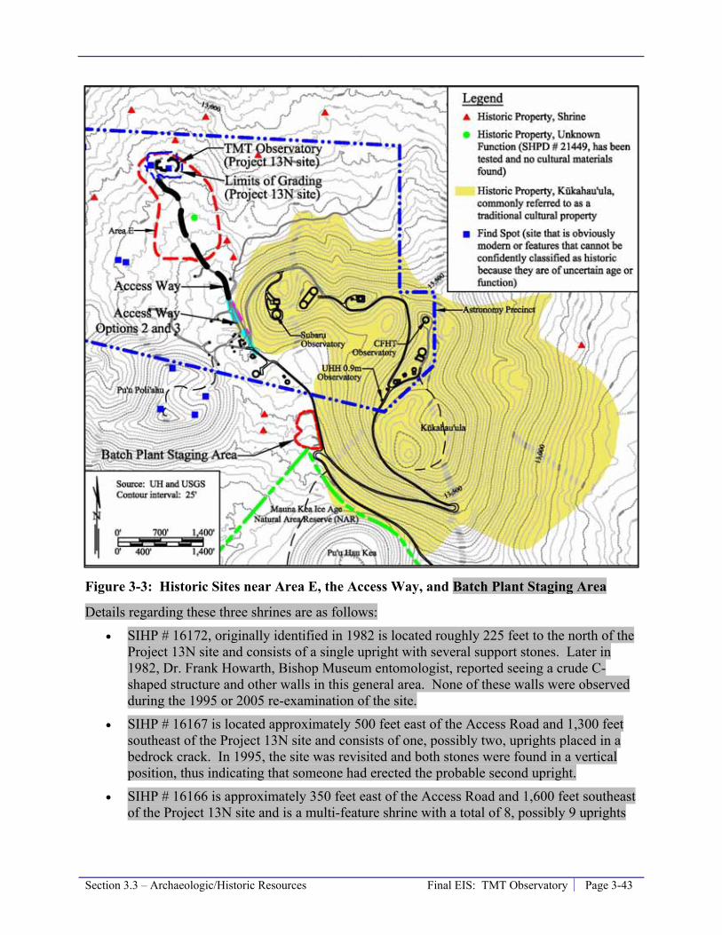
Section 3.3 – Archaeologic/Historic Resources Final EIS: TMT Observatory Page 3-43
Figure 3-3: Historic Sites near Area E, the Access Way, and Batch Plant Staging Area
Details regarding these three shrines are as follows:
• SIHP # 16172, originally identified in 1982 is located roughly 225 feet to the north of the Project 13N site and consists of a single upright with several support stones. Later in 1982, Dr. Frank Howarth, Bishop Museum entomologist, reported seeing a crude C-shaped structure and other walls in this general area. None of these walls were observed during the 1995 or 2005 re-examination of the site.
• SIHP # 16167 is located approximately 500 feet east of the Access Road and 1,300 feet southeast of the Project 13N site and consists of one, possibly two, uprights placed in a bedrock crack. In 1995, the site was revisited and both stones were found in a vertical position, thus indicating that someone had erected the probable second upright.
• SIHP # 16166 is approximately 350 feet east of the Access Road and 1,600 feet southeast of the Project 13N site and is a multi-feature shrine with a total of 8, possibly 9 uprights

Page 3-44 Final EIS: TMT Observatory Section 3.3 – Archaeologic/Historic Resources
arranged in two groups. When the site was revisited in 1999 it was noted that several of the uprights had been reset in a vertical position along the edge of the outcrop.
The Historic Property of unknown function, SIHP # 21449, was first recorded in 2005 and is located in Area E approximately 200 feet east of the Access Road and 700 feet south of the Project 13N site (Figure 3-3). Site 21449 consists of a single terrace and is on a small gelifluction terrace on the side of a ridge. This site was tested to determine the presence/absence of cultural materials and to obtain information that would aid in determining the site’s function. No cultural material is present on the terrace or surrounding area. Following testing the function of this site is still unknown.
Historic Properties in Vicinity of the Batch Plant Staging Area
The Kūkahau‘ula Historic Property is located in the vicinity of the Batch Plant Staging Area; Kūkahau‘ula is discussed in a separate section below. This section describes other, archaeological, Historic Properties in the vicinity of the Batch Plant Staging Area.
The Batch Plant Staging Area has been disturbed by a variety of construction activities over the years and no surveys have encountered a historic property there. Two historic shrines are present more than 500 feet west of the Batch Plant Staging Area. These two shrines were originally identified in 1982. These two shrines were located during the survey for this Project and their locations confirmed and mapped; they are illustrated in Figure 3-3.
Kūkahau‘ula Historic Property
Two TCPs have been designated within the MKSR; they are Kūkahau‘ula and Pu‘u Līlīnoe. A third TCP, Waiau, is located in the neighboring Ice Age NAR. These are discussed in more detail in Section 3.2.1 and illustrated on Figure 3-3. All of Maunakea down to the 6,000 foot elevation has been suggested as a TCP. During the preparation of the 2000 Master Plan and draft Historic Preservation Plan (HPP) in 1999-2000, SHPD determined that Kūkahau‘ula and two others cinder cones on Maunakea met the “e” criteria for designation as Historic Properties. As discussed in Section 3.2.1, the two other cinder cones are Pu‘u Līlīnoe in the MKSR and Waiau in the Mauna Kea Ice Age NAR, but the Project facilities are not near these two properties. The “e” designation criterion is that the property:
have an important value to the native Hawaiian people or to another ethnic group of the state due to associations with cultural practices once carried out, or still carried out, at the property or due to associations with traditional beliefs, events or oral accounts--these associations being important to the group’s history and cultural identity.
Properties on the registry because they meet criterion “e” are commonly referred to as “traditional cultural properties (TCPs)” or “legendary properties.” However, the term Traditional Cultural Property (TCP) is associated with a Federal designation, and while SHPD considers Kūkahau‘ula eligible for Federal TCP designation no formal application for such designation has yet been put forward. Federal law defines a TCP as a location that is eligible for inclusion in the NRHP because of its association with cultural practices or beliefs of a living community that (a) are rooted in that community’s history, and (b) are important in maintaining the continuing cultural identity of the community. The intent of this is to recognize the inherent

Section 3.3 – Archaeologic/Historic Resources Final EIS: TMT Observatory Page 3-45
connection between cultural practices/beliefs and their physical manifestation within certain geographic areas. The CMP and CRMP recognize the importance of Kūkahau‘ula and other criterion “e” Historic Properties and prescribes management actions for their protection.
Kūkahau‘ula includes the summit cinder cones, traditionally collectively referred to as Kūkahau‘ula but in recent times referred to separately as Pu‘u Wēkiu, Pu‘u Kea, and Pu‘u Hau‘oki (Figure 3-3). In total the Kūkahau‘ula covers roughly 480 acres and roughly one-third of that area is within the Astronomy Precinct. Kūkahau‘ula was found eligible under State criterion “e” and considered eligible for listing as a Federal TCP because of its association in Native Hawaiian Mythology with Wākea, the sky god and ancestor of the Hawaiian people, and with Kūkahau‘ula, a male deity, who has been identified as a form of the god Kū and the lover of Poli‘ahu. Kūkahau‘ula is also identified in Hawaiian traditional histories and genealogies as a chief, an ‘aumakua (family deity) of fishermen, and the husband of Līlīnoe. The summit is thus associated with the activities of Hawaiian deities, and appears as the focal point in numerous legends and oral histories. Kūkahau‘ula is also critical landscape elements in maintaining the integrity of Maunakea and the Mauna Kea Summit Region Historic District.
Kūkahau‘ula also contains eight optical/infrared observatories and their supporting infrastructure, a portion of the SMA observatory area, and the summit loop portion of Mauna Kea Access Road. Historically, significant modifications have been made to the various cinder cones incorporated in Kūkahau‘ula, including Pu‘u Hau‘oki and Pu‘u Kea, during the development of the existing observatory structures and roads. Currently, Kūkahau‘ula receives frequent visitor traffic from employees of the observatories, UH management personnel, tourists, and cultural practitioners. Cultural practices associated with Kūkahau‘ula are on-going as evidenced by the existence of modern shrines and staging of cultural events in the area.
The TMT Observatory is roughly 1,700 feet northwest of Kūkahau‘ula, the Access Way will traverse the westernmost portion of Kūkahau‘ula, and the Batch Plant Staging Area is across Mauna Kea Access Road from Kūkahau‘ula.
Find Spots
Two “find spots,” or sites that resemble historic properties, were identified within Area E (Figure 3-3). One was initially interpreted to be a possible pre-contact shrine, consisting of two upright stones, located in the northwestern portion of Area E. The second was initially interpreted to be a possible pre-contact temporary habitation complex, consisting of a C-shaped enclosure and two small terraces, located within a lava channel in the northern portion of Area E. Upon completion of the initial pedestrian survey, a site visit was conducted with SHPD staff and Dr. Patrick McCoy to discuss the significance of the two finds in Area E. Following discussions, neither was determined to warrant historic property designation. The shrine was determined to most likely be a modern structure, likely constructed within the last 10 years. This determination was based on prior surveys undertaken by McCoy within the survey area that did not identify the feature. The possible temporary habitation complex was determined to most likely be a natural geological feature that only appeared to have been man-made. Therefore, neither of the find spots in the Project area are considered Historic Properties.
Another feature thought to be a potential historic property was recorded by McCoy during survey work in Area E in preparation of the CMP. Its location is illustrated in Figure 3-3, and was issued SIHP site number 21449. Due to doubts about its nature and in consultation with SHPD,

Page 3-46 Final EIS: TMT Observatory Section 3.3 – Archaeologic/Historic Resources
a subsurface testing program was carried out. During the testing process no evidence of historic origin was encountered. Therefore, this feature, although illustrated on figures in the CMP, is not a historic property within Area E. After further consideration, SIHP # 21449 is considered a Historic Property of unknown function and is discussed above.
Upon careful survey, research, and consideration no historic properties were identified within Area E, along the Access Way, or in the Batch Plant Staging Area.
Hale Pōhaku
Multiple archaeological surveys and field work have been conducted in Hale Pōhaku, as outlined in Table 3-4.
Table 3-4: Summary of Archaeological Investigations at Hale Pōhaku Year Project Investigation Reference
1979 Hale Pōhaku Mid-Level Facilities Complex Development Plan Reconnaissance survey McCoy 1979
1984-85 Supplemental EIS for Construction Laborer Camp Reconnaissance survey McCoy 1985 1986 HELCO transmission line and substation Reconnaissance survey Bonk 1986 1987 HELCO transmission line and substation Reconnaissance survey Sinoto 1987 1987 HELCO substation and surrounding area Data recovery McCoy 1981
1990 Subaru Observatory Construction Dormitories Reconnaissance survey Robins and Hammatt 1990
1993 Subaru Observatory Construction Dormitories Data recovery Hammatt and Shideler 2002
2005 Septic tank excavations Monitoring McCoy 2005 2009 Potential TMT Mid-Level Facility Assessment Appendix H 2009 Architectural Inventory Survey Inventory PCSI 2010c
An archaeological assessment of the potential TMT Mid-Level Facility area was performed for the preparation of this EIS (Appendix H). The potential TMT Mid-Level Facility area includes roughly six 3.2 acres within the southern/lower portion of Hale Pōhaku and an area around the HELCO substation outside Hale Pōhaku within the surrounding Mauna Kea Forest Reserve. The survey confirmed the results of previous surveys in the area; the new survey did not encounter any previously unidentified sites.
Two “Lithic Scatters” were identified in Hale Pōhaku in 1985 and determined to be part of the Pu‘u Kalepeamoa site complex. The Pu‘u Kalepeamoa site complex has been categorized as a Stone Tool Quarry/Workshop Complex. Initially, the Institute for Astronomy (IfA) planned to preserve the two lithic scatters, however, dormitory construction increased erosion in the vicinity and, in consultation with SHPD, a data recovery program was agreed to. Based on data recovery in 2002 it was concluded that the sites were modest, out-lying, open, lithic workshop sites with octopus lure sinker manufacture of both “coffee-bean” and “bread-loaf” morphological types. Also part of the Pu‘u Kalepeamoa site complex are two shrines located south, across the 4-wheel drive road from, and at least 190 feet away from Hale Pōhaku and the potential TMT Mid-Level Facility.
While there are areas where physical evidence of human activity was observed in the potential TMT Mid-Level Facility area during the recent survey, there were good grounds for concluding that the specific constructions were less than fifty years old and hence the physical evidence of

Section 3.3 – Archaeologic/Historic Resources Final EIS: TMT Observatory Page 3-47
human activity was regarded as inappropriate for designation as a historic property. All but one of these findings was located completely outside the potential TMT Mid-Level Facility areas, though some fell within 200 feet of the areas. In order to provide a more complete record, and to avoid any possible misunderstandings, these cases were documented and are shown in Appendix H. Three previously identified historic properties that are outside of Hale Pōhaku but in the vicinity of the potential TMT Mid-Level Facility were confirmed as being outside of the potential TMT Mid-Level Facility area.
Upon careful survey, research, and consideration no historic properties were identified within the potential TMT Mid-Level Facility area, which includes only a portion of Hale Pōhaku. Within Hale Pōhaku, the three stone cabins (two rest houses from the 1930s and one comfort station from 1950) are greater than 50 years old and therefore historic properties; however, they are not within 200 feet of the potential TMT Mid-Level Facility area.
Headquarters
The University Park area was surveyed for archaeological resources during the preparation of the University of Hawai‘i at Hilo University Park Final Environmental Impact Statement (DAGS, 1997). Four rock mounds and a portion of a stacked boulder wall were identified in the southern portion of University Park, and determined to have been constructed and maintained historically as part of Waiākea Mill Co.’s sugar cane operations. The construction and maintenance of the mounds and wall were done to increase the cultivatable soil area by removing rocks from the fields and piling them into mounds and/or along field edges (e.g., the wall). The features were included within SIHP # 50-10-35-18670, and no further work was recommended.
In 2005, in support of the proposed expansion of the University Park and the relocation of Hawai‘i Community College (HawCC) to the Komohana Campus, the University of Hawai‘i at Hilo Mauka Lands Master Plan Final Environmental Impact Statement (UH Hilo, 2005) was prepared. In the UH Hilo Mauka Lands project area, there are 20 archaeological sites, 18 of which require no further work; data recovery was recommended for the other two sites, associated with past dairy and military use. The two sites requiring data recovery are not slated for preservation, or any further work beyond data recovery. SIHP # 50-10-35-24243 is a large multi-component site consisting of eleven features that was originally constructed as a dairy facility after 1939, and was later used as a center for U.S. Army training during World War II. SIHP # 50-10-35-24244 is an anti-aircraft gun emplacement that was used during World War II, and includes ancillary features associated with that function. There are no pre-contact archaeological sites present.
3.3.2 Thresholds Used to Determine Level of Impact In accordance with the Chapter 343 significance criteria, the Project would result in a significant impact if it involves an irrevocable commitment to loss or destruction of any natural or cultural resource. The majority of the historic properties found on Maunakea are man-made sites, such as shrines, ahu, and adze quarry workshops. Significant impacts would occur if those properties were physically altered or disturbed by the action.
Other historic properties are significant because of their associations with cultural practices or beliefs, such as the three cinder cones recognized by the State as Historic Properties. Those types of historic properties, commonly referred to as TCPs, would be significantly impacted if

Page 3-48 Final EIS: TMT Observatory Section 3.3 – Archaeologic/Historic Resources
the action were to substantially alter the property or introduce new elements on or in the immediate vicinity of the property that substantially alter the setting in which cultural practices take place. New elements may include, but are not be limited to, visual elements, noise, traffic and human presence.
The Mauna Kea Summit Region Historic District would be significantly affected if the action were to: (1) substantially alter the district or components of the district that contribute to its uniqueness; or (2) introduce new elements into the historic district that substantially alter its character. New elements may include, but are not be limited to, visual elements, noise, traffic and human presence.
Ultimately, potential impacts would be considered significant if they substantially compromise the integrity of the historic property.
3.3.3 Potential Environmental Impacts The potential impacts of the Project on historic properties are evaluated within the framework of compliance with all applicable rules, regulations, and requirements for the Project type and location. This includes requirements of the CMP and CRMP, within the MKSR and Hale Pōhaku. Potential impacts to the cultural practices and beliefs associated with these properties are discussed in Section 3.2.3.
Maunakea Summit Region
The TMT Observatory, Access Way, and Batch Plant Staging Area are within the Mauna Kea Summit Region Historic District. There is one Historic Property, Kūkahau‘ula, SIHP # 21438, and one Historic District, SIHP # 26869, that will be physically affected by the development of the Project components.
Project Effects on Kūkahau‘ula
As discussed in Section 3.2.3, summarized in Table 3-1, and illustrated on Figure 3-2, the Access Way will disturb approximately 0.6 acre, except Access Way Option 3B which will disturb approximately 0.4 acres, on the westernmost portion of the roughly 480-acre Kūkahau‘ula cinder cone complex. Roughly 0.4 acre of this area has been previously disturbed by roads, including a SMA road, the old blocked 4-wheel drive road, and the Mauna Kea Access Road Loop. The Access Way effect will primarily be associated with a 0.2-acre area of new disturbance. In addition, Options 2A and 3B require the construction of a retaining wall and installation of slope facing, respectively, which will affect Kūkahau‘ula. A roughly 600 foot-long section of the Access Way within Kūkahau‘ula would also be paved and a guard rail installed on the down slope side of the road.
The area comprising Kūkahau‘ula has been significantly modified by previous development activities including eight optical/infrared observatories, a portion of the SMA observatory, and roads. Yet, it is still recognized as a culturally important landscape. Despite the historic physical changes associated with development within the Astronomy Precinct, the area has retained its integrity for some, but not all, native Hawaiians. The Project will alter a minimal portion of 480-acre Kūkahau‘ula along the Access Way (less than one-tenth of one percent of the area), but it will not substantially affect the overall integrity of the cinder cones. Consequently,
Section 3.3 – Archaeologic/Historic Resources Final EIS: TMT Observatory Page 3-49
the potential physical impacts to Kūkahau‘ula from the proposed Project components are anticipated to be less then significant.
Project Effects on Historic District
The Mauna Kea Historic Preservation Plan, Management Components (SHPD, 2000; provided as Appendix J of this Final EIS) prepared by SHPD for IfA and included as Appendix F of the 2000 Master Plan states:
“Within the historic district, the effect of a project on the historic district as a whole needs to be assessed as well as the project’s effect on individual historic properties located within or immediately adjacent to the project area. The effect of a project on the historic district must be addressed even if no individual historic properties are found within or immediately adjacent to the project area.
“Effects on a district would consider the visual impact of a facility on the surrounding landscape (i.e., the various land forms creating the setting and context of the multiple historic properties encompassed by the district) and on those individual historic properties which contribute to the significance of the district. Creating a network of roads would affect the historic district because, in addition to altering the landscape, it creates easier access to more areas in the historic district and thus increases the possibility of historic properties being damaged by visitors.” (page 20 to 21)
Project effects on the Historic District and the contributing properties include:
• Physical effects on the integrity of cinder cones within the district.
• The visual effect of the Project’s man-made structures within the district.
• The effect of increased number of people and their vehicles associated with Project operation (observatory employees and deliveries) in the summit region.
• The effect of the potential accidental release of wastewater or hazardous substances due to Project activities within the district.
• The effect of dust generated by Project activities within the district.
These and other issues identified in the Mauna Kea Historic Preservation Plan, Management Components are discussed in the following subsections.
Historic Properties and Integrity of Cinder Cones
The Project physical effects on Kūkahau‘ula, the only individual Historic Property within or adjacent to the Historic District affected by the Project, are discussed above. All Project components within the Historic District are more than 200 feet away from all other Historic Properties within or adjacent to the Historic District.
Because Kūkahau‘ula is comprised of cinder cones, the Project effects on it are also the Project effects on the integrity of cinder cones. The only other Project facility that is within 200 feet of a cinder cone in the district is the Batch Plant Staging Area. The Batch Plant Staging Area is located across Mauna Kea Access Road from the southeastern portion of Kūkahau‘ula. The
Page 3-50 Final EIS: TMT Observatory Section 3.3 – Archaeologic/Historic Resources
Batch Plant Staging Area has been used during previous construction projects and the Project’s use will be similar to those past uses. No additional areas will be disturbed by the Project, including the Kūkahau‘ula cinder cone across the road from the staging area.
Visual
The visual impact of the Project is described in detail in Section 3.5.3.
The TMT Observatory will not be visible from the summit of the State Historic Property Kūkahau‘ula; therefore, the TMT Observatory will not be visible in the views documented as those of greatest cultural concern, including the open view from the summit to the west. This is due to the presence of the northern ridge of Kūkahau‘ula that blocks the view from the summit peak. The TMT Observatory will also not be visible from Pu‘u Līlīnoe and Waiau. Many of the existing observatories are visible from these culturally important areas.
However, the TMT Observatory will add a new visual element to the northern plateau area that will be visible to varying degrees from the northern ridge of Kūkahau‘ula, Pu‘u Pōhaku, Pu‘u Poli‘ahu, and some of the historic shrines and other historic properties along the northern slopes of Maunakea. The TMT Observatory will appear in the view directly toward the summit from only a few of the shrines on the northern plateau. From all locations within the district that the TMT Observatory will be visible, multiple existing observatories are also visible.
Although the TMT Observatory will be built in a relatively undeveloped portion of the MKSR Astronomy Precinct, it will be more isolated and less visible within the Historic District than the existing observatories. This will reduce its overall visual impact on the Historic District as well as other historic properties in the vicinity. Consequently, the potential visual impact to the Historic District and its contributing properties are not anticipated to be significant.
The Access Way would also be visible within the Historic District. Because the Access Way, regardless of which Option is selected, would be located among the existing roads in the area (the SMA road, the blocked 4-wheel drive road, and the Mauna Kea Access Road Loop); therefore, the road itself will be in character with its surroundings. The paving of the Access Way for a distance of roughly 750 feet (600 feet on Kūkahau‘ula) and addition of a guard rail where needed will result in a slight change to the character of the road. The Option 2A retaining wall and Option3B embankment facing would be new visual elements that would be noticeable to those in the immediate vicinity of those structures, primarily within the SMA area; however, the wall or embankment facing would not be visible from the summit of Kūkahau‘ula, Pu‘u Līlīnoe, Waiau, or any shrine.
Roads and Access
The Access Way will primarily improve existing roads. The Access Way will not create a “network” of roads, but will create easier access to a limited area of the Historic District. The Access Way will only substantially improve access over a 0.3 mile length starting north of the SMA access road, by improving the 4-wheel drive road currently in Area E to an improved dirt road. Nevertheless, TMT employees and visitors will be accessing a portion of the Historic District that is currently rarely visited. It is estimated that approximately 100 employees currently work at the observatory facilities within MKSR. It is expected that an average of 24 employees will work at the TMT Observatory during daytime operations, with a minimum of 15

Section 3.3 – Archaeologic/Historic Resources Final EIS: TMT Observatory Page 3-51
and a maximum of 43 possible; nighttime operations will require an average of 6 employees at the facility.
The increase of employee and visitor traffic in the vicinity of the North Plateau may result in some potential impacts to individual historic properties; however, as described below, TMT will implement the Cultural and Natural Resources Training Program to educate its employees regarding the necessity to avoid impacts to historic properties, among other things. Nevertheless, some sites that may be too remote for some people to visit today may become more accessible. This may result in improved access for cultural practitioners to historic properties and the development of further modern shrines in the vicinity of the TMT. It also may result in the alteration of existing historic properties by non-TMT employees.
The increased potential for construction of modern shrines and the illegal alteration of historic properties in the vicinity of the TMT is not anticipated to be significant. Archaeological surveys of the MKSR indicate that tampering with historic properties and/or the construction of modern shrines typically occurs in areas that are relatively distant from the Astronomy Precinct.
Accidental Release of Wastewater or Hazardous Substances
Some Native Hawaiians have indicated that the practice of releasing domestic wastewater into the subsurface through septic systems by current observatories desecrates the spiritual and sacred quality of the mountain, and hence the district. The same has been said regarding the potential accidental spillage of wastewater or hazardous substances. For these reasons the CMP requires that all new uses remove all domestic wastewater from the mountain for treatment. As detailed in Section 3.7.3, the Project will comply with this requirement and will not utilize a septic system to dispose of domestic wastewater. No wastewater will be released and all wastewater will be trucked off the mountain for disposal; no hazardous substances will be introduced to the outside environment of Maunakea.
Dust
Dust could have an effect on the historic properties and hence the district; these impacts are discussed in detail in Section 3.14.3. Project construction will also generate dust and is discussed in Section 3.15. The movements of employees and materials to and from the TMT Observatory will generate dust when traveling on unpaved roads. The dust generated by Project activities is not anticipated to be significant enough to generate a discernable physical impact to historic properties or the Historic District.
Treatments
The following treatments, commonly known as mitigation measures, will be implemented by the Project. The treatment/mitigation measures are listed here, instead of Section 3.3.4, due to their relationship to characterizing the Project’s effects to historic properties and the Historic District.
• In compliance with the CMP and to mitigate potential effects on cultural practices and Historic Properties, among other things, a Cultural and Natural Resources Training Program will be developed and implemented. As discussed in the CMP, the Cultural and
Page 3-52 Final EIS: TMT Observatory Section 3.3 – Archaeologic/Historic Resources
Natural Resources Training Program will include educational instruction and materials designed to:
- Impart an understanding of Maunakea’s cultural landscape, including cultural practices, historic properties and their sensitivity to damage, and the rules and regulations regarding the protection of historic properties.
- Make it clear that any disturbance of a historic property is a violation of HRS Chapter 6E-11 and punishable by fine.
- Provide guidance and information as to what constitutes respectful and sensitive behavior while in the summit area.
The training program will be updated regularly to incorporate UH Management Area-wide updates by OMKM. All people involved in TMT Observatory operation and maintenance activities, including but not limited to scientists and support staff, will receive the training on an annual basis.
• To mitigate the TMT Observatory’s visual effect within the Historic District: - In compliance with the 2000 Master Plan, the TMT Observatory has selected the
13N site within Area E, which, as the 2000 Master Plan details, was selected to minimize the Project’s visual effect.
- The Project has attempted to reduce the TMT Observatory’s visual impact as described in Section 3.5.3 and 3.5.4. Steps include design efforts to reduce its size, finish the support building and fixed structure exterior with a lava color, and finish the dome with a reflective aluminum-like finish similar to the Subaru Observatory.
• To mitigate the Access Way’s effect on Kūkahau‘ula and the Historic District, the Access Way Options:
- Have been designed to reduce disturbance by including the steep slopes of Option 2 and modifying Option 3 to a single lane configuration, even though these designs are not desirable from an observatory operation standpoint.
- Will have pavement with a reddish color to blend with the surroundings (it will be paved for a length of approximately 750 feet, of which roughly 600 feet are within the Kūkahau‘ula Historic Property).
- In addition, should Access Way Options 2A or 3B be selected, the retaining wall or embankment facing will be treated so as to blend into the natural environment to the extent feasible.
• To mitigate the generation of wastewater in the summit region, the Project will implement a zero discharge wastewater system and remove all wastewater from the mountain for treatment, as detailed in Section 3.7.
• To mitigate the chance of an accidental release of a hazardous substance, the Project will comply with applicable rules, regulations, and requirements, plus implement measures to reduce the potential for accidental spills of hazardous substances and reduce the potential impact of those events should they occur as detailed in Section 3.8.
• To mitigate effects related to noise and dust, the Project will implement a Ride-Sharing Program to reduce the number of vehicle trips between Hale Pōhaku and the TMT
Section 3.3 – Archaeologic/Historic Resources Final EIS: TMT Observatory Page 3-53
Observatory, which is discussed in Section 3.11.4. Additional control measures discussed in Sections 3.13 and 3.14 will also be implemented.
• To mitigate the presence of the TMT Observatory during culturally significant events that take place within the Historic District, TMT Observatory daytime operations will be reduced to minimize activities on up to four days in observance of Native Hawaiian cultural practices. TMT will work with OMKM and Kahu Kū Mauna to determine days for such observances. While the observatory will be operated during these periods, this measure will involve having only a skeleton crew at the observatory, no vehicles will be visible, noise will be reduced, and no visitors will be allowed.
• To mitigate the general development of TMT Observatory, the following additional mitigation measures will be implemented:
- The Project will work with OMKM and ‘Imiloa to develop exhibits for the VIS and ‘Imiloa regarding cultural and archaeological resource.
- TMT’s outreach efforts (two full time staff) will work with ‘Imiloa and Native Hawaiian groups to support/fund programs specific to Hawaiian culture and archeological resources.
Summary of Effect in Maunakea Summit Region
The Project will not result in the loss or complete destruction of any historic properties within the Maunakea summit region. The physical impacts on the only historic property physically effected, Kūkahau‘ula, will be minimal and will not be significant.
Impacts to the Historic District and its contributing properties will be confined to the impacts on Kūkahau‘ula and the introduction of the Project components into the Historic District. Although the TMT will be a new structure in the Historic District, it will be isolated in the Northern Plateau and will not be visible from most areas with the district. The district is currently recognized as a significant cultural landscape based on the multitude of historic properties in the area and despite the existence of the modern structures and numerous find spots in the area that may detract from its overall character.
Because the Project will (a) have certain facilities within a Historic District, (b) affect a Historic Property within the district, and (c) provide treatments/mitigations to address those effects, it has been determined that the Project will result in an “effect with treatment/mitigation commitments.”
Because the Project will not result in the loss or complete destruction of any archaeologic/historic resource within the Maunakea summit region, this impact is considered to be less than significant.
Hale Pōhaku
As no archaeological or historic properties were identified in any of the Project areas in or near Hale Pōhaku, including the potential TMT Mid-Level Facility area, no historic properties will be affected. With this determination, no effect or significant impact is expected.
Page 3-54 Final EIS: TMT Observatory Section 3.3 – Archaeologic/Historic Resources
Headquarters
The Headquarters will not adversely impact any archaeological sites within the University Park area. There are two sites designated with SIHP numbers that could potentially be impacted by the Project, depending on the final location of the Headquarters. However, these two sites were not recommended for preservation, but instead for data recovery due to their importance to documenting military defense and training activities in the upland area of Hilo, and because data recovery at these sites will contribute archaeological data to the scant documentary information presently on record. At SIHP # 50-10-35-24243, recovery, if necessary, would include excavations at strategic locations to fully understand the feature construction sequences and the specific functions of features, as well as conducting additional research into military activities of this type in Hilo and interviews with individuals and groups involved with this activity. At SIHP # 50-10-35-24244, recovery, if necessary, would include fully exposing the architecture of the gun emplacement and excavations at strategic locations around the emplacement to understand the full organization of such site, as well as conducting additional research into military activities of this type in Hilo and interviews with individuals and groups involved with this activity.
The data recovery efforts would be designed in consultation with individuals and/or groups that have expertise in the military history of Hilo. If the Headquarters is located within the vicinity of either of these sites, the Project will perform the data recovery as recommended, and therefore, no adverse impacts are expected.
3.3.4 Mitigation Measures This section lists mitigation measures that will be implemented by the Project. The mitigation measures go beyond the management procedures outlined above to comply with the CMP, CRMP, and other requirements. Items that are considered to be compliance management procedures include the Cultural and Natural Resources Training Program (required by the CMP), and Project design that provides for compliance such as a zero discharge wastewater system (required by the CMP) and siting the Observatory in Area E to reduce impacts (per the 2000 Master Plan), and no additional mitigation is required. Mitigation measures include the other treatment/mitigation measures outlined in Section 3.3.3; they are discussed in Section 3.3.3 due to their relationship to the determination of “effect with treatment/mitigation commitments.” Together, the management procedures and other treatment/mitigation measures will ensure that Project impact will not have a significant impact on historic resources.
Notwithstanding the finding that the modern shrine at the 13N site is not a Historic Property, the Project will continue consultation with SHPD and Kahu Kū Mauna Council to establish appropriate protocols for dismantling relocating it per CMP Management Action CR-9. In addition, the Project will perform archaeological data recovery for the two find spots – the modern shrine and the site that initially appeared to be a temporary habitation – notwithstanding that they have been determined not to be historic properties.
Mitigation measures related to construction are discussed in Section 3.15 and include items such as cultural and archaeological monitoring.
Section 3.3 – Archaeologic/Historic Resources Final EIS: TMT Observatory Page 3-55
3.3.5 Level of Impact after Mitigation Because the Project will (a) have certain facilities within a Historic District, (b) affect a Historic Property within the district, and (c) provide treatments/mitigations to address those effects, it has been determined that the Project will result in an “effect with treatment/mitigation commitments.”
Because the Project will not result in the loss or complete destruction of any historic property within the Maunakea summit region or substantially alter the Mauna Kea Summit Region Historic District, this impact is considered to be less than significant. The mitigation measures outlined above will incrementally reduce the Project’s impact on historic properties.
No archaeological or historical properties were identified in any of the Project areas and the recommendation by Cultural Surveys Hawai‘i‘ was a “no historic properties affected” determination, this, along with the mitigation measures discussed result in the Project having no significant impact on archaeological and/or historical resources.
3.3.6 References Allen. 1981. An Analysis of the Mauna Kea Adze Quarry Archaeobotanical Assemblage.
Master’s thesis, University of Hawai‘i.
Bonk. 1986. An Archaeological Survey at the Middle Level, Southern Flank of Mauna Kea, Hawai‘i. Papers in Ethnic & Cultural Studies 86-2.
Borthwick and Hammatt. 1990. Archaeological Reconnaissance Survey of the Proposed Galileo Telescope Sites C and D, Summit of Mauna Kea, Hawai‘i Island, Hawai‘i (TMK 4-4-015:09). Prepared for MCM Planning.
Cleghorn. 1982. The Mauna Kea Adze Quarry: Technological Analyses and Experimental Tests. Unpublished Doctoral Dissertation, University of Hawai‘i.
Department of Accounting and General Services (DAGS), 1997. University of Hawai‘i at Hilo University Park Final Environmental Impact Statement, Hilo, Hawaii. TMK: 2-4-01: 7, 12, 19, 41and 2-4-03: 26. Prepared by Engineering Concepts, Inc. for DAGS. September 1997.
Escott, Glenn. 2004. An Archaeological Inventory Survey on Approximately 258 Acres of Land for the University of Hawai‘i-Hilo Mauka Lands Development, Waiākea Ahupua‘a, South Hilo District, Island of Hawai‘i, Hawai‘i (TMK 2-4-01:122). Prepared for PBR Hawai‘i.
Hammatt and Borthwick. 1988. Archaeological Reconnaissance of Two Proposed Antenna Sites for the National Radio Astronomy Observatory, Mauna Kea, Hawai‘i.
Hammatt and Shideler. 2002. Data Recovery and Report for Two Archaeological Lithic Scatters, Site 50-10-23-10,310 and 50-10-23-10,311 at the Puu Kalepeamoa Complex, Hale Pōhaku, Ka‘ohe Ahupua‘a, Mauna Kea, Hawai‘i Island (TMK 4-4-15:12). Prepared for The Institute of Astronomy, University of Hawai‘i.
Page 3-56 Final EIS: TMT Observatory Section 3.3 – Archaeologic/Historic Resources
Kam and Ota. 1983. Archaeological Reconnaissance Survey of Mauna Kea Observatory Powerline: Upper Portions, Mauna Kea, Hāmākua, Hawai‘i. State Historic Preservation Division Office. Prepared for University of Hawai‘i. On file at State Historic Preservation Office.
McCoy, Patrick. 1977. The Mauna Kea Adz Quarry Project: A Summary of the 1975 Field Investigations. Journal of the Polynesian Society 86(2):233-244.
McCoy, Patrick. 1979. Letter Report Dated August 22, 1979 to Mr. Francis Oda on Archaeological Reconnaissance Survey for the Preparation of the Mauna Kea Mid-Elevation Facilities Master Plan. Department of Anthropology, Bernice P. Bishop Museum.
McCoy, Patrick. 1981. Letter Report Dated June 9, 1981 to J. Jeffries on archaeological survey for the proposed Kitt Peak National Observatory. Department of Anthropology, Bishop Museum.
McCoy, Patrick. 1982a. Archaeological Reconnaissance Survey, In Patrick C. McCoy and Holly McEldowney, Cultural Resources Reconnaissance of the Mauna Kea Summit Region. Department of Anthropology, Bishop Museum.
McCoy, Patrick. 1982b. Archaeological Survey of the Proposed Site of the Caltech 10-Meter Telescope on Mauna Kea, Hawai‘i. Prepared for Group 70, Inc. Department of Anthropology, Bishop Museum.
McCoy, Patrick. 1984b. Mauna Kea Summit Region Survey: A summary of the 1984 Fieldwork. Ms. on file at the Department of Anthropology, Bishop Museum.
McCoy, Patrick. 1985. Preliminary Archaeological Survey of the Puu Kalepeamoa Site, Mauna Kea, Hawai‘i. Prepared for MCM Planning for Draft Supplemental Impact Statement for Construction Camp Housing at Hale Pōhaku, Hāmākua, Hawai‘i. Ms. on file at the Department of Anthropology, Bishop Museum.
McCoy, Patrick. 1990. Subsistence in a “Non-Subsistence” Environment: Factors of Production in a Hawaiian Alpine Desert Adze Quarry. In Pacific Production Systems: Approaches to Economic Prehistory, edited by D.E. Yen and J.M.J. Mummery, pp. 85-119. Occasional Papers in Prehistory, No. 18, Department of Prehistory, Research School of Pacific Studies, Australian National University, Canberra.
McCoy, Patrick. 1991. Survey and Test Excavations of the Puu Kalepeamoa Site, Mauna Kea, Hawai‘i. Prepared for Facilities Planning and Management Office, University of Hawai‘i. Ms. on file in the Department of Anthropology, Bernice P. Bishop Museum. Honolulu.
McCoy, Patrick. 1993. Letter Report on the Inspection of Two Sites Located in the Vicinity of the Smithsonian Submillimeter Array. Submitted to the Smithsonian Institution Astrophysical Observatory.
McCoy, Patrick. 1999a. Mauna Kea Science Reserve Archaeological Site Inventory: Formal, Functional, and Spatial Attributes. In Mauna Kea Science Reserve Master Plan (Appendix K), Group 70 International, Inc. Honolulu.

Section 3.3 – Archaeologic/Historic Resources Final EIS: TMT Observatory Page 3-57
McCoy, Patrick. 1999b. Neither Here Nor There: A Rites of Passage Site on the Eastern Fringes of the Mauna Kea Adze Quarry, Hawai‘i. Hawaiian Archaeology 7:11-34.
McCoy, Patrick. 2005. Archaeological Monitoring of Four Septic Tank Excavations at the Mid-Level Facilities Located at Hale Pōhaku, Mauna Kea, Ka‘ohe, Hāmākua. Island of Hawai‘i (TMK: [3]:4-4-015:012). Prepared for the University of Hawai‘i Institute for Astronomy.
Office of Mauna Kea Management (OMKM), 2009b. A Cultural Resource Management Plan for the University of Hawai‘i Management Areas on Mauna Kea, Ka‘ohe Ahupua‘a, Hāmākua District, Island of Hawai‘i, State of Hawai‘i. TMK: (3) 4-4-015: 09, 12; A Sub-Plan for the Mauna Kea Comprehensive Management Plan. October 2009. Prepared by Pacific Consulting Services, Inc., approved by BLNR on March 25, 2010.
McCoy, Patrick et al Pacific Consulting Services, Inc. (PCSI). 2005. Mauna Kea Science Reserve Archaeological Inventory Survey, Ka‘ohe, Hāmākua, Island of Hawai‘i, Interim Report No. 1. Prepared for the Office of Mauna Kea Management.
McCoy, Patrick and Nees PCSI. 2006. Mauna Kea Science Reserve Archaeological Inventory Survey, Ka‘ohe, Hāmākua, Island of Hawai‘i, Interim Report No. 2. Prepared for the Office of Mauna Kea Management.
McCoy, Patrick and Nees PCSI. in prep 2010a. Draft Report, Archaeological Inventory Survey of the Mauna Kea Science Reserve, Ka‘ohe, Hāmākua, Island of Hawai‘i. Prepared for the Office of Mauna Kea Management. January 2010.
PCSI. 2010b. Final Report, Archaeological Inventory Survey of the Astronomy Precinct in the Mauna Kea Science Reserve, Ka‘ohe, Ahupua‘a, Hāmākua District, Hawai‘i Island, Hawai‘i. Prepared for Office of Mauna Kea Management. January 2010.
PCSI. 2010c. Final Report, Architectural Inventory Survey of Hale Pōhaku Rest Houses 1 and 2 and Comfort Station, Ka‘ohe Ahupua‘a, Hāmākua District, Hawai‘i Island, Hawai‘i. Prepared for Office of Mauna Kea Management. January 2010.
PCSI. 2010d. Final Report, Archaeological Inventory Survey of the Mauna Kea Access Road Management Corridor, Ka‘ohe Ahupua‘a, Hāmākua District, Hawai‘i Island, Hawai‘i. Prepared for Office of Mauna Kea Management. January 2010.
Robins and Hammatt. 1990. Archaeological Reconnaissance for Summit and Mid-Level Facilities for the Proposed Japan National Large Telescope. Prepared for MCM Planning, Honolulu.
Sinoto. 1987. Post-Field Report on the Archaeological Surface Survey of the Halepohaku Substation Site and Overland Transmission Line-Mauka Approach Areas, Halepohaku, Mauna Kea, Hawai‘i Island. Mountain Archaeology Research Area, and Bishop Museum Anthropology Department, Honolulu. Letter Report Submitted to Clyde Akita, Facilities Planning and Management Office, University of Hawai‘i, Honolulu.
State of Hawai‘i, Department of Land and Natural Resources, State Historic Preservation Division (SHPD). 2000. Mauna Kea Historic Preservation Plan, Management Components. Prepared for Institute for Astronomy. March 2000.

Page 3-58 Final EIS: TMT Observatory Section 3.3 – Archaeologic/Historic Resources
University of Hawai‘i (UH), 2009a. Mauna Kea Comprehensive Management Plan. January, 2009. Approved by BLNR on April 9, 2009.
UH, 2005. Mauka Lands Master Plan Final Environmental Impact Statement TMK 2-4-01: 122. Prepared by PBR Hawai‘i for UH. February 2005.
Williams. 1987. Post-field Letter Report Dated July 7, 1987 to Mr. Clyde Akita on the Archaeological Reconnaissance Survey of the Summit Road Between Halepohaku and the Stockpile Area, Mauna Kea, Hawai‘i Island. Bishop Museum, Honolulu, Hawai‘i.
Williams. 1989. A Technological Analysis of the Debitage Assemblage from Ko‘oko‘olau Rockshelter No. 1, Mauna Kea Adze Quarry, Hawai‘i. Unpublished M.A. Thesis, Washington State University.

Section 3.4 – Biologic Resources Final EIS: TMT Observatory Page 3-59
3.4 Biologic Resources This section discusses the biologic resources (flora and fauna, including rare, threatened, and endangered species) in the region and in the Project areas, the potential impacts of the Project on those resources, and mitigation measures the Project will employ to mitigate those potential impacts. Impacts associated with construction and decommissioning activities are discussed in Section 3.15 of this EIS.
3.4.1 Environmental Setting
Maunakea Summit Region
Detailed information about Project area inventories and assessments may be found in the Biological Resources Technical Report in Appendix K.
National Natural Landmark
The U.S. Department of Interior, National Park Service, National Natural Landmarks Program designated a portion of Maunakea as a National Natural Landmark (NNL) in November 1972. A brief prepared by the program indicates that Maunakea was designated a NNL based primarily on its topography, morphology, and geology; these subjects are discussed in detail in Section 3.6.
Flora
There are two general vegetation types/ecosystems or habitats in the Maunakea summit region (Figure 3-4):
• Alpine Shrublands and Grasslands. This is generally the area from 9,500 feet (the tree line) to 12,800 feet.
• Alpine Stone Desert. This is the area above 12,800 feet.
Vegetation generally decreases in diversity, density and size towards the summit of the mountain, moving from alpine shrublands and grasslands above the treeline, at roughly 9,500 feet, to a stone desert above 12,800 feet. Area E, the Access Way, and the Batch Plant Staging Area are located in the alpine stone desert.
The alpine shrublands and grasslands vegetation on Maunakea begins just above Hale Pōhaku. Alpine shrubs and grasses grow predominantly on ‘a‘a lava flows, cinder cones, and air-fall deposits of lapilli and ash. The most common native vascular plants37 that occur here include pūkiawe (Styphelia Leptecophylla tameiameiae), nohoanu (Geranium cuneatum), and ‘ohelo (Vaccinium reticulatum), but various other native shrubs, grasses, sedges, and ferns can also be found. The alpine shrublands and grasslands are also home to the Mauna Kea silversword (Argyroxiphium sandwicense), an endangered species. A fence exclosure surrounds the largest known population, about 30 plants near 9,350 feet elevation above the Wailuku river basin.
37 Vascular plants are those that have lignified (woody) tissues for conducting water, minerals, and photosynthetic products through the plant. Vascular plants include ferns, conifers, and flowering plants.

Page 3-60 Final EIS: TMT Observatory Section 3.4 – Biologic Resources
Figure 3-4: Overview of Maunakea Ecosystems
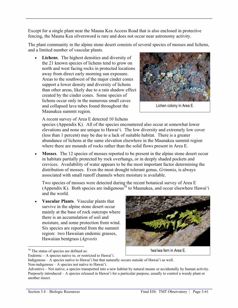
Section 3.4 – Biologic Resources Final EIS: TMT Observatory Page 3-61
Except for a single plant near the Mauna Kea Access Road that is also enclosed in protective fencing, the Mauna Kea silversword is rare and does not occur near astronomy activity.
The plant community in the alpine stone desert consists of several species of mosses and lichens, and a limited number of vascular plants.
• Lichens. The highest densities and diversity of the 21 known species of lichens tend to grow on north and west facing rocks in protected locations away from direct early morning sun exposure. Areas to the southwest of the major cinder cones support a lower density and diversity of lichens than other areas, likely due to a rain shadow effect created by the cinder cones. Some species of lichens occur only in the numerous small caves and collapsed lava tubes found throughout the Maunakea summit region.
A recent survey of Area E detected 10 lichens species (Appendix K). All of the species encountered also occur at somewhat lower elevations and none are unique to Hawai‘i. The low diversity and extremely low cover (less than 1 percent) may be due to a lack of suitable habitat. There is a greater abundance of lichens at the same elevation elsewhere in the Maunakea summit region where there are mounds of rocks rather than the solid flows present in Area E.
• Mosses. The 12 species of mosses reported to be present in the alpine stone desert occur in habitats partially protected by rock overhangs, or in deeply shaded pockets and crevices. Availability of water appears to be the most important factor determining the distribution of mosses. Even the most drought tolerant genus, Grimmia, is always associated with small runoff channels where moisture is available.
Two species of mosses were detected during the recent botanical survey of Area E (Appendix K). Both species are indigenous38 to Maunakea, and occur elsewhere Hawai‘i and the world.
• Vascular Plants. Vascular plants that survive in the alpine stone desert occur mainly at the base of rock outcrops where there is an accumulation of soil and moisture, and some protection from wind. Six species are reported from the summit region: two Hawaiian endemic grasses, Hawaiian bentgrass (Agrostis
38 The status of species are defined as: Endemic – A species native to, or restricted to Hawai’i. Indigenous – A species native to Hawai’i but that naturally occurs outside of Hawai’i as well. Non-indigenous – A species not native to Hawai’i. Adventive – Not native, a species transported into a new habitat by natural means or accidentally by human activity. Purposely introduced – A species released in Hawai’i for a particular purpose, usually to control a weedy plant or another insect.
Lichen colony in Area E.
‘Iwa‘iwa fern in Area E.

Page 3-62 Final EIS: TMT Observatory Section 3.4 – Biologic Resources
sandwicensis) and pili uka (Trisetum glomeratum); two naturally occurring ferns, ‘iwa‘iwa (Asplenium adiantum-nigrum) and Douglas’ bladderfern (Cystopteris douglasii); and two exotic daisies, Hairy cat’s ear (Hypochoeris radicata) and common dandelion (Taraxacum officinale).
Seven vascular plant species were detected in Area E during the recent botanical survey, all present in low abundance (Appendix K). The endemic spleenwort, ‘oāli‘i (Asplenium trichomanes subsp. densum) was uncommon in Area E, occurring in crevices of rocks. This species, not previously reported from the alpine stone desert, is locally abundant in full sunlight in open areas on lava fields and in kīpuka from 3,950 to 8,850 feet on East Maui and Hawai‘i. The Hawaiian endemic Douglas’ bladderfern was observed and is known to occur at high elevations on Haleakalā and Maunakea but also occurs in moist forests on Kaua‘i, O‘ahu, Lāna‘i, and Maui, and is a U.S. Fish and Wildlife Service (USFWS) species of concern. In the summit region, this fern is more common to the east, in the vicinity of Area F, near an existing unimproved dirt roadway, where several patches occur.
Fauna
The only resident faunal species in the Alpine Stone Desert ecosystem above 12,800 feet on Maunakea are arthropods. At least 10 confirmed resident species of indigenous Hawaiian arthropod species have been collected near the summit including: wēkiu bugs (Nysius wekiuicola), lycosid wolf spiders (Lycosa sp.), two sheetweb spiders (genus Erigone), two mites (Family Aystidae and Family Eupodidae: both species unknown), two springtails (Family Entomobryidae: two species unknown), a centipede (Lithobius sp.39), a noctuid moth (Agrotis sp.). Several other indigenous Hawaiian species have also been collected near the summit but their resident status is unconfirmed. Additional arthropod species, non-indigenous to Hawai‘i, are thought to be resident to the summit area cinder cones. One of the indigenous arthropods, the wēkiu bug, is proposed as a candidate species for Federal listing under the Endangered Species Act.
Wēkiu bug lives only in loose cinder habitats on the cinder cones above 11,715 feet on Maunakea. There is a similar species, Nysius aa, which occurs in the upper elevations on Mauna Loa. The wēkiu bug is a small “true bug” that has made a remarkable adaptation in feeding behavior. Many true bugs, including most of those found elsewhere in Hawai‘i, are herbivores and feed on seeds and plant juices. The wēkiu bug is a scavenger that uses its straw-like mouth to feed on insects blown up to the summit area from the surrounding lowlands. These aeolian insects accumulate in protected pockets on the cinder cones; they quickly become moribund in the cold and thus easy prey for foraging wēkiu bugs who have adapted to the harsh conditions of the summit area.
Wēkiu bugs are generally concentrated on the cinder cones in the summit area, but also utilize other habitats. Six arthropod habitat types have been identified in the alpine stone desert.
39 The abbreviation “sp.” is used when the actual specific name cannot be specified.

Section 3.4 – Biologic Resources Final EIS: TMT Observatory Page 3-63
• Type 1 – Snow patches: Seasonal patches of snow accumulate insects that are blown up the mountain from lower elevations. Wēkiu bugs are thought to exploit the edges of these patches, feeding on aeolian insects as they emerge from the melting snow.
• Type 2 – Tephra ridges and slopes: On cinder cones, where tephra cinders are large enough (≥1 cm), wēkiu bugs, spiders, caterpillars (Agrotis sp.) and smaller arthropods are able to move within the interstitial spaces and utilize humid, protected microhabitats among the tephra. This is the habitat where wēkiu bugs are observed in greatest abundance. Smaller arthropods, like springtails (Collembola), and mites inhabit smaller (≤1cm) tephra cinders.
• Type 3 – Loose, steep tephra slopes: The unstable steep outside slopes of cinder cones where tephra cinders are smaller and subject to downward creep. Wēkiu bugs are present in low abundance in this habitat.
• Type 4 – Lava flows: ‘a‘a and pāhoehoe lava flows with large outcrops of andesitic rocks. This is the principal habitat for lichens and mosses, lycosid wolf spiders, and centipedes. Wēkiu bugs are uncommon in this habitat, presumably because of the lack of suitable microhabitat.
• Type 5 – Talus slopes and highly fractured rock outcrops: Usually found as islands within Type 4 habitat, these are areas of talus slopes, highly fractured rock outcrops, and depressions between lava flows with glacially deposited, rounded cobbles and rocks lie on fine loess. Small voids provide suitable microhabitats for wēkiu bugs which can occur in moderate abundance during times of high population outbreaks.
• Type 6 – Compacted ash, silt, and mud: Found on roadways, disturbed areas, and where fine aeolian loess accumulates. The interstitial spaces are mostly filled with fine-grained material and therefore not suitable for wēkiu bugs and lycosid spiders. Springtails and mites are the most abundant arthropods in this habitat type.
About 5 percent of the lava flow terrain of Area E and other Access Way areas can be classified as Type 5 wēkiu bug habitat, with the remainder being Type 4. During a 1982 arthropod survey wēkiu bugs were present in low density in Type 5 habitats within Area E, based on captures in 14 traps placed in the area. Wēkiu bug have not been collected in Area E or similar nearby habitat since, despite three subsequent intensive collecting efforts. Twenty-five traps were set in 1997/1998 along the 13N access road but no wēkiu bugs were captured in any of those traps. No wēkiu bugs were collected during the 2008 sampling effort, which included 20 sampling points within Area E and along the Access Way (Figure 3-5). Wēkiu bugs were not found during the 2009 sampling effort within Area E (6 sample points) but were found in the cinder along the southern portion of the Access Way (6 sample points).
Wēkiu Bug Photo by Greg Brenner

Page 3-64 Final EIS: TMT Observatory Section 3.4 – Biologic Resources
Figure 3-5: Arthropod Sampling in Vicinity of Area E and the Access Way
Section 3.4 – Biologic Resources Final EIS: TMT Observatory Page 3-65
The bulk of the Access Way alignment is habitat similar to the lava flow terrain in Area E (Types 4 and 5) while the rest is Type 6 habitat.
Access Way Options 2 and 3 primarily comprises a combination of Type 3 and Type 6 habitat. Wēkiu bugs are present in low abundance in the Type 3 habitat at the base of the unnamed pu‘u (the northwestern extent of Kūkahau‘ula). Although wēkiu bugs were not found in this area in 2008, they were found in the spring of 2009 in abundances similar to those in other nearby cinder cone habitat.
Threatened and Endangered Species
There are no currently-listed threatened or endangered40 species known to occur in the Astronomy Precinct. However, in a comment on the Draft EIS, it was reported that an ‘io (Buteo solitaries), the endangered Hawaiian Hawk, has been observed circling above the summit region on occasion. ‘Io are known to use a broad range of forest habitats and are not frequent visitors to elevations greater than roughly 7,000 feet, and do not reside in the summit region; however individuals can be observed in the area occasionally. The Mauna Kea silversword (Argyroxiphium sandwicense), an endangered species, is known to occur at lower elevations and is discussed below in the Hale Pōhaku section. A recent arthropod and botanical survey of the Project areas in the Maunakea summit region did not encounter any species listed as endangered or threatened under either Federal or State of Hawai’i endangered species statutes.
One species is currently a candidate for listing, the wēkiu bug (Nysius wekiuicola). Wēkiu bugs were not found in Area E during studies for the Project, but were found during Project studies in the Spring of 2009 in Type 3 habitat along Access Way Options 2 and 3. wēkiu bugs are known to occur on a number of cinder cones above an elevation of 11,700 feet; they are most common in Type 2 habitat but are also known to frequent Type 3 habitat.
One species currently considered a species of concern by the USFWS, the Douglas’ bladderfern (Cystopteris douglasii), are known to occur in the Maunakea summit region. The Douglas’ bladderfern was found throughout Area E; it is known to be widespread, occurring on all main Hawaiian Islands and on Maunakea is more common to the east, in the vicinity of Area F. Area E is not considered critical habitat for the Douglas’ bladderfern.
The ‘ua‘u (Pterodrama sandwichensis) the endangered Hawaiian petrel, may have historically utilized the lower portions of the alpine shrublands and grasslands on Maunakea, but none have been observed near Project sites.
40 There are several terms that are used to describe the status of species. These include: Endangered species – Any species which is in danger of extinction throughout all or a significant portion of its range, as listed in the Endangered Species Act (ESA) or HRS Chapter 195D. Threatened species – Any species which is likely to become endangered within the foreseeable future, as listed in the ESA or HRS Chapter 195D. Candidate species – Any species being considered by the Secretary of the Interior for listing as an endangered or a threatened species, but not yet the subject of a proposed rule. Species of Concern – Those species about which regulatory agencies have some concerns regarding status and threats, but for which insufficient information is available to indicate a need to list the species under the ESA. Rare species – Those species that occur very infrequently, but are not classified threatened or endangered. Sensitive species – Those species which rely on specific habitat conditions that are limited in abundance, restricted in distribution, or are particularly sensitive to development.

Page 3-66 Final EIS: TMT Observatory Section 3.4 – Biologic Resources
Hale Pōhaku
Detailed information about Project area inventories and assessments may be found in the Biological Resources Technical Report in Appendix K.
Flora
Hale Pōhaku is located in the māmane subalpine woodlands ecosystem that extends down to the Saddle Road (Figure 3-4). The subalpine woodlands are dry most of the year, and māmane trees (Sophora chrysophylla) intercept fog that provides them and other plant species with the small amounts of moisture they need to survive.
The understory of the māmane subalpine woodland near Hale Pōhaku is comprised largely of native shrubs like ‘āheahea (Chenopodium oahuense), pūkiawe (Styphelia Leptecophylla tameiameiae), and less abundant are nohoanu (Gernium cuneatum), two native mints, Stenogyne microphylla and mā‘ohi‘ohi (Stenogyne rugosa), and the Hawaiian catchfly (Silene hawaiiensis), a threatened species. Pili uka (Trisetum glomeratum) and hairgrass (Deschampsia nubigena) are the most abundant indigenous grasses.
The potential TMT Mid-Level Facility would be located in the southern portion of Hale Pōhaku. Portions of the area are compacted ash and rock, with little vegetation and have been used for construction staging and parking for several of the observatories on Maunakea. Māmane trees are present in the potential TMT Mid-Level Facility site, but are less dense than in the surrounding forest, which is the Mauna Kea Forest Reserve. The ground cover of the potential TMT Mid-Level Facility site consists of a mixture of non-indigenous plants, dominated by needlegrass (Nassella cernua) growing between common groundsel (Senecio vulgaris), fireweed (Senecio madagascariensis), pin clover (Erodium cicutarium), common mullein (Verbascum thapsus), evening primrose (Oenothera stricta), and telegraph plant (Heterotheca grandiflora).
In a recent survey, only a few native plant species were present in the potential TMT Mid-Level Facility area: māmane trees (Sophora chrysophylla), ‘aheahea (Chenopodium oahuense), hinahina (Geranium cuneatum), mā‘ohi‘ohi (Stenogyne rugosa), littleleaf stenogyne (Stenogyne microphylla), Hawaiian bent grass (Agrostis sandwicensis), pili grass (Trisetum glomeratum), and another grass (Deschampsia australis). All of these species occur over a wide range and most on other islands in Hawai‘i and none are considered rare or threatened. (Appendix K).
Fauna
The open-canopied māmane forest is home to the palila (Loxiodes bailleui), a native Hawaiian bird listed as endangered. The māmane forest on Maunakea has a diverse arthropod fauna. More than 200 arthropod species have been collected there. The arthropod fauna includes several species of Plagithmysus (a genus of native Hawaiian long-horn beetles), seven species of small native caterpillars (Cydia spp.) that live in māmane pods and are important prey of palila, the Kamehameha butterfly (Vanessa tameamea) – the official state insect of Hawai‘i, and the koa bug (Coleotichus blackburniae).
Thirty-three species of arthropods and two snails were observed on or near the potential TMT Mid-Level Facility site within Hale Pōhaku. Fifteen of the species detected are endemic to Hawai‘i, seventeen are purposeful or adventives non-indigenous species, and three are of unknown origin. The arthropod fauna at the potential TMT Mid-Level Facility area consists
Section 3.4 – Biologic Resources Final EIS: TMT Observatory Page 3-67
mostly of non-indigenous species and common endemic species that are abundant throughout the māmane forest, and occur on other islands. None of the species found are designated as serious pests, and no ants were detected during the sampling (Appendix K).
Threatened and Endangered Species
A number of threatened, endangered or species of concern are potentially present in the māmane subalpine woodlands. These include:
• Flora - Mauna Kea silversword (Argyroxiphium sandwicense subspecies sandwicense),
an endangered species. There are no wild individuals of this species near Hale Pōhaku. However, they are being outplanted within an exclosure behind the Visitor Information Station.
- Hawaiian catchfly (Silene hawaiiensis), a threatened species. A small population of the Hawaiian catchfly was reported in rocky areas on the steep slopes adjacent to and above the maintenance area in the northern/upslope portion of Hale Pōhaku by Char in 1985.
- ‘Akoko (Chamaesyce olowaluana), na‘ena‘e (Dubautia arborea), Hawai‘i black snakeroot (Sanicula sandwicensis), and Douglas’ bladderfern (Cystopteris douglasii); all State species of concern. These species are all potential present in the habitat surrounding Hale Pōhaku but have not been detected during surveys within the Hale Pōhaku boundaries.
- Diamond spleenwort (Asplenium fragile var. insulare), an endangered species. - Kiponapona (Phyllostegia racemosa var. racemosa), an endangered species. - Hawaiian vetch (Vicia menziesii), an endangered species.
• Fauna - Palila (Loxiodes bailleui), a native Hawaiian bird listed as endangered. Hale
Pōhaku is within the boundaries of palila critical habitat, but no palila were detected there during surveys in 2007.
- ‘Amakihi (Hemignathus virens), ‘apapane (Himatione sanguine), ‘i‘iwi (Vestiaria coccinea) are bird species of concern. These species have been observed in māmane subalpine woodlands but only ‘amakihi and ‘apapane were detected during the 1979 and 1985 bird surveys near Hale Pōhaku. ‘I‘iwi were observed at Hale Pōhaku in 2006 but have been described as seasonal, uncommon visitors to the area.
- ‘Akiapola‘au (Hemignathus munroi), an endangered bird. The ‘akiapola‘au are found primarily in koa-ōhi‘a forests and therefore not likely in the Hale Pōhaku area.
- ‘Io (Buteo solitaries), the endangered Hawaiian Hawk. ‘Io use a broad range of forest habitats and are not frequent visitors to the māmane subalpine woodlands, but could pass through occasionally.

Page 3-68 Final EIS: TMT Observatory Section 3.4 – Biologic Resources
- Nēnē (Branta sandvicensis), the endangered Hawaiian goose. Nēnē may inhabit high elevation grasslands and dry forests during breeding season, but evidence suggests that this species no longer utilizes the area around Hale Pōhaku.
- ‘Ope‘ape‘a (Lasiurus cinerus semotus), the endangered Hawaiian hoary bat. The ‘ope‘ape‘a, has been observed in māmane subalpine woodlands on Maunakea, but the status of this species at Hale Pōhaku is unknown.
- Koa bug (Coleotichus blackburniae), a species of concern, is not likely to be present at Hale Pōhaku because its common host plants koa (Acacia koa) and a‘ali‘i (Dodonea viscosa) do not occur there.
- Black-veined Agrotis noctuid moth (Agrotis melanoneura), a species of concern, is known to reside on Maunakea (Bishop Museum 2007) and has not been collected observed at light traps at Hale Pōhaku in recent years. Very little information is available regarding this species and while it is uncommon, it is widespread on Maunakea (Giffin 2009). and may be extinct.
- Two yellow-faced bees (Hylaeus difficilis and H. flavipes), both species of concern have been observed at. Only H. flavipes, a federal and state species of concern, has been confirmed from Hale Pōhaku.
- Two species of snails (Succinea konaensis and Vitrina tenella), both species of concern, have been collected at Pu‘u La‘au from elevations ranging from 6,200 to 8,600 feet.
A recent arthropod and botanical survey at the potential TMT Mid-Level Facility site found no species listed as endangered, threatened, or that are currently proposed for listing under either Federal or State of Hawai’i endangered species statutes. The Yellow-footed yellow-faced bees, the Difficult yellow-faced bee (Hylaeus difficillis) and the Yellow-footed yellow-faced bee (H. flavipes), and a succineid snail (Succinea konaensis) were the only Federal or State species of concern detected during the arthropod survey. The Difficult yellow-faced bee was observed only during the Spring 2009 sampling period and normally may forage at higher elevations during warmer weather. This species also occurs on Maui, Lāna‘i, and Moloka‘i. The Yellow-footed yellow-faced bee was observed during both sampling periods foraging on māmane; this species also occurs on Maui and Lāna‘i. Little is known about the distribution of the succineid snail; however, it is known to occur near Pu‘u La‘au on the western slopes of Maunakea.
Headquarters
Botanical studies conducted of the University Park area have found the area to be characterized by three vegetation types: ōhi‘a tree/uluhe fern forest, strawberry guava thicket, and ruderal vegetation. The birds found in the area are mostly completely non-indigenous introduced species. Endangered bird species may fly over University Park occasionally between the months of April and October; these species include the Hawaiian Hawk or ‘io (Buteo solitarius), the Short-eared Owl or pueo (Asiofiammeus sandwichensis), the ‘ua‘u (Pterodrama sandwichensis) the endangered Hawaiian petrel, and the Newell’s Shearwater or ‘ao (Puffinus newelli). Additionally, a comment received on the Draft EIS, reported that a Hawaiian hoary bat or ‘ope‘ape‘a (Lasiurus cinerus semotus) was observed in the area in 2004. ‘Ope‘ape‘a are known to use a broad range of rural habitats but are not frequent visitors to urban areas; however, individuals may be observed in the area occasionally.

Section 3.4 – Biologic Resources Final EIS: TMT Observatory Page 3-69
Based on the study, none of the plants inventoried were listed as threatened or endangered species, nor were any proposed as candidate for such status. The area is not considered critical habitat for any species.
3.4.2 Thresholds Used to Determine Level of Impact In accordance with the Chapter 343 significance criteria, the Project would result in a significant effect to the existing biological resources if it (1) caused/involved an action that irrevocably commits a natural resource, (2) curtails the range of beneficial uses of the environment, or (3) or substantially affects a rare, threatened, or endangered species, or its habitat.
Therefore, a significant adverse impact would occur if the Project caused long-term loss or impairment of a substantial portion of local habitat of indigenous Hawaiian species; caused a substantial reduction in the population of a protected species, as designated by Federal and State agencies, or a species with regional and local significance; introduced or increased the prevalence of undesirable non-native species; curtailed the range of a native Hawaiian species; or otherwise reduced the range of beneficial uses of the environment. This can occur with a reduction in numbers; by alteration in behavior, reproduction, or survival, or by loss or disturbance of habitat.
3.4.3 Potential Environmental Impact The potential impacts of the Project are evaluated within the context of the existing environment and framework of compliance with all applicable rules, regulations, and requirements for the project type and location. The current context includes the presence of observatories and roads within the MKSR, including direct impacts to roughly 63 acres to Type 2 and 3 wēkiu bug habitat, and developments at Hale Pōhaku. As detailed in Section 3.16.2, the past actions on Maunakea have resulted in various levels of cumulative impact to the ecosystems of Maunakea. Applicable rules, regulations, and requirements include the CMP and associated NRMP, the 2000 Master Plan, the Endangered Species Act, USFWS Species Recovery and Conservation Plans, and the State of Hawai‘i Environmental Policy (HRS 344).
Impacts on biological resources were evaluated by assessing the sensitivity, significance, or rarity of each resource that could be adversely affected by the Project. The significance may be different for each habitat or species and is based on the resource’s rarity or sensitivity and the level of impact that will result from the Project. Most impacts on high sensitivity resources are considered significant, while the determination of significance for impacts on the moderate and low sensitivity resources is based more on site-specific factors, such as the habitat quality and population size, as well as the nature and extent of the expected impact.
Potential long-term impacts associated with the Project include; (a) the replacement of existing habitat with the TMT Observatory, Access Way, potential TMT Mid-Level Facility, and Headquarters; (b) dust generated by vehicles traveling along the unpaved Access Way and parking at the TMT Observatory and potential TMT Mid-Level Facility; and (c) paving a roughly 300-foot section of the Access Way.
Each of these potential impacts is discussed below. As a general measure to avoid impacts to natural resources during operations, the Project will implement a Cultural and Natural Resources Training Program as required by the CMP (Management Action EO-2). The program will be

Page 3-70 Final EIS: TMT Observatory Section 3.4 – Biologic Resources
used to raise awareness and appreciation of the area being experienced. As discussed in the CMP, the Cultural and Natural Resources Training Program will include educational instruction and materials designed to:
• Describe the status, condition, and diversity of natural resources present on the mountain, including biotic and physical elements.
• Outline the potential and existing threats to the natural resources.
• Summarize the protection afforded the natural resources in various rules and regulations.
• Provide expectations and requirements to avoid habitat damage, including but not limited to:
- A prohibition on off-road vehicle use. - The requirements of the Invasive Species Prevention and Control Program
detailed below. - Watch for and avoid impact with nēnē along the roads. - Restrictions on smoking and other potential sources of fire.
• Provide steps to take and consider regarding personal safety and potential hazards of working on the mountain.
The training program will be updated regularly to incorporate UH Management Area-wide updates by OMKM. All people involved in TMT Observatory operation and maintenance activities, including but not limited to scientists and support staff, shall receive the training on an annual basis.
The CMP requires (Management Action FLU-5) that an airflow analysis be performed on the design of proposed structures to assess potential impacts to aeolian ecosystems. The aeolian ecosystem is related to the wēkiu bug and the fact that its food supply consists of insects blown from lower elevations to the summit, where they come to rest and become wēkiu bug prey. Because the TMT Observatory is not located on a cinder cone and wēkiu bugs are not normally present in the area, this requirement is not applicable to the Project.
Species or Habitat Displacement
CMP Management Action FLU-6 requires that habitat mitigation plans be incorporated into the project planning process to address potential impacts to sensitive habitats. Three Access Way Options were evaluated in the Draft EIS. As discussed in Section 2.5.2, the Access Way Options have been revised since the Draft EIS was completed. Modifications included planning actions in compliance with FLU-6 to reduce Access Way Option 3’s impact on a sensitive habitat. The original Option 3 design would have resulted in the displacement of roughly 0.7 acre of Type 3 wēkiu bug habitat; the refined design, which shrinks the road from two lanes to one lane, would result in either a 0.2 or 0.1 acre displacement of Type 3 wēkiu bug habitat, depending on which design approach is employed.
The decision to pave a 750 foot long portion of the Access Way near the SMA core and Type 3 wēkiu bug habitat was also made to reduce the Project’s potential impact on sensitive habitat in compliance with FLU-6. Paving this portion of the Access Way will reduce the generation of dust where the Access Way is adjacent to sensitive habitat.

Section 3.4 – Biologic Resources Final EIS: TMT Observatory Page 3-71
In addition to these design choices made to mitigate the Project’s impact on sensitive habitat, TMT will work with OMKM on the development and implementation of a habitat restoration study.
The Project will also implement a number of measures during construction to reduce potential construction-phase impacts. Construction phase measures are outlined in Section 3.15.1 and include a BMP Plan to limit the area disturbed during construction and an Invasive Species Prevention and Control Program to aggressively reduce the potential for invasive species introduction during construction.
Species and habitats that will be displaced by the Project include:
• TMT Observatory: Roughly 4.7 4.5 acres of alpine stone desert lava flow habitat (wēkiu bug habitat Types 4 and 5) will be displaced. Roughly 0.5 acre of the 5.2 5-acre TMT Observatory site has previously been disturbed by roads and site testing (wēkiu bug habitat Type 6).
• Access Way: Roughly 1.3 1.4 acres of lava flow habitat similar to that at the TMT Observatory site will be displaced by the portion of the Access Way north of where the Access Way Options come together (the “common” Access Way). Roughly 1.2 1.1 acres of the 2.5-acre common Access Way area has previously been disturbed by roads. Table 3-5 summarizes habitat displacements that would occur for each of the Access Way Options being considered.
Table 3-5: Summary of Habitat Displacements by Access Way Options
Access Way Option 2A
Access Way Option 2B
Access Way Option 2C
Access Way Option 3A
Access Way Option 3B
Displacement of Lava Flow Habitat (wēkiu bug Type 4 and 5) (acre) 0.04 0.2 0.5 0.1 0.01
Displacement of Alpine Cinder Cone Habitat (wēkiu bug Type 3) (acre) 0.23 0.2 0.2 0.2 0.06
Displacement of Current Roads (wēkiu bug habitat Type 6) (acre) 0.95 0.9 0.9 0.8 0.76
The following additional habitat could be displaced, depending on which Access Way Option is selected:
- Option 1: Another 0.3 acre of habitat similar to the TMT Observatory site could be displaced; roughly 1.0 acre of the 1.3-acre Option 1 area has previously been disturbed by roads (Wēkiu bug habitat type 6).
- Option 2: 0.3 acre of cinder cone habitat (Wēkiu bug habitat type 3) associated with the pu‘u could be displaced; roughly 1 acre of the 1.3- acre Option 2 area has previously been disturbed by roads (Wēkiu bug habitat type 6).
- Option 3: 0.7 acre of cinder cone habitat (Wēkiu bug habitat type 3) associated with the pu‘u could be displaced; roughly 0.9 acre of the 1.6-acre Option 3 area has previously been disturbed by roads (Wēkiu bug habitat type 6).
• Batch Plant Staging Area: This roughly 4-acre area has been disturbed previously by other construction efforts. Sensitive habitat and species of concern will not be displaced.

Page 3-72 Final EIS: TMT Observatory Section 3.4 – Biologic Resources
• Potential TMT Mid-Level Facility: All of the roughly 3.2 acres that may be impacted by the potential TMT Mid-Level Facility have previously been disturbed by construction activities for other observatories. A few māmane trees and other species exist within or around the parameter of the area.
• Headquarters: An unknown area of abundant low-land habitat that does not harbor any species of concern will be displaced.
• Port Staging Area: Existing warehouses and/or yards to be utilized will be chosen so that no species or habitat of concern will be displaced.
Overall, the displacements will not have a significant impact on biological resources because species and habitat of these areas are not unique to the Project sites and are found elsewhere on Maunakea and/or on other islands in Hawai‘i. The following sections discuss some of these areas individually.
TMT Observatory and Common Access Way
The six roughly 5.9 acres of new habitat displacement will not have a significant impact on biological resources. The botanical species and habitat of these areas are not unique to the Project sites and are found elsewhere on Maunakea and/or on other islands in Hawai‘i. The habitat is not considered critical habitat for any species and floral, lichen, moss, and arthropod species present occur in greater abundance in other nearby areas. Roughly 5.7 5.6 acres of Type 4 wēkiu bug habitat (95 percent of the area) and 0.3 acre of Type 5 wēkiu bug habitat will be displaced. The mix of Type 4 and 5 habitats is not considered optimal for wēkiu bugs; they may only occupy this area during extreme population explosions that push the insects into marginal habitats. Lycosid wolf spiders, centipedes, lichens, and mosses regularly occupy this habitat. The amount of habitat that will be disturbed represents only a small portion (less than 0.5 percent) of the total wēkiu bug habitat similar to this (mix of Type 4 and 5 habitats) available on Maunakea and will have a less than significant impact on wēkiu bug populations.
Access Way Options
Option 1 would displace about 0.3 acre of Type 4 habitat and small areas of Type 5 habitat. As with the TMT Observatory, this is not prime habitat. In addition, since the amount of habitat that would be displaced is small, and these species are more abundant elsewhere in the Maunakea summit region, the impact of Option 1 would be less than significant.
As listed in Table 3-5, the various Access Way Options would displace from 0.01 to 0.5 acre of lava flow habitat (wēkiu bug Type 4 and 5 habitat) and 0.06 to 0.23 acre of alpine cinder cone habitat (wēkiu bug Type 3 habitat). For the reasons described above for the TMT Observatory and common Access Way, the small displacement of lava flow habitat by any of the Options would not result in a significant impact. The alpine cinder cone habitat, wēkiu bug Type 3 habitat that would be displaced by the Access Way Options is considered to be good, but not optimal wēkiu bug habitat. Wēkiu bugs have been reported in low abundance in Type 3 habitat. No wēkiu bugs were collected in this area during the 2008 sampling, but were collected during the Spring 2009 sampling. Because the displacement is a relatively small area, the impact to wēkiu bugs and other Maunakea summit region arthropods will be less than significant regardless of which Access Way Option is selected.
Section 3.4 – Biologic Resources Final EIS: TMT Observatory Page 3-73
The Project would prepare and implement a Habitat Restoration Plan to compensate for the loss of Type 3 Wēkiu bug habitat should the Access Way Option 2 or 3 be selected. Habitat would be restored at a 1:1 basis; therefore, roughly 0.3 acres of habitat would be restored should Option 2 be selected and 0.7 acres of habitat would be restored should Option 3 be selected. At this time it is envisioned that, should Option 2 be selected, at least a portion of the area disturbed by the old 4-wheel drive road would be restored (the area where Option 3 is located). Should Option 3 be selected, it is envisioned that the disturbed area below the Subaru Observatory would be restored using methods described in the Outrigger Habitat Restoration Plan, which was never implemented. The restoration plan would focus on the creation of new Wēkiu bug habitat, and would include two to five years of monitoring to assess restoration results.
In addition to the FLU-6 considerations discussed above, the Project will monitor arthropod activity in the vicinity of the portion of the Access Way that will impact the sensitive, Type 3 wēkiu bug alpine cinder cone habitat. Monitoring will be performed prior to, during, and for at least two years after construction in this area. This monitoring program is proposed to replace the habitat restoration measure discussed in the Draft EIS. This modification is based on comments received during the Draft EIS public review period, the Project's limited impact on Type 3 wēkiu bug habitat, and the uncertainty associated with the feasibility and effectiveness of any physical habitat restoration approach.
Furthermore, TMT will work with OMKM on the development and implementation of a habitat restoration study. Depending on the results of this study, it could be used to support the design and implementation of a Habitat Restoration Plan in the future.
Potential TMT Mid-Level Facility
Less than one acre of māmane subalpine forest could be displaced by the TMT Mid-Level Facility. The potential TMT Mid-Level Facility will not disturb any previously undisturbed areas. However, there are some māmane trees that have grown in the area that may need to be trimmed or removed. No palila, for which this area is designed critical habitat, have been detected at Hale Pōhaku during recent surveys, and the māmane forest on the site is less dense than that found outside the limits of Hale Pōhaku. Six species of indigenous Hawaiian plants grow on this Project site. Three species identified as Federal or State species of concern were also observed in this area: the Difficult yellow-faced bee (Hylaeus difficillis), the Yellow-footed yellow-faced bee (H. flavipes), and a succineid snail (Succinea konaensis). All of these species, except the succineid snail, are known to occur over a wide range and most occur on other islands in Hawai‘i. Little is known about the distribution of the succineid snail other than it is also present at Pu‘u La‘au. Due to the distribution of these species and the small area of potential habitat displacement, the impacts from habitat displaced by the potential TMT Mid-Level Facility would be less than significant.
Headquarters
The Headquarters will be in an urban setting where no critical habitats are present, and species of concern are not regularly observed. Therefore, this displacement will not have a significant impact on biological resources.

Page 3-74 Final EIS: TMT Observatory Section 3.4 – Biologic Resources
Dust from Operations
It is estimated that about 50 an average of 24 daytime and 6 nighttime employees will commute daily to the TMT Observatory and there will also be occasional freight pickups and deliveries to support operations. Generation of excessive dust from vehicle traffic on the unpaved Project areas, including the Access Way, TMT Observatory parking area, and potential TMT Mid-Level Facility parking area, could impact biological resources, particularly in the Maunakea summit region. Wind-blown dust that covers plants, lichens and mosses, deprives them of needed sunlight. The potential impact of excessive dust could have a moderate effect on the flora in habitats adjacent and downwind of the Access Way and TMT Observatory. However, because the lichens, mosses, and plants that will be impacted are found elsewhere in the Maunakea summit region and Hawai‘i, the overall impact to the flora will be less than significant.
Wind-blown dust can also impact arthropod habitats by filling interstitial spaces and microhabitats where arthropods reside. It is not likely that the amount of dust generated from vehicle traffic during operation of the TMT Observatory will be sufficient to affect spiders and centipedes in adjacent or downwind habitats, but there is a potential for impacting wēkiu bugs. However, wēkiu bugs only occupy habitats nearby and downwind of the Project sites during periods of high population, an uncommon event, and generally are more abundant elsewhere in the Maunakea summit region that will not frequently receive dust from the Project areas. Nevertheless, the Access Way will be paved where it is adjacent to, but upwind of, sensitive wēkiu bug habitat. Thus the overall impact to arthropods due to dust generated by Project operations in the Maunakea summit region will be less than significant.
Paved Road through SMA Core Area
Paving the Access Way through the SMA core area will have little impact on the flora and fauna of the Maunakea summit region. The species that are most abundant in habitats adjacent to the road will likely not be affected. Wēkiu bugs have been seen crossing dirt roads, but none have been observed crossing paved roads. Only wēkiu bugs that occasionally cross the dirt road while dispersing during periods of high population could be impacted by the pavement. Therefore, the number of wēkiu bugs likely to be impacted will be small. Paving the Access Way through the SMA core area will not have a significant impact. In fact, paving the road could reduce dust generated by vehicle traffic on the road thereby protecting nearby habitats.
Impacts Associated with Potential Accidents
In addition to the long-term Project impacts, as discussed above, there will be a potential for impacts that may occur if there were to be an accident associated with the Project. These potential impacts are discussed below.
Accidental Introduction of Invasive Species
Movement of vehicles, personnel, and equipment to the Project areas may accidentally introduce invasive, non-indigenous species to the Maunakea summit region or Hale Pōhaku. Invasive plant species can displace indigenous species and thereby reduce their populations. Arthropods introduced outside of their natural range can represent a threat to natural systems because they can deplete indigenous arthropod food resources and/or prey on indigenous species. Non-indigenous arthropod species that successfully establish populations within the Mauna Kea
Section 3.4 – Biologic Resources Final EIS: TMT Observatory Page 3-75
Science Reserve could out-compete or exclude indigenous species, such as the wēkiu bug, lycosid wolf spider, and other native resident arthropods. Alien arthropods can arrive at Project sites from localities on the Island of Hawai‘i where they are already established, or in crates, boxes, containers, or construction equipment that are shipped from off the Island.
The Project, as required by the CMP (Management Action NR-2), will reduce the probability for invasive species being introduced to the environment by implementing an Invasive Species Prevention and Control Program. The program will be developed in coordination with OMKM and also be in place during construction activities, as discussed in Section 3.15. The portions of the program applicable to TMT operations will include:
• Requirements that everyone who plans to pass beyond Hale Pōhaku brush down their clothes and shoes to remove invasive plant seeds and invertebrates. This will be done at the Headquarters or other lower elevation location, prior to boarding observatory vehicles bound for the summit area.
• Regular inspections and washing, at lower elevation facilities such as the Headquarters, of observatory vehicles and other items that are regularly transported between the TMT Observatory and lower elevations.
• Regular monitoring of the habitat along the Access Way and around the TMT Observatory and potential TMT Mid-Level Facility, and the interior of the TMT Observatory and potential TMT Mid-Level Facility for invasive species, and eradication of such species when found using methods that will not impact indigenous resident species.
• Inspection, by a biologist, of major shipments of new equipment bound for the TMT Observatory prior to transportation beyond the Headquarters.
Thus the potential impacts due to invasive non-indigenous species are likely to be less than significant.
Accidental Vehicle Impacts
There are reports of nēnē killed by vehicles on the Mauna Kea Access Road below Hale Pōhaku. Nēnē may utilize the lower portions of this road, especially during breeding season, and inattentive drivers may strike these birds. Nēnē are not often seen on the Mauna Kea Access Road and occur elsewhere on the island in greater abundance, however the taking of endangered species is serious. While the overall impact of Project traffic on the Mauna Kea Access Road will be less than significant to the nēnē population of Hawai‘i, to avoid the potential for such an accident, the TMT personnel will be informed of the potential impact to nēnē during the required cultural/natural resources training and required to take precautions at all times while traveling on this segment of the road.
3.4.4 Mitigation Measures The Project will comply with existing regulations and requirements, which will mitigate many of the potential impacts, as discussed above. The Project’s policies to comply with applicable rules and regulations will include the following CMP Management Actions detailed above:

Page 3-76 Final EIS: TMT Observatory Section 3.4 – Biologic Resources
• Management Action NR-6: implementation of a Cultural and Natural Resources Training Program. This program, detailed in Section 3.4.3, will require that TMT personnel receive an annual orientation regarding natural resources.
• Management Action NR-2: implementation an Invasive Species Prevention and Control Program. This program, detailed in Section 3.4.3, will outline steps to be taken to avoid the potential impacts associated with invasive species.
• Management Action FLU-6: the following has occurred or will be implemented: - The Access Way has been designed to limit disturbance and displacement of
sensitive habitat and will be paved where adjacent to sensitive habitat to reduce dust-related impacts.
- Construction-phase measures will be implemented to reduce impacts to sensitive habitat (Section 3.15), and arthropods will be monitored in the area of the Access Way prior to, during, and for two years after construction on the alpine cinder cone habitat.
- Implement a Habitat Restoration Plan should Access Way Options 2 or 3 be selected. The restoration plan would comply with CMP Management Action FLU-6. TMT will work with OMKM on the development and implementation of a habitat restoration study.
Mitigation measures that go beyond what is required by the CMP and other applicable requirements related to biological resources include the following.
• The Access Way Options have been designed to reduce the impact to wēkiu bug habitat by including the steep slopes of Option 2 and modifying Option 3 to a single lane configuration, even though these designs are not desirable from an observatory operation standpoint.
• The Project will work with OMKM and ‘Imiloa to develop exhibits for the VIS and ‘Imiloa regarding natural resource.
• TMT will plant two new māmane trees for each māmane tree directly impacted (i.e. removed or pruned to reduce canopy by more than half) by possible Project activities at the potential TMT Mid-Level Facility. This effort, if necessary, will include monitoring and caring for new plantings for a period of two years to ensure the new trees become established. TMT would either (a) prepare and implement a Habitat Restoration Plan to compensate for the minimal loss of māmane subalpine forest habitat displaced by the TMT Mid-Level Facility development, or (b) help fund the palila recovery effort. These are both being considered. Because the minimal loss of habitat as a result of the TMT Mid-Level Facility is not considered significant and an offsetting restoration plan would provide minimal benefit, TMT is considering providing funding equal to such a restoration effort to the palila recovery effort instead.
• TMT will implement a Ride-Sharing Program, described in Section 3.11.4. This program will reduce the number of vehicle trips a day to the summit, including pickup and deliveries to about 14 9 trips. Dust generated along unpaved section of the Mauna Kea Access Road and the Access Way will be reduced relative to the number of trips reduced by the program.
Section 3.4 – Biologic Resources Final EIS: TMT Observatory Page 3-77
• TMT may elect to use soil-binding stabilizers to control dust along the unpaved portion of the Access Way. Several dust-suppressing soil stabilizers are considered “environmentally friendly” and appear to be free of residuals that can harm native arthropod populations. This would only be implemented following the approval of OMKM. Soil stabilizers would not be used indiscriminately, nor would they ever be applied beyond the unpaved Access Way travel way. Application of soil stabilizers would only be performed at intervals recommended by the manufacturer and then applied under light wind conditions to prevent drift into adjacent habitat.
3.4.5 Level of Impact after Mitigation Project impacts on biological resources will be less than significant with implementation of the Cultural and Natural Resources Training Program and Invasive Species Prevention and Control Program.
Implementation of the additional mitigation measures, including VIS exhibits, tree plantings, and the implementation of the Ride-Sharing Program and use of soil-binding stabilizers, will further reduce the potential impact of the Project.
3.4.6 References Bishop Museum. 2007c. Mauna Kea Online: Species found at Mauna Kea (Entomology
Collection) website: http://www2.bishopmuseum.org/mkmk2/natsci.asp?Locality=Mauna%20Kea&Collection=Entomology. Accessed April 12, 2010.
Char, W.P. 1985. Botanical survey for the proposed Temporary Construction Camp Housing at Hale Pōhaku, Mauna Kea, Island of Hawai‘i. Prepared for MCM Planning.
Char, W.P. 1999a. Botanical Resources, Mauna Kea, Hawai‘i. Prepared for Group 70, Inc.
Department of Accounting and General Services (DAGS), 1997. University of Hawai‘i at Hilo University Park Final Environmental Impact Statement, Hilo, Hawaii. TMK: 2-4-01: 7, 12, 19, 41and 2-4-03: 26. Prepared by Engineering Concepts, Inc. for DAGS. September 1997.
Department of Land and Natural Resources (DLNR). 1997. Indigenous Wildlife, Endangered and Threatened Wildlife and Plants, and Introduced Birds. Department of Land and Natural Resources, State of Hawai’i. Administrative Rules §13-1 through §13-134-10.
Englund, R.A. D.A. Polhemus, F.G. Howarth, and S.L. Montgomery. 2002. Range, Habitat, and Ecology of the Wēkiu bug (Nysius wekiuicola), a rare insect species unique to Mauna Kea, Hawai‘i Island. Final Report. Hawai‘i Biological Survey Contribution No. 2002-23.
Englund, R.A., A. Ramsdale, M. McShane, D.J. Preston, S. Miller, S.L. Montgomery. 2005. Results of 2004 Wēkiu bug (Nysius wekiuicola) surveys on Mauna Kea, Hawai‘i Island. Final Report. Hawai‘i Biological Survey Contribution No. 2005-003.
Federal Register. 1999. Department of the Interior, Fish and Wildlife Service, Endangered and Threatened Wildlife and Plants. 50 CFR 17:11 and 17:12.

Page 3-78 Final EIS: TMT Observatory Section 3.4 – Biologic Resources
Federal Register. 2005. Department of the Interior, Fish and Wildlife Service, 50 CFR 17. Endangered and Threatened Wildlife and Plants. Review of Species That Are Candidates or Proposed for Listing as Endangered or Threatened; Annual Notice of Findings on Resubmitted Petition; Annual Description of Progress on Listing Actions. Federal Register, 70 No. 90 (Wednesday, May 11, 2005): 24870-24934.
Federal Register. 2006. Department of the Interior, Fish and Wildlife Service, 50 CFR 17. Endangered and Threatened Wildlife and Plants--Proposed Critical Habitat Designations; Proposed Rule. Federal Register, 70 No. 90 (September 12, 2006): 53755-53835.
Gerrish, G. 1979. Botanical survey of principal site (Hale Pōhaku) and two alternate sites. Prepared for Group 70, Inc.
Giffin, J. G. 2009. Correspondence and comments from Jon Griffin, The Nature Conservancy, to the Office of Mauna Kea Management, on the July 2009 Pre-Final Natural Resources Management Plan for the UH Management Areas on Mauna Kea.
Hartt, C.E. and M.C. Neal. 1940. The Plant Ecology of Mauna Kea, Hawai‘i. Ecology 21(2):237-266.
Hawai‘i Biodiversity and Mapping Program. 2008. Hawai‘i Biodiversity and Mapping Program website: http://hbmp.hawaii.edu/printpage.asp?spp=PPDRY07020. Accessed November 16, 2008.
Howarth, F. G., G. J. Brenner, and D. J. Preston. 1999. An arthropod assessment within selected areas of the Mauna Kea Science Reserve. Prepared for the University of Hawai‘i Institute for Astronomy. 62 pp. plus maps.
Howarth, F.G. and F.D. Stone. 1982. An Assessment of the Arthropod Fauna and Aeolian Ecosystem near the Summit of Mauna Kea, Hawaii. Prepared for Group 70, Honolulu, Hawai‘i.
Howarth, F.G. and S.L. Montgomery. 1980. Notes on the ecology of the high altitude Aeolian zone on Mauna Kea. ‘Elepaio 41(3):21-22.
Leonard, David L. Jr., Paul C. Banko, Kevin W. Brinck, Chris Farmer, And Richard J. Camp. 2008. Recent Surveys Indicate Rapid Decline of Palila Population. Elepaio 68(4):27-30
Office of Mauna Kea Management (OMKM), 2009a. Natural Resources Management Plan for the UH Management Areas on Mauna Kea; A Sub-Plan of the Mauna Kea Comprehensive Management Plan. September 2009. Prepared by Sustainable Resources Group International, Inc., approved by BLNR on March 25, 2010.
Pacific Basin Information Node. 2008. U.S. Geological Survey – National Biological Information Infrastructure Pacific Basin Information Node website: http://www2.bishopmuseum.org/natscidb/?w=PBIN&srch=b&pt=t&lst=o&cols=8&rpp=50&pge=1&tID=383068168&lID=1455184240. Accessed November 16, 2008.
Smith, C.W., W.J. Hoe, and P.J. O’Conner. 1982. Botanical survey of the Mauna Kea summit above 13,000 feet. Prepared for Group 70, Honolulu, Hawai‘i.

Section 3.4 – Biologic Resources Final EIS: TMT Observatory Page 3-79
University of Hawai‘i (UH), 2009a. Mauna Kea Comprehensive Management Plan. January, 2009. Approved by BLNR on April 9, 2009.
UH, 2005. Mauka Lands Master Plan Final Environmental Impact Statement TMK 2-4-01: 122. Prepared by PBR Hawai‘i for UH. February 2005.
Wagner, W.L., D.R. Herbst, and S.H. Sohmer. 1990. Manual of the Flowering Plants of Hawai’i. University of Hawai‘i Press, Honolulu.
Wolfe, E.W., W.S. Wise, and G.B. Dalrymple. 1997. The Geology and Petrology of Mauna Kea Volcano, Hawai‘i – A Study of Postshield Volcanism. U.S. Geological Survey Professional Paper 1557. United States Government Printing Office, Washington, D.C.
Page 3-80 Final EIS: TMT Observatory Section 3.5 – Visual and Aesthetic Resources
3.5 Visual and Aesthetic Resources This section describes the existing visual conditions on the Island of Hawai‘i and Maunakea, discusses the visual impacts the Project may have, and identifies how the Project mitigates its potential visual impacts. For a more thorough discussion of the Project’s potential impacts on visual and aesthetic resources see the Visual Impact Assessment Technical Report (Appendix M).
3.5.1 Environmental Setting The Island of Hawai‘i’s landscape and visual resources are varied. On the northern tip, the coast is rugged, covered in dense vegetation and dotted with waterfalls and rivers. Inland, around the town of Waimea, at an elevation of 4,000 feet, the landscape is comprised of rolling pastures used for cattle ranching. The western side of the island consists of popular resorts and beaches, but lacks vegetation. The southern and southeastern portions of the island experience high rainfall and are covered with lush vegetation; Volcanoes National Park is located in this area. The eastern portion of the island consists of steep terrain with dramatic views of the rainforest and cliffs along the coast.
The Hawai‘i County General Plan (County of Hawai‘i, 2005) includes a chapter on Natural Beauty that recognizes the importance of preserving the island’s natural and scenic beauty. The chapter includes goals, policies and standards to identify and protect scenic vistas and viewplanes. One goal is to “Protect scenic vistas and view planes from becoming obstructed.” The General Plan also provides guidelines for designating sites and vistas of extraordinary natural beauty to be protected, and includes the standard “Distinctive and identifiable landforms distinguished as landmarks, e.g. Maunakea, Waipio Valley.” Around the island of Hawai‘i the following natural beauty sites have been identified that include Maunakea:
• View of Maunakea and Mauna Loa from Pāhoa-Kea‘au, Volcano-Kea‘au Roads, and various Puna subdivisions
• Viewpoint of Hilo Bay with Maunakea in background
• Mauna Kea State Park area
In addition, the South Kohala Development Plan (County of Hawai‘i, 2008) includes a policy to preserve Waimea’s sense of place. To do this, the plan recommends the strategy to “protect the pu‘u of Waimea that have cultural, historical and visual importance” and which have “grand views of Mauna Kea.”
Maunakea Summit Region
In contrast to the lush coastal areas, the summit of Maunakea is an alpine ecosystem. Above the tree line, at roughly 9,500 feet, vegetation is comprised of low shrubs and above 12,800 feet vegetation is limited to lichens, moss, and small ferns. A small alpine lake, Lake Waiau, is situated on the upper southern flank of the mountain. The summit of Maunakea is often obscured by vog, a volcanic smog formed when sulfur dioxide and other volcanic gases emitted by Kīlauea mix with oxygen, moisture, and sunlight. The vog has been especially thick since February 2008 when gas emissions from Kīlauea dramatically increased.

Section 3.5 – Visual and Aesthetic Resources Final EIS: TMT Observatory Page 3-81
There are 11 observatories on Maunakea within the Astronomy Precinct. The 11 observatories and the attributes that affect their visibility are listed in Table 3-6. Some of these existing observatories are visible from locations around the island such as Hilo, Honoka‘a, and Waimea; the viewshed of each observatory, the percent of the island’s land area from which the observatory is potentially visible, is listed in Table 3-6. On the west coast of the island, the existing observatories appear most visible at sunset, when they are lit by the setting sun; on the east coast they appear most visible at sunrise. Some of these observatories also use laser guide stars as part of their AO system, similar to the TMT AO system described in Section 2.5.1. The laser guide stars may be visible within some portions of the MKSR. Considering all existing observatories together, at least one observatory is visible from roughly 43 percent of the island’s land area.
Table 3-6: Existing Observatory Visual and Aesthetic Attributes
Observatory 2000 Master Plan Siting
Area
Ground Elevation
(feet) Dome Height
(feet) Dome Color Viewshed (%)
Subaru B 13,578 141 Metallic 20 Keck B 13,603 111 White 17 IRTF B 13,652 53 Aluminum 14 CFHT A 13,726 125 White 35 Gemini A 13,764 151 Aluminum 39 UH 2.2m A 13,784 80 White 36 UKIRT A 13,762 61 White 26 UH Hilo 0.9m A 13,727 20.25 White 15 CSO C 13,362 63 Metallic 5 JCMT C 13,390 100 White 7 SMA C 13,279 – 13,400 45 NA 2
The 2000 Master Plan includes a discussion of a NGLT. The Master Plan recognizes that the size of a NGLT makes the visual impact considerations very important, and recommends siting such a facility within Area E of the Astronomy Precinct because it would “minimize its visibility.”
Viewer Groups and Viewpoints
The people that view the island of Hawai‘i, and more specifically Maunakea, can be described as residents, sightseers and cultural practitioners, each with a different expectation of their visual experience.
Seventeen Eighteen representative viewpoints within the northern portion of the island have been identified as places that are of visual significance to the three viewer groups. The viewpoints are all located in the northern portion of the island because the location of the TMT Observatory is such that it will not be visible from the southern portion. Table 3-7 provides the viewpoint name, description, the viewer group expected, and the primary view direction. The viewpoints and the direction of the primary view from each viewpoint are mapped in Figure 3-6.
Figure 3-7 illustrates the combined viewshed of the existing 11 observatories near the summit within the Astronomy Precinct, where the top of at least one of the existing observatories is visible. From approximately 43 percent of the island area a viewer is able to potentially see at

Page 3-82 Final EIS: TMT Observatory Section 3.5 – Visual and Aesthetic Resources
least one existing observatory. According to 2000 U.S. Census data, 72 percent of the population of the Island of Hawai‘i, or about 107,000 people reside within the viewshed of the existing observatories.
Table 3-7: Description of Viewpoint, Viewer Group and Primary View Direction
Viewpoint Location Description Viewer Group Primary View
1 Hualālai Resort Exclusive, luxury residential community and hotel.
Residents / Sightseers
West toward the ocean (makai)
2 Pu‘u Waawaa Summit of cinder cone that is of cultural importance to Native Hawaiians.
Cultural Practitioners Panoramic
3 Big Island Country Club
Independent (non-resort affiliated) daily-fee golf course. The club includes views of the coastline and of Maunakea.
Residents / Sightseers Panoramic
4 Waikoloa/Mauna Lani Resort development. Sightseers West makai
5 Hāpuna Beach Public beach near a resort. Sightseers / Residents West makai
6 Puukohola Heiau National historic site and Spencer Beach Park, which includes camping and picnic areas along a beach.
Residents / Sightseers West makai
7 DHHL Kawaihae at Route 250
Summit of Highway 250 between Waimea and Hāwī. Residents
Southeast toward Maunakea (mauka)
8 Route 250 Pu‘u Overlook
Gravel shoulder where cars pull off of the highway and view Maunakea and North Kona/South Kohala.
Sightseers Southeast mauka
9 DHHL Lalamilo Waimea residential neighborhoods. Residents Southeast mauka
10 Waimea Park Athletic facilities for sports such as baseball and tennis; near a school. Residents Southeast mauka
11 DHHL Pu‘u Kapu Waimea residential neighborhoods. Residents Southeast mauka
12 DHHL Waikoloa-Waialeale
Along Old Māmalahoa Highway through ranch lands. Residents South mauka
13 Waipio Valley Lookout
Formal lookout with parking lot and trail to scenic view. Sightseers Northwest along
the coast
14 Honoka‘a Main road into town. Residents Northwest up the coast
15 Laupāhoehoe Point State park with parking lot and picnic facilities along the coast. Sightseers Northeast makai
16 Maunakea Summit (Kūkahau‘ula)
Highest point on Maunakea. Recognized as a sacred place to Native Hawaiians.
Cultural Practitioners Panoramic
17 Lake Waiau Small lake near the summit of Maunakea, accessible by a trail. Waters used for healing and worship practices in Hawaiian culture.
Cultural Practitioners
West over the lake
18 North ridge of Maunakea summit cinder cone (Kūkahau‘ula)
North ridge of Kūkahau‘ula, near Keck, Subaru, IRTF, or CFHT observatories. Sightseers Panoramic /
toward Maui

Section 3.5 – Visual and Aesthetic Resources Final EIS: TMT Observatory Page 3-83
Figure 3-6: Viewpoints and Primary View Direction from Viewpoints

Page 3-84 Final EIS: TMT Observatory Section 3.5 – Visual and Aesthetic Resources
Figure 3-7: Viewshed of Existing Observatories on Maunakea

Section 3.5 – Visual and Aesthetic Resources Final EIS: TMT Observatory Page 3-85
Hale Pōhaku
The existing support facilities at Hale Pōhaku are not visible from other locations on the island. The 2000 Master Plan provides a number of design guidelines to maintain the visual aesthetics of Hale Pōhaku. These guidelines aim at maintaining the proportions of developments in Hale Pōhaku and help them blend into the physical landscape.
Headquarters
There are no designated or recognized visual resources associated with University Park of UH Hilo. The zoning of the area regulates the height of structures to 45 feet.
3.5.2 Thresholds Used to Determine Level of Impact In accordance with the Chapter 343 significance criteria, the Project would result in a significant impact if it substantially affects scenic vistas and viewplanes identified in County or State plans or studies. Therefore, the Project would have a significant impact if it would block or substantially obstruct a vista by placing a structure in the foreground so as to prevent a view of an identified resource from an identified area or create a structure that would be incongruous with existing structures currently in the vista or viewplane. Thus, the impact would be considered to be significant if it would affect any of the following identified views:
• View of Maunakea from Pāhoa-Kea‘au, Volcano-Kea‘au Roads, and various Puna subdivisions
• Viewpoint of Hilo Bay with Maunakea in background
• Mauna Kea State Park area
In addition, the South Kohala Development Plan includes a policy to preserve Waimea’s sense of place. The plan recommends the strategy to “protect the pu‘u of Waimea that have cultural, historical and visual importance” and which have “grand views of Mauna Kea.”
3.5.3 Potential Environmental Impact The Project impacts will occur within the context of the current conditions in the summit region as described in Section 3.5.1. That context includes the presence of 11 observatories within the Astronomy Precinct that are visible from roughly 43 percent of the island’s land area. As detailed in Section 3.16.2, the visual impact of past actions on Maunakea is considered substantial, significant, and adverse.
The potential impacts of the Project are evaluated within the framework of compliance with all applicable rules, regulations, and requirements for the Project type and location. This includes requirements of the CMP. This analysis primarily focuses on the potential visual impacts that will occur from locating the TMT Observatory at the 13N Site on Maunakea.
The vast majority of the Access Way will overlay existing roads and it will be located among the existing roads in the area (SMA roads, the blocked 4-wheel drive road, and the Mauna Kea Access Road Loop), therefore, the Access Way will be in character with the surroundings. The paving of the Access Way for a distance of roughly 750 feet and addition of a guard rail along steep banks will result in a slight change to the character of the road. The Option 2A retaining

Page 3-86 Final EIS: TMT Observatory Section 3.5 – Visual and Aesthetic Resources
wall and Option3B embankment facing, should one of those options be selected, would result in a new visual elements. The new element would be noticeable to anyone in the immediate vicinity of those structures, primarily within the SMA area; however, the wall or embankment facing would not be visible from the summit of Kūkahau‘ula, Pu‘u Līlīnoe, or Waiau.
Due to the topography of the area, the existing facilities at Hale Pōhaku are not visible from other locations on the island, and thus, the potential TMT Mid-Level Facility buildings would also not be visible at this location. The potential TMT Mid-Level Facility would also be designed in consultation with OMKM to comply with design standards and reduce potential visual impact. Therefore, the potential TMT Mid-Level Facility would not result in an adverse visual impact.
The Headquarters at Hilo is not expected to have an adverse visual impact as there are no designated or recognized visual resources associated with the University Park in Hilo and because the Headquarters will comply with zoning regulations and be no more than 45 feet in height.
Scenic Vistas and Viewplanes
Locating the TMT Observatory on Maunakea will not substantially affect scenic vistas and viewplanes identified in the Hawai‘i County General Plan or the South Kohala Development Plan. The TMT Observatory will not be visible in the view of Maunakea from Pāhoa-Kea‘au, Volcano-Kea‘au Roads, and various Puna subdivisions or from locations where Hilo Bay is visible with Maunakea in the background. Although the TMT Observatory may be visible in the view of Maunakea from portions of the South Kohala district and the area around Waimea, it will not block or substantially obstruct the views and viewplanes of the mountain. Therefore, the Project will not exceed significance criteria 12 as stated in §11-200-12 of the HAR; therefore, the Project’s visual impact will be less than significant per the HAR significance criteria applicable to the HRS Chapter 343 process.
Visibility of the TMT Observatory
The TMT Observatory’s AO system will utilize laser guide stars (Section 2.5.1). The multiple overlapping laser beams could be faintly visible to the naked eye as a single beam on moonless nights for a distance of up to 9 miles from the observatory. The area where the laser may be visible consists primarily of ranchlands and forest reserve which are not populated. The Federal Aviation Administration requires that the lasers be shuttered when aircraft are present in the area of the sky where the laser beams are pointed. Aircraft will be detected automatically using multiple camera systems, supplemented initially by human spotters, if necessary. Therefore, the laser system will not significantly impact visual resources.
A viewshed analysis was conducted based on topography to assess which areas of the island may have a view of the TMT Observatory. According to the viewshed analysis, the TMT Observatory will be visible from roughly 14 percent of the island area, as depicted in Figure 3-8; from nearly all this area existing observatories are currently visible. According to 2000 U.S. Census data, approximately 15.4 percent of Hawai‘i’s population, or 23,000 people, live within the viewshed of the TMT Observatory (Table 3-8). Others, including visitors and island residents that reside outside the viewshed, will be able to see the TMT Observatory when they travel through and visit locations within the viewshed. The results of this analysis are shown in
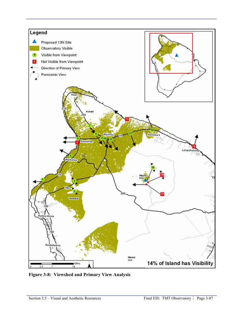
Section 3.5 – Visual and Aesthetic Resources Final EIS: TMT Observatory Page 3-87
Figure 3-8: Viewshed and Primary View Analysis

Page 3-88 Final EIS: TMT Observatory Section 3.5 – Visual and Aesthetic Resources
Figure 3-8. As shown in the Figure 3-8, the shaded portions of the island are areas where at least the top of the TMT Observatory may be visible. For the 18 representative viewpoints, a green circle shows that the TMT Observatory will be visible and a red square indicates it will not be visible.
Table 3-8: Visibility of the TMT Observatory
Visibility Area of Island (%) Hawai‘i’s Population % People
Visible 14% 15.4% 23,000 Not Visible 86% 84.6% 125,000
Of the 13 viewpoints where the TMT Observatory may be visible, it will not be within the primary view of four: the Hualālai Resort (1), Waikoloa/Mauna Lani (4), Puukohola Heiau (6) and Honoka‘a (13). At these coastal locations, the primary view is makai. The TMT Observatory could be visible and in the primary view direction from viewpoints along Highway 250 (7 and 8) and around the town of Waimea (9, 10, 11 and 12). The TMT Observatory could also be visible from the Big Island Country Club (3), from the summit of Pu‘u Waawaa (2), and from the north ridge of the Maunakea summit cinder cone (Kūkahau‘ula) (18), where the panoramic view will be important to the viewer.
Table 3-9 divides the viewshed, and the population within the viewshed, into five areas: Waimea, Honoka‘a, Hāwī, Waikoloa and Kawaihae, and Hualālai. Of these, the TMT Observatory will be visible in the primary view direction only from the area around Waimea. Of the island’s population, 5.5 percent, or 8,100 people reside within the area around Waimea and may be able to see the TMT Observatory.
Table 3-9: Visibility of the TMT Observatory within the Primary View Direction
Location Hawai‘i’s Population Primary View Direction? % People Waimea 5.5% 8,100 Yes Honoka‘a 2.8% 4,200 No Hāwī 2.6% 3,900 No Waikoloa and Kawaihae 4.3% 6,400 No Hualālai 0.2% 303 No
For the 13 representative viewpoints where the TMT Observatory may be visible, a silhouette analysis was conducted to determine whether the view of the facility will be a full or partial silhouette against the sky, or whether it will be seen against the backdrop of Maunakea. Table 3-10 summarizes the silhouette analysis for the TMT Observatory and the potential long-term impact to visual and aesthetic resources.

Section 3.5 – Visual and Aesthetic Resources Final EIS: TMT Observatory Page 3-89
Table 3-10: TMT Observatory - Summary of Potential Visual Impacts
Viewpoint Location Visual Impact
Is the TMT visible?
Visible in primary view?
Visible in silhouette? No Partial Full
1 Hualālai Resort Yes No -- 164 feet (50 m) -- 2 Pu‘u Waawaa Yes N/A1 -- 58 feet (17 m) -- 3 Big Island Country Club Yes N/A1 -- 82 feet (25 m) -- 4 Waikoloa/Mauna Lani Yes No -- 164 feet (50 m) -- 5 Hāpuna Beach No No N/A 6 Puukohola Heiau Yes No -- 164 feet (50 m) --
7 DHHL Kawaihae at Route 250 Yes Yes X -- --
8 Route 250 Pu‘u Overlook Yes Yes X -- -- 9 DHHL Lalamilo Yes Yes -- 49 feet (15 m) -- 10 Waimea Park Yes Yes -- 89 feet (27 m) -- 11 DHHL Pu‘u Kapu Yes Yes -- 98 feet (30 m) -- 12 DHHL Waikoloa-Waialeale Yes Yes -- 164 feet (50 m) -- 13 Waipio Valley Lookout No N/A N/A 14 Honoka‘a Yes No -- 82 feet (25 m) -- 15 Laupāhoehoe Point No N/A N/A 16 Maunakea Summit No N/A N/A 17 Lake Waiau No N/A N/A 18 North ridge of Kūkahau‘ula Yes N/A X -- --
1 The primary view criterion is not applicable because at these viewpoints the panoramic view is important.
TMT Observatory Dome Finish
As stated in Section 2.5.1, the finish for the TMT Observatory dome will be a reflective aluminum-like finish, similar to that of the Subaru observatory. The use of a reflective aluminum-like finish was based on the following considerations (1) visibility of the dome, (2) optimum performance of the observatory, and (3) reduced need of cooling air within the dome during the day. Each of these considerations is discussed below.
Visibility of the TMT Observatory Dome. A reflective aluminum-like finish reflects the colors of the sky and the ground, which helps the dome blend into its setting and reduces the visual impact whether the summit is bare or covered with snow. As indicated in Section 3.14.1, from November through March varying amounts of snow and ice regularly fall near the summit, covering varying portions of the mountain for varying periods of time. For comparison, the results of photo simulations using three different colors are presented below. The brown color would stand out far more than a reflective finish on the dome, particularly during periods of snow on the summit. The white color appeared to blend in with the surroundings when snow is present, however, without snow the white color appears more obtrusive. The reflective aluminum-like finish appears to reduce the visual impact in all conditions.
Optimum Performance of the Observatory. The performance of the TMT in observing in visible and infrared wavelengths is affected by any difference in temperature of the surface of the dome and the surrounding air. Air in contact with the surface of the dome is heated to above or below the temperature of the surrounding air, resulting in turbulence in the air. When this
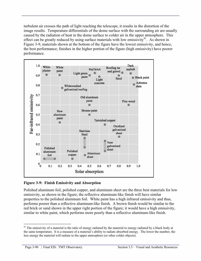
Page 3-90 Final EIS: TMT Observatory Section 3.5 – Visual and Aesthetic Resources
turbulent air crosses the path of light reaching the telescope, it results in the distortion of the image results. Temperature differentials of the dome surface with the surrounding air are usually caused by the radiation of heat in the dome surface to colder air in the upper atmosphere. This effect can be greatly reduced by using surface materials with low emissivity41. As shown in Figure 3-9, materials shown at the bottom of the figure have the lowest emissivity, and hence, the best performance; finishes in the higher portion of the figure (high emissivity) have poorer performance.
Figure 3-9: Finish Emissivity and Absorption
Polished aluminum foil, polished copper, and aluminum sheet are the three best materials for low emissivity, as shown in the figure; the reflective aluminum-like finish will have similar properties to the polished aluminum foil. White paint has a high infrared emissivity and thus, performs poorer than a reflective aluminum-like finish. A brown finish would be similar to the red brick or sand shown in the upper right portion of the figure; it would have a high emissivity, similar to white paint, which performs more poorly than a reflective aluminum-like finish.
41 The emissivity of a material is the ratio of energy radiated by the material to energy radiated by a black body at the same temperature. It is a measure of a material’s ability to radiate absorbed energy. The lower the number, the less energy the material will radiate to the upper atmosphere (or other colder objects).
Section 3.5 – Visual and Aesthetic Resources Final EIS: TMT Observatory Page 3-91
Reduced Need for Cooling Air within the Dome. Air within the dome of modern observatories is cooled during the day to the level of the forecasted nighttime temperature. This improves “seeing” for the telescope by reducing the amount of distortion related to differences in air temperature inside the dome and the surfaces of the telescope and the dome interior. The need of extensive cooling of the dome interior air is substantially reduced when the exterior surface has low solar absorption42. Materials on the left side in Figure 3-9 perform best by staying cool, with poorer performance materials shown to the right of the figure. Polished aluminum foil and white plaster are the two best materials shown on this figure; the reflective aluminum-like finish will have similar properties. White paint would be similar to a reflective aluminum-like finish, but brown paint would be similar to the red brick or sand shown in the figure further to the right. Because a brown finish would absorb more energy it would require more energy to cool the dome compared to a white or reflective aluminum-like finish. The additional energy required is estimated to be equivalent to the energy required to power between 4 and 40 homes in Hilo, depending on weather conditions outside the TMT Observatory.
Photo Simulations
Views from Lower Elevation Developed Areas
In compliance with CMP Management Action FLU-4 the Project has prepared visual renderings of the project setting. Photo simulations of the TMT Observatory were created using photographs of the summit of Maunakea that were taken with a 600 mm/5.6 telephoto lens resulting in a “binocular view.” For comparison purposes a “naked eye view”, without the aid of binoculars or a telephoto lens, photo is also provided. The naked eye view has been sized so that if the page is held at arm’s length the size and spacing of the existing observatories appears as it would when standing at the location the photo was taken.
An example of the naked eye view of Maunakea from Waimea is shown in Figure 3-10. Figure 3-11 is a binocular view simulation of the TMT Observatory, with a version of the reflective aluminum-like finish on the dome enclosure, from Waimea, where there is no snow on Maunakea. Figure 3-12 and Figure 3-13 show the same binocular view from Waimea, but with the dome having a white and brown finish, respectively.
Figure 3-14, Figure 3-15, and Figure 3-16 are simulations of the TMT Observatory with a reflective aluminum-like finish, and, for comparison, also in white, and brown coating, respectively, when there is snow present on Maunakea. This photograph was taking from another location within Waimea so the perspective is slightly different.
42 Solar absorption is a measure of a surface’s ability to absorb heat from the sun. A lower number is preferred as less solar heat is absorbed, which in turn requires less air conditioning to keep the dome interior temperature at the forecast nighttime temperature.
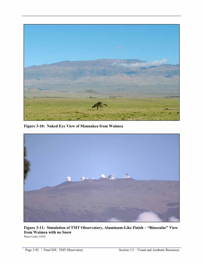
Page 3-92 Final EIS: TMT Observatory Section 3.5 – Visual and Aesthetic Resources
Figure 3-10: Naked Eye View of Maunakea from Waimea
Figure 3-11: Simulation of TMT Observatory, Aluminum-Like Finish – “Binocular” View from Waimea with no Snow Photo Credit: CFHT

Section 3.5 – Visual and Aesthetic Resources Final EIS: TMT Observatory Page 3-93
Figure 3-12: Simulation of TMT Observatory, White Finish – “Binocular” View from Waimea with no Snow Photo Credit: CFHT
Figure 3-13: Simulation of TMT Observatory, Brown Finish – “Binocular” View from Waimea with no Snow Photo Credit: CFHT

Page 3-94 Final EIS: TMT Observatory Section 3.5 – Visual and Aesthetic Resources
Figure 3-14: Simulation of TMT Observatory, Aluminum-Like Finish – “Binocular” View from Waimea with Snow Photo Credit: Charles R. West Photography
Figure 3-15: Simulation of TMT Observatory, White Finish – “Binocular” View from Waimea with Snow Photo Credit: Charles R. West Photography
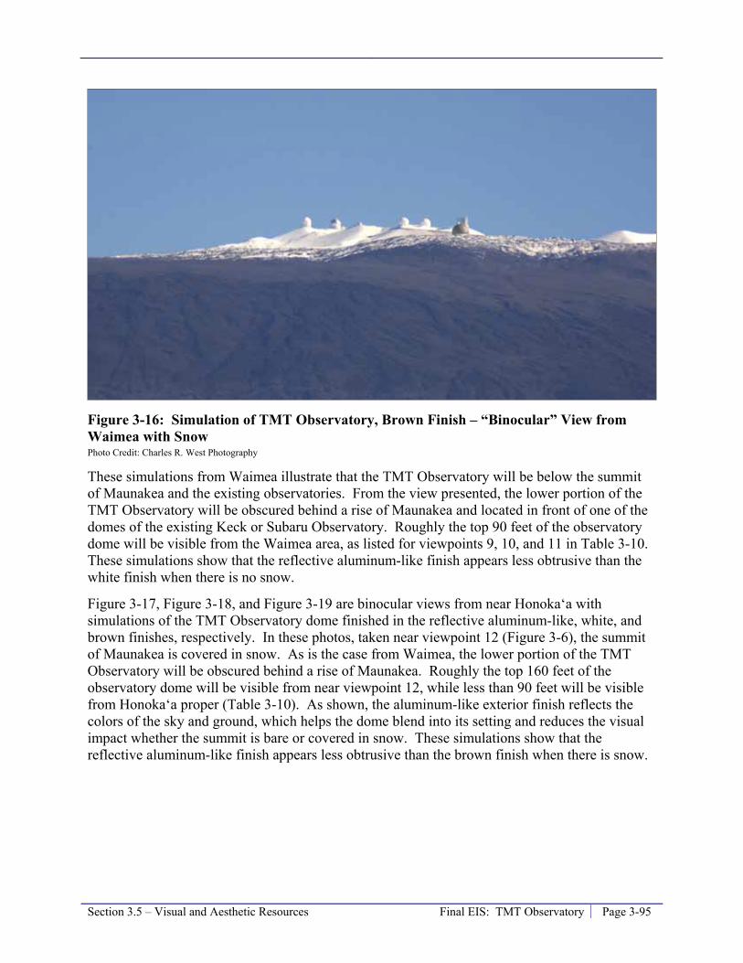
Section 3.5 – Visual and Aesthetic Resources Final EIS: TMT Observatory Page 3-95
Figure 3-16: Simulation of TMT Observatory, Brown Finish – “Binocular” View from Waimea with Snow Photo Credit: Charles R. West Photography
These simulations from Waimea illustrate that the TMT Observatory will be below the summit of Maunakea and the existing observatories. From the view presented, the lower portion of the TMT Observatory will be obscured behind a rise of Maunakea and located in front of one of the domes of the existing Keck or Subaru Observatory. Roughly the top 90 feet of the observatory dome will be visible from the Waimea area, as listed for viewpoints 9, 10, and 11 in Table 3-10. These simulations show that the reflective aluminum-like finish appears less obtrusive than the white finish when there is no snow.
Figure 3-17, Figure 3-18, and Figure 3-19 are binocular views from near Honoka‘a with simulations of the TMT Observatory dome finished in the reflective aluminum-like, white, and brown finishes, respectively. In these photos, taken near viewpoint 12 (Figure 3-6), the summit of Maunakea is covered in snow. As is the case from Waimea, the lower portion of the TMT Observatory will be obscured behind a rise of Maunakea. Roughly the top 160 feet of the observatory dome will be visible from near viewpoint 12, while less than 90 feet will be visible from Honoka‘a proper (Table 3-10). As shown, the aluminum-like exterior finish reflects the colors of the sky and ground, which helps the dome blend into its setting and reduces the visual impact whether the summit is bare or covered in snow. These simulations show that the reflective aluminum-like finish appears less obtrusive than the brown finish when there is snow.
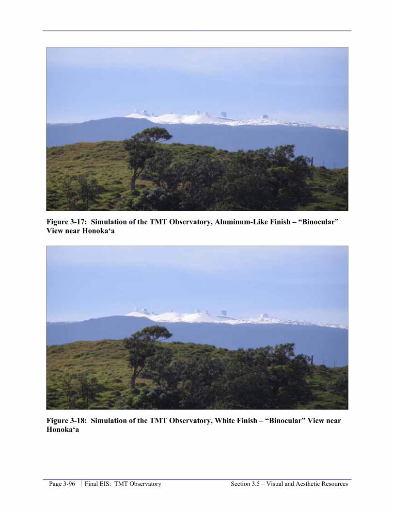
Page 3-96 Final EIS: TMT Observatory Section 3.5 – Visual and Aesthetic Resources
Figure 3-17: Simulation of the TMT Observatory, Aluminum-Like Finish – “Binocular” View near Honoka‘a
Figure 3-18: Simulation of the TMT Observatory, White Finish – “Binocular” View near Honoka‘a

Section 3.5 – Visual and Aesthetic Resources Final EIS: TMT Observatory Page 3-97
Figure 3-19: Simulation of the TMT Observatory, Brown Finish – “Binocular” View near Honoka‘a
Figure 3-20, Figure 3-21, and Figure 3-22 are binocular views from Waikoloa village with simulations of the TMT Observatory dome finished in the reflective aluminum-like finish, and, for comparison, also in white and brown finishes, respectively. In these photos, the summit of Maunakea is partially covered in snow. As is the case from Waimea, the lowest portion of the TMT Observatory, including the support building and parking area, will be obscured behind a rise of Maunakea. Roughly the top 160 feet of the observatory dome will be visible from the Waikoloa area (Table 3-10). As shown, the aluminum-like exterior finish reflects the colors of the sky and ground, which helps the dome blend into its setting and reduces the visual impact whether the summit is bare or covered in snow. These simulations show that the reflective aluminum-like finish appears less obtrusive than the brown finish when there is snow.

Page 3-98 Final EIS: TMT Observatory Section 3.5 – Visual and Aesthetic Resources
Figure 3-20: Simulation of the TMT Observatory, Aluminum-Like Finish – “Binocular” View from Waikoloa Photo Credit: Charles R. West Photography
Figure 3-21: Simulation of the TMT Observatory, White Finish – “Binocular” View from Waikoloa Photo Credit: Charles R. West Photography

Section 3.5 – Visual and Aesthetic Resources Final EIS: TMT Observatory Page 3-99
Figure 3-22: Simulation of the TMT Observatory, Brown Finish – “Binocular” View from Waikoloa Photo Credit: Charles R. West Photography
Views within the Summit Region
Although the TMT Observatory will not be visible from the summit of Maunakea, viewpoint 16, or Lake Waiau, viewpoint 17, it will be visible from other locations within the summit region, primarily the northern plateau and the northern ridge of Kūkahau‘ula where the Subaru, Keck, IRTF, and CFHT observatories are located, viewpoint 18. Figure 3-23 shows the current view from near the Keck Observatory, viewpoint 18, looking to the northwest, looking over the northern plateau and TMT Observatory 13N site. Figure 3-24 is a simulation of the TMT Observatory with an aluminum-like finish from the same view point.
As the simulation in Figure 3-24 shows, the TMT Observatory will add a substantial new visual element in the landscape that will be visible from viewpoints along the northern ridge of Kūkahau‘ula and by people as they travel within the northern portion of the summit region. Views from the northern ridge of Kūkahau‘ula are now dominated by views of observatories, including Subaru, Keck, IRTF, and CFHT observatories, which are located on this ridge. The majority of visitors to the summit region and cultural practitioners visit the Kūkahau‘ula summit, not the northern ridge of Kūkahau‘ula. In addition, TMT’s lower elevation and minimal size and height mean it will not block the view of Maui from the ridge. Nevertheless, the TMT Observatory will add a substantial new visual element to a currently relatively undeveloped portion of the summit region.

Page 3-100 Final EIS: TMT Observatory Section 3.5 – Visual and Aesthetic Resources
Figure 3-23: Naked Eye View from Near Keck Observatory Viewing Northwest
Figure 3-24: Simulation of the TMT Observatory with an Aluminum-Like Finish from Near Keck Observatory Viewing Northwest
Overall Long-Term Visual Impact
As discussed above, while the TMT Observatory will be a new visual element among the existing observatories within the views of Maunakea (for approximately 14 percent of the island

Section 3.5 – Visual and Aesthetic Resources Final EIS: TMT Observatory Page 3-101
area, and visible to approximately 15.4 percent of the population, or approximately 23,000 people from their residences), it will not substantially obstruct or block existing views of Maunakea from around the island of Hawai‘i. Existing observatories are visible in most of this area. The new area where the TMT Observatory will be visible and where currently none of the existing observatory can be seen is approximately 1.2 percent of the area of the island. Using the 2000 U.S. Census average household size of 2.75 people for the County of Hawaii, 72 people live in this new area.
In addition to residents within the TMT viewshed, the TMT Observatory will be visible to other island residents and visitors when they travel within the TMT viewshed (Figure 3-8), including travel along roads and stops at viewpoints. The Project’s visual impact is perceived by some to be significant; however, in the context of the existing observatories and the fact that the TMT Observatory will not block or substantially obstruct the identified views and viewplanes of the mountain, which is the applicable significance criteria in §11-200-12 of the HAR, the Project’s visual impact will be less than significant.
As described in Section 3.16.2, the visual impact of past actions on Maunakea, such as the 11 observatories currently located within the Astronomy Precinct, is considered substantial, significant, and adverse. When the TMT Observatory is combined with the existing conditions, the cumulative visual impact of development on and near the summit of Maunakea will continue to be significant, as discussed in detail in Section 3.16.4.
3.5.4 Mitigation Measures The location of the TMT Observatory is the primary mitigation for the Project’s potential visual impacts. Because the location proposed for the TMT Observatory is north of and below the summit of Maunakea it will be substantially less visible than if it were to be placed in a more visible location, such as the summit ridge or pu‘u.
The visual impacts of the TMT Observatory, which will house a telescope with a primary mirror 98 feet (30 meters) in diameter, are also due to the size of the dome enclosure. The diameter of the dome is 216 feet. Because the center of the dome will be placed only 36 feet above grade, the observatory will have a height of approximately 180 feet above grade level. While this will be the tallest observatory on Maunakea, it has been designed to minimize the height of the structure, in turn minimizing the visual impacts. The telescope itself has been designed to be much shorter, with a focal ratio43 of f/1.0, to allow for the smallest dome possible. In addition, the enclosure has been designed to fit very tightly around the telescope, leaving just enough room for a person, only about 20 inches, between the telescope and the dome (Figure 3-25). For comparison purposes, the Keck Observatory consists of two telescopes each with mirrors 33 feet in diameter with a focal ratio of f/1.75; the diameter of each Keck dome is 121 feet; the height of the Keck dome and other observatories on Maunakea is listed in Table 3-6. If the TMT Observatory were to use the same ratio of mirror-to-dome size, it would result in a dome with a diameter of 364 feet, almost twice the current measurement (Figure 3-26).
43 Focal ratio (f/) is defined as the ratio of the focal length of the mirror to its diameter.

Page 3-102 Final EIS: TMT Observatory Section 3.5 – Visual and Aesthetic Resources
Figure 3-25: Overview of TMT and Dome Design
Figure 3-26: Comparison of Observatory Dome Sizes to Telescope Focal Ratios

Section 3.5 – Visual and Aesthetic Resources Final EIS: TMT Observatory Page 3-103
Finally, the color, or coating, of the dome enclosure has substantial visual implications. The coating of the dome enclosure will be an aluminum-like coating, similar to that used on the Gemini Subaru Observatory. In general, an aluminum-like coating reflects the morning sunrise and evening sunset light and stands out during this period, however, during most of the day the coating reflects the sky, and reduces the visibility of the observatory.
The support building attached to the observatory dome has been reduced in size since the Draft EIS. This reduces its visibility, the designed continues to incorporate items to reduce its visibility from Kūkahau‘ula, the summit cinder cone complex that is a TCP State Historic Property. The building will be lava-colored and the parking areas will not be visible from Kūkahau‘ula, except the visitor parking area.
The Access Way incorporates design components to mitigate its visual impact. These measures include coloring the pavement a reddish color pavement to better blend with the surroundings, using a wire type guardrail to reduce its visibility, and should Access Way Options 2A or 3B be selected, the retaining wall or embankment facing will be treated so as to blend into the natural environment to the extent feasible.
In summary, the location and design of the TMT Observatory and Access Way incorporate measures that mitigate the potential visual impacts; no further visual mitigation measures are proposed.
3.5.5 Level of Impact after Mitigation The mitigation for the impacts to visual and aesthetic resources is incorporated into the Project’s design. Therefore, the level of the visual impact after mitigation is the same as described in Section 3.5.3. The direct long-term visual impact of the TMT Observatory will be less than significant.
3.5.6 References CFHT. 2008. CFHT Observatory Manual website:
http://www.cfht.hawaii.edu/Instruments/ObservatoryManual/CFHT_ObservatoryManual_(Sec_3).html and photograph description at http://www.cfht.hawaii.edu/Science/Astros/Imageofweek/ciw070800.html. Accessed December 12, 2008.
County of Hawai‘i. 2005. Hawai‘i County General Plan.
County of Hawai‘i. 2008. South Kohala Development Plan.
Gemini Northern Observatory. 2008. Website: http://www.gemini.edu/media/factsheets/enclosurefacts.html. Accessed December 17, 2008.
IRTF. 2008. Website: http://iqup.ifa.hawaii.edu/hvac/pages/fy93_nasa_pm9736_a6big.html. Accessed December 10, 2008.

Page 3-104 Final EIS: TMT Observatory Section 3.5 – Visual and Aesthetic Resources
National Aeronautics and Space Administration (NASA), Universe Division. 2005. Final Environmental Impact Statement for the Outrigger Telescopes Project, Mauna Kea Science Reserve, Island of Hawai‘i, Volume 1.
Subaru Observatory. 2008. Website: http://www.naoj.org/Introduction/telescope.html. Accessed December 6, 2008.
United States Census Bureau. 2000. Census 2000 Data website: http://factfinder.census.gov. Accessed December 10, 2008.
United States Geologic Survey. 2008. National Elevation Dataset website: www.ned.usgs.gov/. Accessed November 25, 2008.
University of Hawai‘i (UH). 2009. Coping with Vog from Pu‘u O‘o website: http://www.uhh.hawaii.edu/~nat_haz/volcanoes/vog.php. Accessed February 25, 2009.
UH, 2009a. Mauna Kea Comprehensive Management Plan. January, 2009. Approved by BLNR on April 9, 2009.
UH, 2006. Final Environmental Assessment for University of Hawai‘i 24-inch Telescope Observatory Renovation. Mauna Kea Science Reserve, Hāmākua, Hawai‘i, Hawai‘i. August 2006.
UH, 2000. Mauna Kea Science Reserve Master Plan. Available on the web http://www.hawaii.edu/maunakea/. Prepared by Group 70 International, Inc., adopted by the UH Board of Regents on June 16, 2000.
UH, 1983a. Mauna Kea Science Reserve: Complex Development Plan. Prepared by Group 70 International, Inc. for Research Corporation of the University of Hawai‘i. February 1983 (amended May 1987).
UH, 1983b. Mauna Kea Science Reserve: Complex Development Plan Final Environmental Impact Statement. Prepared by Group 70 International, Inc. for Research Corporation of the University of Hawai‘i. January 1983.
UH, 1975. Final EIS for Existing Operations of the UH Observatory and the Construction and Operation of the new IRTF and UKIRT Observatories.
University of Hawai‘i, Institute for Astronomy. 2008. Website: www.ifa.hawaii.edu.mko/coordinates. Accessed December 2, 2008.

Section 3.6 – Geology, Soils, and Slope Stability Final EIS: TMT Observatory Page 3-105
3.6 Geology, Soils, and Slope Stability This section discusses the geology, soils, and slope stability in the region and specific Project areas, the potential impact of the Project on those characteristics, and mitigation measures the Project will employ to mitigate those potential impacts.
3.6.1 Environmental Setting Maunakea is one of five volcanoes comprising the Island of Hawai‘i (Figure 3-27). This dormant44 shield volcano is the highest of the five, and the highest mountain in the interior Pacific basin. Because of its elevation, Maunakea’s summit was repeatedly glaciated during the past few hundred thousand years, and preserves the best glacial record of any oceanic volcano on Earth. Maunakea has erupted 12 times within the last 10,000 years, and though it has been at least 4,600 years since its last eruption it is expected that the volcano will erupt again sometime in the future; such an eruption would likely occur on the flanks of the volcano, below the summit.
Figure 3-27: Volcanoes of the Island of Hawai‘i
44 “Dormant” volcanoes are distinguished from (a) “active” ones by the fact that active volcanoes have ongoing eruptions, such as Kīlauea; and (b) “extinct” ones by fact that the intervals between a dormant volcano's prehistoric eruptions (recurrence interval) is greater than the time since the last eruption to present.
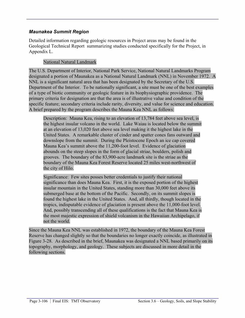
Page 3-106 Final EIS: TMT Observatory Section 3.6 – Geology, Soils, and Slope Stability
Maunakea Summit Region
Detailed information regarding geologic resources in Project areas may be found in the Geological Technical Report summarizing studies conducted specifically for the Project, in Appendix L.
National Natural Landmark
The U.S. Department of Interior, National Park Service, National Natural Landmarks Program designated a portion of Maunakea as a National Natural Landmark (NNL) in November 1972. A NNL is a significant natural area that has been designated by the Secretary of the U.S. Department of the Interior. To be nationally significant, a site must be one of the best examples of a type of biotic community or geologic feature in its biophysiographic providence. The primary criteria for designation are that the area is of illustrative value and condition of the specific feature; secondary criteria include rarity, diversity, and value for science and education. A brief prepared by the program describes the Mauna Kea NNL as follows:
Description: Mauna Kea, rising to an elevation of 13,784 feet above sea level, is the highest insular volcano in the world. Lake Waiau is located below the summit at an elevation of 13,020 feet above sea level making it the highest lake in the United States. A remarkable cluster of cinder and spatter cones fans outward and downslope from the summit. During the Pleistocene Epoch an ice cap covered Mauna Kea’s summit above the 11,200-foot level. Evidence of glaciation abounds on the steep slopes in the form of glacial striae, boulders, polish and grooves. The boundary of the 83,900-acre landmark site is the striae as the boundary of the Mauna Kea Forest Reserve located 25 miles west-northwest of the city of Hilo.
Significance: Few sites posses better credentials to justify their national significance than does Mauna Kea. First, it is the exposed portion of the highest insular mountain in the United States, standing more than 30,000 feet above its submerged base at the bottom of the Pacific. Secondly, on its summit slopes is found the highest lake in the United States. And, all thirdly, though located in the tropics, indisputable evidence of glaciation is present above the 11,000-foot level. And, possibly transcending all of these qualifications is the fact that Mauna Kea is the most majestic expression of shield volcanism in the Hawaiian Archipelago, if not the world.
Since the Mauna Kea NNL was established in 1972, the boundary of the Mauna Kea Forest Reserve has changed slightly so that the boundaries no longer exactly coincide, as illustrated in Figure 3-28. As described in the brief, Maunakea was designated a NNL based primarily on its topography, morphology, and geology. These subjects are discussed in more detail in the following sections.

Section 3.6 – Geology, Soils, and Slope Stability Final EIS: TMT Observatory Page 3-107
Figure 3-28: Mauna Kea National Natural Landmark
Geology
Area E was designated in the 2000 Master Plan as a location for future facilities development, and includes the limits of sites being considered for the location of the TMT Observatory. It is entirely underlain by a single lava flow, and consists of uniformly dense, fine-grained lavas. The flow was emplaced as viscous pāhoehoe, although some ‘a‘a fragmental material may have originally overlain the surface. The eruption that produced this overall flow likely produced multiple flow layers that overlaid one another as the eruption progressed; multiple complex layers may be found at depth during excavation.
Surface features indicate that most of this flow was emplaced beneath glacial ice or snow. In contrast, the source vent for this
Typical topography and rock surface in Area E. Photo by CSH

Page 3-108 Final EIS: TMT Observatory Section 3.6 – Geology, Soils, and Slope Stability
flow shows no evidence of interaction with water, meaning fire fountains at the source must have melted through overlying ice during the eruption so that lava fountaining took place and made contact with the air, producing numerous air-cooled volcanic bombs. The flows from this vent traveled down slope to the northwest, beneath a thin glacier; the flows preserve many features that document sub-glacial origin. Lava flowage beneath the ice was concentrated in irregular lava channels typically 3-8 feet deep and beneath ridges that are oriented in fan shapes roughly radial to the principal axis of the flow. A single chemical analysis of this lava flow shows the flow to be of typical “hawaiite” composition (a type of alkali-rich basalt).
The glacial features found on Maunakea are unique to glaciated terrains, and are found at no other oceanic volcano in the Pacific. However, the features in Area E are not unique on Maunakea, and better examples are widely distributed in other areas of the summit above the elevation of about 12,000 feet. The degree of glacial polishing is related to the thickness of the overlying ice that was present; because the glacial ice cap that overlaid Area E was less thick than the glacier overlying the lower elevations southeast of the summit, glacial polishing and striations are less developed on the flow in Area E and the Access Way area.
Most molten lava was supplied by flowage beneath a solidified layer of frozen lava, but where the layer was breached, especially at flow margins south and east of Area E, bulbous lava protrusions formed rounded structures, termed mega-pillows. These unique structures consist of especially fine-grained, flinty lava with interstitial glass on marginal surfaces. These flinty rocks are similar in texture to the materials quarried by Hawaiian toolmakers at sites near Pu’u Koko‘olau on Maunakea’s south flank; however, they were likely obscured by snow during the cooler weather of the past, and would not have been exposed for possible use during the period of active quarrying at lower elevations.
Following the emplacement and cooling of the flow, ice continued to cover the Maunakea summit, and down slope movement of the glaciers that formed modified lava flow surfaces through the erosive power of flowing melt water and associated rock debris. Any fragmental material originally at the surface was eroded away by torrents of sub glacial melt water, leaving typically irregular surfaces that reveal the structures of the underlying dense lava. In areas where moving ice directly overlaid lava, the hard surfaces were scoured by rock debris, which polished high-standing areas and left glacial striations. During the eruption, some of the lava channels may have formed small pyroducts, or lava tubes, but if once present, the thin coverings that enclosed them have generally been removed by glacial erosion.
The last glaciers melted in the area 10,000-13,000 years ago, boulders once being transported in the ice were left standing on high places as the ice melted. These boulders, called glacial erratics, give testament to the carrying power of the ice that once flowed above Area E. Such glacial erratics and other debris form extensive deposits of glacial till about a mile down slope, but the glaciers were never extensive enough to form such spectacular glacial moraines as are preserved on the south flank of Maunakea.
It is estimated that the aggregate thickness of all lava flow layers from the time of the eruption that placed the
Glacial erratic in Area E. Photo by Geohazards Consultants International
Section 3.6 – Geology, Soils, and Slope Stability Final EIS: TMT Observatory Page 3-109
lava currently present at the surface in the vicinity of the TMT Observatory site is at least 75 feet. Because lava flows tend to travel along pre-existing depressions, it is likely that most of the flow is thicker than this, especially in the center, and more likely is over 100 feet thick. The pre-existing ground surface in this area evidently sloped to the northwest, so that the flow surface slopes in this direction, as well as to the north. Judging from older rocks exposed down slope from Area E, it is possible that this flow overlies a rubbly surface consisting of loose lava fragments and windblown cinders from summit cones, although such material may have been eroded away by glacial activity before flow emplacement.
Soils and Slope Stability
No soils in the conventional sense are present in Area E, as the only fragmental material present has not had sufficient time for weathering to become soil in the arid, alpine environment. This fragmental material is present in most low-lying areas though, and could be classified as a non-weathered soil. This material consists of unconsolidated debris derived from glacial erosion and mechanical weathering of the adjacent lavas and nowhere is more than a foot or two in thickness. Because these materials have no internal strength, they must be removed before overlain by heavy structures.
The lava flow at the surface and extending to an estimated depth of 75 feet in Area E is composed of dense, fine-grained lava of exceptional strength, and slope stability will not be a problem for well-anchored structures. There are typically few gas bubbles in this lava, except in the uppermost sections of flows. During the flow emplacement, most lava was supplied by subsurface lava tubes, but these structures appear to have mostly been filled up during late eruption stages. Some voids might be encountered at depth within the lavas during excavation, but are likely small and not extensive. The estimated combined thickness of these flows should allow basement foundations to rest on solid lava and not on the more fragmented materials that might lie at greater depths.
Geologic Hazards
The potential for renewed volcanic activity in this region is extremely remote. Maunakea last erupted about 4,600 years ago, and the volcano is considered to be dormant. In 1997, Wolfe and others mapped a dozen separate post-glacial (post- 10,000 year old) eruptive vents on Maunakea’s middle flanks, but none younger than 40,000 years were found in the summit area. These findings support the theory that future eruptions will likely occur well below the summit and will not pose any direct threat to astronomical facilities.
The most significant geologic hazard is seismic activity. Hawai‘i Island is one of the most seismically active areas on Earth, and about two dozen earthquakes with magnitude 6 or greater have been documented on Hawai‘i since the devastating earthquakes of 1868; those that caused damage are listed in Table 3-11. The approximate epicenter of those earthquakes and the predicted Modified Mercalli Intensity Scale seismic intensities are illustrated on Figure 3-29. The earthquake in 2006 caused minor damage to the Keck, Subaru, UH 2.2m, and CFHT observatories. Some auxiliary equipment was damaged, but the telescopes’ mirrors and overall facility structural integrity were not affected.
Earthquakes will continue to impact the Maunakea summit area in the future, and any future construction must include design considerations for significant seismic forces. The summit of

Page 3-110 Final EIS: TMT Observatory Section 3.6 – Geology, Soils, and Slope Stability
Maunakea is susceptible to seismic intensities of up to VII on the Modified Mercalli Intensity Scale.
Table 3-11: Summary of Damage Causing Earthquakes
# Date Epicenter Location
Maximum Intensity
Mag Magnitude No. of
Deaths Damage Repair Cost
1 03-28-1868 Southern Hawai‘i IX 7.0 0 Extensive-S. Hawai‘i Unknown
2 04-02-1868 Southern Hawai‘i XII 7.9 81 >100 houses destroyed in tsunami Unknown
3 10-05-1929 Hualālai VIII 6.5 0 Extensive-Kona Unknown 4 08-21-1951 Kona VIII 6.9 0 Extensive-Kona Unknown 5 04-26-1973 North of Hilo VIII 6.2 0 Extensive-Hilo $5.6M 6 11-29-1975 Kalapana VIII 7.2 2 Extensive-Hilo $4.1M 7 11-16-1983 Ka‘oiki IX 6.7 0 Extensive-S. Hawai‘i >$6M 8 06-25-1989 Kalapana VII 6.2 0 Southeast Hawai‘i almost $1M 9 10-15-2006 Kiholo Bay VIII 6.7&6.0 0 NW Hawai‘i >$100M Approximate epicenter location illustrated on Figure 3-29.
Figure 3-29: Seismic Intensities (Modified Mercalli Intensity Scale) and Estimated Epicenters of Damage Causing Earthquake (1868 to present) on the Island of Hawai‘i
Hale Pōhaku
Detailed information regarding geologic resources in Project areas may be found in the Geological Technical Report, in Appendix L, summarizing studies conducted specifically for the Project in Appendix L. This area is comprised of a loose mixture of sand, gravel, and blocks,

Section 3.6 – Geology, Soils, and Slope Stability Final EIS: TMT Observatory Page 3-111
and deeper volcanic tephra, that has been extensively impacted by frost action and overlain by soil alteration zones where not disturbed. Because this material is unconsolidated, it is subject to erosion and gullying by flowing surface water during heavy rainfall.
The potential TMT Mid-Level Facility site in the southern/down-slope portion of Hale Pōhaku has been extensively modified by construction around buildings, and is impacted by minor gullying, especially in the upper portions where water runoff is concentrated from parking areas and roof drainage. The undisturbed surfaces are covered with loose volcanic blocks overlying fine grained sand of volcanic origin; clumps of vegetation have trapped high mounds of wind-blown sand. Slopes are as steep as 8 degrees southward in the upper area, but less than 2 degrees in the south/lower portion of the potential TMT Mid-Level Facility area.
The HELCO transformer substation is located in a natural saddle, or dip, between Pu‘u Kalepeamoa to the south and a cinder cone and crater associated with Pu‘u Kilohana to the north. The HELCO enclosure is mostly sited on a thick layer of imported gravel fill, and has had no impact on surrounding geologic structures. The surface underlying this fill consists of unconsolidated sand and gravel that has been unaffected by surface water runoff. The adjoining cinder cone slopes are covered with debris from volcanic eruptions, mostly broken volcanic bombs.
Similar to the summit area, earthquakes have and will continue to impact Hale Pōhaku. The area is susceptible to seismic intensities of up to VII on the Modified Mercalli Intensity Scale.
Headquarters
The soil type along University Park is largely pāhoehoe lava flow, a classification characterized by a relatively smooth surface with little to no soil covering it. Also found in the area is Keaukaha Extremely Rocky Muck, a classification characterized by well-drained, thin organic soils overlaying pāhoehoe lava bedrock. The University Park area slopes from west to east, with site slopes ranging from 6 to 15 percent; along Komohana Street slopes are between 10 and 15 percent. There are no unique geologic features present on the site. Hilo is susceptible to seismic intensities of up to VIII on the Modified Mercalli Intensity Scale.
3.6.2 Thresholds Used to Determine Level of Impact In accordance with the Chapter 343 significance criteria, the Project would result in a significant impact if it affects or is likely to suffer damage by being located in an environmentally sensitive area such as a flood plain, tsunami zone, beach, erosion-prone area, geologically hazardous land, estuary, fresh water, or coastal waters. Therefore, a significant impact would occur if the Project affected or suffered damage by being located in an environmentally sensitive area.
3.6.3 Potential Environmental Impacts The Project impacts will occur within the context of the current conditions at Project sites. That context includes the presence of observatories and roads in the summit region that have had direct impacts to roughly 63 acres of the cinder cones. As detailed in Section 3.16.2, the past actions on Maunakea have resulted in substantial, significant, and adverse impacts to geologic resources, primarily due to the alteration of the cinder cone morphology.
Page 3-112 Final EIS: TMT Observatory Section 3.6 – Geology, Soils, and Slope Stability
The TMT Observatory and the Access Way will unavoidably remove any surface geologic structures present, such as lava flow morphology and glacial features in the summit region. However, such geologic features are not unique on Maunakea and are better developed at many other areas, especially on the southern summit area adjacent to the Mauna Kea Access Road in the MKSR Natural/Cultural Preserve Area and the Ice Age NAR. Nevertheless, the destruction of any surface geologic features denigrates the Mauna Kea NNL; however, the Project will destroy less than 0.01 percent, roughly 6.2 acres (with slight variations depending on which Access Way Option is selected), of the surface geology within the 83,900 acre Mauna Kea NNL. At most, this destruction of surface geologic features would only include roughly 0.2 acres of a cinder cone.
The Access Way near the SMA core will be adjacent to or within steep terrain. Access Way design includes grading and Access Way Options 2A and 3B include a retaining wall and slop facing, respectively in the case of Option 2, and grading plus the installation of a retaining wall, in the case of Option 3. The designs are in compliance with applicable standards while keeping grading and retaining structures to a minimum in this culturally and biologically sensitive area. Compliance with applicable standards will mitigate slope stability concerns.
The area being considered for the potential TMT Mid-Level Facility is entirely underlain by unexceptional volcanic materials that characterize much of the lower slopes of Maunakea, and there are no geologically unique features in the area.
Similarly, the area being considered for the Headquarters is not geologically exceptional.
Because Hawai‘i Island is in a seismically active area, the Project will comply with applicable regulations and standards, with the design for all structures meeting all applicable seismic safety codes to ensure life safety of personnel and visitors.
Therefore, the Project’s impact to geologic resources, soils, and slope stability will be less than significant.
3.6.4 Mitigation Measures Through compliance with existing regulations and requirements, Project impacts on geologic resources, soils, and slope stability will be less than significant and no additional mitigation is required. The Project’s design features to comply with applicable rules and regulations will include:
• Grading in compliance with applicable standards; and
• The Project will comply with applicable seismic safety regulations and standards in the design of structures to meet applicable codes to ensure life safety of personnel and visitors.
In addition to these compliance measures, the Project will implement the following mitigation measures:
• There are noteworthy examples of glacial features near the Access Way, and such features are presently unappreciated. Interpretive signs will be placed along the Access Way identifying these noteworthy examples of glacial features to enhance public interpretation/education efforts. The number and placement of signs will be determined

Section 3.6 – Geology, Soils, and Slope Stability Final EIS: TMT Observatory Page 3-113
through consultation and coordination with OMKM. Installation of interpretive signs is consistent with CMP Management Action EO-4, which calls for improvements to interpretive, safety, and regulatory signs throughout the UH Management Areas.
• The Project will work with OMKM and ‘Imiloa to develop exhibits that reflect the nationally-recognized natural resources of the MKSR, which is within the Mauna Kea NNL. These exhibits will be utilized by the VIS and ‘Imiloa, as appropriate.
• The design of the Observatory will incorporate techniques to minimize the seismic risk of potential damage to the telescope and associated equipment. With these measures, the likelihood of damage will be lessened.
3.6.5 Level of Impact after Mitigation The mitigation measures proposed will further reduce the level of impact to geologic resources, which is considered less than significant without any mitigation, and ensure compliance with seismic safety standards.
3.6.6 References Cleghorn, Paul. 1982. The Mauna Kea adze quarry – technological analysis and experimental
tests: Ph.D. Thesis, Univ. of Hawai‘i Department of Anthropology.
Frey, F.A., Wise, W.S., Garcia, M.O, West, H., Kwon, S.T., and Kennedy, A. 1990. Evolution of Mauna Kea Volcano, Hawai‘i - petrologic and geochemical constraints on postshield volcanism: Journal of Geophysical Research, v. 95, p. 1271-1300.
Gemini Observatory. 2007. Mauna Kea Observatories Earthquake Workshop. Kailua-Kona. Website: http://www.gemini.edu/node/227. Accessed December 10, 2008.
Lockwood, J. P. 2000. Mauna Kea Science Reserve Geologic Resources Management Plan – Appendix H. Prepared for Group 70. .
Matsuoka, Norikazu. 2001. Solifluction rates, processes and landforms: a global review: Earth Science Reviews, v. 55, pp.107-134.
Mills, P. R., Lundblad, S. P., Suitzer, J.G, McCoy, P. C., and Naleimaile, S. P. 2008. Science and sensitivity – a geochemical characterization of the Mauna Kea adze quarry complex, Hawai‘i Island, Hawai‘i. American Antiquity, v. 73, n. 4, pp. 748-759.
Mullineux, D. R., Peterson, D. W., and Crandell, D. R. 1987. Volcanic Hazards in the Hawaiian Islands, p. 1187-1220. U. S. Geological Survey Professional Paper 1350.
Office of Mauna Kea Management (OMKM), 2009a. Natural Resources Management Plan for the UH Management Areas on Mauna Kea; A Sub-Plan of the Mauna Kea Comprehensive Management Plan. September 2009. Prepared by Sustainable Resources Group International, Inc., approved by BLNR on March 25, 2010.
Porter, S.C. 1979a. Quaternary stratigraphy and chronology of Mauna Kea, Hawai‘i - a 380,000 year record of mid-Pacific volcanism and ice-cap glaciation. Geological Society of America Bulletin, Pt. 2, v. 90, p. 908-1093.

Page 3-114 Final EIS: TMT Observatory Section 3.6 – Geology, Soils, and Slope Stability
Porter, S.C. 1979b. Geologic map of Mauna Kea volcano, Hawai‘i. Geological Society of America, Map and Chart Series MC-30, Scale 1:57,000.
Porter, S. C. 1979c. Hawaiian glacial ages. Quaternary Research, v. 12, pp. 161-167.
Porter, S.C. 1987. Pleistocene subglacial eruptions on Mauna Kea. Decker, R. W., Wright, T.L., and Stauffer, P.H. (Eds.). Volcanism in Hawai‘i. U.S. Geological Survey Professional Paper 1350, p. 587-598.
Porter, S. C., Stuiver, Minze, and Yang, I. C. 1977. Chronology of Hawaiian glaciations. Science, v. 195, pp 61-63.
Robertson, I.N., Nicholson, P.G. and Brandes, H.G. 2006. Reconnaissance following the October 15th, 2006 Earthquakes on the Island of Hawai’i, Research Report UHM/CEE/06-07, University of Hawai‘i College of Engineering, Department of Civil and Environmental Engineering; 65 pp.
University of Hawai‘i (UH), 2009a. Mauna Kea Comprehensive Management Plan. January, 2009. Approved by BLNR on April 9, 2009.
U.S. Department of the Interior, National Park Service, National Natural Landmarks Program. Natural Landmark Brief for Mauna Kea, May 1994.
Wentworth, C.K. and Powers, W.E. 1941. Multiple glaciation of Mauna Kea, Hawai‘i. Geological Society of America Bulletin, v. 52, p. 1193-1218.
Werner, B.T. and Hallet, B. 1993. Numerical simulation of self-organized stone stripes. Nature, v. 361, p. 142-145.
Wolfe, E.W., Wise, W.S., and Dalrymple, G.B. 1997. The geology and petrology of Mauna Kea Volcano, Hawai‘i B a study of postshield volcanism. U.S. Geological Survey Professional Paper 1557, 129 pp.
Wyss, M., and Koyanagi, R. Y. 1992. Isoseismal maps, macroseismic epicenters, and estimated magnitudes of historical earthquakes in the Hawaiian Islands. U. S. Geological Survey Bulletin 2006, 93 p.

Section 3.7 – Water Resources and Wastewater Final EIS: TMT Observatory Page 3-115
3.7 Water Resources and Wastewater This section discusses the water resources and wastewater management practices in the region and in the Project area and the potential impacts of the Project on those resources, and mitigation measures the Project will employ to mitigate those potential impacts.
3.7.1 Environmental Setting
Maunakea Summit Region
Surface Water
There are no regularly flowing or perennial streams in the Mauna Kea Science Reserve. The Wailuku River is the only river whose numerous gulches extend along the upper flanks of Maunakea, and stream flow is considered to be perennial where the gulches come together, downslope near the elevation of 10,000 feet. The only surface water regularly present in the summit region is Lake Waiau within the adjacent Mauna Kea Ice Age Natural Area Reserve (NAR). Figure 2-3 illustrates the location of the lake.
Lake Waiau is located at the bottom of Pu‘u Waiau and is one of Hawai‘i’s few confined surface water bodies and one of the highest alpine lakes in the Unites States. The lake freezes almost entirely during colder times of the year and has never been known to dry up. Lake Waiau is believed to have formed approximately 15,000 years ago following the last glacial retreat, and is revered by many Native Hawaiians as a pool created for the snow Goddess Poli‘ahu by her father, Kāne. The lake is heart-shaped, 300 feet in diameter, reaches approximately 7.5 feet depth at full capacity, and sits at an elevation of 13,020 feet on the southern flank of Maunakea. Topography limits the lake’s watershed to about 35 acres. The lake’s water is derived from snow melt and precipitation within the watershed, not relic layers of ice or permafrost within the ground. The presence of Lake Waiau is attributable to an impermeable layer within Pu‘u Waiau that creates a perched45 aquifer, which is a limited aquifer that occurs above the regional aquifer. In the absence of this impermeable layer, the rainwater and snowmelt would continue its downward migration to the regional aquifer, which is much deeper.
Lake Waiau lies roughly 1.5 miles south of the TMT Observatory site, which will be on the opposite flank of Maunakea from the lake. The Project’s Batch Plant Staging Area, roughly 3,000 feet upslope of Lake Waiau, will not be located within the Lake Waiau watershed.
Groundwater Aquifers
The regional aquifer beneath the summit is what is referred to in Hawai‘i as “high-level,” which means that the aquifer is entirely fresh water, not fresh water floating on salt water, and geologic structures, such as a volcanic sills and dikes, isolate the water. Although groundwater is the primary source of drinking water in Hawai‘i, there are no wells extracting groundwater near the summit, since it is considered uneconomical to drill a well deep enough to reach the groundwater 45 A perched aquifer is an aquifer that occurs above the regional water table, in the unsaturated zone. This occurs when there is an impermeable layer of rock or sediment (known as an aquiclude) or relatively impermeable layer (known as an aquitard) above the main aquifer but below the surface of the land.

Page 3-116 Final EIS: TMT Observatory Section 3.7 – Water Resources and Wastewater
and pump it to the surface. The nearest well is located approximately 12 miles away in Waiki‘i Ranch along Saddle Road; the ground elevation at the well is 4,260 feet above mean sea level (MSL) and the static water level in the well was measured at 1,280 feet above MSL in 1988. The Astronomy Precinct, and, therefore, the TMT Observatory site and Batch Plant Staging Area site, is located entirely above the Waimea Aquifer (Figure 3-30), which has a sustainable yield of 24roughly 13 million gallons a day.
Figure 3-30: Groundwater Aquifers on the Island of Hawai‘i
Potable Water
MKSS contracts with a trucking company to deliver potable water from Hilo to the summit observatories in 5,000-gallon-capacity tank trailers that are owned by MKSS. Each observatory stores its own water and is responsible for the maintenance of its water tanks; observatories also use 5-gallon water jugs for drinking water. Water is trucked to the summit about twice a week for an annual average of approximately 502,500 gallons over the past three years, which indicates a combined daily use of roughly 1,400 gallons.
Section 3.7 – Water Resources and Wastewater Final EIS: TMT Observatory Page 3-117
Wastewater Collection, Treatment, and Disposal
Domestic wastewater and refuse liquids, including mirror washing wastewater, are the primary sources of wastewater generated by activities in the MKSR. Keck, CFHT, Gemini, Subaru, and the UH 2.2-meter observatories have facilities to conduct mirror washing and/or recoating activities. The other observatories bring their mirrors to one of those observatories for washing and recoating. All mirror washing effluent is collected and trucked off the mountain for off-site treatment and disposal.
Each observatory operates its own wastewater system to collect and treat domestic wastewater, pursuant to the permits issued by the Hawai’i State Department of Health (HDOH).
Existing restroom facilities at the summit available for visitor use include four portable toilets and the restrooms located in the Keck Observatory. The portable toilets are located at two different parking areas and are moved between the sites as needed. Portable toilets are serviced weekly and pumping is done on-site.
Drainage
Drainage at the summit occurs through percolation of rainfall through the cinder and broken rock substrates. Runoff from paved surfaces is directed to lined channels that conduct the water to collection basins or dry wells, where it then percolates. This system assists in the prevention of surface erosion.
Hale Pōhaku Facilities
Surface Water
There are no regularly flowing or perennial streams in the vicinity of Hale Pōhaku. Only during times of heavy rainfall will a few of the normally dry channels nearby have flowing water.
Groundwater Aquifers, Seeps, and Springs
As evidenced by modest spring and seeps, shallow groundwater does exist in the mountain’s flanks below the summit area. The most prominent of these springs and seeps are the series of springs found near Pōhakuloa and Waikahalulu Gulches. The gulches are on Maunakea’s south flank at a distance of approximately 3.25 and 1.25 miles west of Hale Pōhaku, respectively. Scientific dating tests of the spring’s water indicate that it is recent, meaning that the water is not from the melting of ancient subsurface ice or permafrost, and analyses of the water shows it to be identical to rainfall at the summit. This indicates that at least some of the rainfall and snow melt at the summit percolates downward to a perching layer to ultimately discharge at the ground surface as a spring or seep.
Hale Pōhaku is located above the Onomea Aquifer system (Figure 3-30). There are no wells in the vicinity of Hale Pōhaku, because, similar to the summit area, the groundwater is at such a great depth that it is not considered economical to use it.
Page 3-118 Final EIS: TMT Observatory Section 3.7 – Water Resources and Wastewater
Potable Water
MKSS contracts with a trucking company to deliver potable water from Hilo to Hale Pōhaku in 5,000-gallon-capacity tank trailers that are owned by MKSS. Data gathered by MKSS indicates that the Hale Pōhaku facilities currently require approximately 30,000 gallons of water per week or roughly 4,300 gallons per day.
Wastewater Collection, Treatment, and Disposal
Currently, Hale Pōhaku has three small capacity cesspools46 and six septic47 systems. At Hale Pōhaku’s main common building, dormitories B and C, and the VIS the wastewater systems have been upgraded to septic tanks that use the old cesspools instead of leach fields to discharge septic tank effluent. Dormitory D was constructed with a septic system and no modifications have been made to date. A septic tank with a leach field is present at the newer construction camp site below VIS. The septic tanks are regularly maintained by pumping out the sludge and other solids contained in them approximately 12 times per year. The wastewater systems at the older construction camp, dormitory A, and utility buildings between the cafeteria and the VIS use the original small-capacity cesspools for wastewater disposal. Figure 2-9 provides an overview of Hale Pōhaku facilities.
Drainage
Pōhakuloa and Waikahalulu Gulches, over a mile away, are the most developed drainage channels along the upper slopes of the mountain. These channels likely formed following large-scale scouring and movement of materials down the present day gulch alignment from a process initiated by melting glaciers. There is no developed drainage system at Hale Pōhaku. The low annual rainfall and permeability of the subsurface at Hale Pōhaku make a developed drainage system unnecessary. Rainfall from the common building roof and all paved areas is allowed to runoff into drywells; rainfall from all other building roofs is allowed to runoff to an unpaved area and percolate into the subsurface.
Headquarters
The majority of the University Park is located outside any flood boundary, but a portion of the northern area of the property is located within Flood Zone A, an area inside the 100-year floodplain. The nearest surface body of water is Waiākea Stream; no part of Waiākea Stream in the vicinity of the UH Hilo campus is perennial. University Park is located above the Hilo Aquifer System (Figure 3-30). Storm drain drywells and landscaping/grading are used by other facilities and roads in University Park to control storm water and recharge the aquifer. Domestic water is provided by the UH Hilo system to the existing University Park; the mauka area of the park is not yet connected to the system. The existing University Park is hooked up to the regional wastewater system; the mauka area of the park is not yet sewered. 46 A cesspool is either a sealed tank (modern definition) used to temporarily store domestic wastewater or a dry well (old definition) used to store or dispose of domestic wastewater. In Hawai‘i cesspools typically refer to dry wells; dry wells allow liquids to drain into the underlying soil and domestic wastewater solids typically are broken down by bacteria in the dry well. 47 A septic system generally consists of a septic tank connected to either a dry well or a leach field. Domestic wastewater solids settle in the tank and are anaerobically digested. The wastewater liquid flows out of the septic tank relatively clear and is discharged to the soil through the leach field or dry well.

Section 3.7 – Water Resources and Wastewater Final EIS: TMT Observatory Page 3-119
3.7.2 Thresholds Used to Determine Level of Impact In accordance with the Chapter 343 significance criteria, the Project would result in a significant impact to water resources and wastewater if it involves a substantial degradation of environmental quality and/or detrimentally affects water quality.
Therefore, a significant water quality impact would occur if the Project affected water resources so that their quality was degraded to the point that they were no longer fit for their designed use and/or the chemical composition exceeded applicable regulatory water quality standards.
3.7.3 Potential Environmental Impact The Project will result in new impervious surfaces, additional consumption of fresh (potable) water, and additional wastewater discharges. The potential impacts of the Project are evaluated within the framework of existing conditions in the Project area and compliance with all applicable rules, regulations, and requirements for the project type and location. This includes complying with the requirements of the HDOH, the County of Hawai‘i, and the CMP.
Impervious Surfaces
Paved areas and buildings are impervious surfaces that prevent rainwater from directly percolating into the subsurface. They may also increase the volume of stormwater runoff. The Project will create new impervious surfaces at the TMT Observatory, portions of the Access Way, and the Headquarters, and may create new impervious surfaces at the potential TMT Mid-Level Facility area. The new impervious area at the TMT Observatory will be roughly 1.4 1.3 acres, which accounts for the dome and support buildings. The parking areas will not be paved and will remain pervious allowing rain to percolate naturally. A maximum 500-foot roughly 750 foot long portion of the Access Way will be paved, generating up to 0.3-acre of new impervious surface (area of impervious surface has not increased with greater length of paving because width of roads has been reduced to minimize impacts). The amount of new impervious area at the potential TMT Mid-Level Facility and Headquarters will depend on the final design of those facilities.
The impact due to new impervious surfaces will be limited due to the permeability of the surrounding ground surface and the area of natural land downslope of the TMT Observatory, Access Way, and potential TMT Mid-Level Facility. The impact at the Headquarters will be limited due to the high permeability of the ground surface and the presence of drainage systems in the area. Also, in compliance with existing regulations and requirements, TMT facilities will be designed to maximize groundwater recharge to the extent possible. Site grading and landscaping will be designed to direct storm water to pervious areas so that it may percolate into the ground. Storm drain drywells may also be utilized at the Headquarters facility, but will not be necessary at the TMT Observatory, Access Way, or potential TMT Mid-Level Facility where rainfall is low and permeability is high. New drywells will be designed by a professional engineer, permitted per HDOH requirements, and maintained properly. If the Headquarters is built within Flood Zone A, the Project will not adversely impact the floodplain or its functions, and will comply with rules and regulations of the National Flood Insurance Program. As the Mauka Lands Master Plan Final EIS (UH, 2005) indicates, “When the lots affected by the Zone
Page 3-120 Final EIS: TMT Observatory Section 3.7 – Water Resources and Wastewater
A floodplain are developed, a detailed study should be performed to determine the 100-year floodplain.”
In the case of the Observatory, Access Way, and potential Mid-Level Facility these measures would result in all precipitation ultimately recharge underlying aquifers because runoff would be directed to nearby areas where it would percolate into the ground rather than enter streams that discharge to the ocean. Therefore, the potential impact associated with impervious surfaces will be less than significant.
Potable Water
Freshwater is a limited resource on Hawai‘i Island. The sustainable use of freshwater from all island aquifers has been estimated by the Commission on Water Resource Management (CWRM) at 2,410 million gallons a day. Currently the approximate daily groundwater pumpage is about 32 million gallons. The Project will slightly increase the amount of freshwater used island-wide due to water use by employees at the various Project facilities. Assuming a maximum daily use of 20 gallons a day per person at the work place, the following daily uses of potable water are estimated: 1,000 480 gallons at the TMT Observatory, possibly 200 gallons at the potential TMT Mid-Level Facility, and 1,200 1,600 gallons at the Headquarters. This represents less than 0.01 percent of the current island-wide daily potable water pumpage, and 0.0001 percent, of the estimated sustainable use of freshwater from the island’s aquifers. Also, in compliance with the existing requirements, water efficient fixtures will be installed and water efficient practices implemented to reduce the demand on freshwater resources. Therefore, this impact will be less than significant.
A component of the Project’s Waste Minimization Plan (WMP) will be an assessment of potential water saving measures at all Project facilities; this plan is discussed in detail in Section 3.8.3. This will both reduce water use and reduce the volume of wastewater generated, particularly at the TMT Observatory where all wastewater will be collected and transported off the mountain for treatment.
Wastewater and Spillage
The discharge of domestic wastewater via a septic system has the potential to degrade surface and groundwater resources. In compliance with CMP Management Action FLU-7, TMT will instead install a zero-discharge waste system at the Observatory. Therefore, there will be no discharge of any wastewater, including domestic wastewater and mirror washing wastewater, at the summit. All wastewater will be collected and transported off the mountain for treatment and disposal.
The use of the existing Hale Pōhaku facilities by TMT personnel will increase the discharge of domestic wastewater via septic systems at Hale Pōhaku. It is expected that the existing Hale Pōhaku facilities will be able to accommodate the slight increase in volume generated by TMT use. A new wastewater system may be installed as part of the potential TMT Mid-Level Facility development in the lower portion of Hale Pōhaku. No adverse impact is expected because that system will be designed and permitted per applicable rules and regulations administered by the HDOH.
Section 3.7 – Water Resources and Wastewater Final EIS: TMT Observatory Page 3-121
The Headquarters will be connected to the regional wastewater collection system and wastewater will be treated at the Hilo Wastewater Treatment Plant. The existing University Park infrastructure has been designed for a development such as the Headquarters facility so no adverse impact is expected. The existing University Park area sewer system was not sized to accommodate development of the mauka area of the park, therefore, a separate off-site sewer along Lanikaula Street has been proposed to transport the wastewater flows from the mauka area to a point in the County’s sewer system with the capacity to convey the wastewater to the County’s wastewater treatment plant. The hook up to the University Park wastewater system will be designed and reviewed as required by applicable rules.
The release of fuel or chemicals, including mirror washing wastewater, from an accidental spill could degrade surface and groundwater resources. Like existing observatories, all mirror washing wastewater generated at the TMT Observatory will be collected and trucked off the mountain for off-site treatment and disposal. Although transportation of the mirror washing wastewater off the mountain will alleviate concerns regarding the degradation of water resources, it will increase the chance that an accident could occur as the wastewater was transported from the TMT Observatory to the treatment and disposal facility. Similar wastewater generated at the existing observatories has been transported off the mountain for treatment since 2002 without incident. The wastewater will only be transported off the mountain from the TMT Observatory when 2,000 gallons had accumulated. It is estimated that such removal will occur approximately once a month, and the likelihood of an accident is slight.
Also, in compliance with existing regulations and requirements, a Spill Prevention and Response Plan (SPRP) will be developed and implemented; this plan is described in detail in Section 3.8.2. Facility engineering measures will also be taken to provide proper chemical and fuel storage enclosures. Both the SPRP and the engineering measures will protect against the release of chemicals or fuel to the environment. Engineering measures will include draining all potentially chemically-impacted wastewater, such as mirror washing wastewater, in double-walled pipes and capturing it in a 5,000-gallon double-walled underground storage tank in the exterior equipment area (Figure 2-7). Fuel storage and piping will also be double-walled and be equipped with leak monitors. The SPRP will require inspections to ensure that systems are working properly, no leaks are occurring, and any necessary maintenance measures are taken. Therefore, this impact is considered less than significant.
3.7.4 Mitigation Measures Through compliance with existing regulations and requirements, Project impacts on water resources will be less than significant and no additional mitigation is required. The Project’s design features and policies to comply with applicable rules and regulations will include:
• The use of stormwater dry wells and grading to maximize groundwater recharge;
• The installation of water efficient fixtures and the implementation of a water saving practices to reduce the demand for freshwater resources;
• In compliance with CMP Management Action FLU-7, a zero-discharge waste system will be installed at the TMT Observatory so there will be no discharge of any wastewater at the summit;

Page 3-122 Final EIS: TMT Observatory Section 3.7 – Water Resources and Wastewater
• Facility engineering measures to provide proper chemical and fuel storage enclosures to protect against the release of chemicals or fuel to the environment, including double-walled piping and tanks for fuel and mirror washing wastewater; and
• The development and implementation of a SPRP that will outline measures to appropriately use and store chemicals and require inspections to ensure that systems are working properly and any necessary maintenance measures are taken.
In addition to these compliance measures, the Project will include in its Waste Minimization Plan (WMP), which is described in Section 3.8.3, an annual audit of water use by the Project with an evaluation of measures that could be implemented to reduce Project water use. The annual audit will be submitted to OMKM.
3.7.5 Level of Impact after Mitigation Mandatory compliance with existing regulations and requirements will ensure that the Project will not result in a significant impact on water resources or water quality. The mitigation measure will further reduce the level of impact to water resources, which is considered less than significant without any mitigation.
3.7.6 References Arvidson, R. E. 2002. Draft environmental assessment for the Outrigger Telescopes Project
published by NASA in December 2000; Response to comments concerning the hydrology of Mauna Kea. Outrigger. St. Louis, MO, McDonnell Center for the Space Sciences, Dept. of Earth and Planetary Sciences, Washington University.
Commission on Water Resources Management. 2009. Ground Water Well Index / Summary.
Commission on Water Resources Management. 2009. Island of Hawai‘i Hydrologic Units Sustainable Yield/Aquifer code. Website: http://hawaii.gov/dlnr/cwrm/mapsillustrations/gwhu_hawaii.pdf. Accessed December 6, 2008.
Ehlmann, B., R. E. Arvidson, et al. 2005. Hydrologic and isotopic modeling of alpine Lake Waiau, Mauna Kea, Hawai‘i. Pacific Science 59(1): 1-15.
Laws, E. A. and A. H. Woodcock. 1981. Hypereutrophication of an Hawaiian alpine lake. Pacific Science 35(3): 257-261.
Lippiatt, S. 2005. The isolation and identification of diatoms from Lake Waiau sediments. Journal of Young Investigators 13(4): 6 p.
Macdonald, G. A., A. T. Abbott, et al. 1983. Volcanoes in the sea: the geology of Hawai‘i. Honolulu, University of Hawai‘i Press.
Massey, J. E. 1979. The diatoms of contemporary and ancient sediments from Lake Waiau, Hawai‘i, and their geochemical environment. Review of Palaeobotany and Palynology 27(1): 77-83.

Section 3.7 – Water Resources and Wastewater Final EIS: TMT Observatory Page 3-123
MCM Planning for National Astronomical Observatory JNLT Project Office. January 1991. Project Description for Japan National Large Telescope (JNLT).
McNarie, A. D. 2004. Mercury on the mountain. Hawai‘i Island Journal Volume, DOI: 9-7
Melvin, D. 1988. Poli‘ahu: snow goddess of Mauna Kea. Spirit of Aloha 13(6): 51.
NASA. 2005. Final Environmental Impact Statement for the Outrigger Telescopes Project, Mauna Kea Science Reserve, Island of Hawai‘i. National Aeronautics and Space Administration (NASA), Universe Division, Science Mission Directorate, Washington, D.C.
Office of Mauna Kea Management (OMKM), 2009a. Natural Resources Management Plan for the UH Management Areas on Mauna Kea; A Sub-Plan of the Mauna Kea Comprehensive Management Plan. September 2009. Prepared by Sustainable Resources Group International, Inc., approved by BLNR on March 25, 2010
Porter, S. C. 2005. Pleistocene snowlines and glaciation of the Hawaiian Islands. Quaternary International 138-139: 118-128.
University of Hawai‘i (UH), 2009a. Mauna Kea Comprehensive Management Plan. January, 2009. Approved by BLNR on April 9, 2009.
UH, 2005. Mauka Lands Master Plan Final Environmental Impact Statement TMK 2-4-01: 122. Prepared by PBR Hawai‘i for UH. February 2005.
Woodcock, A. H. 1974. Permafrost and climatology of a Hawai‘i volcano crater. Artic and Alpine Research 6(1): 49-62.
Woodcock, A. H. 1980. Hawaiian alpine lake level, rainfall trends, and spring flow. Pacific Science 34(2): 195-209.
Woodcock, A. H., R. Meyer, et al. 1966. Deep layer of sediments in alpine lake in the tropical mid-Pacific. Science 154: 647-648.

Page 3-124 Final EIS: TMT Observatory Section 3.8 – Waste and Material Management
3.8 Solid and Hazardous Waste and Material Management This section discusses the solid and hazardous waste and materials management practices at Maunakea, including the Project area and potential impacts of the Project on those practices. Measures that will be implemented by the Project to reduce the possible impacts of solid and hazardous waste on the environment are also presented.
3.8.1 Environmental Setting There are two landfills on the Hawai‘i Island, the South Hilo Landfill in Hilo, East Hawai‘i and the Pu‘uanahulu Landfill in North Kona, West Hawai‘i. The South Hilo Landfill has an estimated remaining capacity of 400,000 cubic yards and is expected to close operations in about four years. As of 2002, the Pu‘uanahulu landfill had more than 12,000,000 cubic yards of permitted air space, which will be able to accommodate the current waste stream from West Hawai‘i for about 40 years.
Maunakea Summit Region
Solid Waste
Solid waste, as defined under Section 1004(27) of the Resource Conservation and Recovery Act (RCRA), refers to any discarded solid, semisolid, liquid, or contained gaseous materials.
Solid waste and trash at the existing observatories is primarily generated from three sources: construction activity, visitors, and ongoing observatory operational and maintenance activities. The summit area is maintained and kept free of trash, debris, and other wastes through regular maintenance and the proper removal and disposal of all solid waste from the mountain. All trash containers are required to be covered and secured to prevent providing a food source for invasive fauna and to reduce the possibility of escaping debris, which can occur during periods of high winds that occur frequently.
The solid waste generated by each of the existing 11 observatories and one radio antenna was estimated to range from about 4 cubic feet per week generated by the Joint Astronomy Center (JAC) to up 160 cubic feet per week at the Keck Observatory. Each facility puts its trash in standard containers for transport and disposal off the mountain.
Hazardous Material and Waste
Limited quantities of hazardous materials are used at the summit observatories for a variety of maintenance and cleaning operations. Each observatory has a written procedure for safely, handling, and disposing of hazardous materials and emergency procedures for attending to spills. Table 3-12 identifies the hazardous materials used and stored within UH Management Areas, as well as the quantities of those materials normally stored or used. The best available information suggests that while mercury spills have occurred, spilled amounts occurred inside during mirror handling activities and were small. To date, there have been no mercury spills in the outside environment at the Maunakea summit. Also, since the 2000 Master Plan’s new rules were put in place, there have been no spills inside any of the existing observatories. Certain observatories also have fuel tanks for emergency generator diesel fuel which is stored on site. The size of the

Section 3.8 – Waste and Material Management Final EIS: TMT Observatory Page 3-125
tanks varies with the size of the facility and associated generator. Potential secondary sources of contamination from generator equipment include waste oil and coolant (e.g., ethylene glycol). In the past, there have been instances in which cinder was contaminated and then excavated to contain the potential effects of the spill.
All telescope mirror washing activities are done in accordance with the current wastewater management protocols. The waste is contained and transported off the mountain for treatment and disposal. The mirror washing activities do not generate hazardous waste.
Hazardous waste, as defined by the EPA (Title 40 of the CFR, Chapter 1, Subchapter I-Solid Wastes, Part 261-299), refers to substances that have “imminent and substantial danger to public health and welfare or the environment.” The regulations pertaining to hazardous waste provide criteria to define a waste as a “characteristic” hazardous waste and provide a listing of “listed”
hazardous wastes. Only small quantities of hazardous waste are generated by the observatories and are periodically transported to permitted treatment and disposal facilities. The volume of hazardous waste generated does not require any of the observatories to register as other than conditionally exempt or small quantity generators of hazardous waste.
Hale Pōhaku
Solid Waste
Solid waste at Hale Pōhaku primarily consists of food, paper products, and other packaging materials generated by the cooking and housekeeping staff as a result of the activities of Hale Pōhaku guests and visitors to the VIS; it is also generated by construction and maintenance activities. On average, about 250 cubic feet of waste is produced weekly. All trash containers are required to be covered and secured to prevent providing a food source for invasive fauna and to reduce the possibility of escaping debris. Trash from Hale Pōhaku is taken off the mountain daily by the MKSS housekeeping staff and brought to the main Hilo office, where it is removed by the subcontractors.
Hazardous Materials and Waste
Hazardous materials are used at Hale Pōhaku for a variety of maintenance and cleaning operations, and primarily consist of fuel that is used by dormitory operations and transportation and road maintenance equipment. Table 3-12 identifies the hazardous materials used and stored within UH Management Areas, as well as the quantities of those materials normally stored or used.
Hale Pōhaku has three underground storage tanks (USTs): an 11,500 gallon tank for diesel fuel and a 2,000 gallon tank and 4,000 gallon tank for gasoline. The USTs are located in front of the maintenance utilities shop and are believed to be approximately 25 years old. In 1997 the USTs were retrofitted with a 24-hour a day leak sensor monitoring system that is checked daily. No releases have been reported from any of these USTs.
The limited amounts of hazardous wastes generated on UH Management Areas are placed in containers and removed from the mountain by licensed transport, treatment and disposal contractors to an offsite disposal facility. No hazardous wastes are disposed of within UH Management Areas.

Page 3-126 Final EIS: TMT Observatory Section 3.8 – Waste and Material Management
Table 3-12: Hazardous Materials Used and Stored at Observatories and Hale Pōhaku
UH (0.6 m and 2.2m) Hale Pōhaku SMA Subaru Gemini
North W.M. Keck Hydraulic Fluid
400 gal (1,500 l) in use, 150 gal (570 l) in storage; replaced every 5 years
Hale Pōhaku normally has less than 55 gal (208 l ) on hand; recycle 760 l (200 gal) yearly
100 gal (380 l) in use, 40 gal (150 l) in storage
690 gal (2,600 l) reservoir, 55 gal (208 l) in storage
400 gal (1,500 l) in use; replaced as needed every several years
1,200 gal (4,500 l) in 55 gal use, (208 l) in storage
Paint and Related Solvents
About 38 10 gal (38 l) on site, mostly spray cans; several used per month as needed
Solvent, 50 gal (190 l) mostly in parts washer; recycled.
Paint and primer 12 gal (45 l) in use and storage; mineral spirits 2 g (7.6 l) in use and storage
None on site.
About 20 gal (76 l) in storage; thinner, several liters in storage; used maybe once per week.
Various amounts on site; used as needed
Oil and Lubricant
Lube, 20 to 30 gal (76 to 114 l)
Oil, less than 100 50 gal (380 190 l) in storage; less than 200 gal (760 l) of used oil generated annually.
Engine oil, 9 gal (34 l) in use, 10 gal (38 l) in storage; lubricant 10 lb (4.5 kg) in use, 10 lb (4.5 kg) in storage
Lubricant for periodic service of backup generator, none stored onsite
Grease, about 50 lb (23 kg), and oils about 100 gal (380 l) in storage
Oil, 1,000 gal (3,800 l) in use, 100 gal (380 l) in storage
Mercury
Primary mirror support for 2.2-m (7.2ft) only, 30 lb (13.6 kg) in use, 20 lb (9.1 kg) in storage
No mercury used
No mercury used
No mercury used
No mercury used, other than a few thermometers
1.4-m (4.6ft) secondary mirror support; 13 lb (5.9 kg) in use, 17 lb (7.7 kg in storage
Source: Mauna Kea CMP Final EA, 2009.
Headquarters
The UH Hilo campus generates solid waste form everyday activities associated with its facilities and programs. The campus has an active recycling program. Numerous recyclable material collection stations have been in places throughout the existing campus, with collection service provided through contract with a private refuse hauling company.
According to the Department of Environmental Management, Solid Waste Division, the existing municipal landfill currently has adequate capacity for disposal of solid wastes. However, there are plans to close the landfill and operate a solid waste transfer station in its place for processing and recompaction, prior to hauling waste to the Pu‘uanahulu landfill.

Section 3.8 – Waste and Material Management Final EIS: TMT Observatory Page 3-127
Table 3-12 (Continued) VLBA JCMT CSO UKIRT IRTF CFHT
Hydraulic Fluid
28 gal (106 l) in use, 20 gal (76 l) in storage; replaced yearly
Less than 30 gal (114 l) in use in both UKIRT and JCMT; less than 5 gal (19 l) in storage
100 gal (380 l) in use, 5 gal (19 l) in storage; added to equipment as needed
Less than 30 gal (114 l) in use in both UKIRT and JCMT; less than 5 gal (19 l) in storage
90 gal (340 l) in use, 5 gal (19 l) in storage; replaced as needed
300 gal (1,135 l) in use, 600 gal (2,100 l) in storage; systems replenished once in past 10 years
Paint and Related Solvents
Acrylic roof coating 5 gal (19 l), spot repairs, once per year.
Less than 5 gal (19 l) onsite
Paint, 22 gal (83 l) on site for cosmetic touch up; thinner, 2 gal (7.6 l) on site
Less than 5 gal (19 l) onsite
50 gal (189 l) on site; used on monthly, basis depending on job requirements
10 gal (38 l) paint on site, used for occasional touch up
Oil and Lubricant
Gear lube 5 gal (19 l) grease, 15 gal (57 l), and motor oil 2 gal (7.6 l)
Between UKIRT and JCMT, about 20 gal (76 l) stored on site
Grease, about 50 lb (23 kg) and lubricants, 12 gal (45 l) stored on site
Between UKIRT and JCMT, about 20 gal (76 l) stored on site
30 gal (114 l) stored on site.
Oil and lube, 25 gal (95 l) in storage
Mercury No mercury used
No mercury used
No mercury used
No mercury used
About 112 lb (51 kg) in support tube for primary mirror, none held in reserve
Mercury used in radial support tube for secondary mirror: 17 lb (7.7 kg) in use, 21 lb (9.5 kg in reserve
3.8.2 Thresholds Used to Determine Level of Impact In accordance with the Chapter 343 significance criteria, the Project would result in a significant impact if it substantially affects the public health, involves a substantial degradation of environmental quality, and/or detrimentally affects air or water quality. Therefore, if the generation, storage, use, transportation, or disposal of hazardous materials, solid waste, or hazardous waste by the Project resulted in the degradation of air, soil, or water quality to the point it no longer could be used for its intended purpose, or contained pollutants or toxic elements exceeding allowable levels, a significant impact would occur.
Page 3-128 Final EIS: TMT Observatory Section 3.8 – Waste and Material Management
3.8.3 Potential Environmental Impact The Project will result in additional generation of solid and hazardous wastes. The potential impacts of the Project are evaluated within the framework of compliance with all applicable rules, regulations, and requirements for the Project type and location. This includes requirements of the U.S. Environmental Protection Agency, HDOH, the County of Hawai’i, and the CMP. Key regulations and requirements regarding solid and hazardous waste include:
• Occupational Safety and Health Administration (OSHA), Title 29, Code of Federal Regulations, Section 1910.120
• Resource Conservation and Recovery Act (RCRA)
• Emergency Planning and Community Right-To-Know Act (EPCRA)
• Hazardous Waste Operations and Emergency Response
• HRS Chapter 342J, Hawai‘i Hazardous Waste Law
• HAR Title 11, Chapter 260, Hazardous Waste Management General Provisions
• HAR Title 11, Chapter 262, Standards Applicable to Generators of Hazardous Waste
• HAR Title 12, Chapter 74.1, Hawai’i Occupational Safety and Health
• The CMP
The Project will develop and implement a WMP and a Materials Storage/Waste Management Plan, which will include a SPRP. These plans will be overseen by a safety and health officer (SHO). The duties of the SHO will include regular inspection of all Project facilities to evaluate compliance with guidance, rules, and regulations; inspection of equipment and storage areas to detect any inappropriate practices and items needing maintenance; and developing new policies and practices as new rules, regulations, and techniques are developed, including waste minimization practices that could eliminate or replace the use of chemicals in Project’s operation. These plans and policies will be used to manage hazardous materials, solid waste, and hazardous waste. With implementation of these plans and actions, detailed below, the impact of the Project’s hazardous materials, solid waste, and hazardous waste will be less than significant.
The Project’s WMP will follow the State of Hawai‘i’s WMP and develop procedures for efficient operation through the use of appropriate planning techniques and methods, including annual audits, and utilizing the best available technologies for operations to reduce solid waste generation. The WMP will be regularly updated to include the most current methods to reduce the amount of waste generated at the facility, as new products and practices become available. The WMP will call for the removal of all unnecessary packaging materials at the Headquarters receiving dock before transporting items to the summit. This will reduce the generation of solid waste at the TMT Observatory. The TMT waste minimization planning has found ways to avoid the use of materials that contain certain hazardous materials, including acetone and methyl ethyl ketone (MEK).
The Materials Storage/Waste Management Plan and component SPRP will spell out protocols for proper handling, storage, use, and disposal of liquid and solid materials and wastes. Standard practices and emergency procedures will be outlined in compliance with applicable rules and regulations. The plan will outline steps to be taken to ensure that the accidental occurrence of a
Section 3.8 – Waste and Material Management Final EIS: TMT Observatory Page 3-129
spill is minimized and, that if a spill did occur, that it will be quickly managed. Should a spill occur, observatory spill response procedures will include the notification of the OMKM of any release or spill of a reportable quantity of any hazardous material. Written safety procedures for both the handling and disposing of hazardous materials will be included in the plan along with emergency procedures for attending to spills of hazardous waste. All workers involved in the handling of hazardous materials will undergo specialized training, including proper implementation of all plan procedures and actions. Material Safety Data Sheets (MSDS) and warning and handling data will be collected and kept on file at the location of use and storage. The plans will also require inspections to ensure that systems are working properly, no leaks are occurring, and any necessary maintenance measures are taken.
The Project’s design plus implementation of the plans and programs, all designed to comply with applicable rules and requirements, will result in the Project’s impact related to solid waste, hazardous materials, and hazardous waste less than significant.
Solid Waste
Trash and other solid waste generated as part of the activities associated with the TMT at both the TMT Observatory and at Hale Pōhaku will result in a minor increase in the generation and disposal of solid waste from Maunakea. It is anticipated that the TMT will generate trash at a rate similar to that of the Keck observatory, approximately 120 cubic feet per week. Solid waste and trash generated by the daily operation will be primarily composed of waste paper, spent containers, and limited amounts of food waste.
Like the existing observatories, in compliance with the existing regulations, the Project’s waste or leftover material will be recycled and reused to the extent possible. Scrap metal, plastic, and glass will be collected for recycling, and the remaining solid waste rubbish will be removed and trucked off the mountain for disposal in a landfill. Between pickups, rubbish will be stored indoors in lidded trash containers. Cans, plastic, and glass bottles, paper and cardboard, and scrap metal will be collected in separate containers and transported to Headquarters for reuse or recycling. Wastes such as used oil and glycol, will be removed to also be recycled by licensed contractors. No solid waste will be disposed of at the summit.
Hazardous Materials and Waste
Like the existing observatories, normal operations and maintenance of the TMT Observatory will utilize vehicle and generator fuel, alcohols used for optics and general cleaning, liquid adhesives for optics bonding, various metals used for coating deposition materials, lubricants, hydraulic fluid, glycol coolants, and small quantities of acids, paints, and solvents. Instead of toxic solutions, a non-toxic ethylene glycol solution of 35 to 40 percent by volume will be used for the chilled water system. The TMT Observatory’s emergency generator will be served by a 5,000 2,000 gallon capacity diesel fuel tank located outside and above-ground in a protected area. No mercury will be used by the Project. To minimize the potential of an accidental spill or release of the hazardous materials or wastes, all such materials will be stored in a secondary containment area and inspected daily for leaks.
The primary maintenance activities associated with the Project are those related to the telescope primary and secondary mirrors, or mirror washing. It is expected that mirror maintenance activities will occur continuously. TMT Observatory design includes a separate mirror
Page 3-130 Final EIS: TMT Observatory Section 3.8 – Waste and Material Management
laboratory for mirror washing. The laboratory is designed to collect waste from the mirror washing and coating area floor drain and laboratory sinks into double contained piping. The piping will drain by gravity to a holding tank. The tank will be double walled. The tank will be sized to accommodate at least one week’s worth of normal use, as well as the volume needed to allow for fire-suppression sprinkler discharge. Each point of exit from the mirror stripping area will have a trench drain that will drain to the storage tank. All exposed concrete in areas of chemical use will have a chemical resistant coating applied. A leak detection system will be installed and will monitor the double contained pipes and tank. A level control system will monitor the tank and be equipped with an overfill alarm in the event that the level in the tank reaches 90 percent capacity.
The waste collected from the mirror washing process will be collected, removed, and transported off site for treatment and disposal. The mirror washing wastewater will not be a hazardous waste.
To minimize the potential for an accidental spill while wastes are in transit down the mountain to the proper disposal site, no tank or containers being transported will be filled to the top. To further ensure the safe transport and disposal of hazardous waste, the Project will utilize only EPA-permitted and licensed contractors to transport hazardous wastes. More frequent removal of hazardous waste will also be examined to reduce the total amount of hazardous material on the mountain at any given time.
3.8.4 Mitigation Measures Implementation of the design and engineering features, techniques, and management procedures to comply with existing regulations and requirements will ensure that Project impact will be less than significant, and no additional mitigation is required. The Project’s design features and policies to comply with applicable rules and regulations include:
• Collecting all solid waste in secured and covered storage containers and trucking it down the mountain for proper disposal at an off-site disposal facility.
• Instituting a WMP, that will include an annual audit to identify waste produced by the Project and how that waste could be reduced, reused, or recycled. Implementation of waste minimization practices during design has eliminated the use of mercury Project-wide, and the use of acetone and MEK at the TMT Observatory.
• Storing a minimal amount of hazardous materials on site.
• Implementation of a Materials Storage/Waste Management Plan and component SPRP.
• Recycling solid and non-hazardous waste material and reusing them to the extent possible.
• Designs that include specialized space and contained system to collect chemical waste from the mirror stripping, coating, and washing area floor drain and laboratory.
• Leak detection systems and daily inspection of equipment handling hazardous materials.
• Mandatory training of all personnel handling hazardous materials and waste.
• Regular inspections by a SHO.

Section 3.8 – Waste and Material Management Final EIS: TMT Observatory Page 3-131
3.8.5 Level of Impact after Mitigation Mandatory compliance with existing regulations and requirements will ensure that the Project will not result in a significant impact due to its solid and hazardous waste management.
3.8.6 References Harding ESE. 2002. Update to the Integrated Solid Waste Management Plan for the County of
Hawai‘i.
McNarie, A. D. 2004. Mercury on the mountain. Hawai‘i Island Journal.
NASA, 2005. Final Environmental Impact Statement for the Outrigger Telescope Project, Mauna Kea Science Reserve, Island of Hawai’i. National Aeronautics and Space Administration (NASA), Universe Division, Science Mission Directorate, Washington, D.C.
Office of Mauna Kea Management (OMKM), 2009a. Natural Resources Management Plan for the UH Management Areas on Mauna Kea; A Sub-Plan of the Mauna Kea Comprehensive Management Plan. September 2009. Prepared by Sustainable Resources Group International, Inc., approved by BLNR on March 25, 2010.
University of Hawai‘i (UH), 2009a. Mauna Kea Comprehensive Management Plan. January, 2009. Approved by BLNR on April 9, 2009.
Page 3-132 Final EIS: TMT Observatory Section 3.9 – Socioeconomic Conditions and Public Services and Facilities
3.9 Socioeconomic Conditions and Public Services and Facilities
This section discusses the socioeconomic conditions and public services and facilities in the region and in the Project areas, and the potential long-term socio-economic impacts of the Project. Impacts related to construction and decommissioning of the TMT Project are discussed in Section 3.15 of this EIS.
3.9.1 Environmental Setting
Socioeconomics
The MKSR and Hale Pōhaku on Maunakea are located in the District of Hāmākua. The district is a relatively sparsely populated area; in 2000, the 6,108 residents represented approximately 4 percent of the county’s total population of 148,677. The County of Hawai‘i has been experiencing a population growth rate of approximately 2.4 percent per year; however, this growth rate is projected to decline steadily to 1.2 percent by the year 2030, when the county’s population is expected reach 261,030.
In 2007, the county had an estimated labor force of 86,300 residents, and an unemployment rate of 3.3 percent. In 2008, unemployment had increased to 3.8 percent and in 2009 it has reached 10.2 percent. In 2006, annual salaries in the county averaged $33,960; in 2005, it was estimated that 13.5 percent of the county’s population was below the poverty level.
Findings of an economic and workforce study conducted by the Hawai‘i Science and Technology Council in 200848, demonstrated a significant growth of the State’s science and technology industries and their increasing contribution to the state’s economy. In 2007, State of Hawai‘i’s private technology sector contributed about $3 billion to the economy, approximately 5 percent of the State’s total $61 billion economy. About $97.8 million of that contribution was generated by private sector technology companies in the County of Hawai‘i. In addition to the $3 billion direct economic benefit, an additional $2 billion was indirectly generated through purchases of goods and services by the technology companies and their employees. Together, these contributions represented more than 8 percent of the state’s economy in 2007.
Within the technology sector, astronomy is the smallest market segment, but it is one of the most prominent science activities that occur on the island. Activities occurring in the MKSR and Hale Pōhaku that generate revenues within the County of Hawai‘i are primarily astronomy and tourism49.
The IfA conducts research in astrophysics and planetary science and is responsible for the development of astronomical facilities and programs in the MKSR. The IfA operates several observatories on Maunakea that are used for the study of planets, stars, and galaxies. Through its service organization, MKSS, the IfA provides the common services required by all the
48 Hawai‘i Science and Technology Council, Fact Sheet, 2008. 49 Final Environmental Assessment for the Mauna Kea Comprehensive Management Plan, 2009.

Section 3.9 – Socioeconomic Conditions and Public Services and Facilities
Final EIS: TMT Observatory Page 3-133
astronomy facilities on Maunakea. Table 3-13 summarizes socioeconomic information about the existing facilities.
Table 3-13: Summary Maunakea Observatories Costs and Employment (2008)
Facility Annual Operating
Cost ($ million)
Capital Cost ($ million)
(a) County of Hawai‘i
Based Staff Year Operational
UH 0.9m Unknown 0.3 Unknown 1968(c) UH 2.2m 1.2 5 7 1970 CFHT 7.5 30 49 1979 NASA IRTF 4.0 10 16 1979 UKIRT 3.3 5 27 1979 CSO 2.6 10 11 1986 JCMT 3.8 32 27 1986 Keck 13.0 170 130 1992/1996 VLBA 0.3 7 2 19992 SMA 5.0 80 27 2003 Subaru 18.4 170 96 1999 Gemini 13.3 92 105 1999 MKSS (b) 3.9 n/a 30 n/a Total 72.4 611 527 - Source: IfA Fact Sheet March 3, 2009. a: Historical cost, not adjusted for inflation, and not including subsequent capital improvements. b: Not included in the total since derived from facility operating costs. c; The UH 0.6m telescope was operational in 1968; the UH 0.9m telescope replaced the 0.6m telescope in 2008. n/a: not applicable
The observatories provide continuous employment for astronomers, a wide range of engineers and engineering technicians (mechanical, electrical, and optical), software and information technology engineers, staff to maintain and operate the equipment under the extremely difficult conditions of the summit, and administrative personnel.
According to the 2007 survey conducted by the Hawai‘i Science & Technology Council, 885 jobs were supported by the Maunakea observatories50, with the island’s astronomy segment growing 7.3 percent per year between 2002 and 2007 (Table 3-14). These jobs include private-sector firms involved in astronomy, most of which are located on the island and employ engineers and technicians to design, construct, and help maintain the equipment used in the observatories.
These employees earned about 50 percent more than the average worker in the state, with an average annual salary of $70,951 in 2007. These higher salaries generate higher tax revenues for the county and state. Additionally, employment projections suggest that the technology sector is likely to grow nearly 50 percent faster than the rest of the State of Hawai‘i’s economy over the next decade51.
50 Draft Astronomy and Space Science & Technology, Research and Economic Analysis Division, February 2009. 51 Hawai‘i Science & Technology Council, Fact Sheet.

Page 3-134 Final EIS: TMT Observatory Section 3.9 – Socioeconomic Conditions and Public Services and Facilities
Table 3-14: Estimates of Astronomy Market Segment, Year 2007 Astronomy Market Segment State of Hawai‘i
Employment (all astronomy jobs) 885 Employment (private-sector astronomy jobs) 342 Annual private-sector employment growth rate (2002-2007) 7.3% Average earnings $70,951 Average earnings – private-sector only $83,654 Establishments 28 Source: The Hawai‘i Science & Technology Council, Innovation and Technology in Hawai‘i: An Economic and
Workforce Profile, October, 2008
Public Services and Facilities
Police Protection
The Hawai‘i County Police Department provides law enforcement for the island; operations are separated into two areas of the island. Area I covers the eastern side of the island and includes the districts of Hāmākua, North Hilo, South Hilo, and Puna, and is home to Police Headquarters and four stations; Area II covers the western side of the island and includes the districts of North Kohala, South Kohala, Kona, and Ka‘ū, with five stations located throughout the districts. Each of the two areas is run by a Commander, and each district in the county is headed by a police captain. The most recent data presented in the County of Hawai‘i Data Book is for the year of 2006, and lists the per capita ratio of resident population to police officers at 425 to 1; there is no further breakdown of the number by district.
Fire Protection
The Hawaii County Fire Department provides multiple emergency services for the Big Island, including fire suppression, emergency medical services (EMS), land and sea rescues, vehicular and other extractions, and hazardous materials mitigation. The county is divided into two battalion areas, East and West, with one Assistant Fire Chief for each battalion area. There are twenty full-time fire/medic stations and twenty volunteer fire stations, with over sixty pieces of equipment available for a variety of emergencies that may occur on the island.
Schools
There are roughly 42 public, 12 charter, and 19 private schools located around the island; some serve grades K-12, while others serve only certain grade levels. Enrollment for the 2008-2009 school year reveals that there are 30,408 students enrolled at all educational facilities; there are 24,147 students in public schools, 2,403 in charter schools, and 3,858 in private schools.
Recreational Facilities
There are various recreational facilities sponsored by the County of Hawai‘i on the island, including parks, pools, and senior and community centers. Public school facilities are also available to the community as recreational facilities when school is not in session.
Section 3.9 – Socioeconomic Conditions and Public Services and Facilities
Final EIS: TMT Observatory Page 3-135
Healthcare Services
There are five major facilities on the island: Kohala Hospital, Hale Ho‘ola Hāmākua, Kona Community Hospital, Ka‘ū Hospital, and Hilo Medical Center. These facilities offer varying services and levels of care, but all offer 24-hour emergency medical services.
3.9.2 Thresholds Used to Determine Level of Impact
Socioeconomics
In accordance with the Chapter 343 significance criteria, the Project would result in a significant impact if the Project substantially affects the economic or social welfare of the community or state. Therefore a significant socioeconomic impact would occur if the Project adversely affected the revenue, employment, or overall economic conditions of the island community or the state as a whole.
Public Services and Facilities
In accordance with the Chapter 343 significance criteria, the Project would result in a significant impact on public services and facilities if the Project involves substantial secondary impacts, such as population changes or effects on public facilities. Therefore, a significant impact on public services and facilities would occur if the Project caused a substantial change in population or adversely affected public facilities.
3.9.3 Potential Environmental Impact
Socioeconomics
The operations of the Project will provide additional long-term potential employment on the island for astronomers, a wide range of engineers and engineering technicians (mechanical, electrical, and optical), software and information technology engineers, staff to maintain and direct equipment at the observatory, scientific support, public outreach, and management and administrative personnel, including cultural and education outreach specialists. The current estimate for observatory operations anticipates the need for up to 140 full-time employees. The majority of the observatory positions will likely be in the technical and engineering areas (40%), followed by science (20%), software/IT (10%), and administration (10%).
In addition to the direct employment through these jobs, the Project will result in the creation of additional employment opportunities by contracting for work and services with local companies for a variety of services ranging from precision machine shop work to website design. The Project will also generate direct revenues associated with payments for electricity, communication infrastructure, goods and services, and local and state taxes. The annual labor budget for the Project is estimated at up to $13.0 million, with a non-labor budget of up to $12.8 million per year, for a total annual operating cost of up to $25.8 million in 2010 dollars, contributing to the state and local economies.
In addition, it is planned to locate TMT’s Instrument Development Office in Hawai‘i which will manage and coordinate the construction of new instruments worth up to $20 million per year in

Page 3-136 Final EIS: TMT Observatory Section 3.9 – Socioeconomic Conditions and Public Services and Facilities
2010 dollars. This would offer additional employment opportunities and experience with on-going astronomical development projects.
Those employed by the Project and their families will purchase local goods and services and pay local and state taxes, further contributing to the socioeconomic welfare of the island community and the state.
The Project will substantially enhance the current socioeconomic benefits of the established observatories on Maunakea. The Project will provide access to UH scientists and researchers through a guaranteed fraction of the observing time. The TMT Observatory will allow the UH system to enhance its astronomy program and thereby retain its substantial role in the nation’s astronomy program. As the TMT Observatory will be the most powerful ground-based observatory on earth, it is anticipated that it will generate interest and could lead to increased tourism related to the observatories and astronomy. Additional visitors will generate additional revenue for local and state economies, and in turn, additional local employment.
Overall, the Project will result in a beneficial socioeconomic impact by directly and indirectly generating new revenues for local and state economies, contributing to the state’s gross domestic product, and generating new employment opportunities for local residents and the state.
Public Services and Facilities
Though the TMT Project is committed to hiring as many local staff as possible as outlined in Section 3.9.4, for impact analysis purposes, the worst-case scenario has been used that considers all TMT employees move to the island from elsewhere. This would represent an increase in the island population of 140 people. It is assumed for purposes of this analysis that these employees will be part of a household of 2.75 people, the average household size in Hawai‘i County according to the 2000 Census. Therefore, the Project could result in approximately 385 people moving to Hawai‘i County under this worst case scenario. The 2000 Census found the total resident population of the county to be just over 148,000 people; the addition of 385 people represents an increase of less than 0.3 percent. For comparison, the yearly birthrate on the island averaged 2,130 during the years of 2001 to 2005.
As presented above, in 2006 the average annual salary in the county was $33,960; in 2007 the average annual salary of those in the astronomy industry was $70,951. The higher salaries of astronomy employees generate higher tax revenue per person for the county, as well as the state. In this respect, these employees contribute more tax revenue per person on average, and, therefore, help support public services and facilities within the county and state.
Lastly, it is reasonably anticipated that not all TMT employees will choose to live in the same town, or even on the same side of the island. Also, the number of people being introduced to the island is relatively small. Therefore, the impact on public services and facilities should be negligible, and it is anticipated that there will not be any disproportionate adverse impact on any single public service or facility.
For the reasons outlined above, the Project impacts on public services and facilities will be beneficial and less than significant.
Section 3.9 – Socioeconomic Conditions and Public Services and Facilities
Final EIS: TMT Observatory Page 3-137
3.9.4 Mitigation Measures
Socioeconomics
This section describes mitigation measures the Project is committed to, including a Community Benefits Package (CBP) and Workforce Pipeline Program (WPP). These socioeconomic mitigation measures will ensure that as many local people as possible are trained and equipped to fill TMT jobs at most levels, with the further result that fewer than 140 of the Project’s future employees will move to the Island of Hawai‘i from elsewhere.
Community Benefits Package (CBP)
The CBP will be funded by the TMT Observatory Corporation and will be administered via The Hawai‘i Island New Knowledge (THINK) Fund Board of Advisors. The THINK Fund Board of Advisors will consist of local Hawai‘i Island community representatives. The CBP funding will commence upon the start of Project construction and continue throughout the TMT Observatory’s presence, so long as the CDUP is not invalidated or construction stayed by court order. As part of the CBP, the TMT Observatory Corporation will provide $1 million annually during such period to the THINK Fund; the dollar amount will be adjusted annually using an appropriate inflation index (the baseline from when inflation index will be applied will be the date of start of construction). It is envisioned that THINK Fund purposes could include:
• Scholarships and mini-grants,
• Educational programs,
• College awards,
• Educational programs specific to Hawaiian culture,
• Educational programs specific to astronomy,
• Educational programs specific to math and science, and
• Community outreach.
Educational initiatives will focus on K-5, 6-8, 9-12, and college. The program could include support for students to visit ‘Imiloa, TMT, and other observatories.
Workforce Pipeline Program (WPP)
TMT is committed to partner with UH Hilo, Hawai‘i Community College (HawCC), and the Department of Education (DOE) to help develop, implement, and sustain a comprehensive, proactive, results-oriented WPP that will lead to a highly qualified pool of local workers who could be considered for hiring into most job classes and salary levels. Special emphasis will be given to those programs aimed at preparing local residents for science, engineering, and technical positions commanding higher wages. Therefore, there will be a significant component in the WPP for higher education on the Island of Hawai‘i.
TMT began to refine the WPP with a workforce roundtable in September 2009. The roundtable initiated information exchanges and close coordination with current and new programs on Hawai‘i Island. Among those organizations with whom TMT is currently working are: UH Hilo, including UH Hilo science, technology, engineering and math (STEM) programs; HawCC;

Page 3-138 Final EIS: TMT Observatory Section 3.9 – Socioeconomic Conditions and Public Services and Facilities
workforce programs that train, retrain, and place trainees in jobs; current observatories; the Department of Education; and charter schools. A dedicated TMT WPP manager will coordinate the program.
In addition, TMT is participating in a County of Hawai‘i Workforce Investment Board initiative with the Mauna Kea Observatories to explore opportunities for marshaling existing community resources to introduce focused programs within the Hawai‘i Island community to provide the observatories with a broader and stronger qualified local labor pool, as candidates for careers in the local astronomy enterprise. Key elements of the planned pipeline program include:
• Initiation of a TMT workforce committee including members from UH Hilo, HawCC, DOE, and Hawai‘i Island workforce development groups.
• Identification of specific TMT job requirements that UH Hilo, HawCC, and DOE can use to create education and training programs, and ongoing support for the identified programs.
• TMT will earmark funds in its annual operations budget which can be used to support workforce development programs at suitable educational institutions.
• TMT support of the development and implementation of education and training programs, including at least 4 internships per semester, apprenticeships, and at least 10 summer jobs for students.
• Creation of a partnership between UH Hilo and TMT partner organizations, such as Caltech, the UC system, and Canadian universities to attract and develop top talent. This will include internships, degree programs, and student exchanges.
• Support of, and active participation in, on-going efforts to strengthen science, technology, engineering and math (STEM) education in Hawai‘i Island K-12 schools and informal learning organizations. Examples include the Science and Engineering Fair, FIRST robotics competitions, and ‘Imiloa Astronomy Center of Hawai‘i.
• The program will be focused on long term investments to strengthen the current STEM skills infrastructure, programs, and curricula at UH Hilo, HawCC, and Big Island K-12 education organizations, especially those serving lower income and first-generation college attending populations. Examples could be the development or support of astronomy, other sciences, and engineering education at UH Hilo as well as programs at HawCC that could provide well-qualified mechanical and electrical technicians. The scope of these investments will include strengthening language and culture programs and their integration with science and engineering to broaden the appeal of STEM disciplines to Hawai‘i Island college students while earning and retaining community support.
The Project will start the WPP during the early construction phase so that local youth of today have the qualifications and could be considered for hiring into most job classes and salary levels with the Project when the operational phase begins.
Additional Mitigation Measures
In addition to the CBP and WPP effort discussed above, the following measures will be implemented by the Project to ensure that the economic benefit potential for the community and the State is realized:
Section 3.9 – Socioeconomic Conditions and Public Services and Facilities
Final EIS: TMT Observatory Page 3-139
• To the greatest extent feasible, employment opportunities will be filled locally. This will include advertising available positions locally first; however, to fill some positions, which typically require a worldwide search, advertisements will be simultaneously released both locally and to a wider audience.
• At least two three full-time positions will be established for community outreach. One of these positions will focus on the WPP and the others will perform general outreach activities. General outreach activities will include scientific and technical outreach to the local community and educational institutions to further the Project objectives to develop general science and technology education and allied employment opportunities. One such activity will include working with OMKM and ‘Imiloa to develop educational, interpretive, and outreach exhibits and programs, including informational materials that explore the connection between Hawaiian culture and astronomy.
• Support of, and active participation in, on-going efforts to strengthen science, technology, engineering and math (STEM) education in Hawai‘i Island K-12 schools and informal learning organizations. Examples include the Science and Engineering Fair, FIRST robotics competitions, and ‘Imiloa Astronomy Center of Hawai‘i.
• A mentoring program for children will be developed to provide support for those interested in astronomy, technology, engineering, and math during the entire elementary school-to-university graduate school educational path, with an ultimate goal of strengthening STEM skills throughout Hawai‘i Island.
• Scholarship programs for students interested in careers in astronomy, engineering, science, and technology will be established.
Prior to completion of the HRS Chapter 343 EIS process the Project has been involved in a number of outreach activities. Activities have included contributing over $100,000 to the following:
• Akamai intern program in 2009,
• Waiākea High School Robotics program in 2009,
• IfA Elementary School robotics program in 2009,
• Journey to the Universe program in 2009,
• Journey to the Universe program for 2010,
• Kona teachers’ workshop in 2009,
• Kona teachers’ workshop 2008,
• DOE mentoring program workshop,
• ‘Imiloa outreach activities, and
• Intern employment.
Should the Project commence construction in Hawai‘i, outreach activities will increase and include elements such as those listed above.
Page 3-140 Final EIS: TMT Observatory Section 3.9 – Socioeconomic Conditions and Public Services and Facilities
Public Services and Facilities
As Project impacts on public services and facilities will be beneficial and less than significant, no mitigation measures related specifically to public services and facilities are required.
3.9.5 Level of Impact after Mitigation The mitigation measures proposed will increase the Project’s benefit to the island community and the State. Beyond these important collateral employment and economic impacts, increased STEM capacity of the K-16 educational institutions associated with the WPP, the Project will provide Hawai‘i Island with a magnet of educational excellence that could form the basis for technology-based, innovation driven job-producing activities around complementary activities in energy, agriculture, and information technologies and scientific research and support. The skills and expertise developed for a large modern observatory like TMT are readily applicable to many areas of technology-based industries and a wide range of additional employment opportunities could be developed on Hawai‘i Island.
Put together, the CBP, WPP, and additional mitigation measures will help to maximize the number of local residents qualified for most level of Project jobs or other high tech projects on Hawai‘i Island. Because the mitigation measures will ensure fewer new island residents resulting directly from the Project, potential impacts to public services and facilities will also be reduced.
3.9.6 References Research and Economic Analysis Division, Dept. of Business Economic Development and
Tourism. 2009. Astronomy and Space, Draft Astronomy and Space Science and Technology.
Department of Research and Development website: http://www.hawaii-county.com/directory/dir_research.htm. Accessed January 17, 2009.
Department of Business Economic Development and Tourism, 2007. The State of Hawai‘i Data Book.
Helbert Hastert & Fee, Inc. 2006. Final Environmental Assessment University of Hawai‘i 24-Inch Telescope Observatory Renovation. Prepared for the University of Hawai‘i at Hilo and the National Science Foundation.
NASA, 2005. Final Environmental Impact Statement for the Outrigger Telescopes Project. National Aeronautical and Space Administration, Universe Division, Science Mission Directorate, Washington, D.C.
The Center for Regional Economic Competitiveness. 2008. Innovation and Technology in Hawai‘i: An Economic and Workforce Profile. Prepared for The Hawai‘i Science and Technology Institute (HiSciTech).
UH, 2009b. Mauna Kea Comprehensive Management Plan Final Environmental Assessment. Prepared by Pacific Consulting Services, Inc. for UH. April 2009.
Section 3.10 – Land Use Plans, Policies, and Controls Final EIS: TMT Observatory Page 3-141
3.10 Land Use Plans, Policies, and Controls This section discusses the land use plans, regulations, and existing uses in the region and in the Project areas, and the Project’s potential land use planning effects and its compatibility with existing land uses.
3.10.1 Environmental Setting This section discusses the land plans and uses in the region and in the Project areas.
State land use plans, policies, and controls that apply to all Project areas include:
• Hawai‘i State Plan, HRS Chapter 226. Adopted in 1978 and last revised in 1991, the plan establishes a set of themes, goals, objectives, and policies meant to guide the long-term growth and development within the state. The three themes are individual and family self-sufficiency, social and economic mobility, and community and social well-being.
• State Land Use Law, HRS Chapter 205. Administered by the Land Use Commission. All lands in the State of Hawai‘i are classified into one of four major land use districts: urban, rural, agricultural, and conservation. Each category has a range of allowable uses.
• Environmental review, HRS Chapter 343 and Hawai‘i Administrative Rules (HAR) Section 11-200. The statute and rules establish a system of environmental review and provide that environmental concerns are considered for all proposed actions on State and county lands.
• State Environmental Policy, HRS Chapter 344. The broad goals of this policy are to conserve natural resources and enhance the quality of life in the State. It encourages productive and enjoyable harmony between people and their environment to promote efforts which will prevent or eliminate damage to the environment and biosphere, stimulate the health and welfare of humanity, and enrich the understanding of the ecological systems and natural resources important to the people of Hawai‘i.
• State Coastal Zone Management (CZM) Program, HRS Chapter 205A. Administered by the Department of Business, Economic Development & Tourism, Office of Planning, the CZM area encompasses the entire state and extends seaward to the limit of the State’s police power and management authority to include the territorial sea. The program is the State’s resource management policy umbrella, and therefore, the guiding perspective for the design and implementation of allowable land and water uses and activities throughout the state.
County land use plans, policies, and controls will apply only to the Headquarters facility, located in Hilo. Applicable County requirements include those in the County of Hawai‘i General Plan as well as associated zoning regulations. The General Plan is a policy document expressing the broad goals and policies for the long-range development of the island; it is organized into thirteen elements with policies, objectives, standards, and principles for each. The plan was adopted by ordinance in 1989 and revised in 2005. This plan, and its associated policies and

Page 3-142 Final EIS: TMT Observatory Section 3.10 – Land Use Plans, Policies, and Controls
controls do not apply to the TMT Observatory or potential TMT Mid-Level Facility because they are located on state-owned conservation lands.
Federal rules, such as the National Environmental Policy Act (NEPA), do not apply to the Project because no Federal agency is involved in the Project, no Federal funding is being used for the Project, and the Project does not use Federal land.
Maunakea Summit Region and Hale Pōhaku
Formed as a shield volcano, Maunakea rises nearly 33,000 feet from the ocean floor to an elevation of 13,796 feet, making it the highest point in Pacific Polynesia. Maunakea has consistently been recognized for its aesthetic beauty, and was listed as a National Natural Landmark in 1972. In 1968 the State created the MKSR in recognition of Maunakea’s scientific potential. In the 2000 Master Plan the UH designated 95 percent of the Science Reserve as a Natural/Cultural Preservation Area in recognition of Maunakea’s natural and cultural significance.
Land Classification
All land within the State of Hawai‘i is classified as one of four major land use districts: conservation, agriculture, rural, or urban. Beginning at an elevation of approximately 7,000 feet and extending to the summit, the lands of Maunakea are classified as a Conservation District. This classification is the most restrictive of the four, and permits a very limited range of land uses (HRS §205-2). The objective is to conserve, protect, and preserve the state’s natural resources through appropriate management and use meant to promote their long-term sustainability and the public health, safety, and welfare. Permitted uses of lands are administered by the DLNR through the State Office of Conservation and Coastal Lands (OCCL) (HRS §183C-3).
Conservation District lands are categorized into five subzones (HAR §13-5-10): protective, limited, resource, general, or special (Figure 3-31). The MKSR, Hale Pōhaku, and the majority of the Mauna Kea Forest Reserve are classified as resource subzone. Portions of the Ice Age Natural Area Reserve (NAR) are also classified resource subzone, but much of Ice Age NAR and remaining portions of the Mauna Kea Forest Reserve are classified as protective subzone. Through proper management, the objective of the resource subzone is to develop areas to ensure sustained use of the natural resources. Land uses potentially allowed within the resource subzone include astronomy facilities, commercial forestry, and mining and extraction.
The construction and operation of astronomy facilities within a resource subzone requires a Conservation District Use Permit (CDUP) (HAR § 13-5-34). A CDUP is issued through the BLNR of DLNR. An approved management plan must be in place prior to the construction and operation of an astronomy facility within a resource subzone (HAR § 13-5-39); a BLNR-approved CMP must also be developed prior to construction and operation of such a facility. A CMP for UH’s Management Areas on Maunakea was approved by the BLNR on April 9, 2009. The BLNR placed conditions on their approval, including the production of the following CMP sub plans within a year or prior to submittal of a CDUP application by a project:
• Cultural Resources Management Plan (CRMP),
• Natural Resources Management Plan (NRMP),

Section 3.10 – Land Use Plans, Policies, and Controls Final EIS: TMT Observatory Page 3-143
• Decommissioning Plan (DP), and
• Public Access Plan (PAP).
UH prepared these sub plans and they were all approved by the BLNR on March 25, 2010.
Figure 3-31: Conservation District and Subzones on Island of Hawai‘i
Land Ownership and Leases
MKSR, Hale Pōhaku, the Ice Age NAR, and Mauna Kea Forest Reserve are all considered “ceded” lands. Ceded lands are those crown, public, and government lands that were once held by the Kingdom of Hawai‘i. The Republic of Hawai‘i took control of these lands after the overthrow of the Hawaiian monarchy. The United States annexed Hawai‘i in 1898 and the Republic of Hawai‘i ceded 1.8 million acres of public lands to the Federal government.
In 1995, The Office of Hawaiian Affairs (OHA) and several other plaintiffs sought an injunction against the State from selling or otherwise transferring two specific parcels of ceded lands from the public lands trust to third parties.
In January 2008, the Hawai‘i Supreme Court held that Congress’ Joint Resolution to Acknowledge the 100th Anniversary of the January 17, 1893 overthrow of the Kingdom of Hawai‘i (Apology Resolution) gave rise to a fiduciary duty on the part of the State, as trustee of the ceded lands, to preserve the corpus of the public lands trust until “such time as the unrelinquished claims of native Hawaiians have been resolved.” The State appealed the ruling to the United States Supreme Court.

Page 3-144 Final EIS: TMT Observatory Section 3.10 – Land Use Plans, Policies, and Controls
In March 2009, the United States Supreme Court noted that when Hawai‘i joined the Union in 1959 as the 50th state, the Federal government granted title to the ceded lands to the State. These lands, together with the proceeds from the sale or other disposition and income there from, are held by the State as a public trust. The Office of Hawaiian Affairs (OHA) has sought to enjoin the sale or transfer of these ceded lands until OHA’s claim to revenue from those lands has been resolved. That case is currently pending before the Hawai‘i Supreme Court. The Court held that the Apology Resolution could not be read to “create a retroactive ‘cloud’ on the title [of the ceded lands] that Congress granted to the State of Hawai‘i in 1959.” The Court reversed the Hawai‘i Supreme Court’s decision and remanded the case to the Hawai‘i Supreme Court.
On October 27, 2009, the Hawai‘i Supreme Court dismissed the appeal, except as to one individual plaintiff, based on the parties’ joint motion to dismiss. The court also remanded the individual plaintiff’s case for entry of a judgment dismissing his case against the State without prejudice because his asserted claims were not ripe for adjudication.
The State holds the ceded lands in a public trust for (1) the support of the public schools and other public educational institutions, (2) the betterment of the conditions of native Hawaiians, as defined in the Hawaiian Homes Commission Act, (3) the development of farm and home ownership on as widespread a basis as possible, (4) for the making of public improvements, and (5) the provision of lands for public use (The Admission Act Section 5(f)).
The DLNR manages the majority of the undeveloped ceded lands, including the Mauna Kea Ice Age NAR and Mauna Kea Forest Reserve. In 1968, BLNR granted UH a 65-year lease (General Lease No. S-4191) for the area consisting of approximately all land above 12,000 feet elevation. The MKSR is approximately circular, with a 2.5-mile radius that is centered on the UH 2.2-meter observatory near the summit, except for those areas that were withdrawn and designated as part of the NAR in 1981. The lease states that the MKSR is to be used “as a scientific complex, including without limitation thereof an observatory, and as a scientific reserve being more specifically a buffer zone to prevent the intrusion of activities inimical52 to said scientific complex.” Through this general lease, UH subleases areas within the MKSR for observatory facilities.
UH was also granted a separate lease for a 19.3-acre parcel located at an elevation of 9,200 feet on the southern slope of Maunakea (Lease No. S-5529) by the BLNR. This parcel, known as Hale Pōhaku, has numerous uses and is currently home to the UH IfA’s facilities that support operations of observatories.
UH also has a Grant of Easement (No. S-4697) for the Mauna Kea Access Road that extends from Hale Pōhaku to the boundary of the MKSR at approximately 11,500 feet.
Land Management
The MKSR is managed pursuant to the policies set forth in the General Lease S-4191 between BLNR and UH, the DLNR Administrative Rules Title 13, and the conditions imposed by BLNR on CDUPs issued to UH.
A series of plans have been prepared for Maunakea since the 1970s, including development plans, master plans, and management plans. The current Master Plan accepted by the UH BOR 52 Unfavorable
Section 3.10 – Land Use Plans, Policies, and Controls Final EIS: TMT Observatory Page 3-145
is the 2000 Master Plan. The current BLNR-approved Management Plan is the CMP, which was approved on April 9, 2009.
The Mauna Kea Plan – 1977
In 1977, BLNR approved The Mauna Kea Plan. This plan created five management areas and indicated the management objectives and permitted uses for each. Responsibility for the management and upkeep of the Science Reserve and the astronomy facilities at Hale Pōhaku were deemed to be the responsibility of UH. The 1977 Mauna Kea Plan indicated that development of any mid-level facilities at Hale Pōhaku should ensure that the impacts to the surrounding māmane-naio forest ecosystem should be minimal. The Hale Pōhaku Mid-Elevation Facilities Master Plan: Complex Development Plan was prepared in 1980 (Group 70 1980).
Research and Development Plan (RDP) for the Mauna Kea Science Reserve and Related Facilities – 1982
In 1982 the Research and Development Plan (RDP) for the Mauna Kea Science Reserve and Related Facilities was approved by the UH BOR. This plan was created as a programmatic master plan for the continued development of the MKSR.
Mauna Kea Science Reserve Complex Development Plan – 1983
In 1983, the UH BOR approved the Mauna Kea Science Reserve Complex Development Plan, a second plan that was designed to facilitate the implementation of the specific research facilities identified in the RDP. The Mauna Kea Science Reserve Complex Development Plan was a plan to provide the physical planning framework to implement the RDP. The objective was to guide and control development in order to preserve the scientific, physical, and environmental integrity of the mountain. Incorporated into this document was a proposal for managing resources and for monitoring and controlling visitor use. Accompanying the plan was an environmental impact statement that evaluated the potential general impacts of implementing the actions proposed in the complex development plan and proposed actions to mitigate potential negative impacts. The Mauna Kea Science Reserve Complex Development Plan was not submitted to BLNR for approval. This plan was amended in 1987 to address the development of the Very Long Baseline Array (VLBA).
Mauna Kea Management Plan – 1985
In 1985, BLNR approved UH’s Mauna Kea Management Plan (also referred to as CDUA HA-1573). The plan was a revised version of the conceptual management plan contained in the 1983 Mauna Kea Science Reserve Complex Development Plan. The BLNR approved CDUA HA-1573, the Mauna Kea Management Plan, on February 22, 1985.
Revised Management Plan for the UH Management Areas on Mauna Kea – 1995
In 1995 BLNR approved the Revised Management Plan for the UH Management Areas on Mauna Kea (1995 Management Plan). One of the subjects this plan discusses in detail is which public use activities are permitted within the UH management areas, including recreational, educational, cultural, and commercial activities. One of the major tasks of the 1995 Management Plan was to address the lack of management over commercial use. To that end, all
Page 3-146 Final EIS: TMT Observatory Section 3.10 – Land Use Plans, Policies, and Controls
management responsibilities, except those related directly to astronomical facilities or the Mauna Kea Access Road, were transferred back to DLNR.
The 1995 Management Plan was approved by BLNR subject to certain conditions. Conditions included education of MKSS staff on the details of the plan and instruction on reporting violations; prohibition of tampering with all historic, archaeological and cultural sites; upon completion of biological and archaeological reports, staff shall report back to the BLNR to review whether any modifications to the plan are warranted; posting of additional signage and subject to funding; and the VIS should be open seven days a week.
Mauna Kea Science Reserve Master Plan – 2000
In 1998, the Mauna Kea Advisory Committee was created by UH in an effort to improve management of the Science Reserve and the facilities at Hale Pōhaku, and to assist with the planning of future development. In 2000, with consideration of issues raised in the public meetings and the state audit, UH released the Mauna Kea Science Reserve Master Plan (2000 Master Plan). The 2000 Master Plan called for 525 acres of the summit area leased land to be designated an “Astronomy Precinct.” To help protect natural and cultural resources within the Science Reserve, and to protect the astronomy facilities from outside impacts, all astronomy facilities would be confined to this area. The UH BOR accepted the Mauna Kea Science Reserve Master Plan in June 2000. Similar to the 1983 Master Plan, the 2000 Master Plan was not adopted nor approved by BLNR.
In the 2000 Master Plan, UH concluded that there was a need for a single entity to manage the comprehensive plan for the Science Reserve. The 2000 Master Plan calls for the management organization to be housed within the UH system and funded as an ongoing program unit of UH Hilo; that management organization is OMKM.
The 2000 Master Plan sought to include community involvement in the management of the Science Reserve and recommended a management board “composed of members representing the major stakeholders of Maunakea.” In fulfillment of this recommendation, the MKMB was established. The MKMB is comprised of members appointed by the UH BOR. Kahu Kū Mauna (Guardians of the Mountain), members are appointed by the MKMB to serve as advisors to the Chancellor of UH Hilo and MKMB on all matters impacting the cultural integrity of Maunakea.
Prior to the 2000 Master Plan, the 1985 Management Plan expanded UH’s management area along the Mauna Kea Access Road to include approximately 400 yards on either side of the road, except for the western side of the road where that width would have extended into the Mauna Kea Ice Age NAR. Since the 1983 Master Plan, all master and management plans have addressed UH’s management areas to include the access road and the 400-yards on either side as outlined above, the MKSR (TMK 4-4-15:9), and Hale Pōhaku (TMK 4-4-15:12).
The 2000 Master Plan outlined responsible stewardship and use of university managed lands on Maunakea through 2020 and created OMKM. OMKM is housed within UH Hilo and is the local management authority for Maunakea. One of the fundamental management measures of the 2000 Master Plan separated the 11,288-acre MKSR into a 10,763-acre Natural/Cultural Preservation Area and the 525-acre Astronomy Precinct. The 2000 Master Plan did not identify a “carrying capacity”, but it limited future development to the Astronomy Precinct. The 2000 Master Plan also prohibited development on undisturbed pu‘u (by limiting development to within

Section 3.10 – Land Use Plans, Policies, and Controls Final EIS: TMT Observatory Page 3-147
the Astronomy Precinct); limited the siting of new development on undisturbed land to areas off Kūkahau‘ula; and limited development on Kūkahau‘ula to recycling of existing sites.
Areas within the Astronomy Precinct preferred for future astronomy facilities were also identified, including Area E for the NGLT. The 2000 Master Plan was adopted by the UH BOR. The Master Plan requires all major projects undergo a design review and approval process with final UH approval by the BOR. All new land uses on Maunakea, including the TMT, are subject to BLNR approval through the CDUA process. In adopting the 2000 Master Plan, the BOR acknowledged the importance of community-based, on-island management that is sensitive to the cultural and environmental issues of Maunakea.
Since adopting the 2000 Master Plan, UH Hilo has instituted OMKM, its advisory board MKMB, and its Native Hawaiian advisory group, Kahu Kū Mauna Council. Over this decade, OMKM has systematically addressed the criticisms of UH stewardship and pursued its mission to involve the community in the protection of the cultural and natural resources of Maunakea.
Mauna Kea Comprehensive Management Plan (CMP) – 2009
On April 9, 2009, the BLNR approved the CMP and on March 25, 2010, the BLNR approved the four CMP sub plans. The CMP provides the framework for managing existing and potential future uses and activities, including astronomy, recreational and commercial activities, scientific research, and cultural and religious activities within the UH management area – which consists of the MKSR, Hale Pōhaku, and the Mauna Kea Access Road between Hale Pōhaku and the MKSR (Figure 3-32). The CMP was approved by the BLNR and the UH BOR accepted responsibility to implement the CMP.
OMKM is charged with the day-to-day management of the MKSR. OMKM works closely with the Mauna Kea Management Board (MKMB), the Kahu Kū Mauna Council, and several advisory committees. Seven members of the community who are nominated by the UH Hilo Chancellor and approved by the UH BOR comprise the MKMB. Upon approval of the CMP, the BLNR made the UH BOR responsible for implementing the CMP. In accepting that responsibility, the UH BOR delegated implementation of the CMP through normal UH governance channels to UH Hilo, OMKM, and MKMB and also assigned two members of the UH BOR to sit as ex officio, non-voting members on the MKMB. MKMB guides the operations of OMKM and advises the Chancellor on activities, operations, and development. Kahu Kū Mauna – in Hawaiian, Guardians of the Mountain – is a nine-member council named by MKMB, and advises the MKMB, OMKM, and the UH Hilo Chancellor on cultural matters. Other advisory councils formed to advice the MKMB include an Environment Committee, a Hawaiian Culture Committee, a Public Safety and Conduct Committee, and a Wēkiu Bug Scientific Committee.
OMKM oversees compliance of CDUP conditions and lease requirements; this oversight includes semi-annual inspections of all observatories. OMKM manages a ranger program to facilitate visitor safety and education on Maunakea; ranger activities include advising and educating visitors, providing emergency assistance when necessary, performing site maintenance activities, and assisting OMKM with compliance matters. Although OMKM will oversee day to day compliance with the CDUP, the BLNR’s approval of the CMP included a special condition that states, “the BOR recognizes that by approving the CMP, the BLNR has not delegated any authority (not already in existence) to the University with respect to land use approvals, leasing,

Page 3-148 Final EIS: TMT Observatory Section 3.10 – Land Use Plans, Policies, and Controls
Figure 3-32: UH Management Areas

Section 3.10 – Land Use Plans, Policies, and Controls Final EIS: TMT Observatory Page 3-149
or public access at Mauna Kea.” Therefore, BLNR retains final authority to oversee compliance with CDUPs and leases.
OMKM also oversees compliance with the CMP which utilized the Ka Pa‘akai analytical framework. The CMP was developed based on the Hawai‘i Supreme Court analytical framework to ensure that traditional and customary Native Hawaiian rights are preserved and protected. Ka Pa‘akai, 94 Hawai‘i at 52, 7 P.3d at 1089. The three components of Ka Pa‘akai are:
1. The identity and scope of the valued cultural, historical, or natural resources that are found within the UH Management Areas, including the extent to which traditional and customary Native Hawaiian rights are exercised in the areas.
2. The extent to which those resources – including traditional and customary Native Hawaiian rights – will be affected or impaired by the proposed action.
3. The feasible action, if any, to be taken by the agency to reasonably protect Native Hawaiian rights if they are found to exist.
MKSS is responsible for providing support to the observatory facilities, including managing the facilities at Hale Pōhaku, maintaining the Mauna Kea Access Road, providing utility support and safety and emergency services, and maintaining the communication network. MKSS also manages the VIS.
The Ice Age NAR is managed by the Division of Forestry and Wildlife (DOFAW), within DLNR. DOFAW has a general management plan for the NAR, which includes non-native animal control, non-native plant pest control, restoration and habitat enhancement, monitoring, public information and education, and research. In 2008, BLNR, DOFAW, and OMKM reached a tentative agreement to formalize coordinated management of cross-boundary issues. Under the agreement, OMKM rangers would provide visitor assistance, engage in joint research and educational efforts with NAR staff, and report violations occurring in the NAR.
The 52,500-acre Mauna Kea Forest Reserve, which surrounds the MKSR, the Ice Age NAR, and Hale Pōhaku, is under the jurisdiction and management of the DOFAW. The Forest Reserve System is managed under the guidance of the Hawai‘i State Constitution, HRS (Chapter 183), and associated HAR (Chapter 104).
Cultural and Religious Activities
As discussed in Section 3.2, Maunakea continues to be utilized by Native Hawaiians for prayer and ritual observances, including the construction of new altars and other contemporary practices. Lake Waiau and the Adze Quarry within the Ice Age NAR are destinations of interest, as is the summit cluster of cones, traditionally known as Kūkahau‘ula (lately known as Pu‘u Wēkiu), and other locations on the mountain lands.
Astronomy
The summit of Maunakea is one of the earth’s premier locations for astronomical research. The atmosphere on the summit is exceptionally stable providing extremely dry and cloud free conditions that are exceptional for making astronomical observations. The summit is also far removed from any city lights which could cause interference, allowing for clear dark skies. Due
Page 3-150 Final EIS: TMT Observatory Section 3.10 – Land Use Plans, Policies, and Controls
to the location of the Hawaiian Islands within the northern hemispheric tropics, astronomers can observe the entire northern sky and nearly 80 percent of the southern sky from the summit. These conditions are the primary reason that there are currently 11 observatories operating within the Astronomy Precinct near the summit of Maunakea (Figure 2-3), drawing astronomers from around the world. The IfA is one of the most respected in the world, attracting some of the most highly talented faculty and students from around the world. One of the primary reasons for IfA’s success is its access to the world class observatories located on Maunakea. As part of their sublease agreements with UH, the observatories agree to provide UH with a guaranteed share of observation time, which is typically between 10 to 15 percent of the observatory’s total viewing time. It is the access to these observatories that sets IfA apart and solidifies its outstanding international reputation.
In the 1960s, UH initiated an astronomy research program to attract global interest in constructing and operating observatories in Hawai‘i; since, fourteen facilities operated by 11 countries have been built on Maunakea. Currently there are 12 facilities (11 observatories and one separate telescope) located on Maunakea (Table 3-15, Figure 2-3). The 13N Site and a site near the summit, the site of the existing 2.2-meter UH observatory, were tested in the 1960s for the placement of a new observatory; the summit site was selected because the seeing indicators were slightly superior.
The northern portion of Hale Pōhaku houses facilities that provide sleeping accommodations, offices, lounge areas, and a cafeteria for observatory scientists, and staff. A library and small labs are also available to support the scientific activity that takes place on the mountain. The central portion of Hale Pōhaku is home to the VIS, where visitors to Maunakea can use public telescopes, register for a summit tour, sightsee, and acclimate to the elevation. The headquarters for MKSS, including water tanks and a maintenance area, is located in the upper-most portion of Hale Pōhaku.
Hale Pōhaku has also served as a construction staging area for all observatory-related projects within the MKSR. Stone cabins in the “old” construction camp were used for the first observatories on Maunakea in the late 1960s until the 1980s. It is these original stone cabins, just below the modern main buildings, which gave rise to the location’s name, Hale Pōhaku, which is Hawaiian for “stone house.” The “new” construction camp is located below the VIS building and includes buildings used during the construction of the Subaru and Keck Observatories (Figure 2-9). The camps are used for limited storage at the new camp by VIS and ranger personnel; the new construction camp area is also used as a parking area.
Additional Educational Purposes
IfA’s access to the observatories on Maunakea is a unique resource for education and state-of-the-art astronomical research. UH at Mānoa offers both master’s and doctorate degrees in astronomy, while UH Hilo offers a bachelor’s degree in astronomy. Graduates majoring in astronomy at UH Hilo have gone on to work at the existing observatories and have been accepted to the UH Mānoa graduate program. University Park is also home to the ‘Imiloa Astronomy Center of Hawai‘i. The ‘Imiloa Astronomy Center features interactive exhibits, a planetarium, and offers field trips as well as student and family tours which explore both Maunakea’s world-famous observatories as well as the rich traditions of Hawaiian culture. Additionally, every year thousands of high school and elementary students receive an introduction to astronomy unlike
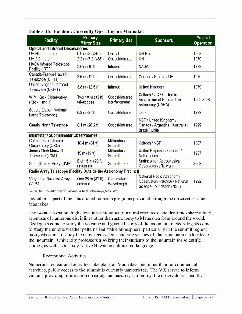
Section 3.10 – Land Use Plans, Policies, and Controls Final EIS: TMT Observatory Page 3-151
Table 3-15: Facilities Currently Operating on Maunakea
Facility Primary Mirror Size Primary Use Sponsors Year of
Operation Optical and Infrared Observatories UH Hilo 0.9-meter 0.9 m (3 ft/36”) Optical UH Hilo 1968 UH 2.2-meter 2.2 m (7.2 ft/88”) Optical/Infrared UH 1970 NASA Infrared Telescope Facility (IRTF) 3.0 m (10 ft) Infrared NASA 1979
Canada-France-Hawai‘i Telescope (CFHT) 3.6 m (12 ft) Optical/Infrared Canada / France / UH 1979
United Kingdom Infrared Telescope (UKIRT) 3.8 m (12.5 ft) Infrared United Kingdom 1979
W.M. Keck Observatory (Keck I and II)
Two 10 m (33 ft) telescopes
Optical/Infrared interferometer
Caltech / UC / California Association of Research in Astronomy (CARA)
1992 & 96
Subaru (Japan National Large Telescope) 8.2 m (27 ft) Optical/Infrared Japan 1999
Gemini North Telescope 8.1 m (26.2 ft) Optical/Infrared NSF / United Kingdom / Canada / Argentina / Australia / Brazil / Chile
1999
Millimeter / Submillimeter Observatories Caltech Submillimeter Observatory (CSO) 10.4 m (34 ft) Millimeter /
Submillimeter Caltech / NSF 1987
James Clerk Maxwell Telescope (JCMT) 15 m (49 ft) Millimeter /
Submillimeter United Kingdom / Canada / Netherlands 1987
Submillimeter Array (SMA) Eight 6 m (20 ft) antennas Submillimeter Smithsonian Astrophysical
Observatory / Taiwan 2002
Radio Array Telescope (Facility Outside the Astronomy Precinct)
Very Long Baseline Array (VLBA)
One 25 m (82 ft) antenna
Centimeter Wavelength
National Radio Astronomy Observatory (NRAO) / National Science Foundation (NSF)
1992
Source: UH IfA, (http://www.ifa.hawaii.edu/mko/telescope_table.htm)
any other as part of the educational outreach programs provided through the observatories on Maunakea.
The isolated location, high elevation, unique set of natural resources, and dry atmosphere attract scientists of numerous disciplines other than astronomy to Maunakea from around the world. Geologists come to study the volcanic and glacial history of the mountain; meteorologists come to study the unique weather patterns and stable atmosphere, particularly in the summit region; biologists come to study the native ecosystems and rare species of plants and animals located on the mountain. University professors also bring their students to the mountain for scientific studies, as well as to study Native Hawaiian culture and language.
Recreational Activities
Numerous recreational activities take place on Maunakea, and other than for commercial activities, public access to the summit is currently unrestricted. The VIS serves to inform visitors, providing information on safety and hazards, astronomy, the observatories, and the

Page 3-152 Final EIS: TMT Observatory Section 3.10 – Land Use Plans, Policies, and Controls
natural and cultural resources of Maunakea. Figure 3-33 illustrated the parking and restroom facilities available to the public to facilitate recreation activities in the summit region.
Figure 3-33: Parking and Restroom Facilities in the MKSR
Sightseeing & Stargazing. Numerous visitors come to Maunakea each year to sightsee, view the stars, and tour the world-class observatories. The VIS offers guided tours of the summit that include a stop in at least one observatory and a stargazing program at Hale Pōhaku where visitors are able to view the stars through a telescope while guided by a staff member. Visitors also have the opportunity to use their private vehicles to explore the summit. Summit access by private vehicles may be restricted due to high volume of traffic, safety, or other concerns. “Off-roading” recreational activities are not allowed in the MKSR or the NAR. Trails at lower elevations
Section 3.10 – Land Use Plans, Policies, and Controls Final EIS: TMT Observatory Page 3-153
provide additional access points to the mountain. In mid 2007, DOFAW opened up two existing trails to off-highway recreational use. Both trails are used by hikers, mountain bikers, ATVs, hunters, motorcycles, horses, and 4-wheel-drive vehicles.
Hiking. The unique topography, location, and views draw many hikers to Maunakea. Hikers typically drive up the mountain for a distance before parking and hiking. Hikers are encouraged to register at the VIS and check back in once they have completed their hike. The Maunakea – Humu‘ula Trail is accessible from the VIS. There are no camping facilities within the MKSR or Hale Pōhaku. There are a few established, but unmarked, trails in the summit region and other trails at lower elevations. According to OMKM, there were a total of 5,718 hikers on Maunakea in 2007.
Skiing and Snow Play. Weather patterns dictate where snow related activities can take place, but when snow does fall it typically covers the northern slope of Kūkahau‘ula (Pu’u Hau‘oki and the unnamed pu‘u) first and remains there the longest. However, snow play activities are generally concentrated in the “Poi Bowl” area immediately east of the CSO, which is a southern facing slop of Kūkahau‘ula. The Mauna Kea Access Road is kept clear of snow by MKSS, and provides access to skiing and other winter activities on the summit. The ski run known as Poi Bowl is the most popular ski area because it is accessible by roads at both the top and the bottom of the run. If snowfall is heavy enough, the area to the east of the summit, known as King Kamehameha run, can be used for longer ski runs. However, as the bottom of the run is not accessible by vehicles, skiers must hike back to a roadway. At times it is possible to ski from the summit to the edge of the MKSR. Based on the CMP, rangers are now to restrict snow-play activities to areas with a layer of snow deep enough to provide protection to resources – determined to be a minimum of eight inches deep.
Hunting. Hunting may often be viewed as a recreational activity, but can also be viewed as part of the culture and subsistence of area residents. There are approximately 3,000 licensed hunters living on the island. Pigs, sheep, goats, and a variety of game birds, including turkeys, pheasants, quails, chukars, and francolins are hunted in the 36 hunting units concentrated in the central portion of the island. The Mauna Kea Forest Reserve, from an elevation above 7,000 feet, is a hunting unit where game may be hunted with bow and arrows and firearms.
Commercial Uses
Commercial Tours. Commercial tours bring visitors to the mountain to view the summit area. Most tour operators entertain visitors on six to eight-hour trips that can include an observatory tour and dinner, along with narratives on the area’s vegetation and natural history. OMKM issues a limited number of Commercial Activity Permits to tour operators and these tour operators must register at Hale Pōhaku each time they ascend the mountain. On average, there are 302 commercial operator trips to the summit per month (OMKM, 2009). During evening, or sunset, tour companies are limited to two vehicles each with up to 14 customers per vehicle. Currently there are nine tour companies permitted to operate with UH Management Areas. Commercial tours are not allowed to lead hikes to Lake Waiau within the Ice Age NAR and OMKM has requested that commercial tours not lead hikes to the summit of Pu‘u Wēkiu,
Filming. Because of Maunakea’s unique natural landscape, commercial film activities are popular on the mountain. Film activities, including still photography, video, digital cameras, and high definition digital recordings that will be performed for the purpose of sale, video

Page 3-154 Final EIS: TMT Observatory Section 3.10 – Land Use Plans, Policies, and Controls
production, or television transmission must first acquire a permit from OMKM and the State of Hawai‘i Film Office.
Headquarters
University Park is home to a number of observatory headquarters, including UKIRT, JCMT, CSO, Subaru, Gemini, and IfA, as well as the ‘Imiloa Astronomy Center, the U. S. Department of Agriculture’s Institute for Pacific Island Forestry, and the Komohana Agricultural Complex. The College of Pharmacy and the College of Hawaiian Language are currently either being built or planned.
The County of Hawai‘i General Plan notes that the UH Hilo Long Range Development Plan, which was last updated in 1996, emphasizes the “spine” concept that organizes all campus structures along a main pedestrian access way, which Nowelo Street provides. The Land Use Pattern Allocation Guide (LUPAG) within the General Plan indicates University Park is classified as University Use.
County of Hawai‘i zones a portion of University Park as Agricultural District with a minimum building site of 1 acre (A-1a) and a portion as Single-family Residential District with a minimum building site area of 10,000 square feet (RS-10). A new University District zoning category was approved by the County Council per Hawai‘i County Ordinance No 07-104, effective August 1, 2007. UH Hilo may include the University Park area in an application for a change of zone to this more appropriate district at some time in the future. University Park is not within the County’s special management area.
3.10.2 Thresholds Used to Determine Level of Impact In accordance with the Chapter 343 significance criteria, impact is considered to be significant if the Project would conflict with the adopted applicable land use plans and policies and /or state land use policies or goals and guidelines as expressed in Chapter 344 HRS.
3.10.3 Potential Environmental Impacts The potential impacts of the Project are evaluated within the framework of compliance with all applicable rules, regulations, and requirements for the project type and location.
Consistency with Land Use Plans, Policies, and Controls
The following sections examine the Project’s compliance with applicable land use plans and policies.
Chapter 343, Hawai‘i Revised Statutes
HRS Chapter 343, the State of Hawai‘i EIS Law, requires that any proposed use within a Conservation District be subject to review. As part of this review, this EIS has been prepared to ensure that environmental concerns are given appropriate consideration in decision making, along with economic and technical considerations.
Section 3.10 – Land Use Plans, Policies, and Controls Final EIS: TMT Observatory Page 3-155
Chapter 344, State Environmental Policy
Like all other uses on Maunakea, the Project will abide by the guidelines promulgated by HRS §344-4(1)–(10), including, but not limited to, encouraging management practices which conserve natural resources, protection of endangered species of indigenous plants and animals, adoption of guidelines to alleviate environmental degradation caused by motor vehicles, and encouraging the efficient use of energy resources.
Chapter 205, State Land Use Law
The Project, an astronomical observatory, is an allowable identified use within the resource subzone (HAR §13-5-24) of a Conservation District (HRS §205-2), and consistent with the objectives of the resource subzone.
Hawai‘i State Plan
The Project will contribute to the diversification of the State’s economic base by generating economic benefits associated with a stable, high technology industry, protecting significant natural, cultural, and historic sites on Maunakea; and providing for educational access to the its facilities, thereby supporting research programs and activities that enhance the education programs of the State. The combination of generating new revenues to the state and local economies, providing new and stable employment opportunities, and enhancing educational opportunities will enhance the quality of life as well as the community and social well-being on the island. Therefore, the Project will be consistent with the Hawai‘i State Plan objectives.
1983 Master Plan
The Project is an optical/infrared telescope facility that will be located in an area identified as Area D in the 1983 Master Plan. The Master Plan states “Area D is highly suitable for future major optical/infrared telescopes. It can accommodate three to four telescopes, on the flatter portions, with some flexibility in choice of sites based on technical site selection criteria such as laminar wind flow and obscuration.” The plan indicates the following development considerations for projects in Area D:
• Due to geotechnical concerns, telescopes should be located at least 100 feet from the boundary between two lava flows.
• Future observatory sites must be carefully planned to minimize disturbance to a variety of lichens.
• If observatories are sited in close proximity to two archaeological sites in the northern portion of Area D, then archaeological mitigation, as specified by the State Historic Preservation Officer, will be required.
• The access road in the area should be improved and paved and necessary utilities placed underground.
The TMT Observatory will be located more than 800 feet from the boundary between lava flows, has been planned to minimize disturbance to lichens (Section 3.4.3), and is located at least 200 feet from the archaeological sites (Section 3.3.3). The TMT Access Way will improve the existing road and place necessary utilities underground; however, only a portion of the Access

Page 3-156 Final EIS: TMT Observatory Section 3.10 – Land Use Plans, Policies, and Controls
Way will be paved. A portion of the Access Way will not be paved because since the preparation of the 1983 Master Plan policy makers have preferred leaving lesser-traveled roads unpaved.
2000 Mauna Kea Science Reserve Master Plan
The Master Plan goals are to protect natural resources, protect historic and Hawaiian cultural resources and practices, protect and enhance education and research, and protect and enhance recreational opportunities. The Project is an astronomical observatory facility which is a land use consistent with the guidelines for future development in the Astronomy Precinct. The Project is a 30-meter aperture telescope that meets the definition of the NGLT envisioned in the 2000 Master Plan. The primary land use policy applicable to the TMT Observatory is that it should be located in Area E. The Project’s location is in Area E, consistent with this land use policy.
The 2000 Master Plan also set forth many design guidelines for observatories and support buildings. The following sections discuss the Project’s design characteristics and their consistency with the guidelines. The Project’s compliance with the design guidelines and land use policies laid out in the 2000 Master Plan will be monitored and evaluated through the OMKM design review and approval process (Section 3.19, Required Approvals and Permits).
TMT Observatory and Access Way
The preliminary design concept for the NGLT in the 2000 Master Plan was to employ a sliding dome mirror enclosure and a sub-grade foundation, with the lower half of the observatory below grade to minimize the apparent height and mass of the facility. However, it has been determined that placing the telescope mirror below grade would significantly limit the area of the sky that could be viewed. In addition, the subsurface location would suffer because the air near the ground is more turbulent and dusty; and this would degrade the quality of images obtained by the telescope. Furthermore, the volume of rock that would need to be excavated, on the order of 70,000 cubic yards, runs counter to new OMKM policies to reduce the movement of rock. It would also make it more difficult to decommission the observatory per new OMKM policies due to the amount of material excavated. Therefore, the TMT Observatory design places the primary mirror roughly 66 feet above the ground surface in order to minimize these adverse effects. As discussed in Section 2.5.1, TMT Observatory Design, and detailed in Section 3.5, Visual and Aesthetic Resources the TMT Observatory has been designed as to minimize the above-grade height and total width to the extent possible.
It was also suggested in the 2000 Master Plan that the half of the NGLT observatory above grade be shaped and colored to simulate a pu‘u to blend with the landscape. Because the TMT Observatory’s primary mirror will be located above ground, the shape of the above-ground enclosure could not be made to be shaped like a pu‘u unless it covered a much larger area. Such a structure would not be feasible because it would disturb the cultural and natural resources to a significantly larger extent than the proposed design. As stated, the rotating dome of the TMT Observatory will have a reflective aluminum-like coating. This color was selected because it appears to blend with the natural environment year-round better than white or mottled brown (see Section 3.5, Visual and Aesthetic Resources), and it reduces energy use relative to using a mottled brown color.

Section 3.10 – Land Use Plans, Policies, and Controls Final EIS: TMT Observatory Page 3-157
Consistent with the design goals, the Project design keeps the support facilities in the summit area to a minimum and includes terracing, whereby the components of the facility are located on three ascending levels, to match the natural contours of the site. The site will be graded so that much of the base and office structure be built blending into the existing slopes to minimize the disturbance to the existing landform and visual impact from both the summit and off-mountain areas. This design maximizes the use of the natural landform. Since the Draft EIS was completed, the support facility attached to the observatory dome has been significantly reduced in size and limited to one level so that terracing is no longer needed. Also, the observatory dome structure will be shaped using curved forms, rather than angular geometries to further minimize impact. The building attached to the dome will use materials, colors, and patterns to blend into the mottled red and brown tones of the surrounding landscape. All concrete utility boxes and other miscellaneous structures will be lava-colored.
The parking area will be built into the existing southern slopes, and designed to retain any natural landforms present to the extent possible.
The Access Way will be located along an existing roadway and designed to minimize slope cutting. The utility corridor will be located within the Access Way to minimize disturbance, and all utility lines will be buried to minimize interference with the natural landscape.
Hale Pōhaku
The potential TMT Mid-Level Facility at Hale Pōhaku could consist of buildings a maximum of two stories tall, and designed to appear like one story structures through the use of techniques such as building into attic spaces, as the existing buildings have done. The design, architecture, color, and materials used at Hale Pōhaku would be compatible with those used in existing facilities and serve to merge the new facility into the natural landscape. Wood and other native plant materials may be used as appropriate to relate the facility to the natural and cultural setting. Also, particularly steep areas would be avoided to minimize the potential for erosion or the interruption of drainage patterns in the area. Parking areas would be designed to fit into the existing landscape and sensitive to the existing topography of the area. Also, vegetation or natural landforms would be incorporated into the site design and retained to the extent feasible.
Mauna Kea Comprehensive Management Plan (CMP)
On April 9, 2009, the BLNR approved the CMP, subject to conditions. One condition was that within one year of the BLNR’s approval of the CMP, or the submission of a Conservation District Use Application (CDUA), whichever occurs sooner, UH shall submit for review and approval the following sub plans:
1. A Cultural Resources Management Plan. OMKM has developed a CRMP that identifies the resources, threats to the resources, and management actions to protect and preserve the cultural resources. Management actions contained in the CRMP are consistent with the CMP, in particular, Management Actions CR-1 to CR-14.
2. A Natural Resources Management Plan (NRMP). OMKM has developed a NRMP that, like the CRMP, identifies the resources, threats to the resources, and management actions to protect and the preserve the natural resources. Management actions contained in the NRMP are consistent with the CMP, in particular Management Actions NR-1- to NR-18).

Page 3-158 Final EIS: TMT Observatory Section 3.10 – Land Use Plans, Policies, and Controls
3. A Decommissioning Plan (DP). OMKM will be developing has developed a plan that describes the process for the decommissioning of observatories. This plan addresses the removal of observatory facilities and site restoration and a requirement that all existing observatories commit to complying with the conditions of their existing subleases and to a financial plan for meeting the costs of decommissioning and site restoration. It also includes a discussion on developing cost estimates and obtaining financial funding mechanisms that will provide assurances that there will be sufficient funds to carry out decommissioning activities. The provisions described in the DP may be incorporated into new or renegotiated subleases. The DP is consistent with the CMP, in particular, Management Actions SR-1 to SR-3 and FLU-3.
4. A Public Access Plan (PAP). OMKM has initiated the development of a public access plan. The goal of the plan is to protect the resources, protect the health and safety of people visiting Maunakea and accommodate access for those wishing to engage in their traditional and customary practices. The plan will be consistent with access provisions of existing rules and regulations and with the constitutionally protected right to access to engage in traditional and customary practices. OMKM has developed a PAP, the purpose of which is to provide guidance in addressing public access in full cooperation with DLNR’s authority over public access and activities within UH’s management areas. The PAP contains a set of principles and policies that will guide UH in the development of management actions relating to public and commercial activities and eventual development of administrative rules. The PAP recognizes Maunakea is part of the public lands trust, held in trust for Native Hawaiians and the general public and must be managed as a public resource. It recognizes that Native Hawaiians’ exercise of traditional and customary practices are legally and constitutionally protected and safe accommodation shall be provided subject to reasonable governmental regulation. The highest management priorities are health and safety and the protection of resources. The CMP contains provisions for access, in particular, Management Actions ACT-1 to ACT-12. The CMP also includes access provisions of the BLNR-approved 1995 Management Plan which has been incorporated into the CMP.
Prior to the submission of the Project’s CDUA, UH submitted those four plans to BLNR and they were approved by BLNR on March 25, 2010. The CMP and sub plans identify the management actions necessary to address the various management needs of the full range of uses on Maunakea. The Project will ensure that all requirements of the CMP and sub plans are met by including those requirements in the facility siting, design standards, features, and operational procedures, and by developing and implementing the mitigation measures outlined in this EIS.
In addition, the Project will comply with the BLNR’s requirement that no CDUA be submitted prior to UH completing the four sub plans.
The TMT acknowledges, would has adopted, and will comply with all relevant provisions in the CMP and the four sub plans.
County of Hawai‘i General Plan
Consistent with the General Plan, the Project will contribute to the field of astronomy, which has become one of Hawai‘i’s best known industries. Consistent with the General Plan, the Project will contribute to the Plan’s support of the continued expansion of the University system and the

Section 3.10 – Land Use Plans, Policies, and Controls Final EIS: TMT Observatory Page 3-159
UH Hilo campus and encouraging educational programs throughout the community. Also included is policy to encourage the implementation of existing State and University of Hawai‘i plans for the continued development of the University Park “Research and Technology Park” on the UH Hilo campus. The Project will avoid impacts to historic and natural resources.
Consistency Summary
Overall, since the Project will be consistent with all applicable land use regulation and will not conflict with the applicable land use plans, it will not result in a significant land use planning impact in the State of Hawai‘i or on the Island of Hawai‘i. The Project will develop and implement a range of plans and programs, outlined in this EIS, including a Cultural and Natural Resources Training Program (Sections 3.2.3, 3.3.3, and 3.4.3), Invasive Species Prevention and Control Program (Section 3.4.3), WMP (Section 3.8.3) and component annual energy audit, a Materials Storage/Waste Management Plan and component SPRP (Section 3.8.3), and Ride-Sharing Program (Section 3.11.4) to ensure ongoing compliance.
TMT Observatory Sublease
The building and operation of the TMT Observatory on Maunakea will require a sublease from UH, which leases this ceded land from the DLNR. The sublease will be subject to approval first by the TMT Board and UH BOR followed by approval by the BLNR. Although a sublease is required, there is no specific template of required terms of the sublease. Traditionally, the terms of the sublease between UH and observatories have included observing time for UH (up to 15 percent) and payment of a pro-rata share of common costs of operating the observatories on Maunakea. Based on preliminary discussions between UH and TMT relating to a sublease for the TMT Observatory, it is generally anticipated that any sublease may include terms similar to those listed below.
• Sublease rent that will commence upon the TMT Observatory’s first scientific observations and continue for the term of the sublease or until observatory decommissioning, whichever is sooner. The lease rent shall consist of an annual payment, to be deposited into the Mauna Kea lands management special fund and used for the purposes set forth in HRS § 304A-2170. This dollar amount will be adjusted annually using an appropriate inflation index (the baseline from when the inflation index will be applied will be the subject of negotiation and specified in the sublease).
• TMT Observatory observing time will also be provided to UH.
• The TMT Observatory Corporation shall pay its pro-rata share of common costs of operating observatories on Maunakea and shall contribute toward the costs of development of additional Maunakea infrastructure. These funds shall first be applied to fund the upgrade of electrical power to the summit, including upgrades to the substation at Hale Pōhaku and new power cables from there to near the summit, and for the extension of the road and utilities to the TMT site.
The sublease will be negotiated after the Project receives a CDUP and will be consistent with the existing Master Lease between UH and the BLNR, adopted under HRS Chapter 171. The sublease consideration would likely include benefits for the Island of Hawai‘i, as well as observing time for UH.

Page 3-160 Final EIS: TMT Observatory Section 3.10 – Land Use Plans, Policies, and Controls
The current UH lease expires in 2033 and the TMT Observatory will be required to be decommissioned and restore the site at that time, unless a new lease is obtained from the BLNR.
It is very probable that TMT, along with some of the existing observatories, would request UH seek a new lease beyond 2033. Any lease negotiations would be subject to BLNR approval at a publicly noticed meeting under HRS Chapter 171. It is also very probable that any lease negotiations would generate considerable public discussion on the issue of compensation for the use of State ceded lands, including appropriate distribution to the Office of Hawaiian Affairs (OHA). However, any discussion of lease negotiations would be at the discretion of UH and BLNR.
Compatibility with Existing Uses
The Project staff will be trained to not interfere with cultural and religious practices, and the Project would not impede any traditional cultural or religious practices. The Project will benefit the educational uses of the mountain by providing the most advanced tool for astronomical research in the world and providing opportunities for the public to visit and learn about the high-technology science taking place and the discoveries made.
Recreational and commercial uses will not be significantly impacted by the Project. No hiking trails will be affected and the TMT Observatory and Access Way are outside of snow play areas. The Project is anticipated to result in a beneficial effect on tourism, stargazing, and sightseeing since people may want to see the world’s most advanced observatory and the most powerful ground based telescope on earth. However, others may perceive the TMT Observatory differently and, therefore, choose not to visit the summit region.
Because the Access Way will be near the core of the SMA facility, dust from Project vehicles could collect on the SMA antennas and potentially impact the operations of the SMA. The Project is sufficiently removed from other observatories so that they will not be impacted by the Project.
Overall, the Project will not result in a significant impact on current land use in the MKSR or Hale Pōhaku, both of which are located within the Conservation District, resource subzone. Similarly, the development of the Headquarters in Hilo will not cause a significant impact to existing land uses. Overall, the Project will be in compliance with HRS Chapter 344 and other applicable land use plans, policies, or controls. Therefore the Project will not result in a significant adverse land use impact.
The Project’s potential uses of Hale Pōhaku will be consistent with existing uses, including the use of the lower portion of Hale Pōhaku for star gazing by tour groups. However, a small portion of the Keck construction-phase facilities at Hale Pōhaku that may be replaced are currently used for storage by VIS personnel and the Subaru cabins that may be remodeled are currently used by rangers, VIS staff, and volunteers. Upon completion of Project construction, the management of the potential TMT Mid-Level Facility, if built, would fall to MKSS. The potential TMT Mid-Level Facility could ultimately serve to improve the space available for the current uses.
Section 3.10 – Land Use Plans, Policies, and Controls Final EIS: TMT Observatory Page 3-161
3.10.4 Mitigation Measures The Project will comply with existing regulations and requirements, which will reduce potential impacts as discussed above. Compliance with regulations and requirements will require that TMT develop and implement the various plans and programs outlined in this EIS, such as a Cultural and Natural Resources Training Program (Sections 3.2.3, 3.3.3, and 3.4.3), Invasive Species Prevention Plan (Section 3.4.3), WMP (Section 3.8.3) and component annual energy audit, a Materials Storage/Waste Management Plan and component SPRP (Section 3.8.3), and Ride-Sharing Program (Section 3.11.4).
The building and operation of the TMT Observatory on Maunakea would require a sublease from UH, which leases this ceded land from the DLNR. The sublease, to include higher education and community benefit packages for the Island of Hawai‘i community, as well as observing time for UH, would be negotiated. The higher education and community benefit packages would become a part of a lease or sublease, if TMT decides to come to Hawai‘i. Provided an agreement is reached, details of the benefit packages will be described in the Final EIS.
The terms of the sublease between UH and the TMT Observatory Corporation, other than observing time and payment of common costs, are considered a mitigation measure. Therefore, the annual sublease rent, deposited into the Maunakea lands management special fund and used for the purposes set forth in HRS § 304A-2170, is considered a mitigation measure. These funds could be used, according to HRS § 304A-2170 to:
• Manage Maunakea lands within the UH Management Area, including maintenance, administrative expenses, salaries and benefits of employees, contractor services, supplies, security, equipment, janitorial services, insurance, utilities, and other operational expenses; and
• Enforcing administrative rules adopted relating to the UH Management Area of Maunakea.
Therefore, the Maunakea lands management special fund, including the TMT sublease rent, could be utilized to fund OMKM and its implementation of the CMP.
In addition, an approximately 300 750 foot long portion of the Access Way will be paved to mitigate the potential impact to the SMA observatory due to dust from vehicles traveling on the Access Way near the core of the SMA. The paved section will extend from the current end of pavement near the SMA building to a location north of the SMA core. The Project may also coordinate the replacement and remodeling of the Keck construction dorms and Subaru construction cabin facilities with those currently using them. Arrangements would be made, in coordination with OMKM and MKSS, to address (a) continued access to similar office, storage and presentation spaces during TMT construction either in the potential TMT Mid-Level Facility or elsewhere at Hale Pōhaku, and (b) the possible future reuse of the potential TMT Mid-Level Facility for the needed space and uses following TMT construction.
3.10.5 Level of Impact after Mitigation The implementation of the mitigation measures identified will serve to further reduce any potential impacts the Project may have on land use.

Page 3-162 Final EIS: TMT Observatory Section 3.10 – Land Use Plans, Policies, and Controls
3.10.6 References County of Hawai‘i Planning Department. 2005. County of Hawai‘i General Plan. Website:
http://www.hawaii-county.com/la/gp/2005/main.html. Accessed January 18, 2009.
DAGS, 1997. University of Hawai‘i at Hilo University Park Final Environmental Impact Statement, Hilo, Hawaii. TMK: 2-4-01: 7, 12, 19, 41and 2-4-03: 26. Prepared by Engineering Concepts, Inc. for DAGS. September 1997.
DLNR, 1997. Management Policies of the Natural Area Reserves System. Natural Area Reserves System Commission, Division of Forestry and Wildlife, Department of Land and Natural Resources, State of Hawai‘i. Website: http://plonedev.hawaii.gov/dlnr/dofaw/nars/NARS%20Management%20Policies%20no%20appendices.pdf. Accessed February 9, 2009.
National Aeronautics and Space Administration (NASA). 2005. Final Environmental Impact Statement for the Outrigger Telescopes Project¸ National Aeronautics and Space Administration, Universe Division, Science Mission Directorate, Washington, D.C.
Office of Mauna Kea Management (OMKM), 2010b. Public Access Plan for the UH Management Areas on Mauna Kea; A Sub-Plan of the Mauna Kea Comprehensive Management Plan. January 2010. Prepared by Sustainable Resources Group International, Inc., Island Planning, and Island Transitions, LLC, approved by BLNR on March 25, 2010.
OMKM, 2010a. Decommissioning Plan for Mauna Kea Observatories; A Sub-Plan of the Mauna Kea Comprehensive Management Plan. January 2010. Prepared by Sustainable Resources Group International, Inc., approved by BLNR on March 25, 2010.
OMKM, 2009b. A Cultural Resource Management Plan for the University of Hawai‘i Management Areas on Mauna Kea, Ka‘ohe Ahupua‘a, Hāmākua District, Island of Hawai‘i, State of Hawai‘i. TMK: (3) 4-4-015: 09, 12; A Sub-Plan for the Mauna Kea Comprehensive Management Plan. October 2009. Prepared by Pacific Consulting Services, Inc., approved by BLNR on March 25, 2010.
OMKM, 2009a. Natural Resources Management Plan for the UH Management Areas on Mauna Kea; A Sub-Plan of the Mauna Kea Comprehensive Management Plan. September 2009. Prepared by Sustainable Resources Group International, Inc., approved by BLNR on March 25, 2010.
OMKM. 2009. OMKM Ranger Report, Reports: 366. May 8, 2009.
University of Hawai‘i (UH), 2009c. Draft Environmental Impact Statement, Thirty Meter Telescope Project, Island of Hawai‘i. Proposing Agency University of Hawai‘i at Hilo. May 23, 2009.
UH, 2009b. Mauna Kea Comprehensive Management Plan Final Environmental Assessment. Prepared by Pacific Consulting Services, Inc. for UH. April 2009.
UH, 2009a. Mauna Kea Comprehensive Management Plan. January, 2009. Approved by BLNR on April 9, 2009.

Section 3.10 – Land Use Plans, Policies, and Controls Final EIS: TMT Observatory Page 3-163
UH, 2008. Environmental Impact Statement Preparation Notice / Environmental Assessment, Thirty Meter Telescope Project, Mauna Kea Northern Plateau and Hale Pōhaku, Island of Hawai‘i, TMK 4-4-15: 9 and 12. Proposing Agency University of Hawai‘i at Hilo. September 23, 2008.
UH, 2005. Mauka Lands Master Plan Final Environmental Impact Statement TMK 2-4-01: 122. Prepared by PBR Hawai‘i for UH. February 2005.
UH, 2000. Mauna Kea Science Reserve Master Plan. Available on the web http://www.hawaii.edu/maunakea/. Prepared by Group 70 International, Inc., adopted by the UH Board of Regents on June 16, 2000.
UH, 1999. Mauna Kea Science Reserve Master Plan Final Environmental Impact Statement. Prepared by Group 70 International Inc. for UH. December 1999.
UH, 1983a. Mauna Kea Science Reserve: Complex Development Plan. Prepared by Group 70 International, Inc. for Research Corporation of the University of Hawai‘i. February 1983 (amended May 1987).
UH, 1983b. Mauna Kea Science Reserve: Complex Development Plan Final Environmental Impact Statement. Prepared by Group 70 International, Inc. for Research Corporation of the University of Hawai‘i. January 1983.
UH Hilo, Department of Geography. 1998. Atlas of Hawai‘i. 3rd ed. Honolulu: University of Hawai‘i Press.
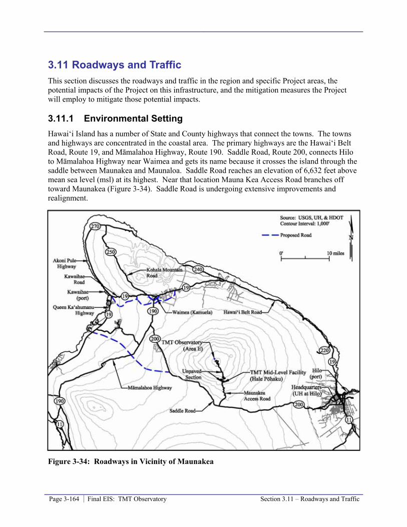
Page 3-164 Final EIS: TMT Observatory Section 3.11 – Roadways and Traffic
3.11 Roadways and Traffic This section discusses the roadways and traffic in the region and specific Project areas, the potential impacts of the Project on this infrastructure, and the mitigation measures the Project will employ to mitigate those potential impacts.
3.11.1 Environmental Setting Hawai‘i Island has a number of State and County highways that connect the towns. The towns and highways are concentrated in the coastal area. The primary highways are the Hawai‘i Belt Road, Route 19, and Māmalahoa Highway, Route 190. Saddle Road, Route 200, connects Hilo to Māmalahoa Highway near Waimea and gets its name because it crosses the island through the saddle between Maunakea and Maunaloa. Saddle Road reaches an elevation of 6,632 feet above mean sea level (msl) at its highest. Near that location Mauna Kea Access Road branches off toward Maunakea (Figure 3-34). Saddle Road is undergoing extensive improvements and realignment.
Figure 3-34: Roadways in Vicinity of Maunakea
Section 3.11 – Roadways and Traffic Final EIS: TMT Observatory Page 3-165
Maunakea Summit Region and Hale Pōhaku
Access to Hale Pōhaku and Maunakea is from the Mauna Kea Access Road off Saddle Road discussed above. From Saddle Road past Hale Pōhaku, Mauna Kea Access Road extends to near the summit and loops along the Pu‘u Kea, Pu‘u Hau‘oki, and an unnamed pu‘u cinder cones to reach the existing observatories. The Mauna Kea Access Road is 16.3 miles long, has two lanes, guard rails in places, limited shoulders, and slopes up to 20 percent. Hale Pōhaku is approximately 6 miles up Mauna Kea Access Road from Saddle Road, and the 4.6 mile long segment just past Hale Pōhaku is unpaved. The road is paved again above 11,600 feet. A portion of the loop is unpaved between the Keck Observatory and the SMA.
The existing observatories have mostly short paved or unpaved driveways off the main road. The unpaved SMA service roadways are the most extensive roads other than the main Mauna Kea Access Road. One branch of the SMA road extends toward Area E. Where the SMA road ends, an unimproved 4-wheel drive trail extends into and runs through the middle of Area E to the 13N site, where it ends.
In 1994, the average daily traffic (ADT) on Saddle Road was 900, in 2006 the ADT was 1,150, and the ADT is projected to grow to 14,000 7,791 by 2014 2031. Saddle Road is undergoing extensive improvements and realignment in order to service the forecast increase in ADT. Construction work north of the Mauna Kea Access Road is ongoing. Southern portions of the project have been complete but modifications to the plan are ongoing for the section north of mile post 42, which is north of the Mauna Kea Access Road intersection.
In 2008, observatory-related trips accounted for roughly 11,800 trips, visitors for 13,700 trips, and commercial operators for 5,200 trips. A 4-wheel drive vehicle is recommended, but not required, for trips beyond Hale Pōhaku on Mauna Kea Access Road. That is an average of 32 observatory trips and 52 other trips per day, or roughly seven percent of the 2006 ADT on Saddle Road. Observatory trips counts include two potable water deliveries per week and one trip per month to remove mirror washing wastewater. There is a possibility that the number of trips from existing observatories will decline as remote access and control of the telescopes continues to improve. More astronomers are likely to access data and control telescopes remotely, reducing the number of trips to the observatories.
Vehicle and visitor traffic to the summit may be particularly high on snow days, especially when they fall on weekends. Many people, especially local residents, visit the mountain only when there is snow. During the nineteen days documented by OMKM Rangers as snow days in 2007, a total of 2,547 vehicles were recorded on the mountain (134 per day). On days following heavy snow fall in 2008, OMKM Rangers estimated the summit region’s daily vehicle count to be between 400 and 600 (OMKM 2010b). Presently, during periods of heavy snow, Rangers keep the road closed at Hale Pōhaku until they receive confirmation that conditions are safe for visitors to precede up the mountain. Even though UH could restrict traffic on the Mauna Kea Access Road, the road is not closed or limited to daylight hours.
There is no data available for the number of vehicles making the trip from Saddle Road to Hale Pōhaku via the Mauna Kea Access Road, but is likely that it is more than double the number proceeding beyond Hale Pōhaku to the summit, as this accounts for the people that work at Hale Pōhaku and visitors that go the VIS but do not proceed to the summit.
Page 3-166 Final EIS: TMT Observatory Section 3.11 – Roadways and Traffic
There are three visitor parking areas along the Mauna Kea Access Road above Hale Pōhaku. Parking Area 1 is located just after the paved road begins; Parking Area 2 is near the trailhead to Lake Waiau; and Parking Area 3 is just past the junction of the access road and the summit loop, and is also known as the Batch Plant Staging Area (Figure 3-33). These areas are shown on the map included in the safety brochure available to workers and visitors, but are not identified by signage on-site. At the summit, many visitors park near the UH 2.2-meter observatory if they plan to hike the summit trail. During the winter, before roads are fully cleared of snow and when there are large numbers of private vehicles in the summit area, parking becomes congested and visitors park their vehicles along the road wherever there is space. Commercial tour vehicles usually park in the area around the UH 2.2-meter observatory and Gemini observatory during the sunset viewing times. Observatory vehicles park in designated areas near their buildings. Parking Areas 1 and 2 are paved, though most parking areas are graded but unpaved.
There are three main parking areas at Hale Pōhaku (a) the cafeteria parking lot, (b) the dormitory parking lot, and (c) the VIS parking lot. There are other unpaved areas used for parking, including an area used by tours across the road from the VIS.
Headquarters
Komohana Street is a two-lane county roadway and serves as one of several major cross-town roads. Nowelo Street runs in an east-west direction and provides the main entry to University Park from Komohana Street (Figure 2-11). The intersection of Komohana Street with Nowelo Street includes auxiliary turn lanes. A‘ohōkū Street and ‘Imiloa Place run parallel to Komohana Street and provide access to the lots within the makai portion of University Park. All roads within University Park are paved with asphalt concrete and have concrete gutters, curbs, and sidewalks. Many of the secondary roads planned for the University Park mauka area have not been built yet.
3.11.2 Thresholds Used to Determine Level of Impact In accordance with the Chapter 343 significance criteria, the Project would result in a significant impact if it involves a substantial degradation of environmental quality. Therefore, the Project impact would be considered to be significant if it would increase traffic resulting in a substantial deterioration of traffic conditions and/or requiring additional road improvements beyond minor modifications at the access point and those already identified and planned for the region.
3.11.3 Environmental Impacts Approximately 50 TMT staff would work at the TMT Observatory; 44 during the day and 6 at night. It is expected that an average of 24 employees will work at the TMT Observatory during daytime operations, with a minimum of 15 and a maximum of 43 possible; nighttime operations will require an average of 6 employees at the facility. If each TMT Observatory staff member drove separately, this would result in 50 an average of 30 round trips a day to the TMT Observatory; however, this is very unlikely due to the wear and tear that would occur to individual’s vehicles. TMT staff will more likely share rides to access the TMT Observatory from the Headquarters, which will reduce the number of trips to the summit area, even if the Project did not require ride sharing. Roughly 2 additional round trips a day to the TMT Observatory will occur due to (a) the transport of equipment between the TMT Observatory and

Section 3.11 – Roadways and Traffic Final EIS: TMT Observatory Page 3-167
Headquarters, and (b) additional demand for potable water and wastewater pick-up, plus deliveries. The TMT Observatory will require a potable water delivery every five days, a domestic wastewater removal once every two days, and require mirror washing wastewater removal roughly once every month. This additional traffic will result in a maximum potential increase of 52 32 round trips a day, or a 62 38 percent increase over existing traffic volumes. However, traffic on the Mauna Kea Access Road will remain light at roughly 136 116 trips a day on a roadway that could accommodate many times that number of trips a day up to 110 vehicles per hour per lane and remain relatively congestion free based on information in the 2000 Highway Capacity Manual for a two-lane rural road in mountainous terrain. Therefore, it is expected that the associated impact will be negligible and less than significant.
The addition of TMT’s use of the facilities at Hale Pōhaku could result in a slight increase in the number of trips made by MKSS personnel. The Project’s potential impact on Saddle Road, the addition of up to 52 32 trips a day, represents roughly 4 3 percent of the current Saddle Road ADT and 0.3 0.4 percent of the projected ADT. With Saddle Road being improved to handle a projected ADT of 14,000 7,791, the Project will have a less than significant impact on traffic along Saddle Road.
Anticipated traffic associated with the approximately 60 116 employees at the Headquarters will not result in a significant traffic impacts or warrant additional road improvements in the area, other than those discussed above. Some of the staff will work off-peak hours to operate the telescope at night. The additional traffic generated by the staff will be negligible in relation to the existing traffic volumes, and will not lead to substantial congestion and/or deterioration of existing conditions, or a need for roadway improvements to provide additional capacity to accommodate Project-related traffic.
3.11.4 Mitigation Measures The Project will institute a Ride-Sharing Program for the TMT Observatory as well as the Headquarters employees. The program will be mandatory for TMT Observatory employees to travel beyond Hale Pōhaku, and will support ride sharing for Headquarters employees.
TMT Observatory personnel will meet at various locations around the island and travel to the summit in observatory vehicles. The locations will include the Headquarters and/or park-and-ride lots. There will be approximately 10 an average of 5 vehicles for the day shift and 2 for the night shift, with 5 people per vehicle. With the implementation of the Ride-Sharing Program for employees plus other trips (such as deliveries), it is estimated there will be an average of 14 9 trips to the TMT Observatory daily, an 17 11 percent increase over the existing number of trips beyond Hale Pōhaku.
TMT will also consider off-peak work hours for Headquarters personnel, if warranted, at the time of completion of the facilities.
3.11.5 Level of Impact after Mitigation Project impact level prior to mitigation will be less than significant. With the mitigation measures proposed, the less than significant level of impact will be further reduced.
Page 3-168 Final EIS: TMT Observatory Section 3.11 – Roadways and Traffic
3.11.6 References County of Hawai‘i. 2007. Waimea Traffic Circulation Study.
DAGS, 1997. University of Hawai‘i at Hilo University Park Final Environmental Impact Statement, Hilo, Hawaii. TMK: 2-4-01: 7, 12, 19, 41and 2-4-03: 26. Prepared by Engineering Concepts, Inc. for DAGS. September 1997.
State of Hawai‘i Department of Transportation (HDOT). 1999. Final Environmental Impact Statement, Saddle Road (State Route 200), Māmalahoa Highway (State Route 190) to Milepost 6.
HDOT. 2004. Environmental Impact Statement Preparation Notice, Hawai‘i Belt Road, Mud Lane to the Kamuela Racetrack (Waimea Bypass).
HDOT. 2007. Supplemental Environmental Impact Statement Preparation Notice, Saddle Road, (State Route 200), Māmalahoa Highway (State Route 190) to Milepost 42.
Office of Mauna Kea Management (OMKM), 2010b. Public Access Plan for the UH Management Areas on Mauna Kea; A Sub-Plan of the Mauna Kea Comprehensive Management Plan. January 2010. Prepared by Sustainable Resources Group International, Inc., Island Planning, and Island Transitions, LLC, approved by BLNR on March 25, 2010.
OMKM, 2009a. Natural Resources Management Plan for the UH Management Areas on Mauna Kea; A Sub-Plan of the Mauna Kea Comprehensive Management Plan. September 2009. Prepared by Sustainable Resources Group International, Inc., approved by BLNR on March 25, 2010.
OMKM. 2009. OMKM Ranger Report, Reports: 366. May 8, 2009.
Terry, Ron. 2009. Personal communication (regarding Saddle Road ADT). September 2, 2009.
Transportation Research Board (TRB). 2000. Highway Capacity Manual.
University of Hawai‘i (UH), 2009a. Mauna Kea Comprehensive Management Plan. January, 2009. Approved by BLNR on April 9, 2009.
UH, 2005. Mauka Lands Master Plan Final Environmental Impact Statement TMK 2-4-01: 122. Prepared by PBR Hawai‘i for UH. February 2005.

Section 3.12 – Power and Communications Final EIS: TMT Observatory Page 3-169
3.12 Power and Communications This section discusses the power and communications facilities in the region and specific Project areas, the potential impact of the Project on those facilities, and mitigation measures the Project will employ to mitigate those potential impacts.
3.12.1 Environmental Setting HELCO experienced a peak island-wide demand of approximately 203 megawatts (MW) during December 2006; the latest system peak load was 198 MW. HELCO has the generating capacity of 288 MW, resulting in a reserve margin of 45 percent over the latest system peak to provide 20 percent above that peak demand. Alternative renewable sources, such as wind, solar, and geothermal, account for roughly 30 40 percent of Hawai‘i Island’s generating capacity. Currently the largest consumer of power on Hawai‘i Island is the Hilton at Waikoloa which reaches a peak demand of 4 to 5 MW.
Maunakea Summit and Hale Pōhaku
Power
A 69 kilovolt (kV) overhead transmission line feeds the Hale Pōhaku substation, located across Mauna Kea Access Road from Hale Pōhaku. The substation consists of two 3,000 kilovolt-ampere (kVA) transformers, with a total capacity of 6,000 kVA (or 5,400 kilowatts (kW) assuming a system power factor of 0.9). An underground 12.47 kV dual loop feed system from the substation services the observatory facilities, including the SMA, the closest facility to Area E. The existing peak demand load documented by HELCO at the substation, including all the observatories and the Hale Pōhaku facilities, is 2,230 kW, approximately less than half of the capacity of the substation. Of this current use, the Keck observatory uses approximately 350 kW of power on average.
Certain observatories also have emergency diesel generators that, generally, are used to safely close down the facility in the event of a power outage on the HELCO power distribution system; battery backup systems are also used to provide uninterrupted service if there are short power outages.
Communications
The first underground communications system was installed on the mountain at the same time the underground power distribution grid was installed. In the mid-1990s, the installation of underground fiber optic lines provided high speed communications capability to the observatories using a Hawaiian Telcom fiber cable. The fiber optic communications system services the same facilities as the power distribution system, and allows for data flow between the summit and off-mountain base facilities, thereby supporting remote observing.
Headquarters
The University Park is served by the existing HELCO power distribution system serving Hilo, as are all existing campus facilities. HELCO’s system has ample capacity and no capacity shortage

Page 3-170 Final EIS: TMT Observatory Section 3.12 – Power and Communications
has occurred to date. HELCO has adequate generation capacity in the area to serve the first phase of the development of the mauka portion of University Park; upon completion of the first phase, HELCO will determine if an additional transformer is needed.
3.12.2 Thresholds Used to Determine Level of Impact In accordance with the Chapter 343 significance criteria, the Project would result in a significant impact if it requires substantial energy consumption. Therefore, a significant impact would occur if the Project required provisions for additional capacity beyond that already available or planned.
3.12.3 Potential Environmental Impacts The potential impacts of the Project are evaluated within the framework of compliance with all applicable rules, regulations, and requirements for the Project type and location.
Power
Preliminary design electrical load estimates indicate that the TMT Observatory will operate with a “Peak Demand” (defined as the single highest demand electrical load required during any observatory operating period of time) load of 2.4 MW. However, the average power usage at the TMT Observatory is likely to be similar to the average power usage at the Keck observatory, 350 kW, because the two facilities will be similar in size when you consider both of the Keck domes. To adequately support the peak power requirement, including coincidental and intermittent loads, a new transformer two transformers will be installed upgraded at the existing HELCO substation near Hale Pōhaku. The electrical service from the substation near Hale Pōhaku to the existing electrical utility manholes across the road from the SMA building will also be upgraded to support the TMT Observatory. The upgrade will involve the removal of existing cables and the installation of new electric cable in existing empty underground conduits.
In the Access Way a new 12.47 kV distribution feeders/circuits will be installed in new underground conduit to complete electrical service to the TMT Observatory. The TMT Observatory will also have an emergency generator powered by diesel fuel.
Energy consumption at the potential TMT Mid-Level Facility is expected to be minor and would be supplied through the existing HELCO power distribution system at Hale Pōhaku. The 20,000 to 35,000 square foot Headquarters, with 90 up to 116 employees, could consume 60 kW hours per month, based on the average electric bill for the Keck Observatory Headquarters. Electric power to the Headquarters will be supplied by the HELCO power distribution system available in Hilo.
The electricity use associated with the TMT Observatory, potential TMT Mid-Level Facility, and Headquarters will not have a significant impact on other facilities on the mountain or island-wide. The Project’s average electrical power use represents less than one percent of the generating capacity of HELCO, and is less than the electrical power use associated with a number of different commercial facilities, including resort hotels. HELCO reports that they can generate 20 45 percent more power than the maximum demand; adding the Project’s new demand to the island-wide electrical power distribution system will not require additional capacity.
Section 3.12 – Power and Communications Final EIS: TMT Observatory Page 3-171
Communications
New fiber optic lines will be installed within the Access Way to serve the TMT Observatory from the existing network that serves the current observatories. The Project’s communication demands will be well within the expected capacity which will be provided by the existing communications system. No significant impact will result.
3.12.4 Mitigation Measures A component of the WMP outlined in Section 3.8.3 will be an annual audit of energy use by the Project. The audit will include examining methods available to reduce energy use.
A TMT Energy Roundtable meeting was held on September 8, 2009, with representatives from HELCO, the Department of Energy (DOE)/National Renewable Energy Laboratory (NREL), Pacific International Center for High Technology Research (PICHTR), and Hawai‘i Clean Energy Initiative. The importance of maximizing energy efficiency in the design of TMT’s facilities was emphasized at this meeting. As part of TMT’s design work there is an active program to analyze the environmental heat loads and energy usage in the telescope enclosure and supporting facilities. Appropriate energy saving designs will be employed into all aspects of the buildings and facility design including: high R-rated53 insulation panels, radiant exterior barriers, high performance window glazing, and air infiltration sealing, for example.
Energy saving devices will be incorporated into Project facilities; plans include: solar hot water systems, photo voltaic power systems, energy efficient light fixtures controlled by occupancy sensors, efficient Energy Star rated electrical appliances at all facilities, and design with local knowledge to maximize the use of natural ventilation and lighting at the Headquarters.
3.12.5 Level of Impact after Mitigation Even without mitigation the Project’s energy consumption will have a less than significant impact. The proposed mitigation measures will serve to further reduce the impact of the Project on energy grids and resources.
3.12.6 References NASA, 2005. Final Environmental Impact Statement for the Outrigger Telescopes Project,
Mauna Kea Science Reserve, Island of Hawai‘i. National Aeronautics and Space Administration (NASA), Universe Division, Science Mission Directorate, Washington, D.C.
HELCO, 2009. HELCO Letter to PB Americas, Inc., Subject: Thirty Meter Telescope Observatory, Draft EIS Comments, Maunakea, Hawai‘i Island. October 9, 2009.
HELCO, August 8, 2008. Personnel communication.
HELCO, 2007. Hawai‘i Electric Light Company, Inc. Integrated Resource Plan, 2007-2026. May 2007.
53 The R-value is a measure of thermal resistance; the higher the R-value, the better the material’s insulation effectiveness.

Page 3-172 Final EIS: TMT Observatory Section 3.12 – Power and Communications
http://www.helcohi.com/vcmcontent/HELCO/RenewableEnergy/IRP/HELCO_IRP3_Report_Final.pdf

Section 3.13 – Noise Final EIS: TMT Observatory Page 3-173
3.13 Noise This section discusses the noise conditions in the region and in the Project areas, the potential impacts of the Project on those conditions, and the mitigation measures the Project will employ to mitigate those potential impacts.
3.13.1 Environmental Setting Sound levels are fluctuating air pressure waves expressed on a logarithmic scale in decibels (abbreviated as dB). A change of 10 units on a decibel scale reflects a 10-fold increase in sound energy. A 10-fold increase in sound energy roughly translates to a doubling of perceived loudness. In general, humans can barely hear a change of 1 decibel, can usually hear a change of 3 decibels, and can easily hear a change of 5 decibels. In evaluating human response to noise, acousticians compensate for people’s varying abilities to discern frequency or pitch components of sound. While a healthy young ear may be able to hear sounds over the frequency range of 20 hertz54 (Hz) to 20,000 Hz, the human ear is most sensitive to sounds in the middle frequency range used for human speech, and less sensitive to lower- and higher-pitched sounds. The “A” weighting scale is used to account for this varying sensitivity. Thus, most community noise standards are expressed in decibels on the A-weighted scale, abbreviated dBA. Zero on the decibel scale corresponds to the threshold of human hearing, while sound levels of 120 dBA and higher can be painful and cause hearing damage. For reference, human speech at 10 feet is about 60-70 dBA. Noise-sensitive uses include residences, hospitals, schools, parks, and similar uses. Noise could also be a sensitive issue for cultural practices and nature-watching activities.
Noise levels fluctuate over time so they are often evaluated using statistical metrics. The Lmax and Lmin levels are the loudest and quietest instantaneous levels, respectively, measured during some time period. The Leq level, or equivalent sound level, is the energy-averaged noise level over some period of time. Fluctuating noise levels can also be described by their percentile levels, abbreviated Ln. For example, the L10 noise level represents a less common noise level exceeded only ten percent of the time, while the L90 level represents more steady background noise occurring 90 percent of the time.
Maunakea Summit Region and Hale Pōhaku
Pursuant to HAR §11-46-3, lands such as the MKSR and Hale Pōhaku, which are within a Conservation District, are classified as a Class A district. A maximum L10 noise level of 55 dBA during daytime hours (7 a.m. to 10 p.m.) and 45 dBA during nighttime hours (10 p.m. to 7 a.m.) is allowed as measured at the property lines of a parcel in a Class A district. Noise levels are not to exceed these maximum permissible L10 levels within any twenty-minute period, except by permit or variance.
Noise-sensitive sites near TMT Project facilities are limited to areas where outdoor use is common in the Maunakea summit region and Hale Pōhaku areas. The summit region and the area around Hale Pōhaku are removed from urban areas and generally experience low ambient
54 Hertz is a unit of frequency, and is defined as the number of complete cycles per second. Hertz is the high or low pitch, while decibels are the volume.
Page 3-174 Final EIS: TMT Observatory Section 3.13 – Noise
noise levels. No one resides at the summit; the scientists and observatory staff use the Hale Pōhaku dormitories, while tourists and other visitors leave the summit before nightfall. The primary activities that produce sounds above the natural background level include:
• Vehicular travel. Traffic is discussed in Section 3.11. The 12 existing astronomy facilities generate, on average, about 36 vehicle trips a day and there are roughly 52 other trips per day.
• Observatory operations. Observatories are generally quiet with all operations occurring indoors during the day. Most of the 11 existing observatories utilize heating, ventilation, and cooling (HVAC) systems to keep the interior of the observatory domes in equilibrium with the outside temperature when they open in the evening. The HVAC systems and/or their exhaust vents are the primary sources of noise at the observatories.
• Construction operations. Periodically, construction operations occur in the summit area. Most are associated with observatory upgrades and improvements. Roadway work is another source of construction noise.
Other potential contributors to noise levels are the Army’s Pōhakuloa Training Area, Bradshaw Army Airfield, and local and tourist-related air travel; nothing has been documented in literature to suggest that military-related noise is an issue at the MKSR or Hale Pōhaku.
On October 21, 2009, from 10 a.m. to 3 p.m., a noise study was conducted, during which ambient noise was measured at various locations on Maunakea. The sound levels generated by observatory operations, specifically the noise resulting from the observatory HVAC systems, was the focus of the study.
Study Instrumentation
The noise measurement instrument used in this study was a Larson Davis Model 820 Sound Level Meter (LD 820). The LD 820 meets or exceeds accuracy requirements as defined by the American National Standards Institute Standard S1.4 for Type I Instrumentation. The meter was calibrated for use beforehand using a Larson Davis LD 200 portable acoustic calibrator. The LD 820 was configured to measure and record A-weighted sound pressure levels over a period of 15 minutes, and the noise data recorded by the LD 820 included Lmax, Lmin, Leq, L10, L50 and L90 levels. A three-inch foam windscreen was used to cover the microphone during data sampling in order to reduce wind interference. A Skymate Plus SM-19 portable wind speed indicator was also used to measure the wind speed during noise data collection.
Study Measurement Locations
Ambient noise levels were measured for 15-minute periods at twelve locations in the Project vicinity (Figure 3-35). Measurements were collected to describe the existing noise environment. Noise measurements were generally collected from three types of areas:
• Around existing observatory facilities, with a focus on their greatest daytime noise sources – HVAC equipment and exhaust. Measurement locations represent areas of specific distances from observatory HVAC exhaust systems. All measurements were collected in areas facing HVAC system exhaust outputs where noise levels from the systems are loudest. Existing noise levels were measured at four existing observatories to

Section 3.13 – Noise Final EIS: TMT Observatory Page 3-175
characterize typical HVAC noise levels; multiple measurements were taken at three of these facilities, resulting in a total of eight readings related to existing facilities.
• Recreational areas, such as the trail head to the summit of Kūkahau‘ula and at the summit of Kūkahau‘ula. These are considered noise sensitive locations.
• Background measurement at the TMT Observatory 13N site.
Study measurements were collected during favorable meteorological conditions; specifically, the winds were generally light with gusts less than 5 miles per hour (mph) except at the Pu‘u Wēkiu/Kūkahau‘ula Summit and Trailhead measurement locations, where wind speeds reached up to 14 mph.
Figure 3-35: Noise Measurement Sites
Study Measurement Results
The results of the study are summarized in Table 3-16. Noise levels in the vicinities of the existing observatories varied from 38 dBA to 77 dBA Leq, and 40 to 78 dBA L10, with noise
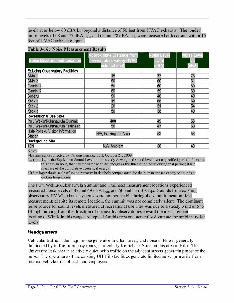
Page 3-176 Final EIS: TMT Observatory Section 3.13 – Noise
levels at or below 60 dBA Leq beyond a distance of 50 feet from HVAC exhausts. The loudest noise levels of 68 and 77 dBA Leq, and 69 and 78 dBA L10, were measured at locations within 15 feet of HVAC exhaust outputs.
Table 3-16: Noise Measurement Results
Noise Measurement Location Approximate Distance from nearest observatory HVAC
exhaust (feet)
Noise Level Leq(h) (dBA)
Noise Level L10
(dBA) Existing Observatory Facilities SMA 1 15 77 78 SMA 2 50 60 61 Gemini 1 50 60 60 Gemini 2 80 59 60 Subaru 50 48 49 Keck 1 15 68 69 Keck 2 20 51 54 Keck 3 50 38 40 Recreational Use Sites Pu’u Wēkiu/Kūkahau‘ula Summit 400 49 53 Pu’u Wēkiu/Kūkahau‘ula Trailhead 50 47 50 Hale Pōhaku Visitor Information Station N/A, Parking Lot Area 52 56
Background Site 13N N/A, Ambient 36 40 Notes: Measurements collected by Parsons Brinckerhoff, October 21, 2009. Leq (h) = Leq is the Equivalent Sound Level, or the steady A-weighted sound level over a specified period of time, in
this case an hour, that has the same acoustic energy as the fluctuating noise during that period; it is a measure of the cumulative acoustical energy.
dBA = logarithmic scale of sound pressure in decibels compensated for the human ear sensitivity to sounds at certain frequencies.
The Pu’u Wēkiu/Kūkahau‘ula Summit and Trailhead measurement locations experienced measured noise levels of 47 and 49 dBA Leq, and 50 and 53 dBA L10. Sounds from existing observatory HVAC exhaust systems were not noticeable during the summit location field measurement; despite its remote location, the summit was not completely silent. The dominant noise source for sound levels measured at recreational use sites was due to a steady wind of 5 to 14 mph moving from the direction of the nearby observatories toward the measurement locations. Winds in this range are typical for this area and generally dominate the ambient noise levels.
Headquarters
Vehicular traffic is the major noise generator in urban areas, and noise in Hilo is generally dominated by traffic from busy roads, particularly Komohana Street at this area in Hilo. The University Park area is relatively quiet, with traffic on the adjacent streets generating most of the noise. The operations of the existing UH Hilo facilities generate limited noise, primarily from internal vehicle trips of staff and employees.

Section 3.13 – Noise Final EIS: TMT Observatory Page 3-177
Pursuant to HAR §11-46-3, land such as an office park where the Headquarters will be located is classified as a Class B district. A maximum noise level of 60 dBA during daytime hours (7 a.m. to 10 p.m.) and 50 dBA during nighttime hours (10 p.m. to 7 a.m.), as measured at the property line is allowed in a Class B district. Noise levels are not to exceed these maximum permissible L10 levels within any twenty-minute period, except by permit or variance.
3.13.2 Thresholds Used to Determine Level of Impact In accordance with the Chapter 343 significance criteria, the Project would result in a significant impact if it detrimentally affects ambient noise levels, which could then lead to substantial degradation in environmental quality. Therefore, a significant noise impact would occur if the Project would result in increased ambient noise levels to the extent that noise-sensitive receptors would be exposed to noise exceeding regulatory levels.
3.13.3 Potential Environmental Impacts The potential impacts of the Project are evaluated within the framework of compliance with all applicable rules, regulations, and requirements for the project type and location. This includes state noise standards under HAR Section11-46, requirements of the Occupational Safety and Health Administration (OSHA), and the CMP.
Traffic and associated transient noise will occur due to Project personnel commuting to and from the TMT Observatory, potential TMT Mid-Level Facility, and Headquarters. Along the main roads of Hilo and Saddle Road, the noise generated by the relatively slight increase in traffic resulting from the Project will be negligible. Through the Conservation District from Hale Pōhaku to the TMT Observatory, the increase in traffic related to the Project will generate transient noise during shift changes only.
The noise generated by the TMT Observatory during the typical day will be the result of the HVAC equipment. Other noise producing equipment includes an emergency standby generator that will only be used when power is not available from HELCO and briefly during periodic testing. The HVAC equipment will be located inside the observatory facility. The HVAC units are designed to cool the dome in the daytime and exhaust will be discharged from the lowest level of the TMT Observatory and directed to the north, away from the visitor area and the summit. The noise generated by the TMT Observatory would be well below the Class A criteria at a distance of 50 feet from the HVAC exhaust. Therefore, anyone standing beyond the area graded for the TMT Observatory would not be exposed to noise exceeding the Class A standard.
At night, the HVAC equipment will not continue to operate in order to keep scientific instruments at their required operating temperatures. The motors used to rotate and open the dome will be the only source of additional noise at night, unlike during the day, which experiences visitor traffic and various other sources of additional noise. Those motors will be located inside the observatory building and enclosed by the structure’s walls. The walls will provide for a substantial loss in sound transmission, so the motors are not expected to be audible from outside the building.
The TMT Observatory will utilize HVAC equipment of similar function and size to the systems currently in use at the existing observatories; however, it will be newer and more efficient equipment and will be no louder than the systems currently in use at existing observatories in the
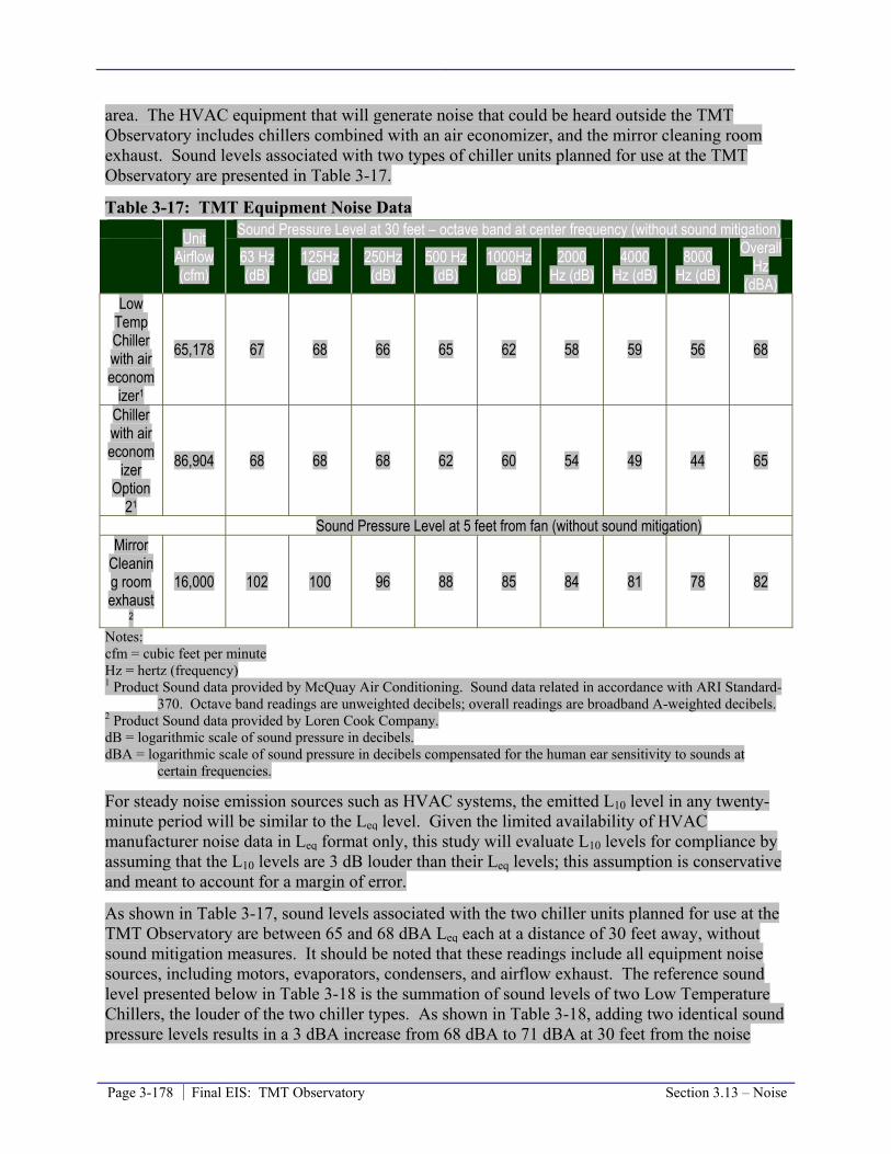
Page 3-178 Final EIS: TMT Observatory Section 3.13 – Noise
area. The HVAC equipment that will generate noise that could be heard outside the TMT Observatory includes chillers combined with an air economizer, and the mirror cleaning room exhaust. Sound levels associated with two types of chiller units planned for use at the TMT Observatory are presented in Table 3-17.
Table 3-17: TMT Equipment Noise Data Unit
Airflow (cfm)
Sound Pressure Level at 30 feet – octave band at center frequency (without sound mitigation)
63 Hz (dB)
125Hz (dB)
250Hz (dB)
500 Hz (dB)
1000Hz (dB)
2000 Hz (dB)
4000 Hz (dB)
8000 Hz (dB)
Overall Hz
(dBA) Low
Temp Chiller with air econom
izer1
65,178 67 68 66 65 62 58 59 56 68
Chiller with air econom
izer Option
21
86,904 68 68 68 62 60 54 49 44 65
Sound Pressure Level at 5 feet from fan (without sound mitigation) Mirror
Cleaning room exhaust
2
16,000 102 100 96 88 85 84 81 78 82
Notes: cfm = cubic feet per minute Hz = hertz (frequency) 1 Product Sound data provided by McQuay Air Conditioning. Sound data related in accordance with ARI Standard-
370. Octave band readings are unweighted decibels; overall readings are broadband A-weighted decibels. 2 Product Sound data provided by Loren Cook Company. dB = logarithmic scale of sound pressure in decibels. dBA = logarithmic scale of sound pressure in decibels compensated for the human ear sensitivity to sounds at
certain frequencies.
For steady noise emission sources such as HVAC systems, the emitted L10 level in any twenty-minute period will be similar to the Leq level. Given the limited availability of HVAC manufacturer noise data in Leq format only, this study will evaluate L10 levels for compliance by assuming that the L10 levels are 3 dB louder than their Leq levels; this assumption is conservative and meant to account for a margin of error.
As shown in Table 3-17, sound levels associated with the two chiller units planned for use at the TMT Observatory are between 65 and 68 dBA Leq each at a distance of 30 feet away, without sound mitigation measures. It should be noted that these readings include all equipment noise sources, including motors, evaporators, condensers, and airflow exhaust. The reference sound level presented below in Table 3-18 is the summation of sound levels of two Low Temperature Chillers, the louder of the two chiller types. As shown in Table 3-18, adding two identical sound pressure levels results in a 3 dBA increase from 68 dBA to 71 dBA at 30 feet from the noise

Section 3.13 – Noise Final EIS: TMT Observatory Page 3-179
source. In assuming that L10 levels are 3 decibels louder than Leq levels, the two chillers will produce 74 dBA L10 at 30 feet away.
Table 3-18 shows how sound levels from a point source such as the HVAC system are expected to decrease by 6 to 7 dBA for every doubling of distance from the source. This decrease in noise with distance is the result of noise attenuation55 from geometric spreading56.
Table 3-18: Projected Noise Levels of Observatory HVAC System
Distance from Source (feet)
Point Source (-6 dBA per doubling
of distance ) TMT HVAC L10 Noise (-
6 dBA) Recreational Use Site located within Noise
Level Range 301 71 dBA1 74 dBA None 60 65 dBA 68 dBA None
120 59 dBA 62 dBA None 240 53 dBA 56 dBA None 480 47 – 52 dBA 50 – 55 dBA None 960 41 – 49 dBA 44 – 52 dBA None
1920 35 – 49 dBA 38 – 52 dBA None Notes: dBA = logarithmic scale of sound pressure in decibels compensated for the human ear sensitivity to sounds at
certain frequencies. 1 Reference sound distance and noise level provided by McQuay Air Conditioning, assuming 2 units.
As shown in Table 3-18, it can be approximated that sound levels further than 270 feet from TMT Observatory HVAC systems will be below the Class A allowable daytime noise level of 55 dBA. In general, noise levels further from the HVAC system become more variable and fluctuate with the existing conditions of the ambient environment which includes the presence of visitors, workers, vehicles, and windy conditions throughout most of the Astronomy Precinct. That is why at distances greater than 480 feet Table 3-18 states a range of noise levels with the lower level being indicative of TMT Observatory HVAC equipment in the absence of background noise and the higher number being indicative of background conditions measured and reported in Table 3-16.
The noise generated by the TMT Observatory will be below the Class A allowable limits at a distance of 270 feet from the HVAC system during the day and 850 feet from the system at night. Therefore, anyone standing at least 270 feet from the TMT Observatory HVAC system during the day will not be exposed to noise levels exceeding the Class A daytime standard. This area is illustrated in Figure 3-36. Areas beyond 850 feet of the TMT Observatory HVAC exhaust output will not experience noise levels exceeding the Class A nighttime standard. All identified noise sensitive areas in the summit region, including the trailhead and summit of Pu’u Wēkiu/Kūkahau‘ula, Lake Waiau, and Pu‘u Līlīnoe, will be more than 850 feet from the TMT Observatory HVAC system (Figure 3-35). Operation of the TMT Project will not contribute to a noticeable increase in noise levels at the identified recreational sites recognized as sensitive to noise in the surrounding area.
55 Attenuation is defined as the general loss in intensity of any kind of flux through a medium; e.g., sunlight is attenuated by dark glasses. 56 Geometric spreading refers to the spreading of sound energy as a result of the expansion of the wavefronts; this results in a dissipation of noise.
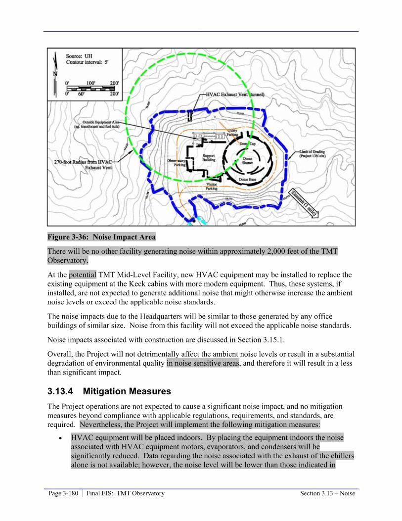
Page 3-180 Final EIS: TMT Observatory Section 3.13 – Noise
Figure 3-36: Noise Impact Area
There will be no other facility generating noise within approximately 2,000 feet of the TMT Observatory.
At the potential TMT Mid-Level Facility, new HVAC equipment may be installed to replace the existing equipment at the Keck cabins with more modern equipment. Thus, these systems, if installed, are not expected to generate additional noise that might otherwise increase the ambient noise levels or exceed the applicable noise standards.
The noise impacts due to the Headquarters will be similar to those generated by any office buildings of similar size. Noise from this facility will not exceed the applicable noise standards.
Noise impacts associated with construction are discussed in Section 3.15.1.
Overall, the Project will not detrimentally affect the ambient noise levels or result in a substantial degradation of environmental quality in noise sensitive areas, and therefore it will result in a less than significant impact.
3.13.4 Mitigation Measures The Project operations are not expected to cause a significant noise impact, and no mitigation measures beyond compliance with applicable regulations, requirements, and standards, are required. Nevertheless, the Project will implement the following mitigation measures:
• HVAC equipment will be placed indoors. By placing the equipment indoors the noise associated with HVAC equipment motors, evaporators, and condensers will be significantly reduced. Data regarding the noise associated with the exhaust of the chillers alone is not available; however, the noise level will be lower than those indicated in

Section 3.13 – Noise Final EIS: TMT Observatory Page 3-181
Table 3-17 and Table 3-18. Therefore, the radius of the area exposed to noise levels greater than the Class A standard will also be reduced.
• The exhaust of the HVAC equipment will be directed through a tunnel duct that exits on the northwest side of the graded area, which faces away from noise sensitive areas. Measures along the route of the airflow will also be used to reduce the noise discharging outside of the TMT Observatory; measures could include acoustical louvers, tunnel duct wall treatments, and duct silencers. These measures will further reduce the radius of the area exposed to noise greater than the Class A standard.
• Other openings between the interior of the observatory and outdoors, such as air intake locations, will be furnished with measures to reduce noise discharging outside of the observatory, such as acoustical louvers.
In addition, the Project will institute a Ride-Sharing Program for both TMT Observatory and Headquarters employees. The program, detailed in Section 3.11.4, will be mandatory for TMT Observatory employees to travel beyond Hale Pōhaku and actively encouraged for Headquarters employees. There will be approximately 10 five vehicle trips for the day shift and two for the night shift, assuming five per vehicle.
3.13.5 Level of Impact after Mitigation The implementation of the mitigation measures identified will serve to further reduce the noise associated with the Project. It is expected that the operation of the TMT will result in a negligible increase in noise and a minor increase in vehicular traffic noise at Hale Pōhaku and along the Mauna Kea Access Road.
3.13.6 References CPWR (Center to Protect Worker’s Rights). 2003. Construction Noise Hazard Alter. Website:
http://www.cpwr.com/hazpdfs/kfnoise.PDF. Accessed March 2, 2009.
NASA, 2005. Final Environmental Impact Statement for the Outrigger Telescopes Project¸ National Aeronautics and Space Administration, Universe Division, Science Mission Directorate, Washington, D.C.
HAR, Department of Health, Chapter 46, Community Noise Control.

Page 3-182 Final EIS: TMT Observatory Section 3.14 – Climate, Air Quality, and Lighting
3.14 Climate, Meteorology, Air Quality, and Lighting This section discusses the air quality, climatic, and sky illumination conditions in the region and specific Project areas, the potential impact of the Project on those resources, and mitigation measures the Project will employ to mitigate those potential impacts.
3.14.1 Environmental Setting This section discusses the air quality, climatic, and sky lighting conditions in the region and specific Project areas.
Maunakea Summit Region
Air Quality
Air quality and climate are very important siting considerations for observatories, as unique visibility conditions are required for astronomical observations. Although many studies have been performed to evaluate astronomical seeing conditions, traditional air quality monitoring has not been actively undertaken at the summit of Maunakea. Traditional air quality monitoring consists of monitoring for ozone, carbon monoxide, particulate matter – including respirable particular matter and particular matter less than 2.5 microns in diameter, nitrogen dioxide, sulfur dioxide, lead, and visibility-reducing particles.
Air quality monitoring has been performed at the Mauna Loa Observatory at an elevation of approximately 11, 140 feet since its construction in 1956. This monitoring station provides data most representative of the conditions at Maunakea. The data gathered at this station indicate that the air quality at the Mauna Loa Observatory is excellent and in attainment status with State and National Ambient Air Quality Standards (NAAQS). Given the similarities between the two locations (Maunakea and Maunaloa), it has been inferred that the overall air quality at Maunakea is excellent as well.
The Maunakea summit area rises well above the atmospheric temperature inversions that occur around 7,000 feet. Particulates and aerosols like vog (volcanic gas), smog, dust, smoke, salt particles, and water vapors generated below the inversion level are “capped” by the temperature inversion, so they do not rise above the inversion level and do not cause any interference at the summit. However, anabatic winds57 can on occasion come up the slopes of Maunakea, penetrating the inversion layer, bringing with them insects and relatively small volumes of air from the lower elevations. Locally generated contributors to air pollution above the inversion level include vehicle exhaust, chemical fumes from construction and maintenance activities, and fugitive dust from various sources, including vehicles traveling on unpaved surfaces and road grading and construction or other activities conducted on unpaved areas. Rapid dispersion of pollutants is aided by strong winds.
57 Anabatic winds are winds that blow up a steep slope or mountain side, driven by heating of the slope, typically during the daytime in calm sunny weather.

Section 3.14 – Climate, Air Quality, and Lighting Final EIS: TMT Observatory Page 3-183
Climate
There are two seasons in Hawai‘i, winter (October–April) and summer (May-September), with the trade winds blowing approximately 80 percent of the time in the summer and 50 percent of the time in the winter. Winter temperatures on Maunakea range from 10 to 40 degrees Fahrenheit, but wind chill can bring the temperature to below zero; summertime temperatures recorded at the summit area range from below 30 to 60 degrees.
In the summit region, annual precipitation ranges from approximately 20 inches at the Very Long Baseline Array (VLBA) at an altitude of 12,600 feet to approximately 15.5 inches (including snowfall) at the Subaru Observatory at an altitude of 13,575 feet. Storms, including wintertime cold-fronts, upper-level and surface low-pressure systems, tropical depressions, and hurricanes provide the majority of annual precipitation over a very short period of time. Although no data on average snowfall is available, it is known that significant snowfall can occur during any month of the year. Varying amounts of snow and ice regularly fall near the summit, concentrated during November January through March, and rare from June to September.
Wind velocities usually range from 10 to 30 miles per hour in the summit region. During severe winter storms though, winds can exceed 100 miles per hour on exposed summit areas, such as the tops of cinder cones. High winds are also common due to atmospheric anomalies, such as the jet stream dipping down or low and high pressure systems creating vortexes.
Some of the Maunakea summit’s other unique characteristics include its minimal cloud cover, with about 325 days per year being cloud free, and the low water vapor level, which means the atmosphere is more transparent for infrared observations. The dry and breezy conditions facilitate high rates of evaporation at the summit and maintain the cool, dry atmosphere.
Sky Lighting
Another characteristic that makes Maunakea one of the best sites in the world for astronomical observations is the very dark sky. This results from the summit’s remoteness from urban development, as well as the County of Hawai‘i’s island-wide lighting ordinance requirements. Three main types of high-intensity outdoor lighting are used in cities: low pressure sodium (LPS), high pressure sodium (HPS), and mercury vapor lamps. Of these, LPS is the choice of astronomers because light from LPS bulbs is concentrated in a very narrow part of the spectrum, leaving all other wavelengths uncontaminated. Therefore, light and radiation in other parts of the spectrum from stars, galaxies, and planets can be viewed and be valuable for astronomers. HPS or mercury vapor lamps contaminate much of or the entire spectrum that astronomers study, and areas that are brightly illuminated by these kinds of lights are unusable for astronomical measurements. The absence of air pollution and the absence of large, brightly-lit cities on the Island of Hawai‘i give astronomers some of the deepest views into the universe that can be achieved at ground based observatories.
Hale Pōhaku
Air Quality
Air quality at the Hale Pōhaku facilities is similar to that at the summit because it is also located above the temperature inversion level. However, as discussed above, anabatic winds can on
Page 3-184 Final EIS: TMT Observatory Section 3.14 – Climate, Air Quality, and Lighting
occasion come up the slopes of Maunakea, penetrating the inversion layer, bringing with them insects and relatively small volumes of air from the lower elevations. This is likely more frequent at Hale Pōhaku because it is closer to the inversion layer elevation.
Climate
Average temperatures at Hale Pōhaku, at 9,200 feet, range between 30 and 70 degrees Fahrenheit throughout the year. At Hale Pōhaku, it is not uncommon for winds to reach upwards of 20 range between 2.7 to 3.6 miles per hour. Annual precipitation ranges from 12 to 20 inches, with most rain occurring between November and March. Fog is common, while snow is rare.
Headquarters
Currently, no routine ambient air monitoring is conducted by HDOH in the Hilo area. Historical monitoring during the 1970s and 1980s indicated very low pollutant levels in Hilo. Recent increase in volcanic activity has led to higher than average levels of vog, although the western side of the island is affected more than Hilo.
Hilo is located on the eastern, or windward, side of the island and is usually subjected to northeasterly trade winds during the day. These wind speeds predominantly range from 4 to 12 miles per hour. Daytime temperatures range from the upper 70s to low 80s in degrees Fahrenheit, while temperatures at night range from the low 60s to the upper 70s. The annual rainfall in Hilo averages about 141 inches. Although the wet season usually occurs from October through April, rain falls approximately 280 days of the year.
Hilo, and the rest of the island, uses only LPS bulbs for outdoor lighting.
3.14.2 Thresholds Used to Determine Level of Impact In accordance with the Chapter 343 significance criteria, the Project would result in a significant impact if it would result in a detrimental effect on air quality leading to a substantial degradation in environmental quality. Thus, the Project impact would be considered to be significant if it would result in emissions of air pollutants that could substantially impair the existing air quality through generation of substantial pollutant concentrations and/or lead to the area becoming a non-attainment area for State and NAAQS.
3.14.3 Potential Environmental Impact Air pollutants emissions associated with the Project will include dust (or particulate matter) and exhaust fumes from vehicular travel, plus emissions related to maintenance activities. Dust will be the primary air quality concern along the unpaved portion of the Mauna Kea Access Road and the Access Way. It is expected that approximately 44 daytime an average of 24 employees will work at the TMT Observatory during daytime operations, with a minimum of 15 and a maximum of 43 possible; nighttime operations will require an average of 6 employees at the facility. These employees will travel to the TMT Observatory daily. Deliveries and pickups, including trips made for equipment, supplies, water, and waste, will generate additional trips to and from the TMT Observatory.

Section 3.14 – Climate, Air Quality, and Lighting Final EIS: TMT Observatory Page 3-185
Potential air quality and climate impacts resulting from fugitive dust include decreased surface albedo58, and associated increased rate of snow melt at higher elevations; disruptions to photosynthesis by vascular plants due to dust fall out; potential impacts on wēkiu bug habitat; reduced clarity of view for both the human eye and for astronomical technologies; and safety concerns. Potential air quality and climate impacts resulting from vehicle exhaust emissions include reduced health within the lichen and moss communities, and reduced clarity of view for both the human eye and for astronomical technologies.
The potential dust-related impacts to biological resources, such as plants, lichen, moss, and wēkiu bugs are discussed in Section 3.4.3. The potential for increased snow melt due to dust will only be an issue along the unpaved portion of the Access Way; and this potential for slightly quicker melting of snow along the Access Way due to dust is not considered significant because the longevity of the snow or rate of melting does not change the fate of the melt water (groundwater recharge). Also, the potential increased melt rate may be offset by the snow along the Access Way being thicker once the road is plowed clear.
The small number of daily vehicular trips beyond Hale Pōhaku has no potential to generate air pollutant emissions that could substantially impair the existing air quality or affect the health of lichen and moss communities. The TMT vehicles will be in compliance with industry emission standards and regularly maintained. In addition, the potential impacts to air quality from pollutants other than dust are likely to be temporary because the nearly constant winds at the summit will quickly disperse them.
The Headquarters in Hilo is anticipated to have a staff of approximately 60 up to 116 employees. The vehicular traffic associated with employee travel and typical deliveries and pickups at this facility will represent slight increases over the current traffic conditions in the area. Those trips will generate minor amounts of exhaust emissions with no potential to impair the existing air quality because those vehicles will be in compliance with applicable emissions standards.
The ongoing standard maintenance of the Project’s facilities will not involve any activities that could generate substantial air pollutant emissions. In the rare instances that the emergency generator may be required, minor diesel exhaust emissions will occur. The Project will comply with existing requirements to limit the emissions from the generator, and the generator will meet Federal emissions standards, while the diesel fuel used will meet Federal requirements regarding sulfur content and cetane index. Therefore, occasional use of the emergency generator has no potential to result in air pollutant concentrations at the summit that could impair the existing air quality.
Overall, the impact of the Project on air quality and the climate will be less than significant. The excellent air quality due to the island’s climatic conditions, including winds that rapidly disperse pollutants and prevent their concentration, will not be degraded. The Project does not include any features or activities that could substantially change either precipitation, temperature, wind velocities, inversion levels, cloud cover, water vapor or any other climate factors at Maunakea or the Island of Hawai‘i.
58 Albedo is the surface reflectivity of the sun’s radiation; the lower the albedo of an object the more radiation it absorbs.

Page 3-186 Final EIS: TMT Observatory Section 3.14 – Climate, Air Quality, and Lighting
The Project will comply with lighting standards for outdoor lighting. This will include minimizing the use of exterior lighting, and using LPS lighting with suitable shielding for all necessary outdoor lighting. At the TMT Observatory, there will be no outdoor lighting because it would interfere with observatory operations. The TMT Observatory’s AO system will utilize laser guide stars. The multiple overlapping laser beams could be faintly visible to the naked eye as a single beam on moonless nights for a distance of up to 9 miles from the observatory. The area where the laser may be visible consists primarily of ranchlands and forest reserve which are not populated. The Federal Aviation Administration requires that the lasers be shuttered when aircraft are present in the area of the sky where the laser beams are pointed. Aircraft will be detected automatically using multiple camera systems, supplemented initially by human spotters if necessary. Therefore, the Project will not illuminate the sky or significantly impact nighttime conditions on the island.
3.14.4 Mitigation Measures TMT will prepare and implement a Ride-Sharing Program, as outlined in Section 3.11.4. The program will require all personnel working at the TMT Observatory to ride-share in observatory vehicles beyond Hale Pōhaku, or a lower elevation location, to the summit area. The TMT vehicles will be selected based on balancing the needs for fuel efficiency, low emissions, and safety for transportation to the summit. Approximately 10 An average of five vehicles will be used for day-time trips and two for night-time trips. This required ride sharing will reduce the total number of Project trips beyond Hale Pōhaku to the summit area to approximately 14 9 trips per day (12 7 staff trips and 2 other trips, such as deliveries), and will further reduce the potential impact of the Project on air quality.
There is a possibility the Project would employ a soil-binding stabilizer, such as DuraSoil, to control dust on the unpaved section of the Access Way between the SMA and the TMT Observatory. This would reduce dust generated along the short 3,000 foot (0.6 mile) section of unpaved Access Way. This is primarily being considered to mitigate possible impacts to biologic resources due to dust in the summit area, but would also benefit air quality. Soil-binding stabilizers would be used sparingly, and would never be applied to habitat adjacent to the road or parking areas. Prior to the use of a soil-binding stabilizer the Project will coordinate with OMKM and Kahu Kū Mauna and only proceed with their concurrence. A roughly 750 foot long portion of the Access Way will be paved near the SMA core. This will reduce the generation of dust in the summit region, particularly near the SMA where dust could interfere with SMA operations and the alpine cinder cone habitat where dust can impact wēkiu bug habitat.
In addition, the Project’s Ride-Sharing Program will encourage and support the establishment of ride sharing by its Headquarters staff. This will further reduce the potential impacts associated with the Project. TMT may also consider flexible hours for staff at this facility, as necessary, to further reduce the potential impact.
The TMT Observatory will also coordinate the use of its AO laser guide stars with the other observatories on Maunakea using the existing Laser Traffic Control software system to minimize the interference between the various guide star systems in use, as well as their impact on other astronomical observations.
Section 3.14 – Climate, Air Quality, and Lighting Final EIS: TMT Observatory Page 3-187
3.14.5 Level of Impact after Mitigation The Project will not have a significant impact on air quality or climate, even without mitigation. Compliance with existing requirements will ensure that the air quality will remain in compliance with the State and NAAQS and therefore no significant impacts are expected. The outlined mitigation measures will further reduce the Project’s minor impact on air quality in the summit area.
3.14.6 References Arvidson, R. E. 2002. Draft environmental assessment for the Outrigger Telescopes Project
published by NASA in December 2000; Response to comments concerning the hydrology of Mauna Kea. Outrigger. St. Louis, MO, McDonnell Center for the Space Sciences, Dept. of Earth and Planetary Sciences, Washington University.
da Silva, S.C. 2006. Climatological analysis of meteorological observations at the summit of Mauna Kea. Physics Department, University of Lisbon; 77p.
Giambelluca, T. W. and M. Sanderson. 1993. The Water Balance and Climate Classification. Prevailing Trade Winds, Weather and Climate in Hawai'i. M. Sanderson. Honolulu, University of Hawai‘i Press.
Jurvik, S. P. and J.O. Jurvik, Eds. 1998. Atlas of Hawai‘i. Honolulu, University of Hawai‘i Press.
Laws, E. A. and A. H. Woodcock. 1981. Hypereutrophication of an Hawaiian alpine lake. Pacific Science 35(3): 257-261.
Miyashita, A., N. Takato, et al. 2004. Statistics of weather data, environmental data and the seeing of the Subaru Telescope. Ground-based Telescopes. J. M. Oschmann, Proc. of SPIE. 5489: 207-217.
NASA. 2005. Final environmental impact statement for the Outrigger Telescopes Project: Mauna Kea Science Reserve, Island of Hawai‘i. National Aeronautics and Space Administration, Universie Division, Science Mission Directorate Washington, D.C.
Nullet, D., J. O. Juvik, et al. 1995. A Hawaiian mountain climate cross-section. Climate Research 5: 131-137.

Page 3-188 Final EIS: TMT Observatory Section 3.15 – Construction and Decommissioning
3.15 Construction and Decommissioning This section discusses the potential construction and decommissioning phase impacts related to the natural and built environment and the potential mitigation measures that could be employed. Construction and decommissioning effects will be temporary.
Construction work details will be developed during final design of the Project. The conceptual Project construction schedule is presented in Table 2-2. Project construction could begin as early as 2011 and take approximately seven years to complete. No unusual construction techniques or materials are anticipated for the construction of the potential TMT Mid-Level Facility or Headquarters; these Project components will be relatively standard office/warehouse facilities. Construction could begin with the potential TMT Mid-Level Facility within Hale Pōhaku, if constructed, in order to provide a base of operations during construction of the TMT Observatory and Access Way. Access Way preparation and TMT Observatory site grading will then take place followed by TMT Observatory foundation work.
Project construction will require the excavation of rock from the TMT Observatory site and along the Access Way. The need to excavate rock is primarily governed by the need to place a foundation for the TMT (the telescope) and the observatory dome. A Rock Movement Plan will be developed prior to construction in compliance with CMP Management Action C-3. The plan will detail excavation and grading activities. TMT will balance the excavated (cut) material with the need for fill (material brought in to raise the ground level) so that there will be a slight amount of excess cut material.
The total volume of excavated material (“cut” material) is estimated to be 96,000 64,000 cubic yards. The dramatic decrease in the volume of excavated material since the Draft EIS was completed is due to revisions in the TMT Observatory design; the revisions were in part made to reduce the Project’s impacts and include revising the support building to be smaller and have only one level instead of three. This estimate is based on geotechnical assumptions concerning the subsurface in the area and could change following the completion of geotechnical borings. Roughly 95,000 44,000 cubic yards of the cut material will be reused at the TMT Observatory site or Access Way. Approximately 1,000 20,000 cubic yards of material will be excess cut and will be stored at a location designated by OMKM for use as determined by OMKM. By using almost all of the material on the TMT Observatory site and Access Way, that material will be available for later use to restore the TMT Observatory site during decommissioning.
There will be no soil or cinder transported from off the mountain used as fill on Maunakea unless Access Way Option 3B is selected. Access Way Option 3B includes a road embankment with a 1:1 slope that can only be achieved using imported structural fill. Roughly 1,000 cubic yards of imported fill would be required.
The areas that will be affected by the cut and fill at the TMT Observatory 13N site are shown in Figure 2-4; cut and fill will also occur along the length of the Access Way. An enlarged view of the final grading plan of the TMT Observatory site is shown in Figure 2-7.
The construction at the TMT Observatory site would be performed in two phases. The first phase would provide for construction access for a crane required for erection of the rotating portion of the dome. Once the rotating dome was installed, the grading would be completed will

Section 3.15 – Construction and Decommissioning Final EIS: TMT Observatory Page 3-189
start with the rough grading of the 13Nsite, followed by the excavation for foundations, utility trenches, utility tunnels, water storage tanks, and underground holding tanks (Figure 2-7).
The TMT pier foundation will consist of a continuous, circular outer wall shallow concrete spread footing bearing on the soil at a depths varying from 15 to 23 of approximately 20 feet below the finished floor grade, with a central shallow concrete pad for a pintle bearing, used to hold the center of rotation of the telescope in place when at rest, bearing at a depth of 16 feet below finished floor grade and connected with six radial concrete spokes to the telescope pier outer wall and footing. A utility tunnel bearing on the soil at a depth of 21.5 feet below the finished floor elevation will connect the telescope pier with the mechanical equipment room on the utility level of the support building. A utility tunnel for venting warm air from the mechanical room out to the north side of the site will bear on the soil at a depth of 21.5 feet below the finished floor elevation.
The dome foundation will be shallow continuous spread footings bearing at a varying depth of 6 to 22 10 feet below surrounding finished floor grade, depending on the depth of original rock when the foundation would be located in fill. Floors will be concrete slabs-on-grade bearing on a six-inch layer of material obtained from excavated (cut) material. Some utility piping and conduit will be located below the concrete floor slabs.
The support building foundation will consist of shallow spread footings bearing at approximately 6 feet below the finished floor grade. Floors will be concrete slabs-on-grade bearing on a six-inch layer of material obtained from excavated (cut) material. Concrete retaining walls would be located on three sides of the building.
A trench for electrical and communications lines will be excavated along one side of the road. The conduits will be encased in concrete per governing code requirements. Excavated material will be used to raise the Access Way road surface where required to improve grades on the road and to provide a smooth driving surface where a rough surface from excavation will otherwise be exposed.
Following foundation work, the dome and telescope will be built. A 300-ton crawler crane, in combination with a 200-ton assisting crawler crane, will be used to erect the dome. Once the dome is complete, the telescope will be assembled inside the dome. When dome and telescope construction is complete, the site would be regraded and a three-level single level support building that is attached to the dome on two levels will be constructed.
It is anticipated that the construction crew at the TMT Observatory site will average 50 to 60 crew members through the construction period. During certain phases, a crew of more than 100 will be working at the TMT Observatory site. Construction is expected to take place six days a week, 10 hours a day; however, some special operations or construction phases will require longer work hours. It is expected that winter weather conditions at the TMT Observatory site will interrupt construction at times, until the dome is completed.
Other than the planned development areas, construction staging areas will be utilized and staffed at varying levels during construction (Section2.6). These include the Batch Plant Staging Area, the Hale Pōhaku Staging Area, and a Port Staging Area. The Batch Plant Staging Area, a roughly 4 acre area, will primarily be used for storing bulk materials and a cement batch plant during the grading and foundation work (a period of roughly 1.5 years). The Batch Plant Staging
Page 3-190 Final EIS: TMT Observatory Section 3.15 – Construction and Decommissioning
Area could also be used for storing bulk material during later stages of construction. The Hale Pōhaku Staging Area may be used for parking, vehicle washing and inspection and cleaning prior to proceeding up to the observatory site, and construction staging. The Hale Pōhaku Staging Area, if utilized, will be roughly 1.5 acres and will be used throughout the roughly eight year construction period. The Port Staging Area will be used primarily during the roughly four year observatory erection process when telescope and dome components are being shipped to the island. Items received will be inspected, repackaged, assembled to the extent possible, and prepared for transportation in the Port Staging Area.
During all construction related activities, TMT will comply with CMP Management Action C-1, which calls for an on-site construction monitor who will have authority to order any and all construction activity cease if and when, in the construction monitor’s judgment, (a) there has been a violation of the permit that warrants cessation of construction activities, or (b) that continued construction activity would unduly harm cultural resources; provided that the construction monitor’s order to cease construction activities be for a period not to exceed seventy two (72) hours for each incident. All orders to cease construction issued by the construction monitor will immediately be reported to OMKM and, if it is a violation of the CDUP, notice would be reported to DLNR.
Similarly, whenever construction, operations or maintenance activities include earth movement or disturbance, a trained archaeologist, selected by OMKM and approved by DLNR, will be on site to monitor any impacts, real or potential, of construction activities on archaeological and historical resources. The archaeological monitor will be funded by TMT. This provision is consistent with the CMP and previous conditions on CDUPs approved by BLNR.
Likewise, prior to the entry into the Maunakea UH Managements Areas, all construction materials, equipment, crates, and containers carrying materials and equipment will be inspected by a trained biologist, selected by OMKM and approved by DLNR, who will certify that all materials, equipment, and containers are free of any and all flora and fauna that may potentially have an impact on the Maunakea summit ecosystem. This provision is consistent with the CMP and previous conditions on CDUP’s approved by BLNR.
In compliance with the CMP (CMP Management Actions SR-1 and SR-2) and its Decommissioning sub plan, the Project will develop a Site Decommissioning Plan as the end of TMT Observatory’s useful life nears. This plan and its associated components will assess and document the potential impacts associated with decommissioning and the three levels of site restoration, including an environmental cost-benefit analysis and a cultural assessment to select the appropriate level of restoration (minimal, moderate, or full). It is anticipated that decommissioning of the TMT Observatory and the portion of the Access Way exclusively used to access the TMT Observatory will require a similar process to that required to build them; however, the exact method that will be used is not known at this time. The areas required, equipment used, and temporary impacts will likely be similar to those used during construction. The time required to remove the structure and restore the site will likely be less than the time required to build the TMT Observatory. The primary difference in impacts between the three levels of restoration will likely be the duration of the impact, with minimal providing the shortest duration of impact and full restoration being the longest period of impact. Because more material would likely be moved with the higher levels of restoration, there may be more construction equipment involved and a higher potential for dust and noise production.

Section 3.15 – Construction and Decommissioning Final EIS: TMT Observatory Page 3-191
In compliance with CMP Management Action FLU-3 and in order to aid in the eventual restoration of the area, the TMT Observatory and Access Way sites will be documented prior to the start of construction. This will be accomplished with high-resolution surface and aerial photography to document existing natural conditions.
3.15.1 Potential Environmental Impacts Impacts during construction and decommissioning will be similar. The time period of decommissioning impacts will be less than those associated with construction; both are temporary in nature. Unless specifically called out, the decommissioning impacts are assumed to be similar enough to the construction impacts that they do not warrant separate discussion.
The potential construction and decommissioning phase impacts are evaluated within the framework of compliance with all applicable rules, regulations, and requirements for the project type and location. Applicable rules, regulations, and requirements will include OSHA, the CMP (particularly Section 7.3.2 – Construction Guidelines), and necessary permits. To maintain compliance, the Project will develop and implement the various plans and programs outlined in this EIS. These plans and programs will include policies and procedures to be employed during construction and decommissioning as well as long-term operation. The plans and programs that will contain construction phase policies include:
• Reporting Plan, a plan will be developed and implemented in coordination with OMKM to require contractors to provide information from construction activities to OMKM (CMP Management Action C-4).
• Safety and Accident Prevention Plan
• Cultural and Archaeological Monitoring Plan, which will require an independent construction monitor who will have oversight and authority to insure that all aspects of ground based work comply with protocols and permit requirements (CMP Management Actions C-1, C-5, and C-6). The plan will comply with HAR section 13-279 as well.
• Cultural and Natural Resources Training Program (operation phase policy described in Sections 3.2.3, 3.3.3, and 3.4.3), construction workers will be required to receive the same annual training as operation personnel (CMP Management Actions C-7 and C-8).
• Invasive Species Prevention and Control Program (operation phase policy described in Section 3.4.3), construction materials will be inspected prior to being moved to the summit area (CMP Management Action C-9).
• Waste Minimization Plan (operation phase policy described in Section 3.8.3)
• Materials Storage/Waste Management Plan and component Spill Prevention and Response Plan (operation phase policy described in Section 3.8.3)
• Ride-Sharing Program (operation phase policy described in Section 3.11.4)
• Fire Prevention and Response Plan
• Rock Movement Plan (CMP Management Action C-3)

Page 3-192 Final EIS: TMT Observatory Section 3.15 – Construction and Decommissioning
The construction phase policy that will be included in these programs and plans is outlined in this section. In addition, the necessary construction-phase permits will be obtained and complied with. The necessary construction permits include (Section 3.19):
• National Pollutant Discharge Elimination System (NPDES) and component Best Management Practice (BMP) plan (CMP Management Action C-2),
• Noise permit,
• Noise variance, and
• Oversize and Overweight Vehicles Permit (OOVP).
The following sections discuss the various potential construction phase impacts and how they will be limited by the applicable rules, regulations, and requirements and how the Project will incorporate those rules and requirements into the various Project plans and programs.
Cultural/Archaeological/Historic Resources
This section discusses the potential impacts to cultural, archaeological, and historical resources during Project construction. Potential impacts during the construction phase include:
• Construction could alter or destroy a cultural/archaeological/historic property or resources, including the inadvertent discovery of human remains.
• The potential disturbance of land beyond the planned limits of disturbance could impact cultural/archaeological resources that otherwise would not be impacted.
• Fire could originate at a construction or staging area and impact cultural resources. This is primarily a concern at the potential TMT Mid-Level Facility where the dry forest is susceptible to fire impacts. This potential impact is discussed in the Biological Resources section below because the cultural resources that could be impacted by fire are biological in nature.
• Noise generated during construction could affect cultural practices in the summit area. This potential impact is discussed in the Noise section below.
• Dust generated by grading and preparation activities, and from vehicles traveling along the unpaved areas may affect cultural resources. This is primarily a concern in areas of low rainfall such as the Maunakea summit region and Hale Pōhaku. This potential impact is discussed in the Air Quality, Climate, and Lighting section below.
• Trash and construction materials could litter the area and degrade resources. This potential impact is discussed in the Solid and Hazardous Materials and Waste section below.
• The release of hazardous materials during construction could impact cultural resources. This potential impact is discussed in the Solid and Hazardous Materials and Waste section below.
Per the 2000 Master Plan and CMP, a buffer will be maintained between Project construction activities within the MKSR and Hale Pōhaku and archaeological resources. The implementation of the following plans and programs will limit the potential impact due construction activities disturbing additional area:
Section 3.15 – Construction and Decommissioning Final EIS: TMT Observatory Page 3-193
1. The NPDES BMP plan will outline steps to prevent disturbance of land beyond that which is necessary. The BMP plan will require flagging of the planned limits of disturbance by surveyors prior to the start of construction.
2. Cultural and Archaeological Monitoring Plan. This construction phase plan will require that any ground disturbing construction activity be monitored by both a cultural observer and an archaeologist.
3. The Cultural and Natural Resources Training Program will require all construction managers, contractors, supervisors, and all construction workers be trained regarding the potential impact to cultural and archaeological resources and the measures to prevent such impact. This will be the same training outlined for operations personnel in Sections 3.2.3 and 3.3.3.
These steps will ensure that during TMT Observatory, Access Way, and potential TMT Mid-Level Facility construction, all disturbances, including disturbances at staging areas, will remain at least 200 feet from archaeological resources and impacts to cultural resources will be minimized.
The Cultural and Archaeological Monitoring Plan will be implemented, as required by OMKM, even though the Project has been planned so as to avoid impact to cultural and archaeological resources. Although no burials have been encountered during developments thus far in the astronomy precinct, there are no burial markers or surface indicators of burials present in the Project disturbance areas, and the absence of caves in the area and the general desert pavement geology of the Project disturbance areas would not be conducive for burial location selection, cultural observers and the archaeologist will be present to watch for inadvertent discovery of human remains, as well as other cultural/archaeological resources. The cultural observer and archaeologist will have the ability to stop activities in an area if human remains or other cultural/archaeological resources are encountered. The Project will comply with HRS Chapter 6E concerning human remains and the discoveries of human remains will immediately be reported to SHPD and other required authorities.
In Hilo, there are no historic resources on either of the Project will not adversely impact any identified archaeological resources on the areas being considered for the Headquarters.
Overall, through compliance with existing rules and policies, Project construction will not have an adverse impact on cultural, historical, or archaeological resources.
Biological Resources
This section discusses the potential impacts to biological resources during Project construction. Potential impacts during the construction phase include:
• The potential disturbance of habitat beyond the planned limits of disturbance could further impact habitat and species.
• Invasive species could accidentally be carried to construction and staging areas and may become established and displace native species. This is primarily a concern for the māmane subalpine forest surrounding the potential TMT Mid-Level Facility and the alpine stony desert in the Maunakea summit region.

Page 3-194 Final EIS: TMT Observatory Section 3.15 – Construction and Decommissioning
• Fire could accidentally originate at a construction or staging area and impact habitat and species. This is primarily a concern at the potential TMT Mid-Level Facility where the surrounding māmane subalpine forest, which is habitat for threatened and endangered species, is susceptible to fire impacts.
• Dust generated by grading and preparation activities, and from vehicles traveling along the unpaved areas may affect habitat and species. This is primarily a concern in areas of low rainfall such as the Maunakea summit region and Hale Pōhaku. This potential impact is discussed in the Air Quality and Lighting section below.
• Trash and construction materials could blow into and impact habitats. This potential impact is discussed in the Solid and Hazardous Materials and Waste section below.
• The accidental release of hazardous materials during construction could impact sensitive species or habitat. This potential impact is discussed in the Solid and Hazardous Materials and Waste section below.
• Vehicles could accidentally impact nēnē on the lower portions of the Mauna Kea Access Road.
To address all of these potential impacts, the Project, in compliance with the CMP, will have a training biologist selected by OMKM and approved by the DLNR on site to monitor activities during earth movement or disturbance within MKSR or Hale Pōhaku. In addition, per the CMP and Project’s Cultural and Natural Resources Training Program, all construction managers, contractors, supervisors, and all construction workers will be trained regarding natural resources. This will be the same training outlined for operations personnel in Section 3.4.3.
The following sections discuss the potential impacts to biological resources associated with additional disturbance, invasive species, and fire.
Additional Disturbance
There is the potential for construction equipment to disturb areas beyond the limits of the disturbance needed or planned for the facility. This is especially a concern in Area E where the landscape is uniform and there are no obvious boundaries. The associated impact would be similar to the impact discussed in the above sections related to the displacement of current conditions with the Project facilities. The level of impact would be relative to the area of additional land disturbed. This potential impact will be addressed in the NPDES BMP plan. The BMP plan will outline steps to prevent disturbance of lands beyond that which is necessary. The BMP plan will require flagging of the planned limits of disturbance by surveyors prior to the start of construction. Therefore, the potential impact is slight and not significant.
Accidental Introduction of Invasive Species
Movement of construction materials, earthmoving equipment, and vehicles to the construction areas may introduce non-indigenous weedy flora or invasive fauna pests to the Maunakea summit region or Hale Pōhaku. These alien species can out-compete and displace native species and thereby reduce their populations. The CMP requires this potential impact be addressed by new developments. Packaging material will be redone at the Port Staging Area prior to continuing up the mountain. To comply, the Project will develop and implement an Invasive

Section 3.15 – Construction and Decommissioning Final EIS: TMT Observatory Page 3-195
Species Prevention and Control Program to address this potential impact. Components of the program during the construction phase will include:
• Materials Control and Reduction. All shipments will be repacked at the Port Staging Area so that only essential packing material is used for the final transportation to the construction site. This will reduce the volume of material potentially harboring invasive species, aid inspection, and minimize the waste generated at the construction sites. In addition:
- Contractors will be required to inspect shipping crates, containers, and packing materials before shipment to Hawai‘i.
- Pallet wood will be free of bark and treated to prevent the transport of alien species.
- Items that could serve as a food source for invasive species, such as food waste and food wrappers, will be collected separately from other debris and removed from the Maunakea summit region construction sites at the end of each day.
• Washing/Cleaning. Materials and clothing will be washed or otherwise cleaned prior to proceeding above Saddle Road. This will be done at lower elevation baseyards, such as the Port Staging Area, and could include:
- A requirement that everyone brushes down their clothes and shoes to remove invasive plant seeds and invertebrates.
- A requirement that waste containers be regularly pressure-washed using steam and/or soap to reduce odors that may attract bugs.
- A requirement for pressure wash-down of all construction vehicles and heavy equipment.
• Inspections. Prior to proceeding beyond the Saddle Road, all construction materials, equipment, crates, and containers carrying materials and equipment will be inspected and certified free of invasive species by a trained biologist, selected by OMKM and approved by the DLNR.
• Monitoring. Construction areas above Saddle Road, including the potential TMT Mid-Level Facility, Batch Plant Staging Area, Access Way, and TMT Observatory sites will be monitored weekly for the presence of invasive species. The monitoring will be carried out by a trained biologist.
• Control. Invasive species identified during monitoring will be controlled to prevent spread. Control measures will be implemented by staff trained by a trained biologist, selected by OMKM and approved by the DLNR.
• Education/Training. The Invasive Species Prevention and Control Program will include an educational component to the Cultural and Natural Resources Training Program (Section 3.4.3). It will require that construction personnel be trained to understand the sensitivity of the alpine environment and to follow the above steps, as applicable to their position.
The Invasive Species Prevention and Control Program will be further developed during the CDUP process and expanded as necessary. The program will be part of project plans and specifications for construction bidding. The implementation of this plan will reduce the potential

Page 3-196 Final EIS: TMT Observatory Section 3.15 – Construction and Decommissioning
for accidental introduction of non-indigenous species and reduce the likelihood of adverse impacts associated with invasive species. Many invasive species are already well established at the potential Headquarters sites and those sites are not unique or critical habitat. The Invasive Species Prevention and Control Program will be implemented at the Headquarters site only to the extent necessary to prevent new invasive species from becoming established and will not include inspections by a biologist at the Headquarters site. Thus the potential impact due to invasive species by construction activities will be small and not significant.
Accidental Fire
Hale Pōhaku, and the potential TMT Mid-Level Facility site, is surrounded by designated critical habitat for the endangered palila (Loxiodes bailleui). Firefighting in this rugged habitat would be difficult. A fire could destroy large portions of habitat before it could be controlled. Fire is also a threat to the small population of the Hawai‘i catchfly in rocky areas on the steep slopes adjacent to and above the Hale Pōhaku maintenance area.
The principal locality for palila is at Pu‘u La‘au more than 10 miles to the west of the potential TMT Mid-Level Facility, and palila are rarely seen near Hale Pōhaku. While these threatened and endangered species occur elsewhere, the potential impact of fire caused by Project construction on their populations could be significant. Mitigation measures to address accidental fire are presented in the Section 3.15.2, Mitigation Measures, below.
Fire will not pose a significant threat during the construction of the Headquarters. While it is a possibility, with the correct construction practices in place, it is minimal and unlikely to occur. Also, regardless of the site chosen, it will be easily accessible by the local fire department and a fire would not harm threatened or endangered species or habitats.
Accidental Vehicle Impacts with Nēnē
There are reports of nēnē being killed by vehicles on the Mauna Kea Access Road. Nēnē may utilize the lower portions of this road, especially during breeding season and inattentive drivers may strike these birds. Nēnē are not often seen on the Mauna Kea Access Road and occur elsewhere on the island in greater abundance, however the taking of endangered species is serious. The impact of traffic on the Mauna Kea Access Road is likely to be small and not significant to the nēnē population of Hawai‘i.
Nēnē education and driver awareness will be a component of the Cultural and Natural Resources Training Program. A refresher briefing regarding the nēnē will be given to all drivers at the beginning of the nēnē breeding season, on or before November 1 of each year. This will reduce the likelihood of vehicles harming nēnē on the Mauna Kea Access Road.
Visual and Aesthetic Resources
Temporary visual impacts from Project construction, and future decommissioning, of the TMT Observatory will be associated with the presence of construction equipment and workers, material stockpiles, debris, and staging areas. Temporary visual impacts are not expected to be a concern at the Headquarters construction site.
Most of the construction staging and material storage will occur in the Batch Plant Staging Area and the Hale Pōhaku Staging Area, and will not be visible from other areas of the island. Dust
Section 3.15 – Construction and Decommissioning Final EIS: TMT Observatory Page 3-197
and glare emanating from construction activities on the construction site will also have a temporary visual impact. Dust is discussed in detail in the Air Quality and Lighting section below. To minimize this impact, construction activities will be efficiently phased to ensure the shortest durations possible. This temporary impact is expected to be minimal and not significant.
Erosion and Water Quality
Construction activities have the potential to cause erosion and degrade stormwater quality. Sediment loading of stormwater could occur when unstabilized, exposed soil at excavations and stockpiles are exposed to heavy rain. Sediment-laden stormwater could create unacceptable levels of turbidity and high sedimentation rates, and contaminated stormwater could impact surrounding waters.
Other water sources, chemicals, or fuel could flow into natural streams or stormwater collection systems if not properly controlled; these include water used to control dust, water used to wash concrete trucks, chemicals used during construction such as paints and adhesives, and petroleum products such as fuel and oil. The handling of chemicals and petroleum products to address this potential impact is discussed in the Solid and Hazardous Materials and Waste section below.
Portable toilets will be utilized at all construction sites. These facilities will be properly maintained and serviced by a licensed and permitted contractor.
Prior to the start of construction at any location a NPDES permit for construction will be obtained from the HDOH. Separate permits may be obtained for activities at the TMT Observatory, potential TMT Mid-Level Facility, and Headquarters, depending on the timing of construction at these locations. Project and site-specific BMP plans will be prepared and submitted with the NPDES permit. BMPs will include methods to mitigate possible pollution, soil erosion, and turbidity cause by stormwater runoff from all sources. Agency reviews conducted as part of the NPDES permit process will ensure that proper control techniques are identified in the permit and implemented during construction. Stormwater BMPs overlap with air quality mitigation measures, discussed below, to a degree and could include the following:
• Minimize land disturbance.
• Stabilize or cover the surface of soil piles.
• Maintain stabilized construction site ingress/egress areas.
• Wash or clean trucks prior to leaving the construction site.
• Install silt fences and stormwater intake filters.
• Prevent off-site stormwater from entering the construction site.
The NPDES permit will also address other sources of water and their proper management, including water used to wash concrete trucks and control dust.
The removal of the Project structures will have the potential to release chemicals, such as paints or adhesives, in the form of flakes or chips that could be loosened while the structure is being dismantled. The handling of these materials is discussed in the below section.
Page 3-198 Final EIS: TMT Observatory Section 3.15 – Construction and Decommissioning
The potential for Project construction activities to impact water resources is slight and not significant due to compliance with applicable rules and regulations; no adverse impacts are expected.
Solid and Hazardous Materials and Waste
If not properly managed, solid and hazardous materials and waste used and stored in construction areas could impact cultural resources, biological resources, aesthetic and visual characteristics, and water quality in the surrounding area.
To minimize the potential for contamination, the Project will prepare and implement a Materials Storage/Waste Management Plan and component SPRP. These plans will be components of the overall BMP plan included with the NPDES permit. Construction phase components of the plans will include:
• Materials and Waste Storage. Materials will be stored in a manner so as to minimize their potential impact on the surrounding environment. Measures could include:
- “Roll off” containers will be equipped with secure tops and lids to ensure no debris escape.
- Outdoor trash receptacles will be secured to the ground and have attached lids that are secured to the receptacles and plastic liners so that the receptacle, its lid, or its contents will not blow away and the contents will not be exposed to stormwater.
- Hazardous materials, fuel, and wastes will be stored in designated areas in containers suitable and appropriate for storing such materials according to applicable rules and regulations. Storage areas will be located away from stormwater and other water resources.
- Construction materials and supplies will be covered with heavy tarps; steel cables attached to anchors that are driven into the ground may also be used to hold materials down. Materials will be secured at the close of each work day, and throughout the day during periods of high wind.
- Periodic inspections of the immediate and outlying areas around the Project construction sites and staging areas within the UH Management Areas and the removal of any waste found.
• Waste Management. Waste will be managed so as to minimize the potential impact on the surrounding environment. Measures could will include:
- Waste will be collected on a regular basis before containers become completely full.
- Waste will be picked up and transported by licensed contractors and disposed of at appropriate facilities.
• Inspection. Inspections will be performed to minimize the potential impact on the surrounding environment. Measures could include:
- Regular vehicle inspections to ensure they are operating safety and identify any mechanical issues, such as leaks; these inspections should be done prior to vehicles being moved above Saddle Road when they are being inspected for invasive species and regularly thereafter.
Section 3.15 – Construction and Decommissioning Final EIS: TMT Observatory Page 3-199
- Hazardous materials and waste storage areas and containers will be inspected daily for signs of leakage.
• Spill Response. The SPRP will include measures to minimize the potential impact of a spill or unintentional release on the surrounding environment. Measures could include:
- Require that appropriate spill response materials be stored at sites where hazardous materials and fuel are stored and used, including transport vehicles.
- Include copies of MSDS, which include spill response measures, for all materials. - Provide a check list to be followed in the event of a spill, including those that
should be contacted and how.
• Education/Training. The Materials Storage/Waste Management Plan and component SPRP will outline required employee training. All employees will be trained to comply with the Materials Storage/Waste Management Plan and component SPRP. Employees in the MKSR and Hale Pōhaku will also receive the training outlined in the Cultural and Natural Resources Training Program.
In association with the Project, HELCO will be replacing two transformers in their compound near Hale Pōhaku. HELCO will dispose of or reuse the transformers in accordance with applicable rules and regulations.
With the implementation of these measures, the presence and use of hazardous materials at the Project construction sites will have a less than significant impact on the environment.
Socioeconomic Conditions
Depending on the final Project schedule and other economic factors, the Project costs may exceed $1 billion. A substantial portion of the construction cost will be spent on specialized equipment, components, and material that must be fabricated and procured from locations in many countries. However, to the extent practicable, when suitable construction material is available in Hawai‘i it will be procured locally. During construction, the Project will establish an office on the island to support on-site engineering, administration, business, and project management needs. Positions needing to be filled for the Project office will include administrative and financial services, software and information technology engineering, mechanical engineering, and installation and service technicians.
It is expected that the contractors and service providers for the Project will require skilled trade employees such as carpenters, steelworkers, electricians, plumbers, heavy equipment operators, laborers, supervisors, shipping and trucking service workers, caterers, paramedics, security personnel, and vehicle mechanics. Construction crew personnel are expected to receive Union scale wages. The potential TMT Mid-Level Facility, if constructed, may provide housing and support services at Hale Pōhaku for certain TMT Observatory construction personnel choosing to take advantage of such a facility. Equipment and sourcing needs will likely include excavating and grading equipment, trucks, cranes, lifts, welding machines, and miscellaneous construction consumables, as well as subcontracts to local steel fabricators, machine shops, trucking companies and other suppliers and vendors.
Project construction will generate a number of jobs directly through employment of trades’ people in the construction sector. Construction equipment and personnel will be sourced locally
Page 3-200 Final EIS: TMT Observatory Section 3.15 – Construction and Decommissioning
to the maximum extent feasible. Construction will also generate indirect employment, which are jobs created in other sectors of the economy as a result of the construction, such as increases in the food services sector to support the increased construction employment. Direct and indirect employment also induces additional employment due to the overall expansion of the regional economy.
Potential socioeconomic impacts during the construction of the Project are expected to be positive, on both the county- and state-wide levels.
Land Use
Temporary land use impacts may occur during construction, including possible delays in accessing the summit area due to the movement of observatory components, heavy machinery, and construction equipment. This potential impact is discussed in the Roadways and Traffic section below. Dust due to grading operations could also impact SMA operations; this potential impact is discussed in the Air Quality and Lighting section below. All Project construction activities will be conducted in a manner that will allow the surrounding areas to remain accessible for all existing activities. Access to Hale Pōhaku, the summit area, and recreational areas will not be restricted; however, those accessing the area for cultural purposes, hiking, or other outdoor activities will be affected by construction traffic, dust, and noise as discussed in those sections below. Generally, the distance of the TMT Observatory construction site from the primary areas of cultural practice and hiking trails will reduce the potential impact. The Headquarters facility will not result in an adverse impact to land use. Overall, no significant adverse impacts to land use are anticipated during Project construction.
Roadways and Traffic
Construction of the TMT Observatory and potential TMT Mid-Level Facility could impact roadways and traffic along the Saddle Road and Mauna Kea Access Road. Increases in traffic along those roads due to construction could include:
• Workers commuting to and from the construction sites. It is estimated that an average of 50 to 60 workers will be required at the TMT Observatory construction site. Certain workers could elect to reside at the potential TMT Mid-Level Facility, if constructed.
• Equipment and materials moving to and from the construction sites. This will include equipment such as excavators and cranes plus materials such as concrete, partially assembled telescope and dome materials, water for dust control, and waste. There will be brief peaks in the movement of equipment and materials, such as concrete pours, but on average it is estimated there will be two large trucks a day.
It is expected that some of the machines and partially assembled components will exceed weight, height, or size restrictions for the roadways and, therefore, an OOVP will be required by the HDOT. Special accommodations may be required in order to move these loads through town, as standard lane widths may not be sufficient to allow for normal traffic flows and patterns. The largest components of the telescope mirror cell component at approximately 69 feet long by 23 feet wide; the heaviest components are the vent modules at 18 tons each.
Dome and telescope components will be shipped to Hilo or Kawaihae Harbor. From the port, they will be transported to a nearby Port Staging Area. This area will be used for receiving and

Section 3.15 – Construction and Decommissioning Final EIS: TMT Observatory Page 3-201
assembling these materials to the extent possible prior to transport to either another staging area or the construction site. Upon completion of pre-assembly, the components will be trucked to the TMT Observatory site by a route determined through the OOVP permit process.
The impact associated with transporting items to Hale Pōhaku or MKSR will be minimized by complying with OOVP conditions. It is anticipated that the permit will require transporting these items during non-peak traffic hours. Most other construction materials, not requiring a permit, will also be transported during non-peak traffic hours. At this time, it is proposed that the trucks will leave the Port Staging Area in the early morning before peak traffic in Hilo so as to reach the construction site at 7 a.m. Trucking will be coordinated with OMKM to reduce the potential impact to observatory vehicles.
With an increase in vehicle traffic, an increase in the potential for vehicular accidents could occur. The Project’s Safety and Accident Prevention Plan will include specific driver training and certification for all staff plus measures to ensure compliance with applicable Commercial Divers License (CDL) requirements and policies to reduce the likelihood of an accident. In addition, the Materials Storage/Waste Management Plan and component SPRP will require vehicles to carry spill response materials in case of accidents. The increased and heavy traffic on the unpaved portions of the Mauna Kea Access Road could also speed the deterioration of the dirt road surface.
The anticipated traffic impacts due to Project construction will be temporary and intermittent, and are not expected to significantly impact or alter existing conditions.
Power and Communication
Power and communication required during construction electricity will consist of energy necessary to power construction equipment and transport construction crews and equipment to and from the construction sites. Required energy will be provided by engines in construction equipment and trucks, portable generators, and HELCO. A connection to HELCO-supplied power will be achieved early in the construction process to reduce the need for generators. Use of HELCO-supplied power during Project construction will be less than that used during operation and will be obtained exclusively through the new transformer upgraded transformers and power lines installed for the Project. No significant impact on the availability of power on the summit or island-wide is expected.
No out-of-the-ordinary communication needs will exist during construction and bandwidth requirements will be less than during Project operation. A connection to the existing Maunakea communications system will be sought as soon as feasible due to the lack of cell phone coverage at the TMT Observatory site. Project construction will not have a significant impact on communication infrastructure.
Noise
Noise during construction will be bothersome and annoying to nearby residents, visitors, tourists, and businesses. Construction noise could also affect cultural practices in the summit area. The nearest facility to the TMT Observatory construction site, where construction noise will have the longest duration, is the Subaru Observatory roughly 2,500 feet away. Project construction will

Page 3-202 Final EIS: TMT Observatory Section 3.15 – Construction and Decommissioning
generate noise from the engine-powered equipment being used and traffic. Traffic due to construction will be cyclic in manner and are therefore will not result in a significant impact.
Noise will result from construction activities such as excavation, trenching, grading, pouring of foundations, and erection of structures. These activities will involve the use of standard heavy excavation machinery, including trucks, cranes, bulldozers, earth movers, backhoes, trenchers, and paving equipment, as well as portable petroleum-powered generators and compressors. Figure 3-37 shows the range of noise levels that can be expected from different types of construction equipment. Short periods of blasting may also be necessary to dig foundations for the TMT Observatory.
Figure 3-37: Typical Construction Equipment Noise Levels
Construction noise decreases at a rate of 6 to 8 dBA per doubling of the distance from the source once more than 50 feet from the source. For example, as illustrated in Table 3-19, if the noise level is 90 dBA at 50 feet from a jackhammer, it would be reduced to approximately 83 dBA at 100 feet and 76 dBA at 200 feet. Doubling the number of noise sources would increase the noise level by 3 dBA. In the above example, two jackhammers operating together would generate a noise level of 93 dBA at 50 feet. This assumes no other noise in area and no wind.

Section 3.15 – Construction and Decommissioning Final EIS: TMT Observatory Page 3-203
Table 3-19: Example of Noise Reduction over Distance Distance from Source (feet)
Noise Level (dBA)
50 90 dBA 100 83 dBA 200 76 dBA 400 69 dBA 800 62 dBA 1600 55 dBA
A noise permit will be obtained, per regulations from the HDOH, under HAR §11-46-7 to temporarily allow noise levels to exceed those typically permitted. A noise variance will also be obtained under HAR §11-46-8 for construction of the TMT Observatory so that work could be performed beyond normal work hours. Noise impacts associated with construction will be mitigated through compliance with conditions set forth in Noise Permits and the Noise Variance obtained by the Project for construction activities. The following measures are examples of what could be incorporated into the permit and variance conditions:
• Conduct noise-emitting activities during normal work hours to the extent possible;
• Reduce or substitute power operations/processes through the use of proportionally sized power equipment necessary only for tasks at hand;
• Maintain all powered mechanical equipment and machinery in good operating condition with proper intake and exhaust mufflers;
• Turn off or shut down equipment and machinery between active operations; and
• Strategically place or erect temporary noise curtains around stationary equipment, such as compressors and generators.
Additionally, construction contractor(s) will be required to strictly comply with all Federal OSHA regulations, applicable noise regulations under HAR §11-46, and State of Hawai‘i occupational noise exposure safeguards stipulated under HAR §12-200.1.
Construction noise at the TMT Observatory site is likely to be inaudible from a relatively short distance from the source due to the existing background noise associated with the strong wind conditions at the summit.
The distance from any occupied area, the strong wind, and compliance with permit and variance conditions will lessen the temporary potential noise impact from TMT Observatory construction to a level less than significant.
Noise impacts associated with Headquarters construction will be temporary, minimal, and not significant. All applicable permits will be obtained, and rules and regulations followed. All locations are within town limits and acknowledged as busy during the regular hours of workdays. Also, construction will not require nearly the amount of equipment necessary for construction of the TMT Observatory.

Page 3-204 Final EIS: TMT Observatory Section 3.15 – Construction and Decommissioning
Air Quality and Lighting
The generation of excessive dust from the construction areas is the primary air quality concern and could impact cultural and botanical resources. This is primarily a concern in areas of low rainfall, such as the Maunakea summit region (TMT Observatory, Access Way, and Batch Plant Staging Area) and Hale Pōhaku (potential TMT Mid-Level Facility). Dust could land on and accumulate on plants, lichens, and mosses, depriving them of needed sunlight. Dust could also be deposited in wēkiu bug habitat, degrading the habitat by filling voids in the cinder utilized by the bugs. Plants and habitat adjacent to unpaved roads and construction sites are the most susceptible to impact from dust. Other potential air quality impacts are associated with emissions from engines such as carbon monoxide and sulfur.
Dust could be generated (a) during site preparation and by vehicles traveling around construction sites and along the unpaved portion of the Access Way, (b) by increased traffic and heavy trucks traveling on the unpaved portion of the Mauna Kea Access Road between Hale Pōhaku and the TMT Observatory, and (c) by storms and accompanying high winds can arise quickly at the summit that can raise dust from recently exposed cinder and ash.
The State of Hawai‘i regulates air pollutant emissions (HAR 11-60.1), including fugitive dust (HAR 11-60.1-33). The Project will comply with these regulations. Examples of precautions the Project will take to prevent the generation of dust include:
• Use of water to control dust during grading operations;
• Application of water to control dust from roads and stockpiles;
• Covering of all moving, open-bodied trucks transporting materials that could produce dust, such as cinder and ash;
• Maintaining the roadway at the construction site egress in a clean manner; and
• Suspending dust generating activities during periods of high winds.
To minimize the potential mobile source impact from vehicle and equipment emissions during construction, all potential sources will be maintained and inspected regularly.
During certain construction events or phases of construction lighting may be necessary. The use of exterior lighting will be kept to a minimum, coordinated with other observatories, and used in compliance with applicable requirements.
Construction impacts on air quality and lighting will be less than significant with the implementation the required control measures outlined above.
3.15.2 Mitigation Measures Mitigation measures during construction and decommissioning will be similar. Unless specifically called out, the decommissioning mitigation measures will be similar enough to the construction mitigation measures that they do not warrant separate discussion.
In compliance with CMP Management Action FLU-3 and in order to aid in the eventual restoration of the area, the TMT Observatory site will be documented prior to the start of

Section 3.15 – Construction and Decommissioning Final EIS: TMT Observatory Page 3-205
construction. This will be accomplished with high-resolution surface and aerial photography to document existing natural conditions.
The Project will comply with applicable regulations and requirements, in order to mitigate potential impacts as discussed above. This will include developing and implementing the various plans outlined in this EIS, including compliance with NPDES requirements, such as the site-specific BMP plan related to storm water and non-storm water as outlined above.
Additional Disturbance and Encroachment
In addition to the NPDES BMP plan that will require flagging of the planned limits of disturbance, the location of nearby property boundaries will be surveyed to ensure that the limits of disturbance do not encroach on neighboring parcels. This will be done at the Batch Plant Staging Area to prevent encroachment on the Ice Age NAR, at the potential TMT Mid-Level Facility area, if constructed, and at the Headquarters construction site.
Noise
The Project will meet with OMKM and Kahu Kū Mauna to identify cultural events that would be sensitive to construction noise in the vicinity of the TMT Observatory site and the Batch Plant Staging Area. On up to four days identified by Kahu Kū Mauna the Project will endeavor to reduce construction noise and activities in the vicinity of cultural practices. In addition, a connection to HELCO-supplied power will be sought early in the construction process to reduce the need to operate generators.
Ride-Sharing Program
The Project will institute a Ride-Sharing Program. Participation will be required for workers at the TMT Observatory construction site. The program will require that construction workers use designated contractor vehicles to travel beyond Hale Pōhaku. This measure is designed to limit traffic on the Mauna Kea Access Road and limit the potential introduction of invasive species. With an average construction crew of 50 to 60, it is estimated nine or 10 vehicles will be required to transport the crew on a daily basis.
Roadways
Due to the expected increase of heavy traffic during construction there is a chance for more rapid deterioration of the unpaved portions of the Mauna Kea Access Road surface, TMT will arrange for the more frequent grading of the unpaved roadway.
Fire Prevention
The Project will develop and implement a Fire Prevention and Response Plan. The plan will be developed in coordination with OMKM and outline steps to be taken during construction activities to decrease the chance of fire at Hale Pōhaku, and hence the threat to cultural and natural resources in the surrounding māmane dry forest. Elements of the plan could include:
• Welding and grinding within the Hale Pōhaku Staging Area will be restricted to designated areas at least 20 feet from any combustible materials, including dry grass, and will not be performed during periods of high wind that could blow sparks beyond this 20
Page 3-206 Final EIS: TMT Observatory Section 3.15 – Construction and Decommissioning
foot buffer. Barriers may also be used to isolate welding and grinding activities from combustible materials.
• Smoking will be restricted at construction sites to avoid starting fires. Smoking will be restricted to areas at least 20 feet from any combustible material, including dry grass. Ash trays will be provided and their use required; cigarette butts will be properly extinguished and disposed.
• Motorized equipment will be properly maintained and inspected regularly for possible ignition sources. Carburetors and motors will be required to have protective screens and covers to reduce the likelihood of heat sources starting fires.
• Motorized equipment will be equipped with fire extinguishers. The extinguishers will be appropriately sized to respond to that piece of equipment catching fire for any reason.
• Contractors will also be required to notify the local fire department of activities and coordinate with them on a regular basis. Construction personnel will be required to have cell phones or other communication equipment that provides coverage at the work site that can be used to contact the fire department immediately in the event of a fire.
3.15.3 Level of Impact after Mitigation Prior to the implementation of the mitigation measures described above, the potential impact was found to be less than significant, with the possible exception of the potential impact of a fire in the māmane dry forest. The implementation of the mitigation measures will serve to further reduce the potential impacts related to Project construction, include fire, to a level less than significant.

Section 3.16 – Cumulative Impacts Final EIS: TMT Observatory Page 3-207
3.16 Interrelationships and Cumulative Environmental Impacts
A cumulative impact occurs when two or more individual effects taken together are either substantial or they compound or increase other environmental impacts. Thus, cumulative impacts can result from an action that is individually limited but cumulatively has considerable effect upon the environment when added to other individually minor, but collectively significant, actions taking place over time. Hence, a cumulative impact would occur when the incremental environmental effects of the Project added to other past, present, and reasonably foreseeable future actions result in substantial significant impacts.
The cumulative effects are discussed below for each environmental area to provide detail; however, all these effects are interrelated and none occurs in isolation. For example, each of the uses generates visitors and/or employees who come to the mountain for recreation, hunting, scientific research, sightseeing, maintenance and services, cultural practices, and other activities. Thus roadways have been created for vehicles, which affected the geological features of the land, but also its biological and cultural resources. Vehicular travel on unpaved roads generates dusts, which in turn can affect moss, lichen, and other flora and fauna; as well as air quality and the mountain’s ambiance. This in turn could affect some cultural and religious uses. Continued hiking and walking over the cinder cones crushes small, individual pieces of cinder leaving footpaths and trails that may adversely affect the viewshed, but also reduce air space in the cinder that could be utilized by arthropods plus create dust-sized particles that may settle on the existing habitats. The discussion below describes those interrelations that result from many cumulative sources and uses to the extent possible.
3.16.1 Past Activities Table 3-20 identifies activities on or adjacent to the MKSR and Hale Pōhaku that have contributed to the level of cumulative impact. The general locations of many of the past activities that occurred above Hale Pōhaku are illustrated on Figure 3-38.
Table 3-20: Past and Present Activities Activity Location Sponsor Description Dates
Adze Quarry Activity Southern Slopes of Maunakea
Radiocarbon dates from adze quarry sites document Native Hawai‘i Use of quarries.
1100 to 1800
Cattle and other ungulates graze Maunakea
First cattle introduced through a gift from Captain Vancouver to Kamehameha I. Continues with cattle and sheep ranches, and feral ungulates for hunting
1793 to 1936 (some feral ungulates still present)
Hawai‘i Forest Reserve system established
Maunakea Territory of Hawai‘i
System established to protect forests against fire and grazing – inspired by fires in Hāmākua.
established in 1903

Page 3-208 Final EIS: TMT Observatory Section 3.16 – Cumulative Impacts
Activity Location Sponsor Description Dates
Civilian Conservation Corps (CCC) activities Maunakea CCC
CCC plants trees and constructs horse and truck trails; trail around Maunakea at 7,000 feet elevation completed in 1935; stone cabins built at Hale Pōhaku.
1930s
Mauna Kea Forest Reserve fenced Maunakea Territory of
Hawai‘i
Fence erected around the Mauna Kea Forest Reserve to keep sheep and goats out; more than 40,000 sheep and goats are exterminated within the forest reserve.
1935-1936
Saddle Road paved Saddle Road Paving of Saddle Road is complete, increasing access to Maunakea. 1949
Maunakea Access Jeep Trail established
Maunakea southern slope
State of Hawai‘i First road is bulldozed to facilitate astronomy development, originally built to support astronomical testing on Maunakea.
1964
University of Arizona 0.3-m Site Test Telescope
Pu‘u Poli‘ahu University of Arizona
0.3-m (12-in) site test telescope; erected on Pu‘u Poli‘ahu and used intensively for a 6-month test program, all equipment was removed upon completion of testing.
1964-1964
Site testing for UH 2.2-m Observatory
13N (Area E), Pu‘u Poli‘ahu, and Pu‘u Kea (Area A)
UH
Site testing was performed at the 13N location (the location for the TMT Observatory), Pu‘u Poli‘ahu (former location of Arizona test telescope), and on Pu‘u Kea (the current location of the UH 2.2m observatory). Jeep trails were built to access the test sites.
1965-1967
UH 0.9-m Observatory Astronomy Precinct, Area A
UH
Observatory consisted of a 0.6-m (24-in) optical telescope; was built by the U.S. Air Force and transferred to UH; upgraded with a 0.9-m telescope in 2008; is now used primarily for teaching and research by UH Hilo.
1968-present
Planetary Patrol 0.6-m Observatory
Astronomy Precinct, Area A
Lowell Observatory
Observatory consisted of a 0.6-m (24-in) optical telescope; was used for long-term monitoring of the planets in the solar system until facility was removed to make way for Gemini North.
1968-1990s
UH 2.2-m Observatory Astronomy Precinct, Area A
UH Observatory consists of a 2.2-m (88-in) optical/infrared telescope; was funded by NASA, now entirely funded and operated by UH.
1970-present
Mauna Kea Access Road Improved
Maunakea southern slope
Original jeep trail realigned to remove some sharp corners and improve access.
1975

Section 3.16 – Cumulative Impacts Final EIS: TMT Observatory Page 3-209
Activity Location Sponsor Description Dates United Kingdom Infrared Telescope (UKIRT)
Astronomy Precinct, Area A
United Kingdom Observatory consists of a 3.8-m (12.5-ft) infrared telescope; operated by the Joint Astronomy Center (JAC) with headquarters in Hilo.
1979-present
NASA Infrared Telescope Facility (IRFT)
Astronomy Precinct, Area B
NASA Observatory consists of a 3.0-m (10-ft) infrared telescope; operated and managed for NASA by UH.
1979-present
Canada-France-Hawai‘i Telescope (CFHT)
Astronomy Precinct, Area A
Canada/ France/ UH
Observatory consists of a 3.6-m (12-ft) optical/infrared telescope; jointly funded by Canada, France and the State of Hawai‘i through UH, headquarters located in Waimea.
1979-present
Hale Pōhaku Expansion Hale Pōhaku UH
The original construction camp, including stone cabins and temporary buildings, has been progressively upgraded and expanded to include dormitory and support facilities to accommodate astronomers and visitors to the summit of Maunakea.
1983-present
Mauna Kea Access Road
Maunakea southern slope
State of Hawai‘i and MKSS
Access road improved to allow for safer access to the summit. Portions paved and the alignment further straightened.
1985
Caltech Submillimeter Observatory (CSO)
Astronomy Precinct, Area C
Caltech/ NSF
Observatory consists of a 10.4-m (34-ft) millimeter/submillimeter telescope; operated by Caltech under a National Science Foundation (NSF) contract and managed from CSO headquarters in Hilo.
1986-present (planned removal in 2016)
James Clerk Maxwell Telescope (JCMT)
Astronomy Precinct, Area C
United Kingdom/ Canada/ Netherlands
Observatory consists of a 15-m (49-ft) millimeter/submillimeter telescope; operated by the JAC from its headquarters in Hilo.
1986-present
Installation of power and communications utilities
Saddle Road to the Astronomy Precinct
UH, with individual observatories
UH funded the design and installation of the power and communication lines connecting the HELCO system at Saddle Road to the summit distribution loop. Lines are overhead from Saddle Road to near Hale Pōhaku and then underground from there to the summit area.
Mid-1980s
Very Long Baseline Array (VLBA)
MKSR, outside Astronomy Precinct
NRAO/ AUI/ NSF
25-m (82-ft) centimeter-wavelength antenna; is an aperture-synthesis radio telescope consisting of ten remotely operated antennas, funded by the NSF and managed from New Mexico.
1992-present

Page 3-210 Final EIS: TMT Observatory Section 3.16 – Cumulative Impacts
Activity Location Sponsor Description Dates
W.M. Keck Observatory
Astronomy Precinct, Area B
Caltech/ University of California/ CARA
Observatory consists of two 10-m (33-ft) optical/infrared telescopes; used individually for most of the time, about 10 percent of the time they are used together as an interferometer, managed by non-profit CARA and headquartered in Waimea.
1992 (Keck I) / 1996 (Keck II) - present
GTE Fiber Optic Cable Installation
Saddle Road to Hale Pōhaku
IfA
A fiber optic telecommunications line was installed connecting the Maunakea observatories to the GTE Hawaiian Telephone Company fiber optic system.
1998
Subaru Observatory Astronomy Precinct, Area B
Japan
Observatory consists of a 8.2-m (27-ft) optical/infrared telescope; formerly known as the Japan National Large Telescope (JNLT), operated by the National Astronomical Observatory of Japan and headquartered in Hilo.
1999-present
Gemini North Observatory
Astronomy Precinct, Area A
USA/ UK/ Canada/ Argentina/ Australia/ Brazil/ Chile
Observatory consists of a 8.1-m (26.2-ft) optical/ infrared telescope; is the twin to the Gemini South Observatory located in Chile, NSF was the Federal agency for the project, and is headquartered in Hilo.
1999-present
Jeep Trail Closure Pu‘u Poli‘ahu OMKM A 300- to 400-yard trail that extended up to Pu‘u Poli‘ahu was closed to vehicles to minimize disturbance to cultural sites.
2001
Submillimeter Array (SMA)
Astronomy Precinct, Area C
Smithsonian Astrophysical Observatory/ Taiwan
Observatory consists of an eight 6-m (20-ft) submillimeter antennas; operated from a base facility in Hilo.
2002-present
Saddle Road improved Saddle Road HDOT
Saddle Road is being realigned and improved, increasing access to Maunakea.
2005
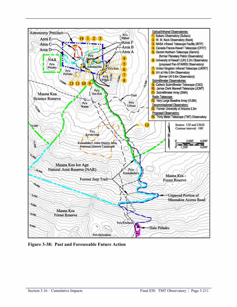
Section 3.16 – Cumulative Impacts Final EIS: TMT Observatory Page 3-211
Figure 3-38: Past and Foreseeable Future Action

Page 3-212 Final EIS: TMT Observatory Section 3.16 – Cumulative Impacts
3.16.2 Level of Existing Cumulative Impact
Cultural, Archaeological, and Historic Resources
Existing cultural, archaeological, and historic resources are discussed in Section 3.2.1 and 3.3.1.
Maunakea Summit Region and Hale Pōhaku
Prior to contact with Europeans, Hawaiians engaged in a number of activities in the summit region. Except for the activities at the adze quarry, those activities were generally small in scale, without long-lasting adverse effects, and resulted in a minimal impact to the mountain landscape.
The period between contact with Europeans and the development of observatories on Maunakea saw a change in the nature and intensity of the impacts on Maunakea. The introduction of cattle and sheep severely affected resources used by Hawaiians. The grazing animals lead to the near disappearance of the silversword and impacts to the subalpine māmane forests and alpine shrublands and grasslands habitats; this resulted in the total loss or severe population drops of several native bird species. The current policies to control or eliminate feral ungulates in large areas, such as the MKSR, Ice Age NAR, and Mauna Kea Forest Reserve, have the potential to reverse some of the past impacts of both managed and feral animals on cultural resources that can regenerate, such as flora and fauna.
Increased Access
After the initial contact with Europeans it is reported that visits by Native Hawaiian to the summit greatly decreased; few foreigners are documented as visiting the summit area during that time as well. In the later 19th century and early 20th century the number of visitors to the summit area increased due to the popularity of horseback excursions to the summit area. Native Hawaiians, kama‘āina, and visitors are reported to have visited the summit in this way. Trails worn by the horses and visitors had a minimal impact on the mountain and apparently followed the two primary trails, the Maunakea – Humu‘ula Trail and the Maunakea – ‘Umikoa Trail.
Access to the summit was made easier over the years with the paving of Saddle Road and the road to Hale Pōhaku following World War II.
In 1964, the first road to the summit was cut, making the construction of the observatories possible and also providing a relatively easy means of access to the general public. The increased number of visitors increased the potential for disturbance to cultural, archaeological, and historic resources. The road also facilitated access by cultural practitioners and allowed Native Hawaiians and scientists easier access to identify, record, and propose measures to protect cultural resources and culturally important natural resources.
The number of visitors and workers and the fact they have largely been unaware of the cultural significance of Maunakea increased the potential for impact to cultural resources. For example, in the past some engaged in off-road driving in the summit area; this has largely been curtailed by road improvements and OMKM rangers. Others have unknowingly impacted archaeological resources, disrupted the ambiance necessary for Native Hawaiian religious observances, or otherwise defiled a sacred realm.
Section 3.16 – Cumulative Impacts Final EIS: TMT Observatory Page 3-213
Archaeological Resources
Prior to 1982, few archaeological surveys were conducted, so it is not known whether development on the mountain damaged subsurface resources. There is no indication that any archaeological sites in the summit region were destroyed during the construction of the Mauna Kea Access Road or the early observatories. Since 1982 the number and thoroughness of archaeological surveys undertaken prior to the construction of new observatory facilities has increased. Surface sites found in the vicinity of development projects have been flagged and protected during construction; monitoring during construction to identify possible subsurface cultural deposits or human burials was not undertaken in most cases.
Some of the historic shrines have been altered in the recent past. Some have been defaced with modern writing and symbols, while portions of others have been repositioned. Consultations conducted during the development of the CMP indicate that some cultural practitioners believe they have the right to modify the historic shrines, while others disagree. The accumulation of offerings have reportedly become obtrusive and distracting to the point that they have an adverse effect on historic properties in some cases.
As discussed in Section 3.2.1, traditional accounts suggest that some ancient trails were present in the summit region. In some instances in other areas of Hawai‘i island, Hawaiian trails have been preserved and are archaeological features. It is unknown if the current trails in the summit region follow the same route as the ancient trails. In general, over the years the trails have been improved to accommodate visitors to the region, including realignment of certain trails (Table 3-20). In some cases, roads have also been built that intersect or replace short sections of trails. These activities may have impacted the ancient trails; alternatively the ancient trails followed different routes and have been impacted by natural erosive processes. In either case, there is no remaining physical evidence of ancient Hawaiian trails in the region.
Cultural Practices
Access and use rights are among important factors in allowing for cultural practices. As mentioned earlier, the roads built to the summit have facilitated access by cultural practitioners. Outside of not allowing vehicle access beyond Hale Pōhaku due to hazardous road conditions and requiring people to depart the summit region shortly after sunset, there are no known instances of limiting access for cultural practices. Families are building new shrines, practitioners are visiting the adze quarry and Lake Waiau to conduct cultural and religious rituals, and there have been spiritual observances of the winter solstice and other events. Despite this, the existing observatories have disrupted the ambiance necessary for Native Hawaiian religious observances.
There is also the possibility that existing observatories altered or removed a location where cultural practices once occurred. It has been reported that during construction of the existing facilities no archaeological sites or burials were encountered. Due to the lack of information concerning cultural practices taking place prior to the development of the observatories it is unknown if they directly altered or removed a location where cultural practices were taking place in modern times.
Page 3-214 Final EIS: TMT Observatory Section 3.16 – Cumulative Impacts
Spiritual and Sacred Quality of Maunakea
The construction of observatories near and on the slopes of the cinder cones that comprise what SHPD now recognizes as the TCP Historic Property of Kūkahau‘ula, spiritually the most important area of the mountain, greatly affected traditional cultural resources. Little consideration was given to Kūkahau‘ula during previous projects because the significance was not understood at the time. Observatory construction has resulted in the moving of more than 10,000 cubic yards of material, grading and flattening of Kūkahau‘ula ridges, and placement of man-made structures on Kūkahau‘ula, affecting the views to and from the summit. The development of observatories within the Astronomy Precinct substantially altered the appearance of the summit, and the presence of these observatories continues to affect the performance of religious and cultural practices.
As evidence of this affect, Kealoha Pisciotta has said regarding Kūkahau‘ula: “Unfortunately though, Poli‘ahu’s image and bodily form is being destroyed. They are altering the images of our deities because the pu‘u[s] are being leveled and the telescopes are being built on top of her.”59
Kumu Pono Associates, LLC prepared a collection of historical accounts and interviews for OMKM in which it is suggested that the use of the new individual names (Pu‘u Wēkiu, Pu‘u Kea, and Pu‘u Hau‘oki) for the cinder cones at the summit “have displaced the significant spiritual and cultural values and sense of place associated with name Pu‘u o Kūkahau‘ula.”60
Kūkahau‘ula has been adversely affected, not only by astronomy, but by all public and commercial activities, including snow play.
Although none of the observatories are visible from the shores of Lake Waiau, a number of them are visible from the summit of Pu‘u Waiau and the summit of Pu‘u Līlīnoe.
Maunakea Summit Region and Hale Pōhaku Summary
The existing level of cumulative impact on cultural, archaeological, and historic resources is substantial, significant, and adverse.
Headquarters
The development of the University Park has not disturbed any cultural, archaeological, or historic resources; there has been no cumulative impact on cultural, archaeological, or historic resources.
Biological Resources
Existing biological resources are discussed in Section 3.4.1.
Maunakea Summit Region and Hale Pōhaku
There are three main ecosystems within this area. The highest ecosystem is the alpine stone desert in the area above 12,800 feet and includes the summit cinder cones. The 11 observatories
59 Na Maka o ka ‘Āina, 2008. 60 Kumu Pono, 2005:vi.

Section 3.16 – Cumulative Impacts Final EIS: TMT Observatory Page 3-215
are located in this area. Some cinder cones with similar habitat to the summit cinder cones exist down to an elevation of 11,715 feet; due to their similarities with the alpine stone desert they are considered part of that ecosystem. Below the alpine stone desert is the alpine shrublands and grasslands ecosystem, which extend from 9,500 feet (the tree line) to 12,800 feet. The VLBA radio antenna and the Mauna Kea Access Road are located in this area. The māmane subalpine woodlands ecosystem is below the alpine shrublands and grasslands ecosystem and extends from the tree line down to Saddle Road. Hale Pōhaku and the lower portions of the Mauna Kea Access Road are located in this area.
Alpine Stone Desert Ecosystem
The summit of Maunakea is an island within an island, separated from other ecosystems by not only vast oceans, but high elevations as well. The upper elevations of the MKSR receive almost no rainfall and snow accumulates only during the winter season. Temperatures often drop below freezing at night and reach up to 50 degrees Fahrenheit during the day. Solar radiation is extreme, and evaporation rates are high. The harsh environmental conditions limit the composition of the resident floral and faunal communities found there. Under these harsh conditions, only hardy lichens, mosses, ferns, and scattered grasses can survive61.
The bulk of human activity has occurred on the cinder cones near the summit of Maunakea, where eight of the existing observatories are located. Human activities have had a very limited impact on the relatively extensive habitats beyond the summit cinder cones. Therefore, human activity has not had a significant cumulative impact on species that dwell in these other habitats, such as lichens, mosses, and vascular plants. Due to the level of development that has occurred within the relatively small area of summit cinder cones, many studies have been conducted to evaluate if that development has impacted natural inhabitants of the cinder cone habitat.
The wēkiu bug, which lives only in loose cinder habitats on the cinder cones above 11,715 feet on Maunakea62, has been identified as the species most closely related to and reliant on the cinder cone habitat. There is a similar species, Nysius aa, which occurs in the upper elevations on Mauna Loa63.
Of more than 20 cinder cones in the MKSR, five show signs of human modification from construction of existing observatories and supporting infrastructure. To ascertain the state of the wēkiu bug, numerous studies have been, and continue to be, conducted in the MKSR.
In the 1999 study64, wēkiu bugs were more abundant in disturbed areas compared to non-disturbed areas, which led the investigators to suggest “the possibility that observatory construction had not impacted wēkiu bug or lycosid spider distributions at the summit, outside of the immediate vicinity of paved and covered areas.” That study demonstrated that wēkiu bug were still fairly abundant in the cinder of the pu‘u on which Keck and Subaru sit in the areas of the inner crater walls and crater bottom that had been modified during construction of the Subaru Observatory. This suggests that the wēkiu bugs are able to recolonize the previously disturbed areas.
61 Cuddihy, 1989 62 Porter and Englund, 2006 63 Polhemus 1998 64 Howarth and others, 1999

Page 3-216 Final EIS: TMT Observatory Section 3.16 – Cumulative Impacts
From October, 2002 through April, 2007, four reports of arthropod research were completed by the B.P. Bishop Museum considering the results of sampling over a large portion of the MKSR65. The purpose of these studies was to gather information about the distribution of wēkiu bugs throughout the MKSR. The four studies, which involved extensive trapping and tests, found wēkiu bugs on at least 15 cinder cones ranging in elevation from 11,715 feet to 13,796 feet. The studies generally concluded that wēkiu bugs are restricted to rims and inner craters of cinder cones where loose cinders provide interstitial spaces large enough to allow movement through the cinder habitat. Surveys have shown that wēkiu bugs are still abundant and are found in previously disturbed areas and undisturbed areas of their cinder cone habitat. The researchers advanced a hypothesis that weather, abiotic factors, temperature, and substrate moisture all may influence wēkiu bug activity.
A fifth report66 details the accounts of a study on possible geologic factors that may influence wēkiu bugs. That study found that the wēkiu bugs appear to prefer non-glaciated cinders and lava spatter in areas where glacial erratics are lacking. The study concluded that “Because the [Wēkiu] bugs apparently do not like bedrock substrates, telescopes sited on the glacially modified lava flows in the summit region may have little or no local impact on the bugs…”
A long-term baseline monitoring study was also started in February 2002, for the then-proposed W.M. Keck Observatory’s Outrigger Telescopes Project67. The study was comprised of ten pitfall live-traps at permanent sampling stations inside the pu‘u crater northwest and below the Keck Observatory and another ten at permanent sampling stations inside Pu’u Wēkiu. Sampling was conducted quarterly from February 2002 through May 2006. Microclimate data were collected to make inferences about the relationship between wēkiu bug abundance and habitat temperature. Over the four-and-a-half years of sampling, 7,912 wēkiu bugs were collected. Wēkiu bugs were found to be more abundant on the pu‘u Keck sits on than on Pu‘u Wēkiu. The results of this study supported the conclusion of the previous 1999 study – that observatory construction had not impacted wēkiu bug and lycosid spider distributions at the summit, outside of the immediate vicinity of paved and covered areas. The study also found that wēkiu bug activity appeared to vary with temperature and that wēkiu bug populations fluctuated year to year.
The wealth of current data from long-term monitoring studies indicates that the existing observatories have not impacted wēkiu bug and lycosid spider distributions at the summit, outside of the immediate vicinity of paved and covered areas. The pavement and covered area associated with the existing observatories (63 acres) resulted in cumulative displacement of no more than 3.3 percent of the total known Type 2 and 3 wēkiu bug habitat. The total known and suspected Type 2 and 3 habitat is illustrated on Figure 3-4, and constitutes roughly 1,900 and 775 acres, respectively.
Based on the available information it is not possible to determine the magnitude or significance of past human activity on wēkiu bugs or other biological resources that inhabit the alpine cinder cone ecosystem.
65 Englund and others 2002, 2005, 2006, 2007 66 Porter and Englund, 2006 67 Brenner, 2002 – 2006

Section 3.16 – Cumulative Impacts Final EIS: TMT Observatory Page 3-217
Alpine Shrublands and Grasslands and Māmane Subalpine Woodlands
Below 11,700 feet is an alpine shrublands and grasslands ecosystem growing on ‘a‘a lava flows, cinder cones, and air-fall deposits of lapilli and ash. Native shrubs, grasses, sedges, and ferns grow well above the tree line, and become sparser with increasing elevation.
Below the alpine shrub zone are the māmane subalpine woodlands that extend down to Saddle Road. The open-canopied māmane woodland is home to the endangered bird, palila (Loxiodes bailleui). Māmane trees also act to intercept fog that provides them and other species nearby with the small amounts of moisture they need to survive68. The understory of the subalpine forest is comprised largely of native shrubs, and in undisturbed areas clumps of native grasses are the most abundant ground cover; dominant understory plants in the vicinity of Hale Pōhaku are invasive weedy species such as common mullein, telegraphweed, needle grass, and evening primrose (Hess et al. 1996). The māmane forest on Maunakea has a diverse arthropod fauna; over 200 arthropod species have been collected there.
While construction at Hale Pōhaku has resulted in the removal of small areas of māmane woodlands, the past has seen the greatest and most devastating impacts to the māmane subalpine forest and alpine shrublands and grasslands ecosystems on Maunakea through the intentional maintenance of feral ungulates (hoofed mammals such as wild sheep, pigs, and boars) during past ranching and more recently for recreational hunting. These ungulates nearly destroyed the māmane woodlands and have reduced the once abundant Mauna Kea silversword populations to nearly zero. The impact of ungulates on the natural resources in these ecosystems far outweighs any other impact from human activities within the subalpine and alpine environments. The portion of cumulative impact related to development of Hale Pōhaku and observatory facilities in general is less than significant; however, due to past ungulate management practices, the cumulative impact on these ecosystems has been substantial, significant, and adverse.
Headquarters
According to previous studies, the development of University Park did not result in a significant impact to biological resources.
Visual and Aesthetic Resources
Existing visual and aesthetic resources are discussed in Section 3.5.1.
Maunakea Summit Region and Hale Pōhaku
The astronomical observatories (Table 3-20) are prominent visual elements on the summit of Maunakea. On a cloud-free day, some of these existing observatories are visible from locations around the island such as Hilo, Honoka‘a, and Waimea. On the west coast of the island, the existing observatories appear most visible at sunset, when they are lit by the setting sun; on the east coast they appear most visible at sunrise. All eight existing optical/infrared observatory structures are colored white or silver to minimize the difference in temperature between day and night and the associated cooling needs as much as possible. Most of the structures are rounded, but the Subaru observatory has a cylindrical paneled structure. The cylindrical panels of the Subaru observatory make it less visible during most of the day; however, at sunset, it appears 68 Gerrish, 1979
Page 3-218 Final EIS: TMT Observatory Section 3.16 – Cumulative Impacts
bright due to the reflection of sunlight from its flat surfaces. After conducting a viewshed analysis based on topography, at least one of the existing observatories is visible from roughly 43 percent of the island. According to 2000 U.S. Census data, 72 percent of the population, or about 107,000 people, reside within that viewshed area. At the summit, the existing observatories obscure portions of the 360-degree panoramic view from the summit area.
Maunakea is often veiled by clouds formed by the inversion layer and obscured by vog; this shrouds the summit from view from low elevation areas around the island, as well as the views from the summit to the island below.
The existing support facilities at Hale Pōhaku are not visible from other locations on the island due to the terrain of this area. The Hale Pōhaku mid-elevation support facilities were specially designed with the structures sited and built to follow the contours of the mountain, and colored to blend with the surrounding natural features and terrain.
The existing development on Maunakea does not block or obstruct any of the identified views in the County of Hawai‘i General Plan or the South Kohala Development Plan. They are, however, visible within the viewplanes from Hilo, Waimea, and the summit. Overall, the existing level of the cumulative visual impact from past projects at the summit is considered to be substantial, significant, and adverse.
Headquarters
The development of the University Park thus far has not resulted in a significant visual impact.
Geology, Soils, and Slope Stability
Existing geologic resources are discussed in Section 3.6.1.
Maunakea Summit Region and Hale Pōhaku
Within the MKSR, most of the changes associated with local geology are due to wind, the movement of ice, snow, and water, and human activity. The main human activities that disturb cinder and other geologic features include road grading and travel by vehicles, hiking, off-road vehicle use (now prohibited), and activities associated with infrastructure improvements.
The development of each existing observatory required localized site work that significantly modified the preexisting terrain, and impacted geologic structures and slope stability. Pu‘u Hau‘oki and an unnamed cinder cone to the west (where Keck and Subaru observatories are located) have undergone the most significant alterations as connecting roads were built and the tops of the cones were flattened to serve as foundations for the facilities. Most of the material that was removed was transported away for use elsewhere or placed on the floor of the pu‘u crater northwest of Keck, but some material was pushed over the sides of the cones. As a result, these areas have steeper slopes than would naturally occur, and because they consist of poorly consolidated material they are more susceptible to disturbance. As a result of the low amount of precipitation and high porosity of the ground surface at the summit there is no evidence of erosion by surface runoff.
Following the construction of the Mauna Kea Access Road, erosion of materials next to the roadway has been an issue during heavy rainfall or rapid snow erosion. Past episodes have
Section 3.16 – Cumulative Impacts Final EIS: TMT Observatory Page 3-219
transported loose material as much as 300 feet downslope from the road, but the construction of settling basins along the roadway has largely mitigated this occurrence. To maintain the road, grading of the unpaved areas is conducted approximately three times per week.
At Hale Pōhaku erosion impacts appear to be more extensive due to greater visitor counts and concentrations.
The existing level of cumulative impact on geology, soils, and slope stability is considered to be substantial, significant, and adverse, primarily due to the alteration of the cinder cone morphology.
Headquarters
The development of University Park thus far has not resulted in significant impacts on geology, soils, or slope stability.
Water Resources and Wastewater
Existing water resources and wastewater management are discussed in Section 3.7.1.
Maunakea Summit Region and Hale Pōhaku
The drainage patterns on the summit have been minimally impacted by the past development (Table 3-20). On the cinder cones, the introduction of impervious surfaces has not resulted in surface runoff, as the cinder is so pervious that the capacity to absorb water has always been greater than the rate of precipitation. Mauna Kea Access Road does create surface runoff and slightly alters the path of natural surface runoff. There are numerous points of discharge along the road and the rates of discharge at each are fairly small, so the resulting erosion and deposition of materials are minor. Also, the surface runoff does not extend to or below an elevation of 6,000 feet, which means that the majority of the water ultimately ends up percolating and becoming groundwater recharge with only a small amount lost to evaporation.
The existing wastewater systems at Hale Pōhaku, and the individual wastewater systems operated by each observatory on Maunakea have all been designed to meet the HDOH permit requirements for sanitary waste systems. Domestic type wastewater is discharged into these approved systems, and there is no direct discharge into the ground. The collected solids are pumped out of the systems on a regular basis, hauled off the mountain, and disposed of in approved facilities. The natural nutrient removal that takes place over the decades-long travel time from the summit to the Waiki‘i wells results in no impact to the wells due to the introduction of the domestic wastewater. The wastewater generated during mirror washing is no longer directed into any of these systems and instead, is fully containerized and hauled down the mountain for disposal. It has been shown that the past disposal practices of mirror washing wastewater have not had a significant impact on water quality.
The existing level of cumulative impact on water quality is negligible and less than significant.

Page 3-220 Final EIS: TMT Observatory Section 3.16 – Cumulative Impacts
Headquarters
The development of the University Park thus far has increased the amount of impervious surfaces in the area, thereby increasing the volume of storm runoff. The drainage system was designed and built to properly capture, collect, and transport the runoff from the area.
The connection of the existing facilities in the University Park to the regional wastewater system resulted in a minimal increase in the volume of wastewater treated by the Hilo Wastewater Treatment Plant.
The existing level of cumulative impact on water quality is negligible and less than significant.
Solid and Hazardous Materials and Waste
Existing solid and hazardous materials and waste conditions and management are discussed in Section 3.8.1.
Maunakea Summit Region and Hale Pōhaku
Human activities, including astronomy, tourism, and recreation, generate trash and other solid waste that has been collected in containers, removed regularly, and disposed of at authorized landfills. In the past, researchers reported occurrences of a considerable amount of trash left around the mountain and in response, MKSS began collecting the trash, including that left by visitors to the summit, and it is now rarely seen within the MKSR.
Observatory operations on Maunakea have required the use of hazardous materials, and generated waste from such materials; these include paint, solvents, vehicle and generator fuel, lubricants, hydraulic fluid, glycol coolants, acids, and mercury. A small number of mercury spills have occurred since observatory operations began; the best available information regarding such occurrences suggests that none of the spills reached the outside environment impacted soil or groundwater.
The existing level of cumulative impact due to solid and hazardous materials and waste is small and less than significant.
Headquarters
The development of the University Park thus far has involved the use of hazardous materials, and generated waste from such materials; which include paint, solvents, vehicle and generator fuel, lubricants, and hydraulic fluid. Operations of facilities within the Park generate trash and solid waste, which is collected and regularly picked up and disposed of at a landfill. Overall, impact due to solid and hazardous materials and waste is small and not significant.
Socioeconomic Conditions and Public Services and Facilities
Existing socioeconomic and public services and facilities conditions are discussed in Section 3.9.1.

Section 3.16 – Cumulative Impacts Final EIS: TMT Observatory Page 3-221
Maunakea Summit Region and Hale Pōhaku
Astronomy has become a local industry, and has provided significant economic and educational benefits to the State and local communities. The majority of the funding for the construction and operation of the observatories has been provided by organizations outside of the state. At least one-third of the funds for construction were spent on local services; more than 80 percent of the operating funds are spent in Hawai‘i, mostly within the County of Hawai‘i. Payments of fees and tax obligations by the observatories flow into the State and the County on an annual basis, as do payments for utilities and other services. The staff and other employees contribute to the local economy directly through income tax and other payments, and indirectly through purchases of local goods and services.
Of the approximately 600 people currently employed by the existing observatories, it is estimated that roughly half moved to Hawai‘i, and about half of the employees were already in Hawai‘i when they began working for the observatories. This relatively small (roughly 300 employees plus family for a total of 825 people or 0.6 percent of the County’s population) addition of people to the County of Hawai‘i for observatory employment has not adversely affected the social fabric of the island communities. The astronomy sector of the local economy has provided the County of Hawai‘i with many beneficial social and education opportunities that would otherwise not exist. These include programs such as the Observatory Directors Lecture Series, the Universe Tonight program at the VIS, the Astronomy Educators in the Classroom program, the activities and facilities at ‘Imiloa, the Doing Astronomy with Kupuna program, and astronomy internship programs. In addition, the astronomy community helps sponsor a number of non-astronomy events in the community.
Overall, the existing level of cumulative impact on socioeconomic conditions is substantial and beneficial.
Headquarters
The University Park facilities contribute to the economy of the State and the County through payment of utility and other fees and purchase of local goods and services. The staff and employees contribute directly through income tax and other payments and indirectly by purchasing local goods and services.
Land Use Plans, Policies, and Controls
Existing land use plans, policies, and controls are discussed in Section 3.10.1.
Maunakea Summit Region and Hale Pōhaku
The construction and operation of observatories in the MKSR, the Hale Pōhaku facilities, and access roadways (Table 3-20) have all been consistent with State and local land use policies and land use designations, including the CMP that provides the framework for managing existing and future activities, including astronomy, recreational and commercial activities, scientific research, and cultural and religious activities within the UH management area – which consists of the MKSR, Hale Pōhaku, and the Mauna Kea Access Road between Hale Pōhaku and the MKSR. Each of the existing observatories on the summit underwent required permitting processes and

Page 3-222 Final EIS: TMT Observatory Section 3.16 – Cumulative Impacts
reviews. As such, this past development has not resulted in conflict with existing land use plans, policies, or controls for the Conservation District, resource subzone.
Other cumulative land use-related impacts, including those on cultural and religious uses, visual effects, the mountain’s natural ecosystems, its geology, water quality, and other areas, are each addressed in this section under its type of environmental issue area.
Headquarters
The development of the University Park has been consistent with the applicable land use plans and policies. This development is subject to the regulations of these plans and policies, preventing the potential for land use planning conflict.
Roadways and Traffic
Existing roadways and traffic conditions are discussed in Section 3.11.1.
Maunakea Summit Region and Hale Pōhaku
The creation of Mauna Kea Access Road that provided for the relative ease of accessing the summit, has led to increased traffic on the mountain. Traffic associated with recreation and tourism has increased over the past several decades; this has included an increase in the number of organized commercial and educational tours. As detailed in Section 3.11, more than 100,000 people have visited the mountain per year over the past few years. In 2008, the total number of visitations in vehicles on the mountain was approximately 30,763, with about 10,438 visiting 4-wheel drive vehicles and 11,844 observatory vehicles. While on average this represents about 28 visitor and 30 observatory vehicular trips per day, the cumulative level of vehicular trips is considerable for the Maunakea environment. The impact related to this number of visitors is demonstrated by the level of impact on biological and other natural resources, including the natural setting of the mountain. However, the existing roads are sufficient to handle this level of traffic and it does not represent a significant impact to the roads or level of traffic.
Headquarters
The development of the University Park has increased traffic on the surrounding streets during peak rush hours; however, the overall level of traffic has not resulted in a substantial or significant cumulative impact on the existing roadway system.
Power and Communication
Existing power and communications infrastructure are discussed in Section 3.12.1.
Maunakea Summit Region and Hale Pōhaku
The construction of power lines began in 1985, and once the lines reached Hale Pōhaku additional work was performed to provide the summit with power through an underground distribution system (Table 3-20). This work was completed in 1988, and in 1995 an upgrade to the system added an underground distribution loop at the summit and provided service to the SMA observatory.

Section 3.16 – Cumulative Impacts Final EIS: TMT Observatory Page 3-223
The communications system was installed together with the power system in 1985. Fiber optic cables were added in the 1990s, and the existing communication system allows for real-time communication between the summit facilities and on- and off-island headquarters offices, as well as an internet connection.
The provision of power and communication systems to serve the existing uses and activities on Maunakea has not resulted in a substantial or significant cumulative effect on the capacity or supply of electricity and communication systems on the mountain or island-wide.
Headquarters
University Park is served by the existing HELCO power distribution system and Hawaiian Tel communication network. These systems service the entire island. No power or communication capacity shortage has occurred to date.
Noise
Existing noise conditions and requirements are discussed in Section 3.13.1.
Maunakea Summit Region and Hale Pōhaku
Ambient sound levels at Maunakea are low, with vehicle traffic and wind providing the dominant background. Observatory operations generate minimal noise, primarily related to their HVAC systems. Noise associated with a relatively small numbers of visitors (estimates by rangers indicate an average of about 28 non-commercial visitor vehicle trips a day to the summit, most of them staying less than 30 minutes) and observatory vehicle trips (the existing observatories average about 30 vehicle trips a day) is relatively limited. While people’s sensitivity to noise vary, no one is habitually exposed to noise at the summit; the scientists and observatory staff use the Hale Pōhaku dormitories, and tourists and other visitors leave the summit before nightfall. While construction activities create intermittent, though sometimes significant disruptions, the existing ambient noise levels remain low and fully within the applicable noise standards of 55 dBA during daytime hours and 45 dBA during nighttime hours, except within the immediate area of certain observatory HVAC systems and/or their exhaust. Noise measurements at various locations in the summit region indicate that although the applicable noise standards are sometimes exceeded in the vicinity of observatory HVAC systems and/or their exhaust, noise levels are unlikely to exceed the noise standards at identified noise sensitive locations. Thus, the overall level of cumulative noise impact is less than significant.
Headquarters
Vehicular traffic is the major noise generator in urban areas, and noise in Hilo is generally associated with traffic from busy roads, particularly Komohana Street in the area. The University Park area is relatively quiet, with traffic on the adjacent streets generating most noise. The operations of the existing UH Hilo facilities generate limited noise, primarily from internal vehicle trips of staff and employees. The overall ambient noise levels are within standards consistent with types of existing uses and level of development and the cumulative noise impact is less than significant.

Page 3-224 Final EIS: TMT Observatory Section 3.16 – Cumulative Impacts
Air Quality, Climate, and Lighting
Existing air quality, climate, and lighting conditions are discussed in Section 3.14.1.
Maunakea Summit Region and Hale Pōhaku
Maunakea’s geographic and meteorological isolation produces excellent air quality. With the summit area rising well above the atmospheric temperature inversions, that occur around 7,000 feet, air pollutants are “capped” and do not cause any interference at the summit. Locally generated contributors to air pollution above the inversion level include vehicle exhaust, chemical fumes from construction and maintenance activities, and fugitive dust from road grading and construction or other activities conducted on unpaved surfaces. Strong winds aid the rapid dispersion of these pollutants, helping to maintain Maunakea’s excellent air quality, in attainment status with all ambient air quality standards. The level of cumulative air quality impact associated with past and current development and activities is small and not significant.
The past and existing uses and activities on Maunakea (Table 3-20) have not changed the climate on the island; however, they have incrementally contributed to the planet-wide global climate change associated with the use of fossil fuels and global warming practices. It is unlikely that those uses and activities were contributing proportionally more to climate change than those occurring at other elevations in Hawai‘i, or at other locations on the planet.
One of the characteristics of Maunakea, which makes it one of the best sites in the world for astronomical observations, is the very dark sky. This results from the summit’s remoteness from urban development, as well as the County of Hawai‘i’s island-wide lighting ordinance requirements that have resulted in the exclusive use of LPS outdoor lighting. The absence of air pollution, the absence of large, brightly-lit cities on the island of Hawai‘i, and the absence of high intensity illumination of existing facilities at Maunakea have resulted in a low level of sky illumination all through the mountain areas. The level of cumulative sky illumination impact associated with past and current uses and activities is small and less than significant.
Headquarters
The air quality within the entire island, including the University Park, is excellent; with no exceedences of ambient air quality standards resulting in a low level of cumulative impact. All development and uses are subject to the County of Hawai‘i’s island-wide lighting ordinance requirements resulting in a low level of cumulative impact.
3.16.3 Reasonably Foreseeable Future Actions Over time, there have been many conceptual ideas and plans for astronomical facility development in the future, as well as for projects to support various other uses, including recreational uses. The cumulative impact evaluation addresses possible future projects that may be reasonably foreseeable. The following projects may be reasonably foreseeable future projects within the Astronomy Precinct:
• The Project – the TMT Observatory will be built and operated at the 13N site in Area E (Section 2.5.1), and the Access Way will be built between the 13N site and the Mauna Kea Access Road Loop (Section 2.5.2). The TMT Observatory and portion of the Access Way exclusively used to access it will be decommissioned at the end of its life.

Section 3.16 – Cumulative Impacts Final EIS: TMT Observatory Page 3-225
• Panoramic Survey Telescope and Rapid Response System (Pan-STARRS) would replace the existing UH 2.2-meter telescope in Area A. Pan-STARRS is expected to consist of four 1.8-meter telescopes, each with a 3-degree field of view and a 1.4-billion pixel camera, all in a single enclosure. The Pan-STARRS would be able to observe the entire available sky several times during the dark portion of each lunar cycle. The new technology planned for Pan-STARRS would enable remote and/or robotic operation.
• Smithsonian Astrophysical Observatory is considering adding 2 antenna pads and 1 antenna in Areas C and/or D to the existing 24-pad, 8-antenna SMA system.
• Decommissioning and removal of the Caltech Submillimeter Observatory (CSO), which was built in 1987 in Area C.
• The paving of the remaining dirt portions of the Mauna Kea Access Road above Hale Pōhaku (roughly 4.6 miles long between 9,300 feet to 11,800 feet). CMP Management Action IM-8 outlines a policy to assess the feasibility of paving the road.
The general locations of these foreseeable future actions are illustrated in Figure 3-38.
Another foreseeable event is the end of UH’s lease of the MKSR. UH’s current lease will expire in 2033. Because there is a range of possible outcomes or actions related to this event, it is discussed separately in Section 3.16.5.
Foreseeable actions within Hale Pōhaku include the Project’s potential Mid-Level Facility, which, if constructed, would primarily consist of remodeling and replacing existing structures (Section 2.5.3). In Hilo, the UH Hilo campus and surrounding area are expected to continue to develop with infill developments, such as the Project Headquarters (Section 2.5.4).
3.16.4 Level of Future Cumulative Impact with the Project and Reasonably Foreseeable Future Actions
The potential impacts, and hence cumulative impact, of the Project and reasonably foreseeable future actions are evaluated within the framework of compliance with all applicable rules, regulations, and requirements applicable to the action type and location. This includes the requirements of the CMP.
The Headquarters development, and other similar developments nearby, would add to the cumulative impact of the further development of UH Hilo. However, the expansion of the University Park area is consistent with land use plans and policies and further development is not anticipated to have a significant negative cumulative impact on the environment.
Cultural, Archaeological, and Historic Resources
The existing level of cumulative impact on cultural, archaeological, and historic resources is considered substantial, significant, and adverse (Section 3.16.2). This section describes cumulative impact associated with the Project and the foreseeable actions. Details regarding Project impacts on cultural resources are disclosed in Section 3.2.3 and details regarding Project impacts on archaeological and historic resources are disclosed in Section 3.3.3.
Page 3-226 Final EIS: TMT Observatory Section 3.16 – Cumulative Impacts
Maunakea Summit Region and Hale Pōhaku
Generally, through compliance with the 2000 Master Plan, the CMP, the CRMP, and other rules, regulations, and requirements for the Project area, the Project and other foreseeable action within MKSR and Hale Pōhaku, would result in a small limited incremental increase in the cumulative impact on cultural resources. The limited extent of the impact is primarily because:
• Areas of Project and future development would be sited to avoid culturally significant areas and known historic resources.
• Archaeological surveys would be performed prior to any ground-modifying work to ensure minimal impact to archaeological resources.
• Ground-modifying activities would be monitored by a qualified archaeologist.
• Consultations would be conducted with representatives of the Native Hawaiian community, including Kahu Kū Mauna, during planning activities and prior to construction.
• Construction and installation activities would be monitored by a cultural observer.
• Construction workers, operational staff, and visitors would be educated to understand the sacredness of the summit, to understand and recognize the sensitivity of the cultural resources, the importance of not disturbing the resources or disturbing cultural and religious practices, and ways to conduct their daily activities that would avoid the potential for disturbance.
• TMT will implement the mitigation measures identified in Section 3.2.4 and the treatments identified in Section 3.3.3.
There are some opportunities to reduce the level of impact during the implementation of some of the foreseeable projects, most notably the decommissioning of the CSO.
Increased Access
The paving of the 4.6 mile segment of the Mauna Kea Access Road above Hale Pōhaku could result in increased trips and visitors to the summit area. As part of the CMP, a Public Access Plan (PAP) has been prepared that addresses overall access to the summit area. With the implementation of the principles of “adaptive management” laid out in the PAP and education plans called for in the CMP, impact due to increased access would not significantly increase the impact on resources in the summit area.
The development of the Project and foreseeable actions in the summit area would increase access within the summit region. With the exception of the expansion area of the SMA in Area D, 4-wheel drive roads, at the very least, already exist in the vicinity of all foreseeable actions. The existing roads would be improved, and new roads added in the case of the SMA expansion, and the presence of observatories along those roads could draw more visitors to travel along those roads. The presence of an improved road in Area F could have the additional effect of increasing snow play activities on the north side of Kūkahau‘ula because it would provide a clear route that could be used to access the top of the runs known as Ali‘i Run and Warrior’s Run. All the roads have the potential to tempt visitors to access areas previously not normally visited, but this possibility is considered low because Areas D, E, and F do not provide views, access to trails, or
Section 3.16 – Cumulative Impacts Final EIS: TMT Observatory Page 3-227
opportunities for experiences that cannot be achieved along currently existing roadways, other than visiting the new observatories.
The Project and other foreseeable actions may attract more visitors to the summit region to see the observatories. The presence of these additional visitors and the additional employees of the Project and other foreseeable actions could impact cultural resources. However, because Maunakea will continue to be a remote destination, these increases are likely to be slight relative to the existing level of visitors and employees. With existing programs and the implementation of the concepts presented in the CMP and PAP sub plan, including the ranger program and increased education programs, the impact to cultural resources by visitors and employees is likely to be reduced relative to current conditions.
Cultural Practices
With the implementation of the policies laid out in the CMP, the potential impact to cultural and religious practices by operations of the new uses would be minimal. The primary concern, therefore, is the potential for the Project or foreseeable actions to alter or remove a location where cultural or religious practices occur. This is particularly a concern where previously undisturbed areas would be used for projects. The Project in Area E and the 2 new SMA antenna pads could alter or remove a location where cultural practices occur. However, with each project required to go through the steps outlined for project development by OMKM, including consultations with Kahu Kū Mauna, the likelihood of this occurring is low.
The decommissioning of the CSO provides an opportunity to reduce the level of impact on cultural practices; however, it is not evident that cultural practices occurred at this location prior to the CSO development.
Spiritual and Sacred Quality of Maunakea
The integrity of the TCPs Historic Properties, including Kūkahau‘ula, Pu‘u Līlīnoe, and Waiau that are spiritually the most important areas of the mountain, are significant factors to the spiritual and sacred quality of Maunakea. The Project and foreseeable actions would not have a significant impact on the integrity of the TCPs Kūkahau‘ula Historic Property, unless Access Way Option 3 for the Project is selected because a maximum 0.6 acre portion of the property will be disturbed and the bulk of that has previously been disturbed by roads. Should the Pan-STARRS project redevelop the existing UH 2.2-meter observatory location on Kūkahau‘ula, a slight change to the impact related to that existing observatory could occur; Pan-STARRS design and operation concept would reduce the visual impact, as well as the number of staff at the observatory.
The visual impact of man-made structures is another one of the factors affecting the spiritual and sacred quality of Maunakea. Overall visual impact is discussed in a Visual and Aesthetic Resources section below. As discussed in Section 3.5.3, the TMT Observatory and Access Way will not be visible from the summit of Kūkahau‘ula, Pu‘u or Lake Waiau, or Pu‘u Līlīnoe, which are identified as State Historic Properties and are where many cultural practices occur. Pan-STARRS design would reduce the visual impact relative to the existing UH 2.2m observatory, which is visible from the summit of Kūkahau‘ula. The decommissioning of the CSO, which is visible from Pu‘u Waiau, would also reduce the visual impact.

Page 3-228 Final EIS: TMT Observatory Section 3.16 – Cumulative Impacts
Maunakea Summit Region and Hale Pōhaku Summary
The addition of the Project and other foreseeable actions to the existing environment would have a small limited incremental impact; however, the level of cumulative impact on cultural, archaeological, and historic resources would continue to be substantial, significant, and adverse.
Headquarters
Further development of the University Park area is not anticipated to significantly contribute to the existing less than significant cumulative impact on cultural, archaeological, or historic resources.
Biological Resources
Details regarding Project impacts on biological resources are disclosed in Section 3.4.3.
Maunakea Summit Region and Hale Pōhaku
Generally, through compliance with the CMP, the Project, reasonably foreseeable future actions, and the visitors they may attract would not result in a negative cumulative impact on biological resources. This is primarily because (a) any future development would have to replace any sensitive habitat, such as wēkiu bug habitat type 2 or 3, it would disturb at a minimum 1:1 ratio; and (b) all staff and visitors would be educated to understand the sensitivity of the biological resources, the importance of not disturbing them or their habitats, and ways to avoid impacting them during their daily activities.
Overall, the current policies to control or eliminate feral ungulates in large areas, such as the MKSR, Ice Age NAR, and Mauna Kea Forest Reserve, have the potential to begin reversing the past impact of both managed and feral animals.
Alpine Stone Desert Ecosystem
The Astronomy Precinct is entirely above 12,800 feet and therefore within the alpine stone desert ecosystem. The TMT Observatory and other foreseeable actions, except the paving of the existing Mauna Kea Access Road, would be located within the Astronomy Precinct of the MKSR. There are no currently-listed threatened or endangered species known to occur in the Astronomy Precinct. One species that is currently a candidate for listing, the wēkiu bug (Nysius wekiuicola), and one species currently considered a species of concern by the USFWS, the Douglas’ bladderfern (Cystopteris douglasii), are known to occur in the Maunakea summit region, including the Astronomy Precinct.
Douglas’ Bladder Fern. The Douglas’ bladder fern is present in the Astronomy Precinct, including 2000 Master Plan Areas C, D, E and F, but it also occurs throughout the MKSR, on Maui, and on the eastern slopes of Mauna Loa. Other species that live in the lava flow habitat of Areas C, D, E, and F are also widespread. Development of the TMT Observatory and Access Way plus the two new SMA antenna pads would displace less than 0.5 percent of this habitat and not result in a significant cumulative impact because this area does not represent a unique habitat essential for the fern’s or other species’ survival69.
69 Char, 1990

Section 3.16 – Cumulative Impacts Final EIS: TMT Observatory Page 3-229
Wēkiu Bug. The wēkiu bug, which normally lives only in loose cinder habitats on the cinder cones above 11,715 feet on Maunakea70, has been identified as the species most closely related and reliant on the cinder cone habitat.
The development of the TMT Observatory, Access Way, and new SMA pads would not have a significant cumulative impact on the wēkiu bug. The lava substrate in these areas is primarily Type 4 wēkiu bug habitat with roughly 5 percent Type 5 habitat; these types of habitat are considered to be marginal wēkiu bug habitat71, which is theorized to be occupied only during extreme population outbreaks. The amount of this habitat that would be displaced by construction and installation of the TMT Observatory, Access Way, and new SMA pads would be about a quarter (0.25) of one percent (roughly 10 acres of the more than 4,000 acres) of the total lava flow (Type 4 and 5) habitat above 11,700 feet. The Access Way Options would displace a maximum of roughly 0.2 acre of Type 3 wēkiu bug habitat, an area at least equal to the disturbance would be restored to provide similar or better habitat for the Wēkiu bug. The Access Way Options have been designed to limit disturbance and displacement of sensitive habitat and will be paved where adjacent to sensitive habitat to reduce dust-related impacts. Prior to, during, and for a period of two years after this disturbance, arthropods in the area will be monitored. Thus the individual contribution of the Project to the cumulative impact will be small and not significant.
The contribution to the cumulative impact by other foreseeable action (decommissioning of CSO and Pan-STARRS) would be less than significant; and could potentially result in a beneficial impact to wēkiu bug habitat in comparison with the existing conditions. This is because the future decommissioning of CSO, with subsequent habitat restoration, could increase the amount of available wēkiu bug habitat, thereby reducing the cumulative impact of the observatories in the Maunakea summit region. Pan-STARRS redevelopment would occur within the existing footprint of the UH 2.2-meter observatory and therefore, would add little, if any, to the cumulative impact.
Alpine Shrublands and Grasslands and Māmane Subalpine Forest Ecosystems
The paving of the Mauna Kea Access Road would reduce the amount of dust generated within these ecosystems. This would benefit these ecosystems.
As with the existing development at Hale Pōhaku, the Project’s potential Mid-Level Facility could remove a small number of māmane trees; none of the other foreseeable actions involve additional development at Hale Pōhaku. All the area that would be disturbed by the potential TMT Mid-Level Facility has been disturbed in the past and would not result in a significant cumulative impact. The slight increase in traffic related to the Project and other foreseeable actions, which could generate slightly more dust than the current level of traffic until the road is paved, would not result in a significant cumulative impact either.
70 Porter and Englund, 2006 71 Howarth and Stone 1982, Howarth and others 1999, Brenner and Lockwood 2005

Page 3-230 Final EIS: TMT Observatory Section 3.16 – Cumulative Impacts
Summary
While overall the Project and the potential future actions would result in less than significant cumulative impacts, the existing level of cumulative impacts would not be significantly reduced. Therefore, the level of cumulative impact would remain at the levels discussed in Section 3.16.2.
Visual and Aesthetic Resources
As detailed in Section 3.5.4, the location and design of the TMT Observatory incorporate measures to reduce its potential visual impacts. Most significantly, the TMT Observatory will not be visible from the southern portion of the island, including Hilo. Although the TMT Observatory may be visible in the view of Maunakea from portions of the South Kohala district and the area around Waimea, it will not block the views and viewplanes of the mountain. From some viewpoints, the TMT Observatory will be located in front of one of the domes of the existing Keck or Subaru Observatories and/or the lower portion obscured behind a rise of Maunakea.
The TMT Observatory will add a new visual element within the views of Maunakea for approximately 14 percent of the island area. However, current observatories can already be seen in most of that area. Figure 3-39 shows the visibility/viewshed of the existing observatories on Maunakea combined with the viewshed of the TMT Observatory. The green shaded area indicates where the existing observatories on Maunakea are visible, which is approximately 43 percent of the island. Roughly 72 percent of the island of Hawai’i’s population, or 107,000 people, live within the green shaded area. The portions of the island that are shaded in red in Figure 3-39 are areas where the TMT Observatory will be visible and where currently none of the existing observatories can be seen. The new area where an observatory will be visible is roughly 1.2 percent of the area of the island. Using the 2000 U.S. Census average household size of 2.75 people for the County of Hawai‘i, the estimated number of people living in this area is 72.
The visual impacts of the foreseeable actions can be summarized as follows:
• Decommissioning of the CSO facility would result in a minimal decrease in the cumulative visual impact. The CSO is only visible from approximately 5 percent of the island; it is not visible from Lake Waiau or Pu‘u Līlīnoe, but is visible from Kūkahau‘ula’s and Pu‘u Waiau’s summits. Therefore, there would be an incremental decrease in the visual impact from the summit of Pu‘u Waiau and Kūkahau‘ula.
• The addition of new SMA pads and antenna would not result in substantial new visual impacts as the individual antennas are small and would most likely be largely hidden from view by the placement on the northern plateau behind the change in slope. The SMA area is visible from Kūkahau‘ula’s summit, but the addition of one antenna to the existing eight would be a small incremental impact. The area is not visible from Pu‘u Līlīnoe or Waiau.
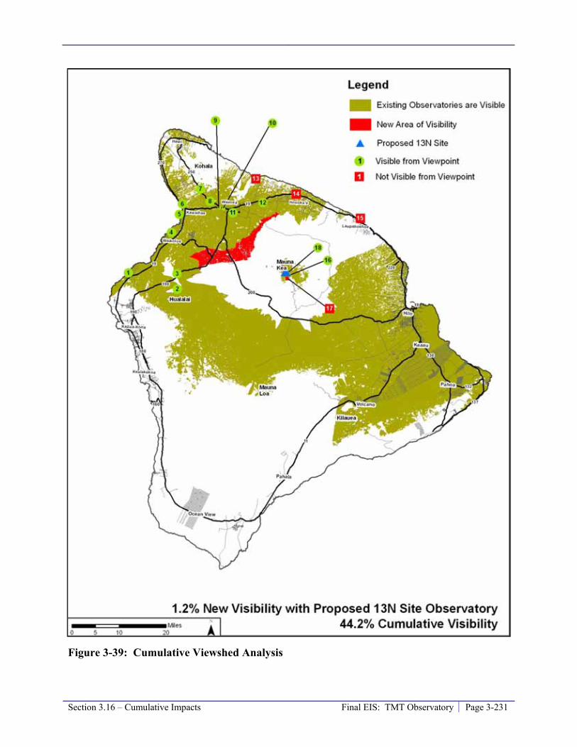
Section 3.16 – Cumulative Impacts Final EIS: TMT Observatory Page 3-231
Figure 3-39: Cumulative Viewshed Analysis

Page 3-232 Final EIS: TMT Observatory Section 3.16 – Cumulative Impacts
• Pan-STARRS would alter an existing element in the viewshed (redevelopment of the existing UH 2.2 meter observatory). The UH 2.2 meter observatory is seen from roughly 36 percent of the island, including the summits of Kūkahau‘ula, Pu‘u Līlīnoe, Pu‘u Waiau. The Pan-STARRS viewshed would be smaller than that of the existing UH 2.2 meter observatory because its dome would be roughly 15 feet shorter. The Pan-STARRS dome is being designed, through the OMKM design review process, to blend in with surroundings and be less obtrusive than that of the UH 2.2 meter observatory; therefore, a small incremental benefit would be realized.
• The paving of the Mauna Kea Access Road is not expected to have an additional cumulative visual impact; the road is present today and road grades and embankments would not need to be modified significantly to allow paving.
The incremental increase in cumulative visual impact due to both the Project and the foreseeable actions would be less than significant. Nonetheless, when combined with the existing conditions, the cumulative visual impact of development on and near the summit of Maunakea would continue to be significant, as the current level of cumulative impact has been assessed to be significant, as discussed in Section 3.16.2.
Due to the limited visibility of Hale Pōhaku, the low level of foreseeable actions in Hale Pōhaku, and the compliance of those actions with OMKM design review guidelines, the Project and other foreseeable actions would not significantly affect visual and aesthetic resources in the area.
Geology, Soils, and Slope Stability
Details regarding the Project’s impacts on geologic resources are disclosed in Section 3.6.3.
The Project and other foreseeable actions would involve construction of the facilities, access roadways, and vehicle travel during operation. With the implementation of proper construction techniques and procedures, and mitigation measures to reduce vehicle travel, the Project by itself or in combination with other foreseeable actions would not result in a significant impact on geology, soils, or slope stability. The Project and other foreseeable actions, including redevelopment of the current UH 2.2 meter observatory site by Pan-STARRS, would not further level the ridge or top of any cinder cone or displace large volumes of cinder.
Potential increases in human foot traffic, due to an increase in recreational visitors, can accelerate degradation of cinder cone slopes and disturb natural habitats. These impacts can be reduced by educating visitors regarding the sensitive nature of the ecosystem and encouraging them to stay on roadways and established trails, as envisioned in the CMP and PAP sub plan.
The incremental increase in cumulative impact related to the foreseeable actions would be small. However, when added to the existing level of cumulative impact, the level of cumulative impact on geology, soils, and slope stability would continue to be significant, as discussed in Section 3.16.2, primarily due to the alteration of cinder cone morphology along the ridges of Kūkahau‘ula.
Water Resources and Wastewater
Details regarding the Project’s impacts on water resources and wastewater management are disclosed in Section 3.7.3.
Section 3.16 – Cumulative Impacts Final EIS: TMT Observatory Page 3-233
The Project will slightly alter the drainage pattern along the Access Way and at the TMT Observatory. The addition of two small SMA antenna pads would not disrupt drainage patterns and the redevelopment of the UH 2.2 meter observatory site by Pan-STARRS would not change the current drainage pattern. Precipitation in these areas is limited and the ground very permeable; therefore, these actions are not anticipated to significantly modify drainage patterns.
The paving of the 4.6-mile long currently unpaved section of the Mauna Kea Access Road would increase runoff along the road. Paving the road would reduce the volume of sediment carried off the road surface and downslope. With proper design the small increases in runoff volume would be addressed so that this project would be an improvement over existing conditions.
The TMT Observatory will contain all domestic and mirror washing wastewater, and thus will not contribute to any discharge of wastewater at the summit area. The Project will not substantially alter or disturb surface water or drainages. The use of potable water associated with the Project will be relatively limited and will not substantially affect supply capacity.
The decommissioning and removal of the CSO would remove its use of potable water and its wastewater generation and discharge. The additional antenna at the SMA would not generate wastewater nor consume potable water. The operations plan for Pan-STARRS would result in a reduction in the volume of potable water used and, therefore, would generate less wastewater because fewer people would be needed to operate and maintain Pan-STARRS relative to the current UH 2.2 meter observatory. In addition, because Pan-STARRS is classified as a major project, OMKM would require that all wastewater generated by the facility be removed from the mountain instead of discharging to a septic system as currently done at the UH 2.2 meter observatory.
The TMT Project and Pan-STARRS project would discharge domestic and mirror washing wastewater to the Hilo Wastewater Treatment Plant for treatment and disposal. The Project discharge is discussed in Section 3.7.3. The Project’s discharge of roughly 2,000 gallons a month generated at the TMT Observatory and transported down and up to 1,600 gallons a day generated at the TMT Headquarters will likely be much greater than discharges associated with the Pan-STARRS project. Additional wastewater may be directed to the treatment plant if employees of the TMT Project live within the sewer network collection area; if all 140 potential employees were newly located within the area and had an average family size of 2.75 people (the County average in the 2000 census), this would result in an additional roughly 38,500 gallons of wastewater a day (based on 100 gallons a day per person, a conservative estimate) directed to the treatment plant. With the decommissioning of the CSO and their headquarters in Hilo, the volume of wastewater generated would be incrementally reduced. The total volume of wastewater currently treated at the Hilo Wastewater Treatment Plant averages 3 million gallons a day and the plant is designed for a maximum capacity of 5 million gallons a day. The volume of wastewater potentially directed to the treatment plant by the Project and its employees, should they all live within the collection area, represents less than two percent of the 2 million gallon unutilized capacity of the Hilo Wastewater Treatment Plant.
Thus, the addition of the Project together with the future foreseeable actions would have a relatively small incremental impact; and the level of cumulative impact on water quality and resources would continue to be less than significant.

Page 3-234 Final EIS: TMT Observatory Section 3.16 – Cumulative Impacts
Solid and Hazardous Materials and Waste
Details regarding Project impacts related to solid and hazardous materials and waste are disclosed in Section 3.8.3.
The TMT Observatory will dispose of all waste in compliance with the existing regulations and requirements and thus will not contribute to any discharge of solid or hazardous waste at the summit. No mercury will be stored or used. The Project will develop and implement a WMP, a Materials Storage/Waste Management Plan and a component SPRP. Facility engineering measures will also be taken to provide proper chemical and fuel storage enclosures. Both the SPRP and the engineering measures will protect against the release of chemicals or fuel to the environment. Engineering measures will include draining all potentially chemically-impacted wastewater, such as mirror washing wastewater, in double-walled pipes and capturing it in a double-walled storage tank. Fuel storage and piping will also be double-walled and be equipped with leak monitors. The SPRP will require inspections to ensure that systems are working properly, no leaks are occurring, and any necessary maintenance measures are taken.
The decommissioning and removal of the CSO would remove its associated generation of hazardous and solid wastes, while the operation of additional antenna at the SMA would generate minimal wastes. Pan-STARRS would replace a facility (the UH 2.2 meter observatory) that currently uses mercury. Overall, Pan-STARRS use of hazardous materials and generation of waste would be similar to that of the current UH 2.2 meter observatory, but would not include mercury. Like the Project, the foreseeable future actions would dispose of all waste in compliance with the existing rules and regulations and, therefore, would not contribute to any discharge of solid or hazardous waste at the summit.
The paving of the 4.6-mile currently unpaved section of the Mauna Kea Access Road would make the road safer and reduce the likelihood of accidents. Therefore, the release of fuel and oil from vehicles involved in accidents would be reduced and the likelihood of a material or waste being spilled during transport would also be reduced.
Thus, the addition of the Project together with the future foreseeable actions would have a small incremental impact; and the level of cumulative impact would continue to be not significant.
Socioeconomic Conditions
Details regarding Project’ impacts on socioeconomic conditions are disclosed in Section 3.9.3.
The Project will provide both construction and operational employment opportunities. Full-time astronomy employment levels would increase by up to 23 percent with the addition of up to 140 positions to the 611 jobs currently directly provided by the existing observatories. Additional direct and indirect economic benefits to the County and State will be generated through local and state tax revenues and fees paid by TMT and the TMT personnel, locally obtained goods and services, and potential additional Federal funding to support for the premier astronomy programs at UH Hilo, Mānoa, and on Maui. Thus, the Project’s contribution to the cumulative socioeconomic impact in the future will be substantial and beneficial to both local communities and the State. Other foreseeable actions, such as the decommissioning of CSO, Pan-STARRS, the addition of an antenna at SMA, and paving of the Mauna Kea Access Road would generate construction employment opportunities and revenues associated with purchases of goods and services. This cumulative socioeconomic impact would be beneficial. Removal of the CSO and
Section 3.16 – Cumulative Impacts Final EIS: TMT Observatory Page 3-235
redevelopment of the UH 2.2 meter observatory with Pan-STARRS would eliminate some full-time jobs and relocate others among the remaining facilities; the creation of new employment by the Project will result in an overall increase in the number of jobs at the astronomy facilities.
The Project, together with these future foreseeable actions, would result in an incremental beneficial cumulative effect, and the level of cumulative socioeconomic impact would continue to be substantial and beneficial.
Land Use Plans, Policies, and Controls
Details regarding Project consistency with land use plans, policies, and controls are discussed in Section 3.10.3.
The CMP identifies the management actions necessary to properly address the needs of the full range of uses on Maunakea. The Project will ensure that all requirements of the CMP and its sub plans are met by appropriately including those requirements in the facility siting, design standards, features, and operational procedures, as well as through implementation of the mitigation measures outlined in this EIS. Other foreseeable actions of decommissioning of CSO, Pan-STARRS, and the addition of an antenna at SMA, would all be required to comply with the CMP and other existing requirements, ensuring that no land use planning conflict would occur. Paving the remainder of the Mauna Kea Access Road could increase the potential for land use conflicts by improving access to the summit region. It is assumed that the CMP and its components could be adjusted to address potential conflicts resulting from improved access. Therefore, the cumulative effect related to land use plans, policies, and controls would be less than significant.
Roadways and Traffic
Details regarding Project impacts on roadways and traffic are disclosed in Section 3.11.3.
The additional traffic generated by the Project will result in a minor increase in existing traffic volumes, and will not result in a change in level-of-service (LOS) along Saddle Road or Mauna Kea Access Road. The implementation of the Ride-Sharing Program will reduce the number of Project-related trips to the summit area.
The removal of the CSO facility would result in fewer trips to the summit. The addition of antennas at the SMA would generate minimal and infrequent trips because the maintenance of new antennas could be performed by the current personnel. The redevelopment of the UH 2.2 meter observatory with the Pan-STARRS project would reduce the number of trips to the summit because the planned remote and/or robotic operations would require fewer people and visits. In addition, as technology allowing remote access and control of telescopes continues to improve, more astronomers are likely to access data remotely, decreasing the amount of traffic travelling to the summit.72
The Project and other foreseeable actions may attract more visitors to the summit region to see the observatories. However, because Maunakea will continue to be a remote destination, these increases are likely to be slight relative to the existing level of visitors and employees. The LOS along Saddle Road or Mauna Kea Access Road would not degrade to a level below LOS C as a 72 Mauna Kea Comprehensive Management Plan Environmental Assessment

Page 3-236 Final EIS: TMT Observatory Section 3.16 – Cumulative Impacts
result of the additional visitors; LOS C is characterized by roads that are safe but efficiently close to capacity and where the posted speed is maintained, not hindered by congestion.
The paving of the 4.6-mile currently unpaved section of the Mauna Kea Access Road could make the road safer and reduce the likelihood of accidents. It could also raise the speed at which vehicles travel along the road, potentially reducing safety. To truly improve safety it may be necessary to police compliance with a speed limit. Paving the road would also increase the accessibility to the summit region. Visitors are the most likely to take advantage of this accessibility; however, it is not known if this project would result in rental car companies lifting their restrictions of their vehicles travelling beyond Hale Pōhaku. Maunakea would continue to be a remote destination requiring a large part of the day to visit. The potential increase in traffic related to the paving of the road is not expected to result in a change in the LOS along the access road.
Therefore, the cumulative effect of the Project together with foreseeable future actions would be less than significant as the existing roads are sufficient to handle this level of traffic, and it does not represent a significant impact to the roads and level of traffic. However, the existing cumulative impact of vehicular trips from visitors, observatories, and others is considered significant for the Maunakea environment. The impact related to the number of visitors is demonstrated by the level of impact on biological and other natural resources.
Power and Communications
Details regarding Project impacts on power and communications infrastructure are disclosed in Section 3.12.3.
The Project facilities will use electricity and communication systems. To convey electricity, a new transformer two transformers will be installed replaced at the HELCO substation site near Hale Pōhaku and power cables from there to the summit region will be upgraded. In compliance with existing requirements, energy-conserving lighting, appliances, and systems will be used in the TMT Observatory, potential TMT Mid-Level Facility, and Headquarters to reduce energy use. Additionally, as a component of the Waste Minimization Plan, an annual audit of energy use by the Project will be conducted and include examining methods available to reduce energy use. The TMT Observatory will utilize the communications system present in the summit area.
Decommissioning of the CSO facility would result in a decrease in energy use within the Astronomy Precinct. The addition of an antenna at SMA and the Pan-STARRS observatory would only incrementally increase the energy use at those facilities. These projects would not significantly increase communications demand in the summit area.
As discussed in Section 3.12.1, HELCO currently has generating capacity equivalent to 45 percent over recent system peak usage and 40 percent of their generating capacity is from alternative renewable sources. Communication with HELCO has indicated that the Project and other foreseeable actions would not result in a need to increase generating capacity by adding a new generating unit or by significantly increasing the operation of an existing unit. Overall, the addition of Project together with these foreseeable future actions would result in a small incremental impact that is not substantial, and the future level of cumulative impact would continue to be less than significant.

Section 3.16 – Cumulative Impacts Final EIS: TMT Observatory Page 3-237
Noise
Details regarding Project impacts related to noise are disclosed in Section 3.13.3.
Traffic and the associated incidence of transient noise will occur due to Project personnel commuting to and from the TMT Observatory and other facilities plus additional visitors that may be attracted to the summit area by the new observatories. Through the Conservation District from Hale Pōhaku to the TMT Observatory the increase in traffic related to the Project will generate transient noise during shift changes only. The noise generated by the TMT Observatory during the day will be limited to HVAC equipment. At night, the bulk of the HVAC equipment would not operate, only the motors used to rotate and open the dome would also generate noise. Those motors will be located inside the observatory building and enclosed by the structure’s walls and will not be audible from outside. Project generated noise will not exceed the Class A standard at noise sensitive locations in the summit region. Overall, it is anticipated that the operation of the TMT Observatory will result in a negligible increase in noise and a minor increase in vehicular traffic noise at Hale Pōhaku and along the Mauna Kea Access Road.
The removal of the CSO facility would end its operational noise and reduce noise associated with current vehicle trips to that observatory. An additional antenna at the SMA facility would generate minimal noise, as would the operations of the Pan-STARRS telescopes at the UH facility. Increased access related to paving the remainder of the Mauna Kea Access Road could increase transient noise from vehicles. However, this could be offset by using smaller and more fuel efficient vehicles to reach the summit instead of the currently required 4-wheel drive vehicles, which tend to generate more noise.
Overall, ambient noise levels would not be significantly increased with the addition of the Project and the foreseeable projects.
Air Quality, Climate, and Lighting
Details regarding Project impacts on air quality, climate, and lighting conditions are disclosed in Section 3.14.3.
The existing air quality at Maunakea is excellent. The Project will generate minimal air pollutant emissions during it operations, primarily from vehicle travel by its personnel. Those exhaust emissions will be small and will not significantly affect air quality. Removal of the CSO facility would reduce vehicular emissions currently associated with staff trips to the facility, and the additional antenna at the SMA facility would generate minimal emissions, primarily associated with standard maintenance. The Pan-STARRS development would replace the existing UH 2.2 meter observatory; the difference in air pollution due to this replacement would be minimal, if any. Paving the Mauna Kea Access Road could result in increases in vehicle emissions, which could be offset by the ability to use smaller and more fuel efficient vehicles to reach the summit area. Paving the road would also reduce the generation of fugitive dust, improving air quality. In the short-term, the Project together with the foreseeable actions would generate dust and air pollutant emissions associated with construction. However, even with the addition of such emissions, the cumulative impact would be less than significant due to Maunakea’s geographic and meteorological isolation, the temperature inversions, and strong winds that aid rapid dispersion of these pollutants. Attainment status with all ambient air quality standards would continue.

Page 3-238 Final EIS: TMT Observatory Section 3.16 – Cumulative Impacts
Potential threats from climate change involve alteration of weather patterns, such as changes in rainfall or wind. While the impacts of climate change on MKSR are unknown, results of some general climate circulation model runs suggest that the trade winds inversion will be more persistent. With more persistent inversion, the capping of local air pollutants at about 7,000 feet would continue. Weather pattern changes are also expected to result in a reduction in the number of storm events and subsequently lower annual precipitation on Maunakea’s summit and upper slopes. Such a change may impact the volume of the annual snowpack and its persistence. This in turn is expected to alter the species distribution and density of flora and fauna in both alpine and subalpine ecosystems of Maunakea. It is unlikely that the human-use activities occurring on Maunakea are contributing proportionally more to climate change than those occurring at other elevations in Hawai’i, or at other locations on Earth. All human activities that involve consumption of fossil fuels are contributing to global climate change, and any activities that can reduce this consumption would help reduce the impacts of climate change.
The Project includes a range of measures that will help reduce its consumption of fossil fuels either directly or indirectly. Among those are the Waste Minimization Plan and component annual energy audit, Ride-Sharing Program, use of energy efficient lighting and other features and processes, and overall consideration of sustainable practices in operations.
The Project, together with the foreseeable actions, would not result in the operation of additional HELCO power generators or significant increases to existing power generators that may release pollutants. The Project and the foreseeable actions would not change the island’s climate; however, as all human activities do, they would incrementally contribute to the cumulative global climate change effects. It is unlikely that those projects would contribute proportionally more to climate change than those occurring at other elevations in Hawai‘i, or at other locations on the planet.
The addition of Project together with the foreseeable actions would not change the characteristics of Maunakea that make it one of the best sites in the world for astronomical observations, including its very dark sky. This results from the summit’s remoteness from urban development, as well as the County of Hawai‘i’s island-wide lighting ordinance requirements that have resulted in the exclusive use of LPS outdoor lighting. The level of cumulative sky illumination impact associated with past, current, and foreseeable future uses and activities would be small and less than significant.
3.16.5 End of Lease The current lease UH holds on the MKSR will end in the year 2033. As it is unknown at present what will transpire at that time, the following two possible scenarios are considered:
1. UH, or some other entity, would negotiate a new lease that would allow observatories (both the existing and those that are potentially foreseeable actions) to extend or negotiate new subleases to continue operation beyond 2033. The observatories would continue to implement the necessary environmental protections and mitigation measures required by the CMP and all other applicable rules, regulations, and requirements.
2. All observatories within the MKSR would undergo a decommissioning processes approved by UH and DLNR, per the Decommissioning Plan (a sub plan of the CMP). The decommissioning activities would be conducted in accordance with applicable rules,

Section 3.16 – Cumulative Impacts Final EIS: TMT Observatory Page 3-239
regulations, and requirements, so that impacts to cultural and biological resources would be minimized. The appropriate level of restoration would be determined as described in Section 2.7.4 for each decommissioned site. The three levels of restoration are:
- Minimal – would include the removal of all man-made materials and the grading of the site.
- Moderate – would include the removal of all man-made materials, grading of the site, and enhancing the structure of the physical habitat to benefit the arthropod (insect) community.
- Full – would include return of the site to its original topography and restoration of physical habitat.
Scenario 1
Pursuant to this scenario, the level of cumulative impact would remain the same as that discussed above in Section 3.16.4. Continued operation of the observatories beyond the year 2033 would have little to no new adverse incremental impacts; the level of cumulative impact would continue as described above. Similarly, astronomy would continue to provide substantial beneficial effects to the local and State economies, employment, and education. Maunakea would remain a premier ground-based astronomy location in the world and the nation, and Hawai‘i would continue to attract the best astronomers and astronomical research projects and programs.
Although the only foreseeable observatory decommissioning at this time is the decommissioning of the CSO, it is possible that by 2033 other observatories would have or may be reaching the end of their useful life and either (a) be replaced as envisioned in the 2000 Master Plan, or (b) be decommissioned without replacement.
Under this scenario, the number of employees at and visitors to the MKSR would likely remain similar to those anticipated if the potential foreseeable actions are realized.
Scenario 2
Should all the observatories be dismantled at the end of the current lease in 2033, there would not be enough surplus cinder on Maunakea to provide for moderate or full restoration of all the observatory sites. If moderate or full restoration were to be desired for each existing observatory site, cinder would have to be imported from off-mountain locations. If imported material was found to be unacceptable, then each site would be restored to the extent possible, and left clean with adequate drainage controls installed to prevent erosion at any of the minimally restored sites. Decommissioning activities would be phased over a number of years to avoid potential significant impacts to other uses on Maunakea. With careful phasing and planning, many potential adverse impacts to the various resources on the mountain from activities involved in the dismantling of the observatories would be mitigated during the decommissioning process. Overall, impacts of decommissioning and restoration activities are expected to be temporary, transient, and not significant.
Pursuant to this scenario, the number of employees in the summit region of Maunakea would be significantly reduced and possibly only include rangers, once decommissioning activities were complete. Local residents would still likely visit the summit area in similar numbers as they presently do for recreational activities - such as snow play, and cultural and religious practices.

Page 3-240 Final EIS: TMT Observatory Section 3.16 – Cumulative Impacts
Visits to the summit region by tourists would likely decrease slightly; however, ecotourism and other tour activities, including star gazing, would likely continue, if allowed.
The ultimate cumulative impact of the resulting restoration of the sites of current observatories would be beneficial, particularly in terms of visual and landform effects, and the effects on the physical habitat. The cumulative impact of decommissioning and restoration is discussed in more detail in the following sections.
Cultural/Archaeological Resources
All observatories would be required to implement appropriate measures and precautions to ensure that known cultural resources in the surrounding area would be protected, and to allow for the protection of potential unknown resources that could be found during decommissioning activities. Because the observatory sites have been disturbed during construction, cultural resources should not be directly or adversely impacted during decommissioning. Vibrations caused by demolition equipment could indirectly impact the stability of shrines and other physical features on the mountain; such resources would have to be considered when developing a Decommissioning Plan (DP) for each individual observatory. Cultural practices on Maunakea would likely be impacted due to the presence of decommissioning and restoration workers, vehicles, and equipment and the decommissioning activities; this impact would continue for the duration of decommissioning of all observatories.
Should observatory sites be restored minimally, and no off-mountain cinder imported, the topography of Kūkahau‘ula could not be restored. Thus, a substantial, significant, and adverse cumulative impact to the spiritual and sacred nature of Kūkahau‘ula would persist following decommissioning and restoration.
Should off-mountain cinder be imported and full restoration be done, the topography of Kūkahau‘ula would be restored. However, some have suggested that the import of off-mountain cinder would not be appropriate and even though the topography were restored, a substantial, significant, and adverse cumulative impact to the spiritual and sacred nature of Kūkahau‘ula would persist.
The expected reduction in the number of employees at and visitors to the summit region would reduce the potential for impact on physical cultural/archaeological resources, but not directly reduce the existing level of cumulative impact on those resources. The reduced number of employees and visitors could, however, reduce the level of impact on cultural practices following the decommissioning.
Biological Resources
The flora of the mountain would likely not be subject to long-term adverse impacts due to decommissioning activities. The observatory sites were previously disturbed during construction, and it is expected that little flora would be directly impacted by the decommissioning activities. Nearby flora and wēkiu bug habitat may be subject to fugitive dust, but careful attention to dust control measures would minimize possible impacts to these resources. Vibrations caused by demolition equipment could impact the stability of the pu‘u and wēkiu bug habitat, and work in these areas would require careful planning and mitigation measures to prevent the loosening of cinder and destabilizing the slopes of the pu‘u.

Section 3.16 – Cumulative Impacts Final EIS: TMT Observatory Page 3-241
Minimal restoration of the observatory sites would not restore wēkiu bug habitat on the alpine cinder cone. Therefore, the level of existing cumulative impact on the alpine cinder cone ecosystem would continue at its current level. Should moderate or full restoration be completed using imported off-mountain cinder, the level of cumulative impact to the alpine cinder cone ecosystem could be incrementally reduced.
A reduction in the number of employees and visitors in the summit region could reduce the further incremental impact to habitat caused by walking over cinder, or walking off trails in general.
Visual and Aesthetics
Upon the complete removal of all observatory components and minimal restoration of all sites, all machinery and debris would be removed and the visual impact would be significantly reduced. The original topography of the mountain would not be fully restored however, and sites could still show evidence that they had been the locations of large structures.
Should new cinder be imported from off-mountain and full restoration performed, the visual impact could be further reduced. However, it is unlikely that imported cinder would match the color of native cinder, and thus such cinder could look out of place.
In either case, the cumulative visual impact following decommissioning would be significantly reduced, but since the original topography and appearance could not be fully restored, a moderate level of cumulative impact would continue for on-mountain users.
Geology, Soils, and Slope Stability
Minimal restoration of the observatory sites would not result in a change to the existing substantial, significant, and adverse cumulative impact, which is primarily due to the alteration of the cinder cone morphology.
If off-mountain material is imported and full restoration is performed so that pu‘u topography is restored to preconstruction condition, there is a possibility for impacts due to the imported material not having settled naturally and being less stable than the material below it. Cinder may loosen and in traveling to the base of the pu‘u, could impact the area around it, and the slope stability of the pu‘u would not be able to be fully restored. Although the full site restoration could reverse the existing significant adverse cumulative impact to the pu‘u cinder cone morphology, the introduction of non-native cinder and slope stability concerns could result in a continued significant adverse cumulative impact.
Solid Waste
Due to the number and size of the observatories on Maunakea, their removal would generate an extremely large amount of solid waste. Some of the materials could and would be reclaimed or recycled, but it is anticipated that a large amount of the material would need to be disposed of at a landfill. However, the daily generation of solid waste by observatory operations would cease. Therefore, the current less than significant level of cumulative solid waste impact would be incrementally reduced.
Page 3-242 Final EIS: TMT Observatory Section 3.16 – Cumulative Impacts
Socioeconomics
The removal of the observatories would effectively remove astronomy from Maunakea resulting in an adverse impact to local and State economies, as well as employment and educational opportunities. The State and local economies benefit from approximately $72.4 million per year currently infused into them by astronomy. It is likely that this amount would increase between now and 2033 due to the Project and other foreseeable actions, but it would cease after the year 2033 pursuant to this scenario. The current 885 long-term astronomy jobs together with additional jobs created by the Project and other foreseeable actions would be lost, along with those indirect jobs that astronomy generates throughout the local and State economies. Many of these jobs are in highly skilled occupations that would be lost to the State and local job bases.
The educational opportunities provided to the students and residents of the community and community at-large by the astronomy facilities and programs, would no longer be available. Maunakea would no longer be the premier host of astronomy, and the activities conducted there, and their associated benefits, would likely move to other locations around the world. Because the observatories provide funding for the support activities on Maunakea, such as road maintenance, Hale Pōhaku facilities and the Visitor Information Station, other sources would need to be found to continue these operations. In addition, other sources of funding would need to be found to continue the ranger and cultural interpretive programs.
The socioeconomics impact due to decommissioning would be adverse and substantial, essentially eliminating the existing cumulative benefit.
Roadways and Traffic
Demolition workers, same as construction workers, would be required to carpool to the summit, reducing the amount of traffic generated from decommissioning activities. The number of trucks travelling to the summit area during decommissioning would be controlled by phasing so that the same heavy machinery and equipment would be used for the duration of the decommissioning of all observatories on the summit. There would still be heavy trucks accessing the mountain, including water trucks and trucks to haul demolition debris down the mountain from the sites. All reasonable efforts would have to be made to coordinate accessing the demolition sites with times of low traffic to reduce the likelihood of delays for those attempting to access Maunakea.
Additional trucks would be travelling on Mauna Kea Access Road should cinder be imported to facilitate full restoration. More than 10,000 cubic yards of cinder would need to be imported to fully restore all the observatory sites, resulting in a substantial number of additional truck trips.
After the decommissioning is finalized, the number of trips to the summit area would be reduced, incrementally reducing the cumulative impact to roadways and traffic.
Noise
The removal of the observatories would generate localized noise for the duration of the decommissioning process. In the long-term, the noise in the summit area would be reduced due to elimination of trips to and from observatories and absence of the observatories HVAC systems. Therefore, the current less than significant level of cumulative noise impact would be incrementally reduced.

Section 3.16 – Cumulative Impacts Final EIS: TMT Observatory Page 3-243
Other Resources
Following decommissioning of the observatories, the demand for potable water in the summit area would be substantially reduced. Hazardous materials and hazardous waste would no longer be used or generated in the summit area and domestic wastewater would no longer be disposed of using septic systems.
Land use plans, policies, and controls would not be substantially impacted by the removal of the observatories. The land would remain ceded lands, classified as Conservation, Resource subzone, and all other activities would continue to be allowed.
Power and communications would not be significantly affected by the decommissioning of the observatories. The power used by the observatories represents a small fraction of the power generated on the island. The communications system would continue to operate normally for the island.
Climate, meteorology, air quality, and lighting would not be significantly affected by decommissioning. The reduction in the number of trips and visitors to the summit area due to removal of the observatories could reduce the production of fugitive dust in the long-term.
3.16.6 Cumulative Impact Conclusions From a cumulative perspective, the impact of past, present, and the Project together with other reasonable foreseeable future actions on cultural, archaeological, and historic resources is substantial, significant, and adverse. The cumulative impact to geologic resources in the astronomy precinct has been substantial, significant, and adverse. The cumulative impact to the alpine shrublands and grasslands and māmane subalpine woodlands has also been substantial, significant, and adverse, primarily due to grazing by hoofed animals. The magnitude or significance of cumulative impact to the alpine stone desert ecosystem is not yet fully determined.
The cumulative socioeconomic impact is substantial and beneficial.
In general, the Project will add a small limited increment to the level of cumulative impact, but would not tip the balance of any specific cumulative impact from a less than significant level to a significant level.
3.16.7 References Allen. 1981. An Analysis of the Mauna Kea Adze Quarry Archaeobotanical Assemblage.
Master’s thesis, University of Hawai‘i.
Arvidson, R. E. 2002. Draft environmental assessment for the Outrigger Telescopes Project published by NASA in December 2000; Response to comments concerning the hydrology of Mauna Kea. Outrigger. St. Louis, MO, McDonnell Center for the Space Sciences, Dept. of Earth and Planetary Sciences, Washington University.
Bonk. 1986. An Archaeological Survey at the Middle Level, Southern Flank of Mauna Kea, Hawai‘i. Papers in Ethnic & Cultural Studies 86-2.
Page 3-244 Final EIS: TMT Observatory Section 3.16 – Cumulative Impacts
Borthwick and Hammatt. 1990. Archaeological Reconnaissance Survey of the Proposed Galileo Telescope Sites C and D, Summit of Mauna Kea, Hawai‘i Island, Hawai‘i (TMK 4-4-015:09). Prepared for MCM Planning.
CFHT. 2008. CFHT Observatory Manual website: http://www.cfht.hawaii.edu/Instruments/ObservatoryManual/CFHT_ObservatoryManual_(Sec_3).html and photograph description at http://www.cfht.hawaii.edu/Science/Astros/Imageofweek/ciw070800.html. Accessed December 12, 2008.
Char, W.P. 1985. Botanical survey for the proposed Temporary Construction Camp Housing at Hale Pōhaku, Mauna Kea, Island of Hawai‘i. Prepared for MCM Planning.
Char, W.P. 1999a. Botanical Resources, Mauna Kea, Hawai‘i. Prepared for Group 70, Inc.
Cleghorn. 1982. The Mauna Kea Adze Quarry: Technological Analyses and Experimental Tests. Unpublished Doctoral Dissertation, University of Hawai‘i.
Commission on Water Resources Management. 2009. Ground Water Well Index / Summary.
Commission on Water Resources Management. 2009. Island of Hawai‘i Hydrologic Units Sustainable Yield/Aquifer code. Website: http://hawaii.gov/dlnr/cwrm/mapsillustrations/gwhu_hawaii.pdf. Accessed December 6, 2008.
County of Hawai‘i. 2005. Hawai‘i County General Plan.
County of Hawai‘i. 2007. Waimea Traffic Circulation Study.
County of Hawai‘i. 2008. South Kohala Development Plan.
County of Hawai‘i Planning Department. 2005. County of Hawai‘i General Plan. Website: http://www.hawaii-county.com/la/gp/2005/main.html. Accessed January 18, 2009.
CPWR (Center to Protect Worker’s Rights). 2003. Construction Noise Hazard Alter. Website: http://www.cpwr.com/hazpdfs/kfnoise.PDF. Accessed March 2, 2009.
Department of Accounting and General Services (DAGS). 1997. Final Environmental Impact Statement, University of Hawai‘i at Hilo, University Park.
da Silva, S.C. 2006. Climatological analysis of meteorological observations at the summit of Mauna Kea. Physics Department, University of Lisbon; 77p.
DAGS, 1997. University of Hawai‘i at Hilo University Park Final Environmental Impact Statement.Hilo, Hawaii. TMK: 2-4-01: 7, 12, 19, 41and 2-4-03: 26. Prepared by Engineering Concepts, Inc. for DAGS. September 1997.
Department of Business Economic Development and Tourism, 2007. The State of Hawai‘i Data Book.
Department of Land and Natural Resources (DLNR). 1997. Indigenous Wildlife, Endangered and Threatened Wildlife and Plants, and Introduced Birds. Department of Land and Natural Resources, State of Hawai’i. Administrative Rules §13-1 through §13-134-10.

Section 3.16 – Cumulative Impacts Final EIS: TMT Observatory Page 3-245
DLNR, 1997. Management Policies of the Natural Area Reserves System. Natural Area Reserves System Commission, Division of Forestry and Wildlife, Department of Land and Natural Resources, State of Hawai‘i. Website: http://plonedev.hawaii.gov/dlnr/dofaw/nars/NARS%20Management%20Policies%20no%20appendices.pdf. Accessed February 9, 2009.
Department of Research and Development website: http://www.hawaii-county.com/directory/dir_research.htm. Accessed January 17, 2009.
Ehlmann, B., R. E. Arvidson, et al. 2005. Hydrologic and isotopic modeling of alpine Lake Waiau, Mauna Kea, Hawai‘i. Pacific Science 59(1): 1-15.
Englund, R.A. D.A. Polhemus, F.G. Howarth, and S.L. Montgomery. 2002. Range, Habitat, and Ecology of the Wēkiu bug (Nysius wekiuicola), a rare insect species unique to Mauna Kea, Hawai‘i Island. Final Report. Hawai‘i Biological Survey Contribution No. 2002-23.
Englund, R.A., A. Ramsdale, M. McShane, D.J. Preston, S. Miller, S.L. Montgomery. 2005. Results of 2004 Wēkiu bug (Nysius wekiuicola) surveys on Mauna Kea, Hawai‘i Island. Final Report. Hawai‘i Biological Survey Contribution No. 2005-003.
Escott, Glenn. 2004. An Archaeological Inventory Survey on Approximately 258 Acres of Land for the University of Hawai‘i-Hilo Mauka Lands Development, Waiākea Ahupua‘a, South Hilo District, Island of Hawai‘i, Hawai‘i (TMK 2-4-01:122). Prepared for PBR Hawai‘i.
Federal Register. 1999. Department of the Interior, Fish and Wildlife Service, Endangered and Threatened Wildlife and Plants. 50 CFR 17:11 and 17:12.
Federal Register. 2005. Department of the Interior, Fish and Wildlife Service, 50 CFR 17. Endangered and Threatened Wildlife and Plants. Review of Species That Are Candidates or Proposed for Listing as Endangered or Threatened; Annual Notice of Findings on Resubmitted Petition; Annual Description of Progress on Listing Actions. Federal Register, 70 No. 90 (Wednesday, May 11, 2005): 24870-24934.
Federal Register. 2006. Department of the Interior, Fish and Wildlife Service, 50 CFR 17. Endangered and Threatened Wildlife and Plants--Proposed Critical Habitat Designations; Proposed Rule. Federal Register, 70 No. 90 (September 12, 2006): 53755-53835.
Frey, F.A., Wise, W.S., Garcia, M.O, West, H., Kwon, S.T., and Kennedy, A. 1990. Evolution of Mauna Kea Volcano, Hawai‘i - petrologic and geochemical constraints on postshield volcanism: Journal of Geophysical Research, v. 95, p. 1271-1300.
Gemini Observatory. 2007. Mauna Kea Observatories Earthquake Workshop. Kailua-Kona. Website: http://www.gemini.edu/node/227. Accessed December 10, 2008.
Gemini Observatory. 2008. Website: http://www.gemini.edu/media/factsheets/enclosurefacts.html. Accessed December 17, 2008.
Gerrish, G. 1979. Botanical survey of principal site (Hale Pōhaku) and two alternate sites. Prepared for Group 70, Inc.

Page 3-246 Final EIS: TMT Observatory Section 3.16 – Cumulative Impacts
Giambelluca, T. W. and M. Sanderson. 1993. The Water Balance and Climate Classification. Prevailing Trade Winds, Weather and Climate in Hawai'i. M. Sanderson. Honolulu, University of Hawai‘i Press.
Hammatt and Borthwick. 1988. Archaeological Reconnaissance of Two Proposed Antenna Sites for the National Radio Astronomy Observatory, Mauna Kea, Hawai‘i.
Hammatt and Shideler. 2002. Data Recovery and Report for Two Archaeological Lithic Scatters, Site 50-10-23-10,310 and 50-10-23-10,311 at the Puu Kalepeamoa Complex, Hale Pōhaku, Ka‘ohe Ahupua‘a, Mauna Kea, Hawai‘i Island (TMK 4-4-15:12). Prepared for The Institute of Astronomy, University of Hawai‘i.
HAR, Department of Health, Chapter 46, Community Noise Control.
Harding ESE. 2002. Update to the Integrated Solid Waste Management Plan for the County of Hawai‘i.
Hartt, C.E. and M.C. Neal. 1940. The Plant Ecology of Mauna Kea, Hawai‘i. Ecology 21(2):237-266.
Hawai‘i Biodiversity and Mapping Program. 2008. Hawai‘i Biodiversity and Mapping Program website: http://hbmp.hawaii.edu/printpage.asp?spp=PPDRY07020. Accessed November 16, 2008.
State of Hawai‘i Department of Transportation (HDOT). 1999. Final Environmental Impact Statement, Saddle Road (State Route 200), Māmalahoa Highway (State Route 190) to Milepost 6.
HDOT. 2004. Environmental Impact Statement Preparation Notice, Hawai‘i Belt Road, Mud Lane to the Kamuela Racetrack (Waimea Bypass).
HDOT. 2007. Supplemental Environmental Impact Statement Preparation Notice, Saddle Road, (State Route 200), Māmalahoa Highway (State Route 190) to Milepost 42.
Helbert Hastert & Fee, Inc. 2006. Final Environmental Assessment University of Hawai‘i 24-Inch Telescope Observatory Renovation. Prepared for the University of Hawai‘i at Hilo and the National Science Foundation.
HELCO, 2009. HELCO Letter to PB Americas, Inc., Subject: Thirty Meter Telescope Observatory, Draft EIS Comments, Maunakea, Hawai‘i Island. October 9, 2009.
HELCO, August 8, 2008. Personnel communication.
HELCO, 2007. Hawai‘i Electric Light Company, Inc. Integrated Resource Plan, 2007-2026. May 2007. http://www.helcohi.com/vcmcontent/HELCO/RenewableEnergy/IRP/HELCO_IRP3_Report_Final.pdf
Hess, S. C., P. C. Banko, G. J. Brenner and J. D. Jacobi. 1996. Tree Densities in a subalpine woodland on Mauna Kea, Hawai‘i. Proceedings of the Western Association of Fish and Wildlife Agencies: Honolulu Hawai‘i, July 22-26, 1996.

Section 3.16 – Cumulative Impacts Final EIS: TMT Observatory Page 3-247
Howarth, F. G., G. J. Brenner, and D. J. Preston. 1999. An arthropod assessment within selected areas of the Mauna Kea Science Reserve. Prepared for the University of Hawai‘i Institute for Astronomy. 62 pp. plus maps.
Howarth, F.G. and F.D. Stone. 1982. An Assessment of the Arthropod Fauna and Aeolian Ecosystem near the Summit of Mauna Kea, Hawaii. Prepared for Group 70, Honolulu, Hawai‘i.
Howarth, F.G. and S.L. Montgomery. 1980. Notes on the ecology of the high altitude Aeolian zone on Mauna Kea. ‘Elepaio 41(3):21-22.
IRTF. 2008. Website: http://iqup.ifa.hawaii.edu/hvac/pages/fy93_nasa_pm9736_a6big.html. Accessed December 10, 2008.
Jurvik, S. P. and J.O. Jurvik, Eds. 1998. Atlas of Hawai‘i. Honolulu, University of Hawai‘i Press .
Kam and Ota. 1983. Archaeological Reconnaissance Survey of Mauna Kea Observatory Powerline: Upper Portions, Mauna Kea, Hāmākua, Hawai‘i. State Historic Preservation Division Office. Prepared for University of Hawai‘i. On file at State Historic Preservation Office.
Kumu Pono, 2005. Mauna Kea-Ka Piko Kaulana o ka ‘Āina (Mauna Kea—The Famous Summit of the Land); A collection of Native Traditions, Historical Accounts, and Oral History Interviews for: Mauna Kea, the Lands of Ka‘ohe, Humu‘ula and the ‘Āina Mauna on the Island of Hawai‘i. Prepared for the Office of Mauna Kea Management. March 30, 2005.
Kumu Pono, 1999. Mauna Kea Science Reserve and Hale Pōhaku Complex Development Plan Update: Oral History and Consultation Study, and Archival Literature Research; Ahupua‘a of – Ka‘ohe (Hāmākua District) and Humu‘ula (Hilo District), Island of Hawai‘i. February 1999.
Kumu Pono, 1998. Mauna Kea – Kuahiwi Kū Hao Malie. A Report on Archival and Historical Documentary Research, Ahupua‘a of Humu‘ula and Ka‘ohe, Districts of Hilo and Hāmākua, Island of Hawai‘i. Kumu Puno Associates. Hilo.
Langlas, Charles, 1999. Supplement to Archaeological, Historical and Traditional Cultural Property Assessment for the Hawai’i Defense Access Road A-AD-6(1) and Saddle Road (SR200) Project.
Laws, E. A. and A. H. Woodcock. 1981. Hypereutrophication of an Hawaiian alpine lake. Pacific Science 35(3): 257-261.
Leonard, David L. Jr., Paul C. Banko, Kevin W. Brinck, Chris Farmer, And Richard J. Camp. 2008. Recent Surveys Indicate Rapid Decline of Palila Population. Elepaio 68(4):27-30
Lippiatt, S. 2005. The isolation and identification of diatoms from Lake Waiau sediments. Journal of Young Investigators 13(4): 6 p.
Lockwood, J. P. 2000. Mauna Kea Science Reserve Geologic Resources Management Plan – Appendix H. Prepared for Group 70. .

Page 3-248 Final EIS: TMT Observatory Section 3.16 – Cumulative Impacts
Macdonald, G. A., A. T. Abbott, et al. 1983. Volcanoes in the sea: the geology of Hawai‘i. Honolulu, University of Hawai‘i Press.
Massey, J. E. 1979. The diatoms of contemporary and ancient sediments from Lake Waiau, Hawai‘i, and their geochemical environment. Review of Palaeobotany and Palynology 27(1): 77-83.
Matsuoka, Norikazu. 2001. Solifluction rates, processes and landforms: a global review: Earth Science Reviews, v. 55, pp.107-134.
McCoy, Patrick. 1977. The Mauna Kea Adz Quarry Project: A Summary of the 1975 Field Investigations. Journal of the Polynesian Society 86(2):233-244.
McCoy, Patrick. 1979. Letter Report Dated August 22, 1979 to Mr. Francis Oda on Archaeological Reconnaissance Survey for the Preparation of the Mauna Kea Mid-Elevation Facilities Master Plan. Department of Anthropology, Bernice P. Bishop Museum.
McCoy, Patrick. 1981. Letter Report Dated June 9, 1981 to J. Jeffries on archaeological survey for the proposed Kitt Peak National Observatory. Department of Anthropology, Bishop Museum.
McCoy, Patrick. 1982a. Archaeological Reconnaissance Survey, In Patrick C. McCoy and Holly McEldowney, Cultural Resources Reconnaissance of the Mauna Kea Summit Region. Department of Anthropology, Bishop Museum.
McCoy, Patrick. 1982b. Archaeological Survey of the Proposed Site of the Caltech 10-Meter Telescope on Mauna Kea, Hawai‘i. Prepared for Group 70, Inc. Department of Anthropology, Bishop Museum.
McCoy, Patrick. 1984b. Mauna Kea Summit Region Survey: A summary of the 1984 Fieldwork. Ms. on file at the Department of Anthropology, Bishop Museum.
McCoy, Patrick. 1985. Preliminary Archaeological Survey of the Puu Kalepeamoa Site, Mauna Kea, Hawai‘i. Prepared for MCM Planning for Draft Supplemental Impact Statement for Construction Camp Housing at Hale Pōhaku, Hāmākua, Hawai‘i. Ms. on file at the Department of Anthropology, Bishop Museum.
McCoy, Patrick. 1990. Subsistence in a “Non-Subsistence” Environment: Factors of Production in a Hawaiian Alpine Desert Adze Quarry. In Pacific Production Systems: Approaches to Economic Prehistory, edited by D.E. Yen and J.M.J. Mummery, pp. 85-119. Occasional Papers in Prehistory, No. 18, Department of Prehistory, Research School of Pacific Studies, Australian National University, Canberra.
McCoy, Patrick. 1991. Survey and Test Excavations of the Puu Kalepeamoa Site, Mauna Kea, Hawai‘i. Prepared for Facilities Planning and Management Office, University of Hawai‘i. Ms. on file in the Department of Anthropology, Bernice P. Bishop Museum. Honolulu.
McCoy, Patrick. 1993. Letter Report on the Inspection of Two Sites Located in the Vicinity of the Smithsonian Submillimeter Array. Submitted to the Smithsonian Institution Astrophysical Observatory.
Section 3.16 – Cumulative Impacts Final EIS: TMT Observatory Page 3-249
McCoy, Patrick, 1999. Mauna Kea Science Reserve Archaeological Site Inventory: Formal, Functional, and Spatial Attributes.
McCoy, Patrick. 1999a. Mauna Kea Science Reserve Archaeological Site Inventory: Formal, Functional, and Spatial Attributes. In Mauna Kea Science Reserve Master Plan (Appendix K), Group 70 International, Inc. Honolulu.
McCoy, Patrick. 1999b. Neither Here Nor There: A Rites of Passage Site on the Eastern Fringes of the Mauna Kea Adze Quarry, Hawai‘i. Hawaiian Archaeology 7:11-34.
McCoy, Patrick. 2005. Archaeological Monitoring of Four Septic Tank Excavations at the Mid-Level Facilities Located at Hale Pōhaku, Mauna Kea, Ka‘ohe, Hāmākua. Island of Hawai‘i (TMK: [3]:4-4-015:012). Prepared for the University of Hawai‘i Institute for Astronomy.
McCoy, Patrick et al. 2005. Mauna Kea Science Reserve Archaeological Inventory Survey, Ka‘ohe, Hāmākua, Island of Hawai‘i, Interim Report No. 1. Prepared for the Office of Mauna Kea Management.
McCoy, Patrick and Nees. 2006. Mauna Kea Science Reserve Archaeological Inventory Survey, Ka‘ohe, Hāmākua, Island of Hawai‘i, Interim Report No. 2. Prepared for the Office of Mauna Kea Management.
McCoy, Patrick and Nees in prep. Mauna Kea Science Reserve Archaeological Inventory Survey, Ka‘ohe, Hāmākua, Island of Hawai‘i. Prepared for the Office of Mauna Kea Management.
McEldowney, Holly, 1982. Ethnographic Background of the Mauna Kea Summit Region. Report 1 in Cultural Resources Reconnaissance of the Mauna Kea Summit Region. Bishop Museum Department of Anthropology.
MCM Planning for National Astronomical Observatory JNLT Project Office. January 1991. Project Description for Japan National Large Telescope (JNLT).
McNarie, A. D. 2004. Mercury on the mountain. Hawai‘i Island Journal Volume, DOI: 9-7
Melvin, D. 1988. Poli‘ahu: snow goddess of Mauna Kea. Spirit of Aloha 13(6): 51.
Mills, P. R., Lundblad, S. P., Suitzer, J.G, McCoy, P. C., and Naleimaile, S. P. 2008. Science and sensitivity – a geochemical characterization of the Mauna Kea adze quarry complex, Hawai‘i Island, Hawai‘i. American Antiquity, v. 73, n. 4, pp. 748-759.
Miyashita, A., N. Takato, et al. 2004. Statistics of weather data, environmental data and the seeing of the Subaru Telescope. Ground-based Telescopes. J. M. Oschmann, Proc. of SPIE. 5489: 207-217.
Mullineux, D. R., Peterson, D. W., and Crandell, D. R. 1987. Volcanic Hazards in the Hawaiian Islands, p. 1187-1220. U. S. Geological Survey Professional Paper 1350.
National Aeronautics and Space Administration (NASA), Universe Division. 2005. Final Environmental Impact Statement for the Outrigger Telescopes Project, Mauna Kea Science Reserve, Island of Hawai‘i, Volume 1.
Page 3-250 Final EIS: TMT Observatory Section 3.16 – Cumulative Impacts
Nullet, D., J. O. Juvik, et al. 1995. A Hawaiian mountain climate cross-section. Climate Research 5: 131-137.
Ochi, Paul, County of Hawai‘i Department of Environmental Management, Plant Manager, Hilo Wastewater Treatment Plant, personal communication, October 30, 2009.
Office of Mauna Kea Management (OMKM), 2010b. Public Access Plan for the UH Management Areas on Mauna Kea; A Sub-Plan of the Mauna Kea Comprehensive Management Plan. January 2010. Prepared by Sustainable Resources Group International, Inc., Island Planning, and Island Transitions, LLC, approved by BLNR on March 25, 2010.
OMKM, 2010a. Decommissioning Plan for Mauna Kea Observatories; A Sub-Plan of the Mauna Kea Comprehensive Management Plan. January 2010. Prepared by Sustainable Resources Group International, Inc., approved by BLNR on March 25, 2010.
OMKM, 2009b. A Cultural Resource Management Plan for the University of Hawai‘i Management Areas on Mauna Kea, Ka‘ohe Ahupua‘a, Hāmākua District, Island of Hawai‘i, State of Hawai‘i. TMK: (3) 4-4-015: 09, 12; A Sub-Plan for the Mauna Kea Comprehensive Management Plan. October 2009. Prepared by Pacific Consulting Services, Inc., approved by BLNR on March 25, 2010.
OMKM, 2009a. Natural Resources Management Plan for the UH Management Areas on Mauna Kea; A Sub-Plan of the Mauna Kea Comprehensive Management Plan. September 2009. Prepared by Sustainable Resources Group International, Inc., approved by BLNR on March 25, 2010.
OMKM. 2009. OMKM Ranger Report, Reports: 366. May 8, 2009.
Orr, Maria, 2004. Cumulative Cultural Impact Study/Assessment, Desktop Study & Ethnographic Survey, NASA W.M. Keck Observatory Outrigger Telescopes, Mauna Kea, Ka‘ohe & Humu‘ula Ahupua‘a, Moku of Hamakua & Hilo, Hawai‘i. Prepared for International Archaeological Institute, Inc. (IARII), National Aeronautics and Space Administration (NASA), Tetra Tech, Inc., and Science Applications International Corporation (SAIC).
Pacific Basin Information Node. 2008. U.S. Geological Survey – National Biological Information Infrastructure Pacific Basin Information Node website: http://www2.bishopmuseum.org/natscidb/?w=PBIN&srch=b&pt=t&lst=o&cols=8&rpp=50&pge=1&tID=383068168&lID=1455184240. Accessed November 16, 2008.
Porter, S. C. 2005. Pleistocene snowlines and glaciation of the Hawaiian Islands. Quaternary International 138-139: 118-128.
Preston, E. D, 1895. Determination of latitude, gravity, and the magnetic elements at stations in the Hawaiian Islands, including a result for the mean density of the earth, 19-891, 1892. In Report of the Superintendent of the United States Coast and Geodetic Survey for the Fiscal Year Ending June 30, 1893, part II. Washington, D.C.: Government Printing Office.
Section 3.16 – Cumulative Impacts Final EIS: TMT Observatory Page 3-251
Paul H. Rosendahl, Ph.D. Inc. (PHRI), 1999. Cultural Impact Assessment Study: Native Hawaiian Cultural Practices, Features, and Beliefs Associated with the University of Hawai‘i Mauna Kea Science Reserve Master Plan Project Area. Prepared for the UH IfA. In the 2000 Master Plan, Appendix N. August 1999.
Porter, S.C. 1979a. Quaternary stratigraphy and chronology of Mauna Kea, Hawai‘i - a 380,000 year record of mid-Pacific volcanism and ice-cap glaciation. Geological Society of America Bulletin, Pt. 2, v. 90, p. 908-1093.
Porter, S.C. 1979b. Geologic map of Mauna Kea volcano, Hawai‘i. Geological Society of America, Map and Chart Series MC-30, Scale 1:57,000.
Porter, S. C. 1979c. Hawaiian glacial ages. Quaternary Research, v. 12, pp. 161-167.
Porter, S.C. 1987. Pleistocene subglacial eruptions on Mauna Kea. Decker, R. W., Wright, T.L., and Stauffer, P.H. (Eds.). Volcanism in Hawai‘i. U.S. Geological Survey Professional Paper 1350, p. 587-598.
Porter, S. C., Stuiver, Minze, and Yang, I. C. 1977. Chronology of Hawaiian glaciations. Science, v. 195, pp 61-63.
Research and Economic Analysis Division, Dept. of Business Economic Development and Tourism. 2009. Astronomy and Space, Draft Astronomy and Space Science and Technology.
Robins and Hammatt. 1990. Archaeological Reconnaissance for Summit and Mid-Level Facilities for the Proposed Japan National Large Telescope. Prepared for MCM Planning, Honolulu.
Robertson, I.N., Nicholson, P.G. and Brandes, H.G. 2006. Reconnaissance following the October 15th, 2006 Earthquakes on the Island of Hawai’i, Research Report UHM/CEE/06-07, University of Hawai‘i College of Engineering, Department of Civil and Environmental Engineering; 65 pp.
Sinoto. 1987. Post-Field Report on the Archaeological Surface Survey of the Halepohaku Substation Site and Overland Transmission Line-Mauka Approach Areas, Halepohaku, Mauna Kea, Hawai‘i Island. Mountain Archaeology Research Area, and Bishop Museum Anthropology Department, Honolulu. Letter Report Submitted to Clyde Akita, Facilities Planning and Management Office, University of Hawai‘i, Honolulu.
Smith, C.W., W.J. Hoe, and P.J. O’Conner. 1982. Botanical survey of the Mauna Kea summit above 13,000 feet. Prepared for Group 70, Honolulu, Hawai‘i.
State of Hawai‘i, Department of Land and Natural Resources, State Historic Preservation Division (SHPD). 2000. Mauna Kea Historic Preservation Plan, Management Components. Prepared for Institute for Astronomy. March 2000.
Subaru Observatory. 2008. Website: http://www.naoj.org/Introduction/telescope.html. Accessed December 6, 2008.
Terry, Ron. 2009. Personal communication (regarding Saddle Road ADT). September 2, 2009.

Page 3-252 Final EIS: TMT Observatory Section 3.16 – Cumulative Impacts
The Center for Regional Economic Competitiveness. 2008. Innovation and Technology in Hawai‘i: An Economic and Workforce Profile. Prepared for The Hawai‘i Science and Technology Institute (HiSciTech).
Transportation Research Board (TRB). 2000. Highway Capacity Manual.
United States (U.S.) Census Bureau. 2000. Census 2000 Data website: http://factfinder.census.gov. Accessed December 10, 2008.
U.S. Department of the Interior, National Park Service, National Natural Landmarks Program. Natural Landmark Brief for Mauna Kea, May 1994.
U.S. Geologic Survey. 2008. National Elevation Dataset website: www.ned.usgs.gov/. Accessed November 25, 2008.
University of Hawai‘i (UH), 2009c. Draft Environmental Impact Statement, Thirty Meter Telescope Project. May 23, 2009.
UH, 2009b. Mauna Kea Comprehensive Management Plan Final Environmental Assessment. Prepared by Pacific Consulting Services, Inc. for UH. April 2009.
UH, 2009a. Mauna Kea Comprehensive Management Plan. January, 2009. Approved by BLNR on April 9, 2009.
UH, 2009. Coping with Vog from Pu‘u O‘o website: http://www.uhh.hawaii.edu/~nat_haz/volcanoes/vog.php. Accessed February 25, 2009.
UH, 2008. Environmental Impact Statement Preparation Notice / Environmental Assessment, Thirty Meter Telescope Project, Mauna Kea Northern Plateau and Hale Pōhaku, Island of Hawai‘i, TMK 4-4-15: 9 and 12. Proposing Agency University of Hawai‘i at Hilo. September 23, 2008.
UH, 2006. Final Environmental Assessment for University of Hawai‘i 24-inch Telescope Observatory Renovation. Mauna Kea Science Reserve, Hāmākua, Hawai‘i, Hawai‘i. August 2006.
UH, 2005. Mauka Lands Master Plan Final Environmental Impact Statement TMK 2-4-01: 122. Prepared by PBR Hawai‘i for UH. February 2005.
UH, 2000. Mauna Kea Science Reserve Master Plan. Available on the web http://www.hawaii.edu/maunakea/. Prepared by Group 70 International, Inc., adopted by the UH Board of Regents on June 16, 2000.
UH, 1999. Mauna Kea Science Reserve Master Plan Final Environmental Impact Statement. Prepared by Group 70 International Inc. for UH. December 1999.
UH, 1983a. Mauna Kea Science Reserve: Complex Development Plan. Prepared by Group 70 International, Inc. for Research Corporation of the University of Hawai‘i. February 1983 (amended May 1987).
UH, 1983b. Mauna Kea Science Reserve: Complex Development Plan Final Environmental Impact Statement. Prepared by Group 70 International, Inc. for Research Corporation of

Section 3.16 – Cumulative Impacts Final EIS: TMT Observatory Page 3-253
the University of Hawai‘i. January 1983.UH. 2000. Mauna Kea Science Reserve Master Plan.
UH, 1975. Final EIS for Existing Operations of the UH Observatory and the Construction and Operation of the new IRTF and UKIRT Observatories.
UH Hilo, Department of Geography. 1998. Atlas of Hawai‘i. 3rd ed. Honolulu: University of Hawai‘i Press.
UH, Institute for Astronomy (IfA). 2008. Website: www.ifa.hawaii.edu.mko/coordinates. Accessed December 2, 2008.
Wagner, W.L., D.R. Herbst, and S.H. Sohmer. 1990. Manual of the Flowering Plants of Hawai’i. University of Hawai‘i Press, Honolulu.
Wentworth, C.K. and Powers, W.E. 1941. Multiple glaciation of Mauna Kea, Hawai‘i. Geological Society of America Bulletin, v. 52, p. 1193-1218.
Werner, B.T. and Hallet, B. 1993. Numerical simulation of self-organized stone stripes. Nature, v. 361, p. 142-145.
Westervelt, W.D, 1963. Hawaiian Legends of Volcanoes. Reprint. Charles E. Tuttle, Rutland, VT.
Williams. 1987. Post-field Letter Report Dated July 7, 1987 to Mr. Clyde Akita on the Archaeological Reconnaissance Survey of the Summit Road Between Halepohaku and the Stockpile Area, Mauna Kea, Hawai‘i Island. Bishop Museum, Honolulu, Hawai‘i.
Williams. 1989. A Technological Analysis of the Debitage Assemblage from Ko‘oko‘olau Rockshelter No. 1, Mauna Kea Adze Quarry, Hawai‘i. Unpublished M.A. Thesis, Washington State University.
Wolfe, E.W., W.S. Wise, and G.B. Dalrymple. 1997. The Geology and Petrology of Mauna Kea Volcano, Hawai‘i – A Study of Postshield Volcanism. U.S. Geological Survey Professional Paper 1557. United States Government Printing Office, Washington, D.C.
Wolfe, E.W., Wise, W.S., and Dalrymple, G.B. 1997. The geology and petrology of Mauna Kea Volcano, Hawai‘i B a study of postshield volcanism. U.S. Geological Survey Professional Paper 1557, 129 pp.
Woodcock, A. H. 1974. Permafrost and climatology of a Hawai‘i volcano crater. Artic and Alpine Research 6(1): 49-62.
Woodcock, A. H. 1980. Hawaiian alpine lake level, rainfall trends, and spring flow. Pacific Science 34(2): 195-209.
Woodcock, A. H., R. Meyer, et al. 1966. Deep layer of sediments in alpine lake in the tropical mid-Pacific. Science 154: 647-648.
Wyss, M., and Koyanagi, R. Y. 1992. Isoseismal maps, macroseismic epicenters, and estimated magnitudes of historical earthquakes in the Hawaiian Islands. U. S. Geological Survey Bulletin 2006, 93 p.
Page 3-254 Draft EIS: Proposed TMT Observatory Section 3.17 – Short-Term/Long-Term
3.17 Relationship of Short-Term Uses and Long-Term Productivity
Short-term uses are those that will occur during the lifetime of the Project, while long-term productivity is in reference to the timeframe beyond the completion of the life cycle of the Project.
The TMT Observatory will occupy approximately 5 acres of land within Area E of the Astronomy Precinct in the MKSR. The Project’s primary effect on the Native Hawaiian cultural environment and the visual environment will cease upon the decommissioning of the TMT Observatory and associated Access Way. The Site Decommissioning Plan (SDP), to be prepared prior to TMT Observatory and Access Way decommissioning, and its associated components will assess and document the potential impacts associated with decommissioning and the three levels of site restoration, including an environmental assessment, a cultural sensitivities evaluation, and a cost-benefit analysis to determine the appropriate level of restoration (minimal, moderate, or full), as described in Section 2.7.4. The long-term productivity of the area will be restored to as near the preconstruction level as possible, with slight variations based on the level of restoration selected. Regardless of the level of site restoration employed, the disturbed area will not be restored to exactly its former condition because the precise appearance and arrangement of the previous lava rock landscape cannot be recreated exactly, although the existing landscape will be documented prior to construction. These records will be used to restore the site to the extent possible. However, regardless of the level of restoration employed, some type of visible mark will remain on the landscape following restoration; the type of mark that remains will depend on the level of restoration identified based on the future due diligence review and cultural assessment.
The use of the land for an astronomical observatory will be in compliance with existing land use policies; when the Project reached the end of its life cycle, the land will be available for other beneficial uses in the future and remain consistent with the land use policies for the Astronomy Precinct. The Project will not result in a substantial adverse effect to the long-term productivity of the environment because the Project will not be sited in an area considered to be exceptional or unique with respect to natural resources. The use of water, electricity, and roadways will result in a slight increase in demand in the short-term, but the long-term productivity and capability of these resources will not be inhibited by the Project.
Short-term, the Project will introduce a prominent scientific institution to Hawai‘i, serving to enhance its leadership role in the field of astronomy. The Project will also boost the growing research and development industry while providing unique employment and educational opportunities for residents. Upon the completion of the Project, other viable technology-based opportunities or businesses may have arisen and could remain as long-term opportunities for residents.
The short-term use of resources by the Project represents a valuable effort to conduct groundbreaking astronomical research, and will not result in a substantial adverse impact to the long-term productivity of any resources.
Section 3.18 – Irreversible and Irretrievable Draft EIS: Proposed TMT Observatory Page 3-255
3.18 Irreversible and Irretrievable Commitments of Resources
The Project will require the commitment of natural, physical, and human resources to plan, design, and develop; to construct and operate; and ultimately to decommission the TMT Observatory. A commitment of resources is irreversible when primary or secondary impacts limit the future options for a resource; an irretrievable commitment refers to the use or consumption of resources that are neither renewable nor recoverable for future use.
The Project will result in such commitments of some resources. The electrical power that will be used by the Project will be supplied through renewable and fossil-fuel power generation by HELCO, it is important to note that 40 percent of the power supplied by HELCO originates from renewable resources and that percentage could increase over the life of the Project. Also, relatively limited amounts of natural and propane gas and diesel fuel will be used during various stages of the Project. Building materials will be used for the Project facilities; some of those materials could ultimately be recycled for reuse in the future, those that are not will be expended. Solid waste generated by the Project will occupy space at a landfill; even with the implementation of waste minimization, recycling, and sustainable practices outlined, some solid waste will be generated and require disposal at a landfill. The human labor required during construction, operation, and decommissioning/site restoration will be expended and unable to be recovered. However, none of these resources are considered to be in short supply, and the commitment of them to the Project will not have an adverse effect on the continued availability of these resources.
The Project will not result in such commitments in multiple areas. Regarding cultural, archaeological, and historical resources, any potential impacts due to the Project will largely cease upon the decommissioning/site restoration; however, as discussed in Section 3.17, a visible mark on the landscape will remain following restoration. While the TMT Observatory site may be suitable habitat for moss, lichen, or ferns that occur in the Alpine Stony Desert ecosystem, there is substantial habitat for these species, and the area will be returned to suitable habitat upon completion of decommissioning/site restoration. The visual and aesthetic impact will likewise largely come to a close once the TMT Observatory is decommissioned, although a visible mark will remain. It is planned that the geology of the site will be restored using the previously excavated materials, to the extent practicable. Water will be used by the Project, but will be treated at a wastewater treatment plant and returned to the naturally occurring cycle after treatment. Any noise associated with the Project will stop once the Project is decommissioned, as will any impacts to air quality. The Project will not have an adverse effect on the future options for any resource, and any uses of those resources will be renewable or recoverable.

Page 3-256 Final EIS: TMT Observatory Section 3.19 – Required Approvals and Permits
3.19 Required Approvals and Permits This section provides information about the necessary approvals required for the Project from governmental agencies, boards, or commissions or other similar groups with jurisdiction over specific components and/or activities of the Project. The status of each identified approval is discussed.
The acceptance of the EIS pursuant to HRS Chapter 343 by the Office of the Governor is a requirement for the Project in its entirety. Below, the major permits required for the Project are listed specifically by Project development.
3.19.1 TMT Observatory and Potential TMT Mid-Level Facility A set of approvals that cover all Project activities on conservation land leased by the UH including the TMT Observatory below the summit and potential TMT Mid-Level Facility at Hale Pōhaku, will be required. The major required approvals include:
• State Historic Preservation, Chapter 6E Consultation. The State of Hawai‘i, DLNR, SHPD and SHPO are jointly responsible for participating in this coordination process. The consultation has been taking place and will continue to take place in parallel with the Chapter 343 EIS process.
• Office of Mauna Kea Management (OMKM) 2000 Mauna Kea Science Reserve Master Plan Project Review/Approval Process. The Master Plan Project Review/Approval Process consists of a number of steps designed to keep projects in compliance with the Master Plan. The MKMB recommended classifying this Project as a major project and the President of UH concurred, initiating the Master Plan Review/Approval process. The “pre-design” phase of the review has been performed by a Design Review Committee; the “schematic” design review phase has been completed, and the MKMB indicated the Project could proceed to the “design development phase”. Future process steps include a design development review/approval by the Design Review Committee, followed by required approvals from the MKMB, UH Hilo Chancellor, the UH President, and the UH BOR prior to the submittal of the CDUP application. Input from Kahu Kū Mauna is sought throughout the Master Plan Review/Approval process.
• Conservation District Use Permit (CDUP). The CDUP is triggered by the use of conservation lands. Approval of this permit lies with the State of Hawai‘i BLNR. The permit process is managed by the DLNR, Office of Conservation and Coastal Lands (OCCL). The CDUP process has not begun yet but will commence once the Project Final EIS is accepted and the Project has been approved by the BOR and the required CMP sub plans had been submitted to the BLNR.
• National Pollutant Discharge Elimination System Permit (NPDES). The NDPES general permit covering discharge of storm water associated with construction activities will be required because the construction area will exceed one acre of disturbed land. The HDOH is responsible for administering, reviewing and approving this permit, pursuant to the Clean Water Act, Section 402.
Section 3.19 – Required Approvals and Permits Final EIS: TMT Observatory Page 3-257
• Community Noise Permit and Noise Variance. A Noise Permit is required for any standard construction activity. A noise variance will be required for Project construction activities generating noise above the allowable levels and/or construction activities taking place outside of normal work hours. The HDOH Indoor and Radiological Health (IRH) Branch administers the Community Noise Permit and Noise Variance.
• Oversize and Overweight Vehicles Permit (OOVP). The State of Hawai‘i DOT administers the OOVP, which will be required for a number of the loads transported from port facilities to the TMT Observatory.
In association with the Project, HELCO will upgrade electrical conductors from Hale Pōhaku to the summit area. HELCO will have to enter the Ice Age NAR to remove existing electrical wire and install new electrical wire in existing underground conduits which are partially within the Ice Age NAR, as discussed in Section 2.5.3. Because they will have to enter the Ice Age NAR, HELCO will obtain a NAR Special Use Permit prior to the start of construction.
3.19.2 Headquarters Because the Headquarters will not be located in the Conservation District a CDUP will not be required. Similarly the Master Plan Review will not be required because the Headquarters will not be located in an area administered by OMKM. Approvals that will be required for the Headquarters include:
• State Historic Preservation, Chapter 6E Consultation
• NPDES
• Community Noise Permit • Underground Injection Control (UIC). A UIC permit will be triggered by storm drain
dry wells. The HDOH Safe Drinking Water Branch manages the UIC permit process.
• County of Hawai‘i, Department of Public Works: - Building Division Approval and Building Permit - Grading and Driveway Permit - Drainage Approval
• County of Hawai‘i, Planning Department - Plan Approval - Planning Director Height Variance
Actions to obtain all these required approvals and permits will commence once final location for the Headquarters is selected and the level of study and/or design of the Headquarters is sufficient to support the necessary submittals.
Page 3-258 Final EIS: TMT Observatory Section 3.20 – Unavoidable Adverse Impacts
3.20 Unavoidable Adverse Impacts Probable long-term unavoidable and adverse impacts related to Project operation include the following:
• The TMT Observatory and Access Way will be within the Mauna Kea Summit Region Historic District; a small portion of Kūkahau‘ula, a Historic Property, will be affected; one modern shrine (considered a “find spot”) will be relocated; and a second “find spot” will be displaced by Project developments (Section 3.3.3).
• Flora and fauna at the Project sites will be displaced by Project developments (Section 3.4.3).
• A new element will be added to the view of Maunakea from the northern portion of the island, including Honoka‘a, Waimea, and Waikoloa (Section 3.5.3).
• Geologic resources will be displaced by Project developments and topography will be modified to allow Project developments (Section 3.6.3).
• Consumption of and demand on potable water (most likely obtained from groundwater resources) will increase slightly (Section 3.7.3).
• Wastewater requiring treatment will be generated (Section 3.7.3); however, none will be discharged within the MKSR.
• Project personnel coming and going to work and Project-related deliveries will add to the number of vehicles on the roads (Section 3.11.3).
• Trucks and vehicles travelling on the unpaved portions of the Access Way and Mauna Kea Access Road will generate airborne dust. Mitigation measures will be employed to reduce dust generation, but some airborne dust will be generated during periods of heavy traffic or high winds.
• Increased truck and vehicle traffic will generate additional exhaust emissions. These emissions will be localized and will not impact local or regional air quality (Section 3.14.3).
• Increased truck and vehicle traffic during construction, operation, and decommissioning plus on-site construction and decommissioning activities will generate noise. Noise impacts will be intermittent and/or temporary.
Probable short-term unavoidable and adverse impacts related to Project construction (Section 3.15.1) and decommissioning includes the following:
• Small amounts of natural flora and fauna and geological features will be removed during construction, such as in the construction staging areas (these areas have previously been disturbed).
• Soil exposed during construction could experience increased erosion and minor amounts of soil could be carried beyond the limits of construction sites. BMPs will be employed to limit this impact.
• Construction equipment and activities will affect the visual quality of the area.

Section 3.20 – Unavoidable Adverse Impacts Final EIS: TMT Observatory Page 3-259
• The transport of large construction equipment and large TMT Observatory components during construction and decommissioning will impede traffic temporarily along roads utilized. Compliance with OOVP conditions will mitigate this probable impact.
• Increased truck and vehicle traffic and the operation of heavy equipment on construction sites will generate additional exhaust emissions. These emissions will be localized and not impact local or regional air quality.
• Heavy construction equipment operation at construction sites, excavation/grading activities, and trucks and vehicles traveling on the unpaved portions of the Access Way and Mauna Kea Access Road will generate small dust particles. BMPs will be employed to reduce dust generation, but some soil will occasionally be subject to erosion during periods of high winds.
• Increased truck and vehicle traffic plus on-site construction and decommissioning activities will generate noise. Noise impacts will be intermittent and/or temporary. Compliance with Noise Permit and Noise Variance requirements will mitigate this impact.
Although these potential impacts are considered to be unavoidable at a certain level, compliance with rules, regulations, and requirements plus the proposed mitigation measures will minimize the level of impact and that level will be less than significant.
Notwithstanding these unavoidable impacts, the Project should proceed because the Project will (a) be in compliance with existing land use plans, policies, and controls (Section 3.10.3); (b) provide a socioeconomic benefit to the island community and state (Section 3.9.3 and 3.9.4); and (c) provide for the public good by achieving its purposes and objectives (Sections 2.2 and 2.3).
Page 3-260 Final EIS: TMT Observatory Section 3.20 – Unavoidable Adverse Impacts
3.21 Unresolved Issues Unresolved issues include:
• Selection of the Access Way Option near or around the SMA core. Two Access Way Options are still being considered, as described in Section 2.5.2 and illustrated on Figure 2-4 and Figure 2-8. One of the options will be selected prior to the Final EIS based on continued coordination with UH, DLNR, and other stakeholders.
• Selection of the Headquarters location. Headquarter locations are being considered in Hilo, as discussed in Section 2.5.4 and illustrated in Figure 2-11. A specific location within the UH Hilo University Park development will be selected prior to the Final EIS through future negotiations with UH. Those negotiations will occur when the time to break ground on the Headquarters nears; at that time TMT and UH will work together to determine the best location for the Headquarters within University Park that accommodates TMT requirements and other planned or foreseeable facilities.
• Selection of the TMT Observatory dome exterior finish. A reflective finish is proposed but the level of reflectance to be used has not been established. A selection will be made prior to the Final EIS.
• The mitigation measures presented in this Draft EIS are considered proposed measures to address the potential adverse impacts of the Project. The mitigation measures presented in this Draft EIS will continue to be refined during the public Draft EIS review process, and the resulting final and committed mitigation measures will be outlined in the Final EIS.
• UH has not yet entered into a sublease agreement with the TMT Observatory Corporation. UH, the holder of the MKSR master lease and Project proposing agency, is negotiating with the TMT Observatory Corporation in good faith and has determined it is prudent to proceed with Project planning. The sublease will be negotiated and will include lease rent payments, observing time for UH, and TMT’s pro-rata share of common costs of operating observatories on Maunakea, as discussed in Section 3.10.3 a higher education benefit package to provide funding for selected educational initiatives of UH Hilo and HawCC on the Island of Hawai‘i; a community benefit package to provide funding for locally-chosen and managed educational programs. The benefit packages would become a part of a lease or sublease, if TMT decides to come to Hawai‘i. Provided an agreement is reached, details of the benefit packages will be described in the Final EIS. Ultimately the sublease will be completed after the Project receives a CDUP and need the approval of the TMT Board, UH BOR, and the BLNR.
• The level of decommissioning cannot be selected until OMKM, Kahu Kū Mauna, and other stakeholders evaluate conditions and needs and a cost/benefit analysis is performed as the decommissioning approaches. This Final EIS evaluates the potential impacts associated with all three levels of decommissioning.

Chapter 4 – Alternatives to the Project Final EIS: TMT Observatory Page 4-1
4.0 Alternatives to the Project The selected alternative is the Project described in Chapter 2.0. The 13N site, detailed in Section 2.5.1, has been selected as the TMT Observatory site and other Project components will support that selection. This Chapter describes the Project background and history, and the alternatives to the Project, including a No Action Alternative. The potential environmental effects together with the alternative’s feasibility and capability of achieving the purpose, need, and objectives of the Project are discussed. The environmental effects of each alternative after full compliance with applicable requirements and regulations and implementation of mitigation measures are used as a basis for comparison.
4.1 Project Background and History The search for the best locations for astronomical observations has been ongoing for more than 50 years and has involved conducting multiple surveys to identify and evaluate potential observatory sites around the world. The TMT Observatory Corporation used these existing surveys and studies, as well as satellite studies of cloud cover and water vapor, and data from established observatory sites in the search.
4.1.1 Location Evaluation A number of criteria are used to evaluate the quality of a site for astronomical observations and research. The physical characteristics of the site and how they affect the ability to make accurate astronomical observations are a primary concern. A second major consideration is the potential for optimizing scientific productivity based on factors other than the physical characteristics of the site. Another factor of significance includes feasibility and administrative or policy related factors.
Physical Characteristics of a Site
The ideal site for astronomical observation would be perfectly clear every night, the atmosphere stable and dry, the temperature constant, and the wind speed low; a telescope located at such a site could have good observing conditions each and every night. However, this ideal combination of attributes does not exist anywhere on Earth; therefore, the existing physical characteristics at a given site are evaluated to estimate how many days of the year a telescope could make high quality astronomical observations as well as how good the observations would be, on average. The following sections discuss the most important physical characteristics and how they affect observational quality.
Fraction of Clear Nights
A desirable site has a large fraction of clear nights, meaning nights with no cloud cover, during the year. Cloudy nights prevent astronomical observations altogether. More clear nights per year results in being able to make observations over a larger fraction of the time. The fraction of nights suitable for astronomical observations can be determined using historical data for those sites that have hosted observatories for many years, as well as analyzing satellite data that has

Page 4-2 Final EIS: TMT Observatory Chapter 4 – Alternatives to the Project
been compiled over the last 25 years, and measurements that were taken during the TMT site testing process.
Stability of the Atmosphere above the Site
The atmosphere above a ground-based telescope affects the light from astronomical sources in several ways. The constantly moving and varying atmosphere above the telescope bends the light before it reaches the telescope, resulting in the light traveling slightly different paths from one moment to the next. This is what causes stars to appear to twinkle, and for astronomical observations made over periods as short as seconds it results in larger and less detailed images, or blurring. The more turbulent the atmosphere is the more pronounced this effect is. This effect is called “seeing” and is measured in units of angle called arcseconds (3,600 arcseconds equal one degree of angle). Historically, a site for which the typical seeing image sizes were less than 1 arcsecond was considered a very good site. With the technical advances in new telescopes and the imaging quality expected of current telescopes, sites for which the image size is routinely smaller than 0.75 arcsecond are essential. Sites meeting these conditions are rare.
Poor seeing degrades the quality of observations, adding to the time required to obtain the desired scientific results from an observation. Some types of scientific observations and research become difficult or impossible with poor seeing. Thus, great importance is placed on selecting a site where there is a high percentage of time with good seeing.
Good astronomical sites are typically located on isolated mountains. It is important for the telescope to be above as much of the lower, more turbulent atmosphere, as possible. In addition, the flow of winds over an isolated mountain tends to be more smooth and stable.
There are additional, more subtle characteristics of the atmospheric turbulence above a site that are also important; of particular significance are those affecting the ability to correct for atmospheric blurring using adaptive optics (AO) systems. The two most important characteristics, in addition to the seeing itself, are the length of time during which the image does not change (coherence time) and the area of the sky over which the image does not change (isoplanatic angle). In simple terms this means that the more the atmosphere above the telescope remains constant (or stable), both over the longest period of time and over the largest angle of the sky, the better it is for observations. With longer coherence times and larger isoplanatic angles, the AO-based correction is easier and can be done more effectively. It is possible for one site to have slightly worse “seeing” but better coherence time and a larger isoplanatic angle, and be a better site for a telescope with an AO-based correction system.
Mean Temperature and Temperature Variability
Low mean temperatures are better for observing at infrared73 wavelengths, which include all wavelengths from 1,000 to 400,000 nanometers (1 to 400 microns). Infrared radiation is emitted from all objects; the more radiation being emitted, the higher the temperature of the object. All parts of the telescope emit infrared radiation and this combines with the actual image of the
73 Infrared can be divided into near, mid, and far infrared wavelengths, generally as follows: Near – 1,000 to 2,200 nanometers (1.0 to 2.2 micrometers or microns); includes the J, H, and K bands in astronomy Mid –2,500 to 30,000 nanometers (2.5 to 30 microns); includes L M, N and Q astronomy bands Far – 30,000 to 400,000 nanometers (30 to 400 microns); also referred to as submillimeter
Chapter 4 – Alternatives to the Project Final EIS: TMT Observatory Page 4-3
desired object. The effects of the additional radiation must be removed, which requires more observing time. In some cases, the observations become difficult or impossible. Locating the telescope at a cooler site reduces this effect.
When different parts of the telescope and enclosure are at different temperatures, heat-induced turbulence occurs. To eliminate this heat-induced turbulence in the observatory dome, the telescope components, including the primary mirror, and the air inside the dome, are actively controlled during the day to match predicted nighttime temperatures. At locations with large day-night temperature fluctuations, this climate control can be very costly.
Telescope systems and instruments need to be optimized to operate within the expected temperature range at the site, as temperature fluctuations can adversely affect the performance of the telescope. This optimization is more difficult and costly when the day-night temperature fluctuations, as well as the annual temperature fluctuations, are large.
Precipitable Water Vapor
Observations of the near and mid infrared wave spectrum (1,000 – 30,000 nanometers) are strongly affected by absorption, or blocking, of the infrared light by water vapor in the Earth’s atmosphere. Higher-altitude sites have lower precipitable water vapor, making them the preferred locations for observations of the infrared spectrum.
Latitude
Objects in the sky that can be seen at an observatory are dependent on the latitude, or the location of the observatory with respect to the earth’s equator. This affects the science and research that can be conducted. Most important is the availability of specific astronomical observation targets, such as planets, stars, galaxies, and clusters, seen at different latitudes. For example, the nearest dwarf galaxies to the Milky Way Galaxy, the Large and Small Magellanic Clouds, are only observable efficiently from south of the equator. On the other hand, the nearest large spiral galaxy similar to the Milky Way Galaxy, Messier 31, is best observed from north of the equator. Other astrophysical objects, like the Galactic Center, can be observed from either hemisphere.
Importance of Particular Physical Characteristics
In some cases, the importance of a particular physical characteristic varies with the type of astronomical observations to be performed. For example, low water vapor above the site is crucial for observations in the near- to mid-infrared, but is not as important for visible-light observations. The TMT will be used to carry out astronomical observations at wavelengths from near ultra violet light (320 nanometers) to the mid-infrared wavelength (30,000 nanometers). It is anticipated that the mix of TMT observations will emphasize the near- and mid-infrared, focusing on 1,000 to 30,000 nanometers.
Scientific Productivity and Synergy
Another important factor is the potential for increased scientific productivity through synergy with other astronomical observatories and facilities.

Page 4-4 Final EIS: TMT Observatory Chapter 4 – Alternatives to the Project
There are many potential scientific synergies between the TMT and other existing and planned astronomical facilities. Smaller optical/infrared observatories can provide observation targets for the TMT and carry out supporting science programs that do not require the large light-gathering power and fine diffraction limit of the TMT. Facilities that observe at radio wavelengths would also be able to provide targets for TMT observations and collect supporting complementary scientific information. This synergy increases productivity in conducting science when compared to a single observatory operating independently. Observatories that share common partners are more likely to collaborate and go to greater lengths to work together, including designing and installing complementary suites of instruments on individual telescopes.
Feasibility, Administration, and Policy
Additional important factors include:
Environmental Considerations
It is the policy of the TMT Observatory Corporation to avoid, minimize, or mitigate potential environmental impacts of the Project. The presence of existing infrastructure and partner facilities generally reduces the level of environmental impact a new observatory would cause and increases the feasibility of siting a new observatory at that location.
The physical attributes of the site can affect the level of environmental impact. For example, the geotechnical characteristics of a site, including the type of bedrock, rock formation and stability, and seismic characteristics affect how the site needs to be prepared, what depth and size of foundations need to used, and other similar factors.
Site-dependent Construction Costs
There are differences in the estimated costs of constructing the TMT at different sites. These are based on the presence or lack of existing roads, power and communications infrastructure, local costs of services, and factors that affect the number of annual work days (e.g. weather).
Operating Costs of the Observatory
The annual cost of operating the observatory depends on a number of factors. Local workforce costs and the workforce model, costs of generating or purchasing power, tax obligations, and the ability to share operations with existing partner facilities all effect the annual costs of operating an observatory.
Site-dependent Ability to Attract and Retain Staff
There will be a staff of up to 140 employees working for the Project in Hawai‘i during operations. Many of the positions require specialized skills in computing, optical-mechanical engineering, and other technical areas; the availability of a local workforce with the requisite skills is a very strong plus for a site. The unique technical systems that make up the observatory make it desirable to have long-term employees, so the availability of housing, quality schools and medical care, and opportunities for spousal employment are also important factors in attracting and retaining employees.
Chapter 4 – Alternatives to the Project Final EIS: TMT Observatory Page 4-5
4.1.2 Selection of Maunakea for Further Consideration The TMT Observatory Corporation used the considerations described above to evaluate potential locations. In June 2008, the TMT Observatory Corporation Board selected Maunakea as the best site in the northern hemisphere; this is the Project which is the subject of this Final EIS.
4.2 Alternatives to the Project Once Maunakea was selected by the TMT Board as a potential location for the TMT Observatory, alternative locations on Maunakea were considered. Modeling of wind flow over Maunakea indicates that the best conditions for astronomy research may be on the summit ridge, where the existing optical/infrared observatories are located. However, as described in Section 2.5.1, in compliance with the 2000 Master Plan, which outlines cultural, biological, and visual impact concerns, a site in Area A or B on the summit ridge or another cinder cone was not considered for the Project.
TMT evaluated other areas within the 36-acre Area E identified for development of a NGLT in the 2000 Master Plan. Four sites, which were distributed from north to south along the access road within Area E, were considered; the furthest north being the 13N site, which is the proposed selected site, and the furthest south being near the southern boundary of Area E. The southern sites were considered because of the potential reduction in environmental impact associated with a shorter access road to the TMT Observatory when compared to the Project site (the 13N site).
Nearby structures and landforms can produce turbulent wakes that disrupt airflow, resulting in worse seeing conditions, even when considering sites which are close to one another. The cinder cones around the summit of Maunakea can cause such turbulence. The TMT Observatory Corporation performed a computational fluid dynamics (CFD) analysis in which typical westerly (wind from the east) airflow over the summit was modeled to evaluate the effects of turbulence on seeing conditions at the four alternative sites within Area E. The CFD analysis showed that the 13N site and its immediate neighbor to the south, referred to as the E2 site, would provide similar astronomical observational quality. Seeing at the two southern sites within Area E was found to be degraded by between 10 percent and 20 percent. This degradation in image quality is significant and would result in increases of more than 20 percent in the time required to complete a given program. Put another way, such a reduction would essentially render a 30-meter telescope at one of the southern sites equivalent to a 27-meter telescope at the Project’s 13N site.
As a result, for this exceptionally unique Project (as defined in Chapter 2), the following are considered to be reasonable alternatives:
• No Action alternative
• Another site at Maunakea, referred to as the E2 site
4.2.1 No Action Alternative The “No Action” alternative, required to be evaluated in the EIS process, considers existing conditions as well as what would be reasonably expected to occur in the foreseeable future absent the Project, based on current land use plans.

Page 4-6 Final EIS: TMT Observatory Chapter 4 – Alternatives to the Project
Facilities
Pursuant to this alternative, TMT would not fund construction, installation, or operation of the TMT Observatory and its supporting facilities at Maunakea. However, the 36-acre Area E is identified for development of a Next Generation Large Telescope (NGLT) in the Mauna Kea Science Reserve Master Plan. Therefore, it is possible that absent the Project, another observatory could be developed within Area E pursuant to the Master Plan. Any other future observatory would require the construction of an observatory, headquarters, and support facility, as well as infrastructure improvements. Since Area E is designated for a NGLT facility, it is likely that a possible future observatory would be similar in size and scope to the TMT.
Environmental Effects
Pursuant to this alternative, the TMT Observatory would not be sited at the 13N site, the potential TMT Mid-Level Facility would not be built at Hale Pōhaku, and the Headquarters would not be built. Thus, the potential Project environmental impacts evaluated in this EIS would not occur.
The No Action alternative would result in forgoing Project economic benefits to the State of Hawai‘i and the County of Hawai‘i because construction and operation funds would not be spent, the required taxes would not be paid, and the direct and indirect effects of generating additional employment and revenues associated with the Project would not be realized. UH would not receive the no-cost observing time at the TMT Observatory. Potential community benefits associated with construction employment opportunities and long term operation-related employment opportunities would not be realized. Community outreach and mentoring programs, support of science programs, scholarship opportunities for local students to attend college, and internship opportunities for local students at Project facilities would also not be realized.
While the environmental effects associated with the Project would not occur pursuant to the No Action alternative, it is possible that in the absence of the TMT Observatory, another observatory could be sited within Area E pursuant to the 2000 Master Plan, which designates the area for astronomy uses and a NGLT. Environmental effects associated with such a future facility might be similar to those associated with the Project due to the existing physical characteristics of Area E, and because it is likely that any possible future facility would be a NGLT consistent with the current land use designation. Any NGLT would likely be similar in scope, function, and operational characteristics to the TMT Observatory. Any possible future facility would require construction of the observatory and its supporting infrastructure, and support and headquarters facilities. Therefore, pursuant to the No Action alternative, environmental impacts associated with the use of land consistent with the Master Plan may still occur in the future absent the Project.
Relation to Project Objectives
The No Action alternative would not achieve major Project objectives that include integrating science and education with culture and sustainability in the Project. Without the public outreach component of the Project, the children of Hawai‘i and the nation would not be exposed to astronomy, and science in general, to the same degree as with the Project at Maunakea. Without the operation and continued development of the Project’s capabilities, the resultant number of jobs in Hawai‘i in the areas of computer science, engineering, electronics, and optics would not

Chapter 4 – Alternatives to the Project Final EIS: TMT Observatory Page 4-7
be provided. The potential contribution of the Project to maintaining UH as a leading institution in astronomical studies, and the nation as a leader in astronomical research in the world, would not be realized without the Project. The potential for a substantial scientific synergy between the existing observatories at Maunakea and the Project would not be realized, and the resultant potential for superior science and in substantially higher scientific productivity by the integrated observatories would not be achieved.
4.2.2 Maunakea Alternative E2 Site The Maunakea E2 site is located roughly 500 feet south-southeast of and 50 feet higher than the Project site. Figure 4-1 illustrates the E2 site location. Though this alternative was considered a reasonable alternative to the Project and has not been eliminated from consideration, based on comments and input received during the Draft EIS public review period and on-site testing data of seeing conditions at the 13N site validating the suitability of these conditions at that location, the 13N site has been selected as the future location of the TMT Observatory.
Physical Site Characteristics for Observations
Nearby structures and landforms can produce turbulent wakes that disrupt airflow, resulting in worse seeing conditions, even for sites which are close to one another. The cinder cones around the summit of Maunakea can cause such turbulence. TMT performed a computational fluid dynamics (CFD) analysis in which typical westerly (wind from the east) airflow over the summit was modeled to evaluate the effects of turbulence on seeing conditions within Area E. The CFD analysis showed that the 13N site and the E2 site would provide similar astronomical observational quality; however, the sites evaluated south of site E2 showed significant degradation in quality. However, the confidence in the seeing quality at the E2 is not as high as it is for the Project 13N site because site testing was not performed at the E2 site and the E2 site is closer to the southern sites where the CFD analysis indicates seeing conditions are inferior.
The CFD analysis is a computer model that predicts site conditions based on a variety of inputs including the terrain. Should the direction of wind swing slightly to the south, which it historically does roughly 15 percent of the time, the analysis indicates slight deterioration in the quality of seeing attributed to the upwind terrain. Although the CFD analysis indicates the E2 site may be similar to the 13N site in most characteristics, the level of confidence is greater at the 13N site because that is where physical testing was performed, and because the 13N site is farther removed from the two more southerly sites which showed significant degradation in observational quality.
Scientific Productivity and Synergy
This component of site selection would be the same for the E2 site as the Project 13N site. On Maunakea, partners and potential partners of the TMT Observatory Corporation currently operate the Keck, Canada-France-Hawai‘i Telescope (CFHT), and Subaru observatories. If the TMT were also sited at Maunakea, these existing observatories would provide many opportunities for supporting and balancing observations and capabilities with the TMT, to the same extent at the Project 13N site and the alternative E2 site. Because of these common partners, the possibilities for realizing synergies in science programs and scientific instrument systems are particularly promising at Maunakea. With UH having access to all the observatories
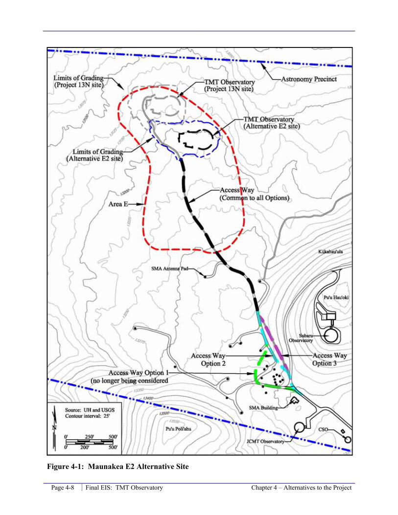
Page 4-8 Final EIS: TMT Observatory Chapter 4 – Alternatives to the Project
Figure 4-1: Maunakea E2 Alternative Site

Chapter 4 – Alternatives to the Project Final EIS: TMT Observatory Page 4-9
on Maunakea, including the TMT, additional synergy is possible. With these synergies, a superior and more productive system of integrated observatories that can coordinate observations and other science could emerge. The scientific productivity of such an integrated system would be greater than that of a single observatory.
There are three NGLTs currently in the design phase, the Giant Magellan Telescope (GMT), the European Extremely Large Telescope (E-ELT), and the TMT. Each of these NGLTs would have a primary mirror larger than 25 meters in diameter. The GMT has already selected a site in the southern hemisphere and most of the principal sites under consideration for the E-ELT are also in the southern hemisphere. In this context, the TMT at Maunakea would provide complementary sky coverage to these other NGLTs, and would provide unique scientific opportunities for those astronomical objects only visible through observations in the northern hemisphere.
TMT Facilities and Policies
Other than the location and elevation of the E2 site, all other aspects of the TMT Observatory design (Section 2.5.1), construction (Section 2.7.2), operation (Section 2.7.3), and decommissioning (Section 2.7.4) would be the same as at the Project13N site, except that the Access Way (Section 2.5.2) would be roughly 520 feet shorter (Figure 4-1). One of the Access Way Options (Section 2.5.2) would still need to be selected for the segment of the Access Way near or around the SMA core. The potential TMT Mid-Level Facility (Section 2.5.3) and Headquarters (Section 2.5.4) would be identical to the facilities as discussed for the Project.
As discussed throughout Chapter 2.0 and Chapter 3.0, if the TMT Observatory were sited at the alternative E2 site instead of the 13N site, all applicable regulations, rules, and requirements would be complied with, including those outlined in the CMP and its four sub plans being prepared.
Environmental Setting and Potential Impacts
The environmental setting at the E2 site is comparable to the Project 13N site; both are located within Area E and are on the same lava flow with similar topography. Thus, the potential environmental impacts of locating the TMT Observatory at the E2 site would be comparable to impacts associated with the selected Project 13N site. As with the Project 13N site, most impacts of this alternative, including geology, water quality, land use, traffic, noise, air quality, power and communications, and solid and hazardous waste would be less than significant. The principal differences between the Project 13N site and the alternative E2 site are discussed in the following sections.
Cultural Resources
The cultural setting of the E2 site is the same as that described in Section 3.2.1, as it describes the cultural setting of the summit region and Area E. The only difference in setting between the Project 13N site and the alternative E2 site is associated with an ahu (shrine) near the end of the 4-wheel drive road in Area E (Figure 4-2). This shrine is believed to have been constructed in the early 2000s; but its creator is unknown. This shrine is more than 200 feet from the extent of grading for the TMT Observatory if it were placed at the E2 site.
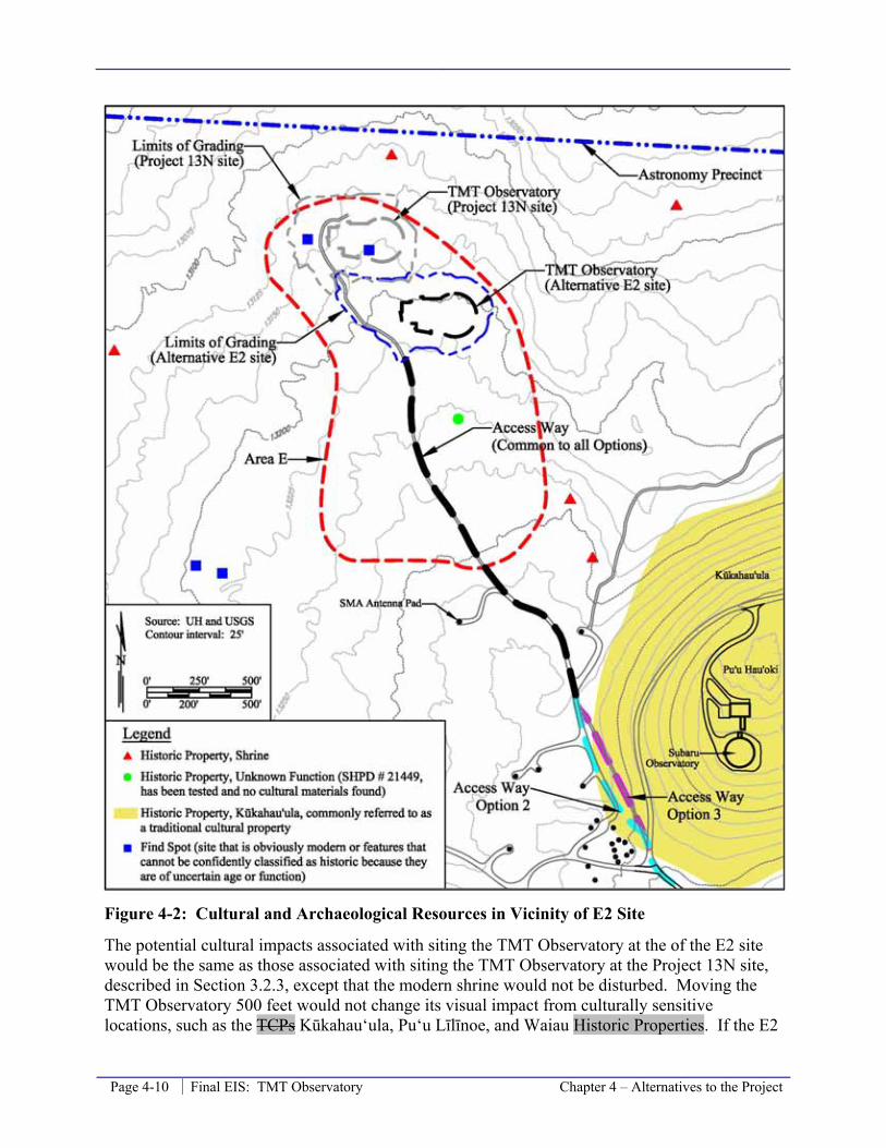
Page 4-10 Final EIS: TMT Observatory Chapter 4 – Alternatives to the Project
Figure 4-2: Cultural and Archaeological Resources in Vicinity of E2 Site
The potential cultural impacts associated with siting the TMT Observatory at the of the E2 site would be the same as those associated with siting the TMT Observatory at the Project 13N site, described in Section 3.2.3, except that the modern shrine would not be disturbed. Moving the TMT Observatory 500 feet would not change its visual impact from culturally sensitive locations, such as the TCPs Kūkahau‘ula, Pu‘u Līlīnoe, and Waiau Historic Properties. If the E2

Chapter 4 – Alternatives to the Project Final EIS: TMT Observatory Page 4-11
site had been selected, the same mitigation measure outlined in Section 3.2.4 would have been employed. Therefore, the level of impact would the same as for the Project 13N site, less than significant.
Archaeological/Historic Resources
The archaeological and historic setting of the E2 site is the same as that described in Section 3.3.1, which describes the setting of the summit region in general and Area E. Three historic shrines are present in the vicinity of Area E and the Access Way. One is located north of Area E and the Project 13N site and two are located southeast of Area E. Other shrines are located at a greater distance from Area E (Figure 4-2). The shrines are at least 100 feet from Area E and the existing roads and more than 200 feet from the E2 site and other Project improvements. No burials are known to be present in Area E. Two “find spots,” or potential historic properties, were identified within Area E (Figure 4-2). One was initially interpreted to be a possible pre-contact shrine and the other initially interpreted to be a possible pre-contact temporary habitation complex. Following coordination with others, neither find spot was determined to warrant historic property designation. Another feature thought to be a potential historic property was recorded by McCoy during survey work in Area E in preparation of the CMP. Its location is illustrated in Figure 3-3, and was issued SHPD site number 21449. Due to doubts about its nature and in consultation with SHPD, a subsurface testing program was carried out. During the testing process no evidence of historic origin was encountered. Therefore, this feature, although illustrated on figures in the CMP, is not a historic property within Area E.
As discussed in Section 3.3.3 for the Project, no archaeological or historical properties Kūkahau‘ula would be disturbed by the Access Way if the TMT Observatory were placed at the E2 site and the TMT Observatory and Access Way would be located within the Mauna Kea Summit Region Historic District. Furthermore, no archaeological or historical properties are present within 200 feet of any disturbances. Therefore, no historic properties would be affected. With this determination, no significant impact is expected. If the E2 site had been selected, the same treatments/mitigation measure outlined in Sections 3.3.3 and 3.3.4 would have been employed, except that no data recover of the two find spots would be performed and the modern shrine would not be relocated because those features would not be disturbed.
Therefore, the effect associated with the Alternative E2 site would be the same as the effect associated with the Project: “effect with treatment/mitigation commitments.” The level of impact would have been the same as for the Project 13N site, less than significant.
Biological Resources
The biological resources setting of the E2 site is the same as that described in Section 3.4.1, as it describes the biologic setting of the summit region and Area E. Biologic studies performed for the TMT Project encompassed the entirety of Area E. There was no discernible difference between the habitat in the vicinity of the Project 13N site and that in the vicinity of the alternative E2 site. The density of flora, including lichens, mosses, and vascular plants, was the same with no evidence of the habitat in the vicinity of the 13N site or E2 being preferred. Similarly, there was no discernible difference in fauna density and variety at the two sites. Both sites are comprised of Type 4 and 5 wēkiu bug habitat, as is all of Area E, with Type 5 being present at roughly 5 percent of the area. A similar number of sampling points were placed in the

Page 4-12 Final EIS: TMT Observatory Chapter 4 – Alternatives to the Project
vicinity of each of the two sites (Figure 4-3) and no wēkiu bugs were found in any of the sampling points at either the 13N site or the E2 site.
Figure 4-3: Arthropod Sampling in Vicinity of Alternative E2 Site
The potential biological impacts associated with siting the TMT Observatory at the of the E2 site would be similar to that associated with siting the TMT Observatory at the Project 13N site, described in Section 3.4.3, except that the area of displaced habitat would be slightly different. Locating the TMT Observatory at the Alternative E2 site would displace less alpine stone desert habitat, roughly 0.25 acre less. Disturbance to the alpine cinder cone habitat would be the same for both the Project 13N site and the Alternative E2 site. In either case, this impact is evaluated to be less than significant because the habitat is not considered critical habitat for any species and floral, lichen, moss, and arthropod species present occur in greater abundance in other nearby areas.
Other potential biological impacts associated with other aspects of the Project, if the TMT Observatory were located at the E2 site, would be the same as those associated with siting the TMT Observatory at the Project 13N site, described in Section 3.4.3, and are primarily associated with the Access Way near the SMA core.

Chapter 4 – Alternatives to the Project Final EIS: TMT Observatory Page 4-13
If the E2 site had been selected, the same mitigation measure outlined in Section 3.4.4 would have been employed. Therefore, the level of impact associated with the alternative E2 site would have been the same as for the Project 13N site, less than significant.
Visual and Aesthetic Resources
The visual and aesthetic resources setting of the E2 site is the same as that for the Project 13N site described in Section 3.5.1. The potential visual and aesthetic impacts associated with siting the TMT Observatory at the of the E2 site would be very similar to those associated with siting the TMT Observatory at the Project 13N site, described in Section 3.2.3. Moving the TMT Observatory 500 feet would result in very minor changes to the TMT Observatory’s viewshed and would not change its visual impact from culturally sensitive locations on Maunakea, such as the TCPs Kūkahau‘ula, Pu‘u Līlīnoe, and Waiau Historic Properties.
As with the Project, locating the TMT Observatory at the E2 site would not substantially affect scenic vistas and viewplanes identified in the County of Hawai‘i’s General Plan or the South Kohala Development Plan. The Observatory would not be visible in the view of Hilo Bay with Maunakea in the background. In addition, although the TMT Observatory may be visible in the view of Maunakea from portions of the South Kohala district and the area around Waimea, it would not block the views and viewplanes of the mountain. The viewshed analysis (Figure 4-4) indicates that because it would be located north of and below the summit of Maunakea, the TMT Observatory at the E2 site would not be visible in the southern portion of the island; this includes the large cities of Hilo and Kailua-Kona.
At the E2 site, the TMT Observatory would be visible from about 13 percent of the island area, while at the Project 13N site it will be visible from about 14 percent of the island area. Approximately 15.1 percent of the island’s population, or approximately 22,500 people, reside within the viewshed of the E2 site; slightly less than the 15.4 percent, or about 23,000 people that reside in the viewshed of the Project 13N site. In comparison with the Project site, at the E2 site the TMT Observatory would not be visible from the viewpoint used for Honoka‘a, but it would be visible from the viewpoint used for Hāpuna Beach. These differences are due to slight changes in the precise viewpoint location; if the viewpoints were moved slightly but kept within Honoka‘a and Hāpuna Beach, the reverse effect could occur.
The silhouette analysis for the E2 site generally shows that the extent of the TMT Observatory that would be visible in silhouette would be similar to that at the Project 13N site (see Appendix M, the Visual Impact Assessment Technical Report). Photo simulations were not conducted separately for the E2 site because the displacement between the two sites (500 feet) would not result in a discernible difference from the perspectives of Honoka‘a, Waimea, and Waikoloa, which are over 15 miles away, or the perspective from near the Keck Observatory.
Overall, as with the Project, the visual impact of the TMT Observatory at the E2 site would be less than significant.
Should the E2 site be selected, the same mitigation measure proposed in Section 3.5.4 would be employed. Therefore, the level of impact associated with the alternative E2 site would the same as for the Project 13N site, less than significant.
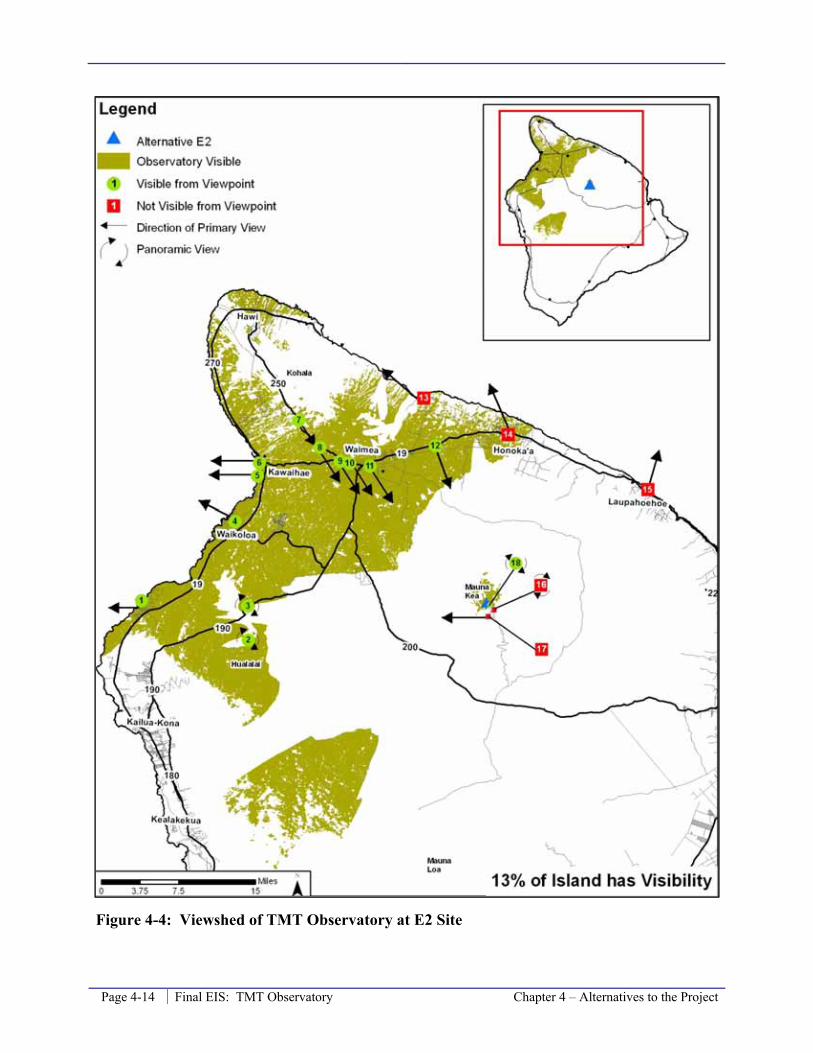
Page 4-14 Final EIS: TMT Observatory Chapter 4 – Alternatives to the Project
Figure 4-4: Viewshed of TMT Observatory at E2 Site
Chapter 4 – Alternatives to the Project Final EIS: TMT Observatory Page 4-15
Geology, Soils, and Slope Stability
The geologic setting of the E2 site is the same as that described in Section 3.6.1, as it describes the geologic setting of the summit region and Area E. Geologic studies performed for the TMT Project encompassed the entirety of Area E. There was no discernible difference between the geologic resources in the vicinity of the Project 13N site and that in the vicinity of the alternative E2 site.
The potential impacts to geologic resources associated with siting the TMT Observatory at the of the E2 site would be similar to that associated with siting the TMT Observatory at the Project 13N site, described in Section 3.6.3, except that the area of displaced habitat would be slightly different. As discussed above the in the Biological Resources section above, the alternative E2 site would result in 0.25 acre less, or four percent less, new disturbance relative to the Project 13N site. In either case, this impact is evaluated to be less than significant because the geologic resources in Area E are not unique on Maunakea and are better developed at many other areas, especially on the southern summit area.
If the E2 site had been selected, the same mitigation measure outlined in Section 3.6.4 would have been employed. Therefore, the level of impact associated with the alternative E2 site would have been the same as for the Project 13N site, less than significant.
Other Environmental Factors
Related to other environmental factors, siting the TMT Observatory at the E2 site would not result in different conditions, different impacts, or require different mitigation measures relative to the Project 13N site. This can be said for other subjects discussed in Chapter 3.0, including: Water Resources and Wastewater; Solid and Hazardous Waste and Material Management; Socioeconomic Conditions; Land Use Plans, Policies, and Controls; Roadways and Traffic; Power and Communications; Noise; Climate, Meteorology, Air Quality, and Lighting; and Construction and Decommissioning.
Cumulative Effects
The incremental cumulative impacts associated with locating the TMT Observatory at the E2 site would be comparable to those of the Project 13N location. Therefore, the cumulative impact associated with past, present, and other foreseeable actions would remain as described in Section 3.16.4, including a continuing significant cumulative effect on cultural resources, certain biological resources, and certain geological features.
The incremental cumulative visual impact of locating the TMT Observatory at the E2 site would be slightly less pursuant to this alternative due to the E2 site’s location further back from (south of) the change in Maunakea’s northern slope when compared to the Project’s 13N site. From the E2 site, the new area where an observatory would be visible is roughly 0.9 percent of the area of the island (Figure 4-5), versus slightly less than 1.2 percent of the area from the 13N site (Figure 3-39). The estimated number of people living in this area of new observatory visibility is about 28 versus 72 people that reside within the new area of the observatory visibility from the 13N site. Nonetheless, as with the Project, when combined with the past, present, and reasonably foreseeable future actions, the cumulative visual impact of development at and near the summit of Maunakea would continue to be significant pursuant to the E2 site alternative as well.
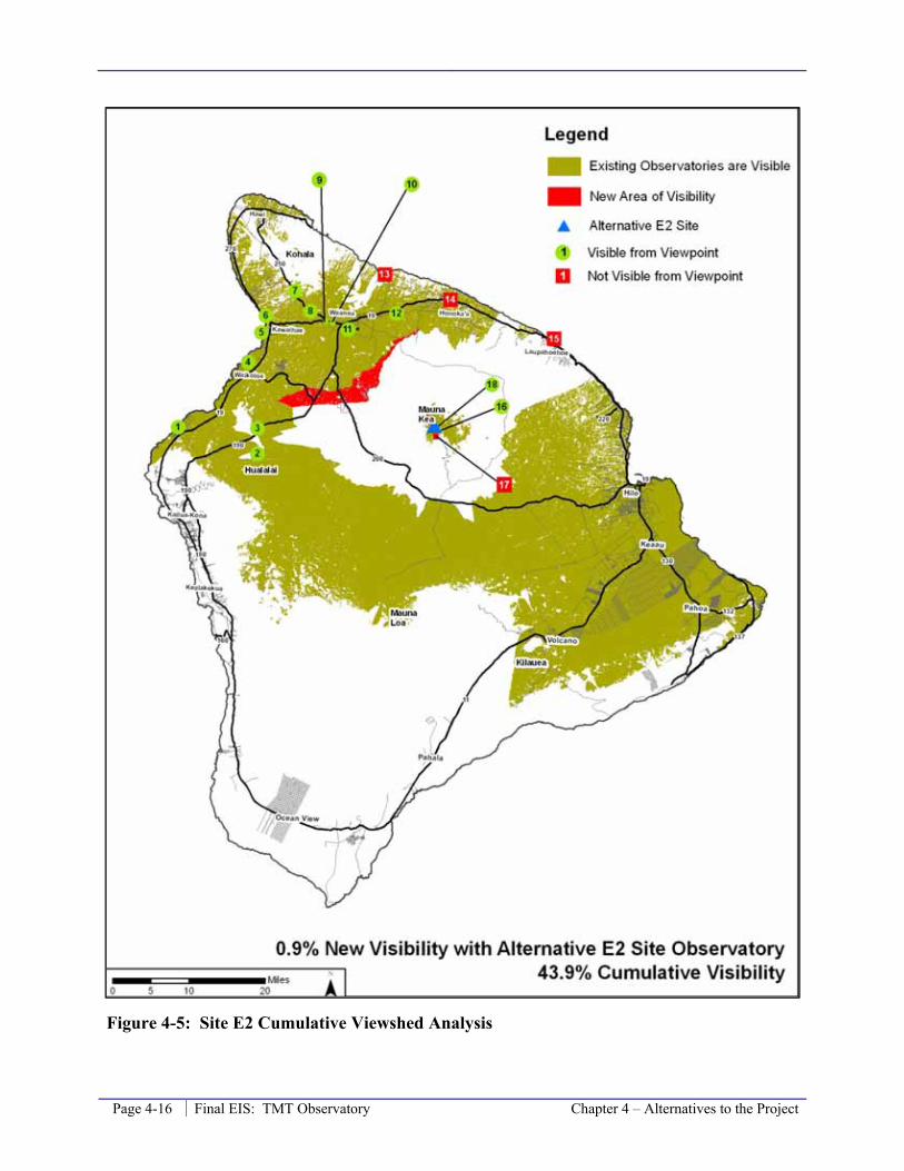
Page 4-16 Final EIS: TMT Observatory Chapter 4 – Alternatives to the Project
Figure 4-5: Site E2 Cumulative Viewshed Analysis

Chapter 4 – Alternatives to the Project Final EIS: TMT Observatory Page 4-17
Relation to Project Objectives
This alternative would achieve all major objectives of the Project; however, the confidence in the seeing quality is not as high as it is for the Project 13N site and scientific goals could suffer if the CFD analysis are not accurate and the seeing quality at the alternative E2 site is inferior.


Chapter 5 – Additional Information Final EIS: TMT Observatory Page 5-1
5.0 Additional Information in Response to Scoping Comments
The TMT Observatory Corporation Board also evaluated and considered a site in northern Chile, known as Cerro Armazones. On July 21, 2009, the TMT Board selected Maunakea over the Cerro Armazones site as the preferred site for the TMT Observatory. Although the Cerro Armazones site is being was considered by the TMT Board, it was not considered an “alternative” for UH because UH cannot approve locating the TMT in Chile. The Cerro Armazones site is discussed here to inform the community regarding this location, as requested in scoping comments.
The Cerro Armazones site is located within the jurisdiction of the government of Chile and requires a different environmental process and approvals pursuant to the laws and requirements of Chile. The potential impacts of the TMT at Cerro Armazones that have been evaluated in compliance with those laws and requirements are summarized here.
The Cerro Armazones is located in the Atacama Desert at an elevation of 10,100 feet. It is one of many mountains in the Coastal Range, and is located roughly 22 miles from the coast. There are many similar mountains nearby, including Cerro Paranal, which is 13.4 miles to the west and hosts ESO’s Very Large Telescope (VLT). The Cerro Armazones site is located 67 miles south of the closest city, Antofagasta (Figure 5-1). Antofagasta is the provincial capital and a town of approximately 280,000 residents. The town is primarily a housing and services area for the region’s mines. Good roads lead from the town to near Cerro Armazones; there is currently only a steep and narrow switch-back dirt path from the base of the mountain to the summit.
At Cerro Armazones, physical characteristics that affect astronomical observations are similar to those at the Project’s site as on Maunakea. For some individual criteria the Cerro Armazones site has more favorable characteristics, such as the number of clear nights. In others, the Maunakea site has more favorable characteristics, such as the precipitable water vapor and the coherence time and angle of the atmospheric seeing. Considering all physical characteristics and the TMT’s mix of observations, overall there is no significant difference in the quality of observations between the Cerro Armazones site and the site of the Project on Maunakea.
In the southern hemisphere, the European-run VLT is located approximately 31 miles (by road) to the west of Cerro Armazones. This facility has four 8-meter optical/infrared telescopes. The Atacama Large Millimeter Array (ALMA), a radio telescope array, is under construction in northern Chile, and is expected to be fully operational by the year 2013. The Large Synoptic Survey Telescope (LSST), an 8-meter optical/infrared survey telescope, is in the design phase for a site located approximately 350 miles south of Cerro Armazones. While the ALMA and LSST could potentially help identify astronomical observation targets for the TMT, none of those observatories is operated by the TMT partners and they are scattered over a large geographic area. Thus, the potential for synergy between those facilities and TMT, or for a system of
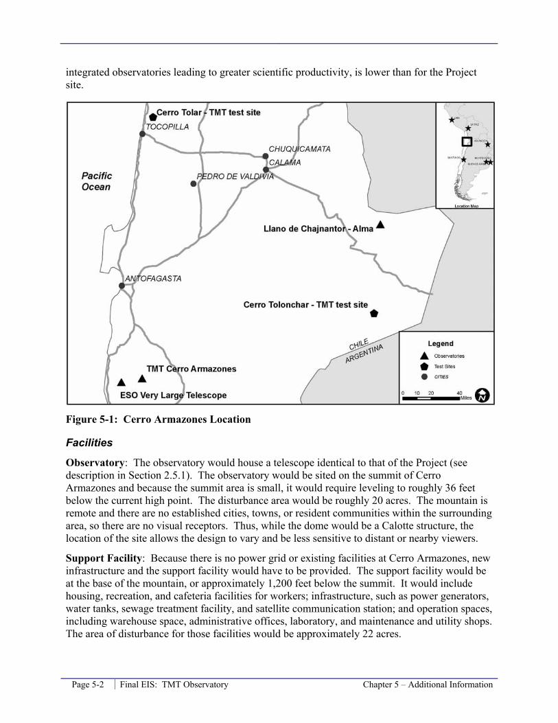
Page 5-2 Final EIS: TMT Observatory Chapter 5 – Additional Information
integrated observatories leading to greater scientific productivity, is lower than for the Project site.
Figure 5-1: Cerro Armazones Location
Facilities
Observatory: The observatory would house a telescope identical to that of the Project (see description in Section 2.5.1). The observatory would be sited on the summit of Cerro Armazones and because the summit area is small, it would require leveling to roughly 36 feet below the current high point. The disturbance area would be roughly 20 acres. The mountain is remote and there are no established cities, towns, or resident communities within the surrounding area, so there are no visual receptors. Thus, while the dome would be a Calotte structure, the location of the site allows the design to vary and be less sensitive to distant or nearby viewers.
Support Facility: Because there is no power grid or existing facilities at Cerro Armazones, new infrastructure and the support facility would have to be provided. The support facility would be at the base of the mountain, or approximately 1,200 feet below the summit. It would include housing, recreation, and cafeteria facilities for workers; infrastructure, such as power generators, water tanks, sewage treatment facility, and satellite communication station; and operation spaces, including warehouse space, administrative offices, laboratory, and maintenance and utility shops. The area of disturbance for those facilities would be approximately 22 acres.

Chapter 5 – Additional Information Final EIS: TMT Observatory Page 5-3
Access Way: A new 13.5-mile road would need to be built from an existing paved public road to the support facility. A new 3.6-mile access road would also need to be built from the support facility to the summit observatory. The road would be a 24-foot wide unpaved surface, except for the last 0.6-mile where it would have an asphalt surface.
Headquarters: A Headquarters facility similar to that described in Section 2.5.4 would be in Antofagasta. Antofagasta is the nearest town, approximately 1.5 hours, or 70 miles by road, away from Cerro Armazones.
Temporary Facilities: Construction baseyards would be required during construction of the observatory. These would include use of an existing warehouse and yard in the port city of Antofagasta for receiving materials and some assembly work, a five-acre staging area next to the support facility, and the area within the roughly 20-acre summit site not occupied by buildings.
Environmental Effects
The TMT Observatory Corporation prepared a Declaractión de Impacto Ambiental (DIA) for the Cerro Armazones site pursuant to the applicable Chile environmental laws and regulations. The DIA was accepted by the government of Chile.
The following sections summarize the findings of the DIA.
Cultural Resources
The DIA reports that there are no records of archaeological sites in the immediate and surrounding areas of the Cerro Armazones site. The information that does exist for the area includes the presence of predominantly coastal archaeological sites representative of a maritime and collection economy. The following recorded archaeological sites were discussed in the DIA:
• Punta Grande, Caleta Norte. Located approximately 39 miles southwest of Cerro Armazones, this site is a ceramic cemetery with separately aligned buried bodies every 6.5 feet and spreads over an area of about 1,200 square yards. Objects made of gold, silver, and copper, projectile point, trowels, and necklaces were found.
• Puesto Olivia. Located approximately 48.5 miles southwest of Cerro Armazones, this site is a ceramic cemetery where stone knives, trowels, necklaces, pipes, and copper plates were found.
• Alero Loreto. Located approximately 16 miles southwest of the Cerro Armazones this site has a surface area of about 120 square yards. The site consists of rocked eaves with
View from Cerro Armazones

Page 5-4 Final EIS: TMT Observatory Chapter 5 – Additional Information
cave art, with a 3-foot thick midden74 in its scarp; mollusks’ shells remains, projectile points, fines, and shell hooks were found.
• Pinturas de Quebrada El Médano. Located approximately 14 miles southwest of Cerro Armazones, this site is a blocks field with cave art, fishing scenes paintings on walls that belong to the “Cañón El Medano”, for about 2 miles. No archaeological contexts were found.
• Punta de Las Conchas. Located approximately 52 miles to the southwest of Cerro Armazones, this site is an archaic midden with several occupation layers containing hooks, weights, mortars, pestle, and harpoons.
A field study was also performed for the DIA; the study covered approximately 8,900 acres and included the Cerro Armazones hill and potential access road from the west. The study area was extensively traveled and there was good surface visibility. There were no remains of cultural or heritage value found at the base of the mountain, and the access road and summit are too vertical and were found to have no remains either. Special attention was paid to the summit for the presence of any place of worship, as it is the highest point in the area. The remainder of the access road was inspected and only rocks and natural stone chips were found. The study team postulated that the prehistoric pattern of settlements that shows preference for the conjunction of resources found at the coast, specifically close to fresh water runoffs, likely explained the lack of findings in the site study area. The only findings of heritage value found were located outside of the direct influence area, and these roadside shrines would not be affected by construction activities. The study team recommended that during excavations or earth moving, an archaeologist should be present at the site to supervise the work and that a Protocol for Archaeological Findings be developed prior to construction.
The DIA concludes that there are no human communities in the area of Cerro Armazones that have traditions, communal interests or feelings of attachment towards the land. It also states that sites with anthropological, archaeological, historical, or cultural heritage would not be affected.
Natural Resources
As part of the DIA, the biology of the Cerro Armazones site was researched using secondary resources of official statistics along with information collected in the field. The DIA field study area was approximately 2,150 acres and covered Cerro Armazones hill and the potential future access road.
While 82 percent of the study area was determined to be land without vegetation, or barren, there were five floristic species found within the study area. These species were all of the Magnoliophyta Division. Adesmia atacamensis, Calandrinia salsoloides, Cistanthe arancioana, Nolana sessiliflora, and Cryptantha sp. are not listed for preservation or have been determined to be out of danger. Adesmia atacamensis and calandrinia salsoloides are species that live mainly in ravines and intermittent water courses. Cistanthe arancioana and nolana sessiliflora are species that develop in bumps and rocky outcroppings.
74 Midden, in archaeological terms, is a mound or deposit containing shells, animal bones, and other refuse that indicates the site of a human settlement.
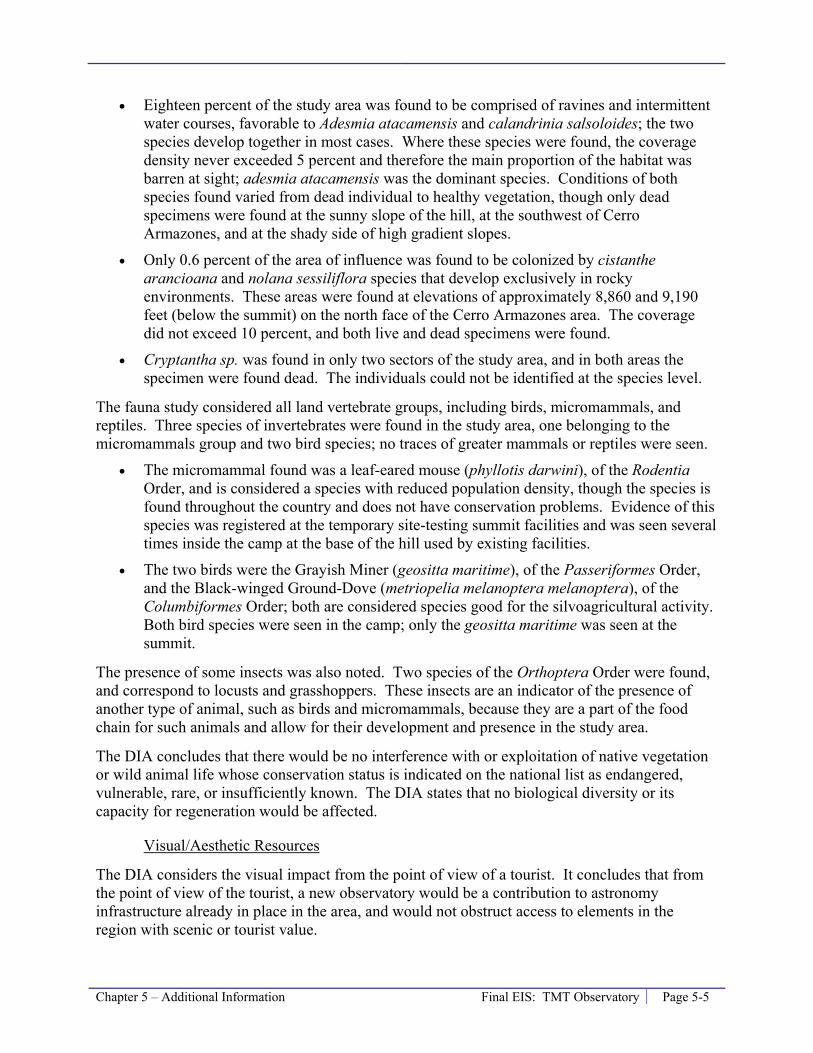
Chapter 5 – Additional Information Final EIS: TMT Observatory Page 5-5
• Eighteen percent of the study area was found to be comprised of ravines and intermittent water courses, favorable to Adesmia atacamensis and calandrinia salsoloides; the two species develop together in most cases. Where these species were found, the coverage density never exceeded 5 percent and therefore the main proportion of the habitat was barren at sight; adesmia atacamensis was the dominant species. Conditions of both species found varied from dead individual to healthy vegetation, though only dead specimens were found at the sunny slope of the hill, at the southwest of Cerro Armazones, and at the shady side of high gradient slopes.
• Only 0.6 percent of the area of influence was found to be colonized by cistanthe arancioana and nolana sessiliflora species that develop exclusively in rocky environments. These areas were found at elevations of approximately 8,860 and 9,190 feet (below the summit) on the north face of the Cerro Armazones area. The coverage did not exceed 10 percent, and both live and dead specimens were found.
• Cryptantha sp. was found in only two sectors of the study area, and in both areas the specimen were found dead. The individuals could not be identified at the species level.
The fauna study considered all land vertebrate groups, including birds, micromammals, and reptiles. Three species of invertebrates were found in the study area, one belonging to the micromammals group and two bird species; no traces of greater mammals or reptiles were seen.
• The micromammal found was a leaf-eared mouse (phyllotis darwini), of the Rodentia Order, and is considered a species with reduced population density, though the species is found throughout the country and does not have conservation problems. Evidence of this species was registered at the temporary site-testing summit facilities and was seen several times inside the camp at the base of the hill used by existing facilities.
• The two birds were the Grayish Miner (geositta maritime), of the Passeriformes Order, and the Black-winged Ground-Dove (metriopelia melanoptera melanoptera), of the Columbiformes Order; both are considered species good for the silvoagricultural activity. Both bird species were seen in the camp; only the geositta maritime was seen at the summit.
The presence of some insects was also noted. Two species of the Orthoptera Order were found, and correspond to locusts and grasshoppers. These insects are an indicator of the presence of another type of animal, such as birds and micromammals, because they are a part of the food chain for such animals and allow for their development and presence in the study area.
The DIA concludes that there would be no interference with or exploitation of native vegetation or wild animal life whose conservation status is indicated on the national list as endangered, vulnerable, rare, or insufficiently known. The DIA states that no biological diversity or its capacity for regeneration would be affected.
Visual/Aesthetic Resources
The DIA considers the visual impact from the point of view of a tourist. It concludes that from the point of view of the tourist, a new observatory would be a contribution to astronomy infrastructure already in place in the area, and would not obstruct access to elements in the region with scenic or tourist value.
Page 5-6 Final EIS: TMT Observatory Chapter 5 – Additional Information
Socioeconomic
The DIA states the amount of money expected to be invested in Chile during construction would be $150 million (U.S.) over a period of 8 years. During the construction phase, it is anticipated that 170 people would be employed, 20 of whom would be foreigners. During the operation phase, it is expected that approximately 100 people would be employed with long-term contracts; any given day there would be about 40 people working at Cerro Armazones. The DIA states that this would not cause any significant socioeconomic changes in the population, including level of education or employment levels.
Other Environmental Topics
The DIA also considers land use policies; water resources in the area; water consumption and water supply source; erosion; power and communications; waste generation and disposal; air pollutant emissions; the generation of noise; lighting; and geographic and demographic characteristics, among other topics. The DIA states that no adverse impacts to human health, the environment, or existing infrastructure were anticipated.
Environmental Effects Conclusion
The DIA concludes that an observatory would generally comply with all applicable rules and regulations and that a higher level of environmental study is not warranted.

Chapter 6 – List of Preparers Final EIS: TMT Observatory Page 6-1
6.0 List of Preparers Lead Agency
University of Hawai‘i at Hilo
Consultant to the Lead Agency
Parsons Brinckerhoff 1001 Bishop Street, Suite 2400 American Savings Bank Tower Honolulu, Hawai‘i 96813
James Hayes Project Manager Irena Finkelstein, AICP QA/QC David Atkin Jason Miles Robin Christians Malie Espin Allyson Powers Scott Polzin Tiffany Batac Pooja Nagrath Larissa King Rawlins
Responsibility: Overall preparation and coordination of EIS and environmental analysis.
Cultural Surveys Hawai‘i P.O. Box 1114 Kailua, Hawai‘i 96734
Hallett H. Hammatt Principle David Shideler Manager, Archaeological Assessment Lisa Gollin Manager, Cultural Impact Assessment Todd Tulchin Brian Kawika Cruz Mindy Simonson Lehua Kauhane Margaret Magat Mishalla Spearing
Responsibility: Preparation of Archaeological Assessments and Cultural Impact Assessment
Page 6-2 Final EIS: TMT Observatory Chapter 6 – List of Preparers
Pacific Analytics P.O. Box 1064 Corvallis, Oregon 97339
Greg Brenner Jesse Eiben (UH Graduate Student) Cliff Smith (UH Emeritus Faculty)
Responsibility: Preparation of Arthropod and Botanical Inventory and Assessment.
Geohazards Consultants International P.O. Box 479 Volcano, Hawai‘i 96785
Jack Lockwood
Responsibility: Preparation of Geologic Inventory and Assessment.
Chapter 7 – References Final EIS: TMT Observatory Page 7-1
7.0 References National Aeronautics and Space Administration. 2005. Final Environmental Impact Statement
for the Outrigger Telescopes Project¸ National Aeronautics and Space Administration, Universe Division, Science Mission Directorate, Washington, D.C.
National Research Council (NRC), 2001. Astronomy and Astrophysics in the New Millennium. By NRC; Commission on Physical Sciences, Mathematics, and Applications; Board on Physics and Astronomy-Space Studies Board; Astronomy and Astrophysics Survey Committee. National Academy Press, Washington D.C. 2001.
NRC-Canada, 1999. Canadian Astronomy and Astrophysics in the 21st Century, The Origins of Structures in the Universe. NRC-Canada, Natural Sciences and Engineering Research Council of Canada, and Canadian Astronomical Society.
Office of Environmental Quality Control (OEQC), 2008. The Environmental Notice. Pages 6-7. September 23, 2008.
Office of Mauna Kea Management (OMKM), 2010b. Public Access Plan for the UH Management Areas on Mauna Kea; A Sub-Plan of the Mauna Kea Comprehensive Management Plan. January 2010. Prepared by Sustainable Resources Group International, Inc., Island Planning, and Island Transitions, LLC, approved by BLNR on March 25, 2010.
OMKM, 2010a. Decommissioning Plan for Mauna Kea Observatories; A Sub-Plan of the Mauna Kea Comprehensive Management Plan. January 2010. Prepared by Sustainable Resources Group International, Inc., approved by BLNR on March 25, 2010.
OMKM, 2009b. A Cultural Resource Management Plan for the University of Hawai‘i Management Areas on Mauna Kea, Ka‘ohe Ahupua‘a, Hāmākua District, Island of Hawai‘i, State of Hawai‘i. TMK: (3) 4-4-015: 09, 12; A Sub-Plan for the Mauna Kea Comprehensive Management Plan. October 2009. Prepared by Pacific Consulting Services, Inc., approved by BLNR on March 25, 2010.
OMKM, 2009a. Natural Resources Management Plan for the UH Management Areas on Mauna Kea; A Sub-Plan of the Mauna Kea Comprehensive Management Plan. September 2009. Prepared by Sustainable Resources Group International, Inc., approved by BLNR on March 25, 2010.
TMT Observatory Corporation (TMT), 2008. Declaración de Impacto Ambiental, Proyecto Transporte, Construcción y Operación de Telescopio TMT (Thirty Meter Telescope) en Cerro Armazones, Región de Antofagasta. May 2008.
University of Hawai‘i (UH), 2009c. Draft Environmental Impact Statement, Thirty Meter Telescope Project, Island of Hawai‘i. Proposing Agency University of Hawai‘i at Hilo. May 23, 2009.
Page 7-2 Final EIS: TMT Observatory Chapter 7 – References
UH, 2009b. Final Environmental Assessment (FEA) for the Mauna Kea Comprehensive Management Plan (CMP). Prepared by Pacific Consulting Services, Inc. for UH. April 2009.
UH, 2009a. Mauna Kea Comprehensive Management Plan, UH Management Areas. January, 2009. Approved by BLNR on April 9, 2009.
UH, 2008. Environmental Impact Statement Preparation Notice / Environmental Assessment, Thirty Meter Telescope Project, Mauna Kea Northern Plateau and Hale Pōhaku, Island of Hawai‘i, TMK 4-4-15: 9 and 12. Proposing Agency University of Hawai‘i at Hilo. September 23, 2008.
UH, 2000. Mauna Kea Science Reserve Master Plan. Available on the web http://www.hawaii.edu/maunakea/. Prepared by Group 70 International, Inc., adopted by the UH Board of Regents on June 16, 2000.
UH, 1999. Mauna Kea Science Reserve Master Plan Final Environmental Impact Statement. Prepared by Group 70 International Inc. for UH. December 1999.
UH, 1983a. Mauna Kea Science Reserve: Complex Development Plan. Prepared by Group 70 International, Inc. for Research Corporation of the University of Hawai‘i. February 1983 (amended May 1987).
UH, 1983b. Mauna Kea Science Reserve: Complex Development Plan Final Environmental Impact Statement. Prepared by Group 70 International, Inc. for Research Corporation of the University of Hawai‘i. January 1983.


![JONES’ MAR · ~ff two bo:gt~ at e~yother brand. 1~’ok-. -. ..... IMsct~ b~ heat. ll~rGl~]P ’JP]ffE: G][J~ IU][]li]~. L ~ .;pr0mpt~ a~ended to Orders by mall will rt~-.ive prompt](https://static.fdocuments.us/doc/165x107/5f0cec9d7e708231d437ce0c/jonesa-ff-two-bogt-at-eyother-brand-1aok-imsct-b-heat-llrglp.jpg)