I-70-frontage concept-Dev Scrn Report v11€70 Frontage Road Improvements Concept Development and...
44
X
Transcript of I-70-frontage concept-Dev Scrn Report v11€70 Frontage Road Improvements Concept Development and...

X

Concept Development and Screening Report
for the
I‐70 Frontage Road Improvements
Idaho Springs, Colorado
Prepared for:
CDOT Region 1
Prepared By:
Michael Baker Jr., Inc.
165 South Union Boulevard, Ste. 200
Lakewood, CO 80228
January 2012


I‐70 Frontage Road Improvements Concept Development and Screening Report
January 2012 pg i
TABLE OF CONTENTS
1 Introduction .......................................................................................................................................... 1
1.1 Purpose of this Report ................................................................................................................. 1
1.2 Project Overview .......................................................................................................................... 1
1.3 Recommendations from the I‐70 PEIS ....................................................................................... 2
1.4 Project Purpose and Need .......................................................................................................... 2
1.5 Independent Utility and Logical Termini .................................................................................... 2
1.6 Funding and Timing ..................................................................................................................... 3
1.7 CSS process .................................................................................................................................. 7
2 Concept development ......................................................................................................................... 9
2.1 Cross Sections .............................................................................................................................. 9
2.1.1 Summary of Cross Sections Considered ................................................................................. 9
2.1.2 Cross Section A – 38’ .............................................................................................................. 10
2.1.3 Cross Section B – 50’ ............................................................................................................... 11
2.1.4 Cross Section C – 46’ with cantilever ..................................................................................... 12
2.1.5 Cross Section D – 50’ cut wall ................................................................................................. 13
2.1.6 Cross Section E – detached trail ............................................................................................ 14
2.1.7 Cross Section F – narrow ........................................................................................................ 15
2.2 Decision Areas............................................................................................................................. 17
2.2.1 Western Decision Area ........................................................................................................... 17
2.2.2 Gravel/Doghouse Bridge Decision Area ................................................................................ 18
2.2.3 Phase I Decision Area ............................................................................................................. 19
2.2.4 Eastern Decision Area ............................................................................................................ 20
3 Evaluation criteria ............................................................................................................................... 21
3.1 Development of Evaluation Criteria .......................................................................................... 21
3.1.1 Evaluation of Cross Sections within Decision Areas ............................................................ 25
4 Selection and Refinement of Preferred Alternative ........................................................................ 34
Concept Development and Screening Report I‐70 Frontage Road Improvements
pg ii January 2012
LIST OF TABLES
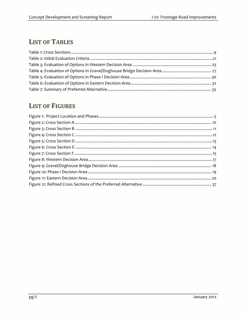
Table 1: Cross Sections ................................................................................................................................. 9
Table 2: Initial Evaluation Criteria ............................................................................................................... 21
Table 3: Evaluation of Options in Western Decision Area ....................................................................... 25
Table 4: Evaluation of Options in Gravel/Doghouse Bridge Decision Area ............................................. 27
Table 5: Evaluation of Options in Phase I Decision Area .......................................................................... 30
Table 6: Evaluation of Options in Eastern Decision Area ......................................................................... 32
Table 7: Summary of Preferred Alternative .............................................................................................. 35
LIST OF FIGURES
Figure 1: Project Location and Phases ........................................................................................................ 5
Figure 2: Cross Section A ........................................................................................................................... 10
Figure 3: Cross Section B ............................................................................................................................ 11
Figure 4: Cross Section C ............................................................................................................................ 12
Figure 5: Cross Section D ............................................................................................................................ 13
Figure 6: Cross Section E ........................................................................................................................... 14
Figure 7: Cross Section F ............................................................................................................................. 15
Figure 8: Western Decision Area ................................................................................................................ 17
Figure 9: Gravel/Doghouse Bridge Decision Area .................................................................................... 18
Figure 10: Phase I Decision Area ................................................................................................................ 19
Figure 11: Eastern Decision Area ................................................................................................................ 20
Figure 12: Refined Cross Sections of the Preferred Alternative .............................................................. 37

I‐70 Frontage Road Improvements Concept Development and Screening Report
January 2012 pg 1
1 INTRODUCTION
1.1 Purpose of this Report
This Concept Development and Screening Report provides supporting documentation for the I‐70
Frontage Road Improvements Categorical Exclusion (Cat Ex). Section 2 presents an overview of the
initial concepts developed. Section 3 summarizes the development of the evaluation criteria and
screening of concepts. This evaluation process led to the development and screening of a variety of
options, which resulted in the identification and refinement of a Preferred Alternative (Section 4).
As concepts were developed and presented to the Project Leadership Team/Technical Team
(PLT/TT), these concepts were screened against criteria to identify the concepts that best met the
project purpose and need and minimized environmental impacts. The impacts calculated for each of
the concepts were based on conceptual design developed for the Field Inspection Review Plans (FIR)
as of December 1, 2011. Design will continue to be revised and developed; as such, impacts and
descriptions in this report may differ from conditions represented in the Cat Ex and other project
documents.
1.2 Project Overview
The Colorado Department of Transportation (CDOT) has initiated the I‐70 Frontage Road
Improvements Project as part of the commitments from the I‐70 Mountain Corridor Programmatic
Environmental Impact Statement (PEIS) Record of Decision (ROD). The purpose of this project is to
provide enhanced safety and mobility for vehicles, pedestrians, and bicyclists between eastern Idaho
Springs (I‐70 Exit 241) and the Hidden Valley/Central City Interchange (Exit 243). This project is
entirely state funded, with no federal transportation funding. Project concepts will be developed
and studied in coordination with the Project Leadership Team (PLT) and will be evaluated for
environmental impacts in a state process similar to a Cat Ex and will be documented on CDOT Form
128, which is the same form used to document federal Cat Exs.
CR 314 between Idaho Springs and Hidden Valley serves both local and through traffic. Current
traffic volumes range from 100 to 1,300 average daily traffic (ADT), with higher volumes reflecting
seasonal and weekend traffic corresponding with peak travel on I‐70. The local connectivity provides
access to residents, businesses, recreational opportunities and emergency access. CR 314 also serves
as an alternative to travel on I‐70, especially during accidents, peak travel times, severe weather, and
construction or maintenance on I‐70.
CR 314 between Idaho Spring and Hidden Valley lacks consistent lane and shoulder widths.
Additionally, it has a narrow gravel section for approximately 1,000 feet. Within this corridor, a
majority of the Scott Lancaster Memorial Trail is also located on the shoulder of CR 314, providing
bicycle and pedestrian connectivity and recreational opportunities. Clear Creek is north of existing
CR 314 and is heavily used by anglers and rafters.

Concept Development and Screening Report I‐70 Frontage Road Improvements
pg 2 January 2012
1.3 Recommendations from the I‐70 PEIS
Improvements for CR 314 were identified in the I‐70 PEIS Preferred Alternative recommendation. In
addition to the six–lane component on I‐70 from Floyd Hill through the Twin Tunnels, the PEIS
Preferred Alternative includes improvements to the frontage road and bike trail from Idaho Springs
to Hidden Valley and Hidden Valley to US 6.
1.4 Project Purpose and Need
Consistent with the recommendations from the I‐70 PEIS ROD, the purpose of this project is to
provide enhanced safety and mobility for vehicles, pedestrians, and bicyclists between eastern Idaho
Springs (I‐70 Exit 241) and the Hidden Valley/Central City Interchange (Exit 243). Project needs
include the following:
Provide pavement and widths that consistently meet Clear Creek County standards.
Serve as an alternative to travel on I‐70 for local traffic and emergency response,
especially during accidents, construction, or maintenance on I‐70.
Improve consistency with the facilities proposed in the Clear Creek County Greenway
Plan, including bicycle, pedestrian, and recreational access.
1.5 Independent Utility and Logical Termini
The PEIS Preferred Alternative identified improvements to the frontage road and bike trail from
Idaho Springs to Hidden Valley and Hidden Valley to US 6. The frontage road currently extends on
the south side of Clear Creek along CR 314 between Idaho Springs (I‐70 Exit 241) and the Hidden
Valley/Central City Interchange (Exit 243). A frontage road does not currently extend between
Hidden Valley and US 6.
The section of the existing frontage road between Idaho Spring and Hidden Valley lacks consistent
lane and shoulder widths. Additionally, it has a narrow gravel section for approximately 1,000 feet.
The existing frontage road serves local access, emergency response, recreation access (rafting and
fishing along Clear Creek), and bicycle and pedestrian mobility. CR 314 between Idaho Springs and
Hidden Valley also serves as an alternate route during accidents, construction, and other delays on I‐
70 near the Twin Tunnels. The Scott Lancaster Memorial Trail runs parallel with the frontage road
and a portion of the trail is shared with the existing roadway.
Proposed improvements to CR 314 are anticipated in the same location as the existing roadway.
Changes to vertical or horizontal alignment were not planned or evaluated, with a possible exception
in the Gravel/Doghouse Bridge area. The frontage road project has been in close coordination with
other on‐going studies and plans including the I‐70 Twin Tunnels EA, Advanced Guideway System
(AGS) study, Clear Creek County Greenway Plan, Department of Revenue’s Port of Entry at Dumont,
City of Idaho Springs, Clear Creek County, and local land owners. The project does not restrict
consideration of alternatives for other reasonably foreseeable actions and in the case of the Clear
Creek County Greenway allows additional options for implementation.

I‐70 Frontage Road Improvements Concept Development and Screening Report
January 2012 pg 3
Shoulder and trail improvements to CR 314 between Idaho Springs and Hidden Valley have
independent utility and will provide improved safety, local connectivity and emergency response
even if no other transportation improvements are made in this area.
The Frontage Road Improvements Project does not automatically trigger any other actions. It is not
dependent on the Twin Tunnels Project. It can proceed independently of the Twin Tunnels Project.
It is also not an interdependent part of a larger action. It has a separate Purpose and Need which is
not dependent on any of the other I‐70 PEIS improvements which were identified in the ROD.
1.6 Funding and Timing
The frontage road project will be developed in two phases:
Phase I – State funds are immediately available to provide improvements to a portion of
the frontage road. Both local and through traffic will benefit from these improvements
planned for construction in the summer of 2012. Approximately $6 million dollars are
available for the design and construction. CDOT is working with the I‐70 Frontage Project
Leadership and Technical Teams (PLT/TT) to identify locations of the immediate
improvements. The Phase I immediate improvements are anticipated to begin near the
gravel section of CR 314 and extend to the Hidden Valley/Central City Interchange (Exit
243). No federal funds will be used on this phase.
Phase II – Funding for future construction has not been identified. Phase II will include
the remaining frontage road and Greenway construction or reconstruction to full width
between eastern Idaho Springs (I‐70 Exit 241) and the Hidden Valley/Central City
Interchange (Exit 243). Phase II of the frontage road improvements will be developed as
funding becomes available for roadway and trail improvements. As cost estimates are
being developed, project partners for additional funding are currently being identified.
Throughout project development, the extent of Phase I and II have been revised in coordination with
the PLT/TT and Federal Highway Administration (FHWA). Both Phase I and Phase II construction can
be completed while maintaining a single lane of traffic for local connectivity, but options to limit
vehicle traffic during construction are being evaluated with the PLT/TT to improve safety and reduce
construction duration. Figure 1 shows the Frontage Road Project location and phases.

Concept Development and Screening Report I‐70 Frontage Road Improvements
pg 4 January 2012
This page intentionally left blank.

I‐70 Frontage Road Improvements Concept Development and Screening Report
January 2012 pg 5
Figure 1: Project Location and Phases

Concept Development and Screening Report I‐70 Frontage Road Improvements
pg 6 January 2012
This page intentionally left blank.

I‐70 Frontage Road Improvements Concept Development and Screening Report
January 2012 pg 7
1.7 CSS process
CDOT has committed to following a context sensitive solutions (CSS) process on the I‐70 Mountain
Corridor. As part of this commitment, CDOT integrates a six‐step process in all I‐70 Mountain Corridor
projects to ensure collaboration with
stakeholders. CDOT’s CSS framework is
described in detail on CDOT’s CSS website
(i70mtncorridorcss.com). Consistent with this
process, the I‐70 Frontage Road Improvements
project integrates the I‐70 Mountain Corridor
context statement and core values developed
and endorsed by the Project Leadership Team
and Technical Team (PLT/TT). These attributes
are summarized in the call‐out box at right.
Step 1 of the CSS process calls for defining
desired outcomes and actions for the project.
This effort was undertaken during a PLT/TT
meeting on August 30, 2011. Desired outcomes
and actions for the project include:
Improving emergency access
Enhancing alternatives for bicyclists,
pedestrians, and non‐motorized
transportation users
Providing interconnectivity with Idaho Springs
Improving safety for all users
Providing detours for I‐70 closures resulting from inclement weather, traffic accidents,
and construction
This project will be considered successful if the project team develops a widely accepted solution
that serves as an effective detour, preserves rafting and fishing access, enhances wetlands and
improves commercial infrastructure. This project must be consistent with plans for other I‐70
improvements, connect existing frontage roads and must produce little to no impact on adjacent
businesses.
Step 2 of the CSS process calls for endorsing the process. Federal Highway Administration (FHWA),
CDOT, and the project team are committed to close collaboration with potentially affected
individuals and entities and other interested parties. Stakeholders for this project include Clear Creek
County, Idaho Springs, rafting businesses, other businesses, residents, and the I‐70 Mountain
Corridor Project Leadership and Technical Teams. CDOT has initiated coordination with stakeholders
Context Statement:
I-70 is Colorado’s only east-west Interstate. The adjacent frontage road (CR 314) provides access to local businesses, recreation, and residences and an alternate east west connection for vehicles, bikes, and pedestrians.
Between Idaho Springs and Hidden Valley, the frontage road is parallel to I-70 and Clear Creek. It provides a natural crossing for wildlife and connects local communities to regional services, recreation, and I-70.
Core values:
sustainability | collaborative decision making | safety | healthy environment | historic context | community respect | mobility/accessibility | aesthetics

Concept Development and Screening Report I‐70 Frontage Road Improvements
pg 8 January 2012
and will continue that commitment throughout the project. Step 3 establish criteria and Step 4
develop alternatives and options are summarized in the following sections this report.
The CSS process will continue through the duration of the project. A project website, monthly
newsletters, PLT/TT meetings, Issue Task Force meetings, and one‐on‐one meetings provide
opportunities for open communication as part of the CSS process. PLT/TT presentations, meeting
minutes, and newsletters are available on the project website
(http://www.coloradodot.info/projects/i70frontageroad‐idahosprings). PLT/TT meetings held to date
include:
PLT/TT Kick‐off – August 31, 2011
PLT/TT #2 – October 26, 2011
PLT/TT #2.5 – November 1, 2011
PLT/TT invited to participate in Field Inspection Review (FIR) meeting – December 1, 2011
PLT/TT #3 – December 15, 2011
PLT/TT #4 – January 18, 2012
PLT/TT #5 – February 2, 2012
Additional PLT/TT meetings including Final Office Review (FOR) of Phase I will continue to be
held as the project progresses
I‐70 Frontage Road Improvements Concept Development and Screening Report
January 2012 pg 9
2 CONCEPT DEVELOPMENT
2.1 Cross Sections
Initial concepts were developed in coordination with comments provided at the first PLT/TT meeting
and existing CDOT, Clear Creek County, and Idaho Springs standards and plans. Physical constraints
along existing CR 314 include limited pavement width, steep slopes, Clear Creek, commercial and
residential driveways, and utilities. Due to the physical constraints along existing CR 314, six typical
cross sections were developed to provide a comparison of concepts along the frontage road.
These cross sections were developed and applied along the project area to develop the FIR level
plans (roughly 30% level of design). It was anticipated that these cross sections and overall design
will continue to be revised as the project progresses based on continued PLT/TT coordination,
refined understanding of site conditions (topographic survey and geotechnical evaluation), and
minimization of environmental impacts. Cross sections evaluated prior to FIR plan development
include the following:
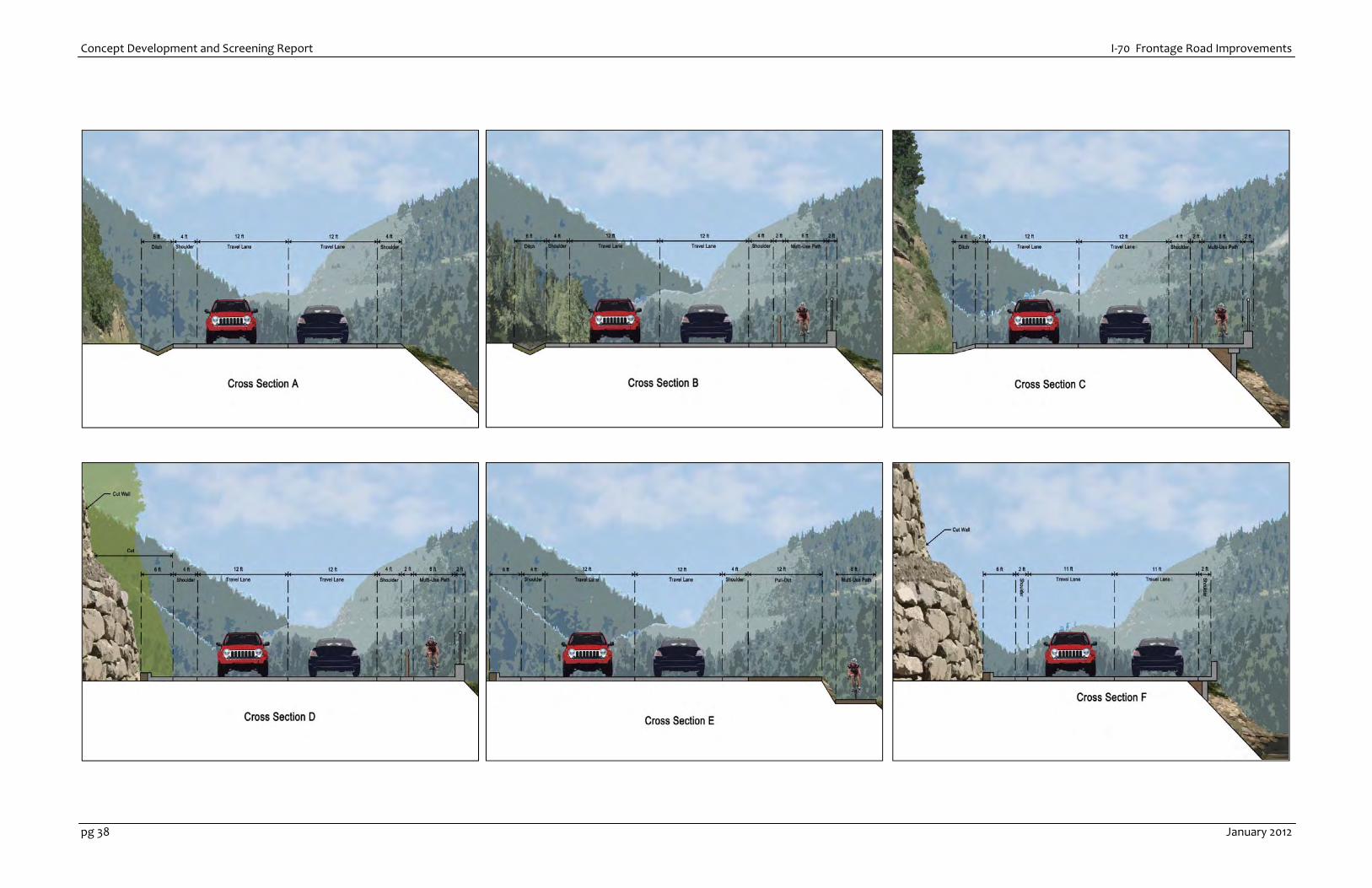
2.1.1 Summary of Cross Sections Considered
The following cross sections were initially developed to address project purpose and need and
physical constraints. A single cross section or combination may be used in each of the decision areas.
Table 1: Cross Sections
Cross Section Description Total Width Greenway Trail
Accommodation
Cross Section A Clear Creek County Collector section 38’ On road
Cross Section B Clear Creek County Collector section
with trail 50’ Trail separated with barrier
Cross Section C Clear Creek County Collector section
with trail on cantilever and wall 46’ Trail separated with barrier
Cross Section D Clear Creek County Collector section
with trail and boulder rock wall 50’ Trail separated with barrier
Cross Section E Clear Creek County Collector section
with detached trail Varies Detached trail
Cross Section F Clear Creek County Local Access
section 32’ On road

Concept Development and Screening Report I‐70 Frontage Road Improvements
pg 10 January 2012
2.1.2 Cross Section A – 38’
This is the standard section for a Clear Creek County roadway of this type. In areas where the
greenway trail is separated from the roadway, this is the baseline section. This typical section
includes a 6’ ditch, 4’ shoulder, two 12’ lanes, and 4’ shoulder. Figure 2 Illustrates Cross Section A.
Figure 2: Cross Section A

I‐70 Frontage Road Improvements Concept Development and Screening Report
January 2012 pg 11
2.1.3 Cross Section B – 50’
Some portions of existing CR 314 are currently wide enough to accommodate a wider cross section
for both vehicle lanes and a connected, but barrier separated greenway trail. The Clear Creek County
Greenway Plan (November 2005) identifies design preferences that were incorporated into this trail
design. This typical cross section includes 6’ ditch, 4’ shoulder, two 12’ lanes, 4’ shoulder, 2’ barrier,
8’ paved trail, and 2’ barrier. Figure 3 illustrates Cross Section B.
Figure 3: Cross Section B
Concept Development and Screening Report I‐70 Frontage Road Improvements
pg 12 January 2012
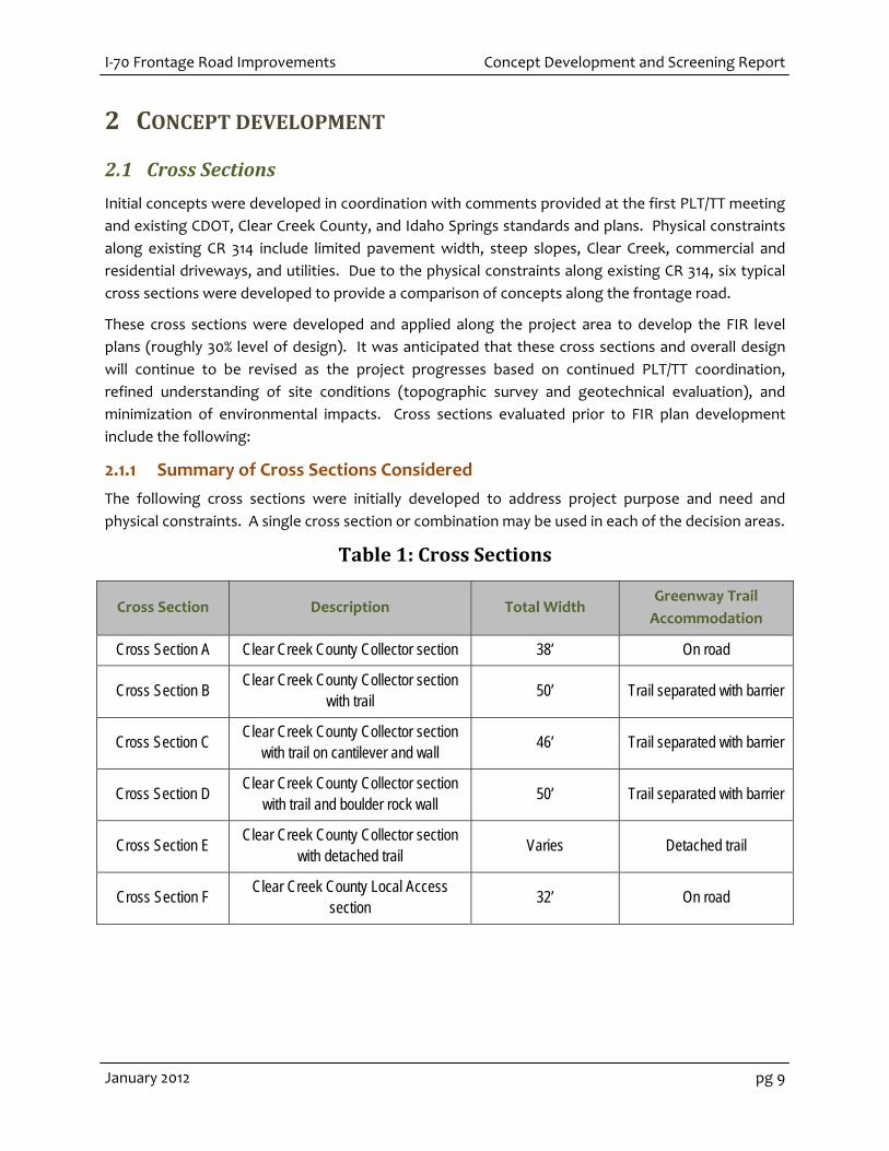
2.1.4 Cross Section C – 46’ with cantilever
Where the physical bench along CR 314 is limited, one option is to extend the proposed trail or
roadway over the Clear Creek slope with a cantilever and wall. While the cantilever and wall may be
designed to accommodate vehicle or bicycle/pedestrian loads, it was assumed for this cross section
that the cantilever and wall structures would be designed to accommodate only bicycle and
pedestrian loads to reduce cost and potential construction impact on Clear Creek. This typical cross
section includes 4’ paved ditch, 2’ shoulder, two 12’ lanes, 4’ shoulder, 2’ barrier, 8’ paved trail, and 2’
barrier. Figure 4 illustrates Cross Section C
Figure 4: Cross Section C
I‐70 Frontage Road Improvements Concept Development and Screening Report
January 2012 pg 13
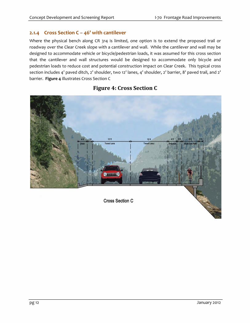
2.1.5 Cross Section D – 50’ cut wall
Where the physical bench along CR 314 is limited, another option is to cut into the upslope and add a
wall. The material and geological history of the hillside will dictate the type of wall will be used. A
rockery wall is shown in the figure as it is the most likely wall that will be used on this project. It is
assumed that all traffic – vehicles and trail are on existing grade. This typical cross section includes a
6’ offset to shoulder for rock fall, 4’ shoulder, two 12’ lanes, 4’ shoulder, 2’ barrier, 8’ paved trail, and
2’ barrier. Figure 5 illustrates Cross Section D.
Figure 5: Cross Section D

Concept Development and Screening Report I‐70 Frontage Road Improvements
pg 14 January 2012
2.1.6 Cross Section E – detached trail
The PLT requested concepts be developed that provided separation between CR 314 and the
greenway trail where space was available. Additionally, the Clear Creek County Greenway Plan
identified parking (pullout) locations for fishing and rafting. This section was designed to
accommodate these multiple uses where space was available. This section may vary in total width,
but at a minimum would include 34’ of roadway, 12’ paved pullout for rafting, fishing and trail access,
and 8’ greenway. This section may also provide the multi‐use path at the same grade as the roadway
and pullout. This typical cross section includes 6’ offset to shoulder for rockfall, 4’ shoulder, two 12’
lanes, 4’ shoulder,12’ pullout, varying natural ground width, 8’ paved trail. Figure 6 illustrates Cross
Section E.
Figure 6: Cross Section E

I‐70 Frontage Road Improvements Concept Development and Screening Report
January 2012 pg 15
2.1.7 Cross Section F – narrow
In some locations due to severe right‐of‐way or physical constraints, it may be preferred to have a
narrower cross section. This cross section is designed for vehicle traffic and assumes the trail will be
accommodated in a separate location on the existing Scott Lancaster Memorial Trail or on road.
Depending on specific conditions, this section may or may not include wall cuts (rockeries) and/or
minor cantilever and wall. This typical cross section includes 6’ paved ditch, 2’ shoulder, two 11’
lanes, and 2’ shoulder for a total of 32’ Figure 7 illustrates Cross Section F.
Figure 7: Cross Section F

Concept Development and Screening Report I‐70 Frontage Road Improvements
pg 16 January 2012
This page intentionally left blank.
I‐70 Frontage Road Improvements Concept Development and Screening Report
January 2012 pg 17
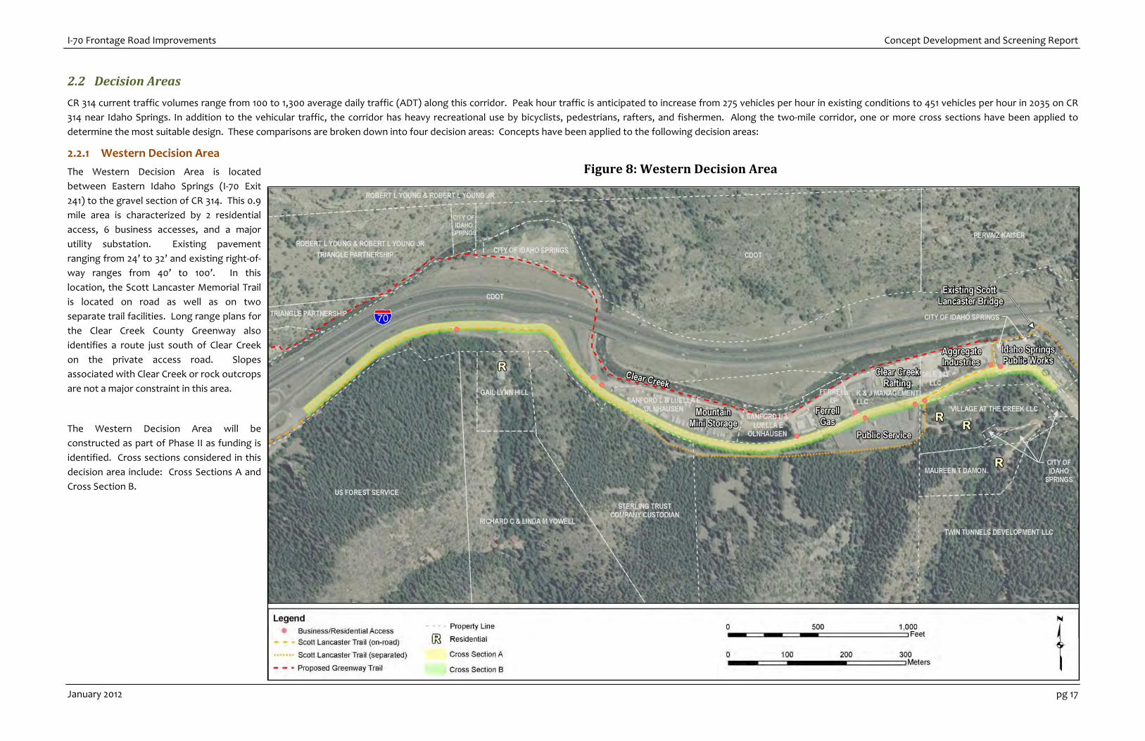
2.2 Decision Areas
CR 314 current traffic volumes range from 100 to 1,300 average daily traffic (ADT) along this corridor. Peak hour traffic is anticipated to increase from 275 vehicles per hour in existing conditions to 451 vehicles per hour in 2035 on CR
314 near Idaho Springs. In addition to the vehicular traffic, the corridor has heavy recreational use by bicyclists, pedestrians, rafters, and fishermen. Along the two‐mile corridor, one or more cross sections have been applied to
determine the most suitable design. These comparisons are broken down into four decision areas: Concepts have been applied to the following decision areas:
2.2.1 Western Decision Area
The Western Decision Area is located
between Eastern Idaho Springs (I‐70 Exit
241) to the gravel section of CR 314. This 0.9
mile area is characterized by 2 residential
access, 6 business accesses, and a major
utility substation. Existing pavement
ranging from 24’ to 32’ and existing right‐of‐
way ranges from 40’ to 100’. In this
location, the Scott Lancaster Memorial Trail
is located on road as well as on two
separate trail facilities. Long range plans for
the Clear Creek County Greenway also
identifies a route just south of Clear Creek
on the private access road. Slopes
associated with Clear Creek or rock outcrops
are not a major constraint in this area.
The Western Decision Area will be
constructed as part of Phase II as funding is
identified. Cross sections considered in this
decision area include: Cross Sections A and
Cross Section B.
Figure 8: Western Decision Area

Concept Development and Screening Report I‐70 Frontage Road Improvements
pg 18 January 2012
2.2.2 Gravel/Doghouse Bridge Decision Area
The Gravel/Doghouse Bridge Decision Area currently includes a 1,000 foot unimproved section of CR314
south and upslope of Clear Creek which accommodates through vehicle traffic. This 0.30 mile area also
includes the existing Doghouse Bridge crossing of Clear Creek connecting Old US 40 (game check area)
with CR 314. A single residential access is located just west of the Doghouse Bridge. PLT/TT identified
the Gem Power Plant as an important local historic resource that should be avoided in this area. The
Scott Lancaster Memorial Trail is accommodated as a separate facility behind the Idaho Spring Public
Works parcel, on the covered bridge, along Old US 40, and on the Doghouse Bridge. Options
considered in this decision area include:
Option 1 – Build two new bridges and abandon Doghouse Bridge and gravel section.
Option 2 – Improve Doghouse Bridge and build new bridge and abandon gravel section.
Option 3 – Improve existing gravel road (cross section F).
In Options 1 and 2, the trail may be attached to the roadway and bridges or an alternate route along the
north side of Clear Creek may be evaluated. There is no change to existing trail conditions in Option 3.
Members of the PLT/TT also identified an additional concept for consideration prior to PLT/TT meeting
#3. This concept will evaluate a new crossing of Clear Creek in a more east/west orientation than the
options shown in Figure 9. This concept was developed to avoid impacts to the Twin Tunnels
Development LLC property.
The Gravel/Doghouse Bridge Decision Area will be constructed as part of Phase II as funding is
identified.
Figure 9: Gravel/Doghouse Bridge Decision Area

I‐70 Frontage Road Improvements Concept Development and Screening Report
January 2012 pg 19
2.2.3 Phase I Decision Area
The Phase I Decision area is located just east of the Doghouse bridge/gravel road and west of the Hidden Valley/ Central City Interchange. This 0.4 mile area is characterized by steep slopes above Clear Creek to the north and rock
outcrops and rock slide slopes to the south. No residents or businesses are located along this area, but it provides direct recreational access for rafting and fishing. In this location, the Scott Lancaster Memorial Trail is located on road.
Existing pavement ranging from 24’ to 30’ and existing right‐of‐way ranges from 70’ to 125’. Cross sections considered in this decision area include: Cross Section C or D. Recreation access pullouts may be added by utilizing Cross
Section E at wider locations.
Figure 10: Phase I Decision Area

Concept Development and Screening Report I‐70 Frontage Road Improvements
pg 20 January 2012
2.2.4 Eastern Decision Area
The Eastern Decision Area is located east of Phase I and connects to the Hidden
Valley/Central City Interchange (Exit 243). This 0.3 mile area bends away from Clear
Creek with steep grades, crests on top of an large retaining wall for the I‐70 Hidden
Valley interchange ramps, and then descends into a signalized intersection just
south of the Hidden Valley interchange. This section is characterized with steep rock
outcrops and two residential access points to the south. Currently, the Scott
Lancaster Memorial Trail is located on road. Existing pavement ranging from 20’ to
26’ and existing right‐of‐way ranges from 70’ to 120’. Cross sections considered in
this decision area include: Cross Section B.
Figure 11: Eastern Decision Area
I‐70 Frontage Road Improvements Concept Development and Screening Report
January 2012 pg 21
3 EVALUATION CRITERIA
3.1 Development of Evaluation Criteria
Step 3 of the CSS process includes the development of evaluation criteria. Building upon previous
CSS efforts in the corridor, the design team reviewed the suggested evaluation criteria from the
Idaho Springs Area of Special Attention Report (IS ASA, March 2011). Table 2 summarizes the
suggested criteria from the IS ASA grouped by the core values of mobility, healthy town,
environmental, and sustainability. The IS ASA includes 27 criteria to address the core values for
improvements to I‐70, AGS, and/or the frontage road.
The project team reviewed the criteria for applicability to the frontage road and eliminated non‐
applicable criteria. Applicable criteria were then revised with metrics specific to the Frontage Road.
The following adjustments were made to the original criteria by the project team:
Criteria displayed in gray text are not applicable to the Frontage Road
Criteria with an “*” were added based on PLT/TT comments and additional concerns
identified at the August 30, 2001 PLT/TT meeting
It is recommended that a total of 17 criteria be evaluated for each Frontage Road
design concept; including 5 mobility, 6 healthy town, 5 environmental, and 1
sustainable criteria.
These criteria were presented to the I‐70 Frontage Road PLT/TT on October 26, 2011 for
endorsement.
Table 2: Initial Evaluation Criteria
Idaho Springs
ASA Values
Criteria for Evaluation of
Alternatives (IS ASA)
Applicable to I‐70
Frontage Road Options Metric
Mobility
Increase throughput on the I-70 Mountain Corridor, reduce congestion
Increase vehicle mobility on the I-70 Mountain Corridor and throughout Idaho Springs and maintain local nature of roadway for traffic calming.
Evaluate adequate lane widths and shoulders – maintained or improved compared to existing conditions.
Traffic volumes on Colorado Boulevard with and without the improvements
NA NA
Number of access points with and without the improvements
Changes in residential and commercial access points
Business/residential access impacts
Rate construction impacts as high/medium/low for all alternatives
Minimize construction impacts
Duration and phasing of construction impacts - high/medium/low

Concept Development and Screening Report I‐70 Frontage Road Improvements
pg 22 January 2012
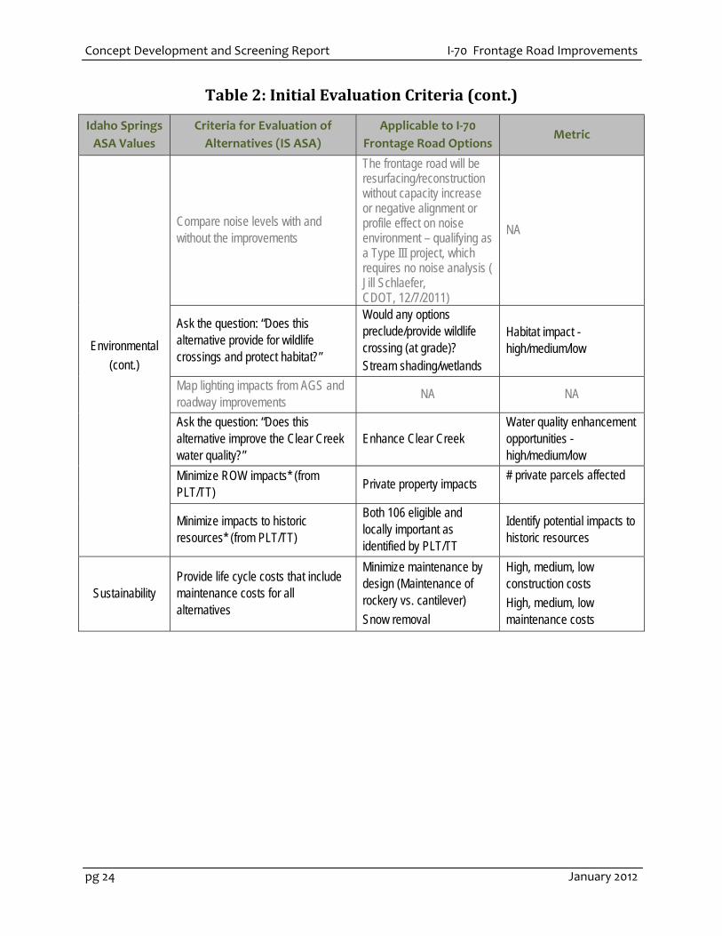
Table 2: Initial Evaluation Criteria (cont.)
Idaho Springs
ASA Values
Criteria for Evaluation of
Alternatives (IS ASA)
Applicable to I‐70
Frontage Road Options Metric
Mobility
(cont.)
Calculate Level of Service for key in-town intersections with and without the improvements
NA NA
Measure length of new trails and access points with and without the improvements
Improve the bike and pedestrian trails
Length/access of trail improvements
Rate access as good/fair/poor for each alternative
NA NA
Safety – how well does the alternative element provide safety measures* (added from PEIS)
Crashes Emergency response (width and access)
Change in crash rating high/medium/low Total roadway width to accommodate emergency response Maintain or increase opportunities for emergency response access
Healthy Town
Lay out sightlines from the AGS to Idaho Springs for each alternative alignment
NA NA
Complete an economic/land use assessment with and without the improvements
Increase economic health, vitality, and redevelopment opportunities
Change in redevelopment opportunity - high/medium/low
Include transit stop in the economic/land use assessment
NA NA
Lay out transit and pedestrian access routes for each alternative
NA NA
Rate access as good/fair/poor based on these three elements of the alternative: more than one interchange, access at east end of town, access downtown/gateway)
NA NA
Ask the question: “Does this alternative provide opportunities for additional downtown parking?”
NA NA
Ask the question: “Can the design of the highway and AGS meet the Aesthetic Guidelines?”
Can the design of the frontage road meet the Aesthetic Guidelines?
Change in aesthetics - high/medium/low

I‐70 Frontage Road Improvements Concept Development and Screening Report
January 2012 pg 23
Table 2: Initial Evaluation Criteria (cont.)
Idaho Springs
ASA Values
Criteria for Evaluation of
Alternatives (IS ASA)
Applicable to I‐70
Frontage Road Options Metric
Healthy Town
(cont.)
Ask the question: “Can business access be maintained during construction?”
Minimize construction impacts on businesses
Impacts to business access during construction - high/medium/low
Ask the question: “Does this alternative acceptably accommodate the Water Wheel?”
NA NA
Ask the question: “Is this alternative consistent with a Clear Creek greenway? (Trail Access)
Flexibility to safely accommodate trail during detour/construction.
Trail accommodation - high/medium/low
Ask the questions: “Is this alternative consistent with a Clear Creek greenway? (Facility Access)
Does design accommodate other greenway facilities like parking, boat ramp, restrooms, etc.?
Facility accommodation - high/medium/low
Ask the question “Are there reasonable accommodations for current and future utilities?”* (PLT/TT)
Utility accommodations along CR 314
Number and type of utilities affected. Can other utilities be extended during construction? Yes/no
Environmental Compare air quality with and without the improvements
The project is exempt from air quality conformity requirements that are applicable to transportation projects in nonattainment areas because it is located in Clear Creek County, at least three miles outside of the nonattainment area boundaries for the Denver metro area. The project would improve an existing two-lane frontage road, not adding capacity. Air quality impacts of this proposed improvement would be negligible. ( Doug Eberhart 12/7/2011)
NA
Concept Development and Screening Report I‐70 Frontage Road Improvements
pg 24 January 2012
Table 2: Initial Evaluation Criteria (cont.)
Idaho Springs
ASA Values
Criteria for Evaluation of
Alternatives (IS ASA)
Applicable to I‐70
Frontage Road Options Metric
Environmental
(cont.)
Compare noise levels with and without the improvements
The frontage road will be resurfacing/reconstruction without capacity increase or negative alignment or profile effect on noise environment – qualifying as a Type III project, which requires no noise analysis ( Jill Schlaefer, CDOT, 12/7/2011)
NA
Ask the question: “Does this alternative provide for wildlife crossings and protect habitat?”
Would any options preclude/provide wildlife crossing (at grade)? Stream shading/wetlands
Habitat impact - high/medium/low
Map lighting impacts from AGS and roadway improvements
NA NA
Ask the question: “Does this alternative improve the Clear Creek water quality?”
Enhance Clear Creek Water quality enhancement opportunities - high/medium/low
Minimize ROW impacts* (from PLT/TT)
Private property impacts # private parcels affected
Minimize impacts to historic resources* (from PLT/TT)
Both 106 eligible and locally important as identified by PLT/TT
Identify potential impacts to historic resources
Sustainability Provide life cycle costs that include maintenance costs for all alternatives
Minimize maintenance by design (Maintenance of rockery vs. cantilever)
Snow removal
High, medium, low construction costs
High, medium, low maintenance costs

I‐70 Frontage Road Improvements Concept Development and Screening Report
January 2012 pg 25
3.1.1 Evaluation of Cross Sections within Decision Areas
Step 5 of the CSS process includes the evaluation, selection, and refinement of options. Options
were presented and discussed with the PLT/TT and stakeholders at the PLT/TT #2 (October 26, 2011),
PLT/TT #2.5 (November 1, 2011), and Greenway Issue Task Force (November 22, 2011).
Tables 3 through 6 provide a comparison of options at each of the four decision areas consistent
with the criteria established at PLT #2. Evaluation of options is based on GIS and aerial analysis of
conceptual design and feedback provided at the stakeholder meetings noted above. A summary of
the evaluations and recommended alternative is found in Section 4 of this report.
Table 3: Evaluation of Options in Western Decision Area
Applicable to I‐70
Frontage Road
Options
Metric Existing Conditions Cross Section A Cross Section B
Increase vehicle mobility on the I-70 Mountain Corridor and throughout Idaho Springs
Evaluate adequate lane widths and shoulders – maintained or improved compared to existing conditions. At narrowest 24’ existing pavement and 40’ ROW
Existing ROW conditions can accommodate Cross Section A, but would require additional pavement
Would require additional ROW and pavement for improved widths and shoulders (32 ft) plus barrier separated 8 ft trail
Changes in residential and commercial access points
Business/residential access impacts 10 existing access points
No changes Up to 10 accesses may be impacted
Minimize construction impacts
Duration and phasing of construction impacts - high/medium/low Condition of existing pavement – TBD
Low – widening Medium – reconstruct (one lane remains open)
Low – widening Medium – reconstruct (one lane remains open)
Improve the bike and pedestrian trails
Length/access of trail improvements Trail is accommodated both on-street and separated. Greenway planned to extend along business road access between Clear Creek and businesses.
No improvements to trails. Bike/peds accommodated on improved and consistent shoulders.
0.44 miles of barrier separated trail
Crashes Emergency response (width and access)
Change in crash rating high/medium/low Low crash history (per Cindy Condon, Idaho Springs City Administrator one accident within the last 3 or 4 years on CR 314) Total roadway width to accommodate emergency response - maintain or increase width
No change in crash rating. 32 ft total roadway width for emergency response maintain opportunity for emergency response access
No change in crash rating. 32 ft total roadway width for emergency response maintain opportunity for emergency response access
Concept Development and Screening Report I‐70 Frontage Road Improvements
pg 26 January 2012
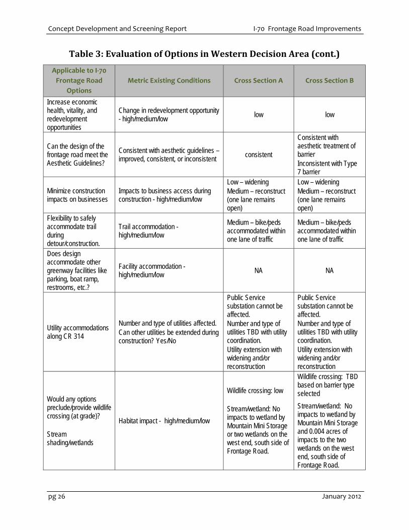
Table 3: Evaluation of Options in Western Decision Area (cont.)
Applicable to I‐70
Frontage Road
Options
Metric Existing Conditions Cross Section A Cross Section B
Increase economic health, vitality, and redevelopment opportunities
Change in redevelopment opportunity - high/medium/low
low low
Can the design of the frontage road meet the Aesthetic Guidelines?
Consistent with aesthetic guidelines – improved, consistent, or inconsistent
consistent
Consistent with aesthetic treatment of barrier Inconsistent with Type 7 barrier
Minimize construction impacts on businesses
Impacts to business access during construction - high/medium/low
Low – widening Medium – reconstruct (one lane remains open)
Low – widening Medium – reconstruct (one lane remains open)
Flexibility to safely accommodate trail during detour/construction.
Trail accommodation - high/medium/low
Medium – bike/peds accommodated within one lane of traffic
Medium – bike/peds accommodated within one lane of traffic
Does design accommodate other greenway facilities like parking, boat ramp, restrooms, etc.?
Facility accommodation - high/medium/low
NA NA
Utility accommodations along CR 314
Number and type of utilities affected. Can other utilities be extended during construction? Yes/No
Public Service substation cannot be affected. Number and type of utilities TBD with utility coordination. Utility extension with widening and/or reconstruction
Public Service substation cannot be affected. Number and type of utilities TBD with utility coordination. Utility extension with widening and/or reconstruction
Would any options preclude/provide wildlife crossing (at grade)? Stream shading/wetlands
Habitat impact - high/medium/low
Wildlife crossing: low Stream/wetland: No impacts to wetland by Mountain Mini Storage or two wetlands on the west end, south side of Frontage Road.
Wildlife crossing: TBD based on barrier type selected
Stream/wetland: No impacts to wetland by Mountain Mini Storage and 0.004 acres of impacts to the two wetlands on the west end, south side of Frontage Road.

I‐70 Frontage Road Improvements Concept Development and Screening Report
January 2012 pg 27
Table 4: Evaluation of Options in Gravel/Doghouse Bridge Decision Area
Table 3: Evaluation of Options in Western Decision Area (cont.)
Applicable to I‐70
Frontage Road
Options
Metric Existing Conditions Cross Section A Cross Section B
Enhance Clear Creek Water quality enhancement opportunities - high/medium/low
Ditch to convey drainage added
Ditch to convey drainage added
Private property impacts
# private parcels affected 0 Up to 8
Minimize impacts to historic resources* (from PLT/TT)
Identify potential impacts to historic resources
NA NA
Minimize maintenance by design
High, medium, low construction costs High, medium, low maintenance costs
Low Similar to existing
Low + additional pavement width Additional costs to remove snow along trail
Applicable to I‐70
Frontage Road Options
Metric
Existing Conditions
Option 1 (Cross
Section B)
Option 2 (Cross
Section B)
Option 3 (Cross
Section F)
Increase vehicle mobility on the I-70 Mountain Corridor and throughout Idaho Springs
Evaluate adequate lane widths and shoulders – maintained or improved compared to existing conditions.
At minimum, existing pavement on gravel section 20’ and doghouse bridge width 38’
Widened lanes and shoulders (32’) on new alignment
Widened lanes and shoulders (32’) on new alignment
Widened lanes and shoulders (26’) on existing alignment
Changes in residential and commercial access points
Business/residential access impacts
0 0 0
Minimize construction impacts
Duration and phasing of construction impacts - high/medium/low
Low – construction on new alignment
Low – construction on new alignment
Medium/High – difficult to maintain a lane of traffic on narrow section

Concept Development and Screening Report I‐70 Frontage Road Improvements
pg 28 January 2012
Table 4: Evaluation of Options in Gravel/Doghouse Bridge
Decision Area (cont.)
Applicable to I‐70
Frontage Road Options
Metric
Existing Conditions
Option 1 (Cross
Section B)
Option 2 (Cross
Section B)
Option 3 (Cross
Section F)
Improve the bike and pedestrian trails
Length/access of trail improvements
500’ new attached trail
375’ new attached trail
No change, trail remains on doghouse bridge
Crashes
Emergency response (width and access)
Change in crash rating high/medium/low
Low crash history -one accident within the last 3 or 4 years on CR 314.
Total roadway width to accommodate emergency response - maintain or increase width
No change in crash rating.
32 ft total roadway width for emergency response
No change in crash rating.
32 ft total roadway width for emergency response
No change in crash rating.
26 ft total roadway width for emergency response
Increase economic health, vitality, and redevelopment opportunities
Change in redevelopment opportunity - high/medium/low
Low – impacts to developable
parcel at doghouse bridge
Low – impacts to developable parcel at doghouse bridge and Twin Tunnels LLC (esp. Gem
Power plant site)
Low – impacts to Twin Tunnels LLC
Can the design of the frontage road meet the Aesthetic Guidelines?
Consistent with aesthetic guidelines – improved, consistent, or inconsistent
TBD based on bridge design
TBD based on bridge design
Consistent – boulder rock walls in some locations
Minimize construction impacts on businesses
Impacts to business access during construction - high/medium/low
low low low
Flexibility to safely accommodate trail during detour/construction.
Trail accommodation - high/medium/low
High – could use gravel road
High – could use gravel road
High – no impact to existing trail at doghouse bridge
Does design accommodate other greenway facilities like parking, boat ramp, restrooms, etc.?
Facility accommodation - high/medium/low
Moderate – direct access to game check bridge area
Moderate – direct access to game check bridge area
Moderate – direct access to game check bridge area
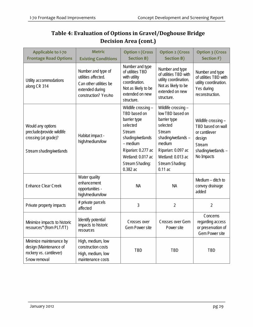
I‐70 Frontage Road Improvements Concept Development and Screening Report
January 2012 pg 29
Table 4: Evaluation of Options in Gravel/Doghouse Bridge
Decision Area (cont.)
Applicable to I‐70
Frontage Road Options
Metric
Existing Conditions
Option 1 (Cross
Section B)
Option 2 (Cross
Section B)
Option 3 (Cross
Section F)
Utility accommodations along CR 314
Number and type of utilities affected.
Can other utilities be extended during construction? Yes/no
Number and type of utilities TBD with utility coordination. Not as likely to be extended on new structure.
Number and type of utilities TBD with utility coordination. Not as likely to be extended on new structure.
Number and type of utilities TBD with utility coordination. Yes during reconstruction.
Would any options preclude/provide wildlife crossing (at grade)?
Stream shading/wetlands
Habitat impact - high/medium/low
Wildlife crossing – TBD based on barrier type selected
Stream shading/wetlands – medium
Riparian: 0.277 ac
Wetland: 0.017 ac
Stream Shading: 0.382 ac
Wildlife crossing – low TBD based on barrier type selected
Stream shading/wetlands – medium
Riparian: 0.097 ac
Wetland: 0.013 ac
Stream Shading: 0.11 ac
Wildlife crossing – TBD based on wall or cantilever design
Stream shading/wetlands – No Impacts
Enhance Clear Creek
Water quality enhancement opportunities - high/medium/low
NA NA Medium – ditch to convey drainage added
Private property impacts # private parcels affected
3 2 2
Minimize impacts to historic resources* (from PLT/TT)
Identify potential impacts to historic resources
Crosses over Gem Power site
Crosses over Gem Power site
Concerns regarding access or preservation of Gem Power site
Minimize maintenance by design (Maintenance of rockery vs. cantilever)
Snow removal
High, medium, low construction costs
High, medium, low maintenance costs
TBD TBD TBD

Concept Development and Screening Report I‐70 Frontage Road Improvements
pg 30 January 2012
Table 5: Evaluation of Options in Phase I Decision Area
Applicable to I‐70
Frontage Road Options Metric Cross Section C Cross Section D
Increase vehicle mobility on the I-70 Mountain Corridor and throughout Idaho Springs
Evaluate adequate lane widths and shoulders – maintained or improved compared to existing conditions.
At narrowest 24’ existing pavement and 70’ ROW
Improved widths and shoulders (32 ft)
Improved widths and shoulders (32 ft)
Changes in residential and commercial access points
Business/residential access impacts 0 0
Minimize construction impacts
Duration and phasing of construction impacts - high/medium/low
Condition of existing pavement – TBD
Medium – reconstruct (one lane remains open)
Medium – reconstruct (one lane remains open)
Improve the bike and pedestrian trails
Length/access of trail improvements 0.37 miles of barrier separated trail
0.37 miles of barrier separated trail
Crashes
Emergency response (width and access)
Change in crash rating high/medium/low
Low crash history - one accident within the last 3 or 4 years on CR 314)
Total roadway width to accommodate emergency response - maintain or increase width
No change in crash rating.
32 ft total roadway width for emergency response
No change in crash rating.
32 ft total roadway width for emergency response
Increase economic health, vitality, and redevelopment opportunities
Change in redevelopment opportunity - high/medium/low
NA NA
Can the design of the frontage road meet the Aesthetic Guidelines?
Consistent with aesthetic guidelines – improved, consistent, or inconsistent
Consistent/inconsistent – cantilevers
consistent –boulder rock walls
Minimize construction impacts on businesses
Impacts to business access during construction - high/medium/low
NA NA
Flexibility to safely accommodate trail during detour/construction.
Trail accommodation - high/medium/low
Low – cantilever not designed to handle vehicle traffic loads
High – can be restriped and barrier shifted to accommodate bike/ped

I‐70 Frontage Road Improvements Concept Development and Screening Report
January 2012 pg 31
Table 5: Evaluation of Options in Phase I Decision Area (cont.)
Applicable to I‐70
Frontage Road Options Metric Cross Section C Cross Section D
Does design accommodate other greenway facilities like parking, boat ramp, restrooms, etc.?
Facility accommodation - high/medium/low
Low
High - Integration of Cross Section E in some locations
Moderate
High - Integration of Cross Section E in some locations
Utility accommodations along CR 314
Number and type of utilities affected.
Can other utilities be extended during construction? Yes/no
Number and type of utilities TBD with utility coordination. Utility extension with widening and/or reconstruction
Number and type of utilities TBD with utility coordination. Utility extension with widening and/or reconstruction
Would any options preclude/provide wildlife crossing (at grade)?
Stream shading/wetlands
Habitat impact - high/medium/low
Wildlife crossing: TBD based on cantilever and barrier design
Stream/wetland: Wetland: No impacts
Stream: TBD extent of overhang
Wildlife crossing: TBD based on barrier selected
Stream/wetland: No Impacts
Enhance Clear Creek Water quality enhancement opportunities - high/medium/low
Medium – ditch to convey drainage added.
Additional opportunity at western end.
Medium – ditch to convey drainage added.
Additional opportunity at western end.
Private property impacts # private parcels affected 0 0
Minimize impacts to historic resources* (from PLT/TT)
Identify potential impacts to historic resources
NA NA
Minimize maintenance by design
High, medium, low construction costs
High, medium, low maintenance costs
Estimated construction cost $2.8 M
Maintenance costs TBD
Estimated construction cost $3.8 M
Maintenance costs TBD
Concept Development and Screening Report I‐70 Frontage Road Improvements
pg 32 January 2012
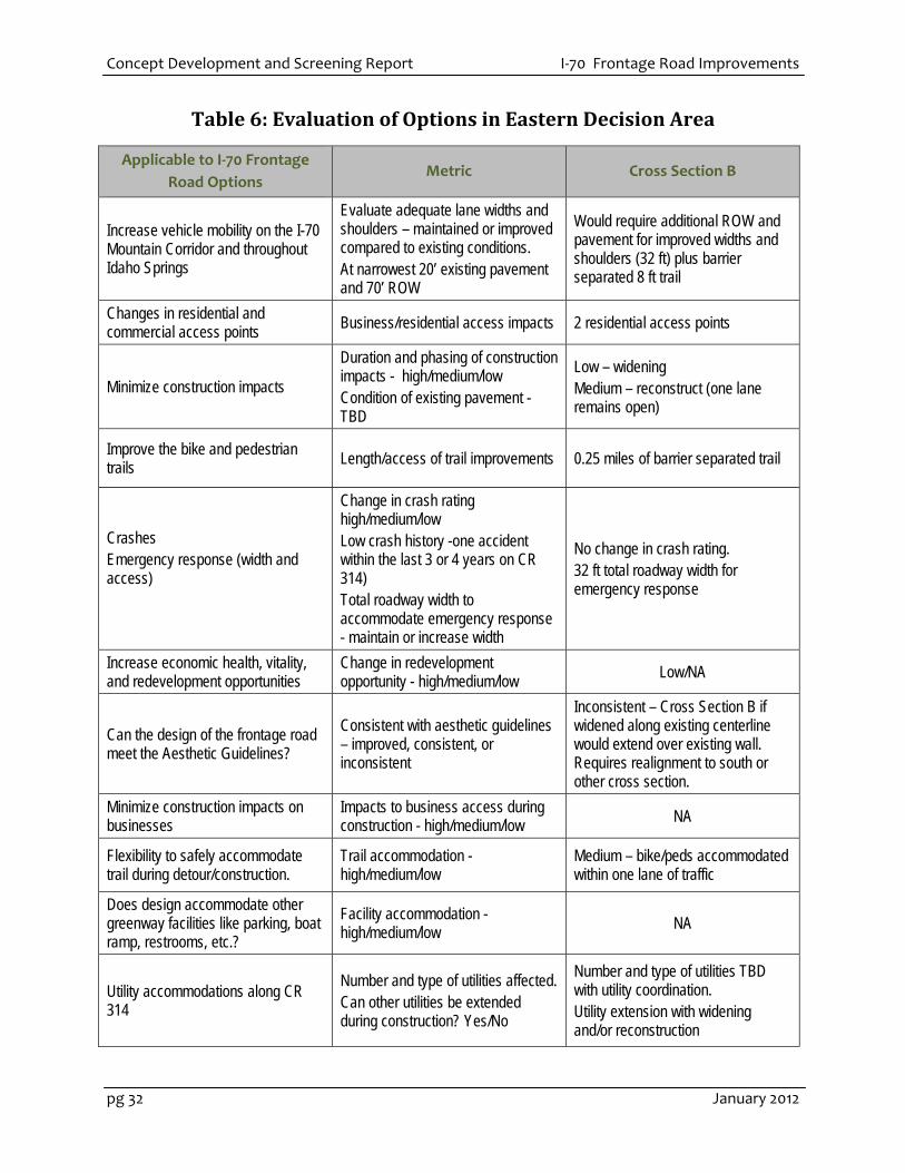
Table 6: Evaluation of Options in Eastern Decision Area
Applicable to I‐70 Frontage
Road Options Metric Cross Section B
Increase vehicle mobility on the I-70 Mountain Corridor and throughout Idaho Springs
Evaluate adequate lane widths and shoulders – maintained or improved compared to existing conditions. At narrowest 20’ existing pavement and 70’ ROW
Would require additional ROW and pavement for improved widths and shoulders (32 ft) plus barrier separated 8 ft trail
Changes in residential and commercial access points
Business/residential access impacts 2 residential access points
Minimize construction impacts
Duration and phasing of construction impacts - high/medium/low Condition of existing pavement - TBD
Low – widening Medium – reconstruct (one lane remains open)
Improve the bike and pedestrian trails Length/access of trail improvements 0.25 miles of barrier separated trail
Crashes Emergency response (width and access)
Change in crash rating high/medium/low Low crash history -one accident within the last 3 or 4 years on CR 314) Total roadway width to accommodate emergency response - maintain or increase width
No change in crash rating. 32 ft total roadway width for emergency response
Increase economic health, vitality, and redevelopment opportunities
Change in redevelopment opportunity - high/medium/low
Low/NA
Can the design of the frontage road meet the Aesthetic Guidelines?
Consistent with aesthetic guidelines – improved, consistent, or inconsistent
Inconsistent – Cross Section B if widened along existing centerline would extend over existing wall. Requires realignment to south or other cross section.
Minimize construction impacts on businesses
Impacts to business access during construction - high/medium/low NA
Flexibility to safely accommodate trail during detour/construction.
Trail accommodation - high/medium/low
Medium – bike/peds accommodated within one lane of traffic
Does design accommodate other greenway facilities like parking, boat ramp, restrooms, etc.?
Facility accommodation - high/medium/low
NA
Utility accommodations along CR 314
Number and type of utilities affected. Can other utilities be extended during construction? Yes/No
Number and type of utilities TBD with utility coordination. Utility extension with widening and/or reconstruction
I‐70 Frontage Road Improvements Concept Development and Screening Report
January 2012 pg 33
Table 6: Evaluation of Options in Eastern Decision Area (cont.)
Applicable to I‐70 Frontage
Road Options Metric Cross Section B
Utility accommodations along CR 314
Number and type of utilities affected. Can other utilities be extended during construction? Yes/No
Number and type of utilities TBD with utility coordination. Utility extension with widening and/or reconstruction
Would any options preclude/provide wildlife crossing (at grade)? Stream shading/wetlands
Habitat impact - high/medium/low Wildlife crossing: TBD based on barrier selected Stream/wetland: No impacts
Enhance Clear Creek Water quality enhancement opportunities - high/medium/low Ditch to convey drainage added
Private property impacts # private parcels affected 0
Minimize impacts to historic resources* (from PLT/TT)
Identify potential impacts to historic resources
Impacts to local historic resources - water line and Bell residence
unknown at this time
Minimize maintenance by design (Maintenance of rockery vs. cantilever) Snow removal
High, medium, low construction costs High, medium, low maintenance costs
Low + additional pavement width Additional costs to remove snow along trail
Concept Development and Screening Report I‐70 Frontage Road Improvements
pg 34 January 2012
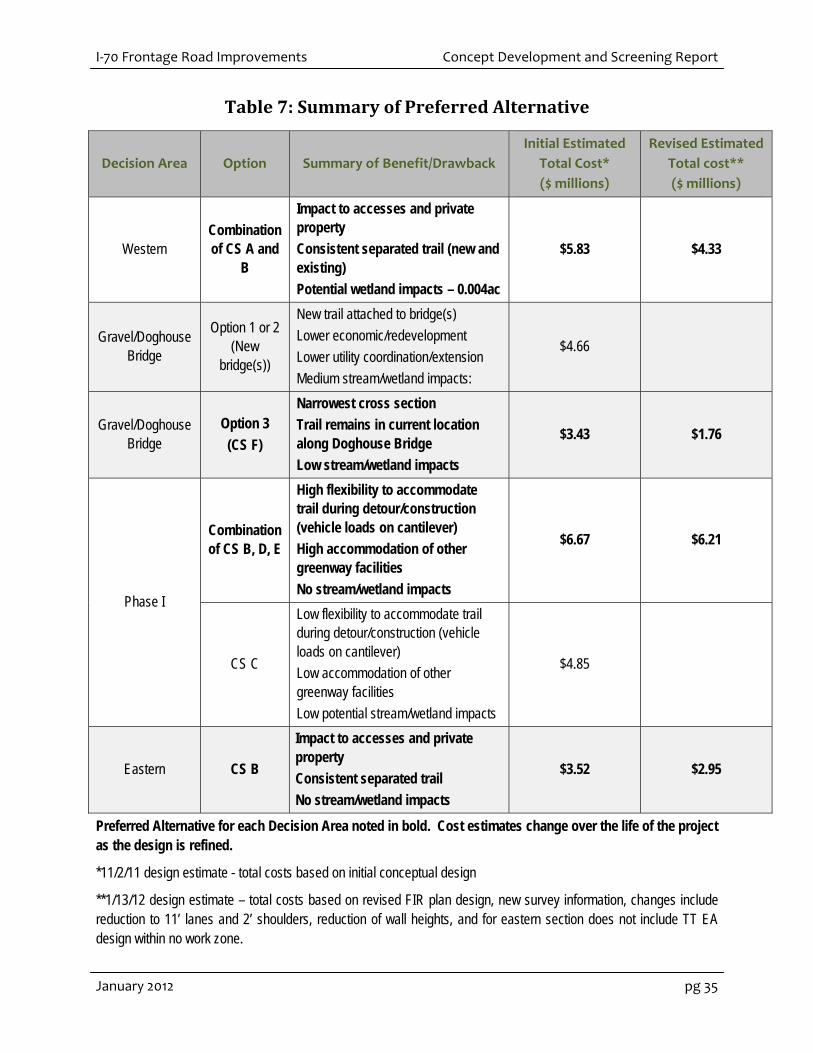
4 SELECTION AND REFINEMENT OF PREFERRED ALTERNATIVEThe preferred alternative for the project was developed as a result of the concept screening and
evaluation process. Table 7 identifies the preferred cross section options for each decision area and
a brief summary of benefits and drawbacks identified in Section 3. Evaluation Criteria. As the design
has been revised throughout the project development process, the cost estimates have also been
adjusted to reflect the design changes. Two “snapshots” of total cost estimates are also provided in
Table 7. These reflect the initial cost estimate presented at PLT/TT #2 and #2.5 and revised cost
estimate presented at PLT/TT #5.
The summary of the initial Preferred Alternative was presented and discussed with the PLT/TT and
stakeholders at PLT Meeting #2.5 (November 1, 2011). Team members and stakeholders were given
the opportunity to view and comment on the frontage road preferred alternative that was
incorporated into the December 1, 2012 FIR plans.
As part of the FIR plan meeting and PLT/TT meetings PLT #3 (December 15, 2011) and #4 (January 18,
2012), project stakeholders provided comments on the Preferred Alternative. Design was also revised
based on updated site conditions including topographic survey and preliminary geotechnical
information. An example of design revision based on updated site conditions includes the removal
of the upslope cut wall within the Gravel/Doghouse Decision Area.
Additional refinements to reduce environmental impacts and wall heights were specifically discussed
at PLT #4. Refinements incorporated into design based on comments include:
10‐foot travel lane width
2‐foot shoulders
5‐foot buffer (instead of barrier) between CR 314 and shared use path
Consideration of alternatives to boulder rock walls
Extension of Phase I improvement to Hidden Valley
Exclusion of improvement in no work zone of Phase I
As design progresses, CDOT will continue to coordinate with the PLT/TT to minimize impacts while
meeting project goals. It is anticipated that design revisions will be consistent with the Mountain
Mineral Belt Design Guidelines. Figure 12 illustrates the preferred alternative and the revised cross
sections evaluated in the Cat Ex and carried forward in design plans.
I‐70 Frontage Road Improvements Concept Development and Screening Report
January 2012 pg 35
Table 7: Summary of Preferred Alternative
Decision Area Option Summary of Benefit/Drawback
Initial Estimated
Total Cost*
($ millions)
Revised Estimated
Total cost**
($ millions)
Western Combination of CS A and
B
Impact to accesses and private property
Consistent separated trail (new and existing)
Potential wetland impacts – 0.004ac
$5.83 $4.33
Gravel/Doghouse Bridge
Option 1 or 2 (New
bridge(s))
New trail attached to bridge(s)
Lower economic/redevelopment
Lower utility coordination/extension
Medium stream/wetland impacts:
$4.66
Gravel/Doghouse Bridge
Option 3
(CS F)
Narrowest cross section
Trail remains in current location along Doghouse Bridge
Low stream/wetland impacts
$3.43 $1.76
Phase I
Combination of CS B, D, E
High flexibility to accommodate trail during detour/construction (vehicle loads on cantilever)
High accommodation of other greenway facilities
No stream/wetland impacts
$6.67 $6.21
CS C
Low flexibility to accommodate trail during detour/construction (vehicle loads on cantilever)
Low accommodation of other greenway facilities
Low potential stream/wetland impacts
$4.85
Eastern CS B
Impact to accesses and private property
Consistent separated trail
No stream/wetland impacts
$3.52 $2.95
Preferred Alternative for each Decision Area noted in bold. Cost estimates change over the life of the project as the design is refined.
*11/2/11 design estimate - total costs based on initial conceptual design
**1/13/12 design estimate – total costs based on revised FIR plan design, new survey information, changes include reduction to 11’ lanes and 2’ shoulders, reduction of wall heights, and for eastern section does not include TT EA design within no work zone.

Concept Development and Screening Report I‐70 Frontage Road Improvements
pg 36 January 2012
This page intentionally left blank.

I‐70 Frontage Road Improvements Concept Development and Screening Report
January 2012 pg 37
Figure 12: Refined Cross Sections of the Preferred Alternative
Concept Development and Screening Report I‐70 Frontage Road Improvements
pg 38 January 2012