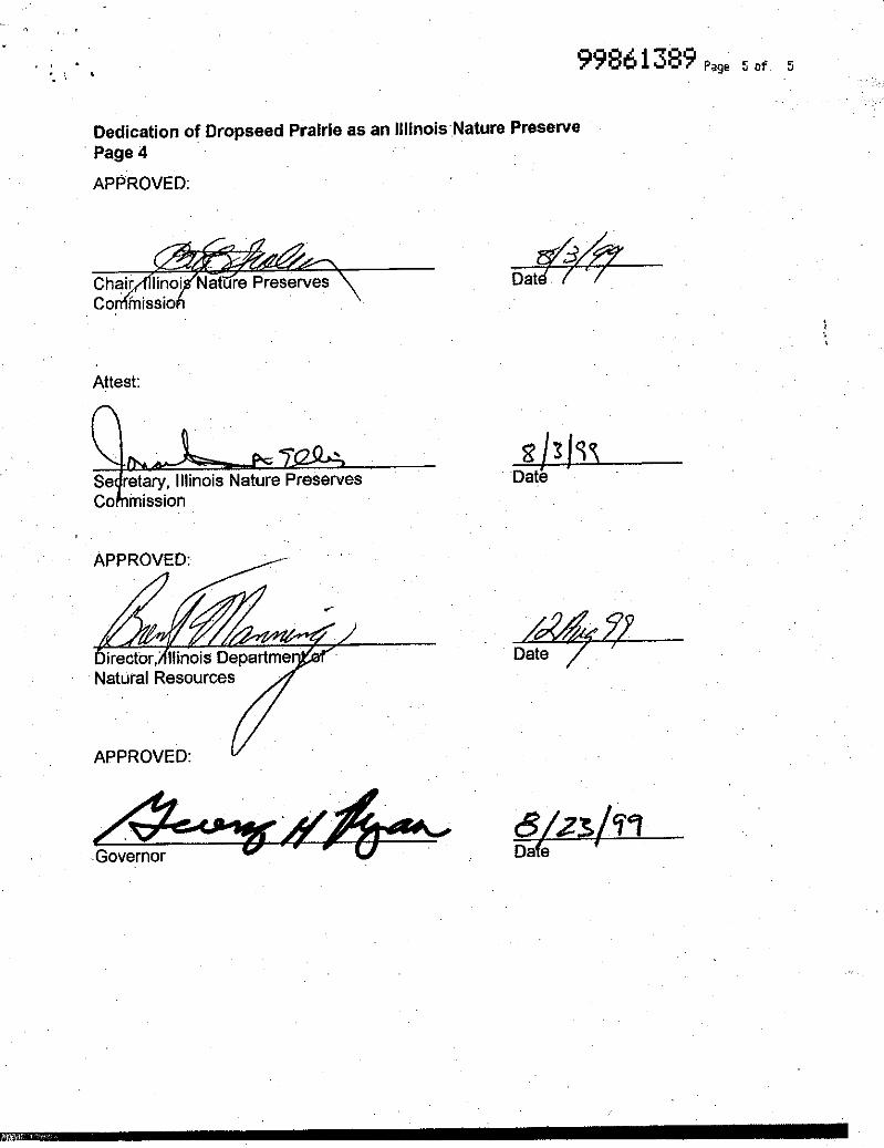
I-294/I-57 INTERCHANGE COOK COUNTY, ILLINOIS ...
156
I-294/I-57 INTERCHANGE COOK COUNTY, ILLINOIS ENVIRONMENTAL ASSESSMENT ADDENDUM Proposed 147th Street Improvements - Kedzie Avenue to Western Avenue/Dixie Highway I-57/I-294 Interchange - Minor Updates Based on New Environmental Studies FEBRUARY 2009
Transcript of I-294/I-57 INTERCHANGE COOK COUNTY, ILLINOIS ...

I-294/I-57 INTERCHANGECOOK COUNTY, ILLINOIS
ENVIRONMENTAL ASSESSMENTADDENDUM
Proposed 147th Street Improvements - Kedzie Avenue to Western Avenue/Dixie HighwayI-57/I-294 Interchange - Minor Updates Based on New Environmental Studies
FEBRUARY 2009
I-294/I-57 EA Addendum
TABLE OF CONTENTS Background and History............................................................................................. 1
Environmental Assessment Addendum..................................................................... 3
1.0 PURPOSE AND NEED......................................................................................... 3
1.1 INTRODUCTION............................................................................................ 3
2.0 ALTERNATIVES ................................................................................................. 5
2.3 ALTERNATIVES EVALUATED IN DETAIL........................................................ 5
2.3.2 Preferred Alternative..................................................................... 5
3.0 AFFECTED ENVIRONMENT/ENVIRONMENTAL CONSEQUENCES 3.1 SOCIAL AND ECONOMIC CONDITIONS .......................................................... 5
3.1.1 Social and Economic Affected Environment............................... 6
3.1.1.12 Pedestrian/Bicycle/Transit Facilities........................... 6
3.1.2 Social and Economic Environmental Consequences.................... 6
3.2 FARMLAND ...................................................................................................7
3.3 AIR QUALITY................................................................................................ 7
3.3.2 Air Quality Environmental Consequences....................................7
3.4 TRAFFIC NOISE .............................................................................................7
3.5 NATURAL RESOURCES ............. ................................................................... 8
3.5.2 Vegetation and Wildlife Environmental Consequences .............. 8
3.5.3 Threatened and Endangered Species Affected Environment …... 8
3.5.4 Threatened and Endangered Species Environmental
Consequence…........................................................................... 10
3.5.5 Trees Affected Environment....................................................... 11
3.5.6 Trees Environmental Consequences .......................................... 11
3.6 WATER RESOURCES AND WATER QUALITY................................................ 16
3.7 WETLANDS .................................................................................................17
3.7.1 Wetlands Affected Environment................................................. 17

I-294/I-57 EA Addendum
3.7.2 Wetlands Environmental Consequences..................................... 17
3.8 FLOODPLAIN AND FLOODWAYS .................................................................. 18
3.9 HISTORIC AND ARCHAEOLOGICAL RESOURCES .......................................... 18
3.10 SPECIAL LANDS ........................................................................................ 18
3.11 SPECIAL WASTE........................................................................................ 18
3.11.1 Special Waste Affected Environment....................................... 18
3.12 AESTHETICS ..............................................................................................21
3.13 CONSTRUCTION IMPACTS......................................................................... 21
3.14 INDIRECT (SECONDARY) IMPACTS ............................................................ 21
3.15 CUMULATIVE IMPACTS ............................................................................ 21
3.16 PERMITS.................................................................................................... 21
3.17 SUMMARY OF IMPACTS ............................................................................ 21
4.0 MITIGATION MEASURES...............................................................................21
4.1 RIGHT-OF-WAY ACQUISITION AND RELOCATIONS ..................................... 21
4.2 TRAFFIC NOISE ...........................................................................................22
4.3 NATURAL RESOURCES ............................................................................... 22
4.3.1 Trees..........................................................................................22
4.4 WATER RESOURCES AND WATER QUALITY................................................ 23
4.5 WETLANDS .................................................................................................23
4.6 FLOODPLAINS / FLOODWAYS ..................................................................... 23
4.7 SPECIAL LANDS .......................................................................................... 23
4.8 SPECIAL WASTE.......................................................................................... 23
4.9 AESTHETICS................................................................................................ 24
4.10 CONSTRUCTION IMPACTS.......................................................................... 24
4.11 SUMMARY OF MITIGATION MEASURES..................................................... 24
5.0 COMMENTS AND COORDINATION
5.1 PUBLIC INVOLVEMENT ............................................................................... 24
APPENDIX B: Correspondence APPENDIX D: Exhibits

I-294/I-57 EA Addendum
1
Background and History The Environmental Assessment (EA) for the I-294 at I-57 Interchange Project was approved by the Federal Highway Administration (FHWA) on August 20, 2008. The Illinois Department of Transportation (IDOT) and the Illinois Tollway have determined that this project shall be conducted jointly and that additional elements and logical termini on 147th Street (classified as a minor urban arterial) will be included as a part of the proposed project. The purpose of this document is to describe additional work to be completed on 147th Street from Kedzie Avenue to Western Avenue/Dixie Highway and the impacts that will result, as well as impact and project updates along the I-294 at I-57 Interchange. The Environmental Assessment for the I-294 at I-57 project was approved for public comment on August 20, 2008 and the public comment period was held from August 25, 2008 to September 26, 2008. Subsequently, the Illinois Department of Transportation in conjunction with the Illinois Tollway has continued to advance the engineering and environmental studies for this project including the I-294 at I-57 system interchange and four surrounding service interchanges (I-57 at 147th St. Interchange, I-57 at 159th St. interchange, I-294 at 147th St. Interchange, and I-294 at US 6 interchange). The additional effort is classified as follows:
• Additional geometric improvements along 147th Street (IL Route 83) from Kedzie Avenue to Western Avenue/Dixie Highway have been identified to accommodate an increase in travel demand and changes in travel patterns along this arterial as a result of the new ramp access to I-294 to and from the north as shown in the EA. The logical termini along 147th Street previously identified in the EA ended either side of the new I-294 ramps.
• The preliminary engineering for the I-294 at I-57 interchange has been advanced
based on new design mapping not available at the time of the original Environmental Assessment. As part of the next phase of engineering design, the Illinois Tollway and IDOT are committed to continuing to look at ways to reduce proposed ROW where it is cost effective with the understanding that the roadway and ramp configurations, as proposed, will be implemented.
• IDOT updated environmental studies in the Fall 2008 for the I-294 at I-57
Interchange Study, and the new work proposed along 147th Street. These studies included wetland delineation, tree surveys, threatened and endangered species, botanical surveys and a Preliminary Environmental Site Assessment (PESA) for special waste issues.
• An avian census was conducted by the Illinois Natural History Survey in 2008 for
the I-294 at I-57 Interchange project.

I-294/I-57 EA Addendum
The intention of this addendum is to document previously unreported impacts associated with the additional improvements along 147th Street and note any changes to impacts previously reported in the I-294/I-57 EA as a result of the subsequent engineering and environmental studies since the September 10, 2008 Public Hearing. New Project Improvements The proposed work on 147th Street will consist of providing a uniform 4-lane cross section with a variable width median from Kedzie Avenue to west of the southbound I-57 ramps. Three eastbound lanes are proposed from the southbound I-57 ramps to Western Avenue/ Dixie Highway. The work will consist of pavement reconstruction to provide standard width through lanes and the addition of a bi-directional left turn lane from Kedzie Avenue to Cleveland Avenue. Other work will include intersection approach and left turn lane improvements to accommodate revised traffic patterns due to the new I-294 access points along 147th Street, traffic signal replacement and interconnection, drainage improvements and intersection improvements at Western Avenue/Dixie Highway. Additional right-of-way acquisition will be required to accommodate lane widening, turn lane additions and retention of sidewalks.
2
I-294/I-57 EA Addendum
Environmental Assessment Addendum The Environmental Assessment Addendum includes proposed improvements along 147th Street between Kedzie Avenue and Western Avenue/Dixie Highway and updates to the I-294/I-57 Interchange. The results of the analysis follow the section numbering of the Environmental Assessment document: Signature Page: Interstate 294/Interstate 57 Interchange, Cook County, Illinois ENVIRONMENTAL ASSESSMENT The last paragraph, sentences three, four, and five should be removed and replaced as follows:
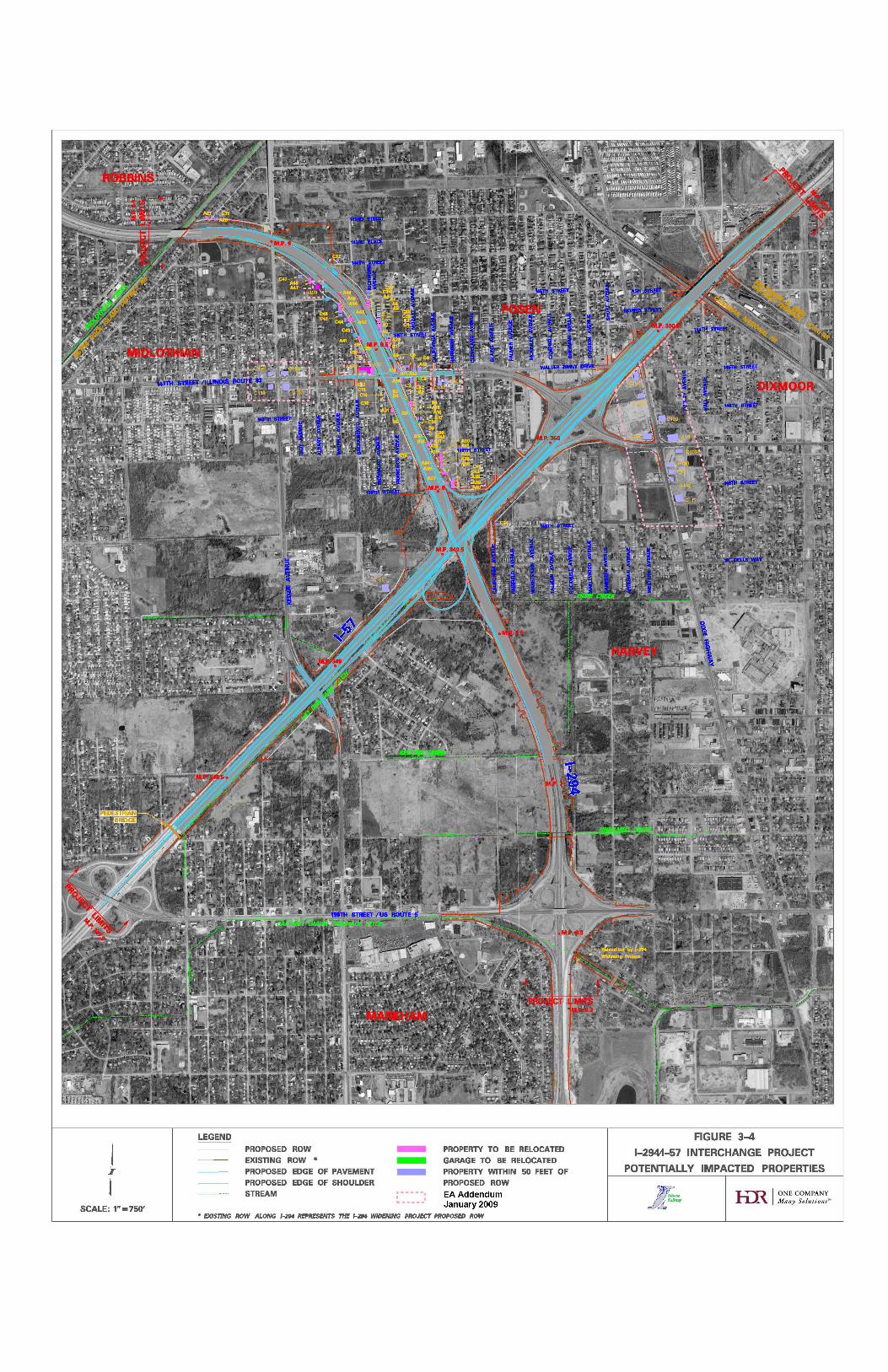
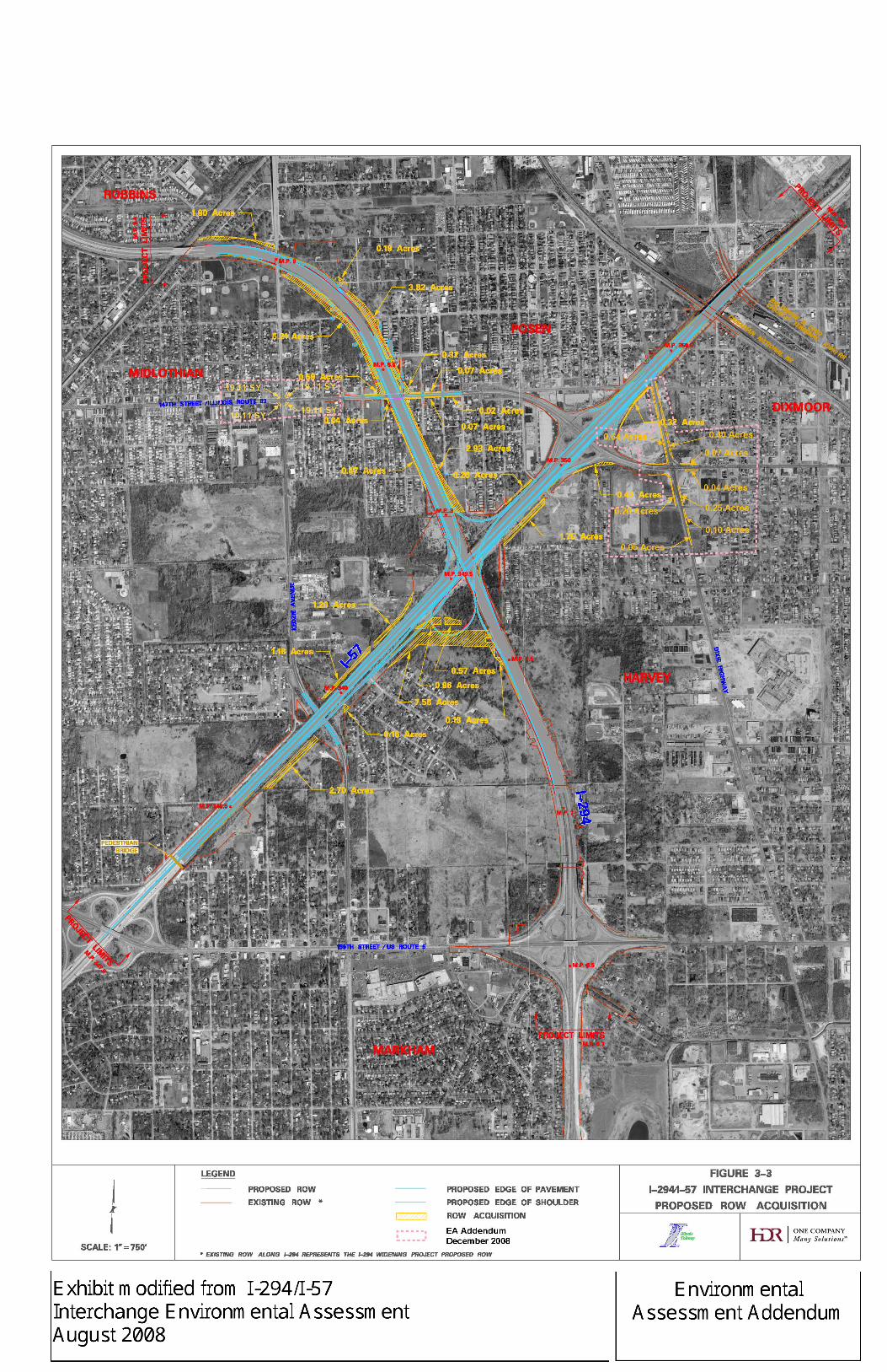
Major components of the proposed improvements include a new interchange between I-294 and I-57, a half-diamond interchange at I-294 and 147th Street and improvements to 147th Street between Kedzie Avenue and Western Avenue/Dixie Highway. There are 43 residential relocations and 3 business relocations and approximately 34.0 acres of new right-of-way that will be required. The proposed improvements impact approximately 4.293 acres of wetlands and 19.3 acres of floodplains.
1.0 PURPOSE AND NEED Page 1-1, 1.0 PURPOSE AND NEED, Section 1.1 Introduction The third paragraph, last sentence should be deleted and replaced as follows:
Two additional logical termini points for the proposed 147th Street improvements are the intersection of 147th Street and Kedzie Avenue on the west and the intersection of 147th Street and Western Avenue/Dixie Highway on the east. See revised Figure 1-2.
3

I-294/I-57 EA Addendum
Figure 1-2: I-294 at I-57 Interchange Logical Termini
Logical termini for the I-294/ I-57 Interchange Project identified in the Environmental Assessment (Aug 20, 2008) extended along Interstate 57 from 159th Street to the Canadian National Railroad. Along Interstate 294, the logical termini extended from north of the 159th Street Interchange to the Metra Rock Island Railroad. It did not include 147th Street outside of the immediate interchange area. Refer to the Figure 1-2 in the Environmental Assessment.
EEAA LLooggiiccaall TTeerrmmiinnii
Figure 1-2A: Inset A 147th Street Logical Termini (Kedzie Avenue to Western Avenue/Dixie Highway)
EEAA LLooggiiccaall TTeerrmmiinnii ..
EEAA LLooggiiccaall TTeerrmmiinnii
EEAA LLooggiiccaall TTeerrmmiinnii
Inset A
AAddddeenndduumm LLooggiiccaall TTeerrmmiinnii
AAddddeenndduumm LLooggiiccaall TTeerrmmiinnii ..
4

I-294/I-57 EA Addendum
Page 1-4, Section 1.1 Introduction The second paragraph, last sentence should be removed and replaced as follows:
The Illinois Tollway Board has approved a systemwide Congestion Relief Capital Program entitled Tomorrow’s Transportation Today that includes a funding commitment of up to $500 million for engineering, property acquisition, mitigation and construction of the I-57 at I-294 Interchange Project.
2.0 ALTERNATIVES Page 2-9, 2.0 ALTERNATIVES, Section 2.3.2 Preferred Alternative The following new section is added: 2.3.2.1.6 Improvements along 147th Street Page 2-9, 2.0 Alternatives, Section 2.3.2.1.6 Improvements along 147th Street The following paragraph should be added to this section: The 147th Street roadway will be widened to a consistent section consisting of two 12-foot wide inside through lanes and two 14-foot wide outside through lanes to accommodate bicycles with barrier type curb and gutter on the outside and with a 12-foot wide bi-directional turn lane from Kedzie Avenue to Cleveland Avenue, except for additional widening and barrier median through the interchange with I-294. From Cleveland Avenue to Western Avenue/Dixie Highway, three 12-foot wide inside through lanes (two eastbound and one westbound) and two 14-foot wide outside through lanes are proposed. Improvements to the 147th Street corridor include the installation and interconnection of traffic signals at the cross road intersections with Kedzie, New SB I-294 Ramp terminal, Harrison, Cleveland, NB and SB I-57 Ramp terminals and Western Avenue/Dixie Highway. Cross road intersection improvements are also proposed at the 147th Street intersections with Kedzie Avenue and Western Avenue/Dixie Highway. Reference Exhibit D.
Page 2-9, Section 2.3.2.2 Cost for the Preferred Alternative The first sentenced should be revised as follows:
The estimated total cost for the Preferred Alternative including both 147th Street proposed improvements and the I-294/I-57 Preferred Build Alternative is $535 million in 2008 dollars. The cost includes design and construction. It does not include right-of-way acquisition.
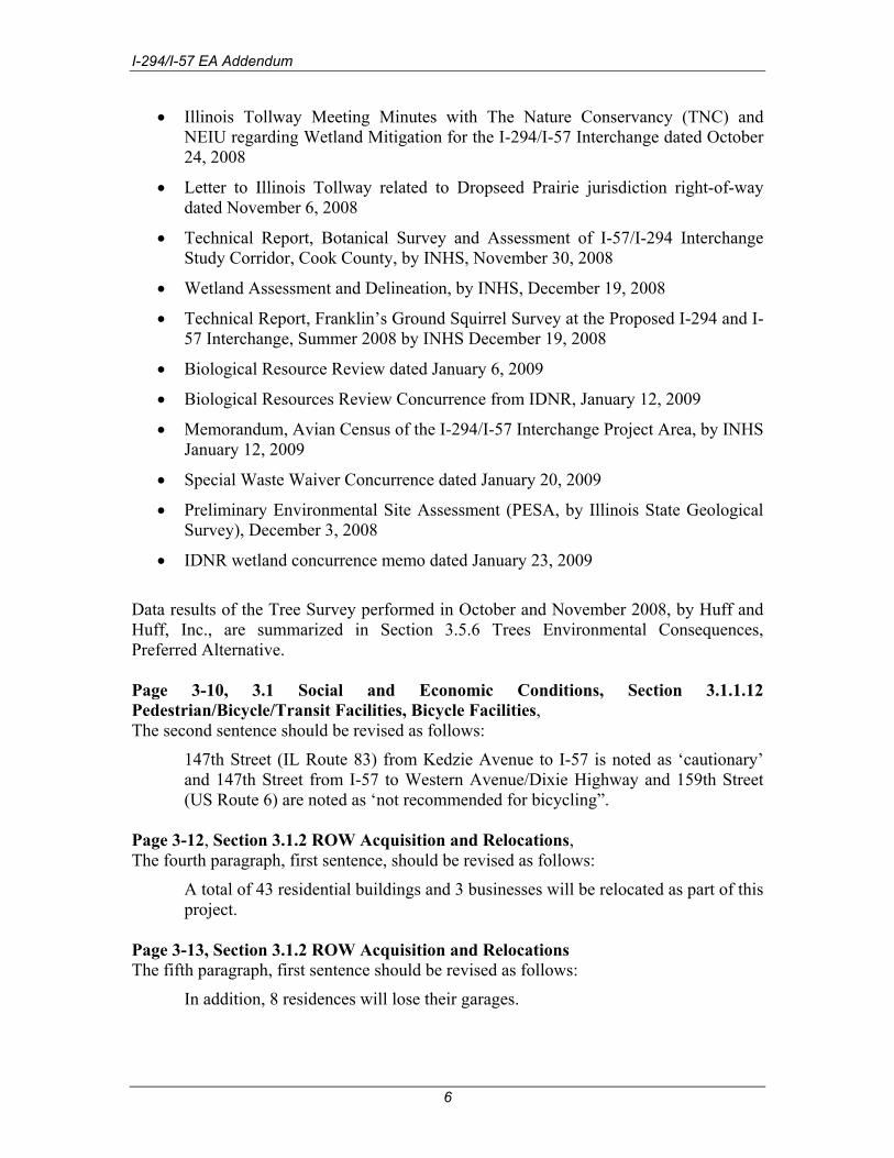
3.0 AFFECTED ENVIRONMENT/ENVIRONMENTAL CONSEQUENCES The following technical documents, investigations, letters, meeting minutes, and memoranda are provided in Appendix B:
• Cultural Resource Clearance from IDOT Central Office BD&E Environment Section dated August 26, 2008
5
I-294/I-57 EA Addendum
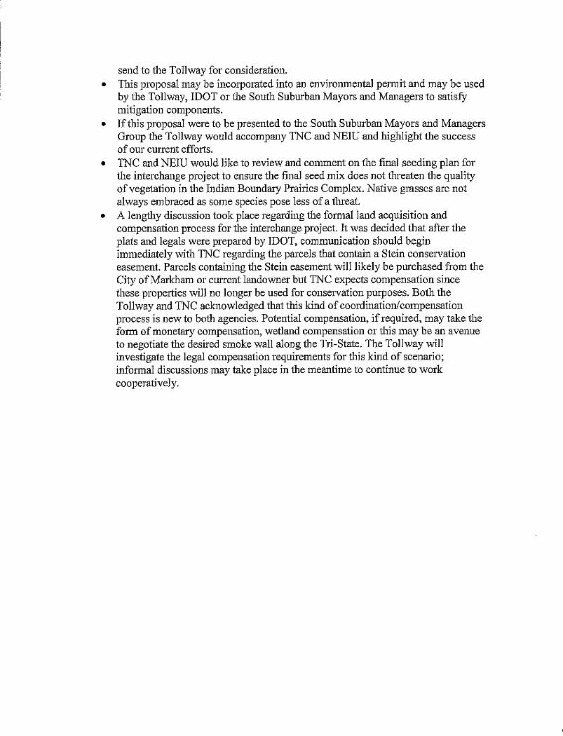
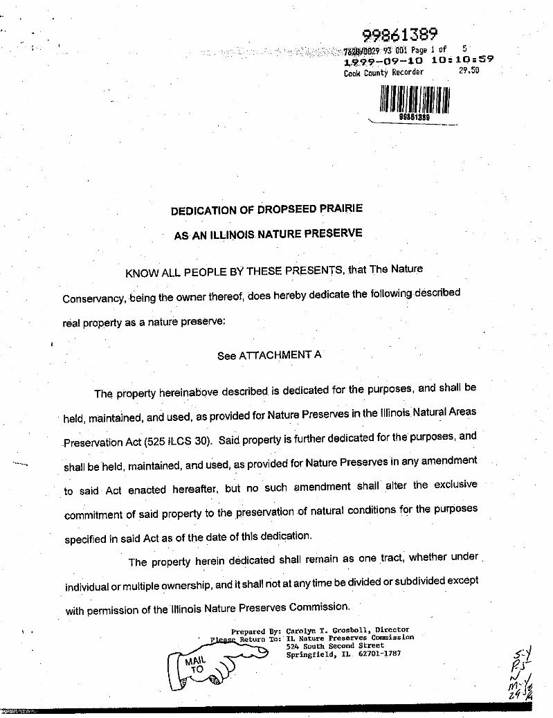
• Illinois Tollway Meeting Minutes with The Nature Conservancy (TNC) and NEIU regarding Wetland Mitigation for the I-294/I-57 Interchange dated October 24, 2008
• Letter to Illinois Tollway related to Dropseed Prairie jurisdiction right-of-way dated November 6, 2008
• Technical Report, Botanical Survey and Assessment of I-57/I-294 Interchange Study Corridor, Cook County, by INHS, November 30, 2008
• Wetland Assessment and Delineation, by INHS, December 19, 2008
• Technical Report, Franklin’s Ground Squirrel Survey at the Proposed I-294 and I-57 Interchange, Summer 2008 by INHS December 19, 2008
• Biological Resource Review dated January 6, 2009
• Biological Resources Review Concurrence from IDNR, January 12, 2009
• Memorandum, Avian Census of the I-294/I-57 Interchange Project Area, by INHS January 12, 2009
• Special Waste Waiver Concurrence dated January 20, 2009
• Preliminary Environmental Site Assessment (PESA, by Illinois State Geological Survey), December 3, 2008
• IDNR wetland concurrence memo dated January 23, 2009
Data results of the Tree Survey performed in October and November 2008, by Huff and Huff, Inc., are summarized in Section 3.5.6 Trees Environmental Consequences, Preferred Alternative.
Page 3-10, 3.1 Social and Economic Conditions, Section 3.1.1.12 Pedestrian/Bicycle/Transit Facilities, Bicycle Facilities, The second sentence should be revised as follows:
147th Street (IL Route 83) from Kedzie Avenue to I-57 is noted as ‘cautionary’ and 147th Street from I-57 to Western Avenue/Dixie Highway and 159th Street (US Route 6) are noted as ‘not recommended for bicycling”.
Page 3-12, Section 3.1.2 ROW Acquisition and Relocations, The fourth paragraph, first sentence, should be revised as follows:
A total of 43 residential buildings and 3 businesses will be relocated as part of this project.
Page 3-13, Section 3.1.2 ROW Acquisition and Relocations The fifth paragraph, first sentence should be revised as follows:
In addition, 8 residences will lose their garages.
6
I-294/I-57 EA Addendum
Page 3-13, Section 3.1.2 ROW Acquisition and Relocations The following paragraph should be added to the end of this section:
In addition to the properties that will be relocated, approximately 25 commercial properties with frontage on 147th Street, Dixie Highway and Western Avenue will have at least part of their properties located within 50 feet of proposed ROW and property acquisition of approximately 1.92 acres will be required. In most cases, the property takes consist of strip property acquisition to accommodate intersection turning lanes and/or sidewalks.
Page 3-14, Section 3.2 Farmland No changes. Page 3-15, Section 3.3 Air Quality, Section 3.3.2 Air Quality Environmental Consequences, Preferred Alternative Microscale Analysis - A Pre-Screen carbon monoxide (CO) analysis was completed for the proposed project. The results from this proposed roadway improvement indicated that a COSIM air quality analysis is not required, as the results for the worst-case receptor are below the 8-hour average National Ambient Air Quality Standard for CO of 9.0 ppm that is necessary to protect the public health and welfare. Conformity - This project is included in the FY 2007-2012 Transportation Improvement Program (TIP) endorsed by the Policy Committee of the Chicago Metropolitan Agency for Planning (CMAP), the Metropolitan Planning Organization (MPO) for the region in which the project is located. Projects in the TIP are considered to be consistent with the 2030 regional transportation plan endorsed by CMAP. On October 9, 2008, the Federal Highway Administration (FHWA) and the Federal Transit Administration (FTA) determined that the 2030 regional transportation plan conforms to the State Implementation Plan (SIP) and the transportation-related requirements of the 1990 Clean Air Act Amendments. On November 18, 2008, the FHWA and the FTA determined that the TIP also conforms to the SIP and the Clean Air Act Amendments. These findings were in accordance with 40 CRF Part 93; “Criteria and Procedures for Determining Conformity to State or Federal Implementation Plans of Transportation Plans, Programs, and Projects Funded or Approved under Title 23 USC of the Federal Transit Act.” The projects’ design concept and scope are consistent with the project information used for the TIP conformity analysis. Therefore, this project conforms to the existing State Implementation Plan and the transportation-related requirements of the 1990 Clean Air Act Amendments. The TIP number assigned for the project area is 07-09-0012.
Page 3-21, Section 3.4 Traffic Noise No changes.
7

I-294/I-57 EA Addendum
Page 3-26, Section 3.5 Natural Resources, Section 3.5.2 Vegetation and Wildlife Environmental Consequences, Preferred Alternative Approximately 34 acres of additional ROW are required to construct the proposed project. There will be a loss of approximately 34 acres of urban wildlife habitat. Page 3-28, Table 3-12. Table 3-12 should be updated as follows:
Table 3-12: State Endangered Species Potentially within the Study Area*
Species State Status Federal Status Characteristics
Black-Crowned Night Heron
(Nycticorax nycticorax) Endangered None
• 23 to 26 inches long • Breeds across the US • Winters in southern
US • Wetland, marsh,
streams, lakes, swamps and agricultural field habitat
Mountain Blue-Eyed Grass (Sisyrinchium montanum) Endangered None
• Perennial herb • Mesic prairie, sand
dune flats, and sedge meadow habitat
• Flowers mid-May to mid-June
* Listed species identified by EcoCAT review and not included in the EA.
Page 3-30, Section 3.5.3 Threatened and Endangered Species Affected Environment The following should be added at the end of this section:
On September 12, 2008, the Illinois Department of Natural Resources (IDNR) requested the project area be surveyed for populations of the alkali bulrush and the mountain blue-eyed grass. A Botanical Survey and Assessment of the Interstate-57/Interstate-294 Interchange Study Corridor, Cook County, Illinois (INHS Technical Report 2008(42)), was issued on November 30, 2008. The project limits were surveyed with the exception of two nature preserves and the areas immediately adjacent and parallel to Interstate 294 due to the on-going construction activity. The purpose of the survey was to search for threatened and endangered species with special emphasis on the prairie bush clover (Lespedeza leptostuchaya) and the eastern prairie fringed orchid (Plantanthera leucophaea) and determine if any high quality natural plant communities were present. Two endangered plant species were identified including the alkali bulrush and the mountain blue-eyed grass, and were found in the survey corridor. The INHS survey did not include an
8

I-294/I-57 EA Addendum
evaluation of potential Black-Crowned Night Heron habitat and did not identify any prairie bush clover or eastern prairie fringed orchid. Alkali Bulrush - Four populations of alkali bulrush were identified growing in the moist to wet roadside ditch areas covering an estimated 323 square feet with approximately 1,140 individuals. A possible fifth population was observed; however, the area was mowed and only bases of the plant were visible, preventing positive identification. Approximately 200 individuals were within this fifth area. The populations of alkali bulrush were located as follows:
• Population #1 - Along the south side of I-57 immediately east of I-294 • Population #2 - Along the north side of I-57, adjacent to the B&O (CSX)
Railroad • Populations #3 and #4 – Along the north side of I-57, north of 147th
Street/IL 83 • Population #5 – Along the southbound entrance ramp to I-57 from 147th
Street Mountain Blue-Eyed Grass – Two populations of mountain blue-eyed grass were observed in the project area, including populations in the Dropseed Prairie (mesic prairie remnant) and a second population just north of the Dropseed Prairie (degraded mesic prairie). The populations identified were approximately 150 feet from the edge of pavement and are likely to be impacted. Natural Communities - Two natural community types were identified in the project corridor, including mesic prairie and wet-mesic prairie. All mesic and wet-mesic prairies, with the exception of the Dropseed Prairie, were highly degraded, small and possessed very little of their original structure and composition. Several species indicative of natural communities occurred in these areas, causing them to be identified as remnant areas. Five separate areas were identified as degraded prairie remnants and are generally located as follows: - East quadrant of I-57 and Kedzie Avenue - Northbound side of I-57 between Kedzie Avenue and I-294 - South quadrant of I-294 and I-57 near the ROW line - North quadrant of I-294 and I-57, adjacent to southbound I-57 - West quadrant of I-57 and the Grand Trunk Western (CN) Railroad
The Biological Resources Review (BRR) memorandum indicates that these areas should be avoided, minimized, or mitigated, in that order.
Franklin’s Ground Squirrel – The report entitled Franklin’s Ground Squirrel Survey at the Proposed I-88 and Eola Road Interchange and the Proposed I-294 and I-57 Interchange, Summer 2008 (INHS Technical Report 2008 (53)) was issued December 19, 2008. Franklin’s ground squirrels were translocated to the Gensburg-Markham Prairie Nature Preserve in 1983 and 1985. Since 1987, the
9
I-294/I-57 EA Addendum
area has been trapped twice and no Franklin’s ground squirrels were captured in either attempt. Suitable habitat includes tall dense vegetation for cover and the soils must be deep enough to keep the burrow insulated and well drained. Trapping by the INHS in 2008 was not conducted in the I-294 and I-57 interchange project corridor as no suitable habitat was found. The BRR concludes that there is no adverse effect by the project on the Franklin’s ground squirrel.
Avian Census – An avian census at the proposed I-294/I-57 interchange area (INHS Memorandum 2009) was issued January 12, 2009. The census was conducted in 2008 during periods that characterize the major annual changes in the diversity of bird populations: spring migration, breeding, and fall migration. A total of 94 bird species representing 34 families of birds were observed in eleven census areas representing all habitat areas in the study area. Two Cook County Forest Preserve areas occur within one (1) mile of the project center line and support a good diversity of bird species, especially during spring and fall migration. The sandhill crane, an Illinois listed species (threatened), was observed flying over the project area during the fall 2008. In the past, Henslow’s sparrow, an Illinois listed species (threatened) has nested in the area. No instances of Henslow’s sparrow were observed during the avian census. Both the sandhill crane and Henslow’s sparrow are proposed for delisting by the Illinois Endangered Species Protection Board. Additionally, the black-crowned night heron, also identified as state-endangered, was not observed.
Page 3-30, Section 3.5.4 Threatened and Endangered Species Environmental Consequences, Preferred Alternative, The second paragraph, second sentence should be revised as follows: The words “and concurred on January 12, 2009” should be added after “March 31, 2008”.
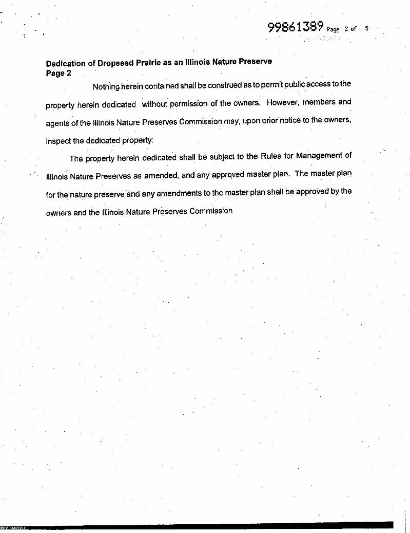
The following paragraphs should be inserted at the end of the section: The EcoCAT response from IDNR received September 2, 2008 identified the same Illinois Natural Area Inventory (INAI) sites and Nature Preserves as the EA in the project corridor. Two additional INAI sites were listed in the EcoCAT response, including the Riverdale Marsh INAI Site and the Tollgate Prairie INAI site. Both these INAI sites are outside the project limits. The IDNR coordination letter to IDOT dated September 12, 2008 requested additional coordination be conducted with the Illinois Nature Preserves Commission to determine the status of the dedication of the Markham-West Prairie as a Nature Preserve and to assure that all resource concerns have been addressed. The Illinois Tollway will continue to coordinate with the Illinois Nature Preserves Commission throughout the design and construction phases of this project. At this time, all natural resource concerns have been addressed.
10

I-294/I-57 EA Addendum
Page 3-31, Section 3.5.5 Trees Affected Environment The following paragraphs should be added to the end of this section:
Trees within the projects limits of the I-57 at I-294 Interchange project were re-surveyed in October and November of 2008. Trees were re-evaluated and identified within the proposed ROW within the project limits. As this is a joint project between the Illinois Department of Transportation (IDOT) and the Illinois Tollway, both the IDOT Departmental Policy (D&E–18) and the Illinois Tollway Criteria for Removal and Replacement of Trees were used. All trees with a diameter of six (6) inches or more at a point four and a half (4.5) feet above the highest ground level at the base of the tree, i.e. diameter at breast height (DBH) as well as all landscaped trees, were identified and measured. Trees located in densely forested areas at the intersection of I-294 and I-57 were inventoried using the transect method. All of the trees with a DBH of six inches or greater within the randomly selected 50-foot by 50-foot (2,500 square foot) area were counted, identified, and evaluated for each transect. The total number of trees in the area represented by each transect was estimated based on an extrapolation from the sub-sample data. The transects/sub-sample method was conducted in the east, west, and south areas of the I-294 and I-57 intersection. For the west and south intersection areas, three (3) transects/sub-samples were taken at random locations and for the east intersection area, two (2) transects/sub-samples were taken at random locations. Trees were individually counted in the area north of the intersection.
Page 3-31, Section 3.5.6 Trees Environmental Consequences, No-Action Alternative The No-Action Alternative does not directly impact trees within the study area.
Page 3-31, Section 3.5.6 Trees Environmental Consequences, Preferred Alternative The following paragraphs should be inserted at the end of the section:
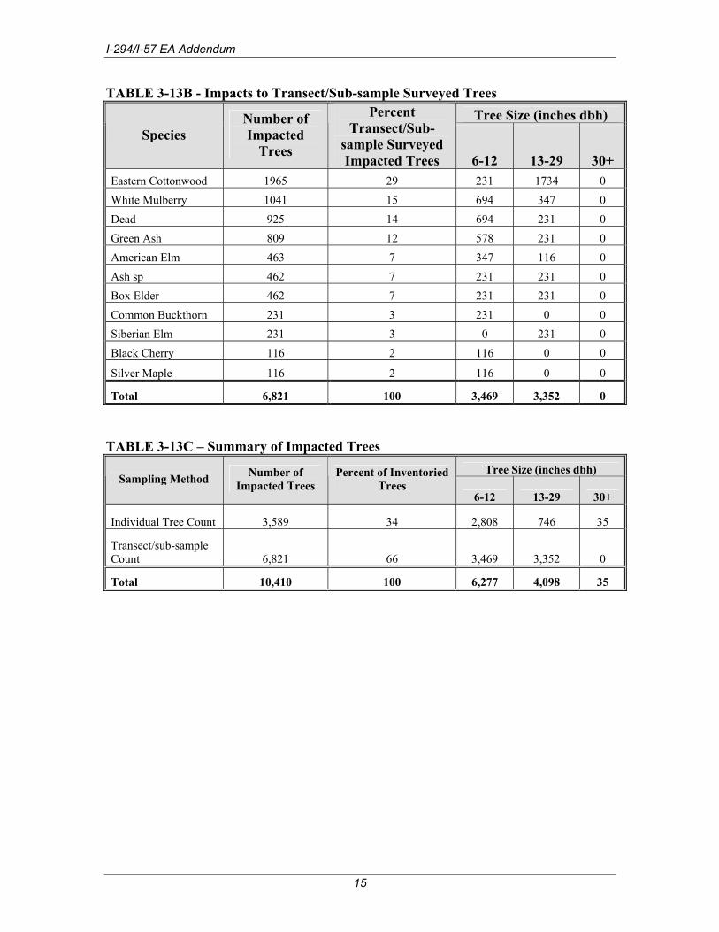
Trees within the projects limits of the Interstate 57 (I-57) at Interstate 294 (I-294/Tri-State Tollway) Interchange project were re-surveyed in October and November of 2008. A total of 3,589 individual (transect inventory omitted) trees were identified within the project limits. A total of 6,821 trees were estimated using the sub-sample method, for an overall estimated total of 10,410 trees within the project limits. Based on the proposed roadway improvements, which includes detention areas within the open areas of the I-294 and I-57 intersection, all trees are anticipated to be impacted. Of the 10,410 impacted trees, approximately 6,821 (66 percent) are within the east, west, and southern quadrants of the proposed I-294/I-57 interchange and approximately 3,589 trees (34 percent) are along I-57 or I-294. A summary of proposed impacts to trees by number and size is presented in Table 3-13A (individually counted trees) and in Table 3-13B (transect/sub-sample counted trees). As shown in Table 3-13A approximately 17 percent of the
11
I-294/I-57 EA Addendum
impacted trees are Eastern cottonwood (Populus deltoides) and Siberian elm (Ulmus pumila), 11 percent are box elder (Acer negundo), 10 percent are dead, and 10 percent are green ash (Fraxinus pennsylvanica subintegerrima). As shown in Table 3-13B, approximately 29 percent of the impacted trees are eastern cottonwood, 15 percent are white mulberry (Morus alba), 14 percent are dead, and 12 percent are green ash. Based on the total number of impacted trees, Table 3-13C summarizes the impacted trees for the project.
12

I-294/I-57 EA Addendum
TABLE 3-13A - Impacts to Individually Surveyed Trees Tree Size (inches dbh)
Species Number of Impacted Trees
Percent Individually
Surveyed Impacted Trees 6-12.5 13-29.5 30+
Eastern Cottonwood 619 17 314 293 12 Siberian Elm 594 17 443 147 4 Box Elder 388 11 325 63 0 Dead 349 10 301 46 2 Green Ash 341 10 324 17 0 Ash sp. 280 8 261 19 0 White Mulberry 177 5 151 23 3 Silver Maple 125 3 76 43 6 American Elm 115 3 98 16 1 Slippery Elm 73 2 58 13 2 Common Buckthorn 72 2 69 2 1 Black Walnut 54 2 51 3 0 Black Cherry 50 1 42 8 0 Honey Locust 46 1 37 9 0 Elm sp. 44 1 38 5 1 Hackberry 42 1 30 12 0 Haw sp. 28 <1 27 1 0 Crabapple 25 <1 25 0 0 White Poplar 19 <1 14 5 0 Peach-leaved Willow 18 <1 10 8 0 Russian Olive 17 <1 15 2 0 Basswood 14 <1 11 3 0 White Ash 11 <1 10 1 0 Autumn Olive 9 <1 9 0 0 Norway Maple 9 <1 9 0 0 Spruce sp. 9 <1 9 0 0 Black Locust 4 <1 4 0 0 Blue Spruce 4 <1 4 0 0 Cherry sp. 4 <1 4 0 0 Cockspur Hawthorn 4 <1 4 0 0 Fir sp. 4 <1 4 0 0 Sugar Maple 4 <1 3 1 0 Weeping Willow 4 <1 1 1 2
13

I-294/I-57 EA Addendum
TABLE 3-13A (Continued) - Impacts to Individually Surveyed Trees Tree Size (inches dbh)
Species Number of Impacted Trees
Percent Individually
Surveyed Impacted Trees 6-12 13-29 30+
Apple sp. 3 <1 3 0 0 Crack Willow 3 <1 2 1 0 Pear sp. 3 <1 2 1 0 Red Haw 3 <1 3 0 0 Red Maple 3 <1 3 0 0 Tree-of-Heaven 3 <1 1 2 0 Bradford Pear 2 <1 2 0 0 Green Spruce 2 <1 1 1 0 Maple sp. 2 <1 2 0 0 Red Cedar 2 <1 2 0 0 Unknown (samaras present) 2 <1 2 0 0 Black Willow 1 <1 0 0 1 Common Catalpa 1 <1 1 0 0 Ohio Buckeye 1 <1 1 0 0 Pine sp. 1 <1 1 0 0 Red Oak 1 <1 1 0 0 Redbud 1 <1 1 0 0
Silver Poplar 1 <1 1 0 0
Total 3,589 100 2,808 746 35
14
I-294/I-57 EA Addendum
TABLE 3-13B - Impacts to Transect/Sub-sample Surveyed Trees Tree Size (inches dbh)
Species Number of Impacted
Trees
Percent Transect/Sub-
sample Surveyed Impacted Trees 6-12 13-29 30+
Eastern Cottonwood 1965 29 231 1734 0 White Mulberry 1041 15 694 347 0 Dead 925 14 694 231 0 Green Ash 809 12 578 231 0 American Elm 463 7 347 116 0 Ash sp 462 7 231 231 0 Box Elder 462 7 231 231 0 Common Buckthorn 231 3 231 0 0 Siberian Elm 231 3 0 231 0 Black Cherry 116 2 116 0 0
Silver Maple 116 2 116 0 0
Total 6,821 100 3,469 3,352 0
TABLE 3-13C – Summary of Impacted Trees
Tree Size (inches dbh) Sampling Method Number of
Impacted Trees Percent of Inventoried
Trees 6-12 13-29 30+
Individual Tree Count 3,589 34 2,808 746 35
Transect/sub-sample Count 6,821 66 3,469 3,352 0
Total 10,410 100 6,277 4,098 35
15

I-294/I-57 EA Addendum
Page 3-37, Section 3.6 Water Resources and Water Quality No changes. Page 3-43, Wetlands, Section 3.7.1 Wetlands Affected Environment The following should be added to the end of this section:
Wetland delineations were performed in October and November of 2008 by the Illinois Natural History Survey (INHS) in accordance with the Corps of Engineers Wetlands Delineation Manual, January 1987. Based on the wetland delineations, 15 on-site wetland determinations were performed. Seven of the sites investigated were determined to be wetlands. Approximately 5.842 total wetland acres existed within the study area in 2008. Within the project area there are numerous creeks and vegetated ditches. None of these sites were identified as wetland areas. Figure 3-10 located at the end of Chapter 3.0, Affected Environment and Environmental Consequences, presents the existing wetlands within the study area and Table 3-14A summarizes the characteristics of these wetlands based on updated delineations. Wetland site number 5 was identified by the INHS as being not isolated, and therefore is considered a jurisdictional wetland. All other wetlands were determined by INHS to be isolated. Table 3-14A provides the Coefficient of Conservatism (C-value), which is a subjective indicator of how likely a plant may be found on an undisturbed site in a natural plant community. A species with a low C-value is common and is likely to tolerate disturbed conditions; a species with a high C-value is relatively rare and is likely to require specific, undisturbed habitats. The Floristic Quality Index (FQI) for each wetland is also provided in Table 3-14A. The FQI is a function of the C-value, and provides a measure of the floristic integrity or level of disturbance of a site. FQI values below 5 suggests a highly disturbed site, below 10 suggests low natural quality site, and above 20 suggests that the site has evidence of native character and may be considered an environmental asset. For additional information on wetlands, see the Wetland Report for I-57 @ I-294 in Cook County, Illinois, October and November, 2008 prepared by the INHS. Additionally, the Wetland Technical Report, I-294/I-57 Interchange October 27, 2003, was prepared for the original EA.
16

I-294/I-57 EA Addendum
Table 3-14A: Summary of Wetlands within the Study Area
Wetland Site No.1
NWI Classification2
Wetland Type
Jurisdictional Status
Predominant Vegetation
C-Value FQI
Existing (2008) Area (Acres)
#5 N/A Marsh Jurisdictional Reed canary grass Narrow-leaf cattail 1.8 4.5 0.025
#6 N/A
Wet Prairie/Native Grassland
Non-jurisdictional
Swamp Marigold Blue Joint Grass Prairie Switchgrass Common Ironweed 3 18.2 1.114
#11 PFO1A Wet Lowland Forest
Non-jurisdictional
Silver Maple Green Ash Eastern Cottonwood American Elm 2.1 6.3 0.410
#12 PEMC Wet Shrubland
Non-jurisdictional
Common Buckthorn Reed Canary Grass 3.3 8.2 0.229
#13 PEMC Wet Meadow Non-jurisdictional Reed canary Grass 2 3.5 0.097
#14 N/A Wet Meadow Non-jurisdictional Reed Canary Grass 2.1 8.5 3.034
#15 N/A Wet Lowland Forest
Non-jurisdictional
Silver Maple American Elm Common Buckthorn Late Boneset Reed Canary Grass 2.4 8.8 0.933
TOTAL WETLAND AREA: 5.842 1. Wetland determinations performed by the Illinois Natural History Survey in October and November,
2008. Site numbers 1-4, and 7-10 were determined not to be wetlands. 2. PFO1A – Palustrine, forested, broad-leaved deciduous, temporarily flooded
PEMC – Palustrine, emergent, seasonally flooded N/A – Not available
No-Action Alternative The No-Action Alternative does not directly impact any wetlands within the study area. Page 3-47, Section 3.7.2 Wetlands Environmental Consequences, Preferred Alternative The following should be added to the end of the paragraph:
Wetland site numbers 5, 6 and 11 will not be impacted as part of the proposed improvements. Wetland sites 12, 13, 14, and 15 are located within the interchange area of I-294 and I-57. Due to the location within the proposed interchange area, each of the wetlands will be impacted.
17

I-294/I-57 EA Addendum
The following table is an update to Table 3-15: Table 3-15A: Summary of Wetland Impacts
Wetland Site No. FQI
Total Wetland
Area (Acres)
Wetland Impacts
Permanent (Acres)
Percent of
Wetland Area
Impacted Functions Lost #5 4.5 0.025 0.0 0 None #6 18.2 1.114 0.0 0 None
#11 6.3 0.410 0.00 0
Sediment and nutrient trapping, flood storage, stormwater retention, wildlife habitat
#12 8.2 0.229 0.229 100
Sediment and nutrient trapping, flood storage, stormwater retention, wildlife habitat
#13 3.5 0.097 0.097 100
Sediment and nutrient trapping, flood storage, stormwater retention, wildlife habitat
#14 8.5 3.034 3.034 100
Sediment and nutrient trapping, flood storage, stormwater retention, wildlife habitat
#15 8.8 0.933 0.933 100
Sediment and nutrient trapping, flood storage, stormwater retention, wildlife habitat
Total 5.842 4.293 .
Page 3-49, Section 3.8 Floodplain and Floodways No changes. Page 3-50, 3.9 Historic and Archaeological Resources, Section 3.9.2 Historic and Archaeological Environmental Consequences The following should be added to the last sentence in the last paragraph:
Cultural Resource Clearance was provided by IDOT Central Office BD&E Environment Section on August 26, 2008.
Page 3-51, Section 3.10 Special Lands No changes. Page 3-54, 3.11 Special Waste, Section 3.11.1 Special Waste Affected Environment The following should be inserted at the end of this section:
The Illinois State Geological Survey (ISGS) conducted a Preliminary Environmental Site Assessment (PESA, November 20, 2008, ISGS Report No.
18

I-294/I-57 EA Addendum
1773). The PESA included a review of environmental databases and site reconnaissance.
Based on the PESA, the project has been determined to have a HIGH risk for the occurrence of regulated substances or natural hazards. A HIGH risk is based on the presence of potentially hazardous compounds, either as detected by ISGS testing or as documented by the Illinois Environmental Protection Agency. Further investigation is required to determine the nature, source and extent of the problem.
Land acquisition will need to be evaluated at all identified site locations. Additionally, grading, excavation, and relocation stipulations will need to be determined based on the work anticipated at each of these locations. Soil found to be contaminated and affected by the project will be managed and disposed of in accordance with applicable federal and state laws and regulations and in a manner that will protect human health and the environment. The quantities to be disposed of are not expected to have a significant effect on landfill capacity.
No Comprehensive Environmental Response Compensation and Liability Information System (CERCLIS) sites are within the project limits. One active CERCLIS site (PESA No. 1773-I) was identified at 148th Place and Dixie Highway in the PESA. This site is outside the project limits.
Fifteen Resource Conservation and Recovery Act (RCRA)/generator sites were identified within the project limits. Seven of these sites were also identified as other sites including one aboveground storage tank (AST) site, two underground storage tank (UST) sites, two leaking underground storage tank (LUST)/former UST sites, one LUST/UST site, and one former UST site. Contamination was detected at ten of the 15 RCRA sites. Non-CERCLIS Sites A PESA for special waste sites was conducted for the project area. The assessment concluded that the build alternative could involve non-CERCLIS sites potentially affected by regulated substances. Further, it was determined that not all the sites could be avoided. Thirty-eight non-CERCLIS/RCRA sites were identified. Eighteen of these sites were identified with volatile organic compounds (VOC’s) significantly above background and have depth stipulations assessed. Six additional sites were identified in the PESA that were determined to be outside the project limits (PESA Nos. 1773-A, 1773-E, 1773-F, and three sites without PESA Nos.). The USEPA listing of potential, suspected, and known hazardous waste or hazardous substance sites in Illinois (i.e. the CERCLIS list) has been reviewed. The proposed undertaking will not require right-of-way from a site included in the CERCLIS listing as of November 17, 2008.
19

I-294/I-57 EA Addendum
Table 3.11A: RCRA and Non-CERLCIS Sites Identified in the PESA Site Type ISGS Site Number* Testing Conducted** Pipeline 1773-35 No Detections Dump 1773-B None Municipal 1773-C None
1773-D None 1773-25 No Detections 1773-32 No Detections
Commercial
1773-K None AST 1773-11 No Detections AST/Drum 1773-G None AST/generator 1773-36 VOCs Detected
1773-2 VOCs Detected 1773-3 VOCs Detected
1773-13 VOCs Detected 1773-26 VOCs Detected 1773-28 No Detections 1773-29 No Detections 1773-30 No Detections 1773-31 No Detections
Possible USTs
1773-34 No Detections 1773-6 VOCs Detected UST
1773-14 VOCs Detected UST/AST 1773-H None UST/RCRA 1773-5 VOCs Detected
1773-1 VOCs Detected LUST/former UST/RCRA 1773-18 VOCs Detected 1773-4 VOCs Detected 1773-8 No Detections LUST/former UST 1773-9 VOCs Detected
LUST/possible UST 1773-12 VOCs Detected 1773-7 No Detections LUST/UST
1773-33 VOCs Detected LUST/UST/RCRA 1773-27 VOCs Detected SRP 1773-10 Metals Detected
1773-16 No Detections Former UST/ RCRA/generator 1773-24 No Detections 1773-15 No Detections 1773-17 VOCs Detected 1773-19 No Detections 1773-20 VOCs Detected 1773-21 No Detections 1773-22 No Detections
RCRA/generator
1773-J None Former RCRA/UST/generator 1773-23 No Detections
1773-37 No Detections Spill 1773-L None
*Bolded site numbers indicate locations with VOCs or metals significantly above background levels detected in soil gas or headspace soils samples where depth stipulations have been specified. ** VOC’s detected significantly above background
20
I-294/I-57 EA Addendum
The PESA for sites potentially impacted with regulated substances concluded that the build alternative will involve sites potentially impacted with regulated substances. Further investigation (Preliminary Site Investigation (PSI) will be conducted to determine the nature and extent of the involvement. Based on the proposed improvements to accommodate this project, right-of-way acquisition or standard road construction (i.e. curb and gutter, sidewalk, driveways, pavement and/or utility work) is anticipated from the following ISGS numbered sites where depth stipulations have been established. These sites are identified in the PESA. The general depth of excavation is approximately five (5) feet within the proposed ROW area. The depth extends to approximately 15 feet deep in areas of storm sewer or watermain improvements. The PESA Response form has been submitted and a special waste waiver was granted January 20, 2009.
Page 3-57, Section 3.12 Aesthetics No changes. Page 3-57, Section 3.13 Construction Impacts No changes. Page 3-58, Section 3.14 Indirect (Secondary) Impacts, 3.14.1 Indirect Environmental Consequences, Water Quality Add the following sentence to the end of the paragraph: Regional water quality will be improved by the de-coupling of storm drains in 147th Street from the combined sewer systems in the area, aiding in decreasing the amount of regional combined sewer overflows to area waterways.
Page 3-60, Section 3.15 Cumulative Impacts No changes. Page 3-61, Section 3.16 Permits Add the following to the end of the section: The installation of separate storm sewers and the de-coupling of existing storm drains from the existing combined sewer system will require a permit from the Metropolitan Water Reclamation District of Greater Cook County. Page 3-61, Section 3.17 Summary of Impacts No changes. 4.0 MITIGATION MEASURES
Page 4-1, Section 4.1 Right of Way Acquisition and Relocations No changes.
21
I-294/I-57 EA Addendum
Page 4-1, Section 4.2 Traffic Noise No changes. Page 4-1, Section 4.3 Natural Resources Threatened and endangered species have been identified in the project corridor, including alkali bulrush and mountain blue-eyed grass. Alkali bulrush has been observed along Interstate 57 in four (possibly five) areas north of Interstate 294. The populations have been observed within the roadside drainage ditches and will likely be impacted by construction of the preferred alternative. Alkali bulrush has been proposed for delisting by the Illinois Endangered Species Protection Board, which, if approved, may be complete during the latter half of 2009. If alkali bulrush is delisted prior to construction, no mitigation will be necessary. Mountain blue-eyed grass has been observed in the Dropseed Prairie and just north of the Dropseed Prairie. These two areas are along Interstate 57 south of Interstate 294. Right-of-way acquisition along Interstate 57 is anticipated. The plants are approximately 150 feet from the edge of pavement and are likely to be impacted. Alkali bulrush has been encountered in several areas within the Tollway system. A Systemwide Programmatic Mitigation and Conservation Plan and Regulatory Review Process memorandum has been prepared and approved by IDNR in January 2008. The mitigation and conservation plan provides mitigation strategies that can potentially be used to mitigate the potential impacts to this species, if mitigation is necessary. Mitigation options include seed collection or translocation of individual plants.
The mitigation and conservation plan does not include the mountain blue-eyed grass species. Coordination with IDNR will be required for the translocation of this species, if impacts are to occur. Five prairie remnant areas were identified in the Botanical Survey and Assessment. If any of the areas are impacted by the project, impacts to the prairies should be avoided, minimized, and mitigated, in that order. The prairie area in the Markham-West Prairie area is already known and impacts to that site are being mitigated.
Page 4-1, Section 4.3.1. Trees Mitigation of the approximately 10,410 trees that are estimated to be removed will be conducted in accordance with IDOT Departmental Policies (D&E – 18) by IDOT and the ISHTA Criteria for Removal and Replacement of Trees by ISHTA. The actual number of replacement trees may be adjusted during the final design based on the actual number of trees impacted. The potential exists within the project area to work with local natural resource agencies and groups to identify areas where replacement trees can be planted. Based on the IDOT policy, the number of replacement trees is dependent on if balled and burlapped trees (1:1 replacement ratio) are used or seedlings (3:1 replacement ratio). Therefore, mitigation under the IDOT policy would require 10,410 balled and burlapped tree plantings or 31,230 seedling plantings.
22

I-294/I-57 EA Addendum
The ISTHA policy mitigates trees based on the size of the tree being replaced with 6 to 12 inch trees being replaced at 1:1, 13 to 29 inch trees at 2:1 and 30 inch and greater being replaced at 3:1. Therefore, mitigation under the ISTHA policy would require 14,578 tree plantings. Page 4-2, Section 4.4 Water Resources and Water Quality No changes. Page 4-3, Section 4.5 Wetlands The Wetland Impact Evaluation form submitted to IDOT BD&E on January 20, 2009 was considered acceptable. The project shall be processed as a Standard Review Action in accordance with the IDOT Interagency Wetlands Action Plan. Mitigation is considered on-site since it shall be performed within one mile of the project area. Wetland Sites #12, #13, #14, and #15 shall be impacted totaling 4.353 acres. All of the impacted wetlands are isolated. Because impacts to the Wetlands #12 and #13 are less than 0.5 acres per wetland, they shall likely be mitigated at a ratio of 1.5:1.0 with mitigation acreages 0.344 and 0.146 acres respectively. Because the impacts to Wetland #14 and #15 totally destroy each wetland, they shall likely be mitigated at a ratio of 2.5:1, with mitigation acreages of 7.585 and 2.483 respectively. Total mitigation acreage may be up to 10.5565 acres. IDOT and Illinois Tollway have separate agreements with IDNR which determine the mitigation ratios for each impact. The minimum mitigation ratio that will be applied to isolated wetland impacts will be 1.5:1.0. The Illinois Tollway will be responsible for coordinating all final ratios with IDNR once the design is finalized and prior to the permitting process. Because this project is a Standard Review Action, it was coordinated with Mr. Patrick Malone of IDNR Office of Resource Review and Coordination. His concurrence is dated January 23, 2009. This project is now considered cleared for letting with respect to the wetlands. The Illinois Tollway will be responsible for wetland mitigation. It will occur in within the Indian Boundary Prairie Mitigation Site. Page 4-3, Section 4.6 Floodplains/Floodways No changes. Page 4-3, Section 4.7 Special Lands No changes. Page 4-4, Section 4.8 Special Waste The following should be added to the end of this section:
Soil testing has been conducted as part of the ISGS PESA review. Sites where contaminants have been detected are identified in Table 3.11A, above and in the PESA found in Appendix B. Due to the HIGH risk of encountering contaminated media within the project limits, additional testing is required to determine the extent of contamination in these areas and develop a special provision for the proposed project. These investigations will be conducted to determine the risks and liabilities. The project will not be implemented until the risks and liabilities of involvement are known and acceptable to IDOT and the Illinois Tollway. A
23
I-294/I-57 EA Addendum
PESA response was submitted to the BDE on January 20, 2009 and a special waste waiver was granted on January 20, 2009 to allow the additional investigation to occur during Phase II of the project development.
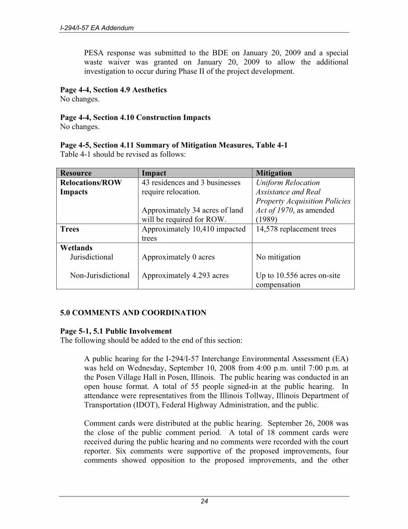
Page 4-4, Section 4.9 Aesthetics No changes. Page 4-4, Section 4.10 Construction Impacts No changes. Page 4-5, Section 4.11 Summary of Mitigation Measures, Table 4-1 Table 4-1 should be revised as follows: Resource Impact Mitigation Relocations/ROW Impacts
43 residences and 3 businesses require relocation. Approximately 34 acres of land will be required for ROW.
Uniform Relocation Assistance and Real Property Acquisition Policies Act of 1970, as amended (1989)
Trees Approximately 10,410 impacted trees
14,578 replacement trees
Wetlands Jurisdictional Approximately 0 acres No mitigation
Non-Jurisdictional Approximately 4.293 acres Up to 10.556 acres on-site
compensation 5.0 COMMENTS AND COORDINATION Page 5-1, 5.1 Public Involvement The following should be added to the end of this section:
A public hearing for the I-294/I-57 Interchange Environmental Assessment (EA) was held on Wednesday, September 10, 2008 from 4:00 p.m. until 7:00 p.m. at the Posen Village Hall in Posen, Illinois. The public hearing was conducted in an open house format. A total of 55 people signed-in at the public hearing. In attendance were representatives from the Illinois Tollway, Illinois Department of Transportation (IDOT), Federal Highway Administration, and the public. Comment cards were distributed at the public hearing. September 26, 2008 was the close of the public comment period. A total of 18 comment cards were received during the public hearing and no comments were recorded with the court reporter. Six comments were supportive of the proposed improvements, four comments showed opposition to the proposed improvements, and the other
24

I-294/I-57 EA Addendum
comments were requesting additional information or the comments that were not directly related to the proposed interchange. In general the comments expressed concerns in the following categories:
• Potentially affected properties • Proposed access changes • Additional information
Each commenter was responded to by letter from the Illinois Tollway following the public hearing. The FHWA received a letter from USEPA on September 22, 2009 providing comments on the I-294/I-57 Interchange Project’s Draft Environmental Assessment. The Illinois Tollway coordinated directly with the USEPA to address these comments. At this time, all USEPA concerns have been addressed.
Additional public outreach presentations to provide updated project information were given to the South Suburban Mayors and Managers Association (SSMMA) Transportation Committee on October 7, 2008, the SSMMA general membership dinner on January 15, 2009, and the Southwest Conference of Mayors (SCM) on November 24, 2008. As part of the presentations, IDOT noted that a similar presentation would be given at the affected community’s respective Board meetings and offered to present at any other interested community’s Board meetings. On January 26, 2009, a presentation was given to the City of Harvey City Council and on January 28, 2009, a presentation was given to the Village of Midlothian Village Board. Additional presentations scheduled include the Village of Dixmoor Village Board on February 9, 2009 and the Village of Posen Village Board on February 10, 2009. An additional general informational presentation is also scheduled for the US Steel Retirees Luncheon on February 10, 2009.
APPENDIX A: List of Acronyms and Abbreviations No changes. APPENDIX B: Correspondence See additional material in separate section. APPENDIX C: Noise Analysis Results Summary Table No changes. APPENDIX D: Exhibits. New. See additional material in separate section.
25

I-294/I-57 EA Addendum
26

I-294/I-57 EA Addendum
Appendix B Correspondence


T E C H N I C A L R E P O R T
Botanical Survey and Assessment of the Interstate-57/Interstate-294 Interchange Study Corridor
Cook County, Illinois
Michael J. C. Murphy
Division of Biodiversity and Ecological Entomology
Biotic Surveys Section
To:
Illinois Department of Transportation Bureau of Environment
2300 South Dirksen Parkway Springfield, Illinois 62764
INHS Technical Report 2008(42) 30 November 2008
INHS 1816 S. Oak St. Champaign, IL 61820 http://www.inhs.uiuc.edu

INTRODUCTION A request was received on 2 October 2008 for botanical surveys to be conducted within the proposed I-57/I-294 interchange study area, located in Cook County, Illinois. Along Interstate-57, survey boundaries extended from the I-57/U.S. Route 6 interchange (southern boundary), north to 915 m (3000 ft.) beyond the I-57/Baltimore-Ohio Railroad intersection (Figure 1). Along I-294, survey boundaries extended from immediately north of the I-294/U.S. Route 6 interchange (southern boundary), north to South Claire Blvd. (Figure 1). Eastern and western extensions of the survey area occurred at the intersections of I-57/IL Route 83, I-57/I-294, and I-57/Kedzie Ave. (Figure 1). Much of this survey area overlapped with areas for which botanical surveys were requested by the Illinois State Toll Highway Authority (ISTHA). Survey requests from the ISTHA were submitted in December 2007, and for this reason, surveys pertaining to this overall study area began in May 2008. When survey work began in May, it was found that construction work for the I-294 lane expansions had already begun along the entire length of the I-294 portion of the survey corridor. For this reason, all portions of the survey corridor that were immediately adjacent and parallel to I-294, were removed from consideration for the overall study area, with the exception of habitats occurring within the proposed I-57/I-294 interchange area (Figure 1). Three state nature preserves are located within the survey corridor, and include: 1) Dropseed Prairie, 2) Gensburg-Markham Prairie, and 3) Paintbrush Prairie (Figure 1). Due to the legal protective status of state nature preserves, surveys were not requested for these areas, and they were excluded from the survey area. Initial field maps however, which were thought to include boundaries of all state nature preserves within the area, did not have preserves identified, and this led to survey efforts being undertaken in Dropseed Prairie. The entire area within the survey corridor occurs within the Chicago Lake Plain Section of the Northeastern Morainal Division (Schwegman 1973). This area is characterized by relatively level topography and poorly-drained soils that formed on lakebed sediments associated with the ancient glacial Lake Chicago, which was present between 14,000 and 4,500 years ago (Schwegman 1973, Wiggers 1997). At the time of settlement, dominant communities in this area included marsh and mesic to wet-mesic prairie (Schwegman 1973, Swink & Wilhelm 1994). Specific survey goals were to 1) search for threatened or endangered plant species in or immediately adjacent to the corridor - with special emphasis on the prairie bush clover, Lespedeza leptostachya Englem., and the eastern prairie fringed orchid, Platanthera leucophaea (Nutt.) Lindl., and 2) determine if any high-quality natural plant communities were present within the corridor. METHODS Botanical surveys were conducted between 20 May 2008 and 10 October 2008, with the search emphasis on threatened and endangered plant species and/or high-quality natural communities. Searches specifically focused on locating potential Plantanthera leucophaea populations were conducted on three non-consecutive days between 28 June and 11 July. Cumulative species lists were compiled for all community types/plant associations encountered. Numerous plant specimens were collected and preserved for laboratory examination with GPS coordinates taken at all collection locations. Digital photographs were taken and/or voucher
1

specimens collected for threatened or endangered plant species that were encountered. Population parameters for threatened or endangered species were determined by one or more of the following methods: 1) determining total number of individuals (genets – genetically distinct individuals) for non-rhizomotous and non-stoloniferous species, 2) estimating total number of flowering/fruiting stems (potential ramets – genetically identical individuals) for rhizomotous and stoloniferous species, and 3) estimating total population area occupied based on digitized aerial photographs. Collected specimens are deposited in the Illinois Natural History Survey Herbarium (ILLS), in Champaign, Illinois. Community classification and grades of natural quality follow White (1978). Grades of natural quality are as follows: Grade A: Relatively stable or undisturbed communities Grade B: Late successional or lightly disturbed communities Grade C: Mid-successional or moderately to heavily disturbed communities Grade D: Early successional or severely disturbed communities Grade E: Very early successional or very severely disturbed communities If present, data from historic collections of threatened and endangered species were checked in the vPlants database (vPlants 2008), which includes collections from the Field Museum of Natural History (F), the Morton Arboretum (MOR), and the Chicago Botanic Garden (CHIC). Botanical nomenclature throughout the report follows Taft et al. (1997). If not specifically indicated, scientific names followed by an asterisk (*) denote vascular plants that are adventive to this region. RESULTS AND DISCUSSION
Threatened and Endangered Plants Two plant species listed as state endangered by the Illinois Endangered Species Protection Board were found in the survey corridor, and include: 1) Scirpus paludosus A. Nelson (alkali bulrush), and 2) Sisyrinchium montanum Green (mountain blue-eyed grass). Four (possibly five) colonies of Scirpus paludosus were located within the corridor (Appendices 1-5; Figure 2) growing in moist to wet roadside ditch areas, occupying a total estimated area of 30 m² (323 ft.²), with an estimated total number of flowering/fruiting stems of 1,140 (Map 1). The potential fifth colony will be discussed in the following section. Two populations of Sisyrinchium montanum were also discovered in the survey corridor (Appendices 6 & 7; Figure 2). The first population was located within Dropseed Prairie Nature Preserve growing in a grade B mesic prairie remnant (Figure 2; Map 1). The second population was located just north of Dropseed Prairie (Figure 2; Map 1) growing in a degraded mesic prairie that ranged in quality from low grade C to D. Details of population parameters for state listed species will be discussed in the following sections. Scientific and common names for all vascular plant species occurring within the survey corridor, as well as the habitats in which they occurred, are provided in Appendix 8.
2

Scirpus paludosus A. Nelson (alkali bulrush) CYPERACEAE – State endangered. The alkali bulrush (Figure 3 A&B) is a rhizomotous, colony-forming perennial sedge that inhabits various, often saline, wetland areas such as marshes, shores, and lake margins (Gleason and Cronquist 1991, Smith 2002), and can tolerate alkaline environments with a pH up to 9.0 (USDA, NRCS 2008). Additionally, this species can survive short periods of complete inundation and is reported to grow well when the water table is within 10 cm of the soil surface (USDA, NRCS 2008). Scirpus paludosus occurs throughout a wide geographic range, including North America, South America, Central America, and the Hawaiian Islands (Smith 2002). In North America, S. paludosus is distributed throughout much of Canada, and within the United States, is known to occur in Illinois, Michigan, all states west of the Mississippi River (except Arkansas and Louisiana), and several northeastern states (Smith 2002).
The alkali bulrush was apparently first discovered in the Chicago region in 1950 (INPN |1970s|, vPlants 2008), occurring as an extensive colony in a roadside ditch in Cook County (Swink 1969), but was noted as being much reduced in size by the late 1970s (Swink and Wilhelm 1979). In 1981, a population was reported from a natural salt marsh in La Salle County, and was believed to be indigenous at this site (Sheviak 1981). The population occurring in La Salle County is the basis for listing the alkali bulrush as a state endangered species. By 1994, the alkali bulrush was reported from three counties within the Chicago region – Cook, Grundy, and Lake, and these populations were all noted as being adventive (Swink and Wilhelm 1994). To date, there are eight counties from which the alkali bulrush is documented in Illinois – Boone, Cook, Du Page, Grundy, Kane, La Salle, Lake, and McHenry (Swink and Wilhelm 1994, Herkert and Ebinger 2002, Murphy 2005, 2006, 2007), and all of these populations (except the La Salle County population) occurred in roadside ditches. Additionally, Swink and Wilhelm (1994) and Smith (2002) note that the accumulation of road-deicing salts in these roadside ditches contributes to the occurrence and spread of this taxon in these environments. Synonymous names for the alkali bulrush include Bolboshoenus maritimus (L.) Palla, Bolboshoenus maritimus (L.) Palla subsp. paludosus (A. Nelson) T. Koyama, Scirpus maritimus L. var. paludosus (A. Nelson) Kükenth., and Scirpus pacificus Britt. (Smith 2002, USDA, NRCS 2008). Within the survey corridor, four colonies of Scirpus paludosus (Appendices 1-4) were found in and along roadside ditches (Figure 3 A&B), occupying a total estimated area of 30 m² (323 ft.²), with an estimated total number of flowering/fruiting stems of 1,140 (Map 1). The potential fifth colony (Appendix 5) was located on the west side of the I-57/IL Rt. 83 on-ramp (Figure 2; Map 1). This area was mowed the entire growing season, and therefore, only the bases of the plants within this colony were visible – preventing positive identification of the plants occurring in this area. The estimated number of potential stems within this population was 200.
Plants frequently to occasionally associated with S. paludosus included: Agropyron repens*, Aster subulatus*, Atriplex patula*, Echinochloa crus-galli*, Eupatorium serotinum, Euthamia graminifolia, Festuca arundinacea*, Juncus dudleyi, J. torreyi, Leptochloa acuminata*, Lycopus americanus, Lythrum salicaria*, Phalaris arundinacea*, Phragmites australis*, Puccinellia distans*, Solidago sempervirens*, Spergularia media*, Suaeda depressa*, and Typha angustifolia* (see also Appendices 1-5).
3

Sisyrinchium montanum Greene (mountain blue-eyed grass) IRIDACEAE – State endangered. A member of the Iris family, mountain blue-eyed grass is a cespitose, perennial herb with dark bluish-violet petals and sepals (Cholewa & Henderson 2002). Sisyrinchium montanum ranges from northwest and northeast Canada, south to northern New Mexico in the western U.S., and the northern tips of Illinois, Indiana, Ohio, and New Jersey in the eastern U. S. (Swink & Wilhelm 1994, Cholewa & Henderson 2002, USDA, NRCS 2008), and inhabits a variety of habitats including moist prairies/meadows, mesic sand prairies, stream banks, and open woods (Mohlenbrock 1970, INPC |1970s|, Swink & Wilhelm 1994, Cholewa & Henderson 2002). In all eastern and Midwestern states where this taxon reaches its southern range limit (i.e., Illinois, Indiana, Ohio, and New Jersey), it is listed as a state endangered species (Herkert & Ebinger 2002, USDA, NRCS 2008). Two varieties of Sisyrinchium montanum are recognized; S. montanum var. montanum, and S. montanum var. crebrum Fern., with var. montanum being the more common element throughout this taxon’s range (Mohlenbrock 1970, Mohlenbrock 2002, Cholewa & Henderson 2002). Both varieties occur in Illinois and both are listed as state endangered. The variety occurring in the survey corridor is S. montanum var. montanum. Synonymy for S. montanum var. crebrum includes: S. montanum Greene subsp. crebrum (Fern.) Böcher; and synonymy for S. montanum var. montanum includes: Sisyrinchium alpestre E. P. Bicknell and Sisyrinchium heterocarpum E. P. Bicknell (Cholewa & Henderson 2002). Within Illinois, the mountain blue-eyed grass inhabits mesic prairies (often sandy), sand dune flats, and sedge meadows (Mohlenbrock 1970, INPC |1970s|, Sheviak 1981, Swink & Wilhelm 1994, ILLS 2008). Historically, S. montanum is known from Du Page, Cook and Lake counties (Herkert & Ebinger 2002). There are also two unverified reports from Kankakee and Winnebago counties (Bowles et al. 1991, Jones 1994). Interestingly, Cholewa & Henderson (2002) do not attribute this species to Illinois even though several of the earliest collections within the state date back to 1890, 1900, 1907, and 1908 (Mohlenbrock 1970, INPC |1970s|, vPlants 2008). The majority of Illinois collections were made before 1955 (INPC |1970s|, Herkert & Ebinger 2002, ILLS 2008, vPlants 2008). Sisyrinchium montanum was listed as state endangered in 1981 when the first state listing of threatened and endangered species was published (Sheviak 1981), and this protective status has not changed since (Herkert 1991, Herkert & Ebinger 2002, IESPB 2005). At that time, no extant populations were known although suitable habitat still remained (Swink & Wilhelm 1979, Sheviak 1981). In the early to mid 1980s, several new populations for this taxon were discovered in Cook and Lake counties, Illinois (INPC |1970s|, Bowles et al. 1991, Herkert 1991, Swink & Wilhelm 1994), up until which time, the last historic collection was 1974 (Bowles et al. 1991). Currently, it is uncertain how many mountain blue-eyed grass populations are extant within the state, but data from the Illinois Natural Heritage Database (IDNR 2008) details the observance of 11 populations within the past 12 years, occurring in Cook (8 populations), Du Page (one population), and Lake (2 populations) counties. However, the historic Cook County population (last observed in May of 2000), which occurred within the 2008 survey corridor, is no longer extant as the entire area has been converted to a gravel-surfaced junkyard (Figure 2). However, there are at least 2 other populations occurring in Cook County that are not contained in the Illinois Natural Heritage Database (IDNR 2008, Masi 2008). Within Illinois, the genus Sisyrinchium is represented by 6 species (Mohlenbrock 2002). Species in this genus can be challenging to identify and several species are known for their
4
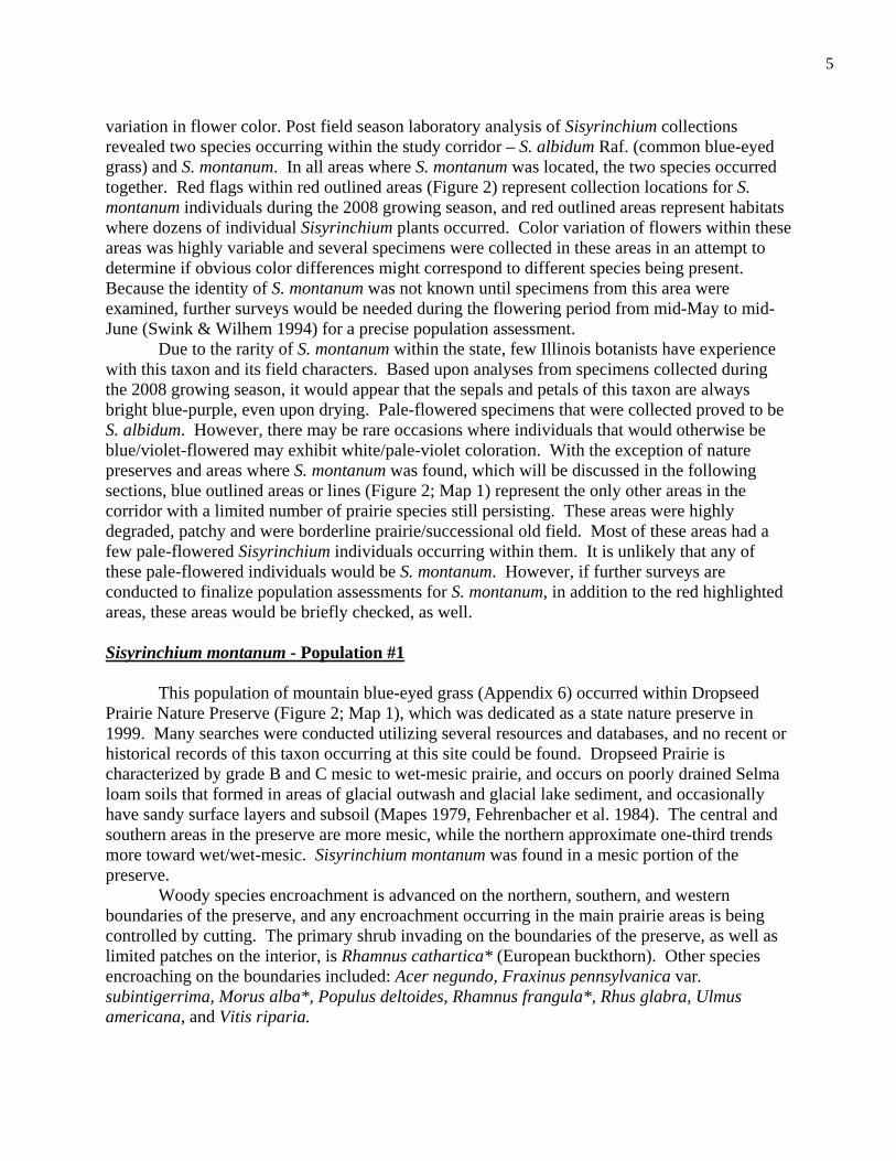
variation in flower color. Post field season laboratory analysis of Sisyrinchium collections revealed two species occurring within the study corridor – S. albidum Raf. (common blue-eyed grass) and S. montanum. In all areas where S. montanum was located, the two species occurred together. Red flags within red outlined areas (Figure 2) represent collection locations for S. montanum individuals during the 2008 growing season, and red outlined areas represent habitats where dozens of individual Sisyrinchium plants occurred. Color variation of flowers within these areas was highly variable and several specimens were collected in these areas in an attempt to determine if obvious color differences might correspond to different species being present. Because the identity of S. montanum was not known until specimens from this area were examined, further surveys would be needed during the flowering period from mid-May to mid-June (Swink & Wilhem 1994) for a precise population assessment. Due to the rarity of S. montanum within the state, few Illinois botanists have experience with this taxon and its field characters. Based upon analyses from specimens collected during the 2008 growing season, it would appear that the sepals and petals of this taxon are always bright blue-purple, even upon drying. Pale-flowered specimens that were collected proved to be S. albidum. However, there may be rare occasions where individuals that would otherwise be blue/violet-flowered may exhibit white/pale-violet coloration. With the exception of nature preserves and areas where S. montanum was found, which will be discussed in the following sections, blue outlined areas or lines (Figure 2; Map 1) represent the only other areas in the corridor with a limited number of prairie species still persisting. These areas were highly degraded, patchy and were borderline prairie/successional old field. Most of these areas had a few pale-flowered Sisyrinchium individuals occurring within them. It is unlikely that any of these pale-flowered individuals would be S. montanum. However, if further surveys are conducted to finalize population assessments for S. montanum, in addition to the red highlighted areas, these areas would be briefly checked, as well. Sisyrinchium montanum - Population #1 This population of mountain blue-eyed grass (Appendix 6) occurred within Dropseed Prairie Nature Preserve (Figure 2; Map 1), which was dedicated as a state nature preserve in 1999. Many searches were conducted utilizing several resources and databases, and no recent or historical records of this taxon occurring at this site could be found. Dropseed Prairie is characterized by grade B and C mesic to wet-mesic prairie, and occurs on poorly drained Selma loam soils that formed in areas of glacial outwash and glacial lake sediment, and occasionally have sandy surface layers and subsoil (Mapes 1979, Fehrenbacher et al. 1984). The central and southern areas in the preserve are more mesic, while the northern approximate one-third trends more toward wet/wet-mesic. Sisyrinchium montanum was found in a mesic portion of the preserve. Woody species encroachment is advanced on the northern, southern, and western boundaries of the preserve, and any encroachment occurring in the main prairie areas is being controlled by cutting. The primary shrub invading on the boundaries of the preserve, as well as limited patches on the interior, is Rhamnus cathartica* (European buckthorn). Other species encroaching on the boundaries included: Acer negundo, Fraxinus pennsylvanica var. subintigerrima, Morus alba*, Populus deltoides, Rhamnus frangula*, Rhus glabra, Ulmus americana, and Vitis riparia.
5

The area where specimen #2613 (population #1) was collected, occurred on the western edge of the preserve along a mowed path. This area was immediately adjacent (east) to the overgrown fenceline where the Interstate-57 right-of-way ends and the southern boundary of Dropseed Prairie begins. Small pockets of this prairie also extend into small openings along this fenceline, but no Sisyrinchium individuals were seen in these areas. Associate species within this area included (relative frequencies of occurrence – 1 = rare, 2 = infrequent, 3 = occasional, 4 = frequent, 5 = very frequent - see also Appendix 8): Achillea millefolium* - (3) Gaura biennis - (1-2) Rhamnus cathartica* - (3) Allium cernuum – (3) Gentiana quinquefolia - (3-4) Schizachyrium scoparium – (3) Andropogon gerardii – (3-4) Heuchera richardsonii – (2) Silphium integrifolium – (3) Anemone virginiana - (2) Hypoxis hirsuta – (3) Silphium laciniatum – (3) Aster azureus – (2) Liatris spicata (3) Silphium terebinthinaceum – (3) Carex meadii – (3) Lithospermum canescens – (4) Sisyrinchium albidum – (3-4) Castilleja coccinea – (4) Monarda fistulosa – (3-4) Smilacina stellata – (2) Claytonia virginica – (3) Oxalis violacea - ( 2) Solidago canadensis – (4) Comandra umbellata – (3-4) Panicum oligosanthes v. scrib. – (2) Solidago rigida – (3) Coreopsis tripteris – (3) Panicum virgatum – (3-4) Sorgashtrum nutans – (4) Daucus carota* - (3) Pastinaca sativa* - (2-3) Sporobolus heterolepis – (3-4) Dodecatheon media – (3) Phlox glaberrima var. interior – (3) Valeriana edulis v. ciliata - (1-2) Elymus canadensis – (2) Phlox pilosa – (3) Veronicastrum virginicum – (2) Eryngium yuccifolium – (2) Pycnanthemum virginianum – (3) Zizia aurea – (3) Fragaria virginiana – (3) Ratibida pinnata – (3-4) Sisyrinchium montanum - Population #2 This population of mountain blue-eyed grass (Appendix 7) occurred in a grade C to D, mesic prairie remnant just north of Dropseed Prairie (Figure 2; Map 1). The soil type in this remnant is a poorly drained, Hoopeston fine sandy loam, which also formed on glacial outwash and glacial lake sediments (Mapes 1979, Fehrenbacher et al. 1984). This prairie remnant was much more degraded than the previously described area, and woody species encroachment was advanced on all boundaries as well as various areas throughout. Primary species encroaching here included: Cornus racemosa, Rhamnus cathartica*, Robinia pseudoacacia*, and Rubus pensylvanicus. Other occasionally to frequently encountered species encroaching in this area included: Fraxinus pennsylvanica var. subintegerrima, Gleditsia triacanthos, Juglans nigra, Juniperus virginiana, Morus alba*, Populus deltoides, Prunus serotina, and Ulmus pumila*. Mowed paths and vehicle tracks were present in limited areas, presumably, to access 2 or 3 billboard advertisement towers that were situated here, and various types of trash had been dumped in several scattered areas. The slightly higher quality areas within this remnant were small and patchy in distribution, and lacking in diversity. Specimen #2621 (population #2) was collected on the western edge of this mesic prairie remnant, immediately adjacent to the overgrown fence-line where the Interstate-57 right-of-way ends. Several small, patchy prairie openings occurred within the heavily overgrown Interstate-57 right-of-way; however, Sisyrinchium plants were observed only along the immediate fence-line area that separated the interstate right-of way and the mesic prairie remnant. As with the previously discussed site, there were many individual Sisyrinchium clumps in this area, with
6

varying flower color, and it is probable that other S. montanum individuals occur in this area. Population parameters are unknown at this time. Associate and nearby species of the mountain blue-eyed grass at this second site included (relative frequencies of occurrence – 1 = rare, 2 = infrequent, 3 = occasional, 4 = frequent, 5 = very frequent - see also Appendix 8): Achillea millefolium* - (3-4) Eupatorium altissimum- (3-4) Ratibida pinnata - (3) Agrostis alba* - (3) Euthamia graminifolia - (3) Rhamnus cathartica* - (4-5) Allium cernuum - (3) Festuca arundinacea* - (4) Rudbeckia hirta - (3) Andropogon gerardii - (3-4) Gentiana quinquefolia - (1) Schizachyrium scoparium - (3) Anemone virginiana - (2) Liatris spicata - (2-3) Silphium integrifolium - (3) Aster ericoides - (3) Leucanthemum vulgare* - (3) Silphium laciniatum - (2) Aster novae-angliae - (2) Melilotus alba* - (4) Silphium terebinthinaceum - (2) Aster pilosus - (3-4) Melilotus officinalis* - (4) Sisyrinchium albidum - (3) Carex blanda - (3) Monarda fistulosa- (3-4) Solanum carolinese* - (3) Cirsium discolor - (2) Panicum implicatum - (3) Solidago canadensis - (4-5) Coreopsis tripteris - (2-3) Panicum virgatum - (3-4) Solidago juncea - (3) Cornus racemosa - (4-5) Poa compressa* (3) Solidago rigida - (3) Dactylis glomerata* - (3-4) Poa pratensis* - (4) Sorgashtrum nutans - (3) Daucus carota* - (4) Prunella vulgaris - (3) Spartina pectinata - (2) Eragrostis spectabilis - (3) Pycnanthemum tenuifolium - (2) Stachys palustris - (2)
Natural and Cultural Community Descriptions
Two, often intergrading, natural community types occurred within the survey corridor, and include: 1) mesic prairie and 2) wet-mesic prairie. All mesic and wet-mesic prairies, with the exception of those occurring at Dropseed Prairie, were highly degraded. The remaining areas within the corridor were cultural communities, which included: developed land, pastureland, roadside areas, wet-mesic old-field, and successional woodland. These natural and cultural communities will be discussed in the following sections. Natural Communities Mesic to wet-mesic prairie: With the exception of the previously discussed areas where populations of the mountain blue-eyed grass were found, all other mesic to wet-mesic prairies had very limited and sporadic distributions within the corridor (see blue highlighted areas - Figure 2; Map 1). Two of these prairie habitats occurred within the vertical angles of the I-57/I-294 proposed interchange area. The term “natural community” is being used loosely in the description of these areas, as they were severely degraded (grade D), quite small, and possessed very little of their original structure and composition. However, several species indicative of natural communities occurred in these areas, thus causing them to stand out relative to the cultural communities that comprised the vast majority of land area within the survey corridor. All of these areas were bordered by, and/or intergraded with (often imperceptibly), wet-mesic old-fields and successional wooded areas (see above discussions on cultural communities). Additionally, these degraded prairie remnants were dominated by species adventive to the region and/or native ruderal species; these included:
7
(mesic to wet-mesic prairie continued) Agrostis alba* Festuca arundinacea* Poa pratensis* Bromis inermis* Melilotus alba* Solidago canadensis Dactylis glomerata* Melilotus officinalis* Daucus carota* Poa compressa* Other species occurring in these degraded remnants are provided in the following list. Species that have CC values of 4 or higher (Appendix 8), and are indicators of remnant native communities, are denoted in bold type. Additionally, no one area had all of the native species listed below occurring in it. Additional species are as follows (relative frequencies of occurrence – 1 = rare, 2 = infrequent, 3 = occasional, 4 = frequent, 5 = very frequent - see also Appendix 8): Achillea millefolium* - 4 Comandra umbellata - 1 Panicum virgatum - 3 Agrimonia gryposepala - 1 Conyza canadensis - 2 Pastinaca sativa* - 3 Allium cernuum - 2 Coreopsis tripteris - 2 Plantago lanceolata* - 2 Ambrosia artemisiifolia - 4 Dianthus armeria* - 2 Potentilla simplex - 3 Andropogon gerardii - 3 Dipsacus laciniatus* - 2 Prunella vulgaris v. elong. - 4 Anemone virginiana - 1-2 Equisetum arvense - 2-3 Pycanthemum virginianum - 1 Apios americana - 2 Eragrostis spectabilis - 2 Ratibida pinnata - 3-4 Asclepias sullivantii - 1 Erigeron strigosus - 2-3 Rudbeckia hirta - 3 Asclepias syriaca - 3 Eupatorium altissimum - 3-4 Schizachyrium scoparium - 2 Asclepias verticillata - 3 Euphorbia corollata - 2 Scirpus pendulus - 1-2 Aster drummondii - 1-2 Euthamia graminifolia - 3 Silphium integrifolium - 2-3 Aster ericoides 2-3 Fragaria virginiana - 3-4 Sisyrinchium albidum - 3 Aster novae-angliae - 2 Gaura biennis - 2 Smilacina stellata - 1 Aster pilosus - 4 Hypericum perforatum* - 3 Solidago juncea - 3 Aster praealtus - 2 Juncus dudleyi - 2 Solidago nemoralis - 2-3 Carex blanda - 3 Juncus torreyi - 1-2 Solidago rigida - 2-3 Carex buxbaumii - 1 Lycopus americanus - 2 Sorghastrum nutans - 2-3 Carex lanuginosa - 1-2 Monarda fistulosa - 3 Spartina pectinata - 1-2 Carex stricta - 1-2 Oenothera biennis - 2-3 Tridens flavus - 2-3 Cirsium arvense* - 2-3 Oxalis dillenii - 3 Vernonia fasciculata - 2 Cirsium vulgare* - 3 Panicum implicatum - 3 Vernonia missurica - 2 Cultural Communities Nearly all of the land area within the survey corridor, with the exception of the previously discussed prairie remnants, was represented by cultural communities - areas that have been modified or impacted by anthropogenic activities and no longer support the plant communities that occurred here at the time of settlement. These cultural communities included: developed land (subdivisions, lawns, scrap-yards/junk-yards, business/industrial sites, abandoned and overgrown industrial sites, etc.), pastureland, roadside areas (shoulders and ditches), wet-mesic old-fields, and successional wooded areas (including fenceline areas). All of these areas were dominated by exotic species and/or native ruderal species, and are discussed below.
8

Pastureland: Pastureland areas were infrequent in the southern end of the survey corridor and were dominated by European grasses. These areas were utilized by horses being kept in several stables within this area. Roadside areas: All roadside areas were extremely degraded and were dominated by plants adventive (*) to the region. Rarely, a few prairie species occurred along road shoulders, but were surrounded by a matrix of adventive and/or native ruderal species - prairie species included: Andropogon gerardii, Aster ericoides, Cicuta maculata, Liatris spicata, Panicum virgatum, Ratibida pinnata, Silphium laciniatum, and Solidago rigida. Plants occasionally to frequently occurring in roadside areas (~ = wet areas; + = dry/drier areas) included (see also Appendix 8): + Achillea millefolium* + Dyssodia papposa* ~ Phalaris arundinacea* ~ + Agropyron repens* ~ Echinochloa crus-galli* ~ Phragmites australis* ~ Agrostis alba* ~ Equisetum arvense + Plantago lanceolata* ~ Agrostis alba v. palustris + Erigeron annuus ~ + Plantago rugelii + Ambrosia artemisiifolia + Eupatorium altissimum + Poa pratensis* + Anagallis arvensis* ~ + Festuca arundinacea* ~ Puccinellia distans* ~ Apocynum sibiricum ~ Helianthus grosseserratus ~ Rumex crispus* + Artemisia vulgaris* ~ Hordeum jubatum* ~ Scirpus paludosus + Asclepias syriaca ~ Juncus torreyi ~ Scirpus tabernaemontanii + Asclepias verticillata + Kochia scoparia* ~ Solanum dulcamara* + Aster pilosus ~ Leptochloa fascicularis* ~ + Solidago canadensis ~ Aster subulatus* ~ Lycopus americanus ~ Solidago sempervirens* ~ Atriplex patula* ~ Lythrum alatum ~ + Sonchus arvensis* + Bromis inermis* ~ Lythrum salicaria* ~ + Spergularia media* ~ + Calystegia sepium + Medicago lupulina* ~ + Suaeda depressa* + Cichorium intybus* + Melilotus alba* ~ + Taraxacum officinale* + Daucus carota* + Melilotus officinalis* + Trifolium pratense* ~ + Dipsacus laciniatus* + Pastinaca sativa* ~ Typha angustifolia* Wet-mesic old-fields: Wet-mesic old-field areas were infrequent in the corridor and occurred in scattered locations within the vertical angles (areas A, B, & D - Figure 2; Map 1) of the intersection of I-57 and I-294. These areas were dominated by Phalaris arundinacea* (reed canary grass) and often were adjacent to, and intergraded with, successional wooded areas and to a lesser extent, highly degraded mesic to wet-mesic prairies. Diversity in these areas was very low, and encroaching woody species included: Acer saccharinum, Cornus obliqua, C. racemosa, Fraxinus pennsylvanica var. subintegerrima, Lonicera X bella, Rhamnus cathartica*, R. frangula*, Rosa multiflora*, Rubus occidentalis, R. pensylvanicus, Salix interior, and Vitis riparia. Other species occurring in these areas are as follows (relative frequencies of occurrence – 1 = rare, 2 = infrequent, 3 = occasional, 4 = frequent, 5 = very frequent - see also Appendix 8):
9

(wet-mesic old-field continued) Agrostis alba* - 2-3 Eleocharis obtusa - 2 Plantago rugelii - 3 Alisma plantago-aquat. v. par. - 1 Erechtites hieracifolia - 2 Polygonum pensylvanicum - 2-3 Ambrosia trifida - 2 Eupatorium serotinum - 2-3 Polygonum puctatum - 2 Apocynum sibiricum - 2 Festuca arundinacea* - 3 Potentilla norvegica - 1-2 Asclepias incarnata - 1-2 Geum laciniatum - 1-2 Prunella vulgaris v. elongata - 2 Barbarea vulgaris* - 2 Juncus dudleyi - 2 Scirpus pendulus - 2 Bidens aristosa - 1 Juncus tenuis - 1-2 Solanum dulcamara* - 2 Bidens frondosa - 2 Juncus torreyi - 1-2 Solidago canadensis - 3 Calystegia sepium - 2 Lycopus americanus - 2 Solidago gigantea - 2 Cirsium arvense* - 3-4 Lythrum alatum - 2 Typha angustifolia* - 2 Cuscuta gronovii - 1-2 Mimulus ringens - 2 Verbena hastata - 2 Echinochloa crus-galli* - 2-3 Penthorum sedoides - 1-2 Xanthium strumarium - 2 Successional wooded areas: Successional wooded areas were frequent throughout the corridor and include overgrown areas that were historically (before settlement) prairie, but in the decades following settlement were converted to agriculture and/or pastureland. More recently, these areas have undergone extensive woody species encroachment and now bear no semblance to their presettlement condition, with the exception of a few scattered openings where a limited number of prairie species still persist. Typically, the most dominant woody species in these areas was Rhamnus cathartica* (European buckthorn). Additionally, these areas were characterized by one or more of the following conditions: 1) moderate to dense growth of trees, shrubs and/or woody vines, 2) an extensive lack of diversity - often with abundant bare ground/leaf litter, and 3) dominant vegetation consisting of exotic species and/or native ruderal species. Further descriptions of these areas are as follows (relative frequencies of occurrence – 1 = rare, 2 = infrequent, 3 = occasional, 4 = frequent, 5 = very frequent - see also Appendix 8): Overstory (when present) Acer negundo - 3-4 Juglans nigra - 2 Ulmus americana - 2 Acer saccharinum - 3-4 Morus alba* - 2-3 Ulmus pumila* - 3 Fraxinus pennsylvanica v. sub. - 3-4 Populus deltoides - 4 Gleditsia triacanthos - 2-3 Prunus serotina - 2-3 Understory, or small, young growth Acer negundo - 4-5 Gleditsia triacanthos - 2-3 Prunus serotina - 4 Acer saccharinum - 3-4 Juglans nigra - 3 Rhamnus cathartica* - 5 Ailanthis altissima* - 2 Juniperus virginiana - 2 Robinia pseudo-acacia* - 3 Catalpa speciosa* - 2 Malus sieboldii* - 2-3 Salix alba ‘tristis’* - 1 Celtis occidentalis - 2-3 Morus alba* - 4 Salix amygdaloides - 1-2 Crataegus mollis - 2 Populus deltoides - 2 Ulmus americana - 4-5 Fraxinus pennsylvanica v. sub. - 4 Populus grandidentata -1 Ulmus pumila* - 3-4
10
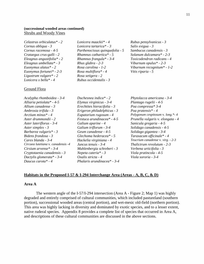
(successional wooded areas continued) Shrubs and Woody Vines Celastrus orbiculatus* - 2 Lonicera maackii* - 4 Rubus pensylvanicus - 3 Cornus obliqua - 3 Lonicera tartarica* - 3 Salix exigua - 3 Cornus racemosa - 4-5 Parthenocissus quinquefolia - 5 Sambucus canadensis - 3 Crataegus crus-galli - 2 Rhamnus cathartica* - 5 Solanum dulcamara* - 2-3 Eleagnus angustifolia* - 2 Rhamnus frangula* - 3-4 Toxicodendron radicans - 4 Eleagnus umbellata* - 3 Rhus glabra - 2-3 Viburnum opulus* - 2-3 Euonymus alatus* - 2 Rosa carolina - 1-2 Viburnum recognitum* - 1-2 Euonymus fortunei* - 2-3 Rosa multiflora* - 4 Vitis riparia - 5 Ligustrum vulgare* - 2 Rosa setigera - 2 Lonicera x bella* - 4 Rubus occidentalis - 3 Ground Flora Acalypha rhomboidea - 3-4 Duchesnea indica* - 2 Phytolacca americana - 3-4 Alliaria petiolata* - 4-5 Elymus virginicus - 3-4 Plantago rugelii - 4-5 Allium canadense - 3 Erechtites hieracifolia - 3 Poa compressa* 3-4 Ambrosia trifida - 3 Erigeron philadelphicus - 3 Poa pratensis* - 4 Arctium minus* - 4 Eupatorium rugosum - 4 Polygonum cespitosum v. long.*- 4 Aster drummondii - 2 Festuca arundinacea* - 4-5 Prunella vulgaris v. elongata - 4 Aster lateriflorus - 3-4 Galium aparine - 4 Sanicula gregaria - 4-5 Aster simplex - 3 Galium triflorum - 3-4 Solidago canadensis - 4-5 Barbarea vulgaris* - 3 Geum canadense - 4-5 Solidago gigantea - 3-4 Bidens frondosa - 3 Glechoma hederacea* - 5 Taraxacum officinale* - 4 Carex blanda - 3-4 Hackelia virginiana - 4 Teucrium canadense v. virg. - 2-3 Circaea lutetiana v. canadensis -4 Juncus tenuis - 3-4 Thalictrum revolutum - 2-3 Cirsium arvense* - 3-4 Muhlenbergia schreberi - 3 Verbena urticifolia - 3 Cryptotaenia canadensis - 3 Nepeta cateria* - 3 Viola pratincola - 4-5 Dactylis glomerata* - 3-4 Oxalis stricta - 4 Viola sororia - 3-4 Daucus carota* - 4 Phalaris arundinacea* - 3-4 Habitats in the Proposed I-57 & I-294 Interchange Area (Areas - A, B, C, & D) Area A The western angle of the I-57/I-294 intersection (Area A - Figure 2; Map 1) was highly degraded and entirely comprised of cultural communities, which included pastureland (southern portion), successional wooded areas (central portion), and wet-mesic old-field (northern portion). This area was highly lacking in diversity and dominated by exotic species, and to a lesser extent, native ruderal species. Appendix 8 provides a complete list of species that occurred in Area A, and descriptions of these cultural communities are discussed in the above sections.
11

Area B The northern angle of the I-57/I-294 intersection (Area B - Figure 2; Map 1) was also highly degraded. This area was a mosaic of mainly successional wooded areas and wet-mesic old-field, interspersed and intergrading with a very small amount of highly degraded (grade D) mesic to wet-mesic prairie (see blue highlighted area in Figure 2; Map 1). Several rarely to infrequently occurring prairie species still persisting here, included: Andropogon gerardii, Asclepias sullivantii, Aster ericoides, A. novae-angliae, Carex lanuginosa, Comandra umbellata, Liatris spicata, Monarda fistulosa, Panicum virgatum, Pycnanthemum virginianum, Ratibida pinnata, Schizachyrium scoparium, Silphium integrifolium, Sisyrinchium albidum, Smilacina stellata, and Solidago rigida. Otherwise, dominant species in this small remnant included: Agrostis alba*, Bromus inermis*, Daucus carota*, Eupatorium altissimum, Poa compressa*, P. pratensis*, and Solidago canadensis (see Appendix 8 for a list of all species occurring within Area B). Area C The eastern angle of the I-57/I-294 intersection (Area C - Figure 2; Map 1) was entirely a successional wooded area, and almost completely dominated by Rhamnus cathartica* (European buckthorn). A list of the very few plant species occurring here is provided in Appendix 8. Area D The southern angle of the I-57/I-294 intersection (Area D - Figure 2; Map 1) was also highly degraded and dominated by a mosaic of successional wooded areas and wet-mesic old-field. One small area (blue outlined area - Figure 2; Map 1) represented a highly degraded (grade D), mesic to wet-mesic prairie remnant that intergraded on all boundaries with wet-mesic old-field and successional wooded areas. This area still possessed several prairie species that were rare to infrequent and patchy in distribution, including: Andropogon gerardii, Carex bauxbaumii, C. stricta, Euthamia graminifolia, Galium obtusum, Liatris spicata, Monarda fistulosa, Panicum virgatum, Pycnanthemum virginianum, Sisyrinchium albidum, Sorghastrum nutans, Spartina pectinata, and Vernonia missurica (see also Appendix 8), but overall, the area was dominated by a matrix of exotic species, including: Achillea millefolium, Agrostis alba, Cirsium arvense, C. vulgare, Dactylis gomerata, Daucus carota, Festuca arundinacea, Melilotus alba, M. officinalis, Nepeta cataria, Poa compressa, P. pratensis; and the native, ruderal species Solidago canadensis (see Appendix 8 for a complete list of species occurring in Area D).
12
LITERATURE CITED
Bowles, M. L., J. B. Taft, E. F. Ulaszek, M. K. Solecki, D. M. Ketzner, L. R. Phillippe, A. Dennis, P. J. Burton, and K. R. Robertson. 1991. Rarely seen endangered plants, rediscoveries, and species new to Illinois. Erigenia 11:27-51.
Cholewa, A. F. and D. M. Henderson. 2002. Sisyrinchium Linnaeus in Flora of North America North of Mexico. 26:351-371. Fehrenbacher, J.B., J.D. Alexander, I.J. Jansen, R.G. Darmody, R.A. Pope, M.A. Flock, E. E. Voss, J. W. Scott, W. F. Andrews, and L. J. Bushue. 1984. Soils of Illinois. University of Illinois at Urbana-Champaign College of Agriculture and Agricultural Experiment Station in Cooperation with the Soil Conservation Service, U. S. Department of Agriculture, Bulletin 778. 85 pp. + map. Gleason, H. A. and A. Cronquist. 1991. Manual of vascular plants of the northeastern United States and adjacent Canada. 2nd Edition. New York: The New York Botanical Garden. Herkert, J. R. editor. 1991. Endangered and Threatened Species of Illinois: Status and
Distribution, Volume 1 – Plants. Illinois Endangered Species Protection Board, Springfield, Illinois. 158 pp.
Herkert, J. R. and J. E. Ebinger, editors. 2002. Endangered and Threatened Species of Illinois: Status and Distribution, Volume 1 – Plants. Illinois Endangered Species Protection Board, Springfield, Illinois. 161 pp. Illinois Department of Natural Resources. 2008. Biological and conservation database system (BCD), Division of Natural Heritage, Office of Resource Conservation, Illinois Department of Natural Resources. Illinois Endangered Species Protection Board. 2005. Checklist of Endangered and Threatened Animals and Plants of Illinois. Illinois Endangered Species Protection Board, Springfield, Illinois. 16 pp. Illinois Nature Preserves Commission. |1970s|. Registry of endangered, threatened, vulnerable, and rare species of Illinois. Illinois Nature Preserves Commission, Rockford, Illinois. (Often referred to as the “registry cards”). ILLS. 2008. Illinois Natural History Survey Herbarium (ILLS) Database. Database of collections in the herbarium of the Illinois Natural History Survey. Champaign, Illinois. Jones, M. D. 1994. The Flora and Vegetational History of Winnebago County, Illinois. Natural Land Institute, Rockford, Illinois.
13
Mapes, D. R. 1979. Soil Survey of Du Page and Part of Cook Counties, Illinois. U. S. Department of Agriculture, Soil Conservation Service and Illinois Agricultural Experiment Station, University of Illinois at Urbana-Champaign, Soil Report No. 108. Masi, S. 2008. Discussion with Susanne Masi, Plant Conservation Manager of Regional Floristics at the Chicago Botanic Garden, regarding extant populations of Sisyrinchium montanum within the state of Illinois. 24 October, 2008. Mohlenbrock, R. H. 1970. The Illustrated Flora of Illinois. lilies to orchids. Southern Illinois University Press, Carbondale, Illinois. Mohlenbrock, R. H. 2002. Vascular Flora of Illinois. Southern Illinois University Press, Carbondale, Illinois. Murphy, M. J. C. 2005. Botanical survey and assessment of the Illinois Interstate-94 tollway improvement corridor in Cook and Lake Counties. Technical Report 2005(16). Center for Wildlife and Plant Ecology, Illinois Natural History Survey, Champaign, IL. Murphy, M. J. C. 2006. Botanical survey and assessment of the Illinois Interstate-90 tollway improvement corridor in Cook and Kane Counties. Technical Report 2006(14). Division of Biodiversity and Ecological Entomology, Illinois Natural History Survey, Champaign, IL. Murphy, M. J. C. 2007. Botanical survey and assessment of the Illinois Interstate-90 tollway improvement corridor in Boone, Kane, McHenry, and Winnebago Counties, Illinois. Technical Report 2007(64). Division of Biodiversity and Ecological Entomology, Illinois Natural History Survey, Champaign, IL. Reed, P. B., Jr. 1988. National list of plant species that occur in wetlands: north central (region 3). U.S. Fish and Wildlife Service Biological Report 88(26.3). Schwegman, J. E. 1973. Comprehensive plan for the Illinois Nature Preserves System. Part 2. The Natural Divisions of Illinois. Illinois Nature Preserves Commission, Rockford, Illinois.
Sheviak, C. J. 1981. Endangered and Threatened Plants. Pages 70-179 in M. L. Bowles, V. E. Diersing, and J. E. Ebinger, eds., Endangered and Threatened Vertebrate Animals and Vascular Plants of Illinois. Illinois Department of Conservation, Springfield.
Smith, G. S. 2002. Bolboschoenus in Flora of North America North of Mexico. 23:37- 44. Swink, F. 1969. Plants of the Chicago Region. The Morton Arboretum, Lisle, Illinois.
14

Swink, F. and G. Wilhelm. 1979. Plants of the Chicago region. Revised and expanded edition with keys. The Morton Arboretum, Lisle, Illinois. Swink, F. and G. Wilhelm. 1994. Plants of the Chicago region, 4th ed. Indianapolis: Indiana Academy of Science. Taft, J. B., G. S. Wilhelm, D. M. Ladd, and L. A. Masters. 1997. Floristic quality assessment for vegetation in Illinois. A method for assessing vegetation integrity. Erigenia 15:3-95.
USDA, NRCS. 2008. The PLANTS Database (http://plants.usda.gov, 22 October 2008). National Plant Data Center, Baton Rouge, LA 70874-4490 USA. vPlants Database 2008. http://www.vplants.org
White, J. 1978. Illinois natural areas inventory technical report. Vol. 1. Survey methods and results. Illinois Natural Areas Inventory, Urbana. 426 pp. Wiggers, R. 1997. Geology underfoot in Illinois. Mountain Press Publishing. Missoula
Montana. 303 pp.
15

147t h Stree t/IL-83
1 47th St reet/IL- 83
57
294
57
294
Kedzie Ave
Kedzie Ave
Grand Trunk Western Railroad
Baltimore and Ohio Railroad
Paintbrush PrairieNature Preserve
Gensburg-Markham PrairieNature Preserve
Sundrop Prairie Nature Preserve
Dropseed Prairie Nature Preserve
Gensburg-Markham Prairie AdditionNatural Heritage Landmark
Figure 1. Aerial photograph showing botanical survey boundaries for the Illinois Department of Transportation I-57/I-294 interchange study area, Cook County, Illinois.
01,000
2,0003,000
4,000500
FeetINHS
Jarvis 11/10/08
16
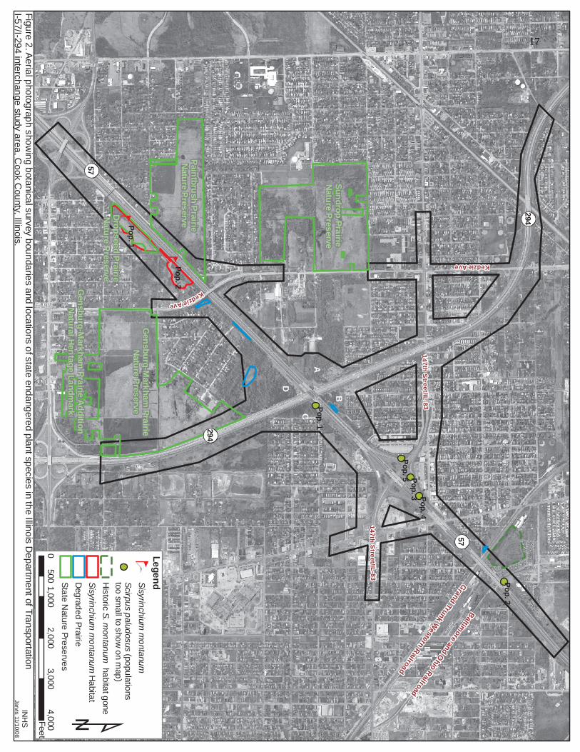
14 7th Str eet/IL-8 3
147th Street/I L-83
57
294
57
294
Kedzie Ave
Kedzie Ave
Grand Trunk Western Railroad
Baltimore and Ohio Railroad
Paintbrush PrairieNature Preserve
Gensburg-Markham PrairieNature Preserve
Sundrop Prairie Nature Preserve
Dropseed Prairie Nature Preserve
Gensburg-Markham Prairie AdditionNatural Heritage Landmark
Pop. 2
Pop. 1
Pop. 5Pop. 4
Pop. 3
Pop. 2
Pop. 1
Figure 2. Aerial photograph showing botanical survey boundaries and locations of state endangered plant species in the Illinois Department of Transportation I-57/I-294 interchange study area, Cook County, Illinois.
INHSJarvis 11/10/08
01,000
2,0003,000
4,000500
Feet
A
B
CD
State Nature PreservesDegraded Prairie
Scirpus paludosus (populations too small to show on map)
LegendSisyrinchium montanum
Sisyrinchium montanum HabitatHistoric S. montanum habitat gone
17

A.
B.
Figure 3. A - Photograph of Scirpus paludosus (population #1) along Interstate-57, growing in a moist roadside ditch, immediately northeast of I-294 and southeast of I-57, Cook Co., Illinois (each of the three white arrows points to one inflorescence). B - Close-up photograph of a fruiting stem of Scirpus paludosus within this population.
18
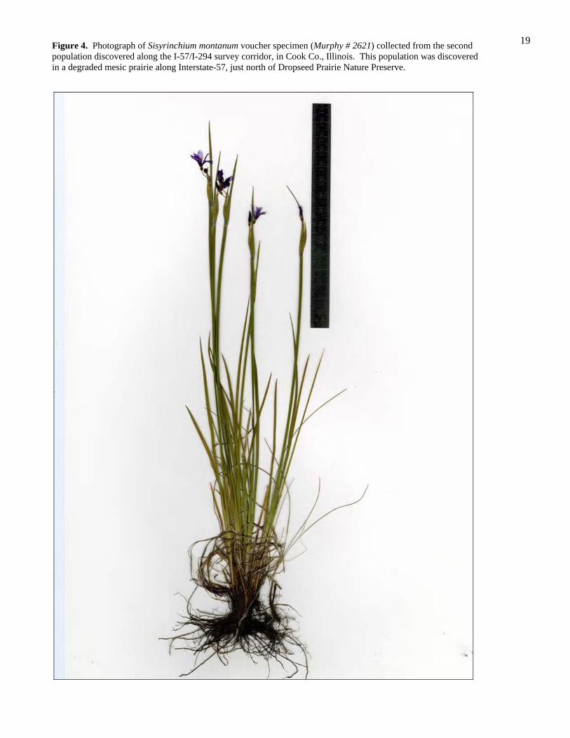
Figure 4. Photograph of Sisyrinchium montanum voucher specimen (Murphy # 2621) collected from the second population discovered along the I-57/I-294 survey corridor, in Cook Co., Illinois. This population was discovered in a degraded mesic prairie along Interstate-57, just north of Dropseed Prairie Nature Preserve.
19

Figure 5. Close-up photograph of Sisyrinchium montanum voucher specimen (Murphy # 2621), collected from the second mountain blue-eyed grass population discovered along the I-57/I-294 survey corridor, Cook Co., Illinois. Photograph shows the fused lower margins (red arrows) of the outer-most bracts (black arrows) - a diagnostic character of this taxon.
20
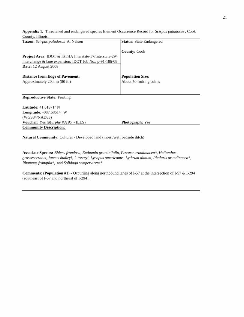
Community Description:
Appendix 1. Threatened and endangered species Element Occurrence Record for Scirpus paludosus , Cook County, Illinois.
About 50 fruiting culms
Taxon: Scirpus paludosus A. Nelson Status: State Endangered
County: Cook
Date: 12 August 2008
Distance from Edge of Pavement: Population Size:Approximately 20.4 m (80 ft.)
Project Area: IDOT & ISTHA Interstate-57/Interstate-294 interchange & lane expansion; IDOT Job No.: p-91-186-08
Comments: (Population #1) - Occurring along northbound lanes of I-57 at the intersection of I-57 & I-294 (southeast of I-57 and northeast of I-294).
Natural Community: Cultural - Developed land (moist/wet roadside ditch)
Reproductive State: Fruiting
Latitude: 41.61871° NLongitude: -087.68614° W
Voucher: Yes (Murphy #3195 - ILLS)
Associate Species: Bidens frondosa, Euthamia graminifolia, Festuca arundinacea*, Helianthus grosseserratus, Juncus dudleyi, J. torreyi, Lycopus americanus, Lythrum alatum, Phalaris arundinacea*, Rhamnus frangula*, and Solidago sempervirens*.
Photograph: Yes(WGS84/NAD83)
21

Project Area: IDOT & ISTHA Interstate-57/Interstate-294 interchange & lane expansion; IDOT Job. No.: p-91-186-08
Comments: (Population #2) - Occurring underneath I-57 railroad overpass.
Natural Community: Cultural - Developed land (moist/wet roadside ditch)
Reproductive State: Fruiting
Latitude: 41.63139° NLongitude: -087.67059° W
Voucher: No
Associate Species: Kochia scoparia*, Lythrum salicaria*, Phragmites australis*, Puccinellia distans*, Scirpus tabernaemontani, Solidago sempervirens*, and Typha angustifolia*.
Photograph: No(WGS84/NAD83)
Community Description:
Appendix 2. Threatened and endangered species Element Occurrence Record for Scirpus paludosus , Cook County, Illinois.
About 700 fruiting culms
Taxon: Scirpus paludosus A. Nelson Status: State Endangered
County: Cook
Date: 12 August 2008
Distance from Edge of Pavement: Population Size:N/A - underneath I-57 railroad overpass
22

Community Description:
Appendix 3. Threatened and endangered species Element Occurrence Record for Scirpus paludosus , Cook County, Illinois.
About 40 fruiting culms
Taxon: Scirpus paludosus A. Nelson Status: State Endangered
County: Cook
Date: 12 August 2008
Distance from Edge of Pavement: Population Size:
Project Area: IDOT & ISTHA Interstate-57/Interstate-294 interchange & lane expansion; IDOT Job. No.: p-91-186-08
Approximately 4 to 6 m
Comments: (Population #3) - Occurring west of I-57, along westbound I-57/147th St. exit ramp (east side of exit ramp).
Natural Community: Cultural - Developed land (moist/wet roadside ditch)
Reproductive State: Fruiting
Latitude: 41.62508° NLongitude: -087.67984° W
Voucher: No
Associate Species: Agropyron repens*, Aster subulatus*, Atriplex patula*, Echinochloa crus-galli*, Festuca arundinacea*, Leptochloa fascicularis*, Solidago sempervirens*, and Spergularia media*.
Photograph: No(WGS84/NAD83)
23

Approximately 4 to 6 m
Comments: (Population #4) - Occurring west of I-57, along westbound I-57/147th St. exit ramp (east side of exit ramp).
Natural Community: Cultural - Developed land (moist/wet roadside ditch)
Reproductive State: Fruiting
Latitude: 41.62568° NLongitude: -087.67819° W
Voucher: No
Associate Species: Agropyron repens*, Aster subulatus*, Atriplex patula*, Echinochloa crus-galli*, Festuca arundinacea*, Leptochloa fascicularis*, Solidago sempervirens*, and Spergularia media*.
Photograph: No(WGS84/NAD83)
Community Description:
Project Area: IDOT & ISTHA Interstate-57/Interstate-294 interchange & lane expansion; IDOT Job. No.: p-91-186-08
Appendix 4. Threatened and endangered species Element Occurrence Record for Scirpus paludosus , Cook County, Illinois.
About 350 fruiting culms
Taxon: Scirpus paludosus A. Nelson Status: State Endangered
County: Cook
Date: 12 August 2008
Distance from Edge of Pavement: Population Size:
24

Approximately 4 to 6 m
(WGS84/NAD83)
Community Description:
Appendix 5. Threatened and endangered species Element Occurrence Record for Scirpus paludosus , Cook County, Illinois.
About 200 culm bases
Taxon: Scirpus paludosus A. Nelson Status: State Endangered
County: Cook
Date: 12 August 2008
Distance from Edge of Pavement: Population Size:
Project Area: IDOT & ISTHA Interstate-57/Interstate-294 interchange & lane expansion; IDOT Job. No.: p-91-186-08
Comments: (potential population #5 - area was mowed throughout growing season and positive identification of plants could not be made; stem bases appeared as those of Scirpus paludosus ) - Occurring west of I-57, along westbound I-57/147th St. on ramp (east side of on ramp).
Natural Community: Cultural - Developed land (moist/wet roadside ditch)
Reproductive State: Sterile (mowed)
Latitude: 41.62447° NLongitude: -087.68150° W
Voucher: No
Associate Species: Agrostis alba var. palustris, Festuca arundinacea*, and Scirpus tabernaemontani.
Photograph: No
25

Comments: (Population #1) - Occurring within the boundaries of Dropseed Prairie Nature Preserve. Woody species encroachment is occurring on the northern, southern, and western boundaries of the preserve. The main species invading is Rhamnus cathartica* ; other woody species include: Acer negundo, Fraxinus pennsylvanica var. subintigerrima, Morus alba*, Populus deltoides, Rhamnus frangula*, Rhus glabra, and Vitis riparia .
Natural Community: High quality mesic to wet-mesic prairie (Dropseed Prairie Nature Preserve)
Reproductive State: Flowering
Latitude: 41.60583° NLongitude: -087.70243° W
Voucher: Yes (Murphy #2613 - ILLS) Photograph: No(WGS84/NAD83)
Associate Species: Achillea millefolium*, Allium cernuum, Andropogon gerardii, Anemone virginiana, Aster azureus, Carex meadii, Castilleja coccinea, Claytonia virginica, Comandra umbellata, Coreopsis tripteris, Daucus carota*, Dodecatheon media, Elymus canadensis, Eryngium yuccifolium, Fragaria virginiana, Guara biennis, Gentiana quiquefolia, Heuchera richardsonii, Hypoxis hirsuta, Liatris spicata, Lithospermum canescens, Monarda fistulosa, Oxalis violacea, Panicum oligosanthes var. scribnerianum, P. virgatum, Pastinaca sativa*, Phlox glaberrima var. interior, P. pilosa, Pycnanthemum virginianum, Ratibita pinnata, Rhamnus cathartica*, Silphium integrifolium, S. laciniatum, S. terebinthinaceum, Sisyrinchium albidum, Smilacina stellata, Solidago canadensis, S. rigida, Sorgashtrum nutans, Schizachyrium scoparium, Sporobolus heterolepis, Valeriana ciliata, Veronicastrum virginicum, and Zizia aurea.
Population Size:
Community Description:
Project Area: IDOT & ISTHA Interstate-57/Interstate-294 interchange & lane expansion; IDOT Job No.: p-91-186-08
Appendix 6. Threatened and endangered species Element Occurrence Record for Sisyrinchium montanum , Cook County, Illinois.
Uncertain
Taxon: Sisyrinchium montanum Greene Status: State Endangered
County: Cook
Date: 20 May 2008
Distance from Edge of Pavement:Approximately 45.8-53.4 m (150-175 ft.)
26

Community Description:
Approximately 45.8 m (150 ft.)
Comments: (Population #2) - Occurring on I-57 (northbound side) along fenceline where interstate right-of-way abuts adjacent areas under private ownership. Woody species encroachment is advanced on all sides of this remnant, and is occurring in middle sections, as well. Primary species encroaching are: Cornus racemosa, Rhamnus cathartica*, Robinia pseudoacacia*, and Rubus pensylvanicus .
Natural Community: Degraded mesic prairie undergoing extensive woody spp. encroachment.
Reproductive State: Flowering
Latitude: 41.60897° NLongitude: -087.69880° W
Voucher: Yes (Murphy #2621 - ILLS) Photograph: No(WGS84/NAD83)
Associate Species: Achillea millefolium*, Agrostis alba, Allium cernuum, Andropogon gerardii, Anemone virginiana, Aster ericoides, A. novae-angliae, A. pilosus, Carex blanda, Cirsium discolor, Coreopsis tripteris, Cornus racemosa, Dactylis glomerata*, Daucus carota*, Eragrostis spectabilis, Eupatorium altissimum, Euthamia graminifolia, Festuca arundinacea*, Gentiana quinquefolia, Leucanthemum vulgare*, Liatris spicata, Melilotus alba*, M. officinalis*, Monarda fistulosa, Panicum implicatum, P. virgatum, Poa pratensis*, Prunella vulgaris, Pycnanthemum tenuifolium, Ratibida pinnata, Rhamnus cathartica*, Rudbeckia hirta, Silphium integrifolium, S. laciniatum, S. terebinthinaceum, Sisyrinchium albidum, Solanum carolinese*, Solidago canadensis, S. juncea, S. rigida, Sorgashtrum nutans, and Schizachyrium scoparium.
Appendix 7. Threatened and endangered species Element Occurrence Record for Sisyrinchium montanum , Cook County, Illinois.
Uncertain
Taxon: Sisyrinchium montanum Greene Status: State Endangered
County: Cook
Date: 21 May 2008
Distance from Edge of Pavement:
Project Area: IDOT & ISTHA Interstate-57/Interstate-294 interchange & lane expansion; IDOT Job. No.; p-91-186-08
Population Size:
27

C Scientific Name W Wetness Origin Physiog. Common Name S1M
WM
S2M
WM
HD
MW
MD
RW
RW
MO
FSC
WO
OD
Are
a A
Are
a B
Are
a C
Are
a D
0 Acalypha rhomboidea 3 FACU Nt A-Forb THREE-SEEDED MERCURY X X X X1 Acer negundo -2 FACW- Nt Tree BOXELDER X X X X X X X X1 Acer saccharinum -3 FACW Nt Tree SILVER MAPLE X X X X X X0 ACHILLEA MILLEFOLIUM 3 FACU Ad P-Forb COMMON MILFOIL X X X X X X3 Agrimonia gryposepala 2 FACU+ Nt P-Forb TALL AGRIMONY X X X0 AGROPYRON REPENS 3 FACU Ad P-Grass QUACK GRASS X X X0 AGROSTIS ALBA -3 FACW Ad P-Grass RED TOP X X X X X X X X8 Agrostis alba v. palustris -3 FACW Nt P-Grass CREEPING BENT GRASS X0 AILANTHUS ALTISSIMA 5 UPL Ad Tree TREE-OF-HEAVEN X X2 Alisma plantago-aquatica v. parviflorum -5 OBL Nt P-Forb COMMON WATER PLANTAIN X X0 ALLIARIA PETIOLATA 0 FAC Ad B-Forb GARLIC MUSTARD X X X X2 Allium canadense 3 FACU Nt P-Forb WILD GARLIC X X X7 Allium cernuum 5 UPL Nt P-Forb NODDING WILD ONION X X X0 Ambrosia artemisiifolia 3 FACU Nt A-Forb COMMON RAGWEED X X X X X X X X X0 Ambrosia trifida -1 FAC+ Nt A-Forb GIANT RAGWEED X X X X X X X X0 ANAGALLIS ARVENSIS 5 UPL Ad A-Forb POOR MAN'S WEATHERGLASS X X5 Andropogon gerardii 1 FAC- Nt P-Grass BIG BLUESTEM X X X X X X4 Anemone virginiana 5 UPL Nt P-Forb TALL ANEMONE X X X X4 Antennaria neglecta 5 UPL Nt P-Forb CAT'S FOOT X4 Antennaria plantaginifolia 5 UPL Nt P-Forb PUSSY TOES X3 Apios americana -3 FACW Nt H-Vine GROUND NUT X X X2 Apocynum sibiricum -1 FAC+ Nt P-Forb INDIAN HEMP X X X X X X X X0 ARCTIUM MINUS 5 UPL Ad B-Forb COMMON BURDOCK X X X X X0 ARTEMISIA VULGARIS 5 UPL Ad P-Forb MUGWORT X4 Asclepias incarnata -5 OBL Nt P-Forb SWAMP MILKWEED X X X X X7 Asclepias sullivantii 5 UPL Nt P-Forb PRAIRIE MILKWEED X X0 Asclepias syriaca 5 UPL Nt P-Forb COMMON MILKWEED X X X X X X1 Asclepias verticillata 5 UPL Nt P-Forb HORSETAIL MILKWEED X X X X0 ASPARAGUS OFFICINALIS 3 FACU Ad P-Forb GARDEN ASPARAGUS X X X7 Aster azureus 5 UPL Nt P-Forb SKY-BLUE ASTER X3 Aster drummondii 3 FACU Nt P-Forb DRUMMOND'S ASTER X X4 Aster ericoides 4 FACU- Nt P-Forb HEATH ASTER X X X X X2 Aster lateriflorus -2 FACW- Nt P-Forb SIDE-FLOWERING ASTER X X X X X4 Aster novae-angliae -3 FACW Nt P-Forb NEW ENGLAND ASTER X X X X X0 Aster pilosus 4 FACU- Nt P-Forb HAIRY ASTER X X X X X X4 Aster praealtus -5 OBL Nt P-Forb WILLOW ASTER X X X X3 Aster simplex -5 OBL Nt P-Forb PANICLED ASTER X X X0 ASTER SUBULATUS -5 OBL Ad A-Forb EXPRESSWAY ASTER X0 ATRIPLEX PATULA 2 FACU+ Ad A-Forb FAT-HEN SALTBUSH X0 BARBAREA VULGARIS 0 FAC Ad B-Forb WINTER CRESS X X X X X1 Bidens aristosa -3 FACW Nt A-Forb SWAMP MARIGOLD X X X1 Bidens frondosa -3 FACW Nt A-Forb COMMON BEGGAR'S TICKS X X X X X X X X0 BROMUS INERMIS 5 UPL Ad P-Grass HUNGARIAN BROME X X X X X X
Appendix 8. Cumulative list of vascular plant species encountered in the I-57/I-294 interchange study corridor, Cook County, Illinois. Community abbreviations are as follows: S1MWM = Sisyrinchium montanum population #1 high quality mesic/wet-mesic prairie (Dropseed Prairie); S2MWM = Sisyrinchium montanum population #2 degraded mesic/wet-mesic prairie; HDMWM = highly degraded mesic/wet-mesic prairie throughout the corridor; DR = dry roadsides; WR = wet roadsides; WMOF = wet-mesic old-field; SCWOOD = successional wooded areas. Areas A, B, C, & D, correspond to vertical angle areas at the intersection of I-57 & I-294 ( see Figure 2). Additional abbreviations are as follows: C = coefficient of conservatism; W = numeric wetness values associated with wetland categories (see end of appendix 8); Wetness = wetland classification category (see end of appendix 8); Origin = native (Nt) or Adventive (Ad) to the region; Physiog. = physiognomy (combination of structural attributes, life history and taxonomic classification). Single letter prefixes accompanying Forb, Grass, Sedge, or Vine classifications are as follows: A = annual, H= herbaceous, P = perennial, W = woody. Taxa with scientific names in all capital letters are adventive to the region.
28

C Scientific Name W Wetness Origin Physiog. Common Name S1M
WM
S2M
WM
HD
MW
MD
RW
RW
MO
FSC
WO
OD
Are
a A
Are
a B
Are
a C
Are
a D
1 Calystegia sepium 0 FAC Nt P-Forb AMERICAN BINDWEED X X X X X X0 CANNABIS SATIVA 0 FAC Ad A-Forb HASHISH X X2 Carex blanda 0 FAC Nt P-Sedge COMMON WOOD SEDGE X X X X X X9 Carex buxbaumii -5 OBL Nt P-Sedge DARK-SCALED SEDGE X X X4 Carex lanuginosa -5 OBL Nt P-Sedge WOOLY SEDGE X X X6 Carex meadii 4 FACU- Nt P-Sedge MEAD'S STIFF SEDGE X5 Carex stricta -5 OBL Nt P-Sedge COMMON TUSSOCK SEDGE X X3 Carex vulpinoidea -5 OBL Nt P-Sedge BROWN FOX SEDGE X X X8 Castilleja coccinea 0 FAC Nt A-Forb INDIAN PAINTBRUSH X0 Catalpa speciosa 3 FACU Nt Tree CIGAR TREE X X0 CELASTRUS ORBICULATUS 5 UPL Ad W-Vine ORIENTAL BITTERSWEET X3 Celtis occidentalis 1 FAC- Nt Tree HACKBERRY X X0 CHENOPODIUM ALBUM 1 FAC- Ad A-Forb LAMB'S QUARTERS X X0 CICHORIUM INTYBUS 5 UPL Ad P-Forb CHICKORY X X4 Cicuta maculata -5 OBL Nt B-Forb WATER HEMLOCK X X X2 Circaea lutetiana v. canadensis 3 FACU Nt P-Forb ENCHANTER'S NIGHTSHADE X X X X0 CIRSIUM ARVENSE 3 FACU Ad P-Forb FIELD THISTLE X X X X X X X X3 Cirsium discolor 5 UPL Nt B-Forb PASTURE THISTLE X0 CIRSIUM VULGARE 4 FACU- Ad B-Forb BULL THISTLE X X X X X X X1 Claytonia virginica 3 FACU Nt P-Forb SPRING BEAUTY X X X6 Comandra umbellata 3 FACU Nt P-Forb BASTARD TOAD-FLAX X X X0 Conyza canadensis 1 FAC- Nt A-Forb HORSEWEED X X X X X4 Coreopsis tripteris 0 FAC Nt P-Forb TALL COREOPSIS X X X4 Cornus obliqua -5 OBL Nt Shrub PALE DOGWOOD X X X X X X2 Cornus racemosa -2 FACW- Nt Shrub GRAY DOGWOOD X X X X X X X X2 Crataegus crus-galli 0 FAC Nt Tree COCK-SPUR HAWTHORN X X2 Crataegus mollis -2 FACW- Nt Tree DOWNY HAWTHORN X X1 Cryptotaenia canadensis 0 FAC Nt P-Forb HONEWORT X X X X2 Cuscuta gronovii -3 FACW Nt A-Forb COMMON DODDER X X0 DACTYLIS GLOMERATA 3 FACU Ad P-Grass ORCHARD GRASS X X X X X X0 DAUCUS CAROTA 4 FACU- Ad B-Forb QUEEN ANNE'S LACE X X X X X X X0 DIANTHUS ARMERIA 5 UPL Ad A-Forb DEPTFORD PINK X X0 DIPSACUS LACINIATUS 5 UPL Ad B-Forb CUT-LEAVED TEASEL X X X X6 Dodecatheon meadia 3 FACU Nt P-Forb SHOOTING STAR X0 DUCHESNEA INDICA 4 FACU- Ad P-Forb INDIAN STRAWBERRY X X0 DYSSODIA PAPPOSA 5 UPL Ad A-Forb FETID MARIGOLD X0 ECHINOCHLOA CRUSGALLI -3 FACW Ad A-Grass BARNYARD GRASS X X X X0 ELAEAGNUS ANGUSTIFOLIA 4 FACU- Ad Shrub RUSSIAN OLIVE X0 ELAEAGNUS UMBELLATA 5 UPL Ad Shrub AUTUMN OLIVE X X X2 Eleocharis obtusa -5 OBL Nt A-Sedge BLUNT SPIKE RUSH X X4 Elymus canadensis 1 FAC- Nt P-Grass CANADA WILD RYE X X X4 Elymus virginicus -2 FACW- Nt P-Grass VIRGINIA WILD RYE X X X0 EPIPACTIS HELLEBORINE 5 UPL Ad P-Forb HELLEBORINE ORCHID X X0 Equisetum arvense 0 FAC Nt Fern COMMON HORSETAIL X X X X X X X3 Eragrostis spectabilis 5 UPL Nt P-Grass PURPLE LOVE GRASS X X2 Erechtites hieracifolia 3 FACU Nt A-Forb FIREWEED X X X X X X X X1 Erigeron annuus 1 FAC- Nt B-Forb ANNUAL FLEABANE X X X X X X X3 Erigeron philadelphicus -3 FACW Nt P-Forb MARSH FLEABANE X X X X X2 Erigeron strigosus 1 FAC- Nt P-Forb DAISY FLEABANE X X X7 Eryngium yuccifolium -1 FAC+ Nt P-Forb RATTLESNAKE MASTER X0 EUONYMUS ALATUS 5 UPL Ad Shrub WINGED EUONYMUS X X0 EUONYMUS FORTUNEI 5 UPL Ad Shrub WINTERCREEPER X
Appendix 8 continued
29

C Scientific Name W Wetness Origin Physiog. Common Name S1M
WM
S2M
WM
HD
MW
MD
RW
RW
MO
FSC
WO
OD
Are
a A
Are
a B
Are
a C
Are
a D
2 Eupatorium altissimum 3 FACU Nt P-Forb TALL BONESET X X X X X X2 Eupatorium rugosum 3 FACU Nt P-Forb WHITE SNAKEROOT X X X X1 Eupatorium serotinum -1 FAC+ Nt P-Forb LATE BONESET X X X X X X X X X X3 Euphorbia corollata 5 UPL Nt P-Forb FLOWERING SPURGE X X0 EUPHORBIA ESULA 5 UPL Ad P-Forb LEAFY SPURGE X3 Euthamia graminifolia -2 FACW- Nt P-Forb GRASS-LVD. GOLDENROD X X X X X X0 FESTUCA ARUNDINACEA 2 FACU+ Ad P-Grass TALL FESCUE X X X X X X X X0 FESTUCA RUBRA 1 FAC- Ad P-Grass RED FESCUE X2 Fragaria virginiana 1 FAC- Nt P-Forb WILD STRAWBERRY X X X X X X2 Fraxinus pennsylvanica v. subintegerrima -3 FACW Nt Tree GREEN ASH X X X X X X X X X0 GALINSOGA QUADRIRADIATA 5 UPL Ad A-Forb PERUVIAN DAISY X X0 Galium aparine 3 FACU Nt A-Forb ANNUAL BEDSTRAW X X X X X X5 Galium obtusum -4 FACW+ Nt P-Forb WILD MADDER X X4 Galium triflorum 2 FACU+ Nt P-Forb SWEET-SCENTED BEDSTRAW X X X2 Gaura biennis 4 FACU- Nt B-Forb BIENNIAL GAURA X X X X7 Gentianella quinquefolia v. occidentalis 0 FAC Nt A-Forb STIFF GENTIAN X X2 Geum canadense 0 FAC Nt P-Forb WHITE AVENS X X X X X2 Geum laciniatum -3 FACW Nt P-Forb ROUGH AVENS X X0 GLECHOMA HEDERACEA 3 FACU Ad P-Forb GROUND IVY X X X X X2 Gleditsia triacanthos 0 FAC Nt Tree HONEY LOCUST X X X X4 Glyceria striata -5 OBL Nt P-Grass FOWL MANNA GRASS X X X X1 Hackelia virginiana 1 FAC- Nt P-Forb STICKSEED X X X X3 Helenium autumnale -4 FACW+ Nt P-Forb SNEEZEWEED X0 HELIANTHUS ANNUUS 1 FAC- Ad A-Forb COMMON SUNFLOWER X2 Helianthus grosseserratus -2 FACW- Nt P-Forb SAWTOOTH SUNFLOWER X X X0 HEMEROCALLIS FULVA 5 UPL Ad P-Forb ORANGE DAY LILY X7 Heuchera richardsonii v. grayana 1 FAC- Nt P-Forb PRAIRIE ALUMROOT X0 HORDEUM JUBATUM -1 FAC+ Ad P-Grass SQUIRREL-TAIL GRASS X0 HYPERICUM PERFORATUM 5 UPL Ad P-Forb COMMON ST. JOHN'S WORT X X X X6 Hypoxis hirsuta 0 FAC Nt P-Forb YELLOW STAR GRASS X X2 Impatiens capensis -3 FACW Nt A-Forb SPOTTED TOUCH-ME-NOT X X X X X5 Iris shrevei -5 OBL Nt P-Forb SOUTHERN BLUE FLAG X X4 Juglans nigra 3 FACU Nt Tree BLACK WALNUT X X X4 Juncus dudleyi 0 FAC Nt P-Forb DUDLEY'S RUSH X X X X X X0 Juncus tenuis 0 FAC Nt P-Forb PATH RUSH X X X X X3 Juncus torreyi -3 FACW Nt P-Forb TORREY'S RUSH X X X X1 Juniperus virginiana 3 FACU Nt Tree EASTERN RED CEDAR X X X0 KOCHIA SCOPARIA 4 FACU- Ad A-Forb SUMMER CYPRESS X0 LAMIUM PURPUREUM 5 UPL Ad A-Forb PURPLE DEAD NETTLE X X4 Leersia virginica -3 FACW Nt P-Grass WHITE GRASS X X0 Leptochloa fascicularis -5 OBL Nt A-Grass BEARDED SPRANGLE TOP X0 LEUCANTHEMUM VULGARE 5 UPL Ad P-Forb OX-EYE DAISY X X X X7 Liatris spicata 0 FAC Nt P-Forb MARSH BLAZING STAR X X X X X X0 LIGUSTRUM VULGARE 5 UPL Ad Shrub COMMON PRIVET X5 Lindernia dubia -5 OBL Nt A-Forb FALSE PIMPERNEL X X6 Lithospermum canescens 5 UPL Nt P-Forb HOARY PUCCOON X X0 LONICERA MAACKII 5 UPL Ad Shrub AMUR HONEYSUCKLE X X X X X X X X0 LONICERA TATARICA 3 FACU Ad Shrub TARTARIAN HONEYSUCKLE X X X X X X X X0 LONICERA X BELLA 3 FACU Ad Shrub SHOWY FLY HONEYSUCKLE X X X X X X X X0 LOTUS CORNICULATUS 1 FAC- Ad P-Forb BIRDSFOOT TREFOIL X3 Lycopus americanus -5 OBL Nt P-Forb WATER HOREHOUND X X X X X X X X X
Appendix 8 continued
30

C Scientific Name W Wetness Origin Physiog. Common Name S1M
WM
S2M
WM
HD
MW
MD
RW
RW
MO
FSC
WO
OD
Are
a A
Are
a B
Are
a C
Are
a D
5 Lythrum alatum -5 OBL Nt P-Forb WINGED LOOSESTRIFE X X X0 LYTHRUM SALICARIA -5 OBL Ad P-Forb PURPLE LOOSESTRIFE X0 MALUS SIEBOLDII 5 UPL Ad Tree JAPANESE CRAB X X X X0 MEDICAGO LUPULINA 1 FAC- Ad A-Forb BLACK MEDICK X X X0 MELILOTUS ALBA 3 FACU Ad B-Forb WHITE SWEET CLOVER X X X X X X0 MELILOTUS OFFICINALIS 3 FACU Ad B-Forb YELLOW SWEET CLOVER X X X X X X5 Mimulus ringens -5 OBL Nt P-Forb MONKEY FLOWER X X7 Moehringia lateriflora 3 FACU Nt P-Forb BLUNT-LEAF SANDWORT X4 Monarda fistulosa 3 FACU Nt P-Forb WILD BERGAMOT X X X X X0 MORUS ALBA 0 FAC Ad Tree WHITE MULBERRY X X X X X X X X X0 Muhlenbergia schreberi 0 FAC Nt P-Grass NIMBLEWILL X0 NEPETA CATARIA 1 FAC- Ad P-Forb CATNIP X X X1 Oenothera biennis 3 FACU Nt B-Forb EVENING PRIMROSE X X X X X0 Oxalis dillenii 3 FACU Nt P-Forb COMMON WOOD SORREL X X X X X X0 Oxalis stricta 3 FACU Nt P-Forb TALL WOOD SORREL X X X X5 Oxalis violacea 5 UPL Nt P-Forb VIOLET WOOD SORREL X0 Panicum capillare 0 FAC Nt A-Grass OLD WITCH GRASS X2 Panicum implicatum 0 FAC Nt P-Grass OLD FIELD PANIC GRASS X X X X3 Panicum oligosanthes v. scribnerianum 3 FACU Nt P-Grass SCRIBNER'S PANIC GRASS X X4 Panicum virgatum -1 FAC+ Nt P-Grass PRAIRIE SWITCH GRASS X X X X X X2 Parietaria pensylvanica 3 FACU Nt A-Forb PENNSYLVANIA PELLITORY X2 Parthenocissus quinquefolia 1 FAC- Nt W-Vine VIRGINIA CREEPER X X X X X X X X X0 PASTINACA SATIVA 5 UPL Ad B-Forb WILD PARSNIP X X X X X X7 Pedicularis canadensis 2 FACU+ Nt P-Forb WOOD BETONY X2 Penthorum sedoides -5 OBL Nt P-Forb DITCH STONECROP X X0 PHALARIS ARUNDINACEA -4 FACW+ Ad P-Grass REED CANARY GRASS X X X X X X0 PHLEUM PRATENSE 3 FACU Ad P-Grass TIMOTHY X X X X6 Phlox glaberrima sp. interior -3 FACW Nt P-Forb SMOOTH PHLOX X7 Phlox pilosa 1 FAC- Nt P-Forb SAND PRAIRIE PHLOX X1 Phragmites australis -4 FACW+ Nt P-Grass COMMON REED X2 Physalis heterophylla 5 UPL Nt P-Forb CLAMMY GROUND CHERRY X X3 Physalis virginiana 5 UPL Nt P-Forb GROUND CHERRY X6 Physostegia virginiana -3 FACW Nt P-Forb OBEDIENT PLANT X X1 Phytolacca americana 1 FAC- Nt P-Forb POKEWEED X X X X X0 PINUS PUNGENS 5 UPL Ad Tree PRICKLY PINE X0 PLANTAGO LANCEOLATA 0 FAC Ad P-Forb ENGLISH PLANTAIN X X X X X X0 Plantago rugelii 0 FAC Nt A-Forb RED-STALKED PLANTAIN X X X X X X X X X0 POA COMPRESSA 2 FACU+ Ad P-Grass CANADIAN BLUE GRASS X X X X X X X0 POA PRATENSIS 1 FAC- Ad P-Grass KENTUCKY BLUE GRASS X X X X X X X X X4 Polygonatum commutatum 3 FACU Nt P-Forb GREAT SOLOMON SEAL X X3 Polygonum amphibium -5 OBL Nt P-Forb WATER KNOTWEED X0 P. CESPITOSUM v. LONGISETUM 5 UPL Ad A-Forb CREEPING SMARTWEED X X X1 Polygonum pensylvanicum -4 FACW+ Nt A-Forb PINKWEED X X X X0 POLYGONUM PERSICARIA -3 FACW Ad A-Forb LADY'S THUMB X3 Polygonum punctatum -5 OBL Nt A-Forb SMARTWEED X X X X2 Populus deltoides -1 FAC+ Nt Tree EASTERN COTTONWOOD X X X X X X X X X4 Populus grandidentata 3 FACU Nt Tree BIG-TOOTH ASPEN X X X0 Potentilla norvegica 0 FAC Nt A-Forb ROUGH CINQUEFOIL X X X X X X3 Potentilla simplex 4 FACU- Nt P-Forb COMMON CINQUEFOIL X X X X X X1 Prunella vulgaris v. elongata 0 FAC Nt P-Forb SELF-HEAL X X X X X X X X X X1 Prunus serotina 3 FACU Nt Tree WILD BLACK CHERRY X X X X X X
Appendix 8 continued
31

C Scientific Name W Wetness Origin Physiog. Common Name S1M
WM
S2M
WM
HD
MW
MD
RW
RW
MO
FSC
WO
OD
Are
a A
Are
a B
Are
a C
Are
a D
0 PUCCINELLIA DISTANS -5 OBL Ad P-Grass ALKALI GRASS X4 Pycnanthemum tenuifolium 0 FAC Nt P-Forb SLENDER MOUNTAIN MINT X X5 Pycnanthemum virginianum -4 FACW+ Nt P-Forb COMMON MOUNTAIN MINT X X X1 Ranunculus abortivus -2 FACW- Nt A-Forb LITTLE-LEAF BUTTERCUP X4 Ranunculus septentrionalis -4 FACW+ Nt P-Forb SWAMP BUTTERCUP X4 Ratibida pinnata 5 UPL Nt P-Forb YELLOW CONEFLOWER X X X X X X0 RHAMNUS CATHARTICA 3 FACU Ad Shrub COMMON BUCKTHORN X X X X X X X X X X X0 RHAMNUS FRANGULA -1 FAC+ Ad Shrub GLOSSY BUCKTHORN X X X X X X X X X X1 Rhus glabra 5 UPL Nt Shrub SMOOTH SUMAC X X1 Robinia pseudo-acacia 4 FACU- Nt Tree BLACK LOCUST X X4 Rosa carolina 4 FACU- Nt Shrub PASTURE ROSE X0 ROSA MULTIFLORA 3 FACU Ad Shrub JAPANESE ROSE X X X X X X X X5 Rosa setigera 2 FACU+ Nt Shrub ILLINOIS ROSE X X X2 Rubus occidentalis 3 FACU Nt Shrub BLACK RASPBERRY X X2 Rubus pensylvanicus 1 FAC- Nt Shrub YANKEE BLACKBERRY X X X X X2 Rudbeckia hirta 3 FACU Nt P-Forb BLACK-EYED SUSAN X X X X X3 Rudbeckia triloba 1 FAC- Nt A-Forb BROWN-EYED SUSAN X X0 RUMEX CRISPUS -1 FAC+ Ad P-Forb CURLY DOCK X X X X X0 SALIX ALBA 'TRISTIS' 3 FACU Ad Tree WEEPING WILLOW X X4 Salix amygdaloides -3 FACW Nt Tree PEACH-LEAVED WILLOW X1 Salix exigua -5 OBL Nt Shrub SANDBAR WILLOW X X X X X X2 Sambucus canadensis 4 FACU- Nt Shrub COMMON ELDER X X X2 Sanicula gregaria -1 FAC+ Nt P-Forb BLACK SNAKEROOT X X5 Schizachyrium scoparium 4 FACU- Nt P-Grass LITTLE BLUESTEM X X X X3 Scirpus americanus -5 OBL Nt P-Sedge CHAIRMAKER'S RUSH X3 Scirpus fluviatilis -5 OBL Nt P-Sedge RIVER BULRUSH X4 Scirpus paludosus -5 OBL Nt P-Sedge ALKALI BULRUSH X3 Scirpus pendulus -5 OBL Nt P-Sedge RED BULRUSH X X X X4 Scirpus tabernaemontanii -5 OBL Nt P-Sedge GREAT BULRUSH X0 SETARIA FABERI 2 FACU+ Ad A-Grass GIANT FOXTAIL X5 Silphium integrifolium 5 UPL Nt P-Forb ROSIN WEED X X X X X5 Silphium laciniatum 4 FACU- Nt P-Forb COMPASS PLANT X X X4 Silphium terebinthinaceum 1 FAC- Nt P-Forb PRAIRIE DOCK X X0 SISYMBRIUM OFFICINALE 5 UPL Ad A-Forb HEDGE MUSTARD X X4 Sisyrinchium albidum 3 FACU Nt P-Forb COMMON BLUE-EYED GRASS X X X X X9 Sisyrinchium montanum -1 FAC+ Nt P-Forb MOUNTAIN BLUE-EYED GRASS X X5 Smilacina stellata 1 FAC- Nt P-Forb STARRY FALSE SOLOMON SEAL X X X4 Smilacina racemosa 3 FACU Nt P-Forb FEATHERY FALSE SOLOMON SEAL X0 Solanum carolinense 4 FACU- Nt A-Forb HORSE NETTLE X X X X0 SOLANUM DULCAMARA 0 FAC Ad W-Vine BITTERSWEET NIGHTSHADE X X X X X0 Solanum ptycanthum 4 FACU- Nt A-Forb BLACK NIGHTSHADE X1 Solidago canadensis 3 FACU Nt P-Forb CANADA GOLDENROD X X X X X X X X X X3 Solidago gigantea -3 FACW Nt P-Forb LATE GOLDENROD X X X X X X4 Solidago juncea 5 UPL Nt P-Forb EARLY GOLDENROD X X X X3 Solidago nemoralis 5 UPL Nt P-Forb OLD FIELD GOLDENROD X X4 Solidago rigida 4 FACU- Nt P-Forb RIGID GOLDENROD X X X X X0 SOLIDAGO SEMPERVIRENS -2 FACW- Ad P-Forb SEASIDE GOLDENROD X X0 SONCHUS ARVENSIS 1 FAC- Ad P-Forb FIELD SOW THISTLE X X X4 Sorghastrum nutans 2 FACU+ Nt P-Grass INDIAN GRASS X X X X4 Spartina pectinata -4 FACW+ Nt P-Grass PRAIRIE CORD GRASS X X X X0 SPERGULARIA MEDIA 3 FACU Ad A-Forb SALT SPURREY X X
Appendix 8 continued
32

C Scientific Name W Wetness Origin Physiog. Common Name S1M
WM
S2M
WM
HD
MW
MD
RW
RW
MO
FSC
WO
OD
Are
a A
Are
a B
Are
a C
Are
a D
3 Sporobolus asper 5 UPL Nt P-Grass ROUGH DROPSEED X X X X5 Stachys palustris -5 OBL Nt P-Forb WOUNDWORT X X X X0 SUAEDA DEPRESSA -3 FACW Ad A-Forb SEA BLITE X0 TARAXACUM OFFICINALE 3 FACU Ad P-Forb COMMON DANDELION X X X X X X X X3 Teucrium canadense v. virginicum -2 FACW- Nt P-Forb AMERICAN GERMANDER X X5 Thalictrum revolutum 0 FAC Nt P-Forb WAXY MEADOW RUE X X0 THLASPI ARVENSE 5 UPL Ad A-Forb FIELD PENNY CRESS X X1 Toxicodendron radicans 3 FACU Nt W-Vine POISON IVY X X X X X X X3 Tradescantia ohiensis 2 FACU+ Nt P-Forb COMMON SPIDERWORT X1 TRIDENS FLAVUS 5 UPL Nt P-Grass COMMON PURPLETOP X X X0 TRIFOLIUM PRATENSE 2 FACU+ Ad P-Forb RED CLOVER X X X X X X0 TRIFOLIUM REPENS 2 FACU+ Ad P-Forb WHITE CLOVER X X X X X0 TYPHA ANGUSTIFOLIA -5 OBL Ad P-Forb NARROW-LEAVED CATTAIL X X X1 Typha latifolia -5 OBL Nt P-Forb BROAD-LEAVED CATTAIL X5 Ulmus americana -2 FACW- Nt Tree AMERICAN ELM X X X X X X X X0 ULMUS PUMILA 5 UPL Ad Tree SIBERIAN ELM X X X X X3 Ulmus rubra 0 FAC Nt Tree SLIPPERY ELM X X10 Valeriana edulis v. ciliata -5 OBL Nt P-Forb COMMON VALERIAN X0 VERBASCUM THAPSUS 5 UPL Ad B-Forb WOOLLY MULLEIN X X3 Verbena hastata -4 FACW+ Nt P-Forb BLUE VERVAIN X X X X X3 Verbena urticifolia -1 FAC+ Nt P-Forb WHITE VERVIAN X X X X X5 Vernonia fasciculata -3 FACW Nt P-Forb COMMON IRONWEED X X X5 Vernonia missurica -1 FAC+ Nt P-Forb MISSOURI IRONWEED X X6 Veronicastrum virginicum 0 FAC Nt P-Forb CULVER'S ROOT X0 VIBURNUM OPULUS 0 FAC Ad Shrub HIGH-BUSH CRANBERRY X X0 VIBURNUM RECOGNITUM -2 FACW- Nt Shrub SMOOTH ARROWWOOD X4 Viola missouriensis -3 FACW Nt P-Forb MISSOURI VIOLET X X1 Viola pratincola 0 FAC Nt P-Forb COMMON BLUE VIOLET X X X X3 Viola sororia 1 FAC- Nt P-Forb WOOLLY BLUE VIOLET X X X X X2 Vitis riparia -2 FACW- Nt W-Vine RIVERBANK GRAPE X X X X X X X X X X X0 Xanthium strumarium 0 FAC Nt A-Forb COCKLEBUR X X6 Zizia aurea -1 FAC+ Nt P-Forb GOLDEN ALEXANDERS X X
Appendix 8 continued
Wetland classification categories follow Reed (1988) for Region 3. Further details are from Taft et al. (1997). Plants are placed within one of five wetland indicator categories: Obligate Wetland (OBL), Facultative Wetland (FACW), Facultative (FAC), Facultative Upland (FACU), and Upland (UPL). Within any of these five categories, a “+” indicates that a particular taxon has a greater tendency to occur in wetlands while a “-” indicates a lesser tendency. Following this, indicator status categories, in descending order of probability of occurrence in wetland habitat to upland habitat, would be:
-5 Obligate Wetland (OBL) -4 Facultative Wetland + (FACW+)-3 Facultative Wetland (FACW) -2 Facultative Wetland - (FACW-) -1 Facultative + (FAC+) 0 Facultative (FAC)
+1 Facultative - (FAC-) +2 Facultative Upland + (FACU+) +3 Facultative Upland (FACU) +4 Facultative Upland - (FACU-) +5 Upland (UPL)
33

dmuller
Rectangle


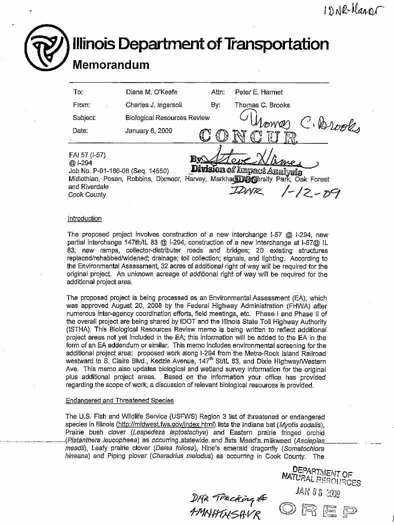


MEMORANDUM
To: Angela LaPorte
Illinois Toll Highway Authority 2700 Ogden Ave. Downer’s Grove, IL 60515
From: Dr. David A. Enstrom, Ornithologist Illinois Natural History Survey 1816 S. Oak Street, Room 235 Champaign IL 61820
Date: 12 January 2009 Subject: Avian Census of the I-294 / I-57 interchange project area. The Illinois Toll Highway Authority requested a survey of the birds in the I-294/I-57 project area be conducted in 2008. We conducted avian surveys in the project area from May through October, 2008. Most of the study area is comprised of urban landscapes but the area includes several natural areas and parks (i.e. prairies, forest, wetlands, and shrublands). Point counts were conducted in representative natural habitats. Some of the census areas include habitat that falls within 150 ft of the project center line. All censuses were conducted within 1 mile of the project center line. Methods Censuses
Censuses were conducted in the project area during the spring migration, breeding, and fall migration seasons (Table 1). These periods characterize the major annual changes in the diversity of bird populations in Illinois. Eleven census points were established in representative bird habitat within the project area (Figures 1-3; Table 2) and modified point-counts (Smith et al. 1993, Hunter et al.1992, Thompson et al. 1992) were used to determine the composition of bird communities in these areas. All individuals seen or heard within 165 ft (50 m) of each census point were recorded for 10-min during each visit. During spring and summer, all point censuses were conducted between one half hour before dawn (a half hour after the birds begin to sing) and 1100 h (when birds are entering the mid-day activity lull). Fall censuses were conducted

2
throughout the day. Timed counts provide measures of the structure of bird communities (e.g., number of individuals and number of species) within the various habitat types. Census areas were selected to represent all of the habitat types that occur in the study area.

Other Assessments Species formally classified as endangered or threatened may not be the only
ones that are subject to significant threats or which should be considered when assessing the value of a parcel of land. Many species of songbirds that occur in the Midwest (passing through or breeding) are Neotropical migrants (i.e. they spend most of the year in lower, subtropical or tropical, latitudes and breed in higher latitudes). These species are generally area-sensitive (i.e. there is some critical amount of habitat required for them to breed) and their preservation is a topic of concern for conservation groups and governmental entities. Partners in Flight (PF), http://www.partnersinflight.org/, a working group of North American avian ecologists (Thompson et al. 1992; Panjabi et al. 2005) has developed a list of species of concern for specific regions of the US. Species of concern for the upper Midwest, including Illinois, are indicated in Tables 3 and 4. The American Bird Conservancy and the National Audubon Society have built on the PF ranking approach, which is limited to land birds, to generate The US Watch List for birds. This list consists of 172 US bird species that the group calculates to be of greatest conservation concern, http://www.abcbirds.org/abcprograms/science/watchlist/index.html. Species with Watch List designation are also indicated in Tables 1 and 2. Finally, the IDNR has identified bird Species in Greatest Need of Conservation for Illinois (Illinois conservation priority species, ILCP) in The Illinois Comprehensive Wildlife Action Plan, http://www.dnr.state.il.us/ORC/WildlifeResources/theplan/birds.asp. These species are indicated in Tables 3 and 4. Table 1. Seasons of Avian Life Cycles in Illinois.
Season Dates
Spring migration
1 March to 30 April
Breeding
1 May to 31 August
Fall migration
1 September to 30 November

4
Table 2. Location and habitat descriptions of bird census.
Census area
Location: UTM and Area Description Habitat Description 1 445720 E Kickapoo Meadows, FPD
4609316 N Riparian forest
2 445622 E Kickapoo Meadows, FPD 4609544 N
Riparian forest/shrubland 3 445622 E Kickapoo Meadows, FPD
4609654 N Non-native grassland and shrubland
4 440018 E Midlothian Meadows, FPD 4606903 N
Upland forest 5 439383 E Midlothian Meadows, FPD
4606432 N Upland forest
6 439057 E Midlothian Meadows, FPD 4606163 N
Marsh 7 439326 E Midlothian Meadows, FPD
4606145 N Non-native grassland
8 443224 E Markham Prairie East 4606966 N
Shrubland
9 442789 E Markham Prairie 4606455 N
Sedge meadow, native prairie
10 442356 E Markham Prairie 4606257 N
Native prairie
11 443354 E I-294 and 167th Street 4604280
Non-native grass, shrubland
Census Results
A total of 94 species of birds belonging to 34 families were observed in the project area during the censuses in 2008 (Table 4). No listed species were encountered in the project area. Henslow’s sparrows have been known to breed at Markam Prairie (Figure 3) however none were seen our censuses. Spring Spring censuses were conducted on May 7th and 13th of 2008. A total of 86 species of 22 families were recorded in the project area during the spring (Table 4). All species were detected within 1 mile of the project center line. Twenty-six species were recorded within 150 ft of the project center line (Table 4). No listed species were encountered. Eleven species designated as species of concern by the Illinois Wildlife Action Plan. Nine species designated as species of concern by Partners in Flight, and one species designated as watch-list species by The American Bird Conservancy and the National Audubon Society were encountered in the study area during the spring

5
(Table 4). Five of these species, field sparrow, brown thrasher and common flicker, Baltimore oriole and eastern kingbird, were found within 150 feet of the center line. All five species prefer open habitats. Breeding Season Breeding season censuses were conducted between June 12th and 13th and July 28th 2008. A total of 58 species of 17 families were recorded in the project area during the breeding season (Table 5). All species were detected within 1 mile of the project center line, and all but one of these species (the ring-billed gull) breed in the area. Thirty-one species were recorded within 150 ft of the project center line (Table 5). No listed species were encountered during the breeding season. Seven species designated as species of concern by the Illinois Wildlife Action Plan, eleven species designated as species of concern by Partners in Flight, and one species designated as watch-list species by The American Bird Conservancy and the National Audubon Society were encountered in the study area during the breeding season (Table 4). Four of these species, field sparrow, brown thrasher, common flicker and eastern kingbird, were found within 150 feet of the center line and breed there. All four species prefer open habitats. Fall Migration
Fall censuses were conducted on September 3rd and October 1st 2008. A total of 53 species of 16 families were recorded in the project area during the fall (Table 6). All species were detected within 1 mile of the project center. Thirty species were recorded within 150 ft of the project center line (Table 5). Eight sandhill cranes (Illinois Threatened) were seen flying high over census area 7 on October 1st. Five species designated as species of concern by the Illinois Wildlife Action Plan, six species designated as species of concern by Partners in Flight, and one species designated as watch-list species by The American Bird Conservancy and the National Audubon Society were encountered in the study area during the fall (Table 6). Two of these species, field sparrow and common flicker, were found within 150 feet of the center line and breed there. Both species prefer open habitats.
SUMMARY
A total of 94 bird species representing 34 families of birds were observed during the avian census of the I-294/I-57 project area. Only one listed species, the sandhill crane (Illinois Threatened) was found in the area. The cranes were in a flock high over census area seven flying south.
Most of the area is highly developed. Two Cook County Forest Preserves areas occur within 1 mile of the project center line. These areas support a good diversity of bird species, especially during migration. In the past, henslow’s sparrow (Illinois Threatened) has nested in the area. I did not find this species during my censuses.
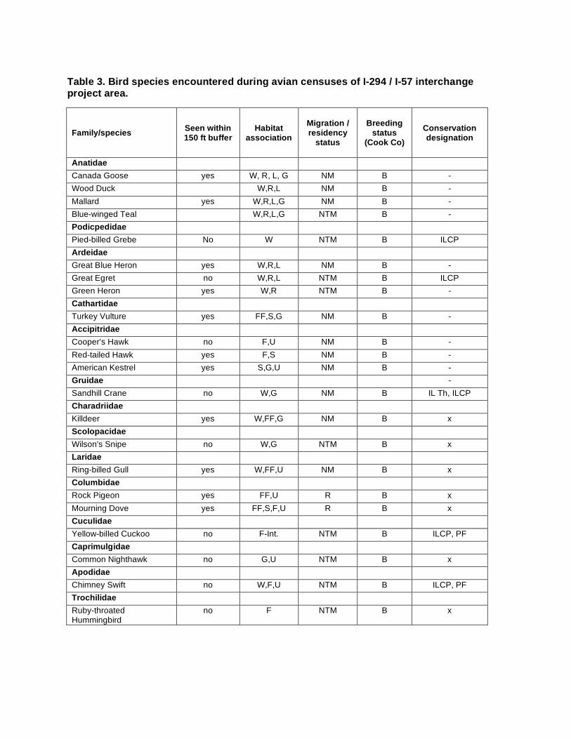
Table 3. Bird species encountered during avian censuses of I-294 / I-57 interchange project area.
Family/species Seen within 150 ft buffer
Habitat association
Migration / residency
status Breeding
status (Cook Co)
Conservation designation
Anatidae Canada Goose yes W, R, L, G NM B - Wood Duck W,R,L NM B - Mallard yes W,R,L,G NM B - Blue-winged Teal W,R,L,G NTM B - Podicpedidae Pied-billed Grebe No W NTM B ILCP Ardeidae Great Blue Heron yes W,R,L NM B - Great Egret no W,R,L NTM B ILCP Green Heron yes W,R NTM B - Cathartidae Turkey Vulture yes FF,S,G NM B - Accipitridae Cooper’s Hawk no F,U NM B - Red-tailed Hawk yes F,S NM B - American Kestrel yes S,G,U NM B - Gruidae - Sandhill Crane no W,G NM B IL Th, ILCP Charadriidae Killdeer yes W,FF,G NM B x Scolopacidae Wilson's Snipe no W,G NTM B x Laridae Ring-billed Gull yes W,FF,U NM B x Columbidae Rock Pigeon yes FF,U R B x Mourning Dove yes FF,S,F,U R B x Cuculidae Yellow-billed Cuckoo no F-Int. NTM B ILCP, PF Caprimulgidae Common Nighthawk no G,U NTM B x Apodidae Chimney Swift no W,F,U NTM B ILCP, PF Trochilidae Ruby-throated Hummingbird
no F NTM B x

7
Table 3. continued
Family/species Seen within
150 ft of center line
Habitat association
Migration / residency
status Breeding
status (Cook Co)
Conservation designation
Picidae Red-headed Woodpecker no F NM B ILCP, WL, PF Red-bellied Woodpecker yes F,U R B x Downy Woodpecker yes S,G,F,U R B x Hairy Woodpecker no F R B x Northern Flicker yes S,G,F,U NM B ILCP, PF Tyrannidae Eastern Wood-Pewee no F NTM B x Willow Flycatcher yes S NTM B ILCP, PF Least Flycatcher no F NTM B x Eastern Phoebe yes S,G NM B x Great Crested Flycatcher no F NTM B PF Eastern Kingbird yes G NTM B PF Vireonidae White-eyed Vireo yes S,F NM B x Yellow-throated Vireo no F NTM B x Blue-headed Vireo no F NM B x Warbling Vireo no S NTM B x Philadelphia Vireo no F NTM B x Red-eyed Vireo no F NTM B x Corvidae Blue Jay yes S,G,F,U NM B x American Crow yes S,G,F,U NM B x Hirundinidae Barn Swallow yes W,R,S,G,U R B x Paridae Black-capped Chickadee no F,S R B x Sittidae White-breasted Nuthatch no F R B x Certhiidae Brown Creeper no R,F NM B ILCP Troglodytidae House Wren yes F,S,U NTM B x Regulidae Ruby-crowned Kinglet no F,S,U NM NB x Sylviidae Blue-gray Gnatcatcher no F NTM B x Turdidae Eastern Bluebird no S,G R B x Veery no F,S NTM B x Gray-cheeked Thrush no F,S NTM NB x Swainson’s Thrush no F,S NTM NB x

8
Table 3. continued
Family/species Seen within
150 ft of center line
Habitat association
Migration / residency
status Breeding
status (Cook Co)
Conservation designation
Turdidae Wood Thrush no F NTM B ILCP, PF American Robin yes FF,S,G,F,U NM B x Mimidae Gray Catbird yes S,F,U NTM B x Brown Thrasher yes S,F,U NM B ILCP, PF Sturnidae European Starling yes FF,S,G, F,U NM B x Parulidae Tennessee Warbler no S,F,U NTM NB x Nashville Warbler no S,F,U NTM NB x Northern Parula no R,F NTM B x Yellow Warbler no S,SV NTM B x Chestnut-sided Warbler no F,S NTM B x Magnolia Warbler yes S,F,U NTM NB x Cape May Warbler no S,F,U NTM NB x Black-throated Green Warbler
no Yellow-rumped Warbler yes S,F,U NM NB x Blackburnian Warbler no S,F,U NTM NB x Palm Warbler no S,G,F,U NTM B x Bay-breasted Warbler no S,F,U NTM NB WL Blackpoll Warbler no S,F,U NTM NB x Black-and-white Warbler no S,F NTM B x American Redstart yes R,S,F NTM B x Ovenbird no F NTM B ILCP Northern Waterthrush no W,R,S,F,U NTM NB x Common Yellowthroat yes W NTM B x Thraupidae Scarlet Tanager no F NTM B x Emberizidae Eastern Towhee no F,S NM B x Field Sparrow yes S,G NM B ILCP, PF Savannah Sparrow no FF,G NM B ILCP Song Sparrow yes F,S,U NM B x Swamp Sparrow no W,S,U NM B x White-throated Sparrow no F,S,U NM NB x White-crowned Sparrow no S,G,U NM NB x Cardinalidae Northern Cardinal no F,S,U R B x Rose-breasted Grosbeak no F NTM B x Indigo Bunting yes S,SV,F,U NTM B x

9
Table 3. continued
Family/species Seen within
150 ft of center line
Habitat association
Migration / residency
status Breeding
status (Cook Co)
Conservation designation
Icteridae Red-winged Blackbird yes W,L,FF,S,G NM B x Eastern Meadowlark no G NM B PF Common Grackle no W,L,FF,S,G NM B x Brown-headed Cowbird no W,L,FF,S,G NM B x Baltimore Oriole no F,G NTM B PF Fringillidae House Finch no S,U R B x American Goldfinch yes FF,S,U R B x Passeridae House Sparrow yes FF,U R B x
Migratory/Residency Status: M = North American migrant, NT = Neotropical migrant, N = non-migratory, R = resident. Habitat association : W = wetland, R = rivers and streams, L = lakes and ponds, FF = farm fields, S = shrub, G = grassland, SV = savanna, F = forest/woodlot, U = urban / suburban. Conservation designations: IL T = Illinois threatened, IL E = Illinois endangered, ILCP = The Illinois Comprehensive Wildlife Action Plan http://www.dnr.state.il.us/ORC/WildlifeResources/theplan/birds.asp conservation priority species, WL = The American Bird Conservancy http://www.abcbirds.org/abcprograms/science/watchlist/index.html Watch List species, PF = The Partners in Flight species of special concern http://www.rmbo.org/pif/downloads/downloads.html.

10
Table 4. Avian census results for spring 2008 census of the I-294/I-57 project area.
Census areas Family/Species
Migration and
Breeding Status
Conservation Designation
Within 150 ft buffer 1 2 3 4 5 6 7 8 9 10 11 Total
Anatidae Canada Goose NM/B x yes 0 0 0 0 0 12 0 0 0 0 2 14 Wood Duck NM/B x no 0 2 0 0 0 4 0 0 0 0 0 6 Mallard NM/B x yes 0 0 0 0 0 3 0 0 3 0 0 6 Blue-winged Teal NTM/B x 0 0 0 0 0 5 0 0 6 0 0 11 Ardeidae Great Blue Heron NM/B x yes 0 0 0 0 0 2 0 0 0 0 0 2 Great Egret NTM/B ILCP no 0 0 0 0 0 3 0 0 1 0 0 4 Cathartidae Turkey Vulture NM/B x yes 0 0 3 0 0 2 1 2 0 3 1 12 Accipitridae Cooper’s Hawk NM/B x no 1 0 0 0 0 0 0 0 0 0 0 1 Red-tailed Hawk NM/B x yes 0 0 1 0 0 0 1 2 0 1 2 7 American Kestrel NM/B x yes 0 0 1 0 0 1 0 0 1 0 0 3 Charadriidae Killdeer NM/B x yes 0 0 0 0 0 2 0 0 5 0 0 7 Scolopacidae Wilson's Snipe NTM/B x no 0 0 0 0 0 0 0 0 1 0 0 1 Laridae Ring-billed Gull NM/B x yes 0 0 0 0 0 3 0 0 0 0 3 6 Columbidae Rock Pigeon R/B x yes 0 0 6 0 0 0 0 0 0 0 3 9 Mourning Dove R/B x yes 3 2 2 0 2 0 0 4 0 0 0 13 Cuculidae Yellow-billed Cuckoo NTM/B ILCP, PF no 0 1 0 0 1 0 0 0 0 0 0 2

11
Table 4. continued
Census areas Family/Species
Migration and
Breeding Status
Conservation Designation
Within 150 ft buffer 1 2 3 4 5 6 7 8 9 10 11 Total
Caprimulgidae Common Nighthawk NTM/B x no 0 0 1 0 0 0 0 0 0 0 0 1 Apodidae Chimney Swift NTM/B ILCP, PF no 0 0 0 0 0 6 4 0 0 0 0 10 Trochilidae Ruby-throated Hummingbird NTM/B x no 0 0 0 0 0 1 0 1 0 0 0 2 Picidae Red-headed Woodpecker NM/B ILCP, WL, PF no 0 0 0 0 3 0 0 0 0 0 0 3 Red-bellied Woodpecker R/B x no 1 0 0 2 1 2 0 0 0 0 0 6 Downy Woodpecker R/B x yes 0 2 0 0 2 0 1 0 2 0 1 8 Northern Flicker NM/B ILCP, PF yes 3 2 2 1 1 0 5 3 3 4 0 24 Tyrannidae Eastern Wood-Pewee NTM/B x 0 1 0 1 2 0 0 0 0 0 0 4 Least Flycatcher NTM/B x 0 0 1 0 0 0 0 0 0 0 0 1 Eastern Phoebe NM/B x yes 0 0 2 0 0 1 0 0 1 0 1 5 Eastern Kingbird NTM/B PF yes 0 0 0 0 0 0 3 1 0 2 0 6 Vireonidae Yellow-throated Vireo NTM/B x no 0 1 0 1 0 0 0 0 0 0 0 2 Blue-headed Vireo NTM/NB x no 1 0 0 0 0 0 0 0 0 0 0 1 Philadelphia Vireo NTM/NB x no 0 1 0 0 0 0 0 0 0 0 0 1 Red-eyed Vireo NTM/B x no 1 1 0 2 1 0 0 0 0 0 0 5 Corvidae Blue Jay NM/B x yes 2 0 1 0 4 0 0 0 1 0 3 11 American Crow NM/B x yes 0 1 6 0 0 0 0 3 0 0 0 10 Hirundinidae Tree Swallow NM/B 0 0 0 0 0 11 6 0 0 0 0 17 Barn Swallow NTM/B x yes 0 0 3 0 0 0 3 0 5 11 0 22
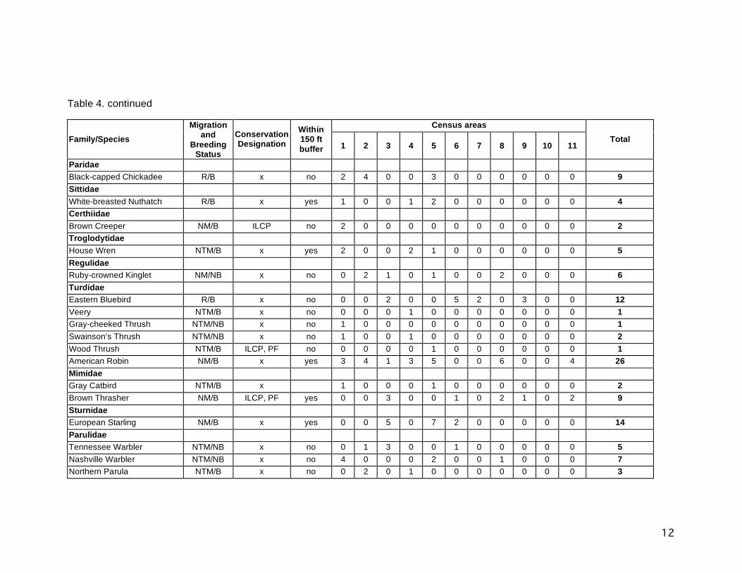
12
Table 4. continued
Census areas Family/Species
Migration and
Breeding Status
Conservation Designation
Within 150 ft buffer 1 2 3 4 5 6 7 8 9 10 11 Total
Paridae Black-capped Chickadee R/B x no 2 4 0 0 3 0 0 0 0 0 0 9 Sittidae White-breasted Nuthatch R/B x yes 1 0 0 1 2 0 0 0 0 0 0 4 Certhiidae Brown Creeper NM/B ILCP no 2 0 0 0 0 0 0 0 0 0 0 2 Troglodytidae House Wren NTM/B x yes 2 0 0 2 1 0 0 0 0 0 0 5 Regulidae Ruby-crowned Kinglet NM/NB x no 0 2 1 0 1 0 0 2 0 0 0 6 Turdidae Eastern Bluebird R/B x no 0 0 2 0 0 5 2 0 3 0 0 12 Veery NTM/B x no 0 0 0 1 0 0 0 0 0 0 0 1 Gray-cheeked Thrush NTM/NB x no 1 0 0 0 0 0 0 0 0 0 0 1 Swainson’s Thrush NTM/NB x no 1 0 0 1 0 0 0 0 0 0 0 2 Wood Thrush NTM/B ILCP, PF no 0 0 0 0 1 0 0 0 0 0 0 1 American Robin NM/B x yes 3 4 1 3 5 0 0 6 0 0 4 26 Mimidae Gray Catbird NTM/B x 1 0 0 0 1 0 0 0 0 0 0 2 Brown Thrasher NM/B ILCP, PF yes 0 0 3 0 0 1 0 2 1 0 2 9 Sturnidae European Starling NM/B x yes 0 0 5 0 7 2 0 0 0 0 0 14 Parulidae Tennessee Warbler NTM/NB x no 0 1 3 0 0 1 0 0 0 0 0 5 Nashville Warbler NTM/NB x no 4 0 0 0 2 0 0 1 0 0 0 7 Northern Parula NTM/B x no 0 2 0 1 0 0 0 0 0 0 0 3

13
Table 4. continued
Census areas Family/Species
Migration and
Breeding Status
Conservation Designation
Within 150 ft buffer 1 2 3 4 5 6 7 8 9 10 11 Total
Parulidae (continued) Yellow Warbler NTM/B x no 0 0 1 0 0 0 0 0 0 1 0 2 Chestnut-sided Warbler NTM/B x no 1 0 0 1 0 0 0 0 0 0 1 3 Magnolia Warbler NTM/NB x yes 2 1 0 1 3 0 0 1 0 0 0 8 Cape May Warbler NTM/NB x no 0 2 0 0 1 0 0 0 0 0 0 3 Black-throated Green Warbler NTM/NB no 0 3 0 1 0 0 0 0 0 0 0 4 Yellow-rumped Warbler NM/NB x yes 4 3 3 2 3 2 0 2 0 0 2 21 Blackburnian Warbler NTM/NB x no 3 0 0 0 0 0 0 0 0 0 0 3 Palm Warbler NTM/B x no 5 3 0 0 0 7 11 6 5 3 2 42 Bay-breasted Warbler NTM/NB WL no 0 2 0 0 0 0 0 0 0 0 0 2 Blackpoll Warbler NTM/NB x no 0 2 0 0 0 0 0 0 0 0 0 2 Black-and-white Warbler NTM/B x no 0 1 0 0 0 0 0 0 0 0 0 1 American Redstart NTM/B x yes 2 1 0 1 0 0 0 0 0 0 0 4 Ovenbird NTM/B ILCP no 0 0 0 0 1 0 0 0 0 0 0 1 Northern Waterthrush NTM/NB x no 1 0 0 0 0 0 0 0 0 0 0 1 Common Yellowthroat NTM/B x yes 0 0 3 0 0 1 5 0 4 0 0 13 Thraupidae Scarlet Tanager NTM/B x no 0 0 0 0 1 0 0 0 0 0 0 1 Emberizidae Eastern Towhee NM/B x no 2 0 0 2 0 0 0 0 0 0 0 4 Field Sparrow NM/B ILCP, PF yes 0 0 0 0 0 0 3 0 0 3 0 6 Savannah Sparrow NM/B ILCP no 0 0 0 0 0 0 0 0 1 0 0 1 Song Sparrow NM/B x yes 0 0 3 0 0 2 4 0 2 0 2 13 Swamp Sparrow NM/B x no 0 0 1 0 0 0 0 1 0 0 0 2 White-throated Sparrow NM/NB x no 4 0 0 0 0 0 0 0 0 0 0 4 White-crowned Sparrow NM/NB x no 0 0 0 0 0 3 5 0 0 4 0 12

14
Table 4. continued
Census areas Family/Species
Migration and
Breeding Status
Conservation Designation
Within 150 ft buffer 1 2 3 4 5 6 7 8 9 10 11 Total
Cardinalidae Northern Cardinal R/B x yes 2 1 2 0 2 0 0 0 0 0 3 10 Rose-breasted Grosbeak NTM/B x no 1 0 0 0 1 0 0 0 0 0 0 2 Indigo Bunting NTM/B x yes 0 0 3 0 0 2 3 1 4 0 2 15 Icteridae Red-winged Blackbird NM/B x yes 0 0 15 0 0 0 5 6 5 2 0 33 Eastern Meadowlark NM/B PF no 0 0 3 0 0 2 1 0 3 0 0 9 Common Grackle NM/B x no 10 0 0 3 0 0 0 0 0 0 6 19 Brown-headed Cowbird NM/B x no 2 1 1 0 1 0 0 0 0 0 0 5 Baltimore Oriole NTM/B PF yes 0 1 0 0 2 0 0 0 0 0 0 3 Fringillidae House Finch R/B x no 0 0 0 0 0 0 0 2 0 1 0 3 American Goldfinch R/B x yes 0 0 9 0 0 0 4 3 6 4 3 29 Passeridae House Sparrow R/B x yes 0 0 6 0 0 2 0 0 0 0 7 15 Number of individuals 69 50 97 31 60 94 74 57 72 49 61 714 Number of species 29 27 30 18 27 27 18 19 21 12 19 86 Migration status: R = resident, NM = North American Migrant, NTM = Neotropical Migrant. Breeding status: B = breeds in Cook County, NB = does not breed in Cook County. Conservation designations: IL T = Illinois threatened, IL E = Illinois endangered, ILCP = The Illinois Comprehensive Wildlife Action Plan http://www.dnr.state.il.us/ORC/WildlifeResources/theplan/birds.asp conservation priority species, WL = The American Bird Conservancy http://www.abcbirds.org/abcprograms/science/watchlist/index.html Watch List species, PF = The Partners in Flight species of special concern http://www.rmbo.org/pif/downloads/downloads.html.

15
Table 5. Avian census results for breeding season 2008 census of the I-294/I-57 project area.
Census area Family/species
Migration and
Breeding Status
Conservation Designation
Within 150 ft buffer 1 2 3 4 5 6 7 8 9 10 11
Total
Anatidae Canada Goose NM/B x yes 0 0 0 0 0 4 0 0 0 0 0 4 Mallard NM/B x yes 0 0 1 0 0 5 0 0 1 0 0 7 Ardeidae Great Blue Heron NM/B x yes 0 0 0 0 0 3 0 0 1 0 0 4 Green Heron NM/B x no 1 0 0 0 0 1 0 0 0 0 0 2 Cathartidae Turkey Vulture NM/B x yes 0 0 3 0 0 1 3 0 2 4 0 13 Accipitridae Cooper’s Hawk NM/B x no 0 1 0 0 1 0 0 0 0 0 0 2 Red-tailed Hawk NM/B x yes 0 0 2 0 0 0 2 2 1 0 0 7 American Kestrel NM/B x yes 0 0 0 0 0 0 0 1 0 1 0 2 Charadriidae Killdeer NM/B x yes 0 0 2 0 0 0 0 3 0 4 0 9 Laridae Ring-billed Gull NM/NB x yes 0 0 0 0 0 2 0 0 0 0 0 2 Columbidae Mourning Dove R/B x yes 2 1 3 2 0 3 2 4 0 1 2 20 Apodidae Chimney Swift NTM/B ILCP, PF no 0 0 3 0 0 0 0 0 0 0 0 3 Picidae Red-headed Woodpecker NM/B ILCP, WL, PF no 0 0 0 0 3 0 0 0 0 0 0 3 Red-bellied Woodpecker R/B x no 2 3 0 2 1 3 0 1 0 0 0 12 Downy Woodpecker R/B x yes 1 1 2 1 1 0 1 1 2 0 1 11 Hairy Woodpecker R/B x no 0 0 0 0 1 0 0 0 0 0 0 1 Northern Flicker NM/B ILCP, PF yes 1 0 3 0 1 2 0 0 4 2 0 13

16
Table 5. continued
Census area Family/species
Migration and
Breeding Status
Conservation Designation
Within 150 ft buffer 1 2 3 4 5 6 7 8 9 10 11
Total
Tyrannidae Eastern Wood-Pewee NTM/B x 2 1 0 2 1 0 0 0 0 0 0 6 Willow Flycatcher NTM/B ILCP, PF no 0 0 2 0 0 0 0 0 0 0 0 2 Eastern Phoebe NM/B x yes 0 0 1 0 0 1 2 0 1 0 1 6 Great Crested Flycatcher NTM/B PF no 1 1 0 2 2 0 0 0 0 0 0 6 Eastern Kingbird NTM/B PF yes 0 0 1 0 0 1 2 0 2 1 0 7 Vireonidae White-eyed Vireo NTM/B x yes 0 0 1 0 0 1 0 2 1 0 0 5 Yellow-throated Vireo NTM/B x no 1 0 0 1 0 0 0 0 0 0 0 2 Warbling Vireo NTM/B x no 0 0 1 0 0 2 0 1 0 1 3 8 Red-eyed Vireo NTM/B x no 1 3 0 2 3 0 0 0 0 0 0 9 Corvidae Blue Jay NM/B x yes 4 3 0 2 1 3 0 1 0 3 0 17 American Crow NM/B x yes 0 1 3 0 0 2 4 3 0 2 0 15 Hirundinidae Barn Swallow NTM/B x yes 0 0 5 0 0 6 4 0 5 0 0 20 Paridae Black-capped Chickadee R/B x no 1 3 0 0 2 0 0 0 0 0 0 6 Sittidae White-breasted Nuthatch R/B x yes 1 0 0 1 2 0 0 2 0 0 0 6 Troglodytidae House Wren NTM/B x yes 3 2 1 0 2 0 0 1 0 0 0 9 Sylviidae Blue-gray Gnatcatcher NTM/B x no 1 0 0 0 1 0 0 0 0 0 0 2 Turdidae Eastern Bluebird R/B x no 0 0 4 0 0 3 0 0 0 2 0 9 Wood Thrush NTM/B ILCP, PF no 1 0 0 0 1 0 0 0 0 0 0 2 American Robin NM/B x yes 2 3 2 3 2 5 2 2 0 1 4 26

17
Table 5. continued
Census area Family/species
Migration and
Breeding Status
Conservation Designation
Within 150 ft buffer 1 2 3 4 5 6 7 8 9 10 11
Total
Mimidae Gray Catbird NTM/B x no 0 2 0 1 0 0 0 0 0 0 0 3 Brown Thrasher NM/B ILCP, PF yes 0 0 1 0 0 2 1 2 1 0 1 8 Sturnidae European Starling NM/B x yes 0 2 1 2 0 9 0 6 0 0 0 20 Parulidae Yellow Warbler NTM/B x no 0 0 0 0 0 0 0 2 0 0 2 4 Ovenbird NTM/B ILCP no 0 0 0 0 1 0 0 0 0 0 0 1 Common Yellowthroat NTM/B x yes 0 0 3 0 0 3 1 0 5 3 0 15 Thraupidae Scarlet Tanager NTM/B x no 1 0 0 1 1 0 0 0 0 0 0 3 Emberizidae Eastern Towhee NM/B x no 0 3 0 2 1 0 0 0 0 0 0 6 Field Sparrow NM/B ILCP, PF yes 0 0 2 0 0 0 3 0 3 2 0 10 Savannah Sparrow NM/B ILCP no 0 0 0 0 0 0 1 0 0 0 0 1 Song Sparrow NM/B x yes 0 0 3 1 0 3 1 2 4 1 2 17 Cardinalidae Northern Cardinal R/B x yes 1 2 0 3 1 2 0 3 0 0 4 16 Rose-breasted Grosbeak NTM/B x no 2 1 0 1 1 0 0 0 0 0 0 5 Indigo Bunting NTM/B x yes 0 0 2 0 0 3 1 1 2 3 1 13 Icteridae Red-winged Blackbird NM/B x yes 0 0 5 0 0 7 0 4 3 0 6 25 Eastern Meadowlark NM/B PF no 0 0 3 0 0 0 4 0 6 4 0 17 Common Grackle NM/B x no 0 4 0 4 0 3 0 0 0 2 9 22 Brown-headed Cowbird NM/B x yes 1 0 0 3 1 5 0 2 0 5 0 17 Baltimore Oriole NTM/B PF no 0 1 0 0 1 1 0 0 0 0 0 3

18
Table 5. continued
Census area Family/species
Migration and
Breeding Status
Conservation Designation
Within 150 ft buffer 1 2 3 4 5 6 7 8 9 10 11
Total
Fringillidae House Finch R/B x no 0 0 0 0 0 0 0 2 0 3 0 5 American Goldfinch R/B x yes 0 0 6 0 0 3 5 3 7 1 3 28 Passeridae House Sparrow R/B x yes 0 0 0 0 0 0 0 5 0 0 0 5 Number of individuals 31 40 69 40 37 95 46 64 60 56 50 588 Number of species 20 19 27 19 23 29 17 24 18 20 13 58 Migration status: R = resident, NM = North American Migrant, NTM = Neotropical Migrant. Breeding status: B = breeds in Cook County, NB = does not breed in Cook County. Conservation designations: IL T = Illinois threatened, IL E = Illinois endangered, ILCP = The Illinois Comprehensive Wildlife Action Plan http://www.dnr.state.il.us/ORC/WildlifeResources/theplan/birds.asp conservation priority species, WL = The American Bird Conservancy http://www.abcbirds.org/abcprograms/science/watchlist/index.html Watch List species, PF = The Partners in Flight species of special concern http://www.rmbo.org/pif/downloads/downloads.html.

19
Table 6. Avian census results for fall 2008 census of the I-294/I-57 project area.
Census area Family/species
Migration and
Breeding Status
Conservation Designation
Within 150 ft buffer 1 2 3 4 5 6 7 8 9 10 11
Total
Anatidae Canada Goose NM/B x yes 0 0 0 0 0 15 0 0 0 0 0 15 Mallard NM/B x yes 0 0 0 0 0 11 0 0 0 0 0 11 Northern Shoveler NM/B x no 0 0 0 0 0 4 0 0 0 0 0 4 Ardeidae Great Blue Heron NM/B x yes 0 0 0 0 0 3 0 0 0 0 0 3 Cathartidae Turkey Vulture NM/B x yes 0 0 6 0 0 3 0 0 2 1 2 14 Accipitridae Cooper’s Hawk NM/B x no 0 0 0 0 0 1 0 0 0 0 0 1 Red-tailed Hawk NM/B x yes 0 0 2 0 0 0 0 2 0 1 0 5 American Kestrel NM/B x yes 0 0 0 0 0 0 2 0 1 0 0 3 Gruidae Sandhill Crane NM/B IL T, ILCP no 0 0 0 0 0 0 8 0 0 0 0 8 Charadriidae Killdeer NM/B x yes 0 0 0 0 0 2 3 2 2 6 0 15 Laridae Ring-billed Gull NM/NB x yes 0 0 0 0 0 3 0 0 0 0 5 8 Columbidae Mourning Dove R/B x yes 3 5 7 0 3 0 0 3 0 2 3 26 Picidae Red-headed Woodpecker NM/B ILCP, WL, PF no 0 0 0 0 4 0 0 0 0 0 0 4 Red-bellied Woodpecker R/B x no 2 1 0 4 2 0 0 0 0 0 0 9 Downy Woodpecker R/B x yes 2 0 2 1 1 2 0 2 0 0 1 11 Northern Flicker NM/B ILCP, PF yes 0 3 5 0 3 1 5 0 3 0 0 20

20
Table 6. continued
Census area Family/species
Migration and
Breeding Status
Conservation Designation
Within 150 ft buffer 1 2 3 4 5 6 7 8 9 10 11
Total
Tyrannidae Eastern Phoebe NM/B x yes 1 0 0 0 1 0 2 0 0 2 1 7 Vireonidae Red-eyed Vireo NTM/B x no 0 1 0 1 0 0 0 0 0 0 0 2 Corvidae Blue Jay NM/B x yes 5 2 0 3 0 3 6 0 0 0 0 19 American Crow NM/B x yes 0 3 5 0 0 0 0 6 0 4 0 18 Hirundinidae Barn Swallow NTM/B x yes 0 0 0 0 0 2 0 0 0 4 0 6 Paridae Black-capped Chickadee R/B x no 1 3 4 0 3 0 0 0 0 2 0 13 Sittidae White-breasted Nuthatch R/B x yes 1 0 0 1 2 1 0 1 0 0 0 6 Troglodytidae House Wren NTM/B x yes 2 1 0 0 0 2 0 0 0 0 0 5 Regulidae Ruby-crowned Kinglet NTM/NB x no 0 0 1 0 0 0 0 1 0 0 0 2 Turdidae Eastern Bluebird R/B x no 0 0 3 0 0 4 0 0 0 2 0 9 Swainson’s Thrush NTM/NB x no 0 2 0 1 2 0 0 0 0 0 0 5 Wood Thrush NTM/B ILCP, PF no 1 0 0 0 0 0 0 0 0 0 0 1 American Robin x yes 3 7 2 6 0 2 0 4 2 3 0 29 Mimidae Gray Catbird NTM/B x no 0 1 0 0 2 0 0 0 1 0 0 4 Sturnidae European Starling NM/B x yes 0 0 0 0 7 0 0 0 15 0 0 22

21
Table 6. continued
Census area Family/species
Migration and
Breeding Status
Conservation Designation
Within 150 ft buffer 1 2 3 4 5 6 7 8 9 10 11
Total
Parulidae Black-throated Green Warbler NTM/NB
x no 0 1 0 0 0 0 0 0 0 0 0 1
Yellow-rumped Warbler NTM/NB x yes 3 0 0 2 1 2 0 0 0 5 0 13 Palm Warbler NTM/NB x yes 0 0 3 0 0 1 4 3 2 1 0 14 Blackpoll Warbler NTM/NB x no 0 1 0 0 0 0 0 0 0 0 0 1 American Redstart NTM/B x yes 1 2 0 0 2 0 0 1 0 0 0 6 Common Yellowthroat NTM/B x yes 0 0 1 0 0 2 0 1 0 0 0 4 Emberizidae Eastern Towhee NM/B x no 1 2 0 1 0 0 0 0 0 0 0 4 Field Sparrow NM/B ILCP, PF yes 0 0 0 0 0 0 3 0 2 0 0 5 Chipping Sparrow NM/B x yes 0 0 0 0 0 2 1 0 0 2 0 5 Song Sparrow NM/B x yes 0 0 4 0 0 2 2 2 1 0 0 11 White-throated Sparrow NM/B x no 0 2 0 0 3 0 3 0 0 1 0 9 Cardinalidae Northern Cardinal R/B x yes 3 4 0 3 2 0 0 0 0 1 0 13 Rose-breasted Grosbeak NTM/B x no 0 0 0 1 0 0 0 0 0 0 0 1 Indigo Bunting NTM/B x yes 0 0 3 0 2 0 2 0 0 3 0 10 Icteridae Red-winged Blackbird NM/B x yes 0 0 6 0 0 1 0 5 0 6 0 18 Eastern Meadowlark NM/B PF no 0 0 2 0 0 0 1 1 3 2 0 9 Common Grackle NM/B x no 5 20 0 3 5 7 0 0 0 0 0 40 Brown-headed Cowbird NM/B x yes 0 7 0 0 7 0 0 0 0 0 0 14 Baltimore Oriole NTM/B PF no 1 0 0 0 0 0 0 0 0 0 0 1

22
Table 6. continued
Census area Family/species
Migration and
Breeding Status
Conservation Designation
Within 150 ft buffer 1 2 3 4 5 6 7 8 9 10 11
Total
Fringillidae House Finch R/B x no 0 0 2 0 0 0 0 3 0 0 0 5 American Goldfinch R/B x yes 0 0 7 0 0 3 2 6 4 3 0 25 Passeridae House Sparrow R/B x yes 0 0 0 0 0 0 0 7 0 0 6 13 Number of individuals 36 70 68 31 57 85 51 58 47 61 29 593 Number of species 16 19 18 11 18 24 14 17 12 19 6 53
Migration status: R = resident, NM = North American Migrant, NTM = Neotropical Migrant. Breeding status: B = breeds in Cook County, NB = does not breed in Cook County. Conservation designations: IL T = Illinois threatened, IL E = Illinois endangered, ILCP = The Illinois Comprehensive Wildlife Action Plan http://www.dnr.state.il.us/ORC/WildlifeResources/theplan/birds.asp conservation priority species, WL = The American Bird Conservancy http://www.abcbirds.org/abcprograms/science/watchlist/index.html Watch List species, PF = The Partners in Flight species of special concern http://www.rmbo.org/pif/downloads/downloads.html.
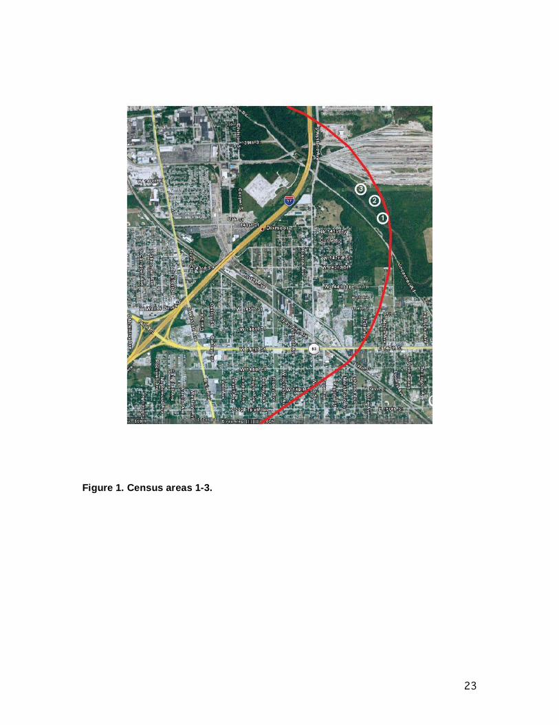
23
Figure 1. Census areas 1-3.

24
Figure 2. Census areas 4-7.

25
Figure 3. Census areas 8-11.

10
Table 4. Avian census results for spring 2008 census of the I-294/I-57 project area.
Census areas Family/Species
Migration and
Breeding Status
Conservation Designation
Within 150 ft buffer 1 2 3 4 5 6 7 8 9 10 11 Total
Anatidae Canada Goose NM/B x yes 0 0 0 0 0 12 0 0 0 0 2 14 Wood Duck NM/B x no 0 2 0 0 0 4 0 0 0 0 0 6 Mallard NM/B x yes 0 0 0 0 0 3 0 0 3 0 0 6 Blue-winged Teal NTM/B x 0 0 0 0 0 5 0 0 6 0 0 11 Ardeidae Great Blue Heron NM/B x yes 0 0 0 0 0 2 0 0 0 0 0 2 Great Egret NTM/B ILCP no 0 0 0 0 0 3 0 0 1 0 0 4 Cathartidae Turkey Vulture NM/B x yes 0 0 3 0 0 2 1 2 0 3 1 12 Accipitridae Cooper’s Hawk NM/B x no 1 0 0 0 0 0 0 0 0 0 0 1 Red-tailed Hawk NM/B x yes 0 0 1 0 0 0 1 2 0 1 2 7 American Kestrel NM/B x yes 0 0 1 0 0 1 0 0 1 0 0 3 Charadriidae Killdeer NM/B x yes 0 0 0 0 0 2 0 0 5 0 0 7 Scolopacidae Wilson's Snipe NTM/B x no 0 0 0 0 0 0 0 0 1 0 0 1 Laridae Ring-billed Gull NM/B x yes 0 0 0 0 0 3 0 0 0 0 3 6 Columbidae Rock Pigeon R/B x yes 0 0 6 0 0 0 0 0 0 0 3 9 Mourning Dove R/B x yes 3 2 2 0 2 0 0 4 0 0 0 13 Cuculidae Yellow-billed Cuckoo NTM/B ILCP, PF no 0 1 0 0 1 0 0 0 0 0 0 2

11
Table 4. continued
Census areas Family/Species
Migration and
Breeding Status
Conservation Designation
Within 150 ft buffer 1 2 3 4 5 6 7 8 9 10 11 Total
Caprimulgidae Common Nighthawk NTM/B x no 0 0 1 0 0 0 0 0 0 0 0 1 Apodidae Chimney Swift NTM/B ILCP, PF no 0 0 0 0 0 6 4 0 0 0 0 10 Trochilidae Ruby-throated Hummingbird NTM/B x no 0 0 0 0 0 1 0 1 0 0 0 2 Picidae Red-headed Woodpecker NM/B ILCP, WL, PF no 0 0 0 0 3 0 0 0 0 0 0 3 Red-bellied Woodpecker R/B x no 1 0 0 2 1 2 0 0 0 0 0 6 Downy Woodpecker R/B x yes 0 2 0 0 2 0 1 0 2 0 1 8 Northern Flicker NM/B ILCP, PF yes 3 2 2 1 1 0 5 3 3 4 0 24 Tyrannidae Eastern Wood-Pewee NTM/B x 0 1 0 1 2 0 0 0 0 0 0 4 Least Flycatcher NTM/B x 0 0 1 0 0 0 0 0 0 0 0 1 Eastern Phoebe NM/B x yes 0 0 2 0 0 1 0 0 1 0 1 5 Eastern Kingbird NTM/B PF yes 0 0 0 0 0 0 3 1 0 2 0 6 Vireonidae Yellow-throated Vireo NTM/B x no 0 1 0 1 0 0 0 0 0 0 0 2 Blue-headed Vireo NTM/NB x no 1 0 0 0 0 0 0 0 0 0 0 1 Philadelphia Vireo NTM/NB x no 0 1 0 0 0 0 0 0 0 0 0 1 Red-eyed Vireo NTM/B x no 1 1 0 2 1 0 0 0 0 0 0 5 Corvidae Blue Jay NM/B x yes 2 0 1 0 4 0 0 0 1 0 3 11 American Crow NM/B x yes 0 1 6 0 0 0 0 3 0 0 0 10 Hirundinidae Tree Swallow NM/B 0 0 0 0 0 11 6 0 0 0 0 17 Barn Swallow NTM/B x yes 0 0 3 0 0 0 3 0 5 11 0 22

12
Table 4. continued
Census areas Family/Species
Migration and
Breeding Status
Conservation Designation
Within 150 ft buffer 1 2 3 4 5 6 7 8 9 10 11 Total
Paridae Black-capped Chickadee R/B x no 2 4 0 0 3 0 0 0 0 0 0 9 Sittidae White-breasted Nuthatch R/B x yes 1 0 0 1 2 0 0 0 0 0 0 4 Certhiidae Brown Creeper NM/B ILCP no 2 0 0 0 0 0 0 0 0 0 0 2 Troglodytidae House Wren NTM/B x yes 2 0 0 2 1 0 0 0 0 0 0 5 Regulidae Ruby-crowned Kinglet NM/NB x no 0 2 1 0 1 0 0 2 0 0 0 6 Turdidae Eastern Bluebird R/B x no 0 0 2 0 0 5 2 0 3 0 0 12 Veery NTM/B x no 0 0 0 1 0 0 0 0 0 0 0 1 Gray-cheeked Thrush NTM/NB x no 1 0 0 0 0 0 0 0 0 0 0 1 Swainson’s Thrush NTM/NB x no 1 0 0 1 0 0 0 0 0 0 0 2 Wood Thrush NTM/B ILCP, PF no 0 0 0 0 1 0 0 0 0 0 0 1 American Robin NM/B x yes 3 4 1 3 5 0 0 6 0 0 4 26 Mimidae Gray Catbird NTM/B x 1 0 0 0 1 0 0 0 0 0 0 2 Brown Thrasher NM/B ILCP, PF yes 0 0 3 0 0 1 0 2 1 0 2 9 Sturnidae European Starling NM/B x yes 0 0 5 0 7 2 0 0 0 0 0 14 Parulidae Tennessee Warbler NTM/NB x no 0 1 3 0 0 1 0 0 0 0 0 5 Nashville Warbler NTM/NB x no 4 0 0 0 2 0 0 1 0 0 0 7 Northern Parula NTM/B x no 0 2 0 1 0 0 0 0 0 0 0 3
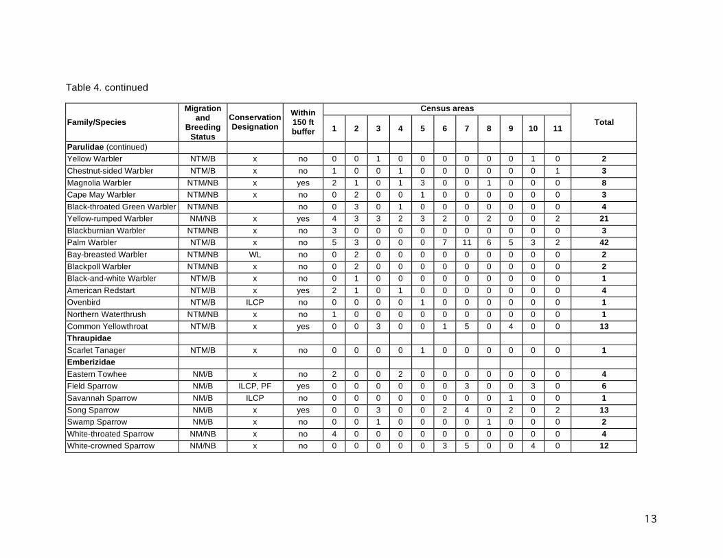
13
Table 4. continued
Census areas Family/Species
Migration and
Breeding Status
Conservation Designation
Within 150 ft buffer 1 2 3 4 5 6 7 8 9 10 11 Total
Parulidae (continued) Yellow Warbler NTM/B x no 0 0 1 0 0 0 0 0 0 1 0 2 Chestnut-sided Warbler NTM/B x no 1 0 0 1 0 0 0 0 0 0 1 3 Magnolia Warbler NTM/NB x yes 2 1 0 1 3 0 0 1 0 0 0 8 Cape May Warbler NTM/NB x no 0 2 0 0 1 0 0 0 0 0 0 3 Black-throated Green Warbler NTM/NB no 0 3 0 1 0 0 0 0 0 0 0 4 Yellow-rumped Warbler NM/NB x yes 4 3 3 2 3 2 0 2 0 0 2 21 Blackburnian Warbler NTM/NB x no 3 0 0 0 0 0 0 0 0 0 0 3 Palm Warbler NTM/B x no 5 3 0 0 0 7 11 6 5 3 2 42 Bay-breasted Warbler NTM/NB WL no 0 2 0 0 0 0 0 0 0 0 0 2 Blackpoll Warbler NTM/NB x no 0 2 0 0 0 0 0 0 0 0 0 2 Black-and-white Warbler NTM/B x no 0 1 0 0 0 0 0 0 0 0 0 1 American Redstart NTM/B x yes 2 1 0 1 0 0 0 0 0 0 0 4 Ovenbird NTM/B ILCP no 0 0 0 0 1 0 0 0 0 0 0 1 Northern Waterthrush NTM/NB x no 1 0 0 0 0 0 0 0 0 0 0 1 Common Yellowthroat NTM/B x yes 0 0 3 0 0 1 5 0 4 0 0 13 Thraupidae Scarlet Tanager NTM/B x no 0 0 0 0 1 0 0 0 0 0 0 1 Emberizidae Eastern Towhee NM/B x no 2 0 0 2 0 0 0 0 0 0 0 4 Field Sparrow NM/B ILCP, PF yes 0 0 0 0 0 0 3 0 0 3 0 6 Savannah Sparrow NM/B ILCP no 0 0 0 0 0 0 0 0 1 0 0 1 Song Sparrow NM/B x yes 0 0 3 0 0 2 4 0 2 0 2 13 Swamp Sparrow NM/B x no 0 0 1 0 0 0 0 1 0 0 0 2 White-throated Sparrow NM/NB x no 4 0 0 0 0 0 0 0 0 0 0 4 White-crowned Sparrow NM/NB x no 0 0 0 0 0 3 5 0 0 4 0 12

14
Table 4. continued
Census areas Family/Species
Migration and
Breeding Status
Conservation Designation
Within 150 ft buffer 1 2 3 4 5 6 7 8 9 10 11 Total
Cardinalidae Northern Cardinal R/B x yes 2 1 2 0 2 0 0 0 0 0 3 10 Rose-breasted Grosbeak NTM/B x no 1 0 0 0 1 0 0 0 0 0 0 2 Indigo Bunting NTM/B x yes 0 0 3 0 0 2 3 1 4 0 2 15 Icteridae Red-winged Blackbird NM/B x yes 0 0 15 0 0 0 5 6 5 2 0 33 Eastern Meadowlark NM/B PF no 0 0 3 0 0 2 1 0 3 0 0 9 Common Grackle NM/B x no 10 0 0 3 0 0 0 0 0 0 6 19 Brown-headed Cowbird NM/B x no 2 1 1 0 1 0 0 0 0 0 0 5 Baltimore Oriole NTM/B PF yes 0 1 0 0 2 0 0 0 0 0 0 3 Fringillidae House Finch R/B x no 0 0 0 0 0 0 0 2 0 1 0 3 American Goldfinch R/B x yes 0 0 9 0 0 0 4 3 6 4 3 29 Passeridae House Sparrow R/B x yes 0 0 6 0 0 2 0 0 0 0 7 15 Number of individuals 69 50 97 31 60 94 74 57 72 49 61 714 Number of species 29 27 30 18 27 27 18 19 21 12 19 86 Migration status: R = resident, NM = North American Migrant, NTM = Neotropical Migrant. Breeding status: B = breeds in Cook County, NB = does not breed in Cook County. Conservation designations: IL T = Illinois threatened, IL E = Illinois endangered, ILCP = The Illinois Comprehensive Wildlife Action Plan http://www.dnr.state.il.us/ORC/WildlifeResources/theplan/birds.asp conservation priority species, WL = The American Bird Conservancy http://www.abcbirds.org/abcprograms/science/watchlist/index.html Watch List species, PF = The Partners in Flight species of special concern http://www.rmbo.org/pif/downloads/downloads.html.

15
Table 5. Avian census results for breeding season 2008 census of the I-294/I-57 project area.
Census area Family/species
Migration and
Breeding Status
Conservation Designation
Within 150 ft buffer 1 2 3 4 5 6 7 8 9 10 11
Total
Anatidae Canada Goose NM/B x yes 0 0 0 0 0 4 0 0 0 0 0 4 Mallard NM/B x yes 0 0 1 0 0 5 0 0 1 0 0 7 Ardeidae Great Blue Heron NM/B x yes 0 0 0 0 0 3 0 0 1 0 0 4 Green Heron NM/B x no 1 0 0 0 0 1 0 0 0 0 0 2 Cathartidae Turkey Vulture NM/B x yes 0 0 3 0 0 1 3 0 2 4 0 13 Accipitridae Cooper’s Hawk NM/B x no 0 1 0 0 1 0 0 0 0 0 0 2 Red-tailed Hawk NM/B x yes 0 0 2 0 0 0 2 2 1 0 0 7 American Kestrel NM/B x yes 0 0 0 0 0 0 0 1 0 1 0 2 Charadriidae Killdeer NM/B x yes 0 0 2 0 0 0 0 3 0 4 0 9 Laridae Ring-billed Gull NM/NB x yes 0 0 0 0 0 2 0 0 0 0 0 2 Columbidae Mourning Dove R/B x yes 2 1 3 2 0 3 2 4 0 1 2 20 Apodidae Chimney Swift NTM/B ILCP, PF no 0 0 3 0 0 0 0 0 0 0 0 3 Picidae Red-headed Woodpecker NM/B ILCP, WL, PF no 0 0 0 0 3 0 0 0 0 0 0 3 Red-bellied Woodpecker R/B x no 2 3 0 2 1 3 0 1 0 0 0 12 Downy Woodpecker R/B x yes 1 1 2 1 1 0 1 1 2 0 1 11 Hairy Woodpecker R/B x no 0 0 0 0 1 0 0 0 0 0 0 1 Northern Flicker NM/B ILCP, PF yes 1 0 3 0 1 2 0 0 4 2 0 13
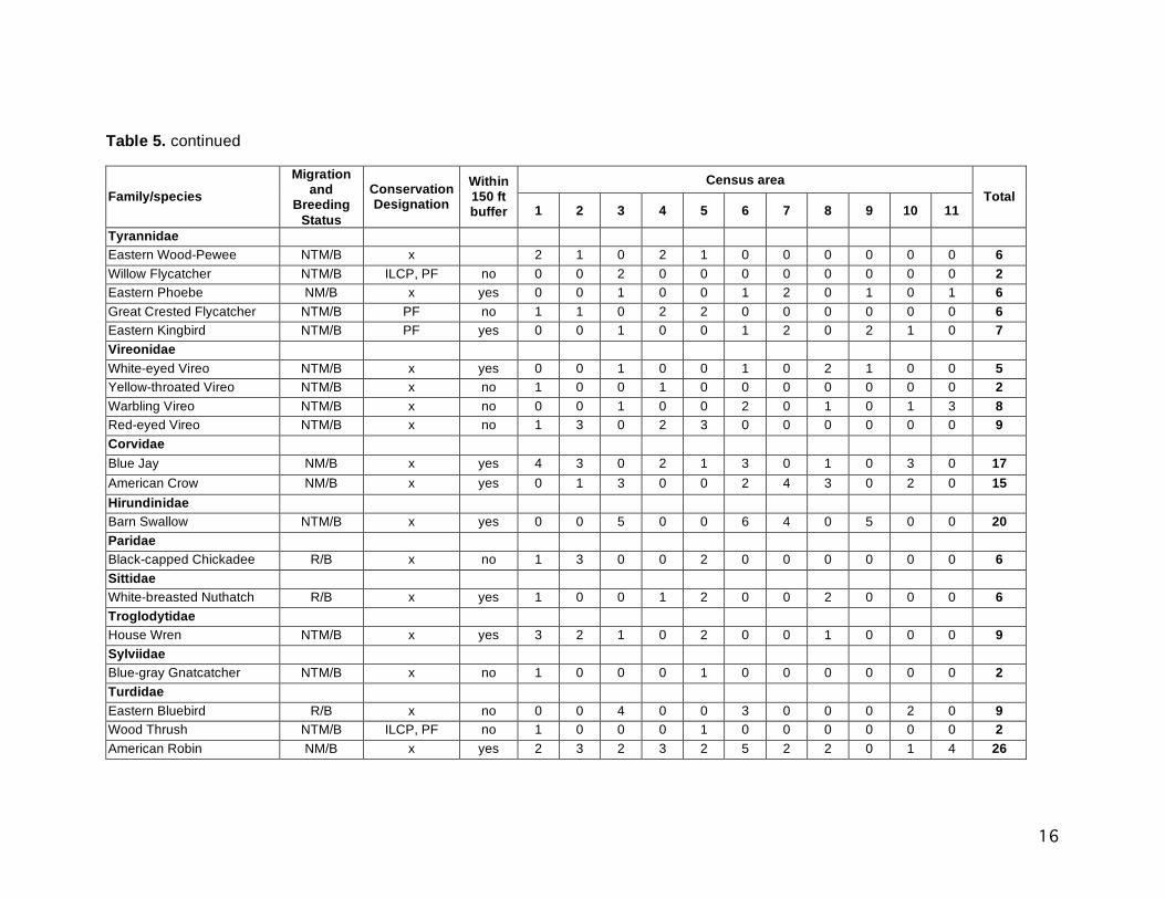
16
Table 5. continued
Census area Family/species
Migration and
Breeding Status
Conservation Designation
Within 150 ft buffer 1 2 3 4 5 6 7 8 9 10 11
Total
Tyrannidae Eastern Wood-Pewee NTM/B x 2 1 0 2 1 0 0 0 0 0 0 6 Willow Flycatcher NTM/B ILCP, PF no 0 0 2 0 0 0 0 0 0 0 0 2 Eastern Phoebe NM/B x yes 0 0 1 0 0 1 2 0 1 0 1 6 Great Crested Flycatcher NTM/B PF no 1 1 0 2 2 0 0 0 0 0 0 6 Eastern Kingbird NTM/B PF yes 0 0 1 0 0 1 2 0 2 1 0 7 Vireonidae White-eyed Vireo NTM/B x yes 0 0 1 0 0 1 0 2 1 0 0 5 Yellow-throated Vireo NTM/B x no 1 0 0 1 0 0 0 0 0 0 0 2 Warbling Vireo NTM/B x no 0 0 1 0 0 2 0 1 0 1 3 8 Red-eyed Vireo NTM/B x no 1 3 0 2 3 0 0 0 0 0 0 9 Corvidae Blue Jay NM/B x yes 4 3 0 2 1 3 0 1 0 3 0 17 American Crow NM/B x yes 0 1 3 0 0 2 4 3 0 2 0 15 Hirundinidae Barn Swallow NTM/B x yes 0 0 5 0 0 6 4 0 5 0 0 20 Paridae Black-capped Chickadee R/B x no 1 3 0 0 2 0 0 0 0 0 0 6 Sittidae White-breasted Nuthatch R/B x yes 1 0 0 1 2 0 0 2 0 0 0 6 Troglodytidae House Wren NTM/B x yes 3 2 1 0 2 0 0 1 0 0 0 9 Sylviidae Blue-gray Gnatcatcher NTM/B x no 1 0 0 0 1 0 0 0 0 0 0 2 Turdidae Eastern Bluebird R/B x no 0 0 4 0 0 3 0 0 0 2 0 9 Wood Thrush NTM/B ILCP, PF no 1 0 0 0 1 0 0 0 0 0 0 2 American Robin NM/B x yes 2 3 2 3 2 5 2 2 0 1 4 26
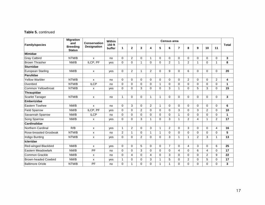
17
Table 5. continued
Census area Family/species
Migration and
Breeding Status
Conservation Designation
Within 150 ft buffer 1 2 3 4 5 6 7 8 9 10 11
Total
Mimidae Gray Catbird NTM/B x no 0 2 0 1 0 0 0 0 0 0 0 3 Brown Thrasher NM/B ILCP, PF yes 0 0 1 0 0 2 1 2 1 0 1 8 Sturnidae European Starling NM/B x yes 0 2 1 2 0 9 0 6 0 0 0 20 Parulidae Yellow Warbler NTM/B x no 0 0 0 0 0 0 0 2 0 0 2 4 Ovenbird NTM/B ILCP no 0 0 0 0 1 0 0 0 0 0 0 1 Common Yellowthroat NTM/B x yes 0 0 3 0 0 3 1 0 5 3 0 15 Thraupidae Scarlet Tanager NTM/B x no 1 0 0 1 1 0 0 0 0 0 0 3 Emberizidae Eastern Towhee NM/B x no 0 3 0 2 1 0 0 0 0 0 0 6 Field Sparrow NM/B ILCP, PF yes 0 0 2 0 0 0 3 0 3 2 0 10 Savannah Sparrow NM/B ILCP no 0 0 0 0 0 0 1 0 0 0 0 1 Song Sparrow NM/B x yes 0 0 3 1 0 3 1 2 4 1 2 17 Cardinalidae Northern Cardinal R/B x yes 1 2 0 3 1 2 0 3 0 0 4 16 Rose-breasted Grosbeak NTM/B x no 2 1 0 1 1 0 0 0 0 0 0 5 Indigo Bunting NTM/B x yes 0 0 2 0 0 3 1 1 2 3 1 13 Icteridae Red-winged Blackbird NM/B x yes 0 0 5 0 0 7 0 4 3 0 6 25 Eastern Meadowlark NM/B PF no 0 0 3 0 0 0 4 0 6 4 0 17 Common Grackle NM/B x no 0 4 0 4 0 3 0 0 0 2 9 22 Brown-headed Cowbird NM/B x yes 1 0 0 3 1 5 0 2 0 5 0 17 Baltimore Oriole NTM/B PF no 0 1 0 0 1 1 0 0 0 0 0 3

18
Table 5. continued
Census area Family/species
Migration and
Breeding Status
Conservation Designation
Within 150 ft buffer 1 2 3 4 5 6 7 8 9 10 11
Total
Fringillidae House Finch R/B x no 0 0 0 0 0 0 0 2 0 3 0 5 American Goldfinch R/B x yes 0 0 6 0 0 3 5 3 7 1 3 28 Passeridae House Sparrow R/B x yes 0 0 0 0 0 0 0 5 0 0 0 5 Number of individuals 31 40 69 40 37 95 46 64 60 56 50 588 Number of species 20 19 27 19 23 29 17 24 18 20 13 58 Migration status: R = resident, NM = North American Migrant, NTM = Neotropical Migrant. Breeding status: B = breeds in Cook County, NB = does not breed in Cook County. Conservation designations: IL T = Illinois threatened, IL E = Illinois endangered, ILCP = The Illinois Comprehensive Wildlife Action Plan http://www.dnr.state.il.us/ORC/WildlifeResources/theplan/birds.asp conservation priority species, WL = The American Bird Conservancy http://www.abcbirds.org/abcprograms/science/watchlist/index.html Watch List species, PF = The Partners in Flight species of special concern http://www.rmbo.org/pif/downloads/downloads.html.

19
Table 6. Avian census results for fall 2008 census of the I-294/I-57 project area.
Census area Family/species
Migration and
Breeding Status
Conservation Designation
Within 150 ft buffer 1 2 3 4 5 6 7 8 9 10 11
Total
Anatidae Canada Goose NM/B x yes 0 0 0 0 0 15 0 0 0 0 0 15 Mallard NM/B x yes 0 0 0 0 0 11 0 0 0 0 0 11 Northern Shoveler NM/B x no 0 0 0 0 0 4 0 0 0 0 0 4 Ardeidae Great Blue Heron NM/B x yes 0 0 0 0 0 3 0 0 0 0 0 3 Cathartidae Turkey Vulture NM/B x yes 0 0 6 0 0 3 0 0 2 1 2 14 Accipitridae Cooper’s Hawk NM/B x no 0 0 0 0 0 1 0 0 0 0 0 1 Red-tailed Hawk NM/B x yes 0 0 2 0 0 0 0 2 0 1 0 5 American Kestrel NM/B x yes 0 0 0 0 0 0 2 0 1 0 0 3 Gruidae Sandhill Crane NM/B IL T, ILCP no 0 0 0 0 0 0 8 0 0 0 0 8 Charadriidae Killdeer NM/B x yes 0 0 0 0 0 2 3 2 2 6 0 15 Laridae Ring-billed Gull NM/NB x yes 0 0 0 0 0 3 0 0 0 0 5 8 Columbidae Mourning Dove R/B x yes 3 5 7 0 3 0 0 3 0 2 3 26 Picidae Red-headed Woodpecker NM/B ILCP, WL, PF no 0 0 0 0 4 0 0 0 0 0 0 4 Red-bellied Woodpecker R/B x no 2 1 0 4 2 0 0 0 0 0 0 9 Downy Woodpecker R/B x yes 2 0 2 1 1 2 0 2 0 0 1 11 Northern Flicker NM/B ILCP, PF yes 0 3 5 0 3 1 5 0 3 0 0 20

20
Table 6. continued
Census area Family/species
Migration and
Breeding Status
Conservation Designation
Within 150 ft buffer 1 2 3 4 5 6 7 8 9 10 11
Total
Tyrannidae Eastern Phoebe NM/B x yes 1 0 0 0 1 0 2 0 0 2 1 7 Vireonidae Red-eyed Vireo NTM/B x no 0 1 0 1 0 0 0 0 0 0 0 2 Corvidae Blue Jay NM/B x yes 5 2 0 3 0 3 6 0 0 0 0 19 American Crow NM/B x yes 0 3 5 0 0 0 0 6 0 4 0 18 Hirundinidae Barn Swallow NTM/B x yes 0 0 0 0 0 2 0 0 0 4 0 6 Paridae Black-capped Chickadee R/B x no 1 3 4 0 3 0 0 0 0 2 0 13 Sittidae White-breasted Nuthatch R/B x yes 1 0 0 1 2 1 0 1 0 0 0 6 Troglodytidae House Wren NTM/B x yes 2 1 0 0 0 2 0 0 0 0 0 5 Regulidae Ruby-crowned Kinglet NTM/NB x no 0 0 1 0 0 0 0 1 0 0 0 2 Turdidae Eastern Bluebird R/B x no 0 0 3 0 0 4 0 0 0 2 0 9 Swainson’s Thrush NTM/NB x no 0 2 0 1 2 0 0 0 0 0 0 5 Wood Thrush NTM/B ILCP, PF no 1 0 0 0 0 0 0 0 0 0 0 1 American Robin x yes 3 7 2 6 0 2 0 4 2 3 0 29 Mimidae Gray Catbird NTM/B x no 0 1 0 0 2 0 0 0 1 0 0 4 Sturnidae European Starling NM/B x yes 0 0 0 0 7 0 0 0 15 0 0 22
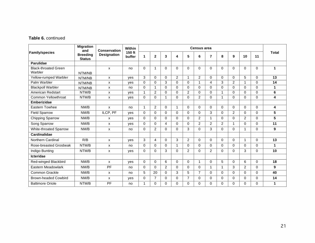
21
Table 6. continued
Census area Family/species
Migration and
Breeding Status
Conservation Designation
Within 150 ft buffer 1 2 3 4 5 6 7 8 9 10 11
Total
Parulidae Black-throated Green Warbler NTM/NB
x no 0 1 0 0 0 0 0 0 0 0 0 1
Yellow-rumped Warbler NTM/NB x yes 3 0 0 2 1 2 0 0 0 5 0 13 Palm Warbler NTM/NB x yes 0 0 3 0 0 1 4 3 2 1 0 14 Blackpoll Warbler NTM/NB x no 0 1 0 0 0 0 0 0 0 0 0 1 American Redstart NTM/B x yes 1 2 0 0 2 0 0 1 0 0 0 6 Common Yellowthroat NTM/B x yes 0 0 1 0 0 2 0 1 0 0 0 4 Emberizidae Eastern Towhee NM/B x no 1 2 0 1 0 0 0 0 0 0 0 4 Field Sparrow NM/B ILCP, PF yes 0 0 0 0 0 0 3 0 2 0 0 5 Chipping Sparrow NM/B x yes 0 0 0 0 0 2 1 0 0 2 0 5 Song Sparrow NM/B x yes 0 0 4 0 0 2 2 2 1 0 0 11 White-throated Sparrow NM/B x no 0 2 0 0 3 0 3 0 0 1 0 9 Cardinalidae Northern Cardinal R/B x yes 3 4 0 3 2 0 0 0 0 1 0 13 Rose-breasted Grosbeak NTM/B x no 0 0 0 1 0 0 0 0 0 0 0 1 Indigo Bunting NTM/B x yes 0 0 3 0 2 0 2 0 0 3 0 10 Icteridae Red-winged Blackbird NM/B x yes 0 0 6 0 0 1 0 5 0 6 0 18 Eastern Meadowlark NM/B PF no 0 0 2 0 0 0 1 1 3 2 0 9 Common Grackle NM/B x no 5 20 0 3 5 7 0 0 0 0 0 40 Brown-headed Cowbird NM/B x yes 0 7 0 0 7 0 0 0 0 0 0 14 Baltimore Oriole NTM/B PF no 1 0 0 0 0 0 0 0 0 0 0 1

22
Table 6. continued
Census area Family/species
Migration and
Breeding Status
Conservation Designation
Within 150 ft buffer 1 2 3 4 5 6 7 8 9 10 11
Total
Fringillidae House Finch R/B x no 0 0 2 0 0 0 0 3 0 0 0 5 American Goldfinch R/B x yes 0 0 7 0 0 3 2 6 4 3 0 25 Passeridae House Sparrow R/B x yes 0 0 0 0 0 0 0 7 0 0 6 13 Number of individuals 36 70 68 31 57 85 51 58 47 61 29 593 Number of species 16 19 18 11 18 24 14 17 12 19 6 53
Migration status: R = resident, NM = North American Migrant, NTM = Neotropical Migrant. Breeding status: B = breeds in Cook County, NB = does not breed in Cook County. Conservation designations: IL T = Illinois threatened, IL E = Illinois endangered, ILCP = The Illinois Comprehensive Wildlife Action Plan http://www.dnr.state.il.us/ORC/WildlifeResources/theplan/birds.asp conservation priority species, WL = The American Bird Conservancy http://www.abcbirds.org/abcprograms/science/watchlist/index.html Watch List species, PF = The Partners in Flight species of special concern http://www.rmbo.org/pif/downloads/downloads.html.

23
Figure 1. Census areas 1-3.

24
Figure 2. Census areas 4-7.

25
Figure 3. Census areas 8-11.


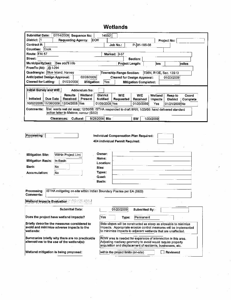


I-294/I-57 EA Addendum
Appendix D Exhibits