I-25 I-80Interchange Report 070108 Final5 · 2.2.3 i-80/lincolnway interchange ......
123
Prepared for: Prepared by: November 2008
Transcript of I-25 I-80Interchange Report 070108 Final5 · 2.2.3 i-80/lincolnway interchange ......

Prepared for:
Prepared by:
November 2008

ii
Contents Section Page
Acronyms and Abbreviations .........................................................................................................vi Executive Summary......................................................................................................................ES-1
Introduction....................................................................................................................... ES-1 Project Description and Location ................................................................................... ES-1 Problem Statement ........................................................................................................... ES-2
Safety ..................................................................................................................... ES-2 Traffic Demands .................................................................................................. ES-4 Coordination with Planned Development....................................................... ES-4 Study Process ....................................................................................................... ES-5
Summary of Recommendations ..................................................................................... ES-5 Ultimate Improvement Recommendations ..................................................... ES-6 Ultimate Improvement Cost .............................................................................. ES-6 Ultimate Improvement Phasing ........................................................................ ES-7 Phased Improvement Cost................................................................................. ES-7
1.0 Introduction.........................................................................................................................1-1 1.1 Project Description and Location ................................................................................1-1 1.2 Problem Statement ........................................................................................................1-1 1.3 Previous and Ongoing Planning Efforts ....................................................................1-2 1.4 Study Process .................................................................................................................1-2 1.5 Study Participants .........................................................................................................1-3 1.6 Public Involvement .......................................................................................................1-4 1.7 Linking Planning and NEPA .......................................................................................1-4
1.7.1 Purpose and Need.....................................................................................1-4 1.7.2 Alternatives ................................................................................................1-5 1.7.3 Affected Environment and Environmental Consequences .................1-5 1.7.4 Other NEPA Issues....................................................................................1-5
2.0 Existing Conditions............................................................................................................2-1 2.1 Land Use .........................................................................................................................2-1 2.2 Roadway Network ........................................................................................................2-1
2.2.1 I-25/I-80 Interchange ................................................................................2-1 2.2.2 I-25/Lincolnway Interchange..................................................................2-1 2.2.3 I-80/Lincolnway Interchange..................................................................2-2 2.2.4 I-80/Roundtop Road Interchange...........................................................2-2 2.2.5 I-25/Missile Drive Interchange ...............................................................2-2
2.3 Traffic Characteristics ...................................................................................................2-2 2.3.1 Traffic Operations......................................................................................2-2
2.4 Safety ...............................................................................................................................2-6 2.5 Environmental Considerations..................................................................................2-10
2.5.1 Community Resources and Economic Development.........................2-10 2.5.2 Visual Resources......................................................................................2-10 2.5.3 History and Archaeological Sites ..........................................................2-11
iii
2.5.4 Hazardous Waste Sites ...........................................................................2-11 2.5.5 Parks, Trails, and Recreation Areas ......................................................2-12 2.5.6 Wetlands and Floodplains .....................................................................2-12 2.5.7 Wildlife .....................................................................................................2-12
3.0 Future Conditions...............................................................................................................3-1 3.1 Land Use .........................................................................................................................3-1 3.2 Traffic Forecasts .............................................................................................................3-2
3.2.1 Future Conditions—No Action ...............................................................3-2 4.0 Alternative Development and Screening ......................................................................4-1
4.1 Description of Process and Criteria ............................................................................4-1 4.1.1 Level 1 Screening Criteria ........................................................................4-1 4.1.2 Level 2 Screening Evaluation Criteria ....................................................4-2
4.2 Description of Alternatives ..........................................................................................4-3 4.2.1 I-25 and I-80 System Interchange Alternatives .....................................4-3 4.2.2 I-25 and Lincolnway Service Interchange Concepts...........................4-10 4.2.3 I-80 and Lincolnway Service Interchange Concepts...........................4-14 4.2.4 Roundtop Road Service Interchange Concepts...................................4-19 4.2.5 Missile Drive Service Interchange Concepts .......................................4-21
4.3 Alternative Packaging.................................................................................................4-23 4.4 Level 1 Screening .........................................................................................................4-33 4.5 Level 2 Screening .........................................................................................................4-38
4.5.1 Impacts on Existing and Planned Development.................................4-38 4.5.2 Mobility.....................................................................................................4-38 4.5.2.1 Assumptions and Methodology for Future Traffic Conditions.........4-38 4.5.2.2 Future Traffic Operations of Alternatives.............................................4-39 4.5.3 Environmental .........................................................................................4-46 4.5.4 Safety.........................................................................................................4-46 4.5.5 Implementation .......................................................................................4-46
4.6 Alternative Evaluation................................................................................................4-46 4.6.1 I-25/I-80 Interchange (System Interchange) Alternatives .................4-46 4.6.2 I-25/Lincolnway Interchange (Service Interchange A) .....................4-52 4.6.3 I-80/Lincolnway Interchange (Service Interchange B) ......................4-57 4.6.4 I-80/Roundtop (Service Interchange C) and I-25/Missile Drive (Service Interchange D) Interchange Alternatives...........................................4-62
4.7 Recommended Alternative ........................................................................................4-67 4.8 Signing ..........................................................................................................................4-68
5.0 Phasing and Funding................................................................................................................5-1 5.1 Phased Improvements ..................................................................................................5-1
5.1.1 Recommended Alternative Phasing ...........................................................5-1 5.2 Funding and Cost ..........................................................................................................5-8
5.2.1 Funding...........................................................................................................5-8 5.2.2 Ultimate Alternative Cost ............................................................................5-8 5.2.3 Ultimate Alternative Phasing Cost .............................................................5-8
6.0 Summary and Next Steps.........................................................................................................6-1 6.1 Summary............................................................................................................6-1 6.2 Schedule.............................................................................................................6-1
iv
6.3 Agency Coordination.......................................................................................6-1 6.4 Next Steps..........................................................................................................6-2 6.5 Other Issues and Design Considerations ......................................................6-2
Appendices 1 Project Information Brochures 2 Steering Committee Group Meeting Minutes 3 Detailed Cost Estimate 4 Historic and Archaeological Sites 5 Wetland and Floodplains 6 Public Meetings 7 Technical Memorandum
List of Tables 1 Study Participants 2 Stakeholders Meetings 3 Levels of Service 4 Average Daily Traffic (Vehicles/Day) 5 Level 1 Screening Criteria 6 Level 2 Screening Criteria 7 I-25/I-80 System Interchange Level 1 Screening Criteria 8 Service Interchange A – I-25/Lincolnway Interchange Level 1 Screening Criteria 9 Service Interchange B – I-80/Lincolnway Interchange Level 1 Screening Criteria 10 Service Interchanges C and D Level 1 Screening Criteria 11 I-25/I-80 System Interchange Level 2 Screening Criteria 12 Comparison of I-25/I-80 Interchange Alternatives 13 Service Interchange A - I-25/Lincolnway Interchange Level 2 Screening Criteria 14 Comparison of I-25/Lincolnway Interchange Alternatives 15 Service Interchange B I-80/Lincolnway Level 2 Screening Criteria 16 Comparison of I-80/Lincolnway Interchange Alternatives 17 Service Interchange C and D Level 2 Screening Criteria 18 Comparison of I-25/Missile Drive Interchange Alternatives
List of Figures ES-1 Aerial of Study Area ES-2 I-25 Crash Data ES-3 I-80 Crash Data ES-4 Future Land Use ES-5 Study Process ES-6 Recommended Alternatives ES-7 Recommended Alternatives ES-8 Recommended Phase I ES-9 Recommended Phase II ES-10 Recommended Phase III ES-11 Recommended Phase IV 1 Study Area
v
2 Existing Ramp/Freeway Volumes and LOS. 3 Existing Turning-Movement Traffic Volumes and Level of Service 4 I-25 Crash Data 5 I-80 Crash Data 6 Future No-Action Ramp/Freeway Volumes and LOS 7 Future No-Action Turning Movement Volumes and LOS 8 Alternative I – Single Loop with Turban 9 Alternative II – Double Loop 10 Alternative III – Stack 11 Alternative VI – Full Turbine 12 Alternative V – Full Cloverleaf with Connector-Distributor (CD) Roads 13 Alternative VI - ¾ Cloverleaf with CD Roads and Flyover 14 Alternative A1 – Half Diamond Existing Location 15 Alternative A2 – Full Diamond with Braided Ramps 16 Alternative A3 – Hook Ramps 17 Alternative A4 – Half Diamond Relocated 18 Alternative B1 – Diamond with Single Loop 19 Alternative B2 – Split Diamond 20 Alternative B3 – Hook Ramps 21 Alternative B4 – Two Loop 22 Alternative B5 – Diamond 23 Alternative C1 – Shortened Diamond 24 Alternative C2 – Split Diamond 25 Alternative D1 – Diamond 26 Alternative D2 – PARCLO A/B 27 Alternative Plan Set I 28 Alternative Plan Set II 29 Alternative Plan Set III 30 Alternative Plan Set IV 31 Alternative Plan Set V 32 Alternative Plan Set VI 33 Alternative Plan Set VII 34 Alternative Plan Set VIII 35 Alternative Plan Set IX 36 System Interchange Alternatives 37 Alternatives A1 through A4 for I-25/Lincolnway Interchange 38 Alternatives B1 through B5 for I-80/Lincolnway Interchange 39 Alternatives D1 and D2 for I-25/Missile Drive Interchange 40 Alternatives C1 and C2 for I-80/Roundtop Road Interchange 41 Recommended Alternative Plan Set 1 42 Recommended Alternative Plan Set 2 43 Recommended Phase I 44 Recommended Phase II 45 Recommended Phase III 46 Recommended Phase IV 47 Project Schedule
vi
Acronyms and Abbreviations
CAT-EX Categorical Exclusion
WYDOT Wyoming Department of Transportation
EA Environmental Assessment
EB eastbound
FHWA Federal Highway Administration
GIS Geographic Information Systems
HCM Highway Capacity Manual
HCS™ Highway Capacity Software
I-25 Interstate 25
I-80 Interstate 80
ITS Intelligent Transportation Systems
LOS level of service
mph miles per hour
MPO Metropolitan Planning Organization
MUTCD Manual on Uniform Traffic Control Devices
NB northbound
PARCLO partial cloverleaf
RTP Regional Transportation Plan
SB southbound
SPUI single-point urban interchange
TIP Transportation Improvement Program
VMS Variable Message Sign
WB westbound

I-25/I-80 INTERCHANGE NETWORK STUDY
DEN/I-25_I-80INTERCHANGE_REPORT_070108_FINAL5.DOC ES-1 COPYRIGHT 2008 BY CH2M HILL, INC. • COMPANY CONFIDENTIAL
Executive Summary
Introduction The I-25/I-80 interchange and adjacent highway facilities are the largest and most heavily used in the state of Wyoming. This segment of the Federal Interstate System serves local, regional, state, and national travel needs and is the primary interchange in Wyoming for interstate commerce from border to border and coast to coast.
Because of the facilities age and change in vehicular demands and characteristic over the last 40 plus years, there is a pressing need for infrastructure improvements. This need is driven by high crash rates and operational deficiencies. This need is also driven by increasing travel demands of private autos and heavy trucks.
Local development is contributing to the need for defining improvements, and the preservation of right of way for their implementation.
Project Description and Location The Wyoming Department of Transportation (WYDOT), in conjunction with the Cheyenne Metropolitan Planning Organization (MPO) and the Federal Highway Administration (FHWA) initiated this I-25/I-80 Interchange Study on (December 3, 2007). (Figure ES-1). The study area includes Roundtop Road to the west, Missile Drive to the north, and areas just east and south of the system interchange. Lincolnway is the main arterial into Cheyenne and provides access off both of the interstates. Lincolnway is paralleled by railroad tracks on the south side. North of Lincolnway, Missile Drive provides another connection into Cheyenne. To the west of I-25, it serves as a primary access point to F.E. Warren Air Force Base.
Figure ES-1 – Aerial of Study Area

I-25/I-80 INTERCHANGE NETWORK STUDY
DEN/I-25_I-80INTERCHANGE_REPORT_070108_FINAL5.DOC ES-2 COPYRIGHT 2008 BY CH2M HILL, INC. • COMPANY CONFIDENTIAL
Problem Statement The I-25/I-80 interchange and adjacent facilities included in this study are the largest and most heavily used interchange in the state of Wyoming. In addition to the main interstate highways, the study area includes a number of critical intersections. These facilities serve local, regional, state, and national travel needs, and are the primary connection in Wyoming for interstate commerce from border to border and coast to coast.
The purpose of improvements to the I-25/I-80 and adjacent local interchanges is to improve traffic flow and safety; accommodate future traffic needs, particularly the heavy truck volumes; and support local development goals.
I-80 is an important freight route. On average trucks represent 50% of vehicles traveling through the I-25/I-80 interchange. The geometry of the loop ramps, short acceleration and deceleration lengths, and weaving conflicts make maneuvering large trucks particularly challenging.
Built in the 1960s, the interchange design has not kept pace with the mobility and access needs of trucks, tourists, and local drivers. The adjacent interchanges close proximity create additional problems for the 40 year old interchange system.
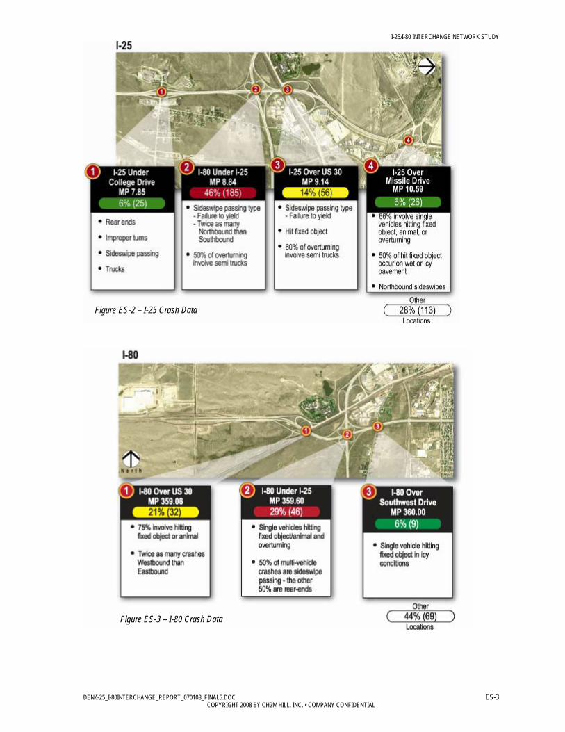
Safety Existing interchange deficiencies contribute to crashes in the study area. As shown in Figures ES-2 and ES-3, the overall crash rate at the I-25/I-80 interchange is twice the statewide average (4.16/I-25, 1.92/statewide), and the fatal crash rate is three times the statewide average (7.72/I-25, 2.40/statewide).
Semi-trucks were involved in 39 percent of the total crashes and 27 percent of the severe crashes for the study area in the past 5 years.
I-25/I-80 INTERCHANGE NETWORK STUDY
DEN/I-25_I-80INTERCHANGE_REPORT_070108_FINAL5.DOC ES-3 COPYRIGHT 2008 BY CH2M HILL, INC. • COMPANY CONFIDENTIAL
Figure ES-3 – I-80 Crash Data
Figure ES-2 – I-25 Crash Data

I-25/I-80 INTERCHANGE NETWORK STUDY
DEN/I-25_I-80INTERCHANGE_REPORT_070108_FINAL5.DOC ES-4 COPYRIGHT 2008 BY CH2M HILL, INC. • COMPANY CONFIDENTIAL
Traffic Demands Current traffic demands in the Study area are the highest in State, and future traffic, for both private and commercial vehicles is expected to double over the 30 year planning horizon. Existing traffic exceeds capacity at key locations in the Study area, and increased traffic volume will exacerbate current operational deficiencies and exceed the design capacity of the I-25/I-80 interchange in other locations as well as the adjacent interchanges. Without transportation improvements, deteriorated traffic operations will increase current traffic congestion and associated delays, and increase local traffic crash potential.
Coordination with Planned Development The project area has been identified by local government and business leaders as the major hub for the City of Cheyenne’s economic development. Land that is currently undeveloped is slated for significant mixed use development, including a large residential population. As the development fills in, right-of-way will become more expensive, and there will be significantly more community disruption required to make transportation improvements.
Options for transportation improvements could be limited, expensive, and environmentally damaging as future development fills in around the mostly undeveloped areas surrounding the interchanges.

I-25/I-80 INTERCHANGE NETWORK STUDY
DEN/I-25_I-80INTERCHANGE_REPORT_070108_FINAL5.DOC ES-5 COPYRIGHT 2008 BY CH2M HILL, INC. • COMPANY CONFIDENTIAL
Study Process The methodology used to develop recommended improvements is essentially a five step process. The following illustrates the steps used to reach a recommended alternative.
Figure ES-5 – Study Process
Agency stakeholders were involved throughout the planning process. Agency representatives from WYDOT, the Cheyenne Metropolitan Planning Organization (MPO), and the Federal Highway Administration (FHWA) participated in monthly project workshops to clarify the planning goals and objectives, develop screening and evaluation criteria, generate ideas for solutions, screen and evaluate potential improvements, and develop final recommendations.
This Steering Committee held several project briefings for WYDOT and FHWA executives, land owners, media, and members of the public. The purpose of these briefings was to present the study process, progress, preliminary results, and next steps. The Steering Committee sought input about the criteria used for evaluating alternatives and the results of the alternatives screening. Based on the results of the evaluation process, the Steering Committee unanimously approved the ultimate improvement recommendations and phasing strategy.
Summary of Recommendations This study includes recommendations to address transportation needs at the I-25/I-80 interchange and the surrounding service interchanges. Many of these recommendations address known operational and safety deficiencies of the existing system and ensure the most effective expenditure of funds. The phased improvements are those seen as having the most efficient benefit-to-cost ratio with the goal of completing the ultimate improvement.

I-25/I-80 INTERCHANGE NETWORK STUDY
DEN/I-25_I-80INTERCHANGE_REPORT_070108_FINAL5.DOC ES-6 COPYRIGHT 2008 BY CH2M HILL, INC. • COMPANY CONFIDENTIAL
The recommendations include alternatives that showed the greatest improvement potential, as well as alternatives that could be combined to provide greater mobility, safety, or operational enhancements.1 The recommendations developed by this study focused on the need for a set of ultimate improvements to address the 30 year traffic demand and current safety concerns. In addition, a phasing program was explored to address traffic conditions over the next 5 to 10 years.
The primary focus of the initial design concepts was to address the key operational and safety issues of the interchanges: weaving conditions, interchange spacing, and maintaining or improving accesses. Minimizing right-of-way requirements and cost were also key considerations in the development of initial alternatives.
Although it was a goal of the study to identify minor improvements that could be implemented immediately, none of the design concepts met that goal, either in totality or through phasing. That is, no low-cost improvements are available that would provide operational or safety benefits because the magnitude of the needed improvements were too great to be accomplished with an inexpensive or quick solution. This conclusion supported WYDOT’s prior experience with implementing low-cost but ineffective changes, such as re-striping, to the interchange configurations
Ultimate Improvement Recommendations The ultimate improvement recommendation is to:
• Reconstruct the I-25/I-80 interchange to a double-loop turbine interchange. • Reconstruct the I-25/Lincolnway interchange to a weaved diamond configuration. • Reconstruct the Missile Drive interchange into a diamond interchange. • Construct a single loop partial cloverleaf (PARCLO) A interchange to replace the I-80/
Lincolnway interchange.
A summary of the ultimate improvement recommendations is shown in Figure ES-6 thru ES-7 Additional information on these alternatives is also provided further in this report.
Ultimate Improvement Cost The estimated costs of improvements (in 2008 dollars) is $220 million. More than half of the total cost is associated with improvements to the I-25/I-80 interchange. Any delays in funding or project approvals will result in higher project expenditures as construction costs continue to rise.
Approximate Project Costs (2008 dollars)
I-25/I-80 Interchange $132,000,000 Lincolnway/I-25 Interchange $36,000,000 Lincolnway/I-80 Interchange $20,000,000
Roundtop Road Interchange
$2,000,000
Missile Drive Interchange $30,000,000 Total $220,000,000
Table ES-3 – Ultimate Costs
1 Multi-modal options were also considered but because of the undeveloped nature of most of the study area, there were not great needs in the study area. Multi-modal options, if warranted in the future, should be developed to be consistent with study recommendations.

I-25/I-80 INTERCHANGE NETWORK STUDY
DEN/I-25_I-80INTERCHANGE_REPORT_070108_FINAL5.DOC ES-7 COPYRIGHT 2008 BY CH2M HILL, INC. • COMPANY CONFIDENTIAL
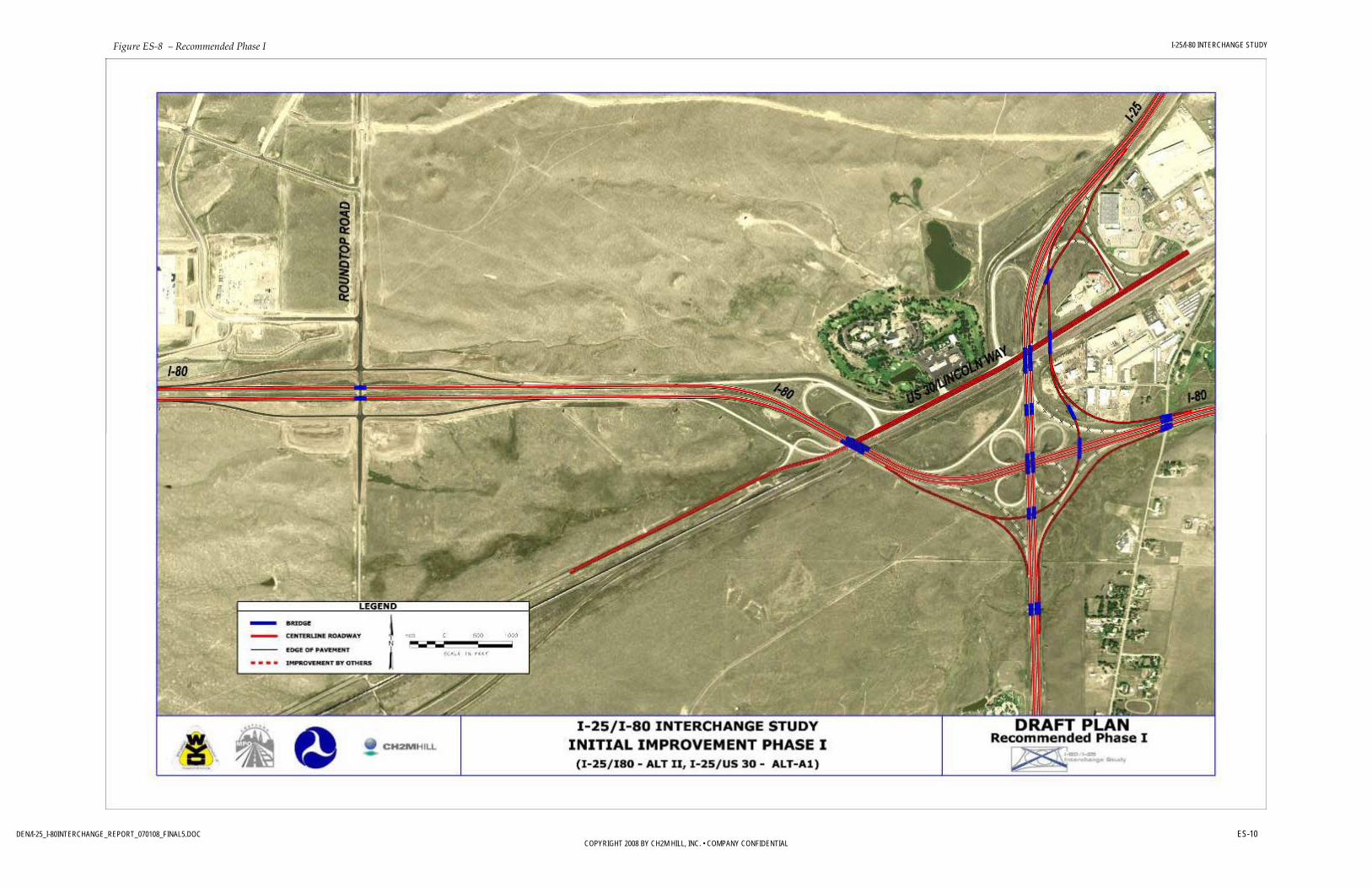
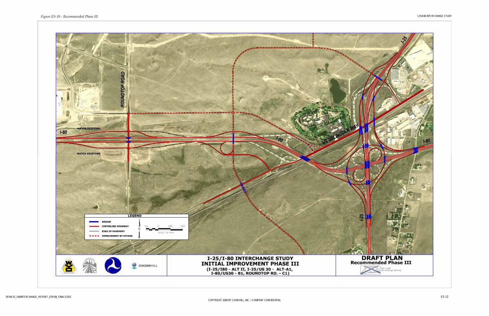
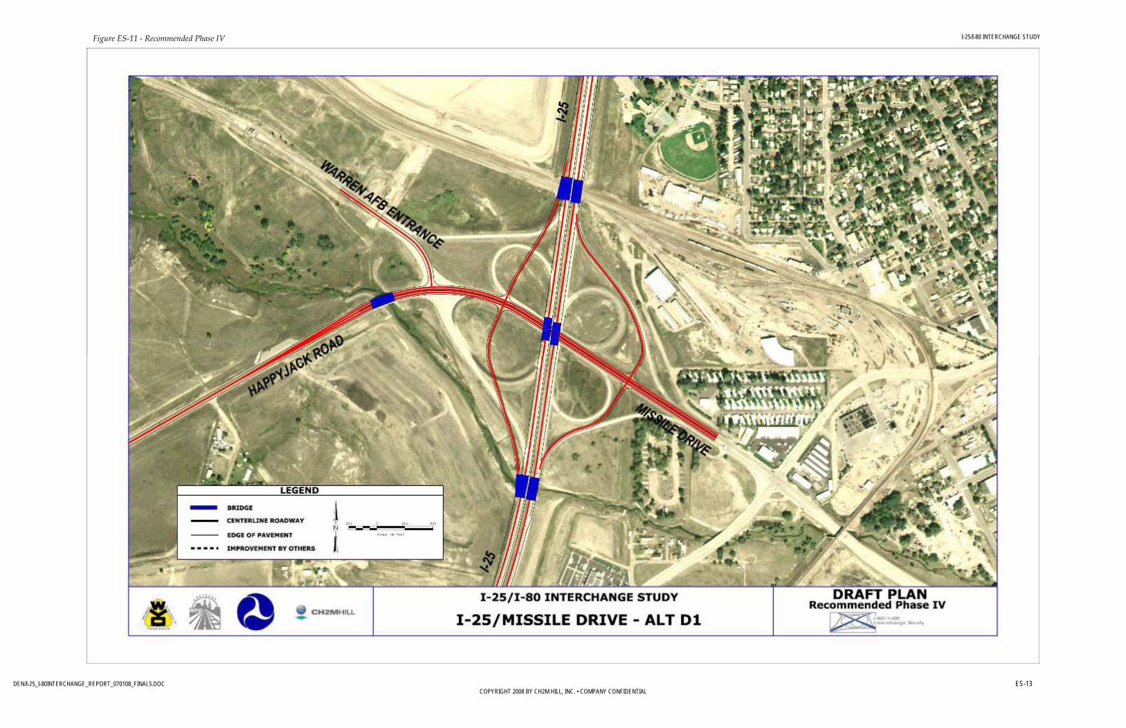
Ultimate Improvement Phasing WYDOT considered cost-effective ways to phase the project improvements. The resulting phasing plan has four stages:
1. Construct east-bound (EB) flyover eliminating southeast (SE) cloverleaf loop. Construct east ramps of I-25/I-80 interchange.
2. The east side of the I-25 and US 30 interchange will need to be constructed to accommodate the northbound flyover ramp for the EB I-80 to north-bound (NB) I-25 system interchange movement.
3. Construct the east side of the Missile Drive interchange; Alternative D1.
4. Shorten the ramps on the east side of the Roundtop Road interchange; Alternative C1.
An illustration of the preliminary designs for the phased improvement recommendations is shown in Figure ES-8 and ES-11.
Phased Improvement Cost Options for phasing improvements were carefully considered, primarily for budgeting reasons. The first phase of recommended improvements would include partial reconstruction of the I-25/I-80 interchange and improvements to the Lincolnway/I-80 interchange. These improvements, which are estimated at approximately $84 million would address the most immediate safety concerns in the project area. Additional phases are described below.
Phase Description Estimated Cost I I-25/I-80 eastbound to northbound flyover ramp
East side of Lincolnway interchange $84,000,000
II I-25/I-80 westbound to southbound flyover ramp West side of Lincolnway interchange
$55,000,000
III Expanded I-25/I-80 loop ramps Roundtop Road interchange improvements Lincolway and I-80 interchange improvements (Ultimate Improvements Plan View, pg. 6)
$51,000,000
IV Missile Drive interchange improvements $30,000,000 TOTAL $220,000,000
Table ES-4 – Phased Cost

I-25/I-80 INTERCHANGE STUDY
DEN/I-25_I-80INTERCHANGE_REPORT_070108_FINAL5.DOC ES-8 COPYRIGHT 2008 BY CH2M HILL, INC. • COMPANY CONFIDENTIAL
Figure ES-6 – Recommended Alternatives

I-25/I-80 INTERCHANGE STUDY
DEN/I-25_I-80INTERCHANGE_REPORT_070108_FINAL5.DOC ES-9 COPYRIGHT 2008 BY CH2M HILL, INC. • COMPANY CONFIDENTIAL
Figure ES-7 – Recommended Alternatives
I-25/I-80 INTERCHANGE STUDY
DEN/I-25_I-80INTERCHANGE_REPORT_070108_FINAL5.DOC ES-10 COPYRIGHT 2008 BY CH2M HILL, INC. • COMPANY CONFIDENTIAL
Figure ES-8 – Recommended Phase I

I-25/I-80 INTERCHANGE STUDY
DEN/I-25_I-80INTERCHANGE_REPORT_070108_FINAL5.DOC ES-11 COPYRIGHT 2008 BY CH2M HILL, INC. • COMPANY CONFIDENTIAL
Figure ES-9 - Recommended Phase II
I-25/I-80 INTERCHANGE STUDY
DEN/I-25_I-80INTERCHANGE_REPORT_070108_FINAL5.DOC ES-12 COPYRIGHT 2008 BY CH2M HILL, INC. • COMPANY CONFIDENTIAL
Figure ES-10 - Recommended Phase III
I-25/I-80 INTERCHANGE STUDY
DEN/I-25_I-80INTERCHANGE_REPORT_070108_FINAL5.DOC ES-13 COPYRIGHT 2008 BY CH2M HILL, INC. • COMPANY CONFIDENTIAL
Figure ES-11 - Recommended Phase IV

I-25/I-80 INTERCHANGE STUDY
DEN/I-25_I-80INTERCHANGE_REPORT_070108_FINAL5.DOC 1-1 COPYRIGHT 2008 BY CH2M HILL, INC. • COMPANY CONFIDENTIAL
1.0 Introduction
1.1 Project Description and Location The Wyoming Department of Transportation (WYDOT), in conjunction with the Cheyenne Metropolitan Planning Organization (MPO) and the Federal Highway Administration (FHWA) initiated the I-25/I-80 Interchange Study to address operational and safety concerns for the I-25/I-80 interchange in Cheyenne, Wyoming (Figure 1-1). The study area includes Roundtop Road to the west, Missile Drive to the north, and areas just east and south of the system interchange. Lincolnway is the main arterial into Cheyenne and provides access off both of the interstates. Lincolnway is paralleled by railroad tracks on the south side. North of Lincolnway, Missile Drive provides another connection into Cheyenne. To the west of I-25, it serves as a primary access point to F.E. Warren Air Force Base.
Figure 1-1. Study Area
1.2 Problem Statement The I-25/I-80 interchange is the largest and most heavily used interchange in the state of Wyoming. It serves local, regional, state, and national travel needs and is the primary interchange in Wyoming for interstate commerce from border to border and coast to coast. As a junction of two interstate highways, the I-25/I-80 interchange serves important national mobility needs, particularly in the cross country movement of freight.

I-25/I-80 INTERCHANGE STUDY
DEN/I-25_I-80INTERCHANGE_REPORT_070108_FINAL5.DOC 1-2 COPYRIGHT 2008 BY CH2M HILL, INC. • COMPANY CONFIDENTIAL
The US 30 Lincolnway corridor is a significant transportation facility for the Cheyenne area, linking the interstate system to Cheyenne’s southern commercial business district. The I-25/ Missile Drive interchange is a primary access point to F.E. Warren Air Force Base (AFB), in addition to new and existing developments east and west of the interchange.
Existing traffic demands at the study interchanges meet current capacity criteria, except for the proposed diamond configuration at the Missile Drive interchange. There are, however, operational deficiencies associated with the cloverleaf interchanges, as well as certain ramp movements. The majority of accidents in the area involved the current configuration of the loop ramps. The I-25/I-80 interchange eastbound (EB) to northbound (NB) movement has also proven hazardous, due to deficient geometric grade and possibly sight distance issues, in addition to the well known weaving problems associated with cloverleaf interchanges.
Future traffic, for both private and commercial vehicles is expected to double over the 30 year planning horizon. This increase, as well as general traffic growth beyond the study area, will exceed the design capacity of the I-25/I-80 interchange as well as the adjacent interchanges. Without transportation improvements, continued expected growth will:
• Further deteriorate traffic operations • Increase current traffic congestion and associated delays • Increase environmental impacts • Increase local traffic crash potential
1.3 Previous and Ongoing Planning Efforts The I-25/I-80 interchange area has long been identified by WYDOT as a critical safety concern. WYDOT has tried numerous “small fixes,” such as re-striping and lighting improvements, to address safety issues but these interim measures have not been effective at reducing crashes or improving operations. Plan Cheyenne has similarly identified I-25/ I-80 as a critical junction for development of the Cheyenne area and identified goals for transportation improvements in the area. Because of the projected high cost of implementing a long-term solution, such as reconstruction of the I-25/I-80 interchange, WYDOT has not programmed any large action into its statewide transportation improvement program. The failure of previous actions, continuing safety problems in the study area, projected increases in traffic (particularly truck traffic), and potential for new development around the interchanges that may preclude future action, WYDOT initiated this study and has begun to consider future funding options.
1.4 Study Process The study followed a five-step process to arrive at recommended improvements.
1. Gather Data and Develop Criteria. The first step is to gather existing traffic, geometric, and environmental data to understand the context for improvements. At this initial stage, the criteria that will be used to screen the alternatives in a later task are developed.
2. Evaluate Existing and Future Conditions and Develop Alternatives. During the second step, existing and future conditions are evaluated to identify a number of options to improve the transportation system.

I-25/I-80 INTERCHANGE STUDY
DEN/I-25_I-80INTERCHANGE_REPORT_070108_FINAL5.DOC 1-3 COPYRIGHT 2008 BY CH2M HILL, INC. • COMPANY CONFIDENTIAL
3. Screen Initial Design Concepts. The initial design concepts were evaluated using a “fatal flaw” level of screening to eliminate the alternatives that do not meet the basic needs of the project.
4. Conduct Detailed Evaluation of Screened Alternatives. After the first level of screening, the remaining alternatives were evaluated to compare their relative performance and to recommend an ultimate improvement alternative.
5. Summarize Report Findings. The report documents the study process and recommendations.
1.5 Study Participants Agency representatives from WYDOT, Cheyenne MPO, and FHWA formed a Steering Committee which participated in monthly workshops throughout the study. These workshops clarified the planning goals and objectives, developed screening criteria, brainstormed issues and potential solutions, evaluated and prioritized improvements, and reached consensus on the ultimate improvement recommendation(s). The members of the core Steering Committee are shown in Table 1.
TABLE 1 – STUDY PARTICIPANTS
STEERING COMMITTEE
PARTICIPANT TITLE AGENCY
PAUL BERCICH HIGHWAY DEVELOPMENT ENGINEER WYDOT MIKE GOSTOVICH STATE TRAFFIC ENGINEER WYDOT JAY GOULD DISTRICT 1 ENGINEER WYDOT PAUL HARKER WYOMING DIVISION PROGRAM MANAGER FHWA THOMAS MASON DIRECTOR CHEYENNE MPO
STRATEGIC INVOLVEMENT
MARK WINGATE PROJECT MANAGER WYDOT KEVIN MCCOY PLANNING CONSULTANT WYDOT KEN POWELL ENVIRONMENTAL MANAGER WYDOT
Key consultant staff members from CH2M HILL, which conducted the study, included:
• Tom Ragland – Principal • Ken McHenry – Project Manager • Mandy Whorton – Lead Environmental Planner • Jacqueline Dowds Bennett - Lead Traffic Engineer • Danielle Yearsley – Lead Roadway Engineer • Ryan Abraham – Lead Bridge Engineer • Chris Angleman – Interchange Specialist • Zeke Lynch – Traffic Engineer • Loretta LaRiviere – Project Assistant
I-25/I-80 INTERCHANGE STUDY
DEN/I-25_I-80INTERCHANGE_REPORT_070108_FINAL5.DOC 1-4 COPYRIGHT 2008 BY CH2M HILL, INC. • COMPANY CONFIDENTIAL
This Steering Committee held several project briefings for WYDOT and FHWA executives, land owners, media, and members of the public (Table 2). The purpose of these briefings was to present the study process, progress, preliminary results, and next steps. The Steering Committee sought input about the criteria used for evaluating alternatives and the results of the alternatives screening. Details of these outreach efforts are included in Appendix 6.
TABLE 2 – STAKEHOLDER MEETINGS
STAKEHOLDER MEETINGS
MEETING LOCATION DATE
WYDOT/FHWA EXECUTIVES WYDOT HEADQUARTERS JULY 29, 2008
LITTLE AMERICA REPRESENTATIVES LITTLE AMERICA AUGUST 5, 2008
OTHER PROPERTY OWNERS CHEYENNE DEPOT AUGUST 27, 2008
CHANNEL 5 (KGWN) CHEYENNE DEPOT AUGUST 27, 2008
PUBLIC MEETING HITCHING POST SEPTEMBER 18, 2008
CHANNEL 2 (KTWO) HITCHING POST SEPTEMBER 18, 2008
1.6 Public Involvement The I-25/I-80 Interchange Study Steering Committee sought input from WYDOT and FHWA executives, adjacent land owners, and the public and held several project briefings or meetings. The purpose of these meetings was to present information about the study process, alternatives evaluation criteria, preliminary alternatives, alternatives screening, and next steps. The results of the public involvement is illustrated in Appendix 6 and 7.
1.7 Linking Planning and NEPA In accordance with the Linking Planning and NEPA guidance of the Safe, Accountable, Flexible, Efficient Transportation Equity Act: A Legacy for Users (SAFETEA-LU), the project team considered the NEPA standards that would need to be met for the results of the interchange study to feed into the NEPA process. In addition to considering purpose and need, alternatives, the affected environment, and, in a more limited sense, environmental consequences in a NEPA context, the interchange study is seeking and incorporating public and agency input. Public involvement has or will include meeting with local agencies to define the scope and needs for improvements, meetings with local landowners that could be affected by proposed improvements, and a public open house.
1.7.1 Purpose and Need The interchange study defined the purpose and need for project. The interchange study included a draft purpose and need statement which was provided for review by project stakeholders, affected parties, and the public, and will be carried forward into the NEPA phase of project development.
I-25/I-80 INTERCHANGE STUDY
DEN/I-25_I-80INTERCHANGE_REPORT_070108_FINAL5.DOC 1-5 COPYRIGHT 2008 BY CH2M HILL, INC. • COMPANY CONFIDENTIAL
1.7.2 Alternatives Based on transportation needs, alternatives were developed and two levels of screening were conducted. The screening and evaluation will include environmental criteria consistent with development of alternatives under NEPA. The screening results were presented in comparative form to document the process for developing a range of alternatives and narrowing the alternatives to recommendations. Stakeholders, affected parties, and the public will be provided opportunities to comment on the evaluation criteria and alternatives development.
It is anticipated that the recommendations of the interchange study will form the basis for the alternatives development in the NEPA process. While new alternatives could be developed in the NEPA phase, the consideration of alternatives was broad in the interchange study, and alternatives considered but not forwarded as part of the interchange study would not be revisited in the NEPA phase.
1.7.3 Affected Environment and Environmental Consequences The interchange study aims to define the important environmental issues that will be analyzed in the NEPA phase. While detailed studies will be required in the NEPA document, the interchange study will allow the NEPA document to focus on the important issues and eliminate those issues that are not relevant or unlikely to be adversely affected by project improvements.
1.7.4 Other NEPA Issues The scope of the I-25/I-80 project makes it one of the largest transportation improvement proposals in the State of Wyoming. As such, it will be important to fully analyze any potential impacts of proposed improvements in a public process. It is recommended that an Environmental Assessment be prepared because the scope of improvements is too large for a Categorical Exclusion to be appropriate; however, no significant environmental impacts have been identified that would require preparation of a more involved Environmental Impact Statement.
Plan Cheyenne identifies the need for improvements in the Transportation Master Plan, and the Statewide Transportation Improvement Plan includes line items for some improvements to the study area interchanges and roadways. The scope of improvements in these documents (and the associated funding strategies) would need to be updated to include the scope of improvements outlined in the interchange study. After the project is included and prioritized in the regional and statewide transportation plans, an Environmental Assessment would be initiated.
It is unlikely that the entire scope of improvements could be included in a fiscally constrained plan. If there is a budget shortfall for the ultimate improvements, the project may need to be constructed in phases. NEPA documentation could identify those phases and support decisions about implementation of project elements, or the entire project could be approved, and as phases of the project are funded, the NEPA documentation could be reviewed and updated if necessary. To avoid segmentation, the latter strategy is recommended.
I-25/I-80 INTERCHANGE STUDY
DEN/I-25_I-80INTERCHANGE_REPORT_070108_FINAL5.DOC 2-1 COPYRIGHT 2008 BY CH2M HILL, INC. • COMPANY CONFIDENTIAL
2.0 Existing Conditions
Data were collected to determine the initial conditions of the project area. A comprehensive Geographic Information System (GIS) database was used to evaluate physical and operational conditions, and a field review was performed to supplement the GIS data. Aerial photography was obtained, as well as “as-built” information for the interchanges. A comprehensive traffic data collection program was also completed.
2.1 Land Use The Cheyenne MPO, City of Cheyenne, and Laramie County, with extensive involvement of citizens and community leaders, developed Plan Cheyenne in November 2006 as a master plan for the future development in the Cheyenne area. Plan Cheyenne built on the community-defined Vision 2020, the master vision for the Cheyenne area.
Current land use surrounding the project area is largely rural/agricultural west and south of the I-25/I-80 interchange. Limited development in the form of commercial and industrial land use is present adjacent to the interstates and at interchanges. A small area of low density residential use parallels I-25 southeast of the interchange.
2.2 Roadway Network Both I-25 and I-80 have two lanes in each direction. Lincolnway is a four-lane highway that narrows to two lanes at the I-80/ Lincolnway interchange. The area has relatively flat-rolling terrain except for areas where the roadways must cross each other and the railroads.
There are four service interchanges in the study area and one system interchange. A service interchange is an interchange between a freeway or controlled access facility and a lower class roadway such as an arterial or collector. A system interchange is an intersection of two or more controlled access facilities, such as freeways.
2.2.1 I-25/I-80 Interchange A full clover leaf system interchange connects I-25, a north–south roadway, with I-80, an east-west roadway. I-25 is a four-lane divided facility with a speed limit of 65 mph and an urban interstate classification. I-80 is a four-lane divided facility with a speed limit of 75 mph and a rural interstate classification. All interchange ramps in the study area are one lane.
2.2.2 I-25/Lincolnway Interchange The I-25/ Lincolnway interchange is a type of button hook configuration to US 30 (Lincolnway) and is in close proximity to the I-25/I-80 system interchange. The I-25/ Lincolnway interchange provides all traffic movements. The on-ramp to southbound I-25 is a loop ramp with a posted speed of 25 mph and the southbound off-ramp has a posted speed of 40 mph. The northbound off-ramp is a loop ramp with a posted speed of 40 mph.

I-25/I-80 INTERCHANGE STUDY
DEN/I-25_I-80INTERCHANGE_REPORT_070108_FINAL5.DOC 2-2 COPYRIGHT 2008 BY CH2M HILL, INC. • COMPANY CONFIDENTIAL
2.2.3 I-80/Lincolnway Interchange The I-80/Lincolnway interchange provides access from Lincolnway to I-80 in all directions except eastbound (EB) I-80. The EB off-ramp has a posted speed of 45 mph, and the WB off-ramp is a loop with a posted speed of 20 mph. The interchange is located in close proximity to the I-25/I-80 interchange. In addition, WB traffic on Lincolnway has to cross the I-80 EB off-ramp to continue on Lincolnway.
2.2.4 I-80/Roundtop Road Interchange The I-80/Roundtop Road interchange is a diamond configuration with ramp speed limits of 45 mph. Roundtop Road is a north-south two-lane road with a posted speed of 55 mph.
2.2.5 I-25/Missile Drive Interchange This interchange is currently a full clover leaf configuration. WYDOT is planning to reconfigure the east side loop ramps to a stop-controlled diamond configuration in the near future. The analysis of existing conditions at this interchange, therefore, used a partial cloverleaf with a stop controlled diamond configuration on the east side and the existing configuration on the west side. The southbound off-ramp terminates at a signalized intersection between Missile Drive and Happy Jack Road. An additional southbound off-ramp provides a free flow movement from the Interstate to F.E. Warren Air Force Base (AFB). The loop ramps have a posted speed of 15 mph and the directional ramps have a posted speed of 35 mph. Missile Drive is a four-lane arterial with a posted speed of 40 mph.
2.3 Traffic Characteristics In January 2008, WYDOT conducted comprehensive traffic counts for the study area. Both AM and PM turning-movement counts were collected at the five study area intersections, in addition to 24-hour vehicle classification counts on the interchange ramps. The count data was used with a seasonal adjustment factor based off the existing average daily traffic (ADT) data for the area. The I-25/I-80 Interchange Study area intersections include the following:
• I-80 WB ramps and Lincolnway • I-25 NB and SB ramps and Lincolnway • Little America access and Lincolnway • Missile Drive and Happy Jack Road • Roundtop Road and EB and WB I-80 ramps Interchange, US 30/Lincolnway corridor, and intersection geometry were compiled from aerial photography, agency coordination for proposed improvements, and through field visits.
2.3.1 Traffic Operations The existing conditions analysis was performed to determine the traffic operations of the current facilities. WYDOT collected and provided the volume data. The data were adjusted as necessary to the year 2008 using a conservative growth factor of 1.75 percent as

I-25/I-80 INTERCHANGE STUDY
DEN/I-25_I-80INTERCHANGE_REPORT_070108_FINAL5.DOC 2-3 COPYRIGHT 2008 BY CH2M HILL, INC. • COMPANY CONFIDENTIAL
recommended by WYDOT. Based on WYDOT data, the January data was increased 25 percent to account for seasonal fluctuations. For data which had hourly counts, the 7am and 3pm hours were used as the morning and evening peak hours since they represent the highest volume hours of the day. For locations in which only daily data was available, the peak hour was assumed to be 10 percent of the daily count. For all facilities, the directional split was assumed to be 50 percent in each direction.
Using these volumes, the traffic operations were analyzed with the Highway Capacity Software (HCS™) and Synchro™ computer programs. HCS™ was used to analyze ramps and freeways while Synchro™ was used to analyze signalized and un-signalized intersections. The operations are measured by a Level of Service (LOS), which is a quantitative measure based on average vehicle delay or density to describe the operating performance of an intersection or roadway. LOS is measured from A to F, with A being the best and F the worst. LOS D serves as the threshold of acceptable LOS for both existing and expected future conditions. The following Table 2 presents the LOS criteria for the different sections of the study.
TABLE 3 – LEVELS OF SERVICE
LEVELS OF SERVICE CRITERIA
LOS Un-signalized Intersection
Signalized Intersection
Merge/Diverge Areas
Weaving Areas
Freeway Segments
Measure Control Delay per Vehicle
Control Delay per Vehicle Density Density Density
Unit (sec) (sec) (pc/mi/in) (pc/mi/in) (pc/mi/in)
A < 10 < 10 ≤ 10 ≤ 10 ≤ 11
B 10-15 10-20 10 – 20 10 – 20 > 11 – 18
C 15-25 20-35 20 – 28 20 – 28 > 18 - 26
D 25-35 35-55 28 – 35 28 – 35 > 26 - 35
E 35-50 55-80 ≥ 53 35 – 43 > 35 – 45
F >50 >80 Demand > Capacity
>43 >45
Source: Highway Capacity Manual 2000, Transportation Research Board
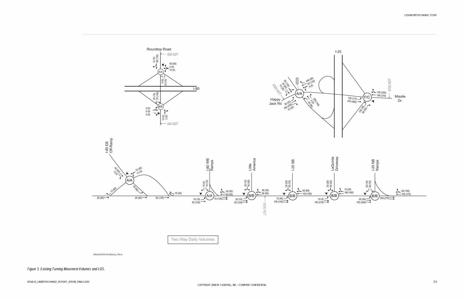
Figures 2 and 3 show the existing conditions for the ramps and freeways as well as the intersections in the study area. The LOS for the un-signalized intersections represents the LOS for the worst movement, which is likely a left-turn movement.

I-25/I-80 INTERCHANGE STUDY
DEN/I-25_I-80INTERCHANGE_REPORT_070108_FINAL5.DOC 2-4 COPYRIGHT 2008 BY CH2M HILL, INC. • COMPANY CONFIDENTIAL
Figure 2. Existing Ramp/Freeway Volumes and LOS.
I-25/I-80 INTERCHANGE STUDY
DEN/I-25_I-80INTERCHANGE_REPORT_070108_FINAL5.DOC 2-5 COPYRIGHT 2008 BY CH2M HILL, INC. • COMPANY CONFIDENTIAL
Figure 3. Existing Turning Movement Volumes and LOS.
I-25/I-80 INTERCHANGE STUDY
DEN/I-25_I-80INTERCHANGE_REPORT_070108_FINAL5.DOC 2-6 COPYRIGHT 2008 BY CH2M HILL, INC. • COMPANY CONFIDENTIAL
The existing conditions operate at acceptable LOS at all locations, except the east side of the I-25/Missile Drive interchange. Based on WYDOT’s short-term plans for the area, the analysis assumes the east-side loop and directional ramps are converted to a diamond configuration with the ramps terminating in an un-signalized intersection. This poor LOS is for the high NB left-turn volume during the morning peak hour. This volume is likely accessing F.E. Warren AFB.
2.4 Safety Crash statistics from the years between 2001 and 2006 were analyzed to determine relevant crash trends or patterns that might suggest countermeasures to improve safety within the study area. The crash statistics are also compared with appropriate national crash statistics from the Traffic Safety Facts 2005 to provide a context for how safety in the study area relates to comparable facilities outside the study area.
A total of 562 crashes were reported between 2001 and 2006, or an average of 93 per year. These data indicated an event frequency of one traffic crash every 4 days and one property damage only crash every 5 days. The crash results are broken down as follows:
• One crash resulted in a single fatality • 127 injury (non-fatal) crashes resulted in 202 injuries • 434 crashes resulted in property damage only
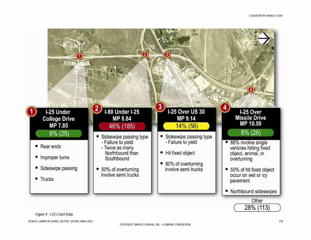
Of the total crashes, approximately 72 percent occurred on I-25 and the remaining 28 percent occurred on I-80. The proportion of injury to total crashes was approximately one-fourth, for both facilities. The only fatal crash occurred on northbound I-25 at milepost 8.84 in the weaving section between the cloverleaf ramps with I-80. Severe crashes equaled 25 percent of all crashes, which was lower than the national severe crash percentage for 2005 (30 percent).
Semi-trucks were involved in 39 percent of the total crashes and 27 percent of the severe crashes for the study area. On I-25, semi-trucks were involved in 42 percent of the total crashes and 18 percent of the severe crashes. On I-80, 29 percent of the total crashes and 44 percent of the severe crashes involved semi-trucks; thus indicating there is a higher risk for injuries if a semi-truck is involved in a crash on this facility. These percentages were much greater than the national percentages of 4 percent for total crashes and 3 percent for severe crashes. However, due to the significant freight movement and relatively low passenger-vehicle volumes, the volume of traffic on these facilities includes more semi-trucks than what is typically experienced in other areas. Thus, a somewhat elevated percentage of crashes involving trucks can be expected within this study area.
Crash rates were calculated individually for I-25 and for I-80 because each facility has a different functional classification and corresponding average statewide crash and fatal crash rate. The crash rate for I-80 for 2006 was 1.85, which is greater than the average statewide crash rate of 1.21 (WYDOT, 2007) for rural interstates for the same year. The crash rate for I-25 for 2006 was 4.16, which is considerably higher than the average statewide crash rate of 1.92 (WYDOT, 2007) for urban interstates for the same year. The fatal crash rate for I-25 in 2004 was 7.72, which was also higher than the 2004 average statewide fatal crash rate of 2.40
I-25/I-80 INTERCHANGE STUDY
DEN/I-25_I-80INTERCHANGE_REPORT_070108_FINAL5.DOC 2-7 COPYRIGHT 2008 BY CH2M HILL, INC. • COMPANY CONFIDENTIAL
(WYDOT, 2007) for urban interstates and the 2005 average national fatal crash rate of 1.47 (NHTSA, 2005).
Two-thirds of the crashes were clustered at seven locations, which were mostly at the interchanges. Analysis of the crashes at these seven locations suggests the following prevailing patterns:
• Drainage or Icing Issues on I-80 – Eighty percent of the crashes on I-80 occurred on non-dry pavement. A few of these occurred on wet or snowy roads, but the majority occurred on icy roads.
• Driving at Unsafe Speeds – Nearly one-third of the crashes was attributed to driving at an unsafe speed for the conditions.
• Run-Off-Road – Single-vehicle crashes occur more often than is expected per the national experience.
• Severe Ramp Curvature – A majority of the crashes occurred on or adjacent to the interchange ramps. Many vehicles left the travelway due to their excessive speed on the curves and overturned or hit fixed objects.
• Sideswipe Passing – Most of these occurred in the auxiliary lanes between the cloverleaf ramps where drivers are merging and diverging. These same-direction crashes suggest the auxiliary lanes do not provide an adequate length for the weaving maneuvers to occur. Semi-trucks were involved in nearly 80 percent of these crashes, further suggesting that the weaving lengths are not adequate for acceleration and deceleration maneuvers.
Trends of crash data for I-25 and I-80 are illustrated in Figures 4 and 5, respectively.
I-25/I-80 INTERCHANGE STUDY
DEN/I-25_I-80INTERCHANGE_REPORT_070108_FINAL5.DOC 2-8 COPYRIGHT 2008 BY CH2M HILL, INC. • COMPANY CONFIDENTIAL
Figure 4 - I-25 Crash Data

I-25/I-80 INTERCHANGE STUDY
DEN/I-25_I-80INTERCHANGE_REPORT_070108_FINAL5.DOC 2-9 COPYRIGHT 2008 BY CH2M HILL, INC. • COMPANY CONFIDENTIAL
Figure 5 - I-80 Crash Data
I-25/I-80 INTERCHANGE STUDY
DEN/I-25_I-80INTERCHANGE_REPORT_070108_FINAL5.DOC 2-10 COPYRIGHT 2008 BY CH2M HILL, INC. • COMPANY CONFIDENTIAL
2.5 Environmental Considerations A high-level review of environmental conditions was undertaken to assist in the evaluation of potential alternatives and identify environmental constraints that could influence the alternatives selection.
In addition to identifying environmental constraints within the project area, this report also addresses compliance with National Environmental Policy Act (NEPA) requirements if the project moves forward with a recommendation. The planning study has been prepared to facilitate a smooth transition to the NEPA phase that will allow WYDOT to continue to refine recommendations for improvements and minimize “back tracking.”
The following describes the existing conditions for potentially important environmental resources or issues in the project area. These include:
• Community resources and economic development • Visual resources • Historic or archaeological sites • Hazardous waste or materials handling sites • Parks, trails, and recreation areas • Wetlands and floodplains • Wildlife
Land use is described in Sections 2.1 and 3.1.
2.5.1 Community Resources and Economic Development The project area represents the cornerstone of economic development opportunities in the Cheyenne area, and supports the nation’s commerce through the meeting point of two important trucking routes. As noted in Section 3.1 (Land Use), the area is projected to be the core of future residential and commercial development in the region. The Cheyenne Area Convention and Visitors Bureau and Cheyenne-Laramie County Corporation for Economic Development (LEADS) have identified significant opportunities for economic development in the project area that can support planned growth in Cheyenne. LEADS has made a considerable financial investment in the North Range Business Park, key to attracting high-paying, high-tech jobs to the region.
2.5.2 Visual Resources The project area is characterized by flat to rolling grasslands typical of eastern Wyoming. The open spaces provide long-range views, and development represents a notable disruption to these vistas. Highway interchanges are elevated elements and are visually prominent elements of the community landscape. Highway corridor landscaping and signage also shape the image and identity of the community. Attractive and inviting regional and community gateways and interstate corridors are identified specifically as important community goals in Plan Cheyenne.
The I-25/I-80 interchange is the most travelled area in the state and provides for many travelers what may be their only impression of Wyoming. Creating an aesthetically pleasing

I-25/I-80 INTERCHANGE STUDY
DEN/I-25_I-80INTERCHANGE_REPORT_070108_FINAL5.DOC 2-11 COPYRIGHT 2008 BY CH2M HILL, INC. • COMPANY CONFIDENTIAL
regional gateway and attractive interstate corridors are key goals for the evolving growth in the Cheyenne area and provide important opportunities to support the community vision by defining Cheyenne as a quality place to live and visit.
The reconstruction of the I-25/I-80 interchange has the potential to introduce new visual elements to Cheyenne’s gateway. Some of these elements, such as multi-level ramps, would significantly change the appearance of the entry into Cheyenne. Alternatives that reduced the height and visual prominence of the interchanges were considered preferable to those that interrupted the long-range views and vistas that make Cheyenne a unique place.
2.5.3 History and Archaeological Sites WYDOT senior archaeologist, Julie Francis, reviewed a small portion of the project area for potential important historic and archaeological sites (Appendix 4). The review was based on file searches of previously surveyed areas and previously identified sites within the study area. It did not include a field inventory or survey, which would need to be conducted prior to any project development. The review identified potentially sensitive areas that may need to be avoided by project design concepts. The review findings, including mapping, are included in Appendix 4.
Historic Sites For the most part, there are no historic buildings within the project area. The only buildings with the potential to be affected are located northeast of the I-25/I-80 interchange. These buildings are modern and not architecturally or historically important.
Several known historic linear resources that are eligible for or listed on the National Register of Historic Places are present in the project area. These include Otto Road (the historic Lincolnway Highway [48LA117]), Union Pacific Railroad, and Cheyenne-Miracle Mile Transmission line (48LA1402). While interchange improvements could cross these resources, it is unlikely that improvements would have an adverse effect.
Missile Drive improvements are within the boundary of the Fort D.A. Russell military reservation (48LA71) and adjacent to Camp Carlin (48LA106). The project area does not contribute to the history of these sites and would likely be considered non-contributing to the larger historic districts.
Archaeological Sites There is excellent potential for prehistoric archaeological sites to be present along the Clear Creek drainage, which crosses the southern portion of the project area. Because project improvements have the potential to affect archaeological sites along Clear Creek, alternatives that avoided or minimized the project footprint within the creek were considered preferable to those that resulted in a larger impact to the creek.
2.5.4 Hazardous Waste Sites The industrial area west of I-25 and south of Happy Jack Road has several areas of concern for hazardous waste, including a trichloroethylene plume that extends from F.E. Warren AFB generally following Westland Road. South of I-80, west of the BNSF railroad is a former city landfill. South of the former landfill, another plume originates at the warehouse

I-25/I-80 INTERCHANGE STUDY
DEN/I-25_I-80INTERCHANGE_REPORT_070108_FINAL5.DOC 2-12 COPYRIGHT 2008 BY CH2M HILL, INC. • COMPANY CONFIDENTIAL
building near Wyott Drive. If project improvements disturbed the soils or groundwater in these areas, construction precautions and even remediation may be necessary.
2.5.5 Parks, Trails, and Recreation Areas Several city and county parks are located within the project area, including Griffin Park south of the Missile Drive interchange and Pioneer Park north of the Missile Drive interchange. Other parks and trails are located east of I-25 primarily along drainages (floodplains). A greenway trail is located south of Missile Drive and is planned for expansion under I-25. Clear Creek Park is a County park located east of I-25 and north of I-80.
2.5.6 Wetlands and Floodplains WYDOT wetland specialist, Deb Fergeson, reviewed aerial photographs and conducted a reconnaissance field survey of the project area to delineate wetland areas. Maps of these areas are included in Appendix 5. Formal wetland delineation would be required as part of the NEPA study, and a Section 404 permit could be required for construction of project improvements. Design concepts that avoided or minimized impacts to these areas are considered preferable to those with greater impacts, and these conclusions are represented in the alternatives screening criteria and results.
There are a number of floodplains in the project area, including the area south of the I-25/I-80 interchange and south and east of the Missile Drive interchange. Crossing of the floodplains are generally perpendicular, and impacts to the floodplains can be avoided or mitigated through design.
2.5.7 Wildlife Mule deer, pronghorn, raptors, and small mammals likely use the rural and agricultural areas south and west of the interchange. Clear Creek also provides habitat for a variety of wildlife species. Although project improvements could result in minor disruption to wildlife habitat and displacement of wildlife in the area, improvements would occur adjacent to existing roadways, railroads, and other development, where disrupted habitat is of marginal quality. Sufficient habitat remains outside of the project area to support wildlife species within the project area. WYDOT concluded that wildlife would not be adversely affected by the construction of the new interchange at Speer Boulevard and I-25, which has similar characteristics to the undeveloped areas surrounding the I-25/I-80 and adjacent interchanges.
Because wildlife species were not considered to be an influencing factor in design concepts, no screening criteria were developed for wildlife issues.
I-25/I-80 INTERCHANGE STUDY
DEN/I-25_I-80INTERCHANGE_REPORT_070108_FINAL5.DOC 3-1 COPYRIGHT 2008 BY CH2M HILL, INC. • COMPANY CONFIDENTIAL
3.0 Future Conditions
3.1 Land Use The Cheyenne MPO, City of Cheyenne, and Laramie County, with extensive involvement of citizens and community leaders, developed Plan Cheyenne in November 2006 as a master plan for the future development in the Cheyenne area. Plan Cheyenne built on the community-defined Vision 2020, the master vision for the Cheyenne area.
Current land use surrounding the project area is largely rural/agricultural west and south of the I-25/I-80 interchange. Limited development in the form of commercial and industrial land use is present adjacent to the interstates and at interchanges. A small area of low density residential use paralleling I-25 exists southeast of the interchange.
The project area is predicted to change dramatically in the future. Plan Cheyenne shows future land use surrounding the project area as primarily urban residential with retail development surrounding interchanges. The I-25/I-80 interchange is predicted to become the new city center and economic hub for the Cheyenne area, and significant development is predicted for the rural/agricultural areas west and south of the interchange. These large tracts of land are owned principally by two land owners, and both have indicated plans to develop their lands for residential and mixed uses. Some development has already begun:
• The North Range Business Park is a 620-acre parcel of land located north of I-80 at Roundtop Road and west of the I-25/I-80 interchange. It is owned by Cheyenne LEADS, a non-profit economic development organization. Wal-Mart has constructed a distribution center in a portion of the business park. The National Center for Atmospheric Research has committed to building a data center at the park, and future development plans for the remaining area call for a high-tech business center.
• The Cheyenne Business Parkway, which is owned by Cheyenne LEADS, is located east of I-25 and north of I-80. The 900-acre parcel is partially developed with about 300 acres of remaining area planned for industrial development.
• Little America, located northwest of the I-25/I-80 interchange and north of Lincolnway, has recently completed a major expansion of its convention and meeting spaces, which is expected to draw larger conventions to the Cheyenne area.
• A new interchange at Speer Boulevard and I-25 south of College Drive has been approved, and design is underway. The new interchange will facilitate development of the property south of the I-25/I-80 interchange, both east and west of I-25. The property owner is an experienced developer and plans to develop residential and mixed use properties compatible with the Plan Cheyenne vision for future land use in the project area.
• The industrial area east of I-25, north and south of Lincolnway and north of the railroad tracks, is evolving to commercial uses. Recent developments include Home Depot, several hotels, Outback Steakhouse, and a planned Starbucks. The existing industrial

I-25/I-80 INTERCHANGE STUDY
DEN/I-25_I-80INTERCHANGE_REPORT_070108_FINAL5.DOC 3-2 COPYRIGHT 2008 BY CH2M HILL, INC. • COMPANY CONFIDENTIAL
uses, dominated by the Consolidated Freight property, are expected to change to commercial uses more compatible with the new development.
• Two new hotels are under construction south of Missile Drive, west of Westland Road. There will be increasing pressure on the Missile Drive interchange to provide access to these hotels, as well as local access to the North Range Business Center and other development along Happy Jack Road.
In addition to supporting access to future development in the project area, the I-25/I-80 interchange is defined as an important gateway to the City of Cheyenne. As such, it is the focal point of the transportation network in Cheyenne and the region, and provides a vital link for two of the nation’s commercial hauling routes. Improving safety and reducing congestion in the project area, improving capacity and operations for the nation’s commerce, improving the connectivity of I-25 and I-80 to surrounding land uses, simplifying the interchanges in the project area, and providing attractive gateways to the City are important goals of the project and of Plan Cheyenne.
3.2 Traffic Forecasts Forecast 30 year traffic conditions were provided by WYDOT using the existing Cheyenne MPO regional travel demand model. This regional model is a database of land use characteristics, expected future roadway network improvements, and travel behavior used to forecast future regional traffic volumes. Consistent with Plan Cheyenne and the Cheyenne MPO long range planning, this study used an anticipated annual traffic growth rate of 2% for the expected future 30 year traffic conditions. This growth scenario shows 73,000 people in Cheyenne for 2000 and estimates approximately 132,000 people in the 30 year scenario. The demand model was used to assess and compare the ultimate improvement alternatives, determine future corridor capacity needs, and develop appropriate expected future turning movements at intersections. Future intersection turning-movement volumes were used to identify the operational and geometric intersection improvements and to evaluate the operations of the ultimate improvement alternatives.
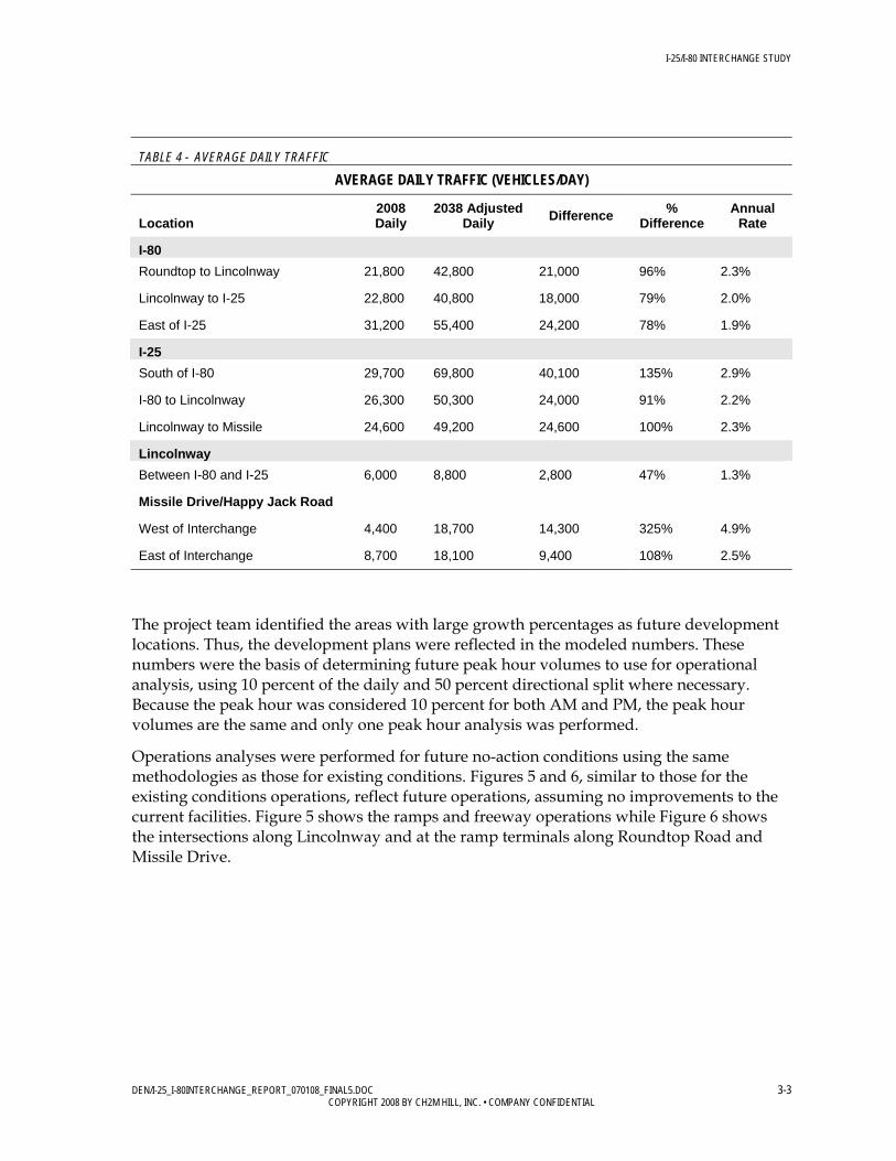
3.2.1 Future Conditions—No Action Future volumes are based on 30-year projections from the Cheyenne MPO transportation model. National Cooperative Highway Research Program Report Number 255 adjustment procedures were used along with the existing counts to adjust the daily model volumes. Table 4 summarizes the change in the ADT from the study year to the future year at specified locations.
I-25/I-80 INTERCHANGE STUDY
DEN/I-25_I-80INTERCHANGE_REPORT_070108_FINAL5.DOC 3-3 COPYRIGHT 2008 BY CH2M HILL, INC. • COMPANY CONFIDENTIAL
TABLE 4 - AVERAGE DAILY TRAFFIC
AVERAGE DAILY TRAFFIC (VEHICLES/DAY)
Location 2008 Daily
2038 Adjusted Daily Difference %
Difference Annual
Rate
I-80 Roundtop to Lincolnway 21,800 42,800 21,000 96% 2.3%
Lincolnway to I-25 22,800 40,800 18,000 79% 2.0%
East of I-25 31,200 55,400 24,200 78% 1.9%
I-25 South of I-80 29,700 69,800 40,100 135% 2.9%
I-80 to Lincolnway 26,300 50,300 24,000 91% 2.2%
Lincolnway to Missile 24,600 49,200 24,600 100% 2.3%
Lincolnway Between I-80 and I-25 6,000 8,800 2,800 47% 1.3%
Missile Drive/Happy Jack Road
West of Interchange 4,400 18,700 14,300 325% 4.9%
East of Interchange 8,700 18,100 9,400 108% 2.5%
The project team identified the areas with large growth percentages as future development locations. Thus, the development plans were reflected in the modeled numbers. These numbers were the basis of determining future peak hour volumes to use for operational analysis, using 10 percent of the daily and 50 percent directional split where necessary. Because the peak hour was considered 10 percent for both AM and PM, the peak hour volumes are the same and only one peak hour analysis was performed.
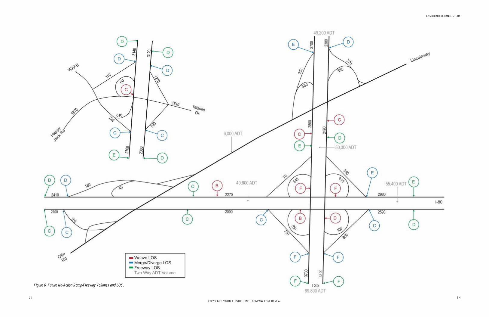
Operations analyses were performed for future no-action conditions using the same methodologies as those for existing conditions. Figures 5 and 6, similar to those for the existing conditions operations, reflect future operations, assuming no improvements to the current facilities. Figure 5 shows the ramps and freeway operations while Figure 6 shows the intersections along Lincolnway and at the ramp terminals along Roundtop Road and Missile Drive.
I-25/I-80 INTERCHANGE STUDY
DEN/I-25_I-80INTERCHANGE_REPORT_070108_FINAL5.DOC 3-4 COPYRIGHT 2008 BY CH2M HILL, INC. • COMPANY CONFIDENTIAL
Figure 6. Future No-Action Ramp/Freeway Volumes and LOS.
I-25/I-80 INTERCHANGE STUDY
DEN/I-25_I-80INTERCHANGE_REPORT_070108_FINAL5.DOC 3-5 COPYRIGHT 2008 BY CH2M HILL, INC. • COMPANY CONFIDENTIAL
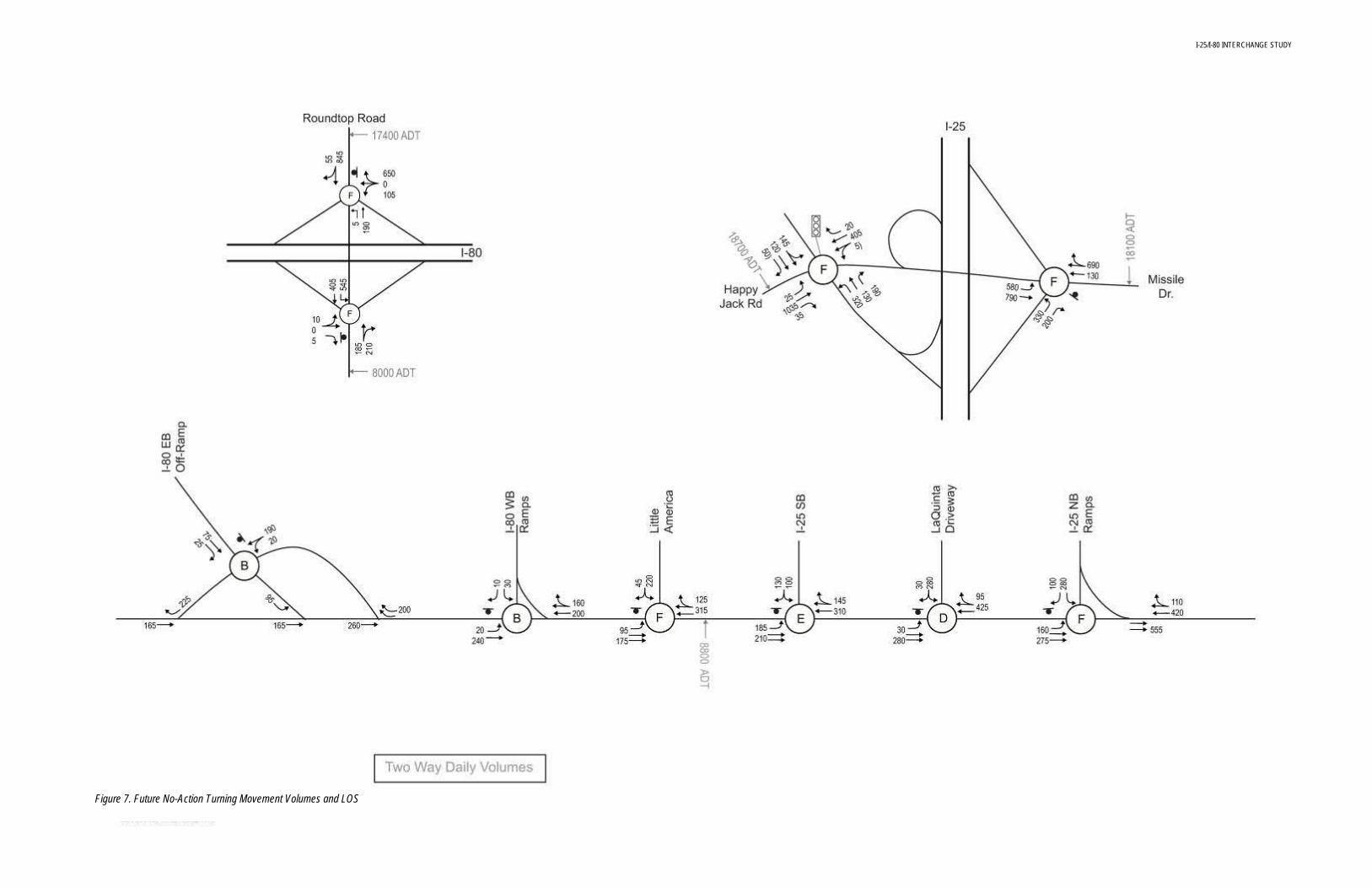
Figure 7. Future No-Action Turning Movement Volumes and LOS
I-25/I-80 INTERCHANGE STUDY
DEN/I-25_I-80INTERCHANGE_REPORT_070108_FINAL5.DOC 3-6 COPYRIGHT 2008 BY CH2M HILL, INC. • COMPANY CONFIDENTIAL
Due to projected volume increases, most LOS grades will worsen in the future—some to unacceptable levels. For example, the weaving sections on WB I-80 and SB I-25 in the system cloverleaf interchange will operate at LOS F and should be addressed to improve future operations. In addition, there are eight merge/diverge locations which will not meet future acceptable LOS. This may be a result of interchange spacing or acceleration/deceleration distances which will need improvement.
There are also several locations along both I-25 and I-80 where the mainline will operate below future acceptable LOS, such as WB I-80 (east of the cloverleaf), NB I-25 (south of the cloverleaf), and SB I-25 from Missile Drive south to the end of the study area. Operational improvements to the ramps, increased interchange spacing, or modified configurations will likely improve mainline levels of service.
Figure 5 shown above also indicates poor LOS at several intersections. The east intersection at Missile Drive and the I-25 NB ramps that fails in the existing scenario experiences even greater delay in the future and continues to operate at LOS F. The signalized intersection west of the Missile Drive interchange also operates at LOS F in the future. Additionally, the added volume on the Roundtop Road ramps creates LOS F at both ramp intersections, indicating a possible need for signals.
Along Lincolnway there are several intersections that do not meet acceptable LOS, and the cause is primarily the cross street delay when trying to make left turns onto the arterial. Both of the I-25 ramp intersections do not meet LOS C, indicating that an increase in the ramp volumes may cause a need for signalization and/or different lane configurations. The driveways into Little America and La Quinta are operating at LOS F, indicating a need for improvements. The intersections along Lincolnway operate in conjunction with one another because of the close spacing. Therefore, providing an improvement, such as a signal at one location, may in turn improve the left-turn gaps at the other un-signalized intersections.

I-25/I-80 INTERCHANGE STUDY
DEN/I-25_I-80INTERCHANGE_REPORT_070108_FINAL5.DOC 4-1 COPYRIGHT 2008 BY CH2M HILL, INC. • COMPANY CONFIDENTIAL
4.0 Alternative Development and Screening
4.1 Description of Process and Criteria Criteria were developed with input from the Steering Committee, as well as an evaluation of existing conditions and existing analyses. During a project workshop, a list of 53 issues and concerns were developed. This list was categorized and consolidated to form the foundation for the screening criteria.
The issues and concerns identified by the Steering Committee in Workshop #2 were grouped into the following criteria categories: Impacts on Development, Mobility, Environmental, Safety, and Implementation. Details on the issues and their categorization can be found in Technical Memorandum #2 on the accompanying CD in Appendix 7.
4.1.1 Level 1 Screening Criteria A two-tiered screening process was used to evaluate and compare alternatives. Level 1 screening criteria were qualitative in nature and focused on identifying “fatal flaws” that would prevent an idea or alternative from being carried forward for additional study. Each criterion is weighted equally and was used to eliminate alternatives that did not meet study objectives. Level 1 screening measures consisted of a series of yes/no questions identified in Workshop #2 (Appendix 2 and 7); one “no” response would screen an alternative from further consideration. The criteria and yes/no questions are detailed in Table 5.
TABLE 5. LEVEL 1 SCREENING CRITERIA
LEVEL 1 SCREENING CRITERIA
Criteria Category Fatal Flaw Questions
Impacts on Existing and Planned Development
• Does the improvement maintain reasonable access to existing and future developments?
Mobility • Does the improvement maintain acceptable LOS on the interstate facilities?
• Does the improvement maintain acceptable LOS on adjacent streets?
Environmental • Can environmental impacts be avoided or mitigated?
Safety • Will the improvement maintain or improve safe conditions?
Implementation • Is the improvement constructible?
• Is the improvement maintainable?
I-25/I-80 INTERCHANGE STUDY
COPYRIGHT 2008 BY CH2M HILL, INC. • COMPANY CONFIDENTIAL 4-2
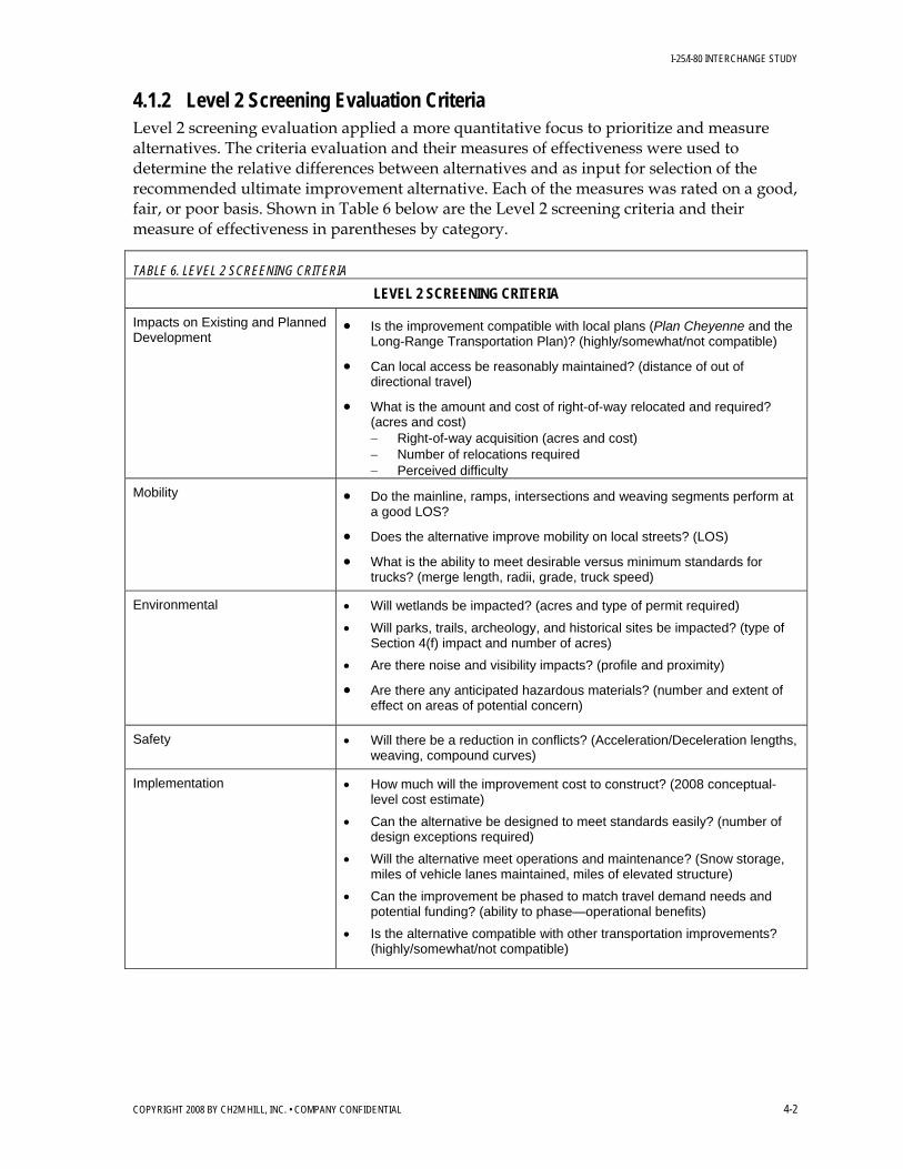
4.1.2 Level 2 Screening Evaluation Criteria Level 2 screening evaluation applied a more quantitative focus to prioritize and measure alternatives. The criteria evaluation and their measures of effectiveness were used to determine the relative differences between alternatives and as input for selection of the recommended ultimate improvement alternative. Each of the measures was rated on a good, fair, or poor basis. Shown in Table 6 below are the Level 2 screening criteria and their measure of effectiveness in parentheses by category.
TABLE 6. LEVEL 2 SCREENING CRITERIA
LEVEL 2 SCREENING CRITERIA
Impacts on Existing and Planned Development
• Is the improvement compatible with local plans (Plan Cheyenne and the Long-Range Transportation Plan)? (highly/somewhat/not compatible)
• Can local access be reasonably maintained? (distance of out of directional travel)
• What is the amount and cost of right-of-way relocated and required? (acres and cost) − Right-of-way acquisition (acres and cost) − Number of relocations required − Perceived difficulty
Mobility • Do the mainline, ramps, intersections and weaving segments perform at a good LOS?
• Does the alternative improve mobility on local streets? (LOS)
• What is the ability to meet desirable versus minimum standards for trucks? (merge length, radii, grade, truck speed)
Environmental • Will wetlands be impacted? (acres and type of permit required)
• Will parks, trails, archeology, and historical sites be impacted? (type of Section 4(f) impact and number of acres)
• Are there noise and visibility impacts? (profile and proximity)
• Are there any anticipated hazardous materials? (number and extent of effect on areas of potential concern)
Safety • Will there be a reduction in conflicts? (Acceleration/Deceleration lengths, weaving, compound curves)
Implementation • How much will the improvement cost to construct? (2008 conceptual-level cost estimate)
• Can the alternative be designed to meet standards easily? (number of design exceptions required)
• Will the alternative meet operations and maintenance? (Snow storage, miles of vehicle lanes maintained, miles of elevated structure)
• Can the improvement be phased to match travel demand needs and potential funding? (ability to phase—operational benefits)
• Is the alternative compatible with other transportation improvements? (highly/somewhat/not compatible)

I-25/I-80 INTERCHANGE STUDY
COPYRIGHT 2008 BY CH2M HILL, INC. • COMPANY CONFIDENTIAL 4-3
4.2 Description of Alternatives A range of alternatives was developed for the study area interchanges. The alternatives were developed to address the known issues and concerns and were evaluated using the evaluation criteria developed by the Steering Committee.
The Steering Committee directed the study team to develop short-term and ultimate improvements for the interchanges in the study area. The Steering Committee was particularly interested in low-cost options that could be implemented immediately to improve safety and operational efficiencies.
To assist in the alternative evaluation process and to quickly distinguish alternatives geographically, a naming convention was implemented using roman numerals for the system interchange at I-25 and I-80 and letters A through D for the adjacent service interchanges. The project team developed initial design concepts for each of the study area interchanges:
• I-25 and I-80 - (Alternatives I, II, III, IV, etc) • I-25 and Lincolnway - (Alternatives A1, A2, etc.) • I-80 and Lincolnway - (Alternatives B1, B2, etc.) • I-80 and Roundtop Road - (Alternatives C1, C2, etc.) • I-25 and Missile Drive - (Alternatives D1, D2, etc.)
The primary focus of the initial design concepts was to address the key operational and safety issues of the interchanges: weaving conditions, interchange spacing, and maintaining or improving accesses. Minimizing right-of-way requirements and cost were also key considerations in the development of initial alternatives.
The following sections describe the initial design alternatives by interchange area. Although it was a goal of the study to identify minor improvements that could be implemented immediately, none of the design concepts met that goal, either in totality or through phasing. That is, no low-cost improvements are available that would provide operational or safety benefits because the magnitude of the needed improvements were too great to be accomplished with an inexpensive or quick solution. This conclusion supported WYDOT’s prior experience with implementing low-cost but ineffective changes, such as re-striping, to the interchange configurations. The initial concepts described here, therefore, are large-scale reconstruction options for each of the interchanges. Potential phasing of improvements is addressed in Section 5.0.
The following describes the initial design concepts developed. Each of these initial design concepts was evaluated using the Level 1 Screening Criteria. Results of the screening are presented in Section 4.4.
4.2.1 I-25 and I-80 System Interchange Alternatives In all of the alternative concepts for the system interchange, free flow ramps are maintained for all movements. The short weave sections in the existing full cloverleaf design were identified as critical safety and design issues that needed to be improved. The predominant traffic movements are NB to EB and WB to SB, which represent Denver to Cheyenne travelers.

I-25/I-80 INTERCHANGE STUDY
COPYRIGHT 2008 BY CH2M HILL, INC. • COMPANY CONFIDENTIAL 4-4
Figure 8 - Alternative I – Single Loop with Turban
Alternative I accommodates traffic via free flowing directional movements with a single loop ramp in the northeast quadrant and three turban ramps that traverse the outside of the existing interchange footprint. The NB to WB loop ramp design speed is improved from the existing 25 mph to 30 mph. The turban ramps are designed at 55 mph.
Advantages • Eliminates all critical weave segments of the existing full cloverleaf design • Has high-speed free flow movements (7 out of 8) • Loop ramps help eliminate the need for structures • Does not require third-level structure • Accommodates phased constructability Disadvantages • Has similar right-of-way needs when compared to full turban • May require higher cost “basket weave” with Lincolnway interchange to the north to maintain full access • Requires additional structures
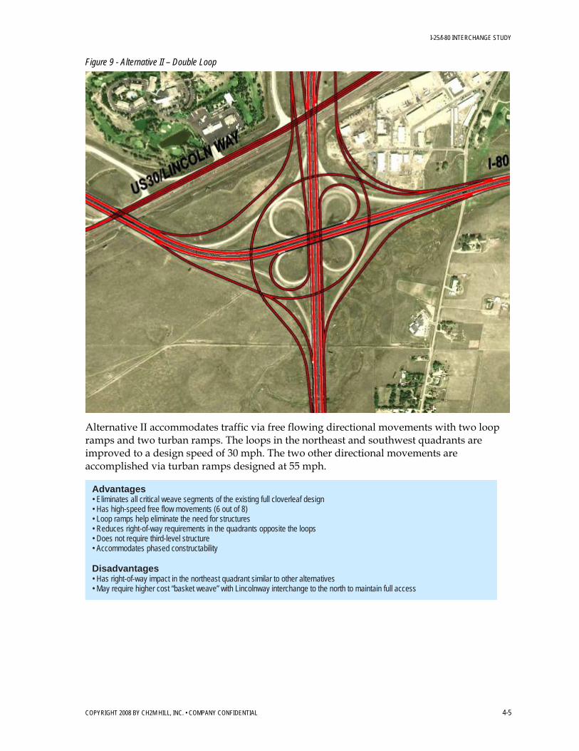
I-25/I-80 INTERCHANGE STUDY
COPYRIGHT 2008 BY CH2M HILL, INC. • COMPANY CONFIDENTIAL 4-5
Figure 9 - Alternative II – Double Loop
Alternative II accommodates traffic via free flowing directional movements with two loop ramps and two turban ramps. The loops in the northeast and southwest quadrants are improved to a design speed of 30 mph. The two other directional movements are accomplished via turban ramps designed at 55 mph.
Advantages • Eliminates all critical weave segments of the existing full cloverleaf design • Has high-speed free flow movements (6 out of 8) • Loop ramps help eliminate the need for structures • Reduces right-of-way requirements in the quadrants opposite the loops • Does not require third-level structure • Accommodates phased constructability Disadvantages • Has right-of-way impact in the northeast quadrant similar to other alternatives • May require higher cost “basket weave” with Lincolnway interchange to the north to maintain full access

I-25/I-80 INTERCHANGE STUDY
COPYRIGHT 2008 BY CH2M HILL, INC. • COMPANY CONFIDENTIAL 4-6
Figure 10 - Alternative III – Stack
Alternative III provides a third-level structure through the heart of the interchange for the EB to NB and WB to SB movements. Similar to the double loop concept, two of the free flowing movements are accomplished with loop ramps. These loops in the northeast and southwest quadrants are improved to a design speed of 30 mph. All other directional movements are designed at 55 mph.
Advantages • Eliminates all critical weave segments of the existing full cloverleaf design • Has high-speed free flow movements (6 out of 8) • Reduces right-of-way requirements in the quadrants opposite the loops Disadvantages • Requires third-level structure (longer bridges and higher cost) • Has right-of-way impact in the northeast quadrant similar to other alternatives • May require higher cost “basket weave” with Lincolnway interchange to the north to maintain full access • Requires significant additional structures • Is more difficult to construct
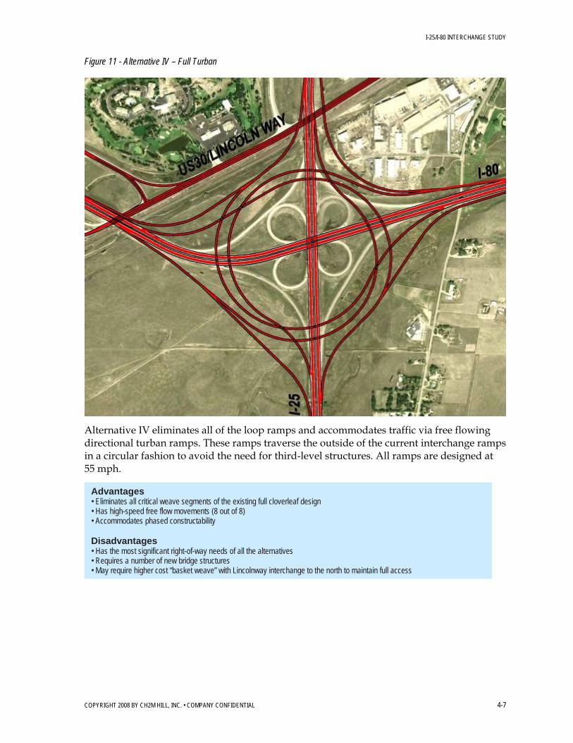
I-25/I-80 INTERCHANGE STUDY
COPYRIGHT 2008 BY CH2M HILL, INC. • COMPANY CONFIDENTIAL 4-7
Figure 11 - Alternative IV – Full Turban
Alternative IV eliminates all of the loop ramps and accommodates traffic via free flowing directional turban ramps. These ramps traverse the outside of the current interchange ramps in a circular fashion to avoid the need for third-level structures. All ramps are designed at 55 mph.
Advantages • Eliminates all critical weave segments of the existing full cloverleaf design • Has high-speed free flow movements (8 out of 8) • Accommodates phased constructability Disadvantages • Has the most significant right-of-way needs of all the alternatives • Requires a number of new bridge structures • May require higher cost “basket weave” with Lincolnway interchange to the north to maintain full access
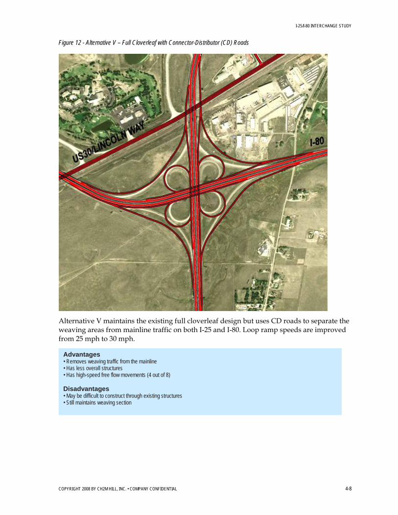
I-25/I-80 INTERCHANGE STUDY
COPYRIGHT 2008 BY CH2M HILL, INC. • COMPANY CONFIDENTIAL 4-8
Figure 12 - Alternative V – Full Cloverleaf with Connector-Distributor (CD) Roads
Alternative V maintains the existing full cloverleaf design but uses CD roads to separate the weaving areas from mainline traffic on both I-25 and I-80. Loop ramp speeds are improved from 25 mph to 30 mph.
Advantages • Removes weaving traffic from the mainline • Has less overall structures • Has high-speed free flow movements (4 out of 8) Disadvantages • May be difficult to construct through existing structures • Still maintains weaving section

I-25/I-80 INTERCHANGE STUDY
COPYRIGHT 2008 BY CH2M HILL, INC. • COMPANY CONFIDENTIAL 4-9
Figure 13 - Alternative VI – ¾ Cloverleaf with CD Roads and Flyover
Alternative VI maintains three of the four existing cloverleaf loop ramps but uses CD roads to separate the weaving areas from mainline traffic on both I-25 and I-80. In addition, a WB to SB flyover ramp replaces the fourth loop ramp. Loop ramp speeds are improved from 25 mph to 30 mph.
Advantages • Removes weaving traffic from the mainline • Has less overall structures • Has high-speed free flow movements (5 out of 8) Disadvantages • Requires third-level structure (longer bridges and higher cost) • May be difficult to construct through existing structures • Still maintains weaving section
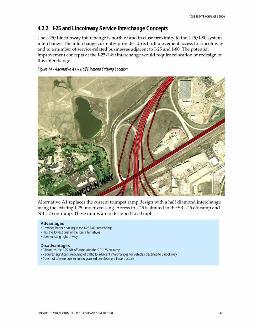
I-25/I-80 INTERCHANGE STUDY
COPYRIGHT 2008 BY CH2M HILL, INC. • COMPANY CONFIDENTIAL 4-10
4.2.2 I-25 and Lincolnway Service Interchange Concepts
The I-25/Lincolnway interchange is north of and in close proximity to the I-25/I-80 system interchange. The interchange currently provides direct full movement access to Lincolnway and to a number of service-related businesses adjacent to I-25 and I-80. The potential improvement concepts at the I-25/I-80 interchange would require relocation or redesign of this interchange.
Figure 14 - Alternative A1 – Half Diamond Existing Location
Alternative A1 replaces the current trumpet ramp design with a half diamond interchange using the existing I-25 under-crossing. Access to I-25 is limited to the SB I-25 off-ramp and NB I-25 on-ramp. These ramps are redesigned to 50 mph.
Advantages • Provides better spacing to the I-25/I-80 interchange • Has the lowest cost of the four alternatives • Uses existing right-of-way Disadvantages • Eliminates the I-25 NB off-ramp and the SB I-25 on-ramp • Requires significant rerouting of traffic to adjacent interchanges for vehicles destined to Lincolnway • Does not provide connection to planned development infrastructure

I-25/I-80 INTERCHANGE STUDY
COPYRIGHT 2008 BY CH2M HILL, INC. • COMPANY CONFIDENTIAL 4-11
Figure 15 - Alternative A2 – Full Diamond with Braided Ramps
Alternative A2 relocates the interchange slightly north of its current location and provides full movement access to Lincolnway via a diamond interchange and a connecting arterial roadway. This connection is also planned to extend west of I-25 to allow access to planned development. The proximity of this interchange to the I-25/I-80 interchange requires the ramps between the interchanges to be braided, i.e., vertically separated so that the on- and off-ramp movements can both occur in a relatively short distance.
Advantages • Maintains existing full movement access • Provides connection to planned development infrastructure • Reduces the number of intersections on Lincolnway by one Disadvantages • Requires new over-crossing of I-25 • Requires additional structure for braided ramps • Has higher cost • Requires more difficult geometry
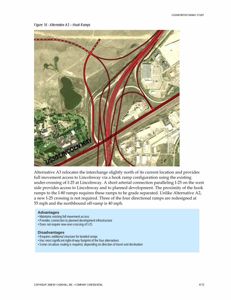
I-25/I-80 INTERCHANGE STUDY
COPYRIGHT 2008 BY CH2M HILL, INC. • COMPANY CONFIDENTIAL 4-12
Figure 16 - Alternative A3 – Hook Ramps
Alternative A3 relocates the interchange slightly north of its current location and provides full movement access to Lincolnway via a hook ramp configuration using the existing under-crossing of I-25 at Lincolnway. A short arterial connection paralleling I-25 on the west side provides access to Lincolnway and to planned development. The proximity of the hook ramps to the I-80 ramps requires these ramps to be grade separated. Unlike Alternative A2, a new I-25 crossing is not required. Three of the four directional ramps are redesigned at 55 mph and the northbound off-ramp is 40 mph.
Advantages • Maintains existing full movement access • Provides connection to planned development infrastructure • Does not require new over-crossing of I-25 Disadvantages • Requires additional structure for braided ramps • Has most significant right-of-way footprint of the four alternatives • Some circuitous routing is required, depending on direction of travel and destination

I-25/I-80 INTERCHANGE STUDY
COPYRIGHT 2008 BY CH2M HILL, INC. • COMPANY CONFIDENTIAL 4-13
Figure 17 - Alternative A4 – Half Diamond Relocated
Alternative A4 replaces the current trumpet ramp design with a half diamond interchange slightly north of its current location. Like Alternative A1, access to I-25 is limited to the SB I-25 off-ramp and NB I-25-on ramp. A new east-west arterial roadway provides access to Lincolnway on the east and to planned development on the west.
Advantages • Provides better spacing to the I-25/I-80 interchange • Has the second lowest cost of the four alternatives • Provides connection to planned development infrastructure Disadvantages • Requires new over-crossing of I-25 • Eliminates the I-25 NB off-ramp and the SB I-25 on-ramp • Requires significant rerouting of traffic to adjacent interchanges for vehicles destined to Lincolnway

I-25/I-80 INTERCHANGE STUDY
COPYRIGHT 2008 BY CH2M HILL, INC. • COMPANY CONFIDENTIAL 4-14
4.2.3 I-80 and Lincolnway Service Interchange Concepts
To provide better spacing between the I-25/I-80 interchange and the I-80/Lincolnway interchange, all design alternatives relocate the I-80/Lincolnway interchange further west, approximately midway between I-25 and the Roundtop Road interchange. An additional north-south arterial between I-25 and Roundtop is envisioned to provide access to planned development; the I-80/Lincolnway interchange would likely tie in to that supportive infrastructure.
Figure 18 - Alternative B1 – Diamond with Single Loop
Alternative B1 provides a diamond interchange with a single loop in the southwest quadrant, essentially providing a one quadrant, partial cloverleaf Type A design. The directional ramps are designed at 35 mph and the loop ramp at 30 mph. Access to and from Lincolnway would be provided via connecting frontage roads on both the north and south sides of I-80.
Advantages • Maintains 1-mile spacing between I-25/I-80 and Roundtop interchanges • Has higher capacity loop ramp for one of the left-turn movements (SB to EB) Disadvantages • Has the second highest right-of-way needs of the five alternatives

I-25/I-80 INTERCHANGE STUDY
COPYRIGHT 2008 BY CH2M HILL, INC. • COMPANY CONFIDENTIAL 4-15
Figure 19 - Alternative B2 – Split Diamond
Alternative B2 consolidates the I-80/Lincolnway and I-80/Roundtop interchanges into a split diamond. The split diamond concept could ultimately have four traffic signals with two-lane, one-way CD roads connecting the ramps between the two service roads.
Advantages • Maintains 1-mile spacing between I-25/I-80 and Lincolnway and Roundtop • Has lowest right-of-way needs of the five alternatives • Provides for all directional movements to and from I-80 Disadvantages • Requires greater out-of-direction travel to access Lincolnway

I-25/I-80 INTERCHANGE STUDY
COPYRIGHT 2008 BY CH2M HILL, INC. • COMPANY CONFIDENTIAL 4-16
Figure 20 - Alternative B3 – Hook Ramps
Alternative B3 does not provide a bridge over-crossing of I-80 and therefore cannot provide full movement access without some out of directional travel to Lincolnway. This hook ramp concept only allows EB off and on movements from the south side of I-80 and WB on and off movements from the north side. Ramps are designed at 50 mph.
Advantages • Maintains 1-mile spacing between I-25/I-80 and Lincolnway • Has the lowest cost of the five alternatives Disadvantages • Provides no bridge over-crossing of I-80 • Does not allow full movement access • Requires substantial out-of-direction travel for certain movements and access to Lincolnway

I-25/I-80 INTERCHANGE STUDY
COPYRIGHT 2008 BY CH2M HILL, INC. • COMPANY CONFIDENTIAL 4-17
Figure 21 - Alternative B4 – Two Loop
Alternative B4 has two loops on the west side of the new north-south arterial, providing higher capacity for the WB to WB and the SB to EB movements. The loop ramps are designed at 30 mph and the directional ramps at 35 mph near the intersections. This configuration provides better spacing to the I-25/I-80 interchange. Access to and from Lincolnway is provided via connecting frontage roads potentially on both the north and south sides of I-80.
Advantages • Maintains 1-mile spacing between I-25/I-80 and Lincolnway • Has higher capacity loop ramps for two of the left-turn movements (SB to EB and WB to SB) Disadvantages • Has highest right-of-way needs of the five alternatives • Introduces an undesirable weave section on arterial

I-25/I-80 INTERCHANGE STUDY
COPYRIGHT 2008 BY CH2M HILL, INC. • COMPANY CONFIDENTIAL 4-18
Figure 22 - Alternative B5 – Diamond
Alternative B5 provides a full movement diamond interchange and connecting frontage roads for access to Lincolnway. To improve the interchange spacing with I-25/I-80, the WB I-80 on-ramp is braided with the I-25 off-ramp. However, it is possible to configure this as a full diamond without the braided ramps.
Advantages • Maintains 1-mile spacing between I-25/I-80 and Lincolnway • Has second lowest right-of-way needs of the five alternatives Disadvantages • Higher cost braided ramp is needed to maintain full access • Reduces ramp spacing to I-25/I-80 if ramps are not braided

I-25/I-80 INTERCHANGE STUDY
COPYRIGHT 2008 BY CH2M HILL, INC. • COMPANY CONFIDENTIAL 4-19
4.2.4 Roundtop Road Service Interchange Concepts
Modifications at the I-80/Roundtop Road diamond interchange are needed to relocate the Lincolnway interchange further west and to provide better overall interchange spacing along I-80.
Figure 23 - Alternative C1 – Shortened Diamond
Alternative C1 requires the east side ramps to be shortened to facilitate an interchange midway between I-25/I-80 and Roundtop Road (as designed ramps still meet design standards). The existing full diamond configuration and associated access is maintained.
Advantages • Facilitates relocation of the Lincolnway interchange • Provides better spacing to the Lincolnway interchange • Has minimal reconstruction costs • Provides better arterial spacing Disadvantages • Reduces the acceleration and deceleration length of the east side ramps but ramps still meet design standards
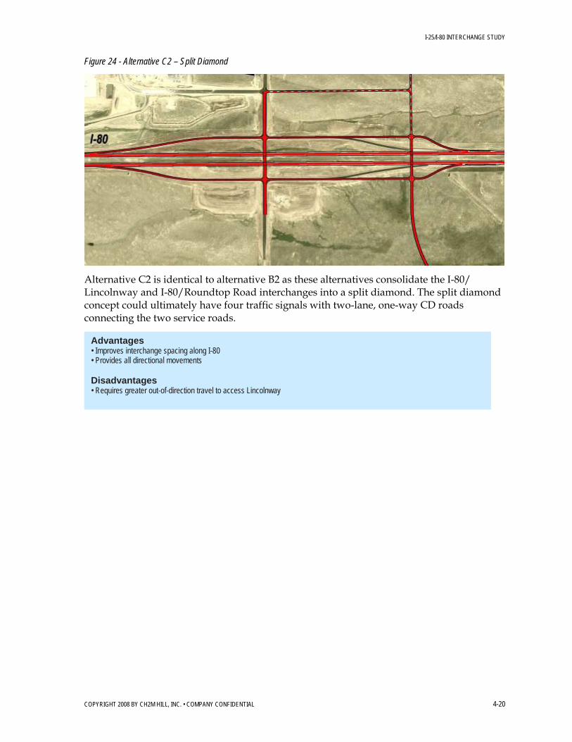
I-25/I-80 INTERCHANGE STUDY
COPYRIGHT 2008 BY CH2M HILL, INC. • COMPANY CONFIDENTIAL 4-20
Figure 24 - Alternative C2 – Split Diamond
Alternative C2 is identical to alternative B2 as these alternatives consolidate the I-80/ Lincolnway and I-80/Roundtop Road interchanges into a split diamond. The split diamond concept could ultimately have four traffic signals with two-lane, one-way CD roads connecting the two service roads.
Advantages • Improves interchange spacing along I-80 • Provides all directional movements Disadvantages • Requires greater out-of-direction travel to access Lincolnway

I-25/I-80 INTERCHANGE STUDY
COPYRIGHT 2008 BY CH2M HILL, INC. • COMPANY CONFIDENTIAL 4-21
4.2.5 Missile Drive Service Interchange Concepts
Figure 25 - Alternative D1 – Diamond
Based on WYDOT’s long-term plan to reconfigure this interchange, Alternative D1 converts the full cloverleaf to a diamond interchange. In the short-term, the east side loop ramps are eliminated and combined with the directional ramps terminating at an un-signalized intersection. For the ultimate configuration, the west side loop ramps are also removed, creating the full diamond configuration.
Advantages • Provides low-cost improvement strategy • Removes all of the weave sections Disadvantages • Introduces two new arterial intersections with close spacing to the F.E. Warren AFB gate intersection • Eliminates SB I-25 off-ramp directly to the F.E. Warren AFB gate

I-25/I-80 INTERCHANGE STUDY
COPYRIGHT 2008 BY CH2M HILL, INC. • COMPANY CONFIDENTIAL 4-22
Figure 26 - Alternative D2 – PARCLO A/B
Alternative D2 converts the full cloverleaf to a two-loop PARCLO A/B interchange. Alternative D2 has two loops on the south side of Missile Drive to maintain a higher capacity for the SB to EB and the WB to NB movements. The loop ramps are designed at 30 mph and the directional ramps at 55 mph on and off I-25.
Advantages • Opens up right-of-way in two quadrants • Provides higher capacity loop ramps for two of the left-turn movements (SB to EB and EB to NB) • Is more compatible for Warren AFB Disadvantages • Is more costly to implement • Introduces merge on mainline

I-25/I-80 INTERCHANGE STUDY
COPYRIGHT 2008 BY CH2M HILL, INC. • COMPANY CONFIDENTIAL 4-23
4.3 Alternative Packaging
After initial advantages and disadvantages by interchange location were identified it was important to understand how each of the individual alternatives would function as a package and begin to identify those alternatives that were incompatible. Therefore, individual alternatives were packaged together and are shown in Figures 26 through 33. The packaging of alternatives also provided a more straightforward format for communicating alternatives to the steering committee, stakeholders, and the public.
The initial intension to keep interchange alternatives as separate options is preserved with the alternatives. However, elements of the multiple interchanges may impact one another depending upon which alternative is chosen for a given location. For instance, any of the I-25/I-80 interchange alternatives may be selected but require different ramp configurations to the adjacent (A) I-25/Lincolnway alternatives. This same logic applies to the (B) I-80/Lincolnway and (C) I-80/Roundtop Road interchanges and one of the combinations for the I-25/I-80 and (B) I-80/Lincolnway interchanges. None of the alternatives were incompatible with one another; most just required a different connection.
The I-25/I-80 interchange NB and SB ramps, on the north side of the interchange, required that they cross the railroad tracks at different configurations leading into the I-25/Lincolnway interchange. This was dependant upon both interchange alternatives as to the configuration.
Since the (B) I-80/Lincolnway interchange alternatives were relocated west of the current interchange the impacts to the I-25/I-80 interchange EB and WB ramps, on the west side of the interchange, were impacted only by the B5 alternative. The other I-25/I-80 interchange ramp configurations for each alternatives acted independently.
The alternatives for the (B) I-80/Lincolnway interchange had a direct impact on what would be necessary at the (C) I-80/Roundtop Road interchange. With the exception of the (B2) “split-diamond” alternative, which combined both interchanges, the (B) I-80/Lincolnway alternatives forced the existing Roundtop Road interchange ramps on the east side of the interchange to be shortened. This was done to provide spacing between the new (B) I-80/Lincolnway interchange and the Roundtop Road interchange.
The location of the Missile Drive interchange didn’t warrant any dependency on the other alternatives.

I-25/I-80 INTERCHANGE STUDY
DEN/I-25_I-80INTERCHANGE_REPORT_070108_FINAL5.DOC 4-24 COPYRIGHT 2008 BY CH2M HILL, INC. • COMPANY CONFIDENTIAL
Figure 27 – Alternative Plan Package I

I-25/I-80 INTERCHANGE STUDY
DEN/I-25_I-80INTERCHANGE_REPORT_070108_FINAL5.DOC 4-25 COPYRIGHT 2008 BY CH2M HILL, INC. • COMPANY CONFIDENTIAL
Figure 28 – Alternative Plan Package II
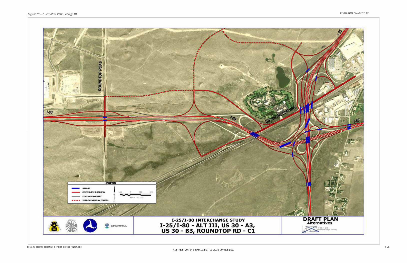
I-25/I-80 INTERCHANGE STUDY
DEN/I-25_I-80INTERCHANGE_REPORT_070108_FINAL5.DOC 4-26 COPYRIGHT 2008 BY CH2M HILL, INC. • COMPANY CONFIDENTIAL
Figure 29 – Alternative Plan Package III

I-25/I-80 INTERCHANGE STUDY
DEN/I-25_I-80INTERCHANGE_REPORT_070108_FINAL5.DOC 4-27 COPYRIGHT 2008 BY CH2M HILL, INC. • COMPANY CONFIDENTIAL
Figure 30 – Alternative Plan Package IV

I-25/I-80 INTERCHANGE STUDY
DEN/I-25_I-80INTERCHANGE_REPORT_070108_FINAL5.DOC 4-28 COPYRIGHT 2008 BY CH2M HILL, INC. • COMPANY CONFIDENTIAL
Figure 31– Alternative Plan Package V

I-25/I-80 INTERCHANGE STUDY
DEN/I-25_I-80INTERCHANGE_REPORT_070108_FINAL5.DOC 4-29 COPYRIGHT 2008 BY CH2M HILL, INC. • COMPANY CONFIDENTIAL
Figure 32 – Alternative Plan Package VI

I-25/I-80 INTERCHANGE STUDY
DEN/I-25_I-80INTERCHANGE_REPORT_070108_FINAL5.DOC 4-30 COPYRIGHT 2008 BY CH2M HILL, INC. • COMPANY CONFIDENTIAL
Figure 33 – Alternative Plan Package VII

I-25/I-80 INTERCHANGE STUDY
DEN/I-25_I-80INTERCHANGE_REPORT_070108_FINAL5.DOC 4-31 COPYRIGHT 2008 BY CH2M HILL, INC. • COMPANY CONFIDENTIAL
Figure 34 – Alternative Plan Package VIII

I-25/I-80 INTERCHANGE STUDY
DEN/I-25_I-80INTERCHANGE_REPORT_070108_FINAL5.DOC 4-32 COPYRIGHT 2008 BY CH2M HILL, INC. • COMPANY CONFIDENTIAL
Figure 35 – Alternative Plan Package IX

I-25/I-80 INTERCHANGE STUDY
DEN/I-25_I-80INTERCHANGE_REPORT_070108_FINAL5.DOC 4-33 COPYRIGHT 2008 BY CH2M HILL, INC. • COMPANY CONFIDENTIAL
4.4 Level 1 Screening The Level 1 screening determined which alternatives would be carried forward for further study. Any alternative that received a “no” in any criterion was eliminated from further consideration. The Level 1 Screening Criteria are described in Section 4.1.1.
The following list includes the alternatives that were not carried forward to the Level 2 evaluation and the reason why they were eliminated:
• Alternative V – This alternative kept a full cloverleaf design but used CD roads to separate the weaving areas from mainline traffic on both I-25 and I-80. This improvement did not meet the mobility needs due to an inadequate weaving section length for the high ramp volumes on WB I-80. Therefore, it fails the mobility criterion, “Does the improvement maintain acceptable LOS on the interstate facility?”.
• Alternative A1 – This alternative was a half diamond interchange using the existing I-25 under-crossing. Access to I-25 was limited to the SB I-25 off-ramp and NB I-25 on-ramp. By creating substantial out-of-direction travel due to limited access to Lincolnway, it impedes reasonable access to existing and future developments. Therefore, it fails the Impacts on Existing and Planned Development Level 1 criterion, “Does the improvement maintain reasonable access to existing and future developments?”.
• Alternative A4 – This alternative was a half diamond interchange slightly north of the current interchange location. Like Alternative A1, access to I-25 was limited to the SB I-25 off-ramp and NB I-25 on-ramp. A new east-west arterial roadway provided access to Lincolnway on the east and to planned development on the west. Also like alternative A1, by creating substantial out-of-direction travel by limiting access to Lincolnway, it impedes reasonable access to existing and future developments. Therefore, it failed the Impacts on Existing and Planned Development Level 1 criterion, “Does the improvement maintain reasonable access to existing and future developments?”.
• Alternative B3 – This alternative does not provide a bridge over-crossing of I-80 and therefore cannot provide full movement access without some out-of-directional travel to Lincolnway. This hook ramp concept only allows EB off and on movements from the south side of I-80 and WB on and off movements from the north side. Due to these factors this option fails the Impacts on Existing and Planned Development Level 1 criterion, “Does the improvement maintain reasonable access to existing and future developments?”
Tables 7 through 10 show the complete Level 1 screening matrices. The remaining 14 ultimate improvement alternatives were further evaluated in a Level 2 screening. A number of improvements were identified for further evaluation but contained elements that were deemed notably inferior. • Alternative III – This alternative under the “Implementation” category is questionable
for the criterion, “Is the improvement maintainable?” due to the level of snow removal required.
• Alternative B2/C2 – This alternative under the “Impacts on Existing and Planned development” is questionable for the criterion, “Does the improvement maintain reasonable access to existing and future developments?”. There is some concern that the one-way frontage roads will cause lengthy, out-of-direction travel.
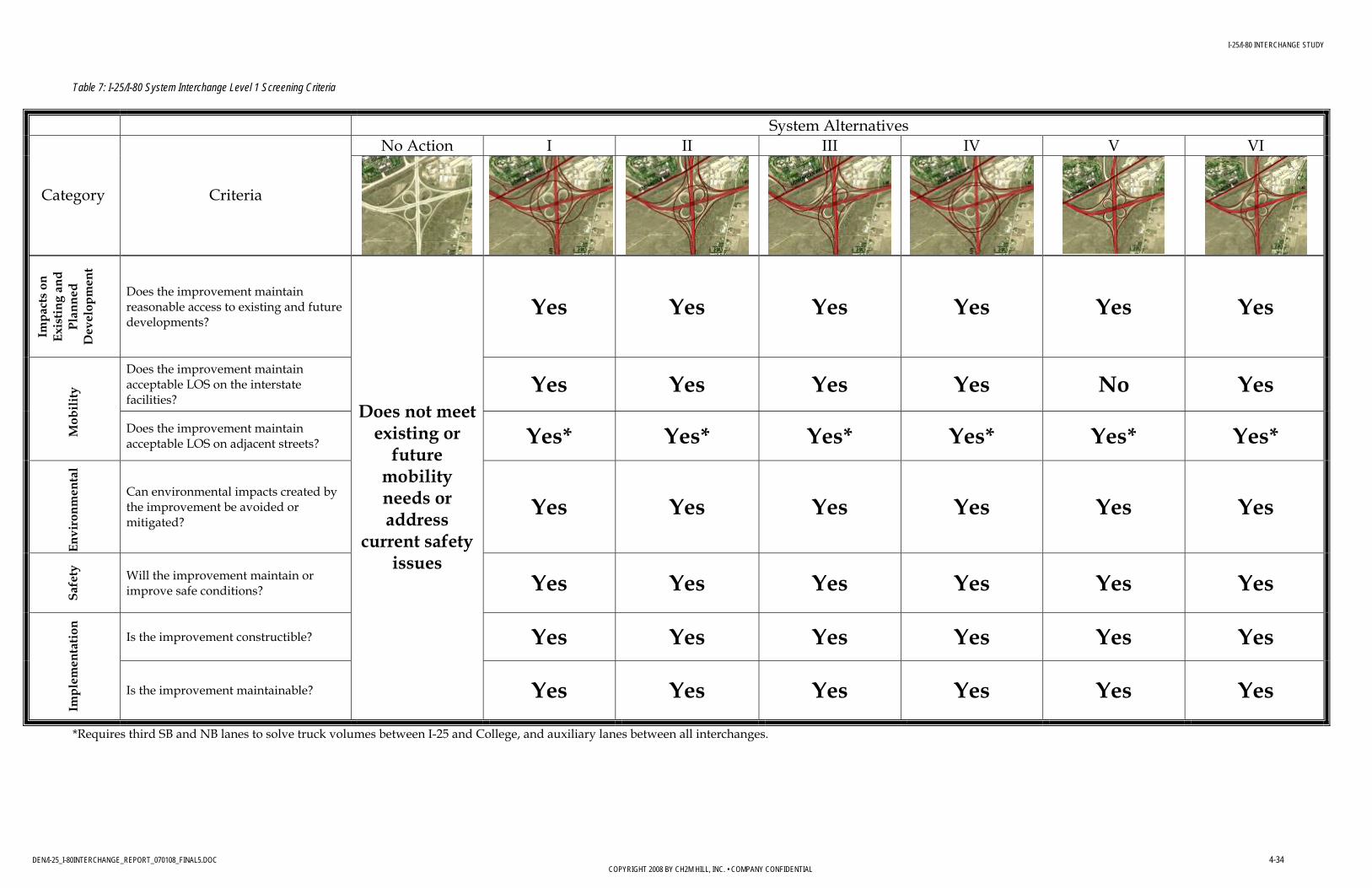
I-25/I-80 INTERCHANGE STUDY
DEN/I-25_I-80INTERCHANGE_REPORT_070108_FINAL5.DOC 4-34 COPYRIGHT 2008 BY CH2M HILL, INC. • COMPANY CONFIDENTIAL
Table 7: I-25/I-80 System Interchange Level 1 Screening Criteria
System Alternatives No Action I II III IV V VI
Category Criteria
Impa
cts
on
Exis
ting
and
Plan
ned
Dev
elop
men
t
Does the improvement maintain reasonable access to existing and future developments?
Yes Yes Yes Yes Yes Yes
Does the improvement maintain acceptable LOS on the interstate facilities?
Yes Yes Yes Yes No Yes
Mob
ility
Does the improvement maintain acceptable LOS on adjacent streets? Yes* Yes* Yes* Yes* Yes* Yes*
En
viro
nmen
tal
Can environmental impacts created by the improvement be avoided or mitigated?
Yes Yes Yes Yes Yes Yes
Sa
fety
Will the improvement maintain or
improve safe conditions? Yes Yes Yes Yes Yes Yes
Is the improvement constructible? Yes Yes Yes Yes Yes Yes
Impl
emen
tatio
n
Is the improvement maintainable?
Does not meet existing or
future mobility needs or address
current safety issues
Yes Yes Yes Yes Yes Yes
*Requires third SB and NB lanes to solve truck volumes between I-25 and College, and auxiliary lanes between all interchanges.

I-25/I-80 INTERCHANGE STUDY
DEN/I-25_I-80INTERCHANGE_REPORT_070108_FINAL5.DOC 4-35 COPYRIGHT 2008 BY CH2M HILL, INC. • COMPANY CONFIDENTIAL
Table 8: Service Interchange A – I-25/Lincolnway Interchange Level 1 Screening Criteria
Service Interchange A Alternatives No Action A1 A2 A3 A4
Category Criteria
Impa
cts
on
Exis
ting
and
Plan
ned
Dev
elop
men
t
Does the improvement maintain reasonable access to existing and future developments?
No Yes Yes No
Does the improvement maintain acceptable LOS on the interstate facilities?
Yes Yes Yes Yes
Mob
ility
Does the improvement maintain acceptable LOS on adjacent streets? Yes Yes Yes Yes
En
viro
nmen
tal
Can environmental impacts created by the improvement be avoided or mitigated?
Yes Yes Yes Yes
Sa
fety
Will the improvement maintain or
improve safe conditions? Yes Yes Yes Yes
Is the improvement constructible? Yes Yes Yes Yes
Impl
emen
tatio
n
Is the improvement maintainable?
Does not meet existing or
future mobility needs or
address current safety issues
Yes Yes Yes Yes

I-25/I-80 INTERCHANGE STUDY
DEN/I-25_I-80INTERCHANGE_REPORT_070108_FINAL5.DOC 4-36 COPYRIGHT 2008 BY CH2M HILL, INC. • COMPANY CONFIDENTIAL
Table 9: Service Interchange B – I-80/Lincolnway Interchange Level 1 Screening Criteria
Service Interchange B Alternatives No Action B1 B2/C2 B3 B4 B5
Category Criteria
Impa
cts
on
Exis
ting
and
Plan
ned
Dev
elop
men
t
Does the improvement maintain reasonable access to existing and future developments?
Yes Yes No Yes Yes
Does the improvement maintain acceptable LOS on the interstate facilities?
Yes Yes Yes Yes Yes
Mob
ility
Does the improvement maintain acceptable LOS on adjacent streets? Yes Yes Yes Yes Yes
En
viro
nmen
tal
Can environmental impacts created by the improvement be avoided or mitigated?
Yes Yes Yes Yes Yes
Sa
fety
Will the improvement maintain or
improve safe conditions? Yes Yes Yes Yes Yes
Is the improvement constructible? Yes Yes Yes Yes Yes
Impl
emen
tatio
n
Is the improvement maintainable?
Does not meet existing or
future mobility needs
or address current safety
issues
Yes Yes Yes Yes Yes

I-25/I-80 INTERCHANGE STUDY
DEN/I-25_I-80INTERCHANGE_REPORT_070108_FINAL5.DOC 4-37 COPYRIGHT 2008 BY CH2M HILL, INC. • COMPANY CONFIDENTIAL
Table 10: Service Interchanges C and D Level 1 Screening Criteria
Service Interchange A Alternatives No Action C1 B2/C2 No Action D1 D2
Category Criteria
Impa
cts
on
Exis
ting
and
Plan
ned
Dev
elop
men
t
Does the improvement maintain reasonable access to existing and future developments?
Yes Yes Yes Yes
Does the improvement maintain acceptable LOS on the interstate facilities?
Yes Yes Yes Yes
Mob
ility
Does the improvement maintain acceptable LOS on adjacent streets? Yes Yes Yes Yes
En
viro
nmen
tal
Can environmental impacts created by the improvement be avoided or mitigated?
Yes Yes Yes Yes
Sa
fety
Will the improvement maintain or
improve safe conditions? Yes Yes Yes Yes
Is the improvement constructible? Yes Yes Yes Yes
Impl
emen
tatio
n
Is the improvement maintainable?
Action required to
facilitate new improvements
Yes Yes
Does not meet existing or
future mobility needs or
address current safety issues
Yes Yes
I-25/I-80 INTERCHANGE STUDY
DEN/I-25_I-80INTERCHANGE_REPORT_070108_FINAL5.DOC 4-38 COPYRIGHT 2008 BY CH2M HILL, INC. • COMPANY CONFIDENTIAL
4.5 Level 2 Screening As a result of the Level 1 screening, 14 improvement alternatives were advanced for further evaluation in Level 2 Screening. The Level 2 evaluation criteria are described in Section 4.1.2.
Level 2 screening evaluation applied a more quantitative focus to prioritize and measure alternatives. The criteria evaluation and their measures of effectiveness were used to determine relative differences among alternatives and to support recommendations for an ultimate improvement alternative. Each of the measures was rated as “Good,” “Fair,” or “Poor.” A combined rating was assigned for each category, and an overall rating was assigned based on the combined ratings of the categories. There was no weighting of measures or categories in assigning the combined ratings. All ratings were determined by the range of performance of the various alternatives. For instance, for the amount and cost of right-of-way measure in the “Impacts on Existing and Planned Development” category for the I-25/I-80 interchange alternatives, the cost ranged from a low of $3 million (16 acres) to a high of approximately $9 million (51 acres). To compare alternatives, then, the “good” range was defined as $0.0 million (0 acres) to $3.4 million (20 acres); “fair” was defined as $3.5 million (21 acres) to approximately $7 million (40 acres); and “poor” was anything greater than $7 million (40 acres).
A description of methods used to evaluate each criteria category is described in the following sections. Some of the criteria evaluated remained more general while others, such as traffic, required a more robust analysis. The overall results of the Level 2 screening by interchange area are presented in tables following the criteria category discussion.
4.5.1 Impacts on Existing and Planned Development To evaluate impacts on existing and planned development, the study team focused on maintaining or changing existing and future accesses. Special attention was given to providing access to current developments, as outlined in Section 2.1, and to planned future developments, as outlined in Section 3.1. A potential local road network was laid out to provide concepts of how future access and land development might occur. WYDOT does not intend to develop the local road network but did want to identify any constraints (such as width of railroad crossings) that may impede the local road development by others.
4.5.2 Mobility The Mobility category criteria were evaluated primarily based on traffic operations. The following describes the traffic analysis and results for the Level 2 evaluation.
4.5.2.1 Assumptions and Methodology for Future Traffic Conditions Similar to the existing and no-action analyses, this analysis used HCS™ and Synchro™ software programs to determine the LOS of the proposed alternatives for the following operations:
• Interstate Mainline • Interstate Merge • Interstate Diverge

I-25/I-80 INTERCHANGE STUDY
DEN/I-25_I-80INTERCHANGE_REPORT_070108_FINAL5.DOC 4-39 COPYRIGHT 2008 BY CH2M HILL, INC. • COMPANY CONFIDENTIAL
• Interstate Weaving • Arterial Intersections
A minimum LOS C is the target for the proposed alternatives. The arterial intersections were initially analyzed with stop control for the minor street approaches. If any movement LOS was less than C, then the intersection was analyzed with signal control and proposed for signalization. The LOS reported for the un-signalized intersections is the LOS for the movement with the most delay, which is typically the minor street left turn. If only one of the interchange intersections requires signalization per this LOS criteria, the adjacent intersection is also recommended for signalization to operate them together for maximum efficiency.
The HCS™ and Synchro™ programs require data for various geometric features to perform the calculations. Since these alternatives are conceptual, assumptions were made regarding this data. The following lists these assumptions, which were applied uniformly to all the alternatives:
• Left- / right-turn lanes are 200 feet long • Deceleration lanes are 500 feet long • Acceleration lanes are 1000 feet long • Directional ramps are either 1/2 or 1 mile long • Diamond and loop ramps are 1/4 mile long • Heavy truck percentage is 20 percent on mainline lanes and ramps • Mainline grades are 1.5 percent for 1/2 mile • Ramp grades are 4 percent
4.5.2.2 Future Traffic Operations of Alternatives The 30-year projected peak hour volumes for the no-action alternative were used as the basis for the alternatives analysis. WYDOT developed 30-year daily traffic forecasts in cooperation with the Cheyenne MPO, using a TransCAD™ travel demand model. Based on available existing traffic counts, the peak hour represents approximately 10 percent of the daily traffic; this assumption was used to determine future peak hour traffic conditions. The traffic volumes were then redistributed from the existing roadway network and interchange configurations to the various ramps and roadways for each alternative. Other than minor volume balancing adjustments between access points, no volumes were added to or subtracted from the 30-year no-action alternative projections for any of the alternatives.
Due to the conceptual level of the alternatives, assumptions were made about future access and changes in travel patterns in order to redistribute the 30 year no action traffic forecasts to each alternative network. Figures 35 through 39 show the resulting volumes and LOS for each of the alternatives. Consistent with the existing conditions and no action methodology, the LOS is color coded per type of operation as follows:
• Green - Interstate Mainline • Blue - Interstate Merge • Blue - Interstate Diverge • Red - Interstate Weaving • Black - Arterial Intersections
As shown in Figure 34, with the exception of Alternative V, all of the action alternative components operate at LOS C or better and meet the study criteria. The proposed

I-25/I-80 INTERCHANGE STUDY
DEN/I-25_I-80INTERCHANGE_REPORT_070108_FINAL5.DOC 4-40 COPYRIGHT 2008 BY CH2M HILL, INC. • COMPANY CONFIDENTIAL
configurations for the I-25/I-80 and service interchanges reduce the density on the interstate mainline lanes and correspondingly improve the LOS. The additional interstate mainline lanes provide more capacity to accommodate the through volumes as well as the merging and diverging movements. Hence, even though the ramp volumes are significant, they cause less turbulence to the mainline traffic stream. All but one of the alternatives eliminates the existing weaving sections in the I-25/I-80 and service interchanges, also resulting in less turbulence to the mainline traffic stream. Furthermore, the proposed ramp geometries have improved curvatures, allowing for higher speeds, increased safety, especially for truck traffic, and enable drivers to enter and leave the interstate mainline lanes at speeds closer to the prevailing speeds, minimizing merging and diverging ramp conflicts.
Alternative V is the CD road concept which maintains the cloverleaf scenario for the I-25/I-80 interchange. Due to the high ramp volumes, the CD road parallel to WB I-80 does not provide an adequate weaving section, resulting in a poor LOS. To address this, Alternative VI was created to enable the WB I-80 to SB I-25 movement via a flyover, eliminating the weaving section. This alternative provides acceptable LOS for all elements of the I-25/I-80 interchange.
As shown in Figure 35, some of the alternatives alter the access direction between the driveways and interstate ramp intersections on Lincolnway. This necessitates signalizing some of these access points and coordinating the timing to provide efficient travel along Lincolnway. The signals reduce left-turn movement delays and improve LOS over the no-action scenario. Alternative III requires the greatest number of signalized access points, with three.
As shown in Figure 36, all of the alternatives provide access to EB I-80 from Lincolnway, a movement that does not exist in the no-action scenario. However, Alternatives I and IV do require out-of-direction travel between Lincolnway and I-25 south of Lincolnway. A driver has to use I-80 and Happy Jack Extension because there is no direct connection between Lincolnway and I-25 to the south. However, the roadways and intersections provide desirable LOS and minimize additional travel time.
As shown in Figure 37, the weaving sections are also eliminated at the Missile Drive interchange. The proposed diamond configuration, Alternative D1, eliminates the direct access to F.E. Warren AFB from southbound I-25. The F.E. Warren AFB entrance is separated from the interchange at a tee intersection. Due to their proximity, this intersection and the diamond interchange can be operated in coordination and provide desirable LOS and efficient access to F.E. Warren AFB in peak travel hours. The PARCLO configuration, Alternative D2, provides a free-flow movement for the high-volume, EB Missile Drive to NB I-25 movement and reduces the required number of lanes on Missile Drive at the intersection.
As shown in Figure 38, each of the potential Roundtop Road alternatives operate at acceptable levels of service. For alternative C1 a weave section with the full movement I-80/US 30 interchange is created but still operates at acceptable levels of service. The split diamond alternative, C2/B2, requires two more traffic signals than the other concepts.

I-25/I-80 INTERCHANGE STUDY
DEN/I-25_I-80INTERCHANGE_REPORT_070108_FINAL5.DOC 4-41 COPYRIGHT 2008 BY CH2M HILL, INC. • COMPANY CONFIDENTIAL
Figure 36. System Interchange Alternatives Levels of Service.

I-25/I-80 INTERCHANGE STUDY
DEN/I-25_I-80INTERCHANGE_REPORT_070108_FINAL5.DOC 4-42 COPYRIGHT 2008 BY CH2M HILL, INC. • COMPANY CONFIDENTIAL
Figure 37. Alternatives A1 through A4 for I-25/Lincolnway Interchange Levels of Service.
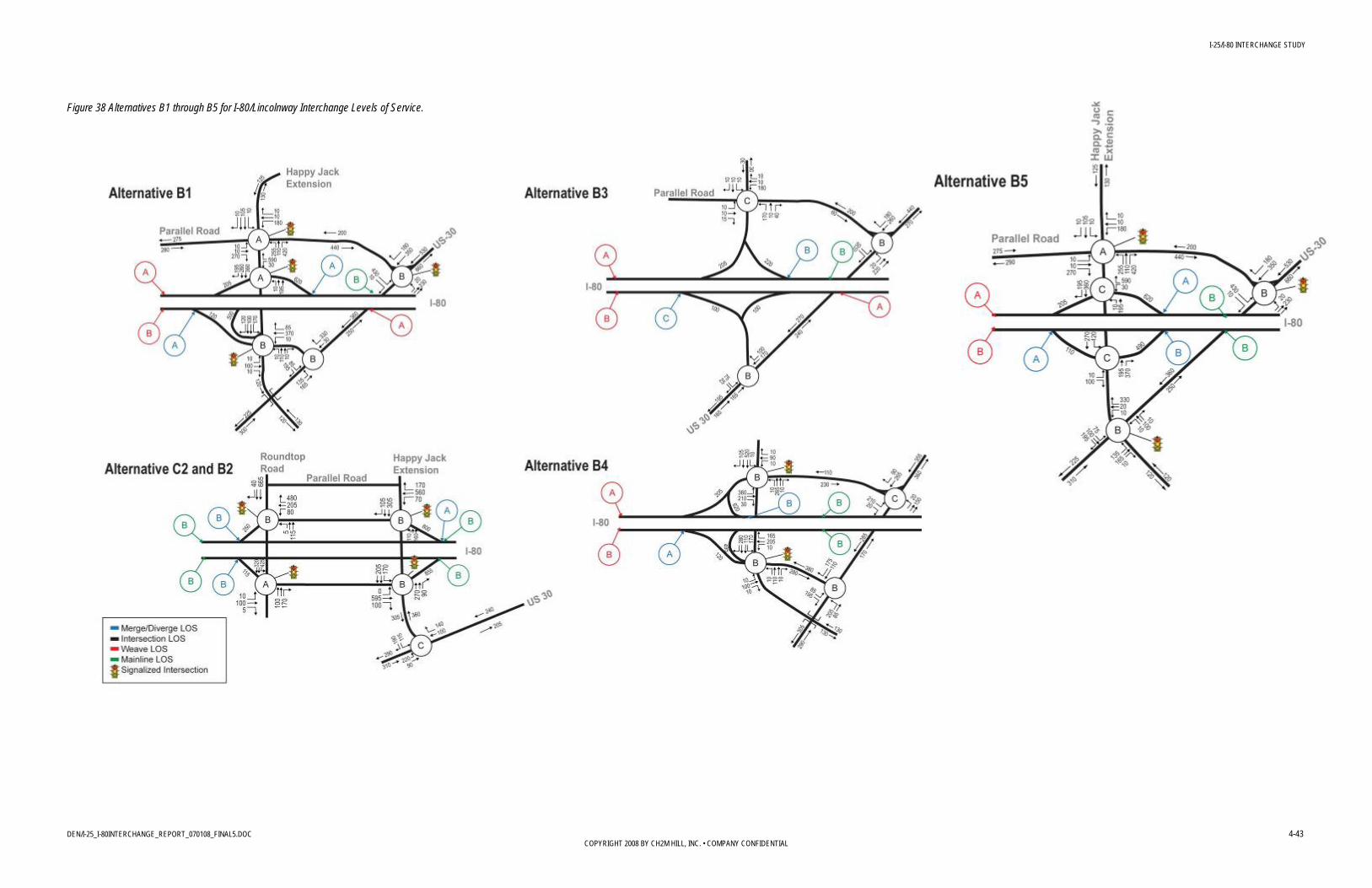
I-25/I-80 INTERCHANGE STUDY
DEN/I-25_I-80INTERCHANGE_REPORT_070108_FINAL5.DOC 4-43 COPYRIGHT 2008 BY CH2M HILL, INC. • COMPANY CONFIDENTIAL
Figure 38 Alternatives B1 through B5 for I-80/Lincolnway Interchange Levels of Service.
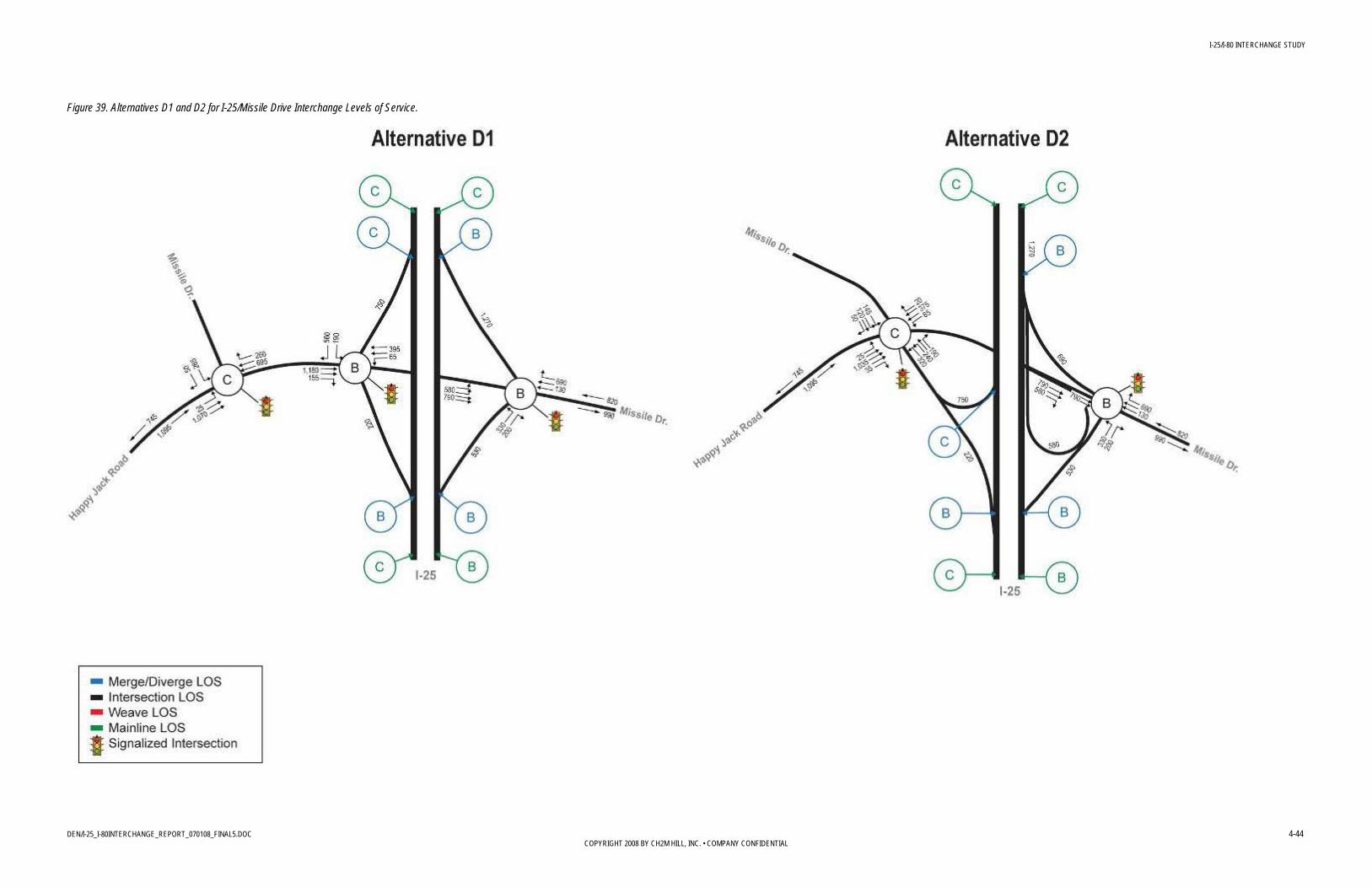
I-25/I-80 INTERCHANGE STUDY
DEN/I-25_I-80INTERCHANGE_REPORT_070108_FINAL5.DOC 4-44 COPYRIGHT 2008 BY CH2M HILL, INC. • COMPANY CONFIDENTIAL
Figure 39. Alternatives D1 and D2 for I-25/Missile Drive Interchange Levels of Service.

I-25/I-80 INTERCHANGE STUDY
DEN/I-25_I-80INTERCHANGE_REPORT_070108_FINAL5.DOC 4-45 COPYRIGHT 2008 BY CH2M HILL, INC. • COMPANY CONFIDENTIAL
Figure 40. Alternatives C1 and C2 for I-80/Roundtop Road Interchange Levels of Service.

I-25/I-80 INTERCHANGE STUDY
DEN/I-25_I-80INTERCHANGE_REPORT_070108_FINAL5.DOC 4-46 COPYRIGHT 2008 BY CH2M HILL, INC. • COMPANY CONFIDENTIAL
4.5.3 Environmental The effects of each alternative on environmental conditions were evaluated by comparing the approximate footprint of the design alternatives to the existing environmental conditions identified in Section 2.5. The results of the comparison are captured in the matrices for each interchange alternative.
4.5.4 Safety The evaluation of safety was based on whether the alternatives met design criteria and preferences identified to improve safety. An alternative’s potential to reduce conflict points was based on whether the alternative improved ramp acceleration and deceleration lengths, eliminated weave sections, and improved horizontal and vertical curvature. Correcting these design deficiencies was expected to reduce the frequency and severity of study area crashes and overall improve the safety of the motoring public.
4.5.5 Implementation The ability to implement an alternative was evaluated based on five criteria. Conceptual level cost estimates were prepared to compare order of magnitude cost differences. Whether an alternative can be designed to meet design standards was also considered and was primarily based on interchange spacing. Due to the severe weather that occurs in Cheyenne, particularly snow accumulation, wind, and blowing snow the steering committee was especially concerned that any alternative be easy to maintain and therefore the evaluation criteria for operations and maintenance was considered based on snow storage, miles of vehicle lanes maintained, and miles of elevated structure. In order to ensure the most cost effective expenditure of funds, the ability to phase an alternative to match travel demand needs and potential funding was evaluated. Finally, the compatibility of each alternative with other expected future transportation improvements was determined.
4.6 Alternative Evaluation The following sections present and summarize the results of the Level 2 evaluation and are organized by interchange area. For each section, tables provide the quantitative data for each of the measures followed by a summary of the Good, Fair, Poor ratings for each category. The results and recommended alternative summaries follow the tables.
4.6.1 I-25/I-80 Interchange (System Interchange) Alternatives Five interchange alternatives were included in the Level 2 evaluation:
I – Contains a single loop ramp in the northeast quadrant and three turban ramps that traverse the outside of the existing interchange footprint.
II – Has two loop ramps in the northeast and southwest quadrants and two turban ramps.
III - Provides a third-level structure through the heart of the interchange for the EB to NB and WB to SB movements. Similar to the double loop concept, two of the free flowing

I-25/I-80 INTERCHANGE STUDY
DEN/I-25_I-80INTERCHANGE_REPORT_070108_FINAL5.DOC 4-47 COPYRIGHT 2008 BY CH2M HILL, INC. • COMPANY CONFIDENTIAL
movements are accomplished with loop ramps. These loops are in the northeast and southwest quadrants.
IV - Eliminates all of the loop ramps and accommodates traffic via free flowing directional turban ramps. These ramps traverse the outside of the current interchange ramps in a circular fashion to avoid the need for third-level structures.
VI - Maintains three of the four existing cloverleaf loop ramps but uses CD roads to separate the weaving areas from mainline traffic on both I-25 and I-80. In addition, a WB to SB flyover ramp replaces the fourth loop ramp.
The results of the Level 2 evaluation measures are included in the following Table 11. A summary of the comparison of alternatives for the I-25/I-80 interchange follows Table 11.

Table 11: I-25/I-80 System Interchange Level 2 Screening Criteria I-25/I-80 interchange study
DEN/I-25_I-80INTERCHANGE_REPORT_070108_FINAL5.DOC 4-48 COPYRIGHT 2008 BY CH2M HILL, INC. • COMPANY CONFIDENTIAL
System Alternatives No Action I II III IV VI
Category Criteria
Is the improvement compatible with local plans (Plan Cheyenne and the Long-Range Transportation Plan)? (Highly/somewhat/not compatible)
Not Compatible (N/A) 3
Highly (Good)
Highly (Good)
Highly (Good)
Highly (Good)
Highly (Good)
Can local access be reasonably maintained? (Distance of out-of-direction travel)
Yes (0 miles) (N/A) 3
Yes (0 miles) (Good)
Yes (0 miles) (Good)
Yes (0 miles) (Good)
Yes (0 miles) (Good)
Yes (0 miles) (Good)
What is the amount and cost of right-of-way relocated and required? (acres and cost) Right-of-way acquisition (acres and cost) Number of relocations required Perceived difficulty
0 Acres $0
0 Relocations (N/A) 3
33.6 Acres $5.8M
2 Potential Relocations (Fair)
19.7 Acres $3.4M
2 Potential Relocations (Good)
24.0 Acres $4.2M
2 Potential Relocations (Fair)
50.9 Acres $8.9M
2 Potential Relocations (Poor)
16.4 Acres $2.9M
2 Potential Relocations(Good) Im
pact
s on
Exi
stin
g an
d
Plan
ned
Dev
elop
men
t
Overall Summary N/A Fair Good Fair Poor Good
Do the mainline, ramps, intersections and weaving segments perform at a good LOS? (LOS)
No (LOS B-F) (N/A) 3
Yes (LOS A-C) (Good)
Yes (LOS A-C) (Good)
Yes (LOS A-C) (Good)
Yes (LOS A-C) (Good)
Yes (LOS B-C) (Good)
Does the alternative improve mobility on local streets? (LOS)
N/A N/A N/A N/A N/A N/A
Mob
ility
What is the ability to meet desirable versus minimum standards for trucks? (Merge length, radii, grade, truck speed)
Weave, Min. 30mph Compound Curve
Lower Truck Speed due to grade
(N/A) 3
Min. Merge Length Met 30 MPH Loop Met + 4% Up/Down Grade
1 Loop (Fair)
Min. Merge Length Met 30 MPH Loop Met + 4% Up/Down Grade
2 Loops (Fair)
Min. Merge Length Met 30 MPH Loop Met + 4% Up/Down Grade
2 Loops (Fair)
Min. Merge Length Met 0 Loop (Good)
Min. Merge Length Met30 MPH Loop Met + 4% Up/Down Grade
3 Loops (Poor)
Overall Summary N/A Fair Fair Fair Good Poor
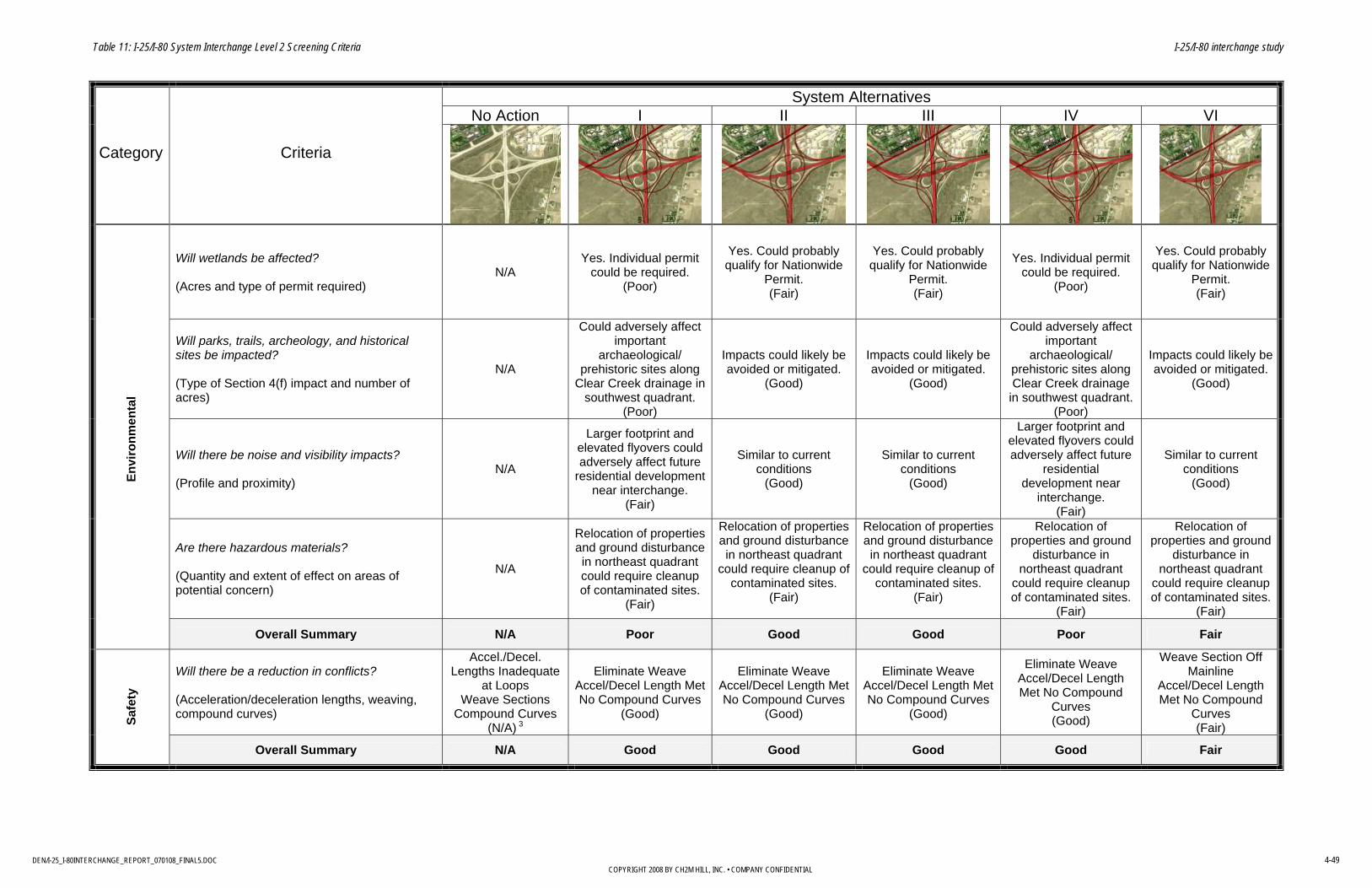
Table 11: I-25/I-80 System Interchange Level 2 Screening Criteria I-25/I-80 interchange study
DEN/I-25_I-80INTERCHANGE_REPORT_070108_FINAL5.DOC 4-49 COPYRIGHT 2008 BY CH2M HILL, INC. • COMPANY CONFIDENTIAL
System Alternatives No Action I II III IV VI
Category Criteria
Will wetlands be affected? (Acres and type of permit required)
N/A Yes. Individual permit
could be required. (Poor)
Yes. Could probably qualify for Nationwide
Permit. (Fair)
Yes. Could probably qualify for Nationwide
Permit. (Fair)
Yes. Individual permit could be required.
(Poor)
Yes. Could probably qualify for Nationwide
Permit. (Fair)
Will parks, trails, archeology, and historical sites be impacted? (Type of Section 4(f) impact and number of acres)
N/A
Could adversely affect important
archaeological/ prehistoric sites along
Clear Creek drainage in southwest quadrant.
(Poor)
Impacts could likely be avoided or mitigated.
(Good)
Impacts could likely be avoided or mitigated.
(Good)
Could adversely affect important
archaeological/ prehistoric sites along Clear Creek drainage
in southwest quadrant. (Poor)
Impacts could likely be avoided or mitigated.
(Good)
Will there be noise and visibility impacts? (Profile and proximity)
N/A
Larger footprint and elevated flyovers could adversely affect future
residential development near interchange.
(Fair)
Similar to current conditions
(Good)
Similar to current conditions
(Good)
Larger footprint and elevated flyovers could adversely affect future
residential development near
interchange. (Fair)
Similar to current conditions
(Good)
Are there hazardous materials? (Quantity and extent of effect on areas of potential concern)
N/A
Relocation of properties and ground disturbance in northeast quadrant could require cleanup of contaminated sites.
(Fair)
Relocation of properties and ground disturbance in northeast quadrant
could require cleanup of contaminated sites.
(Fair)
Relocation of properties and ground disturbance in northeast quadrant
could require cleanup of contaminated sites.
(Fair)
Relocation of properties and ground
disturbance in northeast quadrant
could require cleanup of contaminated sites.
(Fair)
Relocation of properties and ground
disturbance in northeast quadrant
could require cleanup of contaminated sites.
(Fair)
En
viro
nmen
tal
Overall Summary N/A Poor Good Good Poor Fair
Will there be a reduction in conflicts? (Acceleration/deceleration lengths, weaving, compound curves)
Accel./Decel. Lengths Inadequate
at Loops Weave Sections
Compound Curves (N/A) 3
Eliminate Weave Accel/Decel Length MetNo Compound Curves
(Good)
Eliminate Weave Accel/Decel Length Met No Compound Curves
(Good)
Eliminate Weave Accel/Decel Length Met No Compound Curves
(Good)
Eliminate Weave Accel/Decel Length Met No Compound
Curves (Good)
Weave Section Off Mainline
Accel/Decel Length Met No Compound
Curves (Fair)
Sa
fety
Overall Summary N/A Good Good Good Good Fair

Table 11: I-25/I-80 System Interchange Level 2 Screening Criteria I-25/I-80 interchange study
DEN/I-25_I-80INTERCHANGE_REPORT_070108_FINAL5.DOC 4-50 COPYRIGHT 2008 BY CH2M HILL, INC. • COMPANY CONFIDENTIAL
System Alternatives No Action I II III IV VI
Category Criteria
How much will the improvement cost to construct? (2008 conceptual-level cost estimate)
$0 (N/A) 3
$151M (Poor)
$129M (Fair)
$142M (Fair)
$160M (Poor)
$109M 4 (Good)
Can the alternative be designed to meet standards easily? (Number of design exceptions required)
N/A 1: Spacing to College (Fair)
1: Spacing to College (Fair)
1: Spacing to College (Fair)
1: Spacing to College (Fair)
1: Spacing to College (Fair)
What is the ability to meet operations and maintenance? (Snow storage, miles of vehicle lanes maintained, miles of elevated structure)
Reference to Improvement
(N/A) 3 Veh. Lns. 21.5mi Elev. Str. 2 1.7mi
(Fair)
Veh. Lns. 21.0mi Elev. Str. 2 1.4mi
(Good)
Veh. Lns. 21.4mi Elev. Str. 2 1.9mi
(Poor)
Veh. Lns. 22.0mi Elev. Str. 2 2.0mi
(Poor)
Veh. Lns. 21.8mi Elev. Str. 2 1.1mi
(Good)
Can the improvement be phased to match travel demand needs and potential funding? (Ability to phase – operational benefits)
Reference to Improvement
(N/A) 3
Minimum $28M (WB-SB Flyover) Desirable $37M
(EB-NB Flyover w/ E-A2 )
(Fair)
Minimum $27M (WB-SB Flyover)
Desirable $37M (EB-NB Flyover w/ E-A2 )
(Fair)
Minimum $37M (EB-NB & WB-SB
Flyover) Desirable $46M (EB-NB & WB-SB Flyover w/ E-
A2 ) (Poor)
Minimum $23M (EB-NB Flyover) Desirable $23M
(EB-NB Flyover) (Fair)
Minimum $13M (EB-CD)
Desirable $13M (EB-CD) (Good)
Is there compatibility with other transportation improvements? (Highly/somewhat/not compatible)
Does not meet safety needs
(N/A) 3
Somewhat1
(Fair) Somewhat1
(Fair) Somewhat1
(Fair) Somewhat1
(Fair) Somewhat1
(Fair)
Impl
emen
tatio
n
Overall Summary N/A Fair Fair Poor Poor Good
1 Requires third SB and NB lanes to solve truck volumes between I-25 and College, and auxiliary lanes between all interchanges 2 Snow storage based on miles of elevated structure 3 No-action alternative is for comparative purposes only and does not meet operational requirements 4 Could ultimately prove inadequate

I-25/I-80 INTERCHANGE STUDY
DEN/I-25_I-80INTERCHANGE_REPORT_070108_FINAL5.DOC 4-51 COPYRIGHT 2008 BY CH2M HILL, INC. • COMPANY CONFIDENTIAL
The following summarizes results by category of the Level 2 evaluation of the I-25/I-80 interchange alternatives. Impacts on Existing and Planned Development All build alternatives are highly compatible with local plans and maintain reasonable local access. All may require two relocations (in the northeast quadrant).
The distinguishing factor in this category is the estimated right-of-way requirement. Alternative VI requires 16.4 acres of right-of-way, which is the smallest requirement of the five options considered and 17 percent less than the next lowest requirement (Alternative II at 19.7 acres).
Mobility All build alternatives result in acceptable LOS for the mainline, ramps, intersections, and weaving sections.
Alternative IV eliminates all loop movements and therefore is recommended for truck mobility because trucks have a greater distance to accelerate/decelerate to/from highway speed.
Environmental Alternatives I and IV rated poorly on environmental criteria primarily because of potentially significant impacts to wetlands and archaeological sites along the Clear Creek drainage. The high profile and larger footprint of Alternatives I and IV also rated less well for noise and visual effects to future residential development around the interchange area. Alternatives II, III, and VI rated better because, although they also could affect these important resources, the footprint of the improvements is smaller, particularly in along the southwest ramps.
Safety All alternatives meet standard acceleration and deceleration lengths and eliminate compound curves.
All options but Alternative VI eliminate the weave segments. Alternative VI maintains a weave section off of the mainline (which is improved over current conditions where the merge occurs on the mainline, but is less desirable than the other alternatives that eliminate all weaving conflicts).
Implementation Alternative VI is the least expensive option, with a cost of approximately 16 percent less than the next lowest cost alternative, Alternative II.
Alternative II would be easier to phase and construct than Alternative VI. Alternative II has more structural miles than Alternative VI but less lane miles.
One of the biggest differences between Alternatives II and VI is the cost of the initial phase of improvements. The Alternative VI minimum improvements could be constructed for $12 million, which is half of the minimum cost for Alternative II. Alternative VI, while being the least expensive to initially phase, could ultimately be inadequate. All of the improvements under Alternative II, however, would be usable in the long-term.
I-25/I-80 INTERCHANGE STUDY
DEN/I-25_I-80INTERCHANGE_REPORT_070108_FINAL5.DOC 4-52 COPYRIGHT 2008 BY CH2M HILL, INC. • COMPANY CONFIDENTIAL
Conclusion As summarized in Table 12, Alternative II provides the best option based on the screening results. Alternative II meets the project’s mobility, safety, and development goals, provides acceptable environmental and local impacts, and is also cost-effective. While Alternative VI may provide initial relief, it could ultimately be a costly “band-aid.”
TABLE 12 COMPARISON OF I-25/I-80 INTERCHANGE ALTERNATIVES
COMPARISON OF I-25/I-80 INTERCHANGE ALTERNATIVES I-25/I-80 Interchange Study
Alternatives Category
I II III IV VI
Impacts on Existing and Planned Development Fair Good Fair Poor Good
Mobility Fair Fair Fair Good Poor
Environmental Poor Good Good Poor Fair
Safety Good Good Good Good Fair
Implementation Fair Fair Poor Poor Good
Rating Summary 4th 1st 2nd/3rd 5th 2nd/3rd
4.6.2 I-25/Lincolnway Interchange (Service Interchange A) Two alternatives were included in the Level 2 evaluation:
• A2 - This alternative relocates the interchange slightly north of its current location and provides full movement access to Lincolnway via a diamond interchange and a connecting arterial roadway. This connection is also planned to extend west of I-25 to allow access to planned development. The proximity of this interchange to I-25/I-80 requires the ramps between the interchanges to be braided, i.e., vertically separated so that the on- and off-ramp movements can both occur in a relatively short distance.
• A3 - Relocates the interchange slightly north of its current location and provides full movement access to Lincolnway via a hook ramp configuration using the existing under-crossing of I-25 at Lincolnway. A short arterial connection paralleling I-25 on the west side provides access to Lincolnway and to planned development. The proximity of the hook ramps to the I-80 ramps requires these ramps to be grade separated.
The results of the Level 2 evaluation measures are included in the following Table 13. A summary of the comparison of alternatives for the I-25/Lincolnway interchange follows Table 13.

Table 13: Service Interchange A - I-25/Lincolnway Interchange Level 2 Screening Criteria I-25/I-80 interchange study
DEN/I-25_I-80INTERCHANGE_REPORT_070108_FINAL5.DOC 4-53 COPYRIGHT 2008 BY CH2M HILL, INC. • COMPANY CONFIDENTIAL
Service Interchange A Alternatives No Action A2 A3
Category Criteria
Is the improvement compatible with local plans (Plan Cheyenne and the-Long Range Transportation Plan)? (Highly/somewhat/not compatible)
Not Compatible (N/A) 1
Highly (Good)
Somewhat (Fair)
Can local access be reasonably maintained? (Distance of out-of-direction travel)
Yes (0 miles) (N/A) 1
Yes (0.5 miles) (Fair)
Yes (0.5 miles) (Fair)
What is the amount and cost of right-of-way relocated and required? (acres and cost) Right-of-way acquisition (acres and cost) Number of relocations required Perceived difficulty
0 Acres $0
0 relocations (N/A) 1
4.9 Acres $0.8M
0 Relocations (Fair)
22.2 Acres $3.9M
0 Relocations (Poor)
Impa
cts
on E
xist
ing
and
Plan
ned
Dev
elop
men
t
Overall Summary N/A Fair Poor
Do the mainline, ramps, intersections, and weaving segments perform at a good LOS? (LOS)
No (LOS D-F) (N/A) 1
Yes (LOS A-C) (Good)
Yes (LOS A-C) (Good)
Does the alternative improve mobility on local streets? (LOS)
No (LOS D-F) (N/A) 1
Yes (LOS B-C) (Good)
Yes (LOS B-C) (Good)
What is the ability to meet desirable versus minimum standards for trucks? (Merge length, radii, grade, truck speed)
Min. 30mph Compound Curve
Lower Truck Speed due to grade (N/A) 1
Min. Merge Length Met 5% Up/Down Grade
Truck Speed= Design Speed (Fair)
Min. Merge Length Met 5% Up/Down Grade
Truck Speed= Design Speed (Fair)
Mob
ility
Overall Summary N/A Good Good

Table 13: Service Interchange A - I-25/Lincolnway Interchange Level 2 Screening Criteria I-25/I-80 interchange study
DEN/I-25_I-80INTERCHANGE_REPORT_070108_FINAL5.DOC 4-54 COPYRIGHT 2008 BY CH2M HILL, INC. • COMPANY CONFIDENTIAL
Service Interchange A Alternatives No Action A2 A3
Category Criteria
Will wetlands be impacted? (Acres and type of permit required)
N/A Impacts to small wetland areas
could likely be avoided. (Good)
Impacts to small wetland areas could likely be avoided.
(Good)
Will parks, trails, archeology, and historical sites be impacted? (Type of Section 4(f) impact and number of acres)
N/A
Potential effects to NRHP-eligible railroad, transmission line, or Otto
Road properties can likely be avoided. (Good)
Potential effects to NRHP-eligible railroad, transmission line, or Otto
Road properties can likely be avoided. (Good)
Will there be noise and visibility impacts? (Profile and proximity)
N/A Similar to existing (Good)
Similar to existing (Good)
Are there hazardous materials? (Number and extent of effect on areas of potential concern)
N/A Unlikely to affect contaminated
sites. (Good)
Unlikely to affect contaminated sites.
(Good)
En
viro
nmen
tal
Overall Summary N/A Good Good
Will there be a reduction in conflicts? (Acceleration/deceleration lengths, weaving, compound curves)
Interchange Spacing Inadequate Compound Curves
(N/A) 1
Requires 2 Intersections Lengthen Ramp Spacing Accel/Decel Length Met No Compound Curves
(Fair)
Requires 1 Intersection Lengthen Ramp Spacing Accel/Decel Length Met No Compound Curves
(Fair)
Sa
fety
Overall Summary N/A Fair Fair

Table 13: Service Interchange A - I-25/Lincolnway Interchange Level 2 Screening Criteria I-25/I-80 interchange study
DEN/I-25_I-80INTERCHANGE_REPORT_070108_FINAL5.DOC 4-55 COPYRIGHT 2008 BY CH2M HILL, INC. • COMPANY CONFIDENTIAL
Service Interchange A Alternatives No Action A2 A3
Category Criteria
How much will the improvement cost to construct? (2008 conceptual-level cost estimate)
$0 (N/A) 1
$34.7M (Fair)
$35M (Fair)
Can the alternative be designed to meet standards easily? (Number of design exceptions required)
N/A Yes (0) (Good)
Yes (0) (Good)
What is the ability to meet operations and maintenance? (Snow storage, miles of vehicle lanes maintained, miles of elevated structure)
Reference to Improvement (N/A) 1
Veh. Lns. 1.85mi Elev. Str. 0.22mi
(Fair)
Veh. Lns. 3.37mi Elev. Str. 0.17mi
(Fair)
Can the improvement be phased to match travel demand needs and potential funding? (Ability to phase – operational benefits)
Reference to Improvement (N/A) 1
Desirable $34.7M (Full ) (Fair)
Desirable $35M (Full ) (Fair)
What is the compatibility with other transportation improvements? (Highly/somewhat/not compatible)
Does not meet Current Criteria, No Future Access
(N/A) 1 Highly (Good)
Highly (Good)
Impl
emen
tatio
n
Overall Summary N/A Fair Fair
1 No-action alternative is for comparative purposes only and does not meet operational requirements
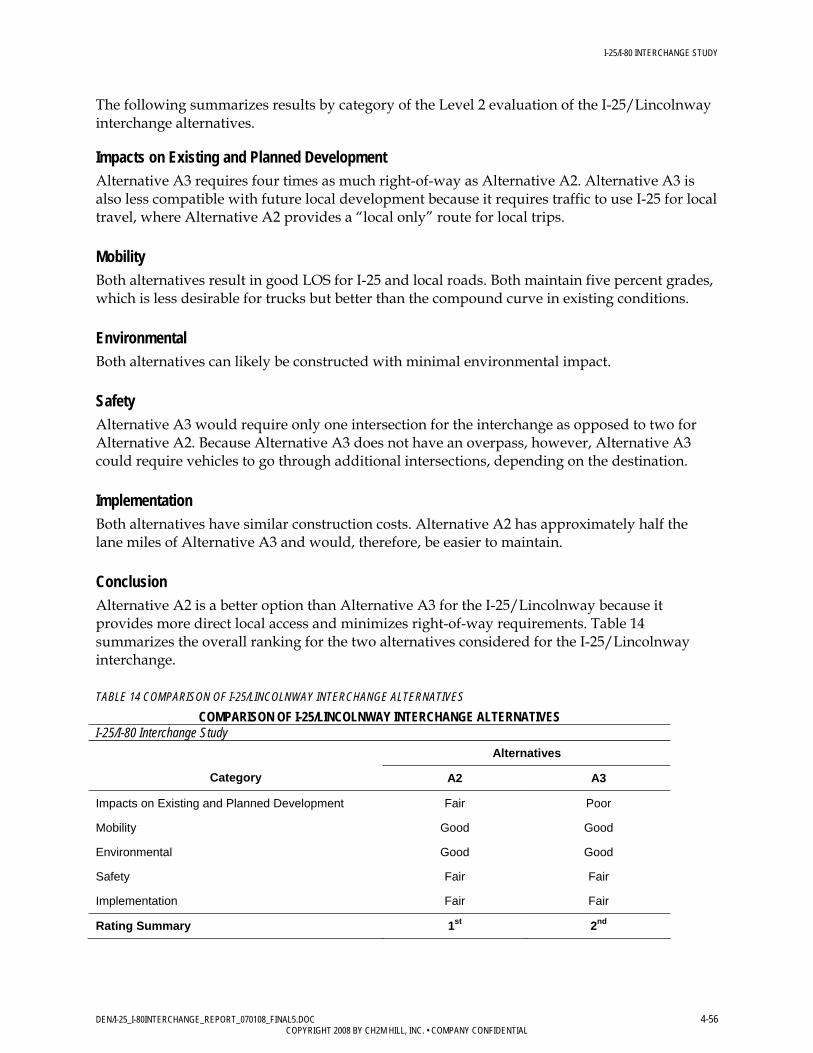
I-25/I-80 INTERCHANGE STUDY
DEN/I-25_I-80INTERCHANGE_REPORT_070108_FINAL5.DOC 4-56 COPYRIGHT 2008 BY CH2M HILL, INC. • COMPANY CONFIDENTIAL
The following summarizes results by category of the Level 2 evaluation of the I-25/Lincolnway interchange alternatives. Impacts on Existing and Planned Development Alternative A3 requires four times as much right-of-way as Alternative A2. Alternative A3 is also less compatible with future local development because it requires traffic to use I-25 for local travel, where Alternative A2 provides a “local only” route for local trips.
Mobility Both alternatives result in good LOS for I-25 and local roads. Both maintain five percent grades, which is less desirable for trucks but better than the compound curve in existing conditions.
Environmental Both alternatives can likely be constructed with minimal environmental impact.
Safety Alternative A3 would require only one intersection for the interchange as opposed to two for Alternative A2. Because Alternative A3 does not have an overpass, however, Alternative A3 could require vehicles to go through additional intersections, depending on the destination.
Implementation Both alternatives have similar construction costs. Alternative A2 has approximately half the lane miles of Alternative A3 and would, therefore, be easier to maintain.
Conclusion Alternative A2 is a better option than Alternative A3 for the I-25/Lincolnway because it provides more direct local access and minimizes right-of-way requirements. Table 14 summarizes the overall ranking for the two alternatives considered for the I-25/Lincolnway interchange.
TABLE 14 COMPARISON OF I-25/LINCOLNWAY INTERCHANGE ALTERNATIVES
COMPARISON OF I-25/LINCOLNWAY INTERCHANGE ALTERNATIVES I-25/I-80 Interchange Study
Alternatives
Category A2 A3
Impacts on Existing and Planned Development Fair Poor
Mobility Good Good
Environmental Good Good
Safety Fair Fair
Implementation Fair Fair
Rating Summary 1st 2nd

I-25/I-80 INTERCHANGE STUDY
DEN/I-25_I-80INTERCHANGE_REPORT_070108_FINAL5.DOC 4-57 COPYRIGHT 2008 BY CH2M HILL, INC. • COMPANY CONFIDENTIAL
4.6.3 I-80/Lincolnway Interchange (Service Interchange B) Four alternatives were included in the Level 2 evaluation:
• B1 - Provides a diamond interchange with a single loop in the southwest quadrant, essentially providing a one quadrant PARCLO Type A design.
• B2/C2 - This option consolidates the I-80/Lincolnway and I-80/Roundtop interchanges into a split diamond. The split diamond concept could ultimately have four traffic signals with two-lane, one-way CD roads connecting the ramps between the two service roads.
• B4 - This alternative has two loops on the west side of the new north-south arterial providing higher capacity for the WB to SB and the SB to EB movements.
• B5 - Provides a full movement diamond interchange and connecting frontage roads for access to Lincolnway. To improve the interchange spacing with I-25/I-80, the EB I-80 on-ramp is braided with the I-25 off-ramp.
The results of the Level 2 evaluation measures are included in the following Table 15. A summary of the comparison of alternatives for the I-80/Lincolnway interchange follows Table 15.
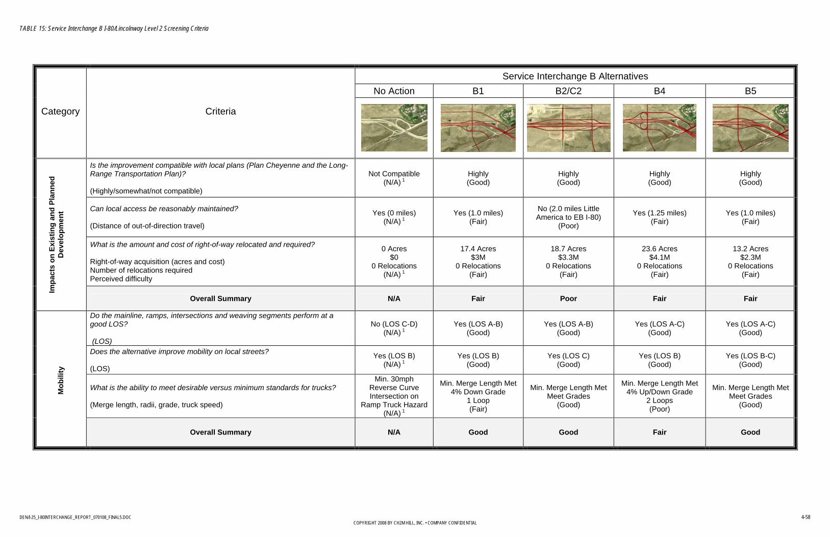
TABLE 15: Service Interchange B I-80/Lincolnway Level 2 Screening Criteria
DEN/I-25_I-80INTERCHANGE_REPORT_070108_FINAL5.DOC 4-58 COPYRIGHT 2008 BY CH2M HILL, INC. • COMPANY CONFIDENTIAL
Service Interchange B Alternatives No Action B1 B2/C2 B4 B5
Category Criteria
Is the improvement compatible with local plans (Plan Cheyenne and the Long-Range Transportation Plan)? (Highly/somewhat/not compatible)
Not Compatible (N/A) 1
Highly (Good)
Highly (Good) Highly
(Good) Highly (Good)
Can local access be reasonably maintained? (Distance of out-of-direction travel)
Yes (0 miles) (N/A) 1
Yes (1.0 miles) (Fair)
No (2.0 miles Little America to EB I-80)
(Poor) Yes (1.25 miles)
(Fair) Yes (1.0 miles) (Fair)
What is the amount and cost of right-of-way relocated and required? Right-of-way acquisition (acres and cost) Number of relocations required Perceived difficulty
0 Acres $0
0 Relocations (N/A) 1
17.4 Acres $3M
0 Relocations (Fair)
18.7 Acres $3.3M
0 Relocations (Fair)
23.6 Acres $4.1M
0 Relocations (Fair)
13.2 Acres $2.3M
0 Relocations (Fair)
Impa
cts
on E
xist
ing
and
Plan
ned
Dev
elop
men
t
Overall Summary N/A Fair Poor Fair Fair
Do the mainline, ramps, intersections and weaving segments perform at a good LOS? (LOS)
No (LOS C-D) (N/A) 1
Yes (LOS A-B) (Good)
Yes (LOS A-B) (Good)
Yes (LOS A-C) (Good)
Yes (LOS A-C) (Good)
Does the alternative improve mobility on local streets? (LOS)
Yes (LOS B) (N/A) 1
Yes (LOS B) (Good)
Yes (LOS C) (Good)
Yes (LOS B) (Good)
Yes (LOS B-C) (Good)
What is the ability to meet desirable versus minimum standards for trucks? (Merge length, radii, grade, truck speed)
Min. 30mph Reverse Curve Intersection on
Ramp Truck Hazard (N/A) 1
Min. Merge Length Met 4% Down Grade
1 Loop (Fair)
Min. Merge Length Met Meet Grades
(Good)
Min. Merge Length Met 4% Up/Down Grade
2 Loops (Poor)
Min. Merge Length Met Meet Grades
(Good)
Mob
ility
Overall Summary N/A Good Good Fair Good

TABLE 15: Service Interchange B I-80/Lincolnway Level 2 Screening Criteria
DEN/I-25_I-80INTERCHANGE_REPORT_070108_FINAL5.DOC 4-59 COPYRIGHT 2008 BY CH2M HILL, INC. • COMPANY CONFIDENTIAL
Service Interchange B Alternatives No Action B1 B2/C2 B4 B5
Category Criteria
Will wetlands be impacted? (Acres and type of permit required)
N/A
Yes. Could probably qualify for Nationwide
Permit. (Fair)
Impacts to a marginal, small wet meadow could
likely be avoided. (Good)
Yes. Could probably qualify for Nationwide
Permit. (Fair)
Yes. Could probably qualify for Nationwide
Permit. (Fair)
Will parks, trails, archeology, and historical sites be impacted? (Type of Section 4(f) impact and number of acres)
N/A
De minimis Section 4(f) use (railroad)
Unlikely to affect other historic or archaeological
sites. (Good)
De minimis Section 4(f) use (railroad)
Unlikely to affect other historic or archaeological
sites. (Good)
De minimis Section 4(f) use (railroad)
Unlikely to affect other historic or archaeological
sites. (Good)
De minimis Section 4(f) use (railroad)
Unlikely to affect other historic or archaeological
sites. (Good)
Will there be noise and visibility impacts? (Profile and proximity)
N/A Similar to existing (Good)
Similar to existing (Good)
Similar to existing (Good)
Similar to existing (Good)
Are there hazardous materials? (Quantity and extent of effect on areas of potential concern)
N/A
Could encounter contamination near
railroad (Fair)
Could encounter contamination near
railroad (Fair)
Could encounter contamination near
railroad (Fair)
Could encounter contamination near
railroad (Fair)
En
viro
nmen
tal
Overall Summary N/A Fair Good Fair Fair
Is there a reduction in conflicts? (Acceleration/deceleration lengths, weaving, compound curves)
Decel. Length Inadequate
Reverse Curves Stop on Ramp
(N/A) 1
1mi spacing 1 Loop Ramp 2 Additional Intersections
Accel/Decel Length Met No Compound Curves
(Good)
1mi spacing 2 Additional Intersections
Accel/Decel Length Met No Compound Curves
(Good)
1mi spacing 2 Loop Ramps
2 Additional IntersectionsAccel/Decel Length Met No Compound Curves
(Fair)
1mi spacing 2 Additional Intersections
Accel/Decel Length MetNo Compound Curves
(Good)
Sa
fety
Overall Summary N/A Good Good Fair Good

TABLE 15: Service Interchange B I-80/Lincolnway Level 2 Screening Criteria
DEN/I-25_I-80INTERCHANGE_REPORT_070108_FINAL5.DOC 4-60 COPYRIGHT 2008 BY CH2M HILL, INC. • COMPANY CONFIDENTIAL
Service Interchange B Alternatives No Action B1 B2/C2 B4 B5
Category Criteria
How much will the improvement cost to construct? (2008 conceptual-level cost estimate)
$0 (N/A) 1
$19.1M (Fair) $17.2M
(Fair) $20M (Fair) $29.2M
(Poor)
Can the alternative be designed to meet standards easily? (Number of design exceptions required)
N/A Yes (0) (Good)
Yes (0) (Good) Yes (0)
(Good) Yes (0) (Good)
What is the ability to meet operations and maintenance? (Snow storage, miles of vehicle lanes maintained, miles of elevated structure)
Reference to Improvement
(N/A) 1 Veh. Lns. 6.33mi Elev. Str. 0.08mi
(Fair) Veh. Lns. 7.00mi Elev. Str. 0.08mi
(Fair) Veh. Lns. 6.71mi Elev. Str. 0.08mi
(Fair) Veh. Lns. 9.10mi Elev. Str. 0.13mi
(Poor) Can the improvement be phased to match travel demand needs and potential funding? (Ability to phase – operational benefits)
Reference to Improvement
(N/A) 1 Minimum = Desirable
(Full) $19.1M (Fair)
Minimum = Desirable (Full) $17.2M
(Fair)
Minimum = Desirable (Full) $20M
(Fair)
Minimum = Desirable (Full) $29.2M
(Poor)
What is the compatibility with other transportation improvements? (Highly/somewhat/not compatible)
Does not meet safety needs (N/A) 1
Highly (Good)
Highly (Good)
Highly (Good)
Highly (Good)
Impl
emen
tatio
n
Overall Summary N/A Fair Fair Fair Poor
1 No-action alternative is for comparative purposes only and does not meet operational requirement

I-25/I-80 INTERCHANGE STUDY
DEN/I-25_I-80INTERCHANGE_REPORT_070108_FINAL5.DOC 4-61 COPYRIGHT 2008 BY CH2M HILL, INC. • COMPANY CONFIDENTIAL
The following summarizes results by category of the Level 2 evaluation of the I-80/Lincolnway interchange alternatives. Impacts on Existing and Planned Development Alternative B2/C2 has approximately 1 additional mile of out-of-direction travel than the other options. It does, however, tighten the interchange into essentially one interchange instead of two, which increases the weave spacing between them (since the alternatives meet the current weave spacing criteria, it is not an issue).
Mobility Alternatives B2 and B5 eliminate the loops, which aid in mobility. Alternative B5 and B3 bring the weave segment closer to the system.
Environmental Alternative B2/C2 could likely be constructed without impacts to wetlands. The other alternatives could be constructed with minimal impacts to wetlands. Other environmental impacts would likely also be minimal.
Safety Alternatives B2 and B5 eliminate the loops which aid in mobility. B5 brings the weave segment closer to the system interchange.
Implementation Alternative B2 is the least expensive to construct. Alternatives B1 and B4 have slightly higher costs.
Conclusion: Based on the Level 2 evaluation, Alternative B1 is the best option for this interchange. It has the advantage over B2 by not having the additional out-of-direction travel. It will also not pose a potential access problem for future development in the area, which has been an issue with other split diamond intersections in other areas. Table 16 summarizes the overall ranking for the four alternatives considered for the I-80/Lincolnway interchange.

I-25/I-80 INTERCHANGE STUDY
DEN/I-25_I-80INTERCHANGE_REPORT_070108_FINAL5.DOC 4-62 COPYRIGHT 2008 BY CH2M HILL, INC. • COMPANY CONFIDENTIAL
TABLE 16 COMPARISON OF I-80/LINCOLNWAY INTERCHANGE ALTERNATIVES
COMPARISON OF I-80/LINCOLNWAY INTERCHANGE ALTERNATIVES I-25/I-80 Interchange Study
Alternatives Category
B1 B2/C2 B4 B5
Impacts on Existing and Planned Development Good Fair Good Fair
Mobility Good Good Fair Fair
Environmental Good Good Good Good
Safety Good Good Fair Good
Implementation Fair Fair Fair Poor
Rating Summary 1st 2nd 3rd/4th 3rd/4th
4.6.4 I-80/Roundtop (Service Interchange C) and I-25/Missile Drive (Service Interchange D) Interchange Alternatives Four alternatives were included in the Level 2 evaluation:
• C1 - The east side ramps to be shortened to facilitate an interchange midway between I-25/I-80 and Roundtop Road.
• B2/C2 - This alternative is identical to alternative B2 as these alternatives consolidate the I-80/Lincolnway and I-80/Roundtop interchanges into a split diamond.
• D1 - Converts the full cloverleaf to a diamond interchange.
• D2 – This alternative retains two loop ramps in the southern quadrants and eliminates the two northern loop ramps. This eliminates weaving and maintains a greater distance to the next interchange.
The following Table 17 compares these alternatives.

TABLE 17: Service Interchange C and D Level 2 Screening Criteria
DEN/I-25_I-80INTERCHANGE_REPORT_070108_FINAL5.DOC 4-63 COPYRIGHT 2008 BY CH2M HILL, INC. • COMPANY CONFIDENTIAL
Service Interchange C and D Alternatives No Action C1 B2/C2 No Action D1 D2
Category Criteria
Is the improvement compatible with local plans (Plan Cheyenne and the Long-Range Transportation Plan)? (Highly/somewhat/not compatible)
Not Compatible (N/A) 2
Highly (N/A) 3
Highly (N/A) 3
Not Compatible (N/A) 2
Highly (Good)
Highly (Good)
Can local access be reasonably maintained? (Distance of out-of-direction travel)
Yes (0 miles) (N/A) 2
Yes (0.25 miles) (N/A) 3
No (2.0 miles Little America to EB I-80)
(N/A) 3
Yes (0 miles) (N/A) 2
Yes (0 miles) (Good)
Yes (0.5 miles) (Fair)
What is the amount and cost of right-of-way relocated and required? (acres and cost) Right-of-way acquisition (acres and cost) Number of relocations required Perceived difficulty
0 Acres $0
0 Relocations (N/A) 2
0 Acres $0
0 Relocations (N/A) 3
18.7 Acres $3.3M
0 Relocations (N/A) 3
0 Acres $0
0 Relocations (N/A) 2
1.41 Acres $246k
0 Relocations (Poor)
1.12 Acres $195k
0 Relocations (Fair)
Impa
cts
on E
xist
ing
and
Pl
anne
d D
evel
opm
ent
Overall Summary N/A N/A N/A N/A Fair Fair
Do the mainline, ramps, intersections and weaving segments perform at a good LOS? (LOS)
No (LOS F) (N/A) 2
Yes (LOS A-B) (N/A) 3
Yes (LOS A-B) (N/A) 3
No (LOS C-E) (N/A) 2
Yes (LOS B-C) (Good)
Yes (LOS B-C) (Good)
Does the alternative improve mobility on local streets? (LOS)
No (LOS F) (N/A) 2
Yes (LOS A-B) (N/A) 3
Yes (LOS C) (N/A) 3
No (LOS F) (N/A) 2
Yes (LOS B-C) (Good)
Yes (LOS B-C) (Good)
What is the ability to meet desirable versus minimum standards for trucks? (Merge length, radii, grade, truck speed)
Min. Merge Length Met (N/A) 2
Min. Merge Length Met (N/A) 3
Min. Merge Length Met (N/A) 3
Weave, Min. 30mph Compound Curve
Lower Truck Speed due to grade (N/A) 2
Min. Merge Length Met (Good)
Min. Merge Length Met(Good)
Mob
ility
Overall Summary N/A N/A N/A N/A Good Good

TABLE 17: Service Interchange C and D Level 2 Screening Criteria
DEN/I-25_I-80INTERCHANGE_REPORT_070108_FINAL5.DOC 4-64 COPYRIGHT 2008 BY CH2M HILL, INC. • COMPANY CONFIDENTIAL
Service Interchange C and D Alternatives No Action C1 B2/C2 No Action D1 D2
Category Criteria
Will wetlands be impacted? (Acres and type of permit required)
N/A No.
Wetlands not present in area.
No. Wetlands not present in
area. N/A
Yes. Minor impacts to
shallow marshes along southwest ramp and
east side of I-25 could qualify for Nationwide
Permit. (Fair)
Yes. Minor impacts to
shallow marshes along southwest ramp and
east side of I-25 could qualify for Nationwide
Permit. (Fair)
Will parks, trails, archeology, and historical sites be impacted? (Type of Section 4(f) impact and number of acres)
N/A
No impacts. (Area has been
surveyed for historic and archaeological
sites, and no important sites recorded)
(Good)
No impacts. (Area has been
surveyed for historic and archaeological
sites, and no important sites recorded)
(Good)
N/A
Impacts to Fort D.A. Russell and Camp
Carlin historic sits could be avoided. Impacts to
trails also can be avoided. Archaeological sites not likely present.
(Good)
Impacts to Fort D.A. Russell and Camp
Carlin historic sits could be avoided. Impacts to
trails also can be avoided. Archaeological sites not likely present.
(Good)
Will there be noise and visibility impacts? (Profile and proximity)
N/A Similar to existing (Good)
Similar to existing (Good) N/A Similar to existing
(Good) Similar to existing
(Good)
Are there hazardous materials? (Quantity and extent of effect on areas of potential concern)
N/A Unlikely to encounter contaminated sites.
(Good)
Unlikely to encounter contaminated sites.
(Good) N/A
Some potential to encounter contaminated groundwater plume on
east side of I-25 (Fair)
Some potential to encounter contaminated groundwater plume on
east side of I-25 (Fair)
En
viro
nmen
tal
Overall Summary N/A Good Good N/A Fair Fair
Will there be a reduction in conflicts? (Acceleration/Deceleration lengths, weaving, compound curves)
Accel/Decel Length Met No Compound Curves
(N/A) 2 Accel/Decel Length Met No Compound Curves
(N/A) 3
Accel/Decel Length Met No Compound Curves
(N/A) 3
Accel./Decel. Lengths Inadequate at Loops
Weave Sections Compound Curves
(N/A) 2
Accel/Decel Length Met No Compound Curves
2 Intersections No Loops
(Fair)
Accel/Decel Length MetNo Compound Curves
1 Intersection 2 Loops
(Fair)
Sa
fety
Overall Summary N/A N/A N/A N/A Fair Fair
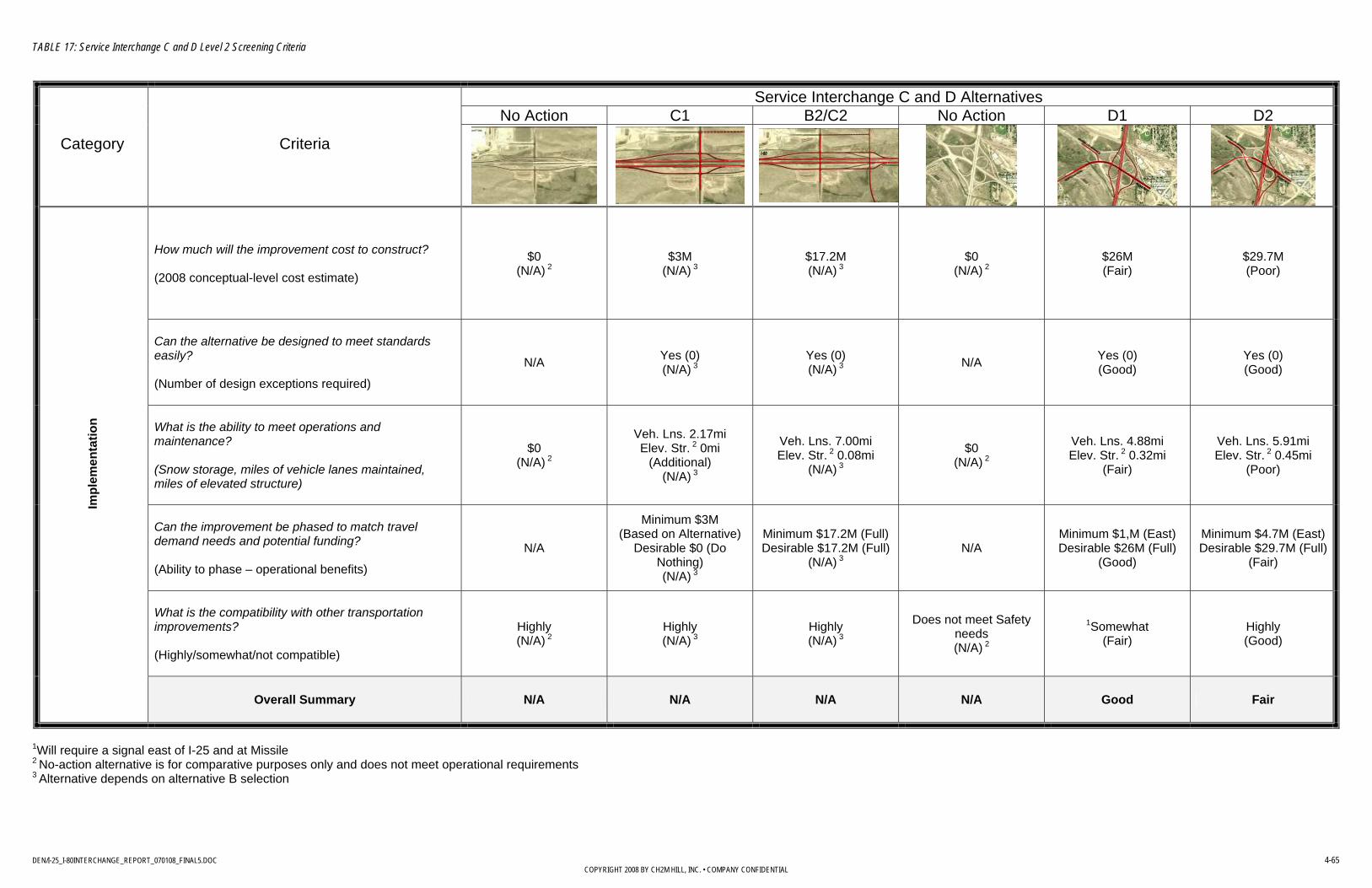
TABLE 17: Service Interchange C and D Level 2 Screening Criteria
DEN/I-25_I-80INTERCHANGE_REPORT_070108_FINAL5.DOC 4-65 COPYRIGHT 2008 BY CH2M HILL, INC. • COMPANY CONFIDENTIAL
Service Interchange C and D Alternatives No Action C1 B2/C2 No Action D1 D2
Category Criteria
How much will the improvement cost to construct? (2008 conceptual-level cost estimate)
$0 (N/A) 2
$3M (N/A) 3
$17.2M (N/A) 3
$0 (N/A) 2
$26M (Fair)
$29.7M (Poor)
Can the alternative be designed to meet standards easily? (Number of design exceptions required)
N/A Yes (0) (N/A) 3
Yes (0) (N/A) 3 N/A Yes (0)
(Good) Yes (0) (Good)
What is the ability to meet operations and maintenance? (Snow storage, miles of vehicle lanes maintained, miles of elevated structure)
$0 (N/A) 2
Veh. Lns. 2.17mi Elev. Str. 2 0mi
(Additional) (N/A) 3
Veh. Lns. 7.00mi Elev. Str. 2 0.08mi
(N/A) 3
$0 (N/A) 2
Veh. Lns. 4.88mi Elev. Str. 2 0.32mi
(Fair)
Veh. Lns. 5.91mi Elev. Str. 2 0.45mi
(Poor)
Can the improvement be phased to match travel demand needs and potential funding? (Ability to phase – operational benefits)
N/A
Minimum $3M (Based on Alternative)
Desirable $0 (Do Nothing) (N/A) 3
Minimum $17.2M (Full) Desirable $17.2M (Full)
(N/A) 3 N/A
Minimum $1,M (East) Desirable $26M (Full)
(Good)
Minimum $4.7M (East) Desirable $29.7M (Full)
(Fair)
What is the compatibility with other transportation improvements? (Highly/somewhat/not compatible)
Highly (N/A) 2
Highly (N/A) 3
Highly (N/A) 3
Does not meet Safety needs (N/A) 2
1Somewhat (Fair)
Highly (Good)
Impl
emen
tatio
n
Overall Summary N/A N/A N/A N/A Good Fair
1Will require a signal east of I-25 and at Missile 2 No-action alternative is for comparative purposes only and does not meet operational requirements 3 Alternative depends on alternative B selection
I-25/I-80 INTERCHANGE STUDY
DEN/I-25_I-80INTERCHANGE_REPORT_070108_FINAL5.DOC 2-66COPYRIGHT 2008 BY CH2M HILL, INC. • COMPANY CONFIDENTIAL
I-80/Roundtop Road Interchange Summary Alternative for this interchange are determined based on the Alternative B selection. Modifications to this interchange are due to the location of the B alternatives, resulting in a need to shorten the spacing at the I-80/Roundtop Road interchange for all but one option. In the case of Alternatives B2/C2, the interchange becomes a part of the B alternative.
I-25/Missile Drive Interchange Summary The following summarizes results by category of the Level 2 evaluation of the I-25/Missile Drive interchange alternatives. Impacts on Existing and Planned Development Alternative D1 requires slightly more right-of-way.
Mobility Alternative D1 requires two additional intersections, while Alternative D2 has only one. Alternative D2 allows for full movement from SB I-25 and EB Missile Drive.
Environmental Alternatives D1 and D2 have similar potential environmental effects. Both could have minor impacts to shallow marshes along the southwest ramp and east side of I-25. Both could avoid impacts to the Fort D.A. Russell and Camp Carlin historic districts. There is some potential for encountering soil or groundwater contamination in the area of the railroad crossing.
Safety Alternative D1 requires two additional intersections, while Alternative D2 has only one.
Implementation Alternative D2 is slightly higher to construct than Alternative D1 and would be more expensive to maintain with more lane miles and a more elevated structure.
Conclusion Table 18 summarizes the rankings for the I-25/Missile Drive alternatives. Alternative D1 is the best option for this interchange if the decision is mainly based on cost. However, if the existing loops were left in place without constructing new offset ramps to the loops (or phased in later) the cost may favor Alternative D2. That may be enough to skew the decision in favor of Alternative D2 based on eliminating the west intersection. Alternative D2 serves F.E. Warren AFB better than having traffic disperse through the diamond intersection to the Missile Drive intersection.
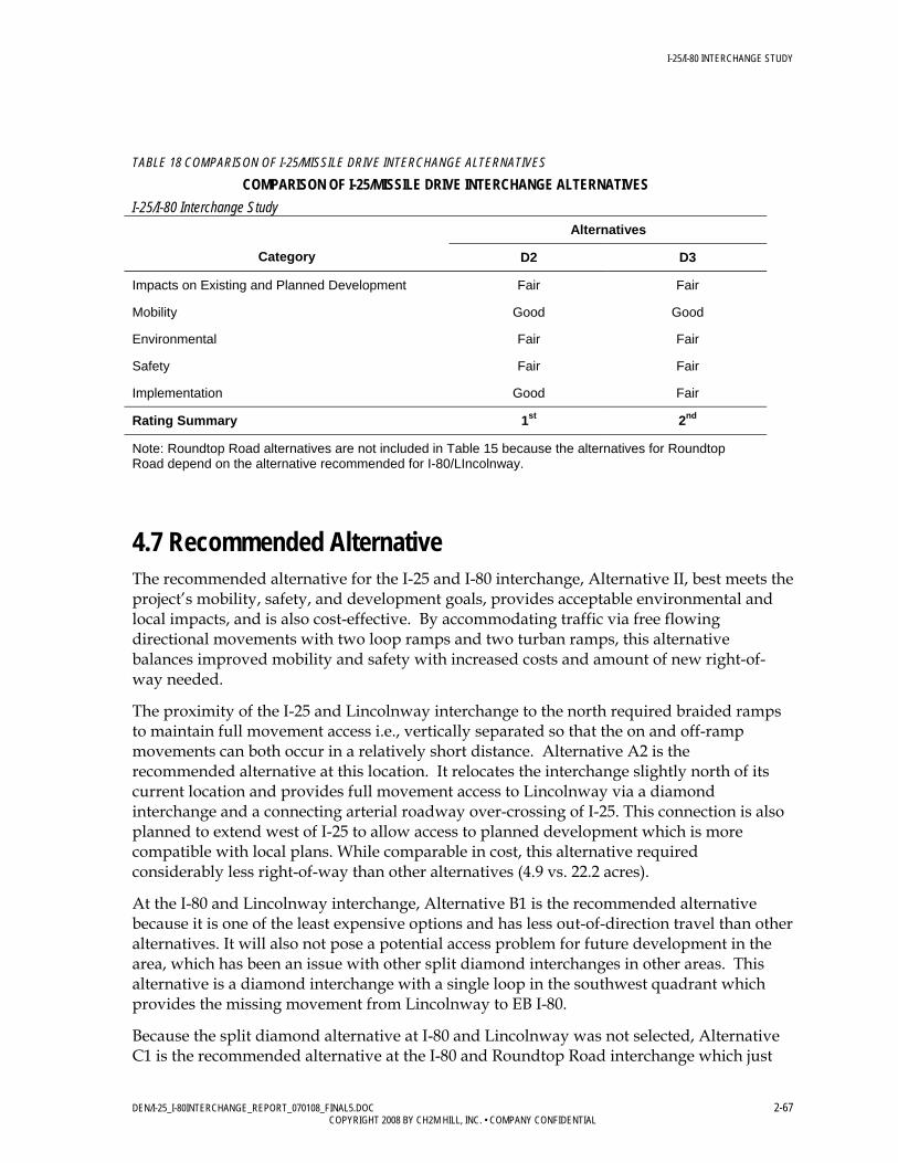
I-25/I-80 INTERCHANGE STUDY
DEN/I-25_I-80INTERCHANGE_REPORT_070108_FINAL5.DOC 2-67COPYRIGHT 2008 BY CH2M HILL, INC. • COMPANY CONFIDENTIAL
TABLE 18 COMPARISON OF I-25/MISSILE DRIVE INTERCHANGE ALTERNATIVES
COMPARISON OF I-25/MISSILE DRIVE INTERCHANGE ALTERNATIVES I-25/I-80 Interchange Study
Alternatives
Category D2 D3
Impacts on Existing and Planned Development Fair Fair
Mobility Good Good
Environmental Fair Fair
Safety Fair Fair
Implementation Good Fair
Rating Summary 1st 2nd
Note: Roundtop Road alternatives are not included in Table 15 because the alternatives for Roundtop Road depend on the alternative recommended for I-80/LIncolnway.
4.7 Recommended Alternative The recommended alternative for the I-25 and I-80 interchange, Alternative II, best meets the project’s mobility, safety, and development goals, provides acceptable environmental and local impacts, and is also cost-effective. By accommodating traffic via free flowing directional movements with two loop ramps and two turban ramps, this alternative balances improved mobility and safety with increased costs and amount of new right-of-way needed.
The proximity of the I-25 and Lincolnway interchange to the north required braided ramps to maintain full movement access i.e., vertically separated so that the on and off-ramp movements can both occur in a relatively short distance. Alternative A2 is the recommended alternative at this location. It relocates the interchange slightly north of its current location and provides full movement access to Lincolnway via a diamond interchange and a connecting arterial roadway over-crossing of I-25. This connection is also planned to extend west of I-25 to allow access to planned development which is more compatible with local plans. While comparable in cost, this alternative required considerably less right-of-way than other alternatives (4.9 vs. 22.2 acres).
At the I-80 and Lincolnway interchange, Alternative B1 is the recommended alternative because it is one of the least expensive options and has less out-of-direction travel than other alternatives. It will also not pose a potential access problem for future development in the area, which has been an issue with other split diamond interchanges in other areas. This alternative is a diamond interchange with a single loop in the southwest quadrant which provides the missing movement from Lincolnway to EB I-80.
Because the split diamond alternative at I-80 and Lincolnway was not selected, Alternative C1 is the recommended alternative at the I-80 and Roundtop Road interchange which just
I-25/I-80 INTERCHANGE STUDY
DEN/I-25_I-80INTERCHANGE_REPORT_070108_FINAL5.DOC 2-68COPYRIGHT 2008 BY CH2M HILL, INC. • COMPANY CONFIDENTIAL
shortens the existing eastside ramps to accommodate Alternative B1 and provides adequate interchange spacing.
Alternative D1, which converts the full cloverleaf to a diamond interchange, is the recommended alternative at I-25 and Missile Drive. This alternative was this least costly and considered the easiest to implement without sacrificing mobility.
Figure 39 shows the recommended alternative at the I-25 and I-80 system interchange and the adjacent service interchanges. Figure 40 shows the recommended alternative at the Missile Drive interchange location.
4.8 Signing Based on the recommended alternatives, a conceptual level of signing detail was performed. This ensures that the sign spacing will be sufficient for the selected alternatives. The signing plan views demonstrate that there are no major issues with sign spacing for the recommended alternatives and can be found in Appendix 7, Tech Memo #4.
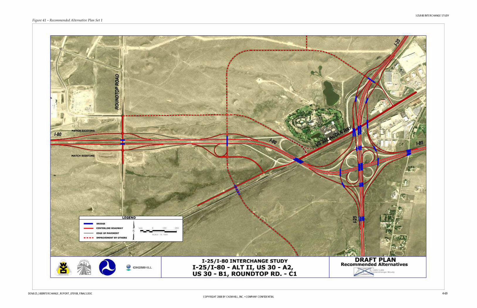
I-25/I-80 INTERCHANGE STUDY
DEN/I-25_I-80INTERCHANGE_REPORT_070108_FINAL5.DOC 4-69 COPYRIGHT 2008 BY CH2M HILL, INC. • COMPANY CONFIDENTIAL
Figure 41 – Recommended Alternative Plan Set 1

I-25/I-80 INTERCHANGE STUDY
DEN/I-25_I-80INTERCHANGE_REPORT_070108_FINAL5.DOC 4-70 COPYRIGHT 2008 BY CH2M HILL, INC. • COMPANY CONFIDENTIAL
Figure 42 – Recommended Alternative Plan Set 2

I-25/I-80 INTERCHANGE STUDY
DEN/I-25_I-80INTERCHANGE_REPORT_070108_FINAL5.DOC 5-1 COPYRIGHT 2008 BY CH2M HILL, INC. • COMPANY CONFIDENTIAL
5.0 Phasing and Funding
5.1 Phased Improvements Once the recommended alternative was selected, possible improvement phasing could be evaluated.
Because this study includes multiple interchanges, phasing options for individual and adjacent interchanges were considered; in many cases, changes to one interchange require changes to elements of other interchanges, although some improvements (Missile Drive, for instance) can be constructed independently of the other improvements.
5.1.1 Recommended Alternative Phasing Construction phasing plans for the alternatives were developed to ensure that the proposed improvements could be built with minimal disruption to the traffic operations on I-25, I-80, and Lincolnway. The Steering Committee also realized that funding a complete reconstruction of the I-25/I-80 interchange and/or the surrounding service interchanges would present budgetary, design, and construction challenges. Therefore, the phases present a set of lower cost improvements for the interchanges that could:
• Be implemented within a 5- to 10-year timeframe • Help improve the I-25/I-80 interchange operations • Result in the final ultimate improvement
Construction of Alternative II could be divided into three phases. The first phase would eliminate the loop that presents the greatest safety issue for the existing interchange (SE quadrant). Existing and future traffic analysis, presented previously, suggest that the system interchange loop in the northwest quadrant accommodates the greatest traffic volumes and would, from a capacity perspective, be logical to include in the first phase for this improvement.
However, based on crash data analysis (documented in the safety memo) and on WYDOT staff experience, the southeast quadrant loop has historically presented the greatest safety issues. The Steering Committee recommended that the first phase should eliminate this southeast loop. Eliminating this loop also eliminates the weave for that location and improves safety. Eliminating the loop in the northwest quadrant is included in the second phase construction.
The WB flyover would seem to be a more economical improvement than the EB flyover due to the fact that the EB flyover would need to tie into the I-25 service interchange, Alternative A2. Therefore, if the EB flyover is selected as an initial phase then funding should be such that Alternative A2 be also included. However, the WB flyover would require some modification to the WB to NB ramp that would most likely be an unrecoverable (throw-away) cost due to it being replaced in later construction phases. With this in mind, the

I-25/I-80 INTERCHANGE STUDY
DEN/I-25_I-80INTERCHANGE_REPORT_070108_FINAL5.DOC 5-2 COPYRIGHT 2008 BY CH2M HILL, INC. • COMPANY CONFIDENTIAL
Steering Committee agreed that the EB to NB flyover would be a more logical option. It eliminates the greatest safety concerns and constructs a greater amount of the system initially, resulting in lower cost since more expensive components are being built and will not be subject to inflation. There will also be less “throw-away” cost with the EB flyover.
In order to implement the EB flyover as phase one it would be prudent if not essential to build the east side of Alternative A2 as part of this phase. With this in mind it should be viewed as an extension of the system interchange. This would also hold true for the implementation of the SB loop expansion for the system interchange. Based on design geometry, the west side of Alternative A2 would need to be implemented in conjunction with the SB loop expansion.
The I-25/I-80 and the I-25/Lincolnway interchanges implement up to three phases. These two interchanges should be built concurrently due to the alternative geometry. The alternatives for the I-80/Lincolnway and Roundtop Road interchanges will also need to be built together. It would therefore be logical to construct the Roundtop Road interchange in preparation for the first phase of the I-80/Lincolnway interchange.
The Missile Drive Alternative (D1) can be phased per side (east/west). Since this is a diamond configuration, each set of ramps can be implemented to replace the existing loop system.
Figure 41-Figure 43 show the proposed phasing plans for the screened alternatives.
The following illustrates the construction for each phase:
Phase 1 The Phase I plan shows the first of the three phases that can be implemented to the system interchange and I-25/Lincolnway interchange. The EB to NB flyover and east side of Alternative A will be constructed first. During this first phase the WB to NB ramp, EB to SB ramp, and NB to EB ramp will also be constructed.
Phase 2 The second phase of construction will implement the WB to SB flyover and west side of Alternative A. During this second phase, the SB to WB ramp will also be constructed.
Phase 3 The third phase will construct the expanded loops and associated CD roads. Included in the third phase are the improvements to the I-80/Lincolnway interchange and the improvement at Roundtop Road.
Phase 4 The final phase involves the Missile Drive improvements.
Immediate Improvements Although it was a goal of the study to identify minor improvements that could be implemented immediately, none of the design concepts met that goal, either in totality or

I-25/I-80 INTERCHANGE STUDY
DEN/I-25_I-80INTERCHANGE_REPORT_070108_FINAL5.DOC 5-3 COPYRIGHT 2008 BY CH2M HILL, INC. • COMPANY CONFIDENTIAL
through phasing. That is, no low-cost improvements are available that would provide operational or safety benefits because the magnitude of the needed improvements were too great to be accomplished with an inexpensive or quick solution.
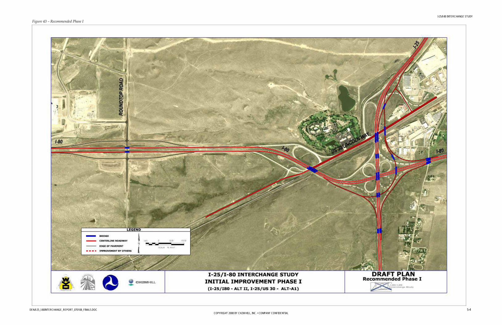
I-25/I-80 INTERCHANGE STUDY
DEN/I-25_I-80INTERCHANGE_REPORT_070108_FINAL5.DOC 5-4 COPYRIGHT 2008 BY CH2M HILL, INC. • COMPANY CONFIDENTIAL
Figure 43 – Recommended Phase I

I-25/I-80 INTERCHANGE STUDY
DEN/I-25_I-80INTERCHANGE_REPORT_070108_FINAL5.DOC 5-5 COPYRIGHT 2008 BY CH2M HILL, INC. • COMPANY CONFIDENTIAL
Figure 44 – Recommended Phase II
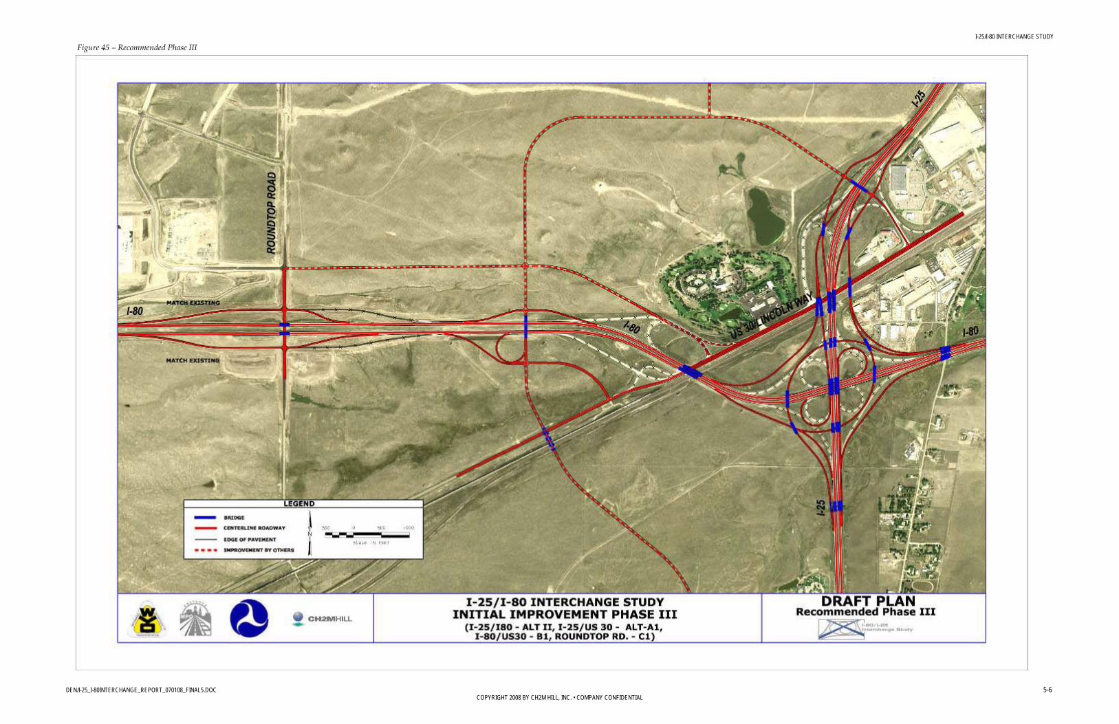
I-25/I-80 INTERCHANGE STUDY
DEN/I-25_I-80INTERCHANGE_REPORT_070108_FINAL5.DOC 5-6 COPYRIGHT 2008 BY CH2M HILL, INC. • COMPANY CONFIDENTIAL
Figure 45 – Recommended Phase III

I-25/I-80 INTERCHANGE STUDY
DEN/I-25_I-80INTERCHANGE_REPORT_070108_FINAL5.DOC 5-7 COPYRIGHT 2008 BY CH2M HILL, INC. • COMPANY CONFIDENTIAL
Figure 46 – Recommended Phase IV

I-25/I-80 INTERCHANGE STUDY
DEN/I-25_I-80INTERCHANGE_REPORT_070108_FINAL5.DOC 5-8 COPYRIGHT 2008 BY CH2M HILL, INC. • COMPANY CONFIDENTIAL
5.2 Funding and Cost 5.2.1 Funding Funding will obviously determine which alternative and/or phase can be implemented.
At this time, funding has not been identified for the ultimate interchange improvement. There is strong support from WYDOT, FHWA, and other project area stakeholders, as well as the general public to identify funding for this project. WYDOT and the City of Cheyenne would like to continue to work cooperatively with FHWA to establish state and federal funding sources that could be paired with local agency money to support the ultimate interchange improvement recommendation.
Funding is crucial for this important transportation improvement project; built in the 1960s, the interchange has not kept pace with the mobility and access needs of trucks, tourists, and local drivers. Improvements are needed to address the high number of crashes in the project area; the out of date roadway standards, traffic flow and safety; and operations for commercial haulers, as I-25 and I-80 are national trucking routes.
5.2.2 Ultimate Alternative Cost A conceptual-level opinion of cost was developed for the alternatives. These estimates are based on unit costs provided by WYDOT and/or costs that have been associated with the items on similar construction projects in the area.
The conceptual opinion of cost was itemized by the major items of work: removals and pavement, structures and retaining walls. Items such as earthwork, drainage, landscaping, traffic control, utilities, signing, striping, and mobilization were estimated as a percentage of total project cost. A contingency was also included in the overall project cost. The estimated conceptual-level opinion of cost for the Ultimate Alternatives is provided in Table 19. The detailed cost estimate can be referenced in Appendix 3.
TABLE 19 – ULTIMATE COSTS
Approximate Project Costs (2008 dollars)
I-25/I-80 Interchange $132,000,000 Lincolnway/I-25 Interchange $36,000,000 Lincolnway/I-80 Interchange $20,000,000
Roundtop Road Interchange
$2,000,000
Missile Drive Interchange $30,000,000 Total $220,000,000
5.2.3 Ultimate Alternative Phasing Cost Options for phasing improvements were carefully considered, primarily for budgeting reasons. The first phase of recommended improvements would include partial reconstruction of the I-25/I-80 interchange and improvements to the Lincolnway/I-80 interchange. These improvements, which are estimated at approximately $84 million would address the most immediate safety concerns in the project area. Additional phases are described below.

I-25/I-80 INTERCHANGE STUDY
DEN/I-25_I-80INTERCHANGE_REPORT_070108_FINAL5.DOC 5-9 COPYRIGHT 2008 BY CH2M HILL, INC. • COMPANY CONFIDENTIAL
TABLE 20 – PHASED COST PHASED COST
Phase Description Estimated Cost I I-25/I-80 eastbound to northbound flyover ramp
East side of Lincolnway interchange $84,000,000
II I-25/I-80 westbound to southbound flyover ramp West side of Lincolnway interchange
$55,000,000
III Expanded I-25/I-80 loop ramps Roundtop Road interchange improvements Lincolnway and I-80 interchange improvements (Ultimate Improvements Plan View, pg. 6)
$51,000,000
IV Missile Drive interchange improvements $30,000,000 TOTAL $220,000,000
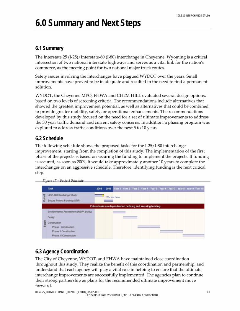
I-25/I-80 INTERCHANGE STUDY
DEN/I-25_I-80INTERCHANGE_REPORT_070108_FINAL5.DOC 6-1 COPYRIGHT 2008 BY CH2M HILL, INC. • COMPANY CONFIDENTIAL
6.0 Summary and Next Steps
6.1 Summary The Interstate 25 (I-25)/Interstate-80 (I-80) interchange in Cheyenne, Wyoming is a critical intersection of two national interstate highways and serves as a vital link for the nation’s commerce, as the meeting point for two national major truck routes.
Safety issues involving the interchanges have plagued WYDOT over the years. Small improvements have proved to be inadequate and resulted in the need to find a permanent solution.
WYDOT, the Cheyenne MPO, FHWA and CH2M HILL evaluated several design options, based on two levels of screening criteria. The recommendations include alternatives that showed the greatest improvement potential, as well as alternatives that could be combined to provide greater mobility, safety, or operational enhancements. The recommendations developed by this study focused on the need for a set of ultimate improvements to address the 30 year traffic demand and current safety concerns. In addition, a phasing program was explored to address traffic conditions over the next 5 to 10 years.
6.2 Schedule The following schedule shows the proposed tasks for the I-25/I-80 interchange improvement, starting from the completion of this study. The implementation of the first phase of the projects is based on securing the funding to implement the projects. If funding is secured, as soon as 2009, it would take approximately another 10 years to complete the interchanges on an aggressive schedule. Therefore, identifying funding is the next critical step.
6.3 Agency Coordination The City of Cheyenne, WYDOT, and FHWA have maintained close coordination throughout this study. They realize the benefit of this coordination and partnership, and understand that each agency will play a vital role in helping to ensure that the ultimate interchange improvements are successfully implemented. The agencies plan to continue their strong partnership as plans for the recommended ultimate improvement move forward.
Figure 47 – Project Schedule

I-25/I-80 INTERCHANGE STUDY
DEN/I-25_I-80INTERCHANGE_REPORT_070108_FINAL5.DOC 6-2 COPYRIGHT 2008 BY CH2M HILL, INC. • COMPANY CONFIDENTIAL
6.4 Next Steps The next step is to establish FHWA and legislative support and approval of the recommended ultimate interchange improvements. The project may then be put into the Transportation Improvement Plan and become a part of the local improvement plan.
The Cheyenne MPO will continue its strong partnership with WYDOT to identify funding for the corridor and submit the ultimate interchange improvements for inclusion in the local improvement plan (Plan Cheyenne) once funding has been identified. Once funding has been identified, the next phase of the project will be to complete the NEPA environmental document.
Funding will be needed to complete an environmental study, which must be completed to qualify the project for federal funding. If an environmental assessment is completed and WYDOT recommends moving forward with improvement, the project could progress with funding for Right-of-Way, design and construction.
6.5 Other Issues and Design Considerations During final design of the ultimate improvement, the potential disposal of excess right-of-way should be further evaluated. According to WYDOT policy, existing state right-of-way that is no longer required may be used in trade for proposed right-of-way, or may be provided to adjacent property owners.