Hydropower 2016/17 Introduction - ULisboa · Rodrigo Proença de Oliveira Hydropower 2016/17...
40
Rodrigo Proença de Oliveira Hydropower 2016/17 Introduction
Transcript of Hydropower 2016/17 Introduction - ULisboa · Rodrigo Proença de Oliveira Hydropower 2016/17...

Rodrigo Proença de Oliveira
Hydropower 2016/17
Introduction
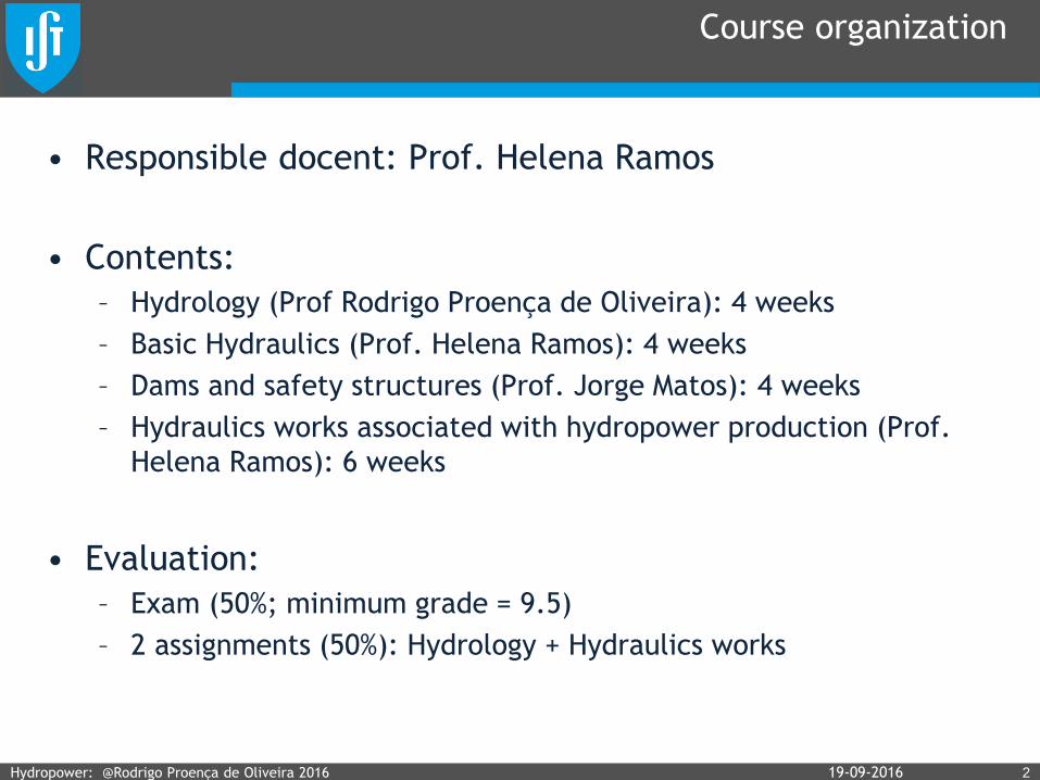
Course organization
• Responsible docent: Prof. Helena Ramos
• Contents:
– Hydrology (Prof Rodrigo Proença de Oliveira): 4 weeks
– Basic Hydraulics (Prof. Helena Ramos): 4 weeks
– Dams and safety structures (Prof. Jorge Matos): 4 weeks
– Hydraulics works associated with hydropower production (Prof.
Helena Ramos): 6 weeks
• Evaluation:
– Exam (50%; minimum grade = 9.5)
– 2 assignments (50%): Hydrology + Hydraulics works
Hydropower: @Rodrigo Proença de Oliveira 2016 219-09-2016

Hydrology module: Main topics
• The water cycle and the water and energy nexus. Basic
concepts in hydrology. Watershed characterization.
• Precipitation, evaporation and evapotranspiration
measurement and estimation.
• Discharge and stream flow estimation. Flow duration curves.
• The relationship between precipitation and runoff. The water
balance at different time scales. Hydrologic models.
• The purpose of reservoirs. Reservoir operation models.
• Statistical analysis and flood risk analysis. The concepts of
return period and IDF curves.
• Isochrones and time of concentration. Flood peak estimation.
• Flood routing. Flood control storage sizing.
319-09-2016Hydropower: @Rodrigo Proença de Oliveira 2016

Water-Energy nexus
419-09-2016Hydropower: @Rodrigo Proença de Oliveira 2016
Geography
Geomorphology
What is hydrology?
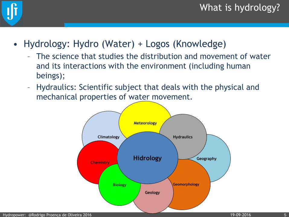
• Hydrology: Hydro (Water) + Logos (Knowledge)
– The science that studies the distribution and movement of water
and its interactions with the environment (including human
beings);
– Hydraulics: Scientific subject that deals with the physical and
mechanical properties of water movement.
Hydropower: @Rodrigo Proença de Oliveira 2016 519-09-2016
Geology
Climatology
Meteorology
Chemistry
Hydraulics
Biology
Hidrology
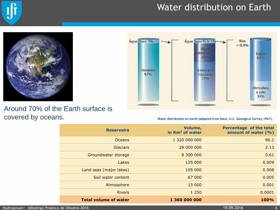
Water distribution on Earth
619-09-2016
ReservoirsVolume,
in Km3 of water Percentage of the total
amount of water (%)
Oceans 1 320 000 000 96.1
Glaciars 29 000 000 2.13
Groundwater storage 8 300 000 0.61
Lakes 125 000 0.009
Land seas (major lakes) 105 000 0.008
Soil water content 67 000 0.005
Atmosphere 13 000 0.001
Rivers 1 250 0.0001
Total volume of water 1 360 000 000 100%
Water distribution on earth (adapted from Nace, U.S. Geological Survey,1967).
Around 70% of the Earth surface is
covered by oceans.
Hydropower: @Rodrigo Proença de Oliveira 2016
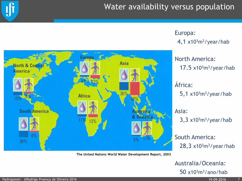
Water availability versus population
719-09-2016
The United Nations World Water Development Report, 2003
Europa:
4,1 x10³m3/year/hab
North America:
17.5 x10³m3/year/hab
África:
5,1 x10³m3/year/hab
Asia:
3,3 x10³m3/year/hab
South America:
28,3 x10³m3/year/hab
Australia/Oceania:
50 x103m3/ano/hab
Hydropower: @Rodrigo Proença de Oliveira 2016

The water cycle
819-09-2016Hydropower: @Rodrigo Proença de Oliveira 2016

Global water balance
919-09-2016
Esc. superficial
44.800 km3/ano
Precipitação sobre
continentes
119.000 km3/ano
Precipitação
sobre oceanos
458.000 km3/ano
Evapotranspiração
de continentes
72.000 km3/ano
Evaporação de
oceanos
505.000 km3/ano
Esc. subterrâneo
2.200 km3/ano
World Water Balance and Water Resources, UNESCO, 1978
Transporte de
humidade do ar
47.000 km3/ano
Evapotranspiration
from continents Evaporation
from oceans
Precipitation
over continentsPrecipitation
over oceans
Runoff
Groundwater flow
Water moisture transport
Hydropower: @Rodrigo Proença de Oliveira 2016
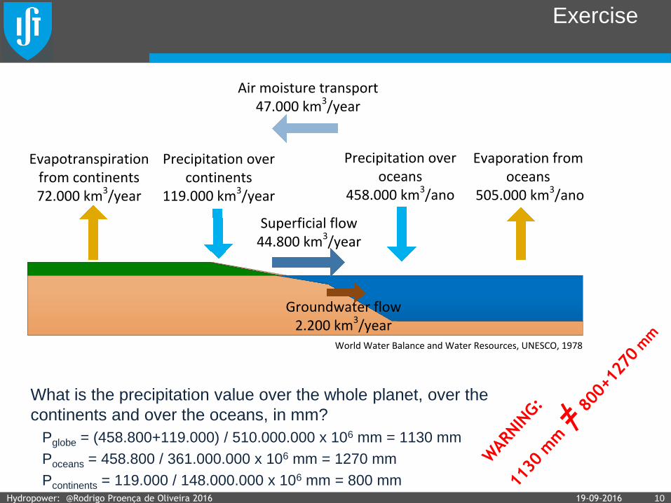
Exercise
What is the precipitation value over the whole planet, over the
continents and over the oceans, in mm?
Pglobe = (458.800+119.000) / 510.000.000 x 106 mm = 1130 mm
Poceans = 458.800 / 361.000.000 x 106 mm = 1270 mm
Pcontinents = 119.000 / 148.000.000 x 106 mm = 800 mm19-09-2016 10Hydropower: @Rodrigo Proença de Oliveira 2016
Superficial flow44.800 km3/year
Precipitation over continents
119.000 km3/year
Precipitation over oceans
458.000 km3/ano
Evapotranspiration from continents72.000 km3/year
Evaporation from oceans
505.000 km3/ano
Groundwater flow2.200 km3/year
World Water Balance and Water Resources, UNESCO, 1978
Air moisture transport 47.000 km3/year

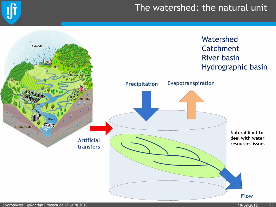
Watershed
1119-09-2016
• The watershed of a given river
at a specific cross-section is
the area where all the water that
falls within it will flow through the
cross-section. / A bacia hidrográfica
de uma dada secção de um curso de
água é a área na qual a água precipitada
se escoa para a secção considerada.
• It is generally defined by the
terrain topography, with the
mountain ranges defining the
watershed limits. / Em geral é
definida a partir da topografia da região,
sendo os limites da bacia constituidos por
linhas de festo.
Hydropower: @Rodrigo Proença de Oliveira 2016

The watershed: the natural unit
1219-09-2016
Limite natural para
lidar com questões de
recursos hídricos
Precipitação Evapotranspiração
Escoamento
Transferências
artificiais
Watershed
Catchment
River basin
Hydrographic basin
Hydropower: @Rodrigo Proença de Oliveira 2016

19-09-2016 13Hydropower: @Rodrigo Proença de Oliveira 2016
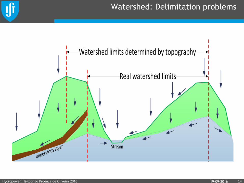
Watershed: Delimitation problems
1419-09-2016Hydropower: @Rodrigo Proença de Oliveira 2016
Watershed limits determined by topography
Real watershed limits
Impervious layer Stream
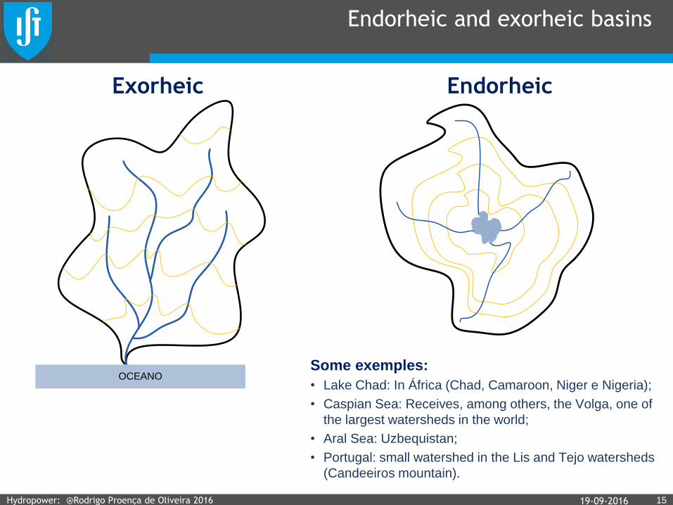
Endorheic and exorheic basins
1519-09-2016
OCEANO
Exorheic Endorheic
Some exemples:
• Lake Chad: In África (Chad, Camaroon, Niger e Nigeria);
• Caspian Sea: Receives, among others, the Volga, one of
the largest watersheds in the world;
• Aral Sea: Uzbequistan;
• Portugal: small watershed in the Lis and Tejo watersheds
(Candeeiros mountain).
Hydropower: @Rodrigo Proença de Oliveira 2016
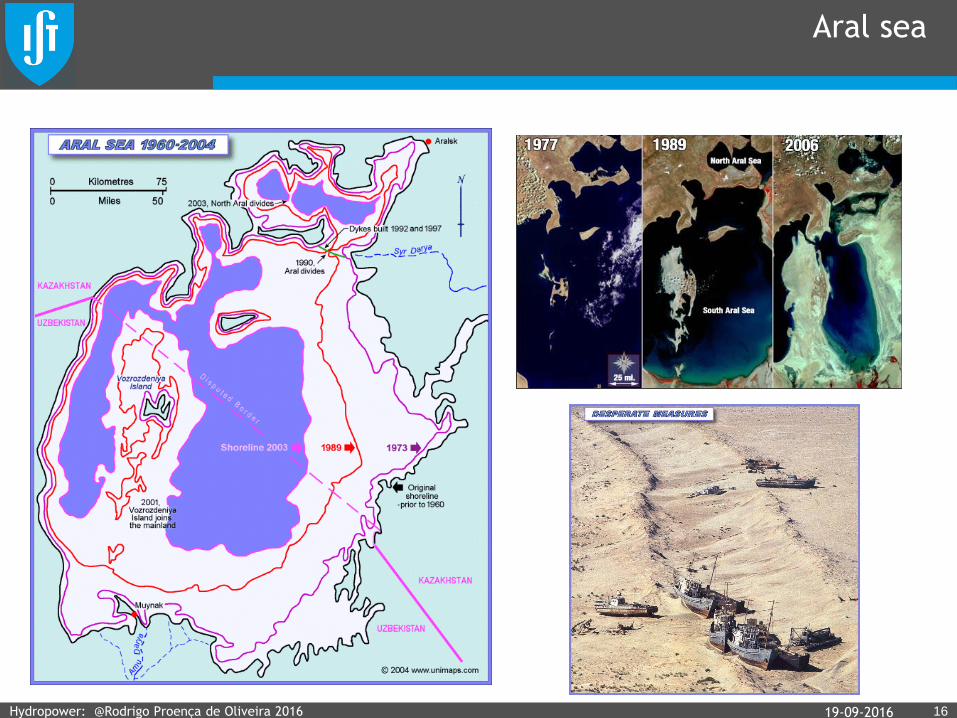
Aral sea
1619-09-2016Hydropower: @Rodrigo Proença de Oliveira 2016

Bacia hidrográfica
1719-09-2016Hydropower: @Rodrigo Proença de Oliveira 2016

World’s largest rivers
1819-09-2016
km3/yr
Hydropower: @Rodrigo Proença de Oliveira 2016

1919-09-2016Hydropower: @Rodrigo Proença de Oliveira 2016

Portugal: Main watersheds
2019-09-2016
A (km2)
Portugal
A (km2)
EspanhaA (km2)
Total
Minho 850 16.230 17.080
Lima 1.180 1.300 2.480
Douro 18.600 79.000 97.600
Tejo 24.800 55.800 80.600
Guadiana 11.500 55.300 66.800
Hydropower: @Rodrigo Proença de Oliveira 2016

Factors that condition the watershed response
• Area or size / Área ou dimensão
• Shape / Forma
• Terrain, orography, hypsometry / Relevo, orografia, hipsometria
• River network / Hidrografia ou rede
hidrográfica
• Geology and soil type / Geologia e
tipo de solo
• Soil use or land cover / Uso do solo
e coberto vegetal
• Climate and meteorology / Clima e
meteorologia
2119-09-2016
Response time / Rapidez da
resposta
Repartition between superficial
flow and infiltration / Repartição
entre escoamento superficial e
infiltração
Response magnitude / Magnitude
da grandezas em jogo
Response time / Rapidez da
resposta
Action over the watershed / Ação sobre a bacia
Hydropower: @Rodrigo Proença de Oliveira 2016

Shape (or form) of the watershed
2219-09-2016
Nile
Mississipi
Amazon
Danube
Shorter traveling distances
Shorter traveling times
Shorter response timePercursos mais curtos
Tempos de escoamento menores
Menor tempo de resposta
Longer traveling distances
Longer traveling times
Longer response timePercursos mais longos
Maiores tempos de escoamento
Menor tempo de resposta
Compact shape watershed
Long watershed:
Hydropower: @Rodrigo Proença de Oliveira 2016
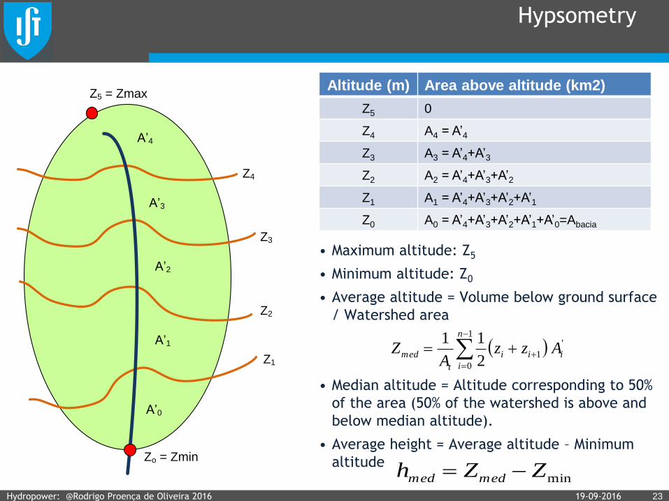
Hypsometry
• Maximum altitude: Z5
• Minimum altitude: Z0
• Average altitude = Volume below ground surface
/ Watershed area
• Median altitude = Altitude corresponding to 50%
of the area (50% of the watershed is above and
below median altitude).
• Average height = Average altitude – Minimum
altitude
23
Zo = Zmin
Z1
Z2
Z3
Z4
Z5 = Zmax
A’1
A’2
A’3
A’4
A’0
1
0
'
12
11 n
i
iii
t
med AzzA
Z
Altitude (m) Area above altitude (km2)
Z5 0
Z4 A4 = A’4
Z3 A3 = A’4+A’3
Z2 A2 = A’4+A’3+A’2
Z1 A1 = A’4+A’3+A’2+A’1
Z0 A0 = A’4+A’3+A’2+A’1+A’0=Abacia
minZZh medmed 19-09-2016Hydropower: @Rodrigo Proença de Oliveira 2016

Hypsometric curve
2419-09-2016
Área acima da
cota (km2)
Altitude/Cota (m)
Altitude média
Z5 = Altitude
máxima
Z0 = Altitude
mínima
Área da
bacia
Altura média
50% da área
da bacia
Altitude mediana
Z1
Z2
Z3
Z4
A1A2A3A4
Area above a
given altitude
A/Abacia x 100
(%)
Cota (m)Curvas Hipsométricas
adimensionais
Jovem
Antiga
Intermédia
100
Hydropower: @Rodrigo Proença de Oliveira 2016
Altitude (m)
River profile
2519-09-2016
Height
(m)
Distance to outlet (km)
Z5 X4 = X’5+X’4+X’3+X’2+X’1
Z4 X4 = X’4+X’3+X’2+X’1
Z3 X3 = X’3+X’2+X’1
Z2 X2 = X’2+X’1
Z1 X1 = X’1
Z0 X0 = 0
Hydropower: @Rodrigo Proença de Oliveira 2016
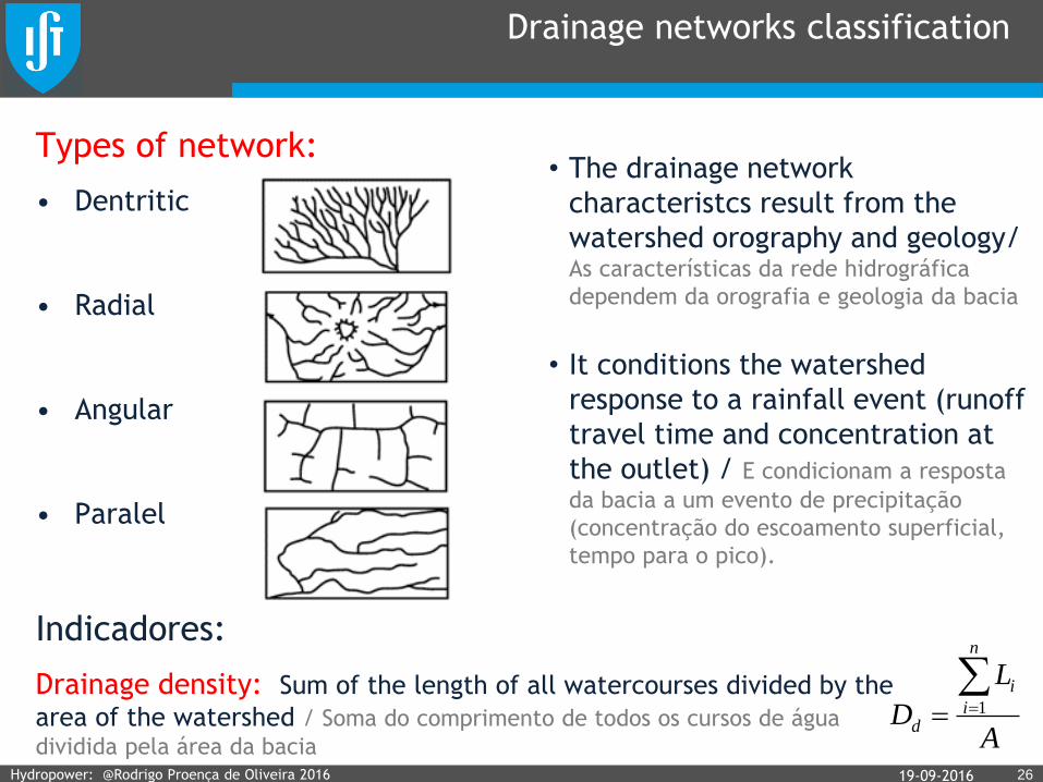
Drainage networks classification
Types of network:
• Dentritic
• Radial
• Angular
• Paralel
Indicadores:
Drainage density: Sum of the length of all watercourses divided by the
area of the watershed / Soma do comprimento de todos os cursos de água
dividida pela área da bacia2619-09-2016
• The drainage network
characteristcs result from the
watershed orography and geology/ As características da rede hidrográfica
dependem da orografia e geologia da bacia
• It conditions the watershed
response to a rainfall event (runoff
travel time and concentration at
the outlet) / E condicionam a resposta
da bacia a um evento de precipitação
(concentração do escoamento superficial,
tempo para o pico).
A
L
D
n
i
i
d
1
Hydropower: @Rodrigo Proença de Oliveira 2016

Geology, soil and land cover (soil use)
• Geology / Geologia
• Soils / Solos
• Soil use (land cover) / Uso do solo (coberto vegetal)
• Make no mistake:
– Soil type / Tipo de solo
– Soil capacity/ Capacidade de uso do solo
– Soil use / Uso do solo
2719-09-2016Hydropower: @Rodrigo Proença de Oliveira 2016

Soil
2819-09-2016Hydropower: @Rodrigo Proença de Oliveira 2016

World soils (USDA classification)
2919-09-2016Hydropower: @Rodrigo Proença de Oliveira 2016
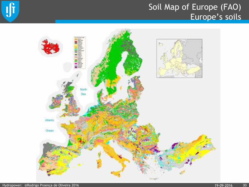
Soil Map of Europe (FAO)
Europe’s soils
3019-09-2016Hydropower: @Rodrigo Proença de Oliveira 2016

Water balance
The watershed: the natural unit
3219-09-2016
Limite natural para
lidar com questões de
recursos hídricos
Precipitação Evapotranspiração
Escoamento
Transferências
artificiais
Watershed
Catchment
River basin
Hydrographic basin
Hydropower: @Rodrigo Proença de Oliveira 2016
Precipitation Evapotranspiration
Artificial
transfers
Flow
Natural limit to
deal with water
resources issues

Flow generation processes
Retention - Intercepted water in ground depressions
which evaporates / Retenção – Água que não se
infiltra nem dá origem a escoamento superficial
(água interceptada ou retida em depressões do solo)
Detention - Water in motion / Detenção – Água em
trânsito
Escoamento
superficial
(directo)
Escoamento
de base
Evapotranspiração
Intercepção
Água retida em
depressões
Evaporação
Infiltração
Precipitação
Recarga
Escoamento
sub-superficial
ou intermédio
Evaporação
Precipitação
Precipitation
Evaporation
Evapotranspiration
Interception
Runoff
Recharge
Infiltration
Base flow
Intermediate
flow
19-09-2016 33Hydropower: @Rodrigo Proença de Oliveira 2016
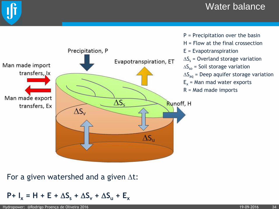
Water balance
P = Precipitation over the basin
H = Flow at the final crossection
E = Evapotranspiration
Ss = Overland storage variation
Sso = Soil storage variation
Saq = Deep aquifer storage variation
Ex = Man mad water exports
R = Mad made imports
19-09-2016 34Hydropower: @Rodrigo Proença de Oliveira 2016
For a given watershed and a given t:
P+ Ix = H + E + Ss + Sv + Su + Ex
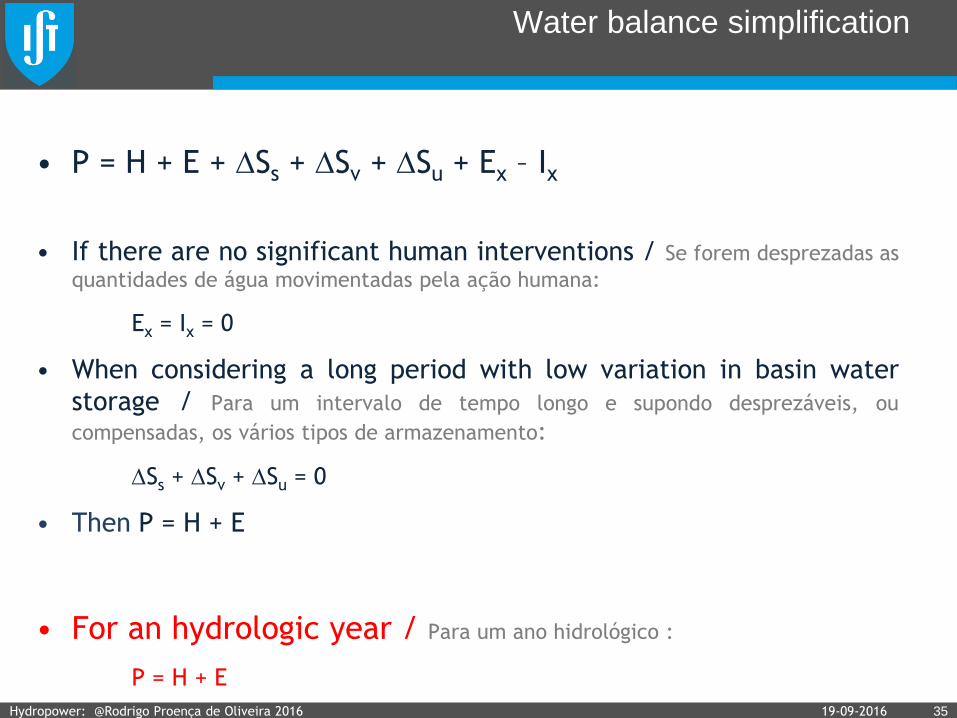
Water balance simplification
• P = H + E + Ss + Sv + Su + Ex – Ix
• If there are no significant human interventions / Se forem desprezadas as
quantidades de água movimentadas pela ação humana:
Ex = Ix = 0
• When considering a long period with low variation in basin water
storage / Para um intervalo de tempo longo e supondo desprezáveis, ou
compensadas, os vários tipos de armazenamento:
Ss + Sv + Su = 0
• Then P = H + E
• For an hydrologic year / Para um ano hidrológico :
P = H + E
19-09-2016 35Hydropower: @Rodrigo Proença de Oliveira 2016
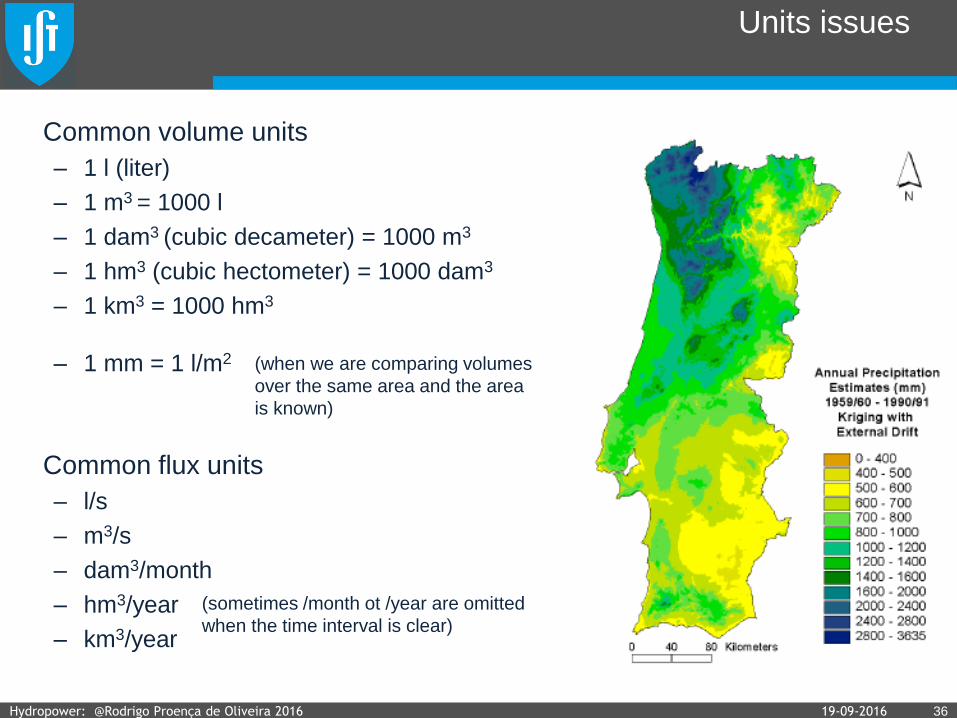
Units issues
Common volume units
– 1 l (liter)
– 1 m3 = 1000 l
– 1 dam3 (cubic decameter) = 1000 m3
– 1 hm3 (cubic hectometer) = 1000 dam3
– 1 km3 = 1000 hm3
– 1 mm = 1 l/m2
Common flux units
– l/s
– m3/s
– dam3/month
– hm3/year
– km3/year
(sometimes /month ot /year are omitted
when the time interval is clear)
(when we are comparing volumes
over the same area and the area
is known)
19-09-2016 36Hydropower: @Rodrigo Proença de Oliveira 2016

Exercise
The anual average precipitation and evapotranspiration of
the Zezere watershed, with 5029 km2, are 1007 mm and
712 mm, respectively. Assuming that the Castelo Bode
reservoir, located in that watershed, supplies the Lisbon
region with an annual average of 450 000 m3/day,
estimated the annual volume, in hm3, that reaches the
Tagus river from the Zezere river.
A bacia hidrográfica do rio Zêzere, com 5029 km2 de área, está
sujeita a uma precipitação anual e a uma evapotranspiração anual
de cerca de 1007 e 712 mm, respetivamente. Assumindo que a
captação para abastecimento público, existente em Castelo de
Bode, transfere para as bacias vizinhas, e nomeadamente para a
região de Lisboa, um caudal médio anual igual a 450 mil m3/dia,
estime o volume anual, em hm3, com que a bacia hidrográfica do
rio Zêzere contribui para o escoamento do rio Tejo.
LisboaTejo
Zêzere
19-09-2016 37Hydropower: @Rodrigo Proença de Oliveira 2016

Exercise
Assume that the annual precipitation and
evapotranspitation in Portugal are 850 mm e
630 mm, respectively. Knowing that the
area of Portugal is 89.000 km2 and that
annual flow volume from Spain reaching
Portugal is 45 km3, estimate the annual
discharge, in m3/s, that reaches the
Portuguese river outlets.
Assuma que a precipitação anual média e a
evapotranspiração real anual média em Portugal
são respetivamente, 850 mm e 630 mm. Sabendo
que a área de Portugal é 89.000 km2 e que o
escoamento anual médio afluente de Espanha é
sensivelmente 45 km3, estime o caudal anual
médio, em m3/s, que se escoa para o mar na
totalidade das fozes dos rios Portugueses.
3819-09-2016Hydropower: @Rodrigo Proença de Oliveira 2016

Exercise
The annual precipitation and the annual runoff of a watershed with
100 km2 are 1000 mm and 1300 mm, respectively. These values are
possible because 8 hm3 per month are transfered from a nearby basin.
Estimate the annual evapotranspiration, in mm.
Numa bacia hidrográfica com 100 km2 de área, para a qual são transferidos de bacia
vizinha cerca de 8 hm3 por mês, a precipitação e o escoamento em determinado ano
hidrológico foram de 1000 mm e 1300 mm, respectivamente. Estime em mm o valor da
evapotranspiração real nesse ano. Justifique.
19-09-2016 39Hydropower: @Rodrigo Proença de Oliveira 2016
Exercise
A project plans to transfer the maximum possible volume of water from
a watershed with 100 km2, while maintaining an annual average flow at
the outlet of 0,5 0 m3/s. Knowing that the annual precipitation and
evapotranspiration of that watershed are 1000 mm and 700 mm,
respectively, estimate the maximum possible flow, m3/s, that can
transfered.
De uma bacia hidrográfica com 100 km2 de área, pretende-se transferir para bacia vizinha
o máximo caudal médio compatível com um escoamento médio de 0,5 m3/s na secção de
referência da bacia de origem. Sabendo que a precipitação e a evapotranspiração anuais
médias na bacia de origem são respectivamente 1000 mm e 700 mm, estime o máximo
caudal médio transferível em m3/s. Justifique.
19-09-2016 40Hydropower: @Rodrigo Proença de Oliveira 2016