HYDROCARBON PROSPECTIVITY IN CENTRAL PART OF TRIPURA...
41
_______________________________________________________ CHAPTER – 3 HYDROCARBON PROSPECTIVITY IN CENTRAL PART OF TRIPURA, INDIA, USING AN INTEGRATED APPROACH _______________________________________________________
Transcript of HYDROCARBON PROSPECTIVITY IN CENTRAL PART OF TRIPURA...

_______________________________________________________
CHAPTER – 3
HYDROCARBON PROSPECTIVITY IN CENTRAL PART
OF TRIPURA, INDIA, USING AN INTEGRATED
APPROACH
_______________________________________________________

Chapter – 3
____________________________________________________________________
47
ABSTRACT
In this study an attempt has been made to evaluate the hydrocarbon prospectivity of
Central Tripura. The geological factors, surface exposures, geochemical anomalies,
seismic expressions have been studied and were correlated with distribution pattern
of gas fields in Bangladesh. Discoveries of oil and gas in and around of the study
area have been studied and prospects have been analyzed in light of various risks
associated with them. The requirement for upgradation of perceived prospectivity of
this area has also been proposed based on the integration study.
3.1 INTRODUCTION
The Tripura region is situated in the north – eastern sector of India, and is
surrounded by the territories of Bangladesh and Burma, except in the north – eastern
part, which is bordered by the Indian states of Assam and Manipur. Geographically,
it is bounded by the latitudes 22000
/N and 24
030
/N and the longitudes 91
010
/E and
93030
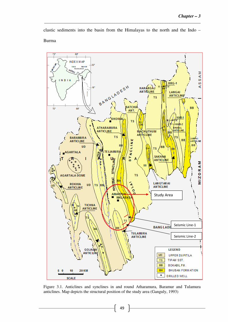
/E. The central part of Tripura can be structurally divided into four parts:
Atharamura anticline, northern part of the Tulamura anticline and parts of two
synclines, namely, Khowai and Dolai, situated at the western and eastern side, of the
Atharamura anticline respectively as shown in the Figure 3.1 ( Ganguly, 1993). The
Atharamura anticline, the longest (about 100 km) and largest of all the anticlines
exposed in Tripura fold belt constitutes almost half of the study area. It extends for
more than 25km in Bangladesh towards south. The Tulamura anticline situated in the
southern most part of the study area is disposed enechelon to the hydrocarbon
bearing Baramura anticline (Figure 3.2). The major part of this anticline goes to
Bangladesh towards its south. Exploratory efforts so far have brought out a number
of commercially viable gas fields in and around the study area such as Baramura,

Chapter – 3
____________________________________________________________________
48
Rokhia, Agartala Dome and Gojalia in the western part, Moulavi Bazar, Rashidpur
in the north and oil shows in Haraganj to its east. A broad similarity in source,
maturation, migration and entrapment coincidence between the Bangladesh and
Tripura sub basin is remarkable from the foregoing discussion. Bangladesh has
approximately 25 Trillion Cubic Feet (TCF) of gas initially in place and 15.52 TCF
of recoverable reserves. The success ratio of Bangladesh is 3.1:1. The presence of
thick sequence of reservoir quality sandstone coupled with organic rich shale, and of
different kinds of traps including broad anticlinal structure, makes the basin highly
prospective for hydrocarbon exploration (Imam and Hassain, 2002). A common
hydrocarbon generation center could not be ruled out, though the synclinal troughs in
Tripura are capable of generating and charging the structure. However, reservoir
facies of Bangladesh is better developed. It is observed that the average Helium
porosity is estimated as 19% and varies within the range from 5% to 28% (Islam,
2009). Hileum porosity reduces with increasing depth due to the detrital grain
contacts are turned from point to long contact in Bangladesh side and the volumetric
amount of quartz, carbonate, pyrite and clay cement increases and partially occlude
intergranular pore space. The correlation between Helium porosity and horizontal
permeability is positive and the horizontal permeability varies from 0.5mD to
490mD with an average 200mD (Islam, 2009). Although the reservoir does not
contain significant volume of carbonate but the inverse relationship of the porosity
and permeability with cement remains relatively steady state throughout the reservoir
in Bangladesh side. The collision of Indian plate with Burmese plate and Tibetan
plate results in a major switch in sedimentation pattern over the Bengal Basin during
the Middle Eocene to Early Miocene. During this time there was a rapid influx of
Chapter – 3
____________________________________________________________________
49
clastic sediments into the basin from the Himalayas to the north and the Indo –
Burma
Figure 3.1. Anticlines and synclines in and round Atharamura, Baramur and Tulamura
anticlines. Map depicts the structural position of the study area (Ganguly, 1993)
Seismic Line-1
Seismic Line-2
Study Area

Chapter – 3
____________________________________________________________________
50
Figure 3.2 Hydrocarbon discoveries in and around the study area (J.A. Curial etal., 2002)
Range to the east and this was followed by an increase in the rate of subsidence of
the basin. In the Bengal Basin sedimentation is thought to have taken place in five
distinct phases namely: Permo – Carboniferous to early Cretaceous; Cretaceous –
Mid Eocene; Mid Eocene – Early Miocene; Early Miocene – Mid Pliocene; and Mid
Pliocene – Quaternary. Moreover in Bengal Basin the characterization of reservoir
rocks are fine to medium grained sandstone, sandstone – siltstone interbeds and
laminated siltstone. Surma Groups (Bokabil and Bhuban formation) sediments are
deposited in a deltaic setting (Holtrop and Keizer, 1970 and Johnson and Alam,
1991) and it is also observed that quartz (mostly monocrystalline), renging from 44%
to 54% dominates the dertrital mineralogy in Bengal Basin (Islam, 2009). A
number of middle Bhuban sand facies in Tripura are heterogeneous and lenticular in

Chapter – 3
____________________________________________________________________
51
nature. In spite of that the large anticlines of Tripura with considerable amplitude
forms a potential trap for housing sizable amount of hydrocarbons.
In light of the above, we tried to describe the tectonic similarity between Central
Tripura and Bangladesh. In this study, hydrocarbon prospectivity of the area has
been analyzed using various geological and geophysical studies carried out
independently. An attempt has been made to integrate all these studies to derive a
meaningful geological model of the area. The outcome of such study is aimed at
identifying various plays within this area and to minimize the risk of exploration
targets. A conceptualized future work programme has also been envisaged in order
to upgrade the value of exploration plays.
3.2 RESULT AND DISCUSSION
3.2.1 Tectonic Framework and Basin Evoluation of Bengal Basin
Beyond the geographical boundaries, the sub – basins of Tripura and Bangladesh
form a single geological entity representing a part of the basinal facies of Assam –
Arakan basin, which came into existence during late Cretaceous collision and
concomitant subduction of the Indian plate margin below Burmese plate. This
combined geological unit can be subdivided into three broad tectonic elements:
Sylhet through to the north, Tripura – Chittagong to the east and southeast and
Pathuakhali depression to the south beyond which the basin opens up in the Bay of
Bengal ( Shamsuddin et al., 1997). The basin exhibits a general N – S trend,
designated as Chittagong strike which abuts against the Hail Hakalula lineaments in
the northwest within the Bangladesh plains. Surma basin defines the northernmost
extension of the fold belt; while the more prominent Bengal basin defines the
western and southern extension of the belt .The uplifted Tripura fold belt had

Chapter – 3
____________________________________________________________________
52
undergone severe folding, faulting and thrusting during the different phases of post
collision orogenies, the intensity of which increases eastward (Kunte, 1989).
Tectonically, this fold belt comprises a series of sub-parallel elongated enechelon
doubly plunging anticlines separated by wide and flat synclines (Khar et al., 1984).
The anticlines are usually bounded by longitudinal reverse faults on one or either
limbs, which disappear towards the plunge of the folds (Kunte, 1989). The young
cross faults and oblique faults of multiple alignments with strike slip component
offset the longitudinal faults and the fold axis (Khar et al., 1984).
The oblique subduction of the Indian plate under the Chinese plate stamped
structurally the eastern portion of the Bengal Basin and the eastern part of
Bangladesh: this region is dominated by the distal, compressional Indo-Burman Fold
Belt, which moved as from Early Miocene time towards west, reaching Bangladesh
territory as from Late Miocene/Early Pliocene times onwards (Alam et al., 2003).
The Sylhet Basin of Bangladesh (sub – basin of the Bengal Basin) contains very
thick (upto 22 km) Tertiary stratigraphic succession. The sylhet succession consists
mainly sandstone and mudstone and is divided into the Jaintia (Paleocene – late
Eocene), Barail (late Eocene – early Miocene), Surma (middle – late Miocene),
Tipam (late Miocene – Pliocene) and Dupitila (Pliocene – Pleistocene) in ascending
order (Hossain, et al., 2009). The total organic carbon (TOC) content varies from
0.11% to 1.56% in the Sylhet succession systematically with sedimentation rate,
with low TOC caused by clastic dilution by high sedimentation rates arising from
rapid uplift and erosion of the Himalaya (Hossain, et.al, 2009). The Sylhet
succession has three phases depositional environments. The deposition occurred
completely in seawater dominated oxic conditions with abundant input of terrestrial
higher plants, including angiosperms during first phase (middle Eocene to early

Chapter – 3
____________________________________________________________________
53
Miocene). The Freshwater anoxic conditions along with a small seawater influence
according to eustasic sea level changes with diluted organic matter derived from
phytoplankton and a lesser influence from terrestrial higher plants during the second
phase (middle to late Miocene). Oxygen poor freshwater conditions prevailed in the
third phase (post – late Miocene).
The Tripura fold belt has undergone four stages of basin development–synrift and
pre-collision, drifting sediments, early collision and late collision.
i. The synrift and precollison is known only from the western margin and
northern margin (Dauki Fault area). The first stage rests unconformably
on a metamorphic basement, corresponds to the pre-breakup stage, and
consists of interbedded coarse-grained sandstone and coal/carbonaceous
shales. The unconformity seaparting the breakup sediments from the post
breakup sediments is represented by Lower Cretaceous Rajmahal trap
(Curiale et al., 2002).
ii. The drift sediments consist of Cretaceous Eocene deposits overlying
Upper Paleozoic and Mesozoic Gondwana graben deposits of largely
continental origin (Alam, 1989).
iii. Early collision sedimentation was contemporaneous with the beginning
of continental collision (Oligocene-late Miocene), when initial uplift of
the Himalayan and Indo-Burmese ranges occurred. Sediments deposited
at this time in the eastern fold belt and Surma range in thickness from
10-15 km and were deposited in deltaic sediments with marine
incursions mainly in the Oligocene–Late Miocene (Curiale et al., 2002).

Chapter – 3
____________________________________________________________________
54
iv. The late collision sediments include the Upper Bhuban and Bokabil units
overlain by Tipam and Dupitila units. The stage is represented by
sedimentation contemporaneous with the major phase of continental
collision (Curiale et al., 2002). Deposition occurred in fluvial deltaic to
estuarine environments. The tectonics and geological setting of the study
area have been greatly influenced by late collision phase.
3.2.2 Stratigraphic Succession
The Tripura sub - basin is constituted by a huge Tertiary sedimentary sequence of
Post Cretaceous to Pleistocene age (Momin et al., 1999). The generalized
stratigraphic section in the study area is given in Figure 3.3. All the wells drilled so
far in Tripura have penetrated only upto Surma Group of rocks. The Lower to
Middle Miocene Surma Group consisting of the Bhuban Formation and the
overlying Bokabil Formation was deposited during repeated transgressions and
regressions. These widespread units together reach more than 4500m thickness in the
Tripura fold belt and the deeper part of the Bengal basin. The sequence appears to
thicken towards south and east and appear to have its depocentre in Mizoram
(Chakravorty et al., 2011). Out of the three units within the Bhuban Formation, the
lowermost and uppermost are mainly siltstones and fine-grained sandstone,
alternating with mudrock, whereas middle unit is composed of silty and sandy
mudstone. The Bokabil formation generally consists of alternating mudstone,
siltstone, and fine to medium–grained sandstones. The middle part of the Bokabil is
more arenaceous and forms natural gas reservoirs in the Tripura as well as in Bengal
basin (Uddin and Lundberg, 1999).

Chapter – 3
____________________________________________________________________
55
Figure.3.3 Stratigraphy and petroleum system of Tripura, Assam–Arakan basin (The red
intervals highlighted above reflect the gross intervals within which multiple pays are
producing. The range of pays varies between 40-80 meters. (After S.M. Akram etal., 2004)).
The gross thickness of gas pools are shown with red rectangles.
3.2.3 Paleogeography and Paleoenvironment
Deltaic to shallow marine depositional settings have been interpreted for Neogene
Surma Group of rocks exposed throughout the SE (South – East) fold belt of Bengal
basin. Based on the earlier studies in field outcrop over Sitapahar anticline,
Rangamati area, and in the Mirinja anticline it has been proposed that the Surma
Group succession represent overall basin ward progradation from deep marine to
coastal marine depositional settings (Gani and Alam, 1999). Comparable deep sea
clastics with thicker intervals of sandstone turbidities contained within a submarine
canyon are present in the Mirinja anticline (Das Gupta et al., 1991).
Detailed paleoecological study of borehole samples are carried out from selected
number of wells drilled in Rokhia, Tichna, Gojalia, Agartala Dome, Pathalia,
Baramura and Haraganj structure in Tripura area. This reveals that various types of

Chapter – 3
____________________________________________________________________
56
paleoenvironments of deposition prevailed during the past. These include- fluvial,
coastal, upper deltaic, lower deltaic, tidal shallow marine, inner neritic and inner-
middle neritic environments. This study also indicated that marine transgressions
occurred during the deposition of sequences of lower Bhuban, middle Bhuban and
Bokabil alongwith in between regressions during the deposition of the sequences of
middle Bhuban, upper Bhuban and Bokabil. Tipam formation shows fluvial
character (Nanjundaswamy et al., 1993).
Paleogeographic maps (Figure 3.4) prepared for the various depths at the
equivalent palynozones depict surface manisfestation of the distribution of various
realms of deposition at a given palynostratigraphic/lithostratigraphic level. The
vertical thickness of sediments in each of these environments varies both vertically
and laterally thus resulting in various shapes in the geometry of the sediments.
Figure 3.4 Paleogeography maps of the Tripura area (after Nanjundaswamy et al., 1993)

Chapter – 3
____________________________________________________________________
57
3.2.4 Hydrocarbon Potential
3.2.4.1 Hydrocarbon Province of Bangladesh
Till now more than twenty gas and gas-condensate fields have been discovered in
Bangladesh (Khan et al., 1999), thereby establishing it as one of potential
hydrocarbon province (Figure 3.5). Apart from innumerable gas shows, oil seepages
are reported from a number of places. There are seven gas-condensate fields
discovered in Bangladesh. About 1,325 bbl of condensate is being produced
everyday and the total recoverable reserve is 64.69 million bbl. Beanibazar (1.82
million bbl), Kailashtila (26.9 million bbl), Jalalabad (15.75 million bbl), Rashidpur
(4.0 million bbl), Feni (8.23 million bbl), Bakhrabad (2.08 million bbl), Titas (1.65
million bbl), Sylhet (0.38 million bbl), Fenchuganj (0.52 million bbl), Belabo (0.31
million bbl), Meghna (0.21 million bbl) and Habiganj (0.08 million bbl) are
significant fields. Major condensate producing fields are Kailashtila, Rashidpur,
Jalalabad, Habiganj and Beanibazar. The recently discovered Bibiyana and Maulvi
Bazar gas fields are considered to be two major gas-condensate fields and these have
a considerable recoverable condensate reserve. But the condensate reserves of these
two fields are now at the stage of appraisal and therefore, not included in the total
reserve estimation. Reservoirs are mainly in fluvial and deltaic sandstone of Miocene
and Pliocene age (upper Bhuban, Bokabil and Tipam formations/Group), occurring
commonly in multiple stacked layers. The producing depth ranges in between 1100m
to 3000m with individual reservoir thickness upto 250m and porosity of 20-22%
(Brown et al., 2001). The most likely source rock of the gas-condensate is the Early
Miocene to Late Oligocene shale (Jenam formation) in the basin centre and in the
synclinal troughs between the fold trends. The source of oil has been presumed as
the Late Oligocene shales. In both cases, the source rocks are terrestrial in origin

_____________________
(Shamsuddin, 1997). The generated hydrocarbons must have migrated relati
long distance in the traps
are both lean and immature for hydrocarbon generation (Murphy et al., 1988).
Hydrocarbon traps are mainly folded anticlinal plays. Stratigraphic plays like
channel bodies (barrie
(Momin et al., 1999).
Figure 3.5 Oil and gas provinces in Assam
3.2.4.2 Hydrocarbon Potential of Tripura
Hydrocarbon exploration in Tripura started in 1962, drilling commenced in 1972
and gas was stuck in the first well drilled on the Baramura anticline in 1975 (Mane et
al., 1999). From then, commercially viable multiple gas pools within Bokabil, upper
_______________________________________________________________
58
(Shamsuddin, 1997). The generated hydrocarbons must have migrated relati
long distance in the traps as the shales interbedded with or adjacent to the reservoirs
are both lean and immature for hydrocarbon generation (Murphy et al., 1988).
Hydrocarbon traps are mainly folded anticlinal plays. Stratigraphic plays like
channel bodies (barrier bars and Chenier), mouth bars etc. forms additional play
(Momin et al., 1999).
Figure 3.5 Oil and gas provinces in Assam-Arakan basin (DGH, 2011)
3.2.4.2 Hydrocarbon Potential of Tripura
Hydrocarbon exploration in Tripura started in 1962, drilling commenced in 1972
and gas was stuck in the first well drilled on the Baramura anticline in 1975 (Mane et
al., 1999). From then, commercially viable multiple gas pools within Bokabil, upper
Chapter – 3
_______________________________________________
(Shamsuddin, 1997). The generated hydrocarbons must have migrated relatively
s interbedded with or adjacent to the reservoirs
are both lean and immature for hydrocarbon generation (Murphy et al., 1988).
Hydrocarbon traps are mainly folded anticlinal plays. Stratigraphic plays like
etc. forms additional play
Arakan basin (DGH, 2011)
Hydrocarbon exploration in Tripura started in 1962, drilling commenced in 1972
and gas was stuck in the first well drilled on the Baramura anticline in 1975 (Mane et
al., 1999). From then, commercially viable multiple gas pools within Bokabil, upper

Chapter – 3
____________________________________________________________________
59
Bhuban and middle Bhuban formations have been discovered in Baramura, Gojalia,
Rokhia and Agartala dome structures. These discoveries restricted to normal and
upper transition pore pressure regime have established the hydrocarbon potential of
the shallow prospects of Tripura area (Figure 3.6). Hydrocarbon potential of deeper
reservoirs within super pressure regime is not adequately established due to drilling
complicacy related to over pressure. However, there are hydrocarbon indications
reported in the super pressure sequence during drilling and testing with encouraging
log response (Babu and Sircar, 2011).
Carbon Isotope studies suggest that the gas reservoir in Tripura (Methane content
95-97%) is non-associated and thermogenic in origin, generated within the oil
window at a late catagenic stage of maturation (Uniyal et al., 1995). Oligocene
shales (Barail formation) could also be a potential source (Uniyal et al., 1995).
Besides the Lower Bhuban strata penetrated in the deepest well in Rokhia have good
source rating capable of generating gas and condensate. Adjoining Cachar oil has
been interpreted as a deeper palaeogene source (Pande et al., 1994b). Therefore,
entrapment of both oil and gas in the deeper reservoirs within lower Bhuban and
underlying Barail is a strong possibility. The argillaceous sequence of Bokabil and
Bhubans of Surma Group act as suitable cap rocks.
Towards the northeastern part of the study area, there are also occurances of crude
oil at shallow depths in the Cachar fold of Lower Assam in Badarpur, Hilara and
Masimpur structures, where, gas has been found in Adamtila, South Badarpur and
Banaskandi structures. Reservoirs are located in the Bhuban and Barail formations
and Miocene and Oligocene age respectively.

Chapter – 3
____________________________________________________________________
60
According to Goswami et al., 2005, the carbon isotopic compositions are stable in
Khoraghat – Nambar area of the Assam – Arakan Basin, India. The oils in the
Bokabil Formation (early to middle Miocene) can be correlated across the Khoraghat
and Nambar field but the oil from Sylhet formation is different as compared to those
in Bokabil formation. The potential source rocks in the Assam – Arakan basin are
mainly late Eocene to early Oligocene Borail coal – shale and middle to late Eocene
Kopili shale sequence.
Figure. 3.6 Hydrocarbon potential-Timing and migration (Jena etal., 2011). The figure
depicts the exposed structures and migration pathway from the depocentres namely Bengal
and Surma sub-basins. Arrow is migration pathway shown in the figure, dotted line is the
outline of two sub – basins namely Bengal basin and Surma basin.

Chapter – 3
____________________________________________________________________
61
Kopili rocks have similar source specific parameters to those of the Sylhet oils,
whereas genetically Barail rocks are correlatable with the Bokabil oils. There are two
petroleum systems in Khoraghat – Nambar area namely, the Barail – Bokabil and the
Kopili – Sylhet (Goswami et al., 2005). The overlying Surma group sediments have
relatively low organic contents with TOC values varying from 0.2% to 0.6% as
compared to Barail group (Khan et al., 1988). In general Surma group has TOC
below the threshold value (0.5%) for a source bed (Tissot and Welte, 1978; Waples,
1985) in Bangladesh side. The Surma group is not mature having average vitrinite
reflectance (R0) values ranges from 0.55% to 0.63% (Shamsuddin and Khan, 1999).
The Eocene Kopili shales are potential sources of hydrocarbons in the Surma group
(Leitz and Kabir, 1982). Moreover in Surma group the sandstones show fairly good
porosities (15% - 25%) and permeabilities (100 – 1500 mD) which are mostly
sublitharenites, fine to medium grained, texturally mature with little clay and
cements (Imam and Shaw, 1985; Imam, 1987).
In the above discussion a broad similarity between the petroleum ingredients of
Tripura and Bangladesh has been worked out. Although a common depocentre
cannot be pointed out but the synclinal closures are capable in charging the potential
hydrocarbon traps (Momin et al., 1999).
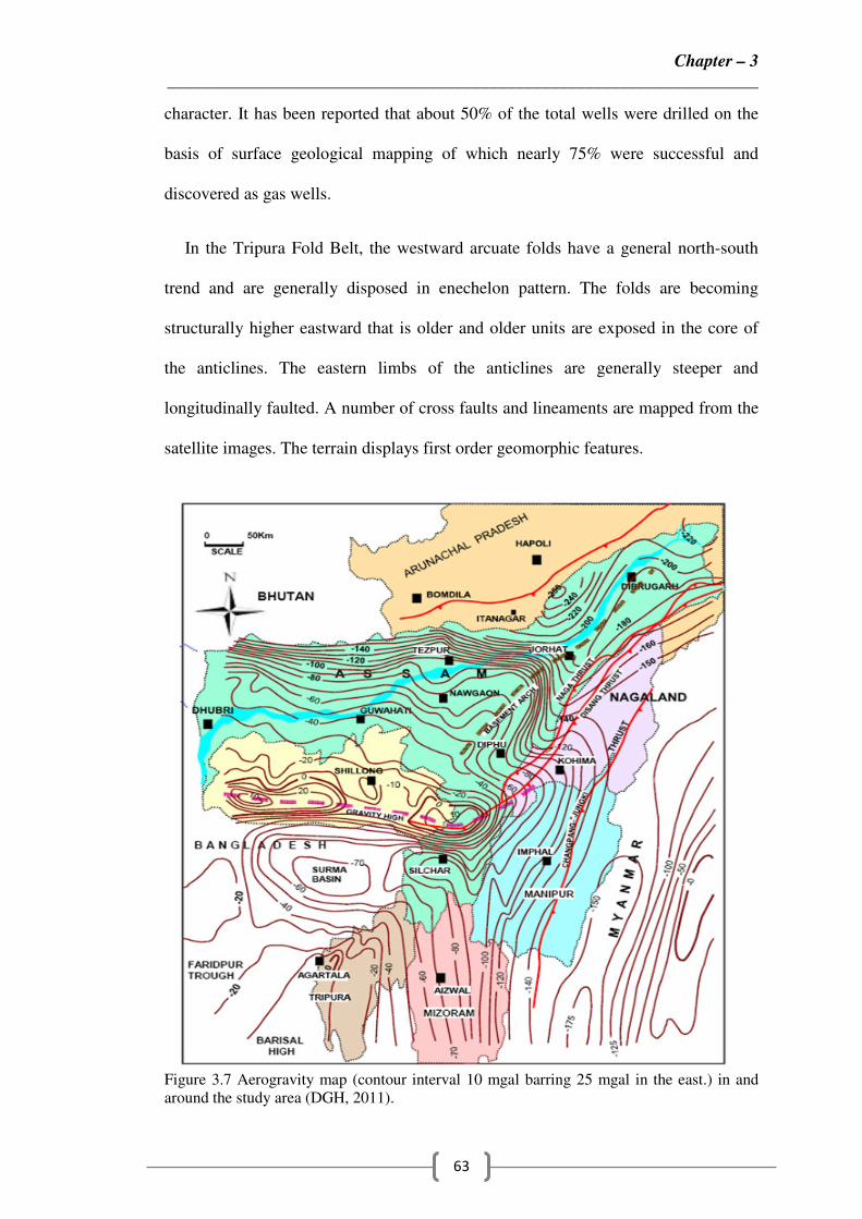
3.2.5 Aerogravity Survey
Aerogravity has helped to bring out the basement configuration (Figure 3.7). The
northern part of the study lies on a gravity high which goes down towards southeast
in the northern part and towards south in the southern part. Gravity survey conducted
in Bengal and Assam–Arakan basins covers the study area and its surrounding area.

Chapter – 3
____________________________________________________________________
62
The Bouguer anomaly map shows that Tripura including the study area lies on
regional gravity high trending NNE-SSW (DGH, 2008).
3.2.6 Landsat Imagery Study
The author purchased landsat imagery map and studied the same, accordingly the
interpretations were made. Structural and denudational processes dominate
geomorphology of the Central Tripura. The Khowai syncline represents a structural
valley with mounds of Dupitila. Overall drainage pattern in the northwestern part of
the area is dendritic and parallel to sub-parallel pattern in the southern part of
Khowai and Dolai syncline. The most significant feature of the map is the presence
of two dominant “geomorphic highs”, one in the northern part of the area (annular)
and the other on the northwestern part of the area (radial). It may be highlighted that
Baramura gas field of ONGC forms part of the radial geomorphic high identified in
the northern part of the area. These two anomalies are indicative of presence of sub-
surface geological structure, which is important from hydrocarbon exploration point
of view (Figure 3.8a, 3.8b and 3.8c). The distinction between Upper and Lower
Bhuban is also supported by trace fossil assemblage. The upper Bhuban is
arenaceous predominating with sandstone, shale and siltstone separated by
conformable and transitional contact from middle Bhuban which is argillaceous. The
middle Bhuban is separated from lower Bhuban (arenaceous in nature) by
conformable and transitional contact.
3.2.7 Geological Mapping
Geological field mapping have been carried out by Oil and Natural Gas
Corporation of India (ONGC) in the study area covering the Atharamura and
Tulamura anticlines that has helped to understand its structure and lithological
Chapter – 3
____________________________________________________________________
63
character. It has been reported that about 50% of the total wells were drilled on the
basis of surface geological mapping of which nearly 75% were successful and
discovered as gas wells.
In the Tripura Fold Belt, the westward arcuate folds have a general north-south
trend and are generally disposed in enechelon pattern. The folds are becoming
structurally higher eastward that is older and older units are exposed in the core of
the anticlines. The eastern limbs of the anticlines are generally steeper and
longitudinally faulted. A number of cross faults and lineaments are mapped from the
satellite images. The terrain displays first order geomorphic features.
Figure 3.7 Aerogravity map (contour interval 10 mgal barring 25 mgal in the east.) in and
around the study area (DGH, 2011).

Chapter – 3
____________________________________________________________________
64
The Baramura anticline to the west is separated from the Atharamura anticline by
the broad Khowai syncline, whereas to the east, the Batchia anticline is separated
from Atharamura-Tulamura line of anticlines by the Dolai syncline. The N–S
trending Atharamura anticline is the longest (about 100 km) and largest of all the
anticlines exposed in Tripura fold belt. It extends into Bangladesh in the south by
more than 25 km and in the north by about 2 km. It has two culminations, the
northern one being larger than the southern one. It covers an area of approximately
780 sq. km within the Central Tripura. The eastern limb of the anticline is steeper
and shorter than the western one and is affected by a major longitudinal reverse fault
heading towards west. As per LANDSAT imagery data, the fold is also affected by
two sets of cross faults; one set is oriented in NE–SW direction and the other in NW
– SE direction.
The NNW–SSE trending Tulamura anticline lies southwest of the Atharamura
anticline. To the west, it is separated from Gojalia anticline by the Bopagha Syncline
(Khar et al., 1984). The Tulamura anticline is disposed enechelon to the Baramura
anticline towards south. The eastern limb of the Tulamura anticline is steeper and
shorter than the western one and similar to the Atharamura anticline and is traversed
by a major longitudinal reverse fault heading towards west. Remote sensing maps
shows the structure to be cut by a few cross faults.
The Bokabil Formation is dominantly argillaceous in the study area. It contains a
large number of sandstone beds and the Tipam sandstone Formation contains many
shale beds. The lower Tipam unit shale-sandstone alteration and the Upper Tipam
are dominantly sandstone with subordinate shales. The Bhuban and Bokabil
formations are mainly dominated by mud or sand filled channels and incised valleys

Chapter – 3
____________________________________________________________________
65
(Lee et al., 2001). Due to head ward erosion of submarine canyons or low stand
subaerial incision of valleys by channel networks these mud or sand filled channels
are formed (Eliet et al., 1999). When those channels are filled by sand they form
excellent stratigraphic traps, however they formed seals when filled with shale.
Figure 3.8a Geomorphological exposure in and around the study area.

Chapter – 3
____________________________________________________________________
66
3.2.8 Depositional Patterns
Isopach maps (based on well data) of Upper Bhuban formation (Figure 3.9a), and
Surma Sequence (Thematic) (Figure 3.9c) are prepared as well as sand /shale ratio of
Upper Bhuban formation (Figure 3.9b), sand percentage of Bokabil formation
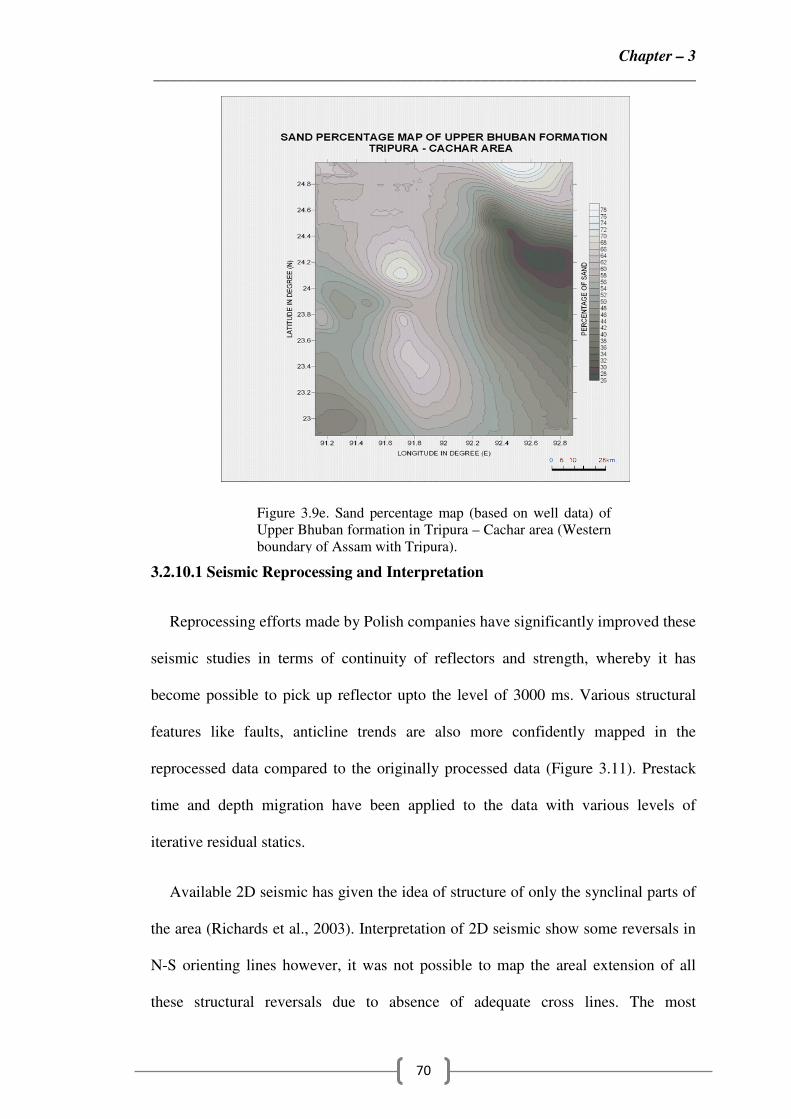
(Figure 3.9d) and sand percentage of Upper Bhuban formation (Figure 9e) are also
prepared for Tripura – Cachar area for better understanding of depositional patterns
of the study area. Sand thickness derived from field traverses and drilled well
suggests the following depositional pattern for the sediments: Upper Bhuban
formation, Surma Sequence (Thematic) and Bokabil formations. The deposition of
upper Bhuban formation in the northeast is only 600 – 700 m around Khowai and
Kamalpur due to limited subsidence in this area. The exposed Indian shield is located
Figure 3.8b. False colour coding in
Landsat imagery.
Figure.3.8c Surface geological exposure
in and around the study area.

Chapter – 3
____________________________________________________________________
67
near the thickness of upper Bhuban formation in the Mizoram part (800 – 900 m) in
the east and Rokhia part (800 – 900m) towards the west. This shows an increase in
thickness as this part is affected by tectonic loading, both from the east (Indo –
Burman ranges) and the northeast (eastern Hymalayas) which caused it to subside
further, helping to accommodate huge thickness (4000 – 4500m) of Miocene
sediments of the Surma Sequence (Figure 9c). The sand/shale ratio has been
estimated from various field traverses and drilled well data. The highest sand/shale
ratio for the Upper Bhuban formation (2.20) is at the Khowai and Kamalpur area in
the northeast, gradually decreasing towards the south and Mizoram areas. In Eastern
Tripura, the ration is higher in Nutanbazar which decreases to 0.80 in Agartala;
further west in Rokhia, it is again 1.20 clearly indicating different sand lobes. The
highest sand percentage for Upper Bhuban formation (68%) is at the Kamalpur area
in the northeast gradually decreases towards the Mizoram areas. In Eastern Tripura,
the sand percentage is higher in Nutanbazar which decreases to 50% in Agartala;
further west in Rikhia, it is again 56% clearly indicating different sand lobes.
Therefore, from the sand /shale ratio map and sand percentage map of upper Bhuban
formation, we have observed that there are two different sand lobes in Tripura.
3.2.9 Geochemical Analysis
Numerous surface and subsurface manifestations of natural gas in Tripura
suggests the existence of conditions conducive to hydrocarbon generation in this
region (Ganguly, 1983).The geochemical studies carried out in the area (Figure 3.10)
indicate that the surface hydrocarbon regime has not been generally perturbed by the
upward migration of subsurface hydrocarbon accumulation (Khan etal., 1999).
However, considering methane anomalies and propane as one of the established
hydrocarbon proximity indicator, one may look for prioritizing geomorphologically

Chapter – 3
____________________________________________________________________
68
or seismically mapped prospects in the region between Teliamura-Ambassa where
central part of the area shows gas ooze with high methane and propane
concentrations around Kaiphang (southern tail of the area). The analysis shows that
97% of the samples are characterized by varying concentration of methane from 1-
79 ppb and few samples have ethane, propane, isobutane and normalbutane. These
numerous surface and subsurface manifestation of natural gas in Tripura suggest
existence of conditions conducive to petroleum generation in the region.
3.2.10 Seismic Studies
Within the study area, Common Depth Points (CDP) seismic surveys were
conducted acquiring 24 fold data in limited areas of the Khowai and Dolai synclines
Figure 3.9a. Isopach map (based on well
data) of Upper Bhuban formation in Tripura
– Cachar area (Western boundary of Assam
with Tripura)
Figure 3.9b. Sand Shale ratio map (based on
well data) of upper Bhuban formation in
Tripura – Cachar area (Western boundary of
AssamwithTripura)

Chapter – 3
____________________________________________________________________
69
by various Indian oil companies. These lines acquired along the roads and nallas are
crooked in nature. Interpretation of seismic data from the area is beset with
difficulties such as (a) statics, (b) tie between various campaigns: seismic lines
belong to different vintages, each set of lines having widely separated ground
locations with no connectivity in between, (c) multiples in the lower levels and (d)
poor imaging of deeper levels. Seismic data interpretation helps to identify low relief
reversals of the area, but has limitations while imaging the core of anticlines. As a
result, gently dipping area towards the plunge of anticlines give relatively better
quality of seismic data than the highly dipping crested area.
Figure 3.9c. Isopach map (based on well data)of
Surma Sequence (Thematic) in Tripura –
Cachar area (Western boundary of Assam with
Tripura).
Figure 3.9d. Sand percentage map (based on
well data) of Bokabil formation in Tripura –
Cachar area (Western boundary of Assam
with Tripura).
Chapter – 3
____________________________________________________________________
70
3.2.10.1 Seismic Reprocessing and Interpretation
Reprocessing efforts made by Polish companies have significantly improved these
seismic studies in terms of continuity of reflectors and strength, whereby it has
become possible to pick up reflector upto the level of 3000 ms. Various structural
features like faults, anticline trends are also more confidently mapped in the
reprocessed data compared to the originally processed data (Figure 3.11). Prestack
time and depth migration have been applied to the data with various levels of
iterative residual statics.
Available 2D seismic has given the idea of structure of only the synclinal parts of
the area (Richards et al., 2003). Interpretation of 2D seismic show some reversals in
N-S orienting lines however, it was not possible to map the areal extension of all
these structural reversals due to absence of adequate cross lines. The most
Figure 3.9e. Sand percentage map (based on well data) of
Upper Bhuban formation in Tripura – Cachar area (Western
boundary of Assam with Tripura).

Chapter – 3
____________________________________________________________________
71
convincing structure is found near the Teliamura which is a three-way dip closure.
Further evidences were provided by remote sensing maps showing the surface
impression of a possible subsurface high, i.e. a geomorphic high, characterized by
the annular drainage pattern.
Figure 3.10 Geochemical survey map showing the concentration of Methane,
Ethane, Propane etc. The red circle indicates the zones where hydrocarbon is
oozing out to surface. (Source: NGRI Research Team, 2008)

Chapter – 3
____________________________________________________________________
72
This kind of concealed low amplitude subsurface structural highs indicated by the
photogeological and Landsat image analysis within the synclinal areas can be
prospective (Momin et al., 1999). Agartala Dome gas field is one such concealed
structure located within Agartala syncline (Figure 3.6).
Figure 3.11 Typical seismic line depicting reversal with masked shadow zone (a) Reversal
masked with shadow zone. The anticlinal trend on the crest is chaotic (before reprocessing),
(b) Reprocessing helped to overcome shadow zone to a great extent and highlighted reflector
continuity over crestal part of reversal with plausible interpretation of continuous reflectors.
(Refer Seismic Line-1 in Figure 3.1)
Few parallel seismic lines in the western flank of Tulamura anticline have
depicted wipe out zone (gas shadow zone). Immediately north of this feature, gas has
been collected during a recent field survey. Figure 3.13 shows high amplitude
reflectors in patches are observed in reprocessed seismic sections which are difficult
to correlate across faults and the area being located in structurally complex area,

Chapter – 3
____________________________________________________________________
73
such section requires structural balancing in order to understand the paleostructure of
the area and to compute a geological model (Refer to Seismic Line-1 in Figure 3.2).
The interpretation of geo-seismic sections is considered to be greatly assisted by
careful application of geometrical balance and a consideration of strain even in areas
of low crustal extensions. The shot gathers of seismic CDP have been analyzed on
all the parallel lines. The weak reflector zone identified has not attributed to
mechanical failure during seismic shooting.
3.2.11 Hydrocarbon Plays in the Study Area
Based on hydrocarbon occurrences and established formation pressure regime of
Tripura and adjoining Bangladesh, the exploration target of the study area can be
divided into two parts: Shallow prospect exploration within normal and upper
transition pressure regime and Deeper prospect exploration in abnormally high-
pressure regime and underlying-Barails (Momin et al., 1999).
3.2.11.1 Shallow Exploration Targets
It includes mainly the shallow reservoirs which are primarily controlled by
structure along with stratigraphic variations like channel cut and fills lensoidal sand
bodies as additional plays. The potential source is established as deep from where
hydrocarbons are migrated and entrapped in these shallow stratigraphic comes
structural plays. This phenomenon and the in situ generation of gas-condensate from
Lower Bhuban shales make the exploration of synclinal areas attractive as tectonic
influence is minimal and preserve better cooking environment for longer time as
compared to the anticlines which were shadowed up. Therefore, the concealed low
amplitude structural highs indicated by the photogeological and Landsat image

Chapter – 3
____________________________________________________________________
74
analysis within the synclinal areas are merit attention. Agartala Dome gas field is
one such concealed structure located within Agartala syncline (Momin et al., 1999).
However, there is a risk of escaping of gas in the areas of structural complexities
(from east of Atharamura). This could be a very convincible explanation of why the
wells at Harargaj went dry in spite of continuous gas shows observed during drilling.
Hence, exploratory success for shallow prospects lies in the comparatively less
disturbed plunge areas of these complex structures where the younger rocks form the
potential cap and the deep-seated younger cross faults provide the trapping
mechanisms (Momin et al., 1999). The gentle plunge of the Tulamura anticline has
such a high possibility of being hydrocarbon bearing like the Gojalia structure which
is in the immediate west of this anticline.
3.2.11.2 Deeper Exploration Targets
Scanty well data and poor seismic response below the Middle Bhuban are the
prime constraints for a fruitful resource assessment for the deeper prospects. Surface
geological mapping envisages a comparatively flatter and gentler closure of pre-
Bhuban sequences which is supported by offset VSP data over Khubal anticline in
eastern Tripura. It also indicated the occurrence of Barail at a depth of around
3960m (abs) in Khubal. VSP-PIVT trends in a number of wells predict possible
pressure regression below Lower Bhuban (Singh et aI., 1997). The role of
overpressure sequence below the middle part of the Middle Bhuban has a great
significance in hydrocarbon migration. This overpressure seal might have formed a
partial barrier to the upward movement of hydrocarbon and thus favoured
accumulation within the reservoir facies of overpressure sequence and underlying
Oligocene reservoirs of Barail Formation. (Momin et al., 1999). More than 3000m

Chapter – 3
____________________________________________________________________
75
thickness of the Eocene and Oligocene Barail group rocks is deposited on the top of
the Kopili. The Barail lower are nacreous unit and the upper Barail coal – shale unit
are the two divisions of the Barail group. Mainly, Main Pay sand, the main lower
sand and minor shales with a combined thickness of as much as 900m are deposited
in Barail lower arenaceous unit. However the upper Barail group coal – shale unit
consists of as much as 1200m of interbeded coals, shales and discontinuous
sandstones reservoirs deposited in a delta – plain environment. In between Naga and
Disang thrusts the thicknesses of upper Eocene and Oligocene Barail coal – shale
unit reaches a maximum 660m (Balan et al., 1997). Barail coal – shale unit has Total
Organic Content (TOC) values ranging from less than 0.8% to more than 12% . In
the Assam geological province Barail formation is considered as primary source
rock. However the Miocene Surma group Bhuban formation if hypothesized to be
the most likely source rocks (Balan et al., 1997).
In Tripura area, gas entrapment is mostly controlled by structures (Figure 3.12).
Here, we discuss possible hydrocarbon plays in the study area, analogy drawn from
neighboring various discoveries:
i. The presence of first order topography in Tripura where in the structures
manifested on the surface continue in the subsurface with minor changes is a
criterion noticeable at the first sight from the structural point of view with a
shift in the axis as we propagate downwards.
ii. In this province, ENE – WSW strike slip faults control entrapment along
anticline axis. Separate closures within the same anticline have different
pools. Sinuosity of Atharamura structure, possibly the effect of younger cross
cutting strike slip faults resulting into the displacement of axis and

Chapter – 3
____________________________________________________________________
76
compartmentalizing the structure into three main parts, the structurally
highest portion felled the central compartment. If it is compared to the nearby
Baramura structure, these cross cutting faults plays vital role in defining the
prospectivity of this structure, because the Baramura gas field is defined by a
N-S orienting reverse fault in its eastern limb and ENE-WSW crosscutting
faults thereby limiting the structure in its northern culmination.
iii. Crest and plunge of anticlines: Crest and plunge along the axis of anticlines
of Tripura Cachar Fold Belt have already been proved as highly prospective
by the various gas discoveries. The Tulamura anticline is enechelon to the
gas bearing Baramura anticline. Towards the immediate east of Tulamura is
the Gojalia anticline, which is having a similar structural set up like
Tulamura. This Gojalia anticline is enechelon to Rokhia and Tichna anticline
respectively in the west and northwest. The plunge of this Gojalia anticline
has proved hydrocarbon entrapment. Similarly, at the plunge of the
Atharamura anticline, Moulavi Bazar gas field is located (in Bangladesh). As
such the plunge of the Tulamura anticline, which is within the study area,
merits attention.
iv. Although a number of crosscutting faults have divided the Atharamura
anticline into a number of compartments, the flank part of the anticline is less
affected. This means that these parts of the anticline are less
compartmentalized. As there is no report of gas seeps up dip it provides a
possibility of encountering leads in the flank parts, which are sealed by
conceptualized faults. The sealing faults could be against sandstone-
mudstone contact or by smearing clay down the fault plane along sandstone-
sandstone contacts.

Chapter – 3
____________________________________________________________________
77
3.2.12 Risking of Plays
Central Tripura is riddled with risk. The structural deposition of anticlines and
synclines possess largest challenge from exploration point of view. Some of the risk
indentified is described as followings:
Figure 3.12 Gas seepage near the study area. The same is also seen in the shot
gather and in the SEGY seismic data. The leaky faults were identified which are
the conduits which oozes out hydrocarbon to the surface. This is also confirmed by
geochemical anomalies.

Chapter – 3
____________________________________________________________________
78
i. The study area is highly dominated by faults and thrusts and presents two
kinds of risks of prospects. Nature of the faults (whether sealed or leaky)
plays a vital role in defining the chances of hydrocarbons trapped in
structural plays. Gas seepages are quite common in this area, where faults are
mainly acting as conduits for gas to escape. Apart from these faults, whether
medium angled or low angle reverse fault (thrust) is also important in
defining the reservoir geometry and extent.
ii. Plunge angle of the anticlines steep or gentle, plays another important role in
the risking of various structural plays. Gentle plunge of anticlines less
deformed by tectonic activities are considered as more prospective.
iii. Taking into consideration of the failure of ONGC’s recent well KK1 which
was drilled in a concealed structure (seen as geomorphic high) within the
syncline in the close proximity of the study area brings into light another risk
in terms of charging of these kind of subtle structures. However, Agartala
Dome is a well-established hydrocarbon bearing structure.
iv. Structures having steeper dips of > 50� have severe challenges in drilling
like Hararganj-1 well. Most discoveries are known from formations having
less than 300 dips.
v. Formation pressure is another very important aspect especially for deeper
targets. 90% reservoirs are known within hydrostatic pressure regime; 10%
within transition pressure regime; none in super pressure regime. High
pressure and high temperature of the formation is a major constraint in
completing many wells in both Tripura and Bangladesh area.

Chapter – 3
____________________________________________________________________
79
Figure 3.13 Structural balancing (High amplitude reflectors in patches are observed in
reprocessed seismic sections, which are difficult to correlate across faults and the area being
located in structurally complex area.
3.3 CONCLUSIONS
Till now, geological mapping is widely used in finding out various structural plays in
this region. The available seismic data are affected by structural complexity of the
region such as shadowing effect of steeply dipping structures. The scanty seismic
data are not adequate enough in proper imaging the deeper level. In order to
minimize the above-mentioned limitations and constraints, the new seismic may be
acquired to achieve better reflector continuing by applying ground mixing. The
prospects in the syncline are mainly concealed anticline within syncline. The

Chapter – 3
____________________________________________________________________
80
anticlines in the study area are less explored and more exploration activities need to
be carried out to exploit the potential of the same.
The risk envisaged has been listed down and hydrocarbon prospectivity evaluated
mostly in terms of geological and geophysical signatures.
REFERENCES
1) Akram, S.M., Mudiar, B., and Sahu, A., 2004. “Geodata integration leads to
reserve accreation in Baramura gas field of Tripura, Assam-Arakan Fold Belt -
A case study”. Paper presented at the 5th
Conference and Exposition on
Petroleum Geophysics, Hydrabad, India, pp. 767 – 771.
2) Alam, M., 1989. “Geology and depositional history of Cenozoic sediments of
the Bengal Basin of Bangladesh, Palaeogeography, Palaeoclimatology,
Palaeoecology”. Elsevier. doi:10.1016/0031-0182(89)90159-4, vol.69, pp. 125-
139.
3) Babu, S., and Sircar, A., 2011. “A comparative study of predicted and actual
pore pressures in Tripura, India”. Journal of Petroleum Technology and
Alternative Fuels, Vol. 2(9), pp. 150 – 160.
4) Brown, T. A., Shamsuddin, A. H. M., and Rickard, M. J., 2001. “Hydrocarbon
resource base of Bangladesh”. Proceedings of the 13th
Offshore South Asia
(SEAPEX) Conference, pp. 79–84.
5) Balan, K.C., Banerjee, B., Pati, L.N., Shilpkar, K.B., Pandey, M.N., Sinha,
M.K., and Zutshi, P.I., 1997. “Quantitative genetic modeling of Upper Assam
Shelf”. Proceedings 2nd
International Petroleum Conference & Exhibition,
Petrotech, New Delhi, India, vol. 1, pp. 341–349.

Chapter – 3
____________________________________________________________________
81
6) Curiale, J.A., Covington, G.H., Shamsuddin, A.H.M., Morelos, J.A., and
Shamsuddin, A.K.M., 2002. “Origin of petroleum in Bangladesh”. AAPG
Bulletin, Vol. 86, pp. 625-652.
7) Chakravorty, D., Gupta, S., Shyam, R., and Bandari, A., 2011. “A Re – look
into exploration strategy of Lower Bhuban play in Eastern Tripura, India - A
case study”. The 2nd
South Asain Geoscience Conference and Exhibition,
GEOIndia 2011, Greater Noida, New Delhi, India.
8) Dasgupta, P.K., Chakraborty, P.K., and Dutta, D., 1991. “Basinward migrating
submarine fan environment from Barail group in North Cachar Hills, Assam
Arakan Orogen, India”. A.H. Bouma and R.M. Carter (Eds.), Facies Models in
Exploration and Development of Hydrocarbon and OreDeposits: VSP, Utrecht,
the Netherlands, p. 254.
9) DGH Report 2011 – 12 and 2007 – 08. “Hydrocarbon exploration and
production activities”. Ministry of Petroleum and Natural gas, Govt. of India.
10) Eliet, P., Edward, A.F., Mingard, H.F., and Talukder, Y.A., 1999. “Fore-
stepping progradational to aggradational sequence stacking geometries, offshore
Bangladesh: Implication for reservoir development”. Proceedings of 2nd
Petroleum Engineering Symposium, Bangladesh University of Engineering and
Technology, Dhaka, p. 19.
11) Ganguly, S., 1983. “Geology and Hydrocarbon prospects of Tertiary succession
of Tripura-Cachar-Mizoram region”. Petroleum Asia journal, Vol. 1, pp. 105-
109.

Chapter – 3
____________________________________________________________________
82
12) Ganguly, S., 1993. “Stratigraphy, Sedimentation and Hydrocarbon prospects of
the tertiary succession of Tripura and Cachar (Assam)”. Indian Journal of
Geology, Vol. 65, pp. 145 – 108.
13) Gani, M.R., and Alam, M.M., 1999. “Trench-slope controlled deep-sea clastics
in the exposed lower Surma Group in south – eastern Fold Belt of the Bengal
Basin, Bangladesh”. Sedimentary Geology, Vol. 127, pp. 221– 236.
14) Goswami, B.G., Bisht, R.S., Bhatnagar, A.K., Kumar, D., Pangtey, K.L., Mittal,
A.K., Geol, J.P., Datta, G.C., and Thomas, N.J., 2005. “Geochemical
characterization and source investigation of oils discovered in Khoraghat –
Nambar structures of the Assam – Arakan Basin, India”. Organic Geochemistry,
Vol. 36, pp. 161 – 181.
15) Holtrop, J.F., and Keizer, J., 1970. “Some aspects of stratigraphy and
correlation of the Surma Basin wells, East Pakistan”. ESCAFE Mineral
Resources Development Series No. 36, pp. 143–154.
16) Hossain, H.M.Z., Sampei, Y., and Roser, B.P., 2009. “Characterization of
organic matter and depositional environment of Tertiary mudstones from the
Sylhet Basin, Bangladesh”. Organic Geochemistry, Vol. 40, pp. 743 – 754.
17) Imam, B., and Hussain, M., 2002. “A review of hydrocarbon habitat in
Bangladesh”. Journal of Petroleum Geology, Vol. 25(1), pp. 31-52.
18) Imam, M.B., and Shaw, H.F., 1985. “The diagenesis of Neogene clastic
sediments from the Bengal Basin, Bangladesh”. Journal Sed. Petrol., Vol. 55,
pp. 665-671.

Chapter – 3
____________________________________________________________________
83
19) Imam, M.B., 1987. “Implications of shale diagenesis on cementation of
reservoir sandstones in Neogene Surma Group, Bengal Basin, Bangladesh”.
Journal Geol. Soc. India, Vol. 30, pp. 447-492.
20) Islam M. Aminul, 2009. “Diagenesis and reservoir quality of Bhuban
sandstones (Neogene),Titas Gas Field, Bengal Basin, Bangladesh”. Journal of
Asian Earth Sciences, Vol. 35, pp. 89 – 100.
21) Jena, A.K., Das, N.C., Saha, G.C., and Asim, S., 2011. “Exploration in
Synclinal Area of Tripura Fold Belt, India: A re – found Opportunity”.
Expanded abstract presentation at AAPG Annual Convention and Exhibition,
Houston, Texas, USA, April 10- 13.
22) Jonson, Y.J. and Alam, A.M.N., 1991. “Sedimentation and tectonics of the
sylhet through, Bangladesh”. Geol. Soc. Am. Bull. Vol. 103, pp. 1513 – 1527.
23) Khar, B.M., and Ganju, J.L., 1984. “Tectonic of Tripura folds – probable
mechanics of folding and faulting”. Petroleum Asian Journal, Vol. 1, pp. 66 –
77.
24) Khan, A.A., and Imaduddin, M., 1999. “Petroleum exploration and production
in Bangladesh: prospect and problems”. Proceedings of the 43rd
Convention of
the Institute of Engineers, pp. 27–32.
25) Khan, R.M.S., Geol, J.P., Sharma, A.K., Pande, A., Mathur, M., and Misra,
K.N., 1999. “Geochemical model for the generation of condensates in Tripura
area”. Proceeding of the 3rd
Int. Pet. Conf. and Exbn. Petrotech, New Delhi,
India, pp. 207- 212.

Chapter – 3
____________________________________________________________________
84
26) Khan, M.A.M., Ismail, M., and Ahmed, M., 1988. “Geology and hydrocarbon
prospect of the Surma Basin, Bangladesh”. 7th
Offshore Southeast Asia Conf.
Singapore, pp. 364-387.
27) Kunte, S.V., 1989. “Tripura – Cachar fold belt genesis of structural style”.
ONGC Bulletin, Vol. 26(2), pp. 1- 15.
28) Leitz, J.K., and Kabir, J., 1982. “ Prospects and constraints of oil exploration in
Bangladesh”. In: Proc. 4th
Offshore Southeast Asia Conference, Singapore, pp.
1-6.
29) Lee, Y.F.S., Brown, T.A., Shamsuddin, A. H. M., and Ahmed, N.U., 2001.
“Stratigraphic complexity of the Bhuban and Bokabil formations, Surma Basin,
Bangladesh: Implications for reservoirmanagement and stratigraphic traps”. 10th
Geological Conference, Bangladesh Geological Society, Dhaka, p. 25.
30) Momin, W.W., and Choudhury, A., 1999. “Evaluation of Tripura subbasin with
special reference to the hydrocarbon province of Bangladesh gas fields”.
Proceeding of the 3rd
Int. Pet. Conf. and Exbn. Petrotech, New Delhi, India, pp.
63-68.
31) Murphy, R.W., 1988. “Bangladesh enters the oil era”. Oil and Gas Journal, pp.
76–82.
32) Mane, P.H., Santanu, D., Bhattacharya, H.S., and Monin, W.W., 1999.
“Petroleum System of Miocene Sediments of Western Tripura”. Proceeding of
the 3rd
Int. Pet. Conf. and Exbn. Petrotech, New Delhi, India, pp. 69 – 72.

Chapter – 3
____________________________________________________________________
85
33) Nanjundaswamy, S., and Kandwal, A.K., 1993. “Paleoenvironmental and
Paleogeographic analysis of Tripura area”. Proceeding of the 2nd
seminar on
Petroliferous Basins of India, Vol.1, pp. 613-624.
34) NGRI Research Team, 2008. “Geochemical study of samples taken from
Sanand field”. Unpublished.
35) Pande, A., Uniyal, A.K., and Chandra, K., 1994b. “Genetic correlation of
biodegraded crude oils from Lower Assam, India using biomarker
composition”. Organic Geochemistry, Vol. 21, pp. 971 – 977.
36) Richards, D.R., Calvert, S.J., and Yamamoto, H., 2003. “2D And 3D Structural
Balancing in a Deformed Foreland Basin, Peruvian Subandean Belt”. 8th
Simposio Bolivarino. pp. 141 – 145.
37) Tiwari, R. P., Rajkonwar, C., Lalchawimawii, Paul, L. J. M., Ralte, V. Z., and
Patel, S. J., 2011. “Trace fossils from Bhuban Formation, Surma Group (Lower
to Middle Miocene) of Mizoram India and their palaeoenvironmental
significance”. Journal of Earth System Science, Vol. 120(6).
38) Tissot, B.P., and Welte, D.H., 1978. “Petroleum Formation and Occurrence – A
New approach to Oiland Gas Exploration”. Springer-Verlag, Berlin, p. 538.
39) Shamsuddin, A. H. M., and Abdullah, S. K. M., 1997. “Geologic evolution of
the Bengal basin and its implication in hydrocarbon exploration in Bangladesh”.
Indian Journal of Geology, Vol. 69, pp. 93–121.
40) Shamsuddin, A. H. M., and Khan, S.I., 1991. “Geochemical criteria of
migration of natural gases in the Miocene sediments of the Bengal Foredeep,
Bangladesh”. Journal of Southeast Asian Earth Sciences, Vol. 5, pp. 89-100.
Chapter – 3
____________________________________________________________________
86
41) Singh, K., Chaudhury, A., and Bhattacharyya, N., 1997. “Application of VSP
for drilling overpressure wells in Tripura”. Journal of Geophysics, Vol. 18(1),
pp. 15 - 26.
42) Uniyal, A.K., Mittal, A.K., Dwivedi, P., Chandra ,U., Benerji, V., Dhawan, R.,
and Mathur, M., 1995. “Genetic classification of Natural Gases of Tripura –
Cachar, India”. Proceeding of Petrotech, New Delhi., Technology trends in
Petroleum Industry.
43) Uddin, A., and Lundberg, N., 1999. “A parleo – Brahmaputra? Subsurface
lithofacies analysis of Miocene deltaic sediments in Himalayan – Bengal,
system, Bangladesh”. Sedimentary Geology, Vol.123, pp. 239 – 254.
44) Waples, D.W., 1985. “Geochemistry in Petroleum Exploration”. D. Reidel
Publishing Company, Boston, p. 232.