Hunter Contracting Case Story
4
Project Summary The town of Gilbert is located within the Phoenix metropolitan area in Maricopa County, Arizona. Since 1980, Gilbert has grown at a breakneck pace, evolving from a sleepy agricultural town of fewer than 6,000 people to an affluent community sup- porting high-wage jobs in numerous industries, including renewable energy, high technology, and the life and health sciences. To help ensure that the safety and reliability of its roads kept pace with the increasing population and traffic, Gilbert engaged Hunter Contracting and CADsoft Consulting to complete a $4.5 million roadway improvement project at the intersection of Greenfield Road and Chandler Heights Road in 2006. “These roads are the only major access to that part of town for the residents who live there,” says Jeff Kramer, senior program manager for Gilbert. Furthermore, the town anticipates an imminent increase in area traf- fic—an increase that could easily overwhelm the intersection’s narrow one-lane roadways. The Challenge Moving forward on the project was complicated by the need to obtain approval from several stakehold- ers, including the local water conservation district, which provides irrigation water to a number of large farms in the area, as well as a local tribal community. The water conservation district’s main water delivery canal passes directly under the center of the intersection, resulting in a slight elevation that reduces driver visibility and contributes to a higher-than-expected number of accidents at the intersection. To improve safety and minimize the town’s liability, Gilbert wished to relocate the water district canal, realign the intersection, and widen the bridge, adding a lane in each direction. The completed project would also include a continuous center turn lane, bike lanes, sidewalks, street light- ing, and other ancillary improvements. Plan. Visualize. Perform. Hunter Contracting completes a fast- track intersection improvement project with Autodesk BIM solutions. Hunter Contracting CADsoft Consulting Client: The Town of Gilbert Customer Success Story AutoCAD ® Civil 3D ® Autodesk ® Navisworks ® Manage Autodesk ® Navisworks ® Freedom The Timeliner functionality in Navisworks is what made this project click. When we presented to the water conservation district, we could stop, move forward, or move back at any time—even flip the model to show base elements—pausing whenever we needed to talk about key elements of the construction schedule. The Timeliner was the most important part of this project from a technical standpoint—and was essential to receiving eventual buy-in from the water conservation district. —Ron Couillard Civil BIM Technical Consultant CADsoft Consulting Visualization of intersection created with Navisworks. Image courtesy of CADSoft Consulting.
-
Upload
cadsoft-consulting -
Category
Documents
-
view
113 -
download
4
description
Hunter Contracting Case Study
Transcript of Hunter Contracting Case Story
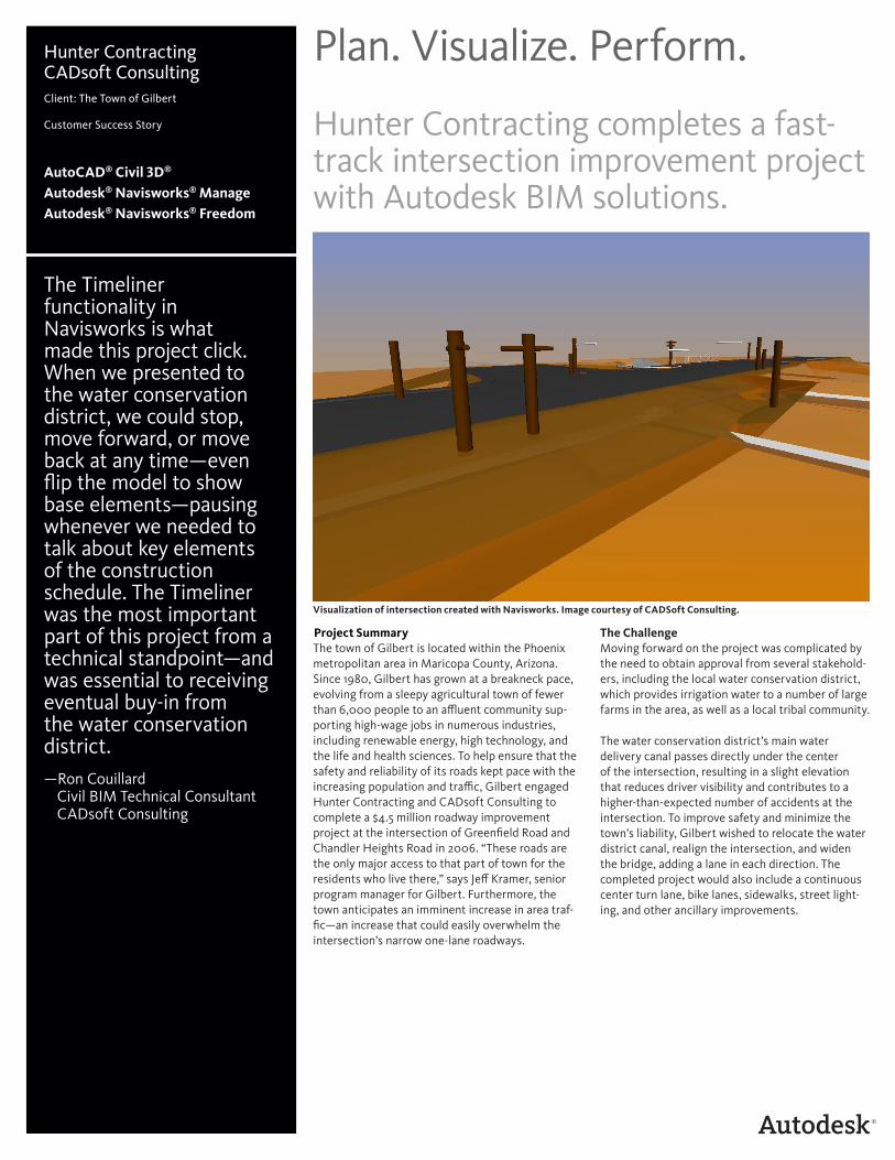
Project SummaryThe town of Gilbert is located within the Phoenix metropolitan area in Maricopa County, Arizona. Since 1980, Gilbert has grown at a breakneck pace, evolving from a sleepy agricultural town of fewer than 6,000 people to an affluent community sup-porting high-wage jobs in numerous industries, including renewable energy, high technology, and the life and health sciences. To help ensure that the safety and reliability of its roads kept pace with the increasing population and traffic, Gilbert engaged Hunter Contracting and CADsoft Consulting to complete a $4.5 million roadway improvement project at the intersection of Greenfield Road and Chandler Heights Road in 2006. “These roads are the only major access to that part of town for the residents who live there,” says Jeff Kramer, senior program manager for Gilbert. Furthermore, the town anticipates an imminent increase in area traf-fic—an increase that could easily overwhelm the intersection’s narrow one-lane roadways.
The Challenge Moving forward on the project was complicated by the need to obtain approval from several stakehold-ers, including the local water conservation district, which provides irrigation water to a number of large farms in the area, as well as a local tribal community.
The water conservation district’s main water delivery canal passes directly under the center of the intersection, resulting in a slight elevation that reduces driver visibility and contributes to a higher-than-expected number of accidents at the intersection. To improve safety and minimize the town’s liability, Gilbert wished to relocate the water district canal, realign the intersection, and widen the bridge, adding a lane in each direction. The completed project would also include a continuous center turn lane, bike lanes, sidewalks, street light-ing, and other ancillary improvements.
Plan. Visualize. Perform.
Hunter Contracting completes a fast-track intersection improvement project with Autodesk BIM solutions.
Hunter ContractingCADsoft ConsultingClient: The Town of Gilbert Customer Success Story
AutoCAD® Civil 3D®
Autodesk® Navisworks® ManageAutodesk® Navisworks® Freedom
The Timeliner functionality in Navisworks is what made this project click. When we presented to the water conservation district, we could stop, move forward, or move back at any time—even flip the model to show base elements—pausing whenever we needed to talk about key elements of the construction schedule. The Timeliner was the most important part of this project from a technical standpoint—and was essential to receiving eventual buy-in from the water conservation district. —Ron Couillard Civil BIM Technical Consultant CADsoft Consulting
Visualization of intersection created with Navisworks. Image courtesy of CADSoft Consulting.

CADsoft imported Oracle’s Primavera® P6 construction schedule into Navisworks to visually depict the construction phasing.
Anyone can say that they can do the work. Navisworks helped us to show them—in a step-by-step, visual fashion—that we could actually get it done. The water conservation district employees were very impressed. It really helped convince them that we could do the work within the time constraints.—Roger Rowley Senior Project Manager Hunter Contracting Company
The water conservation district was concerned that construction would interrupt service to its custom-ers downstream. To satisfy the district’s concerns, Gilbert agreed to perform a major overhaul of the intersection, replacing the concrete box culvert, as well as all control structures and delivery system pipelines—all within a three-week period, in which the water conservation district would lower the water level for canal maintenance and cleaning.
Two Steps Forward, One Step Back The town initiated work on design, right-of-way acquisition, and utility and agency coordination in 2006, when it hired a design engineer and a construction manager. After receiving the initial designs, Gilbert prepared to bid the project in 2007, only to learn that the water conservation district declined to approve the plans due to concerns that the team could not complete the work during the low-flow period.
In late 2007, Gilbert switched construction managers and worked for approximately eight months to revise the design and obtain go-ahead from the water con-servation district. “We got to the critical start date, but at the last minute the district imposed several new requirements that we were unable to address in the available time,” says Kramer.
The Solution At that point, Gilbert decided to take a different approach, expanding the project to include other improvements, including additional lanes along approximately 3.5 miles of roadway and various
frontage and drainage work. “We repackaged the first phase and made it a little larger, requiring expanded roles for the local utility company, the regional flood control district, and a telecommuni-cations company,” says Kramer.
Kramer asked all participants in the selection process to demonstrate the construction schedule virtually, using a 3D, time-scaled model of the inter-section construction process. This model would tie all of the construction components to pre–dry-up, dry-up, and post–dry-up time periods. “We believed that this type of 3D model would help us dem-onstrate that we could successfully complete the project within the low-flow period and convince the water conservation district to approve the project,” says Kramer.
Gilbert selected four contractors from a pool of twelve to give presentations to the selection panel. During this process, one firm stood out—Hunter Contracting Company. In the 30-minute interview, Hunter was the only firm that expressed confidence that a 3D building information model would be an important component of any solution. “We really believe that our confidence was an important factor in our selection to complete the $300,000 precon-struction design phase,” says Roger Rowley, senior project manager for Hunter.
A Strong Partnership For help completing the required 3D, time-scaled model, Hunter turned to CADsoft Consulting, an Autodesk Gold Tier AEC Partner specializing in
consultative engagements to improve design and workflow efficiencies. Hunter selected CADsoft Consulting for its extensive experience working with Autodesk Building Information Modeling (BIM) solutions, including AutoCAD® Civil 3D® design software and Autodesk® Navisworks® project review software.
To get started, Ron Couillard, Civil BIM Technical Consultant at CADsoft Consulting, assembled the existing 2D plan sheets created by three earlier civil engineering firms, as well as design documents from a range of secondary consultants responsible for bridge design, utilities, and traffic signals.
Because these 2D plans were not created in Civil 3D, CADsoft Consulting had to convert the pertinent 2D plans into 3D files. The conversion process was quite extensive, involving the review of more than 300 separate—and often overlapping—2D CAD and PDF files, many conflicting significantly with others. Couillard painstakingly converted all of the relevant line work into Civil 3D objects, which served as the basis for an intelligent Civil 3D model.
Navisworks image of intersection. Image courtesy of CADSoft Consulting.
Critical Buy-in CADsoft Consulting and Hunter Contracting were the first to present their plans to the town of Gilbert. “We invited the water conservation district to that meeting, but they were reluctant to come,” says Rowley. However, once Rowley showed the presentation to a district engineer, the engineer immediately called his colleagues. “They were very impressed with the presentation and thought it made total sense.”
“Anyone can say that they can do the work,” says Rowley. “Navisworks helped us to show them—in a step-by-step, visual fashion—that we could actually get it done. The water conservation district employees were very impressed. It really helped convince them that we could do the work within the time constraints.”
As a result, Gilbert was able to convince the district to move forward. “They did impose requirements for both a temporary pipe bypass as well as a pump bypass for delivery during the low-flow period,” says Kramer. “We needed to demonstrate that if the work did not get completed before they had to begin full delivery downstream, that we would be able to pass the water around the construction site back into their canal to make their full delivery.”
“We were contractually obligated to have the water up and running by January 15, 2010,” says Kramer. Failure to meet this requirement would result in stiff fines for every day that the water was not running. “Based on the narrow window allowed us, we knew we might not quite finish everything within the low-flow period, but we were able to demonstrate that the temporary pipe we installed adjacent to the canal would handle the flow while we completed any outstanding work.”
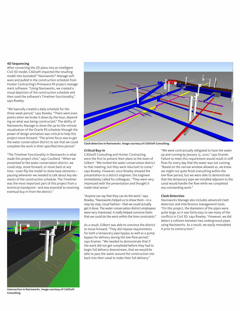
Clash Detection Navisworks Manage also includes advanced clash detection and interference management tools. “On this project, the diameters of the pipes were quite large, so it was fairly easy to see many of the conflicts in Civil 3D, says Rowley. “However, we did detect a collision between two underground pipes using Navisworks. As a result, we easily remodeled it prior to construction.”
4D Sequencing After converting the 2D plans into an intelligent Civil 3D model, CADsoft imported the resulting model into Autodesk® Navisworks® Manage soft-ware and pulled in the construction schedule from Hunter Contracting’s Primavera P6 project manage-ment software. “Using Navisworks, we created a visual depiction of the construction schedule and then used the software’s Timeliner functionality,” says Rowley.
“We basically created a daily schedule for the three-week period,” says Rowley. “There were even points when we broke it down by the hour, depend-ing on what was being constructed.” The ability of Navisworks Manage to show the up-to-the-minute visualization of the Oracle P6 schedule through the power of design animation was critical to help this project move forward. “The prime focus was to get the water conservation district to see that we could complete the work in their specified time period.”
“The Timeliner functionality in Navisworks is what made this project click,” says Couillard. “When we presented to the water conservation district, we could stop, move forward, or move back at any time—even flip the model to show base elements—pausing whenever we needed to talk about key ele-ments of the construction schedule. The Timeliner was the most important part of this project from a technical standpoint—and was essential to receiving eventual buy-in from the district.”
Intersection in Navisworks. Image courtesy of CADSoft Consulting.
Clash detection in Navisworks. Image courtesy of CADSoft Consulting.
The Result At the end of the preconstruction design phase, Hunter delivered a highly compressed model of the project in the NWD file format. Upon completion of this phase, Hunter entered into successful negotia-tions for the construction of the project.
During construction, Hunter showed the Navisworks model to the field teams, who used Autodesk® Navisworks® Freedom software to view the NWD file and the accompanying schedule visual-izations on a projector at the job site. “That really helped them visualize the project clearly, both what was above ground and what lay below,” says Rowley.
On-Time Project Completion Hunter completed Phase 1 construction on the inter-section project between December 27, 2009, and January 15, 2010. Construction on the overall project will be completed in March 2011.
“Our goal was to use Civil 3D and Navisworks to help solve the stakeholder issues of Hunter Contracting and the town of Gilbert,” says Shannon Corgan, marketing manager of CADsoft Consulting. “I think we achieved our goals. We overcame all of the obstacles—including creating a Civil 3D model from multiple sets of 2D plans created by three different civil engineering designers.” Hunter used this model and took full advantage of Autodesk technology to help deliver the project on time and on budget. “Additionally, we were able to build trust with our clients and the other project stakeholders by giving them a clear visualization of the construc-tion schedule.”
“The water conservation district is extremely pleased,” says Kramer. “They were very impressed with how well things went and with the work that Hunter and CADsoft Consulting completed for us.”
“In Gilbert, we’re all very happy with the success of this project,” says Kramer. “The overall project is still underway, but we’re very pleased with how well coordination with the water conservation district went and how we were able to avoid any conflicts. We were also very impressed with the value that BIM brought to the project.”
A Powerful Marketing Tool The team’s success on this project will serve as an effective marketing opportunity. “We got the go-ahead, followed the plan, and completed the project ahead of schedule,” says Rowley. “We believe that we will be able to use our success on this project as a marketing tool to go after other jobs and, when we get them, make them run more smoothly.”
For more information, please visit www.autodesk.com/civil3d and www.autodesk.com/navisworks.
Autodesk, AutoCAD, Civil 3D, and Navisworks are registered trademarks or trademarks of Autodesk, Inc., and/or its subsidiaries and/or affiliates in the USA and/or other countries. All other brand names, product names, or trademarks belong to their respective holders. Autodesk reserves the right to alter product and services offerings, and specifications and pricing at any time without notice, and is not responsible for typographical or graphical errors that may appear in this document.
© 2011 Autodesk, Inc. All rights reserved.
In Gilbert, we’re all very happy with the success of this project. The overall project is still underway, but we’re very pleased with how well coordination with the water conservation district went and how we were able to avoid any conflicts. We were also very impressed with the value that BIM brought to the project.—Jeff Kramer Senior Program Manager Town of Gilbert
Image courtesy of [Company name].
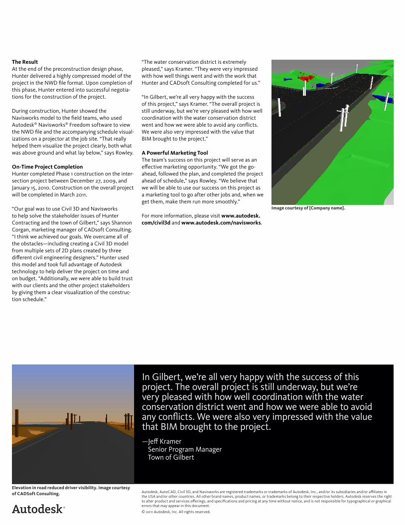
Elevation in road reduced driver visibility. Image courtesy of CADSoft Consulting.