Water Works: A future destination park on the Mississippi River's only true waterfall

OpenStax-CNX module: m47831 1
Human Impact on Fresh Water
Sources*
Miranda Dudzik
Based on Water Cycle and Fresh Water Supply� by
Steve Altaner
This work is produced by OpenStax-CNX and licensed under the
Creative Commons Attribution License 3.0�
Abstract
By the end of this section, you will be able to:
• understand the principles controlling groundwater resources and how they also can a�ect surface
water resources
• know the causes and e�ects of depletion in di�erent water reservoirs
• understand how we can work toward solving the water supply crisis
1 Primary Fresh Water Resources: Precipitation
Precipitation is a major control of fresh water availability, and it is unevenly distributed around the globe(see Figure 1). More precipitation falls near the equator, and landmasses there are characterized by a tropicalrainforest climate. Less precipitation tends to fall near 20�30 ◦ north and south latitude, where the world'slargest deserts are located. These rainfall and climate patterns are related to global wind circulation cells.The intense sunlight at the equator heats air, causing it to rise and cool, which decreases the ability of theair mass to hold water vapor and results in frequent rainstorms. Around 30 ◦ north and south latitude,descending air conditions produce warmer air, which increases its ability to hold water vapor and resultsin dry conditions. Both the dry air conditions and the warm temperatures of these latitude belts favorevaporation. Global precipitation and climate patterns are also a�ected by the size of continents, majorocean currents, and mountains.
*Version 1.1: Oct 23, 2013 12:40 am -0500�http://cnx.org/content/m41397/1.5/�http://creativecommons.org/licenses/by/3.0/
http://cnx.org/content/m47831/1.1/

OpenStax-CNX module: m47831 2
Figure 1: World Rainfall Map The false-color map above shows the amount of rain that falls around
the world. Areas of high rainfall include Central and South America, western Africa, and Southeast
Asia. Since these areas receive so much rainfall, they are where most of the world's rainforests grow.
Areas with very little rainfall usually turn into deserts. The desert areas include North Africa, the Middle
East, western North America, and Central Asia. Source: United States Geological Survey1 Earth Forum,Houston Museum Natural Science
2 Surface Water Resources: Rivers, Lakes, Glaciers
Flowing water from rain and melted snow on land enters river channels by surface runo� (see Figure 2) andgroundwater seepage (see Figure 3). River discharge describes the volume of water moving through a riverchannel over time (see Figure 4). The relative contributions of surface runo� vs. groundwater seepage toriver discharge depend on precipitation patterns, vegetation, topography, land use, and soil characteristics.Soon after a heavy rainstorm, river discharge increases due to surface runo�. The steady normal �ow of riverwater is mainly from groundwater that discharges into the river. Gravity pulls river water downhill towardthe ocean. Along the way the moving water of a river can erode soil particles and dissolve minerals, creatingthe river's load of moving sediment grains and dissolved ions. Groundwater also contributes a large amountof the dissolved ions in river water. The geographic area drained by a river and its tributaries is called adrainage basin. The Mississippi River drainage basin includes approximately 40% of the U.S., a measurethat includes the smaller drainage basins (also called watersheds), such as the Ohio River and MissouriRiver that help to comprise it. Rivers are an important water resource for irrigation and many cities aroundthe world. Some of the world's rivers that have had international disputes over water supply include the
1http://ga.water.usgs.gov/edu/watercyclesummary.html
http://cnx.org/content/m47831/1.1/

OpenStax-CNX module: m47831 3
Colorado (Mexico, southwest U.S.), Nile (Egypt, Ethiopia, Sudan), Euphrates (Iraq, Syria, Turkey), Ganges(Bangladesh, India), and Jordan (Israel, Jordan, Syria).
Figure 2: Surface Runo� Surface runo�, part of overland �ow in the water cycle Source: James M.Pease2 at Wikimedia Commons
2http://commons.wikimedia.org/wiki/File:Runo�.jpg
http://cnx.org/content/m47831/1.1/

OpenStax-CNX module: m47831 4
Figure 3: Groundwater Seepage Groundwater seepage can be seen in Box Canyon in Idaho, where
approximately 10 cubic meters per second of seepage emanates from its vertical headwall. Source: NASA3
3http://astrobiology.nasa.gov/articles/erosion-on-earth-and-mars-mere-seepage-or-mega�ood/
http://cnx.org/content/m47831/1.1/

OpenStax-CNX module: m47831 5
Figure 4: River Discharge Colorado River, U.S.. Rivers are part of overland �ow in the water cycle
and an important surface water resource. Source: Gonzo fan20074 at Wikimedia Commons
Lakes can also be an excellent source of fresh water for human use. They usually receive water fromsurface runo� and groundwater discharge. They tend to be short-lived on a geological time-scale becausethey are constantly �lling in with sediment supplied by rivers. Lakes form in a variety of ways includingglaciation (Great Lakes, North America, See Figure 5), recent tectonic uplift (Lake Tanganyika, Africa),and volcanic eruptions (Crater Lake, Oregon). People also create arti�cial lakes (reservoirs) by dammingrivers. Large changes in climate can result in major changes in a lake's size. As Earth was coming out ofthe last Ice Age about �fteen thousand years ago, the climate in the western U.S. changed from cool andmoist to warm and arid, which caused more than100 large lakes to disappear. The Great Salt Lake in Utahis a remnant of a much larger lake called Lake Bonneville.
4http://commons.wikimedia.org/wiki/File:Overlook_over_the_Colorado.JPG
http://cnx.org/content/m47831/1.1/

OpenStax-CNX module: m47831 6
Figure 5: Great Lakes from Space The Great Lakes hold 21% of the world's surface fresh water.
Lakes are an important surface water resource. Source: SeaWiFS Project, NASA/Goddard Space FlightCenter, and ORBIMAGE5
Although glaciers represent the largest reservoir of fresh water, they generally are not used as a watersource because they are located too far from most people (see Figure 6). Melting glaciers do provide anatural source of river water and groundwater. During the last Ice Age there was as much as 50% morewater in glaciers than there is today, which caused sea level to be about 100 m lower. Over the past century,sea level has been rising in part due to melting glaciers. If Earth's climate continues to warm, the meltingglaciers will cause an additional rise in sea level.
5http://commons.wikimedia.org/wiki/File:Great_Lakes_from_space.jpg
http://cnx.org/content/m47831/1.1/

OpenStax-CNX module: m47831 7
Figure 6: Mountain Glacier in Argentina Glaciers are the largest reservoir of fresh water but they
are not used much as a water resource directly by society because of their distance from most people.
Source: Luca Galuzzi - www.galuzzi.it6
3 Groundwater Resources
Although most people in the U.S. and the world use surface water, groundwater is a much larger reservoir ofusable fresh water, containing more than 30 times more water than rivers and lakes combined. Groundwateris a particularly important resource in arid climates, where surface water may be scarce. In addition,groundwater is the primary water source for rural homeowners, providing 98% of that water demand inthe U.S.. Groundwater is water located in small spaces, called pore space, between mineral grains andfractures in subsurface earth materials (rock or sediment, i.e., loose grains). Groundwater is not located inunderground rivers or lakes except where there are caves, which are relatively rare. Between the land surfaceand the depth where there is groundwater is the unsaturated zone, where pore spaces contain only air andwater �lms on mineral grains (see Figure 7).7 Below the unsaturated zone is the saturated zone, wheregroundwater completely �lls pore spaces in earth materials. The interface between the unsaturated zone andsaturated zone is the water table. Most groundwater originates from rain or snowmelt, which in�ltrates
6http://en.wikipedia.org/wiki/File:Perito_Moreno_Glacier_Patagonia_Argentina_Luca_Galuzzi_2005.JPG7Groundwater is the name for water in the saturated zone and soil moisture describes water in the unsaturated zone.
Therefore, groundwater is the underground water resource used by society but soil moisture is the principal water supply formost plants and is an important factor in agricultural productivity.
http://cnx.org/content/m47831/1.1/

OpenStax-CNX module: m47831 8
the ground and moves downward until it reaches the saturated zone. Other sources of groundwater includeseepage from surface water (lakes, rivers, reservoirs, and swamps), surface water deliberately pumped intothe ground, irrigation, and underground wastewater treatment systems, i.e., septic tanks. Recharge areasare locations where surface water in�ltrates the ground rather than running o� into rivers or evaporating.Wetlands and �at vegetated areas in general are excellent recharge areas.
Figure 7: Subsurface Water Terminology Groundwater in pore spaces and fractures of earth ma-
terials, saturated zone, unsaturated zone, and water table, which follows land surface but in a more
subdued way. Source: United States Geological Survey8
Groundwater is in constant motion due to interconnection between pore spaces. Porosity is the percent-age of pore space in an earth material and it gives a measure of how much groundwater an earth materialcan hold. Permeability is a measure of the speed that groundwater can �ow through an earth material,and it depends on the size and degree of interconnection among pores. An earth material that is capableof supplying groundwater from a well at a useful rate�i.e., it has relatively high permeability and mediumto high porosity�is called an aquifer. Examples of aquifers are earth materials with abundant, large,well-connected pore spaces such as sand, gravel, uncemented sandstone, and any highly fractured rock.
Most shallow water wells are drilled into uncon�ned aquifers. These are called water table wellsbecause the water level in the well coincides with the water table . 90% of all aquifers for water supply areuncon�ned aquifers composed of sand or gravel. To produce water from a well, you simply need to drill ahole that reaches the saturated zone and then pump water to the surface. Attempting to pump water fromthe unsaturated zone is like drinking root beer with a straw immersed only in the foam at the top.
8http://ga.water.usgs.gov/edu/gwhowto�nd.html
http://cnx.org/content/m47831/1.1/
OpenStax-CNX module: m47831 9
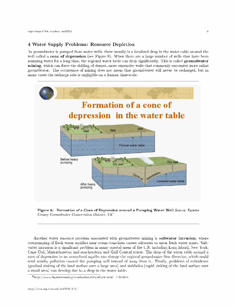
4 Water Supply Problems: Resource Depletion
As groundwater is pumped from water wells, there usually is a localized drop in the water table around thewell called a cone of depression (see Figure 8). When there are a large number of wells that have beenpumping water for a long time, the regional water table can drop signi�cantly. This is called groundwatermining, which can force the drilling of deeper, more expensive wells that commonly encounter more salinegroundwater. The occurrence of mining does not mean that groundwater will never be recharged, but inmany cases the recharge rate is negligible on a human time-scale.
Figure 8: Formation of a Cone of Depression around a Pumping Water Well Source: FayetteCounty Groundwater Conservation District, TX9
Another water resource problem associated with groundwater mining is saltwater intrusion, whereoverpumping of fresh water aquifers near ocean coastlines causes saltwater to enter fresh water zones. Salt-water intrusion is a signi�cant problem in many coastal areas of the U.S. including Long Island, New York;Cape Cod, Massachusetts; and southeastern and Gulf Coastal states. The drop of the water table around acone of depression in an uncon�ned aquifer can change the regional groundwater �ow direction, which couldsend nearby pollution toward the pumping well instead of away from it. Finally, problems of subsidence(gradual sinking of the land surface over a large area) and sinkholes (rapid sinking of the land surface overa small area) can develop due to a drop in the water table.
9http://www.fayettecountygroundwater.com/educational_info.htm
http://cnx.org/content/m47831/1.1/

OpenStax-CNX module: m47831 10
5 The Water Supply Crisis
The water crisis refers to a global situation where people in many areas lack access to su�cient water orclean water or both. This section describes the global situation involving water shortages, also called waterstress. The next section covers the water crisis involving water pollution. Figure 9 shows areas of the worldexperiencing water stress as de�ned by a high percentage of water withdrawal compared to total availablewater. Due to population growth the 2025 projection for global water stress is signi�cantly worse than waterstress levels in 1995. In general, water stress is greatest in areas with very low precipitation (major deserts)or large population density (e.g., India) or both. Future global warming could worsen the water crisis byshifting precipitation patterns away from humid areas and by melting mountain glaciers that recharge riversdownstream. Melting glaciers will also contribute to rising sea level, which will worsen saltwater intrusionin aquifers near ocean coastlines. Compounding the water crisis is the issue of social injustice; poor peoplegenerally get less access to clean water and commonly pay more for water than wealthy people.
Figure 9: Countries Facing Water Stress in 1995 and Projected in 2025Water stress is de�ned
as having a high percentage of water withdrawal compared to total available water in the area. Source:Philippe Rekacewicz10 (Le Monde diplomatique), February 2006
6 Sustainable Solutions to the Water Supply Crisis?
The current and future water crisis described above requires multiple approaches to extending our freshwater supply and moving towards sustainability. Some of the longstanding traditional approaches includedams and aqueducts. Reservoirs that form behind dams in rivers can collect water during wet times andstore it for use during dry spells (see Figure 10). They also can be used for urban water supplies. New YorkCity has a large number of reservoirs and controlled lakes up to 200 km away to meet the water demands ofits large population. Other bene�ts of dams and reservoirs are hydroelectricity, �ood control, and recreation.Some of the drawbacks are evaporative loss of reservoir water in arid climates, downstream river channelerosion, and impact on the ecosystem including a change from a river to lake habitat and interference with�sh migration and spawning. Aqueducts can move water from where it is plentiful to where it is needed (see
10http://maps.grida.no/go/graphic/increased-global-water-stress
http://cnx.org/content/m47831/1.1/

OpenStax-CNX module: m47831 11
Figure 11). Southern California has a large and controversial network of aqueducts that brings in water fromthe Sierra Nevada Mountains in the north, the valleys in northern and central California, and the ColoradoRiver to the east (see Figure 12). Aqueducts can be controversial and politically di�cult especially if thewater transfer distances are large. One drawback is the water diversion can cause drought in the area fromwhere the water is drawn.
http://cnx.org/content/m47831/1.1/

OpenStax-CNX module: m47831 12
Figure 10: Hoover Dam, Nevada, U.S. Hoover Dam, Nevada, U.S.. Behind the dam is Lake Mead,
the largest reservoir in U.S.. White band re�ects the lowered water levels in the reservoir due to drought
conditions from 2000 - 2010. Source: Cygnusloop9911 at Wikimedia Commons
http://cnx.org/content/m47831/1.1/

OpenStax-CNX module: m47831 13
Figure 11: The California Aqueduct California Aqueduct in southern California, U.S. Source: DavidJordan12 at en.wikipedia
11http://commons.wikimedia.org/wiki/File:Hoover_Dam_-_2010-12-10_-_View_from_bridge.jpg12http://en.wikipedia.org/wiki/File:Tupman_California_California_Aqueduct_Mile_236.JPG
http://cnx.org/content/m47831/1.1/

OpenStax-CNX module: m47831 14
Figure 12: Map of California Aqueducts Map of California aqueducts that bring water to southern
California from central and northern California and from the Colorado River to the east. Source: CentralBasin Municipal Water District13
One method that actually can increase the amount of fresh water on Earth is desalination, whichinvolves removing dissolved salt from seawater or saline groundwater. There are several ways to desalinateseawater including boiling, �ltration, electrodialysis, and freezing. All of these procedures are moderatelyto very expensive and require considerable energy input, making the produced water much more expensivethan fresh water from conventional sources. In addition, the processes create highly saline wastewater, which
13http://www.centralbasin.org/waterSupplySystem.html
http://cnx.org/content/m47831/1.1/

OpenStax-CNX module: m47831 15
must be disposed of. Desalination is most common in the Middle East, where energy from oil is abundantbut water is scarce.
Conservation means using less water and using it more e�ciently. Around the home, conservation caninvolve both engineered features, such as high-e�ciency clothes washers and low-�ow showers and toilets, aswell as behavioral decisions, such as growing native vegetation that require little irrigation in desert climates,turning o� the water while you brush your teeth, and �xing leaky faucets. Rainwater harvesting involvescatching and storing rainwater for reuse before it reaches the ground. Collecting rainwater is generally highlyregulated, because the rain that is being collected is rain that is being taken away from the the naturalecosystem it would naturally fall in. E�cient irrigation is extremely important because irrigation accountsfor a much larger water demand than public water supply. Water conservation strategies in agricultureinclude growing crops in areas where the natural rainfall can support them, more e�cient irrigation systemssuch as drip systems that minimize losses due to evaporation, no-till farming that reduces evaporative lossesby covering the soil, and reusing treated wastewater from sewage treatment plants. Recycled wastewaterhas also been used to recharge aquifers. There are a great many other speci�c water conservation strategies.Sustainable solutions to the water crisis must use a variety of approaches but they should have waterconservation as a high priority.
http://cnx.org/content/m47831/1.1/

OpenStax-CNX module: m47831 16
:
Head to this website14 to learn more about the world's fresh water supply.
7 Review Questions
7.1 Free Response
Exercise 1 (Solution on p. 18.)
What is the water cycle and why is it important to fresh water resources?
Exercise 2 (Solution on p. 18.)
What are the relative merits of using surface water vs. groundwater as a water resource?
Exercise 3 (Solution on p. 18.)
Why are drinking water supplies still a major concern for many countries?
14http://openstaxcollege.org/l/freshwater
http://cnx.org/content/m47831/1.1/

OpenStax-CNX module: m47831 17
Exercise 4 (Solution on p. 18.)
Why is society facing a crisis involving water supply and how can we solve it?
8 References
Watkins, K. (2006). Beyond scarcity: Power, poverty and the global water crisis. Human Development Re-
port 2006, United Nations Development Programme. Retrieved from http://hdr.undp.org/en/reports/global/hdr2006/15
15http://hdr.undp.org/en/reports/global/hdr2006/
http://cnx.org/content/m47831/1.1/

OpenStax-CNX module: m47831 18
Solutions to Exercises in this Module
to Exercise (p. 16)Water cycling is the process of water moving through an ecosystem. It involves processes such as transpira-tion, evaporation and precipitation. Fresh water resources are an important part of the water cycle becauseit is fresh water that sustains life on this planet. With such a limited amount relative to the overall waterfound on earth, it is imperative that humanity preserve as much as possible.to Exercise (p. 16)Surface waters easy to access and utilize, but are often inaccessible due to seasonal in�uences or location(i.e. glaciers)Groundwater is more constantly available and there is a lot more of it than surface water, butcan have a drastic impact on the water cycle if over-utilized.to Exercise (p. 16)Most of the water on Earth is salt water, which humans cannot drink unless the salt is removed. Some freshwater is locked in glaciers and polar ice caps, or is present in the atmosphere. The Earth's water suppliesare threatened by pollution and exhaustion. The e�ort to supply fresh drinking water to the planet's ever-expanding human population is seen as a major challenge in this century.to Exercise (p. 17)Desalination, collecting rainwater, and responsible agriculture practices are all ways to lower the impact onfresh water consumption, but each comes with it's own inherent problems. Water conservation, or practicesthat limit and reduce the overall amount of water we consume may be the best approach to solving the watercrisis.
Glossary
De�nition 12: aqueductAn aqueduct is a water supply or navigable channel constructed to convey water. In modernengineering, the term is used for any system of pipes, ditches, canals, tunnels, and other structuresused for this purpose.
De�nition 12: aquiferRock or sediment that is capable of supplying groundwater from a well at a useful rate.
De�nition 12: aquitardEarth material with low hydraulic conductivity.
De�nition 12: artesian wellWater well drilled into a con�ned aquifer where the water level in the well moves above the localwater table.
De�nition 12: condensationChange in the physical state of water where it goes from gas to liquid.
De�nition 12: cone of depressionA localized drop in the water table around a pumping well.
De�nition 12: con�ned aquiferAn aquifer that is bounded by aquitards below and above.
De�nition 12: consumptive water useA societal use of water that is a type of o�stream use where water does not return to the river orgroundwater system immediately after use.
De�nition 12: damA barrier built across a river to obstruct the �ow of water.
De�nition 12: desalinationRemoving dissolved salt from seawater or saline groundwater.
http://cnx.org/content/m47831/1.1/

OpenStax-CNX module: m47831 19
De�nition 12: discharge areaLocation on Earth where groundwater leaves the groundwater �ow system.
De�nition 12: drainage basinGeographic area drained by a river and its tributaries.
De�nition 12: evaporationWhere water changes from liquid to gas at ambient temperatures.
De�nition 12: groundwaterWater located in small spaces between mineral grains and fractures in subsurface rock or sediment.
De�nition 12: groundwater miningA depletion in groundwater resources caused by a large number of water wells that pumped waterfor a long time.
De�nition 12: instream water useA societal use of water that does not remove it from its source.
De�nition 12: o�stream water useA societal use of water that removes it from its source.
De�nition 12: permeabilityMeasure of the speed that groundwater can �ow through rock or sediment.
De�nition 12: pore spaceSmall spaces between mineral grains in subsurface rock or sediment.
De�nition 12: porosityPercentage of pore space in rock or sediment.
De�nition 12: rainwater harvestingCatching and storing rainwater for reuse before it reaches the ground.
De�nition 12: recharge areaLocation on Earth where surface water in�ltrates into the ground rather than runs o� into riversor evaporates.
De�nition 12: reservoirLarge arti�cial lake used as a source of water.
De�nition 12: river dischargeVolume of water moving through a river channel over time.
De�nition 12: saltwater intrusionSaltwater that enters an aquifer due to overpumping of freshwater aquifers near ocean coastlines.
De�nition 12: saturated zoneSubsurface area where groundwater completely �lls pore spaces in rock or sediment.
De�nition 12: soil moistureWater in the unsaturated zone.
De�nition 12: springRiver that emerges from underground due to an abrupt intersection of the water table with theland surface.
De�nition 12: surface runo�Unchannelized overland �ow of water.
De�nition 12: transpirationLoss of water by plants to the atmosphere.
De�nition 12: uncon�ned aquiferAquifer with no aquitard above it.
http://cnx.org/content/m47831/1.1/

OpenStax-CNX module: m47831 20
De�nition 12: unsaturated zoneSubsurface area where pore spaces contain only air and water �lms on mineral grains.
De�nition 12: water conservationUsing less water and using it more e�ciently
De�nition 12: water crisisA global situation where people in many areas lack access to su�cient water or clean water or both.
De�nition 12: water cycleThe continuous movement of water through water reservoirs located on, above, and below Earth'ssurface.
De�nition 12: water reservoir (in water cycle)General location on Earth where water is located including oceans, atmosphere, glaciers, ground-water, lakes, rivers, and biosphere.
De�nition 12: water tableInterface between the unsaturated zone and saturated zone.
De�nition 12: water table wellWater well drilled into an uncon�ned aquifer where the water level in the well coincides with thewater table.
http://cnx.org/content/m47831/1.1/