HTL, LTL AND COASTAL REGULATION ZONE FOR THE …
18
NATIONAL CENTRE FOR EARTH SCIENCE STUDIES Ministry of Earth Sciences, Government of India Thiruvananthapuram - 695 011, Kerala APRIL 2016 HTL, LTL AND COASTAL REGULATION ZONE FOR THE PROPOSED CONSTRUCTION OF JETTY FOR THE INDIAN COAST GUARD AT COCHIN PORT, ERNAKULAM (As per CRZ Notification 2011) Prepared for M/s. COCHIN PORT TRUST, GOVT. OF INDIA
Transcript of HTL, LTL AND COASTAL REGULATION ZONE FOR THE …

NATIONAL CENTRE FOR EARTH SCIENCE STUDIES Ministry of Earth Sciences, Government of India
Thiruvananthapuram - 695 011, Kerala
APRIL 2016
HTL, LTL AND COASTAL REGULATION ZONE FOR THE
PROPOSED CONSTRUCTION OF JETTY FOR THE INDIAN
COAST GUARD AT COCHIN PORT, ERNAKULAM
(As per CRZ Notification 2011)
Prepared for
M/s. COCHIN PORT TRUST, GOVT. OF INDIA
HTL, LTL AND COASTAL REGULATION ZONE FOR THE
PROPOSED CONSTRUCTION OF JETTY FOR THE INDIAN
COAST GUARD AT COCHIN PORT, ERNAKULAM
(As per CRZ Notification 2011)
Prepared for
M/s. COCHIN PORT TRUST, GOVT. OF INDIA
NATIONAL CENTRE FOR EARTH SCIENCE STUDIES
Ministry of Earth Sciences, Government of India Thiruvananthapuram - 695011
April 2016
NATIONAL CENTRE FOR EARTH SCIENCE STUDIES, THIRUVANANTHAPURAM
DOCUMENTATION PAGE
1. REPORT NUMBER NCESS-CRZ-06-2016
2. TYPE OF REPORT CRZ STATUS REPORT
3. TITLE HTL, LTL AND COASTAL REGULATION ZONE FOR THE
PROPOSED CONSTRUCTION OF JETTY FOR INDIAN COAST
GUARD AT COCHIN PORT, ERNAKULAM
4. INVESTIGATOR
VETTING COMMITTEE
MONITORING COMMITTEE
PROJECT STAFF
Dr. K.K.RAMACHANDRAN
D.RAJU, M. RAMESH KUMAR, S.MOHANAN
Dr. T.N.PRAKASH, Dr. K.K.RAMACHANDRAN,
Dr. D.S.SURESH BABU
Dr. M. RAMESHAN, T.J. ARUN
5. KEY WORDS Coastal Regulation Zone (CRZ), CRZ Notification (1991 and 2011),
Cadastral map, Embankments, land use, High Tide Line (HTL), Low
Tide Line (LTL), CRZ IA, CRZ IB, CRZ II, CRZ IVA, CRZ IVB and
Coastal Zone Management Plan (CZMP).
6. ABSTRACT 9r M/s. Cochin Port, Govt. of India requested to provide CRZ Status
Report and maps to facilitate CRZ clearance for the proposed
construction of jetty for the Indian Coast Guard in Survey No. 560 of
Kochi Corporation at Cochin Port. The CRZ map is prepared in 1:4000
scale cadastral base maps with survey plot information. The proposed
site is under CRZ and covered in Map No. 34 of the Coastal Zone
Management Plan (CZMP, 1995) of Kerala. Since the project site is
along the banks of tidal influenced waterbody, the CRZ is 100m
landward of HTL along Vembanad estuary and the width of the canal
along the Eraveli canal, which is on the immediate north of the
proposed site. Ecologically sensitive mangrove ecosystems to be
categorized as CRZ IA are absent in the immediate vicinity of the
project sites. The inter-tidal zones between HTL and LTL are CRZ IB.
The tidal influenced waterbody and its bed are CRZ IVB. Since the
locality of the project site belongs to developed areas of Kochi
Corporation, the CRZ landward of the High Tide Line is CRZ II as per
the approved CZMP of 1996. Layout of the proposed site for the
construction (as provided by the project proponent) is superimposed in
the CRZ Map. As per CRZ Notification (2011) Para 4, Sub-para i(f)
‘construction and operation for ports and harbours, jetties, wharves,
quays, slipways, ship construction yards, breakwaters, groynes, erosion
control measures are permissible activities’. Further, such activities
proposed shall require clearance from MoEF as per Para 4, Sub-para
ii (b).
7. DISTRIBUTION
STATEMENT NOT FOR CIRCULATION
8. PROJECT PROPONENT M/s. COCHIN PORT TRUST, GOVT. OF INDIA

CONTENTS
Page No.
1.0 Introduction 1
2.0 Objective 1
3.0 Location 1
4.0 Coastal Regulation Zone (CRZ) 2
5.0 CRZ for the State of Kerala 3
6.0 Approach 5
6.1. Data source 6
6.2. Influence of tidal action 6
7.0 Identification of HTL and CRZ 7
7.1. Field investigations 7
7.2. Landuse 7
8.0 Coastal Regulation Zone for the project site 8
8.1. High Tide Line and Low Tide Line 8
8.2. CRZ categories 8
9.0 Summary and Recommendation 9
References 10
LIST OF TABLES AND FIGURES
Table 1. Tide data with respect to Chart Datum pertaining to Kochi
Figure 1. Location map
Figure 2. CRZ map
Figure 3. CRZ categories 7km around the proposed project site
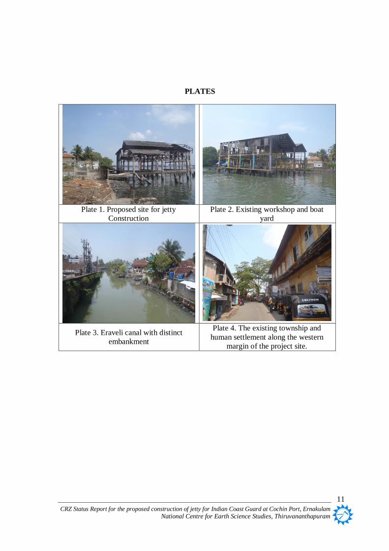
PLATES
Plate 1. Proposed site for jetty Construction
Plate 2. Existing workshop and boat yard
Plate 3. Eraveli canal with distinct embankment
Plate 4. The existing township and human settlements immediate west of the project site.
CRZ Status Report for the proposed construction of jetty for Indian Coast Guard at Cochin Port, Ernakulam
National Centre for Earth Science Studies, Thiruvananthapuram
1
HTL, LTL AND COASTAL REGULATION ZONE FOR THE PROPOSED
CONSTRUCTION OF JETTY FOR THE INDIAN COAST GUARD
AT COCHIN PORT, ERNAKULAM
1.0 Introduction
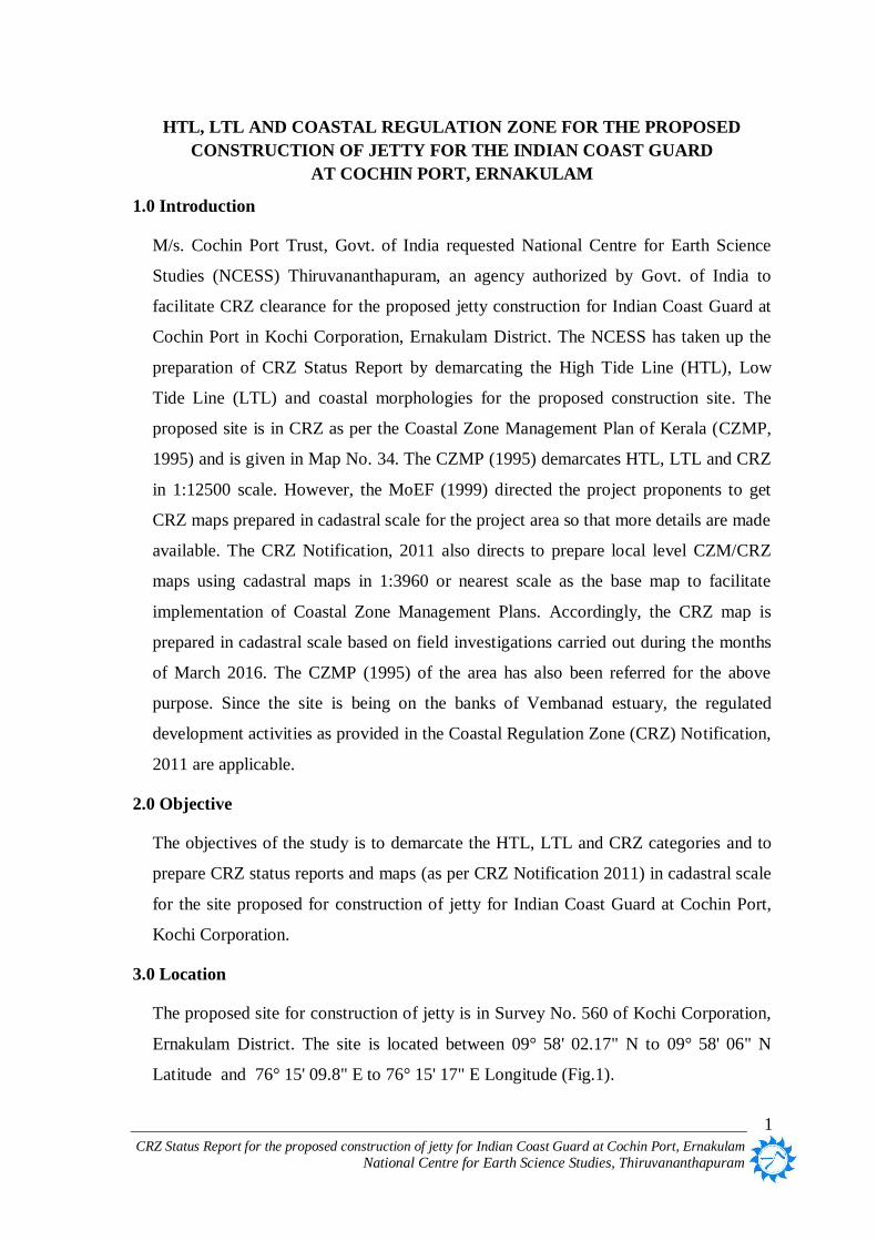
M/s. Cochin Port Trust, Govt. of India requested National Centre for Earth Science
Studies (NCESS) Thiruvananthapuram, an agency authorized by Govt. of India to
facilitate CRZ clearance for the proposed jetty construction for Indian Coast Guard at
Cochin Port in Kochi Corporation, Ernakulam District. The NCESS has taken up the
preparation of CRZ Status Report by demarcating the High Tide Line (HTL), Low
Tide Line (LTL) and coastal morphologies for the proposed construction site. The
proposed site is in CRZ as per the Coastal Zone Management Plan of Kerala (CZMP,
1995) and is given in Map No. 34. The CZMP (1995) demarcates HTL, LTL and CRZ
in 1:12500 scale. However, the MoEF (1999) directed the project proponents to get
CRZ maps prepared in cadastral scale for the project area so that more details are made
available. The CRZ Notification, 2011 also directs to prepare local level CZM/CRZ
maps using cadastral maps in 1:3960 or nearest scale as the base map to facilitate
implementation of Coastal Zone Management Plans. Accordingly, the CRZ map is
prepared in cadastral scale based on field investigations carried out during the months
of March 2016. The CZMP (1995) of the area has also been referred for the above
purpose. Since the site is being on the banks of Vembanad estuary, the regulated
development activities as provided in the Coastal Regulation Zone (CRZ) Notification,
2011 are applicable.
2.0 Objective
The objectives of the study is to demarcate the HTL, LTL and CRZ categories and to
prepare CRZ status reports and maps (as per CRZ Notification 2011) in cadastral scale
for the site proposed for construction of jetty for Indian Coast Guard at Cochin Port,
Kochi Corporation.
3.0 Location
The proposed site for construction of jetty is in Survey No. 560 of Kochi Corporation,
Ernakulam District. The site is located between 09° 58' 02.17" N to 09° 58' 06" N
Latitude and 76° 15' 09.8" E to 76° 15' 17" E Longitude (Fig.1).

CRZ Status Report for the proposed construction of jetty for Indian Coast Guard at Cochin Port, Ernakulam
National Centre for Earth Science Studies, Thiruvananthapuram
2
4.0 Coastal Regulation Zone (CRZ)
All developmental activities in the CRZ are regulated through the CRZ Notification
(MoEF, 2011). The Government of India Notification [S.O.19 (E) dated 6.1.2011]
under Section 3(1) and Section 3(2)(v) of the Environment (Protection) Act, 1986 and
Rule 5(3)(d) of Environment (Protection) Rules, 1986 has redefined the CRZ.
Accordingly the CRZ has been declared as ‘the coastal stretches of the country and the
water area up to its territorial water limit’ (MoEF, 2011). The CRZ consists of:
1. Land area from the High Tide Line (HTL) to 500 m on the landward side along the
sea front.
2. Land area between the HTL to 100 m or width of the creek whichever is less on the
landward side along the tidal influenced water bodies that are connected to the sea
and the distance up to which development along such tidal influenced water bodies
is to be regulated shall be governed by the distance up to which tidal effects are
experienced which is determined based on salinity concentration of 5 parts per
thousand (ppt) measured during the driest period of the year and distance up to
which tidal effects are experienced should be clearly identified and demarcated
accordingly in the Coastal Zone Management Plans (CZMPs). Tidal influenced
water bodies mean the water bodies influenced by tidal effects from sea, in the
bays, estuaries, rivers, creeks, backwaters, lagoons, ponds connected to the sea or
creeks and the like.
3. Land area falling between the hazard line and 500 m from HTL on the landward
side, in case of seafront and between the hazard line and 100 m line in case of tidal
influenced water body. The word ‘hazard line’ denotes the line demarcated by
Ministry of Environment and Forests (MoEF) through the Survey of India (SoI)
taking into account tides, waves, sea level rise and shoreline changes.
4. Land area between HTL and Low Tide Line (LTL), which will be termed as the
inter-tidal zone.
5. Water and the bed area between the LTL to the territorial water limit (12 nm) in
case of sea and the water and the bed area between LTL at the bank to the LTL on
the opposite side of the bank, of tidal influenced water bodies.
The CRZ Notification (MoEF 2011) categorizes Coastal Regulation Zones as CRZ I,

CRZ Status Report for the proposed construction of jetty for Indian Coast Guard at Cochin Port, Ernakulam
National Centre for Earth Science Studies, Thiruvananthapuram
3
CRZ II, CRZ III and CRZ IV based on whether the area is ecologically sensitive,
developed, undeveloped or waterbody and its bed. Ecologically sensitive and
important areas are CRZ IA and the intertidal zone is CRZ IB. Major CRZ IA
categories include the mangroves, corals, coral reef and its associated biodiversity,
sand dunes, Protected Areas and National Parks, biologically active mudflats, salt
marshes, turtle nesting grounds, horse shoe crab habitat, seagrass bed, nesting ground
of birds, areas of archaeological importance and heritage sites. The areas that have
already been developed up to or close to the shoreline and where the built up area is
more than 50% are categorized as CRZ II. Rural/undeveloped areas that are relatively
undisturbed belong to CRZ III. The water area and the bed constitute CRZ IV.
In view of the unique coastal systems of backwater and backwater islands along with
space limitation present in the coastal stretches of the state of Kerala, the CRZ (on the
landward side) in the islands within the backwaters have been defined as 50 m from
the High Tide Line on the landward side (MoEF 2011). The CRZ Notification of 2011
has also defined Critical Vulnerable Coastal Areas (CVCA), which includes
Sunderbans, and other identified ecological sensitive areas in which ‘Vembanad in
Kerala’ is also included.
The Ministry of Environment & Forests, Govt. of India has issued the new CRZ
Notification in January 2011 (CRZ 2011) in supersession of CRZ 1991 except as
respects things done or omitted to be done before such supersession.
5.0 CRZ for the State of Kerala
Coastal Zone Management Plan (CZMP) of Kerala was approved by Ministry of
Environment and Forests in the year 1996. The CZMP has areas covered under CRZ-I,
CRZ-II and CRZ-III. The then CRZ IV (Andamans and Lakshadweep and small
islands) was absent in Kerala. CRZ notification, 2011 was issued in January 2011 in
supersession of CRZ notification, 1991 (except as respects things done or omitted to be
done before such supersession).
The CRZ Notification 2011 categorizes areas that are ecologically sensitive identified
based on the geomorphological features (which play a role in the maintaining the
integrity of the coast) such as mangroves, corals, coral reef, its associated biodiversity,
sand dunes, Protected Areas, National Parks, mudflats which are biologically active,

CRZ Status Report for the proposed construction of jetty for Indian Coast Guard at Cochin Port, Ernakulam
National Centre for Earth Science Studies, Thiruvananthapuram
4
salt marshes, turtle nesting grounds, horseshoe crab habitat, seagrass bed, nesting
grounds of birds, areas of archaeological importance and heritage sites as CRZ IA.
Among these, mudflats, salt marshes, turtle nesting grounds, horseshoe crab habitat,
seagrass bed and nesting ground of birds are newly introduced under CRZ IA as per
CRZ Notification 2011. The intertidal zone is now CRZ IB (It was CRZ I (ii) as per
CRZ 1991). The CRZ, except those categorized as CRZ I, within in the Municipal
Corporations and Municipal Councils (Notified urban local bodies) which are
‘developed’ are categorized as CRZ II while those in Gramapanchayats, being
undeveloped, have been categorized as CRZ III. The categories CRZ II and III remain
the same in CRZ 2011. CRZ IV is now water and the bed area between the LTL to the
territorial water limit (12 nm) in the case of sea (CRZ IV A) and the water and the bed
area between LTL at the bank to the LTL on the opposite side of the bank, of tidal
influenced water bodies (CRZ IV B).
Though the CRZ Notification 2011 is effective since 6th
January 2011, the Coastal
Zone Management Plan (CZMP, 1995) approved in 1996 remains valid till a new
CZMP is approved based on the guidelines issued under CRZ Notification 2011. The
CRZ III has a No Development Zone (NDZ), which extends upto 200 m landward of
the HTL by the sea. CRZ 2011 declares the land area from High Tide Line (HTL) to
500mts on the landward side along the sea front and the land area between HTL to 100
mts or width of the creek whichever is less on the landward side along the tidal
influenced water bodies as under CRZ. When ‘Hazard line’, as defined in CRZ 2011,
is provided by MoEF, the landward extent of CRZ could change according to the
position of hazard line.
In view of the unique coastal systems of backwater and backwater islands in the
coastal stretches of the State of Kerala where in traditional community find itself in
difficulty for construction of dwelling units, the CRZ Notification 2011 declares that
all the islands in the backwaters shall have 50mts width from the High Tide Line on
the landward side as the CRZ area. The CRZ Notification of 2011 has also defined
Vembanad as Critical Vulnerable Coastal Areas (CVCA).

CRZ Status Report for the proposed construction of jetty for Indian Coast Guard at Cochin Port, Ernakulam
National Centre for Earth Science Studies, Thiruvananthapuram
5
6.0 Approach
Coastal geomorphology and ecosystems of the proposed area has been studied using
Survey of India toposheets and very high resolution satellite images (World View - 2).
Toposheets and satellite images came handy in capturing diverse coastal ecosystems in
the proposed area as baseline information prior to field investigations. The CZMP
(1996) of the State was referred to ascertain applicability of site-specific coastal
regulation criteria.
Cadastral maps in 1:4000 scale have been used as the base map. Field investigation
was conducted to capture the ground details. Collateral cadastral features-
unambiguous locations identifiable both on the ground and in the cadastral maps, such
as survey plot boundary junctions, survey stones, canal crossing, etc. are used as
ground control points (GCP). Cadastral maps were georeferenced with precision geo-
coordinates measured using GPS at pre-identified GCPs to collate spatial data onto a
GIS platform. Planimetric standards were met to maintain accuracy of measurements.
UTM projection on to WGS 84 datum has been adopted for appropriate GIS
composition.
The HTL and LTL were located with respect to survey plots. The HTL and CRZ
boundaries are re-locatable in the field with respect to survey plots keeping desirable
positional accuracy since mapping is done in the cadastral base.
The following elements form the general approach of the study:
To prepare the CRZ map delineating HTL and LTL in cadastral scale.
To verify the proposed site based on CZMP of the State (CZMP, 1995) and
identify CRZ areas.
To gather information on status of eco-systems (such as mangroves, tidal flats,
etc.) in the proposed development site and its vicinity.
To observe and record physical signatures for identifying HTL and map the
distance to HTL with respect to survey plots.

CRZ Status Report for the proposed construction of jetty for Indian Coast Guard at Cochin Port, Ernakulam
National Centre for Earth Science Studies, Thiruvananthapuram
6
6.1. Data source
Different sets of data were used for compilation of the final map and preparation of the
CRZ report. The principal data sources are listed below:
Survey of India Toposheets
Very high resolution satellite imagery (World View -2)
Timeline google images of the area
Cadastral maps
CZMP maps
6. Field mapping
6.2. Influence of tidal action
The Coastal Zone Regulations are applicable to the seacoasts and banks of water
bodies influenced by tidal action. Therefore tidal range is an important parameter that
decides the extent of CRZ along rivers and backwaters. It also determines the reach of
the ‘highest water line during the spring tide. Kochi coast has micro-tidal environment
with tidal range varying from 0.2m to 0.9m. Tidal range data with respect to Chart
Datum pertaining to Kochi area (Naval Hydrographic Chart No.2004) as provided by
Naval Hydrographic Office, Dehra Dun is given below:
Table 1. Tide data with respect to Chart Datum pertaining to Kochi
Tide at Kochi Height (m)
Mean High Water Spring 1.20
Mean High Water Neap 0.80
Mean Sea Level 0.60
Mean Low Water Neap 0.60
Mean Low Water Spring 0.30
The distance up to which development along bays, estuaries, creeks and backwaters is
regulated under CRZ depends on the landward extent of tidal influence. The distance
up to which tidal influence is experienced is fixed based on salinity concentration of 5
parts per thousand (ppt) as per MoEF 2011.

CRZ Status Report for the proposed construction of jetty for Indian Coast Guard at Cochin Port, Ernakulam
National Centre for Earth Science Studies, Thiruvananthapuram
7
7.0 Identification of HTL and CRZ
Coastal Regulation Zone Notification defines High Tide Line as “the line on the land
upto which the highest waterline reaches during the spring tide”. The sea level thus
formed due to the combined effect of spring tide and wave set up gives the line of
maximum reach of water on the land. The conventional definition of lowest low water
level and the resultant low water line during spring tide has been taken as the Low
Tide Line (LTL).
7.1. Field investigation
The MoEF guidelines (MoEF, 2011) stipulate that the HTL/LTL be identified based on
coastal geomorphologic signatures in the field/satellite imageries/aerial photographs.
Therefore, delineation of the HTL and LTL and identification of Coastal Regulation
Zones for the site were carried out based on geomorphic signatures.
Field investigation was carried out during the month of March 2016. Local level
(cadastral) map of 1:4000 scale pertaining to the project site was used as base map.
The configuration of HTL/LTL was plotted with respect to the survey plots.
DISTOPRO laser meter along with a Brunton compass and Trimble Juno SB GPS
were used for field mapping. An appraisal of existing land use/landform in the project
area was carried out to identify the occurrence of ecologically sensitive and important
areas eligible to be categorized as CRZ IA. The CZMP (1995) of the State and CRZ
Notification, 2011 were referred to in addition to the landuse for demarcating the CRZ
categories.
7.2. Landuse
A detailed appraisal of the ecosystems and existing landuse in the project area was
carried out to help the categorization of the regulation zones pertaining to sensitive and
important coastal ecosystems. Survey of India topographic maps and very high
resolution satellite imageries (World View - 2) of the area were also used for the same
whenever required. Geomorphic features and other signatures such as berm crests,
seawalls, embankments and inter tidal zones have been used to identify the HTL
during field investigation.
The site proposed for the construction of a jetty for the Indian Coast Guard is on the

CRZ Status Report for the proposed construction of jetty for Indian Coast Guard at Cochin Port, Ernakulam
National Centre for Earth Science Studies, Thiruvananthapuram
8
banks of Vembanad estuary. Eraveli canal starts immediate north of the project site.
Adjoining areas of the proposed site has been occupied by human settlements. An old
workshop and boat landing jetty exist in the proposed site.
8.0 Coastal Regulation Zone for the project site
The area proposed for the construction of jetty is along the banks of tidal influenced
Vembanad estuary having a width of more than 100m and the CRZ of the area is 100m
landward of the High Tide Line along the estuary and width of the tidal influenced
waterbody along Eraveli canal. Since the project area is in Kochi Corporation, the
provisions and regulations of CRZ Notification, 2011 are applicable landward of the
existing authorized structures such as buildings and roads, provided that those
structures exists prior to the date of CRZ Notification, 1991 (CRZ Notification, 1991,
2011). The land area between HTL and LTL, the tidal influenced waterbody and its
beds are also included under CRZ. There are no critical and vulnerable ecosystems in
the immediate vicinity of the project site to be categorized as CRZ IA.
8.1. High Tide Line and Low Tide Line
The distinct line of embankments and the geomorphic signatures depicting highest
high tide level is considered as the High Tide Line along the estuary and tidal
influenced waterbody. The Low Tide Line is the lowest low water level resulting from
the low water line during the lowest spring tide. In some part of the river, the water
level during different tide conditions are confined to the vertical plane of the
embankments and therefore the LTL and HTL remain the same in a spatial frame.
8.2. CRZ Categories
The proposed jetty construction is in the developed areas of Kochi Corporation, the
CRZ landward of the High Tide Line is CRZ II. The details are shown in the CRZ map
(Figure 2). There are no ecologically sensitive mangroves ecosystems present in the
vicinity of the project site to be categorized as CRZ IA. The inter-tidal zones (between
HTL and LTL) are CRZ IB. The waterbody and its bed in the tidal influenced
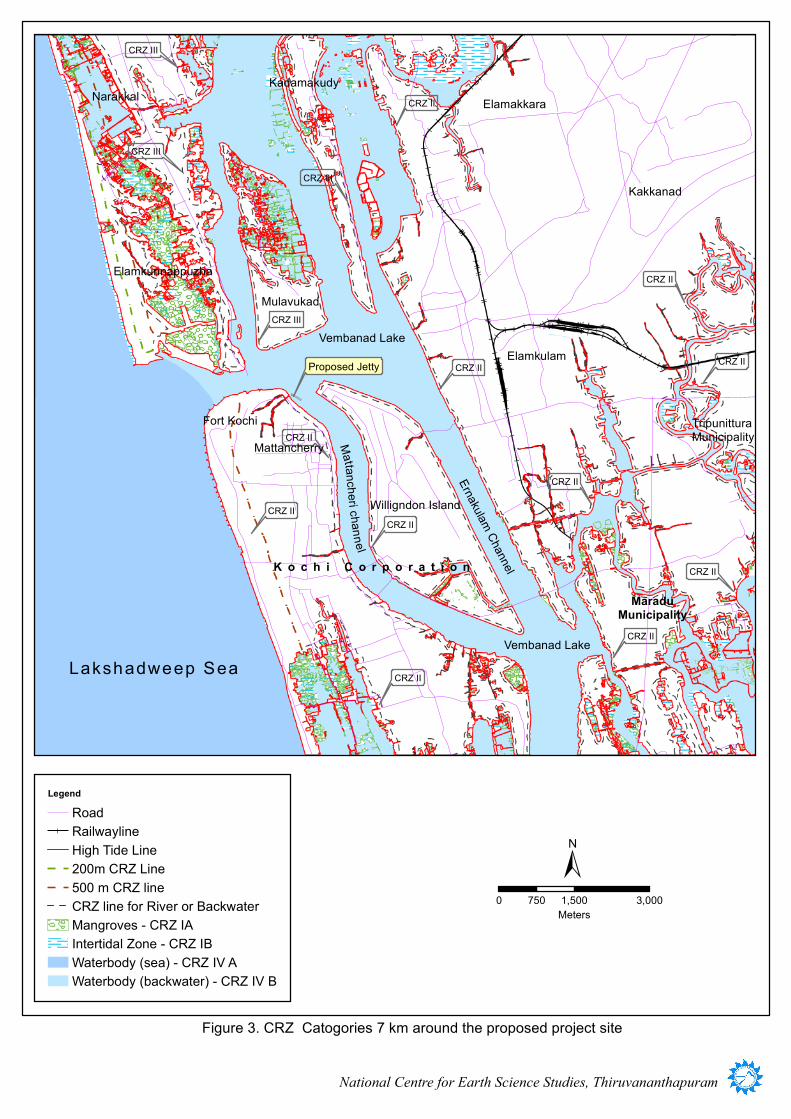
waterbody is CRZ IVB. The CRZ categories 7km around the proposed project site is
given in figure 3.

CRZ Status Report for the proposed construction of jetty for Indian Coast Guard at Cochin Port, Ernakulam
National Centre for Earth Science Studies, Thiruvananthapuram
9
9.0 Summary and Recommendation
The High Tide Line, Low Tide Line and CRZ mapping in the vicinity of the
proposed site for the construction of jetty for Indian Coast Guard in survey no.
560 of Kochi Corporation at Cochin Port was carried out on cadastral maps
having a scale of 1:4000.
The distinct line of embankments and other relevant geomorphic signatures
depicting highest high tide level is considered as the High Tide Line in the case of
Vembanad estuary and tidal influenced Eraveli canal.
The CRZ categories were identified based on field investigation and CZMP of the
state.
The project site is on the banks of Vembanad estuary having a width of more than
100m and the CRZ is 100m landward of High Tide Line. The CRZ landward of
HTL along Eraveli canal is the width of the waterbody on either side.
The ecologically sensitive mangrove ecosystems to be categorized as CRZ IA are
absent in the site or in the immediate vicinity of the project site.
Inter tidal zones are categorized as CRZ IB.
Since the locality of the project site belongs to developed urban areas of Kochi
Corporation, the CRZ landward of the High Tide Line is CRZ II.
The Layout of the proposed construction of jetty as provided by the project
proponent is superimposed in the CRZ Map.
As per CRZ Notification 2011 Para 4, Sub-para i(f) ‘construction and operation
for ports and harbours, jetties, wharves, quays, slipways, ship construction yards,
breakwaters, groynes, erosion control measures are permissible activities’. Further
such activities proposed shall require clearance from MoEF as per Para 4, Sub-
para ii (b).

CRZ Status Report for the proposed construction of jetty for Indian Coast Guard at Cochin Port, Ernakulam
National Centre for Earth Science Studies, Thiruvananthapuram
10
REFERENCES
MoEF, 1991. Notification No.S.0114 dated 19th February, 1991, Ministry of Environment
and Forests, Government of India, New Delhi.
CZMP, 1996. Coastal Zone Management Plan of Kerala, 1995. Dept. of Science
Technology and Environment, Government of Kerala, 77p.
MoEF, 1996. Letter No. J-17011/23/92-1A III dated 27th September 1996 to the Chief
Secretary, Govt. of Kerala. Ministry of Environment and Forests, Government of
India, New Delhi.
MoEF, 1999. Letter No.J.17011/8/92-1A III dated 4 January 1999 to the Chief Secretary
of Coastal States. Ministry of Environment and Forests, Government of India,
New Delhi.
MoEF, 2011. Notification No. S.O.19 (E) dated 6.1.2011, Ministry of Environment and
Forests, Government of India, New Delhi.
NHO, 2000. Hydrographic chart No. 2004 - Naval Hydrographic Office, Dehra Dun.
CRZ Status Report for the proposed construction of jetty for Indian Coast Guard at Cochin Port, Ernakulam
National Centre for Earth Science Studies, Thiruvananthapuram
11
PLATES
Plate 1. Proposed site for jetty
Construction
Plate 2. Existing workshop and boat
yard
Plate 3. Eraveli canal with distinct
embankment
Plate 4. The existing township and
human settlement along the western
margin of the project site.

76°19'30"E
76°19'30"E
76°18'0"E
76°18'0"E
76°16'30"E
76°16'30"E
76°15'0"E
76°15'0"E
76°13'30"E
76°13'30"E10
°0'0"
N
10°0
'0"N
9°58'3
0"N
9°58'3
0"N
9°57'0
"N
9°57'0
"N
9°55'3
0"N
9°55'3
0"N
9°54'0
"N
9°54'0
"N
LegendRoadRailwaylineWaterbody
±0 1,500 3,000750
Meters
National Centre for Earth Science Studies, Thiruvananthapuram
Lakshadweep Sea
Mattancheri channel
K o c h i C o r p o r a t i o n
ErnakulamChannel
MulavukadElamkunnappuzha
TripunitturaMunicipality
MaraduMunicipality
Kadamakudy
Narakkal Elamakkara
Kakkanad
Elamkulam
Figure 1. Location Map
Proposed Jetty
MattancherryFort Kochi
Willigdon Island
Vembanad Lake
Vembanad Lake
LegendRoadRailwaylineHigh Tide Line200m CRZ Line500 m CRZ lineCRZ line for River or BackwaterMangroves - CRZ IAIntertidal Zone - CRZ IBWaterbody (sea) - CRZ IV AWaterbody (backwater) - CRZ IV B
±0 1,500 3,000750
Meters
National Centre for Earth Science Studies, Thiruvananthapuram
CRZ III
CRZ III
CRZ III
CRZ III
CRZ II
CRZ II
CRZ II
CRZ II
CRZ II
CRZ II
CRZ II
CRZ II
CRZ II
CRZ II
Lakshadweep Sea
Mattancheri channel
K o c h i C o r p o r a t i o n
ErnakulamChannel
Mulavukad
Elamkunnappuzha
TripunitturaMunicipality
MaraduMunicipality
KadamakudyNarakkal Elamakkara
Kakkanad
Elamkulam
Figure 3. CRZ Catogories 7 km around the proposed project site
Proposed Jetty
Willigndon Island
MattancherryFort Kochi
Vembanad Lake
Vembanad Lake
CRZ II

BazzarRoad
BazzarRoad
CalavathyR oad
Eraveli Canal Road
0
00
0
602
20
549
33
185
66032
17
610
605
28
18154
644662 646192
3
560
195
1
42
2
53
553
186
193183
55
573
604
182
25
607
2577
618643
26
37
19
552
197
568
18
198
29
8
1871396
2557
578
10
52
178
23
603
13
176
14
46
608612
2560
1386
179
188
45
194
567
548
36
205177
204199
649
44
40
5
1536
190
606
27
614
4
566
1371
642
623
6
1369
12
571
557
615
635
600
196
58
7
1370
651
575
38
640638
565
648
2575
49
632
624
645
1387
34
16
48
15
56
2569
43
41
1379
2573
556
1407
22
564
1346
563
35
1197
140331
21
2572
572
561
2559
620
1390
2558
647
1374
609
13491209
601
1210
189
1409
570 569
1372
191
1392
1383
30
6342555 551
1368
2440
1406
1385
1391
1400
1508
574
39
656
554
15002574
180
581
1348
1397
1384
13981496
1402
1399
1395
24629
613
11
1343
1358
1393
621
1377
630
1256
1347
1364
1497
1405
1388
650
9
1375
558
611
1355
12381389
1258
1394
636
1340
1351
1345
184
1336
1361
1408
1498
1381
6631247
1382
1252
2611
11991254
654
1378
1239
1507
1401
1341
1499
655
1501
1243
627
1356
6411208
2570
1248
1242
1357
2556
1360
622 619
625
1246
1337
2571
1253
1259
635
626
1537
1380
562
1241
628
639
1535
1201
1206
1257
12601404
24442443
1410
1353
1255
579
582 545
1273
1363
559
1205
1325
1251
1240
1339
1342
1367
1338
1335
1359
1324
2568
12441245
1365 1366
1376
1250
76°15'26"E
76°15'26"E
76°15'15"E
76°15'15"E
76°15'4"E
76°15'4"E9°58'10"N
9°58'10"N
9°58'0"N
9°58'0"N
9°57'50"N
9°57'50"N
±
Eraveli CanalMattancheri Channel
Kunnumpuram
Mattancherry
KO
CH
I
CO
RP
OR
AT
IO
N
Vembanad Lake
Fort Kochi Ferry
CRZ II
CRZ II
CRZ II
Figure 2. CRZ Map (Refer CRZ Status Report for more details)
Willingdon Island
LegendRoadHigh Tide LineCRZ limit for River or BackwaterCRZ Landward of HTLWaterbody (backwater) - CRZ IV BProposed JettyExisting JettySurvey plots
560
Bridge
HTL, LTL and CRZ for the Proposed Construction of Jetty for Indian
Coast Guard at Cochin Port, Ernakulam
National Centre for Earth Science StudiesAkkulam,Thuruvikkal P.OThiruvananthapuram 11
Mapped during
Checked byApproved by
March2016
040
8020Meters
1:4,000
Scale