HS2, GIS, BIM and Historic Environment Works an overview · HS2, GIS, BIM and Historic Environment...
16
HS2, GIS, BIM and Historic Environment Works – an overview Mike White, GIS Manager, HS2 Ltd Heritage Sub-group 17/03/2016 www.gov.uk/hs2
Transcript of HS2, GIS, BIM and Historic Environment Works an overview · HS2, GIS, BIM and Historic Environment...

HS2, GIS, BIM and Historic Environment Works – an overview
Mike White, GIS Manager, HS2 Ltd
Heritage Sub-group17/03/2016
www.gov.uk/hs2

• How we use GIS at HS2
• BIM; what is it, where does GIS fit in and how does it benefit Historic Environment Works?
• What are the next steps?
Overview

How we use GIS at HS2 and where
GIS
Environment
Community Engagement
Engineering
Business Case
Land & Property
Supply chain

Where we use GIS at HS2 within Environment
Environment
Heritage
Water Resources
Traffic & Transport
Air Quality
Landscape & Visual
Ecology
Waste
Noise
Agriculture
Community

• Environmental Appraisals such as the Phase One EIA, Phase Two AoS and forthcoming Phase Two EIA
• PQ’s, ad-hoc queries, bespoke projects
Phase One EIA• 55,000 pages• 10,000+ maps• 50 environmental datasets, 300 engineering• GIS provides the foundation
How we use GIS at HS2 within Environment
www.gov.uk/hs2
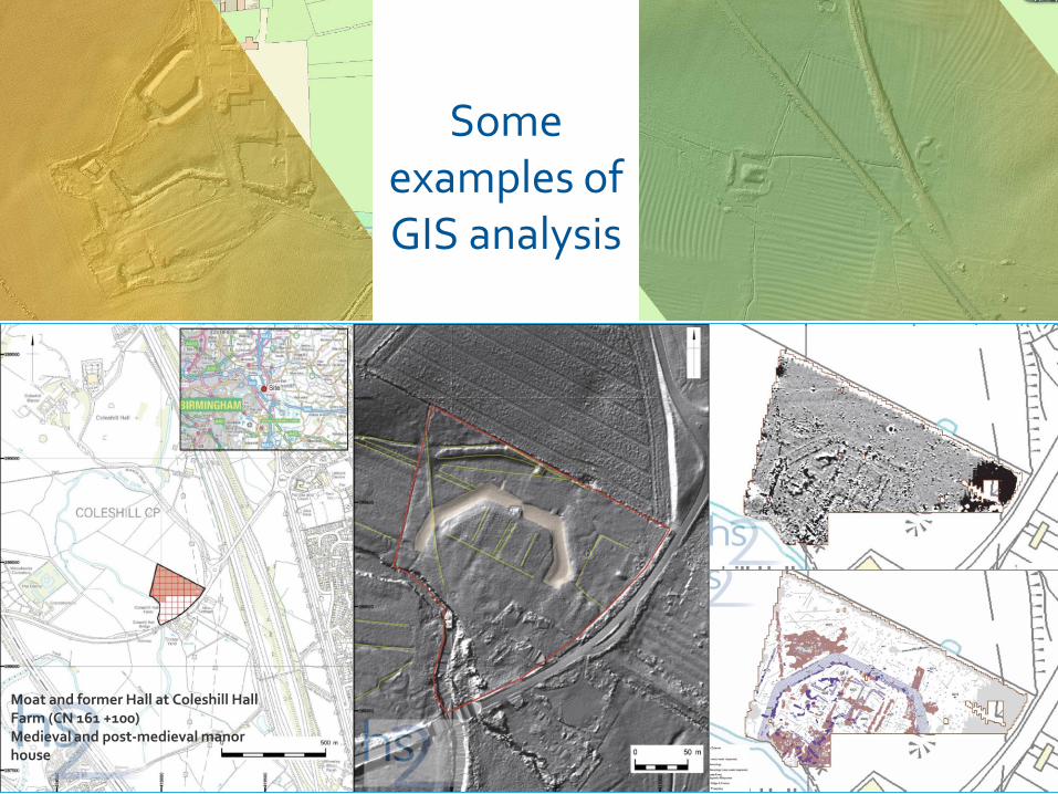
How the ES identified and assessedarchaeological assets
Moat and former Hall at Coleshill Hall Farm (CN 161 +100)Medieval and post-medieval manor house
Some examples of GIS analysis

Where do we get our data from?
Third Party
Supply Chain*
HS2 GIS
Statutory bodies
NGO’s
Local Authorities
5 Environmental
PSC’s
6 Engineering PSCs
115 suppliers
1,605 datasets
550 datasets 2200
datasets
12 GIS staff + supply chain

• Data Management activities such as procurement, licencing, assurance, specification
• gViewer
• Provide data to the Supply Chain and updates
• Open Data provision
• Onward use within projects to ‘mature’ our understanding of HS2 project
What do we do with that data?

• Managing volume of data
• Specifying, assuring and integrating
• Programme
• Meeting stakeholder expectations
Challenges

• Building Information Modelling• Better Information Management• BIM is comprised of two key components: Data Management - a set of standards, methods and procedures that provide a consistent approach to the production, management and delivery of asset information; andData Modelling - often referred to as Digital Engineering, this is the use of data to support decision making. Examples of Data Modelling may include the application of Digital Design (3D) to enhance Health and Safety and Carbon Management; Construction Sequencing (4D); Cost Estimating (5D); and Digital Fabrication.”
What is BIM?


• User friendly way of accessing information about assets
• All information has a relationship with Geography
• Historic Environment Works will be assets
• Generate vast quantity of digital information and physical finds
Where does GIS fit into BIM and for Historic Environment Works?

• GIS will be the spatial representation of all Historic Environment Works
• Can link together many different information sets
• Allows us to understand relationship to the design and our other assets
Where does GIS fit into BIM and for Historic Environment Works?

• Specifying what we want for Construction phase – Technical Standards including information
• GWSI:HERDS – setting out a vision, research objectives and encouraging our supply chain to be innovative where information is concerned
• Vision for a collaborative digital space between HS2 and Supply Chain to facilitate information sharing for HERDS
What are the next steps?

Questions?

Thank you