
HRSC Map & reference issues
16
Transcript of HRSC Map & reference issues

HRSC Map & reference issues
Angelo Pio Rossi
1

Map & reference frame issues
2

Map & reference frame• HRSC Level4 data are map-projected:
• Sinusoidal projection (Latitudes from 85° S to 85° N)
• Polar-Stereographic projection (polar areas)
• The map reference body is a sphere with r = 3396.0 km
• The vertical reference for DEM is either:
• A sphere with r = 3396.0 km (DT4)
• An aeroid (DA4) directly comparable with MOLA MEGDR grids
3
http://pds-geosciences.wustl.edu/missions/mgs/megdr.html
MAP REFERENCE
HEIGHT REFERENCE

Sphere & ellipsoid~ Mars MOLA sphere
A_AXIS = 3396.19 kmB_AXIS = 3396.19 kmC_AXIS = 3376.2 km
A
C
Mars IAU2000 ellipsoid
A_AXIS = 3396.0 kmB_AXIS = 3396.0 kmC_AXIS = 3396.0 km
4
HRSC LEVEL4
MAP REFERENCE
Level3 data STILL withA=B=C = 3396.19 km
(May ’08)
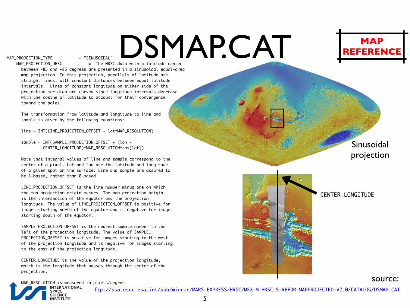
MAP_PROJECTION_TYPE = "SINUSOIDAL" MAP_PROJECTION_DESC = "The HRSC data with a latitude center between -85 and +85 degrees are presented in a sinusoidal equal-area map projection. In this projection, parallels of latitude are straight lines, with constant distances between equal latitude intervals. Lines of constant longitude on either side of the projection meridian are curved since longitude intervals decrease with the cosine of latitude to account for their convergence toward the poles. The transformation from latitude and longitude to line and sample is given by the following equations: line = INT(LINE_PROJECTION_OFFSET - lat*MAP_RESOLUTION) sample = INT(SAMPLE_PROJECTION_OFFSET + (lon - CENTER_LONGITUDE)*MAP_RESOLUTION*cos(lat)) Note that integral values of line and sample correspond to the center of a pixel. Lat and lon are the latitude and longitude of a given spot on the surface. Line and sample are assumed to be 1-based, rather than 0-based. LINE_PROJECTION_OFFSET is the line number minus one on which the map projection origin occurs. The map projection origin is the intersection of the equator and the projection longitude. The value of LINE_PROJECTION_OFFSET is positive for images starting north of the equator and is negative for images starting south of the equator. SAMPLE_PROJECTION_OFFSET is the nearest sample number to the left of the projection longitude. The value of SAMPLE_ PROJECTION_OFFSET is positive for images starting to the west of the projection longitude and is negative for images starting to the east of the projection longitude. CENTER_LONGITUDE is the value of the projection longitude, which is the longitude that passes through the center of the projection. MAP_RESOLUTION is measured in pixels/degree. ftp://psa.esac.esa.int/pub/mirror/MARS-EXPRESS/HRSC/MEX-M-HRSC-5-REFDR-MAPPROJECTED-V2.0/CATALOG/DSMAP.CAT
source:
CENTER_LONGITUDE
Sinusoidal projection
5
DSMAP.CAT MAP REFERENCE
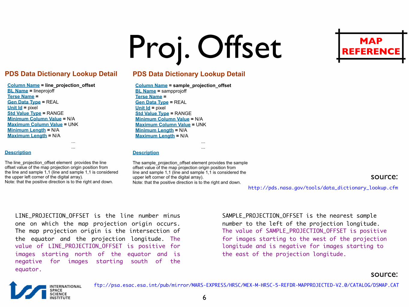
Proj. OffsetPDS Data Dictionary Lookup Detail Column Name = line_projection_offset BL Name = lineprojoff Terse Name = Gen Data Type = REAL Unit Id = pixel Std Value Type = RANGE Minimum Column Value = N/A Maximum Column Value = UNK Minimum Length = N/A Maximum Length = N/A
...
... Description The line_projection_offset element provides the line offset value of the map projection origin position from the line and sample 1,1 (line and sample 1,1 is considered the upper left corner of the digital array). Note: that the positive direction is to the right and down.
PDS Data Dictionary Lookup Detail Column Name = sample_projection_offset BL Name = sampprojoff Terse Name = Gen Data Type = REAL Unit Id = pixel Std Value Type = RANGE Minimum Column Value = N/A Maximum Column Value = UNK Minimum Length = N/A Maximum Length = N/A
...
...Description The sample_projection_offset element provides the sample offset value of the map projection origin position from line and sample 1,1 (line and sample 1,1 is considered the upper left corner of the digital array). Note: that the positive direction is to the right and down.
http://pds.nasa.gov/tools/data_dictionary_lookup.cfm
source:
LINE_PROJECTION_OFFSET is the line number minus one on which the map projection origin occurs. The map projection origin is the intersection of the equator and the projection longitude. The value of LINE_PROJECTION_OFFSET is positive for images starting north of the equator and is negative for images starting south of the equator.
SAMPLE_PROJECTION_OFFSET is the nearest sample number to the left of the projection longitude. The value of SAMPLE_PROJECTION_OFFSET is positive for images starting to the west of the projection longitude and is negative for images starting to the east of the projection longitude.
ftp://psa.esac.esa.int/pub/mirror/MARS-EXPRESS/HRSC/MEX-M-HRSC-5-REFDR-MAPPROJECTED-V2.0/CATALOG/DSMAP.CAT
source:
6
MAP REFERENCE

DEM: aeroid vs. spheroid
α βequator
α = planetocentricβ = planetographic
Latitude:
“MOLA” sphere r=3396.0 km
IAU ellipsoidA = B = 3396.19 km
C = 3376.2 km
Aeroid Surface, GMMM3, NASA
TERRAIN
7(Courtesy K. Gwinner, DLR)
HEIGHT REFERENCE

DTM: aeroid vs. spheroid
α β
Height aboveGMM3 Aeroid
TERRAIN
Height above sphere(r = 3396.0 km)
Height above IAU ellipsoid(r = 3396.0 km)
α = planetocentricβ = planetographic
Latitude:
N
8(Courtesy K. Gwinner, DLR)
HEIGHT REFERENCE

DTM: DT4 vs. DA4
TERRAIN
N
e.g.H0010_0009_DA4.IMG
e.g.H0010_0009_DT4.IMG
Height aboveGMM3 Aeroid
DA4
Height above sphere(r = 3396.0 km)
DT4
9
HEIGHT REFERENCE

HRSC Level4 DEM (dt4 & da4 products)
10

DEM: Summary
• HRSC DT4 DEMs:
• HEIGHT reference = sphere
• HRSC DA4 DEMs:
• HEIGHT reference = aeroid (~MEGDR)
• ALL HRSC Level4 data use as MAP reference a sphere with r = 3396.0 km
11

DT4 vs. DA4: Labels
/* DIGITAL TERRAIN MODEL DEFINITIONS */ GROUP = MEX:DTM MEX:DTM_A_AXIS_RADIUS = 3396.0 MEX:DTM_B_AXIS_RADIUS = 3396.0 MEX:DTM_C_AXIS_RADIUS = 3396.0 MEX:DTM_DESC = HEIGHT_ABOVE_SPHEROID MEX:DTM_MISSING_DN = -32768 MEX:DTM_OFFSET = 0.0 MEX:DTM_SCALING_FACTOR = 1.0 END_GROUP = MEX:DTM
/* DIGITAL TERRAIN MODEL DEFINITIONS */ GROUP = MEX:DTM MEX:DTM_A_AXIS_RADIUS = -1e+32 MEX:DTM_B_AXIS_RADIUS = -1e+32 MEX:DTM_C_AXIS_RADIUS = -1e+32 MEX:DTM_DESC = "HEIGHT_ABOVE_GM3-AREOID" MEX:DTM_MISSING_DN = -32768 MEX:DTM_OFFSET = 0.0 MEX:DTM_SCALING_FACTOR = 1.0 END_GROUP = MEX:DTM
DA4DT4
SEE HRSC EXPERIMENT TO ARCHIVE INTERFACE CONTROL DOCUMENT (EAICD) IN THE HRSC
DATASET IN THE PSA:
12
http://www.rssd.esa.int/PSA/

Level4 DEM: example
13
DT4 DEM viewed in “xvd”

HRSC DEM vs. MOLA
14

HRSC DEM vs. MOLA
For a comprehensive presentation on the comparison between HRSC Level4 Digital Elevation Models and MOLA (Mars Orbiter Laser Altimeter), please see K. Gwinner’s presentation at the 2007 EMSEC Conference (Friday, W.02)
http://sci.esa.int/mars07/
http://www.rssd.esa.int/SYS/include/pubs_display.php?project=MarsEXPRESS&id=2799137
15

HRSC DTM vs. MOLA
Local high differences in height between MOLA and HRSC DA4 DEM might be due to the lower resolution of MOLA and its interpolation (due to unevenly spaced MOLA profiles, especially at low latitudes).
Interpolation
DA4MOLA MEGDR
16


![CHAPTER 3 MANAGING THE CURRICULUM 3.1 Introductionuir.unisa.ac.za/bitstream/handle/10500/1529/04chapter3.pdf · management skills. ... (Human Sciences Research Council [HRSC] ...](https://static.fdocuments.us/doc/165x107/5aa9e02b7f8b9a7c188d63e2/chapter-3-managing-the-curriculum-31-skills-human-sciences-research-council.jpg)

