HOT ZONE - Federal Emergency Management Agency ZONE Pacific Disaster Center Uses Hazus For Hurricane...
4
As part of the disaster response efforts for Hur- ricane Irene in 2011, the Pacific Disaster Center (PDC) in Hawaii ran Hazus analyses utilizing two multi-state study regions at the county level. The first study region consisted of North Carolina, Virginia, Maryland, Washington D.C., and Dela- ware, and the second consisted of Pennsylvania, New York, New Jersey, Connecticut, New Hamp- shire, Vermont, and Rhode Island. To help reduce run times, PDC only selected those counties in New York and Pennsylvania that were close to the forecasted hurricane wind swath. PDC’s models are run on virtual machine platforms, which allow the models to be accessed and run remotely. Febuary 2012 Issue HOT ZONE Pacific Disaster Center Uses Hazus For Hurricane Irene 1 In This Issue Pacific Disaster Center Uses Hazus For Hurricane Irene Northeast States Emergency Consortium Uses Hazus For Hurricane Irene Hazus User Group Update Hazus For Floodplain Managers Tsunami Model Update Hazus Used To Measure Earthquake Risks In Schools Hazus Goes To Singapore In addition, PDC personnel created maps of Total Direct Building Economic Losses, Peak Wind Gusts, and Max Sustained Wind Speeds, which were distributed to government and emergency response entities via email, ftp, and PDC’s Emergency Management Operations System (EMOPS). Hazus reports, such as Build- ing Damage by Count by General Occupancy, Direct Economic Losses for Buildings, and the Global Report, were also disseminated along with the shapefiles used to make the maps men- tioned above. These products were used by American Red Cross, particularly their National Headquarters, as well as in support of Federal entities in D.C., including State National Guards, defense agen- cies and offices concerned with foreign disaster assistance. Feedback received post event reflected that PDC’s Hazus products were highly useful in the response to Hurricane Irene. The PDC was initially conceived as support for the State of Hawaii and Hawaii State Civil Defense, in the wake of Hurricane Iniki, which devastated the island of Kauai on September 11, 1992. How- ever, with support from the U.S. Department of Defense (DOD), the mission enlarged so that by the time the staff began work in 1995, the PDC had been broadened to encompass American interests in the Pacific, and shortly thereafter, the entire Pacific, or the area of responsibility of the U.S. Pacific Command. The Center’s first major project was the Pacific Regional Emergency Management Information System (PREMIS). By 2000, PDC was working under the auspices of DOD to develop an Integrated Decision Support System (IDSS) for the Caribbean, and the Cen- ter’s area of interest has been expanding ever since, in terms of support to U.S. military and civil organizations and in the conduct projects around the world. At this point, PDC products and service are genuinely global, as evidenced by the Global Hazards Atlas, the global coverage of PDC’s Disaster Alert mobile app, and activi- ties in Africa, South America, and Europe, as well as the Pacific region and North Amer- ica, where PDC supported the response, for example, to hurricanes Katrina and Rita. For more information on the PDC please visit www.pdc.org. Wind peak gusts for Hurricane Irene Storm track for Hurricane Irene
-
Upload
nguyendieu -
Category
Documents
-
view
219 -
download
4
Transcript of HOT ZONE - Federal Emergency Management Agency ZONE Pacific Disaster Center Uses Hazus For Hurricane...

As part of the disaster response efforts for Hur-ricane Irene in 2011, the Pacific Disaster Center (PDC) in Hawaii ran Hazus analyses utilizing two multi-state study regions at the county level. The first study region consisted of North Carolina, Virginia, Maryland, Washington D.C., and Dela-ware, and the second consisted of Pennsylvania, New York, New Jersey, Connecticut, New Hamp-shire, Vermont, and Rhode Island. To help reduce run times, PDC only selected those counties in New York and Pennsylvania that were close to the forecasted hurricane wind swath. PDC’s models are run on virtual machine platforms, which allow the models to be accessed and run remotely.
Febuary 2012 Issue
HOT ZONEPacific Disaster Center Uses Hazus For Hurricane Irene
1
In This Issue Pacific Disaster Center Uses Hazus For Hurricane Irene
Northeast States Emergency Consortium Uses Hazus For Hurricane Irene
Hazus User Group Update
Hazus For Floodplain Managers
Tsunami Model Update
Hazus Used To Measure Earthquake Risks In Schools
Hazus Goes To Singapore
In addition, PDC personnel created maps of Total Direct Building Economic Losses, Peak Wind Gusts, and Max Sustained Wind Speeds, which were distributed to government and emergency response entities via email, ftp, and PDC’s Emergency Management Operations System (EMOPS). Hazus reports, such as Build-ing Damage by Count by General Occupancy, Direct Economic Losses for Buildings, and the Global Report, were also disseminated along with the shapefiles used to make the maps men-tioned above.These products were used by American Red Cross, particularly their National Headquarters, as well as in support of Federal entities in D.C., including State National Guards, defense agen-cies and offices concerned with foreign disaster assistance. Feedback received post event reflected that PDC’s Hazus products were highly useful in the response to Hurricane Irene.
The PDC was initially conceived as support for the State of Hawaii and Hawaii State Civil Defense, in the wake of Hurricane Iniki, which devastated the island of Kauai on September 11, 1992. How-ever, with support from the U.S. Department of Defense (DOD), the mission enlarged so that by the time the staff began work in 1995, the PDC had been broadened to encompass American interests in the Pacific, and shortly thereafter, the entire Pacific, or the area of responsibility of the U.S. Pacific Command. The Center’s first major project was the Pacific Regional Emergency Management Information System (PREMIS). By 2000, PDC was working under the auspices of
DOD to develop an Integrated Decision Support System (IDSS) for the Caribbean, and the Cen-ter’s area of interest has been expanding ever since, in terms of support to U.S. military and civil organizations and in the conduct projects around the world. At this point, PDC products and service are genuinely global, as evidenced by the Global Hazards Atlas, the global coverage of PDC’s Disaster Alert mobile app, and activi-ties in Africa, South America, and Europe, as well as the Pacific region and North Amer-ica, where PDC supported the response, for example, to hurricanes Katrina and Rita.
For more information on the PDC please visit www.pdc.org.
Wind peak gusts for Hurricane Irene Storm track for Hurricane Irene
2
Tsunami Model UpdateOn Jan 10, 2012, the 11 member Tsunami Com-mittee held its first meeting in Orange, Califor-nia. After a welcome, introductions, and a review of the agenda, meeting objectives and FEMA objectives for the project, the Tsunami Devel-opment Team presented an overall framework for the tsunami methodology. Presentations fol-lowed on anticipated parts of the model to in-clude the components of the other models such as damage assessment to buildings, damage assessment to lifelines, debris generated, ca-sualty estimates, shelter demand, economic im-pacts, and most importantly the actual tsunami hazard analysis which will detail how a tsunami can affect an area. Another meeting will take place in March to discuss future steps and the next stages in the model development.
Hazus Used to Size up Earth-quake Risks in SchoolsFEMA piloted a program in Washington State in two school districts to efficiently determine earthquake risks. Schools were spending a large amount of money to perform assessments of their schools. The Washington State Seismic Safety Committee conducted this study and pro-vided a report which details the exact approach that was taken. Hazus was used as part of this process to determine risks. In the process the school districts also updated their hazard mitiga-tion plans. This pilot program will demonstrate how other schools with budget constraints can best target federal funding to assist their schools with upgrades. This model will help schools to become more prepared for various types of natural disasters by implementing mitigation strategies and actions.
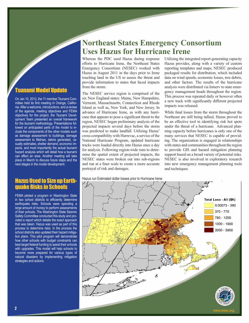
Northeast States Emergency Consortium Uses Hazus for Hurricane IreneWhereas the PDC used Hazus during response efforts to Hurricane Irene, the Northeast States Emergency Consortium (NESEC) worked with Hazus in August 2011 in the days prior to Irene touching land in the US to assess the threat and provide information to states that faced impacts from the storm. The NESEC service region is comprised of the six New England states: Maine, New Hampshire, Vermont, Massachusetts, Connecticut and Rhode Island as well as, New York, and New Jersey. In advance of Hurricane Irene, as with any hurri-cane that appears to pose a significant threat to the region, NESEC began preliminary analysis of the projected impacts several days before the storm was predicted to make landfall. Utilizing Hazus’ cross-compatibility with Hurrevac, a service of the National Hurricane Program, updated hurricane tracks were loaded directly into Hazus once a day for analysis. Following region-wide runs to deter-mine the spatial extent of projected impacts, the NESEC states were broken out into sub-regions and run at a finer scale to create a more accurate portrayal of risk and damages.
Utilizing the integrated report-generating capacity Hazus provides, along with a variety of custom reporting templates and maps, NESEC produced packaged results for distribution, which included data on wind speeds, economic losses, tree debris, and other factors. The results of the hurricane analysis were distributed via listserv to state emer-gency management heads throughout the region. This process was repeated daily or however often a new track with significantly different projected impacts was released. While final losses from the storm throughout the Northeast are still being tallied, Hazus proved to be an effective tool in identifying risk hot spots under the threat of a hurricane. Advanced plan-ning capacity before hurricanes is only one of the many services that NESEC is capable of provid-ing. The organization is engaged in relationships with states and communities throughout the region to provide GIS and hazard mitigation planning support based on a broad variety of potential risks. NESEC is also involved in exploratory research into new emergency management planning tools and techniques.
www.nesec.org.
Hazus run Estimated dollar losses prior to Hurricane Irene

3
Hazus User Group Update
FEMA is proud to announce that Bert Struik, Natural Resources Canada, is the 4th Quarter Hazus User of the Year. Dr. Struik has been a lead contributor in building knowledge transfer and capability for use of Hazus in Canada. Dr. Struik was instrumental in last year’s signing of the Canadian–United States agreement to share Hazus methodology, materials, and outreach between the two countries. He is connecting the two countries through the Canadian Hazus User Group (CanHUG) and Risk Assessment User Group (RAUG) initiatives, which helps to improve cross border modeling of natural hazards. He hosts teleconferences for each group monthly and assists with the maintenance of the (CanHUG) website at www.usehazus.com/canadianhug.
The Hazus User Groups (HUGs) continue to serve as an important resource for the Hazus user community. To date forty-four of the fifty United States have HUG representation and there are six regional HUGs representing multiple states. Moses Wilkins, from FEMA Region IV has taken the lead with the Georgia HUG, the newest HUG in the nation.
The Northeastern Hazus User Group will host their first in-person meeting at FEMA Region I Headquarters in Boston, Mass on March 8 from 10:00 a.m.–4:00 p.m. This meeting is going to be an introduction to the Hazus
program. Confirmed speakers include; Larry Becker, Vermont State Geologist,
Ed Fratto, NESEC Executive Director, and Darrin Punchard, AECOM
Senior Project Manager.
Kelly Stone, FEMA Region X, the leader of the Washington HUG (WAHUG) has held several calls in recent months. The WAHUG December 2011 call featured an overview of Hazus with examples of Hazus use from Washington State. The January 2012 call featured presen-tations by John Schelling and Rebeckah Green on the Washington State Earthquake Scenario Catalog. If you missed any of these presen-tations you can view them on the WAHUG website at www.usehazus.com/wahug.
All Hazus users are encouraged to participate in monthly National Topic Specific HUG calls. The Novem-ber 2011 call featured a presentation by Laura Dinitz and Jeff Peters, U.S. Geological Survey, titled “Land Use Portfolio Model to Evaluate Regional-scale Mitigation Policies for Natural Hazards.” The December 2011 call featured Jamie Caplan and the HUG Leaders review-ing successes from 2011 and their plans for 2012. The January 2012 call featured Philip Schneider, National Institute of Building Sci-ences reviewing three tools that work with Hazus: the Integrated Rapid Visual Screening Tool, the Owners Performance Requirement Tool, and the Urban Blast Tool.
For more information regarding the monthly HUG calls visit www.fema.gov or www.usehazus.com. Guest speakers and topics are announced prior to each call. Future call dates include: Mar 20 and April 30. If you would like to present a project or your work with Hazus on an upcoming call, please contact [email protected]. FEMA and the Hazus outreach team make many resources available to the Hazus user community. New to this list of resources is the Hazus Activities At A Glance calendar on USEHAZUS. Here you can find the entire list of HUG meetings, conferences and training opportunities in one spot. Also available are Hazus Podcasts; twenty-three podcasts are available for download from iTunes. The pod-casts include recordings of 5th annual Hazus
conference sessions, HUG calls, and the Hazus Hot Zone.
Hazus 4th Quarter User of the Year Dr. Bert Struik
Hazus Goes to SingaporeWe’re very proud to announce that the National Uni-versity of Singapore (NUS) has received approval to conduct a Hazus pilot study. This is a significant accomplishment for the Hazus program and we are hopeful that this will lead to further use of Hazus in Singapore.
Earlier this year, the NUS was asked to perform a study for the government of Singapore on sea level rise using loss estimation methodology. After re-searching the best methodologies and tools available, the NUS concluded that Hazus deserved looking into further. NUS representatives then worked with FEMA to arrange for face to face meetings with members of the Hazus program team.
Eric Berman, Hazus Program Manager, Philip Moore of the Emergency Management Institute and Kevin Mickey from The Polis Center visited NUS in Novem-ber to provide additional information on the Hazus software. Their presentation, which included a Hazus workshop and demonstration of the Hazus methodolo-gy, was attended by government representatives from Singapore, NUS and other local academic institutions. As a result of these meetings, NUS decided to pilot the use of Hazus for their study.
A leading international university centered in Asia, NUS offers a global approach to education and re-search. Its transformative education program includes a broad-based curriculum with over 36,000 students from 100 countries.
The Hazus Program Team looks forward to increased opportunities to work with Hazus internationally. This visit to Singapore follows the signing of an agreement between the U.S. and Canada in August to provide Hazus software to Canada.

Hazus for Floodplain Managers
Newly Hazus Trained Professional and Practitioners
Starting in 2012 the Hazus-MH education program will begin offering a new course titled Hazus-MH for Floodplain Managers (Course E176). This course will complement those already available to the Hazus user community including the Using Hazus for Risk Assessment (E296) and Applications of Hazus-MH for Disaster Operations (E179) courses.The Hazus–MH for Floodplain Managers course provides in-depth instruction and hands-on exercises that develop the skills needed by certified floodplain managers and emergency planners to effectively use Hazus-MH and GIS tools for modeling the impacts on communities from riverine and coastal flooding. Those who complete this
course will understand the roles that floodplain managers play as well as how geospatial technologies such as Hazus-MH can be used to protect communities beyond the minimum standards that floodplain managers are responsible for implementing. The audience for this course includes state and local floodplain managers; GIS specialists; Federal, state and local planners; and other personnel responsible for supporting flood mitigation and response activities.FEMA successfully piloted the E176 course in Anniston, Ala. in November 2011. The first regular offering of this course will take place at the Emergency Management Institute in Emmitsburg, Md from April 23 to 26, 2012.
Practitioners:Jeff Birdwell, Madison Fire Department, ALTodd Warren Brown, Madison County Emergency Management, IACarly Cermak, ARCADIS, FLChris Corwin, Blaine County Emergency Communications, IDThomas P. Fisher, Muskingum Watershed Conservancy District, OHDavid J. Green, Custer County Planning Department, SDGwynne Lindsey, City of Colleyville, TXMila Ready, Town of Hudson, WYRachel R. Rodriguez, Yurok Tribe, CAMichael D. Ruzowski, Okaloosa County, FLEston Spain, IEM, Inc., VAPatricia Stiefer, FEMA Region 9, CATim Triesch, Pacific County Public Works Department, WASteven Ward, Gulf Engineering & Consulting, LAEd Whitford, Tetra Tech, WA
Trained Professionals:Jeff Birdwell, Madison Fire Department, ALCarly Cermak, ARCADIS, FLChris Corwin, Blaine County Emergency Communications, IDAndrew D. Megrail, FEMA Region 7, MOMila Ready, Town of Hudson, WYJohn D. Shell, City of Tacoma, WAJonathan B. Slone, AMEC Earth & Environmental, NCEston Spain, IEM, Inc., VAPatricia Stiefer, FEMA Region 9, CATim Triesch, Pacific County Public Works Department, WASteven Ward, Gulf Engineering & Consulting, LAEd Whitford, Tetra Tech, WA
COURSE NUMBER COURSE TITLE DATES
E296 Basic Hazus-MH April 2-5, 2012
E174 Hazus-MH for Floodplain Managers April 23- 26, 2012
E179 ArcGIS for Emergency Managers April 30- May 3, 2012
4
Hazus® and HAZUS-MH® are trademarks of the Federal Emergency Management Agency.
02145 | PL | 2012
Contact InformationHazus Program ManagerEric Berman, [email protected]
Hazus TrainingPhillip Moore,Emergency Management [email protected]
Hazus Program SpecialistMelis Mull, [email protected]
Hazus User Groups (HUGs)Vince Brown, [email protected]
Other Training Courses that are offered at the Emergency Management Institute are listed below: