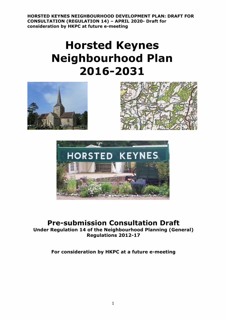
Horsted Keynes Neighbourhood Plan 2016-2031
72
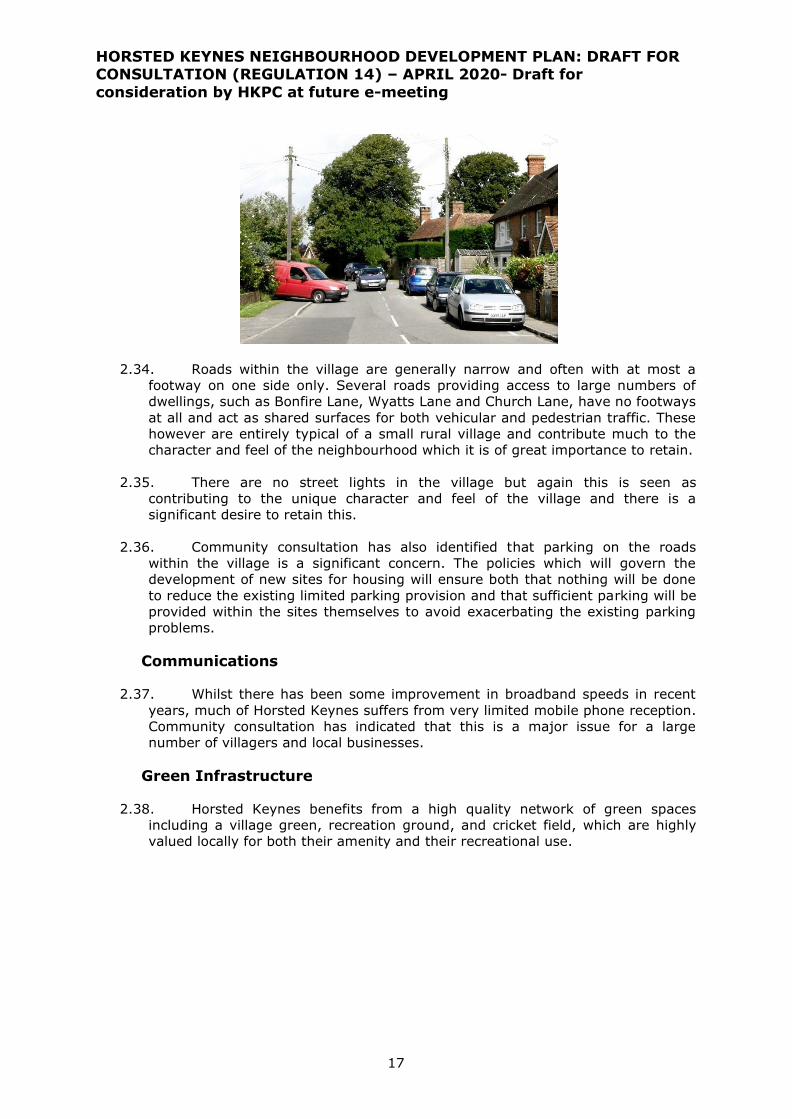
HORSTED KEYNES NEIGHBOURHOOD DEVELOPMENT PLAN: DRAFT FOR CONSULTATION (REGULATION 14) – APRIL 2020- Draft for consideration by HKPC at future e-meeting 1 Horsted Keynes Neighbourhood Plan 2016-2031 Pre-submission Consultation Draft Under Regulation 14 of the Neighbourhood Planning (General) Regulations 2012-17 For consideration by HKPC at a future e-meeting
Transcript of Horsted Keynes Neighbourhood Plan 2016-2031
HORSTED KEYNES NEIGHBOURHOOD DEVELOPMENT PLAN: DRAFT FOR CONSULTATION (REGULATION 14) – APRIL 2020- Draft for
consideration by HKPC at future e-meeting
1
Horsted Keynes
Neighbourhood Plan
2016-2031
Pre-submission Consultation Draft
Under Regulation 14 of the Neighbourhood Planning (General) Regulations 2012-17
For consideration by HKPC at a future e-meeting
HORSTED KEYNES NEIGHBOURHOOD DEVELOPMENT PLAN: DRAFT FOR CONSULTATION (REGULATION 14) – APRIL 2020- Draft for
consideration by HKPC at future e-meeting
2
MAPPING IN THE NEIGHBOURHOOD PLAN
All Ordnance Survey maps are © Crown Copyright. All rights reserved.
Licence Number : 100022432 (MSDC)

HORSTED KEYNES NEIGHBOURHOOD DEVELOPMENT PLAN: DRAFT FOR CONSULTATION (REGULATION 14) – APRIL 2020- Draft for
consideration by HKPC at future e-meeting
3
CONTENT
1 INTRODUCTION .......................................................................................... 5
2 LOCAL CONTEXT ....................................................................................... 11
(a) History of Horsted Keynes ................................................................................. 11
(b) The local environment ....................................................................................... 12
(c) Community Profile .............................................................................................. 13
(d) Local infrastructure ............................................................................................ 14
3 VISION AND OBJECTIVES ...................................................................... 19
Challenges for Horsted Keynes ............................................................................... 19
Vision for Horsted Keynes ....................................................................................... 19
Neighbourhood Plan Objectives .............................................................................. 20
PLANNING POLICIES
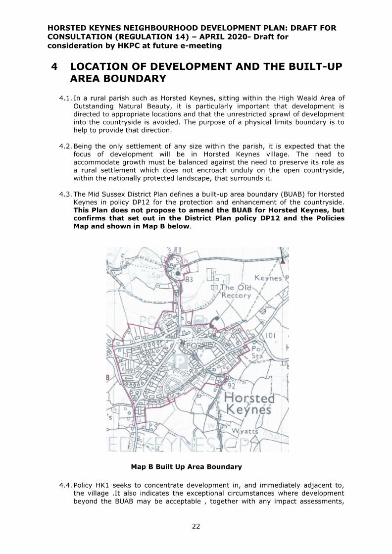
4 LOCATION OF DEVELOPMENT AND BUILT-UP AREA BOUNDARY ... 22
5 HOUSING AND DESIGN OF DEVELOPMENT ......................................... 24
Community-led housing .......................................................................................... 24
Dwelling mix ............................................................................................................. 26
Maintaining local character and ensuring good quality design .............................. 28
Infill development and residential extensions ........................................................ 30
Conserving local heritage ………………………………………………………………………………………… 32
6 ENVIRONMENT AND GREEN SPACE ...................................................... 35
Local Green Spaces ................................................................................................. 37
Protection of landscape and natural habitats ......................................................... 38
Climate change: Sustainable design and renewable energy schemes ................. 42
Flood risk and drainage ........................................................................................... 42
Light pollution .......................................................................................................... 43
7 BUSINESS AND EMPLOYMENT ............................................................... 45
Expansion of existing commercial premises ........................................................... 45
Telecommunications ................................................................................................ 46

HORSTED KEYNES NEIGHBOURHOOD DEVELOPMENT PLAN: DRAFT FOR CONSULTATION (REGULATION 14) – APRIL 2020- Draft for consideration by
HKPC at future e-meeting
4
8 TRANSPORT............................................................................................... 48
Car parking ............................................................................................................... 48
Access by non-vehicular modes ……………………………………………………………………………… 49
9 SITE ALLOCATIONS ................................................................................ 50
10 COMMUNITY ACTION: NON-LAND USE ISSUES AND REVIEW......... 53
11 MONITORING AND PLAN REVIEW ........................................................ 57
12 POLICIES MAPS ........................................................................................ 58
GLOSSARY ......................................................................................................... 60
Appendix A Socio-economic profile
Appendix B Sites put forward by landowners and developers in “call for
sites” to Mid Sussex District Council 2017-19 and outcome of assessment by MSDC
HORSTED KEYNES NEIGHBOURHOOD DEVELOPMENT PLAN: DRAFT FOR CONSULTATION (REGULATION 14) – APRIL 2020- Draft for
consideration by HKPC at future e-meeting
5
1 INTRODUCTION
1.1. This document is the draft Neighbourhood Plan for Horsted Keynes parish. If
“made”, it will form one part of the statutory development plan for the parish
over the period 2016 to 2031, the other parts being the Mid Sussex District Plan
2014-2031, adopted in March 2018, and its related development plan
documents and supplementary planning guidance.
1.2. Mid Sussex District Council (MSDC), as the local planning authority, designated
a Neighbourhood Area for the whole of the Horsted Keynes parish in July 2012
to enable Horsted Keynes Parish Council (HKPC) to prepare the Neighbourhood
Plan. The Plan has been prepared by the community through the Horsted
Keynes Neighbourhood Plan Steering Group (HKNPSG).
1.3. The Horsted Keynes Neighbourhood Plan (HKNP) is being prepared in
accordance with the Town & Country Planning Act 1990, the Planning &
Compulsory Purchase Act 2004, the Localism Act 2011 and the Neighbourhood
Planning Regulations 2012 and 2017 (as amended). The HKNPSG has prepared
the plan to establish a vision for the future of the parish and to set out how that
vision will be realised through planning and controlling land use and
development change over the plan period 2016 to 2031.
1.4. An earlier draft HKNP was submitted to MSDC in November 2017, but was
subsequently withdrawn following advice from the appointed Examiner in June
2018. Towards the end of 2018, HKPC decided to revise and update the plan to
address the issues identified by the Examiner. This document is that revised and
updated HKNP, published for public consultation, prior to consideration of any
views received and then formal re-submission to MSDC.
1.5. The purpose of the Neighbourhood Plan is to guide development within the
parish and provide guidance to any interested parties wishing to submit planning
applications for development within the parish. The process of producing a plan
has sought to involve the community as widely as possible and the different
topic areas are reflective of matters that are of considerable importance to
Horsted Keynes, its residents, businesses and community groups.
1.6. Each section of the plan covers a different topic. Under each heading there is
the justification for the policies presented which provides the necessary
understanding of the policy and what it is seeking to achieve. The policies
themselves are presented in the blue boxes. It is these policies against which
planning applications will be assessed. It is advisable that, in order to
understand the full context for any individual policy, it is read in conjunction
with the supporting text.
1.7. The map below (Map A) shows the boundary of the Neighbourhood Plan area,
which is contiguous with the boundary of Horsted Keynes parish.
1.8. The Horsted Keynes Neighbourhood Plan will be monitored by the local planning
authority and Horsted Keynes Parish Council on an annual basis through the
MSDC Authority Monitoring Report and informed by updates to the five-year
housing supply. The aims and objectives will form the focus of the monitoring
activity, but other data collected or reported at a parish level will also be
included.

HORSTED KEYNES NEIGHBOURHOOD DEVELOPMENT PLAN: DRAFT FOR CONSULTATION (REGULATION 14) – APRIL 2020- Draft for
consideration by HKPC at future e-meeting
6
1.9. The Plan will be reviewed formally on a five-year cycle, or to coincide with a
review of the District Plan, or any other major change in the planning
background necessitating earlier review.
Figure A: Horsted Keynes neighbourhood plan area/parish boundary

HORSTED KEYNES NEIGHBOURHOOD DEVELOPMENT PLAN: DRAFT FOR CONSULTATION (REGULATION 14) – APRIL 2020- Draft for
consideration by HKPC at future e-meeting
7
The planning policy context
1.10. The National Planning Policy Framework (NPPF) (February 2019) seeks to
promote sustainable development through the planning system. It states:
Neighbourhood planning gives communities the power to develop a shared vision
for their area. Neighbourhood plans can shape, direct and help to deliver
sustainable development, by influencing local planning decisions as part of the
statutory development plan. Neighbourhood plans should not promote less
development than set out in the strategic policies for the area, or undermine
those strategic policies* (Paragraph 29).
Once a neighbourhood plan has been brought into force, the policies it contains
take precedence over existing non-strategic policies in a local plan covering the
neighbourhood area, where they are in conflict; unless they are superseded by
strategic or non-strategic policies that are adopted subsequently (Paragraph 30).
[ *Neighbourhood plans must be in general conformity with the strategic policies
contained in any development plan that covers their area ]
Neighbourhood plans must have regard to the national planning policies set out in
the NPPF.
1.11. The Mid Sussex District Plan 2014-2031, adopted by MSDC in March
2018, provides the strategic planning context for this Neighbourhood Plan. The
Plan sets out a vision for how Mid Sussex wants to evolve up to 2031 and a
delivery strategy for how that will be achieved. As such, it sets out broad
guidance on the distribution and quality of development in the form of ‘higher
level’ strategic policies together with policies for the protection and
enhancement of important features of the local environment.
1.12. The District Local Plan’s overall planning strategy for Mid Sussex includes
the overall amount of new residential development up to 2031 and a settlement
hierarchy to indicate how it will be spread across the district. It also identifies
several large-scale strategic development allocations at Burgess Hill (2 sites),
Pease Pottage (1) and Hassocks (1). Allocation of smaller sites is left to the Site
Allocations Development Plan Document (DPD), prepared by MSDC, and/or
Neighbourhood Plans prepared by town and parish councils.
1.13. The Site Allocations DPD was published for public consultation in
October-November 2019 and includes proposals for two housing development
allocations in Horsted Keynes. Views received are currently being assessed by
MSDC. This is considered in more detail in section 9 of this Neighbourhood Plan.
1.14. Mid Sussex District Council adopted three Supplementary Planning
Documents (SPDs) in relation to developer obligations (including
contributions) on 25 July 2018. These documents amplify policies in the District
Plan (particularly DP20 and DP31) and explain how they will be applied in detail.
It is intended to regularly update the documents to ensure they reflect cost
inflation and infrastructure providers’ evolving requirements.

HORSTED KEYNES NEIGHBOURHOOD DEVELOPMENT PLAN: DRAFT FOR CONSULTATION (REGULATION 14) – APRIL 2020- Draft for
consideration by HKPC at future e-meeting
8
• The Development Infrastructure and Contributions SPD sets out the
overall framework for planning obligations. This SPD has been updated
(October 2019) following requests from West Sussex County Council in
relation to new parking guidance, and from the NHS Clinical
Commissioning Group and Sussex Police in relation to their requirements
• The Affordable Housing SPD provides detailed information on the
requirements for on-site and off-site affordable housing provision
• The Development Viability SPD provides information on the viability
assessment process
1.15. The Mid Sussex Design Guide is intended to inform and guide the
quality of design for all development across Mid Sussex District. It sets out a
number of design principles to deliver high quality, new development that
responds appropriately to its context and which is inclusive and sustainable. Mid
Sussex District Council carried out a public consultation for the draft Design
Guide SPD in October – November 2019. Views received are now being
considered by MSDC and, when adopted, the Design Guide will become SPD. Public involvement
1.16. Prior to the Neighbourhood Plan legislation, an informal Horsted Keynes
Village Plan was prepared in 2009 with extensive input from the local
community. Once work began on a Neighbourhood Plan, the Steering Group
(HKNPSG) has carried out extensive community engagement as it has
progressed.
1.17. The community engagement process began in 2012 with two
questionnaire based surveys. The Parish monthly magazine, posters and street
co-ordinators encouraged all villagers to participate. Survey 1 undertaken in
2012 was a Business and Housing Needs survey and Survey 2 undertaken in
2013 covered crucial infrastructure requirements. Response rates were 56%
and 39% respectively. It should be noted that a survey covering similar ground
was done in 2008 in preparation for the 2009 Village Plan and secured a 71%
response. The resultant document provided useful background information for
the Neighbourhood Plan process.
1.18. In 2014, the newly formed steering group re-launched the consultation
process to engage with the community as widely as possible. The steps it took
included the following:
• Monthly meetings of the HKNPSG which parishioners were invited to attend
and to ask questions in an open forum session at the beginning of each
meeting.
• Face to face consultations with St. Giles School, Pre-school and First Steps
groups, involving parents, teachers and children and using aids such as
sticker boards to focus on key issues.
• Similar consultations with other groups such as Women’s institute, Circuit
Training Group, Keep Fit Class, and various clubs, by piggy-backing on
scheduled meetings.
• Use of the Parish website and Parish magazine to invite comment on key
drafts of the Plan as they emerged such as the Vision Statement, Plan
Objectives and Plan Policies.
• Use of social media sites Facebook and Twitter to encourage younger
members of the community to have their say.
• Attendance at occasions already in the village events’ calendar such as the
HORSTED KEYNES NEIGHBOURHOOD DEVELOPMENT PLAN: DRAFT FOR CONSULTATION (REGULATION 14) – APRIL 2020- Draft for
consideration by HKPC at future e-meeting
9
Christmas card charity event with suitable consultation materials.
• Arranging special events such as weekends-outside-shop.
• Organising a community engagement event in the Village Hall in January
2015, using street co-ordinators to post invitations to every household. At
this event, land allocations proposed for housing developments or other
community benefits were displayed in the main hall with maps and other
material to help villagers understand and comment on this key aspect of the
draft Plan, and refreshments were served in the small hall. Steering Group
members were available to answer questions and make a note of comments.
1.19. It was recognised that more direct engagement with the community was
necessary in order to explain more about the background to the process and,
most importantly, to seek the views of parishioners on sites under consideration.
To this end a series of 10 workshops each lasting 2 hours was held in September
2015. Groups of 8-10 villagers were able to discuss each potential development
site in turn, ask questions and express their views. Each group was facilitated
by a member of HKNPSG and had a scribe to note the major points which arose.
Attendees recorded their views per site in a structured questionnaire. They were
invited to say whether the site was suitable for allocation and if so how many
dwellings would be acceptable. In total 170 residents attended a workshop and
questionnaires were returned by 126 people.
1.20. Following the workshops villagers had further opportunities to make their
views known at monthly meetings of the HKNPSG and HKPC and via email. A
petition was also received, signed by 141 residents, almost all of whom lived in
the Hamsland area of the village. Face-to-face conversations also took place
with local businesses to assess their needs and concerns, and following
responses to the formal land call, opportunities were offered to landowners
putting forward parcels of land for housing or other development to discuss the
ways in which their proposals would contribute to the Plan objectives.
1.21. Pre-submission consultation under Regulation 14 of the Neighbourhood
Plan Regulations was carried out in April and May 2016. The draft plan was
extensively publicised in the parish and a large number of statutory and other
consultees were invited to comment on the draft plan documents. This attracted
111 representations, many of which focused on the overall amount of dwellings
to be provided and the sites which should be allocated for housing development.
This led to further discussion and consultation later in 2016 and into 2017. The
Neighbourhood Plan was submitted to MSDC in November 2017 (Regulation 15).
1.22. MSDC arranged statutory consultation on the submitted plan (Regulation
16) between 7 December 2017 and 1 February 2018, which attracted further
representations which were forwarded to the Examiner appointed by MASC in
May 2018. As indicated earlier, the Examiner recommended withdrawal of the
submitted HKLP in June 2018.

HORSTED KEYNES NEIGHBOURHOOD DEVELOPMENT PLAN: DRAFT FOR CONSULTATION (REGULATION 14) – APRIL 2020- Draft for
consideration by HKPC at future e-meeting
10
1.23. Following withdrawal, the Parish Council has sought to address the issues
raised by the Examiner and has prepared a report to update the evidence
supporting the plan, and the planning background against which it has been
prepared .This report is also available to the public as part of the current
consultation on the draft HKNP. This updating work included a public meeting of
the Parish Council in May 2019 to outline progress in work on a revised HKNP
and an ongoing assessment of potential housing development sites. There has
also been technical liaison with landowners and with key consultees such as
MSDC, WSCC Highways and the High Weald AONB Unit.
1.24. A further housing needs survey was also carried out in the parish in
spring 2019.

HORSTED KEYNES NEIGHBOURHOOD DEVELOPMENT PLAN: DRAFT FOR CONSULTATION (REGULATION 14) – APRIL 2020- Draft for
consideration by HKPC at future e-meeting
11
2 LOCAL CONTEXT
(a) History of Horsted Keynes
2.1. A village existed here in Saxon times - it was called Horsted. After the Norman
Conquest, William the Conqueror gave the Rape of Pevensey in which Horsted
lay to his half-brother, Robert de Mortain, and he in turn gave the Manor of
Horsted to one of his henchmen, William de Cahaignes. The village became
known as Horsted de Cahaignes, a name which over the centuries has evolved
into the present Horsted Keynes.
2.2. The people who lived in the Saxon village raised crops and kept cattle and, to
judge by the name of the village - Horsted meant 'a place for horses' - were
renowned for breeding horses. Starting in the 13th century and continuing into
the 18th, the village was at the centre of the Sussex iron industry, as the
hammer ponds to the north-west testify. While some villagers still work on the
land, most find employment in the nearby towns of Haywards Heath, Crawley
and East Grinstead or use commuter services connecting Brighton and London.
2.3. The railway came to Horsted Keynes in 1882, and a station was built a mile
north-west of the village. British Railways ran trains through there until 1963
when the line from London was terminated at East Grinstead. Since then,
however, the famous Bluebell Railway was formed to take over part of the line,
and it now runs restored steam trains from East Grinstead seven miles to the
north via Horsted Keynes to Sheffield Park five miles to the south. This
enterprise has brought many tourists to the village, which is also a popular
centre for cycling clubs and walkers as the Sussex border path runs through the
village. To the north of the village is a small business park, and to the south the
High Weald Diary which produces cheeses of international repute and the

HORSTED KEYNES NEIGHBOURHOOD DEVELOPMENT PLAN: DRAFT FOR CONSULTATION (REGULATION 14) – APRIL 2020- Draft for
consideration by HKPC at future e-meeting
12
Freshfield Lane Brickworks. In addition, many small businesses are run by
villagers from home premises.
2.4. The village's history is reflected in some of its buildings, the oldest building being
the parish Church of St Giles, dating back to the 11th century which itself was
built on the earlier site of a Saxon church. Next to the church is St Giles Church
of England Primary School which caters for around 120 children. The village also
has a pre-school. One of the village's two pubs, The Crown, has been an inn for
more than 250 years and the oldest parts of the building date back to around
1600.
2.5. The centre of the today's village has a general store, and is fortunate in having
two playing fields for cricket and football, an enclosed playground for young
children, and a tennis club. There is a third recreation ground on the southern
edge of the village. Many other clubs and activities flourish in the Village Hall, the
Village Club, and the Martindale Centre.
2.6. Since World War II, in-filling and new developments have meant that the village
has substantially increased in size and, with its mixture of architecture from
Elizabethan to present day styles, it has considerable charm. Not surprisingly,
many retired people enjoy the peace and quiet of Horsted Keynes and on the
road to Birch Grove is the Abbeyfield retirement home, Westall House.
(b) The local environment
2.7. The parish has two conservation areas in Horsted Keynes village and at Birch
Grove. There are 54 listed buildings within the parish, including the Parish
Church of St. Giles (Grade 1) and 53 Grade 2 buildings.
2.8. Horsted Keynes lies entirely within the High Weald Area of Outstanding Natural
Beauty (AONB), a designation which reflects the national importance of this area,
which is described by the AONB Partnership as a “medieval landscape of wooded,
rolling hills studded with sandstone outcrops; small, irregular-shaped fields;
scattered farmsteads; and ancient route ways”.
2.9. The Ashdown Forest is located immediately adjacent to the north-eastern
boundary of the parish within Wealden District. It is designated as a Special Area
of Conservation (SAC) due to its important and rare lowland heathland habitats
and a Special Protection Area (SPA) due to the presence of rare ground nesting
birds such as breeding Nightjars and Dartford Warbler. It forms part of the

HORSTED KEYNES NEIGHBOURHOOD DEVELOPMENT PLAN: DRAFT FOR CONSULTATION (REGULATION 14) – APRIL 2020- Draft for
consideration by HKPC at future e-meeting
13
Natura 2000 network of important nature conservation sites across the European
Union.
2.10. Following consultation with Natural England, Mid Sussex District Council
carried out a Habitats Regulations Assessment (HRA) to test whether the Mid
Sussex District Plan, in combination with other plans and projects, was likely to
have an adverse effect on the integrity of Ashdown Forest. The HRA report on the
District Plan concludes that new housing development close to Ashdown Forest is
likely to increase the number of visitors to the Forest. Such visitors could
increase disturbance to rare, ground-nesting bird populations (in particular the
Dartford Warbler and the Nightjar). The ‘Ashdown Forest Visitor Survey Data
Analysis’ published in September 2010 found that most visitors to the Forest live
within 7km of its boundaries (straight line distance). The HRA therefore identified
a 7km ‘zone of influence’ within which new housing developments must counter its
effect by putting in place measures which reduce visitor pressure.
2.11. All the land in the Neighbourhood Plan area lies within the 7km zone of
influence, and therefore new residential development proposed in the Plan must
have due regard to the Habitats Regulations. The proposed approach set out in
the Mid Sussex District Plan includes providing Suitable Alternative Natural
Greenspace Sites (SANGs) and Strategic Access Management and Monitoring
(SAMM) measures on Ashdown Forest itself in policy DP17.
2.12. SANGs are sites that cater for the recreational needs of communities in
order to reduce the likelihood of visitor pressure and disturbance on important
nature conservation areas. Developer contributions will be required towards the
provision of SANGs and the criteria for a site to be suitable as a SANG site is set
out on the Mid Sussex District Council website (www.midsussex.gov.uk). A
strategic SANG site has been provided at East Grinstead.
2.13. The District Council is responsible for deciding how developer contributions
towards the provision of SANGs and SAMM will be calculated and delivered.
2.14. The HRA of the Mid Sussex District Plan also assessed the impact of
nitrogen deposition on the Ashdown Forest SAC. This included development
proposed through the Neighbourhood Plan. The conclusion of the HRA was that
there would be no likely significant effects on the Ashdown Forest SAC from the
policies in the Neighbourhood Plan.
(c) Community Profile
2.15. The socio-economic profile1 of the Horsted Keynes community is as
follows:
• There are a low proportion of young families, but a high number of people
either approaching or having already reached retirement age. In short, the
population is ageing.
• Growth in population has been below the district average, reflective of Horsted
Keynes’s role in the district as a small rural settlement. This growth has been
in those of retirement age. Horsted Keynes is a community that is increasingly
living in smaller households.
• Economic activity is below the district and regional averages, due to the high
proportion of retirees (who are classed as economically inactive). There is a
1 This is based on the 2011 Census

HORSTED KEYNES NEIGHBOURHOOD DEVELOPMENT PLAN: DRAFT FOR CONSULTATION (REGULATION 14) – APRIL 2020- Draft for
consideration by HKPC at future e-meeting
14
high proportion of people working for themselves, from their own homes.
• The proportion employed in financial, real estate, communication and IT
services – strong growth sectors nationally - is comparatively high. By
contrast, the proportion employed in traditionally lower paying sectors such as
retail is low. This is reinforced by the high proportion of highly educated people.
• A large majority of employees travel to work by car, and do so as the driver of
that car. Interestingly, this is slightly below the district average. The numbers
of people that travel to work on foot or by bicycle is low, highlighting the
limited number of job opportunities that are available locally. Car ownership
and dependence is correspondingly high.
2.16. Horsted Keynes is dominated by detached housing, representing nearly
50% of its housing stock. There is a very high proportion of 4 and 5 bed
properties compared to the district. By contrast, the proportion of 3 and
particularly 2 bed properties is much lower. Given the growing proportion of
smaller households in Horsted Keynes, there is a potential mismatch between
the supply of properties (which are large) and the needs of households (which
are for smaller properties).
2.17. The North West Sussex Strategic Housing Market Assessment (SHMA)
Update2 was published in 2014. This highlighted that affordability is a significant
issue with over 44% of households in Mid Sussex District unable to rent or buy a
property without assistance.
2.18. For affordable housing, the predominant need in the district is for 1 and 2
bed housing, accounting for 87% of all needs. In Horsted Keynes parish, the
picture is even starker. Just taking evidence from the housing register shows
that in January 2020, there was a total of 15 households on the register with a
local connection, with of these having Horsted Keynes as their first choice. 11 of
these households were seeking 1 bed dwellings, 3 were seeking 2 bed dwellings
and 1 a 3 bed dwelling.
2.19. A fresh Housing Needs Survey was carried out in spring 2019 and
published in October 2019. This identified 24 households in housing need, with
one-bedroomed housing for rent being the most common housing need.
(d) Local infrastructure
School
2.20. St Giles Church of England (Aided) Primary School is a small village school
situated in a lovely rural location next to the church of St Giles, with which it has
very close links. The school has played an important part in village life for over
300 years. Horsted Keynes is a thriving, vibrant community and the school is
proud to be at the heart of it, contributing and helping to sustain the village into
the future.
2.21. The school has approximately 100 pupils on roll aged between 4 and 11.
The capacity, designated by West Sussex County Council, is 146. Pupils are
taught in mixed age groups spread across 4 classes.
2 Chilmark Consulting (2014) Northern West Sussex Housing Market Area – Affordable Housing
Needs Model Update, for Horsham District Council, Crawley Borough Council and Mid Sussex
District Council

HORSTED KEYNES NEIGHBOURHOOD DEVELOPMENT PLAN: DRAFT FOR CONSULTATION (REGULATION 14) – APRIL 2020- Draft for
consideration by HKPC at future e-meeting
15
2.22. Recently the school has been rate ‘Good’ by the SIAMS (Statutory
Inspection for Anglican and Methodist Schools) and Ofsted, both commenting on
the strong community links and caring, nurturing ethos. In 2019 67% of pupils
attending the school live within the parish, with the remaining pupils drawn from
the wider locality.
Public Transport
2.23. The village is served by the No. 270 Metrobus service which runs from
East Grinstead to Brighton and connects many of the villages along the way. It
operates hourly from Monday to Saturday providing a connection to Haywards
Heath station, the main strategic connection to the rail network, which takes
approximately 20 minutes. There is a more restricted service on Sundays and
Bank Holidays, with 4 journeys in each direction. Given the service times, it is
mainly used by students and retirees.
2.24. Consultation with the community has demonstrated that the bus service is
highly valued and villagers would welcome its development, particularly in terms
of an extended service in the evenings and more Sunday services.
2.25. The Bluebell Railway is a heritage line between Sheffield Park and East
Grinstead, where it now links into the Southern Railway network. There is a
station at Horsted Keynes, approximately 1.5 km to the north-west of the
village.
Shop
2.26. Horsted Keynes Store is a general purpose retail outlet selling groceries,
greengroceries, fresh dairy produce, wine and spirits, newspapers and some
household supplies. It is well patronised by many in the village and also attracts
custom from adjacent villages without such facilities. It is very highly valued by
the community and considered to be of great importance to the village.
2.27. No information has been obtained as to the viability of the existing
business but, as with all such small retail outlets, it is vulnerable to competition
from larger stores who are often able to offer a wider range of goods at lower
prices. There are many such larger outlets within reasonable driving distance of
Horsted Keynes and, given the high level of car ownership, these are accessible
to the majority of villagers. Some of them make home deliveries.
2.28. The shop premises occupy the lower storey of a two storey semi-detached
building with the upper storey being the owner’s living accommodation. The
owner has not indicated that he is considering retirement in the near future, or
the disposal or conversion of the business, but it is likely that the building would

HORSTED KEYNES NEIGHBOURHOOD DEVELOPMENT PLAN: DRAFT FOR CONSULTATION (REGULATION 14) – APRIL 2020- Draft for
consideration by HKPC at future e-meeting
16
be more valuable as a dwelling than as a shop. Concerns do therefore exist as to
its long term operation and, as it is such an important facility for the village,
contingency plans should be developed for when the present owner decides to
retire. One possibility is the listing of the premises as an Asset of Community
Value.
2.29. The permanent village post office closed in 2014, but there is now a
mobile “outreach” post office (run by Sharpethorne PO) twice a week.
Public Houses
2.30. The village enjoys the benefits of three licensed premises close to the
village centre:
• the Green Man, a typical village pub serving pub food
• the Crown, a pub with rooms serving higher end gourmet food
• the Horsted Club, serving drinks only.
2.31. All three are important institutions within the village and are highly valued
as social centres and meeting places, and as providers of local employment. The
first two in particular are important in attracting visitors to the village and
helping to support the other village facilities.
Healthcare Facilities
2.32. No healthcare facilities are provided within the village and residents must
seek primary health care (GP) services from the adjacent villages and towns of
Lindfield, Forest Row, Haywards Heath and East Grinstead. Given the high level
of car ownership in the village as a whole this does not cause significant
problems for the majority of residents, with those unable to drive supported by a
volunteer car service.
Highways
2.33. Horsted Keynes is fortunate that it does not lie on a major access road
between significant urban areas and that traffic passing through the village
remains relatively light compared with some nearby villages of equivalent size
such as West Hoathly and Ardingly. Nevertheless, community consultation has
indicated that traffic volumes and speeds are still perceived as a significant
problem amongst many in the village. This is seen as a particular issue in
relation to children walking to school and having to cross the main road through
the village at Burn Lane.
HORSTED KEYNES NEIGHBOURHOOD DEVELOPMENT PLAN: DRAFT FOR CONSULTATION (REGULATION 14) – APRIL 2020- Draft for
consideration by HKPC at future e-meeting
17
2.34. Roads within the village are generally narrow and often with at most a
footway on one side only. Several roads providing access to large numbers of
dwellings, such as Bonfire Lane, Wyatts Lane and Church Lane, have no footways
at all and act as shared surfaces for both vehicular and pedestrian traffic. These
however are entirely typical of a small rural village and contribute much to the
character and feel of the neighbourhood which it is of great importance to retain.
2.35. There are no street lights in the village but again this is seen as
contributing to the unique character and feel of the village and there is a
significant desire to retain this.
2.36. Community consultation has also identified that parking on the roads
within the village is a significant concern. The policies which will govern the
development of new sites for housing will ensure both that nothing will be done
to reduce the existing limited parking provision and that sufficient parking will be
provided within the sites themselves to avoid exacerbating the existing parking
problems.
Communications
2.37. Whilst there has been some improvement in broadband speeds in recent
years, much of Horsted Keynes suffers from very limited mobile phone reception.
Community consultation has indicated that this is a major issue for a large
number of villagers and local businesses.
Green Infrastructure
2.38. Horsted Keynes benefits from a high quality network of green spaces
including a village green, recreation ground, and cricket field, which are highly
valued locally for both their amenity and their recreational use.

HORSTED KEYNES NEIGHBOURHOOD DEVELOPMENT PLAN: DRAFT FOR CONSULTATION (REGULATION 14) – APRIL 2020- Draft for
consideration by HKPC at future e-meeting
18

HORSTED KEYNES NEIGHBOURHOOD DEVELOPMENT PLAN: DRAFT FOR CONSULTATION (REGULATION 14) – APRIL 2020- Draft for
consideration by HKPC at future e-meeting
19
3 VISION AND OBJECTIVES
Challenges for Horsted Keynes
3.1. The Neighbourhood Plan seeks to address, as far as is possible, the challenges
that face the community of Horsted Keynes parish. In summary these challenges
are:
• The importance of retaining Horsted Keynes’s special character and identity as
a small historic village set within an Area of Outstanding Natural Beauty (the
High Weald), where the landscape is of national significance. This must
balance the need to provide for the changing population without compromising
its distinct rural identity, set around a village green with a network of green
spaces and attractive views out to rolling, wooded, countryside.
• An ageing population that has particular demands in terms of their
accessibility to services and appropriate recreational facilities.
• A limited number of local services and facilities, some of which are under
threat. The loss in 2014 of the Post Office is a particular example.
• Trying to provide some local employment so that not everyone who wants to
access a job has to travel outside the parish (particularly to Hayward Heath
and Burgess Hill) to do so. The growing trend of home working provides an
opportunity, but telecommunications need to be improved.
• The importance of retaining the bus service as the only means of travelling
outside of the parish without a car.
• The wider role that the community of Horsted Keynes needs to play in
addressing climate change by reducing energy consumption and providing the
opportunity for local sustainable energy generation.
Vision for Horsted Keynes
3.2. In consultation with the community, the established vision for Horsted Keynes is
as follows:
‘In 2031 Horsted Keynes remains an attractive rural village, centred on the
village green, and is a desirable place to live, work and visit.
It has a thriving local economy and is able to sustain sufficient essential
services and facilities to meet most local needs. Homes are available for all
stages of life and circumstances and there is a strong sense of local
community which contributes to low levels of crime.
Development has taken place in a sustainable way, at a scale and form that
preserves the distinctive rural character, landscape and community ethos.’

HORSTED KEYNES NEIGHBOURHOOD DEVELOPMENT PLAN: DRAFT FOR CONSULTATION (REGULATION 14) – APRIL 2020- Draft for
consideration by HKPC at future e-meeting
20
Neighbourhood Plan Objectives
3.3. The objectives of the Neighbourhood Plan as identified through engagement with
the community are as follows:
1. Conserve and enhance the environment of the village in order to
maintain its distinct rural identity, built heritage and outstanding
landscape setting.
2. Maintain and enhance existing, and establish new, local services
and facilities.
3. Meet Horsted Keynes’s local housing needs over the plan period
with emphasis on housing that addresses the needs of younger
people and families to help maintain the village age profile.
4. Support local businesses and provide enhanced employment
opportunities within the parish including home working.
5. Reduce the negative impacts of traffic and roadside parking on the
village and encourage safe walking and cycling.
6. Minimise the adverse environmental effects of new development
and support energy reduction and sustainable energy opportunities
for the whole village, in order to mitigate, and adapt to, climate
change.

HORSTED KEYNES NEIGHBOURHOOD DEVELOPMENT PLAN: DRAFT FOR CONSULTATION (REGULATION 14) – APRIL 2020- Draft for
consideration by HKPC at future e-meeting
21
NEIGHBOURHOOD
PLAN POLICIES
CHAPTERS 4-9
4. Location of Development and Built Up Area Boundary
5. Housing and Design of Development
6. Environment and Green Space
7. Business development
8. Transport
9. Site Allocations
HORSTED KEYNES NEIGHBOURHOOD DEVELOPMENT PLAN: DRAFT FOR CONSULTATION (REGULATION 14) – APRIL 2020- Draft for
consideration by HKPC at future e-meeting
22
4 LOCATION OF DEVELOPMENT AND THE BUILT-UP
AREA BOUNDARY
4.1. In a rural parish such as Horsted Keynes, sitting within the High Weald Area of
Outstanding Natural Beauty, it is particularly important that development is
directed to appropriate locations and that the unrestricted sprawl of development
into the countryside is avoided. The purpose of a physical limits boundary is to
help to provide that direction.
4.2. Being the only settlement of any size within the parish, it is expected that the
focus of development will be in Horsted Keynes village. The need to
accommodate growth must be balanced against the need to preserve its role as
a rural settlement which does not encroach unduly on the open countryside,
within the nationally protected landscape, that surrounds it.
4.3. The Mid Sussex District Plan defines a built-up area boundary (BUAB) for Horsted
Keynes in policy DP12 for the protection and enhancement of the countryside.
This Plan does not propose to amend the BUAB for Horsted Keynes, but
confirms that set out in the District Plan policy DP12 and the Policies
Map and shown in Map B below.
Map B Built Up Area Boundary
4.4. Policy HK1 seeks to concentrate development in, and immediately adjacent to,
the village .It also indicates the exceptional circumstances where development
beyond the BUAB may be acceptable , together with any impact assessments,

HORSTED KEYNES NEIGHBOURHOOD DEVELOPMENT PLAN: DRAFT FOR CONSULTATION (REGULATION 14) – APRIL 2020- Draft for
consideration by HKPC at future e-meeting
23
and management and mitigation measures, necessary to ensure that ensure that
they are accommodated without undue harm.
POLICY HK1: LOCATION OF NEW DEVELOPMENT
New development in Horsted Keynes parish will be focused within the built-up
area boundary (BUAB) of Horsted Keynes village as identified on the Policies
Map, in order to promote sustainable development of the village and to
safeguard the nationally important landscape of the High Weald AONB. Any
infilling or redevelopment within the BUAB should be of an appropriate scale and
nature and not harm the character and function of the village.
Development proposals beyond the built-up area boundary will only be
permitted where:
• they comprise housing development proposals allocations in the Site
Allocations DPD (sites SA 28 and SA 29) which will be incorporated into the
BUAB when that plan is formally adopted, or
• they comply with policy DP6 of the Mid Sussex District Plan , with a proposed
development for fewer than 10 dwellings and are contiguous with the existing
BUAB, or
• they relate to necessary utilities infrastructure and where no reasonable
alternative location is available, or
• they comply with other policies in this Neighbourhood Plan in particular those
relating to community-led housing (policy HK2), dwelling extensions (Policy
HK4) , Protection of the High Weald AONB ( policy HK8) and expansion of
business premises (policy HK12).
In all cases, the proposed development should demonstrate that it has an
acceptable impact on the landscape, supported by an assessment of the
environmental and visual impact of the proposals, particularly the impact on the
High Weald AONB, and include appropriate mitigation measures as necessary.
Proposals should also be supported by a robust assessment of the impact of the
proposal on the local highway network and include appropriate mitigation
measures secure the safe, free flow of traffic, as necessary.
Any proposal causing a significant impact on the Ashdown Forest SPA and SAC
should consider appropriate avoidance, management and mitigation measures
in accordance with District Plan policy DP17.

HORSTED KEYNES NEIGHBOURHOOD DEVELOPMENT PLAN: DRAFT FOR CONSULTATION (REGULATION 14) – APRIL 2020- Draft for
consideration by HKPC at future e-meeting
24
5 HOUSING AND DESIGN OF DEVELOPMENT
5.1. Horsted Keynes is a desirable and attractive place to live, a traditional Sussex
village within the High Weald AONB, surrounded by farmland, woodland and
open countryside. It provides road access to the surrounding towns, travel hubs
and employment opportunities.
5.2. Opportunities for additional housing supply are extremely constrained due to the
surrounding AONB, the conservation area and a limited number of suitable infill
sites within the current built up area boundary.
5.3. Consultation on the plan shows a strong community desire to maintain the scale,
style and setting of housing development in the parish and to protect the
surrounding countryside from inappropriate development. At the same time,
local residents are keen to ensure that, as far as possible, any new housing
meets local community needs and that community cohesion is reinforced by
reducing the need for local people to move away to find the housing they need.
These aims can be secured by planning policies to promote community-led
housing; to achieve a dwelling mix which more closely reflects local housing
needs; and promoting good quality design which is in harmony with this rural
location
Community-led housing
5.4. Work on the Neighbourhood Plan has shown very strong support for new housing
development which is specifically designed and maintained to meet local housing
needs. This can help to build a more sustainable and balanced community,
where people can find the accommodation they need in a place to which they
have strong social or economic connections, on terms they can afford. A
Housing Needs Survey was carried out in the parish in spring 2019. The survey
identified 24 households as being in housing need, most of whom are single
person households, requiring housing for rent. This level of need is likely to be a
minimum, as the survey did not get a response from all households in the parish.
5.5. Local authorities are advised to ensure that they plan for self-build and custom
build development and grant sufficient suitable planning permissions based on
their self and custom build register. Such development can be provided either
as a part of any housing allocations made for Horsted Keynes in the MSDC Site
Allocations DPD or in this Neighbourhood Plan, or on suitable unallocated windfall
sites, but 30% affordable housing (which can take the form of shared ownership
self or custom build and/or affordable rent self or custom build) will be required,

HORSTED KEYNES NEIGHBOURHOOD DEVELOPMENT PLAN: DRAFT FOR CONSULTATION (REGULATION 14) – APRIL 2020- Draft for
consideration by HKPC at future e-meeting
25
if the total number of units to be provided is above the affordable housing
threshold.
5.6. In its policy DP31, the District Plan 2014-2031 requires provision of a minimum
of 30% on-site affordable housing for all developments providing 11 or more
dwellings (or which have a combined gross floor space of more than 1000 square
metres irrespective of the number of units) and a commuted payment to cover
equivalent off-site provision for developments of 6-10 dwellings (which do not
have a gross floor space of more than 1000 square metres) in the High Weald
AONB. Where this policy applies, MSDC will require the right to nominate
occupiers of any affordable housing delivered through the policy from the
Council’s Housing Register. The process will use a cascading principle, which
gives priority on first lettings to people living or working in the parish. All sites
above these thresholds normally need to meet MSDC’s tenure mix of 75%
affordable rent /25% shared ownership, unless evidence supports a different
mix. The housing development allocations in MSDC’s Site Allocations Plan - on
land to the south of The Old Police House and south of St Stephens Church –
would be subject to these requirements
5.7. There are other mechanisms by which community-led housing can be delivered.
These include “rural exceptions” housing, neighbourhood development orders or
community right to build orders, or individual planning applications on suitable
sites. Policy DP32 of the District Plan 2014-2031 sets out requirements for “Rural
Exception Sites” These are sites used for the development of affordable housing
for local people in perpetuity, which would not normally be granted permission
for housing because they lie beyond the built confines of a village. Rural
Exception Sites seek to address the needs of the local community by
accommodating in perpetuity households who are either current residents or who
have an existing family or employment connection with the parish.
5.8. The Localism Act 2011 also provides scope for local people – through their Parish
Council as part of the neighbourhood planning process - to develop proposals for
community-led development for housing and community facilities through
Neighbourhood Development Orders or Community Right to Build Orders. These
have the effect of granting planning permission for a specific development, or
type of development, but must be the subject of extensive local consultation and
a public referendum. Such Orders are not being proposed at the present time.
5.9. It is also open to any community-led housing organisation, or registered social
landlord, to make a planning application for a housing development to meet local
needs. Such proposals would be considered in the normal way against all
relevant planning policies and other material planning considerations. A Horsted
Keynes Community Land Trust (CLT) is currently being formed. The CLT will be
a permanent organisation which can own and maintain the assets in the parish,
for the benefit of the parish. It has expressed a particular interest in providing,
owning and running community-led housing in Horsted Keynes.
5.10. Any planning permissions for community-led housing on non-allocated
sites would contribute to meeting the minimum requirement of 69 dwelllings in
the parish of Horsted Keynes over the period 2014-2031, as set out in policy DP6
of the Mid Sussex District Plan.

HORSTED KEYNES NEIGHBOURHOOD DEVELOPMENT PLAN: DRAFT FOR CONSULTATION (REGULATION 14) – APRIL 2020- Draft for
consideration by HKPC at future e-meeting
26
POLICY HK2: COMMUNITY –LED HOUSING
Proposals for 100% community-led housing development will be supported on
suitable sites within, or - if for less than 10 units - contiguous with, the built-up
boundary of Horsted Keynes village, where they:
(a) meet a specific identified local housing need in the parish, based on the
latest available information from the Council’s Housing Register or the
Horsted Keynes Housing Needs Survey 2019 and are for shared ownership
or shared equity and/or affordable or social rent, normally in the
proportion 75% social or affordable rented homes and 25% intermediate
shared ownership homes; and
(b) are to be developed by, or for, a community -led housing organisation or,
failing that, a Registered Provider, and are to be maintained by them as
social housing in perpetuity; and
(c) are designed to be as sustainable as possible, with an emphasis on
features which allow the development to be well integrated into the village
and the High Weald landscape, which benefit the environment and
demonstrate adaptability to climate change, and which minimise running
costs for occupiers; and
(d) comply with all other relevant national planning policy guidance and with
relevant policies of the Mid Sussex District Plan 2014-2031 (particularly
DP17, DP31 and DP32), the MSDC Affordable Housing SPD and this
Neighbourhood Plan.
Dwelling mix
5.11. The analysis in Section 2 showed that Horsted Keynes has a very high
proportion of 4 and 5 bed properties compared to the district or the South East
as a whole. By contrast, the proportion of 3 and particularly 2 bed properties is
much lower. Given the growing proportion of smaller households in Horsted
Keynes, there is a potential mismatch between the supply of properties (which
are mainly large) and the needs of households (which are mainly for smaller
properties).
5.12. Over the plan period, this trend is likely to continue, with Horsted Keynes
having a significantly above-average proportion of people in the 45-64 age
bracket, i.e. approaching retirement. In the Neighbourhood Plan survey, 42% of
households that responded had at least one person intending to retire over the
plan period.
5.13. It is expected therefore that the demand for smaller properties –
particularly by those currently living in large family properties in Horsted Keynes
now looking to downsize since children have grown up and moved out – will be
significant. In the Neighbourhood Plan survey, 50% of respondents said that
they would consider downsizing if a suitable low maintenance, energy efficient
property was available. Most importantly, 94% of respondents said that they
intended to stay living in Horsted Keynes on retirement.
5.14. The North West Sussex SHMA (2009 and updated 2012 /2014)
recommends that for affordable housing in Mid Sussex, a range of dwelling sizes

HORSTED KEYNES NEIGHBOURHOOD DEVELOPMENT PLAN: DRAFT FOR CONSULTATION (REGULATION 14) – APRIL 2020- Draft for
consideration by HKPC at future e-meeting
27
should be secured through policy that provide the following split3:
• 1 bed: 25%
• 2 bed: 50%
• 3 bed: 20%
• 4+ bed: 5%
5.15. The SHMA does recommend that, when seeking to establish broad
requirements for different types and sizes of new market housing, this should take
account of existing pressures and market signals of shortage. Evidence of sold
property prices shows that, for the RH17 postcode that contains Horsted Keynes
(and covers the rural area surrounding Haywards Heath and Burgess Hill), the
median property price over the year to June 2015 was £490,400. Just looking at
smaller terraced and semi-detached properties, the median prices were £374,400
and £380,300 respectively4. As a first-time buyer, in order to secure a mortgage
on such properties, assuming a 10% deposit, a single person would need an
annual income of £96,275 and a couple, a joint income of £134,7805. This is
clearly out of the reach of almost all first-time buyers. House prices have risen
even further since 2015.
5.16. The most recent evidence, provided by the Horsted Keynes Housing Needs
Survey 2019, also identified that the overwhelming majority of the households
who need affordable housing (87.5% of the 24 households) require one-bedroom
properties. This reflects the high proportion of single adult and adult couple
households, who represent the vast bulk of those identified as being in housing
need.
5.17. This above evidence, combined with the evidence from the local
community, collectively demonstrates that - as well as a need for smaller,
particularly one-bed, properties for rent - there is a need for a greater number of
smaller dwellings at an affordable price for first- time buyers, young and growing
families and older residents wishing to downsize in Horsted Keynes. Indeed, the
provision of a larger supply of smaller units may help to reduce the price and
make entry-level housing more affordable in Horsted Keynes. This is reflected in
Policies HK2 and HK3.
POLICY HK3: DWELLING MIX
Residential developments of over five dwellings should provide a mix of dwelling
sizes (market and affordable) that reflect the most up-to-date local housing need
evidence.
The exact tenure, type and size split on each site can be advised through pre-
application discussions, but it is likely to be approximately:
▪ 40%- 1 bed/2 person
▪ 40%- 2 bed/4 person
▪ 20%- 3 bed/5 person
3 Chilmark Consulting (2014) Northern West Sussex Housing Market Area – Affordable Housing
Needs Model Update for Horsham District Council, Crawley Borough Council and Mid Sussex District Council, Table 17 4 Source: www.home.co.uk 5 This assumes that a single person could borrow 3.5 times their salary and a couple could borrow
2.5 times their joint salary.

HORSTED KEYNES NEIGHBOURHOOD DEVELOPMENT PLAN: DRAFT FOR CONSULTATION (REGULATION 14) – APRIL 2020- Draft for
consideration by HKPC at future e-meeting
28
This mix is based on a blend of the information included in the Strategic Housing
Market Assessment (2009 and updates), MSDC Affordable Housing SPD (2018),
the Horsted Keynes Local Housing Needs Survey (2019) and the Common
Housing Register (January 2020).
Maintaining local character and ensuring good quality
design
5.18. Consultations have shown that residents want Horsted Keynes to retain its
strong identity as a village and that its character should not be harmed by
inappropriate new development. The appearance of the village today reflects its
history as a long standing community dating back to before the 11th century and
contains, in close proximity, buildings of both historic and contemporary
character. This diversity in building styles contributes greatly to the character of
Horsted Keynes and it is important that this diversity is retained when new
development is planned.
5.19. A major part of the village is subject to conservation area status and
contains a number of historic buildings dating back to the 17th and 18th
centuries and others listed as being of architectural or historical importance. Any
development must recognise the significance of the village and its rural setting,
and respect its unique character.
5.20. The NPPF (February 2019) states:
The creation of high quality buildings and places is fundamental to what the
planning and development process should achieve. Good design is a key aspect of
sustainable development, creates better places in which to live and work and
helps make development acceptable to communities. Being clear about design
expectations, and how these will be tested, is essential for achieving this. So too
is effective engagement between applicants, communities, local planning
authorities and other interests throughout the process (Paragraph 124).
Plans should, at the most appropriate level, set out a clear design vision and
expectations, so that applicants have as much certainty as possible about what is
likely to be acceptable. Design policies should be developed with local
communities so they reflect local aspirations, and are grounded in an

HORSTED KEYNES NEIGHBOURHOOD DEVELOPMENT PLAN: DRAFT FOR CONSULTATION (REGULATION 14) – APRIL 2020- Draft for
consideration by HKPC at future e-meeting
29
understanding and evaluation of each area’s defining characteristics.
Neighbourhood plans can play an important role in identifying the special qualities
of each area and explaining how this should be reflected in development
(Paragraph 125).
5.21. Future building should respect the distinctive height, scale, spacing,
layout, orientation, design and materials of the area in which it is located.
Innovative design should continue to reflect design cues from the wider context
of the building.
5.22. Detailed design guidance is provided in three recently published
documents: the National Design Guide (October 2019), the draft Mid Sussex
Design Guide (September 2019) and the High Weald AONB Design Guide for new
housing development (November 2019). Applicants for planning permission
should draw on this guidance and set out how they have responded to it in any
Design and Access Statement submitted with a planning application.
POLICY HK4: MAINTAINING LOCAL CHARACTER AND GOOD QUALITY
DESIGN
All development should maintain the distinct local character and demonstrate
good quality design. This means recognising the significance of the village setting,
responding to it and integrating with local surroundings and landscape context as
well as the existing built environment and in particular:
• achieving high quality design that respects the scale, bulk and character of
existing and surrounding buildings; and
• ensuring proposals relate to established plot widths within streets where
development is proposed, particularly where they establish a rhythm to the
architecture in a street; and
• using good quality materials that complement the existing palette of
materials used within Horsted Keynes; and
• demonstrating where possible innovation to achieve low carbon sustainable
design (policy HK10); and
• adopting the principles of sustainable urban drainage, where practicable
(policy HK11); and
• respecting the natural contours of the site and protecting and sensitively
incorporating well-established natural features of the landscape including
trees, species-rich hedgerows and ponds within the site; and
• providing sufficient external amenity space, refuse and recycling storage and

HORSTED KEYNES NEIGHBOURHOOD DEVELOPMENT PLAN: DRAFT FOR CONSULTATION (REGULATION 14) – APRIL 2020- Draft for
consideration by HKPC at future e-meeting
30
car and bicycle parking to ensure a high quality and well managed
streetscape.
New, improved utility infrastructure will be encouraged and supported in order to
meet the identified needs of the community.
Infill development and residential extensions
5.23. Across the Neighbourhood Plan, area there will be some potential for small
scale development. This will mostly be infill development within the built-up area
boundary. Such developments should be in keeping with the surrounding
character of the area, particularly in respect of design and layout.
5.24. Within the parish over recent years there has been considerable activity in
extending existing dwellings to adapt to changing needs. Although this has the
effect of increasing the average size of the housing stock, which is regarded as
an undesirable side effect, it is a cost effective way for families to meet changing
needs and future proposals for extensions will be permitted in principle, both
within and outside the built up area boundary. However it is important that the
siting, scale, form and materials of extensions are in keeping with the original
property and the street scene.
5.25. All infill development and residential extensions should be designed to a
high quality and should respect the distinctive character of the area of in which
they are situated and reflect the identity of the local context by way of height,
scale, spacing, design and materials of buildings. In addition, extensions should
respect the amenities of adjoining residents. For the avoidance of doubt further
explanation of these requirements follows:
Scale, Height and Form
5.26. The overall scale, height and form of a development are important factors
in achieving a successful design and should fit unobtrusively with the building
and its setting (where it is an extension) and be compatible with the surrounding
properties. An extension should be subservient to the original dwelling and not
dominate the original building, or the locality. A range of devices are available to
subordinate an extension such as setbacks, lower roofs, changes in materials or
detailing. Where visible from public view, roof shape is critical to creating a
successful built form.
Spacing
5.27. Plots must be of sufficient width to allow a building(s) to be sited with
adequate separation between dwellings. The width of the remaining and the new
plot should be similar to that prevailing in the immediate area.
5.28. An extension to the side of a property should normally be acceptable if it
does not have a significant adverse impact on the nature of space between
buildings which would be out of character in the street scene when the gaps,
often with associated landscaping or allowing longer views, are important
elements. Extensions to existing buildings should maintain gaps which provide
views out of the village into surrounding countryside.
HORSTED KEYNES NEIGHBOURHOOD DEVELOPMENT PLAN: DRAFT FOR CONSULTATION (REGULATION 14) – APRIL 2020- Draft for
consideration by HKPC at future e-meeting
31
Materials
5.29. Good quality design relies on the choice and combination of materials. The
choice of materials should respond to, and reinforce, the character of the area
and generally, the materials of an extension should match those used on the
original building. However, often secondary buildings or extensions were
traditionally erected in different materials which can help reinforce the
subservience of the extension and maintain the visual primacy of the original.
Hence, if it is compatible with the materials of the existing building, it could be
appropriate to use other local materials on an extension. There is a rich palette
of building materials in the Horsted Keynes area. Materials typically used include
local clamp fired stock bricks, Sussex red brick with black headers, Wealden
sandstones, clay roof tiles and tile hanging, render and timber weatherboarding.
Innovative Design
5.30. Subject to the context, it may be possible to arrive at an innovative design
which responds to the positive features of the existing building and the area and
ensures sufficient references to reinforce the distinctive character of the building
and its surrounding context.
Privacy, Daylight, Sunlight and Outlook
5.31. New buildings and extensions should not adversely affect neighbouring
properties by significantly reducing the amount of daylight available through
windows or by obstructing the path of direct sunlight to a once sunny garden or
window. Blocking direct sunlight from reaching neighbouring properties can
cause overshadowing and is not acceptable.
5.32. Extensions can materially affect the privacy of adjoining occupiers. In
order to safeguard the privacy of neighbours, windows in extensions should
avoid overlooking windows of habitable rooms in any adjoining property at a
close distance and the private amenity area immediately adjacent to the rear of
an adjoining dwelling.
5.33. Overshadowing occurs when an extension is in such a location, and/or is of
a size that it would cause significant overshadowing of a neighbour’s property or
amenity space. Development should be designed to avoid any significant loss of
daylight or the cutting out of sunlight for a significant part of the day to principal
rooms (including lounge, dining room, kitchen and bedrooms) in neighbouring
properties or private amenity space. Daylight is the volume of natural light that
enters a building to provide satisfactory illumination of internal accommodation
between dawn and dusk. Sunlight refers to direct sunshine and is very much
brighter than ambient daylight.
POLICY HK5: INFILL DEVELOPMENT AND RESIDENTIAL EXTENSIONS
Infill development and residential extensions that require a planning application
will be permitted within the built-up area boundary provided it is in accordance
with the Neighbourhood Plan and meets the following criteria:
• the spacing between buildings reflects the character of the street scene (in
the case of residential extensions, the scale, height and form must fit
unobtrusively with and be subservient to the existing building); and
• existing gaps between buildings at the following locations which provide

HORSTED KEYNES NEIGHBOURHOOD DEVELOPMENT PLAN: DRAFT FOR CONSULTATION (REGULATION 14) – APRIL 2020- Draft for
consideration by HKPC at future e-meeting
32
important views out of the village to the surrounding countryside are
retained; and
• materials are compatible with materials of existing/surrounding buildings; and
• suitable access and on-site parking is provided without detriment to
neighbouring properties; and
• there is no significant harm to the amenity of adjoining residents in respect
of access, noise, privacy, daylight, sunlight and outlook is retained.
Development outside the built-up area boundary that complies with policy HK1,
including small scale residential extensions, must also meet the criteria listed
above.
Conserving local heritage
5.34. The long history of Horsted Keynes is reflected in development over many
centuries and a wealth of historic buildings.
5.35. Horsted Keynes Conservation Area was designated in January 1985. It
includes the two oldest parts of the village. The first is centred on Church Lane
and contains a number of historic buildings dating back to the 17th and 18th
centuries, and the 13th century church. The second is centred on The Green, and
includes parts of Station Road, Lewes Road and the southern end of Church
Lane. The Green is a spacious open area lined by two-storey buildings of
predominantly brick construction with those on the southern side well set back
from the road. Many of the properties around The Green and along Church Lane,
including The Crown Public House and The Forge, are listed as being of
architectural or historical importance. Trees and hedgerows are particularly
important features within the village, as are the Recreation Ground and Cricket
Ground which provide a spacious setting for development to the south of The
Green.
5.36. MSDC identifies the following features which go together to give the
special character of the Horsted Keynes Conservation Area:
• the spacious character of The Green, the attractive groupings of buildings
around The Green and the sense of enclosure created by both buildings
and landscaping
• the variety of age and style of buildings, several of which are listed
buildings
• the use of traditional and natural building materials
• the extensive views of the countryside from within the Conservation Area,
especially around St Giles Church and the views of the church from within
the village
• the hedgerows, trees and banked verges, including those in Church Lane,
Bonfire Lane and Wyatts Lane
5.37. Designation of a conservation area requires all development proposals
(demolition, redevelopment, development, alteration or extension) to preserve
or enhance its special character.

HORSTED KEYNES NEIGHBOURHOOD DEVELOPMENT PLAN: DRAFT FOR CONSULTATION (REGULATION 14) – APRIL 2020- Draft for
consideration by HKPC at future e-meeting
33
Map C Conservation Areas
5.38. Birch Grove Conservation Area was designated in 1990. The focal point
of Birch Grove is a small triangular green, around which the majority of the
buildings are clustered, away from the highway; the absence of through traffic
results in a peaceful and attractive environment.
5.39. Horsted Keynes has 54 buildings listed as being of special architectural or
historic interest. This designation gives them statutory protection from
development which will be harmful to their special interest, or to the setting of
the building. Most of the listed buildings are in or around the village, including
the Grade 1 listed St. Giles Parish Church, but others are historic farmhouses,
barns or cart sheds out in the surrounding countryside. Horsted Keynes railway
station, and its Signal Box, on the Bluebell Railway are both listed buildings.
There are no scheduled ancient monuments in the parish.
5.40. The Neighbourhood Plan seeks to conserve and enhance the environment
of the village in order to maintain its distinctive rural identity and identity, and its
outstanding landscape setting. Accordingly, new development proposals need to
give careful consideration to their impact on the built heritage of Horsted
Keynes, particularly its conservation area and its listed buildings. This requires,
in the first instance, a clear understanding of the historic and architectural
significance of the heritage asset and its setting. This understanding then informs
the design of sensitive proposals which reflect the need to either preserve and
enhance the special character of the area (conservation area) or to preserve or
enhance its special architectural or historic interest (listed buildings) .This means
that the preparation and submission of a Heritage Statement, to accompany any
planning application or application for listed building consent, will be required.

HORSTED KEYNES NEIGHBOURHOOD DEVELOPMENT PLAN: DRAFT FOR CONSULTATION (REGULATION 14) – APRIL 2020- Draft for
consideration by HKPC at future e-meeting
34
POLICY HK6: CONSERVING LOCAL HERITAGE
Development proposals should preserve or enhance the special character and
setting of the Horsted Keynes and Birch Grove Conservation Areas , and
preserve or enhance the special architectural or historic interest of listed
buildings and their settings , and will be assessed against policy DP35 of the Mid
Sussex District Plan
All planning applications in , or affecting, such areas and buildings , or their
settings, should be accompanied by a Heritage Statement, which demonstrates
a clear understanding of the heritage significance of the assets affected and
which then informs the development of sensitive proposals which meet the
statutory requirements for their preservation and enhancement.
In particular, development proposals should have regard to the following special
features of the two conservation areas:
Horsted Keynes
• the spacious character of The Green, the attractive groupings of buildings
around The Green and the sense of enclosure created by both buildings
and landscaping
• the variety of age and style of buildings, several of which are listed
buildings
• the use of traditional and natural building materials
• the extensive views of the countryside from within the Conservation Area,
especially around St Giles Church and the views of the church from within
the village
• the hedgerows, trees and banked verges, including those in Church Lane,
Bonfire Lane and Wyatts Lane
Birch Grove
• the small triangular green, around which the majority of the buildings are
clustered, away from the highway;
• the absence of through traffic resulting in a peaceful and attractive
environment.
Proposals affecting listed buildings will be considered against policy DP34 of the
District Plan and those affecting listed buildings against policy DP35.

HORSTED KEYNES NEIGHBOURHOOD DEVELOPMENT PLAN: DRAFT FOR CONSULTATION (REGULATION 14) – APRIL 2020- Draft for
consideration by HKPC at future e-meeting
35
6 ENVIRONMENT AND GREEN SPACE
6.1. A key objective of the Neighbourhood Plan is to retain what is good about
Horsted Keynes. One of the most important aspects of this is the high quality
environment of Horsted Keynes and its setting as a small village in a very
attractive environment. The plan recognises the need to retain this and, where
possible, to enhance the environment of the village.
6.2. In particular, the need to retain the rural identity of Horsted Keynes is seen as
important, with part of this being the need to retain its setting within a nationally
important landscape. Strategic policy in the District Plan (DP12) protects the
countryside for its intrinsic character and beauty.
6.3. There may be protected species using proposed development sites and that
where this is known or suspected, appropriate surveys should be undertaken
prior to development.
6.4. Similar surveys will be required of windfall sites if known/likely to be used by
protected species, prior to determination of planning applications, to inform any
decision.
6.5. Care is needed where there are old or derelict structures and which include (or
are close to) features such as mature trees, ponds, ditches and field boundaries,
where protected species may be present. It is important that their protection is a
central consideration at the detailed planning stage. Early reference to biological
records would clarify where these issues may be acute.
6.6. Key environmental features of the parish are shown in Figure 6.1 below. The
whole parish is within the High Weald AONB and there are also extensive tracts
of ancient woodland and priority habitats, along with two SSSIs.
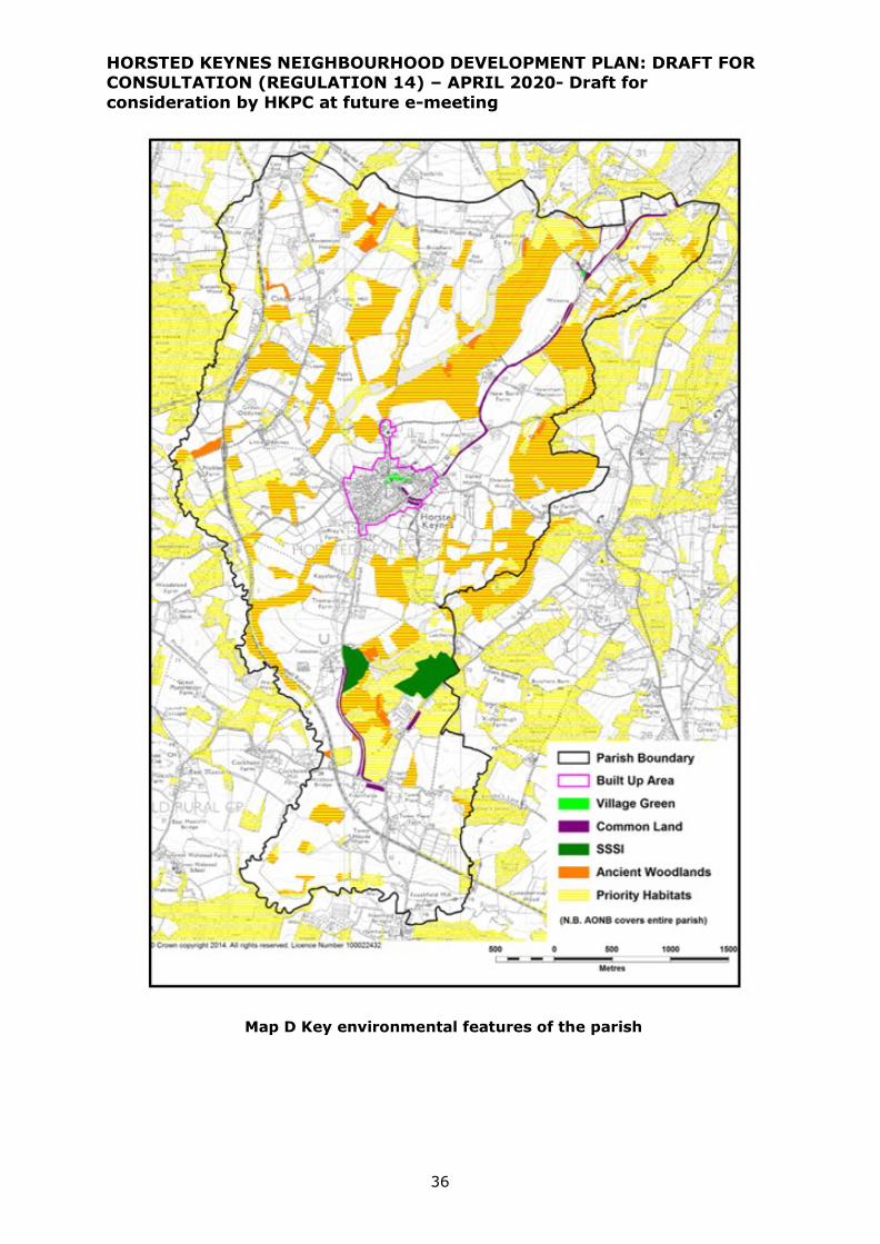
HORSTED KEYNES NEIGHBOURHOOD DEVELOPMENT PLAN: DRAFT FOR CONSULTATION (REGULATION 14) – APRIL 2020- Draft for
consideration by HKPC at future e-meeting
36
Map D Key environmental features of the parish

HORSTED KEYNES NEIGHBOURHOOD DEVELOPMENT PLAN: DRAFT FOR CONSULTATION (REGULATION 14) – APRIL 2020- Draft for
consideration by HKPC at future e-meeting
37
Local Green Spaces
6.7. One of the key features that gives Horsted Keynes its character and identity is
the central green, with the village spreading out from this central point.
6.8. The village green is a very striking feature right at the heart of the village,
beautifully maintained to give pleasure to both visitors and residents alike with
benches for those who wish to rest and take in the view. Bordered by both
period and modern houses, the Crown and Green Man public houses and a shop,
it is central to village life. It provides a perfect setting for community events,
such as Horse Racing on the Green, Carols on the Green and the Village
Triathlon, and was the focal point of the village Jubilee Celebrations in 2012.
Unsurprisingly, villagers see their green as a priceless asset.
6.9. Other green areas close to the centre of the village are:
• The Recreation Ground (including tennis courts); and
• Cricket Field
These are extensively used for sporting and recreational purposes. Community
consultation has shown that these are regarded as very valuable village assets
which should be retained for use by villagers and visitors alike and should not be
used for development of any kind.
6.10. Paragraph 101 of the NPPF states:
The Local Green Space designation should only be used where the green space is:
a) in reasonably close proximity to the community it serves;
b) demonstrably special to a local community and holds a particular local
significance, for example because of its beauty, historic significance,
recreational value (including as a playing field), tranquility or richness of
its wildlife; and
c) local in character and is not an extensive tract of land.
It is considered that these requirements are clearly satisfied for these three areas
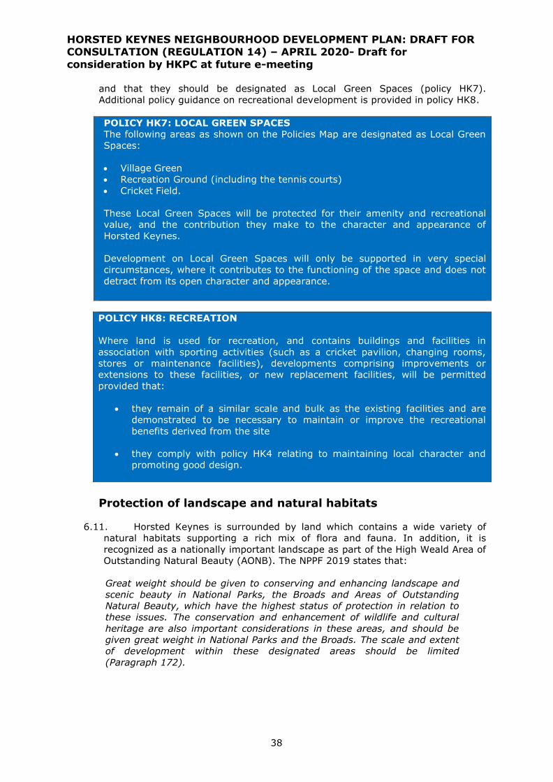
HORSTED KEYNES NEIGHBOURHOOD DEVELOPMENT PLAN: DRAFT FOR CONSULTATION (REGULATION 14) – APRIL 2020- Draft for
consideration by HKPC at future e-meeting
38
and that they should be designated as Local Green Spaces (policy HK7).
Additional policy guidance on recreational development is provided in policy HK8.
POLICY HK7: LOCAL GREEN SPACES
The following areas as shown on the Policies Map are designated as Local Green
Spaces:
• Village Green
• Recreation Ground (including the tennis courts)
• Cricket Field.
These Local Green Spaces will be protected for their amenity and recreational
value, and the contribution they make to the character and appearance of
Horsted Keynes.
Development on Local Green Spaces will only be supported in very special
circumstances, where it contributes to the functioning of the space and does not
detract from its open character and appearance.
POLICY HK8: RECREATION
Where land is used for recreation, and contains buildings and facilities in
association with sporting activities (such as a cricket pavilion, changing rooms,
stores or maintenance facilities), developments comprising improvements or
extensions to these facilities, or new replacement facilities, will be permitted
provided that:
• they remain of a similar scale and bulk as the existing facilities and are
demonstrated to be necessary to maintain or improve the recreational
benefits derived from the site
• they comply with policy HK4 relating to maintaining local character and
promoting good design.
Protection of landscape and natural habitats
6.11. Horsted Keynes is surrounded by land which contains a wide variety of
natural habitats supporting a rich mix of flora and fauna. In addition, it is
recognized as a nationally important landscape as part of the High Weald Area of
Outstanding Natural Beauty (AONB). The NPPF 2019 states that:
Great weight should be given to conserving and enhancing landscape and
scenic beauty in National Parks, the Broads and Areas of Outstanding
Natural Beauty, which have the highest status of protection in relation to
these issues. The conservation and enhancement of wildlife and cultural
heritage are also important considerations in these areas, and should be
given great weight in National Parks and the Broads. The scale and extent
of development within these designated areas should be limited
(Paragraph 172).

HORSTED KEYNES NEIGHBOURHOOD DEVELOPMENT PLAN: DRAFT FOR CONSULTATION (REGULATION 14) – APRIL 2020- Draft for
consideration by HKPC at future e-meeting
39
6.12. In Horsted Keynes, the High Weald AONB landscape is defined by the
following features6:
• Geology, landform, water systems and climate: most of the parish is
on Upper Tunbridge Wells, Ashdown or Ardingly sand formation sandstone
and siltstone interbedded. There is a large clay working at Freshfield
Brickworks and a number of historic sandpits in the area. There are many
streams that cross the parish, generally running north-east to south-west
draining into the River Ouse, which forms the southern boundary. The
western boundary of the parish follows the Cockhaise Brook and one of its
tributaries. There are also a large number of ponds and lakes including a
string of lakes to the north of the village probably related to historic
ironworking industry in the area.
• Settlement: the main settlement is the village of Horsted Keynes, with
the oldest building being the parish church of St Giles, dating back to the
11th century. There are also small hamlets (Birch Grove, Cinder Hill and
Freshfield) and over thirty historic farmsteads dispersed across the parish
dating from medieval periods to the nineteenth century.
• Routeways: Many roads in the parish are historic routeways which were
in existence pre 1800. There are also many historic public rights of way
which were in existence pre 1860.
• Woodlands: There are many small and medium sized blocks of woodland
in the parish, mostly designated Ancient Woodland (i.e. pre 1600). These
include Birchwoodgrove Wood, the Warren, Leamland Wood, Newnhams
Wood, Withy Wood; High Wood, Ovenden Wood and Otye Wood.
• Field and Heath: there are a large number of historic field boundaries
(i.e. unchanged since the nineteenth century) with about one third of the
fields in the parish retaining their medieval small size and irregular shape,
often with sinuous boundaries indicating that they have been chopped by
hand out of the woodland or wastes around them.( “assart fields” ) Other
field systems in the parish were probably medieval or earlier in origin but
have had more recent interventions such as late nineteenth century
enclosures or modern field amalgamation.
6.13. The High Weald AONB Management Plan 2019-2024 and the High Weald
AONB Design Guide for new housing development (2019) set out policies,
proposals and design guidance to help conserve and enhance its special
character.
6 High Weald AONB Unit (2019) The High Weald Area of Outstanding Natural Beauty Management
Plan, 2019 -2024

HORSTED KEYNES NEIGHBOURHOOD DEVELOPMENT PLAN: DRAFT FOR CONSULTATION (REGULATION 14) – APRIL 2020- Draft for
consideration by HKPC at future e-meeting
40
POLICY HK9: THE HIGH WEALD AREA OF OUTSTANDING NATURAL
BEAUTY
Development within the High Weald Area of Outstanding Natural Beauty (AONB)
will only be permitted where it conserves or enhances the natural beauty of the
parish and has regard to the objectives of the High Weald AONB Management
Plan 2019-24.
In particular, development must demonstrate that it meets relevant elements of
these objectives for this nationally important landscape:
• takes opportunities, where watercourses are within or adjacent to the
development site, to restore their natural function in order to improve
water quality; prevent flooding and enhance wetland habitats;
• respects the settlement pattern of the parish and uses local materials
(see paragraph 5.29) and wood fuel systems that enhance the
appearance of development and help to reconnect development with the
landscape;
• relates well to historic routeways and does not divert them from their
original course or damage their rural character by loss of banks,
hedgerows, verges or other important features;
• does not result in the loss or degradation of Ancient Woodland or historic
features within it and, where appropriate will contribute to its ongoing
management;
• conserves and enhances the ecology of fields, trees and hedgerows;
retains and reinstates historic field boundaries; and directs development
away from medieval or earlier fields, especially where these form
coherent field systems with other medieval features.
6.14. As a rural community, the people of Horsted Keynes recognise that wildlife
habitats should be protected and, where possible, restored, enhanced or
extended. As required by the National Planning Policy Framework, if this is not
possible then any harm caused should be adequately mitigated or, as a last
resort, compensated for.
6.15. It is therefore imperative that any potential harm arising from proposed
development is, where possible, avoided. Well-designed developments should be
able to properly establish the location of habitats and the movement patterns of
animals and wildlife such that development does not impact on these. If it is not
possible to avoid such harm, then it will be necessary to identify and ensure that
appropriate mitigation strategies are put in place. If it is not possible to put in
place the necessary mitigation or provide appropriate compensatory measures,
then development should not be permitted.
6.16. Detailed ecological data can be supplied by the Sussex Biodiversity Record
Centre (SxBRC), who hold data on sites and habitats, and protected and
designated species, across the county. SxBRC provide data search services via
https://sxbrc.org.uk/home/
HORSTED KEYNES NEIGHBOURHOOD DEVELOPMENT PLAN: DRAFT FOR CONSULTATION (REGULATION 14) – APRIL 2020- Draft for
consideration by HKPC at future e-meeting
41
POLICY HK10: PROTECTION AND IMPROVEMENT OF NATURAL HABITATS
New developments should safeguard key features of the natural environment, and
demonstrate how they will provide for the protection and enhancement of existing
habitats of any flora and fauna on the development site and , where possible,
utilize opportunities to restore, enhance, or extend them.
The following statutory * and non-statutory ** features of the natural environment
are of particular importance and any development proposals affecting them should
be informed by a detailed ecological assessment:
• Ashdown Forest Special Area for Conservation*
• Ashdown Forest Special Protection Area*
• Sites of Special Scientific Interest at Ashdown Forest* and Freshfield Lane*
• Local Wildlife Sites at Horsted House Farm Marsh**, Birch Grove Fish
Ponds** and Costells, Henfield and Nashgill Woods**
• Local Geological Site at Freshfield Brick Works**
• Road verges at Chilling Street and Treemans Road/Monteswood Lane**
• Priority habitats in the parish**
Where damage to natural habitats cannot reasonably be avoided, measures shall
be taken which will ensure that damage is minimised and the habitat affected can
continue to thrive.
Where loss of, or damage to, natural habitat cannot reasonably be avoided, the
development shall provide suitable mitigation measures or, in the last resort,
compensation measures that allow for the creation of new habitats off-site.
An assessment of impact will need to be based on evidence and landscape capacity
studies

HORSTED KEYNES NEIGHBOURHOOD DEVELOPMENT PLAN: DRAFT FOR CONSULTATION (REGULATION 14) – APRIL 2020- Draft for
consideration by HKPC at future e-meeting
42
Climate change: Sustainable design and renewable energy
schemes
6.17. Horsted Keynes parish is having to cope with a changing climate. In south-
east England, we can expect milder and wetter winters with more intense rainfall
events and increased flood risk. We can also expect warmer, drier summers with
increased frequency of extreme heat and drought events. Therefore, it is
essential that new development takes these risks into account and both
mitigates, and adapts to, climate change. Mitigation addresses the causes of
climate change (primarily, the accumulation of greenhouse gases in the
atmosphere), whereas adaptation addresses the impacts of climate change. Both
approaches are needed.
6.18. Standards for the energy efficiency of developments are now within
national standards, related to the Building Regulations. However, an aspiration in
Horsted Keynes is to achieve a higher level of energy efficiency. This can be
achieved through a variety of means which incorporate low energy and
renewable technologies as part of the design of a development scheme. This
includes solar panels, heat pumps (ground or air source), reed beds and water
harvesting. The inclusion of such technologies will be strongly supported as part
of residential designs.
6.19. The installation of renewable and low carbon energy facilities within the
parish for the benefit of the wider community is also encouraged.
POLICY HK11: LOW CARBON DESIGN AND RENEWABLE ENERGY
SCHEMES
Built development should aim to be carbon neutral or as near to carbon neutral
as possible. Residential design proposals that include low energy and renewable
technologies will be strongly supported.
The siting and design of development should consider opportunities for passive
solar gain and natural ventilation and shading.
The development of renewable and low carbon energy facilities, including
community-led schemes, will be supported, provided that any adverse impacts
(for example landscape and visual impacts, and impacts on biodiversity and
amenity) can be managed and mitigated to an acceptable level.
Flood risk and drainage
6.20. Flood risk in the parish is concentrated alongside the River Ouse, on the
southern edge of the parish, and along the Cockhaise Brook and its tributaries.
These higher risk areas are well away from the village. There is also a surface
water flooding risk in a number of locations arising from intense rainfall events,
where run off from hard surfaces and fields overwhelms local drainage
infrastructure. The potential growing threat of flood risk from new development
is a concern in Horsted Keynes.
6.21. In line with NPPF paragraphs 155-165 and Mid Sussex District Plan Policies
DP41 and DP42, surface water drainage on any development must not add to the
existing site run-off or cause any adverse impact to neighbouring properties or
the surrounding environment/wildlife habitat.

HORSTED KEYNES NEIGHBOURHOOD DEVELOPMENT PLAN: DRAFT FOR CONSULTATION (REGULATION 14) – APRIL 2020- Draft for
consideration by HKPC at future e-meeting
43
6.22. To complement this, it is important that Sustainable Drainage Systems
(SuDS) are designed in new development so that they are effective. These
systems reduce flood risk by slowing down, or storing, water as it runs towards
streams and rivers with measures such as soakaways, holding ponds, swales,
wetlands, green roofs and rainwater harvesting.
POLICY HK12: SUSTAINABLE DRAINAGE SYSTEM DESIGN AND
MANAGEMENT
Development proposals creating significant new drainage requirements must
demonstrate that effective Sustainable Drainage Systems are incorporated, and
a long term management plan must be prepared to secure future maintenance
of the drainage system.
New and improved water and waste water utility infrastructure will be
encouraged and supported in order to meet the identified needs of the
community.
Light pollution
6.23. One of the identified issues in Horsted Keynes parish is light pollution. In
such a rural location in the High Weald AONB, where the undulating topography
makes certain parts of the parish highly visible, over intense, poorly designed
and located lighting can have a disproportionate polluting effect. The High Weald
AONB currently enjoys some of the darkest skies in the south-east of England7
and illumination of the night sky is a significant issue.
6.24. Any development should accord with the guidance notes on the reduction
of light pollution provided by the Institute of Lighting Engineers8. Specifically this
is for Environmental Zone E1 which covers appropriate lighting in areas of
outstanding natural beauty.
6.25. It will be a requirement of any form of development which proposes
external lighting to minimise the amount of light that is visible from outside the
property. Lighting in public areas, particularly street lights, should only be
provided where it is demonstrated to be needed to ensure public safety and must
be provided in the form of down lighters and other measures which serve to
minimise the amount of light that is visible away from the area it is intended to
be lit.
POLICY HK13: LIGHT POLLUTION
New development will be required to demonstrate how it has minimised light
pollution created through its proposed use.
Where external lighting is proposed it must be demonstrated that:
a) it is needed for operational reasons, or to ensure public safety or
security.
b) any light spillage beyond the application site is eliminated, or reduced,
7 http://nightblight.cpre.org.uk/?_ga=1.222499291.133507274.1474542711 8 Institute of Lighting Engineers (2011) Guidance Notes for the Reduction of Light Pollution

HORSTED KEYNES NEIGHBOURHOOD DEVELOPMENT PLAN: DRAFT FOR CONSULTATION (REGULATION 14) – APRIL 2020- Draft for
consideration by HKPC at future e-meeting
44
by measures such as timing and proximity controls, orientation,
screening, shielding or glazing.
c) there is no adverse impact on any nearby residential properties.
Guidance from the Institute of Lighting Engineers (Guidance Notes for the
Reduction of Light Pollution 2011) should be followed.
HORSTED KEYNES NEIGHBOURHOOD DEVELOPMENT PLAN: DRAFT FOR CONSULTATION (REGULATION 14) – APRIL 2020- Draft for
consideration by HKPC at future e-meeting
45
7 BUSINESS AND EMPLOYMENT
7.1. One of the main objectives of the NPPF (paragraph 83) is to build a strong,
competitive economy in both urban and rural areas. It states that in rural areas
planning policies and decisions should enable:
a) the sustainable growth and expansion of all types of business in rural
areas, both through conversion of existing buildings and well-designed new
buildings;
b) the development and diversification of agricultural and other land-based
rural businesses;
c) sustainable rural tourism and leisure developments which respect the
character of the countryside; and
d) the retention and development of accessible local services and community
facilities, such as local shops, meeting places, sports venues, open space,
cultural buildings, public houses and places of worship.
7.2. The community of Horsted Keynes – both residents and existing businesses –
considers that the first and last of these objectives are the most important.
Equally though, there is an important balance that the Neighbourhood Plan seeks
to achieve. It wishes to encourage the growth of appropriate commercial
activities which create jobs for local people.
7.3. Whilst Horsted Keynes does have a limited employment base – mainly restricted
to employment centres such as that at Horsted Keynes Business Park – the
analysis in Section 2 showed that a significant proportion of people work from
home. This is supported by the Neighbourhood Plan survey which found that a
significant proportion of employers (which includes self-employed people working
from home) felt that they were likely to need expanded or additional commercial
premises in the future.
Expansion of existing commercial premises
7.4. Significant employment providers within the parish include:
• High Weald Dairy
• Freshfield Lane Brickworks
• Abbeyfield care home (Westall House)
• Bluebell Railway
• Horsted Keynes Business Park
7.5. Consultation with some of these employers, including engagement with the
Horsted Keynes Business Park in 2015, has shown that development of their
businesses could provide additional employment opportunities within the parish,
but could require conversions or extensions to their existing business premises.
Whilst all of these businesses are situated beyond the built up area boundary,
conversions and minor extensions to existing premises would be acceptable
provided they are carried out in accordance with the principles embodied within
this document for all other new development.

HORSTED KEYNES NEIGHBOURHOOD DEVELOPMENT PLAN: DRAFT FOR CONSULTATION (REGULATION 14) – APRIL 2020- Draft for
consideration by HKPC at future e-meeting
46
7.6. In particular, this relates to the main employment centre in the parish, Horsted
Keynes Business Park. This is currently very well occupied, serving a range of
small businesses. The opportunity for some small-scale expansion of these
premises to be able to serve a greater number of businesses will therefore bring
positive benefits. Any proposals must ensure in particular that they are not
detrimental to the character of the wider countryside.
POLICY HK14: EXPANSION OF EXISTING COMMERCIAL PREMISES
The expansion of existing commercial premises will be permitted, subject to the
following criteria:
• the proposals comply with the other relevant sections of the Neighbourhood
Plan ,in particular Policy HK4 relating to local character and good design; and
• the proposals are not detrimental to the character of the wider AONB
countryside or the views across it , the layout and design of the development
reflects the rural location ,and the site is contiguous with the existing
employment site; and
• the proposals can be demonstrated to provide additional employment
opportunities within the parish or be necessary to maintain existing
employment activities; and
• the activities to be undertaken on the premises do not have an unacceptable
impact on the amenity of neighbouring properties; and
• there is sufficient off-street parking to accommodate workers and visitors;
and
• the activities to be undertaken on the premises will not result in a significant
increase in heavy vehicular traffic on the roads in the vicinity of the premises,
or elsewhere in and around the parish.
Telecommunications
7.7. Mobile communications are becoming increasingly important for modern
businesses. In particular in rural areas, limited phone and broadband connections
are often seen as the most significant restriction on business activity. The
Neighbourhood Plan survey showed that 40% of respondents rely on a
smartphone for work, whereas only 20% are satisfied with the current signal in
Horsted Keynes. Most importantly, 72% of respondents said that they would

HORSTED KEYNES NEIGHBOURHOOD DEVELOPMENT PLAN: DRAFT FOR CONSULTATION (REGULATION 14) – APRIL 2020- Draft for
consideration by HKPC at future e-meeting
47
support the provision of a suitably located phone mast in Horsted Keynes if it
improved the signal for mobile phone use.
POLICY HK15: BROADBAND AND TELECOMMUNICATIONS
Support will be given to appropriate proposals to provide access to super-fast
broadband service and improve mobile telecommunications network that will serve
businesses and other properties within the Parish. This may require above ground
network installations, which must:
a) be sympathetically located and designed to reduce any adverse impact on the
landscape,
b) utilise all available opportunities to share masts and other equipment
between code operators
c) make arrangements for de-commissioning and removal of equipment after it
is no longer required

HORSTED KEYNES NEIGHBOURHOOD DEVELOPMENT PLAN: DRAFT FOR CONSULTATION (REGULATION 14) – APRIL 2020- Draft for
consideration by HKPC at future e-meeting
48
8 TRANSPORT
8.1. In a small rural village such as Horsted Keynes maintaining and improving the
existing infrastructure is of paramount importance in providing a safe and
comfortable environment for residents of all ages.
8.2. The extent to which this can be achieved through the neighbourhood planning
process is limited to those issues which can be governed by land use planning
matters. The provision of additional services such as highways improvements,
water, sewage disposal, electricity and the like remains the responsibility of the
relevant local authority and utility provider and cannot be specified as a
requirement under this plan.
8.3. Nevertheless, it is intended that development should add positively to this
infrastructure where it is practicable to do so, and avoid unacceptable burdens
on existing networks. This is an essential component of sustainable development.
Car parking
8.4. The issue of car parking within the village centre has been a major concern,
strongly expressed, throughout the community consultation process. This has
included concern both about losing any of the existing parking areas within the
village as a result of development and that new development could exacerbate
the existing problem by resulting in additional parked cars on existing narrow
village streets, many of which do not have footways. Policies HK16 is intended to
address these concerns.
POLICY HK16: LOSS OF EXISTING PUBLIC CAR PARKS
Within the Built up Area Boundary, developments which result in the removal
of existing public off-road parking spaces will only be permitted if alternative
provision is made which maintains or increases the number of publicly
accessible parking spaces at, or in the immediate vicinity of, the
development.
8.5. Recent developments in Horsted Keynes have not always provided sufficient off-
street parking for the number of cars owned by those occupying the dwellings.
The 2011 Census results show that the village already has a very high rate of car
ownership which, given the rural setting and the need to access services and
jobs elsewhere, is likely to continue in the future.
8.6. There is already a high incidence of on-street parking on existing roads which
can make it difficult for vehicles to pass, particularly buses and larger
commercial traffic. Many of the village roads do not have footways and parked
cars result in danger to pedestrians both walking in and crossing the road.
8.7. WSCC has recently (August 2019) reviewed parking standards across the county
and the parking demand for Parking Behaviour Zone 1 (the most rural areas with
least access to services / public transport and greater car dependency, including
Horsted Keynes) is set out in the table below. The expectation is that these
demands will be met in new residential development. Therefore, the standards
are neither a minimum nor maximum provision, but a demand which is expected
to be met

HORSTED KEYNES NEIGHBOURHOOD DEVELOPMENT PLAN: DRAFT FOR CONSULTATION (REGULATION 14) – APRIL 2020- Draft for
consideration by HKPC at future e-meeting
49
Residential parking demand (spaces per dwelling)
No.of
bedrooms
No.of habitable
rooms
Parking
provision
(Zone 1)
1 1-3 1.5 spaces
2 4 1.7 spaces
3 5-6 2.2 spaces
4+ 7+ 2.7 spaces
Source: West Sussex guidance on parking in new development WSCC August
2019.
8.8. WSCC state “as part of their planning application, applicants will be expected to
provide a schedule of parking provision, detailing the number of allocated and
unallocated spaces, including garages and electric vehicle charging spaces (both
active and passive)”.
8.9. The Neighbourhood Plan has not gathered any specific evidence on parking
demand in Horsted Keynes, which would justify any variation from the county
standard.
Access by non-vehicular modes
8.10. The scale of Horsted Keynes is such that movement around the village on
foot or by bicycle is an attractive alternative to using a car for many people,
especially given the restricted parking opportunities available in the centre. The
open countryside around the village is also a great attraction to which such
access would be valuable. It is important therefore that this option is encouraged
within any new development by the provision of good access both to the village
and the open countryside beyond. The aim is to make a more “walkable village”.
8.11. Existing footways in the village can be narrow, such that pedestrians
cannot walk two abreast and there is insufficient room for pushchairs, parents
with young children and mobility scooters to travel safely adjacent to the
highway.
8.12. There is an opportunity to ensure that such issues are avoided in new
developments and Policy HK17 seeks to do this.
POLICY HK17: CYCLEWAYS AND FOOTWAYS
New developments shall include publicly accessible footways and, where
possible, cycleways to link the site to the wider footway and road network,
linking them to community facilities in the village such as the primary school,
church, pre-school nursery, the shop, pubs, and meeting rooms.
New developments shall provide footways serving the new dwellings that are of
sufficient width to accommodate at least two persons walking abreast and are
suitable for wheelchairs, prams, pushchairs and mobility scooters, except where
a narrower footway may exceptionally be justified by an overriding need to
maintain the existing character or appearance of a street or lane.

HORSTED KEYNES NEIGHBOURHOOD DEVELOPMENT PLAN: DRAFT FOR CONSULTATION (REGULATION 14) – APRIL 2020- Draft for
consideration by HKPC at future e-meeting
50
9 SITE ALLOCATIONS
Background
9.1. The District Local Plan sets out an overall planning strategy for Mid Sussex in
policies DP4, DP5 and DP6. This includes the overall amount of new residential
development up to 2031 and a settlement hierarchy to indicate how it will be
spread across the district. It also identifies large-scale strategic development
allocations at Burgess Hill (2 sites), Pease Pottage (1) and Hassocks (1).
Allocation of smaller sites is left to the Site Allocations DPD and/or
neighbourhood plans prepared by town and parish councils.
9.2. Horsted Keynes is indicated as a category 3 settlement in policy DP6 (Medium
sized villages providing essential services for the needs of their own residents
and immediate surrounding communities), with 69 dwellings to be provided
over the period to 2031.
9.3. A Strategic Housing and Employment Land Availability Assessment (SHELAA)
provides a “long list” of potential housing and employment sites, which is used to
inform the preparation of the Site Allocations DPD and the Neighbourhood Plan.
”The call for sites” lasted from October 2017 to February 2018 and led to
publication to a revised SHELAA in April 2018. A summary of the outcome of the
assessment by MSDC is attached as Appendix B.
9.4. MSDC published a draft Site Allocations DPD for consultation between 9 October
and 20 November 2019. The draft plan proposes two allocations of land for
housing development in Horsted Keynes:
• SA28 Land south of the Old Police House, Birchgrove Road, Horsted
Keynes (25 dwellings)
• SA29 Land south of St. Stephen’s Church, Hamsland, Horsted
Keynes ( 30 dwellings).
The two proposed allocations are shown in Maps E and F below.
Map E
SA28- Land south of Old Police
House
HORSTED KEYNES NEIGHBOURHOOD DEVELOPMENT PLAN: DRAFT FOR CONSULTATION (REGULATION 14) – APRIL 2020- Draft for
consideration by HKPC at future e-meeting
51
Map F
SA29 -Land south of
St. Stephen’s Church
9.5. It is understood that MSDC will be considering views received as a result of the
consultation in spring 2020, at which stage they will consider whether any
amendments are required to the draft documents, before they are published
again for pre-submission consultation later in 2020.
9.6. The Neighbourhood Plan’s housing strategy is to rely on the MSDC Site
Allocations SA28 and SA29 to meet its residual housing requirement, as
set out in District Plan policy DP6 and, in the event of any shortfall,
consider whether any additional site allocation is necessary to meet the
DP6 strategic requirement.
Housing land supply position at 31 December 2019
9.7. Policy DP6 of the District Plan indicates a net requirement for at least 69 new
dwellings in Horsted Keynes parish from 2014 up to 2031. As at 31 December
2019, the updated evidence for the HKNP indicates that housing land supply
position was as set out below:
Table A: Housing land supply position at 31
December 2019
Completions (1 April 2014 -31 December 2019) and
commitments at 1 November 2019
7 dwellings
Contribution from C2 residential institutions arising
from completions and commitments at Westall
House , based on the guidance in the DCLG Housing
Delivery Test Measurement Rule Book (20 units at a
ratio of 1.8)
11 dwellings
Allocations in the draft MSDC Site Allocations DPD :
SA28 land south of Old Police House (25) and SA29
land south of St. Stephen’s Church (30)
55 dwellings
TOTAL 73 dwellings
9.8. This existing housing land supply is sufficient to meet the strategic
requirement minimum of 69 dwellings up to 2031. Within the plan period,
subject to policies HK1 - HK5, this is very likely to be supplemented by further
“windfall” sites for housing development, which may also include community-led
housing schemes. This would give additional flexibility, if existing commitments
HORSTED KEYNES NEIGHBOURHOOD DEVELOPMENT PLAN: DRAFT FOR CONSULTATION (REGULATION 14) – APRIL 2020- Draft for
consideration by HKPC at future e-meeting
52
are not built out or if any proposed allocations yield less than expected, or are
delayed.
Is there a need for further allocations to supplement the housing land supply?
9.9. Nevertheless – in order to test whether it is sustainable to allocate additional
sites over and above those in the Site Allocations DPD - the Neighbourhood Plan
has undertaken a “site filtering” process of all the sites put forward by
landowners and developers to see if there are any “realistic alternatives”
which warrant assessment against the NDP’s sustainability objectives. The site
filtering process has included sites put forward as part of the Neighbourhood Plan
and as part of the SHELAA process carried out by MSDC to inform the
preparation of the Site Allocations DPD).
9.10. The Sustainability Appraisal (supplemented by a detailed site assessment
using the same criteria as the DPD) confirms that the allocations proposed in the
Site Allocations DPD (Sites SA28 and SA29) are the two most sustainable sites
for housing development in Horsted Keynes and that there are no additional sites
which could be allocated without significant harm to planning interests, in
particular the character and appearance of the High Weald AONB and achieving
safe and convenient vehicular access to any additional allocation site.
9.11. Housing provision in the parish will need to be carefully monitored over
the plan period with a particular focus on:
• new planning permissions granted for housing development
• build out and completion of planning permissions granted for housing
development
• overall progress towards provision of the housing development
required in policy DP6.

HORSTED KEYNES NEIGHBOURHOOD DEVELOPMENT PLAN: DRAFT FOR CONSULTATION (REGULATION 14) – APRIL 2020- Draft for consideration by HKPC at future e-meeting
53
10 COMMUNITY ACTION: NON-LAND USE ISSUES AND REVIEW
10.1. There are a number of issues that have been raised through the process of preparing the Neighbourhood Plan that are not
directly related to land-use matters (although several indirectly relate to the use of land in some form). As such, they are not
matters that can be addressed directly by the provision of a planning policy in the Neighbourhood Plan. However, this is not to
say that these are not important matters and it is important that a strategy for dealing with these matters is assembled and
taken forward. In doing so, this will help to achieve the vision and objectives of the Neighbourhood Plan.
10.2. These community action issues that have been identified are shown in the Table below, along with possible actions.
Table: Community action and Non-land use issues to be addressed
Issue Possible actions Lead agencies and
partner
Funding
needed?
Priority
Transport
Ensure that local
services remain and, if
possible, are enhanced
Continue to engage with Metrobus and put together a
campaign of advertising to increase awareness.
Engage with parishes along the route to explore the
potential of more frequent Sunday services for Route
270
Horsted Keynes Parish
Council
Metrobus
Other local parishes
Yes High
Heavy goods vehicles
passing through the
country lanes and
through the village
Horsted Keynes Parish Council, to explore and support
measures to address inappropriate vehicular traffic
passing through the villages. Previously a proposed
Traffic Regulation Order (TRO) application to erect
signs to restrict access to all vehicles over 7.5 tonne
on all ‘B’ and ‘C’ roads in the greater part of Central
and North Mid Sussex (which covers the Parish of
Horsted Keynes) unless for access or loading was
supported, but did not proceed because of objections
from the Police.
Horsted Keynes Parish
Council
No High
Need for traffic calming Horsted Keynes Parish Council will seek to work with
other organisations and bodies to promote the
reduction in traffic speeds, and provide appropriate
facilities for a school crossing in Station Road.
Horsted Keynes Parish
Council
No Medium
Low carbon
technologies
Support the installation of electric car charging points
and other technological energy efficiency measures of
Horsted Keynes Parish
Council
No Medium

HORSTED KEYNES NEIGHBOURHOOD DEVELOPMENT PLAN: DRAFT FOR CONSULTATION (REGULATION 14) – APRIL 2020- Draft for consideration by HKPC at future e-meeting
54
Issue Possible actions Lead agencies and
partner
Funding
needed?
Priority
the future.
Use developer
contributions to improve
walking and cycling
routes around the
village
Identify key routes Horsted Keynes Parish
Council
No Medium
Environment and energy
Maintenance of green
areas
Continue to maintain green areas Horsted Keynes Parish
Council
Yes Ongoing
Renewable energy Explore the potential for the installation of sustainable
energy systems (e.g. solar panels) on commercial
properties (e.g. via a Community Energy Cooperative)
Horsted Keynes Parish
Council
No Medium
Renewable energy Use developer contributions to finance installation of
electric car charging points and other technological
energy efficiency measures of the future
Horsted Keynes Parish
Council/West Sussex
County Council
No Medium
Efficient electricity More resilient and efficient electricity supply in cases of
extreme weather and other potential disruption.
Electricity
Supplier/Horsted Keynes
Parish Council/West
Sussex County Council
Possibly Medium
Water supply Water supply Southern Water/Horsted
Keynes Parish
Council/West Sussex
County Council
Possibly Medium
Community infrastructure
Protect important
community assets
Identify and seek listing of Assets of Community Value
(ACVs) by MSDC.
Establish of a Community Land Trust to secure suitable
buildings for community use if they become available.
Horsted Keynes Parish
Council
No High
Support the Youth Club Provision of meeting place for the youth club. Hire of
Youth Leader
Horsted Keynes Parish
Council
Possibly Medium
Provision of new
modern playground for
children
This has now been completed, but it still needs to be
subject to regular maintenance and safety checks
Horsted Keynes Parish
Council
Mid Sussex District
Council
Yes High

HORSTED KEYNES NEIGHBOURHOOD DEVELOPMENT PLAN: DRAFT FOR CONSULTATION (REGULATION 14) – APRIL 2020- Draft for consideration by HKPC at future e-meeting
55
Issue Possible actions Lead agencies and
partner
Funding
needed?
Priority
Upgrades to local green
spaces
Maintain, enhance the village green, the recreation
ground and the cricket field.
Horsted Keynes Parish
Council
Possibly Medium
Consider use of the
Pavilion on the
Recreation Ground
Maintain, enhance and find a suitable use for it.
Open and clean the public toilets at the rear of the
Pavilion.
Horsted Keynes Parish
Council
Yes Medium
Provide an easily
available toilet for St.
Giles Church
Agree next steps between partners Horsted Keynes Parish
Council/PCC/’Friends of
the Church’
Yes Medium
Improve the
maintenance of the
roads and repair
potholes
Liaise with highway authority about the state of roads. Horsted Keynes Parish
Council/West Sussex
County Council
No High
Village Shop Prepare a contingency plan to help maintain the Village
shop facility
Horsted Keynes Parish
Council
Possibly High
Village Volunteer Group West Sussex County Council is encouraging
communities to establish Volunteer groups to keep
their area clean and tidy. Several groups have now
been set up in the parish, such as:
HK Conservation Group (also known as the Hackers)
help to keep the Parish clean and tidy.
HK Help provides transport, practical help,
confidential help, and arranges home communion.
First Steps provides weekly sessions for young
mothers and babies.
HK Cafe provides activities and refreshments.
Friends of St. Giles Church support fund raising
activities to maintain church buildings.
Friends of Abbeyfield support Westall House in a
West Sussex County
Council/Mid Sussex
District Council/Horsted
Keynes Parish Council
No Low

HORSTED KEYNES NEIGHBOURHOOD DEVELOPMENT PLAN: DRAFT FOR CONSULTATION (REGULATION 14) – APRIL 2020- Draft for consideration by HKPC at future e-meeting
56
Issue Possible actions Lead agencies and
partner
Funding
needed?
Priority
variety of ways
Housing delivery
Establishment of a
Community Land Trust
The setting up of a CLT has now been completed Horsted Keynes Parish
Council
Yes Medium
HORSTED KEYNES NEIGHBOURHOOD DEVELOPMENT PLAN: DRAFT FOR CONSULTATION (REGULATION 14) – APRIL 2020- Draft for
consideration by HKPC at future e-meeting
57
11 MONITORING AND PLAN REVIEW
11.1. The Neighbourhood Plan will be delivered and implemented over the plan
period to 2031 by a range of stakeholders covering a number of different
interests including the local authorities, landowners and developers, residential
and business property owners, volunteer groups and campaigners. Flexibility will
also be needed as new challenges and opportunities arise over the plan period.
11.2. It is important that we regularly check whether the Plan is delivering the
Vision we have set out for Horsted Keynes in 2031 and whether it needs to be
reviewed to respond to changing social, economic and environmental conditions.
11.3. MSDC prepares an “Authority Monitoring Report” which will give a high
level report on changing conditions across the district. This may need to be
supplemented by some local work to get a more detailed picture for Horsted
Keynes.
11.4. Amongst the things that will need to be monitored locally are:
• The pattern of planning applications submitted in Horsted Keynes and
decisions on them (including planning appeals).
• Any planning enforcement cases in the parish.
• How housing needs in the parish are evolving and the extent to which they
are being met.
• Factors affecting the prosperity of the rural economy and the fortunes of
local businesses.
• Maintenance of local community facilities.
• Whether the condition of key features of the historic and natural
environments are stable, improving or declining.
11.5. In light of this, it is expected that the Horsted Keynes Neighbourhood Plan
will be reviewed within the first five years of being formally “made”.
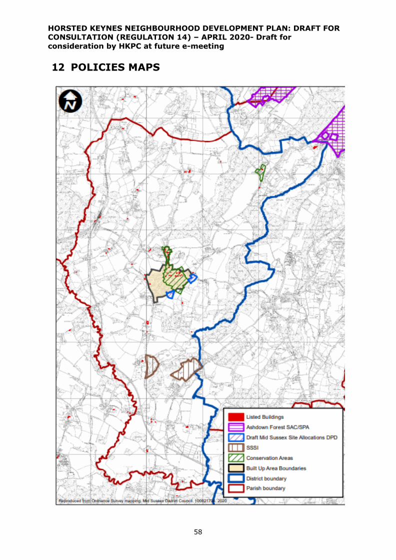
HORSTED KEYNES NEIGHBOURHOOD DEVELOPMENT PLAN: DRAFT FOR CONSULTATION (REGULATION 14) – APRIL 2020- Draft for
consideration by HKPC at future e-meeting
58
12 POLICIES MAPS

HORSTED KEYNES NEIGHBOURHOOD DEVELOPMENT PLAN: DRAFT FOR CONSULTATION (REGULATION 14) – APRIL 2020- Draft for
consideration by HKPC at future e-meeting
59

HORSTED KEYNES NEIGHBOURHOOD DEVELOPMENT PLAN: DRAFT FOR CONSULTATION (REGULATION 14) – APRIL 2020- Draft for
consideration by HKPC at future e-meeting
60
GLOSSARY
• Affordable housing - Social rented, affordable rented and intermediate housing,
provided to eligible households whose needs are not met by the market.
• Community Infrastructure Levy (CIL) – a fixed, non-negotiable contribution that
must be made by new development. It is chargeable on each net additional square
metre of development built and is set by Mid Sussex District Council.
• District Plan 2014-31– the planning policy document produced by Mid Sussex
District Council covering Horsted Keynes parish. This addresses strategic planning
matters and the Horsted Keynes Neighbourhood Plan, as required by the National
Planning Policy Framework, must be in general conformity with the District Plan.
• National Planning Policy Framework (NPPF) – the national planning policy
document which sets out the Government’s planning policies for England and how
these are expected to be applied. (“What you should do “)
• National Planning Practice Guidance (NPPG) – detailed guidance on the
practical application of the national planning policies set out in the NPPF (“How you
should do it” ) in a set of online guidance notes which are updated regularly.
• Social rented housing - Housing owned by local authorities and private registered
providers for which guideline target rents are determined through the national rent
regime.
• Strategic Housing and Employment Land Availability Assessment (SHELAA)
– an evidence base exercise undertaken by all local authorities to determine the
amount of land that has theoretical potential for housing development. All sites put
forward are considered for their availability, suitability and deliverability for housing.
If a site addresses all of these requirements then it is considered to have theoretical
potential for housing development; however this does not mean that the site will be
brought forward for development or that a planning application will be granted
planning permission. All sites for consideration are collated through a ‘Call for Sites’
exercise which invites anyone to put forward land for consideration through the
SHLAA process.
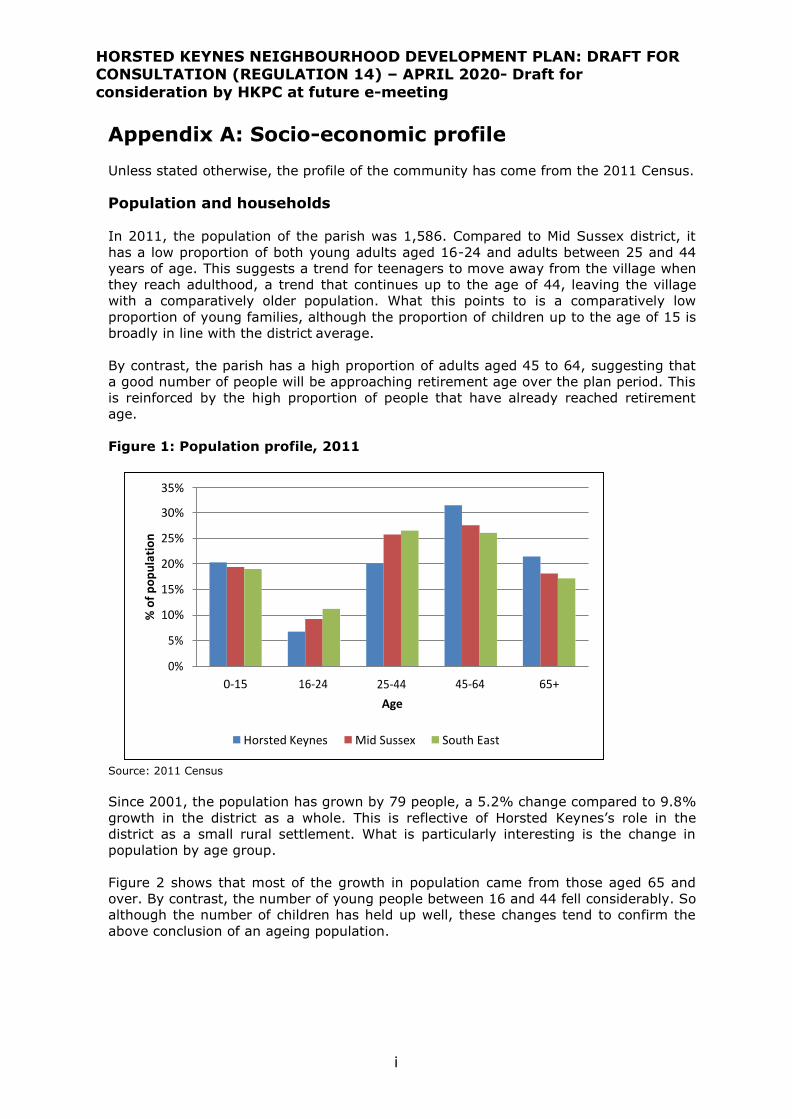
HORSTED KEYNES NEIGHBOURHOOD DEVELOPMENT PLAN: DRAFT FOR CONSULTATION (REGULATION 14) – APRIL 2020- Draft for
consideration by HKPC at future e-meeting
i
Appendix A: Socio-economic profile
Unless stated otherwise, the profile of the community has come from the 2011 Census.
Population and households
In 2011, the population of the parish was 1,586. Compared to Mid Sussex district, it
has a low proportion of both young adults aged 16-24 and adults between 25 and 44
years of age. This suggests a trend for teenagers to move away from the village when
they reach adulthood, a trend that continues up to the age of 44, leaving the village
with a comparatively older population. What this points to is a comparatively low
proportion of young families, although the proportion of children up to the age of 15 is
broadly in line with the district average.
By contrast, the parish has a high proportion of adults aged 45 to 64, suggesting that
a good number of people will be approaching retirement age over the plan period. This
is reinforced by the high proportion of people that have already reached retirement
age.
Figure 1: Population profile, 2011
Source: 2011 Census
Since 2001, the population has grown by 79 people, a 5.2% change compared to 9.8%
growth in the district as a whole. This is reflective of Horsted Keynes’s role in the
district as a small rural settlement. What is particularly interesting is the change in
population by age group.
Figure 2 shows that most of the growth in population came from those aged 65 and
over. By contrast, the number of young people between 16 and 44 fell considerably. So
although the number of children has held up well, these changes tend to confirm the
above conclusion of an ageing population.
35%
30%
25%
20%
15%
10%
5%
0%
0-15 16-24 25-44
Age
45-64 65+
Horsted Keynes Mid Sussex South East
% o
f p
op
ula
tio
n
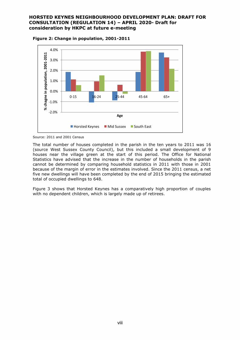
HORSTED KEYNES NEIGHBOURHOOD DEVELOPMENT PLAN: DRAFT FOR CONSULTATION (REGULATION 14) – APRIL 2020- Draft for
consideration by HKPC at future e-meeting
viii
Figure 2: Change in population, 2001-2011
Source: 2011 and 2001 Census
The total number of houses completed in the parish in the ten years to 2011 was 16
(source West Sussex County Council), but this included a small development of 9
houses near the village green at the start of this period. The Office for National
Statistics have advised that the increase in the number of households in the parish
cannot be determined by comparing household statistics in 2011 with those in 2001
because of the margin of error in the estimates involved. Since the 2011 census, a net
five new dwellings will have been completed by the end of 2015 bringing the estimated
total of occupied dwellings to 648.
Figure 3 shows that Horsted Keynes has a comparatively high proportion of couples
with no dependent children, which is largely made up of retirees.
4.0%
3.0%
2.0%
1.0%
0.0%
0-15 16-24 25-44 45-64 65+
-1.0%
-2.0%
Age
Horsted Keynes Mid Sussex South East
% c
hag
ne
in p
op
ula
tio
n, 2
00
1-2
011
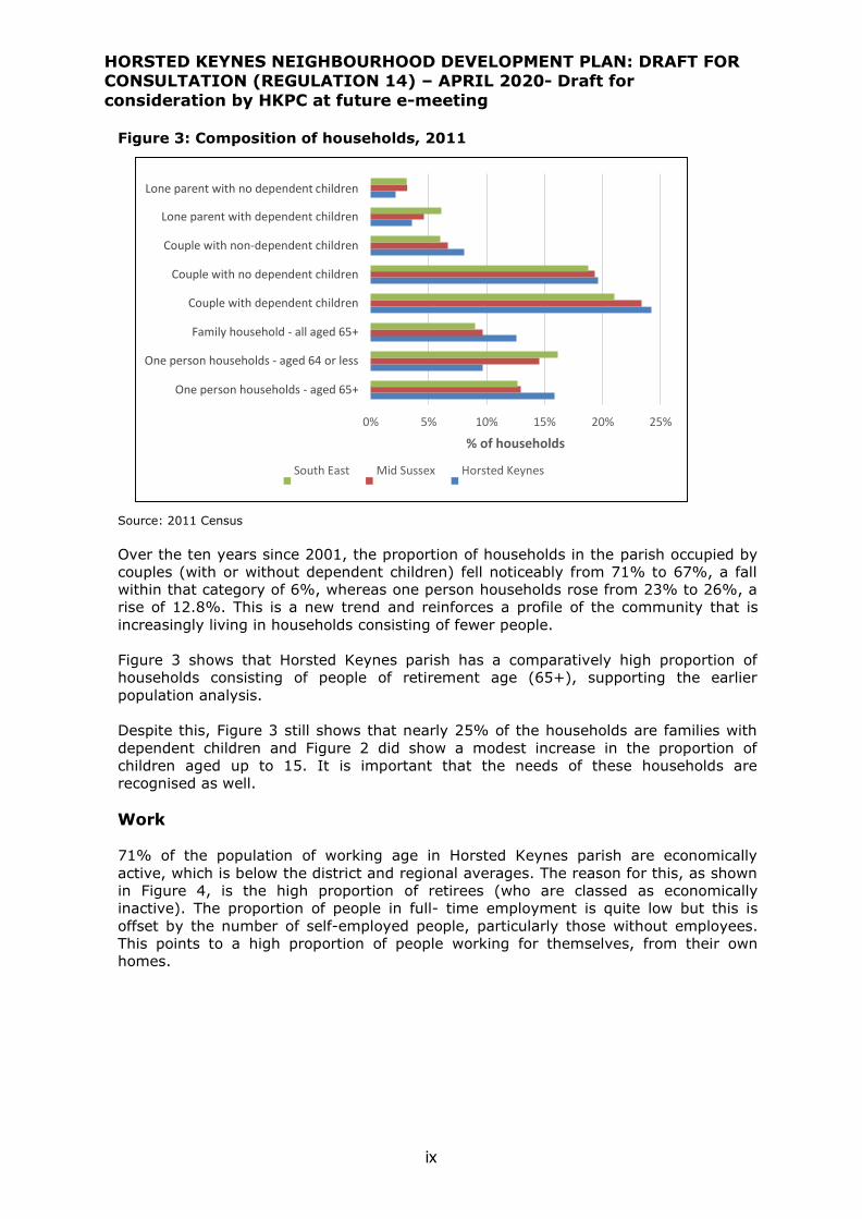
HORSTED KEYNES NEIGHBOURHOOD DEVELOPMENT PLAN: DRAFT FOR CONSULTATION (REGULATION 14) – APRIL 2020- Draft for
consideration by HKPC at future e-meeting
ix
Figure 3: Composition of households, 2011
Source: 2011 Census
Over the ten years since 2001, the proportion of households in the parish occupied by
couples (with or without dependent children) fell noticeably from 71% to 67%, a fall
within that category of 6%, whereas one person households rose from 23% to 26%, a
rise of 12.8%. This is a new trend and reinforces a profile of the community that is
increasingly living in households consisting of fewer people.
Figure 3 shows that Horsted Keynes parish has a comparatively high proportion of
households consisting of people of retirement age (65+), supporting the earlier
population analysis.
Despite this, Figure 3 still shows that nearly 25% of the households are families with
dependent children and Figure 2 did show a modest increase in the proportion of
children aged up to 15. It is important that the needs of these households are
recognised as well.
Work
71% of the population of working age in Horsted Keynes parish are economically
active, which is below the district and regional averages. The reason for this, as shown
in Figure 4, is the high proportion of retirees (who are classed as economically
inactive). The proportion of people in full- time employment is quite low but this is
offset by the number of self-employed people, particularly those without employees.
This points to a high proportion of people working for themselves, from their own
homes.
Lone parent with no dependent children
Lone parent with dependent children
Couple with non-dependent children
Couple with no dependent children
Couple with dependent children
Family household - all aged 65+
One person households - aged 64 or less
One person households - aged 65+
0% 5% 10% 15% 20% 25%
% of households
South East Mid Sussex Horsted Keynes
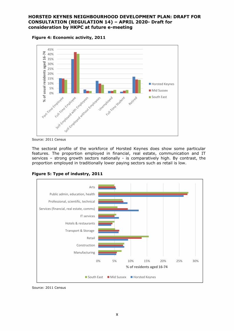
HORSTED KEYNES NEIGHBOURHOOD DEVELOPMENT PLAN: DRAFT FOR CONSULTATION (REGULATION 14) – APRIL 2020- Draft for
consideration by HKPC at future e-meeting
x
Figure 4: Economic activity, 2011
Source: 2011 Census
The sectoral profile of the workforce of Horsted Keynes does show some particular
features. The proportion employed in financial, real estate, communication and IT
services – strong growth sectors nationally - is comparatively high. By contrast, the
proportion employed in traditionally lower paying sectors such as retail is low.
Figure 5: Type of industry, 2011
Source: 2011 Census
45%
40%
35%
30%
25%
20%
15%
10%
5%
0%
Horsted Keynes
Mid Sussex
South East
% o
f u
sual
re
sid
en
ts a
ged
16
-74
Arts
Public admin, education, health
Professional, scientific, technical
Services (financial, real estate, comms)
IT services
Hotels & restaurants
Transport & Storage
Retail
Construction
Manufacturing
0% 5% 10% 15% 20% 25% 30%
% of residents aged 16-74
South East Mid Sussex Horsted Keynes

HORSTED KEYNES NEIGHBOURHOOD DEVELOPMENT PLAN: DRAFT FOR CONSULTATION (REGULATION 14) – APRIL 2020- Draft for
consideration by HKPC at future e-meeting
xi
45%
40%
35%
30%
25%
20%
15%
10%
5%
0%
Highest level of qualification
Horsted Keynes Mid Sussex South East
Figure 6 shows that there are significant numbers of people with high levels of
qualification, i.e. Level 4 or more, which is educated to at least degree level. By
contrast, the proportion of people with lower levels of qualification are lower than the
district or regional averages.
Figure 6: Qualifications of residents aged 16 and over
Source: 2011 Census
The large majority of those in work travel to work by car, and do so as the driver of
that car. Interestingly this is slightly below the district average. The numbers of people
that travel to work on foot or by bicycle is low, highlighting the limited number of job
opportunities that are available locally. However, where Horsted Keynes is very
strongly represented is in the proportion of people that work from home, with nearly
10% of people doing so.
This general picture is further supported by Census figures on access to a car within
households. On average, each Horsted Keynes household has access to 1.78 cars. This
compares to 1.46 cars per household in Mid Sussex district and 1.35 cars per
household across the South East. This represents very high levels of car ownership
which is unsurprising for a small rural community but does highlight the limited
alternative options available for people to travel around to access employment,
services and leisure activities.
% o
f re
sid
ents
age
d 1
6+

HORSTED KEYNES NEIGHBOURHOOD DEVELOPMENT PLAN: DRAFT FOR CONSULTATION (REGULATION 14) – APRIL 2020- Draft for
consideration by HKPC at future e-meeting
xii
Figure 7: Mode of transport to work
Source: 2011 Census
Housing
Horsted Keynes is dominated by detached housing, representing nearly 50% of its
housing stock. However, there is also a significant proportion (over 30%) of semi-
detached housing. By contrast, the proportion of terraced housing and, in particular,
flatted development is very low.
Figure 8: Type of dwelling
Source: 2011 Census
This is reinforced when looking at the number of bedrooms that properties in Horsted
Keynes have. Figure 9 shows that it has a very high proportion of 4- and 5-bed
properties compared to the district or the South East as a whole. By contrast, the
proportion of 3- and particularly 2-bed properties is much lower. Given the growing
proportion of smaller households in Horsted Keynes, there is a potential mismatch
On Foot
Bicycle
Car (driver or passenger)
Bus
Rail
Work from home
0% 10% 20% 30% 40% 50%
% of residents aged 16-74
South East Mid Sussex Horsted Keynes
50%
45%
40%
35%
30%
25%
20%
15%
10%
5%
0%
Horsted Keynes
Mid Sussex
South East
% o
f h
ou
seh
old
s

HORSTED KEYNES NEIGHBOURHOOD DEVELOPMENT PLAN: DRAFT FOR CONSULTATION (REGULATION 14) – APRIL 2020- Draft for
consideration by HKPC at future e-meeting
xiii
between the supply of properties (which are large) and the needs of households (which
are for smaller properties).
Figure 9: Number of bedrooms
Source: 2011 Census
The ownership profile of these dwellings shows that 75% of people own their property
which is broadly in line with the district average. The proportion that are social rented
properties is actually above the district average, at nearly 15%. Where Horsted Keynes
has proportionate under- representation is in the private rented sector.
Figure 10: Ownership profile
Source: 2011 Census
45%
40%
35%
30%
25%
20%
15%
10%
5%
0%
Horsted Keynes
Mid Sussex
South East
1 2 3
No of bedrooms
4 5+
% o
f h
ou
seh
old
s
45%
40%
35%
30%
25%
20%
15%
10%
5%
0%
Horsted Keynes
Mid Sussex
South East
Owned Owned Outright with a
Mortgage or Loan
Social Rented
Private Living Rent Rented Free
% o
f h
ou
seh
old
s
HORSTED KEYNES NEIGHBOURHOOD DEVELOPMENT PLAN: DRAFT FOR CONSULTATION (REGULATION 14) – APRIL 2020- Draft for
consideration by HKPC at future e-meeting
xiv
The North West Sussex Strategic Housing Market Assessment (SHMA) Update9 was
published in 2014. This highlighted that affordability is a significant issue with over
44% of households in Mid Sussex District unable to rent or buy a property without
assistance.
For affordable housing, the predominant need in the district is for 1- and 2-bed housing,
accounting for 87% of all needs. In Horsted Keynes parish, the picture is even starker.
Just taking evidence from the housing register shows that in November 2014, there
was a total of 18 households on the housing register. All of these households were
seeking 1- or 2-bed dwellings.
In addition to this, there is a significant number of households that fall between social
rented properties and the open market, i.e. they are unable to access social rented
properties because their need is not great enough but equally they are unable to buy
or rent on the open market. These people require ‘intermediate’ housing and across
Mid Sussex District, 31% of households are in this bracket10.
The District has very high house prices, with the average price in 2010/11 standing at
over £467,000 for a detached property11 which predominates in Horsted Keynes.
Moreover, detached properties have grown in price by 20% over the period 2009 to
201112. Affordability for the lowest earning local residents is therefore very limited and
the position is worsening.
The SHMA summarises that it is more difficult to get on the property ladder in Mid
Sussex District than it is to move up it. Interestingly, the SHMA recommends that,
across the housing market area (which includes Horsham district and Crawley Borough
as well as Mid Sussex District), more family housing should be delivered than smaller
flats/apartments. A range of between 30% and 45% of developments on larger sites
should be 3-bed properties or larger. Whilst this headline is at odds with the evidence
of needs in Horsted Keynes - where the forecast demand is to be for smaller
properties, both to improve the prospects of first-time buyers to be able to buy a
property locally and also to provide choice to older ‘downsizers’ looking to move out of
family-sized properties but stay locally – it still leaves scope for a considerable
proportion of new dwellings to provide for these smaller property needs.
9 Chilmark Consulting (2014) Northern West Sussex Housing Market Area – Affordable Housing Needs Model
Update, for Horsham District Council, Crawley Borough Council and Mid Sussex District Council 10 Source: 2012 SHMA, Figure 22 11 Source: SHMA, Table 3 12 Source: Figure 9
HORSTED KEYNES NEIGHBOURHOOD DEVELOPMENT PLAN: DRAFT FOR CONSULTATION (REGULATION 14) – APRIL 2020- Draft for
consideration by HKPC at future e-meeting
ix
Appendix B
SITES PUT FORWARD BY LANDOWNERS AND DEVELOPERS IN “CALL FOR
SITES” TO MID SUSSEX DISTRICT COUNCIL 2017-19 The sites put forward, in and around the village, through MSDC’s SHELAA
process are shown in the map below and are as follows below:
663- Field 1 - Ludwell Grange, Keysford Lane
664 – Field 2 - Ludwell Grange, Keysford Lane
837- Land at Little Oddynes Farm, Waterbury Hill
67 - Castle Field, Cinder Hill Lane
893 – Land west of Church Lane (Sledging Field)
748 -The Old Rectory, Church Lane
945 – Land at Lucas Farm, Birchgrove Road
781- Land south of Robyn’s Barn, Birchgrove road
216 – Land at Police House Field, Birchgrove Road
807 – Land south of Police House Field
184 – Land south of St Stephen’s Church
68 – Farm buildings, Jeffrey’s Farm
69 - Land at Jeffrey’s Farm (north)
971- Land at Jeffrey’s Farm south)
In addition, there were three other sites put forward elsewhere in the parish as follows:
878- Freshfield Brick Works, Freshfield Lane
879- Horsted Keynes Industrial Park
880 - Horsted Keynes Station (Bluebell Railway)
All three sites (878, 879 and 880) were put forward for employment use.
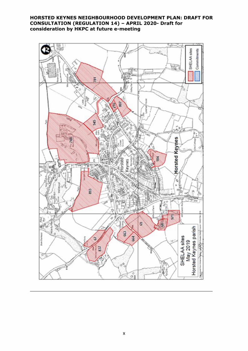
HORSTED KEYNES NEIGHBOURHOOD DEVELOPMENT PLAN: DRAFT FOR CONSULTATION (REGULATION 14) – APRIL 2020- Draft for
consideration by HKPC at future e-meeting
x

HORSTED KEYNES NEIGHBOURHOOD DEVELOPMENT PLAN: DRAFT FOR CONSULTATION (REGULATION 14) – APRIL 2020- Draft for
consideration by HKPC at future e-meeting
xi

HORSTED KEYNES NEIGHBOURHOOD DEVELOPMENT PLAN: DRAFT FOR CONSULTATION (REGULATION 14) – APRIL 2020- Draft for
consideration by HKPC at future e-meeting
xii