HOOTING THE MOON AND THE SUN AND TARS - … in 1969 under Missouri General Not-For-Profit...
42
Lewis and Clark Trail Heritage Foundation / www.lewisandclark.org November 2001 Volume 27, No. 4 SHOOTING THE MOON (AND THE SUN AND STARS) Lewis and Clark as Celestial Navigators Fort Mandan Latitude and Longitude New Light on John Ordway’s Journal FORT MANDAN 1805, BY GARY P. MILLER
Transcript of HOOTING THE MOON AND THE SUN AND TARS - … in 1969 under Missouri General Not-For-Profit...
Lewis and Clark Trail Heritage Foundation / www.lewisandclark.org November 2001 Volume 27, No. 4
�
SHOOTING THE MOON (AND THE SUN AND STARS)Lewis and Clark as Celestial Navigators
Fort Mandan Latitude and Longitude New Light on John Ordway’s Journal
FORT MANDAN 1805, BY GARY P. MILLER
2�February 2000 We Proceeded On
The Lewis and Clark Trail Heritage Foundation, Inc.P.O. Box 3434, Great Falls, Montana 59403 Ph: 406-454-1234 or 1-888-701-3434
Fax: 406-771-9237 www.lewisandclark.org
Mission StatementThe mission of the Lewis and Clark Trail Heritage Foundation, Inc. is to stimulate publicappreciation of the Lewis and Clark Expedition’s contributions to America’s heritage and to support education, research, development, and preservation of the Lewis and Clark experience.
Officers
PresidentCindy Orlando1849 “C” St., N.W.Washington, DC 20240
President-ElectBarbara Kubik10808 N.E. 27th CourtVancouver, WA 98686
Vice-PresidentJane Henley1564 Heathrow DriveKeswick, VA 22947
SecretaryLudd Trozpek4141 Via PadovaClaremont, CA 91711
TreasurerJerry Garrett10174 Sakura DriveSt. Louis, MO 65128
Immediate Past PresidentDavid BorlaugWashburn, ND 58577
Executive DirectorSammye Meadows
Active Past Presidents
David BorlaugWashburn, North Dakota
Robert K. Doerk, Jr.Fort Benton, Montana
James R. FazioMoscow, Idaho
Robert E. Gatten, Jr.Greensboro, North Carolina
H. John MontaguePortland, Oregon
Clyde G. “Sid” HugginsCovington, Louisiana
Donald F. NellBozeman, Montana
James M. PetersonVermillion, South Dakota
William P. ShermanPortland, Oregon
L. Edwin WangMinneapolis, Minnesota
Wilbur P. WernerMesa, Arizona
Stuart E. KnappBozeman, Montana
Incorporated in 1969 under Missouri General Not-For-Profit Corporation Act. IRS Exemption Certificate No. 501(c)3,ldentification No. 510187715.
Directors at large
Beverly HindsSioux City, Iowa
James HolmbergLouisville, Kentucky
Ron LaycockBenson, Minnesota
Larry EpsteinCut Bank, Montana
Dark Rain ThomBloomington, Indiana
Joe MussulmanLolo, Montana
Robert ShattuckGrass Valley, California
Jane SchmoyerWeberGreat Falls, Montana
Frank MuhlyPhiladelphia, Pennsylvania

1�November 2001 We Proceeded On
Contents
Letters: Meriwether Lewis; Chinook Point 2
From the Directors: “The most fun experience” 4
Bicentennial Report: A renewed commitment 5
Trail Notes 6Reflections on September 11; Bozeman Pass; Tower Rock
Serendipity 7A newly discovered letter reveals John Ordway’splans for publishing his expedition journalBy Kerry Oman
Celestial Navigation on the L&C Expedition
Introduction 11
Celestial Navigation Basics 12How the captains found latitude and (sometimes) longitudeBy Eileen Starr
Revisiting Fort Mandan’s Longitude 19Lewis doubted his data, but the fault was in his calculationsBy Robert N. Bergantino
Revisiting Fort Mandan’s Latitude 27Lewis got it almost rightBy Laurence A. Rudner and Hans A. Heynau
Reviews 32Sacagawea Speaks; Across the Snowy Ranges; Kindra Ankney CD
L&C Roundup 33New leadership; awards; Corps II; L&C in other pubs; chapter news
Pierre annual meeting, p. 34
On the coverWe chose Gary Miller’s painting of Fort Mandan for the cover of this issuebecause of the articles, on pages 19-30, about Lewis’s efforts to find longitudeand latitude there during the Corps of Discovery’s winter encampment of1804-5. The painting shows the captains in early April 1805 preparing thekeelboat for its return to St. Louis. Our thanks to the artist. More examples ofGary Miller’s paintings of Lewis and Clark and other themes can be found onhis Web site, www.garypmillerart.com (701-258-0060).
Jedidiah Morse, p. 9
Sextant, p. 13
2 �We Proceeded On November 2001
Letters
Interpreting the character of Meriwether LewisAt the Foundation’s annual meeting inPierre, South Dakota, in August I pur-chased a copy of Clay Straus Jenkinson’sThe Character of Meriwether Lewis:“Completely Metamorphosed” in theAmerican West. After reading the bookand the review of it in the May WPO, Ioffer this brief response. While there ismuch to admire about Jenkinson’s book,it is, nevertheless, puzzling and troubling.Its powerful prose is eminently readableand its design appealing. But the mes-sage—there’s the rub. If one were forcedto summarize it in one sentence, it mightread: Lewis was a psychotic, alcoholic,racist, sexual pervert who was a terriblegovernor, fiscally incompetent, and whokilled himself because he was unable tocope with re-entry into civilization.
Rather than as a “standard history,”Jenkinson describes his 116 pages of textas a “humanities essay” in which he will“speculate a great deal.” Near the end (pp.97-98) he admits that we should not judge19th-century people by 21st-centurystandards; nor should we view Meri-wether Lewis’s entire life in terms of hisalleged suicide. Furthermore, he admon-ishes that the “Lewis and Clark commu-nity has jumped on the bandwagon … toouncritically” regarding those who labelLewis a victim of melancholia, alcohol-ism, and suicide. Yet Jenkinson, by dwell-ing on these very themes, constantly vio-lates his own advice as well as that ofFrancis Bacon, whose warning to viewour certainties with suspicion he quoteson page 98.
Jenkinson’s study of Lewis provides awonderful example of the error of“presentism.” The author excuses him-self by reminding us that he is writing anessay—a form that allows “speculation.”And does he speculate! Frequently, in-deed constantly, he finds melancholia inLewis’s poetic journal entries. For in-stance, the author repeatedly cites thepassage Lewis wrote on his 31st birth-day—thoughts completely normal unlessviewed with a preconceived obsessionwith melancholia. Doubtless the major-ity of those who have read this letter havehad similar thoughts on some particularbirthday.
To label this extended essay puzzlingand troubling does not mean that it is not
useful. Jenkinson plays the provocateurbeautifully. Nor should one jump to theconclusion that I am not an admirer ofJenkinson’s many talents. Indeed, seeinghis masterful performance in Pierre (play-ing Thomas Jefferson, a role he alternateswith that of Meriwether Lewis) was thefourth time I have enjoyed one of his his-torical presentations.
The Character of Meriwether Lewis il-lustrates why the integrity of Americanscholarship demands a forensic examina-tion of Lewis’s remains to determine, ifpossible, the cause of his death. Onehopes that Jenkinson’s book will putpressure on the National Park Service toreverse its decision to allow Lewis’s rela-tions to proceed with an exhumation. Fi-nally, Jenkinson’s speculations mayprompt sorely needed research intoLewis’s finances and administrative af-fairs—scholarship that just might coun-terbalance the myths of Lewis’s oft-citedinsolvency and incompetence.
JOHN D.W. GUICE
Laurel, Miss.
Re “Decision at Chinook Point” (WPO,May 2001), as a career officer in the U.S.Army I have long been vexed by the no-tion—so prevalent in books and docu-mentary films about the expedition—thatLewis and Clark’s decisions were “votes”or “elections” and thereby quintessentialacts of American democracy. Voting, fair-ness, inclusiveness, or protocol had noth-ing to do with the decision at ChinookPoint and all the other decisions made bythe captains, with one possible exceptionI’ll mention shortly.
Lewis and Clark were two army guyswho asked their subordinates what theythought, then did what they wanted todo. Similarly, throughout history, com-manders from Alexander the Great toCaesar to U.S. Grant have held councilsof war to discuss pending decisions withtheir subordinates, then made the deci-sion on their own.
After the second day at Gettysburg,General George Meade wanted to retreat.When he called a council of war, his corpscommanders recommended that they
Chinook Point redux
November 2001 • Volume 27, Number 4
We Proceeded On is the official publication ofthe Lewis and Clark Trail Heritage Founda-tion, Inc. Its name derives from a phrase thatappears repeatedly in the collective journalsof the expedition. 2001.
E. G. Chuinard, M.D., Founder
ISSN 02275-6706
EditorJ. I. Merritt51 N. Main StreetPennington, NJ [email protected]
Art DirectionMargaret Davis DesignPrinceton, New Jersey
Printed by Advanced Litho PrintingGreat Falls, Montana
Editorial Board
Gary E. Moulton, Leader Lincoln, Nebraska
Robert C. CarrikerSpokane, Washington
Robert K. Doerk, Jr.Fort Benton, Montana
Glen LindemanPullman, Washington
Membership InformationMembership in the Lewis and Clark TrailHeritage Foundation, Inc. is open to the pub-lic. Information and applications are availableby writing Membership Coordinator; Lewisand Clark Trail Heritage Foundation, Inc.;P.O. Box 3434; Great Falls, MT 59403.
We Proceeded On, the quarterly magazine ofthe Foundation, is mailed to current membersin February, May, August, and November.
Annual Membership Categories
Student $30Individual/Library/Nonprofit $40Family/International/Business $55Heritage Club $75Explorer Club $150Jefferson Club $250Discovery Club $500Expedition Club $1,000Leadership Club $2,500
The Lewis and Clark Trail Heritage Foundation, Inc.is a tax-exempt nonprofit corporation. Individualmembership dues are not tax deductible. The por-tion of premium dues over $30 is tax deductible.

3�November 2001 We Proceeded On
stay and fight. The result was a major vic-tory for the Union cause. But it wasMeade’s decision and his alone, just as itwas Lewis and Clark’s decision at themouth of the Marias, in the face of nearlyunanimous advice to the contrary, to pro-ceed up the south branch of the river.Likewise, dozens of times I have calledtogether key subordinates and requestedtheir input on some matter in question,but they never shared in the decision orin the responsibility for it.
In his letter in the August WPO, Day-ton Duncan hit it square on the headwhen he acknowledged that the expedi-tion was a military undertaking and thatthe “vote” at Chinook Point was not avote in the strict democratic sense inwhich the result is binding. The fact thatClark recorded the “votes” makes no dif-ference—he recorded everything.
I do, however, believe that the electionof Patrick Gass as sergeant was binding.In the American army, and in many Eu-ropean armies as well, there was a time-honored tradition of enlisted men elect-ing officers. This normally occurred inthe militia, where men would elect theirofficers, who would then either appointor nominate the noncommissioned offic-ers (sergeants and corporals). This wasstill happening as late as World War I. In1917, Harry Truman was a newly enlistedprivate in the Missouri National Guardwhen the men of Battery D, 129th FieldArtillery Regiment, elected him theircommanding officer.
LT. COL. SHERMAN L. FLEEK
Chief Historian,National Guard Bureau
Washington, D.C.
In “Decision at Chinook Point,” how-ever author Martin Plamondon might in-terpret the other “votes” by the Corps ofDiscovery, the selection of Patrick Gassto replace the deceased Charles Floyd assergeant was almost certainly an electionas we understand that term.
The election of officers and noncomshad been the norm in many units duringthe Revolutionary War. It remained a cus-tom as late as the Civil War, at least amongmilitia and irregular units. However,knowing that the most popular manwould not necessarily make the mostcompetent leader, an officer would some-times restrict the slate of candidates. TheConfederate cavalry leader John Single-ton Mosby did this, and Lewis and Clark
may have followed a similar strategy inthe election of Patrick Gass, who sharedthe slate with William Bratton andGeorge Gibson. The captains probablyproposed the contenders and retained theright of approval, but it is not likely thatthey would have denied their commandthe morale-enhancing privilege of a vote,particularly in the wake of the party’s first(and as it turned out, only) death.
PAULINE GRIFFIN
Brooklyn, N.Y.
Historians are on a constant quest to es-tablish a useable past. History has manyattributes, including a good story for agood story’s sake. Lewis and Clark is agreat story, and few moments within thisepic of exploration are as useable to mod-ern readers as the vote to establish win-ter quarters at Station Camp. More thanany other writer, Dayton Duncan hashelped us appreciate this moment of de-cision, and I find right and proper his let-ter in the August WPO defending the word“vote” to describe what happened at Chi-nook Point.
In that same issue, I was delighted toread Grace Wilson’s letter regarding pre-vious ships named for Lewis and Clark.Some years ago, whenthe Polaris missile sub-marine U.S.S. Lewisand Clark was decom-missioned, its executiveofficer, Bill Johnson,presented to the Wash-ington State HistoricalSociety a plaque with the submarine’slogo. The fine print reads, “Theirs to dis-cover, ours to defend.” I still have thisplaque in my office.
DAVID L. NICANDRI
Director,Washington State Historical Society
Tacoma, Wash.
The Lewis and Clark TrailHeritage Foundation, Inc.
OfficersPresident
Jane HenleyKeswick, Va.
President-ElectLarry Epstein
Cut Bank, Mont.
Vice-PresidentRon LaycockBenson, Minn.
SecretaryJane Schmoyer-Weber
Great Falls, Mont.
TreasurerSteven G. LeeColton, Wash.
Immediate Past PresidentBarbara J. KubikVancouver, Wash.
Executive DirectorCari Karns
Directors at largeTom Davis, Ft. Washington, Penn. •
Beverly Hinds, Sioux City, Iowa • SueHottois, Clarkston, Wash.• Frank Muhly,Philadelphia, Penn. • Gordon Julich, Blue
Springs, Mo. • Joe Mussulman, Lolo, Mont.• Jon Stealey, Findlay, Ohio • Hal Stearns,
Wayne, Neb. • Dark Rain Thom,Bloomington, Ind.
Active Past PresidentsDavid Borlaug, Washburn, N.D. • Robert K.
Doerk, Jr., Fort Benton, Mont. • James R.Fazio, Moscow, Id. • Robert E. Gatten, Jr.,
Greensboro, N.C. • Clyde G. “Sid”Huggins, Covington, La. • H. JohnMontague, Portland, Ore. • Cynthia
Orlando, Washington, D.C. • Donald F.Nell, Bozeman, Mont. • James M. Peterson,
Vermillion, S.D. • William P. Sherman,Portland, Ore. • L. Edwin Wang, Minneapo-lis, Minn. • Wilbur P. Werner, Mesa, Ariz. •
Stuart E. Knapp, Bozeman, Mont.
Incorporated in 1969 under Missouri General Not-For-Profit Corporation Act. IRS Exemption
Certificate No. 501(c)3, ldentification No. 510187715.
P.O.B. 3434, Great Falls, MT 59403406-454-1234 / 1-888-701-3434
Fax: 406-771-9237www.lewisandclark.org
The mission of the LCTHF is tostimulate public appreciation of the
Lewis and Clark Expedition’s contribu-tions to America’s heritage and to
support education, research, develop-ment, and preservation of the Lewis
and Clark experience.
Readers may be interested in the Libraryof Congress’s American Memory Collec-tion. The library has scanned numeroushistorical documents and placed them onits Web site, allowing folks to use primarydocumentation for research purposeswithout having to travel or pay for re-production costs. Many of these items arejust pictures of the document, page bypage, but some pages also include the con-
Library of Congress on line
4 �We Proceeded On November 2001
From the Directors
“The most fun experience I have ever had”
A fter receiving the gavel fromBarb Kubik at the final ban-quet of the Foundation’s 33rd
annual meeting, held in August inPierre, South Dakota, I looked out atthe audience of 480 Lewis and Clarkenthusiasts and was overwhelmed withthe feeling of joy shared by all. We hadjust experienced an expertly crafted andmoving talk by James Ronda andgained new understanding of the Corpof Discovery’s “encounter” on the prai-rie with the Sioux. The week’s activi-ties had been stimulating beyond mea-sure, and we shared Jay Vogt and histeam’s joy of a job well done. It wasalso a great joy being in the presence ofone another and sharing our love of theLewis and Clark experience.
What makes following this story,visiting the sites, and reenacting the ex-perience so much fun? Even if we can-not explain the special nature, we all feelit, know it, and respond to it. On threeoccasions in the last month, new re-cruits have come up to me inCharlottesville, Virginia, and said, “Ijust want you to know, Jane, that work-ing on Lewis and Clark activities is themost exciting, the most fun experienceI have ever had.”
The Foundation is working hard tosupport the Bicentennial Council(which the Foundation created) as itprepares for the bicentennial’s inaugu-ral event at Monticello on January 18,2003. We want to share the fun of theLewis and Clark adventure with therest of the nation and see the numberof L&C enthusiasts grow in the yearsahead. Our chapters have been work-ing with Jeff Olson, trail stewardshipcoordinator, preparing for the manythousands of expected visitors. ThePhiladelphia Chapter, with the assis-tance of the Ohio River Chapter, hasproduced a map of the eastern legacyof Lewis and Clark. Many of our sea-soned members are doing double andtriple duty by serving on local and statebicentennial committees as well as car-rying out chapter activities.
To keep our bonds strong and ourspirits high, the Foundation offers newand improved communication tools.Our Web site, www.lewisandclark.org,will be revamped and connected tochapters and other Lewis and Clarksites and kept current by office staff. Anew membership newsletter is beingintroduced in this issue of WPO. Wewelcome comments and suggestions.
In September, director Dark RainThom attended a meeting in Bismarck,North Dakota, of the Circle of TribalAdvisors and the Native AmericanTourism Conference. On behalf of theFoundation, she distributed to all at-tendees strands of dentallium shells andcobalt-blue beads. Dark Rain reportsthat the gifts were very popular andgained the Foundation new friends.
The Circle of Tribal Advisors wasformed by the Bicentennial Council toencourage tribal participation in thebicentennial. The Sovereign NationsCommittee, which Dark Rain heads, isexpanding its program to include newapproaches for partnerships with Na-tive Americans.
We need your supportAt the conclusion of the Annual Re-port for 2000-01, a letter from formerpresident Jim Fazio brought to yourattention some serious financial prob-lems. With so many groups asking formoney for bicentennial programs,contibutions to the Foundation are get-ting harder to come by. Remember, thisorganization will be here after the bi-centennial is long behind us, and ourprograms must continue to grow. Theboard is preparing a plan of action andwill be asking for your support.
At this time of threats against ournation, we should all be reminded ofthe examples of leadership, partnership,courage, and cooperation exhibited bythe Corp of Discovery and pass theselessons on to others. May our owncourage be undaunted.
—Jane HenleyPresident, LCTHF
tent in text form, which can thus besearched electronically. This site is a ma-jor benefit to the American public.
The link is http:memory.loc.gov/ammem/mdbquery.html. A search for thephrase “Meriwether Lewis” yields 76items, including: Thomas Jefferson toPaul Allen, August 18, 1813, with Meri-wether Lewis’s biography; Jefferson toMeriwether Lewis, August 16, 1809; Jef-ferson to Lewis, August 24, 1808; Jeffer-son to Lewis, August 21, 1808; Jeffersonto Lewis, August 8, 1807; Charles Gratiotto Lewis, November 13, 1804; WilliamClark to Lewis, July 18, 1803; Lewis toJefferson, April 27, 1803; William Brentto Lewis, February 25, 1803; Lewis toJefferson, August 31, 1801; John New-man to Lewis, August 10, 1801; Newmanto Lewis, August 8, 1801; Lewis to Jef-ferson, April 10, 1801; Lewis to Jefferson,April 5, 1801; and Jefferson to Lewis,March 31, 1801.
JAY RASMUSSEN
Hillsboro, Ore.
WPO welcomes letters. We may edit themfor length, accuracy, clarity, and civility.Send them to us c/o Editor, WPO, 51 N. MainSt., Pennington, NJ 08534 (e-mail: [email protected]).
As this issue of WPO goes to presswe’ve learned that Cari Karns, theFoundation's executive director, willbe leaving us. Cari’s fiancé, an AirForce captain stationed in GreatFalls, has been transfered to Califor-nia — a direct result of the currentnational emergency — and Cari willbe moving there to be with him af-ter their marriage, in late December.We deeply regret Cari’s departureand wish her well. The directors willbegin an immediate search for herreplacement and welcome applica-tions and recommendations. Pleasesend them to the Foundation’s presi-dent, Jane Henley, at 1564 HeathrowLane, Keswick, VA 22947 (434-296-5162; fax 434-296-5163; [email protected]). ■
Carns leaving post:board seeking newexecutive director
5�November 2001 We Proceeded On
A renewed commitment; annual awards
From the Bicentennial Council
FESTATE PLANNING:
It was hot at the annual meeting inPierre! The “only cloud in the sky” wasunfortunately a figurative one: ourincome is inadequate for the full andrich program that we believe theFoundation should offer.
As we said in the last WPO, one way formembers to help is through planned,or estate, gifts. There are many ways todo this, including the easy and wellknown bequest by will, but prospec-tive donors should look carefully to seeif there are better options for theirfinancial and family situations.
One person at the Pierre annualmeeting told about attending a recentpre-retirement seminar at which long-term giving techniques that havecurrent income-tax deductions wereoutlined. Although these are morecomplex to set up, they are attractiveand advantageous to donors who havethe right assets!
For example, a charitable remaindertrust can provide lifetime income toyou and your spouse as well as a gift tothe Foundation at your death. Thesetrusts (and other plans such ascharitable gift annuities) can befunded tax-advantageously with highlyappreciated assets. Funding such atrust does not take a lot of money.
If you have questions, please contactExecutive Director Cari Karns at theFoundation’s headquarters (P.O. Box3434, Great Falls, MT 59403) or callher at 888-701-3434. Cari can helpyou find a plan that will help you,your family, and the Lewis and ClarkTrail Heritage Foundation.
CHARITABLE
REMAINDER TRUSTS
or several years the NationalCouncil and a unique coalition
of partners have been preparing tocommemorate the bicentennial of theLewis and Clark Expedition. Now, fol-lowing the September 11th terrorist at-tacks on the World Trade Center andthe Pentagon, we have entered an ex-traordinary time in our history, and asense of urgency and a quest for rel-evance vie for equal attention in achanged nation. We have an opportu-nity to share with a world eager forgreater wisdom and understanding theuniquely American story of the Lewisand Clark Expedition.
But as Chet Orloff, a member of ourboard, recently wrote, “If Americansbelieve … that we have turned a pagein our nation’s history, then we’d bet-ter know what book we’re reading. Itis a text more complex than we mightimagine.” The complexity is embeddedin the legacy of the tribes as the firststewards of the land traversed by Lewisand Clark. As another board member,Bobbie Conner, reminds us, the tribalstory is usually left out of the historytaught in schools.
The Council embraces this complex-ity and all its challenges. In the daysbefore September 11, the Circle ofTribal Advisors, representing over two-thirds of the 50 modern tribal govern-ments along the trail, met to considerhow the bicentennial can promote re-tention of vanishing cultural practices,oral histories, and traditional languages;bring economic benefit to tribes strug-gling with unemployment, poverty,substance abuse, and disease; correctcultural stereotypes and misunder-standings; lead to better stewardship ofour earth’s resources; and preserve sa-cred and historical sites along the trail.
In the months ahead, the Councilwill unveil a national public-relationscampaign with help from the firm ofEisner Sanderson. Among other goals,this effort will promote sustainabletourism and encourage travel along thetrail and asttendance at more than a
dozen national signature events. Wewill also be working with the NationalPark Service to promote Corps of Dis-covery II, an interpretive exhibit thatwill travel the length of the trail, andwith Stephen Ambrose to meet his $1million fund-raising challenge grant.We will develop our education cam-paign for trail stewardship with HughAmbrose and work with the NationalGeographic Society on a series of pub-lic-service announcements.
We will feature a special section inSmithsonian magazine’s Spring 2002issue, lend our support to tribal pro-grams of oral history and languagepreservation, expand our national mer-chandising campaign, and develop acommemorative-coin marketing pro-gram to benefit trail projects and tribes.We will promote educational programsand teacher-training institutes so youngpeople can learn about the legacies ofLewis and Clark and use that knowl-edge to make our world strong andpeaceful.
We will be reaching out to all mem-bers of the Foundation as our partnersin telling this story and commemorat-ing the bicentennial. Join us for thejourney—an American experience!
Seeking nominationsThe Council is seeking nominations fortwo important national awards:• The Harry Hubbard Award, in rec-ognition of outstanding efforts by anindividual or organization in promot-ing the commemoration of the bicen-tennial via a project, publication, orspecial event.• The Outstanding Service Award, rec-ognizing outstanding service by an in-dividual or an organization to the Na-tional Council of the Lewis & ClarkBicentennial.
Nominations are due by January 15.For more information and nominationforms, contact [email protected] or call 888-999-1803.
—David BorlaugMichelle Bussard

6 �We Proceeded On November 2001
here does trail stewardship, theLewis and Clark Trail Heritage
Foundation, and the upcoming bi-centennial of the Corps of Discoveryfit in the overall scheme of things? Thatquestion has been on my mind since theSeptember 11 terrorist attacks in NewYork and Washington, D.C.
It is painfully obvious that our lives,our country, and our world have beenradically altered. But they will go on.When the terrorists struck, I was visit-ing family and friends in Seattle andwaiting for a flight home. Four daysand countless canceled flights later,Joanne and I rented a car and began thelong drive to Bismarck.
Along the route we got a glimpse ofthe New World. At our first stop, inSnoqualmie, Washington, we chattedwith a gas station clerk who noted thelack of commercial aircraft in the skieseast of the Emerald City. Later, on thecar radio we listened to the memorialservices at the National Cathedral inWashington.
Driving through Spokane, we saw awoman standing on an I-90 overpassholding aloft a U.S. flag. Near Coeurd’Alene, Idaho, we talked to a womanoperating the visitor counter at a restarea and learned that we were just twoof more than 100 people she had seenthat day who had rented cars in Seattleand were headed east. At day’s end, westood at the Super 8 check-in counterin Butte, Montana, where we met a mandriving west. He was headed to Seattlefrom his home in Pennsylvania, justeight miles from the crash site of thefourth hijacked plane.
We finally made it to Bismarck, andI got back to work. The routine helped.I picked through the 10 days of e-mailand snail mail accumulated in my ab-sence. The stock market opened andtumbled. The baseball season resumed.Soon it was time to hit the road againto work with Foundation chaptermembers and property owners alongthe trail, time to resume efforts relatedto United Harvest’s grain-elevator
Reflections on September 11; protecting Bozeman Pass and Tower Rock
Trail Notes
W project near Pompeys Pillar, time to putone foot in front of the other.
The terrorists who struck theWorld Trade Center and the Pentagonchanged our world, but the changes inthe wake of September 11 don’t erasethe importance of the Corps of Dis-covery and the changes that followedits return in 1806. We maintain our in-terest in the Lewis and Clark NationalHistoric Trail. We continue to learnabout the captains and the people ofthe nations they encountered, andthrough them we continue to learnabout ourselves.
Back on the TrailWe also continue to deal with manytrail stewardship matters. Energy com-panies are forging aheadwith plans to drill forcoal-bed methanegas in Montana’sBozeman Pass,an area tra-versed by Clarkand his party onthe return jour-ney from the Pa-cific. The Headwaters Chapter is moni-toring this issue.
Earlier this summer, thanks to analert from Foundation member AdamSaling of San Diego, we learned that theMontana Department of Transporta-tion plans to sell off land near Craig,Montana, that includes Tower Rock, alandmark climbed by MeriwetherLewis. Foundation President-electLarry Epstein and others attended apublic meeting and encouraged thestate to keep Tower Rock in publichands. It remains to be seen which stateagency will take ownership of the site.Portage Route Chapter members willmake sure that interpretative signagewill be a part of a future pull-off on thefrontage road near Tower Rock.
Private-lands inventorying contin-ues, albeit at a slower pace than we en-visioned. The inventory in Montanaand Idaho should be wrapped up by
year’s end. Work proceeds in the Da-kotas with help from the new Saka-kawea Chapter and the MinnesotaChapter. The new Mouth of the PlatteChapter, in Omaha, has also tackledinventory work, with Bob Berry lead-ing the efforts. Darryll Hersemann isinventorying lands in the NebraskaCity area with the Missouri River Ba-sin Chapter.
We remain committed to facilitatingways to convince United Harvest tomove its proposed high-speed grainhandlers away from Pompeys PillarNational Monument. The company be-gan pouring concrete footings on its100-acre site last August. Montana’sDepartment of Environmental Qualityshut the project down because UnitedHarvest did not apply for an air qual-ity permit, but the DEQ later grantedthe permit. That action remains thesubject of legal protest by the PompeysPillar Historical Association, the Foun-dation, and other groups and individu-als across the country.
The PPHA promises to pursue ju-dicial relief to the Montana SupremeCourt if necessary. Participants at theannual meeting in Pierre, South Da-kota, contributed nearly $2,000 to thePPHA to defray legal expenses, butmore is needed. Those wishing to helpcan send checks to PPHA, POB 213,Worden, MT 59088.
We have a new partner in our effortsto convince United Harvest to move itsproject elsewhere in YellowstoneCounty, Montana. In August, the Na-tional Trust for Historic Preservationjoined with the PPHA and the Foun-dation to help bring United Harvestinto the ranks of good corporate stew-ards. The Trust also made a grant of$2,500 for legal expenses.
—Jeff OlsonTrail Coordinator
Jeff Olson can be reached at [email protected] (POB 2376, Bismarck,ND 58502; Tel: 701-258-1809 or 701-258-1960).
7�November 2001 We Proceeded On
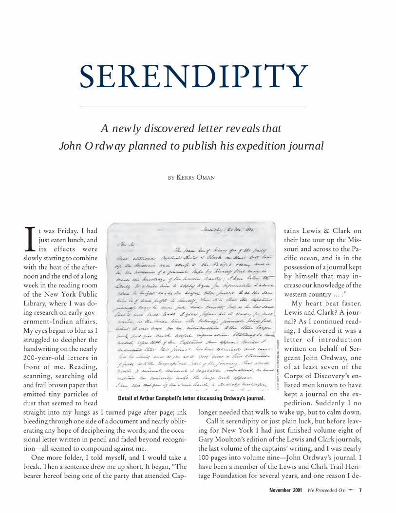
It was Friday. I hadjust eaten lunch, andits effects were
slowly starting to combinewith the heat of the after-noon and the end of a longweek in the reading roomof the New York PublicLibrary, where I was do-ing research on early gov-ernment-Indian affairs.My eyes began to blur as Istruggled to decipher thehandwriting on the nearly200-year-old letters infront of me. Reading,scanning, searching oldand frail brown paper thatemitted tiny particles ofdust that seemed to headstraight into my lungs as I turned page after page; inkbleeding through one side of a document and nearly oblit-erating any hope of deciphering the words; and the occa-sional letter written in pencil and faded beyond recogni-tion—all seemed to compound against me.
One more folder, I told myself, and I would take abreak. Then a sentence drew me up short. It began, “Thebearer hereof being one of the party that attended Cap-
tains Lewis & Clark ontheir late tour up the Mis-souri and across to the Pa-cific ocean, and is in thepossession of a journal keptby himself that may in-crease our knowledge of thewestern country … .”
My heart beat faster.Lewis and Clark? A jour-nal? As I continued read-ing, I discovered it was aletter of introductionwritten on behalf of Ser-geant John Ordway, oneof at least seven of theCorps of Discovery’s en-listed men known to havekept a journal on the ex-pedition. Suddenly I no
longer needed that walk to wake up, but to calm down.Call it serendipity or just plain luck, but before leav-
ing for New York I had just finished volume eight ofGary Moulton’s edition of the Lewis and Clark journals,the last volume of the captains’ writing, and I was nearly100 pages into volume nine—John Ordway’s journal. Ihave been a member of the Lewis and Clark Trail Heri-tage Foundation for several years, and one reason I de-
Detail of Arthur Campbell’s letter discussing Ordway’s journal.
CO
UR
TE
SY
NE
W Y
OR
K P
UB
LIC
LIB
RA
RY
SERENDIPITYA newly discovered letter reveals that
John Ordway planned to publish his expedition journal
BY KERRY OMAN
8 �We Proceeded On November 2001
cided to become a historian stems from reading JamesRonda’s Lewis and Clark Among the Indians. So Lewisand Clark are never far from my mind. But on that Fri-day afternooon, the last thing I expected to find was aletter concerning the expedition—particularly one thatseemed to reveal new information regarding one of itsmost important primary documents.
I came across the letter on April 27, 2001. A week later,after returning to Dallas, where I am a graduate student atSouthern Methodist University, I called Doug Erickson,a friend and the head archivist at Lewis and Clark Col-lege, in Portland. Doug noted how little is actually knownof Ordway and expressed excitement about the two-pageletter. I promised to send him a copy as soon as I receivedthe black-and-white photographs of it I had ordered fromthe New York Public Library. I felt like a child waiting toopen presents on Christmas morning, for it seemed aneternity before the photos arrived. (In actuality, the libraryprocessed my order quickly.)
The letter, from one Arthur Campbell to the ReverendJedidiah Morse, a prominent geographer, was written twomonths after Lewis and Clark’s return to St. Louis. It dealtwith Ordway in the first half and an unrelated matter inthe second:
Kentucky. 20 Nov. 1806.
Rev Sir,The bearer hereof being one of the
party that attended Captains Lewis & Clark ontheir late tour up the Missouri and across to thePacific ocean, and is in the possession of a journalkept by himself that may increase our knowledgeof the western country; I have taken the liberty toadvise him to apply to you for information &advice where he might make it useful to the public& at the same time be of some profit to himself.True it is that the Captains journal may be morefull and correct, but as he has said that it will be atleast 2 years, before his is ready for publication, inthe mean time Mr. Ordway’s journal beingpublished, it will serve as an introduction to theother larger work, and give much useful informa-tion that may be much needed, before that of theCaptains can appear. Besides I understand that thisjournal has been examined and corrected byLewis, and as far as it goes, gives a true statementof facts, as to the Geographical part of the journey.That which relates to animal, mineral & vegetableproduction, we must restrain our curiosity untilthe large work appears. I have also sent you by thesame hand, a Kentucky newspaper, that contains aEulogium on the late Chancellor Wythe ofVirginia that contains some sentiments that maybe useful to young men in any Nation in life,especially that of the bar if you accord with me in
opinion you will readily procure it a place in theMaps Magazine, or some such permanent work,for the benefit of the rising generation. In Virginia& other Southern States, It is a rare thing for awoman to have justice done her when prosecutingfor a rape. The sentiments [of] the honoredChancellor may assist to open the minds of hiscountrymen, and to make liberal judgment on thatdelicate and most important subject.
I am Rev Sir, being respectly yourmost obed Sert
Arthur Campbell1
The writer, Arthur Campbell, is a minor historical fig-ure, best known for his role in an abortive effort, duringthe 1780s, to create the new state of “Franklin” out ofcontiguous parts of western Virginia and North Caro-lina. Campbell was a land speculator caught up in fre-quent property disputes. In 1776, he fought with GeorgeRogers Clark and Thomas Jefferson over their plans tomake Kentucky, which was then part of Virginia, acounty. Campbell served in the Virginia militia for mostof his adult life. By 1806 he had retired from the militiaand was living in Washington County, Virginia, whilemaking frequent visits to land he owned in Kentucky,just west of the Cumberland Gap.2
It appears that Ordway met Campbell while travelingoverland from St. Louis to Washington, D.C., with Meri-wether Lewis and an Indian delegation in the late fall of1806. Their route took them through the CumberlandGap and into southern Virginia, where Campbell lived.Campbell’s letter is the first inkling we have that Ord-way intended to publish his journal and that Lewis hadexamined and corrected it. The trip would have providedhim an opportunity to discuss its publication with Lewis.One can also infer from Campbell’s letter that the ser-geant and his captain reached some sort of agreementabout the kind of information Ordway could include inthe published work.
As mentioned, Ordway was one of at least seven en-listed men of the Corps of Discovery known to have kepta journal. But only one of those journals, Patrick Gass’s,appeared in print in the years immediately following theexpedition’s return. The journals of Ordway, CharlesFloyd, and Joseph Whitehouse were not published untilthe early 20th century. The other three journals—by Rob-ert Frazer for certain and perhaps by Nathaniel Pryor andAlexander Willard—are lost.3
For whatever reason, Ordway did not go ahead withhis publishing plans. Instead, his journal was purchasedby Lewis and later came into the possession of NicholasBiddle, who used it as a reference while writing The His-
9�November 2001 We Proceeded On
tory of the Expedition Under the Command of CaptainsLewis and Clark. Published in 1814, Biddle’s account ismainly an extended paraphrase of the journals kept byMeriwether Lewis and William Clark. Ordway’s journalthen vanished for a century until discovered amongBiddle’s papers by his grandsons in 1913. Edited by MiloM. Quaife, it was published three years later by the StateHistorical Society of Wisconsin and is now in the archivesof the American Philosophical Society, in Philadelphia.4
It is no surprise that Ordway’s journal promised to re-veal strictly geographical discoveries, or, as Campbell putit, to give “a true statement of facts, as to the Geographi-cal part of the journey.” In October, before leaving St.Louis, Lewis had edited theprospectus for the proposedpublication of Private RobertFrazer’s journal. Lewis hadgiven Frazer permission to pub-lish his account, but upon re-viewing the prospectus he wastaken aback by its promise togive a full description of theexpedition’s discoveries in natu-ral history. Lewis demandedthat this promise be expunged,claiming that Frazer was “en-tirely unacquainted with celes-tial observations, mineralogy,botany, or zoology.”5 HistorianStephen E. Ambrose has arguedthat Lewis regarded his scien-tific discoveries as the mostvaluable part of his journal.6
Ordway was surely aware ofLewis’s proprietary feelings andwould have couched his prospectus in terms agreeable tohis commanding officer. He must have proposed restrict-ing his account to a narrative of the journey, avoiding any-thing “which relates to animal, mineral & vegetable pro-duction” and leaving such matters to “the large work” thatLewis expected to write.
Campbell’s letter also informs us—and we can assumehe learned this from Lewis—that it would be approxi-mately two years before Lewis and Clark’s journals (ineffect, the official account) would appear in print.
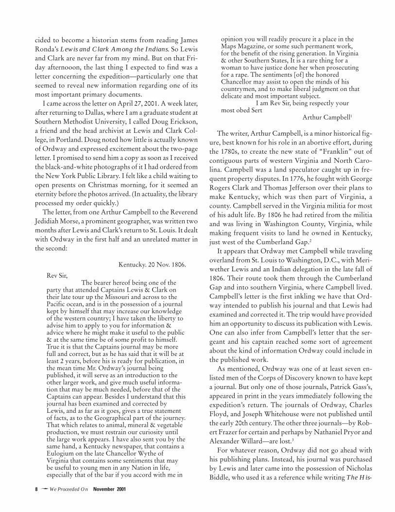
There is no direct documentary evidence for a meetingbetween Ordway and Jedidiah Morse, the geographer towhom Campbell’s letter was addressed, but it is fair toassume that it did occur. We do know that, from Wash-
ington, Ordway returned to his home in New Hampshirewith the intention of publishing his journal. It is unclearwhether he stopped en route at Morse’s home inCharlestown, Massachusetts, or if they met later.
JEDIDIAH MORSE, EMINENT GEOGRAPHER
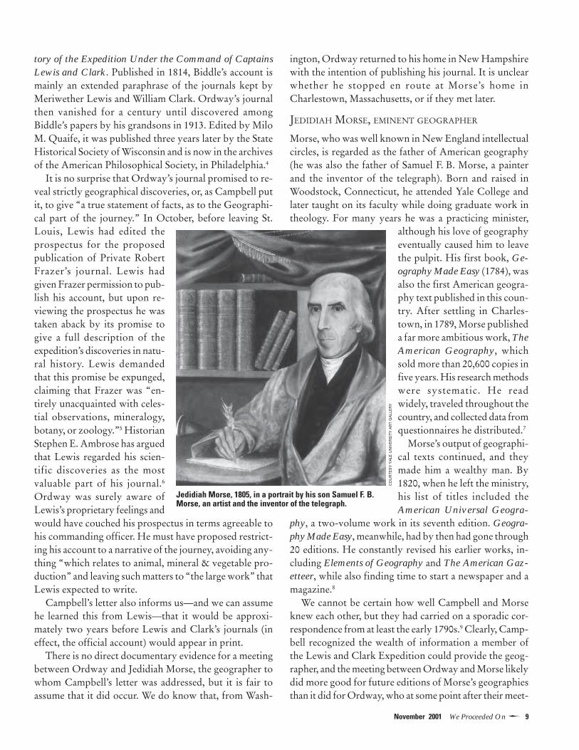
Morse, who was well known in New England intellectualcircles, is regarded as the father of American geography(he was also the father of Samuel F. B. Morse, a painterand the inventor of the telegraph). Born and raised inWoodstock, Connecticut, he attended Yale College andlater taught on its faculty while doing graduate work intheology. For many years he was a practicing minister,
although his love of geographyeventually caused him to leavethe pulpit. His first book, Ge-ography Made Easy (1784), wasalso the first American geogra-phy text published in this coun-try. After settling in Charles-town, in 1789, Morse publisheda far more ambitious work, TheAmerican Geography, whichsold more than 20,600 copies infive years. His research methodswere systematic. He readwidely, traveled throughout thecountry, and collected data fromquestionnaires he distributed.7
Morse’s output of geographi-cal texts continued, and theymade him a wealthy man. By1820, when he left the ministry,his list of titles included theAmerican Universal Geogra-
phy, a two-volume work in its seventh edition. Geogra-phy Made Easy, meanwhile, had by then had gone through20 editions. He constantly revised his earlier works, in-cluding Elements of Geography and The American Gaz-etteer, while also finding time to start a newspaper and amagazine.8
We cannot be certain how well Campbell and Morseknew each other, but they had carried on a sporadic cor-respondence from at least the early 1790s.9 Clearly, Camp-bell recognized the wealth of information a member ofthe Lewis and Clark Expedition could provide the geog-rapher, and the meeting between Ordway and Morse likelydid more good for future editions of Morse’s geographiesthan it did for Ordway, who at some point after their meet-
Jedidiah Morse, 1805, in a portrait by his son Samuel F. B.Morse, an artist and the inventor of the telegraph.
CO
UR
TE
SY
YA
LE U
NIV
ER
SIT
Y A
RT
GA
LLE
RY

10�We Proceeded On November 2001
ing abandoned the plan to publish his journal.Why he did so we can only speculate. Lewis hoped to
make a lot of money from his own published account,and perhaps, upon further reflection, he persuaded Ord-way not to publish his.10 We do know that Lewis and Clarktogether ended up purchasing Ordway’s journal. Althoughmost sources say they paid him $300, there is evidencethat the price may only have been $10. Writer Olin D.Wheeler included in his travel narrative The Trail of Lewisand Clark, 1804-1806, published in 1904, a letter fromone of Ordway’s descendants, Martha Ordway Kibbler.According to Kibbler,
In an old letter which he [John Ordway] wrote justafter he returned from the expedition, and which Iread in 1862, he distinctly stated that the diary hekept and which he wore beneath his shirt, wasbought by the commanders of the expedition to beused by them in their report to the Government,and he thought the ten dollars they paid him for thediary was a good price. Probably the diary was cop-ied and the original lost. This letter with several oth-ers, giving details of their journey, sufferings andeventual success was lost in a fire about 1865.11
A note about the last section of Campbell’s letter, inwhich he states that he gave Ordway a newspaper“Eulogium” (eulogy) for one Chancellor Wythe to de-liver to Morse. Campbell was referring to George Wythe,a signer of the Declaration of Independence and and men-tor to Thomas Jefferson, who had been one of his lawstudents at the College of William and Mary. Campbell’sreference to Wythe appears to concern some legal assis-tance he gave to the victim in a rape case. In one of theera’s most notorious crimes, Wythe was murdered by agrandnephew on June 8, 1806. Jefferson called him “theCato of his country, without the avarice of the Roman.”12
Campbell’s letter adds to the small mysteries of the post-expeditionary phase of the Corps of Discovery. We willnever know how the immediate publication of Ordway’sjournal might have altered the captains’ efforts to publishtheir own work, or how it might have changed America’simage of the expedition. As a result of it, however, we doknow that Ordway intended to publish his journal anddiscussed this with Lewis. The letter also reminds us that,buried in archives, other Lewis and Clark documentssurely await discovery.
Foundation member Kerry Oman is a graduate student inAmerican history at Southern Methodist University.
NOTES
1Arthur Campbell to Jedidiah Morse, November 20, 1806,
Jedidiah Morse Papers, Box 1, folder “Correspondence 1801-1806,” Manuscripts and Archives Division of The New YorkPublic Library. At the end of the letter is a docket, or inscrip-tion, in Morses’s hand stating that the letter was from “GenCampbell. “Gen” is presumably short for “general,” althoughCampbell’s top rank in the Virginia militia was colonel.2Accounts of Arthur Campbell’s life can be found in HartwellL. Quinn, Arthur Campbell: Pioneer and Patriot of the “OldSouthwest” (Jefferson, N. C.: McFarland & Co., 1990); and JamesWilliam Hagy, “Arthur Campbell and the West, 1743-1811,”The Virginia Magazine of History and Biography 90 (1982), pp.456-471.3Gary E. Moulton, ed., The Journals of the Lewis & Clark Ex-pedition, 12 volumes (Lincoln: University of Nebraska Press,1984-99), Vol. 11, p. xii-xiii.4Ibid., Vol. 9. pp. xvi-xvii.5Donald Jackson, ed., Letters of the Lewis and Clark Expedi-tion, with Related Documents, 1783-1854 (Urbana: Universityof Illinois Press, 1978), Vol. 2, p. 386. Frazer’s journal was neverpublished and appears to be one of those lost to history.6Stephen E. Ambrose, Undaunted Courage (New York: Simon& Schuster, 1996), p. 405.7This brief account of Jedidiah Morse is based on Richard J.Moss, The Life of Jedidiah Morse: A Station of Peculiar Expo-sure (Knoxville: University of Tennessee Press, 1995).8Ibid.9The Filson Historical Society, in Louisville, Ky., owns at leastone letter from Jedidiah Morse to Arthur Campbell, dated Aug.27, 1793.10Ambrose, pp. 396-411.11Quoted in Olin D. Wheeler, The Trail of Lewis and Clark,1804-1806, 2 vols. (New York: G.P. Putnam’s Sons, 1904), p. 92.12Thomas Jefferson, “Notes for the Biography of GeorgeWythe,” as quoted in Alonzo Thomas Dill, George Wythe:Teacher of Liberty (Williamsburg: Virginia Independence Bi-centennial Commission, 1979), p. 82. An interesting note re-garding the connection between Arthur Campbell, Thomas Jef-ferson, and the West: In Notes on the State of Virginia, Jeffer-son discusses the possible existence of the mammoth in NorthAmerica. Apparently, Arthur Campbell helped fuel this ideain Jefferson by telling him the following story: “A Mr. Stanley,taken prisoner by the Indians near the mouth of the Tanissee,relates, that, after being transferred through several tribes, fromone to another, he was at length carried over the mountainswest of the Missouri to a river which runs westwardly; thatthese bones abounded there; and that the natives described tohim the animals to which they belonged as still existing in thenorthern parts of their country; from which description hejudged it to be the elephant.” Jefferson specifically mentionedthe mammoths to André Michaux in his instructions to him in1793, at the start of Michaux’s abortive exploration of the West.By the time of the Lewis and Clark Expedition, Jefferson hadbecome more tentative about mammoths roaming the plainsand instructed them to watch for “extinct animals.” See DonaldJackson, Thomas Jefferson and the Stony Mountains: Explor-ing the West from Monticello (Norman: University of Okla-homa Press, 1981), pp. 29-30.
11�November 2001 We Proceeded On
INTRODUCTION: CELESTIAL NAVIGATION
ON THE L&C EXPEDITION
How did Meriwether Lewis and William Clarkknow where they were? Mostly they relied ondead reckoning. By keeping daily records of
courses and distances traveled from a position of knownlatitude and longitude (for example Camp Dubois, theirbase, north of St. Louis, during the winter of 1803-4),they were able to plot their progress across the conti-nent. The system wasn’t perfect, for they tended to over-estimate distance, but it gave them at least a roughsense of their location.
A future issue of WPO will treat the subjectof dead reckoning. This issue deals with themore accurate but also more difficult methodof fixing position by celestial navigation—observation of the sun, moon, and stars. Forthis purpose the captains carried a sextant, anoctant, a chronometer, artificial horizons, andthe requisite celestial almanac and tables.
As the following three articles point out, celestial navi-gation is simple in theory but often dauntingly difficult inpractice. It takes skill to use the instruments effectively,and deriving a position from the raw data requires a seriesof calculations that must be done with accuracy and inthe proper sequence. It is not an exercise for the math-ematically faint-of-heart.
Finding latitude—a position on a line running parallelwith the equator—is relatively straightforward, but find-ing longitude—a position west or east of Greenwich, En-gland—takes multiple observations over days or weeks,and the subsequent mathematics require a strict exacti-tude and sometimes a knowledge of spherical trigonom-etry. Without great success, the captains tried several timesto calculate longitude, but mostly they made the observa-tions and recorded the data with the understanding that aprofessional mathematician would do the numbers afterthe expedition.
With near unanimity, historians have discounted Lewisand Clark’s abilities as celestial navigators. The captainsthemselves admitted their limitations. It is true they weretyros who often erred in their calculations, but as demon-
strated by Robert Bergantino in “Revisiting Fort Mandan’sLongitude” (pages 19-26) and by Laurence Rudner andHans Heynau in “Revisiting Fort Mandan’s Latitude(pages 27-30), their observations were usually pretty good,especially considering the often difficult field conditions.
Much has been made of the apparent uselessness of thecaptains’ data for longitude. Ferdinand Hassler, the math-ematician hired to convert the data, labored at the task off
and on for 10 years before giving up in despair. Althoughhis failure has often been blamed on Lewis and
Clark’s inadequacies as celestial observers, itnow appears that the fault lay with Hasslerand not the captains. Richard S. Preston, aphysicist at Northern Illinois University, ina recent article concludes that Hassler prob-
ably failed to understand or accept the validbut “somewhat unorthodox” observation
method used by Lewis.1 The method, which Lewishad learned from his celestial-navigation mentors, Rob-
ert Patterson and Andrew Ellicott, simplified the obser-vation but complicated the subsequent calculation, aneight-step process that for optimal results had to be re-peated three times. Calculating a single longitude by thismethod, Preston estimates, can take a person using penciland paper at least three hours, but a computer program hewrote for the job whipped through the numbers in sec-onds. Preston reports that the results of 20 of 23 longi-tude calculations based on Lewis and Clark’s data for po-sitions along the trail “agree with the modern values towithin a half a degree.” (Preston’s method is similar to aprocedure developed independently by Bergantino.)2
So let’s hear it for Lewis and Clark, who were bettercelestial navigators than they knew.
NOTES1Richard S. Preston, “The Accuracy of the Astronomical Ob-servations of Lewis and Clark,” Proceedings of the AmericanPhilosophical Society, June 2000, pp. 168-191. The article can beaccessed on the Web at www.aps-pub.com/proceedings/jun00/0600toc.htm.2Ibid, pp. 181, 179.

12�We Proceeded On November 2001
Thomas Jefferson’s orders to Meriwether Lewiswere straightforward as he prepared for his expe-dition to the Pacific: “Beginning at the mouth of
the Missouri, you will take observations of latitude & lon-gitude, at all remarkeable points on the river.”1
Latitude is the distance, in degrees, north or south ofthe equator. The number is expressed as parallels runningfrom zero degrees at the equator to 90 degrees at the poles.Longitude is the distance, in degrees, east or west of a des-ignated meridian, an imaginary line that runs directly be-tween the earth’s north and south poles. The Prime Me-ridian (zero degrees longitude) runs through Greenwich,England. A place’s coordinates of latitude and longitudelocate it on the globe.
INSTRUMENTS FOR DETERMINING LOCATIONS
Lewis and Clark’s celestial observations for latitude andlongitude were made using a sextant, an octant, severaltypes of artificial horizons, and a chronometer.2
A sextant consists of an arm that moves along an arcmarked off, or calibrated, in a scale of degrees, minutes,and seconds. It also has an eyepiece, a mirror, a horizonglass, and adjustable shades for viewing the sun. It is typi-cally used to measure the angular distance of the sun fromthe horizon, although it can also be used to measure theangular distance between the moon and the sun or a star.
The image of the sun reflects off the mirror, which is fixedon the movable arm, and onto the horizon glass, which ismirrored on one side and clear on the other. The observersights on the horizon and moves the arm to align the sun’sreflection with it. The base of the arm slides along the arcwith its calibrated scale. After aligning the sun with thehorizon, the observer reads the sun’s altitude off the scale.
Lewis’s sextant was purchased from Thomas Whitneyof Philadelphia. It was made of brass and had a radius of10 inches. Its scale was graduated by degrees and quarterdegrees (15 minutes of arc). Two other components—avernier scale and a micrometer—allowed Lewis to takereadings to the nearest 7 1/2 seconds.3 The sextant had threeinterchangeable eyepieces. One was a hollow tube. Theother two were telescopes, one of which reversed the im-age of the observed object. Lewis used the reversing-tele-scope eyepiece most often because it gave a fuller and bet-ter image than the others.
An octant, also known as a quadrant, is similar to asextant, but simpler. Lewis’s octant had a radius of 14inches, an arc graduated to 20 minutes, and a fixed eye-piece. A vernier scale and micrometer allowed readings tothe nearest half minute. The octant was used in high sum-mer, when the sun’s altitude at noon was greater than couldbe read using the sextant.
Whether working with the sextant or octant, Lewis and
CELESTIAL NAVIGATION
BASICS
How the captains found latitude and (sometimes) longitude
BY EILEEN STARR

13�November 2001 We Proceeded On
Clark used an artificial horizon for measuring the altitudeof celestial bodies. They had to use an artificial horizonbecause on land (unlike at sea), the actual horizon is al-most always obscured by hills, trees, or other landscapefeatures. An artificial horizon is a reflecting surface, par-allel to the earth, that reflects the image of a celestial ob-ject in the same way it would be reflected from the sur-face of a pond, lake, or ocean under still conditions. Whenusing an artificial horizon while making an observation,the observer aligns the image of the sun reflected from theindex mirror with the image of the sun reflected from theartificial horizon; the actual horizon, if it could be seen,would lie exactly halfway between the two images. Theobserved angle, therefore, must be divided by two to ob-tain the sun’s actual angular distance from the horizon.
Lewis gave the following description of his three typesof artificial horizons in his journal entry of July 22, 1804.(Andrew Ellicott and Robert Patterson were his instruc-tors in celestial navigation. A “sperit-level” is like acarpenter’s bubble level, filled with alcohol or “spirit” sothat it can still be used when the temperature is below thefreezing point of water.)
An Artificial Horizon on the construction recom-mended by Mr. Andrw. Ellicott of Lancaster,Pensyla., in which water is used as the reflecting sur-face; believing this artificial Horizon liable to less
error than any other in my possession. I have uni-formly used it when the object observed was suffi-ciently bright to reflect a distinct immage; but asmuch light is lost by reflection from water, I foundit inconvenient in most cases to take the altitude ofthe moon with this horizon, and that of a star im-practicable with any degree of accuracy. ...
An Artificial Horizon constructed in the manner rec-ommended by Mr. [Robert] Patterson of Philadel-phia; glass is here used as the reflecting surface. Thishorizon consists of a glass plane with a single re-flecting face, cemented to the flat side of the largersegment of a wooden ball; adjusted by means of asperit-level and a triangular stand with a triangularmortice cut through it’s center sufficiently large toadmit of the wooden ball partially; the stand restson three screws inserted near it’s angles, which serveas feet for it to rest on while they assist also in theadjustment. This horizon I have employed in tak-ing the altitude of the sun when his image he hasbeen reather too dull for a perfect reflection fromwater; I have used it generally in taking the altitudeof the moon, and in some cases of the stars also. ...
An Artificial Horizon formed of the index specula[mirror] of a Sextant cemented to a flat board; ad-justed by means of a sperit level and the triangularstand as before discribed. As this glass reflects fromboth surfaces it gives the image of all objects muchmore bright than either of the other horizon; I havetherefore most generally employed it in observingthe altitudes of stars.
Left: An octant of the Lewis and Clark era.Right: A sextant, dating from the early 1800s,
that was similar to the captains’. It hadthree interchangeable eyepieces,
two of which were telescopic, andshades that could be flipped into
place for observing the sun.
OC
TA
NT
FR
OM
TH
E C
OLL
EC
TIO
NS
OF
TH
E M
AR
INE
RS
’ MU
SE
UM
, NE
WP
OR
T N
EW
S, V
A.;
SE
XT
AN
TC
OU
RT
ES
Y N
AT
ION
AL
MU
SE
UM
OF
AM
ER
ICA
N H
IST
OR
Y (
SM
ITH
SO
NIA
N IN
ST
ITU
TIO
N)

14�We Proceeded On November 2001
Lewis purchased his chronometer from Thomas Parker,a Philadelphia watchmaker.4 A chronometer is essentiallya clock. It is used by a celestial navigator to compare hislocal time with Greenwich time when calculating longi-tude. Lewis describes his chronometer in the same jour-nal entry of July 22, 1804:
A Chronometer, her ballance-wheel and [e]scape-ment were of the most improved construction. Sherested on her back, in a small case prepared for her,suspended by an universal joint. She was carefullywound every day at twelve oclock. Her rate of go-ing [daily error] as assertained by a series of obser-vations made by myself for that purpose was foundto be 15 Seconds and a 5 tenths of a second too slowin twenty four howers on Mean Solar time.
The chronometer was not always reliable. AlthoughLewis said he wound it faithfully every day, it stopped atleast twice during the Corps of Discovery’s winter at CampDubois.5 On July 15, 1804, two months into the journeyup the Missouri, Lewis mentioned that the chronometerhad again stopped, even though it had been wound theprevious noon. The chronometer also stopped a fourthtime, on August 24, 1804. There were other occasionswhen the chronometer ran down because the captains,concerned with more pressing matters, simply forgot towind it.6
Lewis received three weeks of instruction in celestialnavigation and surveying from Andrew Ellicott, an as-tronomer and mathematician, and additional training fromthe mathematician Robert Patterson. Based on their rec-ommendations, Lewis carried on the expedition A Practi-cal Introduction to Spherics and Nautical Astronomy, byPatrick Kelly (London, 1796); The Nautical Almanac andAstronomical Ephemeris, which gave daily locations ofheavenly bodies; and the Tables Requisite to be Used withthe Nautical Ephemeris for Finding the Latitude and Lon-gitude at Sea, by Nevil Maskelyn.7
FINDING LATITUDE AND LONGITUDE
Finding latitude is a much simpler exercise than findinglongitude. Lewis typically determined latitude by mea-suring solar noon—the altitude of the sun at local noon,when it was directly south and at its highest point in thesky. In the Northern Hemisphere, as you move north-ward the sun appears lower in the sky. Although the sunrises and sets at different points along the horizon, andvaries in elevation depending on the time of the year, as-tronomical tables of the sort carried by Lewis and Clarkgave the declination of the sun at noon Greenwich appar-ent time for every day of the year. From the declination
(the number of degrees the sun stood north or south ofthe equator) one could calculate the latitude of a noonobservation.8 The calculations involved correcting for re-fraction (the bending of the sun’s image by the atmo-sphere), apparent size of the solar disc (which varies be-cause of changes in earth’s distance from the sun), andparallax (changes in the observer’s perspective).9
Finding longitude is based on the relationship betweentime and distance in the sun’s apparent passage from eastto west. The earth turns once on its axis every 24 hours.During that 24 hours, a point on the earth moves 360 de-grees, or 15 degrees every hour relative to the sun. Longi-tude can be found by comparing the local apparent timeof an event, such as the time when the sun is due south,with the apparent time of the same event at the PrimeMeridian (zero degrees longitude, at Greenwich, England).The difference in time in hours, minutes, and seconds canbe converted to the distance west from the Prime Merid-ian in degrees, minutes, and seconds.
The difficulty is knowing the time at the Prime Merid-ian. The easiest way is to use a chronometer, a clock set toGreenwich time. But chronometers are not perfect timepieces, so an observer must know the chronometer’s “rateof going,” or daily error, and factor that into his calcula-tions. He can calculate this error by observing the time oflocal noon on successive days and seeing how fast or slow
This pocket chronometer, made in London in 1807, was similar toone purchased by Lewis in Philadelphia for $250, plus 75 cents fora winding key. It came in a mahogany box and rested on gimbals.Lewis often removed it from the box and carried it in his pocket.
CO
UR
TE
SY
NA
TIO
NA
L M
US
EU
M O
F A
ME
RIC
AN
HIS
TO
RY
(S
MIT
HS
ON
IAN
INS
TIT
UT
ION
)

15�November 2001 We Proceeded On
his chronometer is running on “clock time” relative totrue “solar” time. If the chronometer stops (as it did onseveral occasions for Lewis and Clark), it can be reset.
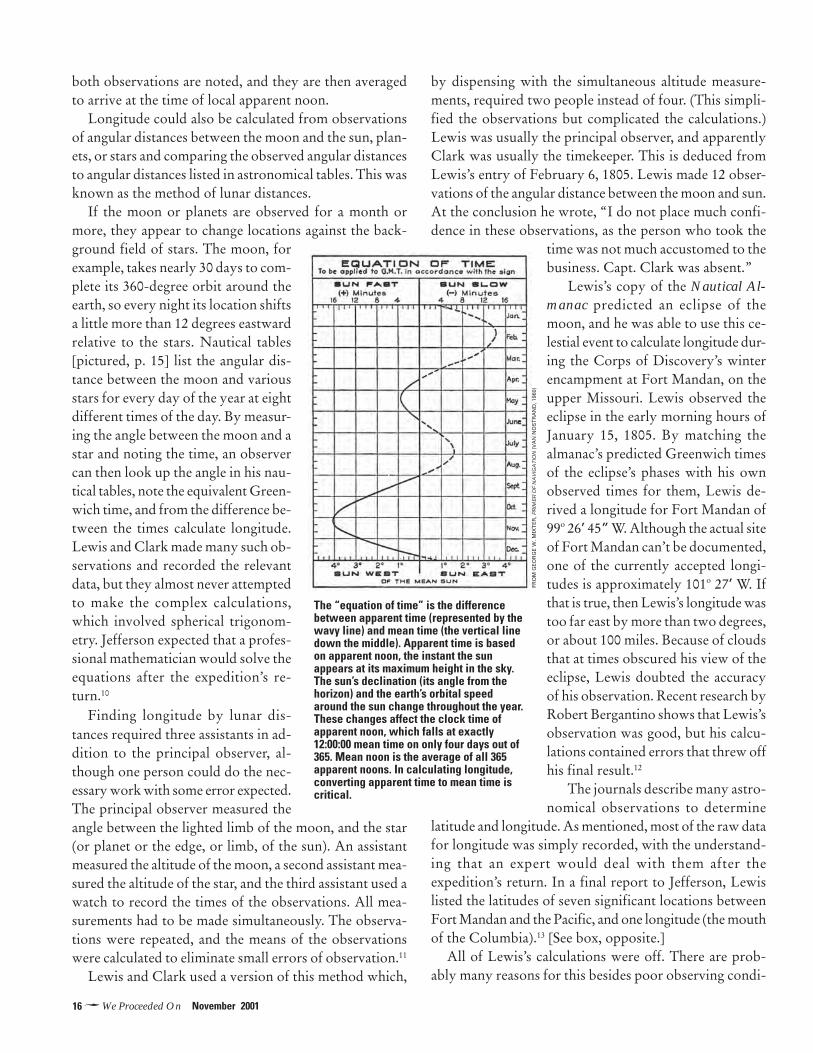
Distinguishing between local time and mean time wasan essential correction in finding longitude. The earth or-bits the sun once a year. Because earth’s orbit is an ellipserather than a true circle, the earth’s distance from the sunvaries. So too does its orbital speed, because the earthmoves faster when it is closer to the sun and slower whenit is farther away. As a result, clock time (as in “12 o’clock”)and sun time (as in solar noon) almost always differ. Thisdifference is also influenced by changes in the sun’s decli-nation (its angle in the sky) over the course of a year. Themaximum difference between clock time and solar time is16 minutes, 24 seconds—meaning that solar noon as mea-
sured by the clock can occur as early as 11:43:36 A.M. or aslate as 12:16:24 P.M. Solar time is also called apparent time,and in certain calculations it is necessary for a navigatorto convert apparent time to mean time. Mean time is timeon a clock set to the yearly average time of noon. An ad-justment called the “equation of time” [page 16] is used incalculations to determine the clock time of local noon.
The simplest method of getting longitude in Lewis andClark’s era was to determine the Greenwich time of localnoon (that is, when the sun is at its highest point in thesky in the observer’s meridian). The time of local noonwas deduced by observing “equal altitudes” of the sun. Inthis method, two observations are made, one in the morn-ing and the other in the afternoon, when the sun is at thesame altitude east and west of the meridian. The times of
The Nautical Almanac predicted lunar angular distances for the sun and bright Zodiac stars.
16�We Proceeded On November 2001
both observations are noted, and they are then averagedto arrive at the time of local apparent noon.
Longitude could also be calculated from observationsof angular distances between the moon and the sun, plan-ets, or stars and comparing the observed angular distancesto angular distances listed in astronomical tables. This wasknown as the method of lunar distances.
If the moon or planets are observed for a month ormore, they appear to change locations against the back-ground field of stars. The moon, forexample, takes nearly 30 days to com-plete its 360-degree orbit around theearth, so every night its location shiftsa little more than 12 degrees eastwardrelative to the stars. Nautical tables[pictured, p. 15] list the angular dis-tance between the moon and variousstars for every day of the year at eightdifferent times of the day. By measur-ing the angle between the moon and astar and noting the time, an observercan then look up the angle in his nau-tical tables, note the equivalent Green-wich time, and from the difference be-tween the times calculate longitude.Lewis and Clark made many such ob-servations and recorded the relevantdata, but they almost never attemptedto make the complex calculations,which involved spherical trigonom-etry. Jefferson expected that a profes-sional mathematician would solve theequations after the expedition’s re-turn.10
Finding longitude by lunar dis-tances required three assistants in ad-dition to the principal observer, al-though one person could do the nec-essary work with some error expected.The principal observer measured theangle between the lighted limb of the moon, and the star(or planet or the edge, or limb, of the sun). An assistantmeasured the altitude of the moon, a second assistant mea-sured the altitude of the star, and the third assistant used awatch to record the times of the observations. All mea-surements had to be made simultaneously. The observa-tions were repeated, and the means of the observationswere calculated to eliminate small errors of observation.11
Lewis and Clark used a version of this method which,
by dispensing with the simultaneous altitude measure-ments, required two people instead of four. (This simpli-fied the observations but complicated the calculations.)Lewis was usually the principal observer, and apparentlyClark was usually the timekeeper. This is deduced fromLewis’s entry of February 6, 1805. Lewis made 12 obser-vations of the angular distance between the moon and sun.At the conclusion he wrote, “I do not place much confi-dence in these observations, as the person who took the
time was not much accustomed to thebusiness. Capt. Clark was absent.”
Lewis’s copy of the Nautical Al-manac predicted an eclipse of themoon, and he was able to use this ce-lestial event to calculate longitude dur-ing the Corps of Discovery’s winterencampment at Fort Mandan, on theupper Missouri. Lewis observed theeclipse in the early morning hours ofJanuary 15, 1805. By matching thealmanac’s predicted Greenwich timesof the eclipse’s phases with his ownobserved times for them, Lewis de-rived a longitude for Fort Mandan of99o 26’ 45” W. Although the actual siteof Fort Mandan can’t be documented,one of the currently accepted longi-tudes is approximately 101o 27’ W. Ifthat is true, then Lewis’s longitude wastoo far east by more than two degrees,or about 100 miles. Because of cloudsthat at times obscured his view of theeclipse, Lewis doubted the accuracyof his observation. Recent research byRobert Bergantino shows that Lewis’sobservation was good, but his calcu-lations contained errors that threw offhis final result.12
The journals describe many astro-nomical observations to determine
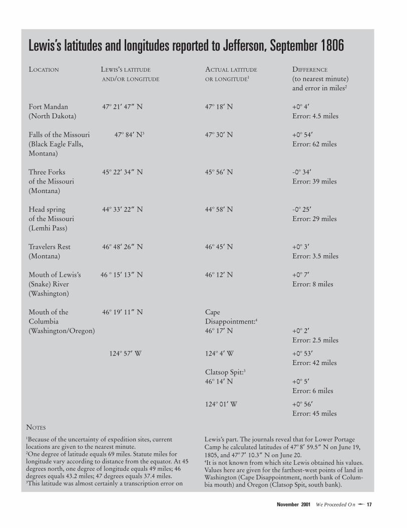
latitude and longitude. As mentioned, most of the raw datafor longitude was simply recorded, with the understand-ing that an expert would deal with them after theexpedition’s return. In a final report to Jefferson, Lewislisted the latitudes of seven significant locations betweenFort Mandan and the Pacific, and one longitude (the mouthof the Columbia).13 [See box, opposite.]
All of Lewis’s calculations were off. There are prob-ably many reasons for this besides poor observing condi-
The “equation of time” is the differencebetween apparent time (represented by thewavy line) and mean time (the vertical linedown the middle). Apparent time is basedon apparent noon, the instant the sunappears at its maximum height in the sky.The sun’s declination (its angle from thehorizon) and the earth’s orbital speedaround the sun change throughout the year.These changes affect the clock time ofapparent noon, which falls at exactly12:00:00 mean time on only four days out of365. Mean noon is the average of all 365apparent noons. In calculating longitude,converting apparent time to mean time iscritical.
FRO
M G
EO
RG
E W
. MIX
TE
R, P
RIM
ER O
F N
AV
IGA
TIO
N (
VA
N N
OS
TR
AN
D, 1
960)
17�November 2001 We Proceeded On
Lewis’s latitudes and longitudes reported to Jefferson, September 1806LOCATION LEWIS’S LATITUDE ACTUAL LATITUDE DIFFERENCE
AND/OR LONGITUDE OR LONGITUDE1 (to nearest minute)and error in miles2
Fort Mandan 47o 21’ 47” N 47o 18’ N +0o 4’(North Dakota) Error: 4.5 miles
Falls of the Missouri 47o 84’ N3 47o 30’ N +0o 54’(Black Eagle Falls, Error: 62 milesMontana)
Three Forks 45o 22’ 34” N 45o 56’ N -0o 34’of the Missouri Error: 39 miles(Montana)
Head spring 44o 33’ 22” N 44o 58’ N -0o 25’of the Missouri Error: 29 miles(Lemhi Pass)
Travelers Rest 46o 48’ 26” N 46o 45’ N +0o 3’(Montana) Error: 3.5 miles
Mouth of Lewis’s 46 o 15’ 13” N 46o 12’ N +0o 7’(Snake) River Error: 8 miles(Washington)
Mouth of the 46o 19’ 11” N CapeColumbia Disappointment:4
(Washington/Oregon) 46o 17’ N +0o 2’Error: 2.5 miles
124o 57’ W 124o 4’ W +0o 53’Error: 42 miles
Clatsop Spit:3
46o 14’ N +0o 5’Error: 6 miles
124o 01’ W +0o 56’Error: 45 miles
1Because of the uncertainty of expedition sites, currentlocations are given to the nearest minute.2One degree of latitude equals 69 miles. Statute miles forlongitude vary according to distance from the equator. At 45degrees north, one degree of longitude equals 49 miles; 46degrees equals 43.2 miles; 47 degrees equals 37.4 miles.3This latitude was almost certainly a transcription error on
Lewis’s part. The journals reveal that for Lower PortageCamp he calculated latitudes of 47o 8’ 59.5” N on June 19,1805, and 47o 7’ 10.3” N on June 20.4It is not known from which site Lewis obtained his values.Values here are given for the farthest-west points of land inWashington (Cape Disappointment, north bank of Colum-bia mouth) and Oregon (Clatsop Spit, south bank).
NOTES

18�We Proceeded On November 2001
tions and mistakes in calculation. For example, there wasconsiderable error in the published lunar distance tables.At the time of the Lewis and Clark Expedition, the meanerror in the tables for celestial latitude was 13 seconds,with a maximum of 80 seconds. The mean error for celes-tial longitude was 27 seconds, with a maximum of 87 sec-onds.14 Instrument error was another factor. Although thestandard error of each instrument was known and includedin calculations, they could have been additionally affectedby conditions of extreme heat and cold and low humid-ity; the aridity of the upper plains, for example, could havewarped the wooden octant.
The Corps of Discovery, following Jefferson’s orders,did make latitude and longitude measurements at all re-markable points of the river. Considering the instrumentsand tables that they had to work with, the measurementswere remarkably accurate and provided the approximatelocations of what Jefferson termed the durable “naturalmarks & characters” in the lands secured by the Louisi-ana Purchase and those farther west.
Foundation member Eileen Starr is a professor of science atValley City State University, in Valley City, North Dakota.
NOTES
1Jefferson to Lewis, June 20, 1803. Donald Jackson, Letters ofthe Lewis and Clark Expedition with Related Documents, 1783-1854, 2 volumes (Urbana: University of Illinois Press, 1978),Vol. 1, p. 61.2The captains also carried a circumferentor, or surveying com-pass. Since this is not, strictly speaking, an instrument for celes-tial navigation, it is not discussed in detail. In conjunction withan observation of the sun with a sextant or octant, acircumferentor can be used to determine magnetic declination,the difference between true and magnetic north, which variesaccording to one’s location. Lewis and Clark took readings ofmagnetic declination for their records of courses and distancestraveled. Lewis gave a detailed description of his instruments inhis journal entry of June 22, 1804. See Gary E. Moulton, ed.,The Journals of the Lewis & Clark Expedition (Lincoln: Uni-versity of Nebraska Press, Vols. 2-11, 1986-97), Vol. 2, pp. 410-14. Quotations or references to journal entries in the ensuingtext are from Moulton, Vols. 2-11, by date, unless otherwiseindicated.3The vernier scale (which Lewis called a nonius) and microme-ter, or tangent screw, were attached to the arm. Moulton, Vol. 2,p. 414.4Moulton, Vol. 2, p. 412. Lewis referred to it as a “Gold Chro-nometer. It was made in England and may or may not have been anArnold’s chronometer, which set the standard of quality for thetime. See Guy Meriwether Benson, Exploring the West fromMonticello: A Perspective in Maps from Columbus to Lewis andClark (Charlottesville: University of Virginia Library, 1995), p. 77.
5Ibid., p. 381.6Moulton, Vol. 2, p. 113.7Moulton, Vol 2, p. 87. The Nautical Almanac and Astronomi-cal Ephemeris contained the predicted angular distances betweenthe moon and sun and nine bright zodiacal stars—Alpha Aquilae,Fomalhaut, Alpha Arietis, Aldebaran, Pollux, Regulus, Antares,Spica, and Alpha Pegasi. Only Fomalhaut exceeded the maxi-mum declination of the moon and was selected because thereare no other bright stars in that area of the sky. The positionswere given daily at eight separate times, every three hours, be-ginning at noon. Proportional logarithms were given inMaskelyne’s Requisite Tables to calculate the angular separa-tion at times other than those given. The astronomical tablesgave values of the position of the moon as viewed from thecenter of the earth, and values of distances from the center ofthe moon or sun. A number of tedious spherical trigonomet-ric calculations, termed “clearing the distance” was necessary.Corrections for parallax and the refraction of light were needed,as well as the position of the center of the sun or moon. Bothobjects change in apparent size, depending on their distancefrom the earth. The daily semi-diameter of the sun or moon,found in the tables carried by the Corps, was then added tothe angular distance measured with a sextant. Different meth-ods were used to clear the distance, and all gave slightly differ-ent values for longitude. All calculations of longitude requiredknowledge of the latitude. See Charles Cotter, A History ofNautical Astronomy (New York: American Elsevier Publish-ing Co., 1968) p. 239.8Another method for finding latitude is to measure the altitudeof the North Celestial Pole, which is located near Polaris, theNorth Star. In the Northern Hemisphere, the higher one’s lati-tude, the higher the North Star appears in the sky. Lewis doesn’tsay so specifically, but he may have used this method for deter-mining latitude while camped at the mouth of the Great OsageRiver in early June 1804 (Moulton, Vol. 2, p. 269). On succes-sive nights he measured magnetic declination by sighting thecircumferentor on Polaris, and it is reasonable to assume that healso took a sextant reading of Polaris’s altitude.9In his journal entry for December 3, 1803 (Moulton, Vol. 2, p.121), Clark went through the steps for calculating latitude atKaskaskia, Illinois. He did this twice after apparently realizingthat his first calculation is based on a faulty measurement of thesun’s altitude (“Sexion [sextant] not right”). The latitude he ar-rived at—39o 46’ 41”—differs by 1 degree, 25 minutes, 53 sec-onds from a latitude calculation of 38o 20’ 57” recorded on thesame day by Lewis. Because one degree of latitude equals ap-proximately 69 miles, the difference between Clark’s and Lewis’scalculations is about a mile and a half. Clark also detailed hissteps when he calculated a latitude on December 18 and 19, 1803.10Jackson, p. 62.11Cotter, pp. 205-06.12Robert Bergantino, “Fort Mandan’s Longitude Revisited,”appears in this issue of WPO.13Moulton, Vol. 8, p. 413. The readings were included in an un-dated letter written from St. Louis in late September of 1806.14J.E.D. Williams, From Sails to Satellites (New York: OxfordUniversity Press, 1992). p. 96.

19�November 2001 We Proceeded On
Beginning at the mouth of the Missouri, you will take ob-servations of latitude & longitude, at all remarkeable pointson the river, & especially at the mouths of rivers, at rapids,at islands, & other places & objects distinguished by suchnatural marks & characters of a durable kind, as that theymay with certainty be recognised hereafter.—Thomas Jefferson to Meriwether Lewis, June 20, 18031
During their expedition to the Pacific and back,Meriwether Lewis and William Clark complieddiligently with President Jefferson’s instruc-
tions. Between November 1803, about the time theymoved into winter quarters at Camp Dubois, north of St.Louis, and January 1805, when they were encamped atFort Mandan, on the Upper Missouri, they made manyobservations of the sun for latitude (distance in degreesnorth of the equator) and the moon for longitude (dis-tance in degrees west of Greenwich, England).2 They rou-tinely calculated latitude, a fairly straightforward exercisebased on the sun’s angular elevation at noon, but deferredthe far more complex job of calculating longitude basedon the angular distance between the moon and the sun ora star. That was fine by Jefferson, who expected that aprofessional mathematician, using the captains’ data,would make the calculations for longitude after theexpedition’s return.3
Once at Fort Mandan, the captains had the time and
opportunity to attempt a calculation of longitude basedon an eclipse of the moon on the night of January 14-15,1805. The longitude for the mouth of the Columbia hadbeen plotted by mariners a decade before, and an accuratemeasurement of longitude at Fort Mandan would tell themhow far west they still had to travel to reach the Pacific.4
The captains knew of two previous longitude estimatesfor the vicinity of Fort Mandan. One, from fur traderAlexander Mackenzie’s account of his explorations ofCanada, stated that David Thompson, another Canadianfur trader and explorer, had determined “the Northernbend of the Missouri” to be at longitude 101o 25’ W. 5 Theother came from John Evans, a fur trader who exploredthe Missouri between St. Louis and the Mandan villagesin 1795-97.6 Evans’s map of the upper Missouri showedthe longitude of some abandoned Mandan villages 12 mileseast of Fort Mandan at about 107o W. The difference ofnearly 6 degrees between Thompson’s and Evans’s longi-tudes was significant—about 300 miles—and the captainsmust have wondered who, if either, was right. They hopedthe observation of the lunar eclipse would help providean answer.
SHOOTING THE MOON
Lewis knew of the upcoming eclipse from his copy of theBritish Nautical Almanac and Astronomical Ephemeris.The almanac recorded in Greenwich time the key phases
REVISITING FORT MANDAN’S
LONGITUDELewis doubted his data, but the fault was in his calculations
BY ROBERT N. BERGANTINO
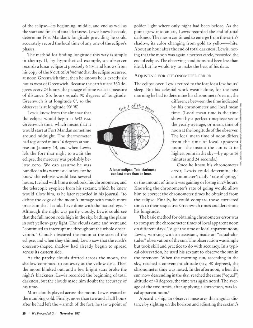
20�We Proceeded On November 2001
of the eclipse—its beginning, middle, and end as well asthe start and finish of total darkness. Lewis knew he coulddetermine Fort Mandan’s longitude providing he couldaccurately record the local time of any one of the eclipse’sphases.
The method for finding longitude this way is simplein theory. If, by hypothetical example, an observerrecords a lunar eclipse at precisely 6 P.M. and knows fromhis copy of the Nautical Almanac that the eclipse occurredat noon Greenwich time, then he knows he is exactly sixhours west of Greenwich. Because the earth turns 360 de-grees every 24 hours, the passage of time is also a measureof distance. Six hours equals 90 degrees of longitude.Greenwich is at longitude 0o, so theobserver is at longitude 90o W.
Lewis knew from the almanac thatthe eclipse would begin at 6:42 P.M.Greenwich time, which meant that itwould start at Fort Mandan sometimearound midnight. The thermometerhad registered minus 16 degrees at sun-rise on January 14, and when Lewisleft the fort that night to await theeclipse, the mercury was probably be-low zero. We can assume he wasbundled in his warmest clothes, for heknew the eclipse would last severalhours. He had with him a notebook, his chronometer, andthe telescopic eyepiece from his sextant, which he knewwould allow him, as he later recorded in his journal, “todefine the edge of the moon’s immage with much moreprecision that I could have done with the natural eye.”7
Although the night was partly cloudy, Lewis could seethat the full moon rode high in the sky, bathing the plainsin soft yellow-gray light. The clouds came and went and“continued to interrupt me throughout the whole obser-vation.” Clouds obscured the moon at the start of theeclipse, and when they thinned, Lewis saw that the earth’screscent-shaped shadow had already begun to spreadacross its eastern side.
As the patchy clouds drifted across the moon, theshadow continued to eat away at the yellow disc. Thenthe moon blinked out, and a few bright stars broke thenight’s blackness. Lewis recorded the beginning of totaldarkness, but the clouds made him doubt the accuracy ofhis time.
More clouds played across the moon. Lewis waited inthe numbing cold. Finally, more than two and a half hoursafter he had left the warmth of the fort, he saw a point of
golden light where only night had been before. As thepoint grew into an arc, Lewis recorded the end of totaldarkness. The moon continued to emerge from the earth’sshadow, its color changing from gold to yellow-white.About an hour after the end of total darkness, Lewis, not-ing that the moon was again a perfect circle, recorded theend of eclipse. The observing conditions had been less thanideal, but he would try to make the best of his data.
ADJUSTING FOR CHRONOMETER ERROR
The eclipse over, Lewis retired to the fort for a few hours’sleep. But his celestial work wasn’t done, for the nextmorning he had to determine his chronometer’s error, the
difference between the time indicatedby his chronometer and local meantime. (Local mean time is the timeshown by a perfect timepiece set tothe yearly average, or mean, time ofnoon at the longitude of the observer.The local mean time of noon differsfrom the time of local apparentnoon—the instant the sun is at itshighest point in the sky—by up to 16minutes and 24 seconds.)
Once he knew his chronometererror, Lewis could determine thechronometer’s daily “rate of going,”
or the amount of time it was gaining or losing in 24 hours.Knowing the chronometer’s rate of going would allowhim to correct the chronometer times he obtained fromthe eclipse. Finally, he could compare those correctedtimes to their respective Greenwich times and determinehis longitude.
The basic method for obtaining chronometer error wasto compare the chronometer times of local apparent noonon different days. To get the time of local apparent noon,Lewis, working with an assistant, made an “equal-alti-tudes” observation of the sun. The observation was simplebut took skill and practice to do with accuracy. In a typi-cal observation, he used his sextant to observe the sun inthe forenoon. When the morning sun, ascending in thesky, reached a convenient altitude (say, 40 degrees), thechronometer time was noted. In the afternoon, when thesun, now descending in the sky, reached the same (“equal”)altitude of 40 degrees, the time was again noted. The aver-age of the two times, after applying a correction, was lo-cal apparent noon.8
Aboard a ship, an observer measures this angular dis-tance by sighting on the horizon and adjusting the sextant’s
A lunar eclipse. Total darknesscan last more than an hour.
FRO
M G
EO
RG
E W
. MIX
TE
R, P
RIM
ER O
F N
AV
IGA
TIO
N (
VA
N N
OS
TR
AN
D, 1
960)
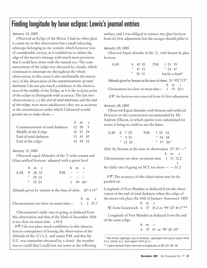
21�November 2001 We Proceeded On
Finding longitude by lunar eclipse: Lewis’s journal entriessurface, and I was obliged to remove my glass horizonfrom it’s first adjustment lest the savages should pilfer it.
January 20, 1805Observed Equal altitudes of the , with Sextant & glass
horizon.
A.M. 8 40 20 P.M. 1 21 55 [l.l. ” 47 15 ” 24 47 [ [
” 50 10 .] lost by a cloud*
Altitude given by Sextant at the time of obstn. 31o 40[’] 15” h m s
Chronometer too slow on mean time— 1 15 20.3
the horizon was removed from it’s first adjustment.
January 28, 1805Observed Equal altitudes with Sextant and artificial
Horizon on the construction recommended by Mr.Andrew Ellicott, in which sperits were substituted forwater, it being to could to use the latter.
A.M. 8 7 29 P.M. 1 52 34 [l.l. ” 9 51 ” 54 58 [ [ ” 12 20 ll.] ” 57 26*
Altd. by Sextant at the time of observation 33o 25’ —”h m s
Chronometer too slow on meant time 1 11 12.2s
her daily rate of going on M.T. too slow — — 51.2[
The accuracy of this observation may be de-pended on.
Longitude of Fort Mandan as deduced from the obser-vation of the end of total darkness when the eclips ofthe moon tok place the 14th of January Astronocl. 1805
h m sW. from Greenwich 6 37 31.2 or 99o 22’ 45.3”**
Longitude of Fort Mandan as deduced from the endof the same eclips
h m s 6 37 47 or 99o 26’ 45”
* The three readings, top to bottom, represent the sun’s lower limb(l.l.), center (c.), and upper limb (u.l.).
** Lewis should have derived a longitude of 99o 22’ 48” W.
January 14, 1805Observed an Eclips of the Moon. I had no other glass
to assist me in this observation but a small refractingtelescope belonging to my sextant, which however wasof considerable service, as it enabled me to define theedge of the moon’s immage with much more precisionthat I could have done with the natural eye. The com-mencement of the eclips was obscured by clouds, whichcontinued to interrupt me throughout the wholeobservation; to this cause is also attributable the inaccu-racy of the observation of the commencement of totaldarkness. I do not put much confidence in the observa-tion of the middle of the Eclips, as it is the wo[r]st pointof the eclips to distinguish with accuracy. The last twoobservations (i. e.) the end of total darkness, and the endof the eclips, were more satisfactory; they are as accurateas the circumstances under which I laboured wouldpermit me to make them.—
h m sCommencement of total darkness 12 28 5Middle of the Eclips 12 57 24End of total darkness 13 41 30End of the eclips 14 39 10
January 15, 1805Observed equal Altitudes of the with sextant and
Glass artifical horizon adjusted with a sperit level
h m s h m s A.M. 8 26 32 [u.l.] P.M.
” 29 14 ” 32 01 1 49 46* .l.]
Altitude given by sextant at the time of obtn. 26’ 6 15”
h m sChronomerter too slow on mean time— 1 1 57.7
Chronometer’s daily rate of going, as deduced fromthis observation and that of the 22nd of December 1804is too slow on mean time s 55.8
I do not place much confidence in this observa-tion in consequence of loosing the observation of theAltitude of the ’s L.L. and center P.M. and that hisU.L. was somewhat obscured by a cloud. the weatherwas so could that I could not use water as the reflecting
– – –– – –
.
.
.

22�We Proceeded On November 2001
movable index arm until the sun’s image (reflected off theindex mirror, which is fixed to the index arm) aligns withthe horizon on a half-mirrored horizon glass. The base ofthe index arm moves along a calibrated arc that allows theobserver to read the number of degrees between the hori-zon and the sun.
Because—unlike at sea—the skyline on land is not atrue horizon, Lewis measured angular distance using anartificial horizon. This is a reflecting surface that is paral-lel to the real horizon. The observer aims the sextant atthe image of the sun reflected off the artificial horizon.He then adjusts the index arm until the two images of thesun—the one reflecting off the artificial horizon and theother off the index mirror—converge on the horizon glass.Because the angle measured is twice the sun’s angular dis-tance from the horizon, to obtain the sun’s altitude theangle must be divided by two.
The expedition carried several types of artificial hori-zons. The preferred device used water as the reflectingsurface; the temperature on the morning of January 15was well below freezing, however, so this wasn’t an op-tion. Instead, Lewis used a mirror, fitted with three ad-justable legs, that could be leveled with a bubble level.
Lewis set up the artificial horizon and began the obser-vation. This involved shooting the sun’s upper limb, cen-ter, and lower limb at a fixed angle as the sun climbed inthe sky and marking the time of each. If he got three goodreadings they would be averaged to “smooth” the obser-vation. Taking three readings also ensured that if cloudsspoiled even two of the afternoon’s three shoots, he wouldstill have one set of readings to compare.
With the sextant, Lewis first aligned the two images ofthe sun by their upper limbs and called “Mark!,” and theassistant at the chronometer recorded the time. Lewislocked the sextant at the angle of observation and, squint-ing through the eyepiece, waited for the two images ofthe sun’s disk to align at their centers. When they did sothe time was again marked. Lewis and his assistant fol-lowed the same procedure to get a reading for the sun’slower limb. These three chronometer times and the initialangle of observation were all he needed for the forenoonpart of the observation.
By early afternoon the sky was clouding up, but thesun remained visible much of the time. As the sun de-scended toward the approximate altitude of the morningobservation, Lewis commenced the afternoon observation.The clouds kept him from shooting the sun’s lower limband center, but they opened up enough for him to get a fixon the upper limb. Lewis could see the disk indistinctly,
but he made a best guess when he thought the limbs alignedand called for a mark.
Lewis had little confidence in either the forenoon orafternoon observation. He doubted his ability to level themirror of his artifical horizon. To make matters worse, hehad to level the mirror twice—once for the morning ob-servation and again for the afternoon observation—andthere was no guarantee that he had set it up each time inthe identical way.9
Despite his doubts, Lewis proceeded to calculate chro-nometer error. First he determined that the chronometerat noon had been 1 hour, 1 minute, 57.7 seconds slow onlocal mean time.10 Then he took a chronometer error onlocal mean time that he had calculated for noon of De-cember 22 and subtracted it from the error he had justcalculated for January 15. Dividing the result by the num-
The Nautical Almanac predicted an eclipse of the moon on January14, 1805. It occurred at Fort Mandan in the early hours of the 15th.

23�November 2001 We Proceeded On
ber of days elapsed, he determined that the chronometerwas losing 55.8 seconds per day. 11
On January 20, Lewis made another equal-altitudesobservation, but he must have had little confidence in it.Although he calculated the error of the chronometer, hedid not provide a figure for its daily rate of loss.12
On January 28, he made yet another equal-altitudes ob-servation. This time he recorded his figure for thechronometer’s loss since December 22. It came to 51.2 sec-onds per day. He then used this daily rate to find the localmean time for the end of total darkness and end of eclipseon January 15; they were, respectively, 2 hours, 41 min-utes, 28.8 seconds and 3 hours, 39 minutes, 13.0 seconds.Now that he had adjusted these times, he could at lastcalculate longitude based on his observation of the lunareclipse of two weeks before.
When he did so, he arrived at two figures deduced, re-spectively, from the times for the end of total darknessand end of eclipse: 99o 22’ 45.3” W and 99o 26’ 45” W.
WHAT WENT WRONG?
The actual longitude of Fort Mandan, as best as can bedetermined from historical maps and detailed reconstruc-tions of the expedition’s courses and distances, was 101o
16’ 24” W. The average of Lewis’s two longitudes, 99o 24’45”W, places Fort Mandan almost 1o 52’—about 87miles—too far east.13 By contrast, the longitude derivedby David Thompson for the abandoned Mandan villages12 miles east of Fort Mandan was 101o 14’ 24” W—anerror placing them only about 13 minutes west (a littlemore than 10 miles) of their actual longitude.
There are several reasons Lewis was so far off the mark.For starters, he obtained his longitudes from an eclipse ofthe moon, a method that is relatively straight-forward butlimited in accuracy. Thompson, on the other hand, ob-tained his longitude from several sets of lunar distances(measurements of the angle between the moon and thesun or a star), a method that is relatively complex but ca-pable of yielding fairly accurate results. The problem withthe lunar-eclipse method is that the earth’s shadow as itcrosses the moon is fuzzy at the edges, and it moves veryslowly. This makes it difficult to determine precisely thebeginning and end of eclipse and of total darkness. Forthis reason, almanac times for a lunar eclipse were givenonly to the nearest minute or fraction thereof, while lunardistance times were given to the nearest second.
But there’s a more elementary reason for the inaccu-racy of Lewis’s longitude: he messed up his calculations.Lewis failed to note or remember that the almanac gave
the time of astronomical events in Greenwich apparenttime, not Greenwich mean time. Thus, he mistakenly com-pared his local mean times for the end of total darknessand end of eclipse with their respective Greenwich appar-ent times.
Lewis was right in comparing his chronometer to localmean time to determine its error, but he should have con-verted the corrected chronometer times to local apparenttime. (He could also have converted the Greenwich ap-parent times to Greenwich mean times.) The differencebetween Greenwich apparent time and Greenwich meantime during the latter part of the eclipse was 9 minutes 47seconds—equivalent to 2o 26’ 45” of longitude! If Lewishadn’t been confused about this, his two longitude calcu-lations would have yielded 101o 49’ 33” W and 101o 53’30” W.
Lewis also made several mistakes in determining hischronometer’s error on mean time. Most of these mistakes,however, had little effect on the value that he derived forthe chronometer’s daily error, or rate of going, because herejected his equal-altitudes observations for January 15and 20 and used the chronometer error on mean time fromthe observations of December 22 and January 28. By notplotting all the chronometer’s errors on mean time, how-ever, Lewis failed to see that the chronometer’s daily rateof going had changed appreciably between the period ofDecember 22 to January 15 and the period of January 15to 28. By using a daily rate of going derived only from theobservations of December 22 and January 28 instead ofthe daily rate of going balanced from all the observations,and by making a small miscalculation in projecting thatdaily error from either December 22 or January 28 to thetime of the eclipse, Lewis’s “corrected” times for the endof total darkness and end of eclipse are about 1 minute 45seconds too slow. His error in projecting the daily rate ofgoing to the time of eclipse is equivalent to moving hislongitude about 26 minutes (about 211/2 miles) west.
As noted, the net effect of Lewis’s errors puts his aver-aged longitude for Fort Mandan 87 miles too far east.Lewis felt that the only reliable times that he had obtainedfor the eclipse were for the end of total darkness and endof eclipse; in this he was correct. But when his chronom-eter times are adjusted to local mean times, then subtractedfrom their respective Greenwich mean times, they yieldan average longitude for Fort Mandan of 101o 30’ W. Thisis some 131/2 minutes—about 101/2 miles—west of the ac-tual longitude. For a longitude derived from a lunar eclipse,especially under such difficult observing conditions, this
�

24�We Proceeded On November 2001
is pretty good. Lewis did all right on that cold night atFort Mandan. If only his math had been better.14
Robert N. Bergantino lives in Butte, Montana, where he is ahydrologist and cartographer for the Montana Bureau ofMines and Geology. A long-time member of the Foundation,
he was honored in 1992 with its Appreciation Award and in1998 with its Distinguished Service Award.
NOTES1Donald Jackson, Thomas Jefferson & the Stony Mountain: Ex-ploring the West from Monticello (Norman: University of Okla-homa Press, 1981), p. 140.
CALCULATIONS FOR THE TOTAL ECLIPSE OF THE MOON, JANUARY 14-15, 1805
Greenwich Equation GreenwichAstronomical of CivilApparent Time Time Mean TimeJanuary 14 (+) January 15
Midnight 12h 00m 00s 09m 39.0s 00h 09m 39.0sBeginning of the Eclipse 18h 42m 09m 45.0s 06h 52mBeginning of Total Darkness 19h 40m 09m 45.8s 07h 50mMiddle of the Eclipse 20h 291/2m 09m 46.4s 08h 391/2mEnd of Total Darkness 21h 19m 09m 47.3s 09h 29mEnd of the Eclipse 22h 17m 09m 48.2s 10h 27mNoon 24h 00m 00s 09m 49.7s 12h 09m 49.7s
Fort Mandan Fort Mandan Fort MandanChrono Time, Chronometer Corrected*Astronomical Time, Civil Chrono TimeJanuary 14 January 15 January 15
12h 00m 00s 00h 00m 00s 01h 01m 29.2sBeginning of Total Darkness 12h 28m 05s 00h 28m 05s 01h 30mMiddle of the Eclipse 12h 57m 24s 00h 57m 24s 01h 59mEnd of Total Darkness 13h 41m 30s 01h 41m 30s 02h 43mEnd of the Eclipse 14h 39m 10s 02h 39m 10s 03h 41m
24h 00m 00s 12h 00m 00s 13h 01m 51.1s
Greenwich Fort Mandan DifferenceCivil Local Mean in timeMean Time Time* x15 January 15 January 15 per hour
Beginning of Total Darkness 07h 50m 01h 30m 95o 00’Middle of the Eclipse 08h 391/2m 01h 59m 100o 071/2’End of Total Darkness 09h 29 02h 43m 101o 30’End of the Eclipse 10h 27m 03h 41m 101o 30’
Longitude from End of Total Darkness and End of Eclipse 101o 30’ WActual longitude of Fort Mandan 101o 161/2’ WDifference 0o 131/2’ W**
The Nautical Almanac and Astronomical Ephemeris for the Year 1805 gives the Greenwich apparent times for phases of theeclipse only to the nearest minute or fraction thereof; therefore, the equivalent Fort Mandan corrected times shown hererounded to that same degree of accuracy. The longitude derived from Lewis’s observation of the eclipse actually should bewritten 101o 30’ ± 7 1/2’ W, because, mathematically, the result cannot be more accurate than that. This is because the times forthe elements of the eclipse are given only to the nearest half second, and this converts to 71/2’ of longitude. Therefore thelongitude derived can only be said to lie somewhere between 101o 221/2’ and 101 371/2’ W.
* The times listed under “Fort Mandan Corrected Chrono(meter) Time” for the phases of the eclipse were determined from astatistical procedure (called a least-squares fit) that allows one to find the best-fitting straight line through a series of datapoints. This line (which was fit through the chronometer’s error on mean time for the equal altitudes observations of January15, 20, and 28) had a slope of -42.68s per day. In other words: the chronometer was losing 42.68 seconds per day. Thecorrelation factor for this fit is 0.9998, with 1.0000 being a perfect fit.
** At 47o 16’ 54” latitude, an arc of 131/2’ of longitude equals 10.6 miles.

25�November 2001 We Proceeded On
2Between November 20, 1803, and January 13, 1805, the cap-tains made more than 70 meridian solar observations at 52 places(for latitude) and more than 20 lunar observations at 16 places(for longitude). They calculated most of their meridian solarobservations but made no calculations of longitude from theirlunar observations. Lewis’s first recorded attempt at a celestialobservation (equal altitudes) was at Fort Massac, on November15, 1803. His first successful observation (also equal altitudes)was on November 16 at the mouth of the Ohio. Clark movedinto Camp Dubois on December 12.
While en route to Fort Mandan they twice calculated longi-tude using other, simpler methods—at St. Charles, Missouri, onMay 18, and at Fish Camp (also known as White Catfish Camp),near present Homer, Nebraska, which the explorers reached onAugust 17. They estimated the longitude at St. Charles by meansof the difference in “adjusted” chronometer time between thetwo places to determine their distance from Camp Dubois,whose longitude they knew.
The longitude at Fish Camp was almost certainly based ondead reckoning—that is, using daily records of the courses anddistances traveled to extrapolate from a point of known longi-tude (in this case, Camp Dubois). Clark placed Fish Camp’s lon-gitude at 99o 45’ 00” W. The captains carried copies of severalmaps made by fur trader John Evans about five years before.Evans showed Fort Charles, the site of a trading post he estab-lished a few miles east of the future Fish Camp, at longitude100o 10’. W, so we know Clark could not have based his longi-tude on Evans’s. The author’s calculations show the longitudeof Fort Charles at 96o 00’ 23” W and the longitude of Fish Campat 96o 23’ 54” W. At the approximate latitude of Fish Camp (42o
N), one minute of longitude equals 0.858 mile, so Clark placedit too far west by about 172 miles.
For more on the location of Fish Camp, see Gary E. Moulton,ed., The Journals of the Lewis & Clark Expedition, 12 volumes,(Lincoln: University of Nebraska Press, 1984-99), Vol. 2, p.488n. Moulton, citing Map 27 of the Missouri River Commis-sion, gives the longitude of Fish Camp as 96o 25’ W. See alsoMartin Plamondon, Lewis and Clark Trail Maps: A CartographicReconstruction, Vol. 1 (Pullman: University of Washington Press,2000), Map 78, p. 102, which appears to locate Fish Camp at 96o
25’ 54” W. The Missouri River in this area is subject to intensemeandering, and parts of Lewis and Clark’s water route betweenOmaha, Nebraska, and Sioux City, Iowa, are now as much asseven miles from the current river levees.3Jackson, p. 140.
4At least one of the maps carried by Lewis and Clark showedthe mouth of the Columbia at approximately 123o 55’ W, whichis seven minutes east of its actual position of about 124o 02’ Was measured midway between the tip of Cape Disappointmentand the tip of Clatsop Spit. See Moulton, Vol. 1 (Atlas), map32a. This was British mariner George Vancouver’s reading of1792, which Lewis mentions in a letter of May 29, 1803, to Jef-ferson. See Donald Jackson, Letters of the Lewis and Clark Ex-pedition with Related Documents, 1783-1854, 2 vols. (Urbana:University of Illinois Press, 1978), Vol. 1, p. 53.5Arlin J. Large, “Fort Mandan’s Dancing Longitude,” We Pro-ceeded On, February 1987, p. 14. Large cites Alexander Mac-kenzie, Voyages from Montreal on the River St. Laurencethrough the Continent of North America to the Frozen andPacific Oceans (Rutland, Vt.: Charles E. Tuttle Co., 1971 re-
print of original 1801 edition), p. lviii. As Large points out,Thompson, an exceptionally skilled navigator, had taken theposition of the Mandan villages at Knife River (located acrossthe Missouri from Fort Mandan and about 3 miles west, orupstream) in January 1798 and had fixed them at latitude 47o
17’ 22” N and longitude 101o 14’ 24” W. But the captains wereunaware of these coordinates, which were not published untilafter the return of the Lewis and Clark Expedition, so theywent by the longitude of 101o 25’ supplied by Mackenzie. Seealso Guy Meriwether Benson, Exploring the West fromMonticello: A Perspective in Maps from Columbus to Lewisand Clark (Charlottesville: University of Virginia Library,1995), pp. 64-5.6John Logan Allen, Passage Through the Garden: Lewis andClark and the Image of the American Northwest (Urbana: Uni-versity of Illinois Press, 1975), p. 43. For more on Evans, seefootnote 2, and Gary E. Moulton, ed., The Journals of the Lewis& Clark Expedition (Lincoln: University of Nebraska Press,12 volumes, 1984-99), Vol. 1 (Atlas), Evans maps 1-6.
7Evans’s map did not explicitly state the longitude of the Man-dan villages, but it could be inferred. It showed the villages tobe 17o 33’ west of St. Louis and 7o 23’ west of Fort Charles, atrading post farther downriver (footnote 2). Lewis knew the ap-proximate longitudes of St. Louis and Fort Charles and fromthem could extrapolate the longitude of the Mandan villages.
8This was an indirect method of finding local apparent noon. Inprinciple, it is possible to obtain local apparent noon directlyby observing the sun and recording when it reaches its zenith,but as a practical matter the equal-altitudes method is better. Itis easier to get precise readings when the sun is going up anddown earlier and later in the day because its apparent motionthen is much faster than at noon. The readings are then aver-aged to find the clock time of local apparent noon.9Moulton, Vol. 3, p. 273. All quotations or references to journalentries in the ensuing text are from Moulton, Vol. 3, by date,unless otherwise indicated. The temperature is from the cap-tains’ weather log (Moulton, pp. 281-82).10Lewis’s equal-alitudes observation of January 15, in fact, wasfairly reliable. The chronometer error recalculated from Lewis’sobservation that day is 1 hour, 1 minute, 57.3 seconds slow; theerror determined by the least-squares fit of chronometer errorsbetween January 15 and 28 is 1 hour, 2 minutes, 1.6 secondsslow. Also, the times that the sun should have been at the alti-tude observed by Lewis can be computed from sun elementscontained in the 1805 almanac and from the known coordinatesof Fort Mandan; from these we can determine that Lewis’s chro-nometer error at noon on the 15th was 1 hour, 1 minute, 59.5seconds slow. For more detail, see calculation tables, below.11Lewis left no record of how he obtained chronometer error,but it was an exercise he did a number of times over the courseof the expedition. Sometimes the chronometer error he derivedand ones the author has calculated using Lewis’s data are veryclose, but at other times they differ significantly. However heactually did it, he should have followed this sequence: (1) aver-age the average times of the forenoon and the afternoon obser-vations to find the averages of both; (2) subtract the averagedtime of the forenoon observation from the averaged time of theafternoon observation to obtain the elapsed time between ob-
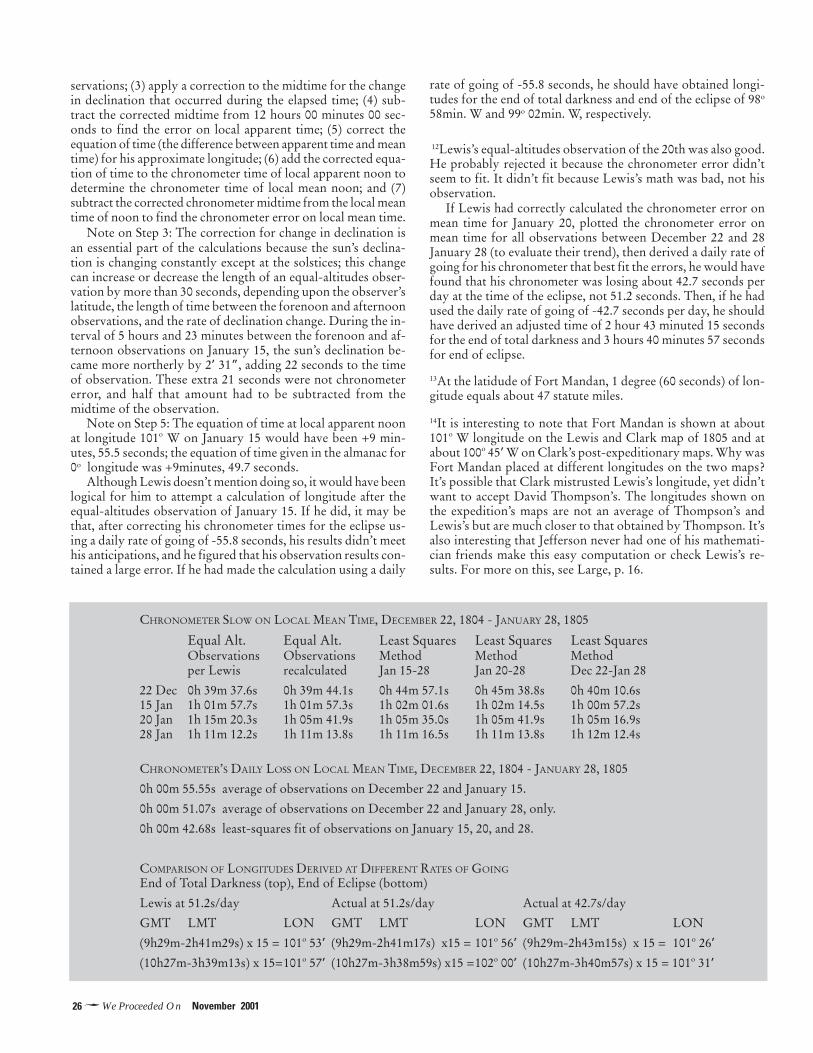
26�We Proceeded On November 2001
servations; (3) apply a correction to the midtime for the changein declination that occurred during the elapsed time; (4) sub-tract the corrected midtime from 12 hours 00 minutes 00 sec-onds to find the error on local apparent time; (5) correct theequation of time (the difference between apparent time and meantime) for his approximate longitude; (6) add the corrected equa-tion of time to the chronometer time of local apparent noon todetermine the chronometer time of local mean noon; and (7)subtract the corrected chronometer midtime from the local meantime of noon to find the chronometer error on local mean time.
Note on Step 3: The correction for change in declination isan essential part of the calculations because the sun’s declina-tion is changing constantly except at the solstices; this changecan increase or decrease the length of an equal-altitudes obser-vation by more than 30 seconds, depending upon the observer’slatitude, the length of time between the forenoon and afternoonobservations, and the rate of declination change. During the in-terval of 5 hours and 23 minutes between the forenoon and af-ternoon observations on January 15, the sun’s declination be-came more northerly by 2’ 31”, adding 22 seconds to the timeof observation. These extra 21 seconds were not chronometererror, and half that amount had to be subtracted from themidtime of the observation.
Note on Step 5: The equation of time at local apparent noonat longitude 101o W on January 15 would have been +9 min-utes, 55.5 seconds; the equation of time given in the almanac for0o longitude was +9minutes, 49.7 seconds.
Although Lewis doesn’t mention doing so, it would have beenlogical for him to attempt a calculation of longitude after theequal-altitudes observation of January 15. If he did, it may bethat, after correcting his chronometer times for the eclipse us-ing a daily rate of going of -55.8 seconds, his results didn’t meethis anticipations, and he figured that his observation results con-tained a large error. If he had made the calculation using a daily
rate of going of -55.8 seconds, he should have obtained longi-tudes for the end of total darkness and end of the eclipse of 98o
58min. W and 99o 02min. W, respectively.
12Lewis’s equal-altitudes observation of the 20th was also good.He probably rejected it because the chronometer error didn’tseem to fit. It didn’t fit because Lewis’s math was bad, not hisobservation.
If Lewis had correctly calculated the chronometer error onmean time for January 20, plotted the chronometer error onmean time for all observations between December 22 and 28January 28 (to evaluate their trend), then derived a daily rate ofgoing for his chronometer that best fit the errors, he would havefound that his chronometer was losing about 42.7 seconds perday at the time of the eclipse, not 51.2 seconds. Then, if he hadused the daily rate of going of -42.7 seconds per day, he shouldhave derived an adjusted time of 2 hour 43 minuted 15 secondsfor the end of total darkness and 3 hours 40 minutes 57 secondsfor end of eclipse.
13At the latidude of Fort Mandan, 1 degree (60 seconds) of lon-gitude equals about 47 statute miles.
14It is interesting to note that Fort Mandan is shown at about101o W longitude on the Lewis and Clark map of 1805 and atabout 100o 45’ W on Clark’s post-expeditionary maps. Why wasFort Mandan placed at different longitudes on the two maps?It’s possible that Clark mistrusted Lewis’s longitude, yet didn’twant to accept David Thompson’s. The longitudes shown onthe expedition’s maps are not an average of Thompson’s andLewis’s but are much closer to that obtained by Thompson. It’salso interesting that Jefferson never had one of his mathemati-cian friends make this easy computation or check Lewis’s re-sults. For more on this, see Large, p. 16.
CHRONOMETER SLOW ON LOCAL MEAN TIME, DECEMBER 22, 1804 - JANUARY 28, 1805
Equal Alt. Equal Alt. Least Squares Least Squares Least SquaresObservations Observations Method Method Methodper Lewis recalculated Jan 15-28 Jan 20-28 Dec 22-Jan 28
22 Dec 0h 39m 37.6s 0h 39m 44.1s 0h 44m 57.1s 0h 45m 38.8s 0h 40m 10.6s15 Jan 1h 01m 57.7s 1h 01m 57.3s 1h 02m 01.6s 1h 02m 14.5s 1h 00m 57.2s20 Jan 1h 15m 20.3s 1h 05m 41.9s 1h 05m 35.0s 1h 05m 41.9s 1h 05m 16.9s28 Jan 1h 11m 12.2s 1h 11m 13.8s 1h 11m 16.5s 1h 11m 13.8s 1h 12m 12.4s
CHRONOMETER’S DAILY LOSS ON LOCAL MEAN TIME, DECEMBER 22, 1804 - JANUARY 28, 1805
0h 00m 55.55s average of observations on December 22 and January 15.
0h 00m 51.07s average of observations on December 22 and January 28, only.
0h 00m 42.68s least-squares fit of observations on January 15, 20, and 28.
COMPARISON OF LONGITUDES DERIVED AT DIFFERENT RATES OF GOING
End of Total Darkness (top), End of Eclipse (bottom)
Lewis at 51.2s/day Actual at 51.2s/day Actual at 42.7s/day
GMT LMT LON GMT LMT LON GMT LMT LON
(9h29m-2h41m29s) x 15 = 101o 53’ (9h29m-2h41m17s) x15 = 101o 56’ (9h29m-2h43m15s) x 15 = 101o 26’
(10h27m-3h39m13s) x 15=101o 57’ (10h27m-3h38m59s) x15 =102o 00’ (10h27m-3h40m57s) x 15 = 101o 31’
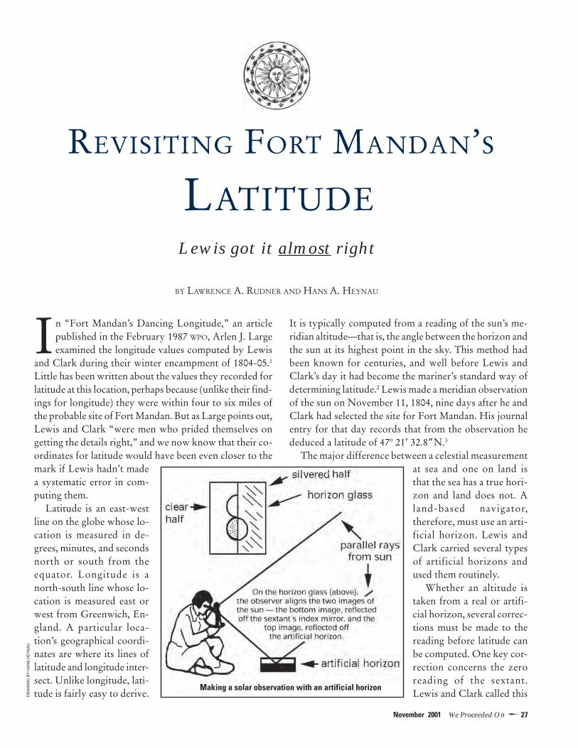
27�November 2001 We Proceeded On
In “Fort Mandan’s Dancing Longitude,” an articlepublished in the February 1987 WPO, Arlen J. Largeexamined the longitude values computed by Lewis
and Clark during their winter encampment of 1804-05.1
Little has been written about the values they recorded forlatitude at this location, perhaps because (unlike their find-ings for longitude) they were within four to six miles ofthe probable site of Fort Mandan. But as Large points out,Lewis and Clark “were men who prided themselves ongetting the details right,” and we now know that their co-ordinates for latitude would have been even closer to themark if Lewis hadn’t madea systematic error in com-puting them.
Latitude is an east-westline on the globe whose lo-cation is measured in de-grees, minutes, and secondsnorth or south from theequator. Longitude is anorth-south line whose lo-cation is measured east orwest from Greenwich, En-gland. A particular loca-tion’s geographical coordi-nates are where its lines oflatitude and longitude inter-sect. Unlike longitude, lati-tude is fairly easy to derive.
It is typically computed from a reading of the sun’s me-ridian altitude—that is, the angle between the horizon andthe sun at its highest point in the sky. This method hadbeen known for centuries, and well before Lewis andClark’s day it had become the mariner’s standard way ofdetermining latitude.2 Lewis made a meridian observationof the sun on November 11, 1804, nine days after he andClark had selected the site for Fort Mandan. His journalentry for that day records that from the observation hededuced a latitude of 47o 21’ 32.8”N.3
The major difference between a celestial measurementat sea and one on land isthat the sea has a true hori-zon and land does not. Aland-based navigator,therefore, must use an arti-ficial horizon. Lewis andClark carried several typesof artificial horizons andused them routinely.
Whether an altitude istaken from a real or artifi-cial horizon, several correc-tions must be made to thereading before latitude canbe computed. One key cor-rection concerns the zeroreading of the sextant.Lewis and Clark called this
REVISITING FORT MANDAN’S
LATITUDELewis got it almost right
BY LAWRENCE A. RUDNER AND HANS A. HEYNAU
Making a solar observation with an artificial horizon
DR
AW
ING
BY
HA
NS
HE
YN
AU

28�We Proceeded On November 2001
the index error, or I.E. (in modern terminology it is knownas the index correction, or I.C.). The sextant used by Lewishad an index error of minus 8 minutes, 45 seconds. Thismeant that the actual angle from the horizon of an ob-served celestial body was 8 minutes and 45 seconds lessthan indicated on his sextant’s graduated arc. Lewis wouldhave factored index error into all his calculatons.
Lewis’s determination of Fort Mandan’s latitude was basedon an altitude measurement of the sun’s upper limb. His jour-nal entry for November 11, 1804, states that from this mea-surement he “deduced” a latitude of 47o 21’ 32.8” N, but hegives no details of how he accomplished this. However,the authors were able to reconstruct his calculations.Lewis’s steps are outlined in the first part of the accompa-nying table [opposite].
Lewis recorded his raw meridian altitude as 51 degrees,4 minutes, 52 seconds. An observer shooting the sun witha sextant and artificial horizon sees, one on top of another,two images—the sun itself and its reflection [illustration,p. 27]. The measured angle must be divided by two. WhenLewis did this he arrived at a value of 25 degrees, 32 min-utes, 26 seconds. He then subtracted the index error of 8minutes, 45 seconds, giving him an angle of 25 degrees, 23minutes, 41 seconds.
Continuing his calculations, Lewis next had to take intoaccount three variables. One was refraction. This is thebending of light by the atmosphere, which causes celes-tial objects to appear higher in the sky than they reallyare. Another was disc size. Because the earth’s orbit aroundthe sun is slightly elliptical, the distance between the two
bodies varies over the course of the year, which in turnaffects the apparent diameter of the sun’s disc. The thirdvariable was parallax. This is the change in a viewer’s per-spective of an object from the surface, rather than at thecenter, of the earth. Lewis used data from two navigationalaids, the Nautical Almanac and Tables Requisite, to cor-rect for these variables. These corrections gave him a truesolar altitude of 25 degrees, 5 minutes, 36.1 seconds.
To complete his calculations, Lewis would have fol-lowed standard procedure for so-called “latitude reduc-tion” from a solar altitude. This involves subtracting thesolar altitude from 90 degrees, then adding or subtractingcorrection figures for the sun’s declination. The latitudederived, 47o 21’ 30.4” N, is within 2.4 seconds of Lewis’s47o 21’ 32.8” N. Lewis’s latitude is a little more than 5.4statute miles from our estimate of the probable locationof Fort Mandan. That estimate—47o 16’ 50.0” N—is anaverage of the latitude estimates of three authorities onthe subject.4
LEWIS’S MISTAKE
In the initial steps shown in the accompanying table, Lewisrecorded a measured angle of 51 degrees, 4 minutes, 52seconds. Because the angle was shot using an artificial ho-rizon, he divided it by two, then subtracted the index er-ror. His mistake was in the sequence of steps—if using anartificial horizon, one must subtract the index error fromthe measured angle before dividing the angle by two. Inthe section headed “Revised initial steps (what Lewisshould have done),” we have correctly reordered the se-
A key correction for any sextant reading is whatLewis and Clark called index error. The most com-mon way to find index error is to view the oceanthrough the sextant’s eye pieceand adjust the index arm tomatch the two horizon imageson the sextant’s horizon glass.The left frame of the glass istransparent and the right frame is mirrored. Theobserver has a direct view of the horizon in the leftframe and a reflected view of it in the right. Theimage in the right frame is reflected off a mirror fixedto the sextant index arm and onto the mirroredportion of the horizon glass. The observer aligns the
two images by moving the sextant index arm. Tech-niques also exist for finding index error when a seahorizon isn’t available, and Lewis would have usedone of these whenever he calibrated his sextant.
Any offset on the sextant’s graduated arc is readand recorded. The drawing illustrates what the arc ofLewis’s sextant might have lookedlike when he measured its indexerror. Each line on the arc’s scalerepresents 15 angular minutes.Lewis’s sextant had an index errorof minus 8 minutes and 45 seconds,as indicated by the asterisked line,known as the index mark.
Adjusting the sextant for index error
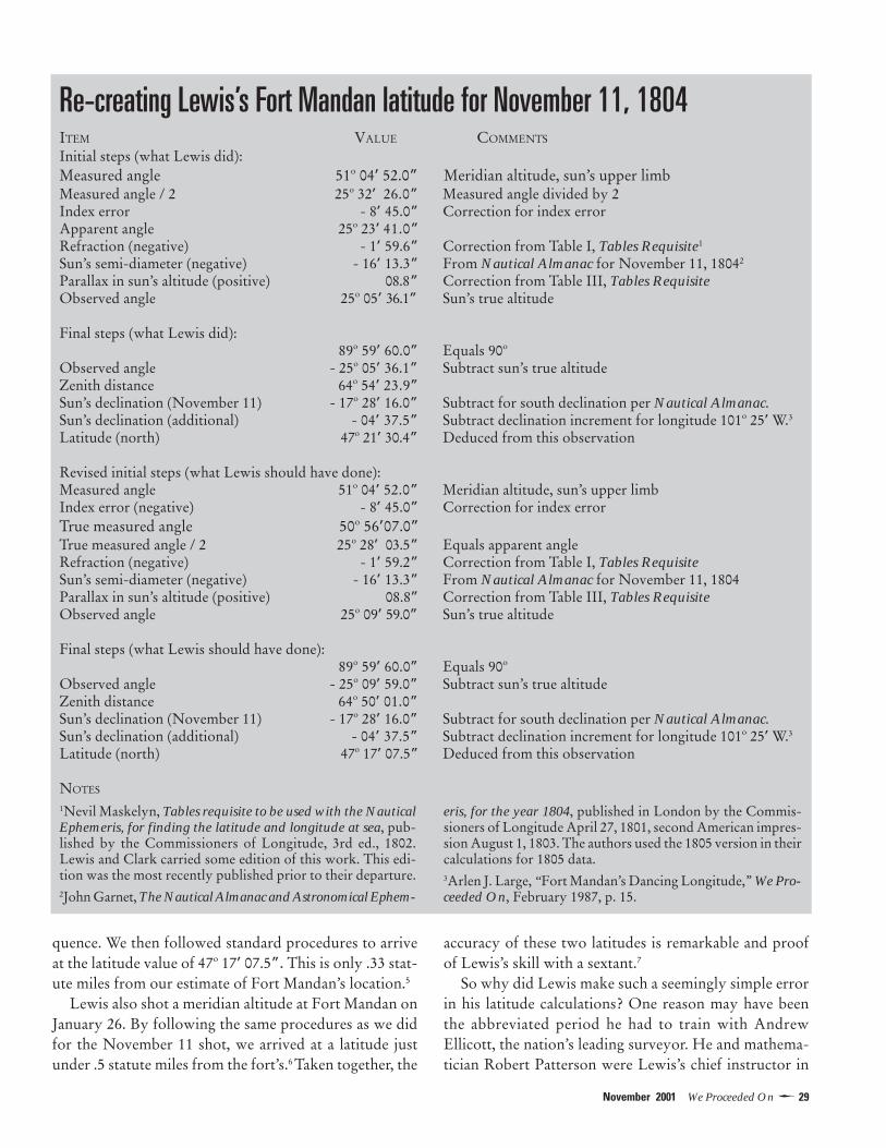
29�November 2001 We Proceeded On
quence. We then followed standard procedures to arriveat the latitude value of 47o 17’ 07.5”. This is only .33 stat-ute miles from our estimate of Fort Mandan’s location.5
Lewis also shot a meridian altitude at Fort Mandan onJanuary 26. By following the same procedures as we didfor the November 11 shot, we arrived at a latitude justunder .5 statute miles from the fort’s.6 Taken together, the
accuracy of these two latitudes is remarkable and proofof Lewis’s skill with a sextant.7
So why did Lewis make such a seemingly simple errorin his latitude calculations? One reason may have beenthe abbreviated period he had to train with AndrewEllicott, the nation’s leading surveyor. He and mathema-tician Robert Patterson were Lewis’s chief instructor in
Re-creating Lewis’s Fort Mandan latitude for November 11, 1804ITEM VALUE COMMENTS
Initial steps (what Lewis did):Measured angle 51o 04’ 52.0” Meridian altitude, sun’s upper limbMeasured angle / 2 25o 32’ 26.0” Measured angle divided by 2Index error - 8’ 45.0” Correction for index errorApparent angle 25o 23’ 41.0”Refraction (negative) - 1’ 59.6” Correction from Table I, Tables Requisite1
Sun’s semi-diameter (negative) - 16’ 13.3” From Nautical Almanac for November 11, 18042
Parallax in sun’s altitude (positive) 08.8” Correction from Table III, Tables RequisiteObserved angle 25o 05’ 36.1” Sun’s true altitude
Final steps (what Lewis did): 89o 59’ 60.0” Equals 90o
Observed angle - 25o 05’ 36.1” Subtract sun’s true altitudeZenith distance 64o 54’ 23.9”Sun’s declination (November 11) - 17o 28’ 16.0” Subtract for south declination per Nautical Almanac.Sun’s declination (additional) - 04’ 37.5” Subtract declination increment for longitude 101o 25’ W.3
Latitude (north) 47o 21’ 30.4” Deduced from this observation
Revised initial steps (what Lewis should have done):Measured angle 51o 04’ 52.0” Meridian altitude, sun’s upper limbIndex error (negative) - 8’ 45.0” Correction for index errorTrue measured angle 50o 56’07.0”True measured angle / 2 25o 28’ 03.5” Equals apparent angleRefraction (negative) - 1’ 59.2” Correction from Table I, Tables RequisiteSun’s semi-diameter (negative) - 16’ 13.3” From Nautical Almanac for November 11, 1804Parallax in sun’s altitude (positive) 08.8” Correction from Table III, Tables RequisiteObserved angle 25o 09’ 59.0” Sun’s true altitude
Final steps (what Lewis should have done): 89o 59’ 60.0” Equals 90o
Observed angle - 25o 09’ 59.0” Subtract sun’s true altitudeZenith distance 64o 50’ 01.0”Sun’s declination (November 11) - 17o 28’ 16.0” Subtract for south declination per Nautical Almanac.Sun’s declination (additional) - 04’ 37.5” Subtract declination increment for longitude 101o 25’ W.3
Latitude (north) 47o 17’ 07.5” Deduced from this observation
NOTES
1Nevil Maskelyn, Tables requisite to be used with the NauticalEphemeris, for finding the latitude and longitude at sea, pub-lished by the Commissioners of Longitude, 3rd ed., 1802.Lewis and Clark carried some edition of this work. This edi-tion was the most recently published prior to their departure.2John Garnet, The Nautical Almanac and Astronomical Ephem-
eris, for the year 1804, published in London by the Commis-sioners of Longitude April 27, 1801, second American impres-sion August 1, 1803. The authors used the 1805 version in theircalculations for 1805 data.3Arlen J. Large, “Fort Mandan’s Dancing Longitude,” We Pro-ceeded On, February 1987, p. 15.

30�We Proceeded On November 2001
celestial navigation.8 It’s possible to imagine either Ellicottor Patterson telling him, “The computation of an artifi-cial horizon sight is the same as for a regular, natural-ho-rizon sight, except for dividing the measured angle bytwo,” without emphasizing the necessity of starting thedivide-by-two and sight-reduction process after applica-tion of the index-error correction.
Why, then, didn’t this discrepancy show up during thepractice reductions that Lewis must have done underEllicott’s tutelage? At the time, Lewis had yet to acquirethe sextant he took on the expedition, so he would havepracticed using his instructor’s instrument. Ellicott’s jour-nals reveal that his sextant typically had little or no indexerror, so it is possible that Lewis didn’t need to enter acorrection during his practice reductions.9 Another rea-son may lie with the navigational references Lewis car-ried on the expedition. They were for marine navigation—that is, navigation at sea, where a natural horizon obviatesany need for an artificial one. None of the referencestreated artificial horizons, and the sight-reduction ex-amples in Lewis’s copy of Tables Requisite did not evenshow the step for index-error correction.10
Whatever the reason for it, Lewis’s procedural error inno way detracts from his navigational achievements un-der difficult field conditions and the care both he and Clarktook in recording data. The fact that their positions forboth latitude and longitude can be accurately recon-structed from journal entries is yet one more tribute tothem. They got (almost) all the details right.11
Larry Rudner is a retired aerospace engineer and cruise-shiplecturer on various topics, including celestial navigation. HansHeynau is a retired aerospace engineer and celestial-naviga-tion sight instructor. Both are Foundation members.
NOTES1Arlen J. Large,” Fort Mandan’s Dancing Longitude,” We Pro-ceeded On, February 1987, pp. 12-16.2Samuel Eliot Morison, Admiral of the Ocean Sea (New York:Fine Communications, 1997), pp. 258-259.3Gary E. Moulton, ed., The Journals of the Lewis and ClarkExpedition, Vol. 3 (Lincoln: University of Nebraska Press,1987), p. 233. All quotations or references to journal entries inthe ensuing text are from Moulton, by date, unless otherwiseindicated.4Lewis shot the sun at what he called “Point of ObservationNo. 51.” He was vague about its location relative to Fort Man-dan itself, but it must have been close. The authors’ estimatedlatitude of 47o 16’ 50.0” N is an average of latitude values attrib-uted to (a) Robert Bergantino, as discussed in Richard S. Preston,“The Accuracy of the Astronomical Observations of Lewis and
Clark,” Proceedings of the American Philosophical Society, Vol.144, No. 2, pp. 168-191; (b) Mike Scholl of the North DakotaLewis and Clark Bicentennial Foundation, private communica-tion; and (c) Martin Plamondon II, Lewis and Clark Trail Maps:A Cartographic Reconstruction, Vol. 1, Map 151, p. 175.5For modern-day descriptions of error corrections and divide-by-two, see American Practical Navigator (Bowditch), 1977, Vol.I, p. 411, Article. 1512; and Junior Navigation, United StatesPower Squadrons Advanced Grades 1999 text, p. A-2, article“Artificial Horizon Sights.”6Lewis, making the same mistake in sequence as he did on No-vember 11, arrived at a deduced latitude of 47o 21’ 47” N. Hismeasured angle was 51 degrees, 4 minutes, 52 seconds.7Lewis shot one other meridian altitude at Fort Mandan, on Janu-ary 13, but his measured angle of 43 degrees, 18 minutes, 30seconds utilized a less accurate type of artificial horizon, andwe did not compute it. In his observations of November 11 andJanuary 26, Lewis employed an artificial horizon that was es-sentially a shallow tray filled with water, an inherently self-lev-eling medium. This was the artificial horizon Lewis preferred,but he could only use it if the temperature was above freezing.On January 13 the temperature was below freezing, forcing himto use a glass horizon leveled with a bubble device similar to acarpenter’s level. In his journal entry for November 11, Lewisdoes not specifically state the type of artificial horizon he used,but according to his weather diary (Moulton, p. 248) the tem-perature at sunrise that day was 28 degrees, and it must havebeen above freezing by the time he set up for his observation.8Stephen E. Ambrose, Undaunted Courage (New York: Simon& Schuster, 1996), pp. 86-87. Lewis arrived in Lancaster , Penn-sylvania, where Ellicott lived, on April 19, 1803, and he wasready to depart by May 7. During his two weeks there he wasbusy equipping and provisioning the expedition in addition tolearning what he could from Ellicott.9Andrew Ellicott, The Journal of Andrew Ellicott … for Deter-mining the Boundary Between the United States and the Pos-sessions of His Catholic Majesty in American (Philadelphia 1803;reprint, Chicago 1962), Appendix.10Donald D. Jackson, “Some Books Carried by Lewis andClark,” Missouri Historical Society Bulletin, Vol. XVI, No. 1,October 1959, p. 24. In addition to the Nautical Almanac andTables Requisite, the expedition also had a copy of Patrick Kelly’sPractical Introduction to Spherics and Nautical Astronomy. Thefirst edition of the latter was published in 1796; the expeditioncarried some edition of this work.11In addition to Lewis’s mistake in sequencing the step for indexcorrection, his initial observation for the sun’s angular distancemay have been slightly off. A physicist who has reconstructedLewis’s longitude calculations has noted systematic errors in hislongitude readings which may have resulted from a visual bias.See Preston, pp. 186-88.
This article pertains only to the sextant readings. The otherastronomical-measurement instrument carried, the octant orHadley’s quadrant, has other unique characteristics the authorshave analyzed and expect to discuss in a future article, whichwill also deal with the longitude of Fort Mandan derived from alunar eclipse. A review of that event shows that Lewis in hissight reduction incorrectly used mean time rather than appar-ent time. The article will discuss why he might have done so.
�

31�November 2001 We Proceeded On
FORT WALLAWALLA1 PAGE

32�We Proceeded On November 2001
Reviews
Sacagawea’s story blends facts and folk tradition
S acagawea, the most romanticizedmember of the Corps of Discovery,
inspires an outpouring of books com-parable to spring runoff on the Lochsa.In Sacagawea Speaks: Beyond the Shin-ing Mountains with Lewis and Clark,Joyce Badgley Hunsaker gives us alovely coffee-table quality portrait ofthe young Shoshone presented as herpersonal account of the expedition.
The Sacagawea story unfortu-nately has lent itself to literary licensethat has resulted in sensationalized por-traits of her that cannot be rationalizedby reference to credible historical evi-dence. She left no journal of her own,and journal entries referring to her arelimited. Thus she has become a conve-nient tabula rasa for many an author’sfantasies and speculations.
Hunsaker avoids the obvious pitfallsand offers a convincing mainstreamtreatment of the Shoshone teenager’srole in the expedition. SacagaweaSpeaks is two books in one. The first isa sprightly narrative that follows theconvention of tying expedition vi-gnettes to journal excerpts, a story-teller’s chronology written on the levelof young readers’ historical fiction.
In the absence of much first-handevidence of how Sacagawea experi-enced events or what she thought, read-ers must suspend their disbelief. It iscredible that she may have cried outsomething like “Brother! Brother!”when she first grasped Cameahwait’sidentity, less so that she actually won-dered why Lewis’s beloved companionSeaman did not end up on the menu.Hunsaker’s prose, while occasionally abit imaginative, generally follows thestory faithfully and is not overwrought.
The second part of the book, which
includes a timeline, well-craftedendnotes, and detailed biographies ofthe corps, takes a more factual tack.These sections will reward the maturereader who possesses a seasoned famil-iarity with the expedition.
In one aspect of the story—the cir-cumstances of Sacagawea’s death—Hunsaker is too neutral. Her bio-graphical rendering indicates that thisis in contention, but her timeline maysow confusion. A brief entry from 1812quotes factor John Luttig’s brief ac-count of Sacagawea’s death at FortManuel. However, a more detailed ac-
count from 1884, with a photograph ofher purported gravestone, concludesthe timeline with her death at the WindRiver Reservation. Even readers whocarefully peruse the entire volume maynot quite appreciate the degree to whichhistorians discount the latter version.
“Visionary inchantment”The book revels in the splendor of itswilderness photography, with a pan-orama of the Little Camas Prairie inbloom and other “seens of visionaryinchantment” that evoke the work ofSam Abell and David Muench. Frothymountain streams and mist-en-shrouded trees make one hunger to beopening a tent flap at dawn to put thecoffee on. Wildlife sketches contributeto a richly textured graphic presenta-tion that is a visual feast.
Trail artifacts depicted compare with
exhibits of relics and reconstructionsfound in interpretive centers that havesprung up along the trail. This wouldmake an indispensable source book fora Hollywood property mistress, cos-tumer, or cinematographer. An exten-sive Shoshone vocabulary, however, isa well-meaning but gratuitous flourish.Two things cannot be learned withouta live instructor—to dance and to speaka language.
John L. Allen suggests in the collec-tion of essays Voyages of Discovery (ed-ited by James Ronda) that the approachof the Lewis and Clark bicentennialmay foster a convergence of the “folk”and “literate elite” images of the expe-dition. Perhaps this could enrich the
story of Sacagawea. However, thewholesome image of the Shos-
hone girl that graces the dollar coinreminds us of one of our best-loved
folk heroines without enlarging oursophistication about her life and role.
On the other hand, one of the mostcarefully researched contemporaryscholarly studies, Donna J. Kessler’sThe Making of Sacagawea: A Euro-American Legend, is distinctly inhos-pitable to the folk tradition. Kesslersharply critiques traditional portrayalsas flattering Euro-American culturalneeds and biases. She articulates a de-sire for a new Native American hero-ine, “a tribal chairwoman in blue jeans,”a career choice not available to the deer-skin-clad Shoshone and a phrase thatsubstitutes one cliché for another.
During the bicentennial, Americanswill choose their own version of thetruth. They may permit themselves tobe weaned from the “Sacajawea” pro-nunciation and the fiction that she wasthe expedition’s guide. They are un-likely to surrender their vision of heressential decency and good character.In times increasingly characterized byuncivil behavior, Americans deeplyneed to believe that, when Luttig in-scribed her epitaph as “a good and thebest woman in the fort,” he had it right.
—Dennis M. O’Connell
An obsidian knife and beaded sheath— a detail from Joyce Badgley Hunsaker’sSacagawea Speaks.
Sacagawea Speaks: Beyondthe Shining Mountains withLewis and ClarkJoyce Badgley HunsakerGlobe Pequot Press151 pages / $27.50 hardcover

33�November 2001 We Proceeded On
ReviewsReviews
Across the Snowy Ranges:The Lewis and Clark Expeditionin Idaho and Western MontanaJames R. FazioWoodland Press204 pages / $29.95 hardcover
Lewis and Clark in the heart of the Rockies
Once, when I asked Stephen Ambrosethe best advice he ever received
about writing, he told me of the pro-fessor in graduate school who said tohim, “Read all of Shakespeare and notehow he uses his verbs.”
Ambrose’s skills as a storyteller are due in large measureto his active voice and engagingmanner. The same can be saidof at least two other Lewis andClark scholars, James Rondaand John Logan Allen. Now wehave James Fazio to add to thelist. From the introduction toAcross the Snowy Ranges to thefinal paragraphs, his prose isgripping, clear, and concise. Itconveys a sense of immediacybased on his experience alongthe Lolo Trail. I’ve extensivelytraveled that trail myself andhave read and reread the jour-nal accounts of it, but Fazio’s booktaught me things I didn’t know. It setsthe standard for all future “segment his-tories” of the Lewis and Clark Trail.
The book’s 9x11-inch format doesjustice to the text as well as to the ex-cellent maps by Steve F. Russell and themarvelous color photographs by MikeVenso. A concise introduction summa-rizes the expedition and its purposes.The narrative, which is divided into twosections—outbound and homewardbound—totaling eight chapters, tellsthe reader the whereabouts of the twocaptains (who were often separated) oneach day. The narrative runs from Au-gust 12, 1805 (when Lewis crossedLemhi Pass) to October 10 (when theyreached the junction of the Clearwaterand Snake rivers) and from May 5, 1806(when they returned to the land of the
Nez Perce) to July 2 (when they arrivedat Traveler’s Rest). The photo captionsare complemented by quotes from thejournals describing the scene as it ap-peared to the explorers. Sidebars on arange of topics—the naming of Saca-gawea, the protection of the GladeCreek campsite, a publishing history ofthe Lewis and Clark journals, peacemedals, and other matters—are superbmini-essays in their own right.
In the chapter “A Puzzle Wrappedin a Mystery: Over Lost Trail Pass,”Fazio offers insights into the naming of
Lost Trail Pass (long-held assumptionsthat the name refers to Lewis andClark’s problems there are question-able), its connections to other nearbypasses, and where along the pass theparty may have camped on September3, 1805. Compounding the mystery is
a 13-day gap in Lewis’s journal duringthat period. Fazio is particularly acutewhen writing about the expedition’s in-teractions with Native Americans andemphasizes the crucial role played bythe Nez Perce—a role acknowledgedby a grateful Lewis, who wrote that thetribe deserved “immortal honor” for itslife-saving hospitality.
Informed by the author’s deep per-sonal knowledge of the land and jour-nals, Fazio’s narrative gave me a senseof looking over the shoulders of the ex-plorers as they camped, tended to their
daily tasks, and struggled withthe snow, freezing cold, and lackof game. Yet Across the SnowyRanges is also a practical guidethat can be used by anyone fol-lowing the trail.
I was struck by the fine edit-ing job done by the publisher. Ifound only one error: in the in-troduction, the date for thekeelboat’s departure from FortMandan to St. Louis should beApril 7, 1805, instead of April5. Small stuff indeed.
I recommend Across theSnowy Ranges to any Lewis andClark enthusiast, scholar, or
armchair traveler and to anyone whoenjoys a story well told in texts, maps,and photographs. It is available for$29.95 from Woodland Press, 310 N.Main St., Moscow, ID 83843 (208-882-4767, www.woodlandgifts.com).
—Robert K. Doerk, Jr.
A photo of Shoshone horses from Across the Snowy Ranges.
MIK
E V
EN
SO
The L&C saga in new songs by Kindra Ankney
Great things come in small packages.This applies equally well to both the
CD Songs of the Journey and to its ar-tistic creator, Kindra Ankney. Thoughshe is small in stature, Ankney’s cre-ative energy shines brightly through-out her multidisciplinary and multigen-erational works.
While being home-schooled, herson, Jamin, and daughter, Emily, be-
came fascinated with the saga of theCorps of Discovery. Of course, sim-ply reading the story was not enough,so Ankney and her children com-pleted hands-on educational projectssuch as gathering, steaming, andgrinding acorns to make pancakes,making tallow candles, jerking buf-falo meat, and pressing wildflowers.
Still having more to say and do on

34�We Proceeded On November 2001
L&CCOOKBOOK1/3rd square
L&C TRAILADVENTURES
1/3rd square
this topic, she penned words and mu-sic to 15 songs, all inspired by passagesand events from the journals. The songsare geared to families—for listening, en-joying, and learning together. To shareher creative message, Ankney contactedthe renowned Bobby Horton, who iswell known for his Civil War-era mu-sic and his work with filmmaker KenBurns on numerous documentaries.Horton was impressed with Ankney’swords and melodies and agreed to ar-range, perform, record, and mix hersongs. In the process, he used 18 dif-ferent period instruments including abodhran (Irish drum), uilleann pipes,hammer dulcimer, tin whistles, fiddle,harpsichord, and a deer-toe rattle thatAnkney fashioned just for the occasion.
The songs are full of facts from thejournals, which, mixed with the emo-tional aspects of the music, become easyto absorb and retain. The songs dwellon feelings, hope, and dreams. I espe-cially love the chorus from UncommonCamaraderie:
They had an uncommon camaraderie,a blending of skills,
complementing temperaments andpersevering wills;
a shared spirit of adventure built thisideal team —
capable resourcefulness,and mutual esteem.
Other songs span the extent of thejourney covering topics such as Sea-man, Captain Lewis’s Dog; Sacagawea;Fort Mandan; Bitterroot Mountains;Fort Clatsop, and Back Home. My fa-vorites were the lively tunes of Cru-zatte’s Fiddle, Oh, Joy!, and BackHome, but I think children will particu-larly enjoy The List, which humorouslydetails a number of the animals encoun-tered by the corps.
In addition to being a talentedteacher and songwriter, Ankney is anaccomplished artist. The CD and itscover feature a couple of her wonder-ful pen-and-ink drawings. As a com-panion to her audio CD, she is nowworking on an illustrated book thatwill, she says, “cite the quotes upon
ReviewsReviews

35�November 2001 We Proceeded On
Amidst the spate of young readers’books focusing on the diverse per-
sonalities of the expedition—Saca-gawea, York, even Seaman—parentsand educators understandably mayyearn for a treatment that puts thewhole story between two covers. JanisHerbert has done it with Lewis andClark for Kids: Their Journey of Dis-covery with 21 Activities (Chicago Re-view Press, 160 pages, $14.95 paper).
Don’t be put off by the subtitle; thisis no connect-the-dots vacation amuse-ment book. The activities are meaning-ful—latitude and longitude exercises;preserving plants; drying fruit for thetrail; Native American dance, instru-ments, and regalia; trail signs; and signlanguage. The book’s real strength is acomprehensive text thoroughly illus-trated with artwork and photographs.
The artwork draws on the best ofKarl Bodmer, George Catlin, Edgar S.Paxson, Charles M. Russell, and oth-ers to present a richly decorated intro-duction to expedition history, trailscenery and ethnology. The book’s nar-rative, tied to key dates, offers a read-able entrée to the expedition for thenewcomer with a thoughtful focus ontribal relations. Detailed sidebars covereverything from biographies of Jeffer-son, Lewis, and Clark to taxonomy,Lakota tribal divisions, mammothbones, and Welsh Indians. This is a fineresource that can be revisited with ayoungster either at home or on the trail.
—Dennis M. O’Connell
which the songs are based and tell the‘between-the-lines’ story that the songsleave out.”
Songs of the Journey can be pur-chased for $15 through Edge-of-the-Woods Publishing, POB 8251, Yakima,WA 98908. Washington State residentsshould add 7.6 percent sales tax.
—Jay Rasmussen
ReviewsReviews
This kids’ book teacheswhile it entertains
PHILADELPHIABOOK
1/3rd square
KINDRA ACKNEY1/6 page vertical
Prints of L&C at Fort Mandan (see cover)
and other expedition scenes by North
Dakota artist Gary P. Miller. Call 701-258-
0060, e-mail [email protected], or
visit Web site www.garypmillerart.com.
Write to Gary’s Gallery, 305 East
Broadway, Bismarck, ND 58501.
Fine Art PrintsL&C Expedition
WPO DISPLAY ADSInside front or back cover:Black & white, $650; color, $750Outside back cover:Black & white, $800; color, $900
Inside pages (black & white only):Full page: 71/4 X 91/2 $6002/3rd vertical: 43/4 X 91/2 $4001/2 horizontal: 71/4 X 45/8 $3001/3rd square: 43/4 X 45/8 $2001/3rd vertical: 21/4 X 91/2 $2001/6th vertical: 21/4 X 45/8 $1001/12th: 21/4 X 23/16 $50Address inquiries to Rebecca Young,P.O. Box 3434, Great Falls, MT59403. 406-454-1234/fax:406-771-9237 [email protected].
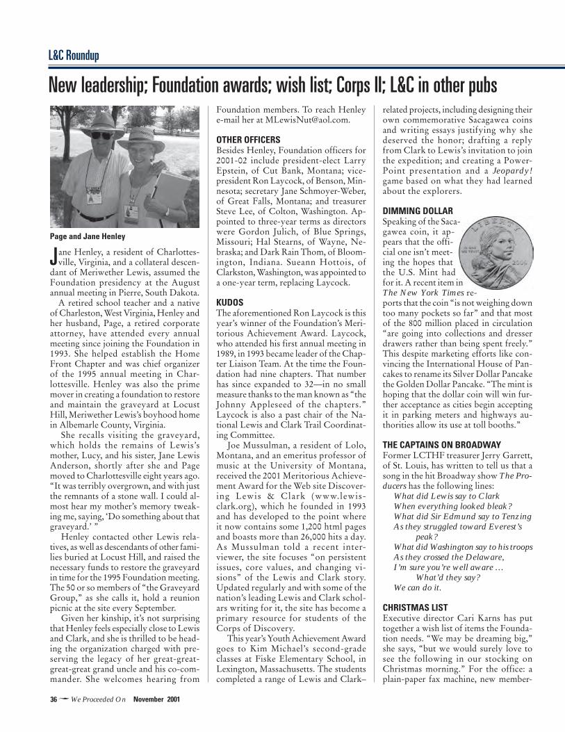
36�We Proceeded On November 2001
L&C Roundup
Jane Henley, a resident of Charlottes-ville, Virginia, and a collateral descen-
dant of Meriwether Lewis, assumed theFoundation presidency at the Augustannual meeting in Pierre, South Dakota.
A retired school teacher and a nativeof Charleston, West Virginia, Henley andher husband, Page, a retired corporateattorney, have attended every annualmeeting since joining the Foundation in1993. She helped establish the HomeFront Chapter and was chief organizerof the 1995 annual meeting in Char-lottesville. Henley was also the primemover in creating a foundation to restoreand maintain the graveyard at LocustHill, Meriwether Lewis’s boyhood homein Albemarle County, Virginia.
She recalls visiting the graveyard,which holds the remains of Lewis’smother, Lucy, and his sister, Jane LewisAnderson, shortly after she and Pagemoved to Charlottesville eight years ago.“It was terribly overgrown, and with justthe remnants of a stone wall. I could al-most hear my mother’s memory tweak-ing me, saying, ‘Do something about thatgraveyard.’ ”
Henley contacted other Lewis rela-tives, as well as descendants of other fami-lies buried at Locust Hill, and raised thenecessary funds to restore the graveyardin time for the 1995 Foundation meeting.The 50 or so members of “the GraveyardGroup,” as she calls it, hold a reunionpicnic at the site every September.
Given her kinship, it’s not surprisingthat Henley feels especially close to Lewisand Clark, and she is thrilled to be head-ing the organization charged with pre-serving the legacy of her great-great-great-great grand uncle and his co-com-mander. She welcomes hearing from
Foundation members. To reach Henleye-mail her at [email protected].
OTHER OFFICERSBesides Henley, Foundation officers for2001-02 include president-elect LarryEpstein, of Cut Bank, Montana; vice-president Ron Laycock, of Benson, Min-nesota; secretary Jane Schmoyer-Weber,of Great Falls, Montana; and treasurerSteve Lee, of Colton, Washington. Ap-pointed to three-year terms as directorswere Gordon Julich, of Blue Springs,Missouri; Hal Stearns, of Wayne, Ne-braska; and Dark Rain Thom, of Bloom-ington, Indiana. Sueann Hottois, ofClarkston, Washington, was appointed toa one-year term, replacing Laycock.
KUDOSThe aforementioned Ron Laycock is thisyear’s winner of the Foundation’s Meri-torious Achievement Award. Laycock,who attended his first annual meeting in1989, in 1993 became leader of the Chap-ter Liaison Team. At the time the Foun-dation had nine chapters. That numberhas since expanded to 32—in no smallmeasure thanks to the man known as “theJohnny Appleseed of the chapters.”Laycock is also a past chair of the Na-tional Lewis and Clark Trail Coordinat-ing Committee.
Joe Mussulman, a resident of Lolo,Montana, and an emeritus professor ofmusic at the University of Montana,received the 2001 Meritorious Achieve-ment Award for the Web site Discover-ing Lewis & Clark (www.lewis-clark.org), which he founded in 1993and has developed to the point whereit now contains some 1,200 html pagesand boasts more than 26,000 hits a day.As Mussulman told a recent inter-viewer, the site focuses “on persistentissues, core values, and changing vi-sions” of the Lewis and Clark story.Updated regularly and with some of thenation’s leading Lewis and Clark schol-ars writing for it, the site has become aprimary resource for students of theCorps of Discovery.
This year’s Youth Achievement Awardgoes to Kim Michael’s second-gradeclasses at Fiske Elementary School, inLexington, Massachusetts. The studentscompleted a range of Lewis and Clark–
related projects, including designing theirown commemorative Sacagawea coinsand writing essays justifying why shedeserved the honor; drafting a replyfrom Clark to Lewis’s invitation to jointhe expedition; and creating a Power-Point presentation and a Jeopardy!game based on what they had learnedabout the explorers.
DIMMING DOLLARSpeaking of the Saca-gawea coin, it ap-pears that the offi-cial one isn’t meet-ing the hopes thatthe U.S. Mint hadfor it. A recent item inThe New York Times re-ports that the coin “is not weighing downtoo many pockets so far” and that mostof the 800 million placed in circulation“are going into collections and dresserdrawers rather than being spent freely.”This despite marketing efforts like con-vincing the International House of Pan-cakes to rename its Silver Dollar Pancakethe Golden Dollar Pancake. “The mint ishoping that the dollar coin will win fur-ther acceptance as cities begin acceptingit in parking meters and highways au-thorities allow its use at toll booths.”
THE CAPTAINS ON BROADWAYFormer LCTHF treasurer Jerry Garrett,of St. Louis, has written to tell us that asong in the hit Broadway show The Pro-ducers has the following lines:
What did Lewis say to ClarkWhen everything looked bleak?What did Sir Edmund say to TenzingAs they struggled toward Everest’s
peak?What did Washington say to his troopsAs they crossed the Delaware,I’m sure you’re well aware …
What’d they say?We can do it.
CHRISTMAS LISTExecutive director Cari Karns has puttogether a wish list of items the Founda-tion needs. “We may be dreaming big,”she says, “but we would surely love tosee the following in our stocking onChristmas morning.” For the office: aplain-paper fax machine, new member-
New leadership; Foundation awards; wish list; Corps II; L&C in other pubs
Page and Jane Henley

37�November 2001 We Proceeded On
ship/fund-raising software, and a two-drawer locking file cabinet. For the li-brary: a slide scanner and a map-displaycase. New or used is fine. Those in theholiday spirit can reach Cari at 1-888-701-3434.
CORPS OF DISCOVERY IIThe National Park Service and other fed-eral agencies are planning a “travelingeducation center” that will criss-cross thecountry during the three years of theLewis and Clark Bicentennial. “Corps ofDiscovery II: 200 Years to the Future”will start off in Charlottesville, Virginia,in January 2003 and finish in St. Louis in2006. In between, plans call for it to visitsome 200 communities along the Lewisand Clark Trail and in Florida, Texas,California, and other states far from theexplorers’ path. Says Gerard A. Baker, theNPS official supervising the project,“Through a combination of mobile mu-seum exhibits, live interpretation, use ofthe Internet, and distance-learning video,Corps II will reach millions of people.”Corps II’s Web site is www.nps.gov\lecl\welcome.htm. Baker, who works outof NPS offices in Omaha, Nebraska, canbe reached at [email protected](402-221-7296).
L&C AND THE U.S. ARMYThe L&C Expedi-tion was a militaryendeavor mannedlargely by soldiers,and the U.S. Army,Army Reserve, andNational Guardare putting to-gether a traveling exhibit to honor cap-tains Meriwether Lewis and WilliamClark and the enlisted members of theCorps of Discovery. The 6,000-square-foot exhibit, titled “Beyond Lewis andClark,” will visit Virginia, WashingtonState, and Kansas before taking up per-manent residence at the Frontier ArmyMuseum at Fort Leavenworth, Kansas.
Lt. Col. Sherman Fleek, who is over-seeing the exhibit, notes too that in 2004,as part of the Lewis and Clark bicenten-nial, the National Guard will host a na-tionwide relay run from Virginia to Or-egon. Much of the route will be on or nearthe explorer’s trail, 80 percent of which
is owned or managed by the U.S. ArmyCorps of Engineers.
L&C ART EXHIBITThe Lewis and Clark Bicentennial Asso-ciation of Clatsop County, Oregon, andthe Fort Clatsop Historical Associationsponsor the Journey’s End National ArtExhibition, an annual show that usesoriginal works to interpret the history ofexploration in the Pacific Northwest. Theshow’s theme for 2002 is the Corps ofDiscovery. Accepted art will be exhibitednext March 8-10 at the Columbia RiverMaritime Museum, in Astoria, Oregon.
The deadline for receipt of slides, fees, andentry forms is January 4. For further de-tails check the Web site [email protected] or write journey’sEnd National Art Exhibition, POB 2005,Astoria, OR 97103.
L&C IN OTHER PUBLICATIONSFrom time to time, WPO will report onrecent articles about Lewis and Clark inother publications. Here is a current list,along with information on how to reachthe publishers.• “The Lewis and Clark Expedition’s Tiesto Pennsylvania,” by Frank Muhly. Penn-sylvania Heritage, Summer 2001. 717-
Pierre: Gathering on the prairieClockwise fromleft: The keelboatDiscovery crossesto Fort Pierre withmembers of theCorps of Rediscov-ery to take part inthe Bad Riverreenactment. A stopat the Narrows, adramatic bend inthe Missouri. Localgreeting. A Siouxelder speaks at thereenactment.
Under cloudless skies and a baking sunthat sent afternoon temperatures
soaring above 100 degrees, some 450members of the LCTHF converged on Pierre,South Dakota, August 5-8 for “Encounters onthe Prairie,” the Foundation’s 33rd annualmeeting. The confabulation included lec-tures, kids’ activities, tours of Indian reserva-tions and historic sites, and a reenactment ofthe Corps of Discovery’s confrontation withthe Teton Sioux at Bad River. ■
JEFF
OLS
ON
JIM
ME
RR
ITT
JEFF
OLS
ON
JIM
ME
RR
ITT
ReviewsReviews
38�We Proceeded On November 2001
VIDEO BILL1/2 page
ReviewsReviews
787-2407. ([email protected].)• “The Vote: ‘Station Camp,’ Washing-ton,” by Dayton Duncan; • “A LastingLegacy: The Lewis and Clark PlaceNames of the Pacific Northwest — PartI,” by Allen “Doc” Weselius. Columbia:The Magazine of Northwest History,Spring 2001. (253-798-5902; www.wshs.org/columbia.)• “The First American Epic,” by LarryMcMurtry. The New York Review ofBooks, February 8, 2001. A lengthy re-view of The Journals of the Lewis andClark Expedition, edited by Gary E.Moulton. (212-757-8070; www.nybooks.com/.)• “On the Trail of Lewis and Clark,” byAlfred A. Gruber. American Philatelist,January 2001. Postage stamps commemo-rating the Corps of Discovery. (P.O. Box8000, State College, PA 16803. www.americanphilatelic.org.)• “Meriwether Lewis and His Son: TheClaim of Joseph DeSomet Lewis and theProblem of History,” by Harry F. Th-ompson. North Dakota History, Vol. 67,No. 3, 2000. An examination of oneman’s assertion that he was the offspring
of a sexual liaison between Lewis and aTeton Sioux woman. (701-328-2666.www.state.nd.us/hist.)• “Lewis and Clark in the Boonslick,” byJames M. Denny. Boone’s Lick Heritage,June-September 2000. A study of theCorps of Discovery’s passage up the Mis-souri from the mouth of the Osage Riverto present Glasgow, Missouri. (573-256-2602. http://mrcn.missouri.org.)• “Proceeding on to the Lewis & Clarkairgun,” by Robert D. Beeman. AirgunReview, No. 6. The author can be reachedat 1600 Sweetwater Spring Road,Healdsburg, CA 95448-9415. ([email protected].)
CHAPTER NEWSFour chapters have recently joined theFoundation. They are the SakakaweaChapter, in Bismarck, North Dakota; theSacajawea Chapter, in Salmon, Idaho; theMouth of the Platte Chapter, in CouncilBluffs, Iowa; and the Blackfoot RiverChapter, in Missoula, Montana.
Efforts by the Headwaters Chapter, inBozeman, may have helped stop, or atleast delay, plans by Montana Rail Link,
the state’s railroad utility, to park up tosix diesel-electric locomotives on a sidetrack at Trident, just north of Headwa-ters State Primitive Park, near ThreeForks, to feed power to a nearby electri-cal substation. The last word, accordingto president R. G. Montgomery, is thatthe project is now on hold because “elec-tricity apparently is still too cheap to jus-tify their use.” ■
Bright yellow shirts to the contrary, this is notthe Lewis and Clark Bowling Team but mem-bers of the Falls of the Ohio Chapter gatheredin Pierre. They are organizing the 2002 annualmeeting, to be held in Louisville next July 28-31. Front: Ash Padya, Linda Robertson, PhyllisYeager, Dani Cummins, and Chuck Parish.Rear: John Minta, Jerry Robertson, Jim Keith,and Bill Smith.
SK
IP J
AC
KS
ON

39�November 2001 We Proceeded On
GIB FLOYD1/3rd square
WAYNEMUNFORD13rd square
The U.S. Senate and House of Rep-resentatives Lewis and Clark Bicenten-
nial Congressional Caucuses wereformed in 1998 to coordinate the congres-sional response to the bicentennial of theCorps of Discovery (1803-1806). Sincethen, these caucuses have united as thebipartisan and bicameral Lewis and ClarkBicentennial Congressional Caucus andmembership has more than doubled—thecaucus now comprises 73 members rep-resenting 21 states.
Caucus members have supported leg-islation related to the bicentennial andhave participated in joint quarterly brief-ings with federal, state, and tribal repre-sentatives and with the National Coun-cil of the Lewis and Clark Bicentennial.The briefings allow participants to shareinformation and discuss issues about pro-grams and projects.
The caucus co-chairs are: Sen. LarryE. Craig (R-Id.), Sen. Byron L. Dorgan(D-N.D.), Sen. Conrad Burns (R-Mont.),Rep. Earl Pomeroy (D-N.D.), and Rep.Doug Bereuter (R-Neb.).
The caucus helps inform and involvemembers of Congress about the signifi-cance of the Lewis and Clark Expeditionto our nation’s history. It acts as a unifiedvoice in Congress to help coordinate andprovide resources. The caucus will remainin existence through the end of the bi-centennial, in 2006. Information aboutthe caucus is posted at www.lewisandclark200.org and can also be obtained bycontacting those below:
• MICHELLE L. WATSON
Lewis & Clark Bicentennial Caucus2184 Rayburn BuildingWashington, DC 20515202-225-5675 / fax 202-225-5686Omaha: 402-514-9315 [email protected]• MIKE OLIVER
Lewis & Clark Bicentennial Caucus208 N. Montana Ave., Ste. 202AHelena, MT 59601406-449-5401 / fax [email protected]• CRAIG “ROCKY” ROCKWELL
Congressional Liaison846 Main StreetLewiston, ID 83501208-743-0792 / fax [email protected] ■
Congressional Caucushelps with bicentennial

40�We Proceeded On November 2001
Bicentennial Counciloutlines major eventsThe National Council of the Lewis and
Clark Bicentennial has approved 10 na-tional heritage events for the Lewis andClark Bicentennial. Dates, places, andcontacts:
• January 18, 2003: Bicentennial Kick-Off—Monticello, Charlottesville, Vir-ginia. Wayne Mogielnicki, 434-984-9828;[email protected].• October 24-26, 2003: Falls of theOhio—Louisville, Kentucky, andClarksville, Indiana. Dell Courtney, 502-292-0059; [email protected].• Spring, 2004: Three Flags Ceremony/Expedition Departure—St. Louis, Mis-souri, and Hartford/Wood River, Illinois.Timothy G. O’Rourke, 314-516-6884;[email protected]. Marilyn Hurst,217-524-2998; [email protected].• July 3-4, 2004: A Journey Fourth—Atchison and Fort Leavenworth, Kansas,and Kansas City, Missouri. WayneChappell, 816-221-5242; [email protected].• July 30-August 3, 2004: Tribal Coun-cil—Omaha, Nebraska. Ron Hull, 402-472-9333, ext. 315; [email protected].• Late Fall, 2004: Circle of Cultures, Timeof Renewal and Exchange—Bismarck,North Dakota. Kristie Frieze, 877-462-8535; [email protected]. RachaelRetterath, 701-328-2532; [email protected].• July 3-4, 2005: Discovering the BigSky—Great Falls, Montana. Phil Scriver,406-727-8314; [email protected].• Fall, 2005: Destination 2005—The Pa-cific, Lower Columbia, Oregon, andWashington. Don Striker, 503-861-2471;[email protected].• July 25, 2006: Clark on theYellowstone—Pompey’s Pillar, Billings,Montana. Jeffrey Dietz, [email protected].• August 17-20, 2006: Home ofSakakawea—New Town, North Dakota.Contact: Amy Mossett and Dennis Fox,701-627-2870; [email protected],[email protected].
A few more sites may be selected. Pre-cise dates and additional details for allevents will be announced as planningprogresses. For more information, seewww.lewisandclark200.org. ■
CLASSIFIEDS
MISSOURI HEADWATERS. Float theJefferson River to the headwaters of theMissouri. Using the journals and maps ofLewis and Clark, we follow the riverroutes and observe the landscape andwildlife that the Corps of Discovery ex-perienced. This non-whitewater float issuitable for all ages and tailored to yourinterests. Led by a professional interpre-tive guide, we focus on natural and cul-tural history. Yellowstone Safari Com-pany, POB 42, Bozeman, MT 59771. 406-586-1155. E-mail: [email protected]. Our Website is www.beyondyellowstone.com.
TOURS of the Lewis & Clark Trail. Viamotorcoach, plane, train, cruise ship,keelboat, canoe, raft, horse, hiking andmore. Can customize trips for individu-als or groups. Offering two motorcoachtours next summer: 8-Day Rocky Moun-tain Tour in June and 18-Day Plains to thePacific Tour in July. Shorter options avail-able. Trips include boat tours on the Mis-souri and/or Columbia rivers. For aunique experience you will never forget
contact: Rocky Mountain DiscoveryTours in Missoula, MT at 1-888-400-0048.Visit our Website, www. rmdt.com, e-mailus at discovery@ rmdt. com, or write toPMB 520, 248A, N. Higgins Avenue,Missoula, MT 59802.
BOOK: The Mystery of Lost Trail Pass:A Quest for Lewis and Clark’s Campsiteof September 3, 1805. $12, plus $2 ship-ping. Send check or money order to: LostTrail Book, POB 3434, Great Falls, MT59403; or call 1-888-701-3434 withcredit-card information. Inquire tooabout other WPO special publications ona range of topics, including the nine youngmen from Kentucky, Seaman, Lewis inBlackfeet country, and the expedition rolesof Thomas Jefferson and Philadelphia.
CLASSIFIED RATES: 50 cents per word forFoundation members, 75 cents for non-members, $10 min. Address = one word.Send ads with payment to Jim Merritt,Editor, WPO, 51 N. Main St., Pennington,NJ 08534.