Hoosic River Flood Chute · PDF filechannel, the concept design incorporates backwater habitat...
40
Hoosic River Flood Chute Naturalization 30% Concept Design May 2015
Transcript of Hoosic River Flood Chute · PDF filechannel, the concept design incorporates backwater habitat...

Hoosic River Flood Chute Naturalization30% Concept DesignMay 2015

Hoosic River Flood Chute Naturalization Project Design Services 2
HUNTER FOUNDRY ROAD
THE CONFLUENCE
PILOT AREA
Project Scope
STUDY REACH 1.3 MILES
PILOT PROJECT 0.4 MILES

Hoosic River Flood Chute Naturalization Project Design Services 3
Opportunities & Goals
ECOLOGICAL
RESTORE PASSAGE FOR FISH
RESTORE AQUATIC HABITAT
REDUCE WATER TEMPERATURE
FILTER SURFACE WATER RUNOFF
ECONOMIC
FLOOD SAFETY & PROTECTION
CONNECTIVITY TO MAIN STREET
LOW MAINTENANCE COST
RECREATIONAL
ACCESSIBLE PATHS
SPACES FOR PLAY & FITNESS
FISHING AMENITIES
SEASONAL ACTIVITIES
PADDLING LAUNCH SITES
CULTURAL
MARKET & EVENT SPACES
PUBLIC ART INTEGRATION
URBAN AGRICULTURE
EVENT CAMPING
NEW BUSINESS OPPORTUNITIES
CONNECT WITH THE RIVER
ENHANCE RIPARIAN HABITAT

Hoosic River Flood Chute Naturalization Project Design Services 4
500’
The Gateway
The Park
The Wild
MASS MoCA
Main Street CorridorMajor Pedestrian Route
CONCEPTUAL ZONES OF THE SOUTH BRANCH
One River, Four Unique Zones
Ashland Street
MA 8 / Curran Hwy
Church Street
Marshall St
Am. Legion Drive
State St
State St
MCLA Campus
Concept Plan

Hoosic River Flood Chute Naturalization Project Design Services 5
500’
MASS MoCA
MCLA Campus
Main Street
Greylock Market
Illustrative Plan
1
3
2
1 Mohawk Trail Connection2 Courtyard C Terrace3 Hanging Gardens
MASS MoCA4 Main Street Underpass5 Pedestrian Bridges6 Civic Park7 Urban Orchards8 Railroad Underpass9 Scenic Railway Platform
10 River Terrace
The Gateway
46
7
3
5
89
10
14
11
12
13
15
16
17
18
19 Backwater20 River Terrace21 Canoe Launch Area22 Trailhead23 Wet Meadow24 Ashwillticook Trail Connection
The Wild11 River Terrace12 Rain Garden/Winter Skating13 Joe Wolfe Field14 Playground & Splash Pad15 Dog Park16 Softball Fields
The Park
17 Future Recreation Expansion
Soccer/Multi-purpose Field18
19
19
20
2122
2324
25 Stormwater Pond
25
26 Future Floodplain Restoration?
26
Am. Legion Drive
Church St
8A / Ashland St
8A / Ashland St
Marshall St
State St
MA 8 / Curran Hwy
MA2/ Mohawk Trail
19
19
Hoosic River Flood Chute Naturalization Project Design Services 6
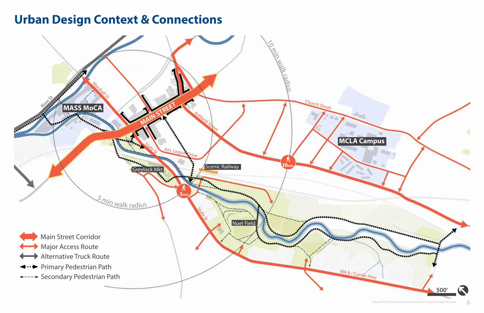
Urban Design Context & Connections
500’
MCLA Campus
MASS MoCA
Noel Field
Scenic RailwayGreylock Mkt
Major Access RouteAlternative Truck Route
10 min w
alk radius5 min walk radius
Ashland Street
MA 8 / Curran Hwy
Church Street
Marshall St
River St
Am. Legion Drive
Main Street Corridor
State St
State St
10min
5min
Primary Pedestrian PathSecondary Pedestrian Path

Hoosic River Flood Chute Naturalization Project Design Services 7
Grading & Flood ProtectionFlood Control Berm Modifications
500’
While urban constraints in the lower reach of the river limit the potential for extensive changes, the upper reach of the study area allows for more significant improvements. For the end goal of developing a working hydrological model, this schematic design level grading plan was developed for the concept design. Matching the noted elevation of the existing flood control berm (715’ near Hunter Foundry Road, descending to 714’ in the vicinity of Joe Wolfe Field), the plan will be modeled and tested to measure it’s performance, and modified to meet or exceed the exsting level of flood control.
Considerations have also been made for low-lying areas behind the relocated levees along State Route 8. With several tributary streams and parcels with elevations below 715’ draining to the back side of the west levee, approximately two to three outfalls will be required through the levee. In addition to requiring backflow prevention measures, these outfalls offer a limited storage area behind the levee and a pump system, in the event that floodwaters prevent proper drainage.
Relocated BermModified Chute Entrance
Existing Berm Alignment

Hoosic River Flood Chute Naturalization Project Design Services 8
MASS MoCA
MCLA Campus
Outfall LocationPotential Street & Parking Lot RetrofitStormwater BMP Location
Storm sewer
500’
Water Quality Measures
Ashland Street
MA 8 / Curran Hwy
Church Street
Marshall St
State St
Review of the utility and infrastructure report from Tighe & Bond indicates numerous stormwater outfalls discharging to the Hoosic River in the study area. While space for surface treatment of stormwater is abundant in The Wild, allowing for BMP design to mimic floodplain features, the high percentage of impervious cover and spatial constraints of The Gateway and MASS MoCA zones reflects a greater need to manage rainwater at the source. In addition to filtering first-flush pollutants from streets and parking lots, rain gardens and infiltration planters will improve infiltration and decrease runoff water temperatures, improving water quality in the river.
Stormwater BMPs & Retrofit Recommendations

Hoosic River Flood Chute Naturalization Project Design Services 9
Forested detention basin BMPWatertown, Massachusetts
Streetscape Integrated Rain gardenPortland, Oregon
Parking lot stormwater retrofitBlair Co., Pennsylvania
Flow-through stormwater planterPortland, Oregon
Water Quality MeasuresPrecedent Images

Hoosic River Flood Chute Naturalization Project Design Services 10
Materials | Planting Strategy
500’
The plant palette for the four conceptual zones references vegetation communities found throughout the Berkshire Region. Both planting beds and restored areas have been inspired by Massachusetts Natural Heritage & Endangered Species Program community classifications which include: wet meadow, shrub swamp, floodplain forest, and northern hardwood forest. Matching these plantings with the sites soil and moisture conditions, this strategy will provide food and cover for wildlife, while creating visual and educational interest, and reducing long-term maintenance costs.
Infusing a deeper connection to the urban and rural context of the Berkshires, plantings reflecting the agricultural heritage of the region are also integrated throughout the design. Edible landscapes range from orchard terraces in The Gateway and The Park zones, to patches of strawberry, blueberry, and blackberry, from The Wild to the urban reaches of the site. Considering the bigger picture, produce from these planting areas could be used in local schools, kitchens, and restaurants.
Turf/Lawn
Wet MeadowShrub SwampHigh-Terrace Floodplain ForestNorthern Hardwood ForestBerkshire Agriculture
Meadow

Hoosic River Flood Chute Naturalization Project Design Services 11
Spotted Joe-pye weedEupatorium maculatum
Nodding bur-marigoldBidens cernua
Wool-grassScirpus cyperinus
Tussock SedgeCarex stricta
Wet Meadow | Blue Hills ReservationPhoto Credit: Neponset River Watershed Association
Wet MeadowReferenced Natural Communities

Hoosic River Flood Chute Naturalization Project Design Services 12
Silky dogwoodCornus amomum
Highbush blueberryVaccinium corymbosum
Black willowSalix nigra
Speckled alderAlnus incana
Shrub swamp/Fen edge habitatHockomock Swamp, MA
Shrub SwampReferenced Natural Communities

Hoosic River Flood Chute Naturalization Project Design Services 13
Lady FernAthyrium filif-femina
Arrowwood ViburnumViburnum dentatum
Musclewood (Ironwood)Carpinus caroliniana
Red MapleAcer rubrum
Red Maple Floodplain ForestFalmouth, MA
Floodplain ForestReferenced Natural Communities

Hoosic River Flood Chute Naturalization Project Design Services 14
BlackberryRubus spp.
Eastern White PinePinus strobus
Northern Red OakQuercus rubra
Sugar MapleAcer saccarum
Northern Hardwood ForestPhoto Credit: New Hampsire Natural Heritage Program
Northern Hardwood ForestReferenced Natural Communities

Hoosic River Flood Chute Naturalization Project Design Services 15
BlackberryRubus spp.
StrawberryFragaria spp.
AppleMalus domestica
A Berkshire Region Apple OrchardPhoto Credit: Massachusetts Office of Travel
Berkshire Agriculture
Highbush blueberryVaccinium corymbosum
Referenced Local Agriculture

Hoosic River Flood Chute Naturalization Project Design Services 16
THE UPPER REACH
Typical Edge ConditionsThe WildThe Park

Hoosic River Flood Chute Naturalization Project Design Services 17
River Terrace
Cherry CreekDenver, Colorado
Upper Reach | Typical Edge Conditions
Bankfull Channel Floodplain Terrace
High-Terrace Floodplain Forest Community
width: 87’
698’
703’706’
width varies: 20’-200’
10’ Bicycle/Pedestrian Path
Expanded floodplain areas which are not constrained by infrastructure or flood control berms open into wide variably level landscape terraces. These areas will be planted with wet meadow and high-terrace floodplain species, restoring them to conditions similar to floodplain areas found in the Western New England Marble Valley ecoregion.
Recreational uses within these areas will largely consist of recreation paths, both paved and unpaved, with occasional overlooks and resting stops.
MA 8 / Curran Hwy
8A / Ashland St
Hunter Foundry Rd

Hoosic River Flood Chute Naturalization Project Design Services 18
Backwater
Backwater & Floodplain ForestInter-Fluve, Inc.
Upper Reach | Typical Edge Conditions
Bankfull Channel Backwater
Native grass & wildflower seed mix10’ Bicycle/Pedestrian Path
width: 87’ width varies: 60’-80’
698’
Flood Control Bermwidth varies: 3:1 slope to 715’
Interpretive Display
With several tributary streams entering from the west, wetland depressions within the existing floodplain, and the remnant channel of the existing river channel, the concept design incorporates backwater habitat throughout The Wild portion of the study area. These areas provide important habitat and refuge for juvenile fish and create shallow refugia for young amphibians and invertebrates.
Outside of providing a place for paddlers to explore by canoe or kayak, adjacent trails provide interpretive signage, highlighting the ecological benefits of this riverine feature.
Upper Reach | Typical Edge Conditions
MA 8 / Curran Hwy
8A / Ashland St
Hunter Foundry Rd

Hoosic River Flood Chute Naturalization Project Design Services 19
Cut Bank
Charles River OverlookSasaki Associates, Inc.
Upper Reach | Typical Edge Conditions
Bankfull Channel Designed Edge
Native grass & wildflower seed mix10’ Bicycle/Pedestrian Path
width: 87’ typical width: 20’
698’
Flood Control Bermwidth varies: 3:1 slope to 715’
Low Impact Overlook
705’
While true cut bank conditions will exist in the bankfull channel along the outside of the meander bend, out-of-channel areas above these morphological features will reflect a more steep change in topography. In some instances these may simply be the flood control berm descending to the bankfull channel edge.
Recreational access to these areas will be controlled as to prevent disturbance in areas where vegetation is essential to bank stability.
Upper Reach | Typical Edge Conditions
MA 8 / Curran Hwy
8A / Ashland St
Hunter Foundry Rd
Overlook Location
Overlook LocationOverlook Location
Hoosic River Flood Chute Naturalization Project Design Services 20
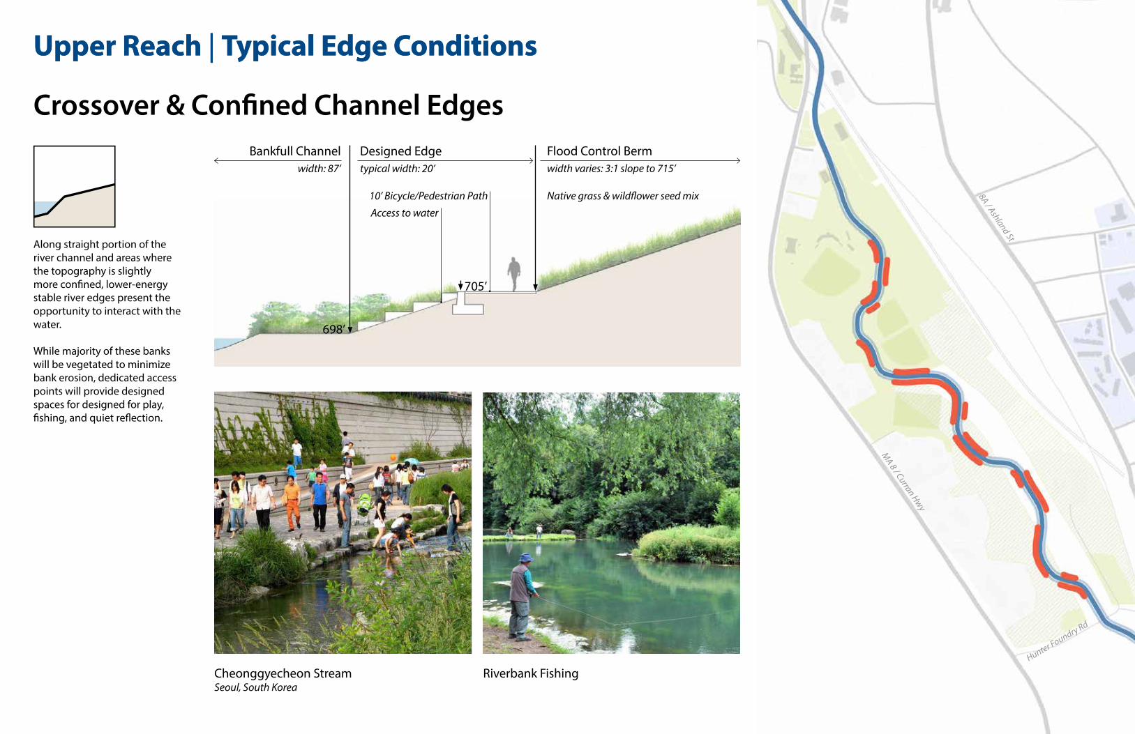
Crossover & Confined Channel Edges
Cheonggyecheon StreamSeoul, South Korea
Upper Reach | Typical Edge Conditions
Bankfull Channel Designed Edge
Native grass & wildflower seed mix10’ Bicycle/Pedestrian Path
width: 87’ typical width: 20’
698’
Flood Control Bermwidth varies: 3:1 slope to 715’
Access to water
705’
Along straight portion of the river channel and areas where the topography is slightly more confined, lower-energy stable river edges present the opportunity to interact with the water.
While majority of these banks will be vegetated to minimize bank erosion, dedicated access points will provide designed spaces for designed for play, fishing, and quiet reflection.
Upper Reach | Typical Edge Conditions
MA 8 / Curran Hwy
8A / Ashland St
Hunter Foundry Rd
Riverbank Fishing

Hoosic River Flood Chute Naturalization Project Design Services 21
Point Bar
Upper Reach | Typical Edge Conditions
The Confluence - Platte RiverDenver, Colorado
Bankfull Channel Point Bar Edge
10’ Bicycle/Pedestrian Path
width: 87’ width varies: 20’-80’
698’
Native Floodplain Shrub Species
Typically located on the inside bend of river meanders, the out-of-channel portion of the point bar edges will maintain gradual slopes until reaching the designed terrace height or flood control berm. With recreational trails passing along the perimeter of these edge conditions in concept design, the point bar offers the perfect opportunity to interact with the river or land a canoe.
MA 8 / Curran Hwy
8A / Ashland St
Hunter Foundry Rd
Barker River, NHImage Source: NH Natural Heritage Bureau

Hoosic River Flood Chute Naturalization Project Design Services 22
Habitat Features
Upper Reach | Stream Channel
Incorporated into The Wild and The Park zones, in-channel portions of the river will feature habitat enhancements which will provide improved conditions for native cold-water fish species.
MA 8 / Curran Hwy
8A / Ashland St
Hunter Foundry Rd
Areas of elevation change in the channel with swift currents provide critical fish spawning habitat and food resources
Deeper areas of the stream provide important habitat for young and adult fish, particularly feeding habitat for mature trout
Occurs on the inside of meander bends and are formed by the deposition of sand and gravel
Flooded year-round, these areas provide important habitat and refuge for juvenile fish and create shallow refugia for young amphibians and invertebrates
Backwater
Riffle BedPoolLarge WoodPoint Bar
Riffle Bed
Pool (w/Large Wood)
Point Bar
Backwater (w/Large Wood)

Hoosic River Flood Chute Naturalization Project Design Services 23
Upper Reach | Stream Channel

Hoosic River Flood Chute Naturalization Project Design Services 24
THE WILDWorking with the historic floodplain area and existing natural wetland areas west of the current river channel, The Wild is an expression of riparian vegetation communities characteristic to the Western New England Marble Valleys ecoregion. Numerous backwaters and a network of both paved and rustic trails weave through this zone, connecting recreational users to Noel Field to the north and the Ashwillticook trail to the south.
1 Main recreation trail2 Ashwillticook trail connection3 Trailhead4 Canoe/kayak launch area5 Backwater6 Stormwater BMP7 Overlook
1
32
4
5
5
5 5
5
6
1
7
Backwater & Floodplain ForestInter-Fluve, Inc.
Charles River OverlookSasaki Associates, Inc.
200’
P Parking
P

Hoosic River Flood Chute Naturalization Project Design Services 25
THE WILD
Backwater/Stormwater PondInter-Fluve, Inc.
Canoe/Kayak Launch Floodplain Forest Levee trail with native wildflowersSasaki Associates Inc. | Wilkes-Barre, Pennsylvania
Precedent Images

Hoosic River Flood Chute Naturalization Project Design Services 26
THE PARKCharacterized by the most significant meander bend in the study area, the athletic fields in The Park have been reconfigured to embrace the river, placing the Hoosic at center stage. The curved flood control berms, set at a 3:1 slope vary from lawn to native wildflowers and grasses, manageable for maintenance and lounging by the river. On the inside of the meander, gentle point bar banks just beyond the outfield offer an opportunity for interaction with the river, or a landing point for those paddling up or down river.
200’
1 Joe Wolfe Field2 Playground & Splash Pad3 Dog Park4 Softball Fields5 Soccer/Multi-Purpose Field6 Recreational Path7 Rain Garden
5
4
3
2
1
8 River Terrace
6
6
6
7
77
8
The Confluence - Platte RiverDenver, CO
Joe Wolfe FieldNorth Adams, MA
P
P
P
P
P Parking
9 Restroom Location
9

Hoosic River Flood Chute Naturalization Project Design Services 27
MA 8 / Curran Hwy
8A / Ashland St
THE PARK | Noel Field ReconfigurationCharacterized by the most significant meander bend in the study area, the athletic fields in The Park have been reconfigured to embrace the river. The side-by-side comparison to the right, highlights the current and proposed arrangement, moving both softball fields to the east of the river, and moving the soccer/multi-purpose field further to the south.
All athletic facilities at Noel Field would been retained, with a an expanded playground, and new multi-use trails, seasonal recreation spaces for winter activities, river/fishing overlooks, and rest rooms (located near the softball fields).
P84 spaces
P68 spaces
Punknown
spaces
P84 spaces
P68 spaces
Punknown
spaces
Pnew parking
Punknown
spaces
8A / Ashland St
MA 8 / Curran Hwy
P50 spaces
Punknown
spaces
playground playground
PlaygroundSoccer/Multi-purpose FieldBaseball/Softball Field
Future Recreation Expansion Area
ParkingP
Vehicle AccessMulti-use Trail
Existing Conditions Proposed Changes

Hoosic River Flood Chute Naturalization Project Design Services 28
THE PARK | Sections
A
B
A
B
Bankfull Channel Floodable Terrace Softball Field Flood Control Berm
Cross-section at Study/Pilot Area Transition (Minimum)
Maximum & Minimum Channel Alterations
Cross-section at the Softball Field Meander Bend (Maximum)
Flood Control Berm
Flood Control Berm Bankfull Channel Flood Control BermSoccer/Multi-purpose Field
Existing Channel
Existing Channel
Existing Flood Control BermExisting Athletic Field Elevation

Hoosic River Flood Chute Naturalization Project Design Services 29
THE PARK | Sections
A
A
Pedestrian bridge on the Charles RiverNewton, Massachusetts
Pedestrian Bridge Crossing
Flood Control Edge Bankfull Channel Flood Control Berm
Recreation PathRecreation Path
Existing Channel
Existing Flood Control Berm

Hoosic River Flood Chute Naturalization Project Design Services 30
THE LOWER REACH
Edge ConditionsThe GatewayMASS MoCA

Hoosic River Flood Chute Naturalization Project Design Services 31
Terraced Edge
Wilkes-Barre RiverfrontSasaki Associates, Inc.
Lower Reach | Typical Edge Conditions
Exisiting Channel
Low-flow channel: 20’
width: 45’
673’-693
Floodable terraces in place of existing wall structure
Terraced Plazawidth varies: 40’-100’
elevation varies:
10’ Bicycle/Pedestrian Path
While most areas where the current flood chutes pass through are highly constricted, three areas on the eastern bank provide space for removal of the flood chute walls. In these select locations, the concept design study explored the opportunity for terraced plazas, of which lower portions would be tolerant of flood conditions.
Marshall St
MA 2 / Mohawk Trail
Am. Legion Drive
State St
Main Street
MA
8 / C
urra
n Hw
y
FLOOD FLOW
SPRING FLOW
SUMMER FLOW
Flow StudyInter-Fluve, Inc.

Hoosic River Flood Chute Naturalization Project Design Services 32
Channel Path
Cheonggyecheon StreamSeoul, South Korea
Lower Reach | Typical Edge Conditions
Exisiting Channel
Low-flow channel: 20’
width: 45’
673’-693elevation varies:
10’ Bicycle/Pedestrian Path
Due to the constraint of surrounding buildings and infrastructure, many portions of the existing flood chutes may have to remain. However, with the integration of a low-flow channel and by providing access to the chute, these areas can safely be utilized as a bicycle/pedestrian corridor.
Flood levels will need to be closely monitored for these stretches of trail. Nonetheless, in the event of flooding, the concept design incorporates alternative routes outside the channel, to easily navigate through the city.
Marshall St
MA 2 / Mohawk Trail
Am. Legion Drive
State St
Main Street
MA
8 / C
urra
n Hw
y
FLOOD FLOW
SPRING FLOW
SUMMER FLOW

Hoosic River Flood Chute Naturalization Project Design Services 33
THE GATEWAYThe Gateway is the primary entry point for visitors to downtown North Adams. Whether by bike, train, or car; from Mount Greylock or the Mohawk Trail, the Civic Park and Greylock Market are the major focal points of this district. In two bold moves, the concept design looks to direct vehicle traffic down Main Street, invigorating downtown, while providing a principal gathering space for concerts and markets, at the corner of State and Main Street.
1 Main Street Underpass2 Pedestrian Bridges3 Civic Plaza4 Urban Orchards5 Railroad Underpass6 Scenic Railway Platform7 River Terrace
1
2
2
4
4
56
8
9
3
7
7
8 Greylock Market9 Expanded Parking
MAIN STREET
200’
Urban OrchardConcept/Inspiration
Pritzker ParkChicago, IL

Hoosic River Flood Chute Naturalization Project Design Services 34
THE GATEWAY | Underpass
A A
Underpass art installation ‘Aspire’ by Warren LangleySydney, Australia
Railroad Underpass & River Terrace
River/Chute Floodable Plaza/Terrace Underpass
Greylock Market Parking Railroad R.O.W.
Artistic underpass lighting installationUnknown location

Hoosic River Flood Chute Naturalization Project Design Services 35
THE GATEWAY | Civic Park
Main Street
State Street
PanAm Rail Corridor

Hoosic River Flood Chute Naturalization Project Design Services 36
THE GATEWAY | Civic Park
Shaded seating/swingsSasaki Associates Inc. | Cincinnati Riverfront
Plaza space for markets & events Art installations River terraces & outdoor performance spaceSasaki Associates Inc. | Wilkes-Barre, Pennsylvania
Precedent Images

Hoosic River Flood Chute Naturalization Project Design Services 37
MASS MoCAThe most constrained zone of the study reach, the MASS MoCA property holds the greatest potential as a destination and critical connection to the Mohawk Bike Trail. Due to the proximity of buildings and infrastructure, only a few limited areas allow for the removal of chute walls and terracing. However, those areas, such as the art terrace, provide access to the river channel path and opportunities for interactive art installations. With limited space for introducing native vegetation, the concept design explored the use of native vines for the installation of hanging gardens through this reach.
1 Mohawk Trail Connection2 Hanging Gardens3 Courtyard C Terrace4 Main Street Underpass
200’
Interactive art installationsSasaki Associates Inc. | Lawn on D
Hanging vines | Inspiration
1
1
2
2
23
4

Hoosic River Flood Chute Naturalization Project Design Services 38
MASS MoCA | Channel path and Courtyard C terrace

Hoosic River Flood Chute Naturalization Project Design Services 39
MASS MoCA | Hanging gardens
Fox GrapeVitis lambrusca
Virgin’s BowerClematis virginiana
Virginia CreeperParthenocissus quinquefolia
Inspired by formal and informal hanging gardens found throughout the world, the constrained conditions and existing bridge infrastructure in the MASS MoCA zone presents an opportunity to integrate hanging vegetation in unique spaces throughout the river corridor.
Selected native vine species shown below would grow from narrow areas near the edge of the existing chute walls and would be directed to grow over wall edges and structures, providing shade, habitat, and visual interest in a limited amount of space

Hoosic River Flood Chute Naturalization Project Design Services 40
500’
MASS MoCA
MCLA Campus
Main Street
Greylock Market
Illustrative Plan
1
3
2
1 Mohawk Trail Connection2 Courtyard C Terrace3 Hanging Gardens
MASS MoCA4 Main Street Underpass5 Pedestrian Bridges6 Civic Park7 Urban Orchards8 Railroad Underpass9 Scenic Railway Platform
10 River Terrace
The Gateway
46
7
3
5
89
10
14
11
12
13
15
16
17
18
19 Backwater20 River Terrace21 Canoe Launch Area22 Trailhead23 Wet Meadow24 Ashwillticook Trail Connection
The Wild11 River Terrace12 Rain Garden/Winter Skating13 Joe Wolfe Field14 Playground & Splash Pad15 Dog Park16 Softball Fields
The Park
17
Soccer/Multi-purpose Field18
19
19
20
2122
2324
25 Stormwater Pond
25
26 Future Floodplain Restoration?
26
Am. Legion Drive
Church St
8A / Ashland St
8A / Ashland St
Marshall St
State St
MA 8 / Curran Hwy
MA2/ Mohawk Trail
Future Recreation Expansion