
Homebush Bay Bridge Cycling Strategy · GTA Consultants was commissioned by Fairmead Business Pty...
56
14S1187000 04/06/15 Homebush Bay Bridge Cycling Strategy
Transcript of Homebush Bay Bridge Cycling Strategy · GTA Consultants was commissioned by Fairmead Business Pty...

14S1
1870
00
04/0
6/15
Homebush Bay Bridge
Cycling Strategy

© GTA Consultants (GTA Consultants (NSW) Pty Ltd) 2014 The information contained in this document is confidential and intended solely for the use of the client for the purpose for which it has been prepared and no representation is made or is to be implied as being made to any third party. Use or copying of this document in whole or in part without the written permission of GTA Consultants constitutes an infringement of copyright. The intellectual property contained in this document remains the property of GTA Consultants.
TIA R
epor
t – N
SW (1
3091
3 v1
.5)
Homebush Bay Bridge
Cycling Strategy Issue: D 04/06/15
Client: Fairmead Business Pty Ltd
Reference: 14S1187000 GTA Consultants Office: NSW
Quality Record
Issue Date Description Prepared By Checked By Approved By Signed
A 17/06/14 Final Justin Murphy Dick van den Dool
Dick van den Dool
Dick van den Dool
B-Dr 03/10/14 Final Draft Justin Murphy Dick van den Dool
Dick van den Dool
Dick van den Dool
B 03/11/14 Final Justin Murphy Dick van den Dool
Dick van den Dool
Dick van den Dool
C 31/03/15 Final Justin Murphy Dick van den Dool
Dick van den Dool
Dick van den Dool
D 04/06/15 Final Justin Murphy Dick van den Dool
Dick van den Dool
Table of Contents
14S1187000 04/06/15 Homebush Bay Bridge Issue: D Cycling Strategy
Table of Contents 1. Introduction 1
2. Existing Conditions 2 2.1 Road Network 2 2.2 Bicycle Network 5 2.3 Cyclist Volumes 11
3. The Proposed Bridge 14 3.1 Bridge Location 14 3.2 Bridge Configuration 16 3.3 Rhodes Bridge Landing 18 3.4 Wentworth Point Bridge Landing 20
4. Strategic Context 22 4.1 Federal Policy and Planning Context 22 4.2 State Policy and Planning Context 22 4.3 Local and Regional Policy and Planning Context 27
5. Promoting the Use of the Bridge 35 5.1 High Quality Connections 35 5.2 Provide Signage and Wayfinding 42 5.3 Manage Conflict with Pedestrians 44 5.4 Public Cycleway Maps 47 5.5 End-of-Trip Facilities 47 5.6 Monitoring and Evaluation 49 5.7 Promotion and Encouragement 49
6. Consultation 50
Figures
Figure 2.1: Proposed Bridge Location and Surrounds 2 Figure 2.2: Gauthorpe Street (looking west) 2 Figure 2.3: Gauthorpe Street (looking east) 2 Figure 2.4: Existing Road Network 3 Figure 2.5: Rhodes Bridge Landing Site 3 Figure 2.6: Wentworth Point Landing Site 4 Figure 2.7: Hill Road (looking north) 4 Figure 2.8: Footbridge Boulevard (looking east) 4 Figure 2.9: Existing Bicycle Network 5 Figure 2.10: Rhodes foreshore shared pedestrian and bicycle path (looking south) 6 Figure 2.11: Rhodes foreshore shared pedestrian and bicycle path (looking south) 6
Table of Contents
14S1187000 04/06/15 Homebush Bay Bridge Issue: D Cycling Strategy
Figure 2.12: John Whitton Bridge shared pedestrian and cycle path (looking north) 7 Figure 2.13: John Whitton Bridge shared pedestrian and cycle path (looking south) 7 Figure 2.14: Parklands Circuit access at Homebush Bay Drive/ Oulton Avenue (looking
west) 7 Figure 2.15: Parklands Circuit shared pedestrian and bicycle path 7 Figure 2.16: Ryde Bridge shared path (looking north) 8 Figure 2.17: Ryde Bridge shared path (looking south) 8 Figure 2.18: Rider Boulevard at Jean Wailes Avenue (looking north) 8 Figure 2.19: Rider Boulevard at Jean Wailes Avenue (looking south) 8 Figure 2.20: The Promenade (looking north) 9 Figure 2.21: Termination of The Promenade (looking north) 9 Figure 2.22: Hill Road Shared Path 9 Figure 2.23: Shared Path Access to Ferry Terminal 9 Figure 2.24: Homebush Bay pathway network – west from Ferry Terminal 10 Figure 2.25: Existing bicycle network surrounding Sydney Olympic Park 11 Figure 2.26: Annual average daily cycle counts 2007-2013 (John Whitton Bridge) 12 Figure 2.27: Average weekday cyclist counts per month (John Whitton Bridge) 12 Figure 2.28: SOPA bicycle and pedestrian count stations 13 Figure 2.29: Average Daily Cyclist Volumes – Woo-La-Ra Precinct Shared Path 13 Figure 3.1: Proposed Homebush Bay Bridge - Location Plan 14 Figure 3.2: Artist impression of Homebush Bay Bridge, Rhodes and Wentworth Point
development sites (looking south) 15 Figure 3.3: Overall Site Plan 16 Figure 3.4: Site Plan – Bridges and Landings 17 Figure 3.5: Bridge Cross Section – Artist Impression 17 Figure 3.6: Rhodes Bridge Landing – Artist Impressions 18 Figure 3.7: Wentworth Point Bridge Approach 21 Figure 4.1: Sydney’s Cycling Future Extract 25 Figure 4.2: Wentworth Point UAP 27 Figure 4.3: Sydney Olympic Park Future Cycle Routes and Adjacent Urban Development29 Figure 4.4: Sydney Olympic Park Master Plan – Bicycle and Pedestrian Routes 31 Figure 4.5: City of Canada Bay Interim Bike Map 32 Figure 4.6: Auburn Council Cycleway Map (2009) 33 Figure 4.7: Strathfield Council Cycle Map 34 Figure 5.1: Rhodes Landing – Modified Landing Design 35 Figure 5.2: Modified Landing Design - Rhodes 36 Figure 5.3: Rhodes Bridge Landing Circulation 36 Figure 5.4: Rhodes Landing – Potential Connections 37 Figure 5.5a: Potential facility and cross-section - Gauthorpe Street, Rhodes 39 Figure 5.5b: Potential cross-section - Walker Street, Rhodes* 39 Figure 5.6: Potential crossing facility 39
Table of Contents
14S1187000 04/06/15 Homebush Bay Bridge Issue: D Cycling Strategy
Figure 5.7: Wentworth Point – Required Connections 40 Figure 5.8: Interim Cyclist and Pedestrian Circulation 41 Figure 5.9: Bicycle Regulatory Signage 42 Figure 5.10: Bicycle Network Route Directional Signage 43 Figure 5.11: Interactions between shared path users 45 Figure 5.12: Recommended Path Width (50/50 Directional Split) 46 Figure 5.13: High capacity secure bicycle parking cage (Adelaide metro) 48 Figure 5.14: Swipe card machine to provide access to parking cage (Adelaide metro) 48 Figure 5.15: Bicycle and Pedestrian Monitoring Station in Mooreland, VIC 49 Figure 5.16: Bicycle and Pedestrian Monitoring Station in The Netherlands 49
Tables
Table 5.1: Shared Path Width Requirements 45
Introduction
14S1187000 04/06/15 Homebush Bay Bridge Issue: D Cycling Strategy Page 1
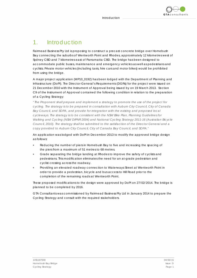
1. Introduction Fairmead Business Pty Ltd is proposing to construct a precast concrete bridge over Homebush Bay connecting the suburbs of Wentworth Point and Rhodes, approximately 12 kilometres west of Sydney CBD and 7 kilometres east of Parramatta CBD. The bridge has been designed to accommodate public buses, maintenance and emergency vehicles as well as pedestrians and cyclists. Private motor vehicles (including taxis, hire cars and motor bikes) would be prohibited from using the bridge.
A major project application (MP10_0192) has been lodged with the Department of Planning and Infrastructure (DoPI). The Director-General’s Requirements (DGRs) for the project were issued on 21 December 2010 with the Instrument of Approval being issued by on 19 March 2013. Section C9 of the Instrument of Approval contained the following condition in relation to the preparation of a Cycling Strategy:
“The Proponent shall prepare and implement a strategy to promote the use of the project for cycling. The strategy is to be prepared in consultation with Auburn City Council, City of Canada Bay Council, and SOPA, and provide for integration with the existing and proposed local cycleways. The strategy is to be consistent with the NSW Bike Plan, Planning Guidelines for Walking and Cycling (NSW DIPNR 2004) and National Cycling Strategy 2011-16 (Australian Bicycle Council, 2010). The strategy shall be submitted to the satisfaction of the Director General and a copy provided to Auburn City Council, City of Canada Bay Council, and SOPA.”
An application was lodged with DoPI in December 2013 to modify the approved bridge design as follows:
• Reducing the number of piers in Homebush Bay to five and increasing the spacing of the piers from a maximum of 51 metres to 68 metres.
• Grade separating the bridge landing at Rhodes to improve the safety of cyclists and pedestrians. This modification eliminates the need for an at-grade pedestrian and cyclist crossing across the roadway.
• Providing an elevated roadway connection to Waterways Street at Wentworth Point in order to provide a pedestrian, bicycle and bus access to Hill Road prior to the completion of the remaining roads at Wentworth Point.
These proposed modifications to the design were approved by DoPI on 27/02/2014. The bridge is planned to be completed by 2016.
GTA Consultants was commissioned by Fairmead Business Pty Ltd in January 2014 to prepare the Cycling Strategy and consult with the required stakeholders.

Existing Conditions
14S1187000 04/06/15 Homebush Bay Bridge Issue: D Cycling Strategy Page 2
2. Existing Conditions The proposed bridge over Homebush Bay would connect the suburbs of Wentworth Point and Rhodes which are located approximately 12 kilometres west of Sydney CBD and 7 kilometres east of Parramatta CBD. The location of the proposed bridge is shown in Figure 2.1.
Figure 2.1: Proposed Bridge Location and Surrounds
Source: Google Maps
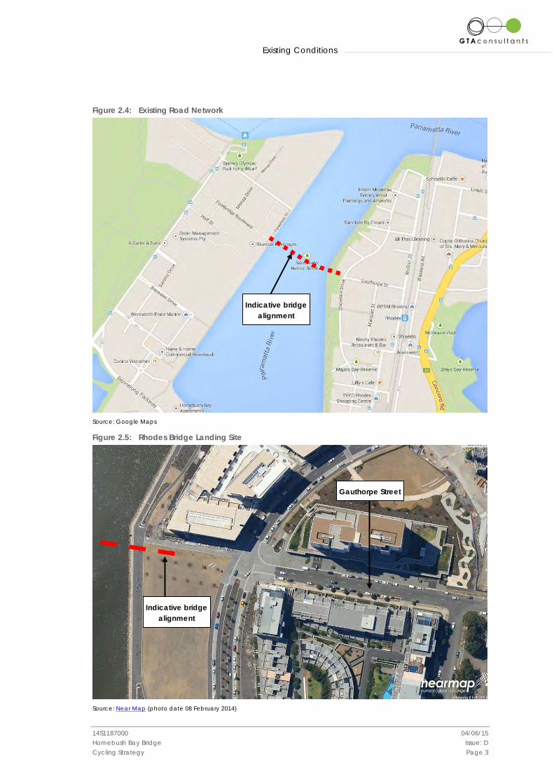
2.1 Road Network The proposed bridge would connect Gauthorpe Street at Rhodes with the proposed Footbridge Boulevard at Wentworth Point as shown in Figure 2.4. The road network in the vicinity of the Rhodes landing site is well established as shown in a recent aerial photograph (Figure 2.5). Gauthorpe Street is an 11.5 metre wide, two-way local road configured with one traffic lane in each direction and on-street parking along both sides as shown in Figure 2.2 and Figure 2.3.
Figure 2.2: Gauthorpe Street (looking west) Figure 2.3: Gauthorpe Street (looking east)
This image cannot currently be displayed.
Existing Conditions
14S1187000 04/06/15 Homebush Bay Bridge Issue: D Cycling Strategy Page 3
Figure 2.4: Existing Road Network
Source: Google Maps
Figure 2.5: Rhodes Bridge Landing Site
Source: Near Map (photo date 08 February 2014)
Indicative bridge alignment
Gauthorpe Street
Indicative bridge alignment
Existing Conditions
14S1187000 04/06/15 Homebush Bay Bridge Issue: D Cycling Strategy Page 4
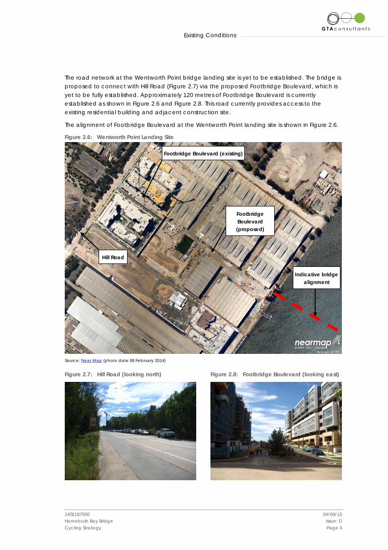
The road network at the Wentworth Point bridge landing site is yet to be established. The bridge is proposed to connect with Hill Road (Figure 2.7) via the proposed Footbridge Boulevard, which is yet to be fully established. Approximately 120 metres of Footbridge Boulevard is currently established as shown in Figure 2.6 and Figure 2.8. This road currently provides access to the existing residential building and adjacent construction site.
The alignment of Footbridge Boulevard at the Wentworth Point landing site is shown in Figure 2.6.
Figure 2.6: Wentworth Point Landing Site
Source: Near Map (photo date 08 February 2014)
Figure 2.7: Hill Road (looking north) Figure 2.8: Footbridge Boulevard (looking east)
Indicative bridge alignment
Hill Road
Footbridge Boulevard (proposed)
Footbridge Boulevard (existing)
Existing Conditions
14S1187000 04/06/15 Homebush Bay Bridge Issue: D Cycling Strategy Page 5
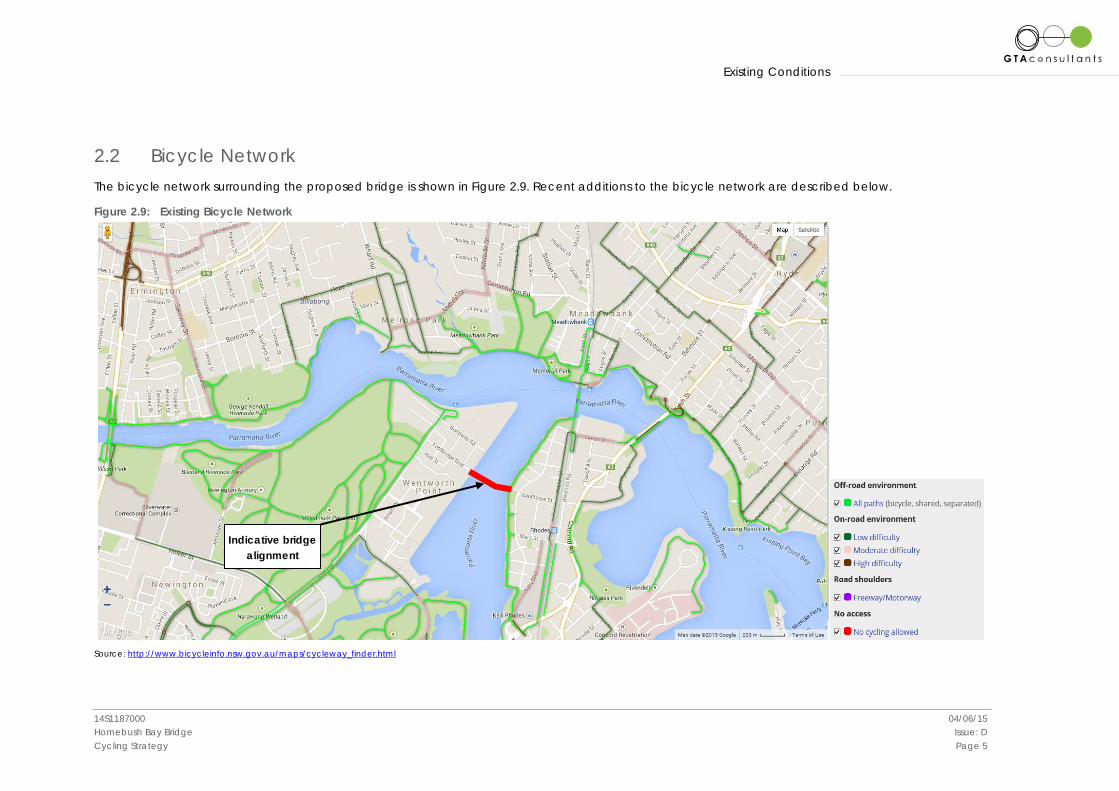
2.2 Bicycle Network The bicycle network surrounding the proposed bridge is shown in Figure 2.9. Recent additions to the bicycle network are described below.
Figure 2.9: Existing Bicycle Network
Source: http://www.bicycleinfo.nsw.gov.au/maps/cycleway_finder.html
Indicative bridge alignment
Existing Conditions
14S1187000 04/06/15 Homebush Bay Bridge Issue: D Cycling Strategy Page 6
2.2.1 Rhodes
Key bicycle infrastructure located in proximity of the proposed Rhodes bridge landing is described below.
Eastern Foreshore Shared Path
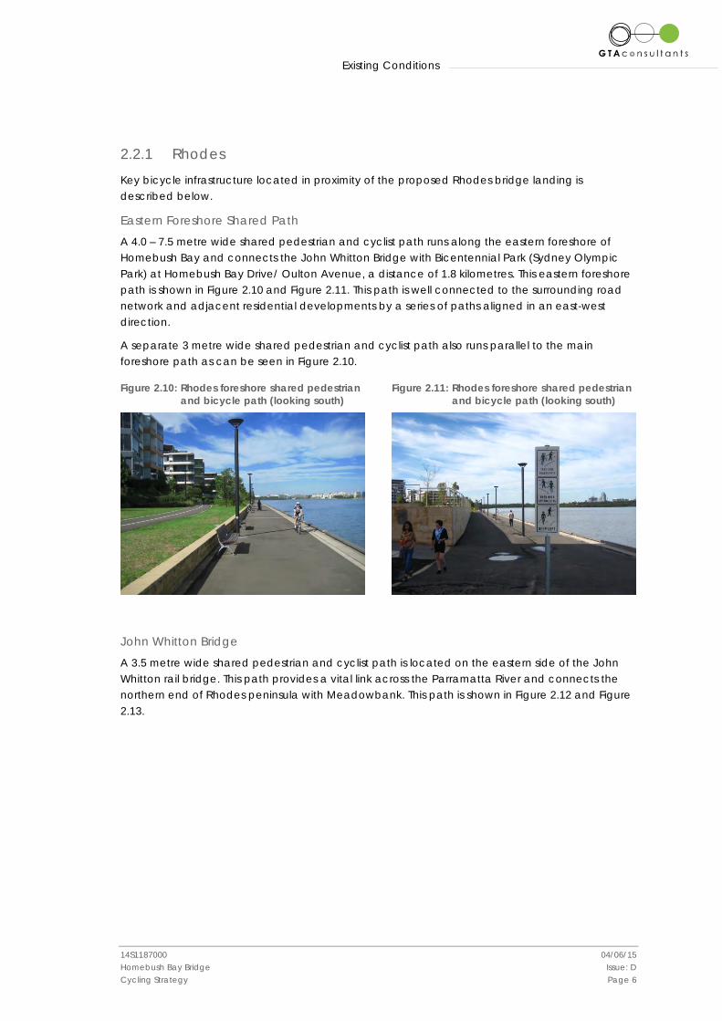
A 4.0 – 7.5 metre wide shared pedestrian and cyclist path runs along the eastern foreshore of Homebush Bay and connects the John Whitton Bridge with Bicentennial Park (Sydney Olympic Park) at Homebush Bay Drive/ Oulton Avenue, a distance of 1.8 kilometres. This eastern foreshore path is shown in Figure 2.10 and Figure 2.11. This path is well connected to the surrounding road network and adjacent residential developments by a series of paths aligned in an east-west direction.
A separate 3 metre wide shared pedestrian and cyclist path also runs parallel to the main foreshore path as can be seen in Figure 2.10.
Figure 2.10: Rhodes foreshore shared pedestrian and bicycle path (looking south)
Figure 2.11: Rhodes foreshore shared pedestrian and bicycle path (looking south)
John Whitton Bridge
A 3.5 metre wide shared pedestrian and cyclist path is located on the eastern side of the John Whitton rail bridge. This path provides a vital link across the Parramatta River and connects the northern end of Rhodes peninsula with Meadowbank. This path is shown in Figure 2.12 and Figure 2.13.

Existing Conditions
14S1187000 04/06/15 Homebush Bay Bridge Issue: D Cycling Strategy Page 7
Figure 2.12: John Whitton Bridge shared pedestrian and cycle path (looking north)
Figure 2.13: John Whitton Bridge shared
pedestrian and cycle path (looking south)
Parklands Circuit (Sydney Olympic Park)
A 3.5 metre wide shared pedestrian and cyclist path connects the eastern foreshore path with Bicentennial Park (Sydney Olympic Park) and Homebush Bay Drive/ Oulton Avenue (Figure 2.14). Parklands Circuit provides a 5.5 kilometre long continuous bicycle facility through the Badu Mangroves to Wentworth Common as shown in Figure 2.15.
Figure 2.14: Parklands Circuit access at Homebush Bay Drive/ Oulton Avenue (looking west)
Figure 2.15: Parklands Circuit shared pedestrian
and bicycle path
Ryde Bridge
A 3.5 metre wide shared pedestrian and cyclist path is located on the eastern side of Ryde Bridge. This path provides an important link across the Parramatta River and provides access to North Ryde, Macquarie Park and beyond. Bicycle access to the Ryde Bridge path from the eastern foreshore path is via Leeds Street, Uhrs Point Reserve and a shared path under the bridge deck.
Existing Conditions
14S1187000 04/06/15 Homebush Bay Bridge Issue: D Cycling Strategy Page 8
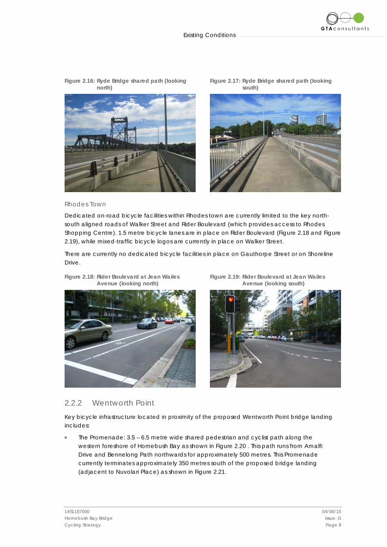
Figure 2.16: Ryde Bridge shared path (looking north) Figure 2.17: Ryde Bridge shared path (looking
south)
Rhodes Town
Dedicated on-road bicycle facilities within Rhodes town are currently limited to the key north-south aligned roads of Walker Street and Rider Boulevard (which provides access to Rhodes Shopping Centre). 1.5 metre bicycle lanes are in place on Rider Boulevard (Figure 2.18 and Figure 2.19), while mixed-traffic bicycle logos are currently in place on Walker Street.
There are currently no dedicated bicycle facilities in place on Gauthorpe Street or on Shoreline Drive.
Figure 2.18: Rider Boulevard at Jean Wailes Avenue (looking north) Figure 2.19: Rider Boulevard at Jean Wailes
Avenue (looking south)
2.2.2 Wentworth Point
Key bicycle infrastructure located in proximity of the proposed Wentworth Point bridge landing includes:
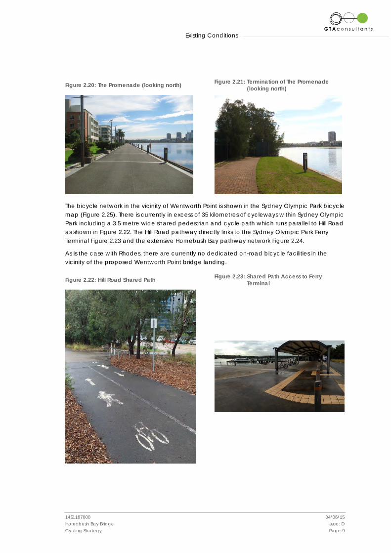
• The Promenade: 3.5 – 6.5 metre wide shared pedestrian and cyclist path along the western foreshore of Homebush Bay as shown in Figure 2.20 . This path runs from Amalfi Drive and Bennelong Path northwards for approximately 500 metres. This Promenade currently terminates approximately 350 metres south of the proposed bridge landing (adjacent to Nuvolari Place) as shown in Figure 2.21.
Existing Conditions
14S1187000 04/06/15 Homebush Bay Bridge Issue: D Cycling Strategy Page 9
Figure 2.20: The Promenade (looking north) Figure 2.21: Termination of The Promenade (looking north)
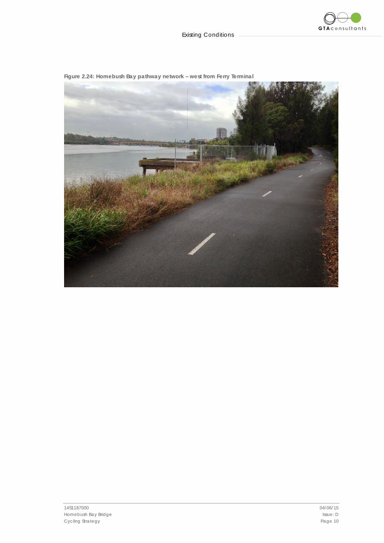
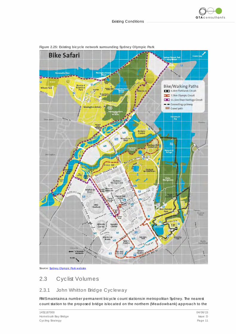
The bicycle network in the vicinity of Wentworth Point is shown in the Sydney Olympic Park bicycle map (Figure 2.25). There is currently in excess of 35 kilometres of cycleways within Sydney Olympic Park including a 3.5 metre wide shared pedestrian and cycle path which runs parallel to Hill Road as shown in Figure 2.22. The Hill Road pathway directly links to the Sydney Olympic Park Ferry Terminal Figure 2.23 and the extensive Homebush Bay pathway network Figure 2.24.
As is the case with Rhodes, there are currently no dedicated on-road bicycle facilities in the vicinity of the proposed Wentworth Point bridge landing.
Figure 2.22: Hill Road Shared Path Figure 2.23: Shared Path Access to Ferry Terminal
Existing Conditions
14S1187000 04/06/15 Homebush Bay Bridge Issue: D Cycling Strategy Page 10
Figure 2.24: Homebush Bay pathway network – west from Ferry Terminal
Existing Conditions
14S1187000 04/06/15 Homebush Bay Bridge Issue: D Cycling Strategy Page 11
Figure 2.25: Existing bicycle network surrounding Sydney Olympic Park
Source: Sydney Olympic Park website
2.3 Cyclist Volumes
2.3.1 John Whitton Bridge Cycleway
RMS maintains a number permanent bicycle count stations in metropolitan Sydney. The nearest count station to the proposed bridge is located on the northern (Meadowbank) approach to the
Existing Conditions
14S1187000 04/06/15 Homebush Bay Bridge Issue: D Cycling Strategy Page 12
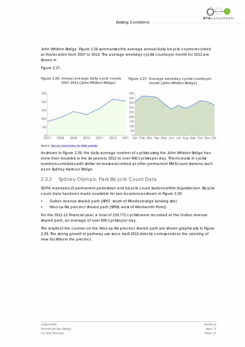
John Whitton Bridge. Figure 2.26 summarises the average annual daily bicycle counts recorded at this location from 2007 to 2013. The average weekday cyclist counts per month for 2013 are shown in
Figure 2.27.
Figure 2.26: Annual average daily cycle counts 2007-2013 (John Whitton Bridge)
Figure 2.27: Average weekday cyclist counts per
month (John Whitton Bridge)
Source: Bicycle Information for NSW website
As shown in Figure 2.26, the daily average number of cyclists using the John Whitton Bridge has more than doubled in the six years to 2012 to over 400 cyclists per day. This increase in cyclist numbers correlates with similar increases recorded at other permanent RMS count stations, such as on Sydney Harbour Bridge.
2.3.2 Sydney Olympic Park Bicycle Count Data
SOPA maintains 15 permanent pedestrian and bicycle count stations within its jurisdiction. Bicycle count data has been made available for two locations as shown in Figure 2.29:
• Oulton Avenue shared path (SP07, south of Rhodes bridge landing site) • Woo-La-Ra precinct shared path (SP08, west of Wentworth Point).
For the 2011-12 financial year, a total of 219,772 cyclists were recorded at the Oulton Avenue shared path, an average of over 600 cyclists per day.
The results of the counter on the Woo-La-Ra precinct shared path are shown graphically in Figure 2.29. The strong growth in pathway use since April 2010 directly corresponds to the opening of new facilities in the precinct.

Existing Conditions
14S1187000 04/06/15 Homebush Bay Bridge Issue: D Cycling Strategy Page 13
Figure 2.28: SOPA bicycle and pedestrian count stations
Source: SOPA
Figure 2.29: Average Daily Cyclist Volumes – Woo-La-Ra Precinct Shared Path
Data Source: SOPA
Oulton Avenue shared path
Woo-La-Ra precinct shared path
The Proposed Bridge
14S1187000 04/06/15 Homebush Bay Bridge Issue: D Cycling Strategy Page 14
3. The Proposed Bridge
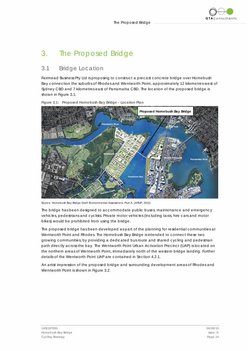
3.1 Bridge Location Fairmead Business Pty Ltd is proposing to construct a precast concrete bridge over Homebush Bay connection the suburbs of Rhodes and Wentworth Point, approximately 12 kilometres west of Sydney CBD and 7 kilometres east of Parramatta CBD. The location of the proposed bridge is shown in Figure 3.1.
Figure 3.1: Proposed Homebush Bay Bridge - Location Plan
Source: Homebush Bay Bridge Draft Environmental Assessment, Part A, (ARUP, 2012)
The bridge has been designed to accommodate public buses, maintenance and emergency vehicles, pedestrians and cyclists. Private motor vehicles (including taxis, hire cars and motor bikes) would be prohibited from using the bridge.
The proposed bridge has been developed as part of the planning for residential communities at Wentworth Point and Rhodes. The Homebush Bay Bridge is intended to connect these two growing communities, by providing a dedicated bus route and shared cycling and pedestrian path directly across the bay. The Wentworth Point Urban Activation Precinct (UAP) is located on the northern areas of Wentworth Point, immediately north of the western bridge landing. Further details of the Wentworth Point UAP are contained in Section 4.2.1.
An artist impression of the proposed bridge and surrounding development areas of Rhodes and Wentworth Point is shown in Figure 3.2.
Proposed Homebush Bay Bridge

The Proposed Bridge
14S1187000 04/06/15 Homebush Bay Bridge Issue: D Cycling Strategy Page 15
Figure 3.2: Artist impression of Homebush Bay Bridge, Rhodes and Wentworth Point development sites (looking south)
Source: DoPI website
Proposed Homebush Bay Bridge
The Proposed Bridge
14S1187000 04/06/15 Homebush Bay Bridge Issue: D Cycling Strategy Page 16
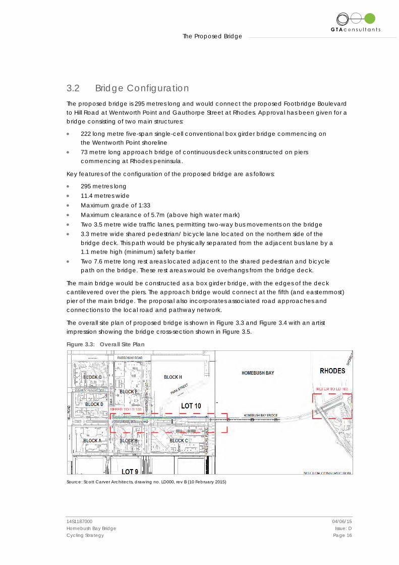
3.2 Bridge Configuration The proposed bridge is 295 metres long and would connect the proposed Footbridge Boulevard to Hill Road at Wentworth Point and Gauthorpe Street at Rhodes. Approval has been given for a bridge consisting of two main structures:
• 222 long metre five-span single-cell conventional box girder bridge commencing on the Wentworth Point shoreline
• 73 metre long approach bridge of continuous deck units constructed on piers commencing at Rhodes peninsula.
Key features of the configuration of the proposed bridge are as follows:
• 295 metres long • 11.4 metres wide • Maximum grade of 1:33 • Maximum clearance of 5.7m (above high water mark) • Two 3.5 metre wide traffic lanes, permitting two-way bus movements on the bridge • 3.3 metre wide shared pedestrian/ bicycle lane located on the northern side of the
bridge deck. This path would be physically separated from the adjacent bus lane by a 1.1 metre high (minimum) safety barrier
• Two 7.6 metre long rest areas located adjacent to the shared pedestrian and bicycle path on the bridge. These rest areas would be overhangs from the bridge deck.
The main bridge would be constructed as a box girder bridge, with the edges of the deck cantilevered over the piers. The approach bridge would connect at the fifth (and easternmost) pier of the main bridge. The proposal also incorporates associated road approaches and connections to the local road and pathway network.
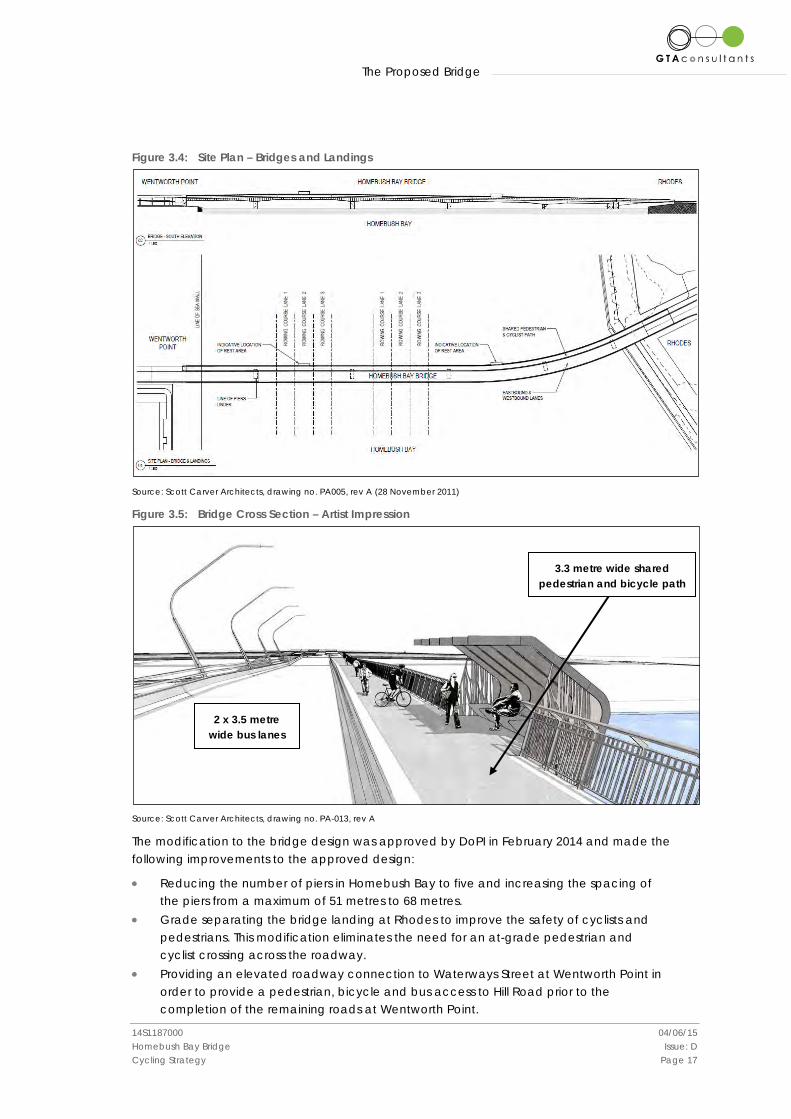
The overall site plan of proposed bridge is shown in Figure 3.3 and Figure 3.4 with an artist impression showing the bridge cross-section shown in Figure 3.5.
Figure 3.3: Overall Site Plan
Source: Scott Carver Architects, drawing no. LD000, rev B (10 February 2015)
The Proposed Bridge
14S1187000 04/06/15 Homebush Bay Bridge Issue: D Cycling Strategy Page 17
Figure 3.4: Site Plan – Bridges and Landings
Source: Scott Carver Architects, drawing no. PA005, rev A (28 November 2011)
Figure 3.5: Bridge Cross Section – Artist Impression
Source: Scott Carver Architects, drawing no. PA-013, rev A
The modification to the bridge design was approved by DoPI in February 2014 and made the following improvements to the approved design:
• Reducing the number of piers in Homebush Bay to five and increasing the spacing of the piers from a maximum of 51 metres to 68 metres.
• Grade separating the bridge landing at Rhodes to improve the safety of cyclists and pedestrians. This modification eliminates the need for an at-grade pedestrian and cyclist crossing across the roadway.
• Providing an elevated roadway connection to Waterways Street at Wentworth Point in order to provide a pedestrian, bicycle and bus access to Hill Road prior to the completion of the remaining roads at Wentworth Point.
2 x 3.5 metre wide bus lanes
3.3 metre wide shared pedestrian and bicycle path
The Proposed Bridge
14S1187000 04/06/15 Homebush Bay Bridge Issue: D Cycling Strategy Page 18
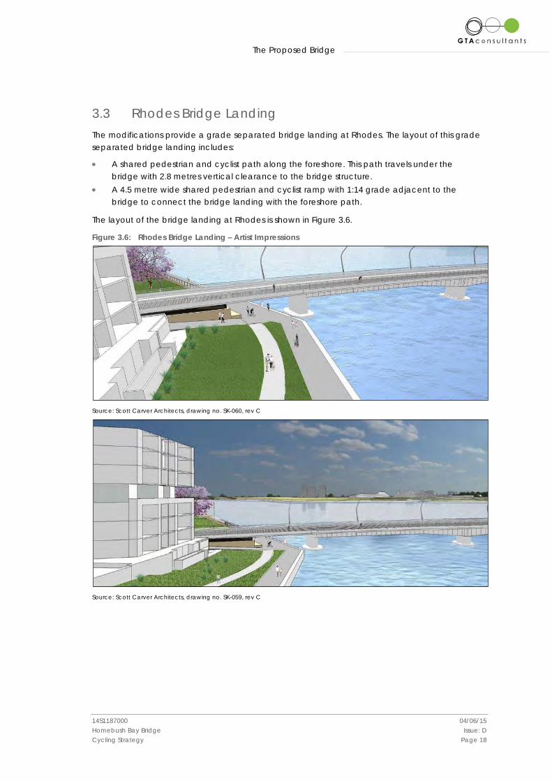
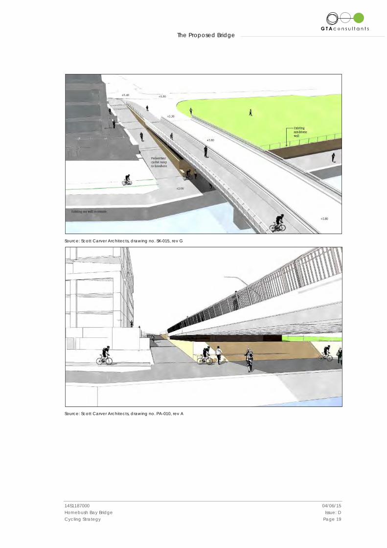
3.3 Rhodes Bridge Landing The modifications provide a grade separated bridge landing at Rhodes. The layout of this grade separated bridge landing includes:
• A shared pedestrian and cyclist path along the foreshore. This path travels under the bridge with 2.8 metres vertical clearance to the bridge structure.
• A 4.5 metre wide shared pedestrian and cyclist ramp with 1:14 grade adjacent to the bridge to connect the bridge landing with the foreshore path.
The layout of the bridge landing at Rhodes is shown in Figure 3.6.
Figure 3.6: Rhodes Bridge Landing – Artist Impressions
Source: Scott Carver Architects, drawing no. SK-060, rev C
Source: Scott Carver Architects, drawing no. SK-059, rev C
The Proposed Bridge
14S1187000 04/06/15 Homebush Bay Bridge Issue: D Cycling Strategy Page 19
Source: Scott Carver Architects, drawing no. SK-015, rev G
Source: Scott Carver Architects, drawing no. PA-010, rev A
The Proposed Bridge
14S1187000 04/06/15 Homebush Bay Bridge Issue: D Cycling Strategy Page 20
Source: Scott Carver Architects, drawing no. SK-017, rev G
Source: Scott Carver Architects, drawing no. PA-010, rev A
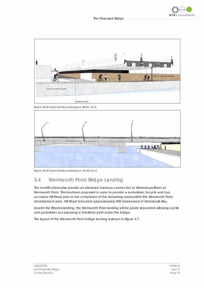
3.4 Wentworth Point Bridge Landing The modifications also provide an elevated roadway connection to Waterways Street at Wentworth Point. This has been proposed in order to provide a pedestrian, bicycle and bus access to Hill Road prior to the completion of the remaining roads within the Wentworth Point development area. Hill Road is located approximately 400 metres west of Homebush Bay.
As with the Rhodes landing, the Wentworth Point landing will be grade separated allowing cyclist and pedestrian access along a foreshore path under the bridge.
The layout of the Wentworth Point bridge landing is shown in Figure 3.7.
The Proposed Bridge
14S1187000 04/06/15 Homebush Bay Bridge Issue: D Cycling Strategy Page 21
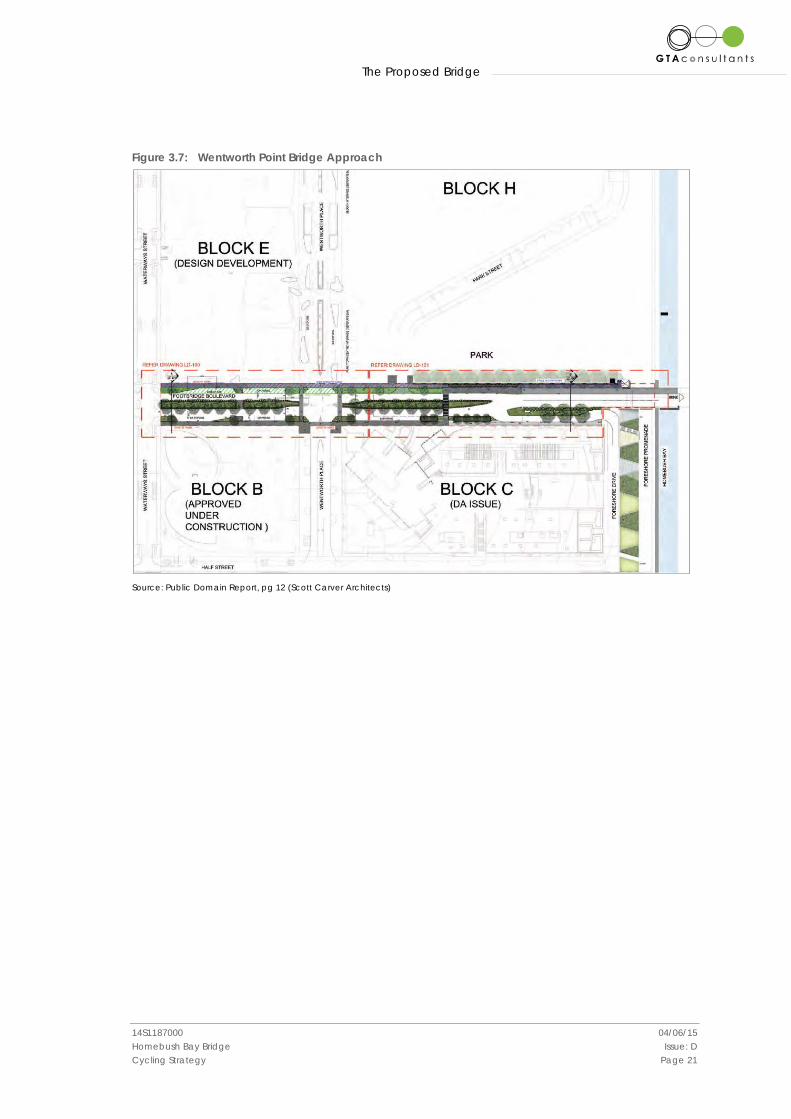
Figure 3.7: Wentworth Point Bridge Approach
Source: Public Domain Report, pg 12 (Scott Carver Architects)
Strategic Context
14S1187000 04/06/15 Homebush Bay Bridge Issue: D Cycling Strategy Page 22
4. Strategic Context
4.1 Federal Policy and Planning Context
4.1.1 Australian National Cycling Strategy 2011-16 (2010)
The National Cycling Strategy was released by Austroads and The Australian Bicycle Council in 2010. The overarching vision for the strategy is to realise a ‘step-change’ in attitudes to cycling and in the numbers of riders in Australia. In the short term, the strategy sets the goal to double the number of people cycling across the nation over the next five years. The strategy sets out a coordinated framework for the development of cycling in Australia to 2016 under the following priorities and objectives:
• Cycling Promotion – Promote cycling as both a viable and safe mode of transport and an enjoyable recreational activity.
• Infrastructure and Facilities – Create a comprehensive network of safe and attractive routes to cycle and end of trip facilities.
• Integrated Planning – Consider and address cycling needs in all relevant transport and land use planning activities.
• Safety – Enable people to cycle safely. • Monitoring and Evaluation – Improve monitoring and evaluation of cycling programs
and develop a national decision making process for investment in cycling. • Guidance and Best Practice – Develop nationally consistent technical guidance for
stakeholders to use and share best practice across jurisdictions.
While the National Strategy makes no reference to specific infrastructure, the provision of safe, separated and integrated facilities such as the proposed bridge are an exemplary means of promoting and encouraging cycling as a viable mode of transport and as a recreational activity. Facilities such as bridges are ideally suited for monitoring stations.
4.2 State Policy and Planning Context
4.2.1 NSW 2021: A Plan to Make NSW Number One (2011)
NSW 2021 was released in 2011 and sets out the government’s transport and service delivery. The plan includes a goal to more than double the mode share of bicycle trips made in the Greater Sydney region, at a local and district level, by 2016. The plan included a priority action to complete the construction of the Metro Sydney Bike Network and work with local councils to complete local cycle networks as part of an integrated transport network.
While NSW 2021 does not directly specify specific infrastructure, the provision of safe, separated and integrated facilities such as the proposed bridge are an important opportunity to help increase the mode share of bicycle trips in the Sydney region.
4.2.2 NSW Long Term Transport Master Plan (2012)
The NSW Long Term Transport Master Plan sets the framework for the NSW Government to deliver an integrated, modern transport system. The final version of the NSW Long Term Transport Master Plan was released in December 2012 and sets out 220 short, medium and long term actions to
Strategic Context
14S1187000 04/06/15 Homebush Bay Bridge Issue: D Cycling Strategy Page 23
integrate, grow, modernise and manage the transport network across NSW, including five key measures related to cycling:
i Improved access to user-friendly bike trip information. ii A long term NSW Cycling Investment Program to improve the planning, management
and delivery of cycleway capital programs, supported by design solutions and standards to reflect customer needs.
iii A program to increase and improve bike parking at public transport interchanges. iv A Connected Cycling Network that targets investment in clearly defined cycleways
within a 5 kilometre radius of major urban centres in the short-term and 10 kilometre radius of centres in the longer term.
v Enhanced cycling routes in regional centres to increase the number of people who cycle.
The Master Plan contains a specific target to double the number of bicycle trips in Metropolitan Sydney by 2016, with further growth in cycling for all trips in NSW by 2031, particularly in urban centres.
$27.5 million was allocated to cycling in the 2012-13 budget, $8.86 million of which was allocated to match Council funding to deliver approximately 100 local cycleway projects in over 70 different locations as well as support local cycling initiatives such as NSW Bike Week.
In particular, the Master Plan identifies the Parramatta-Strathfield-Sydney CBD corridor as a critical constraint in the Sydney transport network. The proposed bus-bike-pedestrian bridge provides an important link in this network that will help relieve congestion in the corridor. The annual funding associated with the plan provides a direct opportunity for completion of the strategic links to the proposed bridge.
4.2.3 Sydney’s Cycling Future (2013)
Sydney’s Cycling Future was prepared by Transport for NSW and was released in December 2013 following the release of the NSW Long Term Transport Master Plan to provide a mode specific cycling strategy. It presents a new direction for bicycle infrastructure planning in metropolitan Sydney by focusing on people who would like to ride more often if cycling was made a safer and more convenient option. It aims to make cycling a feasible transport option for these people by:
• investing in separated cycleways and providing connected bicycle networks to major centres and transport interchanges
• promoting better use of existing infrastructure • engaging with partners across government, councils, developers and bicycle users.
The strategy aims to prioritise investment on projects that have the greatest potential to get the most people to shift their short transport trips to bicycle. In order to achieve this, it aims to invest in connected routes within 5 kilometres of major centres and public transport interchanges. It proposes a three-tier hierarchy of safe cycleways to major centres:
• Regional bicycle corridors – highly used routes that connect to major destinations, on cycleways that are separate from motor vehicles and pedestrians.
• Local bicycle network – lower use corridors that connect to priority corridors and neighbourhood destinations within catchments.
• Quiet local streets – connecting residential destinations and local services in low traffic environments, design treatments make provision for people on bikes.
Strategic Context
14S1187000 04/06/15 Homebush Bay Bridge Issue: D Cycling Strategy Page 24
The strategy seeks to invest in state priority corridors to safely link the following corridors with inner Sydney:
• North Shore Links – North Sydney, St Leonards and Chatswood • Eastern Suburbs Links – Bondi Junction to the CBD • Inner West Links – Sydney University, Royal Prince Alfred Hospital, Sydney College of the
Arts • South East and Light Rail Links – Randwick racecourse, hospital and university precinct • Sydney Airport Links – Green Square, Mascot and Wolli Creek.
In addition to this, the strategy aims to deliver state priority corridors within a 5 kilometre catchment of the following major centres:
• Parramatta • Penrith • Liverpool • Blacktown.
The strategy outlines a ‘Connecting Centres Program’ to assist councils to complete local bicycle networks to major centres in metropolitan Sydney. This program aims to complete links within a 5 kilometre catchment of major centres in the short term and expand to 10 kilometres catchments in the longer term. The strategy states specifically that bicycle network plans will be developed with councils within 5 kilometres of:
• Parramatta/ Westmead • Sydney Olympic Park and Rhodes • Burwood.
Sydney’s Cycling Future uses the proposed Homebush Bay Bridge as an example of linking cycling to urban growth by providing bicycle facilities to new communities. An extract of the strategy is shown in Figure 4.1.
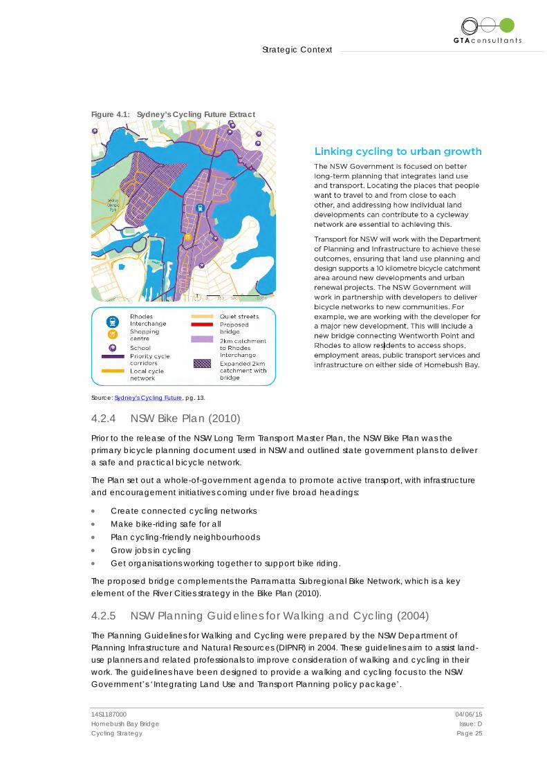
Strategic Context
14S1187000 04/06/15 Homebush Bay Bridge Issue: D Cycling Strategy Page 25
Figure 4.1: Sydney’s Cycling Future Extract
Source: Sydney's Cycling Future, pg. 13.
4.2.4 NSW Bike Plan (2010)
Prior to the release of the NSW Long Term Transport Master Plan, the NSW Bike Plan was the primary bicycle planning document used in NSW and outlined state government plans to deliver a safe and practical bicycle network.
The Plan set out a whole-of-government agenda to promote active transport, with infrastructure and encouragement initiatives coming under five broad headings:
• Create connected cycling networks • Make bike-riding safe for all • Plan cycling-friendly neighbourhoods • Grow jobs in cycling • Get organisations working together to support bike riding.
The proposed bridge complements the Parramatta Subregional Bike Network, which is a key element of the River Cities strategy in the Bike Plan (2010).
4.2.5 NSW Planning Guidelines for Walking and Cycling (2004)
The Planning Guidelines for Walking and Cycling were prepared by the NSW Department of Planning Infrastructure and Natural Resources (DIPNR) in 2004. These guidelines aim to assist land-use planners and related professionals to improve consideration of walking and cycling in their work. The guidelines have been designed to provide a walking and cycling focus to the NSW Government’s ‘Integrating Land Use and Transport Planning policy package’.
Strategic Context
14S1187000 04/06/15 Homebush Bay Bridge Issue: D Cycling Strategy Page 26
The guidelines highlight the benefits of planning for walking and cycling for the development industry, recognising that the marketability of developments can be enhanced by catering for people’s desires for healthy lifestyles.
The guidelines include detailed suggestion for the provision, design, quantity and quality of end-of-trip facilities.
The proposed bridge is a textbook example of the integration of landuse and transport and soundly applies the recommended catchment mapping process to improve walking and cycling access to transport interchanges that would have otherwise been unachievable.
4.2.6 Wentworth Point Urban Activation Precinct (UAP)
The northern areas of Wentworth Point have been identified by DoPI as one of eight UAPs in metropolitan Sydney. The UAP program aims to create high-quality urban areas to help to meet Sydney’s growth needs by transforming sites into centres where people can live and work. Key aspects of the program include increasing the residential and employment densities within the UAPs and improving transport services to these precincts.
The Wentworth Point UAP comprises an area of approximately 18 hectares located in two land parcels on either side of the Sydney Olympic Park ferry wharf as shown in Figure 4.2. The proposals for the UAP are as follows:
• Two residential neighbourhoods containing, in total, approximately 2,300 apartments. • New 3.9 hectare peninsula park and three additional pocket parks. • New primary school with 18 classrooms and playing fields. • Continuous pedestrian and cycle access around the foreshore of both Parramatta
River and Homebush Bay, including a new maritime plaza lined with shops and cafes. • Maritime uses such as boat storage, a marina and rowing/kayaking facilities.
The construction of apartments at the Wentworth Point UAP is likely to extend over 15 years with the primary school anticipated to open by January 2017.
Access to the Wentworth Point UAP in general and to the proposed school in particular is greatly enhanced by the proposed bridge.

Strategic Context
14S1187000 04/06/15 Homebush Bay Bridge Issue: D Cycling Strategy Page 27
Figure 4.2: Wentworth Point UAP
Source: Wentworth Point UAP Proposal, pg. ii, (July 2013), DoPI website
4.3 Local and Regional Policy and Planning Context
4.3.1 Inner Sydney Regional Bike Plan (2009)
The Inner Sydney Regional Bike Plan (ISRBP) was an initiative of the City of Sydney, developed in conjunction with 14 surrounding LGA’s to identify an arterial cycleway network for 1.2 million people in 164 suburbs. The network aims to improve connections between home, work, shopping and recreation areas, increasing the liveability of inner Sydney locations. It includes 160km of separated cycleways and 70 km of upgraded shared paths.
The plan was informed by the 2006 Regional Bike Plan, prepared by South Sydney Regional Organisation of Councils (SSROC), in consultation with local Bicycle User Groups (BUGs).
The ISRBP detailed routes to be implemented in the City of Canada Bay but did not include Auburn LGA. The proposed bridge and its strategic linkages provide a valuable extension of the ISRBP network.
4.3.2 Sharing Sydney Harbour Access Plan (2003)
The Sharing Sydney Harbour Access Plan was released by DIPNR in 2003 and outlines the state government’s vision for access to Sydney Harbour:
“…to improve public access to, and enhance the recreational enjoyment of, Sydney Harbour and its tributaries for the people of Sydney and visitors to the city.”
Strategic Context
14S1187000 04/06/15 Homebush Bay Bridge Issue: D Cycling Strategy Page 28
The Access Plan identifies opportunities to improve access to the foreshores and waterways for a range of recreational users including cyclists. The corresponding Sharing Sydney Harbour Access Program was launched in February 2003 and is managed by DoPI. The program provides dollar for dollar funding for capital works projects such as cycleways, walking tracks, jetties and boat launching facilities. In 2007 the program was extended for another five years to provide $6.75 million until 2013. Each year up to $1.35 million is distributed on a dollar-for-dollar basis to Councils for specific capital works projects such as walking tracks, bicycle paths, new public waterfront parks, jetties, pontoons and boat launching facilities.
The funding sources associated with the program provide a direct opportunity for the completion of the strategic links to the proposed bridge.
4.3.3 Sydney Olympic Park Authority (SOPA)
SOPA has undertaken a range of strategic bicycle network planning in recent years, including the connection of cycleways to surrounding jurisdictions. A selection of notable strategic planning projects is outlined below.
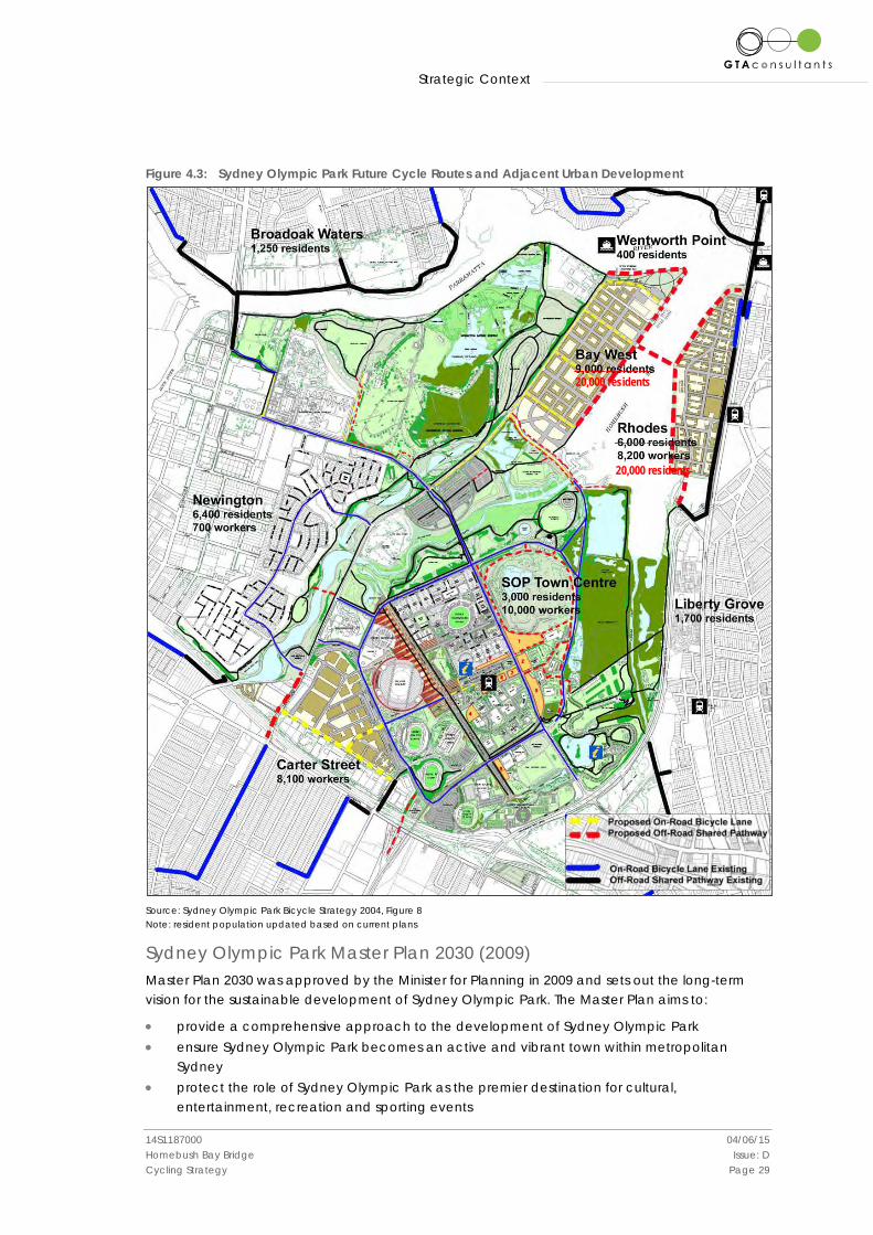
Sydney Olympic Park Bicycle Strategy (2004) The 2004 bicycle strategy was a detailed response to the question of ‘What will make Sydney Olympic Park a great place for cyclists?’ The strategy sets out the vision of cycling at Sydney Olympic Park as follows:
“Sydney Olympic Park as the pre-eminent cycling destination in Sydney for the enjoyment of nature, culture, sport and recreation by offering everyone the best imaginable cycling experience. This cycling experience will comprise the best imaginable facilities and infrastructure; experiences and technological overlay and will be supported by the best imaginable operational, marketing, communication and corporate activities”.
The strategy examined the existing and future bicycle connections in the vicinity of Sydney Olympic Park. The strategy identified the construction of a shared cyclist and pedestrian bridge over Homebush Bay as a significant regional connection which would support cycling in Sydney Olympic Park as well as in the urban developments adjacent to the park. A map showing existing and proposed cycle routes as well as urban development sites in the vicinity of Olympic Park is shown in Figure 4.3.
The bicycle strategy highlighted the strategic importance of providing the bridge across Homebush Bay by providing access for residents of Rhodes Peninsula to the northern precincts of Sydney Olympic Park. The strategy also recognised that the bridge would enable a circular recreational loop around Homebush Bay for cyclists to be completed.
Strategic Context
14S1187000 04/06/15 Homebush Bay Bridge Issue: D Cycling Strategy Page 29
Figure 4.3: Sydney Olympic Park Future Cycle Routes and Adjacent Urban Development
Source: Sydney Olympic Park Bicycle Strategy 2004, Figure 8 Note: resident population updated based on current plans
Sydney Olympic Park Master Plan 2030 (2009) Master Plan 2030 was approved by the Minister for Planning in 2009 and sets out the long-term vision for the sustainable development of Sydney Olympic Park. The Master Plan aims to:
• provide a comprehensive approach to the development of Sydney Olympic Park • ensure Sydney Olympic Park becomes an active and vibrant town within metropolitan
Sydney • protect the role of Sydney Olympic Park as the premier destination for cultural,
entertainment, recreation and sporting events
______________ 20,000 residents
______________ 20,000 residents
Strategic Context
14S1187000 04/06/15 Homebush Bay Bridge Issue: D Cycling Strategy Page 30
• protect and enhance the public domain • protect and enhance the Sydney Olympic Park parklands • provide detailed planning and design principles and controls • encourage development that responds to its context and contributes to the quality of
the built environment and the future character and cultural significance of the site.
The Master Plan contains the following suggestions for improving bicycle and pedestrian access to Olympic Park:
• targeting a specific bicycle/pedestrian mode share split of 10 per cent • adopting best practice cycling guidelines • designing pleasant, safe and connected local streets to encourage walking and
cycling, including intersections that facilitate pedestrian use • providing an enhanced bicycle network, including new routes; improved connections
to existing routes; and better end of trip facilities for cyclists, including commuter bicycle parking
• requiring new commercial and residential developments to offer secure bicycle storage and change/shower facilities
• providing well signposted and safe through-site connections to the regional cycleway network
• continuing to prioritise pedestrians in public spaces during large events • providing a safe and connected shared pathway network in the parklands for health
and fitness, and recreational needs.
The existing and proposed bicycle routes in the vicinity of the park (including the Homebush Bay Bridge) as outlined in Master Plan 2030 are shown in Figure 4.4.
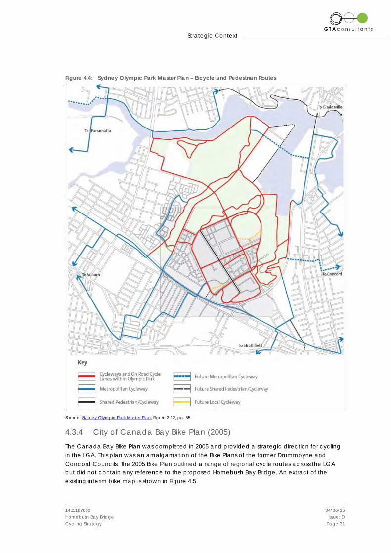
Strategic Context
14S1187000 04/06/15 Homebush Bay Bridge Issue: D Cycling Strategy Page 31
Figure 4.4: Sydney Olympic Park Master Plan – Bicycle and Pedestrian Routes
Source: Sydney Olympic Park Master Plan, Figure 3.12, pg. 55
4.3.4 City of Canada Bay Bike Plan (2005)
The Canada Bay Bike Plan was completed in 2005 and provided a strategic direction for cycling in the LGA. This plan was an amalgamation of the Bike Plans of the former Drummoyne and Concord Councils. The 2005 Bike Plan outlined a range of regional cycle routes across the LGA but did not contain any reference to the proposed Homebush Bay Bridge. An extract of the existing interim bike map is shown in Figure 4.5.
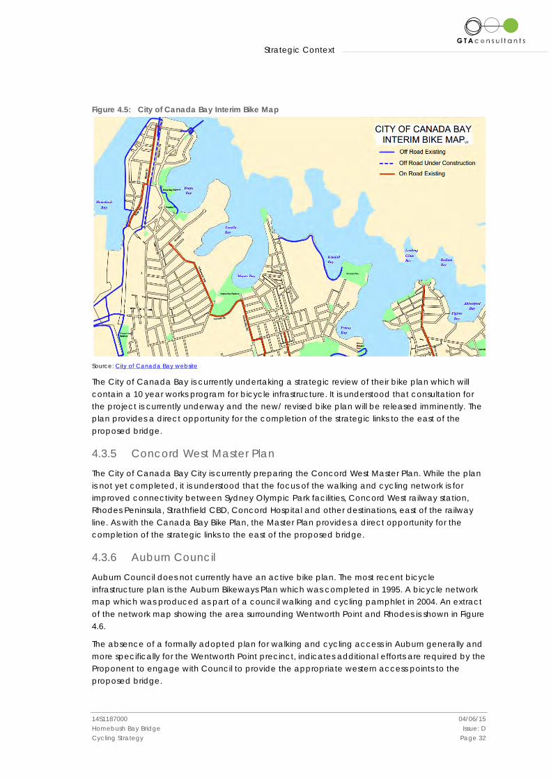
Strategic Context
14S1187000 04/06/15 Homebush Bay Bridge Issue: D Cycling Strategy Page 32
Figure 4.5: City of Canada Bay Interim Bike Map
Source: City of Canada Bay website
The City of Canada Bay is currently undertaking a strategic review of their bike plan which will contain a 10 year works program for bicycle infrastructure. It is understood that consultation for the project is currently underway and the new/ revised bike plan will be released imminently. The plan provides a direct opportunity for the completion of the strategic links to the east of the proposed bridge.
4.3.5 Concord West Master Plan
The City of Canada Bay City is currently preparing the Concord West Master Plan. While the plan is not yet completed, it is understood that the focus of the walking and cycling network is for improved connectivity between Sydney Olympic Park facilities, Concord West railway station, Rhodes Peninsula, Strathfield CBD, Concord Hospital and other destinations, east of the railway line. As with the Canada Bay Bike Plan, the Master Plan provides a direct opportunity for the completion of the strategic links to the east of the proposed bridge.
4.3.6 Auburn Council
Auburn Council does not currently have an active bike plan. The most recent bicycle infrastructure plan is the Auburn Bikeways Plan which was completed in 1995. A bicycle network map which was produced as part of a council walking and cycling pamphlet in 2004. An extract of the network map showing the area surrounding Wentworth Point and Rhodes is shown in Figure 4.6.
The absence of a formally adopted plan for walking and cycling access in Auburn generally and more specifically for the Wentworth Point precinct, indicates additional efforts are required by the Proponent to engage with Council to provide the appropriate western access points to the proposed bridge.

Strategic Context
14S1187000 04/06/15 Homebush Bay Bridge Issue: D Cycling Strategy Page 33
Figure 4.6: Auburn Council Cycleway Map (2009)
Source: Auburn LGA Cycle Routes, 2009, Auburn Council website
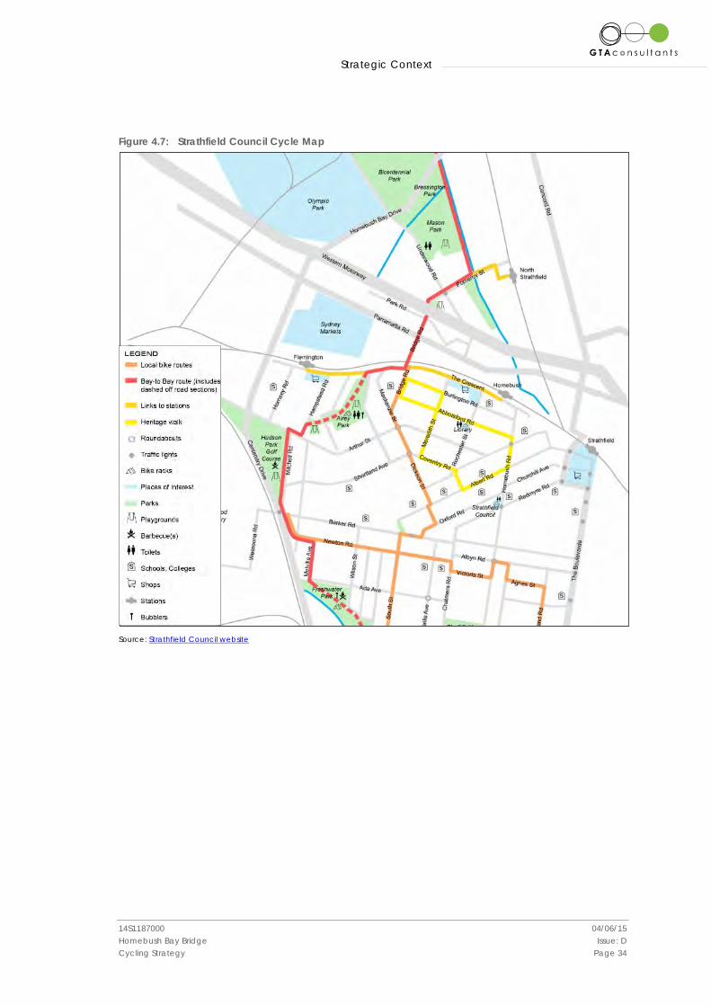
4.3.7 Strathfield Council
Strathfield Council does not currently have an active bike plan but does have a bicycle network map, an extract of which is shown in Figure 4.7. This map shows the Bay to Bay route (shown in red) which is located on the eastern side of Bicentennial Park and Mason Park. It is further understood there are other RMS plans for improved pathway connections along Powells Creek from Mason Park to Strathfield CBD.
The proposed bridge provides a valuable extension to the Bay to Bay route.
Strategic Context
14S1187000 04/06/15 Homebush Bay Bridge Issue: D Cycling Strategy Page 34
Figure 4.7: Strathfield Council Cycle Map
Source: Strathfield Council website
Promoting the Use of the Bridge
14S1187000 04/06/15 Homebush Bay Bridge Issue: D Cycling Strategy Page 35
5. Promoting the Use of the Bridge
5.1 High Quality Connections
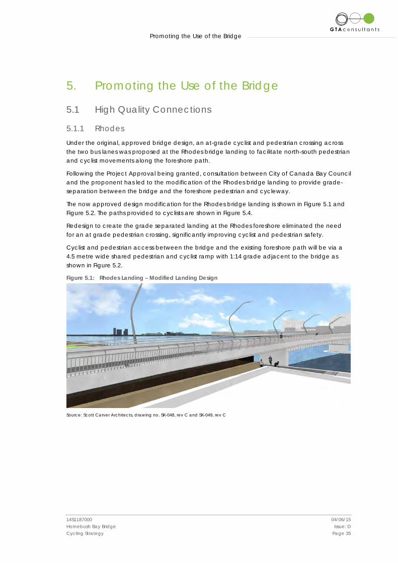
5.1.1 Rhodes
Under the original, approved bridge design, an at-grade cyclist and pedestrian crossing across the two bus lanes was proposed at the Rhodes bridge landing to facilitate north-south pedestrian and cyclist movements along the foreshore path.
Following the Project Approval being granted, consultation between City of Canada Bay Council and the proponent has led to the modification of the Rhodes bridge landing to provide grade-separation between the bridge and the foreshore pedestrian and cycleway.
The now approved design modification for the Rhodes bridge landing is shown in Figure 5.1 and Figure 5.2. The paths provided to cyclists are shown in Figure 5.4.
Redesign to create the grade separated landing at the Rhodes foreshore eliminated the need for an at grade pedestrian crossing, significantly improving cyclist and pedestrian safety.
Cyclist and pedestrian access between the bridge and the existing foreshore path will be via a 4.5 metre wide shared pedestrian and cyclist ramp with 1:14 grade adjacent to the bridge as shown in Figure 5.2.
Figure 5.1: Rhodes Landing – Modified Landing Design
Source: Scott Carver Architects, drawing no. SK-048, rev C and SK-049, rev C
Promoting the Use of the Bridge
14S1187000 04/06/15 Homebush Bay Bridge Issue: D Cycling Strategy Page 36
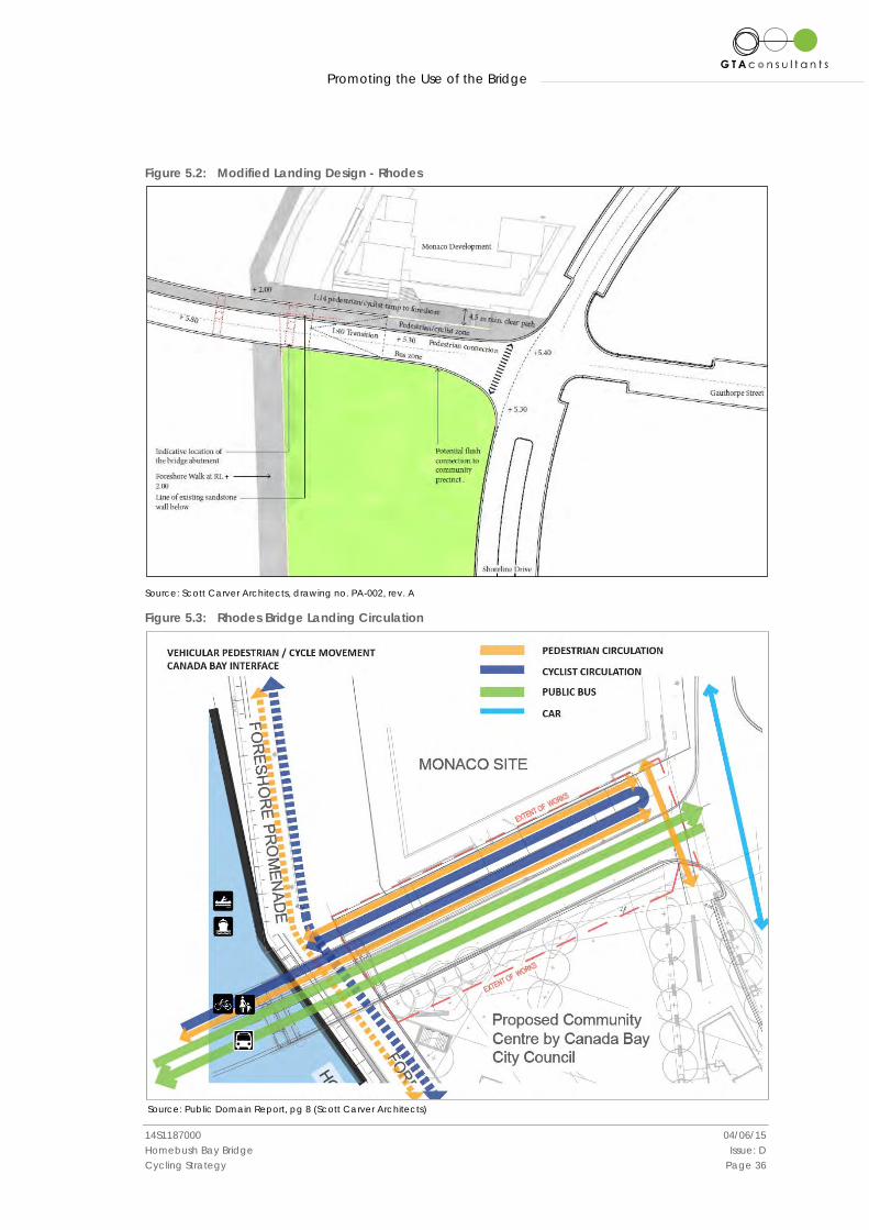
Figure 5.2: Modified Landing Design - Rhodes
Source: Scott Carver Architects, drawing no. PA-002, rev. A
Figure 5.3: Rhodes Bridge Landing Circulation
Source: Public Domain Report, pg 8 (Scott Carver Architects)
Promoting the Use of the Bridge
14S1187000 04/06/15 Homebush Bay Bridge Issue: D Cycling Strategy Page 37
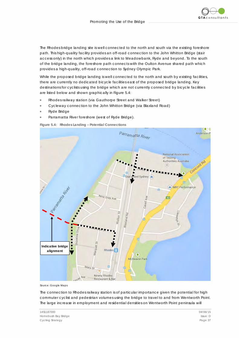
The Rhodes bridge landing site is well connected to the north and south via the existing foreshore path. This high-quality facility provides an off-road connection to the John Whitton Bridge (stair access only) in the north which provides a link to Meadowbank, Ryde and beyond. To the south of the bridge landing, the foreshore path connects with the Oulton Avenue shared path which provides a high-quality, off-road connection to Sydney Olympic Park.
While the proposed bridge landing is well connected to the north and south by existing facilities, there are currently no dedicated bicycle facilities east of the proposed bridge landing. Key destinations for cyclists using the bridge which are not currently connected by bicycle facilities are listed below and shown graphically in Figure 5.4:
• Rhodes railway station (via Gauthorpe Street and Walker Street) • Cycleway connection to the John Whitton Bridge (via Blaxland Road) • Ryde Bridge • Parramatta River foreshore (west of Ryde Bridge).
Figure 5.4: Rhodes Landing – Potential Connections
Source: Google Maps
The connection to Rhodes railway station is of particular importance given the potential for high commuter cyclist and pedestrian volumes using the bridge to travel to and from Wentworth Point. The large increase in employment and residential densities on Wentworth Point peninsula will
Indicative bridge alignment
Promoting the Use of the Bridge
14S1187000 04/06/15 Homebush Bay Bridge Issue: D Cycling Strategy Page 38
result in large amounts of bicycle traffic between the bridge and Rhodes railway station as well as to Rhodes shopping centre.
A high quality link between the bridge and Rhodes railway station is imperative to promoting the use of the bridge by commuter cyclists and encouraging multimodal trips, which are a critical part of an integrated transport network. The crossings of Shoreline Drive and Walker Street are key details to be addressed in providing a continuous pedestrian and cycle link between the bridge and the railway station. In addition to this, there is expected to be a high demand for secure bicycle parking at Rhodes railway station following the completion of the bridge.
Rhodes railway station will also be an important start and end point for recreational cyclists in the area. Sydney Olympic Park is currently a popular destination for cycling and the provision of the bridge across Homebush Bay, as well as the increase in employment and residential densities in Rhodes and Wentworth Point will result in a significant increase in bicycle patronage of Sydney Olympic Park.
Potential Treatments
Potential infrastructure treatments and cross-section of bicycle facilities to connect the Rhodes landing with the railway station via Gauthorpe Street and Walker Street are shown in Figure 5.5a/b. Figure 5.6 shows a potential crossing facility for Shoreline Drive and Walker Street. Alternative crossing facilities could include wide refuges. Traffic signals or roundabouts do not appear to be appropriate. The provision of such a link falls outside the agreed project boundary and is beyond the scope of the approved project. The Proponent is actively encouraging Canada Bay Council to provide such a link.

Promoting the Use of the Bridge
14S1187000 04/06/15 Homebush Bay Bridge Issue: D Cycling Strategy Page 39
Figure 5.5a: Potential facility and cross-section - Gauthorpe Street, Rhodes Figure 5.5b: Potential cross-section - Walker
Street, Rhodes*
Figure 5.6: Potential crossing facility
Source: NSW Bicycle Guidelines – Figure 4.4 and Figure 6.8 (RMS, 2003)
City of Canada Bay Bike Plan 2014 The City of Canada Bay is currently undertaking a strategic review of its 2005 Bike Plan. The new/ revised bike plan is anticipated to be released imminently. A core component of the new bike plan will be identifying routes to connect with the proposed bridge and in particular between the Rhodes landing and Rhodes railway station.
Promoting the Use of the Bridge
14S1187000 04/06/15 Homebush Bay Bridge Issue: D Cycling Strategy Page 40
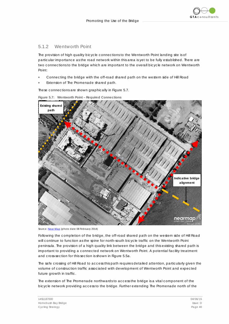
5.1.2 Wentworth Point
The provision of high quality bicycle connections to the Wentworth Point landing site is of particular importance as the road network within this area is yet to be fully established. There are two connections to the bridge which are important to the overall bicycle network on Wentworth Point:
• Connecting the bridge with the off-road shared path on the western side of Hill Road • Extension of The Promenade shared path.
These connections are shown graphically in Figure 5.7.
Figure 5.7: Wentworth Point – Required Connections
Source: Near Map (photo date 08 February 2014)
Following the completion of the bridge, the off-road shared path on the western side of Hill Road will continue to function as the spine for north-south bicycle traffic on the Wentworth Point peninsula. The provision of a high quality link between the bridge and this existing shared path is important to providing a connected network on Wentworth Point. A potential facility treatment and cross-section for this section is shown in Figure 5.5a.
The safe crossing of Hill Road to access this path requires detailed attention, particularly given the volume of construction traffic associated with development of Wentworth Point and expected future growth in traffic.
The extension of The Promenade northwards to access the bridge is a vital component of the bicycle network providing access to the bridge. Further extending The Promenade north of the
Indicative bridge alignment
Existing shared path
Promoting the Use of the Bridge
14S1187000 04/06/15 Homebush Bay Bridge Issue: D Cycling Strategy Page 41
bridge to the Wentworth Point UAP and Sydney Olympic Park ferry wharf would assist in promoting the use of the bridge by directly linking key destinations for cyclists and pedestrians.
The connection between The Promenade and Footbridge Boulevard is yet to be established. As there will be a significant vertical clearance between the bridge approach and ground level, the provision of a safe, high-quality access for cyclists requires specific attention. It is noted that the bridge would be operational prior to the completion of the Wentworth Point development and is under contract for completion in March 2016, linking Hill Road in Wentworth Point to Shoreline Drive in Rhodes.
The provision of the above linkages falls outside the agreed project boundary and is beyond the scope of the approved project. The Proponent is actively encouraging the adjacent landholders, Sydney Olympic Park Authority and Auburn Council to provide these links. The timeframes for the provision of the links is not known at the time of writing this report.
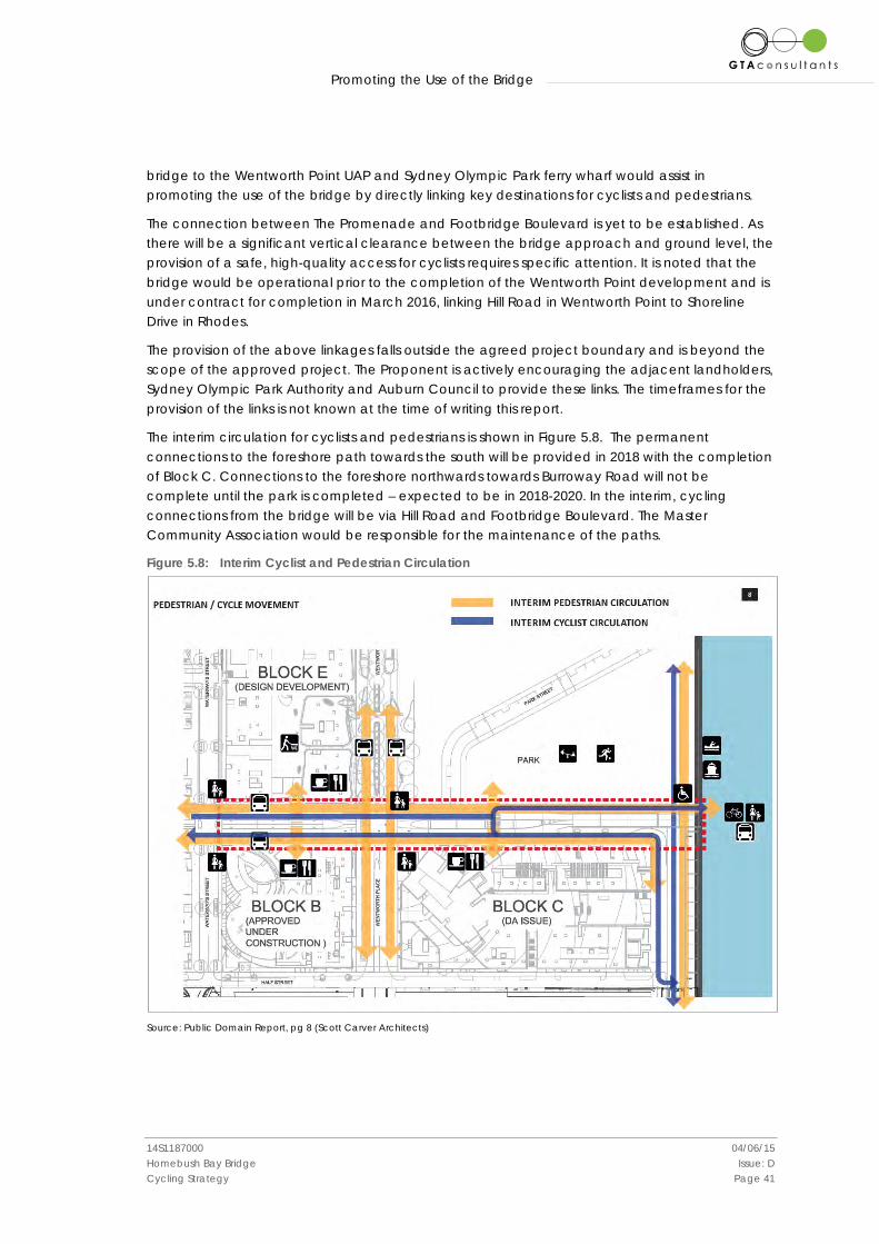
The interim circulation for cyclists and pedestrians is shown in Figure 5.8. The permanent connections to the foreshore path towards the south will be provided in 2018 with the completion of Block C. Connections to the foreshore northwards towards Burroway Road will not be complete until the park is completed – expected to be in 2018-2020. In the interim, cycling connections from the bridge will be via Hill Road and Footbridge Boulevard. The Master Community Association would be responsible for the maintenance of the paths.
Figure 5.8: Interim Cyclist and Pedestrian Circulation
Source: Public Domain Report, pg 8 (Scott Carver Architects)
Promoting the Use of the Bridge
14S1187000 04/06/15 Homebush Bay Bridge Issue: D Cycling Strategy Page 42
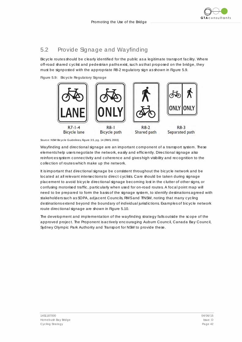
5.2 Provide Signage and Wayfinding Bicycle routes should be clearly identified for the public as a legitimate transport facility. Where off-road shared cyclist and pedestrian paths exist, such as that proposed on the bridge, they must be signposted with the appropriate R8-2 regulatory sign as shown in Figure 5.9.
Figure 5.9: Bicycle Regulatory Signage
Source: NSW Bicycle Guidelines, Figure 3.5, pg. 14 (RMS, 2003)
Wayfinding and directional signage are an important component of a transport system. These elements help users negotiate the network, easily and efficiently. Directional signage also reinforces system connectivity and coherence and gives high visibility and recognition to the collection of routes which make up the network.
It is important that directional signage be consistent throughout the bicycle network and be located at all relevant intersections to direct cyclists. Care should be taken during signage placement to avoid bicycle directional signage becoming lost in the clutter of other signs, or confusing motorised traffic, particularly when used for on-road routes. A focal point map will need to be prepared to form the basis of the signage system, to identify destinations agreed with stakeholders such as SOPA, adjacent Councils, RMS and TfNSW, noting that many cycling destinations extend beyond the boundary of individual jurisdictions. Examples of bicycle network route directional signage are shown in Figure 5.10.
The development and implementation of the wayfinding strategy falls outside the scope of the approved project. The Proponent is actively encouraging Auburn Council, Canada Bay Council, Sydney Olympic Park Authority and Transport for NSW to provide these.

Promoting the Use of the Bridge
14S1187000 04/06/15 Homebush Bay Bridge Issue: D Cycling Strategy Page 43
Figure 5.10: Bicycle Network Route Directional Signage
Source: NSW Bicycle Guidelines, Figure 94, pg. 73, (RMS, 2003)
Promoting the Use of the Bridge
14S1187000 04/06/15 Homebush Bay Bridge Issue: D Cycling Strategy Page 44
5.3 Manage Conflict with Pedestrians Shared paths are used widely across Australia. In five of Australia’s eight states and territories, cyclists are allowed to use any footpath. In New South Wales cyclists are not permitted to ride on the footpath. Shared paths are suitable facilities where the path width and volume of pedestrians and cyclists are appropriate to permit cyclists and pedestrians travelling in the same direction to safely pass one another. Pedestrians have right of way on shared paths at all times.
The probability of conflict between users on shared paths increases with high volumes of pedestrians and cyclists and where the path is narrow. At high volumes the conflicts are pervasive and require alternate measures such as widening and separation and use of the bus lanes.
Widening and separation is happening for example along the Bay Run at Iron Cove Bay, Alison Road at Randwick and, in design at Anzac Parade at Maroubra. Clearly this is no longer possible on the Homebush Bay Bridge, construction having commenced. Hence the recommendation for use of the bus lanes, omission of the barrier kerb and related measures.
Condition F1 of the Project Approval restricts cyclists to the shared path and signage will be erected to this effect. However, it is anticipated that experienced commuter cyclists travelling across the bridge may choose to ride in the bus lanes rather than the shared pedestrian and bicycle path even though prohibited. The use of the bus lanes would offer travel time savings for cyclists in comparison with the adjacent shared path and has the potential to mitigate conflict between cyclists and pedestrians. However, it is acknowledged that in order for cyclists to use the bus lanes, the Project Approval would need to be modified. Should a modification be requested and approved, the use of the bus lanes could be formalised by:
• the use of PS-2 bicycle log road markings along the bus lanes; • a slow speed limit in the bus lane (e.g. 30km/h such as used along the Druitt Street bus
lanes in the Sydney CBD); and • removal of the 1.2 metre high barrier between the bus lane and the shared path so that
cyclists can interchange between the two facilities in response to prevailing traffic patterns (e.g. busy path or busy bus lane).
It is further acknowledged that the NSW Road Rules 2008 further exclude cyclists from “Bus Only Lanes”. However, the Druitt Street example is a case in point.
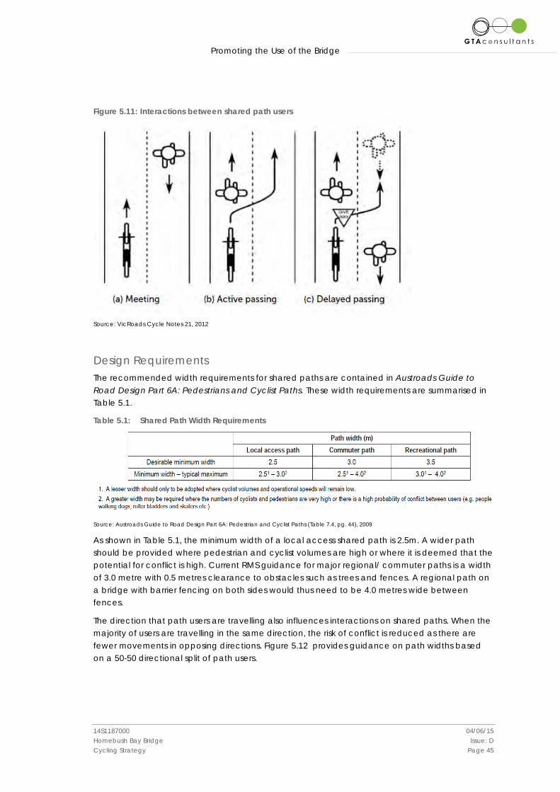
Passings and Meetings Understanding the movement of path users is important in designing and designating paths for shared use. When pedestrians and cyclists use a shared path they will meet other users travelling in the other direction or pass slower pedestrians and cyclists travelling in the same direction. Delayed passings occur when faster cyclists must slow down to pass other users travelling in the same direction. Figure 5.11 shows the interaction and passing movements of shared path users.
Promoting the Use of the Bridge
14S1187000 04/06/15 Homebush Bay Bridge Issue: D Cycling Strategy Page 45
Figure 5.11: Interactions between shared path users
Source: VicRoads Cycle Notes 21, 2012
Design Requirements The recommended width requirements for shared paths are contained in Austroads Guide to Road Design Part 6A: Pedestrians and Cyclist Paths. These width requirements are summarised in Table 5.1.
Table 5.1: Shared Path Width Requirements
Source: Austroads Guide to Road Design Part 6A: Pedestrian and Cyclist Paths (Table 7.4, pg. 44), 2009
As shown in Table 5.1, the minimum width of a local access shared path is 2.5m. A wider path should be provided where pedestrian and cyclist volumes are high or where it is deemed that the potential for conflict is high. Current RMS guidance for major regional/ commuter paths is a width of 3.0 metre with 0.5 metres clearance to obstacles such as trees and fences. A regional path on a bridge with barrier fencing on both sides would thus need to be 4.0 metres wide between fences.
The direction that path users are travelling also influences interactions on shared paths. When the majority of users are travelling in the same direction, the risk of conflict is reduced as there are fewer movements in opposing directions. Figure 5.12 provides guidance on path widths based on a 50-50 directional split of path users.
Promoting the Use of the Bridge
14S1187000 04/06/15 Homebush Bay Bridge Issue: D Cycling Strategy Page 46
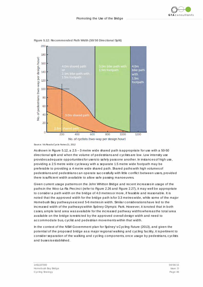
Figure 5.12: Recommended Path Width (50/50 Directional Split)
Source: VicRoads Cycle Notes 21, 2012
As shown in Figure 5.12, a 2.5 – 3 metre wide shared path is appropriate for use with a 50-50 directional split and when the volume of pedestrians and cyclists are low. Low intensity use provides adequate opportunities for users to safely pass one another. In instances of high use, providing a 2.5 metre wide cycleway with a separate 1.5 metre wide footpath may be preferable to providing a 4 metre wide shared path. Shared paths with high volumes of pedestrians and pedestrians can operate successfully with little conflict between users, provided there is sufficient width available to allow safe passing manoeuvres.
Given current usage patterns on the John Whitton Bridge and recent increases in usage of the paths in the Woo-La-Ra Precinct (refer to Figure 2.26 and Figure 2.27), it may well be appropriate to consider a path width on the bridge of 4.0 metres or more, if feasible and reasonable. It is noted that the approved width for the bridge path is for 3.3 metres wide, while some of the major Homebush Bay pathways exceed 5-6 metres in width. Similar considerations have led to the increased width of the pathways within Sydney Olympic Park. However, it is noted that in both cases, ample land area was available for the increased pathway widths whereas the total area available on the bridge is restricted by the approved overall design width and need to accommodate bus, cyclist and pedestrian movements within that width.
In the context of the NSW Government plan for Sydney’s Cycling Future (2013), and given the potential of the proposed bridge as a major regional walking and cycling facility, it is pertinent to consider separation of the walking and cycling components, once usage by pedestrians, cyclists and buses is established.
Promoting the Use of the Bridge
14S1187000 04/06/15 Homebush Bay Bridge Issue: D Cycling Strategy Page 47
Shared Path Education and Awareness Educating people on safely using shared paths helps to create a safer environment for all path users. Education and awareness campaigns are an important component of conflict minimisation in shared path environments. These campaigns should focus on promoting the safe and courteous use of shared paths and include the following key messages for each user type:
For Cyclists • Give Way - Always give way to pedestrians, they have right of way at all times. • Ring Your Bell - Ring your bell early to alert walkers of your presence. • Slow Down - Slow down and be courteous to pedestrians, smile! • Watch Out - Pets and children can be unpredictable, always take extra care on shared
paths when they are present. For Pedestrians • Be Aware - Be aware of other users and try not to listen to your iPod in shared path
environments as it might stop you from hearing a bike bell. • Listen for the Bell - If you hear a bike bell on a shared path, move to the left hand side in
a safe manner and allow the bike rider to pass. • Be Predictable - Keep to the left on shared paths and walk in a predictable manner. • Be Considerate - Keep pets under control and ensure children are supervised on shared
paths.
Some of these messages are already in use on the pathways around Homebush Bay and the Proponent will install similar signs and markings on the bridge and its approaches. The messages should also be included on any public cycleway maps (refer Section 5.4 below).
5.4 Public Cycleway Maps Printed, displayed and electronic maps are an integral part of promoting the proposed Homebush Bay Bridge as a public facility for walking and cycling. The maps would need to identify the entire network of pathways, walkways and roadways, on-road and off-road facilities, end-of-trip facilities, etc. in accordance with standard industry practice. The map would need to include links to cyclable destinations such as Sydney Olympic Park, Rhodes railway station and other public transport stops, wharves, the CBDs of Ryde, Parramatta and Sydney etc. The maps need to be reviewed at regular intervals to reflect changes in the network, facilities and destinations.
Suitable maps are already available from various agencies such as Sydney Olympic Park Authority, Transport for NSW, Auburn Council and Canada Bay Council. The Proponent is actively encouraging these agencies to update the maps to include the bridge and its approaches prior to their completion, along with any “share the path” and other safety and behavioural messages.
5.5 End-of-Trip Facilities In accordance with the National Cycling Strategy and the appropriate State and Local Government planning and policy instruments, the provision of trip-end facilities is a key component of accommodating and increasing the uptake of walking and cycling as a mode of transport and for recreation. Facilities include:
Promoting the Use of the Bridge
14S1187000 04/06/15 Homebush Bay Bridge Issue: D Cycling Strategy Page 48
• Safe and convenient long term parking at key destinations such as residential buildings, public transport stops, wharves and stations, places of employment etc.
• Showers, lockers and supporting facilities at places of employment. • Safe and convenient short term parking at key destinations. • Drinking water, seating, weather protection at selected “mid-trip” locations.
The quantity and quality of these facilities would need to be provided in accordance with the appropriate planning instruments and best practice guidance.
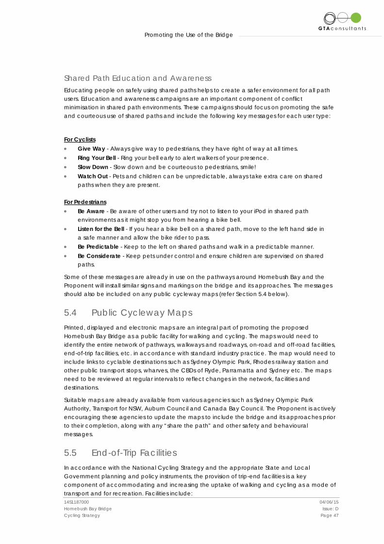
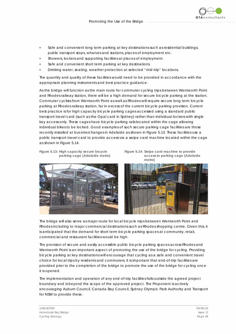
As the bridge will function as the main route for commuter cycling trips between Wentworth Point and Rhodes railway station, there will be a high demand for secure bicycle parking at the station. Commuter cyclists from Wentworth Point as well as Rhodes will require secure long term bicycle parking at Rhodes railway station, far in excess of the current bicycle parking provision. Current best practice is for high capacity bicycle parking cages accessed using a standard public transport travel card (such as the Opal card in Sydney) rather than individual lockers with single key access only. These cages have bicycle parking rails located within the cage allowing individual bikes to be locked. Good examples of such secure parking cage facilities are those recently installed at bus interchanges in Adelaide as shown in Figure 5.13. These facilities use a public transport travel card to provide access via a swipe card machine located within the cage as shown in Figure 5.14.
Figure 5.13: High capacity secure bicycle parking cage (Adelaide metro)
Figure 5.14: Swipe card machine to provide
access to parking cage (Adelaide metro)
The bridge will also serve as major route for local bicycle trips between Wentworth Point and Rhodes including to major commercial destinations such as Rhodes shopping centre. Given this, it is anticipated that the demand for short term bicycle parking spaces at community, retail, commercial and restaurant facilities would be high.
The provision of secure and easily accessible public bicycle parking spaces across Rhodes and Wentworth Point is an important aspect of promoting the use of the bridge for cycling. Providing bicycle parking at key destinations will encourage that cycling as a safe and convenient travel choice for local trips by residents and commuters. It is important that end-of-trip facilities are provided prior to the completion of the bridge to promote the use of the bridge for cycling once it is opened.
The implementation and operation of any end-of-trip facilities falls outside the agreed project boundary and is beyond the scope of the approved project. The Proponent is actively encouraging Auburn Council, Canada Bay Council, Sydney Olympic Park Authority and Transport for NSW to provide these.
Promoting the Use of the Bridge
14S1187000 04/06/15 Homebush Bay Bridge Issue: D Cycling Strategy Page 49
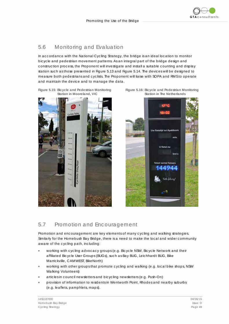
5.6 Monitoring and Evaluation In accordance with the National Cycling Strategy, the bridge is an ideal location to monitor bicycle and pedestrian movement patterns. As an integral part of the bridge design and construction process, the Proponent will investigate and install a suitable counting and display station such as those presented in Figure 5.13 and Figure 5.14. The devices will be designed to measure both pedestrians and cyclists. The Proponent will liaise with SOPA and RMS to operate and maintain the device and to manage the data.
Figure 5.15: Bicycle and Pedestrian Monitoring Station in Mooreland, VIC
Figure 5.16: Bicycle and Pedestrian Monitoring Station in The Netherlands
5.7 Promotion and Encouragement Promotion and encouragement are key elements of many cycling and walking strategies. Similarly for the Homebush Bay Bridge, there is a need to make the local and wider community aware of the cycling path, including:
• working with cycling advocacy groups (e.g. Bicycle NSW, Bicycle Network and their affiliated Bicycle User Groups (BUGs), such as Bay BUG, Leichhardt BUG, Bike Marrickville, CAMWEST, BikeNorth)
• working with other groups that promote cycling and walking (e.g. local bike shops, NSW Walking Volunteers)
• articles in council newsletters and bicycling newsletters (e.g. Push-On) • provision of information to residents in Wentworth Point, Rhodes and nearby suburbs
(e.g. leaflets, pamphlets, maps).

Consultation
14S1187000 04/06/15 Homebush Bay Bridge Issue: D Cycling Strategy Page 50
6. Consultation In accordance with condition C9 of the Project Approval, this strategy has been prepared in consultation with Auburn City Council, City of Canada Bay Council, SOPA, RMS and Transport for NSW. The consultation process sought feedback during both the early project stages and on completion of the final draft report.
Feedback was provided by the councils. Many of the issues raised focused on works outside the scope of the approved project (e.g. on and off-road connections within the adjoining suburban streets and provision of cycle parking at train stations). It is acknowledged that such facilities are important and the Proponent is actively encouraging State and local government authorities to provide these.

www.gta.com.au
Melbourne A Level 25, 55 Collins Street PO Box 24055 MELBOURNE VIC 3000 P +613 9851 9600 F +613 9851 9610 E [email protected]
Canberra A Unit 4, Level 1, Sparta Building, 55 Woolley Street PO Box 62 DICKSON ACT 2602 P +612 6243 4826 F +612 6243 4848 E [email protected]
Townsville A Level 1, 25 Sturt Street PO Box 1064 TOWNSVILLE QLD 4810 P +617 4722 2765 F +617 4722 2761 E [email protected]
Sydney A Level 6, 15 Help Street CHATSWOOD NSW 2067 PO Box 5254 WEST CHATSWOOD NSW 1515 P +612 8448 1800 F +612 8448 1810 E [email protected]
Adelaide A Suite 4, Level 1, 136 The Parade PO Box 3421 NORWOOD SA 5067 P +618 8334 3600 F +618 8334 3610 E [email protected]
Brisbane A Level 4, 283 Elizabeth Street BRISBANE QLD 4000 GPO Box 115 BRISBANE QLD 4001 P +617 3113 5000 F +617 3113 5010 E [email protected]
Gold Coast A Level 9, Corporate Centre 2 Box 37 1 Corporate Court BUNDALL QLD 4217 P +617 5510 4800 F +617 5510 4814 E [email protected]