HolocenehistoryoftheGreatKobukSandDunes, NorthwesternAlaska ·...
23
Quaternary Science Reviews 21 (2002) 709–731 Holocene history of the Great Kobuk Sand Dunes, Northwestern Alaska D.H. Mann a, *, P.A. Heiser b , B.P. Finney c a Institute of Arctic Biology, Irving I Building, University of Alaska, Fairbanks, AK 99775, USA b Department of Geology, 316 Clippinger Laboratories, Ohio University, Athens, OH 45701, USA c Institute of Marine Science, Irving II Building, University of Alaska, Fairbanks, AK 99775, USA Abstract Located just north of the Arctic Circle, the Great Kobuk Sand Dunes (GKSD) are an inland dune field that is closely surrounded by boreal forest. The history of the GKSD tells us about changes in aridity, a climatic parameter whose history is poorly under- stood at high latitudes. Vegetated dunes in several states of geomorphic preservation surround the active dune field today, evidencing a complex history of Holocene activity. Small lakes in the forest bordering the dunes accumulate wind-blown sand. We use 14 C-dated, lake-sediment cores to reconstruct a continuous history of sand influx over the last 8000 yr. The validity of this record is supported by limiting ages obtained from stratigraphic sections within the dune field. The extent of the GKSD underwent a fluctuating shrinkage coincident with Neoglaciation. This downsizing trend was interrupted by periods of increased sand deposition into lakes occurring 4800–4200, 3300–2600, 1300–700, and 300–100 calendar years ago. Aridity in the Kobuk valley during the Holocene probably was controlled by the frequency of North Pacific storms entering the region in late summer. Our results describe the first continuous history of changing moisture balance for central Beringia during the Holocene and comprise a baseline against which future records of climatic and ecological change in this region can be compared. r 2002 Elsevier Science Ltd. All rights reserved. 1. Introduction During the last glacial period, sand sheets and dunes covered >30,000 km 2 in northern Alaska (Carter, 1981; Hopkins, 1982; Lea and Waythomas, 1990). Today, aeolian processes are of minor importance in the taiga and tundra landscapes of this region. Only two large, active dune fields survive in areas distant from the coast: the Great Kobuk Sand Dunes (GKSD) in the central Kobuk valley and the Nogahabara Dunes (Koster et al., 1984) in the lower Koyukuk valley (Fig. 1). Here, we describe changes in the extent and activity of the GKSD during the mid- and late Holocene. The Holocene dynamics of the Great Kobuk Sand Dunes are of interest for several reasons. This dune field’s history and future are important for the conservation of rare plant species that are native to these dunes (Young and Racine, 1977). Also, the GKSD are part of the subsistence landscape utilized by the Inupiat people of the Kobuk valley, and the dune field’s history is potentially important for archaeological record (Anderson, 1988a). Finally, remnant dune fields existing as islands within a sea of boreal forest vegetation are likely to be poised at climatic thresholds and hence be sensitive indicators of climatic change. Our objectives here are to reconstruct the Holocene history of the GKSD and to infer its climatic causes. This study relies on three complimentary sources of data: stratigraphic sections exposed in stream cuts and soil pits, the ages of trees buried by dunes, and sediment cores from dune-marginal lakes. We began this project by studying outcrops exposed in stream cuts and soil pits and by 14 C-dating trees exhumed in interdune swales. However, sand dunes leave only discontinuous stratigraphic records within the boundaries of dune fields. It became obvious that we needed a more complete proxy record of dune-field activity, which we found in the continuously deposited sediments of a dune-marginal lake. But was the influx of sand into a single lake representative of the activity of the entire dune field? To answer this question, we use the terrestrial stratigraphy to test the validity of the lake-core record. Once validated, the lacustrine *Corresponding author. Tel.: 1-907-455-6249. E-mail address: [email protected] (D.H. Mann). 0277-3791/02/$ - see front matter r 2002 Elsevier Science Ltd. All rights reserved. PII:S0277-3791(01)00120-2
Transcript of HolocenehistoryoftheGreatKobukSandDunes, NorthwesternAlaska ·...
Quaternary Science Reviews 21 (2002) 709–731
Holocene history of the Great Kobuk Sand Dunes,Northwestern Alaska
D.H. Manna,*, P.A. Heiserb, B.P. Finneyc
a Institute of Arctic Biology, Irving I Building, University of Alaska, Fairbanks, AK 99775, USAbDepartment of Geology, 316 Clippinger Laboratories, Ohio University, Athens, OH 45701, USAc Institute of Marine Science, Irving II Building, University of Alaska, Fairbanks, AK 99775, USA
Abstract
Located just north of the Arctic Circle, the Great Kobuk Sand Dunes (GKSD) are an inland dune field that is closely surroundedby boreal forest. The history of the GKSD tells us about changes in aridity, a climatic parameter whose history is poorly under-stood at high latitudes. Vegetated dunes in several states of geomorphic preservation surround the active dune field today,
evidencing a complex history of Holocene activity. Small lakes in the forest bordering the dunes accumulate wind-blown sand. Weuse 14C-dated, lake-sediment cores to reconstruct a continuous history of sand influx over the last 8000 yr. The validity of this recordis supported by limiting ages obtained from stratigraphic sections within the dune field. The extent of the GKSD underwent a
fluctuating shrinkage coincident with Neoglaciation. This downsizing trend was interrupted by periods of increased sand depositioninto lakes occurring 4800–4200, 3300–2600, 1300–700, and 300–100 calendar years ago. Aridity in the Kobuk valley during theHolocene probably was controlled by the frequency of North Pacific storms entering the region in late summer. Our results describe
the first continuous history of changing moisture balance for central Beringia during the Holocene and comprise a baseline againstwhich future records of climatic and ecological change in this region can be compared. r 2002 Elsevier Science Ltd. All rightsreserved.
1. Introduction
During the last glacial period, sand sheets and dunescovered >30,000 km2 in northern Alaska (Carter, 1981;Hopkins, 1982; Lea and Waythomas, 1990). Today,aeolian processes are of minor importance in the taigaand tundra landscapes of this region. Only two large,active dune fields survive in areas distant from the coast:the Great Kobuk Sand Dunes (GKSD) in the centralKobuk valley and the Nogahabara Dunes (Koster et al.,1984) in the lower Koyukuk valley (Fig. 1). Here, wedescribe changes in the extent and activity of the GKSDduring the mid- and late Holocene.The Holocene dynamics of the Great Kobuk Sand
Dunes are of interest for several reasons. This dunefield’s history and future are important for theconservation of rare plant species that are native tothese dunes (Young and Racine, 1977). Also, the GKSDare part of the subsistence landscape utilized by theInupiat people of the Kobuk valley, and the dune field’s
history is potentially important for archaeologicalrecord (Anderson, 1988a). Finally, remnant dune fieldsexisting as islands within a sea of boreal forestvegetation are likely to be poised at climatic thresholdsand hence be sensitive indicators of climatic change. Ourobjectives here are to reconstruct the Holocene historyof the GKSD and to infer its climatic causes.This study relies on three complimentary sources of
data: stratigraphic sections exposed in stream cuts andsoil pits, the ages of trees buried by dunes, and sedimentcores from dune-marginal lakes. We began this projectby studying outcrops exposed in stream cuts and soilpits and by 14C-dating trees exhumed in interduneswales. However, sand dunes leave only discontinuousstratigraphic records within the boundaries of dunefields. It became obvious that we needed a morecomplete proxy record of dune-field activity, which wefound in the continuously deposited sediments of adune-marginal lake. But was the influx of sand into asingle lake representative of the activity of theentire dune field? To answer this question, we usethe terrestrial stratigraphy to test the validityof the lake-core record. Once validated, the lacustrine
*Corresponding author. Tel.: 1-907-455-6249.
E-mail address: [email protected] (D.H. Mann).
0277-3791/02/$ - see front matter r 2002 Elsevier Science Ltd. All rights reserved.
PII: S 0 2 7 7 - 3 7 9 1 ( 0 1 ) 0 0 1 2 0 - 2
record provides a closely dated proxy for dune-fieldactivity.
2. Previous studies
The morphology and sedimentology of the GKSDhave been studied extensively as analogs for prehistoric,cold-climate aeolian systems (Dijkmans et al., 1986,1988; Koster and Dijkmans, 1988; Dijkmans andKoster, 1990), but no previous studies address theHolocene history of this dune field. Mapping of surficialgeology revealed that the Kobuk dunes were previouslymuch more extensive (Fernald, 1964; Hamilton, 1984;Kuhry-Helmens et al., 1985). Vegetated dune forms inseveral different states of geomorphic modification(fresh, sharp-crested dunes versus smooth, low-relieffeatures) surround the active dune field and suggest thatmajor fluctuations in aeolian activity occurred duringthe Holocene.A long history of aeolian activity in the Kobuk valley is
recorded by interbedded fluvial sediments, terrestrialpeats, and aeolian sediments exposed in a spectacularcutbank section at Epiguruk, 25km northeast of theGKSD (Fig. 2) (Ashley and Hamilton, 1993). Pleistoceneglaciation of the Brooks Range was accompanied byalluviation and aeolian activity in the Kobuk valley.During the last glacial maximum, 24,000–19,000 14CyrBP, the greatly expanded Kobuk dunes filled the middle
reaches of the Kobuk valley (Hamilton et al., 1987). TheKobuk River was overloaded with sandy sediment andalluviated some 13m above its present level at Epiguruk(Hamilton and Ashley, 1993). Downcutting by the riverand shrinkage of the dune field occurred after 18,50014C yr BP. By 8600 14Cyr BP, the river had established afloodplain near its modern level. Peat deposition startedat Epiguruk ca. 3600 14Cyr BP (Hamilton and Ashley,1993), implying a significant increase in effective moisture(precipitation–evapotranspiration).Palynological research in northwest Alaska by An-
derson (1985,1988b) documented several changes invegetation during the Holocene that probably resultedfrom climatic shifts. Following tundra during the lastglacial period, alder (Alnus) arrived in the area ca. 900014C yr BP in response to the advent of a warmer andmore moist climate. Spruce (Picea), probably mostlyblack spruce (P. mariana), arrived in the Kobuk valley5000–6000 14C yr BP, perhaps in response to a furtherincrease in moisture. The present forest–tundra vegeta-tion mosaic likely dates to that time. Pollen records fromarctic vegetation are notoriously insensitive to climatechange (Anderson et al., 1994), and numerous climaticfluctuations may be unrecorded by the existing pollenrecords.Glacier fluctuations in the Brooks Range (Ellis and
Calkin, 1984; Calkin, 1988) and on the SewardPeninsula (Calkin et al., 1998), together with intermit-tent construction of beach ridges in the Chukchi Sea(Mason and Jordan, 1993; Mason et al., 1995),document repeated climatic fluctuations during the lateHolocene in northwestern Alaska. Interpretation of thebeach-ridge record in terms of paleoclimate is difficultbecause of the complexity of stratigraphic and climaticarguments. The glacial record, based mainly on liche-nometry, suggests advances ca. 4500, 3500, 2800, andperhaps 2000 14C yr BP (Ellis and Calkin, 1984). A seriesof closely spaced glacier advances began ca. AD 800 andcontinued into the 19th century. The relative shortness(B400 yr) of tree-ring records from northern Alaska(D’Arrigo and Jacoby, 1995; Jacoby et al., 1999) andtheir interpretation in terms of temperature historymake comparisons with the GKSD record difficult.These other proxy records of climatic change, althoughstill fragmentary, indicate considerable climate varia-bility during the Holocene in northwestern Alaska.
3. Study area
3.1. Geography and landforms
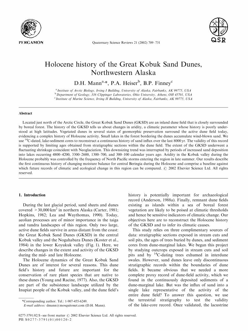
An area of 650 km2 in the middle reaches of theKobuk valley is underlain by sand that was affectedepisodically by aeolian activity over the last 104 yr(Fernald, 1964; Hamilton, 1984; Hamilton et al., 1987).
300 km
Kobuk River
Yukon River
FairbanksKotzebue
Anchorage
B r o o k s R a n g e Chukchi Sea Arctic
Circle
Ikpikpuk Dunes
Koyuku
k Rive
r
Ala
ska R
ange
Bering Sea
Beaufort Sea
Gulf of Alaska
SewardPeninsula
66°N
155°W
NSD
GKSD
Fig. 1. Alaska with locations of sites mentioned in text along with
other key physiographic features. The only other, large active dune
field in interior Alaska is the Nogahabara (NSD). The IKpikpuk dune
field is presently active.
D.H. Mann et al. / Quaternary Science Reviews 21 (2002) 709–731710
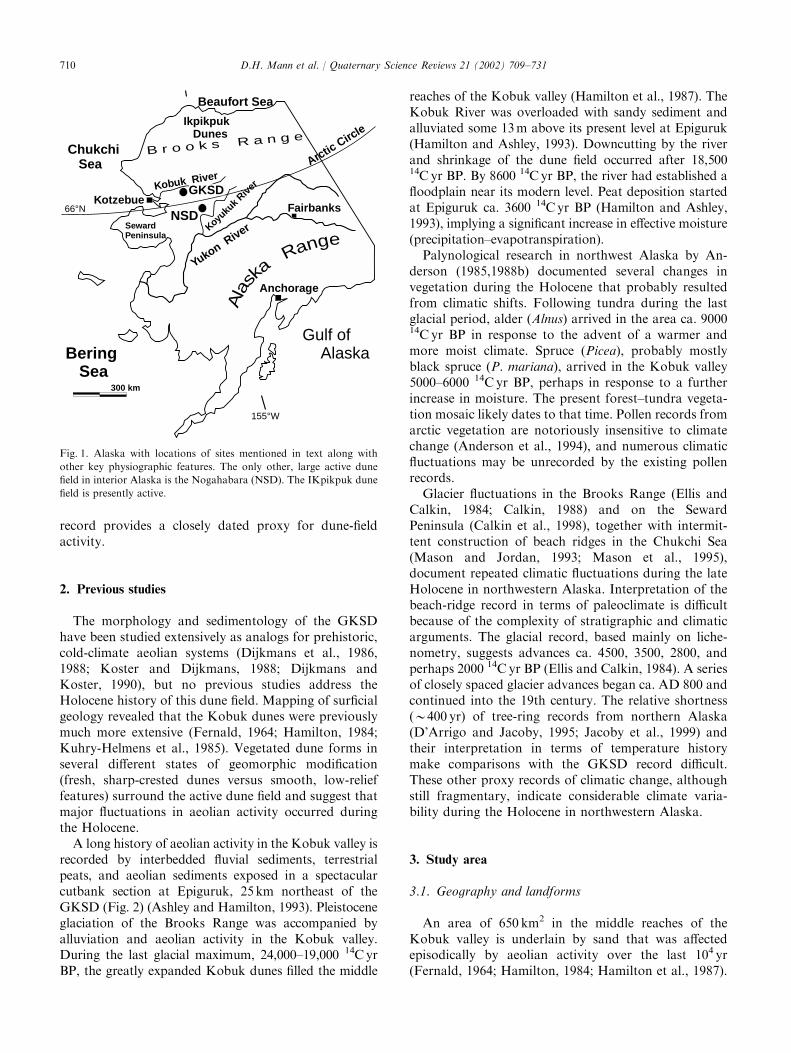
Today, only three areas of active dunes and sand sheetsexist within this Pleistocene sand fill (Fig. 2). Activedunes occur for several kilometers along the KobukRiver near the mouth of Hunt River (Hamilton et al.,1987). The Little Kobuk Dunes (8 km2) are an elongatepatch of blowouts and parabolic dunes with barchanoiddunes at their western extremity (Kuhry-Helmens et al.,1985). The Great Kobuk Dunes (62 km2) are the largestactive dune fields in the area and contain a diverseassemblage of aeolian landforms including parabolic,transverse, longitudinal, and barchanoid dunes, alongwith sand sheets, nabkhas, blowouts, and precipitationridges (Koster and Dijkmans, 1988; Dijkmans andKoster, 1990). Precipitation ridges, or randwallen, devel-op where forests bordering active dunes cause windspeed to drop. Sand is deposited along a linear crestabove a slipface that advances into the adjacent forest(Cooper, 1967; Raup and Argus, 1982). Precipitationridges from much of the perimeter of the GKSD today.The GKSD lie in a 20 km long, topographic
amphitheater facing NNE, which is formed by flankingridges of the low (200–600m) Waring Mountains(Fig. 2). The southwestern margin of the GKSD hasclimbed onto the lower slopes of this topographicbarrier to altitudes of 160m, though most of the activedune field lies at altitudes of 60–80m above sea level.Three streams drain the northern slopes of the WaringMountains and interact with the GKSD. Their alluvialhistories provide proxy records for dune-field activity.
When the dunes are active, blowing sand overwhelmsthe sediment-transporting capacities of these streams.Stream courses are diverted upslope by advancingdunes, and floodplains aggrade. When the dunes areless active, streams downcut rapidly through the sandyvalley fills. The active dune field presently divertsNiaktuvik and Kavet Creeks to the dune-field margin(Fig. 3). In their upper reaches, both these streamsprobably lose part of their flow to infiltration into theadjacent dune field. Ahnewetut Creek maintains itscourse across the GKSD despite large quantities of sandblown in and across it during winter.
3.2. Dune dynamics and sand characteristics
Net sand drift in the GKSD, as indicated by duneorientations, is primarily to the west and northwest,though summer winds cause minor eastward drift. Theultimate source for the sand composing the GKSD isquartzose bedrock in the Brooks Range that was erodedand transported by glaciers and outwash streams intothe Kobuk valley during Pleistocene glaciations (Ha-milton, 1984). Today, there is no sand source for theGKSD other than the underlying, older sandy sedi-ments. At present, the GKSD are separated from thesandy floodplain of the Kobuk River by 3–20 km ofdense vegetation.Despite being cut off from fluvial sources of sand
today, the limiting factor in the GKSD seems to be
Fig. 2. False color satellite image of the Kobuk valley showing areas of active and inactive sand dunes. Landsat Thematic Mapper mosaic from path
78, row 13 acquired on 6 July, 1985. Image courtesy of US National Park Service, Alaska Support Office, GIS Landcover Mapping Program,
Anchorage, AK.
D.H. Mann et al. / Quaternary Science Reviews 21 (2002) 709–731 711
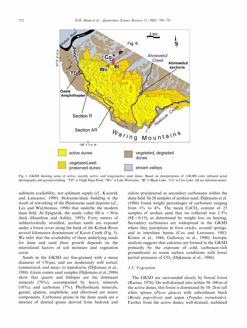
sediment availability, not sediment supply (cf., Kocurekand Lancaster, 1999). Holocene-dune building is theresult of reworking of the Pleistocene sand deposits (cf.,Lea and Waythomas, 1990) that underlie the moderndune field. At Epiguruk, the sandy valley fill is >30mthick (Hamilton and Ashley, 1993). Forty meters ofsubhorizontally stratified, aeolian sands are exposedunder a forest cover along the bank of the Kobuk Riverseveral kilometers downstream of Kavet Creek (Fig. 3).We infer that the availability of these underlying sandsfor dune and sand sheet growth depends on theinterrelated factors of soil moisture and vegetationcover.Sands in the GKSD are fine-grained with a mean
diameter of 170 mm, and are moderately well sorted,symmetrical, and meso- to leptokurtic (Dijkmans et al.,1988). Grain counts sand samples (Dijkmans et al.,1986)show that quartz and feldspar are the dominantminerals (78%), accompanied by heavy minerals(10%), and carbonate (7%). Phyllosilicate minerals,garnet, epidote, amphibole, and chloritoid are minorcomponents. Carbonate grains in the dune sands are amixture of detrital grains derived from bedrock and
calcite precipitated as secondary carbonates within thedune field. In 20 samples of aeolian sand, Dijkmans et al.(1986) found weight percentages of carbonate rangingfrom 1% to 4%. The mean CaCO3 content of 25samples of aeolian sand that we collected was 1.5%(SE=0.15), as determined by weight loss on heating.Secondary carbonates are widespread in the GKSDwhere they precipitate in frost cracks, around springs,and in interdune basins (Cox and Lawrence, 1983;Koster et al., 1986; Galloway et al., 1990). Isotopicanalysis suggests that calcretes are formed in the GKSDprimarily by the exposure of cold, carbonate-richgroundwater to warm surface conditions with lowerpartial pressures of CO2 (Dijkmans et al., 1986).
3.3. Vegetation
The GKSD are surrounded closely by boreal forest(Racine, 1976). On well-drained sites within 50–100m ofthe active dunes, this forest is dominated by 10–20m tallwhite spruce (Picea glauca) with subordinate birch(Betula papyrifera) and aspen (Populus tremuloides).Farther from the active dunes, well-drained, stabilized
Fig. 3. GKSD showing areas of active, recently active, and long-inactive sand dunes. Based on interpretation of 1:60,000 color infrared aerial
photography and ground truthing. ‘‘TD’’ is Thigh Deep Pond. ‘‘Wo’’ is Lake Wolverine. ‘‘Bl’’ is Black Lake. ‘‘Co’’ is Cow Lake. All are informal names.
D.H. Mann et al. / Quaternary Science Reviews 21 (2002) 709–731712
dunes are covered by forest parklands of white spruce,birch, aspen, willow (Salix species), and alder (Alnuscrispa), with a ground layer of ericaceous shrubs(Ericaceae) and foliose lichens (Young and Racine,1977). Black spruce (P. mariana) dominates poorlydrained sites together with feather mosses (generaPleurozium andHylocomium), sphagnum mosses (Sphag-num spp.), and ericaceous shrubs. Sand-sheet areas alongthe eastern margin of the dune field support sparsevegetation dominated by grasses and perennial herbs.
3.4. Climate
The GKSD have a moderately continental, subarcticclimate with long, cold winters and brief, warmsummers. In the middle and upper Kobuk valley, meanannual temperature is –61C, and mean July temperaturesis 151C (Leslie, 1989; PRISM, 2000). Mean annualprecipitation ranges from 300 to 500mm along thesouthern slopes of the western Brooks Range (Hartmanand Johnson, 1984; PRISM, 2000). Almost two-thirds ofthe annual precipitation falls as rain between July andOctober, primarily during the passage of storms enteringthe region from the North Pacific (Hare and Hay, 1974;Moritz, 1979; Mock et al., 1998). The Kobuk valley has adroughty climate for plant growth. Moisture deficits(potential evapotranspiration–actual evapotranspira-tion) range from 10 to 140mmyr�1 in this region (Patricand Black, 1968; Newman and Branton, 1972).Winter (December–March) is the windiest season, and
summer is the calmest, with autumn and springtransitional between the two. Wind speed averages6m s�1 in winter in the Kobuk valley (DeHarpporte,1983). Easterly winds in winter blow snow off the activedunes, leaving the sand exposed to wind action (Kosterand Dijkmans, 1988). During summer, winds are weakerand more variable, with southerly and westerly windsprevailing (Dijkmans and Koster, 1990).
3.5. Permafrost
Although the Kobuk valley is believed to lie withinthe zone of continuous permafrost (Ferrians, 1994), wefound no frozen ground within several meters of thesurface at many localities. We tested five sites within theactive dunes (two dune crests, three interdune areas)with a soil auger in September 1997 and found nopermafrost within 4m of the surface. Soil pits on thecrests and southern flanks of now-forested dunesshowed no evidence of permafrost within 1m of theground surface. At two south-facing sites in Holocene-aged, now-forested dunes, we dug to 2m in lateSeptember 1996 without striking permafrost. In con-trast, north-facing slopes with thick ground covers ofmoss and overstories of conifer trees had permafrostwithin 1m of the surface. Thaw lakes are abundant on
the sand plain east of the GKSD. West of the activedunes, another area of stabilized dunes also containsnumerous thaw ponds (Fig. 2). Permafrost may bepresent at depth beneath the GKSD, but it approachesthe surface only in vegetated areas around theirperiphery.
4. Part I: Stratigraphic sections and buried forests
4.1. Methods and modern facies associations
We worked in the GKSD in late summer when theground was deeply thawed. We dug soil pits at the distaltoe slopes of precipitation ridges to expose buried soilsand cleared cut-bank sections over the course of severaldays’ digging at each site. We also collected wood andbark from the outer surfaces of tree trunks and stumpsexposed in interdune swales.We described and interpreted stratigraphic sections
exposed in stream cuts and soil pits using the faciesassociations present in and around the modern dunefield. Small-scale sets (o10 cm) of trough cross-laminaeformed by linguoid ripples of medium to very fine sandare diagnostic of the deposits left by the shallow, braidedstreams flowing through or alongside the dunes (Ashleyand Hamilton, 1993). In section, microtrough sets oftenare cut by channel-scour surfaces overlain by massive orplanar bedded sands containing granules, rip-up clasts ofpeat, and/or pebbles. Fluid-escape structures and frostcracks (Murton et al., 2000) are common.Overbank deposition of sand and silt onto vegetated
stream banks preserves buried soils containing in situroot layers of willow shrubs and thin strata of sedge(Cyperaceae) peat. Drapes of silty sand vary frommassive-structured beds up to decimeters in thickness tocentimeter-thick beds of trough cross laminae. Erosionalcontacts are rare, and fluid-escape structures and frostcracks are common.Dune foreset deposits are fine to medium-grained
sand in medium- to large-scale sets of high-angle (30–351) cross strata dominated by grainfall, slump, andgrainflow stratification (Hunter, 1977). Cryoturbationfeatures (Koster and Dijkmans, 1988) occur occasion-ally. Along former slip-face aprons, the foresets ofprecipitation ridges typically overlie sand-sheet depositsor deposits of sand-dominated loess.Sand-sheet deposits (Dijkmans and Koster, 1988;
McKenna-Neuman, 1993) are common in the GKSD,and all three of Lea’s (1990) sand-sheet facies arepresent. One end member consists of wedge-like sets ofthin, inversely graded laminae of fine to medium sandcontaining rare ripple foresets (Lea, 1990). Lags ofcoarse sand grains or isolated, convex-upward lenses ofcoarse sand mark truncation surfaces (McKenna-Neu-man and Gilbert, 1986). Organic material and root
D.H. Mann et al. / Quaternary Science Reviews 21 (2002) 709–731 713

mottling are rare. The other end member containsundulatory, alternating, subhorizontal strata of fine tomedium sand, whose internal structure ranges frommassive to well-laminated. Coarse-grained wind ripplesand deflation lags are rare. Bedding packages andinternal strata pinch and swell and terminate alongstrike. Depositional contacts are wavy and irregular(Kolstrup and Jorgensen 1982). Some strata are faintlyoxidized, and root mottling and in situ root systems arelocally abundant. Today, sand sheets occur near themargins of the GKSD, notably along the eastern side ofthe dunes and at the edges of vegetated patches withinthe dunes (Dijkmans and Koster, 1990).Sand-dominated loess deposits form a distinct and
widespread sedimentary facies near the GKSD. Sandthat is transported out of the dune field rains onvegetated surfaces, where it covers and eventuallybecomes interstratified with soil organic horizons.Deposits of sand-dominated loess differ from sand-sheet deposits by containing a greater amount ofinterstratified organic material and by lacking evidencefor aeolian-traction processes. The internal structure ofthe sandy strata is massive. Sand strata range fromlaminae to beds several centimeters thick, and theypinch, swell, and terminate along strike. Contactsbetween beds are wavy and irregular and often disruptedby root channels. Sporadic zones of oxidation and tracesof soil O- and E-horizon development record incipientsoil formation. Post-depositional deformation of sandystrata is common, probably caused by cryoturbation(van Vliet-Lano.e et al., 1993) and by the decay oforganic material. The organic matter in sand-dominatedloess deposits includes humus, charcoal, terrestrialsnails, mammal bones and woody material, includinglogs. Today, most deposition of sand-dominatedloess occurs where precipitation ridges are invadingforests.Soil development around the GKSD is dominated by
podzolization accompanied by the accumulation ofthick organic horizons. These organic horizons containabundant charcoal derived from the area’s frequent wildfires. When buried under unweathered sand near theformer slip-face apron of a precipitation ridge, podzolicprofiles provide a convenient marker for a precedinginterval of surface stability.
5. Results and discussion
5.1. Stratigraphic sections
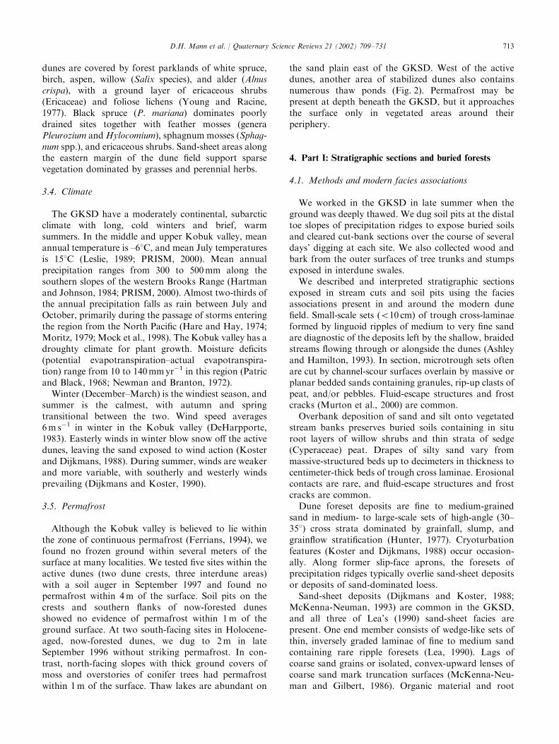
5.1.1. Kavet creekFlowing northward along the lower slopes of the
Waring Mountains, Kavet Creek is forced by topogra-phy to trace closely the western margin of the dune field.Its cutbanks expose several stratigraphic sections of
interest for dune-field history. Section AR (Fig. 4) is a150m long cutbank that exposes floodplain and sand-sheet deposits at creek level overlain by 2–8m of fluvialsands. These fluvial sands evidence several episodes ofstream aggradation. In the upstream part of thecutbank, subsection A, trough cross-laminated sandsbury a rooted willow dating to >40,000 14C yr BP(Fig. 5) (Appendix A, Table 1(a)). A more recentaggradation interval dates to around 1400 14C yr BP,the age of a 25 cm diameter spruce log interbedded withtrough cross-laminated sands containing pebbles andcut-and-fill structures in subsection Z. The calibratedage of a twig dated to 1530750 14C yr BP, from fluvialsands underlying aeolian sand-sheet deposits in subsec-tion A suggests this episode of stream aggradation
Fig. 4. Section AR along upper Kavet Creek.
D.H. Mann et al. / Quaternary Science Reviews 21 (2002) 709–731714
endedB9m above the present stream level at 1180–1410cal yr BP. The foreset beds left by an advancing duneslipface overlie the sand-sheet deposits (Fig. 4). Numer-ous, unpaired stream terraces occur along the westernside of Kavet Creek near this section and indicate thatthe creek has recently been downcutting. A vegetationcover of willow and young white spruce, together withpoorly developed soils with thin organic horizonssuggest these terraces have an age range of 10–100 yr.Six kilometers downstream from the section just
described, Kavet Creek intersects a high dune slipfaceat Section R (Fig. 5). The lower 6m of the sectioncontain sand-sheet deposits overlain by dune foresets.Graminoid stems in foreset strata date to 34,000 14C yrBP (Table 1(b)). Several meters of fluvial deposits,including channel-fill gravels, overlie these Pleistocenedune sands and in turn are overlain by floodplainsediments. Willow shrubs rooted in the floodplaindeposits date to 1410 14C yr BP (Table 1(a)), and theyindicate that the floodplain of Kavet Creek was B9mhigher at that time, consistent with subsection Zdescribed above. Thick, dune-foreset deposits contain-ing occasional sand-sheet units complete the section andindicate that dunes buried the former floodplain some-time after 1400 14C yr BP. A lone spruce tree that died
sometime during the last 500 yr (Table 1(c)) is rooted insand-sheet deposits 11m above creek level (Fig. 5).Today, fluvial erosion exceeds aeolian deposition at thissite, and the creek is eroding laterally into dunesediments. Abundant unpaired terraces covered withyouthful vegetation and soils suggest recent, rapiddowncutting in this reach of Kavet Creek.A complex sequence of aeolian and fluvial sediments is
exposed in ‘‘Oasis Amphitheater’’ near the northwesternend of the GKSD (Fig. 3). At creek level, peatyfloodplain deposits containing rooted willow shrubs dateto 2130 14C yr BP (Fig. 5, section O) (Table 1(b)). Above,4m of alternating fluvial sands and organic floodplaindeposits indicate that floodplain aggradation occurredbetween 2100 and 1240 14C yr BP. Sand-sheet depositsdirectly overlie floodplain deposits dated to 1240 14C yrBP and in turn are buried by dune foresets. Thin strataof trough cross-beds within the aeolian units indicatethat the stream was continuing to aggrade as the dunesexpanded westward across the Kavet Creek valley.Today a low dune is moving westward across the topof the section and burying a sand-sheet deposit contain-ing rooted, dead spruce trees. Kavet Creek is erodinglaterally into the dune sediments today. As is the caseupstream, abundant unpaired terraces with youthfulvegetation and soils suggest recent, rapid downcutting.
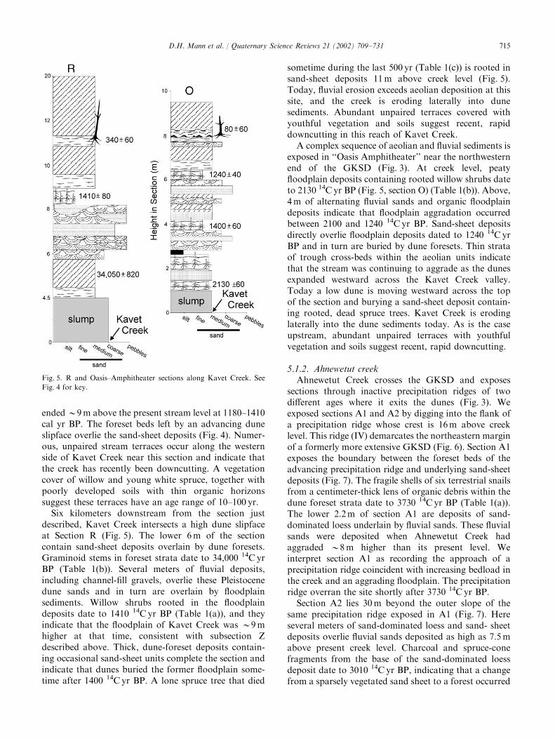
5.1.2. Ahnewetut creekAhnewetut Creek crosses the GKSD and exposes
sections through inactive precipitation ridges of twodifferent ages where it exits the dunes (Fig. 3). Weexposed sections A1 and A2 by digging into the flank ofa precipitation ridge whose crest is 16m above creeklevel. This ridge (IV) demarcates the northeastern marginof a formerly more extensive GKSD (Fig. 6). Section A1exposes the boundary between the foreset beds of theadvancing precipitation ridge and underlying sand-sheetdeposits (Fig. 7). The fragile shells of six terrestrial snailsfrom a centimeter-thick lens of organic debris within thedune foreset strata date to 3730 14C yr BP (Table 1(a)).The lower 2.2m of section A1 are deposits of sand-dominated loess underlain by fluvial sands. These fluvialsands were deposited when Ahnewetut Creek hadaggraded B8m higher than its present level. Weinterpret section A1 as recording the approach of aprecipitation ridge coincident with increasing bedload inthe creek and an aggrading floodplain. The precipitationridge overran the site shortly after 3730 14C yr BP.Section A2 lies 30m beyond the outer slope of the
same precipitation ridge exposed in A1 (Fig. 7). Hereseveral meters of sand-dominated loess and sand- sheetdeposits overlie fluvial sands deposited as high as 7.5mabove present creek level. Charcoal and spruce-conefragments from the base of the sand-dominated loessdeposit date to 3010 14C yr BP, indicating that a changefrom a sparsely vegetated sand sheet to a forest occurred
Fig. 5. R and Oasis–Amphitheater sections along Kavet Creek. See
Fig. 4 for key.
D.H. Mann et al. / Quaternary Science Reviews 21 (2002) 709–731 715
before that time. This implies that the nearby precipita-tion ridge stabilized before 3010 14C yr BP. Together, theAhnewetut sections suggest that precipitation ridge IV(Fig. 6) stabilized between 3700 and 3000 14C yr BP.
Also they record a period of aggradation in theAhnewetut valley that preceded stabilization of RidgeIV and that probably was coincident with dune-fieldexpansion.On the south side of Ahnewetut Creek, a cutbank
exposes a section through another precipitation ridge,which probably is coeval with Ridge II west of the creek(Fig. 6). Here several meters of sand-sheet deposits wereburied by dune foresets. A compressed log fromthese foresets dated to 1300 14C yr BP and indicatesstabilization of the precipitation ridge after that time(Table 1(c)).
5.1.3. Stabilized precipitation ridgesEpisodes of dune-field expansion during the middle
and late Holocene left four precipitation ridges in theforest northeast of the GKSD (Fig. 6). These ridges areup to 10 km long, and they stand 4–8m above the landsurface. After describing numerous soil profiles onvegetated dune crests, it became apparent that repeatedepisodes of soil erosion following fires made it im-possible to use the degree of soil development forcorrelations. Instead, we correlate these ridges acrossdrainages on the basis of their associated tree-ring and14C ages (Table 1(c)).Cores taken with an increment borer from four white
spruce trees growing on Ridge I revealed pith datesbetween AD 1910 and 1940. Wood fragments in the
Fig. 6. Location of precipitation ridges along the northeast side of the GKSD together with stratigraphic sections used to date these ridges.
Fig. 7. Sections along Ahnewetut Creek where it exits the GKSD. At
top is a schematic cross-section through stabilized precipitation Ridge
IV. See Fig. 4 for key.
D.H. Mann et al. / Quaternary Science Reviews 21 (2002) 709–731716
organic horizon of a soil buried by inorganic sand alongthe distal slope of Ridge II dated to 1620 14C yr BP(Fig. 6). Ridge stabilization occurred some time afterthat time. A precipitation ridge south of AhnewetutCreek is probably coeval with Ridge II north of thecreek. As described above, a log dating to 1300 14C yrBP is embedded in dune foresets. Ridge II probablystabilized within several centuries after this time. Wefailed to find soils containing datable material along thedistal margin of Ridge III.Ridge IV is the outermost, morphologically intact
precipitation ridge, and it extends more than 4 km fromthe active dune field. On the crest of Ridge IV nearAhnewetut Creek, the lowest charcoal in a buried soilorganic horizon dates to 3350 14C yr BP, indicating ridgestabilization before that time. A similar, upper-limitingage comes from a soil pit at the base of the distal slopeof a large precipitation ridge near Lake Wolverine(Fig. 6). Here a soil containing charcoal dating to 609014C yr BP was buried by sand. In the same pit, themodern organic horizon contained charcoal near itsbase dating to 3250 14C yr BP. On the basis of theselimiting ages, Ridge IV formed sometime between 6100and 3200 14C yr BP.
5.2. Ages of buried forests and soils
Wind erosion within the active dunes exposespaleosols buried by sand. Podzolic paleosols of severaldifferent ages are widespread in the northwestern andwestern parts of the GKSD. The best-developed profileshave E horizons 5–15 cm thick and Bw horizons up to50 cm thick. The organic horizons of these paleosolscontain charcoal, wood fragments, spruce needles,cones, and mammal bones, notably the mandibles ofsmall mammals. 14C ages from the paleosols range from7000 to 1300 14C yr BP (Table 1(d)), though most clusterbetween 2200 and 1300 14C yr BP. For these soils todevelop at a site, dunes had to be stabilized there.In contrast, the ages of woody debris buried by sand
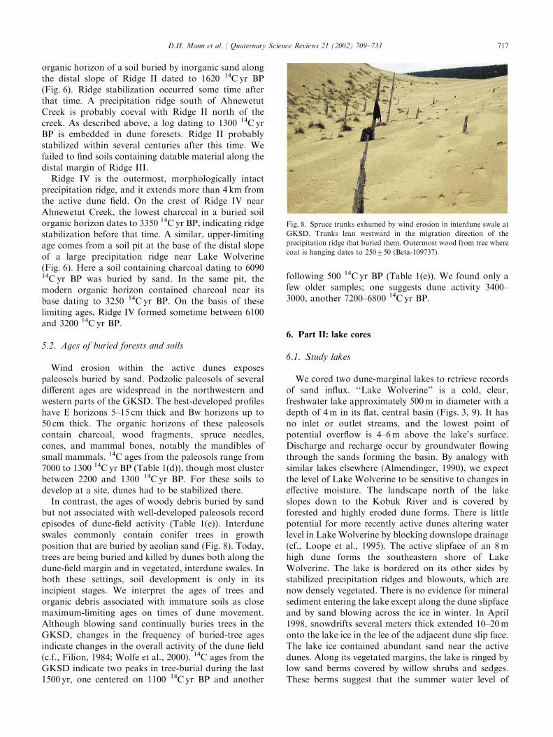
but not associated with well-developed paleosols recordepisodes of dune-field activity (Table 1(e)). Interduneswales commonly contain conifer trees in growthposition that are buried by aeolian sand (Fig. 8). Today,trees are being buried and killed by dunes both along thedune-field margin and in vegetated, interdune swales. Inboth these settings, soil development is only in itsincipient stages. We interpret the ages of trees andorganic debris associated with immature soils as closemaximum-limiting ages on times of dune movement.Although blowing sand continually buries trees in theGKSD, changes in the frequency of buried-tree agesindicate changes in the overall activity of the dune field(c.f., Filion, 1984; Wolfe et al., 2000). 14C ages from theGKSD indicate two peaks in tree-burial during the last1500 yr, one centered on 1100 14C yr BP and another
following 500 14C yr BP (Table 1(e)). We found only afew older samples; one suggests dune activity 3400–3000, another 7200–6800 14C yr BP.
6. Part II: lake cores
6.1. Study lakes
We cored two dune-marginal lakes to retrieve recordsof sand influx. ‘‘Lake Wolverine’’ is a cold, clear,freshwater lake approximately 500m in diameter with adepth of 4m in its flat, central basin (Figs. 3, 9). It hasno inlet or outlet streams, and the lowest point ofpotential overflow is 4–6m above the lake’s surface.Discharge and recharge occur by groundwater flowingthrough the sands forming the basin. By analogy withsimilar lakes elsewhere (Almendinger, 1990), we expectthe level of Lake Wolverine to be sensitive to changes ineffective moisture. The landscape north of the lakeslopes down to the Kobuk River and is covered byforested and highly eroded dune forms. There is littlepotential for more recently active dunes altering waterlevel in Lake Wolverine by blocking downslope drainage(cf., Loope et al., 1995). The active slipface of an 8mhigh dune forms the southeastern shore of LakeWolverine. The lake is bordered on its other sides bystabilized precipitation ridges and blowouts, which arenow densely vegetated. There is no evidence for mineralsediment entering the lake except along the dune slipfaceand by sand blowing across the ice in winter. In April1998, snowdrifts several meters thick extended 10–20monto the lake ice in the lee of the adjacent dune slip face.The lake ice contained abundant sand near the activedunes. Along its vegetated margins, the lake is ringed bylow sand berms covered by willow shrubs and sedges.These berms suggest that the summer water level of
Fig. 8. Spruce trunks exhumed by wind erosion in interdune swale at
GKSD. Trunks lean westward in the migration direction of the
precipitation ridge that buried them. Outermost wood from tree where
coat is hanging dates to 250750 (Beta-109737).
D.H. Mann et al. / Quaternary Science Reviews 21 (2002) 709–731 717
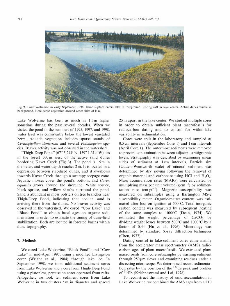
Lake Wolverine has been as much as 1.5m highersometime during the past several decades. When wevisited the pond in the summers of 1995, 1997, and 1998,water level was consistently below the lowest vegetatedberm. Aquatic vegetation includes sparse stands ofCeratophyllum demersum and several Potamogeton spe-cies. Beaver activity was not observed in the watershed.‘‘Thigh-Deep Pond’’ (67o 5.2440 N, 159o 1.3140 W) lies
in the forest 500m west of the active sand dunesbordering Kavet Creek (Fig. 3). The pond is 15m indiameter, and water depth reaches 2m. It is located in adepression between stabilized dunes, and it overflowstowards Kavet Creek through a swampy seepage zone.Aquatic mosses cover the pond’s bottom, and Carexaquatilis grows around the shoreline. White spruce,black spruce, and willow shrubs surround the pond.Sand is abundant in moss polsters on tree branches nearThigh-Deep Pond, indicating that aeolian sand isarriving there from the dunes. No beaver activity wasobserved in the watershed. We cored ‘‘Cow Lake’’ and‘‘Black Pond’’ to obtain basal ages on organic sedi-mentation in order to estimate the timing of dune-fieldstabilization. Both are located in forested basins withindune topography.
7. Methods
We cored Lake Wolverine, ‘‘Black Pond’’, and ‘‘CowLake’’ in mid-April 1997, using a modified Livingstoncorer (Wright et al., 1984) through lake ice. InSeptember 1998, we took additional sediment coresfrom Lake Wolverine and a core from Thigh-Deep Pondusing a pistonless, percussion corer operated from rafts.Altogether, we took ten sediment cores from LakeWolverine in two clusters 5m in diameter and spaced
25m apart in the lake center. We studied multiple coresin order to obtain sufficient plant macrofossils forradiocarbon dating and to control for within-lakevariability in sedimentation.Cores were split in the laboratory and sampled at
0.5 cm intervals (September Core 1) and 1 cm intervals(April Core 1). The outermost sediments were removedto prevent contamination between adjacent stratigraphiclevels. Stratigraphy was described by examining smearslides of sediment at 1 cm intervals. Particle size(Udden–Wentworth scale) of mineral sediment wasdetermined by dry sieving following the removal oforganic material and carbonate using HCl and H2O2.Mass accumulation rates (MARs) were calculated bymultiplying mass per unit volume (g cm�3) by sedimen-tation rate (cm yr�1). Magnetic susceptibility wasmeasured on subsamples using a Bartington MS-2susceptibility meter. Organic-matter content was esti-mated after loss on ignition at 5001C. Total inorganiccarbon content was measured by subsequent heatingof the same samples to 10001C (Dean, 1974). Weestimated the weight percentage of CaCO3 bydividing weight losses between 5001C and 10001C by afactor of 0.44 (Hu et al., 1996). Mineralogy wasdetermined by standard X-ray diffraction techniques(Chen, 1977).Dating control in lake-sediment cores came mainly
from the accelerator mass spectrometry (AMS) radio-carbon ages of plant macrofossils. We extracted plantmacrofossils from core subsamples by washing sedimentthrough 250 mm sieves and examining residues under adissecting microscope. We determined recent sedimenta-tion rates by the position of the 137Cs peak and profilesof 210Pb (Krishnaswami and Lai, 1978).To reconstruct the history of sand accumulation in
Lake Wolverine, we combined the AMS ages from all 10
Fig. 9. Lake Wolverine in early September 1998. Dune slipface enters lake in foreground. Coring raft in lake center. Active dunes visible in
background. Note dense vegetation around other sides of lake.
D.H. Mann et al. / Quaternary Science Reviews 21 (2002) 709–731718
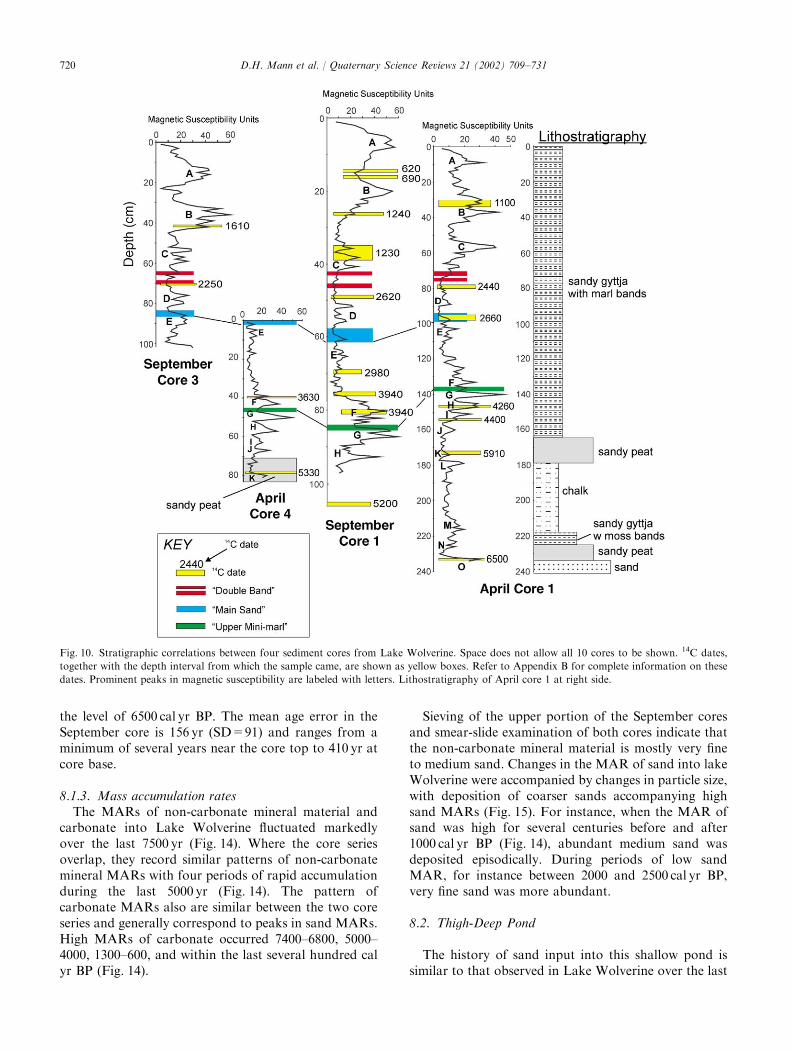
cores after correlating these cores using multiplestratigraphic markers. The most important of thesemarkers were marl layers of varying thicknessand spacing that provide a detailed, stratigraphic ‘‘barcode’’ within Lake Wolverine. We calculated regressionequations relating the depths of specificmarl layers in one core with their depths in other cores.These regression equations, which all had r2 values>0.99, were used to determine the stratigraphicpositions of 14C ages in two master cores (SeptemberCore 1 and April Core 1). These placements wereconfirmed, and in some cases refined, by magneticsusceptibility logs, by comparisons of organic-carboncontent, and by the locations of sediment-type bound-aries (Fig. 10).Age–depth curves were plotted as error envelopes
derived from the 2-sigma errors of the 14C agescombined with the core interval from which each datedmacrofossil was taken. An error of 71 cm was assumedin all depth measurements. Error envelopes wereoutlined by the corners of the boxes formed by plottingthe least possible depth of each AMS sample against thegreatest possible calibrated sample age and vice versa.After calibrating 14C ages (Stuiver et al., 1998), wecalculated a series of spline equations describing the twodepth-age curves outlining the maximum error envel-opes of September Core 1 and April Core 1. Thesesplines were calculated as linear or polynomial regres-sions and spline length (number of dated intervalsincluded) was constrained to keep r2 values X0.99.Though tedious, this procedure avoided the inaccurra-cies involved in using a single polynomial equation todescribe an age–depth relationship in a setting wheresedimentation rate is inconstant (Bennett, 1994). Theseage–depth relationships were used to calculate timeseries of mineral accumulation. The age–error envelopesin plots of mineral accumulation rates are based on theerrors associated with age–depth relationships.
8. Results and discussion
8.1. Lake wolverine
8.1.1. Stratigraphy and sedimentsAbove inorganic basal sand, sediments in Lake
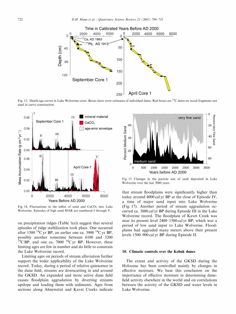
Wolverine alternate between peat, marl, and algalmud, all of which contain abundant sand. Depths andthicknesses vary between the September and April coresdue to differences in compaction caused by the differentcorers. We use the longest cores to illustrate the generalstratigraphy.The April core series penetrated to inorganic, medium
sand 240 cm below the water/sediment interface(Fig. 10). At a depth of 234 cm, a layer of sandygraminoid and moss peat overlies this inorganic sand
along an abrupt boundary. At the 225 cm level, sandyalgal mud (gyttja) first appears and is interlayered withaquatic moss (cf. Scorpidium). At the 218 cm level, gyttjais abruptly replaced by a 40 cm thick unit of sandy chalk(Kelts and Hs *u, 1978). This chalk is yellowish gray incolor and has a wavey, laminated structure. X-raydiffraction of three chalk samples revealed low-Mgcalcite and quartz. Calcium carbonate comprises up to90% of the chalk unit by weight. Aquatic mosses areinterlayered with the chalk within several centimeters ofits upper boundary. A layer of graminoid and moss peatcontaining vole feces and woody rootlets overlies thechalk unit between depths of 177 and 163 cm (Fig. 10).From a depth of 163 cm upwards, sediments consist ofinterstratified, sandy marl and sandy gyttja. X-raydiffraction at two levels revealed the marl to containlow-Mg calcite.In the September cores, medium, fine, and very fine
sands were the predominant particle sizes of non-carbonate mineral material in 102 sieved samples(Fig. 11). Very coarse sand and silt were alwayso20% and usually o5%. Throughout Lake Wolver-ine’s sediments, organic-matter percentages range from5% to around 50% (Fig. 12). Magnetic susceptibility iscorrelated with non-carbonate, mineral concentration(magnetic susceptibility=0.02�+0.03, r2 ¼ 0:60).Above the chalk layer, CaCO3 occurs as laminae anddiffuse beds within the gyttja, and locally it comprises20–30% of sediment mass.
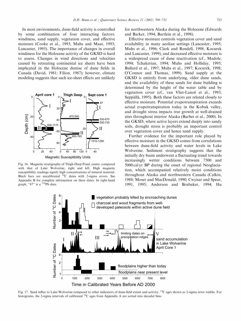
8.1.2. Depth-age modelsWe constructed separate depth–age models for the
September and April core series as the first step incalculating MARs. The two models share most of theirdating control (Fig. 13) (Appendix B). Only one age,Beta-123321 from September Core 1, could not besecurely correlated into April Core 1. Three ages plottedslightly outside the error envelopes of both cores andwere not used in either age model (Fig. 13). Thesesamples (Beta-123320, Beta-125085, and Beta-123326)consisted of a charred twig, an uncharred twig, and awood fragment, respectively. All three samples showedevidence of surface wear including the removal of barkand the rounding of broken edges. The dated samplesused in the age models were non-woody macrofossils,mostly spruce needles and seeds. Reworked charcoal andwood fragments commonly occur in the active dune fielddownwind of interdune swales where buried forest layersare being exhumed by wind erosion. We suspect that thethree, slightly age-discordant samples were blown intoLake Wolverine from buried forests located upwind.Potential errors in estimating the age/depth curves
from Lake Wolverine yield an overall temporal resolu-tion for the records of7150–200 yr. The mean age errorin April Core 1 is 178 yr (SD=72) with a minimum of13 yr near the core top and a maximum of 490 yr around
D.H. Mann et al. / Quaternary Science Reviews 21 (2002) 709–731 719
the level of 6500 cal yr BP. The mean age error in theSeptember core is 156 yr (SD=91) and ranges from aminimum of several years near the core top to 410 yr atcore base.
8.1.3. Mass accumulation ratesThe MARs of non-carbonate mineral material and
carbonate into Lake Wolverine fluctuated markedlyover the last 7500 yr (Fig. 14). Where the core seriesoverlap, they record similar patterns of non-carbonatemineral MARs with four periods of rapid accumulationduring the last 5000 yr (Fig. 14). The pattern ofcarbonate MARs also are similar between the two coreseries and generally correspond to peaks in sand MARs.High MARs of carbonate occurred 7400–6800, 5000–4000, 1300–600, and within the last several hundred calyr BP (Fig. 14).
Sieving of the upper portion of the September coresand smear-slide examination of both cores indicate thatthe non-carbonate mineral material is mostly very fineto medium sand. Changes in the MAR of sand into lakeWolverine were accompanied by changes in particle size,with deposition of coarser sands accompanying highsand MARs (Fig. 15). For instance, when the MAR ofsand was high for several centuries before and after1000 cal yr BP (Fig. 14), abundant medium sand wasdeposited episodically. During periods of low sandMAR, for instance between 2000 and 2500 cal yr BP,very fine sand was more abundant.
8.2. Thigh-Deep Pond
The history of sand input into this shallow pond issimilar to that observed in Lake Wolverine over the last
Fig. 10. Stratigraphic correlations between four sediment cores from Lake Wolverine. Space does not allow all 10 cores to be shown. 14C dates,
together with the depth interval from which the sample came, are shown as yellow boxes. Refer to Appendix B for complete information on these
dates. Prominent peaks in magnetic susceptibility are labeled with letters. Lithostratigraphy of April core 1 at right side.
D.H. Mann et al. / Quaternary Science Reviews 21 (2002) 709–731720
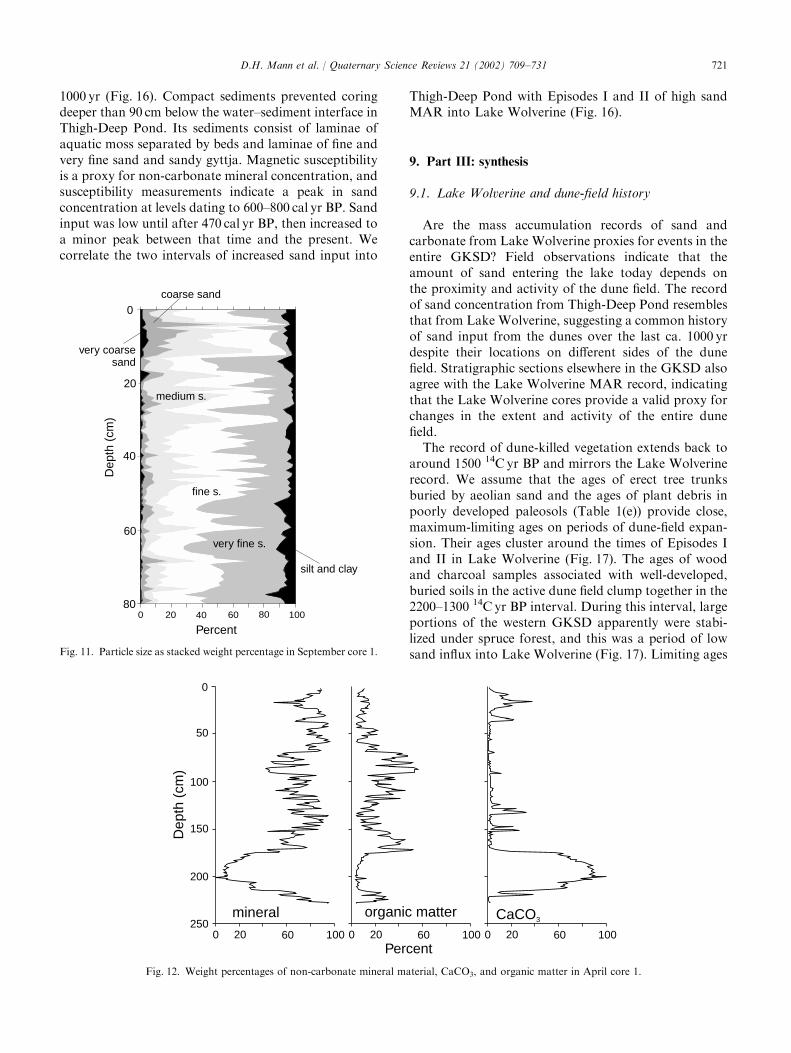
1000 yr (Fig. 16). Compact sediments prevented coringdeeper than 90 cm below the water–sediment interface inThigh-Deep Pond. Its sediments consist of laminae ofaquatic moss separated by beds and laminae of fine andvery fine sand and sandy gyttja. Magnetic susceptibilityis a proxy for non-carbonate mineral concentration, andsusceptibility measurements indicate a peak in sandconcentration at levels dating to 600–800 cal yr BP. Sandinput was low until after 470 cal yr BP, then increased toa minor peak between that time and the present. Wecorrelate the two intervals of increased sand input into
Thigh-Deep Pond with Episodes I and II of high sandMAR into Lake Wolverine (Fig. 16).
9. Part III: synthesis
9.1. Lake Wolverine and dune-field history
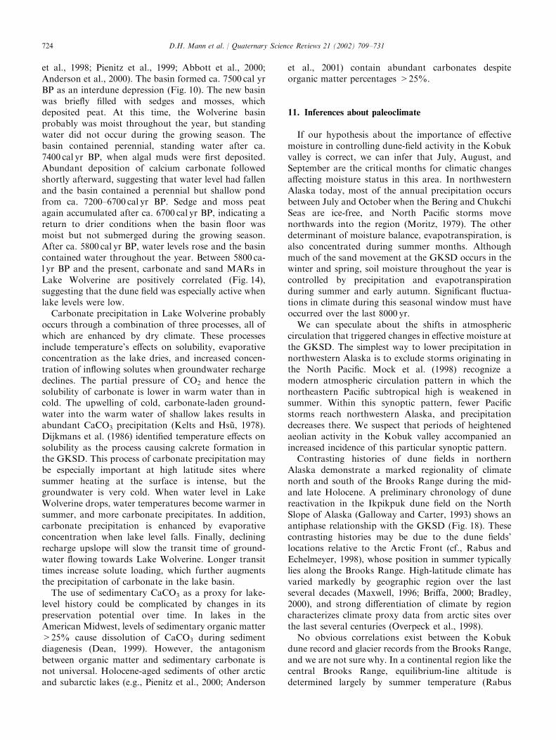
Are the mass accumulation records of sand andcarbonate from Lake Wolverine proxies for events in theentire GKSD? Field observations indicate that theamount of sand entering the lake today depends onthe proximity and activity of the dune field. The recordof sand concentration from Thigh-Deep Pond resemblesthat from Lake Wolverine, suggesting a common historyof sand input from the dunes over the last ca. 1000 yrdespite their locations on different sides of the dunefield. Stratigraphic sections elsewhere in the GKSD alsoagree with the Lake Wolverine MAR record, indicatingthat the Lake Wolverine cores provide a valid proxy forchanges in the extent and activity of the entire dunefield.The record of dune-killed vegetation extends back to
around 1500 14C yr BP and mirrors the Lake Wolverinerecord. We assume that the ages of erect tree trunksburied by aeolian sand and the ages of plant debris inpoorly developed paleosols (Table 1(e)) provide close,maximum-limiting ages on periods of dune-field expan-sion. Their ages cluster around the times of Episodes Iand II in Lake Wolverine (Fig. 17). The ages of woodand charcoal samples associated with well-developed,buried soils in the active dune field clump together in the2200–1300 14C yr BP interval. During this interval, largeportions of the western GKSD apparently were stabi-lized under spruce forest, and this was a period of lowsand influx into Lake Wolverine (Fig. 17). Limiting ages
0
20
40
60
80
Percent
Dep
th (
cm)
0 20 40 60 80 100
coarse sand
medium s.
fine s.
very fine s.
silt and clay
very coarse sand
Fig. 11. Particle size as stacked weight percentage in September core 1.
0
50
100
150
200
250
Dep
th (
cm)
mineral CaCO3
0 20 60 100
organic matter
Percent0 20 60 100 0 20 60 100
Fig. 12. Weight percentages of non-carbonate mineral material, CaCO3, and organic matter in April core 1.
D.H. Mann et al. / Quaternary Science Reviews 21 (2002) 709–731 721
on precipitation ridges (Table 1(e)) suggest that severalepisodes of ridge stabilization took place. One occurredafter 1500 14C yr BP, an earlier one ca. 3900 14C yr BP,possibly another sometime between 6100 and 320014CBP, and one ca. 7000 14C yr BP. However, theselimiting ages are few in number and do little to constrainthe Lake Wolverine record.Limiting ages on periods of stream alluviation further
support the wider applicability of the Lake Wolverinerecord. Today, during a period of relative quiescence inthe dune field, streams are downcutting in and aroundthe GKSD. An expanded and more active dune fieldcauses floodplain aggradation by diverting streamsupslope and loading them with sediments. Ages fromsections along Ahnewetut and Kavet Creeks indicate
that stream floodplains were significantly higher thantoday around 4000 cal yr BP at the close of Episode IV,a time of major sand input into Lake Wolverine(Fig. 17). Another period of stream aggradation oc-curred ca. 3000 cal yr BP during Episode III in the LakeWolverine record. The floodplain of Kavet Creek wasnear its present level 2400–1500 cal yr BP, which was aperiod of low sand input to Lake Wolverine. Flood-plains had aggraded many meters above their presentlevels 1500–900 cal yr BP during Episode II.
10. Climatic controls over the Kobuk dunes
The extent and activity of the GKSD during theHolocene has been controlled mainly by changes ineffective moisture. We base this conclusion on theimportance of effective moisture in determining dune-field activity elsewhere in the world and on correlationsbetween the activity of the GKSD and water levels inLake Wolverine.
Fig. 13. Depth/age curves in Lake Wolverine cores. Boxes show error estimates of individual dates. Red boxes are 14C dates on wood fragments not
used in curve construction.
Fig. 14. Fluctuations in the influx of sand and CaCO3 into Lake
Wolverine. Episodes of high sand MAR are numbered I through V.
0
20
40
60
0 500 1000 1500 2000 2500 3000 3500
60
80
40
20
0very fine sand
medium sand
Years before AD 2000
Per
cent
Med
ium
San
d
Percent V
ery Fine S
and
Fig. 15. Changes in the particle size of sand deposited in Lake
Wolverine over the last 3000 years.
D.H. Mann et al. / Quaternary Science Reviews 21 (2002) 709–731722
In most environments, dune-field activity is controlledby some combination of four interacting factors:windiness, sand supply, vegetation cover, and effectivemoisture (Cooke et al., 1993; Muhs and Maat, 1993;Lancaster, 1995). The importance of changes in overallwindiness for the Holocene activity of the GKSD is hardto assess. Changes in wind directions and velocitiescaused by retreating continental ice sheets have beenimplicated in the Holocene demise of dune fields inCanada (David, 1981; Filion, 1987); however, climatemodeling suggests that such ice-sheet effects are unlikely
for northwestern Alaska during the Holocene (Edwardsand Barker, 1994; Bartlein et al., 1998).Effective moisture controls vegetation cover and sand
availability in many aeolian settings (Lancaster, 1995;Muhs et al., 1996; Clark and Rendell, 1998; Kocurekand Lancaster, 1999), and decreased effective moisture isa widespread cause of dune reactivation (cf., Madole,1994; Tchakerian, 1994; Muhs and Holliday, 1995;Bullard et al., 1997; Muhs et al., 1997; Kocurek, 1998;O’Connor and Thomas, 1999). Sand supply at theGKSD is entirely from underlying, older dune sands,and the availability of these sands for dune building isdetermined by the height of the water table and byvegetation cover (cf., van Vliet-Lano.e et al., 1993;Sepp.all.a, 1995). Both these factors are related closely toeffective moisture. Potential evapotranspiration exceedsactual evapotranspiration today in the Kobuk valley,and drought stress impacts tree growth at well-drainedsites throughout interior Alaska (Barber et al., 2000). Inthe GKSD, where active layers extend deeply into sandysoils, drought stress is probably an important controlover vegetation cover and hence sand supply.Further evidence for the important role played by
effective moisture in the GKSD comes from correlationsbetween dune-field activity and water levels in LakeWolverine. Sediment stratigraphy suggests that theinitially dry basin underwent a fluctuating trend towardsincreasingly wetter conditions between 7500 and5000 cal yr BP during the onset of regional Neoglacia-tion, which accompanied relatively moist conditionsthroughout Alaska and northwestern Canada (Calkin,1988; Moser and MacDonald, 1990; Cwynar and Spear,1991, 1995; Anderson and Brubaker, 1994; Hu
Time in Calibrated Years Before AD 2000
0 1000 2000 3000 4000 5000 6000 7000 8000
floodplains higher than today
floodplains near present level
sand accumulationin Lake WolverineApril Core 1
1
2
4
Num
ber
of C
Date
s14
2
4
6
vegetation probably killed by encroaching dunes
charcoal and wood fragments from well-developed paleosols within active dune field
8
limiting dates onprecipitation ridges
Num
ber
of C
Date
s1
4
I
IIIV
VIII
Fig. 17. Sand influx to Lake Wolverine compared to other indicators of dune-field extent and activity. 14C ages shown as 2-sigma error widths. For
histograms, the 2-sigma intervals of calibrated 14C ages from Appendix A are sorted into decadal bins.
0 20 40
0
20
40
April core 1
930-1170
Sept core 1
0
40
0
20
530-670
550-730
1010-1290
470-540
650-760
0
40 80 120
0
20
40
60
80
Magnetic Susceptibility Units
Thigh Deep
De
pth
(cm
)
87
I
II
I
I
II
II
Fig. 16. Magnetic stratigraphy of Thigh-Deep Pond, center, compared
with that of Lake Wolverine, right and left. High magnetic
susceptibility readings signify high concentrations of mineral material.
Black bars are uncalibrated 14C dates with 2-sigma errors. See
Appendix B for complete information on these dates. In right-hand
graph, ‘‘87’’ is a 210Pb date.
D.H. Mann et al. / Quaternary Science Reviews 21 (2002) 709–731 723
et al., 1998; Pienitz et al., 1999; Abbott et al., 2000;Anderson et al., 2000). The basin formed ca. 7500 cal yrBP as an interdune depression (Fig. 10). The new basinwas briefly filled with sedges and mosses, whichdeposited peat. At this time, the Wolverine basinprobably was moist throughout the year, but standingwater did not occur during the growing season. Thebasin contained perennial, standing water after ca.7400 cal yr BP, when algal muds were first deposited.Abundant deposition of calcium carbonate followedshortly afterward, suggesting that water level had fallenand the basin contained a perennial but shallow pondfrom ca. 7200–6700 cal yr BP. Sedge and moss peatagain accumulated after ca. 6700 cal yr BP, indicating areturn to drier conditions when the basin floor wasmoist but not submerged during the growing season.After ca. 5800 cal yr BP, water levels rose and the basincontained water throughout the year. Between 5800 ca-l yr BP and the present, carbonate and sand MARs inLake Wolverine are positively correlated (Fig. 14),suggesting that the dune field was especially active whenlake levels were low.Carbonate precipitation in Lake Wolverine probably
occurs through a combination of three processes, all ofwhich are enhanced by dry climate. These processesinclude temperature’s effects on solubility, evaporativeconcentration as the lake dries, and increased concen-tration of inflowing solutes when groundwater rechargedeclines. The partial pressure of CO2 and hence thesolubility of carbonate is lower in warm water than incold. The upwelling of cold, carbonate-laden ground-water into the warm water of shallow lakes results inabundant CaCO3 precipitation (Kelts and Hs *u, 1978).Dijkmans et al. (1986) identified temperature effects onsolubility as the process causing calcrete formation inthe GKSD. This process of carbonate precipitation maybe especially important at high latitude sites wheresummer heating at the surface is intense, but thegroundwater is very cold. When water level in LakeWolverine drops, water temperatures become warmer insummer, and more carbonate precipitates. In addition,carbonate precipitation is enhanced by evaporativeconcentration when lake level falls. Finally, decliningrecharge upslope will slow the transit time of ground-water flowing towards Lake Wolverine. Longer transittimes increase solute loading, which further augmentsthe precipitation of carbonate in the lake basin.The use of sedimentary CaCO3 as a proxy for lake-
level history could be complicated by changes in itspreservation potential over time. In lakes in theAmerican Midwest, levels of sedimentary organic matter>25% cause dissolution of CaCO3 during sedimentdiagenesis (Dean, 1999). However, the antagonismbetween organic matter and sedimentary carbonate isnot universal. Holocene-aged sediments of other arcticand subarctic lakes (e.g., Pienitz et al., 2000; Anderson
et al., 2001) contain abundant carbonates despiteorganic matter percentages >25%.
11. Inferences about paleoclimate
If our hypothesis about the importance of effectivemoisture in controlling dune-field activity in the Kobukvalley is correct, we can infer that July, August, andSeptember are the critical months for climatic changesaffecting moisture status in this area. In northwesternAlaska today, most of the annual precipitation occursbetween July and October when the Bering and ChukchiSeas are ice-free, and North Pacific storms movenorthwards into the region (Moritz, 1979). The otherdeterminant of moisture balance, evapotranspiration, isalso concentrated during summer months. Althoughmuch of the sand movement at the GKSD occurs in thewinter and spring, soil moisture throughout the year iscontrolled by precipitation and evapotranspirationduring summer and early autumn. Significant fluctua-tions in climate during this seasonal window must haveoccurred over the last 8000 yr.We can speculate about the shifts in atmospheric
circulation that triggered changes in effective moisture atthe GKSD. The simplest way to lower precipitation innorthwestern Alaska is to exclude storms originating inthe North Pacific. Mock et al. (1998) recognize amodern atmospheric circulation pattern in which thenortheastern Pacific subtropical high is weakened insummer. Within this synoptic pattern, fewer Pacificstorms reach northwestern Alaska, and precipitationdecreases there. We suspect that periods of heightenedaeolian activity in the Kobuk valley accompanied anincreased incidence of this particular synoptic pattern.Contrasting histories of dune fields in northern
Alaska demonstrate a marked regionality of climatenorth and south of the Brooks Range during the mid-and late Holocene. A preliminary chronology of dunereactivation in the Ikpikpuk dune field on the NorthSlope of Alaska (Galloway and Carter, 1993) shows anantiphase relationship with the GKSD (Fig. 18). Thesecontrasting histories may be due to the dune fields’locations relative to the Arctic Front (cf., Rabus andEchelmeyer, 1998), whose position in summer typicallylies along the Brooks Range. High-latitude climate hasvaried markedly by geographic region over the lastseveral decades (Maxwell, 1996; Briffa, 2000; Bradley,2000), and strong differentiation of climate by regioncharacterizes climate proxy data from arctic sites overthe last several centuries (Overpeck et al., 1998).No obvious correlations exist between the Kobuk
dune record and glacier records from the Brooks Range,and we are not sure why. In a continental region like thecentral Brooks Range, equilibrium-line altitude isdetermined largely by summer temperature (Rabus
D.H. Mann et al. / Quaternary Science Reviews 21 (2002) 709–731724
and Echelmeyer, 1998). Warm summers in theBrooks Range should coincide with high pressureand low precipitation in at the GKSD, so glaciersshould be retreating when the dune field is expanding.No obvious relation is discernible between the glacierand dune records. For instance, Ellis and Calkin (1984)noted glacier advances starting ca. AD 1200 andcontinuing through the Medieval Warm Period, whichis evidenced as a major period of expansion at theGKSD.
12. Conclusions
By combining chronostratigraphic information fromstream cuts, soil pits, dune-buried trees, and lake cores,we can reconstruct the history of the Great Kobuk SandDunes over the past 8000 yr. A period of dune-fieldstabilization occurred between 7000 and 5000 cal yr BP.After 5000 cal yr BP, four main episodes of dune-fieldexpansion occurred at 400–1500 year intervals. TheGKSD underwent marked expansion during the Med-ieval Warm Period, ca. AD 900–1400, was relativelyinactive AD 1400–1800 early in the Little Ice Age (LIA),and expanded briefly late in the LIA prior to AD 1900.The dune field has shrunk over the last 80–100 yr.Moisture balance appears to be the major control ofaeolian activity at the GKSD, as it is in other dune fieldslocated in boreal-forest (Wolfe et al., 2000) and grass-land ecosystems (Muhs and Maat, 1993). The history ofdune-field extent and activity that we reconstruct is aproxy for regional moisture balance. The complexhistory of moisture balance changes in northwestern
Alaska indicated by the GKSD record is probablyrelated to shifts in the tracks of late-summer stormsapproaching the region from the North Pacific.Although temperature is usually regarded as the keyvariable mediating the impacts of climatic change onarctic and subarctic ecosystems, water balance may bethe more proximal cause of environmental change in theKobuk valley, and we suspect this is the case throughoutthe dry, interior regions of the boreal forest.
Acknowledgements
We thank Jeanne Schaaf, Peter Richter, Dale Taylor,Jess Grunblatt, and Lois Dollimolli of the United StatesNational Park Service for their interest and support. JeffConaway and Fred Haering assisted in the field, andAndy Krumhardt in the laboratory. Carolyn Parker,David Marrett, Alan Batten, Ronald Sletten, and MaryEdwards made valuable contributions to our studies.We thank Tom Hamilton, Dan Muhs, Vance Holliday,and Margaret Smith for constructive reviews of earlierdrafts of this article. Financial support came from theUnited States National Park Service’s Shared BeringianHeritage Program. B.P.F. was supported by NationalScience Foundation grant ATM9707398.
Appendix A
Radiocarbon dates from the Great Kobuk SandDunes (see Table 1(a)–(f)).
LIA
MWP
IKPIKPUK DUNES INACTIVE
0 1000 2000 3000 4000 5000
Calibrated Years Before AD 2000
BROOKS RANGEGLACIERS
0 1000 2000 3000 4000 5000
0.00
0.02
0.04
0.06
sand accumulationin Lake Wolverine September Core 1
Sa
nd
MA
R (
gm
/ c
m / yr)
2
Fig. 18. Sand influx to Lake Wolverine compared to Holocene activity of Ikpikpik Dunes on the North Slope of Alaska (Galloway and Carter, 1993)
and to glacier activity in the Brooks Range (Ellis and Calkin, 1984; Calkin, 1988). In glacial records, the black boxes are estimated times of glacier
expansion.
D.H. Mann et al. / Quaternary Science Reviews 21 (2002) 709–731 725
Table 1
Sample Laboratory
number
(Beta-)
Unofficial locality
name
Location Dated material d 13C (n) 13C-adjusted
radiocarbon
age (yr before
1950 AD)a
2s calibrated age
range (cal yr
before 1950 AD)b
Lat (1N) Long (1W)
(a) Dates relating to creek floodplains higher than today
9-12-96C 97352 Oasis Amphitheater, Kavet
Creek
67150 36.0700 47.8000 15910 Twig �27.1 1240760a 990–1290
9-15-96A 97354 R section, Kavet Creek 671 4.4550 59.67900 1581 Wood fragments �26.9 1410780a 1170–1510
7-31-98A 123314 AR section, Kavet Creek 671 2.2220 N 56.0310 W 1581 Twig cf willow �27.4 1530750a 1180–1410
3Aug98oe 121019 Oasis Amphitheater, Kavet
Creek
671 50 36.0700 00 47.8000 1591 Conifer in growth position �27.5 1400760 1180–1410
7-31-98aLOG 121016 AR section, Kavet Creek 671 2.2220 56.0310 1581 conifer log �27.8 1410740 1270–1390
PH97-22 111732 AR section, Kavet Creek 671 2.2220 56.0310 1581 Willow bush in growth position �31.9 3010760 3000–3360
9-7-97B 109754 A2 section, Ahnewetuk Creek 671 2.80 49.40 1581 Charcoal and Picea cone scale �26.7 3010750a 3000–3360
9-3-97XYc 109751 A1 section, Ahnewetuk Creek 671 2.80 49.30 1581 Terrestrial snails �7.5 3730750a 3930–4240
PH97-21 111731 AR section, Kavet Creek 671 2.2220 56.0310 1581 Plant fragments �28.2 42,12071310a F
(b) Dates relating to creek floodplains similar in altitude as today
3Aug98od 121018 Oasis Amphitheater, Kavet
Creek
671 50 36.0700 47.8000 1591 00 Twig in woody peat �27.9 1790760a 1550–1870
9-12-96A 97351 Oasis Amphitheater, Kavet
Creek
671 50 36.0700 47.8000 1591 00 Charred wood �27.8 2130760a 1950–2310
(c) Limiting ages on formation of precipitation ridges
9-3-97Ac 109740 Ahnewetuk Camp 671 2.90 1581 48.770 Conifer log in dune foresets 26.2 1300770 1060–1330
8-30-97E 109748 Niaktuvik Creek salient 671 0.780 1581 46.490 Charcoal at base of modern O
horizon
�26.2 1460760a 1280–1520
9-18-98cc 125310 Precipitation Ridge II 671 4.350 1581 53.070 Wood fragment in soil buried by
precipitation ridge
�26.6 1620740a 1410–1610
9-6-97C 109753 Lake Wolverine 671 5.890 1581 54.820 Charcoal at base of modern O
horizon
�24.6 3250750a 3360–3630
8-29-97X 109744 LaBau 671 4.520 1581 48.420 Charcoal in O horizon buried by
episodic colluviation
�26.1 3350750a 3470–3690
8-30-97D 109747 Niaktuvik Creek salient 671 0.780 1581 46.490 Charcoal in buried O horizon �26.8 3400750a 3480–3830
9-3-97XYc 109751 A1 section, Ahnewetuk Creek 671 2.80 1581 49.30 Terrestrial snails �7.5 3730750a 3930–4240
(d) Wood and charcoal buried by sand and associated with well-developed podzolic soil profiles containing E and Bw horizons. Logs are lying on ground,
stumps are root-crown portions of trees still in growth position
9-2-97B 111735 King Dune 671 1.810 1581 52.890 Conifer log �33.3 1680760 1410–1710
9-2-97D 111736 King Dune 671 1.810 1581 52.890 Conifer stump �25.2 1680770 1410–1730
9-11-96#2b 97350 Stump 2 671 60 26.890 15.1900 1591 00 conifer stump �28.1 1700780 1410–1820
9-18-98cc 125310 Precipitation Ridge II 671 4.350 1581 53.070 Wood fragment in soil buried by
precipitation ridge
�26.6 1620740a 1410–1610
D.H
.Mannet
al./Quatern
aryScien
ceReview
s21(2002)709–731
726
9-11-96A 97349 Nearest Camp 671 60 23.3200 40.8300 1591 00 Conifer log �27.9 1730780 1420–1860
9-10-96F 97347 Rabbit 671 60 19.670 48.0700 1581 590 Charcoal and wood �27.1 1800750a 1570–1870
9-9-96B 97345 Barrel 671 60 22.7800 57.8000 1581 590 Conifer log �28.7 1930790 1630–2110
9-10-96#2a 97348 Stump2a 671 60 7.7000 46.3300 1591 00 Conifer log �26.7 2080760 1900–2300
9-9-96D 97346 Two Crowns 671 60 7.0700 44.4200 1581 590 Outermost wood of conifer stump �26.3 4210750 4550–4860
9-2-97A 111734 King Dune 671 1.810 1581 52.890 Charcoal in buried O horizon �27.8 5190760a 5750–6170
9-1-97A 109749 Harpoon Swale 671 0.780 1581 46.490 Charcoal in buried O horizon �26.2 5280750a 5920–6200
9-6-97Ac 109752 Lake Wolverine 671 5.890 1581 54.820 Charcoal in buried O horizon
(same profile as 9-6-96C)
�25.5 6090740a 6800–7160
(e) Wood or charcoal buried by aeolian sand but not associated with a well-developed soil. Tree trunks are standing erect and are buried by aeolian sand
9-12-96D 97353 Oasis Section, Kavet Creek 671 50 36.0700 47.8000 1591 00 Outer wood, conifer trunk �26.4 80760 0–250
8-29-97A 109734 Cottonwood 671 3.010 1581 50.880 Outer wood, conifer trunk �25.0 150750 0–300
9-1-97D 109738 King Dune 671 00 900 1581 500 3400 Outer wood, conifer trunk �27.0 210750 0–420
9-4-97A 109741 Exploded Moose 671 2.20 1581 55.580 Outer wood, conifer trunk �26.2 230750 0–430
9-1-97C 109737 King Dune 671 00 900 1581 500 3400 Outer wood, conifer trunk �25.9 250750 0–460
8-1-98d 121022 R Section, Kavet Creek 671 4.4550 1581 59.67900 Conifer tree in growth position �27.0 340760 290–510
8-29-97B 109735 Cottonwood 671 3.010 1581 50.880 Outer wood, conifer trunk �26.5 390750 310–520
8-29-97C 109736 Cottonwood 671 3.010 1581 50.880 Outer wood, conifer trunk �26.2 510750 500–630
9-6-97D 109743 East Side 671 5.890 1581 54.820 Outer wood, conifer trunk �26.6 810750 660–880
8-30-97C 109746 Niaktuvik Creek Amphitheater 671 0.270 1581 47.980 Conifer log in thin O horizon
overlying dune foresets and buried
by sand sheet
�28.5 960750 740–960
9-1-97E 109739 King Dune 671 00 900 1581 500 3400 Outer wood, conifer trunk �27.1 1130750 930–1170
9-4-97B 109742 Exploded Moose 671 2.190 1581 55.530 Outer wood, conifer trunk �30.0 1210750 990–1270
9-3-97Ac 109740 Ahnewetuk Camp 671 2.90 1581 48.770 Conifer log in dune foresets �26.2 1300770 1060–1330
9-1-97B 109750 Harpoon Swale 671 1.520 1581 54.560 Outer wood, conifer stump �28.0 1290750 1070–1300
7-31-98a 123314 AR Section, Kavet Creek 671 2.2220 1581 56.0310 Branch cf. willow overlain by sand
sheet deposits
�27.4 1530750a 1180–1410
8-30-97a 109745 Niaktuvik Creek Amphitheater 671 0.270 1581 47.980 Conifer log in dune foresets �27.5 2260760 2120–2360
9-7-97Bc 109754 A1 Section, Ahnewetuk Creek 671 2.80 1581 49.40 Charcoal and Picea cone scale �26.7 3010750a 3000–3360
9-6-97Ac 109752 Lake Wolverine 671 5.890 1581 54.820 Charcoal in buried O horizon
(same profile as 9-6-96C)
�25.5 6090740a 6800–7160
(f) Pre-Holocene radiocarbon ages
8-1-98a 121021 R Section, Kavet Creek 671 4.4550 1581 59.67900 Graminoid stems �29.0 34,0507820a FPH97-21 111731 AR Section, Kavet Creek 671 2.2220 1581 56.0310 Plant fragments �28.2 42,12071310a F
aAMS radiocarbon age.bUsing CALIB 4.0 of Stuiver et al., 1998.cSample ages pertaining to two categories.
D.H
.Mannet
al./Quatern
aryScien
ceReview
s21(2002)709–731
727
Appendix B
AMS radiocarbon dates from lakes near GreatKobuk Sand Dunes (see Table 2).
References
Abbott, M.B., Finney, B.P., Edwards, M.E., Kelts, K.R., 2000. Lake-
level reconstructions and paleohydrology of Birch Lake, Central
Alaska, based on seismic reflection profiles and core transects.
Quaternary Research 53, 154–166.
Almendinger, J.E., 1990. Groundwater control of closed-basin lake
levels under steady-state conditions. Journal of Hydrology 112,
293–318.
Anderson, D.D., 1988a. Onion portage: the archaeology of a stratified
site from the Kobuk River, northwest Alaska. Fairbanks, Alaska,
Anthropological Papers of the University of Alaska 22 (1–2), 163.
Anderson, L., Abbott, M.B., Finney, B.P., 2001. Holocene paleocli-
mate from oxygen isotope ratios in lake sediments, central Brooks
Range, Alaska. Quaternary Research 55, 313–321.
Anderson, P.M., 1985. Late Quaternary Vegetational change in the
Kotzebue Sound area, northwestern Alaska. Quaternary Research
24, 307–321.
Anderson, P.M., 1988b. Late Quaternary pollen records from the
Kobuk And Noatak River drainages, northwerstern Alaska.
Quaternary Research 29, 263–276.
Anderson, P.M., Brubaker, L.B., 1994. Vegetation history of north-
central Alaska: a mapped summary of Late-Quaternary pollen
data. Quaternary Science Reviews 13, 71–92.
Anderson, P.M., Bartlein, P.J., Brubaker, L.B., 1994. Late Quaternary
history of tundra vegetation in northwestern Alaska. Quaternary
Research 41, 306–315.
Ashley, G.M., Hamilton, T.D., 1993. Fluvial response to late
Quaternary climatic fluctuations, central Kobuk Valley, north-
western Alaska. Journal of Sedimentary Petrology 63, 814–827.
Barber, V.A., Juday, G.P., Finney, B.P., 2000. Reduced growth of
Alaskan white spruce in the twentieth century from temperature-
induced drought stress. Nature 405, 668–673.
Bartlein, P.J., Anderson, K.H., Anderson, P.M., Edwards, M.E.,
Mock, C.J., Thompson, R.S., Webb, R.S., Webb III, T., Whitlock,
C., 1998. Paleoclimate stimulations for North America over the
past 21,000 years: Features of the stimulated climate and
Table 2
Sample Beta analytic
laboratory
number-
Dated material d 13C (n) 13C-adjusted radiocarbon age
(yr before 1950 AD)
2s calibrated age range
(cal yr before 1950 AD)a
Lake Wolverine
SeptC1.15 123325 Twig with buds �26.5 620750 670–530
SeptC2.16-17 123324 Twig �27.7 690760 730–550
AprilC5e5 120590 4 spruce needles �22.8 1100750 1170–930
SeptC3. 41-42 123320 Charred twig �25.1 1610750 1690–1390
SeptC2.26-27 123323 Charred twig �26.6 1240750 1290–1010
SeptC1comb 127326 2 spruce seeds �24.8 1230740 1270–1060
SeptC3.70-71 127327 3 spruce needles �28.2 2250740 2350–2150
SeptC4.74-75 125085 Twig �28.9 2620740 2780–2710
AprilC2H2d1 118135 Leaves cf. willow with petioles �25.8 2440750 2730–2350
AprilC5MainSand 1 spruce needle, 1 leaf (cf. willow)
midrib, bark fragment,
wood fragment
�28 2660740 2850–2740
SeptC2.69-70 123322 Wood fragment �26.2 2980750 3340–2970
AprilC4.39-40 127323 Dryas leaf, graminoid stem �27.7 3630740 4090–3780
SeptC2.75-76 123326 Wood fragment �26.1 3940750 4520–4240
SeptC2.80-81 123327 2 spruce needles �28.9 3940750 4520–4240
AprilC5� 35 118134 2 spruce needles, twig �28.5 4260740 4870–4660
AprilC1.71 118136 Twig �28.5 4400750 5280–4850
SeptC2.95-97 123321 2 spruce seeds, 1 sedge seed, twig �29.9 5200740 6170–5910
AprilC4.78-79 127325 Rodent scat, woody rootlet �27.8 5330750 6280–5940
AprilC6basal twig 1 118131 Twig �26.6 6500760 7560–7270
AprilC5twig 5 119227 Twig �28.7 5910760 6870–6570
Thigh deep pond
TD36-37 125084 Rodent (cf. lemming) scat �25.1 460740 540–470
TD64 125083 Bark fragment (cf. birch) �26.1 770740 760–650
Black pond
BP+4-5 118132 8 sedge seeds, charcoal fragments �28.4 7440750 8370–8060
Cow lake
CLbasal 118134 Graminoid stem �30.3 12,270750 15,440–13,850
aUsing CALIB 4.0 of Stuiver et al. (1998).
D.H. Mann et al. / Quaternary Science Reviews 21 (2002) 709–731728
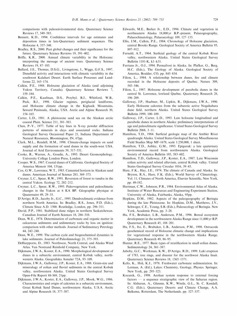
comparisons with paleoenvironmental data. Quaternary Science
Reviews 17, 549–585.
Bennett, K.D., 1994. Confidence intervals for age estimates and
deposition times in late-Quaternary sediment sequences. The
Holocene 4, 337–348.
Bradley, R.S., 2000. Past global changes and their significance for the
future. Quaternary Science Reviews 19, 391–402.
Briffa, K.R., 2000. Annual climate variability in the Holocene:
interpreting the message of ancient trees. Quaternary Science
Reviews 19, 87–105.
Bullard, J.E., Thomas, D.S.G., Livingstone, I., Wiggs, G.F.S., 1997.
Dunefield activity and interactions with climatic variability in the
southwest Kalahari Desert. Earth Surface Processes and Land-
forms 22, 165–174.
Calkin, P.E., 1988. Holocene glaciation of Alaska (and adjoining
Yukon Territory, Canada). Quaternary Science Reviews 7,
159–184.
Calkin, P.E., Kaufman, D.S., Przybyl, B.J., Whitford, W.B.,
Peck, B.J., 1998. Glacier regimes, periglacial landforms,
and Holocene climate change in the Kigluaik Mountains,
Seward Peninsula, Alaska, USA. Arctic and Alpine Research 30,
154–165.
Carter, L.D., 1981. A pleistocene sand sea on the Alaskan arctic
coastal Plain. Science 211, 381–383.
Chen, P.-Y., 1977. Table of key lines in X-ray powder diffraction
patterns of minerals in clays and associated rocks. Indiana
Geological Survey Occasional Paper 21, Indiana Department of
Natural Resources, Bloomington, IN, 67pp.
Clark, M.L., Rendell, H.M., 1998. Climate-change impacts on sand
supply and the formation of sand dunes in the south-west USA.
Journal of Arid Environments 39, 517–531.
Cooke, R., Warren, A., Goudie, A., 1993. Desert Geomorphology.
University College London Press, London.
Cooper, W.S., 1967. Coastal dunes of California. Geological Society of
America Memoir 104, 131pp.
Cox, G.W., Lawrence, W.T., 1983. Cemented horizon in Alaskan sand
dunes. American Journal of Science 283, 369–373.
Cwynar, L.C., Spear, R.W., 1991. Reversion of forest to tundra in the
central Yukon. Ecology 72, 202–212.
Cwynar, L.C., Spear, R.W., 1995. Paleovegetation and paleoclimatic
changes in the Yukon at 6 KA BP. G!eographie physique et
Quaternaire 49, 29–35.
D’Arrigo, R.D., Jacoby Jr., G.C., 1995. Dendroclimatic evidence from
northern North America. In: Bradley, R.S., Jones, P.D. (Eds.),
Climate Since A.D. 1500. Routledge, London, pp. 296–311.
David, P.P., 1981. Stabilized dune ridges in northern Saskatchewan.
Canadian Journal of Earth Sciences 18, 286–310.
Dean, W.E., 1974. Determination of carbonate and organic matter in
calcareous sediments and sedimentary rocks by loss on ignition:
comparison with other methods. Journal of Sedimentary Petrology
44, 242–248.
Dean, W.E., 1999. The carbon cycle and biogeochemical dynamics in
lake sediments. Journal of Paleolimnology 21, 375–393.
DeHarpporte, D., 1983. Northwest, North Central, and Alaska Wind
Atlas. Van Nostrand Reinhold Company, New York.
Dijkmans, J.W.A., Koster, E.A., 1990. Morphological development of
dunes in a subarctic environment, central Kobuk valley, north-
western Alaska. Geografiska Annaler 72A, 93–109.
Dijkmans, J.W.A., Galloway, J.P., Koster, E.A., 1988. Grain-size and
mineralogy of eolian and fluvial sediments in the central Kobuk
valley, northwestern Alaska. United States Geological Survey
Open-File Report 88-369, 21pp.
Dijkmans, J.W.A., Koster, E.A., Galloway, J.P., Mook, W.G., 1986.
Charactersistics and origin of calcretes in a subarctic environment,
Great Kobuk Sand Dunes, northwestern Alaska, U.S.A. Arctic
and Alpine Research 18, 377–387.
Edwards, M.E., Barker Jr., E.D., 1994. Climate and vegetation in
northeastern Alaska 18,000 yr B.P.-present. Palaeogeography,
Palaeoclimatology, Palaeoecology 109, 127–135.
Ellis, J.M., Calkin, P.E., 1984. Chronology of Holocene glaciation,
central Brooks Range. Geological Society of America Bulletin 95,
897–912.
Fernald, A.T., 1964. Surficial geology of the central Kobuk River
valley, northwestern Alaska. United States Geological Survey
Bulletin 1181-K, k1–k31.
Ferrians Jr., O.J., 1994. Permafrost in Alaska. In: Plafker, G., Berg,
H.C. (Eds.), The Geology of Alaska. Geological Society of
America, Boulder, CO, pp. 845–854.
Filion, L., 1984. A relationship between dunes, fire and climate
recorded in the Holocene deposits of Quebec. Nature 309,
543–546.
Filion, L., 1987. Holocene development of parabolic dunes in the
central St. Lawrence, lowland Quebec. Quaternary Research 28,
196–209.
Galloway, J.P., Huebner, M., Lipkin, R., Dijkmans, J.W.A., 1990.
Early Holocene calcretes from the subarctic active Nogahabara
dune field, northern Alaska. United States Geological Survey
Bulletin 1999, 100–109.
Galloway, J.P., Carter, L.D., 1993. Late holocene longitudinal and
parabolic dunes in northern Alaska: preliminary interpretations of
age and paleoclimatic significance. United States Geological Survey
Bulletin 2068, 3–11.
Hamilton, T.D., 1984. Surficial geologic map of the Ambler River
quadrangle Alaska. United States Geological Survey Miscellaneous
Field Studies Map MF-1678, scale 1:250,000, 1 sheet.
Hamilton, T.D., Ashley, G.M., 1993. Epiguruk: a late quaternary
environmental record from northwestern Alaska. Geological
Society of America Bulletin 105, 583–602.
Hamilton, T.D., Galloway, J.P., Koster, E.A., 1987. Late Wisconsin
eolian activity and related alluvium, central Kobuk valley. United
States Geological Survey Circular 1016, 39–43.
Hare, F.K., Hay, J.E., 1974. The climate of Canada and Alaska. In:
Bryson, R.A., Hare, F.K. (Eds.), World Survey of Climatology.
Vol. 11, Climates of North America, Elsevier Scientific, New York,
pp. 49-192.
Hartman, C.W., Johnson, P.R., 1984. Environmental Atlas of Alaska.
Institute of Water Resources and Engineering Experiment Station,
University of Alaska, Fairbanks, Alaska, 95pp.
Hopkins, D.M., 1982. Aspects of the paleogeography of Beringia
during the late Pleistocene. In: Hopkins, D.M., Matthews, J.V.,
Schweger, C.E., Young, S.B. (Eds.), Paleoecology of Beringia. New
York, Academic Press, pp. 3–28.
Hu, F.S., Brubaker, L.B., Anderson, P.M., 1996. Boreal ecosystem
development in the northwestern Alaska Range since 11,000 yr B.P.
Quaternary Research 45, 188–201.
Hu, F.S., Ito, E., Brubaker, L.B., Anderson, P.M., 1998. Ostracode
geochemical record of Holocene climatic change and implications
for vegetational response in the northwestern Alaska Range.
Quaternary Research 49, 86–95.
Hunter, R.E., 1977. Basic types of stratification in small eolian dunes.
Sedimentology 24, 361–387.
Jaboby, G.C., Workman, K.W., D’Arrigo, R.D., 1999. Laki eruption
of 1783, tree rings, and disaster for the northwest Alaska Inuit.
Quaternary Science Reviews 18, 1365–1371.
Kelts, K., Hs *u, K.J., 1978. Freshwater carbonate sedimentation. In:
Lerman, A. (Ed.), Lakes: Chemistry, Geology, Physics. Springer,
New York, pp. 295–323.
Kocurek, G., 1998. Aeolian system response to external forcing
factors F a sequence stratigraphic view of the Saharan region.
In: Alsharan, A., Glennie, K.W., Wintle, G.L., St. C. Kendall,
C.G. (Eds.), Quaternary Deserts and Climate Change, A.A.
Balkema, Rotterdam, The Netherlands. pp. 327–337.
D.H. Mann et al. / Quaternary Science Reviews 21 (2002) 709–731 729

Kocurek, G., Lancaster, N., 1999. Aeolian system sediment state:
theory and Mojave Desert Kelso dune field example. Sedimentol-
ogy 46, 505–515.
Kolstrup, E., Jorgensen, J.B., 1982. Older and younger coversand in
southern Jutland (Denmark). Bulletin of the Geological Society of
Denmark 30, 71–77.
Koster, E.A., Dijkmans, J.W.A., 1988. Niveo-aeolian deposits and
denivation forms, with special reference to the Great Kobuk Sand
Dunes, northwestern Alaska. Earth Surface Processes and Land-
forms 13, 153–170.
Koster, E.A., Galloway, J.P., Mook, W.G., 1986. Characteristics and
origin of calcretes in a subarctic environment, Great Kobuk Sand
Dunes, northwestern Alaska, USA. Arctic and Alpine Research 18,
377–387.
Koster, E.A., Galloway, J.P., Pronk, T., 1984. Photo-interpretation
map of surficial deposits and landforms of the Nogahabara Sand
Dunes and part of the Koyukuk lowland, Alaska, United States
Geological Survey Open-File Report 84–10.
Krishnaswami, S., Lai, D., 1978. Radionuclide limnochronology. In:
Lerman, A. (Ed.), Lakes: Chemistry, Geology, Physics. Springer,
New York, pp. 155–177.
Kuhry-Helmens, K.F., Koster, E.A., Galloway, J.P., 1985. Photo-
interpretation map of surficial deposits and landforms of the
Kobuk sand dunes and part of the Kobuk lowland, Alaska. United
States Geological Survey Open File Report 85–242.
Lancaster, N., 1995. Geomorphology of Desert Dunes. Routledge,
London.
Lea, P.D., 1990. Pleistocene periglacial eolian deposits in southwestern
Alaska: sedimentary facies and depositional processes. Journal of
Sedimentary Petrology 60, 582–591.
Lea, P.D., Waythomas, C.F., 1990. Late-Pleistocene eolian sand sheets
in Alaska. Quaternary Research 34, 269–281.
Leslie, L.D., 1989. Alaska climate summaries: a compilation of long-
term means and extremes at 478 Alaskan stations. Arctic
Environmental Information and Data Center. University of Alaska
Anchorage, Anchorage, Alaska, 478pp.
Loope, D.B., Swinehart, J.B., Mason, J.P., 1995. Dune-dammed
paleovalleys of the Nebraska Sand Hills: intrinsic versus climatic
controls on the accumulation of lake and marsh sediments.
Geological Society of America Bulletin 107, 396–406.
Madole, R.F., 1994. Stratigraphic evidence of desertification in the
west-central Great Plains within the past 1000 yr. Geology 22, 483–
486.
Mason, O.K., Jordan, J.W., 1993. Heightened North Pacific stormi-
ness during synchronous late holocene erosion of northwest Alaska
beach ridges. Quaternary Research 40, 55–69.
Mason, O.K., Jordan, J.W., Plug, L., 1995. Late Holocene storm and
sea-level history in the Chukchi Sea. In: Finkl, C.W. (Ed.),
Holocene Cycles: Climate, Sea Levels, and Sedimentation.
Journal of Coastal Research Special Publication Number 17,
pp. 173–180.
Maxwell, B., 1996. Recent climate patterns in the Arctic. In: Oechel,
W.C., Callaghan, T., Gilmanov, T., Holten, J.I., Maxwell, B.,
Molau, U., Sveinbjornsson, B. (Eds.), Global Change and Arctic
Terrestrial Ecosystems. Springer, New York, pp. 21–46.
McKenna-Neuman, C., 1993. A review of aeolian transport processes
in cold environments. Progress in Physical Geography 17, 137–155.
McKenna-Neuman, C., Gilbert, R., 1986. Aeolian processes and
landforms in glaciofluvial environments of southeastern Baffin
Island N.W.T., Canada. In: Nickling, W.G. (Ed.), Aeolian
Geomorphology. Proceedings of the 17th Annual Binghamton
Geomorphology Symposium. Allen and Unwin, Boston, pp. 220–
236.
Mock, C.J., Bartlein, P.J., Anderson, P.M., 1998. Atmospheric
circulation patterns and spatial climatic variability in Beringia.
International Journal of Climatology 18, 1085–1104.
Moritz, R.E., 1979. Synoptic Climatology of the Beaufort Sea Coast of
Alaska. Occasional Paper Number 30, Institute of Arctic and
Alpine Research, University of Colorado, Boulder, CO.
Moser, K.A., MacDonald, G.M., 1990. Holocene vegetation change at
treeline north of Yellowknife, Northwest Territories, Canada.
Quaternary Research 34, 227–239.
Muhs, D.R., Holliday, V.T., 1995. Evidence of active dune sand on the
Great Plains in the 19th century from accounts of early explorers.
Quaternary Research 43, 198–208.
Muhs, D.R., Maat, P.B., 1993. The potential response of eolian
sands to greenhouse warming and precipitation reduction on the
Great Plains of the USA. Journal of Arid Environments 25,
351–361.
Muhs, D.R., Stafford, T.W., Cowherd, S.D., Mahan, S.A., Kihl, R.,
Maat, P.B., Bush, C.A., Hehring, J., 1996. Origin of the late
Quaternary dune fields of northeastern Colorado. Geomorphology
17, 129–149.
Muhs, D.R., Stafford Jr., T.W., Swinehart, J.B., Cowherd, S.D.,
Mahan, S.A., Bush, C.A., Madole, R.F., Maat, P.B., 1997. Late
Holocene eolian activity in the mineralogically mature Nebraska
Sand Hills. Quaternary Research 48, 162–176.
Murton, J.B., Worsley, P., Gozdzik, J., 2000. Sand veins and wedges in
cold aeolian environments. Quaternary Science Reviews 19, 899–
922.
Newman, J.E., Branton, C.I., 1972. Annual water balance and
agricultural development in Alaska. Ecology 53, 513–519.
O’Connor, P.W., Thomas, D.S.G., 1999. The timing and environ-
mental significance of late quaternary linear dune development in
western Zambia. Quaternary Research 52, 44–55.
Overpeck, J., et al., 1997. Arctic environmental change of the last four
centuries. Science 278, 1251–1256.
Patric, J.H., Black, P.E., 1968. Potential evaporation and climate in
Alaska by Thornthwaite’s classification. United States Department
of Agriculture Forest Service Research Paper PNW-71. Pacific
Northwest Forest and Range Experimental Station, Institute of
Northern Forestry, Juneau, AL.
Pienitz, R., Smol, J.P., MacDonald, G.M., 1999. Paleoliminological
reconstruction of holocene climatic trends from two boreal treeline
lakes, Northwest Territories, Canada. Arctic, Antarctic, and
Alpine Research 31, 82–93.
Pienitz, R., Smol, J., Last, W.M., Leavitt, P.R., Cumming, B.F., 2000.
Multi-proxy Holocene paleoclimatic record from a saline lake in
the Canadian subarctic. The Holocene, in press.
PRISM, 2000. Parameter-elevation regressions on independent slopes
models for Alaska. http://www. ocs. orst.edu/prism/stat products/
ak maps. html. Oregon Climate Service, 326 Strand Agriculture
Hall, Oregon State University, Corvallis, OR97331.
Rabus, B.T., Echelmeyer, K.A., 1998. The mass balance of McCall
Glacier, Brooks Range, Alaska; its regional relevance and
implications for climate change in the Arctic. Journal of Glaciology
44, 333–351.
Racine, C.H., 1976. Flora and vegetation. In: Melchior, H.R., (Ed.),
Biological Survey of the Proposed Kobuk Valley National
Monument. Final Report to the United States National Park
Service, Alaska Cooperative Park Studies Unit, University of
Alaska, Fairbanks, Alaska. pp. 39–139,
Raup, H.M., Argus, G.W., 1982. The Lake Athabasca sand dunes of
northern Saskatchewan and Alberta, Canada. I. The land and
vegetation. National Museum of Natural Sciences Publications in
Botany, No. 12, 96pp. National Museums of Canada, Ottawa,
Canada.
Sepp.all.a, M., 1995. Deflation and redeposition of sand dunes in
Finnish Lapland. Quaternary Science Reviews 14, 799–809.
Stuiver, M., et al., 1998. INTCAL98 radiocarbon age calibration,
24,000–0 cal BP: Radiocabon 40, 1041–1083.
D.H. Mann et al. / Quaternary Science Reviews 21 (2002) 709–731730

Tchakerian, V.P., 1994. Paleoclimatic interpretation from desert dunes
and sediments. In: Abrahams, A.D., Parsons, A.J. (Eds.),
Geomorphology of Desert Environments. Chapman and Hall,
London, pp. 631–643.
van Vliet-Lano.e, B., Sepp.al.a, M., K.ayhk .o, J., 1993. Dune dynamics
and cryoturbation features controlled by Holocene water level
change, Hietatievat, Finnish Lapland. Geologie en Mijnbouw 72,
211–224.
Wolfe, S.A., Muhs, D.R., David, P.P., McGeehin, J.P., 2000.
Chronology and geochemistry of late holocene eolian deposits in
the Brandon Sand Hills, Manitoba, Canada. Quaternary Interna-
tional 67, 61–74.
Wright, H.E., Mann, D.H., Glaser, P.H., 1984. Piston corers for peat
and lake sediments. Ecology 65, 657–659.
Young, S.B., Racine, C.H., 1977. Vegetational and floristic analysis
and discussion of the Quaternary environment of the Kobuk valley.
Report to the United States National Park Service, Center for
Northern Studies, Wolcott, VT, 47pp.
D.H. Mann et al. / Quaternary Science Reviews 21 (2002) 709–731 731