
Holderness Inshore MCZ 2018 Survey Report
56
First published 9 April 2021 www.gov.uk/natural-england Natural England Commissioned Report NECR303 Holderness Inshore MCZ 2018 Survey Report
Transcript of Holderness Inshore MCZ 2018 Survey Report

First published 9 April 2021
www.gov.uk/natural-england
Natural England Commissioned Report NECR303
Holderness Inshore MCZ 2018 Survey Report

Foreword Natural England commission a range of reports from external contractors to provide evidence and advice to assist us in delivering our duties. The views in this report are those of the authors and do not necessarily represent those of Natural England.
Background Following designation, Natural England started a baseline monitoring programme across all marine protected areas. This report was commissioned as part of an inshore benthic marine survey of the Holderness Inshore MCZ.
This report should be cited as: Alexander, C., Meaton, N. and Pryor, K. 2019. Holderness Inshore MCZ 2018 Survey Report. Natural England Commissioned Reports, Number 303.
This report is published by Natural England under the Open Government Licence - OGLv3.0 for public sector
information. You are encouraged to use, and reuse, information subject to certain conditions. For details of the licence visit Copyright. Natural England photographs are only available for non commercial purposes. If any other
information such as maps or data cannot be used commercially this will be made clear within the report. ISBN 978-1-78354-604-6
© Natural England and other parties 2021
Natural England Project Manager – Mike Fraser, Senior Specialist [email protected] Contractor - Charlotte Alexander, Nick Meaton and Katie Pryor, Environment Agency
Keywords – Marine, Inshore seabed survey, video survey, grab survey, MPA, MCZ
Further information This report can be downloaded from the Natural England Access to Evidence Catalogue: http://publications.naturalengland.org.uk/ . For information on Natural England publications contact the Natural England Enquiry Service on 0300 060 3900 or e-mail [email protected].


Holderness Inshore MCZ 2018 Survey Report
Project Code: MB0129 Authors: Charlotte Alexander, Nick Meaton and Katie Pryor Version: 1
Date: 12th September 2019

Holderness Inshore MCZ 2018 Survey Report ii
Document Control
Title: Holderness Inshore MCZ 2018 Survey Report
Version Control History Authors Date Comment Version
C. Alexander, N. Meaton and K. Pryor
21/12/2018 Submitted to Cefas for Q 0.1
C. Alexander, N. Meaton and K. Pryor
20/05/2019 Reviewed by Tammy Noble-James (Cefas) and Mark Etherton-Nicoll (Cefas).
0.1
C. Alexander, N. Meaton and K. Pryor
12/09/2019 Comments addressed. V1 submitted to MPAG for QA.
1

Holderness Inshore MCZ 2018 Survey Report iii
Holderness Inshore MCZ 2018 Survey Report
Project Code: MB0129
Authors: Charlotte Alexander, Nick Meaton and Katie Pryor
Produced by: Environment Agency Estuarine and Coastal Monitoring and Assessment Service Kingfisher House Orton Goldhay Peterborough Cambridgeshire PE2 5ZR Email: [email protected] Website: www.gov.uk/environment-agency

Holderness Inshore MCZ 2018 Survey Report iv
Acknowledgements During the survey planning phase for the Holderness Inshore MCZ, the following marine specialists generously contributed their valuable time and expertise:
B. Green Natural England/Environment Agency Marine Technical Specialist
M. Marsh Natural England Marine Ecology Environmental Specialist
C. Miller Natural England/Environment Agency Marine Technical Specialist
T. Smith North Eastern IFCA Senior Scientific Officer
M. Young Natural England Senior Marine Monitoring Specialist

Holderness Inshore MCZ 2018 Survey Report v
Table of Contents Holderness Inshore MCZ 2018 Survey Report ............................................................ i Document Control ....................................................................................................... ii Acknowledgements .................................................................................................... iv
1. Introduction ........................................................................................................... 8
1.1 Site Description ............................................................................................. 8
1.2 Survey Aim and Objectives ............................................................................. 11
1.3 Survey Team................................................................................................... 12
2. Survey Design and Methods ............................................................................... 13
2.1 Survey Design and Planning Phase ................................................................ 13
2.2 Sample Collection Methodology ..................................................................... 16
2.2.1 Habitat characterisation and in-situ benthic epifauna identification ......... 16
2.2.2 Broadscale Habitat Groundtruthing ......................................................... 17
3. Survey Narrative.................................................................................................. 20
4. Data Acquisition .................................................................................................. 23
4.1 Sample collection summary ........................................................................... 23
4.2 Evidence of anthropogenic impacts ............................................................... 27
5. References .......................................................................................................... 28
6. General List of Abbreviations .............................................................................. 29
7. Annexes .............................................................................................................. 30
7.1 Coastal Survey Vessel General Information .................................................. 30
7.2 Survey Equipment .......................................................................................... 31
7.2.1 Navigation and Positioning ...................................................................... 31
7.2.2 SeaSpyder Drop Camera System ........................................................... 33
7.2.3 Camera Setup ......................................................................................... 35
7.3 EA underwater video procedure_version 2.5 (STR Systems) ........................ 36
7.4 Underwater Visibility Scale ............................................................................ 39
7.5 MCZ Video logsheet ...................................................................................... 40
7.6 Video Survey Metadata .................................................................................. 41
7.7 Grab Survey Metadata ................................................................................... 44

Holderness Inshore MCZ 2018 Survey Report vi
Tables Table 1. Designation status and the current General Management Approach (GMA) for the features of conservation importance present in the Holderness Inshore Marine Conservation Zone.. ................................................................................................. 10
Table 2. Sediment grade terms and size limits. ....................................................... 19
Table 3. Summary of equipment deployments during the 2018 Holderness Inshore Marine Conservation Zone monitoring survey. ......................................................... 20
Table 4. Summary of samples collected during the 2018 Holderness Inshore Marine Conservation Zone monitoring survey. ..................................................................... 23

Holderness Inshore MCZ 2018 Survey Report vii
Figures Figure 1. Location of the Holderness Inshore Marine Conservation Zone (MCZ) in the context of other MCZs off the East of England. ........................................................ 10
Figure 2. Coastal survey vessel Humber Guardian, operated by Briggs Marine. .... 12
Figure 3. Holderness Inshore MCZ 2018 survey plan showing the indicative Mini-Hamon Grab sampling stations. ............................................................................... 14
Figure 4. STR SeaSpyder drop camera system being deployed from the stern of the coastal survey vessel. .............................................................................................. 16
Figure 5. Mini-Hamon Grab, and equipment for sieving benthic fauna samples. .... 18
Figure 6. Simplified sediment classification of the Folk triangle for UK SeaMap ..... 18
Figure 7. Drop Down Video (DDV) camera data acquired during the Holderness Inshore MCZ 2018 Summer survey.......................................................................... 25
Figure 8. Mini-Hamon Grab data acquired during the Holderness Inshore MCZ 2018 Summer survey ........................................................................................................ 26
All figures in the following report are subject to: Environment Agency copyright 2018. All rights reserved. Ordnance survey data layers: © Crown copyright and database rights 2018 Ordnance Survey 100024198. UK Hydrographic Office Admiralty Charts: © Crown Copyright, 2012. All rights reserved. License No. EK001- 2012120. NOT TO BE USED FOR NAVIGATION.

Holderness Inshore MCZ 2018 Survey Report 8
1. Introduction Following the introduction of the Marine and Coastal Access Act in 2009, the UK Government is creating an ecologically coherent network of Marine Conservation Zones (MCZs) in British waters. The MCZ network will exist alongside other Marine Protected Areas (MPAs), including Special Areas of Conservation (SACs), Special Protection Areas (SPAs), Sites of Special Scientific Interest (SSSIs) and Ramsar sites to help conserve marine biodiversity, in particular habitats and species of national importance.
Forming part of this network, the Holderness Inshore MCZ was formally designated on the 17th January 20161. The site has been created to protect important intertidal sand and mud habitats, as well as a range of subtidal sediment and rock features. Following designation, Natural England* have started a programme of monitoring and the initial datasets gathered will be used, along with all other available information, to assess the condition of the features in the site using Natural England marine condition assessment methodology. The method uses attributes set out in the sites supplementary advice on conservation objectives to form an overall decision about the condition of the features, and this work will inform the assessment of specific attributes. The results from the condition assessment will inform future monitoring planning and management of the site.
*inshore Statutory Nature Conservation Body
1.1 Site Description
The Holderness Inshore MCZ is located north of the Humber Estuary mouth (Figure 1). The site boundary covers an area of approximately 309 km2 along the East Riding coast from Spurn Point to Skipsea and extends approximately 3.3 nm offshore. Spurn Point, in the south of the MCZ is a geological feature demonstrating an example of an ‘active spit system’ which extends across the mouth of the Humber Estuary (Natural England, 2016).
The seabed is composed of a variety of habitats including rock, sand, mud and sediment, which helps to support a diverse range of organisms such as red algae, sponges and encrusting fauna (Natural England, 2016). The various habitat types also support commercially significant crustaceans, such as edible crabs (Cancer pagurus), velvet swimming crabs (Necora puber) and lobsters (Homarus gammarus) as well as
1 This report was produced before the Tranche 3 designation announcement on 31st May 2019 and as such all content was correct at the time of writing.

Holderness Inshore MCZ 2018 Survey Report 9
pelagic species, European eel (Anguilla anguilla), dab (Limanda limanda) and wrasse (Natural England, 2016).

Holderness Inshore MCZ 2018 Survey Report 10
Figure 1. Location of the Holderness Inshore Marine Conservation Zone (MCZ) in the context of other MCZs off the East of England.
Within the Holderness Inshore MCZ there are four MPAs that overlap the southern tip of the site. These are; Spurn National Nature Reserve (NNR), Humber Estuary Ramsar, Humber Estuary SAC and Humber Estuary SPA.
The Features of Conservation Importance (FOCI) protected under the MCZ designation order are presented in Table 1, alongside the general management approach. The survey planned here will focus on those features indicated by blue shading (Table 1). The current North Eastern Inshore Fisheries Conservation Authority (IFCA) management measures for the Holderness Inshore MCZ cover both temporal and spatial restrictions of commercial and recreational fishing activities. In particular, the Regulation of Shellfish beds which allows for the closure of shellfish beds to protect from the disturbance of fishing activities. Further information can be found on North Eastern IFCA website: http://www.ne-ifca.gov.uk/legislation-and-byelaws/.
Table 1. Designation status and the current General Management Approach (GMA) for the features of conservation importance present in the Holderness Inshore Marine Conservation Zone. The survey planned here will focus on those features indicated by blue shading.
Feature Type Features Present Designated GMA
Broadscale Habitat (BSH)
Intertidal sand and muddy sand Maintain
Moderate energy circalittoral rock Maintain
High energy circalittoral rock Maintain
Subtidal coarse sediment Maintain
Subtidal mixed sediments Maintain
Subtidal sand Maintain
Subtidal mud Maintain
Feature of Geological
Interest Spurn head (subtidal) Maintain

Holderness Inshore MCZ 2018 Survey Report 11
1.2 Survey Aim and Objectives
To undertake a survey of Holderness Inshore MCZ designated features (Table 1) to obtain new evidence which can be used by Natural England, alongside all other relevant information, to detect change over time and ascribe condition to inform future monitoring and management measures.
Objective: Collect data to investigate structure, function and distribution of MCZ features (Table 1).
The data acquired will:
a.) Provide data for a monitoring time series. b.) Provide information for condition assessment of the Broadscale Habitats. c.) Improve understanding of the MCZ communities and their distribution. d.) Inform site management decisions.
A survey will be undertaken to assess the relative extent, distribution and community composition of the sediment features based on a stratified survey design of 110 grab and drop down video (DDV) stations as shown in Figure 3.

Holderness Inshore MCZ 2018 Survey Report 12
1.3 Survey Team The Holderness Inshore MCZ survey took place between the 10th January and 7th August 2018. The survey team comprised marine monitoring specialists from the Environment Agency, Natural England and APEM. The coastal survey vessel Humber
Guardian, staffed and operated by Briggs Marine (Figure 2, Annex 7.1) was used to conduct the survey work reported here.
Figure 2. Coastal survey vessel Humber Guardian, operated by Briggs Marine.

Holderness Inshore MCZ 2018 Survey Report 13
2. Survey Design and Methods
2.1 Survey Design and Planning Phase
Grab Survey Design
A verification survey was undertaken at Holderness Inshore MCZ in 2012, but only three successful grab samples were collected (Fraser and Godsell, 2013). Therefore, a densely sampled survey inside the MCZ was considered a suitable survey design, to provide as much information as possible on the distribution of Broadscale Habitats across the site. 92 0.1 m2 Mini-Hamon Grab stations were selected using a 2 km triangular grid across the site. A further 18 grab stations were selected within the inshore strip of the MCZ, with their locations stratified by subtidal sediment presence as mapped from the 2011 and 2016 Coastal Programme surveys. The grab sampling design for this survey was therefore a combination of 2 km triangular grid and stratified sampling, with 110 grab stations in total (Figure 3). No contaminant samples were planned to be collected during this survey.

Holderness Inshore MCZ 2018 Survey Report 14
Figure 3. Holderness Inshore MCZ 2018 survey plan showing the target Mini-Hamon Grab sampling stations.

Holderness Inshore MCZ 2018 Survey Report 15
Drop Down Video Survey Design
A verification survey was undertaken at Holderness Inshore MCZ in 2012, but only 21 video tows where visibility was poor were collected (Fraser and Godsell, 2013).
Station selection for the Drop Down Video (DDV) survey was planned after the completion of the grab survey, so no DDV survey maps were produced at the planning stage. Stations would be located where it wasn’t possible to obtain a viable grab sample. Due to the poor visibility historically noted at the site (Fraser and Godsell, 2013), a camera system with a freshwater lens was deemed most suitable.
Marine specialists from the Environment Agency and Natural England reviewed the plan. The following hazards were identified from the UKHO Admiralty charts: gas and high voltage power lines, outfalls, underwater obstructions and the firing range near Hornsea. Sampling stations were relocated to avoid these hazards as far as possible. A ‘Notification of an exempt activity form’ for ‘samples and investigations’ was submitted to the Marine Management Organisation prior to the survey being carried out.

Holderness Inshore MCZ 2018 Survey Report 16
2.2 Sample Collection Methodology
2.2.1 Habitat characterisation and in-situ benthic epifauna identification
Drop video camera equipment (Annex 7.2.2 and 7.2.3) was deployed in accordance with the MESH ‘Recommended Operating Guidelines (ROG) for underwater video and photographic imaging techniques’ (Coggan et al., 2007). The Subsea Technology & Rentals (STR) SeaSpyder camera system was deployed from the stern of the survey vessel, as shown in Figure 4. Real time navigation data acquisition and manual position fixing when the gear contacted the seabed was captured via Trimble® HYDROpro™ software and logged by the survey officer. The mid-point of the vessel’s
stern gantry was used as the default offset for position fixing (see Annex 7.2.1 for further details). Video files and digital still images were transmitted via the sea cable to be captured and saved directly to a computer in the survey cabin. The video footage was annotated with time and position using a GPS (SIMRAD MX512 DGPS) referenced video overlay (uncorrected position data). Images of the seabed were captured approximately every 10 to 15 metres over a distance of > 150 metres. Extra photographs were taken in heterogeneous areas of BSH and if particular habitat/species FOCI were observed. If a BSH habitat boundary was detected towards the end of a tow, the camera deployment was extended to confirm the change. The drop frame depth was controlled via a winch operator receiving instructions from the survey cabin. For further deployment details please see the ‘EA underwater video procedure_version 2.5’ in Annex 7.3.
Figure 4. STR SeaSpyder drop camera system being deployed from the stern of the coastal survey vessel.

Holderness Inshore MCZ 2018 Survey Report 17
During each drop camera deployment, a member of the survey team continuously monitored the real-time video feed, recording general station notes, underwater visibility (Annex 7.4), habitat information and fauna observations. Please see Annex 7.5 for a worked example of the video logsheet.
2.2.2 Broadscale Habitat Groundtruthing
A Mini-Hamon Grab (Figure 5), with a sampling area of 0.1 m2, was deployed from the stern gantry of the vessel to collect sediment from the seabed, as described by Ware and Kenny (2011). Sampling positions were recorded (fixed) using Hydropro data acquisition software when the gear contacted the seabed, with the mid-point of the vessel’s stern gantry being used as the default offset for position fixing (see Annex 7.2.1 for further details).
Once recovered, the sample was emptied into a suitable container, photographed, and the sample volume measured. A minimum of three attempts was made at each station to obtain a valid grab sample before the station was abandoned. A sample volume of 5 litres was required to qualify as a valid sample. Samples of < 5 litres were ordinarily discarded. However, when it was difficult to obtain a valid sample, a sample with < 5 litres of material was retained at the discretion of the lead scientist if it was deemed representative across all attempts made at that station. For valid samples, a small scoop was used to remove a sub-sample (approx. 500 ml) of sediment for particle size analysis (PSA). The remaining sample was washed over a 1 mm sieve to retain the faunal fraction (Figure 5), photographed and preserved with a buffered 4 % formaldehyde solution for transfer ashore to a specialist laboratory for analysis.
If the volume of sediment collected was insufficient for faunal analysis in each grab attempt made at a station, a photograph was taken and if possible, material removed for PSA. The station was then abandoned.

Holderness Inshore MCZ 2018 Survey Report 18
Figure 5. Mini-Hamon Grab (left), and equipment for sieving benthic fauna samples (right).
Sediment descriptions were recorded for each sample collected. For consistency across all the MCZ benthic habitat surveys, these were based on a pictorial field guide produced by Cefas marine sedimentologists, a modified Folk seabed sediment classification system (Long, 2006) (Figure 6) and the Wentworth Scale (Table 2). .
Figure 6. Simplified sediment classification of the Folk triangle for UK SeaMap (Long, 2006).

Holderness Inshore MCZ 2018 Survey Report 19
Table 2. Sediment grade terms and size limits (Wentworth, 1922).
Size Grade Terms > 256 mm Boulder > 64 - 256 mm Cobble 4 - 64 mm Pebble

Holderness Inshore MCZ 2018 Survey Report 20
3. Survey Narrative The Holderness Inshore MCZ grabbing survey was carried-out from the MV Humber
Guardian over the course of six ‘on-task’ days beginning on the 10th January 2018 and concluding on the 7th April 2018. One further ‘on-task’ day was allocated to DDV survey work on the 7th August 2018.
Table 3. Summary of equipment deployments during the 2018 Holderness Inshore Marine Conservation Zone survey.
Equipment Dates Duration Mini-Hamon Grab deployments 10th and 11th January
30th and 31st January 4th April and 7th April
six days
Drop camera deployments 7th August one day
The initial plan was for grab operations to be completed during the second week of January. To this end, survey personnel travelled to the vessel in Grimsby on Tuesday 9th January 2018 and survey gear was transferred on board the following morning.
Once this process was complete, the vessel sailed from Grimsby Fish Docks at 08:55 UTC on Wednesday 10th January, bound for the southern edge of the MCZ. Shortly after departure, a general safety induction was provided for each new member of the survey team and upon arrival at the survey area, a toolbox talk was held with all personnel in attendance. This included a briefing on the day’s survey activities and
provided the opportunity to discuss any questions or concerns about the proposed work and the expected conditions. This process was followed for each day of survey operations.
Grabbing started at 10:50 UTC off Easington and over the course of the next two hours, sampling was attempted at seven stations. Weather conditions were good with light and variable winds, but viable infauna samples were collected at only three of these stations. However, a total of six samples were collected for PSA.
At around 12:55 UTC, the vessel’s starboard alternator failed, forcing the suspension
of survey activities. This fault, which prevented charging of the battery, could not be repaired at sea so it was necessary to return to Grimsby because of the risk of the starboard engine failing when electrical power was lost. The vessel berthed in Grimsby at 15:25 UTC where an engineer attended and identified the part(s) for replacement.
The following morning, Thursday 11th January, the engineer returned and replaced the alternator. Again, weather conditions were favourable with northerly or north-westerly force 2-3 winds and the vessel was ready to sail by 12:10 UTC, arriving at the survey area off Spurn Head by 13:10 UTC. For the next three hours, grabbing was carried out at 16 stations, with infauna samples collected at eight of these and PSA samples at 15.

Holderness Inshore MCZ 2018 Survey Report 21
At around 16:30 UTC it became apparent that the Mini-Hamon Grab bucket welds were starting to fail, likely caused by the coarse substratum. The damage caused sample material to be lost each time the grab was retrieved, so survey operations were again suspended and the vessel steamed back to Grimsby, berthing at 18:15 UTC. The grab with its associated survey gear were then craned ashore for repair by local contractors and the vessel was tasked to other survey activities.
Following repair of the grab, survey work on the MCZ was resumed on Tuesday 30th January. Humber Guardian left Grimsby Fish Docks at 08:35 UTC after survey gear had been transferred aboard and arrived at the south end of the MCZ at 09:50 UTC. With south-westerly force 3-4 winds and a slight sea state, grabbing operations were conducted at 24 station during the next six hours and 20 minutes. Five infauna and 23 PSA samples were collected. The vessel left the survey area at 16:10 UTC and berthed in Grimsby at 18:20 UTC.
The following day, Wednesday 31st January, winds remained from the south-west and the vessel sailed from Grimsby at 07:50 UTC, arriving on station near Kilnsea at 08:20 UTC. Grab sampling was then carried out until 18:50 UTC with six infauna and 23 PSA samples collected at the 25 stations visited. Humber Guardian berthed in Grimsby at around 19:50 UTC, at which point about 65% of the stations had been surveyed.
Winds for the subsequent day were forecast to be westerly, veering north-westerly later, force 5-7 with the sea state increasing from slight to rough. These conditions were unsuitable for safe deployment of the survey gear, so the vessel was tasked to other activities.
In the latter part of February, Great Britain and Ireland were affected by a prolonged Arctic anticyclonic weather system which brought snowfall and storm force easterly winds. This, along with the return of strong easterly winds in the latter half of March meant it was to be April before the next opportunity to complete the grabbing presented itself.
On Wednesday 4th April, survey gear was again transferred on board the Humber
Guardian and the vessel departed from Grimsby fish docks at 08:30 UTC arriving in the survey area off Spurn Head at 09:35 UTC. With southerly or south-easterly force 4 to 5 winds, the sea state was somewhat marginal for Mini-Hamon Grab operations, but it was decided to proceed with caution and review conditions throughout the day. The team managed to complete around six hours of grabbing at a further 20 stations. Only a single viable infauna sample could be collected, although 16 PSA samples were retrieved. Survey operations ceased at 15:45 UTC and the vessel returned to Grimsby by 18:05 UTC.
A strong wind warning was issued for Thursday 5th April, with winds forecast to become northerly force 6 to gale 8, veering north-westerly force 4 or 5 then becoming variable force 3 or 4 later. Although it was hoped that a window may present itself to complete the grabbing operations, the vessel remained down-weathered in port throughout the day. The following day conditions were only suitable for alternative work in the Humber estuary and the vessel was tasked accordingly.
Holderness Inshore MCZ 2018 Survey Report 22
Conditions had improved by Saturday 7th April, with force 1-3 winds generally from the north-east. Humber Guardian sailed from Grimsby at 07:35 UTC, arriving in the survey area off Aldbrough at 10:30 UTC. Over the next five hours the remaining 18 stations were visited. It was not possible to collect a viable infauna sample at any station. However, 15 samples were collected for PSA. Grabbing operations within the MCZ survey area were finally concluded at 15:15 UTC and the vessel berthed back in Grimsby at 18:20 UTC prior to survey gear being transferred ashore.
In total, grabbing operations at the 110 Holderness Inshore MCZ stations took 28 hours and 45 minutes, with a further 24 hours and 25 minutes being used for transit to and from the survey area.
On Saturday 4th August, the Subsea Technology Rentals (STR) Ltd. ‘SeaSpyder’ drop
camera was delivered to Humber Guardian in Hartlepool Marina where it was set up and tested for deployment in the Runswick Bay (RNSB) MCZ. After completion of this work the camera system was available for half a day whilst the vessel transited from Hartlepool to Grimsby. As the favourable weather conditions and underwater visibility which had allowed successful completion of the RNSB survey persisted, the camera was used for as many stations as possible in the Holderness Inshore MCZ en route.
Humber Guardian departed from Hartlepool Marina at around 04:00 UTC on Tuesday 7th August and arrived on the MCZ at 09:50 UTC. Video and stills footage was collected at four stations with excellent or good underwater visibility at each. Survey operations were concluded at 11:25 UTC and the vessel berthed in Grimsby Fish Docks at 13:30 UTC. The camera system was subsequently down-rigged and transferred ashore for delivery back to STR Ltd.

Holderness Inshore MCZ 2018 Survey Report 23
4. Data Acquisition
4.1 Survey plan changes
For five of the grab stations (HLIN043, HLIN044, HLIN104, HLIN107 and HLIN108) a variant of the grab methodology was followed. PSA and infauna samples were collected separately as it was difficult to find viable samples with sufficient material for analysis. At each of the five grab stations where this was followed, the sediment was visually assessed to ensure consistency across the independent PSA and infauna samples. It was decided by the Scientist in Charge that the removal of material for PSA would have reduced the infauna sample volume significantly, resulting in no data being obtained.
Following the successful completion of the grab survey 11 stations (HLIN14, 20, 24, 31, 40, 55, 60, 67, 71, 97 and 102) were selected for the DDV survey. These were stations where no successful grab (infauna or PSA) sample was obtained. Due to the small number of DDV stations and the size of the MCZ, Natural England decided that it was not cost-effective to survey those stations using a freshwater lens camera system. Instead, the survey team made use of the extended calm conditions in summer 2018 and an opportunistic survey of four stations was completed using the STR SeaSpyder camera (Annex 7.2.2 and 7.2.3) during a vessel passage period. Due to further resource reprioritisation by Natural England, the remaining seven DDV stations were not surveyed.
4.1 Sample collection summary
Samples collected during the 2018 Holderness Inshore MCZ survey are summarised in Table 4.
Table 4. Summary of samples collected during the 2018 Holderness Inshore Marine Conservation Zone survey.
Equipment Data Type No. of samples
Drop Down Video Video and still images 4 videos, 59 images
Mini-Hamon Grab Infauna and PSA 18 PSA only 76
Infauna only 5 Epibiota (Rock) 1 Epibiota (Rock w. Sabellaria sp.) 1
Video footage and digital photographs of the seabed were captured at four stations within the Holderness Inshore MCZ boundary (Figure 7). EUNIS Level 3 BSH

Holderness Inshore MCZ 2018 Survey Report 24
classifications and species identifications will be assigned to each station following detailed independent analysis of the usable video footage and stills.
Viable grab samples were successfully recovered from across the survey area. Samples for both infaunal analysis and PSA were collected at 18 stations, using the Mini-Hamon Grab (Figure 8). At 76 stations, the quantity of sediment collected was only sufficient for PSA. 11 stations (HLIN014, HLIN020, HLIN024, HLIN031, HLIN040, HLIN055, HLIN060, HLIN067, HLIN071, HLIN097 and HLIN102) selected for groundtruthing yielded only discards. Definitive classification of habitat features present was not possible prior to the results of the more detailed sample analyses carried out in the laboratory being available.

Holderness Inshore MCZ 2018 Survey Report 25
Figure 7. Drop Down Video (DDV) camera data acquired during the Holderness Inshore MCZ 2018 Summer survey, mapped over interpreted Broadscale Habitat data from the 2013 verification survey (Natural England, 2018).
MCZ Boundary

Holderness Inshore MCZ 2018 Survey Report 26
Figure 8. Mini-Hamon Grab data acquired during the Holderness Inshore MCZ 2018 Summer survey, mapped over interpreted Broadscale Habitat data from the 2013 verification survey (Natural England, 2018).

Holderness Inshore MCZ 2018 Survey Report 27
4.2 Evidence of anthropogenic impacts
No anthropogenic impacts were identified during the survey within the Holderness Inshore MCZ.

Holderness Inshore MCZ 2018 Survey Report 28
5. References Coggan, R., Mitchell, A., White, J. and Golding, N. (2007). Recommended operating guidelines (ROG) for underwater video and photographic imaging techniques. Mapping European Seabed Habitats (MESH) video working group report v.11.2 [online]. Available from: http://www.emodnet-seabedhabitats.eu/PDF/GMHM3_Video_ROG.pdf [Accessed 30/10/2018]. Fraser, M. and Godsell, N. (2013). Holderness Inshore rMCZ survey report. Environment Agency. 70 pp. Long, D. (2006). BGS detailed explanation of seabed sediment modified folk classification. Mapping European Seabed Habitats (MESH) project document [online]. Available from: https://www.researchgate.net/publication/284511408_BGS_detailed_explanation_of_seabed_sediment_modified_folk_classification [Accessed 30/10/2018]. Natural England. (2016). Holderness Inshore MCZ Factsheet. Natural England [online]. Available from: https://assets.publishing.service.gov.uk/government/uploads/system/uploads/attachment_data/file/492320/mcz-holderness-factsheet.pdf [Accessed 30/10/2018]. Natural England. (2017). Designated Sites View, Holderness Inshore MCZ. Natural England [online]. Available from: https://designatedsites.naturalengland.org.uk/SiteList.aspx?siteName=Holderness%20Inshore&countyCode=&responsiblePerson=&DesignationType=All [Accessed 30/10/2018]. Natural England. (2018). Internal Marine Data Release - June 2018. Internal Geographic Information package. North Eastern IFCA. (2018). NEIFCA Legislation and Byelaws. North Eastern IFCA [online]. Available from: http://www.ne-ifca.gov.uk/legislation-and-byelaws/ [Accessed 26/11/2018]. Ware, S.J. and Kenny, A.J. (2011). Guidelines for the Conduct of Benthic Studies at Marine Aggregate Extraction Sites (2nd Edition). Marine Aggregate Levy Sustainability Fund, 80 pp. Wentworth, C.K. (1922). A scale of grade and class terms for clastic sediments. The
Journal of Geology 30, 377-392.

Holderness Inshore MCZ 2018 Survey Report 29
6. General List of Abbreviations BSH Broadscale Habitat Cefas Centre for Environment, Fisheries and Aquaculture Science CHP Civil Hydrography Programme CS Camera Sledge CSV Coastal Survey Vessel DC Drop Video Camera Defra Department for Environment, Food and Rural Affairs DG Day Grab EA Environment Agency ECMAS Estuarine and Coastal Monitoring & Assessment Service ENG Ecological Network Guidance FOCI Features Of Conservation Importance IFCA Inshore Fisheries and Conservation Authority MCZ Marine Conservation Zone MESH Mapping European Seabed Habitats PSA Particle Size Analysis REC Regional Environmental Characterisation RSG Regional Stakeholder Group SAC Special Area of Conservation SAD Site Assessment Document SNCB Statutory Nature Conservation Body SOP Standard Operating Procedure SPA Special Protection Area SSSI Site of Special Scientific Interest STR Subsea Technology and Rentals UTC Coordinated Universal Time

Holderness Inshore MCZ 2018 Survey Report 30
7. Annexes
7.1 Coastal Survey Vessel General Information
Humber Guardian
General Information Main Equipment Length: 18.3 m Main Engines: 2 x Volvo D9-MH 261 bkW @ 2200 rpm. Twin Disc
MGX-5075 integral vee-drive Beam: 6.3 m Draft (baseline): 1.15 m Crew: 2 Draught (skegs): 1.65 m Scientific Officers: Up to 10 Displacement (light ship): 22 T Accommodation: 3 x twin cabins and mess Displacement (full load): 30 T Data network to share information around vessel Service Speed: 16 knots Wet lab/bench for processing water, sediment and ecology
samples Maximum Speed: 18 knots Fridge/freezer for sample storage Dry lab space for two computers and data processing Large aft deck working area A frame – 2 T SWL Double Independent Drum Trawl Winch – 2 T SWL Hydraulic crane
Briggs Marine and Environmental Services Ltd.
Seaforth House, Seaforth Place, Burtisland, Fife, KY3 9AX.
Tel: +44(0)1592 872939
Email: [email protected]
Website: www.briggsmarine.com

Holderness Inshore MCZ 2018 Survey Report 31
7.2 Survey Equipment
7.2.1 Navigation and Positioning
Trimble® HYDROpro™ software is utilised for real-time navigation and survey data acquisition.
Trimble® HYDROpro™ software screen grab displaying real-time navigation and survey data acquisition for a MCZ drop camera survey line.

Holderness Inshore MCZ 2018 Survey Report 32
Navigational and survey equipment offsets on the Coastal Survey Vessel Humber Guardian (Environment Agency Estuarine and Coastal Monitoring & Assessment Service).
NMEA Device Make/Model Offset Name
Offset (m)
X (Starb’d) Y (Forw’d)
Z +ve (Up)
Gyrocompass Simrad Robertson RGC50 n/a - - -
Navigation Echosounder
Furuno DFF1, 525ST- MSD transducer n/a - - -
Survey Echosounder Kongsberg EA400 n/a - - -
Origin n/a Origin 0.0 0.0 0.0
Navigation GPS (Secondary)
Furuno SC-30 DGPS Furuno SC-30 Antenna 0.0 3.0 0.0
Survey GPS (Primary)
SIMRAD MX512 DGPS
MX512 Antenna 2.25 0.5 0.0
n/a n/a Sediment Grab (Stern Gantry) 0.0 -10.25 0.0
Trimble® HYDROpro™ vessel editor screen showing survey equipment offsets from the origin (Environment Agency Estuarine and Coastal Monitoring & Assessment Service).
MX512 Antenna
Stern Gantry
Origin
Furuno SC-30
Antenna

Holderness Inshore MCZ 2018 Survey Report 33
7.2.2 SeaSpyder Drop Camera System

Holderness Inshore MCZ 2018 Survey Report 34

Holderness Inshore MCZ 2018 Survey Report 35
7.2.3 Camera Setup
Survey
Date 7th August 2018 Manufacturer and Model STR Sea Spyder Survey Vessel Humber Guardian Separate video/stills camera Yes – Stills: Canon EOS 700D Approximate video/stills camera line of sight angle (a)
45
Distance of video/stills camera above seabed 60 cm
Flash unit angle relative to the seabed (approx.) 45
Number of lights (dimmable?) 4 (No) Distance between horizontal and vertical vertices of FOV scaling laser points
O 19cm O 22.5cm 19cm O 20cm O
Comments
Camera settings Date and Time Yes Image quality Large Normal (5184 x 3456, 24 bit, 72 dpi)
Flash setup Compulsory (Manually adjusted per-site based on depth/ambient light.)
Shutter speed 1/160 Aperture size F5.0 ISO setting AUTO (ISO-400) White balance AWB Light metering mode Pattern Focus Fixed pre-focus
a

Holderness Inshore MCZ 2018 Survey Report 36
7.3 EA underwater video procedure_version 2.5 (STR Systems)
The procedure outlined below has developed through a series of discussions involving the Environment Agency, Cefas and Natural England. Due to the heterogeneous nature of the inshore coastal seabed habitat, strong tidal streams, various underwater hazards and no dynamic positioning system, a flexible approach is recommended for the underwater video camera deployment. The procedure must be used in accordance with the MESH ‘recommended operating guidelines (ROG) for underwater
video and photographic imaging techniques’ (Coggan et al., 2007). Important points to remember: Select stern gantry offset in Hydropro Synchronise all survey equipment (camera, laptops, etc.) with primary survey
GPS time (UTC). Ensure the correct date, station code, STN number, time and position are
displayed on the video overlay and clapperboard (if used). Overlay Example: EA ECMAS_2018-0622 KNMR_GT017_STN_33_A1 (annotate if station has been attempted on a previous occasion) UTC: 083912 (real time feed from survey GPS) Lat: 5043.1189N (real time feed from survey GPS – uncorrected) Lon: 00025.7294W (real time feed from survey GPS – uncorrected)

Holderness Inshore MCZ 2018 Survey Report 37
Clapperboard Example:
Alter the stills prefix to the correct station code.
The field of view scale bar/laser points should be set up/calibrated prior to the
survey commencing. Laser pointers are ineffective in moderate/poor visibility conditions; a rope with a visible scale will be required as a replacement
Set the image resolution to Large Normal (14.7 Megapixels, 18 sec upload time) Check the camera settings are appropriate for the conditions; the LED lights are
on if required and ensure the video is recording throughout the deployment. If a broadscale habitat (BSH) boundary is detected extend the deployment to
gather as much information on habitat extent as possible. Take extra stills if habitat/species FOCI are observed – note these in the survey
log. If possible, work a downhill seabed profile to avoid slack cable during
deployment. Beware of sudden depth changes when surveying rocky areas. Abandon the station if survey conditions are hazardous.

Holderness Inshore MCZ 2018 Survey Report 38
Video Camera Type
Survey Conditions
Deployment
Drop Down
Good visibility SOG <1.5 knots
*Deploy camera initially working across the HYDROpro 75 m radius target area, as shown in the diagram below. Hover/rest camera above/on the seabed; take a still every 15 m. If tide/wind conditions do not allow a survey line to be followed across the bull ring, use the outer circle as a guide to ensure a distance of 150 m is covered (minimum) nearby.
Poor visibility SOG >1.5 knots
Hover/rest camera above/on the seabed, take a still every 15 m. If the visibility is very poor, retrieve the equipment after taking 3-4 stills.
Image 1 Fix_1201 Start of Line
Image 10 Fix_1210 End of Line

Holderness Inshore MCZ 2018 Survey Report 39
7.4 Underwater Visibility Scale
Example image Scale Definition
Excellent clear, sharp images - no suspended particulate matter
Good seabed features and epifauna clearly discernible
Moderate seabed features discernible - epifauna difficult to discern
Poor both seabed features and epifauna difficult to discern, low confidence in preliminary habitat assessment
Very Poor no seabed features or epifauna visible

Holderness Inshore MCZ 2018 Survey Report 40
7.5 MCZ Video logsheet
Holderness Inshore MCZ 2018 Survey Report 41
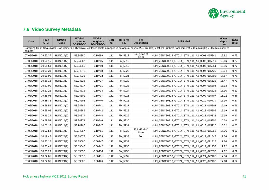
7.6 Video Survey Metadata
Date Time UTC
Station Code
WGS84 Latitude
DD.DDDDD
WGS84 Longitude DD.DDDDD
STN no.
Hpro fix no.
Fix Description Still Label
Water depth
(m) SOG (kts)
Sampling Gear: SeaSpyder Drop Camera, FOV Scale: 4 x laser points arranged in an approx square 22.5 cm (left) x 19 cm (furthest from camera) x 19 cm (right) x 20 cm (closest to camera)
07/08/2018 09:53:37 HLIN014(2) 53.94380 -0.10699 111 Fix_5917 SoL (Start of Line) HLIN_2ENC30818_GT014_STN_111_A1_0001_015241 15.82 0.75
07/08/2018 09:54:15 HLIN014(2) 53.94367 -0.10705 111 Fix_5918 HLIN_2ENC30818_GT014_STN_111_A1_0002_015319 15.86 0.77
07/08/2018 09:54:51 HLIN014(2) 53.94355 -0.10710 111 Fix_5919 HLIN_2ENC30818_GT014_STN_111_A1_0003_015354 15.96 0.72
07/08/2018 09:55:31 HLIN014(2) 53.94342 -0.10718 111 Fix_5920 HLIN_2ENC30818_GT014_STN_111_A1_0004_015435 15.94 0.71
07/08/2018 09:56:00 HLIN014(2) 53.94333 -0.10723 111 Fix_5921 HLIN_2ENC30818_GT014_STN_111_A1_0005_015503 15.57 0.71
07/08/2018 09:56:18 HLIN014(2) 53.94328 -0.10727 111 Fix_5922 HLIN_2ENC30818_GT014_STN_111_A1_0006_015522 15.47 0.71
07/08/2018 09:57:00 HLIN014(2) 53.94317 -0.10731 111 Fix_5923 HLIN_2ENC30818_GT014_STN_111_A1_0007_015604 16.13 0.59
07/08/2018 09:57:22 HLIN014(2) 53.94312 -0.10734 111 Fix_5924 HLIN_2ENC30818_GT014_STN_111_A1_0008_015626 16.16 0.53
07/08/2018 09:58:03 HLIN014(2) 53.94301 -0.10737 111 Fix_5925 HLIN_2ENC30818_GT014_STN_111_A1_0009_015707 16.22 0.56
07/08/2018 09:58:36 HLIN014(2) 53.94293 -0.10740 111 Fix_5926 HLIN_2ENC30818_GT014_STN_111_A1_0010_015739 16.15 0.57
07/08/2018 09:58:59 HLIN014(2) 53.94287 -0.10741 111 Fix_5927 HLIN_2ENC30818_GT014_STN_111_A1_0011_015803 16.19 0.56
07/08/2018 09:59:02 HLIN014(2) 53.94286 -0.10742 111 Fix_5928 HLIN_2ENC30818_GT014_STN_111_A1_0012_015805 16.19 0.55
07/08/2018 09:59:29 HLIN014(2) 53.94279 -0.10744 111 Fix_5929 HLIN_2ENC30818_GT014_STN_111_A1_0013_015832 16.15 0.57
07/08/2018 09:59:53 HLIN014(2) 53.94273 -0.10746 111 Fix_5930 HLIN_2ENC30818_GT014_STN_111_A1_0014_015857 16.28 0.55
07/08/2018 10:00:16 HLIN014(2) 53.94267 -0.10747 111 Fix_5931 HLIN_2ENC30818_GT014_STN_111_A1_0015_015920 16.32 0.60
07/08/2018 10:00:54 HLIN014(2) 53.94257 -0.10751 111 Fix_5932 EoL (End of Line) HLIN_2ENC30818_GT014_STN_111_A1_0016_015958 16.36 0.59
07/08/2018 10:19:45 HLIN024(2) 53.89672 -0.06453 112 Fix_5933 SoL HLIN_2ENC30818_GT024_STN_112_A1_0017_021848 17.56 0.96
07/08/2018 10:20:15 HLIN024(2) 53.89660 -0.06447 112 Fix_5934 HLIN_2ENC30818_GT024_STN_112_A1_0018_021918 17.74 0.87
07/08/2018 10:20:49 HLIN024(2) 53.89647 -0.06442 112 Fix_5935 HLIN_2ENC30818_GT024_STN_112_A1_0019_021952 17.72 0.87
07/08/2018 10:21:29 HLIN024(2) 53.89632 -0.06436 112 Fix_5936 HLIN_2ENC30818_GT024_STN_112_A1_0020_022032 17.62 0.82
07/08/2018 10:22:05 HLIN024(2) 53.89618 -0.06431 112 Fix_5937 HLIN_2ENC30818_GT024_STN_112_A1_0021_022108 17.56 0.88
07/08/2018 10:22:35 HLIN024(2) 53.89606 -0.06426 112 Fix_5938 HLIN_2ENC30818_GT024_STN_112_A1_0022_022138 17.68 0.82

Holderness Inshore MCZ 2018 Survey Report 42
Date Time UTC
Station Code
WGS84 Latitude
DD.DDDDD
WGS84 Longitude DD.DDDDD
STN no.
Hpro fix no.
Fix Description Still Label
Water depth
(m) SOG (kts)
Sampling Gear: SeaSpyder Drop Camera, FOV Scale: 4 x laser points arranged in an approx square 22.5 cm (left) x 19 cm (furthest from camera) x 19 cm (right) x 20 cm (closest to camera) 07/08/2018 10:23:13 HLIN024(2) 53.89593 -0.06420 112 Fix_5939 HLIN_2ENC30818_GT024_STN_112_A1_0023_022216 17.64 0.82
07/08/2018 10:23:52 HLIN024(2) 53.89579 -0.06413 112 Fix_5940 HLIN_2ENC30818_GT024_STN_112_A1_0024_022255 17.68 0.85
07/08/2018 10:24:29 HLIN024(2) 53.89565 -0.06407 112 Fix_5941 HLIN_2ENC30818_GT024_STN_112_A1_0025_022333 17.75 0.82
07/08/2018 10:25:03 HLIN024(2) 53.89553 -0.06401 112 Fix_5942 HLIN_2ENC30818_GT024_STN_112_A1_0026_022406 17.77 0.87
07/08/2018 10:25:28 HLIN024(2) 53.89544 -0.06397 112 Fix_5943 HLIN_2ENC30818_GT024_STN_112_A1_0027_022432 17.64 0.80
07/08/2018 10:25:57 HLIN024(2) 53.89534 -0.06392 112 Fix_5944 HLIN_2ENC30818_GT024_STN_112_A1_0028_022500 17.67 0.77
07/08/2018 10:26:17 HLIN024(2) 53.89527 -0.06389 112 Fix_5945 EoL HLIN_2ENC30818_GT024_STN_112_A1_0029_022520 17.81 0.80
07/08/2018 10:33:52 HLIN020(2) 53.88079 -0.07940 113 Fix_5946 SoL HLIN_2ENC30818_GT020_STN_113_A1_0030_023255 16.58 0.89
07/08/2018 10:34:21 HLIN020(2) 53.88069 -0.07946 113 Fix_5947 HLIN_2ENC30818_GT020_STN_113_A1_0031_023324 16.47 0.63
07/08/2018 10:34:42 HLIN020(2) 53.88061 -0.07949 113 Fix_5948 HLIN_2ENC30818_GT020_STN_113_A1_0032_023346 16.58 0.66
07/08/2018 10:35:19 HLIN020(2) 53.88048 -0.07953 113 Fix_5949 HLIN_2ENC30818_GT020_STN_113_A1_0033_023423 16.51 0.67
07/08/2018 10:35:45 HLIN020(2) 53.88039 -0.07955 113 Fix_5950 HLIN_2ENC30818_GT020_STN_113_A1_0034_023449 16.64 0.81
07/08/2018 10:36:13 HLIN020(2) 53.88028 -0.07957 113 Fix_5951 HLIN_2ENC30818_GT020_STN_113_A1_0035_023517 16.53 0.78
07/08/2018 10:36:45 HLIN020(2) 53.88015 -0.07960 113 Fix_5952 HLIN_2ENC30818_GT020_STN_113_A1_0036_023549 16.54 0.96
07/08/2018 10:37:18 HLIN020(2) 53.88003 -0.07963 113 Fix_5953 HLIN_2ENC30818_GT020_STN_113_A1_0037_023621 16.47 0.97
07/08/2018 10:37:56 HLIN020(2) 53.87989 -0.07966 113 Fix_5954 HLIN_2ENC30818_GT020_STN_113_A1_0038_023700 16.44 0.85
07/08/2018 10:38:27 HLIN020(2) 53.87977 -0.07969 113 Fix_5955 HLIN_2ENC30818_GT020_STN_113_A1_0039_023731 16.52 0.76
07/08/2018 10:38:57 HLIN020(2) 53.87967 -0.07971 113 Fix_5956 HLIN_2ENC30818_GT020_STN_113_A1_0040_023800 16.62 0.76
07/08/2018 10:39:25 HLIN020(2) 53.87957 -0.07973 113 Fix_5957 HLIN_2ENC30818_GT020_STN_113_A1_0041_023829 16.58 0.73
07/08/2018 10:39:47 HLIN020(2) 53.87951 -0.07974 113 Fix_5958 HLIN_2ENC30818_GT020_STN_113_A1_0042_023850 16.57 0.68
07/08/2018 10:40:16 HLIN020(2) 53.87941 -0.07974 113 Fix_5959 HLIN_2ENC30818_GT020_STN_113_A1_0043_023920 16.53 0.70
07/08/2018 10:40:42 HLIN020(2) 53.87933 -0.07975 113 Fix_5960 EoL HLIN_2ENC30818_GT020_STN_113_A1_0044_023945 16.49 0.71
07/08/2018 11:12:52 HLIN031(2) 53.78884 -0.02002 114 Fix_5961 SoL HLIN_2ENC30818_GT031_STN_114_A1_0045_031156 13.34 0.56
07/08/2018 11:13:25 HLIN031(2) 53.78875 -0.01993 114 Fix_5962 HLIN_2ENC30818_GT031_STN_114_A1_0046_031229 13.50 0.71
07/08/2018 11:13:58 HLIN031(2) 53.78864 -0.01985 114 Fix_5963 HLIN_2ENC30818_GT031_STN_114_A1_0047_031302 13.60 0.80

Holderness Inshore MCZ 2018 Survey Report 43
Date Time UTC
Station Code
WGS84 Latitude
DD.DDDDD
WGS84 Longitude DD.DDDDD
STN no.
Hpro fix no.
Fix Description Still Label
Water depth
(m) SOG (kts)
Sampling Gear: SeaSpyder Drop Camera, FOV Scale: 4 x laser points arranged in an approx square 22.5 cm (left) x 19 cm (furthest from camera) x 19 cm (right) x 20 cm (closest to camera) 07/08/2018 11:14:29 HLIN031(2) 53.78854 -0.01978 114 Fix_5964 HLIN_2ENC30818_GT031_STN_114_A1_0048_031333 13.64 0.81
07/08/2018 11:15:07 HLIN031(2) 53.78840 -0.01970 114 Fix_5965 HLIN_2ENC30818_GT031_STN_114_A1_0049_031411 13.41 0.85
07/08/2018 11:15:39 HLIN031(2) 53.78829 -0.01963 114 Fix_5966 HLIN_2ENC30818_GT031_STN_114_A1_0050_031442 13.42 0.82
07/08/2018 11:16:05 HLIN031(2) 53.78819 -0.01957 114 Fix_5967 HLIN_2ENC30818_GT031_STN_114_A1_0051_031509 13.42 0.82
07/08/2018 11:16:37 HLIN031(2) 53.78808 -0.01950 114 Fix_5968 HLIN_2ENC30818_GT031_STN_114_A1_0052_031541 13.41 0.80
07/08/2018 11:17:10 HLIN031(2) 53.78797 -0.01943 114 Fix_5969 HLIN_2ENC30818_GT031_STN_114_A1_0053_031613 13.45 0.78
07/08/2018 11:17:41 HLIN031(2) 53.78786 -0.01935 114 Fix_5970 HLIN_2ENC30818_GT031_STN_114_A1_0054_031644 13.19 0.77
07/08/2018 11:18:18 HLIN031(2) 53.78774 -0.01928 114 Fix_5971 HLIN_2ENC30818_GT031_STN_114_A1_0055_031722 13.19 0.70
07/08/2018 11:18:44 HLIN031(2) 53.78767 -0.01922 114 Fix_5972 HLIN_2ENC30818_GT031_STN_114_A1_0056_031747 13.09 0.72
07/08/2018 11:19:04 HLIN031(2) 53.78760 -0.01917 114 Fix_5973 HLIN_2ENC30818_GT031_STN_114_A1_0057_031807 13.30 0.75
07/08/2018 11:19:24 HLIN031(2) 53.78754 -0.01911 114 Fix_5974 HLIN_2ENC30818_GT031_STN_114_A1_0058_031827 13.21 0.79
07/08/2018 11:19:41 HLIN031(2) 53.78748 -0.01907 114 Fix_5975 EoL HLIN_2ENC30818_GT031_STN_114_A1_0059_031844 13.31 0.77

Holderness Inshore MCZ 2018 Survey Report 44
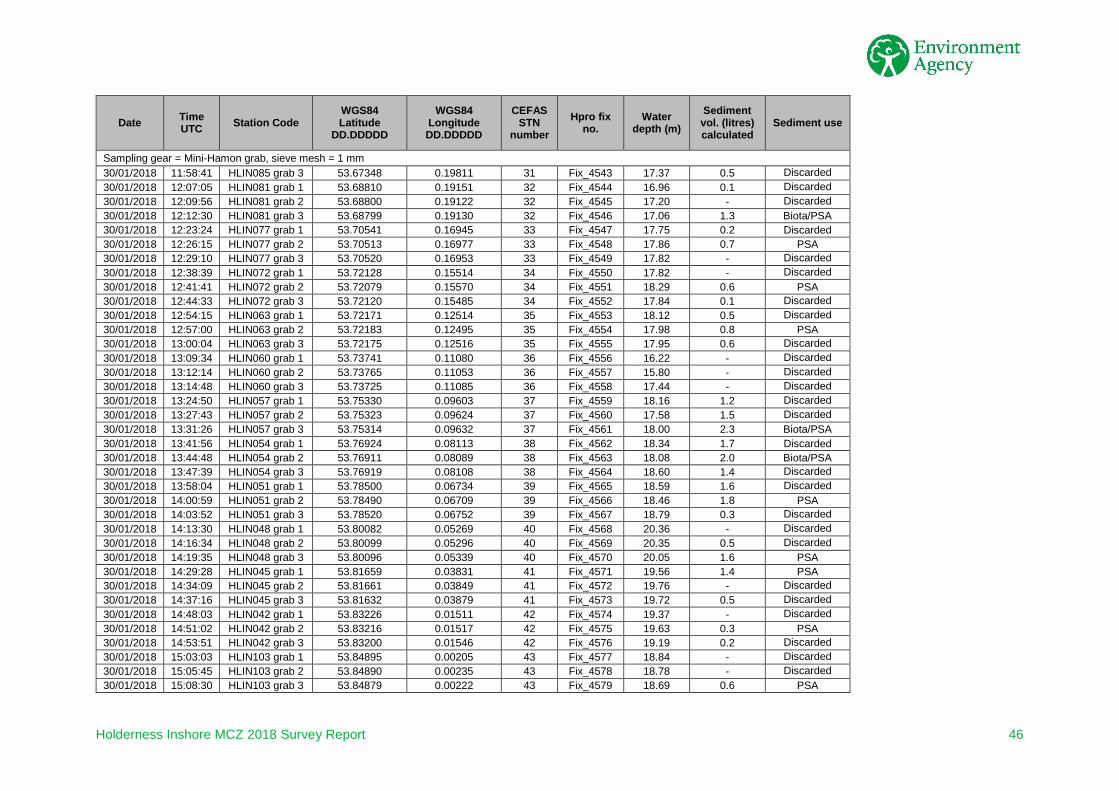
7.7 Grab Survey Metadata
Date Time UTC Station Code
WGS84 Latitude
DD.DDDDD
WGS84 Longitude DD.DDDDD
CEFAS STN
number Hpro fix
no. Water
depth (m) Sediment vol. (litres) calculated
Sediment use
Sampling gear = Mini-Hamon grab, sieve mesh = 1 mm 10/01/2018 10:56:27 HLIN061 53.66117 0.13212 1 Fix_4421 14.57 - Discarded 10/01/2018 10:59:13 HLIN061 53.66117 0.13217 1 Fix_4422 14.89 3.0 Biota/PSA 10/01/2018 11:15:55 HLIN058 53.67531 0.11521 2 Fix_4423 13.11 1.8 Biota/PSA 10/01/2018 11:19:41 HLIN058 53.67522 0.11528 2 Fix_4424 14.04 - Discarded 10/01/2018 11:22:25 HLIN058 53.67523 0.11548 2 Fix_4425 14.16 - Discarded 10/01/2018 11:32:33 HLIN055 53.69109 0.09297 3 Fix_4426 10.60 - Discarded 10/01/2018 11:36:10 HLIN055 53.69110 0.09299 3 Fix_4427 10.58 - Discarded 10/01/2018 11:39:25 HLIN055 53.69096 0.09320 3 Fix_4428 10.65 - Discarded 10/01/2018 11:53:06 HLIN052 53.70693 0.07861 4 Fix_4429 15.63 0.8 PSA 10/01/2018 11:57:10 HLIN052 53.70684 0.07834 4 Fix_4430 14.93 - Discarded 10/01/2018 12:00:14 HLIN052 53.70700 0.07890 4 Fix_4431 15.34 0.3 Discarded 10/01/2018 12:09:25 HLIN049 53.72272 0.06438 5 Fix_4432 16.94 0.5 Discarded 10/01/2018 12:13:01 HLIN049 53.72268 0.06438 5 Fix_4433 16.77 0.5 PSA 10/01/2018 12:16:15 HLIN049 53.72277 0.06462 5 Fix_4434 16.95 0.2 Discarded 10/01/2018 12:25:38 HLIN046 53.73849 0.04999 6 Fix_4435 16.89 - Discarded 10/01/2018 12:28:32 HLIN046 53.73853 0.04992 6 Fix_4436 16.75 - Discarded 10/01/2018 12:31:01 HLIN046 53.73840 0.04998 6 Fix_4437 17.02 - Grab Misfired 10/01/2018 12:33:33 HLIN046 53.73846 0.05010 6 Fix_4438 17.32 0.5 PSA 10/01/2018 12:44:35 HLIN043 53.75443 0.03539 7 Fix_4439 16.42 1.2 Biota 10/01/2018 12:47:44 HLIN043 53.75430 0.03545 7 Fix_4440 16.16 0.6 PSA 10/01/2018 12:50:45 HLIN043 53.75427 0.03516 7 Fix_4441 16.54 0.5 Discarded 11/01/2018 14:59:13 HLIN069 53.62795 0.15035 17 Fix_4463 10.66 0.4 Epibiota (rock) 11/01/2018 15:06:42 HLIN100 53.63486 0.14897 18 Fix_4464 11.23 - Discarded 11/01/2018 15:09:10 HLIN100 53.63490 0.14882 18 Fix_4465 10.67 0.4 PSA 11/01/2018 15:12:54 HLIN100 53.63482 0.14892 18 Fix_4466 11.24 - Discarded 11/01/2018 15:17:58 HLIN098 53.63991 0.14395 19 Fix_4467 11.80 1.8 PSA 11/01/2018 15:20:36 HLIN098 53.63995 0.14410 19 Fix_4468 11.49 - Discarded 11/01/2018 15:23:05 HLIN098 53.63994 0.14392 19 Fix_4469 10.64 - Discarded 11/01/2018 15:27:47 HLIN065 53.64641 0.14158 20 Fix_4470 12.88 1.0 Discarded 11/01/2018 15:30:07 HLIN065 53.64636 0.14169 20 Fix_4471 11.86 0.2 Discarded 11/01/2018 15:33:07 HLIN065 53.64637 0.14128 20 Fix_4472 11.75 1.0 PSA 11/01/2018 15:41:35 HLIN070 53.66121 0.14943 21 Fix_4473 18.12 - Discarded
11/01/2018 15:44:33 HLIN070 53.66117 0.14980 21 Fix_4474 18.08 - Epibiota (rock w. sabellaria)

Holderness Inshore MCZ 2018 Survey Report 45
Date Time UTC Station Code
WGS84 Latitude
DD.DDDDD
WGS84 Longitude DD.DDDDD
CEFAS STN
number Hpro fix
no. Water
depth (m) Sediment vol. (litres) calculated
Sediment use
Sampling gear = Mini-Hamon grab, sieve mesh = 1 mm 11/01/2018 15:47:12 HLIN070 53.66119 0.14938 21 Fix_4475 18.10 1.0 Biota/PSA 11/01/2018 15:55:46 HLIN076 53.67428 0.16779 22 Fix_4476 15.97 0.5 PSA 11/01/2018 15:59:35 HLIN076 53.67437 0.16782 22 Fix_4477 16.42 - Discarded 11/01/2018 16:02:25 HLIN076 53.67428 0.16819 22 Fix_4478 15.31 - Discarded 11/01/2018 16:15:04 HLIN080 53.65841 0.18212 23 Fix_4479 17.60 - Grab Misfired 11/01/2018 16:17:20 HLIN080 53.65837 0.18209 23 Fix_4480 17.62 0.8 PSA 11/01/2018 16:20:11 HLIN080 53.65843 0.18251 23 Fix_4481 17.31 - Grab Misfired 11/01/2018 16:22:35 HLIN080 53.65856 0.18221 23 Fix_4482 17.25 0.4 Discarded 11/01/2018 16:25:52 HLIN080 53.65836 0.18225 23 Fix_4483 17.31 0.4 Discarded 30/01/2018 09:52:51 HLIN082 grab 1 53.58041 0.19310 24 Fix_4515 7.10 8.0 Biota/PSA 30/01/2018 10:01:20 HLIN086 grab 1 53.59582 0.20918 25 Fix_4516 16.37 - Discarded 30/01/2018 10:04:17 HLIN086 grab 2 53.59560 0.20925 25 Fix_4517 16.20 - Grab Misfired 30/01/2018 10:05:45 HLIN086 grab 3 53.59585 0.20964 25 Fix_4518 16.17 - Discarded 30/01/2018 10:08:27 HLIN086 grab 4 53.59562 0.20948 25 Fix_4519 16.49 0.8 PSA 30/01/2018 10:16:08 HLIN090 grab 1 53.59524 0.23751 26 Fix_4520 16.86 0.5 Discarded 30/01/2018 10:19:22 HLIN090 grab 2 53.59507 0.23717 26 Fix_4521 16.56 - Grab Misfired 30/01/2018 10:21:33 HLIN090 grab 3 53.59510 0.23771 26 Fix_4522 16.49 - Grab Misfired 30/01/2018 10:23:58 HLIN090 grab 4 53.59491 0.23783 26 Fix_4523 16.75 - Grab Misfired 30/01/2018 10:29:45 HLIN090 grab 5 53.59510 0.23715 26 Fix_4524 16.84 - Discarded 30/01/2018 10:33:07 HLIN090 grab 6 53.59504 0.23730 26 Fix_4525 16.78 - Grab Misfired 30/01/2018 10:36:17 HLIN090 grab 7 53.59511 0.23729 26 Fix_4526 16.78 - Grab Misfired 30/01/2018 10:38:06 HLIN090 grab 8 53.59593 0.23772 26 Fix_4527 16.57 - Grab Misfired 30/01/2018 10:44:28 HLIN090 grab 9 53.59506 0.23717 26 Fix_4528 16.84 0.8 PSA 30/01/2018 10:53:16 HLIN089 grab 1 53.61083 0.22526 27 Fix_4529 17.75 0.6 Discarded 30/01/2018 10:56:14 HLIN089 grab 2 53.61055 0.22552 27 Fix_4530 17.46 0.7 PSA 30/01/2018 10:59:48 HLIN089 grab 3 53.61067 0.22515 27 Fix_4531 17.51 0.5 Discarded 30/01/2018 11:09:03 HLIN087 grab 1 53.62668 0.21094 28 Fix_4532 15.89 0.6 PSA 30/01/2018 11:11:57 HLIN087 grab 2 53.62661 0.21099 28 Fix_4533 15.71 0.2 Discarded 30/01/2018 11:14:58 HLIN087 grab 3 53.62648 0.21064 28 Fix_4534 16.06 - Discarded 30/01/2018 11:23:17 HLIN084 grab 1 53.64244 0.19669 29 Fix_4535 15.11 - Discarded 30/01/2018 11:26:14 HLIN084 grab 2 53.64234 0.19678 29 Fix_4536 15.27 0.1 Discarded 30/01/2018 11:29:02 HLIN084 grab 3 53.64268 0.19669 29 Fix_4537 15.16 0.5 PSA 30/01/2018 11:38:54 HLIN088 grab 1 53.65922 0.21170 30 Fix_4538 15.18 - Discarded 30/01/2018 11:41:35 HLIN088 grab 2 53.65923 0.21159 30 Fix_4539 14.38 0.3 PSA 30/01/2018 11:44:27 HLIN088 grab 3 53.65924 0.21144 30 Fix_4540 14.70 - Discarded 30/01/2018 11:52:30 HLIN085 grab 1 53.67354 0.19827 31 Fix_4541 16.94 0.5 Discarded 30/01/2018 11:55:45 HLIN085 grab 2 53.67360 0.19822 31 Fix_4542 17.43 1.2 PSA
Holderness Inshore MCZ 2018 Survey Report 46
Date Time UTC Station Code
WGS84 Latitude
DD.DDDDD
WGS84 Longitude DD.DDDDD
CEFAS STN
number Hpro fix
no. Water
depth (m) Sediment vol. (litres) calculated
Sediment use
Sampling gear = Mini-Hamon grab, sieve mesh = 1 mm 30/01/2018 11:58:41 HLIN085 grab 3 53.67348 0.19811 31 Fix_4543 17.37 0.5 Discarded 30/01/2018 12:07:05 HLIN081 grab 1 53.68810 0.19151 32 Fix_4544 16.96 0.1 Discarded 30/01/2018 12:09:56 HLIN081 grab 2 53.68800 0.19122 32 Fix_4545 17.20 - Discarded 30/01/2018 12:12:30 HLIN081 grab 3 53.68799 0.19130 32 Fix_4546 17.06 1.3 Biota/PSA 30/01/2018 12:23:24 HLIN077 grab 1 53.70541 0.16945 33 Fix_4547 17.75 0.2 Discarded 30/01/2018 12:26:15 HLIN077 grab 2 53.70513 0.16977 33 Fix_4548 17.86 0.7 PSA 30/01/2018 12:29:10 HLIN077 grab 3 53.70520 0.16953 33 Fix_4549 17.82 - Discarded 30/01/2018 12:38:39 HLIN072 grab 1 53.72128 0.15514 34 Fix_4550 17.82 - Discarded 30/01/2018 12:41:41 HLIN072 grab 2 53.72079 0.15570 34 Fix_4551 18.29 0.6 PSA 30/01/2018 12:44:33 HLIN072 grab 3 53.72120 0.15485 34 Fix_4552 17.84 0.1 Discarded 30/01/2018 12:54:15 HLIN063 grab 1 53.72171 0.12514 35 Fix_4553 18.12 0.5 Discarded 30/01/2018 12:57:00 HLIN063 grab 2 53.72183 0.12495 35 Fix_4554 17.98 0.8 PSA 30/01/2018 13:00:04 HLIN063 grab 3 53.72175 0.12516 35 Fix_4555 17.95 0.6 Discarded 30/01/2018 13:09:34 HLIN060 grab 1 53.73741 0.11080 36 Fix_4556 16.22 - Discarded 30/01/2018 13:12:14 HLIN060 grab 2 53.73765 0.11053 36 Fix_4557 15.80 - Discarded 30/01/2018 13:14:48 HLIN060 grab 3 53.73725 0.11085 36 Fix_4558 17.44 - Discarded 30/01/2018 13:24:50 HLIN057 grab 1 53.75330 0.09603 37 Fix_4559 18.16 1.2 Discarded 30/01/2018 13:27:43 HLIN057 grab 2 53.75323 0.09624 37 Fix_4560 17.58 1.5 Discarded 30/01/2018 13:31:26 HLIN057 grab 3 53.75314 0.09632 37 Fix_4561 18.00 2.3 Biota/PSA 30/01/2018 13:41:56 HLIN054 grab 1 53.76924 0.08113 38 Fix_4562 18.34 1.7 Discarded 30/01/2018 13:44:48 HLIN054 grab 2 53.76911 0.08089 38 Fix_4563 18.08 2.0 Biota/PSA 30/01/2018 13:47:39 HLIN054 grab 3 53.76919 0.08108 38 Fix_4564 18.60 1.4 Discarded 30/01/2018 13:58:04 HLIN051 grab 1 53.78500 0.06734 39 Fix_4565 18.59 1.6 Discarded 30/01/2018 14:00:59 HLIN051 grab 2 53.78490 0.06709 39 Fix_4566 18.46 1.8 PSA 30/01/2018 14:03:52 HLIN051 grab 3 53.78520 0.06752 39 Fix_4567 18.79 0.3 Discarded 30/01/2018 14:13:30 HLIN048 grab 1 53.80082 0.05269 40 Fix_4568 20.36 - Discarded 30/01/2018 14:16:34 HLIN048 grab 2 53.80099 0.05296 40 Fix_4569 20.35 0.5 Discarded 30/01/2018 14:19:35 HLIN048 grab 3 53.80096 0.05339 40 Fix_4570 20.05 1.6 PSA 30/01/2018 14:29:28 HLIN045 grab 1 53.81659 0.03831 41 Fix_4571 19.56 1.4 PSA 30/01/2018 14:34:09 HLIN045 grab 2 53.81661 0.03849 41 Fix_4572 19.76 - Discarded 30/01/2018 14:37:16 HLIN045 grab 3 53.81632 0.03879 41 Fix_4573 19.72 0.5 Discarded 30/01/2018 14:48:03 HLIN042 grab 1 53.83226 0.01511 42 Fix_4574 19.37 - Discarded 30/01/2018 14:51:02 HLIN042 grab 2 53.83216 0.01517 42 Fix_4575 19.63 0.3 PSA 30/01/2018 14:53:51 HLIN042 grab 3 53.83200 0.01546 42 Fix_4576 19.19 0.2 Discarded 30/01/2018 15:03:03 HLIN103 grab 1 53.84895 0.00205 43 Fix_4577 18.84 - Discarded 30/01/2018 15:05:45 HLIN103 grab 2 53.84890 0.00235 43 Fix_4578 18.78 - Discarded 30/01/2018 15:08:30 HLIN103 grab 3 53.84879 0.00222 43 Fix_4579 18.69 0.6 PSA

Holderness Inshore MCZ 2018 Survey Report 47
Date Time UTC Station Code
WGS84 Latitude
DD.DDDDD
WGS84 Longitude DD.DDDDD
CEFAS STN
number Hpro fix
no. Water
depth (m) Sediment vol. (litres) calculated
Sediment use
Sampling gear = Mini-Hamon grab, sieve mesh = 1 mm 30/01/2018 15:17:36 HLIN036 grab 1 53.83311 -0.00626 44 Fix_4580 18.81 - Discarded 30/01/2018 15:20:18 HLIN036 grab 2 53.83304 -0.00615 44 Fix_4581 18.81 0.9 PSA 30/01/2018 15:22:53 HLIN036 grab 3 53.83299 -0.00624 44 Missed fix 18.74 0.6 Discarded 30/01/2018 15:31:02 HLIN039 grab 1 53.81719 0.00803 45 Fix_4582 18.67 0.9 PSA 30/01/2018 15:33:52 HLIN039 grab 2 53.81708 0.00801 45 Fix_4583 18.62 - Discarded 30/01/2018 15:36:52 HLIN039 grab 3 53.81713 0.00811 45 Fix_4584 18.85 0.3 Discarded 30/01/2018 15:44:53 HLIN041 grab 1 53.80135 0.02235 46 Fix_4585 18.67 0.7 PSA 30/01/2018 15:47:41 HLIN041 grab 2 53.80132 0.02256 46 Fix_4586 18.78 - Discarded 30/01/2018 15:50:24 HLIN041 grab 3 53.80137 0.02283 46 Fix_4587 18.68 0.4 Discarded 30/01/2018 15:58:26 HLIN044 grab 1 53.78819 0.03646 47 Fix_4588 18.67 0.5 Discarded 30/01/2018 16:01:06 HLIN044 grab 2 53.78824 0.03577 47 Fix_4589 18.78 1.5 Biota 30/01/2018 16:03:51 HLIN044 grab 3 53.78829 0.03568 47 Fix_4590 18.68 1.0 PSA 31/01/2018 09:35:57 HLIN099 grab 1 53.63712 0.15565 48 Fix_4591 11.37 0.6 PSA 31/01/2018 09:38:55 HLIN099 grab 2 53.63702 0.15552 48 Fix_4592 11.35 0.4 Discarded 31/01/2018 09:41:33 HLIN099 grab 3 53.63708 0.15530 48 Fix_4593 11.27 - Discarded 31/01/2018 09:46:21 HLIN097 grab 1 53.64374 0.15206 49 Fix_4594 11.71 - Discarded 31/01/2018 09:48:35 HLIN097 grab 2 53.64371 0.15157 49 Fix_4595 11.59 - Discarded 31/01/2018 09:51:04 HLIN097 grab 3 53.64373 0.15173 49 Fix_4596 11.52 - Discarded 31/01/2018 09:54:41 HLIN096 grab 1 53.64786 0.14839 50 Fix_4597 9.73 0.2 Discarded 31/01/2018 09:57:13 HLIN096 grab 2 53.64787 0.14837 50 Fix_4598 10.44 0.6 PSA 31/01/2018 09:59:18 HLIN096 grab 3 53.64782 0.14829 50 Fix_4599 10.29 - Discarded 31/01/2018 10:12:05 HLIN066 grab 1 53.68199 0.13306 51 Fix_4600 15.78 0.7 PSA 31/01/2018 10:14:38 HLIN066 grab 2 53.68203 0.13334 51 Fix_4601 15.83 0.1 Discarded 31/01/2018 10:17:09 HLIN066 grab 3 53.68192 0.13329 51 Fix_4602 15.77 0.6 Discarded 31/01/2018 10:22:10 HLIN062 grab 1 53.69064 0.12339 52 Fix_4603 14.36 1.0 PSA 31/01/2018 10:25:00 HLIN062 grab 2 53.69069 0.12362 52 Fix_4604 14.56 0.3 Discarded 31/01/2018 10:27:39 HLIN062 grab 3 53.69056 0.12301 52 Fix_4605 14.45 0.5 Discarded 31/01/2018 10:34:52 HLIN059 grab 1 53.70632 0.10870 53 Fix_4606 14.30 0.2 Discarded 31/01/2018 10:37:16 HLIN059 grab 2 53.70628 0.10914 53 Fix_4607 14.31 0.4 Discarded 31/01/2018 10:40:11 HLIN059 grab 3 53.70639 0.10865 53 Fix_4608 14.34 0.5 PSA 31/01/2018 10:48:49 HLIN056 grab 1 53.72209 0.09467 54 Fix_4609 14.45 - Discarded 31/01/2018 10:51:30 HLIN056 grab 2 53.72227 0.09412 54 Fix_4610 14.62 0.2 PSA 31/01/2018 10:54:45 HLIN056 grab 3 53.72221 0.09459 54 Fix_4611 14.47 0.3 Discarded 31/01/2018 11:17:53 HLIN037 grab 1 53.75799 0.01609 55 Fix_4612 10.81 0.5 PSA 31/01/2018 11:20:20 HLIN037 grab 2 53.75788 0.01575 55 Fix_4613 10.05 0.2 Discarded 31/01/2018 11:22:40 HLIN037 grab 3 53.75763 0.01607 55 Fix_4614 10.41 0.5 Discarded 31/01/2018 11:31:39 HLIN034 grab 1 53.77409 -0.00461 56 Fix_4615 9.76 0.3 Discarded

Holderness Inshore MCZ 2018 Survey Report 48
Date Time UTC Station Code
WGS84 Latitude
DD.DDDDD
WGS84 Longitude DD.DDDDD
CEFAS STN
number Hpro fix
no. Water
depth (m) Sediment vol. (litres) calculated
Sediment use
Sampling gear = Mini-Hamon grab, sieve mesh = 1 mm 31/01/2018 11:33:52 HLIN034 grab 2 53.77399 -0.00428 56 Fix_4616 9.98 0.4 PSA 31/01/2018 11:36:14 HLIN034 grab 3 53.77424 -0.00423 56 Fix_4617 10.04 - Grab Misfired 31/01/2018 11:36:56 HLIN034 grab 4 53.77414 -0.00381 56 Fix_4618 10.33 - Discarded 31/01/2018 11:44:52 HLIN031 grab 1 53.78807 -0.01944 57 Fix_4619 10.61 - Discarded 31/01/2018 11:47:04 HLIN031 grab 2 53.78814 -0.01945 57 Fix_4620 10.65 - Discarded 31/01/2018 11:49:40 HLIN031 grab 3 53.78819 -0.01920 57 Fix_4621 10.73 - Discarded 31/01/2018 11:58:02 HLIN028 grab 1 53.80218 -0.03811 58 Fix_4622 9.61 0.7 PSA 31/01/2018 12:00:20 HLIN028 grab 2 53.80241 -0.03785 58 Fix_4623 9.69 - Discarded 31/01/2018 12:02:37 HLIN028 grab 3 53.80228 -0.03838 58 Fix_4624 9.24 - Discarded 31/01/2018 12:12:04 HLIN025 grab 1 53.81799 -0.05248 59 Fix_4625 10.92 - Discarded 31/01/2018 12:14:24 HLIN025 grab 2 53.81818 -0.05226 59 Fix_4626 11.09 1.0 PSA 31/01/2018 12:16:51 HLIN025 grab 3 53.81793 -0.05258 59 Fix_4627 10.97 0.3 Discarded 31/01/2018 12:52:05 HLIN110 grab 1 53.89170 -0.13611 60 Fix_4628 7.34 0.5 Discarded 31/01/2018 12:54:17 HLIN110 grab 2 53.89165 -0.13650 60 Fix_4629 7.24 2.0 Discarded 31/01/2018 12:56:42 HLIN110 grab 3 53.89170 -0.13621 60 Fix_4630 7.44 2.3 Biota/PSA 31/01/2018 13:06:22 HLIN006 grab 1 53.91296 -0.13952 61 Fix_4631 13.83 1.9 Biota/PSA 31/01/2018 13:09:52 HLIN006 grab 2 53.91293 -0.13947 61 Fix_4632 13.11 - Discarded 31/01/2018 13:12:18 HLIN006 grab 3 53.91257 -0.13947 61 Fix_4633 13.64 - Discarded 31/01/2018 13:21:13 HLIN004 grab 1 53.92862 -0.15394 62 Fix_4634 12.00 1.0 Discarded 31/01/2018 13:23:40 HLIN004 grab 2 53.92857 -0.15408 62 Fix_4635 12.01 1.7 PSA 31/01/2018 13:26:05 HLIN004 grab 3 53.92868 -0.15398 62 Fix_4636 12.33 0.6 Discarded 31/01/2018 13:30:20 HLIN109 grab 1 53.93409 -0.15771 63 Fix_4637 12.51 1.6 Discarded 31/01/2018 13:33:01 HLIN109 grab 2 53.93402 -0.15779 63 Fix_4638 12.47 1.6 PSA 31/01/2018 13:35:31 HLIN109 grab 3 53.93392 -0.15805 63 Fix_4639 12.04 1.2 Discarded 31/01/2018 13:42:30 HLIN002 grab 1 53.94444 -0.16829 64 Fix_4640 9.98 - Discarded
31/01/2018 13:44:51 HLIN002 grab 2 53.94454 -0.16856 64 Fix_4641 9.72 0.1 PSA (combined)
31/01/2018 13:47:17 HLIN002 grab 3 53.94424 -0.16880 64 Fix_4642 9.80 0.1 PSA (combined)
31/01/2018 13:53:32 HLIN108 grab 1 53.95342 -0.16385 65 Fix_4643 14.10 1.1 PSA 31/01/2018 13:56:23 HLIN108 grab 2 53.95342 -0.16428 65 Fix_4644 13.90 1.7 Discarded 31/01/2018 13:58:53 HLIN108 grab 3 53.95355 -0.16390 65 Fix_4645 13.92 1.8 Biota 31/01/2018 14:08:20 HLIN001 grab 1 53.96361 -0.17335 66 Fix_4646 14.16 0.8 PSA 31/01/2018 14:10:58 HLIN001 grab 2 53.96368 -0.17277 66 Fix_4647 14.35 0.7 Discarded 31/01/2018 14:13:35 HLIN001 grab 3 53.96352 -0.17288 66 Fix_4648 14.35 0.8 Discarded 31/01/2018 14:22:54 HLIN107 grab 1 53.96568 -0.17860 67 Fix_4649 11.77 0.7 PSA 31/01/2018 14:26:41 HLIN107 grab 2 53.96572 -0.17881 67 Fix_4650 12.12 2.0 Biota

Holderness Inshore MCZ 2018 Survey Report 49
Date Time UTC Station Code
WGS84 Latitude
DD.DDDDD
WGS84 Longitude DD.DDDDD
CEFAS STN
number Hpro fix
no. Water
depth (m) Sediment vol. (litres) calculated
Sediment use
Sampling gear = Mini-Hamon grab, sieve mesh = 1 mm 31/01/2018 14:29:08 HLIN107 grab 3 53.96571 -0.17864 67 Fix_4651 12.06 1.9 Discarded 31/01/2018 14:35:17 HLIN106 grab 1 53.97204 -0.18299 68 Fix_4652 12.00 0.6 Discarded 31/01/2018 14:38:43 HLIN106 grab 2 53.97209 -0.18326 68 Fix_4653 11.69 1.4 PSA 31/01/2018 14:41:23 HLIN106 grab 3 53.97200 -0.18291 68 Fix_4654 11.95 0.2 Discarded 31/01/2018 14:49:20 HLIN104 grab 1 53.96365 -0.15719 69 Fix_4655 16.33 1.5 Discarded 31/01/2018 14:52:33 HLIN104 grab 2 53.96360 -0.15721 69 Fix_4656 16.41 1.6 PSA 31/01/2018 14:55:17 HLIN104 grab 3 53.96365 -0.15726 69 Fix_4657 16.40 1.9 Biota 31/01/2018 15:00:24 HLIN005 grab 1 53.95990 -0.15271 70 Fix_4658 16.94 0.3 Discarded 31/01/2018 15:03:15 HLIN005 grab 2 53.95984 -0.15254 70 Fix_4659 17.02 1.4 PSA 31/01/2018 15:05:47 HLIN005 grab 3 53.95977 -0.15280 70 Missed fix 17.13 - Discarded 31/01/2018 15:11:15 HLIN105 grab 1 53.95968 -0.15878 71 Fix_4660 17.40 1.9 Discarded 31/01/2018 15:14:05 HLIN105 grab 2 53.95959 -0.15786 71 Fix_4661 17.15 2.1 Biota/PSA 31/01/2018 15:16:58 HLIN105 grab 3 53.95964 -0.15859 71 Fix_4662 17.32 1.4 Discarded 31/01/2018 15:25:25 HLIN007 grab 1 53.94397 -0.13822 72 Fix_4663 17.81 1.1 Discarded 31/01/2018 15:28:10 HLIN007 grab 2 53.94401 -0.13841 72 Fix_4664 17.94 - Discarded 31/01/2018 15:30:55 HLIN007 grab 3 53.94417 -0.13820 72 Fix_4665 17.81 1.3 PSA 04/04/2018 09:39:57 HLIN078 grab 1 53.59626 0.17896 73 Fix_4670 15.63 - Grab Misfired 04/04/2018 09:42:46 HLIN078 grab 2 53.59646 0.17923 73 Fix_4671 15.40 0.5 Discarded 04/04/2018 09:47:47 HLIN078 grab 3 53.59637 0.17906 73 Fix_4672 15.31 - Grab Misfired 04/04/2018 09:50:19 HLIN078 grab 4 53.59626 0.17907 73 Fix_4673 15.28 - Discarded 04/04/2018 09:54:26 HLIN078 grab 5 53.59621 0.17947 73 Fix_4674 15.10 0.6 PSA 04/04/2018 10:14:30 HLIN083 grab 1 53.61157 0.19457 74 Fix_4675 18.25 0.6 PSA 04/04/2018 10:17:37 HLIN083 grab 2 53.61170 0.19482 74 Fix_4676 17.77 - Grab Misfired 04/04/2018 10:20:35 HLIN083 grab 3 53.61152 0.19469 74 Fix_4677 17.56 - Grab Empty 04/04/2018 10:24:53 HLIN083 grab 4 53.61160 0.19465 74 Fix_4678 17.24 - Grab Empty 04/04/2018 10:36:27 HLIN079 grab 1 53.62748 0.18050 75 Fix_4679 15.89 - Grab Empty 04/04/2018 10:39:19 HLIN079 grab 2 53.62747 0.18085 75 Fix_4680 15.96 1.7 PSA 04/04/2018 10:42:12 HLIN079 grab 3 53.62743 0.17998 75 Fix_4681 16.60 - Grab Empty 04/04/2018 10:51:28 HLIN075 grab 1 53.64310 0.16598 76 Fix_4682 15.31 0.4 PSA 04/04/2018 10:54:24 HLIN075 grab 2 53.64328 0.16603 76 Fix_4683 15.63 - Grab Empty 04/04/2018 10:57:36 HLIN075 grab 3 53.64317 0.16620 76 Fix_4684 15.51 - Boulder 04/04/2018 11:32:00 HLIN071 grab 1 53.69469 0.15043 77 Fix_4685 15.48 - Discarded 04/04/2018 11:35:53 HLIN071 grab 2 53.69470 0.15067 77 Fix_4686 15.74 - Discarded 04/04/2018 12:01:28 HLIN071 grab 3 53.69437 0.14998 77 Fix_4687 15.65 - Discarded 04/04/2018 12:07:16 HLIN067 grab 1 53.70614 0.13891 78 Fix_4688 15.71 - Discarded 04/04/2018 12:10:06 HLIN067 grab 2 53.70595 0.13919 78 Fix_4689 15.87 - Discarded 04/04/2018 12:13:01 HLIN067 grab 3 53.70576 0.13891 78 Fix_4690 15.52 - Discarded

Holderness Inshore MCZ 2018 Survey Report 50
Date Time UTC Station Code
WGS84 Latitude
DD.DDDDD
WGS84 Longitude DD.DDDDD
CEFAS STN
number Hpro fix
no. Water
depth (m) Sediment vol. (litres) calculated
Sediment use
Sampling gear = Mini-Hamon grab, sieve mesh = 1 mm 04/04/2018 12:29:50 HLIN053 grab 1 53.73702 0.07640 79 Fix_4691 13.41 - Discarded 04/04/2018 12:32:43 HLIN053 grab 2 53.73731 0.07586 79 Fix_4692 13.91 0.5 PSA 04/04/2018 12:35:39 HLIN053 grab 3 53.73679 0.07642 79 Fix_4693 12.98 - Discarded 04/04/2018 12:43:03 HLIN050 grab 1 53.75380 0.06559 80 Fix_4694 14.40 0.5 PSA 04/04/2018 12:46:31 HLIN050 grab 2 53.75383 0.06598 80 Fix_4695 14.42 - Discarded 04/04/2018 12:49:42 HLIN050 grab 3 53.75382 0.06621 80 Fix_4696 14.39 0.3 Discarded 04/04/2018 12:57:05 HLIN047 grab 1 53.76981 0.05158 81 Fix_4697 15.00 0.6 PSA 04/04/2018 12:59:35 HLIN047 grab 2 53.76958 0.05136 81 Fix_4698 15.10 0.1 Discarded 04/04/2018 13:01:58 HLIN047 grab 3 53.76961 0.05161 81 Fix_4699 14.93 0.1 Discarded 04/04/2018 13:09:56 HLIN040 grab 1 53.77031 0.02095 82 Fix_4700 12.39 0.1 Discarded 04/04/2018 13:12:21 HLIN040 grab 2 53.77028 0.02107 82 Fix_4701 12.07 - Grab Empty 04/04/2018 13:14:38 HLIN040 grab 3 53.77031 0.02110 82 Fix_4702 12.37 - Discarded 04/04/2018 13:19:51 HLIN101 grab 1 53.77420 0.00768 83 Fix_4703 12.44 - Discarded 04/04/2018 13:22:43 HLIN101 grab 2 53.77373 0.00741 83 Fix_4704 12.21 0.4 PSA 04/04/2018 13:25:19 HLIN101 grab 3 53.77384 0.00735 83 Fix_4705 12.14 0.1 Discarded 04/04/2018 13:30:22 HLIN102 grab 1 53.78026 0.00987 84 Fix_4706 11.95 0.2 Discarded 04/04/2018 13:33:44 HLIN102 grab 2 53.78044 0.01033 84 Fix_4707 11.56 0.1 Discarded 04/04/2018 13:36:46 HLIN102 grab 3 53.78034 0.01002 84 Fix_4708 11.72 0.2 Discarded 04/04/2018 13:40:53 HLIN038 grab 1 53.78596 0.00692 85 Fix_4709 11.24 - Discarded 04/04/2018 13:43:20 HLIN038 grab 2 53.78601 0.00643 85 Fix_4710 11.47 - Discarded 04/04/2018 13:46:05 HLIN038 grab 3 53.78592 0.00658 85 Fix_4711 11.75 0.6 PSA 04/04/2018 14:16:14 HLIN035 grab 1 53.80202 -0.00770 86 Fix_4712 13.08 0.2 Discarded 04/04/2018 14:18:41 HLIN035 grab 2 53.80168 -0.00740 86 Fix_4713 12.97 0.5 PSA 04/04/2018 14:21:04 HLIN035 grab 3 53.80169 -0.00746 86 Fix_4714 13.18 0.1 Discarded 04/04/2018 14:29:11 HLIN032 grab 1 53.81749 -0.02204 87 Fix_4715 11.91 0.3 PSA 04/04/2018 14:31:44 HLIN032 grab 2 53.81745 -0.02203 87 Fix_4716 12.08 - Discarded 04/04/2018 14:34:12 HLIN032 grab 3 53.81769 -0.02220 87 Fix_4717 11.96 0.1 Discarded 04/04/2018 14:43:33 HLIN029 grab 1 53.83325 -0.03677 88 Fix_4718 11.82 0.2 Discarded 04/04/2018 14:45:56 HLIN029 grab 2 53.83332 -0.03653 88 Fix_4719 12.12 1.6 Discarded 04/04/2018 14:48:39 HLIN029 grab 3 53.83348 -0.03643 88 Fix_4720 12.30 2.0 Biota + PSA 04/04/2018 14:57:16 HLIN022 grab 1 53.83379 -0.06687 89 Fix_4721 11.31 0.2 Discarded 04/04/2018 14:59:45 HLIN022 grab 2 53.83407 -0.06701 89 Fix_4722 10.83 - Discarded 04/04/2018 15:02:03 HLIN022 grab 3 53.83381 -0.06651 89 Fix_4723 11.54 0.8 PSA 04/04/2018 15:10:24 HLIN019 grab 1 53.84980 -0.08108 90 Fix_4724 12.41 0.4 Discarded 04/04/2018 15:13:05 HLIN019 grab 2 53.84959 -0.08147 90 Fix_4725 12.20 0.2 Discarded 04/04/2018 15:15:46 HLIN019 grab 3 53.84984 -0.08148 90 Fix_4726 12.43 0.5 PSA 04/04/2018 15:24:05 HLIN026 grab 1 53.84921 -0.05112 91 Fix_4727 13.62 0.6 PSA

Holderness Inshore MCZ 2018 Survey Report 51
Date Time UTC Station Code
WGS84 Latitude
DD.DDDDD
WGS84 Longitude DD.DDDDD
CEFAS STN
number Hpro fix
no. Water
depth (m) Sediment vol. (litres) calculated
Sediment use
Sampling gear = Mini-Hamon grab, sieve mesh = 1 mm 04/04/2018 15:26:34 HLIN026 grab 2 53.84925 -0.05135 91 Fix_4728 13.56 - Discarded 04/04/2018 15:29:14 HLIN026 grab 3 53.84927 -0.05141 91 Fix_4729 13.29 0.1 Discarded 04/04/2018 15:37:35 HLIN033 grab 1 53.84861 -0.02064 92 Fix_4730 16.20 - Discarded 04/04/2018 15:40:10 HLIN033 grab 2 53.84869 -0.02099 92 Fix_4731 16.45 0.5 Discarded 04/04/2018 15:42:59 HLIN033 grab 3 53.84870 -0.02071 92 Fix_4732 16.33 0.5 PSA 07/04/2018 10:33:11 HLIN023 grab 1 53.86499 -0.06583 93 Fix_4733 17.35 0.3 PSA 07/04/2018 10:36:10 HLIN023 grab 2 53.86485 -0.06573 93 Fix_4734 17.23 0.2 Discarded 07/04/2018 10:38:40 HLIN023 grab 3 53.86494 -0.06559 93 Fix_4735 16.72 0.2 Discarded 07/04/2018 10:46:38 HLIN016 grab 1 53.86542 -0.09613 94 Fix_4736 15.25 0.2 Discarded 07/04/2018 10:49:07 HLIN016 grab 2 53.86558 -0.09596 94 Fix_4737 15.18 - Grab Misfired 07/04/2018 10:50:12 HLIN016 grab 3 53.86558 -0.09607 94 Fix_4738 15.24 0.1 Discarded 07/04/2018 10:53:24 HLIN016 grab 4 53.86560 -0.09622 94 Fix_4739 15.09 0.5 PSA 07/04/2018 11:02:43 HLIN012 grab 1 53.88388 -0.11256 95 Fix_4740 15.93 1.4 PSA 07/04/2018 11:06:15 HLIN012 grab 2 53.88377 -0.11251 95 Fix_4741 15.87 1.0 Discarded 07/04/2018 11:10:00 HLIN012 grab 3 53.88382 -0.11244 95 Fix_4742 16.06 0.5 Discarded 07/04/2018 11:18:08 HLIN017 grab 1 53.89674 -0.09472 96 Fix_4743 17.62 1.2 PSA 07/04/2018 11:21:04 HLIN017 grab 2 53.89673 -0.09463 96 Fix_4744 17.26 - Discarded 07/04/2018 11:32:47 HLIN017 grab 3 53.89659 -0.09472 96 Fix_4745 16.91 - Grab Misfired 07/04/2018 11:33:57 HLIN017 grab 4 53.89659 -0.09487 96 Fix_4746 16.83 - Grab Misfired 07/04/2018 11:42:26 HLIN017 grab 5 53.89660 -0.09433 96 Fix_4747 16.91 - Discarded 07/04/2018 11:56:44 HLIN009 grab 1 53.90331 -0.11723 97 Fix_4748 16.06 0.5 PSA 07/04/2018 11:59:30 HLIN009 grab 2 53.90345 -0.11672 97 Fix_4749 15.57 0.3 Discarded 07/04/2018 12:02:15 HLIN009 grab 3 53.90336 -0.11711 97 Fix_4750 15.33 0.1 Discarded 07/04/2018 12:08:26 HLIN013 grab 1 53.91270 -0.10947 98 Fix_4751 16.55 1.1 PSA 07/04/2018 12:11:44 HLIN013 grab 2 53.91251 -0.10891 98 Fix_4752 17.01 0.1 Discarded 07/04/2018 12:14:36 HLIN013 grab 3 53.91252 -0.10909 98 Fix_4753 16.52 0.5 Discarded 07/04/2018 12:23:05 HLIN010 grab 1 53.92827 -0.12351 99 Fix_4754 14.72 0.2 Discarded 07/04/2018 12:25:56 HLIN010 grab 2 53.92830 -0.12332 99 Fix_4755 14.79 0.4 PSA 07/04/2018 12:28:54 HLIN010 grab 3 53.92839 -0.12345 99 Fix_4756 14.61 0.1 Discarded 07/04/2018 12:49:26 HLIN003 grab 1 53.97566 -0.16743 100 Fix_4757 14.44 0.4 Discarded 07/04/2018 12:52:09 HLIN003 grab 2 53.97560 -0.16708 100 Fix_4758 14.20 0.9 PSA 07/04/2018 12:54:14 HLIN003 grab 3 53.97565 -0.16711 100 Fix_4759 14.19 0.2 Discarded 07/04/2018 13:02:50 HLIN008 grab 1 53.97500 -0.13659 101 Fix_4760 15.17 0.8 PSA 07/04/2018 13:05:25 HLIN008 grab 2 53.97502 -0.13696 101 Fix_4761 15.21 0.7 Discarded 07/04/2018 13:08:08 HLIN008 grab 3 53.97522 -0.13685 101 Fix_4762 15.25 0.7 Discarded 07/04/2018 13:16:18 HLIN015 grab 1 53.97482 -0.10617 102 Fix_4763 14.68 0.5 Discarded 07/04/2018 13:18:46 HLIN015 grab 2 53.97457 -0.10673 102 Fix_4764 14.28 - Grab Misfired

Holderness Inshore MCZ 2018 Survey Report 52
Date Time UTC Station Code
WGS84 Latitude
DD.DDDDD
WGS84 Longitude DD.DDDDD
CEFAS STN
number Hpro fix
no. Water
depth (m) Sediment vol. (litres) calculated
Sediment use
Sampling gear = Mini-Hamon grab, sieve mesh = 1 mm 07/04/2018 13:19:52 HLIN015 grab 3 53.97461 -0.10652 102 Fix_4765 13.96 - Grab Misfired 07/04/2018 13:20:58 HLIN015 grab 4 53.97473 -0.10663 102 Fix_4766 14.16 0.7 PSA 07/04/2018 13:25:59 HLIN015 grab 5 53.97465 -0.10599 102 Fix_4767 14.14 0.5 Discarded 07/04/2018 13:34:42 HLIN011 grab 1 53.95949 -0.12235 103 Fix_4768 16.58 0.9 Discarded 07/04/2018 13:38:13 HLIN011 grab 2 53.95940 -0.12233 103 Fix_4769 16.28 - Grab Misfired 07/04/2018 13:40:14 HLIN011 grab 3 53.95933 -0.12259 103 Fix_4770 16.79 1.7 PSA 07/04/2018 13:44:00 HLIN011 grab 4 53.95931 -0.12246 103 Fix_4771 16.27 1.1 Discarded 07/04/2018 13:53:34 HLIN014 grab 1 53.94367 -0.10797 104 Fix_4772 14.53 0.1 Discarded 07/04/2018 13:56:40 HLIN014 grab 2 53.94359 -0.10774 104 Fix_4773 14.68 - Discarded 07/04/2018 13:59:10 HLIN014 grab 3 53.94367 -0.10764 104 Fix_4774 14.44 - Discarded 07/04/2018 14:08:11 HLIN018 grab 1 53.92792 -0.09336 105 Fix_4775 16.20 0.1 Discarded 07/04/2018 14:10:40 HLIN018 grab 2 53.92764 -0.09328 105 Fix_4776 16.15 0.3 Discarded 07/04/2018 14:13:10 HLIN018 grab 3 53.92770 -0.09319 105 Fix_4777 15.90 0.5 PSA 07/04/2018 14:22:19 HLIN021 grab 1 53.91195 -0.07868 106 Fix_4778 16.12 0.2 Discarded 07/04/2018 14:24:52 HLIN021 grab 2 53.91208 -0.07848 106 Fix_4779 16.21 1.5 PSA 07/04/2018 14:27:57 HLIN021 grab 3 53.91192 -0.07882 106 Fix_4780 16.30 0.2 Discarded 07/04/2018 14:37:26 HLIN024 grab 1 53.89627 -0.06426 107 Fix_4781 16.12 - Discarded 07/04/2018 14:40:31 HLIN024 grab 2 53.89618 -0.06447 107 Fix_4782 15.88 - Discarded 07/04/2018 14:44:13 HLIN024 grab 3 53.89602 -0.06451 107 Fix_4783 16.11 - Grab Misfired 07/04/2018 14:46:23 HLIN024 grab 4 53.89644 -0.06460 107 Fix_4784 15.84 0.1 Discarded 07/04/2018 14:54:57 HLIN020 grab 1 53.88103 -0.08040 108 Fix_4785 14.74 - Discarded 07/04/2018 14:58:52 HLIN020 grab 2 53.88111 -0.08007 108 Fix_4786 14.75 - Discarded 07/04/2018 15:00:27 HLIN020 grab 3 53.88081 -0.08007 108 Fix_4787 14.91 - Discarded 07/04/2018 15:09:08 HLIN027 grab 1 53.88039 -0.04967 109 Fix_4788 15.47 1.5 PSA 07/04/2018 15:11:35 HLIN027 grab 2 53.88018 -0.05006 109 Fix_4789 15.55 0.2 Discarded 07/04/2018 15:13:58 HLIN027 grab 3 53.88056 -0.04992 109 Fix_4790 14.60 0.2 Discarded 07/04/2018 15:23:34 HLIN030 grab 1 53.86445 -0.03527 110 Fix_4791 15.33 0.1 Discarded 07/04/2018 15:26:12 HLIN030 grab 2 53.86434 -0.03542 110 Fix_4792 15.25 0.8 Discarded 07/04/2018 15:29:06 HLIN030 grab 3 53.86448 -0.03559 110 Fix_4793 15.56 1.6 PSA


![Index [] · 2015-01-08 · mcz ovp cl 48vuc 1,25a 8449040000 b.115 mcz ovp cl fg 24vuc 0,5a 8704240000 b.118 mcz ovp filter 24v 0,5a 8449100000 b.119 mcz ovp gasableiter 90v 8449130000](https://static.fdocuments.us/doc/165x107/5e96e66af12683124d138cf4/index-2015-01-08-mcz-ovp-cl-48vuc-125a-8449040000-b115-mcz-ovp-cl-fg-24vuc.jpg)