Hodgson Fold - Bradford · Hodgson Fold is located in the neighbourhood of Bolton, which is located...
48
Hodgson Fold CONSERVATION AREA ASSESSMENT December 2005
Transcript of Hodgson Fold - Bradford · Hodgson Fold is located in the neighbourhood of Bolton, which is located...
Hodgson Fold CONSERVATION AREA ASSESSMENT
December 2005

Acknowledgement We would like to thank: Everyone who participated in the consultation in preparing this document by either completing and returning a comments sheet or attending the Hodgson Fold conservation area workshop.

Contents
1. Introduction ………………………………………………………………………………… 3
1.1. What does conservation area designation mean? ……………... 3
1.2. What is the purpose of conservation area assessments? …….. 3
1.3. Conservation area designation in Hodgson Fold ………………. 4
2. Location and Population …………………………………………………………………. 5
3. Origin and Historic Development ………………………………………………………... 6
4. Topography and Setting ……………………………………………………………..…… 10
5. Traditional Building Materials ………………………………………………………….… 12
6. Architectural and Historic Qualities of the Buildings …………………………………... 15
7. Open spaces and Natural Elements ……………………………………………………. 25
8. Permeability and Streetscape …………………………………………………………… 28
9. Conclusion: Character Specification and Guidance …………………………………. 31
10. Proposals ………………………………………………………………………………… 35
10.1 Conservation Area Boundary……………………………………… 35
10.2 Enhancement and Preservation Proposals ……………………… 35
Glossary of Architectural Terms…………………………………………………………….. 37
Further Reading ………………………………………………………………………………. 38
Contacts ……………………………………………………………………………………….. 38
Appendix 1: Map of Hodgson Fold Conservation Area ………………………………… 39
Appendix 2: List Descriptions of the Listed Buildings in Hodgson Fold Conservation Area ……………………………………………………………………………
41
Appendix 3: Legislation and Council Policies Relating to Conservation Areas ……….. 43
1

2

1. Introduction 1.1 What does Conservation Area
Designation Mean? A conservation area is an ‘area of special architectural or historic interest the character or appearance of which it is desirable to preserve or enhance’ (Section 69 of the Planning (Listed Buildings and Conservation Areas) Act 1990). They were first introduced into British legislation by the Civic Amenities Act of 1967 and are an attempt to protect the wider historic environment. An area may warrant designation if, for example, it has an historic layout of streets, or exhibits the characteristic materials, style and landscaping of the region in which it is situated or of a certain period of history. They are cohesive areas in which the interaction of buildings and spaces create unique environments that constitute irreplaceable components of our local, regional and national heritage. Conservation areas are designated by the Council, which has a statutory duty to review its historic districts from time to time, in order to ascertain whether further conservation area designations are deemed to be appropriate. Designation confers a general control over the demolition of buildings, strengthens controls over minor development and makes special provision for the protection of trees. More detail on legislative controls in conservation areas can be found in Appendix 3 of this document. In addition, in exercising its planning powers, the Council has a statutory duty to pay attention to the desirability of preserving and enhancing the character and appearance of conservation areas. Bradford Unitary Development Plan contains a number of policies that have been formulated to provide the mechanism for this objective to be realised (see Appendix 3). These measures aim to ensure that the interest of designated areas is retained for future generations, their environmental quality is
preserved or enhanced and local distinctiveness and sense of place is safeguarded. 1.2 What is the Purpose of Conservation
Area Assessments? The City of Bradford Metropolitan District Council has prepared this assessment of Hodgson Fold Conservation Area in order to fulfil its statutory duty to review its conservation areas from time to time, and to formulate and publish proposals for their preservation and enhancement. It forms part of an ongoing programme of conservation area assessment and review being undertaken by the Conservation Team, which aims to:
• Clearly define and record the special interest of all of the district’s conservation areas, to ensure that there is a full understanding of what is worthy of preservation;
• Reassess current boundaries, to make certain that they accurately reflect what is now perceived to be of special interest and that they are readable on the ground;
• Increase public awareness of the aims and objectives of conservation area designation and stimulate their involvement in the protection of the character of these unique places; and
• Assess the actions that are necessary to safeguard the individual character of each conservation area and put forward proposals for their enhancement.
A summary of the draft of this assessment, a proposed boundary map, a cover letter, a comments sheet and an invitation to the conservation area workshop, were distributed to every address within and local to the conservation area in October 2003. At the same time a copy of the full draft Conservation Area Assessment,
3

proposed boundary maps, comments sheets and invitations to the conservation area workshop were placed on deposit at Bradford Central Library, Bradford Planning Office and on the Council’s website. The consultation period ran from October 2003 until January 2004. Feedback was received on completed comments sheets and at the conservation area workshop which was held at Grove House Primary School, Myers Lane, Bradford on 18th November 2003. The feedback from the local community has been used: • to redraft this assessment, • to prioritise the preservation and
enhancement proposals which set the scene for the future management of the area, and
• as the basis for a review of the proposed
conservation area boundary. This document will provide a framework for the controlled and positive management of change in Hodgson Fold Conservation Area and form a basis on which planning decisions in the area are made. It may also provide the foundation on which the Council can make bids for funding to assist property owners with works to the fabric of their buildings, or to restore derelict structures. It is, however, not intended to be comprehensive in its content and failure to mention any particular
building, feature or space should not be assumed to imply that they are of no interest. The assessment should be read in conjunction the Bradford Unitary Development Plan and national planning policy guidance, particularly Planning Policy Guidance 15 (PPG15): Planning and the Historic Environment. These documents provide more detailed information on local and national policy relating to conservation areas. 1.3 Hodgson Fold Conservation Area Hodgson Fold conservation area was originally designated in September 1974. The conservation area boundary includes all the surviving elements of the original hamlet prior to the post-war development of the surrounding area. Hodgson Fold consists of 23 dwellings (some buildings may be subdivided into more than one dwelling), the oldest of which dates from the 17th century through to the 19th century Victorian houses. The Fold took its name from Hodgson family, who lived and owned land in the settlement for over three hundred years. The settlement is recognised as being a fine example of a 17th century farming hamlet that has retained much of its early built form and original character, despite its suburban surroundings.
A group of interesting 17th and 18th century buildings, 13 and 14 Hodgson Fold and Barn.
4

2. Location and Population The diminutive (formerly) agricultural hamlet of Hodgson Fold is located in the neighbourhood of Bolton, which is located approximately 4km to the northeast of Bradford city centre. The township of Bolton has seen much post-war development and Hodgson Fold now sits amidst 20th century housing developments. Estimates at the number of people living in the conservation area is around 100. Data regarding this population (taken from the Bolton neighbourhood Census
data 1996) indicates that it has an average profile, matching that of the district as a whole, with only a very slightly higher than average percentage of residents over the age of 40 (42% in Bolton, compared with 42% in the district as a whole). The Bolton neighbourhood has a lower than average percentage of households with no access to a car (30% compared to 40.9% district wide) and an above average level of houses that are owner occupied (84% compared to 71.1%).
Hodgson Fold
5

3. Origin and Historic Development
Summary of Historical Interest The historical significance of an area can be judged by the extent of the survival of buildings and spaces that testify to past ways of life in the hamlet. The quality of what has survived naturally has a bearing on its level of interest. The following summarise the factors that make Hodgson Fold conservation area of historical interest: • Hodgson Fold was one of a number of tiny
hamlets located in Bolton, just to the north of Bradford. Bolton is an ancient township, mentioned in the Domesday Survey and is thought to have Anglo-Saxon origins.
• Little is known of the form or size of Hodgson Fold until the first reliable maps of the 18th century were drawn. However, documentary evidence suggests that a settlement developed at Hodgson Fold around the mid-17th century when several buildings, including a house dated 1652, were constructed. It seems likely that the John Hodgson, whose initials are inscribed over the door of the dated house gave his name to the hamlet. The Hodgson family continued to live in the Fold for the next three hundred years.
• The township of Bolton was renowned locally for its beef and dairy produce, which supplied the surrounding towns and villages. Records show that as well as farmers and farm hands, a number of worsted and cloth weavers lived in Hodgson Fold in the late 18th century. Historical records indicate that they worked from the upper rooms of the cottages that were demolished in the late 19th century.
• The first O.S. map of the area, surveyed c.1848, shows a small cluster of buildings at the end of a long lane to the west of Bolton Outlanes. The form of the settlement is remarkably similar to that of today, though the
difference in the setting is notable. Prior to the construction of the surrounding residential developments, fields and woodland surrounded Hodgson Fold.
Historically Hodgson Fold was one of many tiny hamlets and farmsteads that made up the township of Bolton, just to the north of Bradford. Bolton is a relatively ancient settlement, being mentioned in the Domesday Survey in 1086. Though it warranted just a couple of lines in the survey Boteltone was reported as consisting of 4 carucates of cultivated land, which is the equivalent of about in 400 acres. William Cudworth, a Victorian era local historian, traced the origins of Bolton back to pre-Conquest times. He interpreted the name to be taken from the Anglo-Saxon words bolle meaning bull and ton being a town or collection of dwellings. Bolton, in a reflection of the purposed origins of its name as Bull Town, was an agricultural settlement which supplied the growing town of Bradford with beef, dairy produce and grain up until the late 19th century. Bolton itself is described as being not a village but a township consisting of scattered clusters of cottages in the tiny, ancient settlements of Old Bolton, Delph Hill, Hodgson Fold, Low Fold and Bolton Outlanes. The township boundary covered quite an extensive area, being entirely separate to Bradford until 1873. The boundary between Bolton and Bradford ran along the line of Bradford Beck, incorporating the Bradford Canal and Frizinghall Mill, with Idle and Eccleshill to the east. The population of Bolton in 1801 was 470, and it was principally made up of ‘sturdy, industrious and independent’ folk with few poor (Cudworth, 1891). Most of the inhabitants at that time were either farmers or
6

Photograph of Hodgson Fold, taken from the south of the settlement c. 1895. The Italianate villas are visible as are the cottages along Myers Lane. The cottages extending the south of the lane are now demolished as are the large barns to the north of the hamlet.
textile workers and there was no squire, doctor, parson, policeman or publican until the end of the 19th century. Cudworth (1891) describes the settlement of Hodgson Fold as being ‘near as may be to the centre of Bolton’ and consisting of little more than a cluster of old homesteads that he describes as being pleasantly situated on the southern slope of a hill. Though it is not known precisely when the Hodgson family first inhabited the hamlet and gave their name to it, it is likely to have been around the middle of the 17th century. The name Hodgson appears in several documents relating to Bradford, the first known written evidence being that of Thomas Hodgson, a wealthy yeoman who lived in Bowling in 1594. The first Hodgson of Bolton was to be found in the Calverley Parish Registers in 1655, when Thomas, son of John Hodgson was baptised. It is around this date that one of the earliest buildings in Hodgson Fold (11 & 12 Myers Lane) was constructed and the inscription above the door reads JH 1652, making it likely that the newly baptised Thomas was the son of the same John Hodgson that built the house some three years earlier.
11 and 12 Hodgson Fold. The date of the photograph is unknown but probably c. 1970. In 1698, upon the death of John Hodgson, his estate was divided between his wife Mary and his six sons. The details of the estate give an interesting insight into the size of the hamlet at this time. Hodgson’s estate consisted of a messuage (dwelling house with associated fields) in Bolton. This may have referred to the house that he built (11 & 12 Hodgson Fold). Also another messuage called James House which had an adjacent barn called the Great Laithe and stables, a malt kiln with a house over, a smithy house, a fold, outhouse, garden, orchard and several named fields along with the lane that led between them. This substantial list of property and land indicates that the Hodgsons were indeed a wealthy family and would have been counted as part of the yeoman class, small-scale freeholders who cultivated their own lands.
7

Extract from Jeffrey’s map of Yorkshire, 1775. In 1775 the malt kiln, which is described as being particularly ancient by Cudworth (1891) though nothing now remains of it, was leased to a James Greaves. Though at first the arrangement appeared to suit both parties, it soon became problematic to the Hodgson family, resulting in a lawsuit being brought to the law courts in York in August 1782. Though the case was principally about rights of way across the lands evidence was presented to the court that demonstrated that at this time members of the Hodgson family were occupying four dwellings in the Fold. By the late 18th century, records show a diversification in the occupations of the residents of Hodgson Fold, with a move away from agriculture. Several members of the Hodgson family became butchers by profession. A number of worsted and cloth weavers also lived in the hamlet. It is reputed that the upper rooms of several cottages were used for weaving by Messrs Ackroyd and Lightfoot, though it would appear that these cottages were demolished to make way for the construction of the two Italianate villas, 9 & 10 Hodgson Fold (Allan, 1927). This venture into small-scale textile manufacture was common in many agricultural areas during the late 18th century. However, once the production of textiles moved into the mills, hand weaving and spinning became swiftly uneconomical. It is likely that the main source of employment returned to agriculture during the 19th century as the demand for fresh dairy and beef produce increased in the growing town of Bradford.
Hodgson Fold supposedly became the ‘birth place of religious teaching’ within the township of Bolton during the late 18th century (Allan, 1927). The cottages that once stood on the site of villas were used to hold services and when one cottage fell vacant this was transformed into a chapel and then a Sunday school. The meetings were described as being non-sectarian though the attendants soon became known as Wesleyan Methodists (Allan, 1927). A small school was run by a Mrs Ibbotson and an evening school was held in what is now 11 & 12 Hodgson Fold, run by a John Ramsden, and aimed at improving the handwriting and reading of the older children that worked in the fields or mills during the daytime.
Extract from the Ordnance Survey map of 1852 shows the settlement of Hodgson Fold set within open countryside. Until middle of the 19th century the land at Hodgson Fold remained in the ownership of the Hodgson family. The Ordnance Survey map of 1852 shows the Fold at the end of a long narrow lane and surrounded by fields. The form and size of the hamlet is not much different to that of today, thought the later Victorian developments had yet to be built. In 1854, following the death of principal land owner, John Hodgson, his substantial estate was split between his three offspring – John Hodgson, Mrs J. Atkinson-Jowett and Mrs Crowther. Upon his wife’s inheritance James Atkinson- Jowett took up residence in the hamlet. A large Italianate residence called Grove House was built to the northeast of Hodgson Fold and the old cottages along the lane demolished to make way for a pair of villa houses c. 1870. A formal carriageway was laid linking Grove House to Myers Lane.
8

This photograph, thought to have been taken in 1895, shows the south elevations of 7, 8, 8a and 8b Hodgson Fold. The area in which the lady stands washing is now the garden of 7 Hodgson Fold but was once the courtyard of another small terrace of cottages. By 1891 James Hodgson Jowett-Atkinson was the largest landowner in Bolton and one of most affluent men in Bradford. Sadly Grove House was demolished around 1970 to make way for the Hanson Secondary school, although it is reputed to have been a substantial and interesting Victorian house. After the Second World War there was much residential development around the township of Bolton. Many of the tiny rural hamlets that made up the township were surrounded or enveloped by these new housing estates. Hodgson Fold was not an exception to this and now stands amidst the Ashbourne and Grove House estates.
9

4. Topography and Setting
Summary of Topography and Setting The unique location of Hodgson Fold conservation area contributes greatly to its form and character. The most significant features of this are:
• Hodgson Fold was originally a small farming hamlet in the rural township of Bolton, to the northeast of Bradford.
• The hamlet is located on land that slopes gently from north to south. There are distant views from the edge of the conservation area across the city to the south and to mill chimney of Saltaire to the northwest.
• Immediately to the south, west and east of the conservation area are post-war housing developments. To the north are the playing fields of the secondary school that was built upon the site of Grove House and its gardens.
• The topography of the surrounding landscape and the organic orientation of the buildings at the heart of the hamlet blocks most of the views into and out of the conservation area. This has helped maintain a ‘village feel’ and sense of seclusion in Hodgson Fold.
The topography and setting of a conservation area is an important defining characteristic of the sense of place and character within an area. Just as important are the views within, into and out of the conservation area as these give the area a wider context and often reaffirm historical associations. Hodgson Fold is located approximately four kilometres to the northeast of Bradford city centre. It is located on land that slopes gently downwards from north to south and is principally accessed along Myers Lane, which also slopes downwards
towards the conservation area from its junction with Idle Road.
The view down Myers Lane on approach to the conservation area includes the chimney of Salts Mill in the distance. On approach to Hodgson Fold from Idle Road it almost appears that the settlement is nestled in a bowl shaped valley. To the south is Bradford city centre and to the east the chimneys and prominent mill range of Salts Mill are visible at Saltaire. In the distance the densely built-up urban area gives way to rising green hills and patches of woodland, which adds a natural element to the views across the conservation area and beyond. The immediate setting of the conservation area is one that has drastically altered in the course of the last century. During the 19th century the area immediately around Hodgson Fold was characterised by open fields and it would have been very much an agricultural landscape, working hard to produce beef and grain for the growing population of the city just below. Initially rows of terraces were built off the Bolton and Idle toll roads, though with a comfortable distance separating them, these had relatively little impact on Hodgson Fold, which was tucked away at the end of Myers Lane. Post-war the surrounding fields were developed and the housing estates that
10

now surround the hamlet have been added to over the years. Bolton is now effectively a suburb of Bradford and the setting of Hodgson Fold is now distinctly suburban.
Hanson School to the north of the conservation area was built upon the site of Grove House, a late-19th century Italianate house. Immediately to the northeast of the conservation area are the green playing fields that slope up the hillside towards the school buildings, which sit on top of the hill overlooking Hodgson Fold and the valley beyond. The school, which was built during the 1970s, was constructed on the site of Grove House, the Victorian villa built for James Jowett-Atkinson in the late 19th century. To the south and east of the conservation area the results of the post-war housing developments prevail. The houses are mainly built from brick and render and are typical examples of semi-detached residential estates of their time. The school fields around the two primary schools further east along Myers Lane provide open space and greenery in what is a relatively densely built up area.
Post-war houses surround the conservation area to the south, east and west. Immediately to the west of the conservation area is an estate of more recently built houses. These houses appear to have been principally built from
an orangey coloured brick and the contrast between these and the golden-brown hues of the natural stone in the conservation area is a stark one. However, the visual impact of these modern houses is limited due to the topography of the landscape and the line of trees around 16 and 16a Hodgson Fold.
Views into and out of the conservation area are limited by the topography and orientation of buildings. From the field to the north of the conservation area just the stone roofs are visible. Within the conservation area the views in and out of the place are limited. The twist and turns in the lane and the unusual and organic spatial relationship between the buildings effectively blocks most views out of the conservation area. The result of this is that the conservation area has retained much of its quiet sense of seclusion and has an almost ‘rural village’ feel that belies its suburban location.
11

5. Traditional Building Materials
Summary of Traditional Building Materials Traditional building materials are utilised throughout the conservation area and this greatly contributes to the image of the place. These are:
• Local stone (for buildings and boundary walls)
• Stone slate (for roofs);
• Timber (for original features such as windows, doors and gutters on the older buildings);
• Stone setts and flags in limited areas around the buildings.
Almost all the buildings in the conservation area are constructed from local stone, mostly sandstone. The Ordnance Survey map of 1852 shows several sandstone quarries in the vicinity, such as those at Low Bolton and Delf Hill and it is likely that the stone used for building in the hamlet came from one of these quarries.
Most of the earlier buildings are constructed from stone with a distinctive orangey-brown hue and the later buildings from a more yellowy-coloured stone that has blackened more easily. The blackening of some of the buildings is part of its character and stone cleaning should be resisted, especially in
rows as it can lead to a patchwork effect that can detrimentally affect the unity of the group and therefore the quality of the conservation area Different finishes of stonework relate to the period in which the buildings were constructed. 17th century structures tend to be built of roughly dressed rubble placed in irregular courses. The 18th and early 19th century buildings were mainly built from slightly more refined hammer-dressed stone and later 19th century buildings of hammer dressed stone in conjunction with ashlar stone. Stone is also used as a means of decorating the later buildings of the area, in the form of carving
and added details such as kneelers and details to the window surrounds. The use of natural stone is consequentially one of the most important unifying features of the conservation area and gives the area its distinctive character. 12 Hodgson Fold
(Grade II listed) is a good example of a 17th century cottage built from local stone and roofed with stone slate.
Locally quarried stone slate was used as the roofing material on most of the buildings in the conservation area. This material gives the roofline its characteristic colour and distinctive chunky profile, which complements the colour and texture of the stonework. This roofing material is becoming increasingly rare, as other forms of roofing material have become available and earlier buildings lost and it should therefore be treasured. The later 19th century buildings, such as 9 & 10 Myers Lane, tend to be roofed with blue slate. This material was cheaper and easier to transport than stone and became more readily available around middle-late 19th century as improvements were made to the transport network.
12

The roofscape and chimneys in Hodgson Fold are very important characteristics of the conservation area. The stone roofs of the cottages on Myers Lane form an interesting contrast to the blue slate roof of the later Victorian houses. Timber is the traditional material used for the doors, windows and gutters on the older properties of the conservation area that date from the 17th, 18th and 19th centuries. Traditional features such as these are the most susceptible to change and some have been replaced by modern alternatives, such as plastic or stained hardwood, which often disregard the pattern of the original windows and can harm the character of not only the building but cumulatively the conservation area as a whole. Where the traditional form and pattern of windows and doors have been retained they add much to the character of the building and consequentially the conservation area as a whole. The glazing style of the windows is very much dependent on the age of the building and varies from the narrow fixed lights or multi-paned sashes of the earlier structures to the single paned sashes of the later buildings. Untraditional materials and finishes for doors, windows and pipes generally look out of place on older buildings and are at odds with their simple character. Where possible it is better to repair rather than replace traditional features. If this is unavoidable, the use of sympathetic replacements is desirable.
The timber sash windows on the rear of 9 Hodgson Fold are historic features in their own right and add quality and character to the conservation area. The boundary treatment of the buildings within the conservation area varies, demonstrative of the organic way in which the hamlet has developed. Some of the buildings front directly onto the roadside whilst others are set back a short distance behind stone boundary walls. Where they exist, boundary walls are an important aspect of the conservation area, as they define spaces and delineate the line of the highway. In some instances walls are backed by tall conifer hedges, which tend to create an impermeable screen along the streetscape.
Features such as the coal chute set into the stone boundary wall to the rear of 9 & 10 Hodgson Fold are a physical record of a past way of life and contribute to the interest of the conservation area.
The lane that runs into Hodgson Fold is tarmacced for the main part. The narrow path that runs between 12 and 17 Myers Lane is surfaced with traditional stone flags and the track that runs around the top of 18a Myers Lane is mainly unsurfaced, sometimes gravelled. It is possible that the lane was surfaced with stone cobbles or
13

setts at some time in the past, though no evidence of this now remains.
A small stone setted yard exists to the south of 7, 8, 8a and 8b Myers Lane. Stone setts and flags are historic surfacing materials and even in limited areas, the survival of traditional stone surfacing adds interest to the conservation area.
14
6. Architectural and Historic Qualities of the Buildings
Summary of Architectural Interest The architectural merit of Hodgson Fold conservation area can be judged by the quality of the buildings within its confines. The age and rarity of the structures, whether they are good examples of a particular building type or age, and whether they are examples of fine craftsmanship and building techniques are all factors in determining their significance. The following have been deemed to contribute to the area’s architectural interest and justify its conservation area status:
• The conservation area contains a number of Grade II listed buildings. These include the 17th and 18th century vernacular cottages and barns that make up the core of the settlement as well as 9 and 10 Hodgson Fold, the late 19th century Italianate villas. These buildings are all considered to be of special historic and architectural interest and are fine examples of buildings of their type and age.
• Most of the buildings in the conservation area are built in the local vernacular form, which is indicative of a past way of life and is an architectural style particular to a locality. This type of architecture is significant to the sense of place of the area, as it makes use of materials and techniques specific to the region. Good examples are becoming increasingly rare, due to alteration and redevelopment and it is important that the value of these buildings is recognised.
• The oldest buildings in the settlement are thought to have been built for the Hodgson family, who settled here in the mid-17th century and there are some good examples of dwellings dating from this time. The
agricultural origins of the settlement are clearly seen in some of the buildings, such as the barn adjacent to 14 Hodgson Fold and 18 Hodgson Fold.
• The farm workers’ cottages were built following the expansion of the settlement at the start of 19th century.
• The 19th century Victorian houses were built for relatively affluent members of society and in Hodgson Fold there are good examples of the Italianate villa style of development in properties such as 9 and 10 Hodgson Fold.
As a consequence of the loss of the rural landscape that once surrounded the hamlet, much of the historic interest in Hodgson Fold conservation area is derived from the buildings and their spatial relationship to one another. The design, decoration and craftsmanship of the buildings are all factors in determining their significance, however buildings that are good examples of a particular age, building type, style or technique and those that are evocative of a given region are of particular merit. The finest examples of buildings of historic or architectural interest in the country are listed by English Heritage and are subject to Listed Building controls, which aim to protect them from unsympathetic alteration. However, as conservation area designation is area based, it is the group value of buildings that is significant. Therefore, although not all of the buildings in Hodgson Fold Conservation Area are listed, most are of merit and contribute greatly to the feel of the place. The architectural interest of Hodgson Fold conservation area is derived principally from the range of vernacular dwellings and farm buildings
15

dating from between the 17th century and the mid-19th century. Vernacular architecture is indicative of past ways of life and a tangible record of traditional building techniques. It is also significant to the sense of place of the area, as it makes use of materials and techniques specific to the locality. Usually built without the benefit of an architect, somehow it is often taken to imply a fairly humble or practical origin, but this is not the case and several of the vernacular buildings in Hodgson Fold are listed due to their historic and architectural value. Good examples are becoming increasingly rare, due to alteration and redevelopment. On approach to Hodgson Fold from the east, the journey is made along Myers Lane through a post-war housing estate. The arrival at Hodgson Fold is therefore almost a surprise, as it is well hidden at the end of the lane. Only the occasional glimpse of the stone roofscape gives an indication of the location of the cluster of buildings. As one enters the conservation area the lane is lined to either side by a row of stone built cottages. On the north side of the lane are four two-storey cottages. On the eastern elevation of the first cottage, 1 Hodgson Fold is a single storey stone extension with a flat felted roof. The shop-style window in its frontage hints at a previous commercial use but it now appears to be empty and unused. To the west of this building is a row of four cottages that are architecturally simple and are typical examples of farm or textile workers’ cottages, probably dating from the early 19th century.
1-4 Hodgson Fold line the north side of Myers Lane at the entrance to the conservation area. All are constructed from sandstone brick that has darkened considerably over the years. Though none have been stone cleaned, the uniformity of
the group is marred somewhat by the inconsistency in type of pointing used on the stonework. The protruding strip pointing on the eastern most pair has had an overly dominant visual impact. The differences in the stonework indicate that 1 and 2 Hodgson Fold may have been built at a different date to the other pair, possibly being slightly earlier.
Only 4 Hodgson Fold retains the stone mullions to the windows in this row of cottages.
The cottages are all two bays in width, with the doorway being set to the right-hand side and a large window to the left. At first floor level is a large window to the left and a smaller window set above the door. No. 1 is the only exception to this rule, being a slightly larger cottage it has two windows at ground floor and two large windows at first floor level. Some of the windows and doors have flat-faced stone surrounds while others have only a simple stone head and cill. It is likely that all these cottages would have once had stone mullions dividing the larger window into two or even three lights, but only 4 Hodgson Fold, which has a later extension, retains these. Along the entire frontage are two continuous stone sill bands, below the ground and first floor windows. The roofs are covered with stone slate and all have retained their full-height stone corniced chimneystacks. On the south side of Myers Lane the form and style of the cottages is more varied, being a combination of single and two-storey structures. The variations in stonework hint that these dwellings have also been built in more than one phase and the difference in height and fenestration creates an interesting streetscape. Though they have all been built from sandstone ‘bricks’, the stonework has not blackened to the same extent as those on the north side of the lane.
16
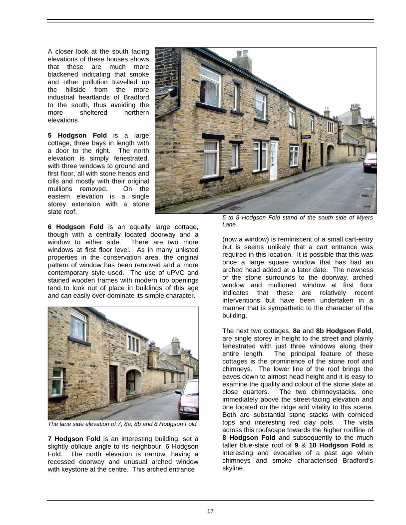
A closer look at the south facing elevations of these houses shows that these are much more blackened indicating that smoke and other pollution travelled up the hillside from the more industrial heartlands of Bradford to the south, thus avoiding the more sheltered northern elevations. 5 Hodgson Fold is a large cottage, three bays in length with a door to the right. The north elevation is simply fenestrated, with three windows to ground and first floor, all with stone heads and cills and mostly with their original mullions removed. On the eastern elevation is a single storey extension with a stone slate roof. 6 Hodgson Fold is an equally large cottage, though with a centrally located doorway and a window to either side. There are two more windows at first floor level. As in many unlisted properties in the conservation area, the original pattern of window has been removed and a more contemporary style used. The use of uPVC and stained wooden frames with modern top openings tend to look out of place in buildings of this age and can easily over-dominate its simple character.
The lane side elevation of 7, 8a, 8b and 8 Hodgson Fold. 7 Hodgson Fold is an interesting building, set a slightly oblique angle to its neighbour, 6 Hodgson Fold. The north elevation is narrow, having a recessed doorway and unusual arched window with keystone at the centre. This arched entrance
5 to 8 Hodgson Fold stand of the south side of Myers Lane. (now a window) is reminiscent of a small cart-entry but is seems unlikely that a cart entrance was required in this location. It is possible that this was once a large square window that has had an arched head added at a later date. The newness of the stone surrounds to the doorway, arched window and mullioned window at first floor indicates that these are relatively recent interventions but have been undertaken in a manner that is sympathetic to the character of the building. The next two cottages, 8a and 8b Hodgson Fold, are single storey in height to the street and plainly fenestrated with just three windows along their entire length. The principal feature of these cottages is the prominence of the stone roof and chimneys. The lower line of the roof brings the eaves down to almost head height and it is easy to examine the quality and colour of the stone slate at close quarters. The two chimneystacks, one immediately above the street-facing elevation and one located on the ridge add vitality to this scene. Both are substantial stone stacks with corniced tops and interesting red clay pots. The vista across this roofscape towards the higher roofline of 8 Hodgson Fold and subsequently to the much taller blue-slate roof of 9 & 10 Hodgson Fold is interesting and evocative of a past age when chimneys and smoke characterised Bradford’s skyline.
17

The end cottage is 8 Hodgson Fold, whose north elevation has just a single window and is half a storey higher than its neighbour. The sandstone bricks have been finely laid in regular courses and the existence of added features such as supporting brackets under the eaves and quoined angles indicate that this property was intended for a wealthier family.
The front elevation of 8 Hodgson Fold faces onto a stone setted yard. Just to the west of 8 Hodgson Fold a narrow track drops down around the cottages, leading into a stone setted yard. The sloping land means that the houses have taller frontages from this aspect, the single storey cottages being two-storey from the yard. No. 8 has an interesting frontage, the central doorway having an ornate cornice on bold brackets that dominates the elevation. There are two large square windows to either side of the door and at first floor three windows of varying size. All have simple flat-faced stone surrounds that protrude slightly from the front wall. It is likely that the windows would have originally been mullioned. A dentil course runs under the line of the timber gutter. A stone set into this elevation is inscribed: Southview JL & S Crowther 1900 indicating that the frontage may have been altered or even rebuilt at this time. The lower roofline of 8a and 8b Hodgson Fold means that these cottages take on a slightly submissive character to no. 8, though they are similarly fenestrated. The large square windows are set in protruding stone surrounds and both of the doorways are decorated with brackets and a cornice, though slightly less ornate than that of 8 Hodgson Fold.
7, 8a and 8b Hodgson Fold are simple stone cottages. The long stone range extending back from 7 Hodgson Fold blocks the vista along this frontage. The straight line of the cottages is broken by the long range of 7 Hodgson Fold, which extends at right angles to the building line and effectively blocks the view along the row of the cottages. This range is obviously of some age, maybe contemporary with the construction of no. 7 itself. It has a number of architectural features that indicate that it may have been constructed around the late 18th /early 19th century.
The prominent gable end of 7 Hodgson Fold displays several interesting architectural features. The taking-in door (now window) indicates a previous semi-industrial use. The prominent west-facing gable-end is almost blank, having just a small doorway and square window. The large quoins and shaped dentil course holding up the timber gutter add interest. The gable end, which is only visible from the
18

garden area, is heavily blackened by pollution. It has a number of intriguing features, such as the dovecote just above what was probably a taking-in door previously (now a window). The taking-in door indicates that this property may have had a semi-industrial use some time ago and the upper floor may have been used for some activity such as weaving or spinning. To either side of the taking-in door are two narrow vents set in stone surrounds. Level with the bottom of the taking-in door are two protruding stones, their intended use unknown. At ground floor are two windows, probably later 19th century insertions. The edge of the roof is topped by tabled copingstones and the gable retains shaped kneelers to its corners.
The group of 17th and 18th century buildings at the head of Myers Lane form the core of the original settlement. At the western end of Myers Lane is a cluster of buildings that form the heart of this 17th century hamlet. The view down the lane to this group, between the two rows of cottages is an interesting one as the differences between the multiple phases of development of Hodgson Fold are easily readable. On the south side of this group of are a pair of late-19th century houses that despite their later age blend in well with the earlier buildings. The frontage of this pair, 9 & 10 Hodgson Fold, faces southwards down the slope of the hill and is constructed of darkened sandstone. These houses were built on the site of a row of old cottages by James Hodgson Jowett Atkinson, after inheriting through marriage, much of the land at Hodgson Fold. Built c. 1870, these semi-detached houses were constructed in an ornate Italianate style and have retained many of their original period features.
The front elevation of 9 Hodgson Fold (Grade II listed) faces southwards away from the lane. The south facing elevation has two flanking breaks to either end, which stand forward of the main elevation. Set within these breaks is a curved bay window at ground floor inset with arch headed sash windows. At first floor is a pair of arched windows set in a decorative corniced stone surrounds. The main elevation is four bays wide. Each dwelling has a doorway set in substantial stone surrounds and an arch headed window at ground floor level. At first floor are four windows, two to each house, that have squared heads and interesting shaped stone cills supported on carved
brackets. All of the window openings retain attractive timber sliding sash frames and panelled timber doors. The retention of these features is a good illustration of how the correct type of window and door in a building can enhance its character and interest. Other features include the
curved dormer windows on the roof slope and the fine stone detailing just below the eaves. The attention to detail on these houses is an indication
19

of the affluence of the Hodgson family during the late 19th century.
The east elevation is relatively plain, though the iron gates that allow access to the front of the property are an interesting feature. The rear elevations of the houses are visible over a tall stone wall which delineates the line of the street from the curtilage of the building. A single storey kitchen (contemporary with
the main body of the house) and an exceedingly tall stone chimney are interesting features that dominate the rear elevation. Attractive stained glass stair windows set within the rear elevation enhance this scene along with the plainer four-pane timber sash windows and curved dormer windows.
Set immediately to the northwest of the Italianate villas is a substantial property that is subdivided into 11, 12 & 13 Hodgson Fold. This building is Grade II listed and probably the most prominent single building in the conservation area, standing at the head of the lane and visible from most places.
11 & 12 Hodgson Fold (Grade II listed). The porch on the gable frontage of 11 & 12 Hodgson Fold is inscribed ‘JH 1652’. It is thought that John Hodgson, the first recorded member of the Hodgson family to have settled in Bolton, built the house around this date and is one of the oldest buildings in the hamlet. It has a broad gabled frontage on its east elevation and is built from roughly shaped and coursed sandstone brick. The aforementioned porch is constructed of the same stone, with two timber stable doors set within quoined surrounds. The date is inscribed on a huge irregular stone lintel above the left-hand doorway. The left hand side of the gable has two windows at ground and first floor, probably inserted in the 19th century when the building was altered and subdivided.
The tall chimney to
the rear of 9 & 10 Hodgson
Fold is an interesting
feature that dominates
this elevation and makes a
valuable contribution to
the conservation
area.
Directly opposite 11 and 12 Hodgson Fold is a single building, now subdivided into two dwellings, 15 and 15a Hodgson Fold. This building, formerly a barn, was probably built around the start of the 19th century and is also a Grade II listed building. The gable end is set slightly above the level of the lane and at two storeys in height, it is prominent in the streetscape. Set within the gable end are six windows in flat-faced stone surrounds. The majority of these appear to be recent insertions, though the window at first floor level on the right hand side probably dates from the 19th century. The centrally located door is accessed via a number of stone steps.
20

The prominent gable end of 15 Hodgson Fold faces onto the lane. From the gable end it is easy to follow the line of the stone slate roof. The rear (east) elevation of the property is covered by a long low roof, which rises up steeply to the ridge line and drops away to a steep, short roof slope at the west side of the building. Attached to the rear of 15 Hodgson Fold are a number of stone outbuildings and extensions. This has resulted in an interesting collection of stone covered roofs and chimneys set at a variety of levels that are visible from the lane.
15 and 15a Hodgson Fold, viewed from the lane, is a Grade II listed former barn. Maps of the area indicates that Myers Lane ends outside 11 & 12 Hodgson Fold, however the tarmacced track continues alongside the west-facing elevation of 15 and 15a Hodgson Fold, which is set back just a short distance from the edge of the carriageway. Set within the west elevation is a considerable number of windows and openings, some partly obscured by ivy. Some appear to be 19th century, having narrow weathered stone heads and cills, others seem to be later as the difference in colour and shape of
the stone surrounds indicates these have not yet been long exposed to the weather and elements. At the northern end of the building is a single storey extension with a stone slate roof and a timber-boarded door in the northern elevation. At the rear of no. 15a is a long two-storey range which runs away from the building line at right angles. Built from yellowy-grey hued sandstone, this barn is simple architecturally and though much of its original agricultural character has been lost in the conversion into residential use, it does make a valuable contribution to the group of buildings at the head of the lane. Opposite 15 and 15a Hodgson Fold are 17 and 18 Hodgson Fold, with no. 18a attached to the north elevation. This is an interesting collection of buildings that have may have 17th century origins, though they have been substantially altered and added to over the years.
The gable end of 17 and 18 Hodgson Fold stands prominently at the head of the lane.
17 and 18 Hodgson Fold share a gabled frontage that faces south into the heart of the fold. Built of sandstone brick and roofed with stone slate, the south elevation of the building has four large windows that are divided by stone mullions into four-lights. These were probably added during the 18th century when the building was substantially altered. Immediately to the north of this building is a long low range, which may have originally been used as a barn and now has four windows in flat-faced stone surrounds inserted in the lane side elevation. At the head of the lane is the two-storey dwelling that is 18a Hodgson Fold, half a storey taller than the adjoining range. Built of sandstone brick and probably dating to the early 19th century, this building has an unusual chamfered corner where the lane turns and runs along the northern
21
elevation. The building is simply fenestrated to its east elevation, having a timber-boarded door and window at ground floor level and two windows at first floor level. To the rear is a timber glazed conservatory and a flat-roofed garage.
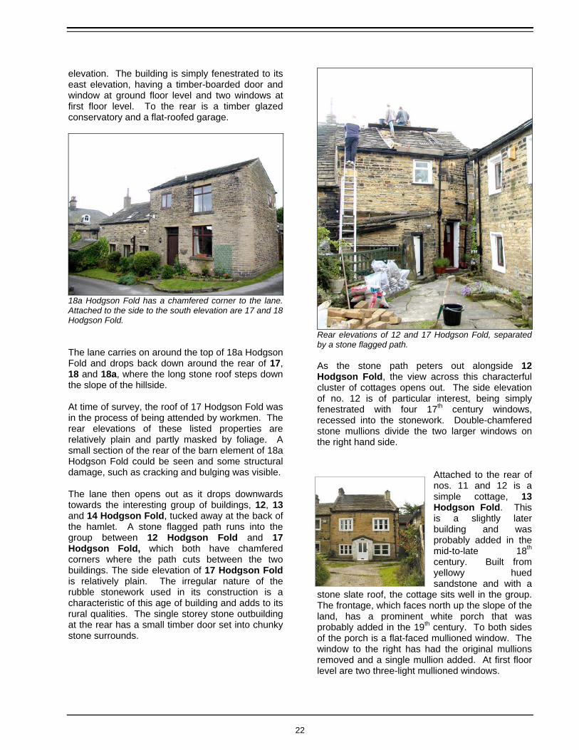
18a Hodgson Fold has a chamfered corner to the lane. Attached to the side to the south elevation are 17 and 18 Hodgson Fold. The lane carries on around the top of 18a Hodgson Fold and drops back down around the rear of 17, 18 and 18a, where the long stone roof steps down the slope of the hillside. At time of survey, the roof of 17 Hodgson Fold was in the process of being attended by workmen. The rear elevations of these listed properties are relatively plain and partly masked by foliage. A small section of the rear of the barn element of 18a Hodgson Fold could be seen and some structural damage, such as cracking and bulging was visible. The lane then opens out as it drops downwards towards the interesting group of buildings, 12, 13 and 14 Hodgson Fold, tucked away at the back of the hamlet. A stone flagged path runs into the group between 12 Hodgson Fold and 17 Hodgson Fold, which both have chamfered corners where the path cuts between the two buildings. The side elevation of 17 Hodgson Fold is relatively plain. The irregular nature of the rubble stonework used in its construction is a characteristic of this age of building and adds to its rural qualities. The single storey stone outbuilding at the rear has a small timber door set into chunky stone surrounds.
Rear elevations of 12 and 17 Hodgson Fold, separated by a stone flagged path. As the stone path peters out alongside 12 Hodgson Fold, the view across this characterful cluster of cottages opens out. The side elevation of no. 12 is of particular interest, being simply fenestrated with four 17th century windows, recessed into the stonework. Double-chamfered stone mullions divide the two larger windows on the right hand side.
Attached to the rear of nos. 11 and 12 is a simple cottage, 13 Hodgson Fold. This is a slightly later building and was probably added in the mid-to-late 18th century. Built from yellowy hued sandstone and with a
stone slate roof, the cottage sits well in the group. The frontage, which faces north up the slope of the land, has a prominent white porch that was probably added in the 19th century. To both sides of the porch is a flat-faced mullioned window. The window to the right has had the original mullions removed and a single mullion added. At first floor level are two three-light mullioned windows.
22

The cluster of attractive cottages and barns tucked away at the rear of the Fold include 12, 13 and 14 Hodgson Fold, all Grade II listed buildings.
The gable fronted building on the right hand side is 14 Hodgson Fold, a 17th century cottage that was refronted in the 19th century.
The roofline is slightly higher than that of nos. 11 and 12 and is delineated by a line of flat copingstones to either gable end. A shaped kneeler to each side adds further interest, as do the two corniced chimneystacks. The building continues some way back from the frontage though little can be seen of this due to the height of the roofline. Set at an oblique angle to nos. 12 and 13 is 14 Hodgson Fold and its adjoining barn. Both are Grade II listed buildings and are thought to date to the 17th century, though it may possibly have earlier origins. Both are constructed from sandstone and have stone slate roofs, the roofline of the cottage being higher than that of the barn. The cottage has a narrow east-facing frontage which was altered in the mid-19th century. At this time the gabled sandstone ‘brick’ frontage was probably added, as the side elevation reveals rubble stonework that is likely to be earlier. The gabled front has a recessed doorway to the left and two large windows set into stone surrounds. Originally these windows would have had four-pane timber sash windows but these have been altered to a top opening casement, albeit to a similar pattern.
The side elevation is entirely plain, with no openings. The rear elevation reveals a collection of extensions and additions that have been rendered and painted and includes a number of interesting windows from different eras in its evolution.
Barn to the side of 14 Hodgson Fold.
The barn to the south of the cottage is an intriguing building that remains partially unconverted, though appears to be in use as a garage. Central in the frontage of the barn is a square opening with large quoins to either side, set within which is a simple timber-boarded door. To the right of the door is a square window set in simple stone surrounds, above which is a small three-light opening. The long low stone roof is unbroken by window lights and this adds much to the rural character of the building.
23

Tucked away at the back of the Fold, this group of buildings have retained their simple rural character to a greater extent than elsewhere in the conservation area. The track that provides access is unsurfaced and the view northwards is green and open, the surrounding housing estates being hidden behind the building line.
16 and 16a Hodgson Fold are slightly divorced from the main settlement being tucked away at the very western end of the conservation area. Hidden away at the western end of the conservation area are 16 and 16a Hodgson Fold, a substantial Victorian villa that is now subdivided into two dwellings. The villa is accessed along a driveway to the side of 14 Hodgson Fold and is well screened by the mature trees that stand in the gardens. The house is approached from the east along the gravelled driveway, which is defined on its northern side by a substantial stone wall topped with triangular copingstones. The eastern gable end provides the entrance to 16 Hodgson Fold, which has a blue-slate hipped roof. Set within this elevation is a centrally located doorway with a transomed light and a heavy stone cornice supported by carved brackets above. To either side of the doorway is a long window with a simple stone head and cill. At first floor level are two more similarly sized windows and a smaller third opening. Adjoining the northern side of the gable is a tall stone outhouse with a single sloping pitched roof and the remains of a stone chimneystack. A stone path leads around to the front of the building and the doorway to 16a Hodgson Fold. This would have originally been the principal elevation of the house prior to its subdivision. Set centrally in this elevation is another doorway, with
stone columns to both sides and a corniced head. The windows to the left of the door have been altered to a 20th century style and appear out of place in the elegant frontage of the house. To the right the Victorian openings have been retained, though the timber sash windows have been altered to modern stained timber casements. A continuous sill band runs beneath the ground floor and first floor windows and the prominent quoined angles add interest to the house. An inscribed stone resting on a first floor window ledge indicates that the property was built in 1856.
24
7. Open Spaces and Natural Elements
Summary of Open Spaces and Natural Elements
The spaces between and around the buildings are an important contributing characteristic of the conservation area in Hodgson Fold: • The hamlet of Hodgson Fold developed in an
organic and unplanned manner, typical of small farming communities in the 17th and 18th centuries.
• The farmhouses and cottages have been built
very close to one another, leaving little space for garden areas or any form of public open space.
• The later 19th century buildings tend to have
larger garden areas, reflective of the affluence of their original residents. The trees within these gardens contribute much to the character of the conservation area and complement the natural stone of the surrounding buildings.
• The school fields to the north of the
conservation area are open and grassy and their greenery complements the rural character of the conservation area.
The interrelationship of the built form with space in the conservation area is a fundamental component of the character of the place. The size, shape and treatment of these spaces are all factors in determining whether, for example, the area takes on a domestic, rural, urban, industrial or civic aspect. Hodgson Fold conservation area is not characterised by large areas of open space, either hard surfaced or green. However, the small
spaces between the buildings and the spatial relationship of the structures to one another make a vital contribution to its historical interest of the conservation area.
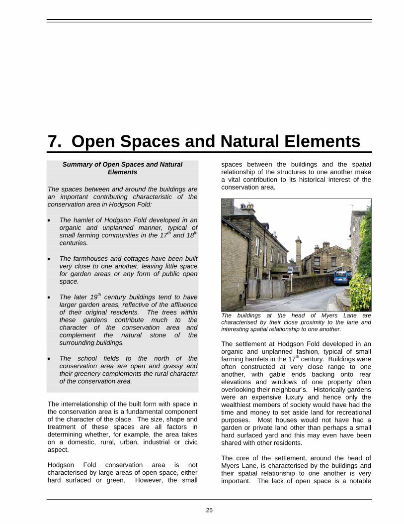
The buildings at the head of Myers Lane are characterised by their close proximity to the lane and interesting spatial relationship to one another. The settlement at Hodgson Fold developed in an organic and unplanned fashion, typical of small farming hamlets in the 17th century. Buildings were often constructed at very close range to one another, with gable ends backing onto rear elevations and windows of one property often overlooking their neighbour’s. Historically gardens were an expensive luxury and hence only the wealthiest members of society would have had the time and money to set aside land for recreational purposes. Most houses would not have had a garden or private land other than perhaps a small hard surfaced yard and this may even have been shared with other residents. The core of the settlement, around the head of Myers Lane, is characterised by the buildings and their spatial relationship to one another is very important. The lack of open space is a notable
25

facet of their character. However, greenery is present in small areas in the form of narrow strips of grass and climbing plants on walls. The buildings in this part of the conservation area are clustered tightly together and even the tiny areas of open space between the buildings are hard surfaced.
The group of cottages and barns in which 12, 13, 14, 17 and 18 Hodgson Fold are set is another area where much interest is derived from the spatial relationship between the buildings. Clustered around the end of an unsurfaced track, this small area of open space appears to be a shared access/parking area but when clear it allows one to step back take in the full impact of the vista across this fascinating group of buildings.
This huddle of cottages and barns are set back around a small area of open space that acts as an access route. The informal surfacing and greenery adds a rural quality to the scene that enhances the simple architectural features of the buildings. Behind the group of buildings at the heart of the conservation area are larger areas of greenery and trees. Where they are visible these natural elements complement the stone of the walls and
buildings and adds to the rural character of the place. The larger garden areas of 9 and 10 Hodgson Fold are a good example. Set along the southern boundary of these gardens are a number of tall trees and shrubs. These not only enhance the setting of the two houses but also effectively screen views between the conservation area and the modern houses beyond. This green barrier helps maintain the rural hamlet feel of the place, belying the Fold’s suburban location. The communal
hard surfaced area to the south of 7 and 8 Hodgson Fold was originally the only ‘garden’ space these properties owned.
A similar situation also arises at the western end of the conservation area where the green and leafy gardens of 16 and 16a Hodgson Fold also help maintain a visual barrier between the housing estate to the south and west of the conservation area thus maintaining the important character of the place.
The garden of nos. 16 and 16a contain a number of good mature trees, visible here at the entrance to the driveway.
15 and 15a Hodgson Fold also have a substantial sized garden to the rear. Partly hard surfaced and partly green, this large garden is bordered to the lane by a stone wall which is backed by a tall screen of conifers that add a slightly suburban feel to the scene.
26
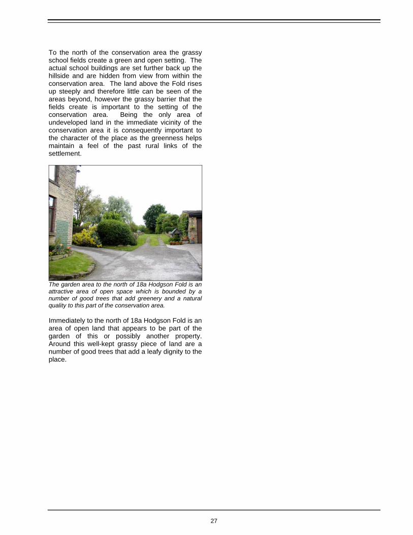
To the north of the conservation area the grassy school fields create a green and open setting. The actual school buildings are set further back up the hillside and are hidden from view from within the conservation area. The land above the Fold rises up steeply and therefore little can be seen of the areas beyond, however the grassy barrier that the fields create is important to the setting of the conservation area. Being the only area of undeveloped land in the immediate vicinity of the conservation area it is consequently important to the character of the place as the greenness helps maintain a feel of the past rural links of the settlement.
The garden area to the north of 18a Hodgson Fold is an attractive area of open space which is bounded by a number of good trees that add greenery and a natural quality to this part of the conservation area. Immediately to the north of 18a Hodgson Fold is an area of open land that appears to be part of the garden of this or possibly another property. Around this well-kept grassy piece of land are a number of good trees that add a leafy dignity to the place.
27

8. Permeability and Streetscape
Summary of Permeability and Streetscape
The form, width and orientation of streets and paths determine the permeability and ease of movement through conservation areas. The small size of the hamlet means there are limited ways of moving across the conservation area however:
• Myers Lane is the principal access route into the settlement. The route is very much the same as it was prior to the development of the residential estate. A number of older cottages and the lodge to Grove House still stand amongst the later houses.
• Upon entering the conservation area the open aspect of the lane alters dramatically. The continuous line of the cottages up against the edge of the highway helps create a sense of enclosure and views are channelled along the lane towards the group of older buildings at the western end.
• The streetscape is enhanced by the variety and height of building types along its length. The lane twists and turns around the buildings before disappearing altogether as it descends towards 12, 13 and 14 Hodgson Fold.
• The few footpaths that run along the boundary of the conservation area help improve the permeability of the area by offering a choice of routes.
Hodgson Fold developed as a cluster of farm buildings and cottages at the head of Myers Lane. Later 19th century developments extended further eastwards along the lane, which is the principal access into the hamlet. Though it is not known exactly when the lane first came into use it is likely that it was preceded by a
footpath or cart track of some description that would have allowed access to the fields prior to the construction of the buildings in the Fold.
The line of Myers Lane may be similar to the route it followed 150 years ago but the setting and surfacing of lane is now very different. The earliest known map of the area (Jeffrey’s map of 1775) shows very little detail in relation to the settlement or its access. The Ordnance Survey map of 1852 shows greater detail and the similarity between the line of the lane 150 years ago and its present course is obvious. It seems likely that over the years the course of the lane has been formalised and some of the kinks that are visible on the earlier maps were straightened out. Robert Allan (1927), a Bolton historian, wrote that prior to a proper road being laid, Hodgson Fold was approached via a narrow cart track that lay immediately to the Bradford side of the current road. The cart track followed the lie of the land and its route was lined with huge stone flags that were laid out so that cartwheels could run along them while the horse walked down the middle. It was also noted that a stream ran alongside the track, which was used by residents for drinking,
28

washing etc. The line of the current track was said to have been laid by James Atkinson Jowett when he built Grove House (Allan, 1927). The 1892 map of the area shows Grove House and a carriage track leading southwards towards Bolton Road, crossing Myers Lane. Grove House has since been demolished but the stone lodge still stands on Myers Lane at the point where it was crossed by the driveway to the house. Historical sources conjecture that the Myers Lane was named after Joseph Myers, a carpenter turned farmer who bought land from Jonathan Hodgson in 1763 (Allan, 1927). It is said that Joseph Myers built a farm and a number of cottages further along the lane around this date, though their precise location is not known. Myers Lane now runs through a post-war housing estate prior to its arrival at Hodgson Fold. Some older cottages and the aforementioned lodge are still present but the road is now surfaced with concrete and the impacts of modern highway engineering have altered the streetscape vastly.
The view into the conservation area is dictated by the hard line of cottages up against the rear of the carriageway. Myers Lane enters the conservation area between the rows of stone cottages to either side of the lane. At this point the open aspect of the lane alters dramatically as the building line is brought forward immediately onto the rear of the highway. The continuous line of the cottages channels the eye along the length of the lane towards the group of buildings at the western end that effectively block any views beyond. At this point Myers Lane effectively ends but a tarmacced track leads northwards alongside 15 Hodgson Fold before turning sharply around 18a Hodgson Fold. The sharp twists and turns of the track echo the organic way in which the settlement developed. Views are short range and the buildings that line the edge of
the highway maintain the sense of enclosure within the place.
The lane twists and turns sharply around the buildings at the heart of the conservation area, creating interesting short-range views and vistas. As the lane bends around 18a Hodgson Fold the tarmac ends and the lane is simply gravelled and grassed. As it drops down towards the cluster of cottages that are 12, 13 and 14 Hodgson Fold the track disappears entirely and the streetscape takes on a more natural and informal feel.
The streetscape in Hodgson Fold conservation area is made interesting by the variety and height of buildings along the length of the lane. The narrow passageways that run around the back of buildings and between them contribute to its rural and organic character.
A driveway continues westwards towards 16 and 16a Hodgson Fold. Part way along the drive a narrow path diverts away from the driveway and runs along the northern boundary of the property and conservation area to join another footpath that leads into the housing estate beyond. Another footpath running along the eastern boundary of the
29

conservation drops down the hillside alongside 5 Hodgson Fold towards Ashbourne Garth. The footpath alongside 16 and 16a Hodgson Fold certainly predates the development of the later housing estate as it is shown on the 1892 Ordnance Survey map of the settlement. These paths contribute somewhat towards the permeability of the Fold and offer a choice of routes across and around the conservation area.
30

9. Conclusion: Character Specification and Guidance
To safeguard the special interest of an area, the Conservation Area designation aims to protect and enhance the character and appearance of the place. Many features interact to form the unique qualities of Hodgson Fold Conservation Area, such as:
the style, form, orientation, massing, height and scale of buildings;
the way the built structure interfaces with the spaces created;
the width and orientation of lane; the colour and texture of the materials
used; the topography and setting of the area; the roofscape and streetscape; how the area interacts with the
surrounding environment; natural elements; and local detailing.
However, less physical features, such as the current uses of buildings and spaces, their condition and intangible ingredients such as sounds and smells, are all factors in creating the identity of Hodgson Fold conservation area. This section highlights the elements that contribute to the character and appearance of the conservation area, summarising the information contained in the body of this document, and puts forwards policies that will provide the framework of the protection of these features. Owners and occupiers of sites within the conservation area, prospective developers and the Council should use this to determine what constitutes appropriate change and as a basis for the future management of the area. It should be read in conjunction with the policies set out in Bradford Unitary Development Plan (see Appendix 3).
31

Characteristics Common to the Entire Conservation Area
Common Characteristics Guidance
• Topography and setting – Hodgson Fold developed as a small farming community within the township of Bolton. The settlement is located on a hillside, with land sloping gently downwards from north to south. Now surrounded by post-war housing estates to the south, east and west and with school fields to the north, the settlement is an enclave around which the suburbs of Bradford have developed.
1. It is essential that the significant views and vistas into, out of and through the conservation area are respected in any development within the conservation area or affecting its setting. Applicants will be requested to provide evidence that this has been considered as part of the evaluation of the site (see Policy BH10 of the Unitary Development Plan (UDP).
2. New development that will impact the setting of the conservation area, as being either immediately within the vicinity or clearly visible from within its confines, should echo the principles of good design set out for new build and not over dominate its form or buildings and respect important areas of green space and woodland (see Policy BH7 of the UDP).
• Traditional building materials – The buildings within the conservation area are almost entirely constructed of local stone, which serves to unify the built form of settlement and create a harmonious whole. Stone slate is the principal roofing material and natural stone has been used for boundary walls. Timber was traditionally used for window frames, doors and guttering though these elements are most susceptible to change and many have been replaced with less sympathetic modern alternatives.
3. There should be a presumption in favour of retaining original materials, such as stone slate. Where the replacement of features is necessary and the traditional has survived this should be done on a like-for-like basis. Where features have been replaced by modern alternatives, the reinstatement of traditional style features constructed in traditional materials will be encouraged (see Policy BH7 of the UDP).
4. Stone cleaning should be resisted where it would interfere with the uniformity of the colour of the stone, particularly in regard to terraced properties. Advice should be sought form the conservation team before cleaning any of the stone buildings of the conservation area (See Policy BH7 of the UDP).
5. Repair and maintenance work to stone buildings within the conservation area (e.g. repointing, repairs to the roof, etc.) should be carried out in an appropriate manner. The conservation team can advise (see Policy BH7 of the UDP).
6. Any new development should make use of quality materials that reflect the interest of the area and sit harmoniously with the existing fabric and respect the uniformity in the colour and texture of the built form of the conservation area (see Policy BH7 of the UDP).
Local stone, which has been used for buildings, walls, roofs and even surfaces, is a crucial element of the character of the conservation area.
32

• Setted and flagged carriageways and footpaths - Only very limited areas of stone setts and flags remain in Hodgson Fold, the principal areas being in private ownership such as the yard to the rear of 7 to 9 Hodgson Fold. Stone surfacing is a historic material and even in small areas adds interest to the conservation area.
7. There should be a presumption in favour of preserving the areas of setted and flagged surfaces of the conservation area (see Policy BH11 of the Unitary Development Plan).
• Boundary walls – Most of the houses front straight onto the lane and therefore have no boundary treatment as such. Stone boundary walls surround some of the later properties in the conservation area. As a traditional form of boundary treatment these walls add interest and variety to the streetscape and should be retained.
8. Existing boundary walls should be retained and restored. Boundary walls constructed of stone that matches the existing should be incorporated into the design of any new development within the conservation area (see Policy BH9 of the Unitary Development Plan).
• Permeability – The small size of the conservation area means permeability and choice of routes across the Fold is restricted. Myers Lane is the principal route into the settlement and a number of footpaths run along the boundary of the area.
9. The road layout of the conservation area is important to its character and its historic interest. Therefore the width direction and orientation of roads and paths through the area should be preserved (see Policy BH7 of the Unitary Development Plan).
The survival of even small areas of stone setts contributes greatly towards the interest of the conservation area.
A substantial stone boundary wall to the rear of 9 & 10 Hodgson Fold separates the lane from the private garden area.
Myers Lane is the principal means of access to the conservation area. The views and vistas it creates as it twists and turns around the buildings result in a varied streetscape.
33
Architecture and building details
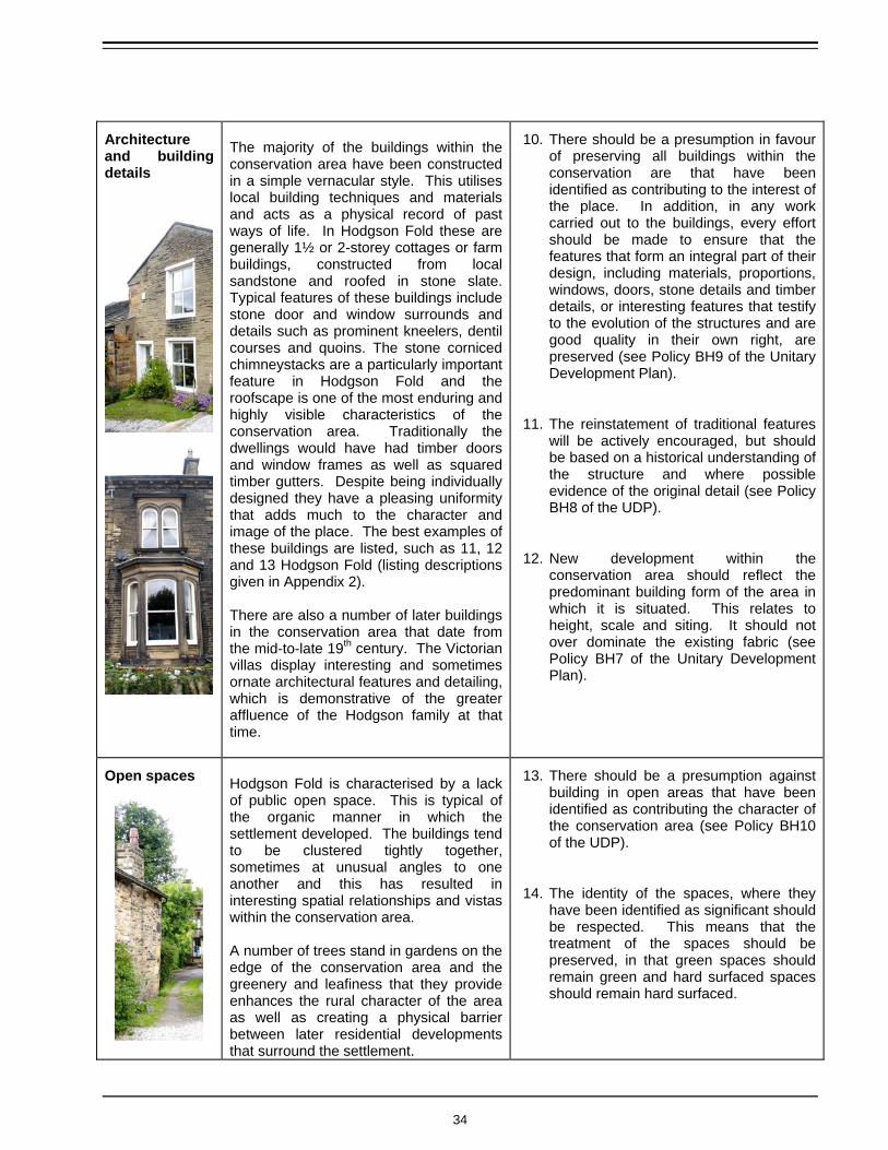
The majority of the buildings within the conservation area have been constructed in a simple vernacular style. This utilises local building techniques and materials and acts as a physical record of past ways of life. In Hodgson Fold these are generally 1½ or 2-storey cottages or farm buildings, constructed from local sandstone and roofed in stone slate. Typical features of these buildings include stone door and window surrounds and details such as prominent kneelers, dentil courses and quoins. The stone corniced chimneystacks are a particularly important feature in Hodgson Fold and the roofscape is one of the most enduring and highly visible characteristics of the conservation area. Traditionally the dwellings would have had timber doors and window frames as well as squared timber gutters. Despite being individually designed they have a pleasing uniformity that adds much to the character and image of the place. The best examples of these buildings are listed, such as 11, 12 and 13 Hodgson Fold (listing descriptions given in Appendix 2). There are also a number of later buildings in the conservation area that date from the mid-to-late 19th century. The Victorian villas display interesting and sometimes ornate architectural features and detailing, which is demonstrative of the greater affluence of the Hodgson family at that time.
10. There should be a presumption in favour of preserving all buildings within the conservation are that have been identified as contributing to the interest of the place. In addition, in any work carried out to the buildings, every effort should be made to ensure that the features that form an integral part of their design, including materials, proportions, windows, doors, stone details and timber details, or interesting features that testify to the evolution of the structures and are good quality in their own right, are preserved (see Policy BH9 of the Unitary Development Plan).
11. The reinstatement of traditional features will be actively encouraged, but should be based on a historical understanding of the structure and where possible evidence of the original detail (see Policy BH8 of the UDP).
12. New development within the conservation area should reflect the predominant building form of the area in which it is situated. This relates to height, scale and siting. It should not over dominate the existing fabric (see Policy BH7 of the Unitary Development Plan).
Open spaces
Hodgson Fold is characterised by a lack of public open space. This is typical of the organic manner in which the settlement developed. The buildings tend to be clustered tightly together, sometimes at unusual angles to one another and this has resulted in interesting spatial relationships and vistas within the conservation area. A number of trees stand in gardens on the edge of the conservation area and the greenery and leafiness that they provide enhances the rural character of the area as well as creating a physical barrier between later residential developments that surround the settlement.
13. There should be a presumption against building in open areas that have been identified as contributing the character of the conservation area (see Policy BH10 of the UDP).
14. The identity of the spaces, where they have been identified as significant should be respected. This means that the treatment of the spaces should be preserved, in that green spaces should remain green and hard surfaced spaces should remain hard surfaced.
34

10. Proposals 10.1 Conservation Area Boundary In preparing this Conservation Area Assessment document, the boundary of the conservation area was assessed by the Conservation Team in order to determine whether it covered a cohesive area of architectural or historic interest and follows property boundaries and physical features. All boundary suggestions received during consultation were visited by the Conservation Team in order to determine whether it would be appropriate to amend the conservation area boundary. This process has resulted in one change to the original conservation area boundary, which was designated in 1974: Include the entire garden of 15a Hodgson
Fold. The original conservation area boundary included the Grade II Listed former barn at 15-15a Hodgson Fold, but excludes the northeastern corner of the garden of no.15a. Conservation area boundaries should follow physical features and should not split individual property boundaries in two, therefore it is logical and practical to include the entire garden of 15a Hodgson Fold within the conservation area.
10.2 Enhancement and Preservation Proposals Naturally there are some elements of the conservation area that are not conducive to the predominant character of the area and do not contribute to an understanding of its historical development. These may detract from its character and appearance or may simply not contribute to it in a positive way. The following are proposals as to how the quality and identity of the place could be strengthened by the active co-operation of the Council, developers and the local community. They are listed in order of priority
(most important first) as identified by the community:
Guidance Notes on the Repair and Maintenance of Historic Buildings. Some of the traditional stone buildings of the area have unsympathetic replacement features and have undergone well intentioned but on occasions inappropriate repair. The production of a guidance note on the repair and maintenance of stone buildings, particularly vernacular style properties, of the region would increase awareness of fitting repair techniques.
Maintenance of the Highway. Myers Lane is the principal route into the settlement and is tarmacced for its entire length. The section of the lane and pavement that extends into the conservation area has been patched a number of times by various statutory bodies undertaking work. It is possible that the lane was setted at an earlier time and the restoration of some areas of stone setts could be considered, as this would enhance greatly the setting of the buildings at the heart of the conservation area.
Monitor Planning Applications. Planning Applications for development within and immediately around the conservation area will be monitored more closely in line with the guidance given in the previous sections of this document. This guidance complements and expands upon policies set out in the Unitary Development Plan and applies them to the special circumstances of Hodgson Fold.
• Retention of Original Features. In many
unlisted buildings traditional timber windows
35

and doors have been replaced with unsympathetic modern alternatives. The resulting appearance is at odds with the character and age of the building and consequently this has harmed the appearance and character of the area on a wider scale. Other features such as natural roofing materials, stone boundary walls and chimneys also contribute much to the interest of the conservation area. In order to protect these features the Council may consider implementing an Article 4 (2) direction to protect these features. This would remove some of the permitted development rights available to householders, meaning that planning permission would be required to replace important features and ensuring that sympathetic replacements are used.
Environmental Enhancement. Whilst it is not appropriate to make an area look overly pristine the care of the natural elements of the conservation area, such as trees, as well as general maintenance of open spaces such as the areas to the front of 12, 13 and 14 Hodgson Fold is important in maintaining the special character and appearance of the place.
Design Guidance for New Development. Any new buildings, outbuildings or extensions constructed within or adjacent to the conservation area, must respect the special character of Hodgson Fold. The production of design guidance for Hodgson Fold would offer greater clarity and certainty to would-be developers, while protecting the special character of Hodgson Fold.
36

Glossary of Architectural Terms
Ashlar: Dressed stonework of any type, where the blocks have squared sides, carefully squared corners, and are laid in regular courses, usually with fine joints. The faces of the stones, called ashlars, are generally smooth and polished, but can be tooled or have a decorative treatment. Bracket: Any projection from the face of a wall whose purpose is to support a structure or object. Chamfer: Narrow face created when stone is cut at an angle, usually at 45 degrees. Coping: Top course, usually of some form of slab, of a wall, designed to prevent water penetrating into the core of the wall. Cornice: In Classic Architecture the top, projecting, horizontal division of the beam between columns. Dentil Course: Rectangular projecting blocks (dentils) tightly spaced like teeth, usually below cornices. Gable: The vertical part of the end wall of a building contained within the roof slope, usually triangular but can be any "roof" shape. Jamb: Usually taken to simply describe the vertical sides to a window or door opening. Properly used, it only relates to those vertical parts which support the lintel. Keystone: The stone at the crown of an arch. Kneeler: The sloping tabling which caps a gable and is upstanding above the plane of the roof. The skew end is the larger, usually square bottom stone of a skew and projects over the wallhead, and is usually moulded or carved. Light: The framed part of a widow opening. In a medieval timber framed building, a window would be formed by several lights separated by mullions. Mullion: Upright member dividing the lights of a window. Quoin: Stones larger or better shaped, than those of which a wall is composed, used to form the corners of walls or door and window openings. Laid in an arrangement of headers and stretchers on alternate courses, this gives strength to the
build, and allows the facework of the walling to tooth into the corner. Sash: A form of window in which two sashes, separated by parting beads, slides within a frame, the case, counterbalanced by weights hung on ropes, the sash cords. The glazing slides in two parallel frames within the case, the upper sliding outward of the lower. The projection of the top sash beyond the bottom sash traps a certain amount of shadow which gives the sash and case window a very satisfying 3-D effect. Setts: Square blocks, usually of granite but sometimes of hardwood for silence, forming a street surface. Setts were set on edge, close together, and they tapered slightly towards the bottom. Sides were never quite smooth, and laying them to achieve a tight joint, is a very skilful business. Sill Band: Continuous band of projecting stone that runs along the elevation of a building, usually between floors or below openings. Tabling: A flat coping usually refers to stones at the wallhead or gable of a building as opposed to a freestanding wall. Transom: A horizontal member dividing a window opening into separate lights. Sometimes in stone linked to vertical mullions. Vernacular: An indigenous building constructed of locally available materials, to local detail, usually without the benefit of an architect. Somehow it is now taken to imply a fairly humble or practical origin, but this is not the case.
37

Further Reading Historical Resources Allan, Robert C (1927) ‘The History of Bolton in Bradford-dale’ Birdsall, M et al (2002) ‘The Illustrated History of Bradford’s Suburbs’ Cudworth, William (1891) ‘Histories of Bolton and Bowling’ Hobson, Valerie et al (n.d.) ‘The History of Bolton 1610-1877 Planning Policy City of Bradford Metropolitan District Council (2005): ‘Bradford Unitary Development Plan’. Department of the Environment (1990): ‘Planning Policy Guidance 15 (PPG 15) – Planning and Historic Environment’. – HMSO, London.
Contacts This document is publicly accessible at the Bradford Planning Office, Bradford Library and on the Council’s website at: www.bradford.gov.uk/council/planning/heritage/cons_assess.asp For further information please contact: The Conservation Team Department of Transportation, Design and Planning City of Bradford Metropolitan District Council Jacobs Well, Manchester Road, Bradford BD1 5RW Tel. (01274) 432455 e-mail: [email protected]
38

Appendix 1: Map of Hodgson Fold Conservation Area
39

40

Appendix 2: List Descriptions of the Listed Buildings in
Hodgson Fold Conservation Area
41

Appendix 2: List Descriptions of the Listed Buildings in Hodgson Fold Conservation Area Myers Lane Bolton Outlanes, Bradford 2 Hodgson Fold (Nos. 9 and 10) 23/877 GV II Circa 1870 semi-detached Italianate houses of 2 storeys and attic, built by the Hodge family, after whom the Fold is named, and expressive of their greater affluence in the later part of the C19. Plain front to west, pitch-faced sandstone “brick”, chamfered quoins. Hipped slate roof with deep eaves on modillion brackets. Tall corniced chimneys. Curved gable dormers. Four window centre with flanking breaks containing paired round headed first floor windows and corniced canted bay windows on the ground floor. Corniced, console bracketed, doorways next to breaks. The interior of No. 10 remains unaltered with all mouldings, fittings etc in particular the ground floor right hand front room has the feature of mirror panelled walls as well as the overmantel above the marble mantelpiece. Myers Lane Bolton Outlanes, Bradford 2 Hodgson Fold (Nos. 11, 12 and 13) 23/878 GV II C17 origin, altered and subdivided in late C18 and early C19. Broad gabled irregular gritstone and sandstone “brick” front with flush quoins to corner of No. 12. Stone slate roof with saddle stone and shaped kneelers to gable. Square mullion windows. No. 11 has porch with date stone inscribed 1.4.1652. Side window has C17 splayed reveal but the mullions have been cut. No. 13 built on to rear in late C18 with shaped kneelers to gable end. Two 3 light square mullion windows, C19 porch.
Myers Lane Bolton Outlanes, Bradford 2 Hodgson Fold (Barn on corner of Fold to east of Nos. 11, 12 and 13) Now Nos. 15 & 15B 23/879 GV II Early C19 sandstone “brick” barn with stone slate roof, bracketed eaves. Beveled corner. Included for group value. Myers Lane Bolton Outlanes, Bradford 2 Hodgson Fold (No. 14 and adjoining barn) 23/880 GV II C17 or possibly earlier origin. Sandstone “brick”, stone slate roof. The house altered early C19 with rendered gabled front but retaining flush quoins exposed. C19 and later sash windows and casements. Rear gable retains 2 light square mullion windows. The barn has a 4 light square mullion window; very splayed reveal indicates C17 origin. The barn was originally open aisled and has king post roof trusses, largely rebuilt in the C18; main doorway has flush quoins. Myers Lane Bolton Outlanes, Bradford 2 Hodgson Fold, (Nos. 17, 18 and integral barn to rear) 23/881 GV II C17 origin altered late C18. Two-storey sandstone “brick” gabled front with flush quoins facing centre of the fold. The corner of No. 18 is splayed and curved on ground floor to allow for passageway. Four light square mullion windows on first floor, 3 light on ground floor all in squared surrounds. Squared jamb doorways. Stone slate roof carried over barn built on to rear.
42

Appendix 3: Legislation and Council Policies Relating to Conservation Areas
43
This is a brief summary of the legislation and policies relating to conservation areas at the time of the issue of this report. These will be subject to constant review. Legislation to Protect the Character and Appearance of Conservation Areas Conservation area designation intrinsically brings with it a certain number of additional controls to protect the existing character of the area:
• Removal of certain permitted development rights including various types of cladding; the insertion of dormer windows into roof slopes; the erection of satellite dishes on walls, roofs or chimneys fronting a highway; the installation of radio masts, antennae or radio equipment. Applications for planning permission for these alterations must be made to the Local Planning Authority.
• Control over the demolition of buildings: applications for consent must be made to the Local Planning Authority.
• The Local Planning Authority is required to pay special attention in the exercise of planning functions to the desirability of preserving or enhancing the character or appearance of the conservation area. This requirement extends to all powers under the Planning Acts, not only those which relate directly to historic buildings. It should also be a consideration for proposals that affect the setting of the conservation area.
• The local authority has powers (under Article 4 of the General Development Order) to control development which would normally be allowed without the need for permission, but which could lead to the deterioration of the character and appearance of the conservation area.
• Before works can be carried out to trees of more than 7.5cm in diameter across the trunk (measured 1.5m from the ground) which are standing in a conservation area, 6 weeks’ written notice must be given to the Local Planning Authority. No works should be carried out during this 6-week period unless consent has been granted by the Local Planning Authority.
(For further details of these controls see PPG15)
Listed buildings, which usually form an integral part of a conservation area, area afforded more stringent protection. The Local Planning Authority must give listed building consent before any work that would affect the character or interest of the
building can be carried out, be they internal or external alterations. Tight control restricts the nature of any alteration to which consent will be given.
City of Bradford Metropolitan District Council’s Policies Concerning Conservation Areas Structure, local and unitary development plans are the main vehicle that local authorities have to establish policies that can be utilised to protect the historic environment. The City of Bradford Metropolitan District Council has recently adopted its Unitary Development Plan (2005) which forms the basis of decision making on planning applications in the district. The UDP has the following policies relating to conservation areas: Policy BH7: Development within or which would affect the setting of conservation areas Development within or which would affect the setting of conservation areas will be expected to be of the highest standards of design and to preserve or enhance the character or appearance of the conservation area.
Policy BH8: Shop fronts in conservation areas Within conservation areas proposals affecting existing shop fronts or proposals for new shop fronts must demonstrate a high standard of design and be sympathetic in scale, style and detail to the original building. Proposed external shutters sun blinds and canopies must be sympathetic in style, colour and materials to the buildings to which they are attached and their architectural style. Blinds will not be permitted on buildings without a shop front or fascia.
Policy BH9: Demolition within a conservation area Within conservation areas, permission will not be granted for the demolition of buildings which make a positive contribution to the special architectural or historic interest of the area unless the development would result in benefits to the community that would justify the demolition.
Policy BH10: Open spaces within or adjacent to conservation areas Planning permission for the development of important open areas of land or garden within or adjacent to a conservation area will not be granted if the land: 1) Makes a significant contribution to the
character of the conservation area. 2) Provides an attractive setting for the buildings
within it.
44

3) Is important to the historical form and layout of the settlement.
4) Affords the opportunity for vistas in or out of the conservation area which are historically or visually significant.
5) Contains natural water features, tree and hedgerows which the development proposals propose to destroy.
Policy BH11: Space about buildings Proposals maintaining traditional townscape within designated conservation areas will be favoured and consideration given to relaxing approved policies and standards if by doing so features of particular townscape merit under threat in the conservation area can be retained. New developments seeking to integrate into an existing built form will be encouraged by relaxing approved policies and standards. Policy BH12: Conservation area environment Changes to the public realm within conservation areas must demonstrate that: 1) The design, materials and layout of traffic
management and parking areas minimise the adverse visual impact which may arise from such development.
2) New and replacement street furniture is of an appropriate design and material that preserve or enhance the character of the surrounding street scene.
3) Proposals for the introduction of public art will preserve or enhance the character or appearance of the conservation area. In certain conservation areas the introduction of public art and street furniture will be encouraged.
Policy BH13: Advertisements in conservation areas Within conservation areas the council will require the design of advertisements to be of a high standard, therefore: 1) Consent will be granted only where the
proposal is in scale and character with the building on which it is located and with surrounding buildings. Where possible, all new shop fronts, fascias, signs and letters should be made of natural / sympathetic materials.
2) Within conservation areas internally illuminated box signs will not be permitted. Sensitively designed fascias or signs incorporating individually illuminated mounted letters on a suitable background may be acceptable in town centres where the scale, colour, design and intensity of illumination
would not detract from the character or appearance of the conservation area.
3) Where unacceptable advertisements already exist in conservation areas, the council will where appropriate take discontinuance action to secure their removal.
In addition to these there are separate policies relating to the listed buildings within the confines of the conservation areas: Policy BH1: Change of Use of Listed Buildings Where possible the original use of a building should be retained or continued. Change of use will only be permitted where the applicant can demonstrate that the original use is no longer viable or appropriate and without an alternative use the building will be seriously at risk. The Council will not grant planning permission for an alternative use unless it can be shown that: 1) The alternative use is compatible with and ill
preserve the character of the building and its setting.
2) No other reasonable alternative exists which would safeguard the character of the building and its setting.
Policy BH2: Demolition of a Listed Building The demolition of a listed building will only be allowed in exceptional circumstances. Before permission is granted for the demolition of a listed building, applicants will have to submit convincing evidence to show that: 1) Every possible effort has been made to repair
and restore the building and to continue the present or past use;
2) It has been impossible to find a suitable viable alternative use for the buildings; and
3) That there is clear evidence that redevelopment would produce substantial benefits for the community which would decisively outweigh the loss resulting from the building’s demolition.
Policy BH3: Archaeology Recording of Listed Buildings Where alterations or demolition of a listed building would result in the loss of features of special interest, a programme of recording agreed with the Local Planning Authority and where appropriate, archaeological investigation will be required before the commencement of development.
45

Policy BH4: Conversion and Alteration of Listed Buildings The alteration, extension or substantial demolition of listed buildings will only be permitted if it can be demonstrated that the proposal: 1) Would not have any adverse effect upon the
special architectural or historic interest of the building or its setting;
2) Is appropriate in terms of design, scale, detailing and materials;
3) Would minimise the loss of historic fabric of the building.
Policy BH4A: Setting of Listed Buildings Proposals for development will not be permitted if they would harm the setting of a listed building. Policy BH5: Shop Front Policy For Listed Buildings Where possible existing traditional shopfronts should be retained and repaired. Proposals for the alteration of existing shop fronts or installation of new shop fronts on a listed building should be a high standard of design and respect the character and appearance of the listed building. External roller shutters will not be granted permission on a listed building shop front unless there is clear evidence of an original shutter housing and the shutter is traditionally detailed and in timber and/or metal of a traditional section.
Policy BH6: Display of Advertisements on Listed Buildings Consent for the display of advertisements on listed buildings or which would affect the setting of a listed building will be permitted only where: 1) The advertisement is appropriate in terms of
its scale, design and materials and would not detract from the character or appearance of the buildings.
2) The advert is not an internally illuminated box. 3) If the proposed advertisement is to be
externally illuminated, the design of the method of illumination would not detract from the character or appearance of the building.
4) Plastic fascia signs whether or not illuminated will not be granted consent on a listed building.
46