HISTORY OF WEATHER OBSERVATIONS Shreveport, Louisiana 1867 … · 2007-03-01 · HISTORY OF WEATHER...
88
HISTORY OF WEATHER OBSERVATIONS Shreveport, Louisiana 1867 – 1957 November 2006 Prepared by: Gary K. Grice Information Manufacturing Corporation Rocket Center, West Virginia This report was prepared for the Midwestern Regional Climate Center under the auspices of the Climate Database Modernization Program, NOAA’s National Climatic Data Center, Asheville, North Carolina
Transcript of HISTORY OF WEATHER OBSERVATIONS Shreveport, Louisiana 1867 … · 2007-03-01 · HISTORY OF WEATHER...

HISTORY OF WEATHER OBSERVATIONS Shreveport, Louisiana
1867 – 1957
November 2006
Prepared by: Gary K. Grice
Information Manufacturing Corporation Rocket Center, West Virginia
This report was prepared for the Midwestern Regional Climate Center under the auspices of the Climate Database Modernization Program, NOAA’s National
Climatic Data Center, Asheville, North Carolina

i
TABLE OF CONTENTS
ACKNOWLEDGMENTS ii LIST OF ILLUSTRATIONS iii INTRODUCTION
Historical Overview 1 Goal of the Study 4
LOCATION OF OBSERVATIONS Smithsonian Observers 5 Army Surgeons 5 Signal Service Observations 6
Weather Bureau Observations 11 City Offices 11 Airport Offices 12 Barksdale Air Force Base 15
INSTRUMENTATION Smithsonian Observers 17 Signal Service Observations 17
Weather Bureau Observations 38 City Offices 38 Airport Offices 48 Barksdale Air Force Base 66
OTHER OBSERVATIONS 71 BIBLIOGRAPHY 73 APPENDICES 76
ii
ACKNOWLEDGMENTS
Special thanks are extended to the staff of the Archives Section of the Noel
Library at LSU in Shreveport. Because of their kindness and commitment to meeting customer needs, considerable material was reviewed relatively quickly. In particular, Fermand Garlington, Mike Rosebery, and Domenica Carriere were especially helpful. Domenica also had spent many hours indexing 22 log books prepared by the Signal Service and Weather Bureau from 1871 through 1910. Because of her hard work, days of research were condensed to just a few hours.
MSgt Shawn M. Bohannon, 2nd Bomb Wing Historian at Barksdale Air Force Base, spent time showing the author Hangar 9 (where weather observations were taken) and explaining the history of the base. His time and effort are greatly appreciated.
Bill Cooksey of the Shreveport Airport Authority provided pictures of both the
Downtown Airport and Regional Airport. He also gave insight into the evolution of the Regional Airport which answered a number of specific questions regarding the old Administration Building. He was quite generous with his time and help.
Ernie Ethridge and Lee Harrison, previous Meteorologists in Charge at the
National Weather Service office in Shreveport, shared their insights with the author regarding the history of the office. Their time and expertise were greatly appreciated and valued. Ernie was responsible for saving the 22 log books that were give to the Noel Library. His foresight in donating the books to the library will benefit generations to come.

iii
LIST OF ILLUSTRATIONS
Figures 1. Map of Northwest Louisiana Including Shreveport 1 2. Map of Shreveport/Bossier City 4 3. Locations of Signal Service Office/Weather Bureau Downtown Offices 8 4. Map of Downtown Airport 13 5. Map of Greater Shreveport Municipal Airport 15 6. Map of Barksdale Air Force Base 16 7. Signal Service Office (2 November 1871) 19 8. Signal Service Office (12-13 August 1872) 20 9. Window Instrument Shelter (2 November 1871) 21 10. Horizontal View of Window Instrument Shelter (2 November 1871) 22 11. Window Instrument Shelter (11 March 1873) 23 12. Roof Weather Instruments (12-13 August 1872) 24 13. Current Photograph of Milam Street 25 14. Current Photograph of Spring Street 26 15. Signal Service Office (19 October 1874) 27 16. Arrangement of Thermometers (4 October 1874) 28 17. Current Photograph of Texas Street 28 18. Signal Service Office (11-14 May 1878) 29 19. Current Photograph of Milam Street 30 20. Signal Service Office (2-3 April 1881) 32 21. Horizontal View of Window Instrument Shelter (2-3 April 1881) 33 22. Roof of Rendall’s Building Showing Locations of Weather Instruments (1888) 33 23. Post Office Building (1890) 35 24. Instrument Shelter on Roof of Post Office Building (1890) 35 25. Majestic Theater (circa 1905) 38 26. Roof of Majestic Theater with Weather Instruments (May 1910) 39 27. Current Photograph of McNeil Street 40 28. Current Photograph of Milam Street 40 29. Post Office Building and Instrument Shelter (1913) 41 30. Post Office Building and Weather Instruments (1913) 42 31. Roof of the Post Office Building (12 December 1925) 42 32. Post Office and Slattery Buildings (July 1931) 43 33. Weather Bureau Office (19 August 1932) 44 34. Weather Instruments on Federal Building (19 August 1932) 45 35. Roof of the Federal Building with Weather Instruments (1932) 46 36. Current Photograph of Federal Building 47 37. Current Photograph of Federal Building and Slattery Building 47
iv
LIST OF ILLUSTRATIONS (Continued)
Figures 38. Roof of Administration Building at Downtown Airport (19 December 1934) 48 39. Vertical View of Downtown Airport Administration Building (December 1934) 48 40. Photograph of Roof of Downtown Airport Administration Building (1940) 49 41. Instrument Shelter and Rain Gage on Roof of Administration Building (1940) 50 42. Schematic of Administration Building and Weather Bureau Office (1942) 51 43. Photograph of Barometers (3 April 1942) 52 44. Schematic of Weather Bureau Office (11 August 1943) 53 45. Photograph of Barometers (11 August 1943) 53 46. Instrument Shelter and Rain Gages (23 April 1943) 55 47. Instrument Shelter, Rain Gages, and Administration Building (circa 1945) 55 48. Instrument Shelter (mid to late 1940s) 56 49. Instrument Shelter (mid to late 1940s) 56 50. Wind Instruments (mid to late 1940s) 57 51. Administration and Weather Instruments at the Municipal Airport (1957) 58 52. Instrument Shelter at the Greater Municipal Airport (1952) 59 53. Weather Instruments at Greater Municipal Airport (1953) 60 54. Weather Instruments at Greater Municipal Airport (1953) 60 55. Instrument Shelter (January 1957) 61 56. Instrument Shelter (January 1957) 61 57. Weather Instruments (January 1957) 62 58. Rain Gages (January 1957) 63 59. Wind Instruments (1952) 64 60. Wind Instruments (1952) 65 61. Wind Instruments (1957) 66 62. Schematic of Instrument Shelter at Barksdale AFB (9 July 1935) 67 63. Aerial Photograph of Hangar No. 9 at Barksdale (1939) 67 64. Hangar No. 9 and Instrument Shelter at Barksdale (circa 1930s) 68 65. Instrument Shelter at Barksdale (circa 1930s) 68 66. Current Photograph of Hangar No. 9 69 67. Locations of Significant Voluntary/Cooperative Observers near Shreveport 72
1
HISTORY OF WEATHER OBSERVATIONS Shreveport, Louisiana
1867 – 1957
Gary K. Grice INTRODUCTION
Historical Overview
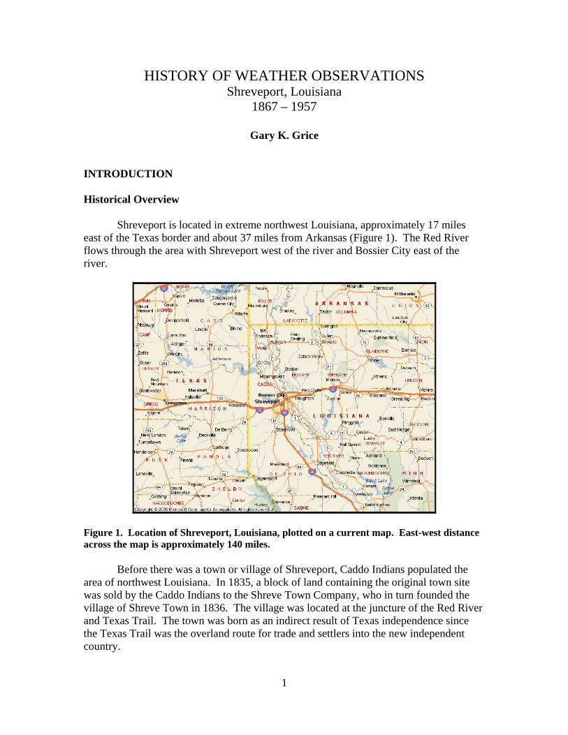
Shreveport is located in extreme northwest Louisiana, approximately 17 miles
east of the Texas border and about 37 miles from Arkansas (Figure 1). The Red River flows through the area with Shreveport west of the river and Bossier City east of the river.
Figure 1. Location of Shreveport, Louisiana, plotted on a current map. East-west distance across the map is approximately 140 miles.
Before there was a town or village of Shreveport, Caddo Indians populated the
area of northwest Louisiana. In 1835, a block of land containing the original town site was sold by the Caddo Indians to the Shreve Town Company, who in turn founded the village of Shreve Town in 1836. The village was located at the juncture of the Red River and Texas Trail. The town was born as an indirect result of Texas independence since the Texas Trail was the overland route for trade and settlers into the new independent country.

2
Shreveport was named for Captain Henry Miller Shreve who commanded the U.S. Army Corps of Engineers that cleared the Red River of massive debris to the new village. In his honor, the Shreve Town Company and the village of Shreve Town were named. On 20 March 1839, the village of Shreve Town was incorporated as the town of Shreveport, and in 1871, it was incorporated as a city. In 1838 Caddo Parish was created with Shreveport the parish-seat. Shreveport’s sister city, Bossier City, was founded in 1884 and incorporated in 1907.
Shreveport was an important center of commerce on the Red River during the
1800s and early 20th Century. River traffic up-and-down the river was active throughout the 19th Century, transporting mostly cotton and agricultural crops. Both slaves and freedmen worked on the river steamboats that navigated the Red River. By 1860, Shreveport had a population of 2,200 people, not including 1,300 slaves.
River traffic waned in the early 1900s due to the rise of the railroads. By 1914,
the Red River had had silted up due to disuse and was not navigable. Northwest Louisiana was not involved with any major battles during the Civil
War, but was a center of supply for the Confederacy. The city was named the capital of Louisiana during the war when Baton Rouge was captured by Union forces. The city escaped the ravages of war and was able to rebound relatively quickly during Reconstruction.
During the late 1800s and early 20th Century, Shreveport and the surrounding area
flourished, primarily because of its location in the tri-state trading area of Oklahoma, Texas, and Louisiana. During the late 1800s, railroads expanded from Shreveport westward into Texas, opening that area. In 1905, oil was discovered just north of Shreveport and the city quickly became a major energy center. The construction of Barksdale Army Air Field in 1931 resulted in the military becoming an important part of the Shreveport/Bossier City area.
Because of its location, Shreveport has been a center of transportation. In 1930,
construction of the Downtown Shreveport Airport commenced, with official dedication on 14 July 1931. The airport initially consisted of an open field with an air-sock in the middle. Paved runways and taxiways were added in the early 1940s. Located approximately two miles north of downtown, the airport was convenient and important to the growth of commerce in Shreveport during the 1930s and 1940s.
On 5 July 1952, the City of Shreveport opened a new airport, the Greater
Shreveport Municipal Airport, approximately eight miles southwest of the Downtown Airport. Commercial flights were transferred to the new airport, with the Downtown Airport being used primarily for general aviation. In July 1971, the original Airport Terminal Building at the Municipal Airport was replaced with a modern version.

3
The initial Shreveport Municipal Airport consisted of a 6,400 foot runway with a full-length parallel taxiway. The new airport functioned well and grew during the 1950s as the demand for air service in the Shreveport area increased.
Barksdale Air Force Base opened in 1933 as Barksdale Army Air Field. The base
was named for Lt. Eugene Hoy Barksdale of the U.S. Army Air Corps, who lost his life in an aircraft accident at Dayton, Ohio, in 1926.
As early as 1924, the City of Shreveport was interested in hosting a military air
field. Following extensive surveying and local coordination, the citizens of Shreveport proposed to the Department of War in the mid 1920s that a base be established in a sprawling section of an old cotton plantation near Bossier City. The site was approximately four miles east of downtown Shreveport.
Shreveport was selected for the base on 5 December 1928 with construction of the
world’s largest known airfield beginning in 1931. Dedication of Barksdale Field was held 2 February 1933.
From the beginning, Barksdale was an active base, serving as home to the 3rd
Attack Wing during the 1930s. In the 1940s, Barksdale saw the training of bomber crews instead of fighter pilots. Among the units trained at Barksdale Field was the famous 17th Bomber Group, which would be led by General Jimmy Doolittle during the raid on Tokyo in 1942. Shortly after the U.S. Air Force became an independent branch of service, Barksdale Field was renamed Barksdale Air Force Base on 13 January 1948.
The first official weather observations in the Shreveport area, according to the
National Climatic Data Center (NCDC) database, were taken in the late 1860s by Smithsonian observers in conjunction with its national observation program. No information could be found on any weather observations taken by the U.S. Army Medical Department.
The U.S. Signal Service began taken weather observations in downtown
Shreveport in September 1871 with the Weather Bureau assuming observing responsibility in 1891. From 1871 through 1941, weather observations were taken in downtown Shreveport.
The first airport observations were taken in 1933 by the Department of Commerce
Airway Radio Station at the Downtown Airport, approximately two and one-quarter miles north of downtown Shreveport. In 1941, the Weather Bureau transferred all weather observing responsibility to the Downtown Airport and in 1952, weather observations were moved to the Greater Shreveport Municipal Airport located approximately six and one-half miles southwest of downtown.
Weather observations began at Barksdale Army Air Field in 1935 and continued
through 1957, although all records are not included in the NCDC database. Figure 2

4
shows the general locations around Shreveport where weather observations were taken from 1871 (beginning with the Signal Service) through 1957.
Figure 2. Current map of the Shreveport/Bossier City area showing the general locations of weather observations from 1871 through 1957. Exact location of weather observations from 1867 to 1871 could not be determined. North is at the top of the page and the east-west distance across the page is approximately 12 miles.
Goal of the Study
The goal of this study is to document the primary weather observational path at Shreveport, LA leading to the Weather Bureau observing program in the first half of the 20th Century. Descriptions of Shreveport weather observations since the 1950s are available through obtainable climatic records, with the challenge being to identify and define the roots of the path that began in the 19th Century and continued through times of significant transition in the early 1900s. Extrinsic observations, i.e., those by Smithsonian and Voluntary (or Cooperative) observers, are considered in relation to the beginning of the central observational stream eventually established by the Signal Service, and subsequently, the Weather Bureau. This does not minimize the importance of these collateral observations, but rather focuses on the original events that led to the routine, formal weather observing program of modern times.
Downtown Shreveport 1871-1941
Downtown Airport 1933-1952
Greater Shreveport Municipal Airport 1952 through 1957
Barksdale AFB 1935 through 1957

5
LOCATION OF OBSERVATIONS Smithsonian Observers (May 1867-November 1873)
The first weather observation listed for the Shreveport area in the National
Climatic Data Center (NCDC) database was taken at Benton, LA (13 miles north of downtown Shreveport) on 1 May 1867 by J.H. Carter as part of the Smithsonian Institution weather observing program. The first observation in the NCDC database for Shreveport was made 1 January 1869 by Fredrick P. Leavenworth.
According to Smithsonian records, J.H. Carter took weather observations in
Benton from 1 May 1867 through 1870, although the last observation in the NCDC database for this observer was 30 November 1869. Latitude/longitude coordinates were listed as 32°30’N 93°45’W. No elevation was listed. Observations in the NCDC database essentially were continuous from May 1867 through December 1868, but sporadic in 1869.
According to observation forms in the NCDC database (and Smithsonian
records), Fredrick P. Leavenworth took weather observations in Shreveport from 1 January 1869 through 31 May 1869. Latitude/longitude was listed as 32°31’N and 16°45’ west of Washington D.C. Elevation was listed as 237 feet.
Dr. Joseph L. Moore was the next Smithsonian observer in Shreveport. The
NCDC database indicated Dr. Moore began taking weather observation on 1 August 1869 and continued through 30 November 1873. Observations in the NCDC database during this period were very sporadic. Latitude/longitude was listed as 32°30’N 93°45’W. Elevation of the barometer was listed as 217 feet above sea level, but changed to 229 feet in May 1872. The exact location where Dr. Moore took the weather observations could not be determined; however, various documents indicated his office was in downtown Shreveport.
Signal Service log books for the Shreveport office occasionally referred to Dr.
Moore as the local weather expert. He also was consulted by the Signal Service observer in determining location and exposure of weather instruments at the early Signal Service offices.
Army Surgeons
Although Union forces occupied Shreveport for almost 11 years following the conclusion of the Civil War, no weather observations were found in the Shreveport area for the U.S. Army Medical Department. The document prepared by the U.S. Army Surgeon General’s office in 1870 entitled, Report on Barracks and Hospitals with Descriptions of Military Posts (Circular No. 4), listed a U.S. Army fort and hospital at Shreveport, located about one-half mile northwest of the city center on the right bank of “Bayou Cross.” According to the publication, the buildings of the fort were erected and used as an arsenal by the Confederates during the Civil War then turned over to the

6
Union Army after the war. However, the document does not list any weather observations for this location and the fort was not mentioned in the 1875 edition of the publication. A search of the literature did not reveal any information regarding U.S. Army presence in Shreveport. Also, no weather observations by Army field surgeons were listed in the NCDC database for Shreveport. Signal Service Offices (2 September 1871-30 June 1891) NOTE – All Signal Service and Weather Bureau station elevations in this report are for office barometers unless otherwise indicated. All elevations related to barometers in this report are above sea level unless otherwise indicated. NOTE - From 1871 to 1888, the U.S. Signal Service conducted 16 inspections of its Shreveport weather office. The inspection reports, available at the National Archives and Records Administration (NARA), contained drawings and textual information regarding office location, weather instrument placement and exposure. The quantity and quality of information varied, depending primarily on the inspector. However, these reports contained revealing information not available from other sources, especially with regard to instrument location and exposure. Inspections of the Shreveport Signal Service office were conducted on the following dates: 2 November 1871 4-6 April 1879 12-13 August 1872 13-15 March 1880 11 March 1873 2-3 April 1881 6-8 February 1874 28-29 April 1884 19 October 1874 2-3 April 1885 4-7 July 1876 20-21 August 1885 2-3 May 1877 12-13 April 1886 11-14 May 1878 12-13 January 1888
According to Weather Bureau Station History documents and Local Climatological Data, the Signal Service opened its office in Shreveport on 29 August 1871 and the first observation was made on 2 September 1871. However, the NCDC database contained Signal Service observations for the month of March 1871. The Signal Service continued to take weather observations in Shreveport until responsibility was transferred to the Weather Bureau on 1 July 1891.
Conflicts were found in Signal Service documents regarding specific
information on building names and locations of the weather stations from 2 September 1871 to 4 October 1874. Documents available to this study for the early to mid 1870s consisted of Signal Service annual reports, inspection reports, and station log books.
7
Listed below are station locations and site names that were accepted by Weather
Bureau officials in the early 20th Century during the preparation of Station History forms, and in subsequent Station Location sections of Local Climatological Data for the period 2 September 1871 to 4 October 1874:
Brooks House 2 September 1871-3 October 1871 Southern Hotel 3 October 1871-16 December 1871 National Hotel 16 December 1871-4 October 1874
Four Signal Service inspection reports were prepared for its Shreveport office during this period. The inspections were conducted on 2 November 1871, 12-13 August 1872, 11 March 1873, and 6-8 February 1874. Signal Service annual reports and station log books also were available.
The first entry in the station log book on 2 September 1871 stated: “Rented
room No. 84 Brooks House on the 29th of August 1871, for the purpose of taking meteorological observations.” First weather observation was logged on 2 September 1871.
The 1871 Signal Service Annual Report stated the first observer failed to accomplish his duties and was relieved. Comments or notations by the first observer in the station log book were sporadic in September 1871 and non-existent in October and early November 1871 (weather observations are listed in the NCDC database for November 1871 but not for September or October 1871 ). The next observer began taking observations on 13 November 1871. It appears likely that the office moved 3 October 1871 to the third floor of a building called the Southern or National Hotel. An inspection report on 2 November 1871 stated the station was located in the front room on the third floor of the Southern Hotel on Milam Street. The individual listed to receive the $18 monthly rent was “W.J. Brooks.” A Shreveport historian and author stated the Southern Hotel was located at the intersection of Texas and Spring Streets and not on Milam. However, all Signal Service documents (inspection reports, annual reports, and log books) stated the buildings containing the weather station were on Milam Street between Spring and Market Streets from 2 September 1871 through 4 October 1874.
The station log book on 16 December 1871 stated the office moved to the
National Hotel; however, the inspection reports and annual reports both continued to state the office was in the Southern Hotel on Milam Street. The Shreveport historian stated no record exists of a National Hotel in Shreveport. Aside from the confusion with regard to the name of the building, the documents agreed the building was located on Milam Street between Spring and Market Streets.
Based on all available information, it appears the Signal Service office was
located on Milam Street between Spring and Market Streets, probably in two separate buildings, from 2 September 1871 to 5 October 1874. It is also possible the office remained in the same building for the period. A letter written by the Signal Service

8
observer on 3 January 1875 stated: “The office of observations located in the International Hotel or Brooks House until the 4th of October 1874 then was moved to the Odd Fellow Building corner of Market and Texas Streets.” Regardless, it appears the observations from 2 September 1871 through 4 October 1874 were taken in close proximity on Milam Street between Spring and Market Streets.
Best estimate is that the office moved from its original site to the third floor of
the Southern Hotel (also referred to as the National Hotel) in early October 1871. In mid December 1871 the office moved from the third floor to the fourth floor of the same building. The chronology of Signal Service weather stations in Shreveport listed in this report is based on this reasoning. Figure 3 shows the locations of the downtown Signal Service and Weather Bureau offices from 1871 through 1941.
Figure 3. Signal Service and Weather Bureau offices in downtown Shreveport from 1871 through 1941. Information is plotted on a current map of Shreveport. North is at the top of the page. East-west distance across the map is approximately three-quarters mile.
Red River
Brooks House 2 Sep 1871-3 Oct 1871
Southern Hotel 3 Oct 1871-4 Oct 1874
Bogel Building 4 Oct 1871-28 Aug 1875
Martin Building 28 Aug 1875-1Dec 1880
Rendall Building 1 Dec 1880-16 Mar 1888
P.O & Customs House 16 Mar 1888-1 May 19101 Feb 1913-14 Jul 1931 19 Aug 1932-6 Oct 1941
Slattery Building 14 Jul 1931-19 Aug 1932
Majestic Theater 1 May 1910-1 Feb 1913

9
2 September 1871–3 October 1871 (Signal Service observations in NCDC database began 1 March 1871)
- Office in Room No. 84 in the Brooks House - Information in the Signal Service inspection reports and 1871 Annual Report
indicated the Brooks House was located in a collection of buildings on Milam Street between Spring and Market Streets along with the Southern Hotel
- Coordinates were listed as 32°30’N 93°45’W - No elevation was listed - GPS coordinates for the intersection of Milam and Spring Streets are 32°30’51”N 93°44’45”W, ground elevation 187 feet
3 October 1871-4 October 1874
- Station at the Southern Hotel (office initially on the third floor but moved to the fourth floor on 16 December 1871) - The inspection reports stated the office and hotel were located on the eastern side Milam Street between Spring and Market Streets - Address was listed as 26 and 28 Milam Street - The Southern Hotel was located in the immediate vicinity of the Brooks House - Station elevation was listed at 180 feet above “mean tide level” for the third floor - The August 1872 inspection listed station elevation as 192 feet above “mean tide level” for the fourth floor - GPS coordinates for the intersection of Milam and Spring Streets are 32°30’51”N 93°44’45”W, ground elevation 187 feet
4 October 1874-28 August 1875
- Station in Bogel’s Building (second story) - Building also referred to as the “Odd Fellow Building” (the upper floor of the
building was rented by the Odd Fellow Society) - Located on the west corner of Texas and Market Streets (Signal Service
inspection reports and Weather Bureau Station History documents list this address as the location of Bogel’s Building; however various editions of Local Climatological Data list the address as the corner of Texas and Marshall Streets, a difference of two city blocks)
- Located approximately 550 feet west northwest of previous location on Milam Street (between Spring and Market Streets)
- Local Climatological Data lists the building as “Begel’s Building” which is incorrect
- The front of the building was on Texas Street - The Signal Service office overlooked Texas Street - Elevation of the station was listed as 187 feet “above mean tide level” - GPS coordinates are 32°30’51”N 93°44’51”W, ground elevation 192 feet

10
28 August 1875-1 December 1880
- Station in the Martin Building (second story) - Located at the west corner of Milam and Martin’s Alley (or Martin’ Lane) - On southwest side of Martin’s Alley and northwest side of Milam Street - Located approximately 775 feet east of previous location (Bogel Building) - Ground elevation listed as 187 feet above sea level and the elevation of the
barometer was 205 feet. - GPS coordinates for intersection of Milam and Spring Streets 32°30’51”N
93°44’45”W, ground elevation 187 feet 1 December 1880-16 March 1888 NOTE – Weather Bureau station history documents, as well as Local Climatological Data, list the date the Signal Service moved from the Rendall Building as 17 April 1888. However, the station log book contained a notation on 16 March 1888 that stated the following: “Moved into new office at 10:15 p.m., which occupies the entire 4th Floor of the Post Office and Custom House Building.”
- Station in Rendall’s Building (third floor) - Located on Milam Street between Market and Spring Streets - Address was 24 Milam Street (in late 1887 or early 1888, it appears the
number of Rendall’s Building was changed to No. 207) - This station was approximately 275 feet southwest of the previous station in
the Martin Building - Elevation was listed as 227 feet above sea level - Ground elevation was listed as 186 feet above sea level - GPS coordinates for intersection of Milam and Spring Streets 32°30’51”N
93°44’45”W, ground elevation 187 feet 16 March 1888-1 May 1910 (Weather Bureau office after 1 July 1891)
- Station in Post Office and Customs House (also called U.S. Government Building)
- Office was located on the fourth floor of the building - Located on north corner of Texas and Marshall Streets - This station was approximately two-tenths mile west southwest of the
previous station in Rendall’s Building - Ground elevation listed as 196 feet above sea level and barometer 249 feet - GPS coordinates 32°30’48”N 93°44’58”W

11
Weather Bureau Offices (1 May 1910 through 1957) (Weather Bureau assumed observing responsibility 1 July 1891) Weather Bureau City Offices (1 May 1910-7 October 1941) 1 May 1910-1 February 1913
- Station in the Majestic Theater Building - Located at the corner of Milam and McNeil Streets - Address 603 Milam Street - Office was on the second floor in Rooms 102, 103, and 104 - Located 700 feet south of the previous station in the Post Office and Customs
House - Elevation of the barometer was listed as 216 feet above sea level. - GPS coordinates 32°30’42”N 93°45’00”W
1 February 1913-14 July 1931
- Station in the Post Office Building (also called U.S. Government Building) - Located at the north corner of Texas and Marshall Streets - Office on third floor of the building in Rooms 301-307 - Located approximately 700 feet north of the previous station in the Majestic
Theater Building - Ground elevation was listed as 196 above sea level and barometer elevation
238 feet - GPS coordinates 32°30’48”N 93°44’58”W
14 July 1931-19 August 1932
- Station in the Slattery Building (room and floor number unknown) - Located at the east corner of Texas and Marshall Streets - Located approximately 75 feet southeast of previous station in the Post Office
Building - Ground elevation was listed as 196 feet. Barometer elevation was 375 feet
above sea level. - GPS coordinates 32°30’48”N 93°44’58”W

12
19 August 1932-6 October 1941
- Office in the Federal Building (fourth floor) - Located at the north corner of Texas and Marshall Streets - Located approximately 75 feet northwest of previous station in the Slattery
Building - Ground elevation was listed as 196 feet above sea level and the elevation of
the barometer was 250 feet - GPS coordinates 32°30’48”N 93°44’58”W - On 7 October 1941, the Weather Bureau observing station and office moved
to the Downtown Airport. Previously, airport weather observations were taken by Civil Aeronautics Administration (CAA) observers.
Weather Bureau/Civil Aeronautics Administration (CAA) Airport Offices (14 February 1933 Through 1957)
On 14 February 1933, an Airway Radio Station was established at the Downtown Airport by the Department of Commerce. Initial Airways weather observations in the NCDC database began 1 January 1934 at this site, although the observations may have started earlier. Observations were taken by Department of Commerce (Aeronautics Branch) employees (Civil Aeronautics Administration-CAA-employees in 1940 when government reorganization occurred). On 6 October 1941, the Weather Bureau office moved to the airport and assumed observing responsibilities. Figure 4 shows the location of the Airport Administration Building (where weather observations were taken) at the Downtown Airport.

13
Figure 4. USGS topographical map (1986) showing the location of the Administration Building (where weather observations were taken) at the Shreveport Downtown Airport from the 1930s to 1950s. North is at the top of the map. East-west distance across the map approximately five miles. 14 February 1933-6 October 1941 (Department of Commerce/CAA Airport Office)
- Located at the Administration Building at the Downtown Airport - The Administration Building was approximately two and one-quarter miles
north of downtown Shreveport - Ground elevation was listed as 173 feet above sea level and the elevation of
the barometer was 193 feet - GPS coordinates for the Administration Building are 32°32’23”N
93°44’57”W
Administration Building (where weather observations were taken)
Downtown Shreveport

14
6 October 1941-6 July 1952
- Weather Bureau office at the Administration Building (second floor) at the Shreveport Downtown Airport
- Located approximately two miles north of the previous station in the Federal Building
- Ground elevation was listed as 174 feet above sea level and the elevation of the barometer was 192 feet
- GPS coordinates for the Administration Building are 32°32’23”N 93°44’57”W
6 July 1952 through 1957
- Weather Bureau office in the Administration Building (second floor), also called the Terminal Building, at the Greater Shreveport Municipal Airport
- The office was located at the west end of the second floor - Located approximately 7.6 miles south southwest of the previous station at the
Downtown Airport - Ground elevation was listed as 252 feet above sea level and the elevation of
the barometer was 268 feet - Coordinates for the airport are 32°28’1”N 93°49’1”W
Figure 5 shows the location of the Administration Building at the Greater
Shreveport Municipal Airport during the 1950s. Information is shown on an 1985 USGS topographical map.

15
Figure 5. USGS topographical map (1985) showing the location of the Administration Building (where weather observations were taken) at the Greater Shreveport Municipal Airport during the 1950s. North is at the top of the map. East-west distance across the map approximately two miles. Barksdale Air Force Base (10 May 1935 through 13 November 1950)
Information regarding weather observing at Barksdale Air Force Base was limited. Weather observations started in 1935 (taken by Weather Bureau employees) and continued through 1957 (later taken by military personnel).
Weather Bureau Station History reports stated: “Airplane observations were
made at Barksdale Field from 10 May 1935 to 30 June 1938 by Weather Bureau personnel.” Two Weather Bureau inspection forms (9 July 1935 and 6 December 1935) described the weather station at Barksdale AFB, with a gap of over six years before Station Record forms commenced on 15 April 1942.
According to the Weather Bureau forms, weather observations at Barksdale
were taken on the west side of Hangar No. 9, located on the west side of the field (Figure 6). The elevation of the barometer was listed as 195 feet above sea level but changed to 168 feet between 9 July 1935 and 6 December 1935. Ground elevation was 165 feet above sea level. Hangar 9 still exists at the base with GPS coordinates 32°30’20”N 93°44’33”W.
Administration Building

16
Figure 6. Current map of Barksdale Air Force Base showing the location of Hangar No. 9 where weather observations were taken beginning in the mid 1930s. North is at the top of the page. East-west distance across the map is two and one-quarter miles.
Hangar No. 9 (where weather observations were taken)

17
INSTRUMENTATION Smithsonian Observations (1 May 1867-30 November 1873)
J.H. Carter took weather observations in Benton, LA (13 miles north of Shreveport) for the Smithsonian Institution from 1867 through 1870 (according to Smithsonian records; last observations in the NCDC database are November 1869).
According to the observation forms, J.H. Carter observed/measured
temperature, precipitation, type of clouds and movement, and wind direction and force. All observations except precipitation were made at 7 a.m., 2 p.m., and 9 p.m. Precipitation included beginning/ending times and daily amount. Remarks regarding the daily weather also were included. Based on the observations, this station had a thermometer, rain gage, and probably, a wind vane; although Smithsonian records indicated only a thermometer was on station. Wind force was most likely estimated. No information could be found regarding the type and location of the Smithsonian weather instruments in Benton. See the report on Minneapolis/St. Paul, MN (under this contract; see Bibliography) for additional information on weather observing instruments and instructions used by Smithsonian observers.
At Shreveport, Frederick P. Leavenworth began taking weather observations on
1 January 1869 (according to the NCDC database), with Dr. Joseph L. Moore becoming the Smithsonian observer on 1 August 1869. Prior to January 1872, the following were observed/measured in Shreveport at 7 a.m., 2 p.m., and 9 p.m.: temperature, cloud type and movement, and wind (direction and force). Also, the beginning/ending times and 24-hour amount of precipitation were recorded, along with observed weather (in the Remarks section). Beginning January 1872, barometric pressure and atmospheric moisture recordings were added. Based on the observations and Smithsonian records, this station initially had a thermometer, rain gage, and probably a wind vane. Wind force was most likely estimated. During 1873, Dr. Moore routinely listed the number of deaths per day from yellow fever.
No specific information could be found regarding the type and location of the
Smithsonian weather instruments used by Mr. Leavenworth or by Dr. Moore. See the report on Minneapolis/St. Paul, MN (under this contract; see Bibliography) for additional general information on weather observing instruments and instructions used by Smithsonian observers.
Signal Service Observations (2 September 1871-30 June 1891) NOTE – Policy of the U.S. Signal Service was for weather observations to be taken at Washington D.C. local time. Local time for Shreveport was 66 minutes behind local time at Washington D.C. Consequently, 7 a.m. observations at Shreveport actually were taken at 5.54 a.m. local time, 3 p.m. observations were taken at 1.54 p.m., and the 11 p.m. observation was taken at 9.54 p.m.

18
2 September 1871-3 October 1871 (Signal Service observations in NCDC database begin 1 March 1871) – Signal Service office in Room 84 of the Brooks House on Milam Street. This station did not have an inspection report.
The only information that could be found regarding weather instruments at this location was from the Signal Service 1871 Annual Report.:
“The station is supplied with a full set of standard instruments, and all of them are reported to be in good condition. The barometer sent out by the observer (from Signal Service Headquarters in Washington DC) was broken in transit by a railroad accident, and a second one was sent through the Post Office Department, and reached the station in safety.”
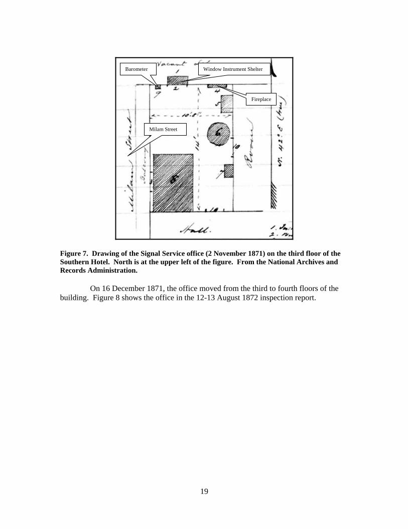
Standard instruments in the Signal Service in 1871 (from the annual report) consisted of a Green standard barometer, a thermometer, a hygrometer, a wind vane, a rain gage, and a Robinson anemometer. 3 October 1871-4 October 1874 – Signal Service office on the third floor of the Southern Hotel on Milam Street. Four Signal Service inspections were conducted while the office was in the Southern Hotel: 2 November 1871, 12-13 August 1872, 11 March 1873, and 6-8 February 1874. Figure 7 shows the Signal Service office on 2 November 1871.
19
Figure 7. Drawing of the Signal Service office (2 November 1871) on the third floor of the Southern Hotel. North is at the upper left of the figure. From the National Archives and Records Administration.
On 16 December 1871, the office moved from the third to fourth floors of the
building. Figure 8 shows the office in the 12-13 August 1872 inspection report.
Window Instrument Shelter Barometer
Milam Street
Fireplace

20
Figure 8. Drawing of the Signal Service office (12-13 August 1872) on the fourth floor of the Southern Hotel. North is at the upper left of the figure. From the National Archives and Records Administration.
Barometer - The barometer was hung on a northeast facing wall of the office near the northwest wall (third floor; see Figure 7). The elevation of the barometer was listed as 33 feet above ground. On 16 December 1871, the barometer was moved to the fourth floor of the hotel with the office move. In the new office, the barometer remained on the northeast wall with a listed elevation of 44 feet above ground (Figure 8). Also between November 1871 and August 1872, an extra barometer was added to the station. The location and elevation of the barometers remained unchanged at least through the inspection on 6-8 February 1874.
Barometer
Window Instrument Shelter
Chimney and Fireplace
Milam Street

21
Instrument Shelter – The window instrument shelter was located in a northeast facing window near the northwest side of the office (Figure 7). The shelter was approximately three feet from the fireplace and chimney. The November 1871 inspection report stated the shelter was, “…a very good one built on the Smithsonian plan.” Figures 9 and 10 show the window instrument shelter at this station.
Figure 9. Drawing of the window instrument shelter located in the Signal Service office at the Southern Hotel (2 November 1871). View is northeast. Note that the bottom and left back panels of the shelter are open. According to the inspection report, the back panel “swung on point “X” so that it could be made to expose the instruments on either side.” From the National Archives and Records Administration.
Exposed Thermometer Hygrometer

22
Figure 10. Horizontal view of the window instrument shelter at the Southern Hotel (2 November 1871). North is the upper left of the figure. From the National Archives and Records Administration.
The window instrument shelter was approximately two feet deep, two feet wide, and seven feet tall. The bottom of the shelter was left open and one-half of the back panel was open. The lattice panel on the back of the shelter could be moved (or swung) to open either side. According to the August 1872 inspection report, the partially open back was the result of the observer misinterpreting Smithsonian instructions. The inspector also stated the shelter construction (shelter appeared to have been built locally) was a serious blunder because the sun could shine on the instruments through the partially open back. The exposed thermometer and hygrometer were 10 inches from the window sill and less than one-foot to the window panes. The thermometer and hygrometer were 34 feet above ground. The November 1871 inspection report stated the shelter needed painting and the observer was ordered to paint the shelter. On 16 December 1871, the window instrument shelter was moved from the third to the fourth floor (Figure 8). The shelter was located on a northeast facing wall a few feet from the fireplace and chimney. The exposed thermometer and hygrometer were 45 feet above ground. Between November 1871 and August 1872, an extra thermometer was added to the station. Between the inspections in August 1872 and March 1873, another instrument shelter was installed at the station (Figure 11). The location and elevation of the instrument shelter, thermometer, and hygrometer remained unchanged at least through the inspection on 6-8 February 1874.
Hygrometer
Exposed Thermometer

23
Figure 11. Replacement window instrument shelter at the Signal Service office (11 March 1873). This shelter had a solid bottom, solid top, lattice back, as well as lattice sides. The inspection report stated the shelter was painted brown. View is from the window of the office on the fourth floor (facing northeast) of the Southern Hotel. From the National Archives and Records Administration.
Rain Gages – In November 1871, the rain gage (type not indicated) was on the roof of the Southern Hotel or one of the buildings in the immediate vicinity. The gage was 3 feet above the roof and 47 feet above ground. Exposure was rated as good. On 16 December 1871, the rain gage was moved to another location in the immediate vicinity of the Southern Hotel (Figure 12). The rain gage was
Barometer
Hygrometer Thermometer

24
approximately 62 feet above ground and 3 feet above the platform supporting the gage. Exposure was rated as good. The location and elevation of the rain gage remained unchanged at least through the inspection on 6-8 February 1874.
Figure 12. Drawing of the roof (exact building not known, but in the immediate vicinity of the Southern Hotel) containing the rain gage and wind instruments (12-13 August 1872). North is the upper right of the figure. The roof sloped in all directions from the ridge line (denoted by the dashed line). The platform supporting the anemometer and rain gage was eight feet square. The wind vane was approximately 12 feet northwest of the anemometer. From the National Archives and Records Administration.
Wind Instruments – The wind instruments initially were on the roof of the Southern Hotel or a building in the immediate vicinity. The anemometer was 5 feet above the roof and 50 feet above ground. The wind vane was 12 feet above the roof and 57 feet above ground. Exposure was rated as good.
Rain Gage
Anemometer
Platform
Wind Vane

25
On 16 December 1871, the wind instruments were moved to another building in the immediate vicinity (Figure 12). The anemometer was 66 feet above ground and 6 feet above the supporting platform. The wind vane was 82 feet above ground and 23 feet above the roof of the building. Exposure was rated as good. Between November 1871 and August 1872, an extra wind vane and anemometer were added to the station. Although not stated in the inspection reports, the station most likely had a small vane (three feet) and a large vane (12 feet). The location and elevation of the wind instruments remained unchanged at least through the inspection on 6-8 February 1874.
Figures 13 and 14 show the terrain around the Milam Street area where observations were taken from 1871 through 1874. The terrain around Milam Street, between Spring and Market Streets, was generally flat although the topography sloped down to the Red River approximately two blocks northeast of the hotels site and sloped up slightly along Spring and Market Streets southeast of the hotels.
Figure 13. Current photograph of Milam Street looking northeast from Market Street showing the general terrain. Photograph by the author.

26
Figure 14. Current photograph of Spring Street looking southeast from Milam Street showing the general terrain. Photograph by the author.
Additional Equipment/Information – On 4 August 1874, the Shreveport Signal Service observer wrote the following letter to the Chief Signal Officer:
“I have the honor to state that the roof of the building is becoming very much dilapidated, so much so that the wind vane is becoming loosened from the roof for want of solid wood to attach it to. During rains my office leaks in a fearful manner which is destructive to the furniture and from the dampness of the room my health is liable to be impaired. The proprietor of this building informs me that in the fall he intends to connect this building with the one opposite my instrument shelter. This will prevent the instrument shelter from having a northern exposure and will necessitate the removal of the office.
Between 1 November 1871 and 12-13 August 1872, a river gage was first installed on the Red River and read by the Signal Service observer. The August 1872 inspection report described in detail the various aspects of the river gage. Weather Bureau Station History documents prepared in the 1950s stated the river gage was installed in May 1873, but the Signal Service inspection reports were specific.

27
4 October 1874-28 August 1875 – Signal Service office on the second floor in the Bogel Building at the west corner of Texas and Market Streets. Figure 15 shows the office at this site. One Signal Service inspection report was made at this station (19 October 1874).
Figure 15. Drawing of the Signal Service office (19 October 1874) on the second floor of the Bogel Building. North is at the lower right of the figure. From the National Archives and Records Administration.
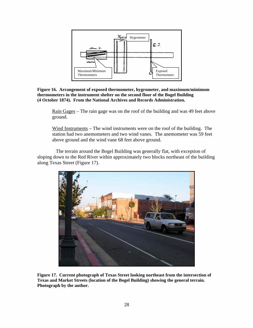
Barometer – The barometers (station and extra) were located near a window close to the west corner of the office. The barometers were listed as 19 feet above ground. Instrument Shelter – The instrument shelter was in a northwest facing window (Figure 15). The shelter was approximately eight feet tall, four feet wide, and two feet deep. The October 1874 inspection report stated the shelter needed to be painted. Maximum and minimum thermometers were added to this station by 19 October 1874 (Figure 16). The exposed thermometer and hygrometer were 21 feet above ground, and the maximum/minimum thermometers 22 feet above ground. An extra thermometer was listed at the station. The October 1874 inspection stated the thermometers in the instrument shelter were well exposed.
Barometer
Window Instrument Shelter
Texas Street
28
Figure 16. Arrangement of exposed thermometer, hygrometer, and maximum/minimum thermometers in the instrument shelter on the second floor of the Bogel Building (4 October 1874). From the National Archives and Records Administration.
Rain Gages – The rain gage was on the roof of the building and was 49 feet above ground. Wind Instruments – The wind instruments were on the roof of the building. The station had two anemometers and two wind vanes. The anemometer was 59 feet above ground and the wind vane 68 feet above ground.
The terrain around the Bogel Building was generally flat, with exception of sloping down to the Red River within approximately two blocks northeast of the building along Texas Street (Figure 17).
Figure 17. Current photograph of Texas Street looking northeast from the intersection of Texas and Market Streets (location of the Bogel Building) showing the general terrain. Photograph by the author.
Exposed Thermometer
Hygrometer
Maximum/Minimum Thermometers
29
Additional Equipment/Information – The 1875 Signal Service Annual Report contained the following message: “A constant error in the reported depth of water in the river at this station was discovered and corrected May 16, 1875. A new gage is in process of construction, and will be completed during the season of low water.”
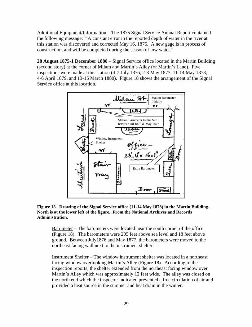
28 August 1875-1 December 1880 – Signal Service office located in the Martin Building (second story) at the corner of Milam and Martin’s Alley (or Martin’s Lane). Five inspections were made at this station (4-7 July 1876, 2-3 May 1877, 11-14 May 1878, 4-6 April 1879, and 13-15 March 1880). Figure 18 shows the arrangement of the Signal Service office at this location.
Figure 18. Drawing of the Signal Service office (11-14 May 1878) in the Martin Building. North is at the lower left of the figure. From the National Archives and Records Administration.
Barometer – The barometers were located near the south corner of the office (Figure 18). The barometers were 205 feet above sea level and 18 feet above ground. Between July1876 and May 1877, the barometers were moved to the northeast facing wall next to the instrument shelter. Instrument Shelter – The window instrument shelter was located in a northeast facing window overlooking Martin’s Alley (Figure 18). According to the inspection reports, the shelter extended from the northeast facing window over Martin’s Alley which was approximately 12 feet wide. The alley was closed on the north end which the inspector indicated prevented a free circulation of air and provided a heat source in the summer and heat drain in the winter.
Window Instrument Shelter
Extra Barometer
Station Barometer Initially
Station Barometer to this Site between Jul 1876 & May 1877

30
The shelter appeared to be the same one used at the previous office (Bogel’s Building) and was seven feet tall, three feet wide, and two feet deep. The exposed thermometer and hygrometer were 23 feet above ground, and the maximum/minimum thermometers were 24 feet above ground. The exposed thermometer was 19 inches from the window panes, hygrometer 23 inches, maximum thermometer 11 inches, and the minimum thermometer 13 inches. The inspection report in March 1880 stated the exposed thermometer and hygrometer were moved closer to the window panes (exact distance not specified) so the instruments could be read without opening the window. The July 1876 inspection report stated the exposure of the shelter was poor because it was surrounded by brick walls approximately 10 to 12 feet away from the shelter. Rain Gages – The rain gage was on the roof and 35 feet above ground. Wind Instruments – The wind instruments were on the roof of the building. The anemometer (the station had 2 anemometers) was 47 feet above ground and the wind vane 63 feet above ground. An anemoscope was added between May 1877 and May 1878.
Terrain around the Martin Building was relatively flat, although the topography began to lower toward the Red River beginning approximately one block northeast of the building (Figure 19).
Figure 19. Current photograph of Milam Street looking northeast from the intersection of Milam and Spring Streets showing the general terrain. Photograph by the author.
Location of Martin Building

31
Additional Equipment/Information – The 1878 Signal Service Annual Report contained the following message with regard to the river gage: “A river-gage is much needed here, as at present the sergeant is obliged to estimate the rise and fall of the river, and has no means of measuring it with accuracy. This is done with every possible care, a graduated stick being used. It is proposed to erect a gage very shortly.” The 1879 Signal Service Annual Report contained the following message with regard to use of the office’s services:
“The press continues its support and readily publishes anything offered to them in relation to the service and its workings. The medical profession has long since recognized the value and usefulness of the weather reports. This office is frequently visited by its members, and questions are asked in relation to the temperature, humidity, etc., and the information given to them is of practical importance. The members of the cotton exchange, business men, and the general public express their high appreciation of the service. The river men derive the most practical benefit from the river bulletin, which emanates from this office daily. The stage of water in the Red River during March and April was the lowest known for many years at that season. The river men attributed it to lack of rain. Navigation, in consequence, closed March 23 for large draft boats, and to all on April 10: opened May 20 and again closed June 24. On the 20th of June the river gage was wrenched from its position by a flatboat.”
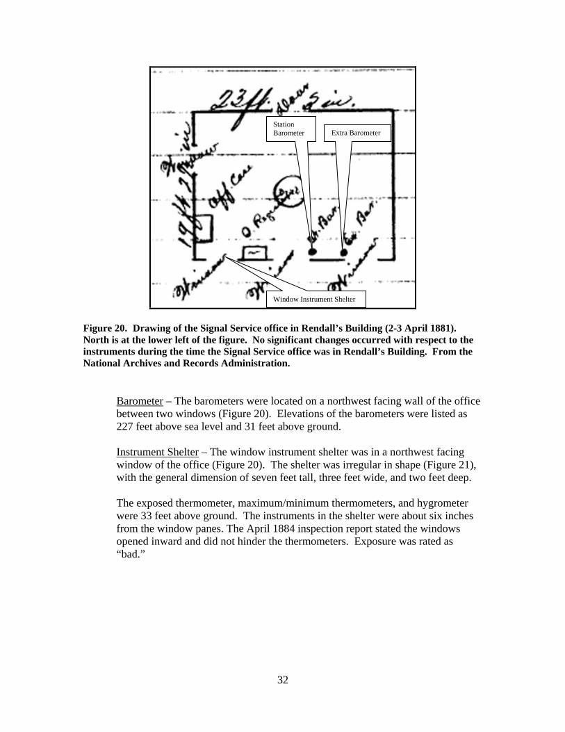
1 December 1880-16 March 1888 – Signal Service office located on third floor of Rendall’s Building. Six Signal Service inspections were conducted at this office on the following dates: 2-3 April 1881, 28-29 April 1884, 2-3 April 1885, 20-21 August 1885, 12-13 April 1886, and 12-13 January 1888. Figure 20 shows the arrangement of the office earlier in the observing period (April 1881).
32
Figure 20. Drawing of the Signal Service office in Rendall’s Building (2-3 April 1881). North is at the lower left of the figure. No significant changes occurred with respect to the instruments during the time the Signal Service office was in Rendall’s Building. From the National Archives and Records Administration.
Barometer – The barometers were located on a northwest facing wall of the office between two windows (Figure 20). Elevations of the barometers were listed as 227 feet above sea level and 31 feet above ground. Instrument Shelter – The window instrument shelter was in a northwest facing window of the office (Figure 20). The shelter was irregular in shape (Figure 21), with the general dimension of seven feet tall, three feet wide, and two feet deep. The exposed thermometer, maximum/minimum thermometers, and hygrometer were 33 feet above ground. The instruments in the shelter were about six inches from the window panes. The April 1884 inspection report stated the windows opened inward and did not hinder the thermometers. Exposure was rated as “bad.”
Window Instrument Shelter
Station Barometer Extra Barometer

33
Figure 21. Shape of the instrument shelter at the Signal Service office on the third floor of Rendall’s Building (2-3 April 1881). Perspective is from the top of the shelter looking down. North is at the upper right part of the figure. Dimensions are in feet and inches. From the National Archives and Records Administration.
Rain Gages – The rain gage was on the roof of the building, 44 feet above ground. Between April 1884 and April 1885, a snow gage was added to the station (on the roof with the rain gage). Inspection reports in April 1884 and April 1885 indicated the exposure of the rain gage was lacking because the gage was near a flagstaff and hatch on the roof. The inspection report on 12-13 April 1886 stated the rain and snow gages were moved 25 September 1885 from the central part of the roof away from the flagstaff and hatch (see Figure 22), to the southern edge of the roof. At that time, the elevation of the gages changed from 44 feet above ground to 41 feet above ground.
Figure 22. Locations of weather instruments on the roof of Rendall’s Building from the inspection report on 12-13 January 1888. Although no direction was listed, it appears that north is at the upper right of the figure. Roof dimensions were 60 feet long and 25 feet wide. From the National Archives and Records Administration.
Window Side of Shelter
Rain & Snow Gages
Wind Vane
Anemometer

34
Wind Instruments – The wind instruments were on the roof of the building (Figure 22). The anemometer was 61 feet above ground and the large wind vane (12 foot) 75 feet above ground. Inspection reports in April 1884 and April 1885 indicated the exposure of the anemometer and wind vane was lacking due to higher buildings to the north. The inspection on 20-21 August 1885 stated the anemometer was broken and was not being used. From August 1885 through February 1886 notes were included on the observation forms stating the anemometer was not operating. The anemometer was repaired in February 1886.
16 March 1888-1 May 1910 (Weather Bureau office after 1 July 1891) – Signal Service/Weather Bureau office in the Post Office and Customs House. No Signal Service inspection reports were prepared for this station. However, Weather Bureau Annual Reports provided a continuous list of elevations (above ground) for the barometer, exposed thermometer, rain gage, and anemometer beginning 1 January 1890. Also, the station log book continued through 1910. Based on available information, the elevations did not change from at least 1 January 1890 through April 1902. Information in the 1890 Signal Service Annual Report stated the elevation of the barometer was consistent back to the time of the move into the Post Office and Customs House.
Barometer – The barometers were located 249 feet above sea level and 52 feet above ground. According to Weather Bureau Annual Reports, as well as instrument documents, the elevation of the barometers did not change while in the Post Office and Customs House. By 1 June 1906, a barograph (Richard) was added to the station. Instrument Shelter – The instrument shelter was a standard type shelter and was located on a platform on the roof of the building. The shelter was approximately three feet long, three feet wide, and three feet high. The exposed thermometer, maximum/minimum thermometers, and psychrometer were approximately 12 feet above the roof and 77 feet above ground. Figures 23 and 24 show the instrument shelter in 1890.

35
Figure 23. Signal Service instrument shelter on top of the Post Office Building (1890). View is north. From the National Archives and Records Administration.
Figure 24. Enlargement of Figure 23 showing the instrument shelter and Signal Service/Weather Bureau office (1890). From the National Archives and Records Administration.
Signal Service and Weather Bureau Office
Instrument Shelter
Instrument Shelter
Signal Service/ Weather Bureau Office
Wind Instruments

36
A letter from the manager of the Shreveport Weather Bureau office on 16 August 1902 stated the instrument shelter needed to be repaired and painted. According to Weather Bureau Annual Reports, as well as instrument documents, the elevation of the hygrometer and thermometers did not change while in the Post Office and Customs House. A Weather Bureau document on 1 June 1906 indicated a thermograph (Richard) was added. The document also listed Green as the maker of the dry bulb, maximum, and minimum thermometers and Schneider the maker of the wet-bulb thermometer. Rain Gages – The tipping bucket and standard rain gages were on the roof of the building. The gages initially were 76 feet above ground, but the 1902 Weather Bureau Annual Report indicated the elevation changed to 77 feet above ground on 1 May 1902. After 1 May 1902, the gages were 4 feet above the roof. A letter on 10 May 1902 from a local Weather Bureau official stated the following:
“The new rain-gage was exposed in the same place as the old one, the platform on which it stands had to be made larger, however, in order to accommodate it. Its height is now 76.8 feet, 10 inches higher than the old one. Thus far it has given a fair record, the recorded amount showing a loss of about 4 percent of the actual measurement.”
Wind Instruments – The wind instruments were on the roof of the tower. The anemometer (4 cup) was 19 feet above the roof and 84 feet above ground. The wind vane was 20 feet above the roof and 85 feet above ground. Additional Equipment/Information – According to Weather Bureau Annual Reports, sunshine measurements were started at the Shreveport station in 1902 (exact date not specified). A letter on 10 May 1902 from a local Weather Bureau official stated the following:
“Some difficulty was experienced in finding a suitable place for the sunshine recorder…it was placed on a support (on the instrument shelter) sufficiently high to put it above the vane. This position suits well for the summer months, but in winter the shadow of the flag or tower may possibly reach it.”
A letter on 5 June 1902 from a local Weather Bureau official stated the following:
“I have the honor to report that the new sunshine recorder at this station has lately shown what appears to be a defect in its construction, and it is consequently not giving a satisfactory record. The column of mercury, when receding, shows an aggravating way of occasionally breaking at the electrodes and leaving a small globule of mercury caught there, thus closing the circuit improperly. This has happened only a few times to my knowledge. At first it was thought to be due to the adjustment and the

37
tube was placed more nearly vertical, but that does not seem to affect it. When the tube is taken from the support and oscillated by hand so as to cause the top of the column to pass back and forth between the electrodes it does not show this tendency to break; it only happens when the instrument is in use on its support, and then only occasionally. It is believed that the tube has a constriction just beneath the little bulb where the electrodes enter it, or else the bulb is too deep on the under side.”
A letter from the Shreveport Weather Bureau office on 16 August 1902 described the location of the office in the Post Office Building:
“The location of the office is central but not of easy access, being on the top or 4th floor with no elevator. Ceilings of office are not very high and, being directly beneath tin roof, the temperature within keeps one soaked with perspiration during hot weather. Electric fans, of the kind in general use here in offices, would probably remedy this to some extent and are recommended. Electric lights for office and instrument shelter would also be an improvement and are recommended.”
Appendices A through F list various information regarding Officials in Charge and weather instruments used at the Shreveport office from 1871 into the early 1900s. The lists are from Signal Service and Weather Bureau station log books with most of the information summarized between 1900 and 1910

38
Weather Bureau Observations (1 May 1910 through 1957) Weather Bureau City Offices (1 May 1910-7 October 1941) 1 May 1910-1 February 1913 – Weather Bureau office located on the second floor in the Majestic Theater Building (Figure 25).
Figure 25. Majestic Theater at the south corner of Milam and McNeil Streets (circa 1905). View is south. Milam Street is to the right of the building and McNeil Street is to the left. International Post Card from the LSUS Archives—Noel Memorial Library.
The instrument shelter, rain gages, and wind instruments were located on the
roof of the theater (Figure 26). The roof was flat and made of tile.
Most Likely Location of Weather Bureau Office
Approximate Location of Weather Instruments

39
Figure 26. Diagram of the roof of the Majestic Theater showing the locations of the weather instruments (May 1910). North is toward the lower left. From the Shreveport Weather Bureau log book in the LSUS Archives—Noel Memorial Library.
Barometer – The barometers were located in Room 104 on the second floor of the building. Elevation of the barometers was 216 feet above sea level and 18 feet above ground. Instrument Shelter – The standard instrument shelter was on the roof of the building. Exposed thermometer, maximum/minimum thermometers and hygrometer were 12 feet above the roof and 68 feet above ground. Rain Gages – The tipping bucket and standard rain gages were on the roof of the building. The gages were 3 feet above the roof and 59 feet above ground. Wind Instruments – The wind instruments were on the roof of the building. The anemometer was 19 feet above the roof and 74 feet above ground. The wind vane was 20 feet above the roof and 75 feet above ground. Additional Equipment/Information – The sunshine recorder was on the roof of the building.
The terrain around the Majestic Theater sloped down slightly toward the southeast and sloped up slightly toward the southwest (Figures 27 and 28).
Wind Instruments
Instrument Shelter
Rain Gage
Snow Gage
Sunshine Recorder

40
Figure 27. Current photograph of McNeil Street southeast from the intersection with Milam Street (where Majestic Theater was located), showing slight downward slope of the terrain. Photograph by the author.
Figure 28. Current photograph of Milam Street southwest from the intersection with McNeil Street (where Majestic Theater was located), showing slight upward slope of the terrain. Photograph by the author.
Location of Majestic Theater
Location of Majestic Theater

41
1 February 1913-14 July 1931 – Weather Bureau office on the third floor of the Post Office Building.
Barometer – The elevation of the barometer was 238 feet above sea level and 42 feet above ground. Instrument Shelter – The standard shelter was on the roof of the building. The exposed thermometer, maximum/minimum thermometers, and psychrometer were 11 feet above the roof and 77 feet above ground. Figures 29 and 30 show the weather instruments in 1911 from the ground and Figure 31 shows the weather instruments from the air in December 1925. Weather Bureau climatological documents stated the exposure was excellent with the shelter and instruments not affected by ventilation exhaust pipes.
Figure 29. Instrument shelter and wind instruments on top of the Post Office Building in 1913. View is north. Texas Street extends to the right of the Post Office and Marshall Street is to the left of the building. From the LSUS Archives—Noel Memorial Library.
Instrument Shelter Wind Instruments

42
Figure 30. Instrument shelter and wind instruments on top of the Post Office Building in 1913. View is east southeast. Marshall Street is in the foreground. From the LSUS Archives—Noel Memorial Library.
Figure 31. Roof of the Post Office Building (12 December 1925), showing the instrument shelter and wind instruments. The rain gages also were on the roof of the building, but are not visible in the photograph. View is east. From the official station history files at the National Climatic Data Center.
Post Office
Instrument Shelter
Wind Instruments
Slattery Building
Wind Instruments
Instrument Shelter
43
Rain Gages – The tipping bucket and standard rain gages were on the roof of the building. The gages were 4 feet above the roof and 70 feet above ground. Exposure of the gages was rated as excellent. Wind Instruments – The wind instruments were on the roof of the building. The anemometer was 27 feet above the roof and 93 feet above ground. The wind vane was 28 feet above the roof and 95 feet above ground. Exposure was rated as excellent until taller adjacent buildings (e.g., the Slattery Building) were built in 1924. A Weather Bureau document (Climatological Record; Remarks on Exposure of Wind Instruments) prepared around 1930 stated: “Wind data from 4-cup anemometer from September 21, 1871, to December 31, 1927, inclusive, then from 3-cup anemometer, more accurate, beginning January 1, 1928.
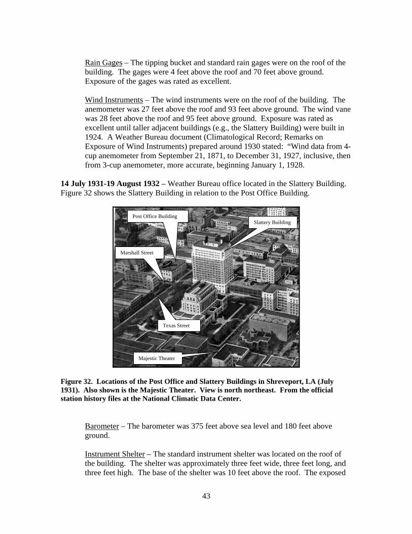
14 July 1931-19 August 1932 – Weather Bureau office located in the Slattery Building. Figure 32 shows the Slattery Building in relation to the Post Office Building.
Figure 32. Locations of the Post Office and Slattery Buildings in Shreveport, LA (July 1931). Also shown is the Majestic Theater. View is north northeast. From the official station history files at the National Climatic Data Center.
Barometer – The barometer was 375 feet above sea level and 180 feet above ground. Instrument Shelter – The standard instrument shelter was located on the roof of the building. The shelter was approximately three feet wide, three feet long, and three feet high. The base of the shelter was 10 feet above the roof. The exposed
Slattery Building Post Office Building
Texas Street
Marshall Street
Majestic Theater
44
thermometer, maximum/minimum thermometers, and psychrometer were 11 feet above the roof and 205 feet above ground. Rain Gages – The tipping bucket and standard rain gages were on the roof of the building. The gages were 4 feet above the roof and 197 feet above ground. Wind Instruments - The wind instruments were on the roof of the penthouse on top of the Slattery Building. The anemometer was 18 feet above the roof and 227 feet above ground. The wind vane was 20 feet above the roof and 229 feet above ground.
19 August 1932-7 October 1941 – Weather Bureau office on the fourth floor of the Federal Building. On 7 October 1941, the Weather Bureau observing station and office moved to the Downtown Airport.
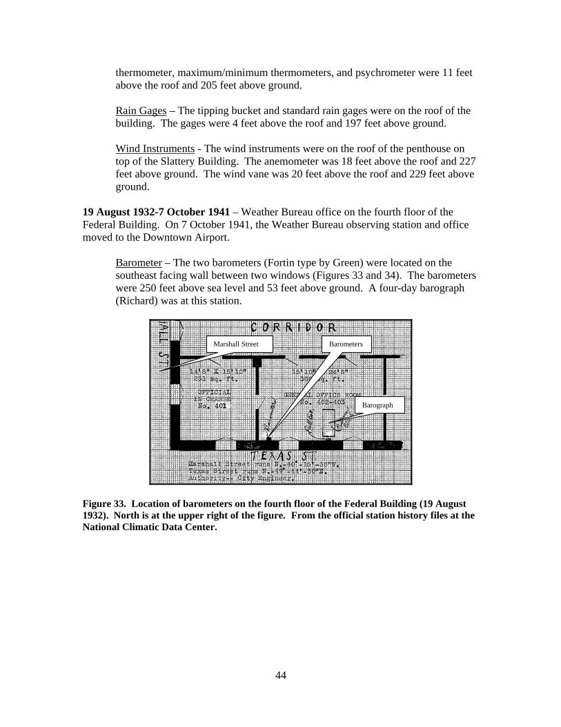
Barometer – The two barometers (Fortin type by Green) were located on the southeast facing wall between two windows (Figures 33 and 34). The barometers were 250 feet above sea level and 53 feet above ground. A four-day barograph (Richard) was at this station.
Figure 33. Location of barometers on the fourth floor of the Federal Building (19 August 1932). North is at the upper right of the figure. From the official station history files at the National Climatic Data Center.
Barometers Marshall Street
Barograph

45
Figure 34. Photograph of the Federal Building (19 August 1932), showing the Weather Bureau office, instrument shelter, and rain gages. View is north. From the official station history files at the National Climatic Data Center.
Instrument Shelter – The standard instrument shelter was located on the roof near the southeast corner of the building (Figure 34 and Figure 35). Exposed thermometer, maximum/minimum thermometers, and psychrometer were 5 feet above the roof and 92 feet above ground. A thermograph was at this station.
Instrument Shelter
Rain Gages
Penthouse
Weather Bureau Office
Barometers

46
Figure 35. Diagram of the roof of the Federal Building showing the locations of the instrument shelter and rain gages (19 August 1932). North is toward the upper right of the diagram. From the official station history files at the National Climatic Data Center.
Rain Gages – The tipping bucket and standard rain gages were on the roof of the building (Figures 34 and 35). The gages were 3 feet above the roof and 90 feet above ground. The gages were eight feet south southwest of the instrument shelter. Exposure was rated as good. Wind Instruments – The wind instruments remained on the roof of the Slattery Building because of poor exposure at the Federal Building. The 3-cup anemometer was 18 feet above the roof and 227 feet above ground. The wind vane (4-foot metal) was 20 feet above the roof and 229 feet above ground. Additional Equipment/Information – The sunshine recorder was on the roof of the Slattery Building and remained at that location when the office moved to the Federal Building.
Figures 36 and 37 are current photographs of the Post Office and Slattery Buildings showing nearby terrain.
Texas Street Instrument Shelter Rain Gages
Penthouse

47
Figure 36. Current photograph of Post Office Building (now Shreveport Municipal Library). View is north. Photograph by the author.
Figure 37. Current photograph of Post Office Building (now Shreveport Municipal Library) and Slattery Building . View is southeast. Photograph by the author.

48
Weather Bureau/Civil Aeronautics Administration Airport (CAA) Offices (14 February 1933 Through 1957) 14 February 1933-6 October 1941 - Department of Commerce/CAA Airway Radio Station at the Administration Building at the Downtown Airport. Figures 38 and 39 show the locations of the weather instruments on the roof of the Airport Administration Building.
Figure 38. Roof (horizontal view) of the Administration Building at the Shreveport Downtown Airport, showing the locations of the weather instruments used by the Department of Commerce employees (19 December 1934). North is to the right of the figure. From the official station history files at the National Climatic Data Center.
Figure 39. Administration Building at the Shreveport Downtown Airport (vertical view), showing the locations of the weather instruments used by the Department of Commerce employees (19 December 1934). North is to the right of the figure. From the official station history files at the National Climatic Data Center.
Roof of the Administration Building
Wind Instruments
Instrument Shelter
Instrument Shelter
Wind Instruments
Aneroid Barometer Located in this Room (CAA office)

49
Barometer – This station had an aneroid barometer that was mounted on the wall in the operations room (Figure 39). The barometer was 20 feet above ground and 193 feet above sea level. Between 20 October 1935 and 27 January 1939, a barograph (4-day type by J.P. Friez) was added to the station. Between 27 January 1939 and 7 June 1939, a mercurial barometer (H.J. Green) was added to the station and the aneroid barometer removed. The Weather Bureau inspection on 7 June 1939 stated the mercurial barometer was mounted on the west wall of the CAA office (see Figure 39) and the barograph was located in the southeast corner of the office. Instrument Shelter - The airways instrument shelter was mounted on a 3 inch metal pipe on the northeast end of the veranda of the Airport Administration Building (roof of the first floor of the building). The shelter was approximately 4 feet above the veranda floor and 18 feet above ground (Figures 38 and 39). It was located approximately 27 feet north of a 16 foot tall wall (wall of the second floor). The shelter contained a fan psychrometer and maximum/minimum thermometers. Exposure was rated as good. Sometime in the late 1930s, the instrument shelter was moved from the northeast corner of the roof of the Administration Building to the northwest corner (Figures 40 and 41).
Figure 40. Roof of the Downtown Airport Administration Building showing the location of the weather instruments (1940). North is toward the left side of the figure. From the Shreveport Airport Authority.
Instrument Shelter
Rain Gage
Wind Instruments

50
Figure 41. Enlargement of Figure 40 showing instrument shelter and rain gage (1940). North is to the left of the photograph. Note that the door to the shelter faces southeast. From the Shreveport Airport Authority.
Between 20 October 1935 and 27 January 1939, the airways shelter was replaced by a cotton region type. The Weather Bureau inspection on 27 January 1939 stated the following: “Instrument shelter somewhat shaken as a result of being blown over sometime ago. Door of instrument opening toward the east southeast, resulting in excessive temperatures; same being changed to true north and shelter firmly guyed.” Rain Gage – The standard eight-inch rain gage was located on the northeast part of the roof (see Figures 40 and 41) and was 27 feet north of a 16 foot tall wall (wall to the second story of the Administration Building). The exposure was rated as satisfactory. Wind Instruments – The wind instruments were mounted on a “standard” 12 foot steel pipe that was fastened to the conning tower on the Administration Building. The 3-foot wind vane and 3-cup anemometer were approximately 7 feet above the

51
roof of the conning tower and 56 feet above ground (Figure 40). The exposure was rated as good.
7 October 1941-6 July 1952 – Weather Bureau office located on the second floor of the Administration Building at the Shreveport Downtown Airport. The office was on the west side of the building. Figure 42 shows the Administration Building, Weather Bureau office, and locations of the weather instruments. Weather Bureau employees assumed observing responsibility from CAA employees.
Figure 42. Schematic of the Airport Administration Building, Weather Bureau office, and weather instruments (4 April 1942). North is to the left of the figure. From the official station history files at the National Climatic Data Center.
Barometer – The mercurial barometers (made by H.J. Green, Fortin type) were mounted on the east wall of the office. The barometers were 192 feet above sea level and 18 feet above ground. The station also had a four-day barograph (made by Friez) that was mounted near the barometers. Figure 43 shows the barometers and barograph on the east wall of the Weather Bureau office.
Barometers & Barograph
Wind Instruments
Instrument Shelter
16-Foot High Wall
To Rain Gages

52
Figure 43. Mercurial barometers and barograph on the east wall of the Weather Bureau office (3 April 1942), located on the second floor of the Airport Administration Building. From the official station history files at the National Climatic Data Center.
In late 1942 (before 28 November 1942), the office was remodeled and the area around the barometers/barograph altered. Figure 44 is a schematic of the office and Figure 45 a photograph of the barometers/barograph following the remodeling.

53
Figure 44. Schematic of the Weather Bureau office (11 August 1943) on the second floor of the Shreveport Airport Administration Building. North is to the left of the figure. From the official station history files at the National Climatic Data Center.
Figure 45. Barometers and barograph following the remodeling work at the Weather Bureau office at the Airport Administration Building (11 August 1943). View is east. From the official station history files at the National Climatic Data Center.
Barometers & Barograph

54
An altimeter setting indicator (Kollsman) was added to the station on 18 January 1948.
Instrument Shelter – The cotton region instrument shelter was located on the northwest corner of the roof of the Administration Building. The shelter was located approximately 25 feet north of a 16 foot wall. This Weather Bureau shelter was located very near the same location of the CAA instrument shelter. The exposed thermometer, maximum/minimum thermometers, and psychrometer (fan) were 5 feet above the roof of the building and 18 feet above ground. The shelter also had a thermograph. Between 15 April 1942 and 8 August 1942, the instrument shelter was moved from the roof of the Administration Building, to a location approximately 85 feet north of the Administration Building which was near the rain gages. Also, the shelter was changed from a cotton region type to a large type. The instruments in the shelter were approximately five feet above ground. Figure 46 shows the weather instruments at the Shreveport Municipal Airport in April 1943. A Weather Bureau document in December 1950 stated the shelter was about 25 feet from a concrete apron to the north and east with an asphalt roadway to the west. Following the move of the instrument shelter in 1942, it was placed over concrete (see Figure 46). A note on the cover sheet on the December 1946 Original Monthly Record of Observations, stated: “Thermometer shelter set over grass on September 17, 1946.” A September 1948 Weather Bureau document showed the shelter to have remained in the same location. Either the shelter was moved slightly, or the concrete slab under the shelter was replaced with grass. Figures 47, 48, and 49 provide different perspectives regarding exposure of the instrument shelter and rain gages during the 1940s.
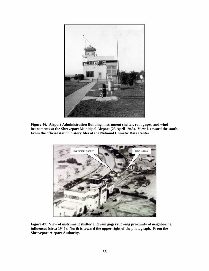
55
Figure 46. Airport Administration Building, instrument shelter, rain gages, and wind instruments at the Shreveport Municipal Airport (23 April 1943). View is toward the south. From the official station history files at the National Climatic Data Center.
Figure 47. View of instrument shelter and rain gages showing proximity of neighboring influences (circa 1945). North is toward the upper right of the photograph. From the Shreveport Airport Authority.
Instrument Shelter Rain Gages
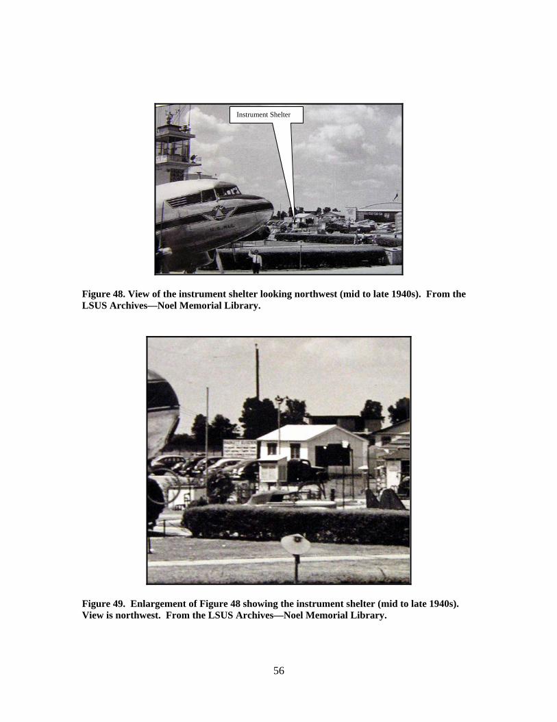
56
Figure 48. View of the instrument shelter looking northwest (mid to late 1940s). From the LSUS Archives—Noel Memorial Library.
Figure 49. Enlargement of Figure 48 showing the instrument shelter (mid to late 1940s). View is northwest. From the LSUS Archives—Noel Memorial Library.
Instrument Shelter

57
Rain Gages – Figures 46 and 47 show the location of the rain gages north of the Airport Administration Building. Based on cover sheets for the Original Monthly Record of Observations, the tipping bucket rain gage (Friez) was not moved from the downtown office until 4 March 1942. Before that time, the standard rain gage remained on the roof of the Administration Building. However, when the tipping bucket gage was moved, i.e., on 4 March 1942, both gages were located approximately 85 feet north of the Administration Building. The tops of the gages were three feet above ground. Wind Instruments – The wind instruments were mounted on the control tower of the Administration Building (same location as CAA wind instruments). The anemometer (3 cup type made by Friez) was approximately 15 feet above the roof of the tower and 64 feet above ground (Figure 50). The wind vane (3-foot metal) was approximately 18 feet above the roof of the tower and 67 feet above ground. Between 15 April 1946 and 15 April 1947, the vane was changed to a five-foot metal type.
Figure 50. Weather Bureau wind instruments on top of the control tower (mid to late 1940s). View is northwest. From the LSUS Archives—Noel Memorial Library.

58
Additional Equipment/Information – The sunshine recorder was mounted on a post near the rain gages. When the instrument shelter was moved from the roof of the Administration Building to near the rain gages, the sunshine recorder was placed on top of the instrument shelter.
6 July 1952 through 1957 – Weather Bureau office in the Administration Building (second floor) at the Greater Shreveport Municipal Airport. Figure 51 shows the Airport Administration Building (also called Terminal Building), as well as relative locations of the weather instruments.
Figure 51. Administration Building at the Greater Shreveport Municipal Airport (January 1957), along with the Weather Bureau office and weather instruments. View is southeast. From the official station history files at the National Climatic Data Center.
Barometer – The mercurial barometer (Fortin type) was 268 feet above sea level and 16 feet above ground. The station had a 4-day barograph (Friez) located 44 feet above ground. The station also had an altimeter setting indicator (Kollsman) located 43 feet above ground. Based on the elevations, the barograph and altimeter setting indicator likely were in the control tower. Instrument Shelter – The instrument shelter was a large type and was situated over sod approximately 75 feet west northwest of the northwest corner of the Airport Administration Building. Maximum/minimum thermometers were six feet above ground and the exposed thermometer and psychrometer (whirling)
Wind Instruments
Rain Gages
Weather Bureau Office
To Instrument Shelter

59
were five feet above ground. A seven-day thermograph was in the shelter, six feet above ground. A Weather Bureau document on 15 October 1952 (Description of Topography and Exposure of Instruments) stated a black top parking lot was approximately 30 feet south of the instrument shelter, a concrete road 11 feet east of the shelter, and the Airport Administration Building 75 feet east and south of the shelter. Figures 52 through 56 show different perspectives of the instrument shelter and rain gages at this station.
Figure 52. View of instrument shelter looking northwest (1952). From the LSUS Archives—Noel Memorial Library.
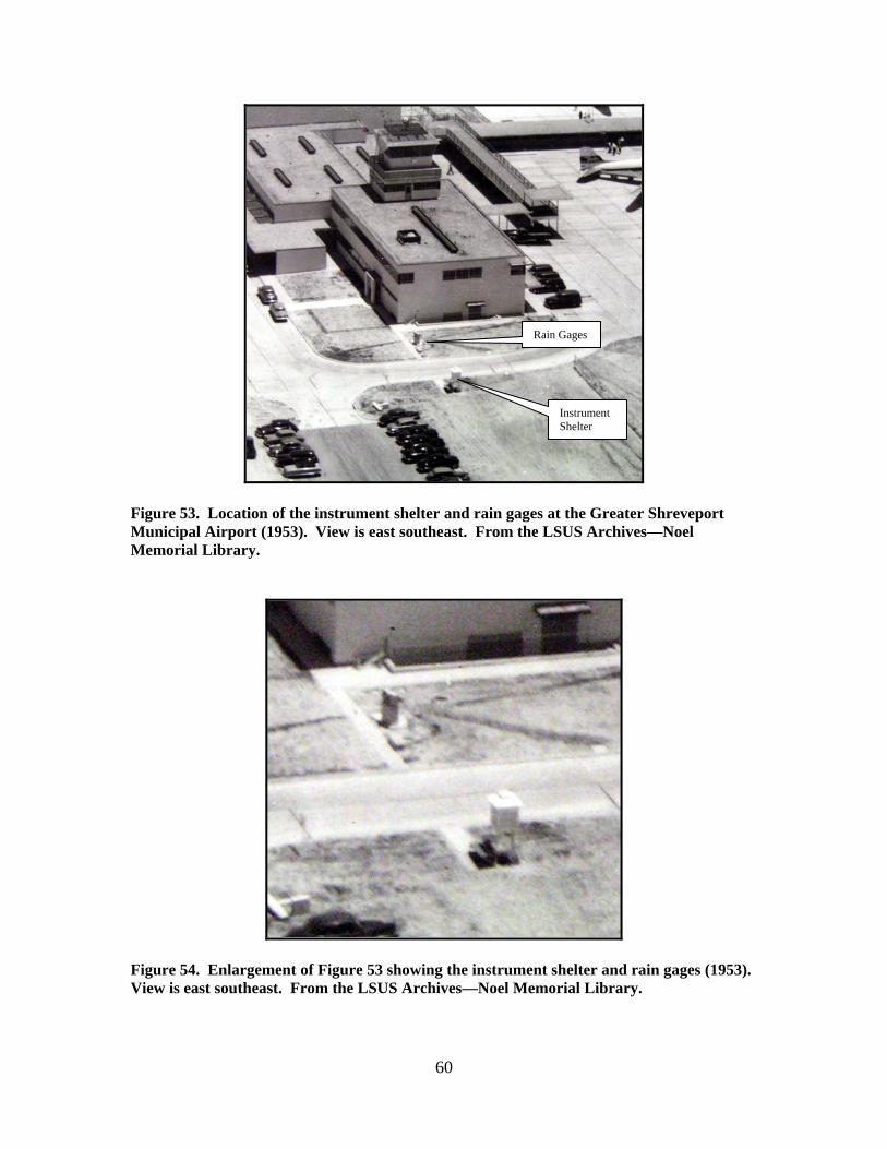
60
Figure 53. Location of the instrument shelter and rain gages at the Greater Shreveport Municipal Airport (1953). View is east southeast. From the LSUS Archives—Noel Memorial Library.
Figure 54. Enlargement of Figure 53 showing the instrument shelter and rain gages (1953). View is east southeast. From the LSUS Archives—Noel Memorial Library.
Instrument Shelter
Rain Gages
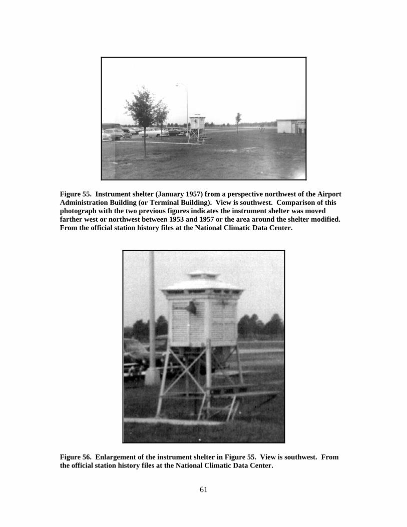
61
Figure 55. Instrument shelter (January 1957) from a perspective northwest of the Airport Administration Building (or Terminal Building). View is southwest. Comparison of this photograph with the two previous figures indicates the instrument shelter was moved farther west or northwest between 1953 and 1957 or the area around the shelter modified. From the official station history files at the National Climatic Data Center.
Figure 56. Enlargement of the instrument shelter in Figure 55. View is southwest. From the official station history files at the National Climatic Data Center.

62
Rain Gages – The rain gages were located approximately 25 feet west of the northwest corner of the Airport Administration Building. The tipping bucket (Friez) and standard rain gages (Weather Bureau) were three feet above ground. A weighing rain gage was not installed at the Shreveport Weather Bureau station until 1 December 1959. Figures 57 and 58 show the location of the rain gages.
Figure 57. Location of the rain gages near the Airport Administration Building (January 1957). View is south. From the official station history files at the National Climatic Data Center.
Rain Gages
Weather Bureau Office in the Airport Administration Building

63
Figure 58. Enlargement of Figure 57 showing the rain gages at the Greater Shreveport Municipal Airport. View is south. From the official station history files at the National Climatic Data Center.
Wind Instruments – The wind instruments were located on the roof of the control tower of the Administration Building. Photographs of the tower in 1952 (Figures 59 and 60), and in 1957 (Figure 61) indicate the anemometer and wind vane were raised sometime during the period. By 1957, the anemometer (Selsyn) and wind vane were 15 feet above the roof of the tower and 59 feet above ground.
Tipping Bucket Rain Gage
Standard 8-Inch Rain Gage
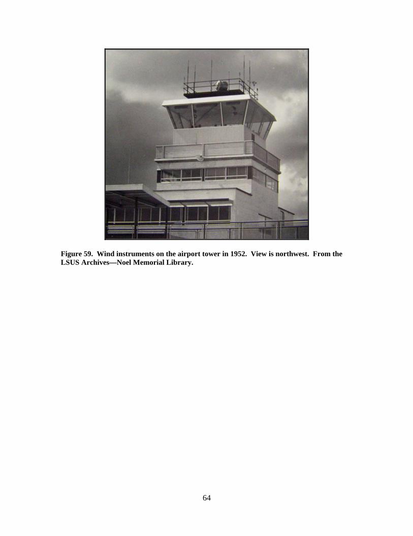
64
Figure 59. Wind instruments on the airport tower in 1952. View is northwest. From the LSUS Archives—Noel Memorial Library.

65
Figure 60. Enlargement of Figure 59 showing the wind instruments in 1952. View is northwest. From the LSUS Archives—Noel Memorial Library.

66
Figure 61. Anemometer and wind vane on top of the control tower at the Airport Administration Building (January 1957). View is southeast. Wind instruments were elevated above the tower during the period from 1952 to 1957. From the official station history files at the National Climatic Data Center.
Additional Equipment/Information – Rawinsonde observations began at Shreveport on 11 January 1956.
Barksdale Air Force Base (10 May 1935 through 13 November 1950)
Figure 61 shows the locations of the weather instruments used by the Weather Bureau at Barksdale in 1935. Exact locations of the instruments at Barksdale subsequent to 1935 could not be determined, but appeared to be similar to those shown in Figure 62. Figure 63 shows Hangar No. 9 in 1939, Figures 64 and 65 show the instrument shelter, and Figure 66 is a current picture of the hangar along with surrounding terrain.
Anemometer
Wind Vane
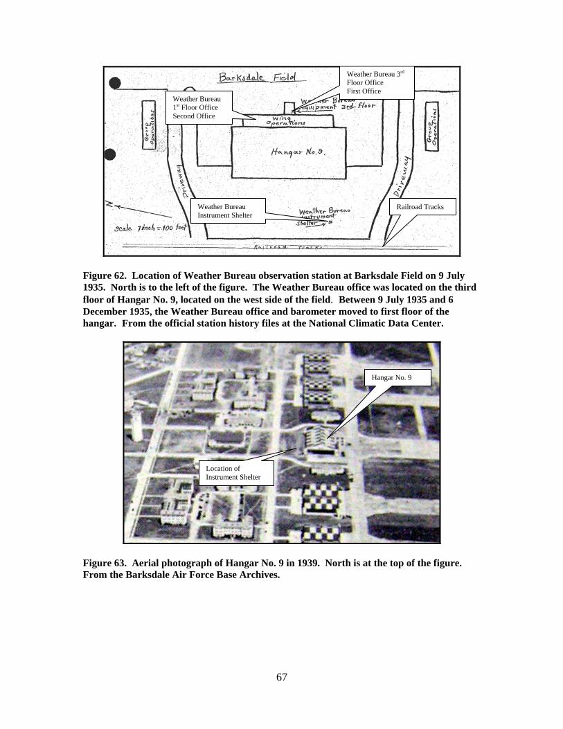
67
Figure 62. Location of Weather Bureau observation station at Barksdale Field on 9 July 1935. North is to the left of the figure. The Weather Bureau office was located on the third floor of Hangar No. 9, located on the west side of the field. Between 9 July 1935 and 6 December 1935, the Weather Bureau office and barometer moved to first floor of the hangar. From the official station history files at the National Climatic Data Center.
Figure 63. Aerial photograph of Hangar No. 9 in 1939. North is at the top of the figure. From the Barksdale Air Force Base Archives.
Railroad Tracks
Weather Bureau 3rd Floor Office First Office
Weather Bureau 1st Floor Office Second Office
Weather Bureau Instrument Shelter
Hangar No. 9
Location of Instrument Shelter

68
Figure 64. Hangar No. 9 and instrument shelter (circa 1930s). View is east northeast. Courtesy of 2nd Bomb Wing History Office, Barksdale AFB, LA.
Figure 65. Enlargement of Figure 64 showing the instrument shelter just west of Hangar No. 9. View is east northeast. Courtesy of 2nd Bomb Wing History Office, Barksdale AFB, LA.
Instrument Shelter

69
Figure 66. Current photograph of Hangar No. 9 looking south southeast. Photograph taken by the author.
Barometer – The barometer was a mercurial type and was owned by the Signal Corps. The barometer was located in the Weather Bureau office that was on the third floor of Hangar No. 9. The elevation of the barometer was 195 feet above sea level but changed to 168 feet between 9 July 1935 and 6 December 1935. Records for the Barksdale observations in the early 1940s (records began 15 April 1942) indicated the station had two mercurial barometers, an aneroid barometer, and a four-day barograph. Elevation of the barometer remained at 168 feet above sea level, i.e., on the first floor of Hangar No. 9. By 4 September 1944, the aneroid barometer was removed. Instrument Shelter – The cotton region instrument shelter was located over sod on the west side of Hangar No. 9 (Figures 63, 64, and 65). The floor of the shelter was four feet above ground and contained an exposed thermometer and hygrometer. Exposure was rated as excellent. No mention was made with regard to the influence of trains on the railroad tracks which were just west of the shelter at that time. Records for the Barksdale observations in the early 1940s (records began 15 April 1942) indicated the instrument shelter was a large type over sod. Exact location was not specified. Also, maximum/minimum thermometers and a thermograph were added to the station based on records in the early 1940s. The April 1942 report stated the hygrometer was a whirling type (ML-74A). By 4 September 1944, the instrument shelter was changed to an airways type over sod.
Hangar No. 9
Location of Instrument Shelter
70
Rain Gages – This station did not have a rain gage initially. By 15 April 1942, a tipping bucket rain gage and standard eight-inch rain gage were added. Exact location not specified other than the gages were three feet above ground. Most likely, the gages were located near the instrument shelter on the lawn west of the hangar. By 4 September 1944, the tipping bucket rain gage was removed from the station. Wind Instruments – The wind instruments were owned by the Signal Corps and were on the roof of the hangar, 18 feet above the roof and 60 feet above ground. Weather Bureau records in April 1942 indicated the anemometer type was a “ML-80” (three-cups) and the wind vane was a three-foot type. Additional Equipment/Information – The Weather Bureau report on 15 April 1942 stated that radiosonde observations were taken at this station, but old-style radiosonde equipment was used. Weather Bureau forms during the 1940s stated that all instruments at this station were owned by the Army (Signal Corps).

71
OTHER OBSERVATIONS
Figure 67 shows the locations of significant observations in the vicinity of Shreveport during the 19th and early 20th centuries. According to the Louisiana Substation History, weather observations were taken at Anchorage Plantation from January 1869 to November 1870. Anchorage Plantation was located near Shreveport, but exact location was not specified. No other information was listed regarding the station.
Voluntary weather observations were taken at Plain Dealing, LA, located approximately 30 miles north of Shreveport, from June 1892 to January 1894. Cooperative weather observations also were taken during the 1940s. This station had a cotton region shelter, maximum/minimum thermometers, and a standard rain gage.
Voluntary weather observations were taken at Grand Cane, LA, located
approximately 27 miles south of Shreveport, from December 1888 to October 1891. Cooperative observations also were taken near Gran Cane beginning June 1907, continuing through 1949. This station had a cotton region instrument shelter, maximum/minimum thermometers, and a standard rain gage.

72
Figure 67. Locations of significant voluntary/cooperative observers nearby to Shreveport. North is at the top of the page. Distance across the figure (horizontal) is approximately 81 miles. Information plotted on a current map of Louisiana.
Plain Dealing, LA
Grand Cane, LA
Anchorage Plantation (General Location; Exact Location Unknown)

73
BIBLIOGRAPHY Army Surgeon General, 1870. Report on Barracks and Hospitals with Descriptions of
Military Posts (Circular No. 4). War Department, Surgeon General’s Office, Washington.
Army Surgeon General, 1875. Hygiene of the United States Army, with Descriptions of
Military Posts. War Department, Government Printing Office, Washington. Bohannon, Shawn M., John Andrew Prime, and H.D. Rigg, 2002. Barksdale Air Force
Base. Arcadia Publishing, Charleston, SC. Brock, Eric J., 1998. Shreveport. Arcadia Publishing, Charleston, SC. Brock, Eric J., 1998. Shreveport in the Twentieth Century. Arcadia Publishing,
Charleston, SC. Brock, Eric J., 2005. Shreveport in Vintage Postcards. Arcadia Publishing, Charleston,
SC. Chief Signal Officer, 1872 through 1892. Annual Report of the Chief Signal Officer (for
the years 1871 through 1891). War Department, Government Printing Office, Washington D.C.
Chief Signal Officer, 1871 through 1888. Signal Service Station Inspection Reports. War
Department, National Archives and Records Administration, Washington D.C. Frank Leslie’s Popular Monthly, 1878. “The United States Signal Service” (author
unknown). September 1878, pages 337-345. Gute, Fredricka Doll and Katherine Brash Jeter, 1982. Historic Profile of Shreveport in
1850. Published for the Spring Street Museum by the Shreveport Committee of the National Society of the Colonial Dames of America in the State of Louisiana.
Grandy, Walter F., 1971. The History of Barksdale Air Force Base. Everett’s Bindery,
Bossier City, LA. Henrici, Holice H., 1986. Shreveport: The Beginnings. Center for Louisiana Studies,
University of Southwestern Louisiana, Lafayette, LA. McLaurin, Ann M., 1985. Glimpses of Shreveport. Northwestern State University Press,
Natchitoches, LA.

74
Midwestern Regional Climate Center (Gary Grice and Peter Boulay), 2005. History of Weather Observations, Minneapolis/St. Paul, MN, 1854-1955. National Climatic Data Center.
National Weather Service, 1981. Substation History (Louisiana). Department of
Commerce, Government Printing Office, Washington D.C. Noel Memorial Library, 2003. Photo by Grabill: A Legacy of Images. Pediment
Publishing, Vancouver, WA. O’Pry, Maude Hearn, 1978. Chronicles of Shreveport. Publisher not listed, but copies are
available at the Shreve Memorial Library and Noel Memorial Library in Shreveport. Plummer, Marguerite R. and Gary D. Joiner, 2000. Historic Shreveport-Bossier.
Historical Publishing Network, San Antonio, TX. Second Air Force, 1971. The History of Barksdale Air Force Base. Ewing and Querbes
families. Shreveport Times and Noel Memorial Library, 2000. A Pictorial History of Northwest
Louisiana, Volumes I and II. Pediment Publishing, Vancouver, WA. Smithsonian Institution, 1850 through 1874. Annual Report of the Smithsonian Institution
(for the years 1849 through 1873). A.O.P. Nicholson, Public Printer, Washington DC. Snyder, Perry Anderson, 1979. Shreveport, Louisiana, During the Civil War and
Reconstruction (Dissertation for Doctor of Philosophy Degree at Florida State University). Florida State University, Tallahassee, FL.
Thomson, Bailey, 1980. Historic Shreveport: A Guide. Shreveport Journal, Shreveport,
LA. Thomson, Bailey and Patricia L. Meador, 1987. Shreveport: A Photographic
Remembrance, 1873-1949. Louisiana State University Press, Baton Rouge, LA. Weather Bureau, 1892 through 1930. Annual Report of the Chief of the Weather Bureau
(for the years 1891 through 1930). Government Printing Office, Washington DC. Weather Bureau, 1936 through 1940. United States Meteorological Yearbook (for the
years 1935 through 1939). Department of Agriculture, Government Printing Office, Washington DC.
Weather Bureau, 1941 through 1943. United States Meteorological Yearbook (for the
years 1940 through 1942). Department of Commerce, Government Printing Office, Washington DC.

75
Weather Bureau, 1956. Substation History (Louisiana). Department of Commerce, Government Printing Office, Washington D.C.
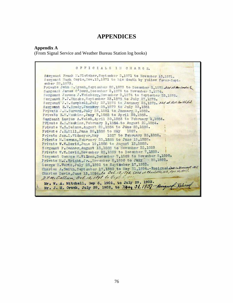
76
APPENDICES
Appendix A (From Signal Service and Weather Bureau Station log books)
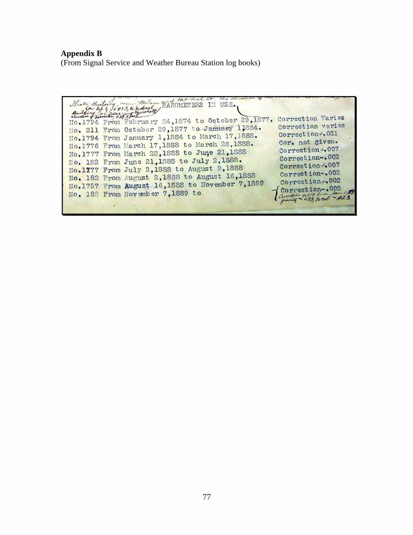
77
Appendix B (From Signal Service and Weather Bureau Station log books)

78
Appendix C (From Signal Service and Weather Bureau Station log books)
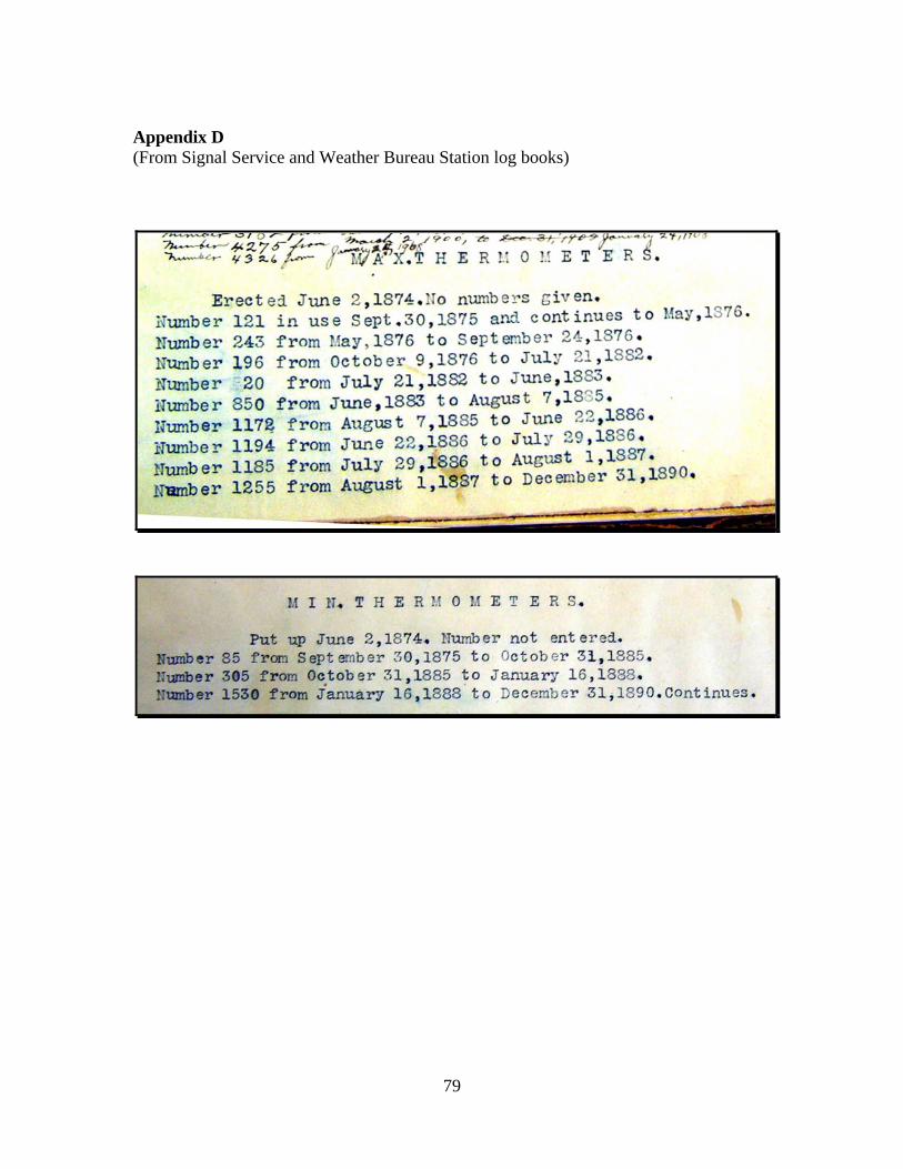
79
Appendix D (From Signal Service and Weather Bureau Station log books)
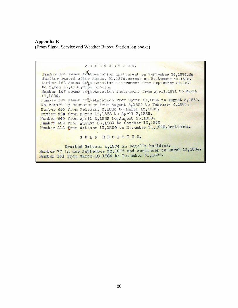
80
Appendix E (From Signal Service and Weather Bureau Station log books)
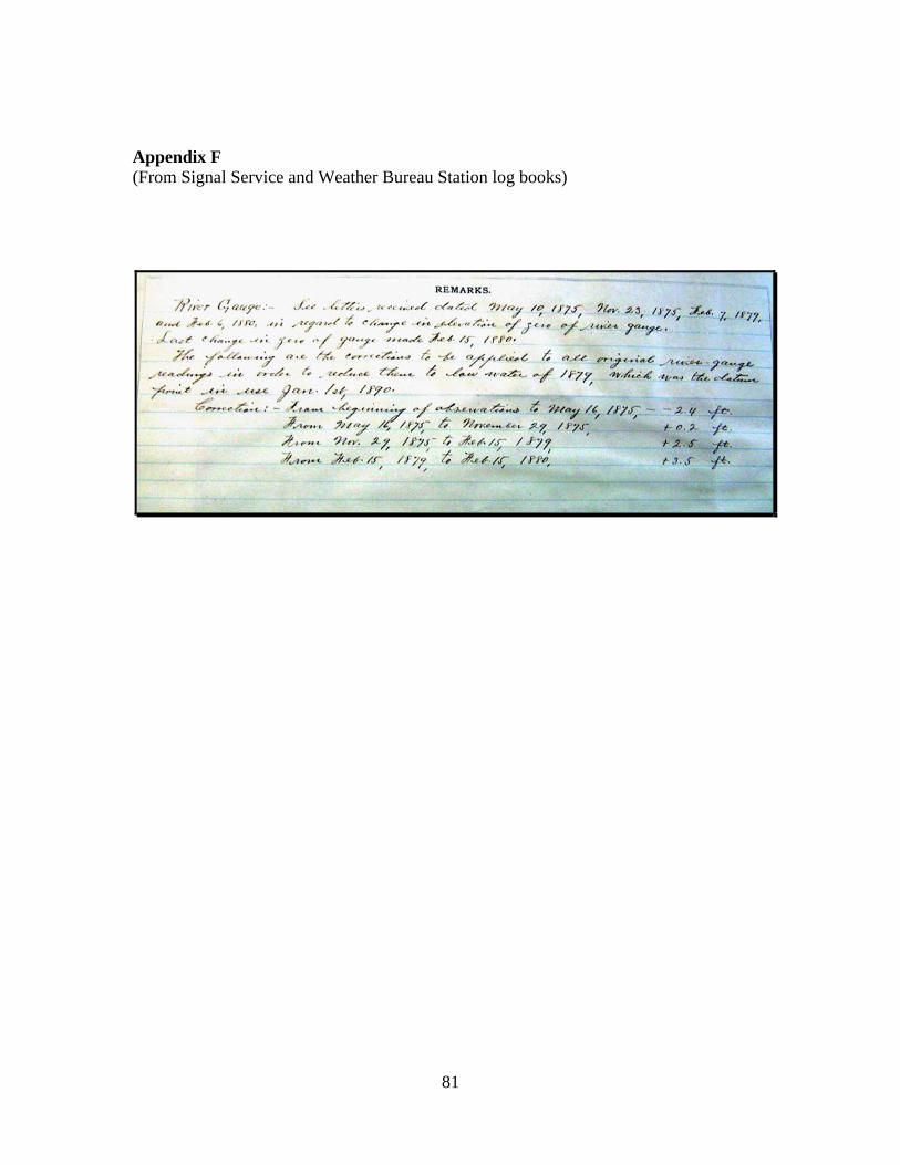
81
Appendix F (From Signal Service and Weather Bureau Station log books)

82
Appendix G
Methodology
Station history files at the National Climatic Data Center (NCDC) provided descriptions of weather station locations beginning in 1867, i.e., during the Smithsonian years, and continued through the Signal Service years, and into the early part of the 20th Century under the U.S. Weather Bureau.
Entries from local Climate Record Books at the NCDC provided the backbone for locations and general exposures for instrument shelters (especially thermometers), rain gages, and anemometers/wind vanes for the Shreveport stations (city office and airport locations) from September 1871 into the 1950s (Signal Service and Weather Bureau years). Numerous Station History reports prepared in the 20th Century were instrumental in defining specific instrument elevation heights at the Weather Bureau City Offices, and at the CAA and Weather Bureau Airport Stations.
Specific building names and street addresses from different sources confirmed the locations of the Signal Service and Weather Bureau city offices from 1871 through 1957. During the latter time period of this study, Weather Bureau officials routinely documented station history and instrument status through forms entitled, “Description of Topography and Exposure of Instruments,” “Report of Elevation and Position of Instruments,” and “Surface Weather Observations.” Information on these forms provided significant detail regarding Shreveport city offices, as well as the stations at the airports.
Tracking office location and instrument exposure on a yearly basis was important to ensure no information gaps existed. This yearly information was obtained from the Annual Reports of the Chief Signal Officer for the 1870s, 1880s, and early 1890s, as well as from the Annual Reports of the Weather Bureau from 1892 through 1930 (detailed Weather Bureau Annual Reports stopped in 1930 to save money during the Depression). Weather Bureau Annual Reports were more complete for this project than Signal Service versions. Information consistency for the 1940s and early 1950s was maintained from the wealth of Weather Bureau historical records during that time period.
Considerable information regarding the early Signal Service observing stations
in Shreveport was available from 16 station inspection reports. These inspections were conducted by Signal Service headquarters and are archived at the National Archives and Records Administration (NARA). These inspection reports have been scanned and are available in the NCDC database. These inspections provided drawings and detailed textual information on the placement and exposure of weather instruments at the Signal Service stations in Shreveport.
The Archives and Special Collections Section of the Noel Memorial Library at
the LSU in Shreveport contains 22 log books of Signal Service and Weather Bureau

83
activities at the Shreveport office from 1871 through 1910. These log books contain extensive information regarding the evolution of the Shreveport office during the 1870s, 1880s, 1890s, and early 1900s and have been indexed by one of the archivists. These books were very helpful in answering specific questions regarding station and instrument location.
Information regarding duration of observations by Smithsonian Institution
weather observers in the Shreveport area was obtained from yearly Smithsonian Institution reports, as well as from the NCDC data base.
General historic information for the Shreveport area was found on various web
sites. Other information and data sources checked (by person, telephone, or through the Internet) during this study were: the Shreve Memorial Library, the Barksdale AFB Historian, the Eighth Air Force Museum, the Shreveport Airport Authority, Centenary College Magale Library, The Spring Street Historical Museum, Louisiana State Museum, and the Louisiana State Archives. Also, relevant information regarding the Weather Bureau and Signal Service was obtained from the Dallas, TX Public Library, Oklahoma State University Library, and the NOAA Library.