Historical Maps 15b - Welcome to NYC.gov | City of New York
23
Transcript of Historical Maps 15b - Welcome to NYC.gov | City of New York
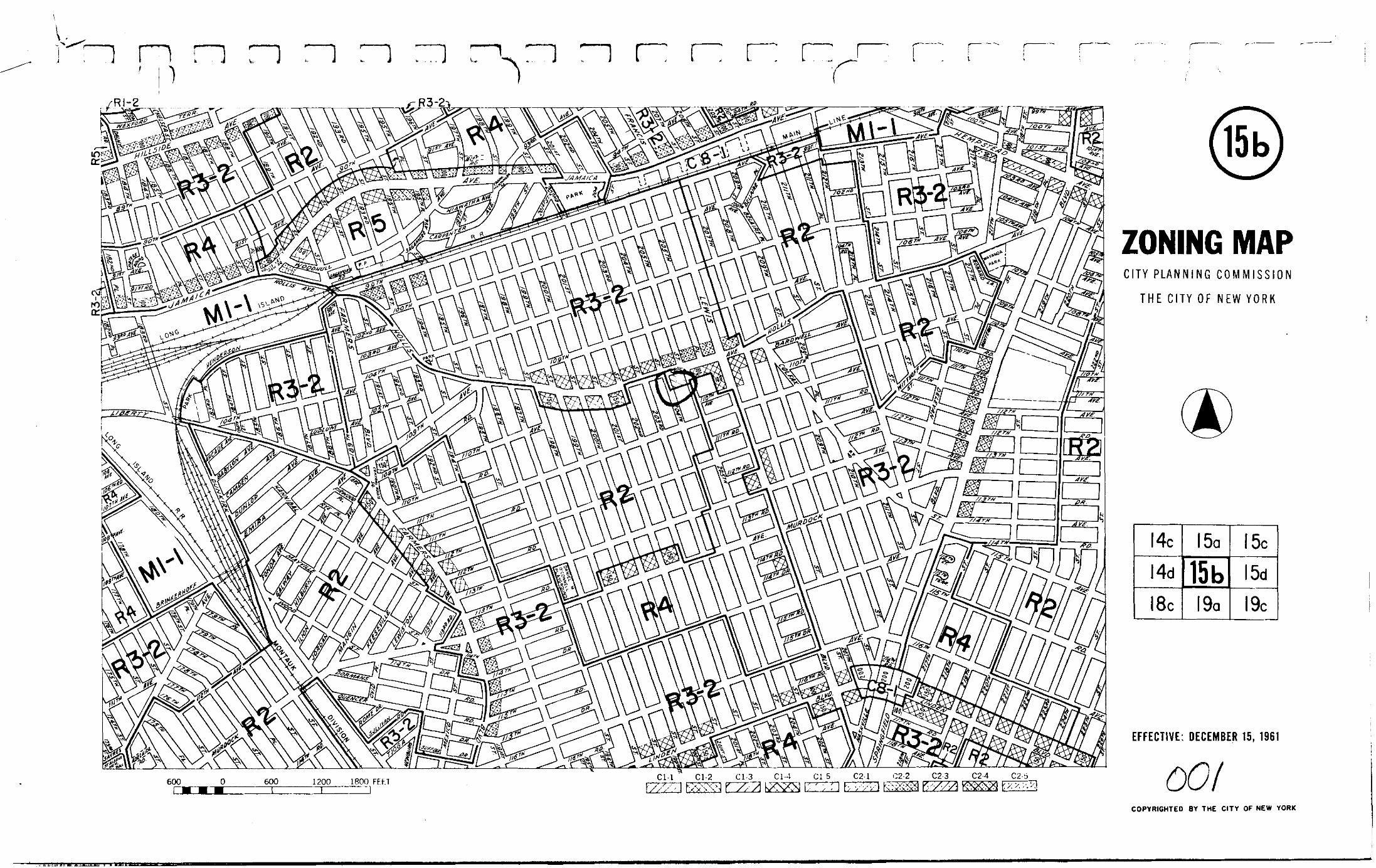

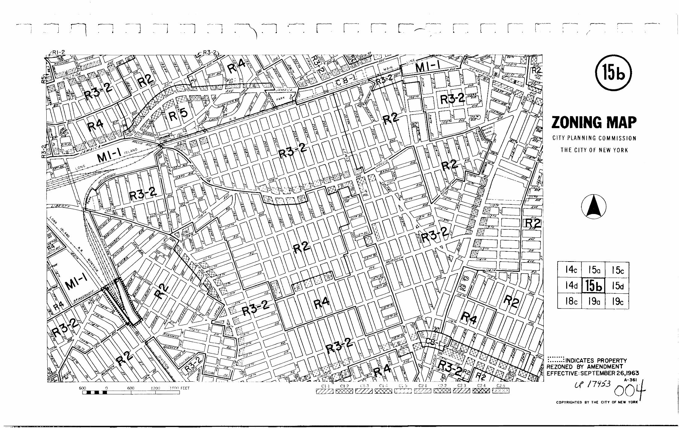


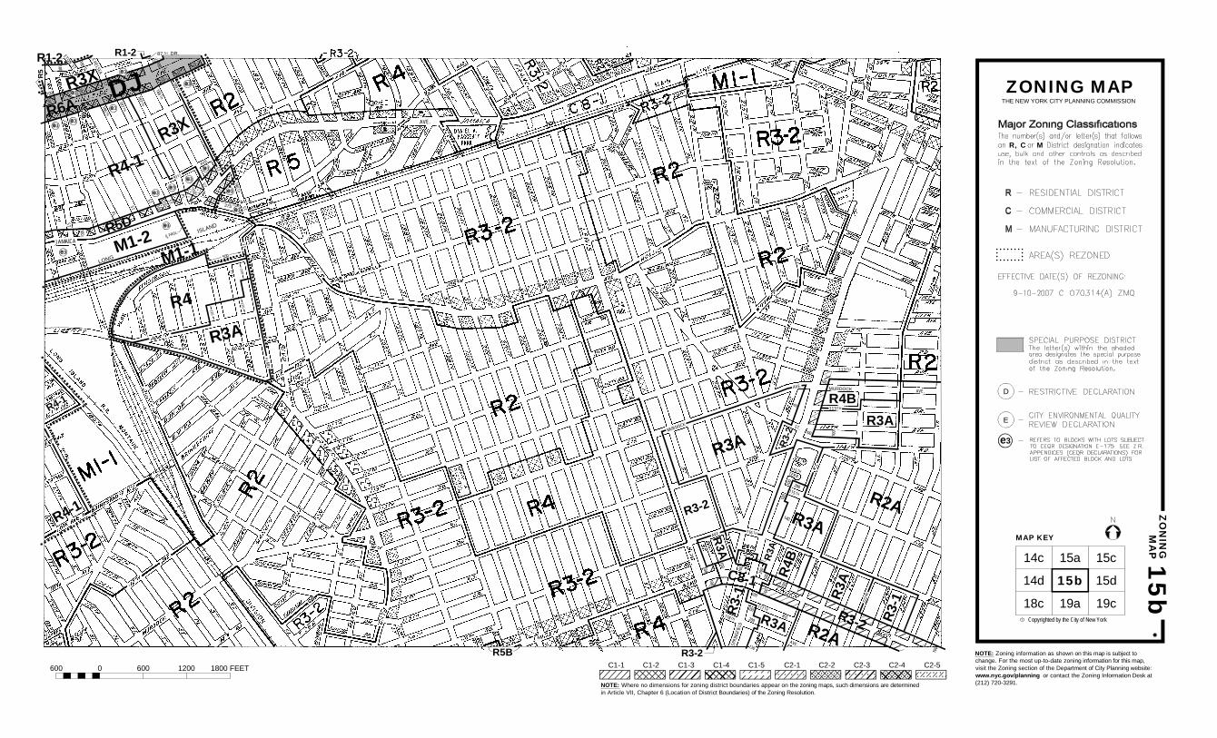
MAP KEY
Copyrighted by the City of New Yorkc
15bZ
ON
ING
MA
P
ZONING MAPTHE NEW YORK CITY PLANNING COMMISSION
D
R, C M
15b
14c 15a 15c
15d
19c19a18c
14d
E
87TH
DR.
R5B NOTE: Zoning information as shown on this map is subject tochange. For the most up-to-date zoning information for this mapcheck the Department of City Planning website:http://www.nyc.gov/html/dcp/html/subcats/zoning.htmlor contact the Zoning Information Desk at (212) 720-3291.NOTE: Where no dimensions for zoning district boundaries appear on the zoning maps, such dimensions are determined
in Article VII, Chapter 6 (Location of District Boundaries) of the Zoning Resolution.
600 0 600 1200 1800 FEET C1-1 C1-2 C1-3 C1-4 C1-5 C2-1 C2-2 C2-3 C2-4 C2-5
118 TH
117 TH
ST.
TERR.
115 TH
115 TH
100
100
130
200
100
100
100
200
140
100
100
100
100
MURDOCKAVE.
R3AR4B
R3A
R3A
R3-2
R3-1
R3A
R3-2
R3-2
R3-1R3
A
R3A
R4B
100
R3A
100
MURDOCK
RD.
100
100R2A
AVE.SPRI
NGFI
ELD
AVE.
AVE.
10020
0
113TH
113TH
116 TH
100
C8-1
222N
D
R2A
R3-2
100
ST.
187 TH187 TH
186 TH
ST.
PL.
ST.
PL.
ST.
ST.
ST.
91ST
AVE.
ST.
190TH
500
240
225
100150
150
100
ST.
100
100
100
100
R4
R3A
M1-2
225
R3X
R3X
R6A
100
LONG
375
225
M1-1
DJ
R5D
100
CLPROL. ISLAND
ST.
ST.
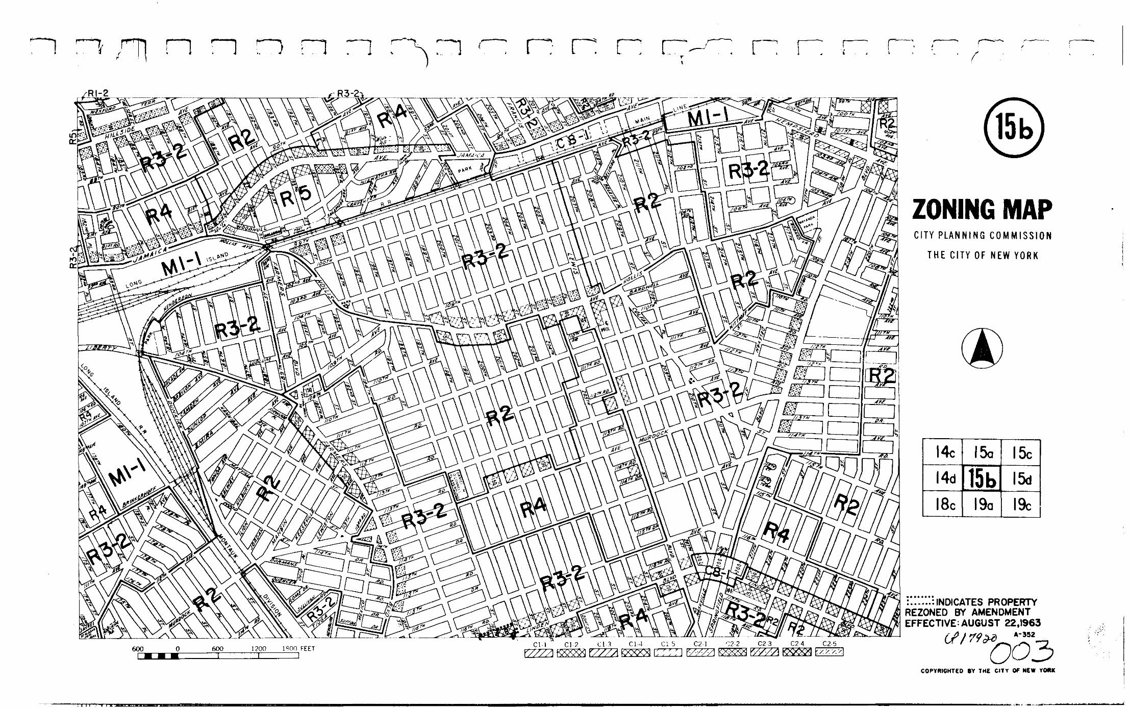
MAP KEY
Copyrighted by the City of New Yorkc
15bZ
ON
ING
MA
P
ZONING MAPTHE NEW YORK CITY PLANNING COMMISSION
D
R, C M
15b
14c 15a 15c
15d
19c19a18c
14d
E
87 TH DR.
R5B
118 TH
117 TH
ST.
TERR.
115 TH
115 TH
100
100
130
200
100
100100
200
140
100
100
100
100
MURDOCKAVE.
R3AR4B
R3A
R3A
R3-2
R3-1
R3A
R3-2
R3-2
R3-1R3
A
R3A
R4B
100
R3A
100
MURDOCK
RD.
100
100R2A
AVE.SPRI
NGFI
ELD
AVE.
AVE.
10020
0
113TH
113TH
116 TH
100
C8-1
222N
D
R2A
R3-2
100
NOTE: Zoning information as shown on this map is subject tochange. For the most up-to-date zoning information for this map,visit the Zoning section of the Department of City Planning website:www.nyc.gov/planning or contact the Zoning Information Desk at(212) 720-3291.NOTE: Where no dimensions for zoning district boundaries appear on the zoning maps, such dimensions are determined
in Article VII, Chapter 6 (Location of District Boundaries) of the Zoning Resolution.
600 0 600 1200 1800 FEET C1-1 C1-2 C1-3 C1-4 C1-5 C2-1 C2-2 C2-3 C2-4 C2-5
100
100
CHELSEA
ETONST.
R1-2 R1-2
R4-1
189TH
R4-1
R4-1
JAMAICA
AVE.
R5
188 TH
189 TH
100
e3

ST.
187 TH187 TH
186 TH
ST.
PL.
ST.
PL.
ST.
ST.
ST.
91ST
AVE.
ST.
190TH
500
240
225
100150
150
100
ST.
100
100
100
100
R4
R3A
M1-2
225
R3X
R3X
R6A
100
LONG
375
225
M1-1
DJ
R5D
100
CLPROL. ISLAND
ST.
ST.
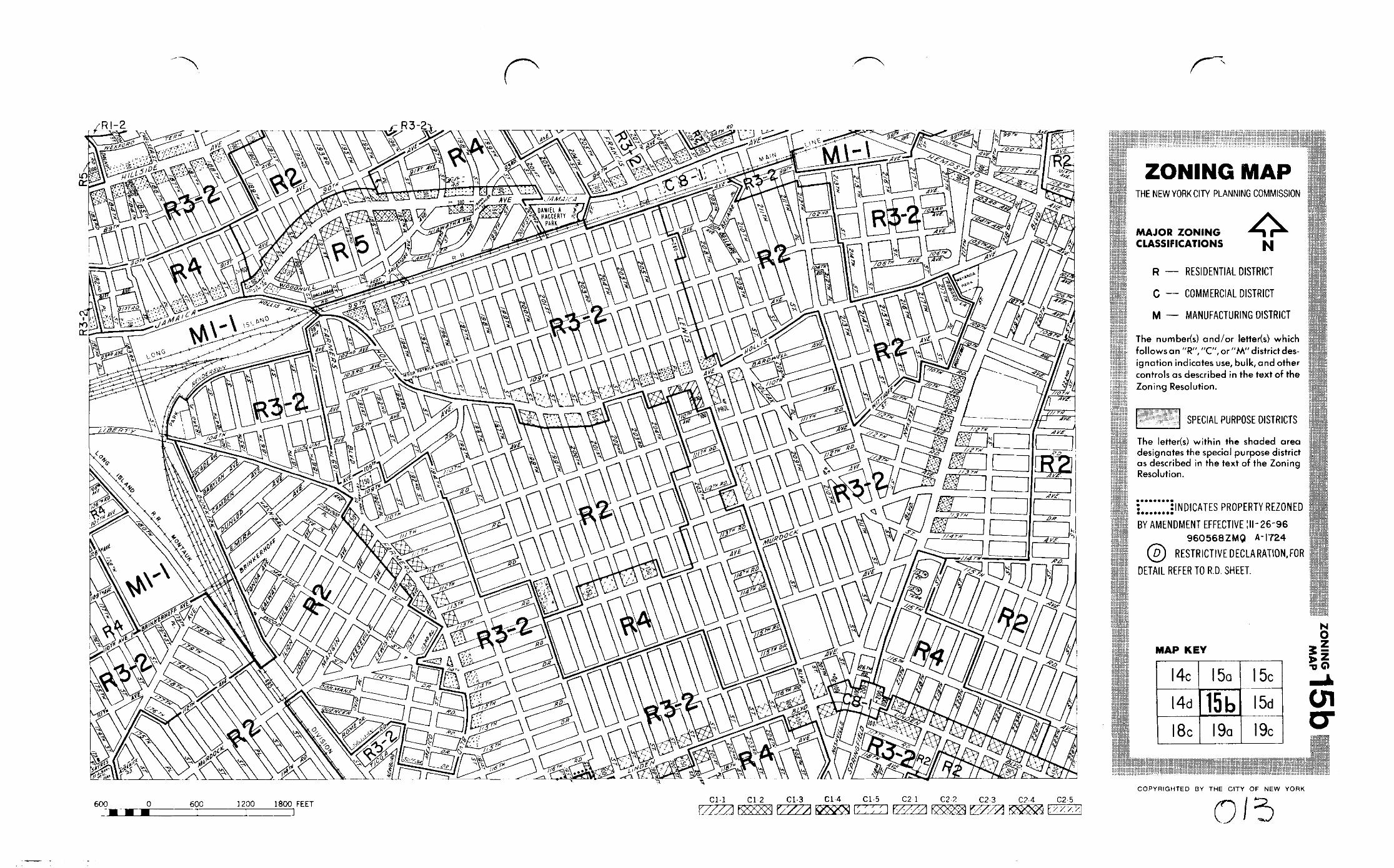
MAP KEY
Copyrighted by the City of New Yorkc
15bZ
ON
ING
MA
P
ZONING MAPTHE NEW YORK CITY PLANNING COMMISSION
D
R, C M
15b
14c 15a 15c
15d
19c19a18c
14d
E
87 TH DR.
118 TH
117 TH
ST.
TERR.
115 TH
115 TH
100
100
130
200
100
100
100
200
140
100
100
100
100
MURDOCKAVE.
R3AR4B
R3A
R3A
R3-2
R3-1
R3AR3A
R3-
2
R3-1R3
A
R3A
R4B
100
R3A
100
MURDOCK
RD.
100
100
R2A
AVE.SPRI
NGFI
ELD
AVE.
AVE.
10020
0
113 TH
113 TH
116 TH
C8-1
222N
D
R2A
R3-2
100
NOTE: Zoning information as shown on this map is subject tochange. For the most up-to-date zoning information for this map,visit the Zoning section of the Department of City Planning website:www.nyc.gov/planning or contact the Zoning Information Desk at(212) 720-3291.NOTE: Where no dimensions for zoning district boundaries appear on the zoning maps, such dimensions are determined
in Article VII, Chapter 6 (Location of District Boundaries) of the Zoning Resolution.
600 0 600 1200 1800 FEET C1-1 C1-2 C1-3 C1-4 C1-5 C2-1 C2-2 C2-3 C2-4 C2-5
100
100
CHELSEA
ETONST.
R1-2 R1-2
R4-1
189T
H
R4-1
R4-1
JAMAICA
AVE.
R5
188 TH
189 TH
100
e3
AVE.
LEW
IS
198TH
AVE.
AVE.
MARNE
ST.
ST.
205TH
AVE.
ST.
AVE.
111TH
112TH
111TH
112 TH
113TH
113TH
115TH
DR.
SUFFOLK
RD.
RD.
ST.
114 TH
113TH
AVE.
110 THAVE.
111TH RD.
114THDR.
115TH RD.
116 THRD.
191 ST
ST.
14090
100
100
100
100
100
130
60
100
100
100
100
100
80
80
100
100
100 100
100
100
100
100
16085
100
100
180
100
100
300
100 100
100
100
100
100
100
100
100
100
100
100
PROL.100
100100
260
260
260
75
150
100
100
100
R4-1
R4A
100100
150
100
R5BR3XR3A
R3A
R3X
R3A
R5B
R3A
R3X R3A
R5B
R3A
R4B
R4BR4-1
R3X
R4B
R3-2
70
E-186
E-186
E-186
E-186
E-186
E-186
R3-2
BLVD.
RD.
LEWIST
ON
AVE.
174 TH
173 RD
109TH
ST .
BRINKERHOFF
100 20
0
ST.
R4A R4A
E-186
E-186
PL.R3-2

ST.
187 TH187 TH
186 TH
ST.
PL.
ST.
PL.
ST.
ST.
ST.
91ST
AVE.
ST.
190 TH
500
240
225
100150
150
100
ST.
100
100
100
100
R4
R3A
M1-2
225
R3X
R3X
R6A
100
LONG
375
225
M1-1
DJ
R5D
100
CLPROL. ISLAND
ST.
ST.
MAP KEY
Copyrighted by the City of New Yorkc
15bZ
ON
ING
MA
P
15b
14c 15a 15c
15d
19c19a18c
14d
87 TH DR.
118 TH
117 TH
ST.
TERR.
115 TH
115 TH
100
100
130
200
100
100
100
200
140
100
100
100
100
MURDOCKAVE.
R3AR4B
R3A
R3A
R3-2
R3-1
R3AR3A
R3-2
R3-1R3
A
R3A
R4B
100
R3A
100
MURDOCK
RD.
100
100
R2A
AVE.SPRI
NGFIE
LD
AVE.
AVE.
10020
0
113TH
113TH
116 TH
C8-1
222N
D
R2A
R3-2
100
NOTE: Zoning information as shown on this map is subject tochange. For the most up-to-date zoning information for this map,visit the Zoning section of the Department of City Planning website:www.nyc.gov/planning or contact the Zoning Information Desk at(212) 720-3291.NOTE: Where no dimensions for zoning district boundaries appear on the zoning maps, such dimensions are determined
in Article VII, Chapter 6 (Location of District Boundaries) of the Zoning Resolution.
600 0 600 1200 1800 FEET C1-1 C1-2 C1-3 C1-4 C1-5 C2-1 C2-2 C2-3 C2-4 C2-5
100
100
CHELSEA
ETONST.
R1-2 R1-2
R4-1
189T
H
R4-1
R4-1
JAMAICA
AVE.
R5
188 TH
189 TH
100
AVE.
LEWIS
198TH
AVE.
AVE.
MARNE
ST.
ST.
205TH
AVE.
ST.
AVE.
111TH
112TH
111TH
112TH
113TH
113TH
115 TH
DR.
SUFFOLK
RD.
RD.
ST.
114 TH
113TH AVE.
110THAVE.
111TH RD.
114THDR.
115TH RD.
116 THRD.
191 ST
ST.
14090
100
100
100
100
100
130
60
100
100
100
100
100
80
80
100
100
100 100
100
100
100
100
16085
100
100
180
100
100
300
100 100
100
100
100
100
100
100
100
100
100
100
PROL.100
100100
260
260
260
75
150
100
100
100
R4-1
R4A
100100
150
100
R5BR3XR3A
R3A
R3X
R3A
R5B
R3A
R3X R3A
R5B
R3A
R4B
R4BR4-1
R3X
R4B
R3-2
70
R3-2
BLVD.
RD.
LEWIST
ON
AVE.
174 TH
173 RD
109TH
ST .
BRINKERHOFF
100 20
0
ST.
R4A R4APL.R3-2
ZONING MAPTHE NEW YORK CITY PLANNING COMMISSION
R
C
M
R, C M

ST.
187 TH187 TH
186 TH
ST.
PL.ST.
PL.
S
T
.
ST.
ST.
91ST
A
V
E
.
ST.
190 TH
500
2
4
0
2
2
5
100150
150
100
100
100
100
100
R
4
R
3
A
M
1
-
2
225
R
3
X
R
3
X
R
6
A
100
L
O
N
G
3
7
5
2
2
5
M
1
-
1
D
J
R
5
D
100
CLPROL. I
S
L
A
N
D
ST.
ST.
MAP KEY
Copyrighted by the City of New Yorkc
15
b
ZO
NIN
G
MA
P
15b
14c 15a 15c
15d
19c19a18c
14d
87
TH
DR.
118 TH
117 TH
ST.
TERR.
115 TH
115 TH
100
100
130
200
100
100100
200
140
100
100
100
100
MURDOCKAVE.
R3A
R4B
R
3
A
R
3
A
R
3
-
2
R
3
-
1
R
3
A
R3A
R
3
-
2
R
3
-
1
R
3
A
R
3
A
R
4
B
100
R
3
A
100
MURDOCK
RD.
100
100
R
2
A
AVE.SPRI
NGFIE
LD
AVE.
AVE.
10020
0
113
TH
113
TH
116 TH
C
8
-
1
222N
D
R
2
A
R
3
-
2
100
100
100CHELSEA
ETONST.
R1-2
R1-2
R
4
-
1
189T
H
R
4
-
1
R
4
-
1
JAMAICA
AVE.
R5
188 TH
189 TH
100
AVE.
L
E
W
I
S
1
9
8
T
H
AVE.
AVE.
MARNE
ST.
ST.
205 TH
AVE.
ST.
AVE.
111TH
112TH
111TH
112TH
113TH
113TH
1
1
5
T
H
DR.
SUFFOLK
RD.
RD.
ST.
114 TH
113THAVE.
110THAVE.
111TH RD.
1
1
4
T
H
D
R
.
115TH RD.
116THRD.
191 ST
S
T
.
14090
100
100
100
1
0
0
100
130
60
100
100
100
100
100
80
80
100
100
100 100
100
100
100
100
16085
100
100
180
100
100
300
1001
0
0
1
0
0
1
0
0
1
0
0
100
1
0
0
100
1
0
0
100
100
100
P
R
O
L
.
100
100100
260
260
2
6
0
7
5
150
1
0
0
1
0
0
1
0
0
R
4
-
1
R
4
A
100100
150
100
R
5
B
R
3
X
R
3
A
R
3
A
R
3
X
R
3
A
R
5
B
R
3
A
R
3
X
R
3
A
R
5
B
R
3
A
R
4
B
R
4
B
R
4
-
1
R
3
X
R
4
B
R
3
-
2
7
0
R
3
-
2
BLVD.
RD.
LEWIST
ON
AVE.
174 TH
173 RD
109TH
ST.
BRINKERHOFF
100 20
0
ST.
R
4
A
R
4
APL.
R3-2
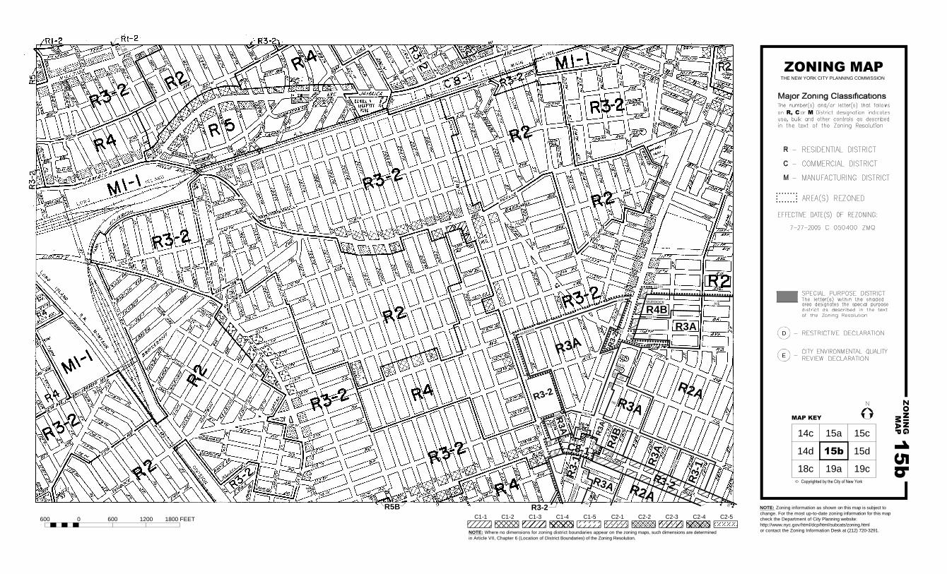
ZONING MAP
THE NEW YORK CITY PLANNING COMMISSION
Major Zoning Classifications:
R, C M
Effective Date(s) of Rezoning:
R
C
M
NOTE: Zoning information as shown on this map is subject to
change. For the most up-to-date zoning information for this map,
visit the Zoning section of the Department of City Planning website:
www.nyc.gov/planning or contact the Zoning Information Desk at
(212) 720-3291.
NOTE: Where no dimensions for zoning district boundaries appear on the zoning maps, such dimensions are determined
in Article VII, Chapter 6 (Location of District Boundaries) of the Zoning Resolution.
600 0 600 1200 1800 FEET
C1-1 C1-2 C1-3 C1-4 C1-5 C2-1 C2-2 C2-3 C2-4 C2-5
Special Requirements:
ST.
DALNYRD.
140 R
7
A
HILLSIDE
AVE.
100
AutoCAD SHX Text
N
AutoCAD SHX Text
The number(s) and/or letter(s) that follows
AutoCAD SHX Text
use, bulk and other controls as described
AutoCAD SHX Text
in the text of the Zoning Resolution.
AutoCAD SHX Text
an or District designation indicates
AutoCAD SHX Text
11-23-2021 C 210192 ZMQ
AutoCAD SHX Text
- RESIDENTIAL DISTRICT
AutoCAD SHX Text
- COMMERCIAL DISTRICT
AutoCAD SHX Text
- MANUFACTURING DISTRICT
AutoCAD SHX Text
AREA(S) REZONED
AutoCAD SHX Text
SPECIAL PURPOSE DISTRICT
AutoCAD SHX Text
The letter(s) within the shaded
AutoCAD SHX Text
area designates the special purpose
AutoCAD SHX Text
district as described in the text
AutoCAD SHX Text
of the Zoning Resolution.
AutoCAD SHX Text
For Inclusionary Housing designated areas and Mandatory Inclusionary Housing areas on this map, see APPENDIX F.
AutoCAD SHX Text
For a list of lots subject to "D" restrictive declarations, see APPENDIX D.
AutoCAD SHX Text
For a list of lots subject to CEQR environmental requirements, see APPENDIX C.
Disclaimer
The Web version of the Zoning Resolution of the City of New York is provided for reference and the convenience of having the Resolution in an online format. Recent amendments to the Zoning Resolution also appear on the Web prior to being incorporated into the print version of the Resolution.
Metadata for Historical Zoning Maps:
Source:These PDF maps were created from the set of past versions of each of the 126 zoning maps in the Technical Review Division’s archive. This set includes map versions for each zoning map beginning with the original 1961 issue of the Zoning Resolution and ending with the current zoning map as posted in the Zoning section of the Department of City Planning website: www.nyc.gov/planning. Scanning and Creation of Adobe PDF copies:Maps in this archive from 1961 through Update #2 of the Zoning Resolution in 2003 are scans of actual printed zoning map. From Update #3 (2005) onwards, maps are direct PDF copies of the map revisions as printed in updates to the Zoning Resolution.
Notes on conversion of Amendment Numbers to CP (City Planning) or ULURP numbers:On earlier zoning maps, an Amendment Number (e.g. A-629) is used to identify the area that has been rezoned. Commission reports and sketch maps for rezonings are referenced solely by CP or ULURP numbers. In order to request copies of reports or sketch maps it is necessary to know the CP or ULURP number. A conversion table (ANumber-CPNumberConversion.pdf) is available to translate the “A” numbers listed on the actual zoning maps to their corresponding CP or ULURP numbers. Use of the Amendment Number to identify zoning map changes has been discontinued.
Copyright:These maps are copyrighted by the City of New York. This is indicated in the space below the map legend on each map.
Contact Info:NYC Department of City Planning22 Reade Street, RM 3NNew York, NY 10007212.720.3505 [email protected]
revised 02/11/11