Historical Information Report - Ft. Wingate
68
Final Historical Information Report Parcel 6 Fort Wingate Depot Activity McKinley County, New Mexico 23 February 2009 Contract No. GS-10F-0029M Contract Task Order No. W9126G-08-F-0070 Prepared for U.S. Army Corps of Engineers Fort Worth District Prepared by 4041 Jefferson Plaza NE Suite 200 Albuquerque, NM 87109 Requests for this document must be referred to: Commander, U.S. Army Corps of Engineers Fort Worth District Attn: CESWF-PER-DI (Beverly Post) 819 Taylor Street Room 3A12 Fort Worth, TX 76112
Transcript of Historical Information Report - Ft. Wingate

Final
Historical Information Report Parcel 6
Fort Wingate Depot Activity McKinley County, New Mexico
23 February 2009
Contract No. GS-10F-0029M Contract Task Order No. W9126G-08-F-0070
Prepared for U.S. Army Corps of Engineers Fort Worth District
Prepared by
4041 Jefferson Plaza NE Suite 200 Albuquerque, NM 87109
Requests for this document must be referred to: Commander, U.S. Army Corps of Engineers Fort Worth District Attn: CESWF-PER-DI (Beverly Post) 819 Taylor Street Room 3A12 Fort Worth, TX 76112


FORT WINGATE DEPOT ACTIVITY MCKINLEY COUNTY, NEW MEXICO
FINAL HISTORICAL INFORMATION REPORT
PARCEL 6
23 February 2009
Prepared for
U.S. Army Corps of Engineers Fort Worth District 819 Taylor Street
Room 3A12 Fort Worth, TX 76112
Contract No. GS-10F-0029M Contract Task Order No. W9126G-08-F-0070
Prepared by
CH2M HILL 4041 Jefferson Plaza NE
Suite 200 Albuquerque, NM 87109

.

REPORT DOCUMENTATION PAGE Form Approved OMB No. 0704-0188
Public reporting burden for this collection of information is estimated to average 1 hour per response, including the time for reviewing instructions, searching existing data sources, gathering and maintaining the data needed, and completing and reviewing the collection of information. Send comments regarding this burden estimate or any other aspect of this collection of information, including suggestions for reducing this burden, to Washington Headquarters Services, Directorate for Information Operations and Reports, 1215 Jefferson Davis Highway, Suite 1204, Arlington, Virginia 22202-4302, and to the Office of Management and Budget, Paperwork Reduction Project (0704-0188), Washington, D.C. 20503.
1. AGENCY USE ONLY
2. REPORT DATE
February 2009
3. REPORT TYPE AND DATES COVERED
Final Historical Information Report, Parcel 6 February 2009
4. TITLE AND SUBTITLE Historical Information Report, Parcel 6 Fort Wingate Depot Activity, McKinley County, New Mexico
6. AUTHOR(S)
Jeff Gamlin, P.G. and Sharon Minchak, P.G., CH2M HILL
5. FUNDING NUMBERS
Contract No. GS-10F-0029M Task Order No. W9126G-08-F-0070
7. PERFORMING ORGANIZATION NAME(S) AND ADDRESS(ES) CH2M HILL 4041 Jefferson Plaza NE Suite 200 Albuquerque, NM 87109
8. PERFORMING ORGANIZATION REPORT NUMBER
9. SPONSORING / MONITORING AGENCY NAME(S) AND ADDRESS(ES) Department of the Army Army Corps of Engineers, Fort Worth District 819 Taylor Street Fort Worth, TX 76102 Project Manager: Steve Martin
10. SPONSORING / MONITORING AGENCY REPORT NUMBER
11. SUPPLEMENTARY NOTES
12a. DISTRIBUTION/AVAILABILITY STATEMENT
Approved for public release; distribution is unlimited.
12b. DISTRIBUTION CODE
13. ABSTRACT (Maximum 200 words)
This Historical Information Report summarizes available historical information and previous environmental investigation and remediation activities at Parcel 6 Solid Waste Management Units and Areas of Concern at Fort Wingate Depot Activity, McKinley County, New Mexico.
14. SUBJECT TERMS
Fort Wingate Depot Activity, Historical Information Report, Parcel 6 SWMUs and AOCs
15. NUMBER OF PAGES
62
16. PRICE CODE
17. SECURITY CLASSIFICATION OF REPORT
UNCLASSIFIED
18. SECURITY CLASSIFICATION OF THIS PAGE
UNCLASSIFIED
19. SECURITY CLASSIFICATION
UNCLASSIFIED
20. LIMITATION OF ABSTRACT
SAR
NSN 7540-01-280-5500
Standard Form 298 (Rev 2-89) Prescribed by ANSI Std 239-18 298-102

THIS PAGE INTENTIONALLY LEFT BLANK 1

Historical Information Report, Parcel 6 Fort Wingate Depot Activity i February 2009
40 CFR 270.11 1 DOCUMENT CERTIFICATION 2
FEBRUARY 2009 3
I certify under penalty of law that this document and all attachments were prepared under 4 my direction or supervision in accordance with a system designed to assure that qualified 5 personnel properly gather and evaluate the information submitted. Based on my inquiry of 6 the person or persons who manage the system, or those persons directly responsible for 7 gathering the information, the information submitted is, to the best of my knowledge and 8 belief, true, accurate, and complete. I am aware that there are significant penalties for 9 submitting false information, including the possibility of fine and imprisonment for 10 knowing violations. 11
_________________________________________ 12 Steve Martin 13 USACE Project Manager 14

Historical Information Report, Parcel 6 Fort Wingate Depot Activity ii February 2009
THIS PAGE INTENTIONALLY LEFT BLANK 1


Historical Information Report, Parcel 6 Fort Wingate Depot Activity iv February 2009
THIS PAGE INTENTIONALLY LEFT BLANK 1

Historical Information Report, Parcel 6 Fort Wingate Depot Activity v February 2009
Contents 1
Section Page 2
Acronyms and Abbreviations ......................................................................................................... ix 3 1.0 Introduction .................................................................................................................................1-1 4
1.1 Objectives and Scope..............................................................................................................1-1 5 1.2 Site Background......................................................................................................................1-1 6 1.3 Summary of Available Historical Information .......................................................................1-5 7
2.0 Parcel 6 Historical Information .................................................................................................2-1 8 2.1 SWMU 4: Building 600, Ammunition Work Shop Change House and Laundry...................2-1 9
2.1.1 Site Description and Operational History.........................................................2-1 10 2.1.2 Previous Investigations.....................................................................................2-1 11
2.2 SWMU 8: Building 537, Pesticide and Field Battery Shop....................................................2-6 12 2.2.1 Site Description and Operational History.........................................................2-6 13 2.2.2 Previous Investigations.....................................................................................2-8 14
2.3 SWMU 11: Buildings 541 and 542, Ammunition Workshop...............................................2-18 15 2.3.1 Site Description and Operational History.......................................................2-18 16 2.3.2 Previous Investigations...................................................................................2-20 17
2.4 SWMU 20: Western Landfill................................................................................................2-18 18 2.4.1 Site Description and Operational History.......................................................2-18 19 2.4.2 Previous Investigations...................................................................................2-20 20
2.5 AOC 28: Igloo Block B ........................................................................................................2-22 21 2.5.1 Site Description and Operational History.......................................................2-22 22 2.5.2 Previous Investigations...................................................................................2-22 23
2.6 AOC 42: Building 516 (Ammunition Receiving Building)..................................................2-26 24 2.6.1 Site Description and Operational History.......................................................2-26 25 2.6.2 Previous Investigations...................................................................................2-26 26
2.7 AOC 61: Building 507 (Smokeless Powder Magazine) .......................................................2-28 27 2.7.1 Site Description and Operational History.......................................................2-28 28 2.7.2 Previous Investigation ....................................................................................2-30 29
2.8 AOC 75: Electrical Transformers .........................................................................................2-30 30 2.8.1 Site Description and Operational History.......................................................2-31 31 2.8.2 Previous Investigations...................................................................................2-31 32
2.9 AOC 78/82: Feature 18.........................................................................................................2-31 33 2.9.1 Site Description and Operational History.......................................................2-31 34 2.9.2 Previous Investigations...................................................................................2-36 35
2.10 AOC 79: Feature 2 ..............................................................................................................2-33 36 2.10.1 Site Description and Operational History.....................................................2-34 37 2.10.2 Previous Investigations.................................................................................2-34 38
2.11 AOC 80: Feature 9 ..............................................................................................................2-36 39 2.11.1 Site Description and Operational History.....................................................2-36 40 2.11.2 Previous Investigations.................................................................................2-36 41
2.12 AOC 81: Feature 11 ............................................................................................................2-38 42 2.12.1 Site Description and Operational History.....................................................2-38 43 2.12.2 Previous Investigations.................................................................................2-38 44

Historical Information Report, Parcel 6 Fort Wingate Depot Activity vi February 2009
2.13 AOC 83: Feature 22 ............................................................................................................2-40 1 2.13.1 Site Description and Operational History.....................................................2-40 2 2.13.2 Previous Investigations.................................................................................2-40 3
2.14 AOC 84: Feature 12 ............................................................................................................2-42 4 2.14.1 Site Description and Operational History.....................................................2-42 5 2.14.2 Previous Investigations.................................................................................2-44 6
3.0 References ....................................................................................................................................3-1 7
Figures 8
1-1 Site Location Map for Parcel 6...............................................................................................1-2 9 1-2 Parcel and Major Land Use Locations ...................................................................................1-3 10 1-3 Parcel 6 AOC and SWMU Locations.....................................................................................1-4 11 2-1 SWMU 4 Site Location ..........................................................................................................2-2 12 2-2 SWMU 8 Site Location ..........................................................................................................2-7 13 2-3 SWMU 11 Site Location ......................................................................................................2-13 14 2-4 SWMU 20 Site Location ......................................................................................................2-19 15 2-5 AOC 28 Site Location ..........................................................................................................2-23 16 2-6 AOC 42 Site Location ..........................................................................................................2-27 17 2-7 AOC 61 Site Location ..........................................................................................................2-29 18 2-8 AOC 78/82 Site Location .....................................................................................................2-32 19 2-9 AOC 79 Site Location ..........................................................................................................2-35 20 2-10 AOC 80 Site Location ..........................................................................................................2-37 21 2-11 AOC 81 Site Location ..........................................................................................................2-39 22 2-12 AOC 83 Site Location ..........................................................................................................2-41 23 2-13 AOC 84 Site Location ..........................................................................................................2-43 24
Appendixes 25
A Parcel 6 Aerial Imagery 26 B1 SWMU 4 Historical Reports 27 B2 SWMU 4 Aerial Imagery 28 B3 SWMU 4 Photographs and Drawings 29 C1 SWMU 8 Historical Reports 30 C2 SWMU 8 Aerial Imagery 31 C3 SWMU 8 Photographs and Drawings 32 D1 SWMU 11 Historical Reports 33 D2 SWMU 11 Aerial Imagery 34 D3 SWMU 11 Photographs and Drawings 35 E1 SWMU 20 Historical Reports 36 E2 SWMU 20 Aerial Imagery 37 E3 SWMU 20 Photographs and Drawings 38 F1 AOC 28 Historical Reports 39 F2 AOC 28 Aerial Imagery 40 F3 AOC 28 Photographs and Drawings 41 G1 AOC 42 Historical Reports 42 G2 AOC 42 Aerial Imagery 43

Historical Information Report, Parcel 6 Fort Wingate Depot Activity vii February 2009
G3 AOC 42 Photographs and Drawings 1 H1 AOC 61 Historical Reports 2 H2 AOC 61 Aerial Imagery 3 H3 AOC 61 Photographs and Drawings 4 I1 AOC 75 Historical Reports 5 I2 AOC 75 Photographs and Drawings 6 J1 AOC 78/82 Historical Reports 7 J2 AOC 78/82 Aerial Imagery 8 J3 AOC 78/82 Photographs and Drawings 9 K1 AOC 79 Historical Reports 10 K2 AOC 79 Aerial Imagery 11 K3 AOC 79 Photographs and Drawings 12 L1 AOC 80 Historical Reports 13 L2 AOC 80 Aerial Imagery 14 L3 AOC 80 Photographs and Drawings 15 M1 AOC 81 Historical Reports 16 M2 AOC 81 Aerial Imagery 17 M3 AOC 81 Photographs and Drawings 18 N1 AOC 83 Historical Reports 19 N2 AOC 83 Aerial Imagery 20 N3 AOC 83 Photographs and Drawings 21 O1 AOC 84 Historical Reports 22 O2 AOC 84 Aerial Imagery 23 O3 AOC 84 Photographs and Drawings 24

Historical Information Report, Parcel 6 Fort Wingate Depot Activity viii February 2009
THIS PAGE INTENTIONALLY LEFT BLANK 1

Historical Information Report, Parcel 6 Fort Wingate Depot Activity ix February 2009
Acronyms and Abbreviations 1
AOC Area of Concern 2
ACM asbestos-containing material 3
AGM aboveground magazine 4
API aerial photo interpretation 5
ASC U.S. Army Sustainment Command 6
AWS Ammunition Workshop 7
BRAC Base Realignment and Closure Plan 8
bgs below ground surface 9
CBU cluster bomb 10
DDD dichlorodiphenyldichloroethane 11
DDE dichlorodiphenyldichloroethene 12
DDT dichlorodiphenyltrichloroethane 13
DOI U.S. Department of the Interior 14
EP Engineering Pamphlet 15
FWDA Fort Wingate Depot Activity 16
HIR Historical Information Report 17
HMX cyclotetramethylene-tetranitramine 18
HSA hollow stem auger 19
HWB Hazardous Waste Bureau 20
IRM Interim Remedial Measures 21
LBP lead-based paint 22
μg/g microgram(s) per gram 23
MEC munitions and explosives of concern 24
mg/kg milligram(s) per kilogram 25
mg/L milligram(s) per liter 26
NARA National Archives and Records Administration 27
NMAC New Mexico Administrative Code 28
NMED New Mexico Environment Department 29
OB/OD Open Burn/Open Detonation 30
OD Open Detonation 31
PCB polychlorinated biphenyl 32

Historical Information Report, Parcel 6 Fort Wingate Depot Activity x February 2009
PMP 2-(dimethoxyphosphiothioylsulfanylmethyl) isoindole-1,3-dione 1
RA Remedial Action 2
RAR Release Assessment Report 3
RCRA Resource Conservation and Recovery Act 4
RDX cyclotrimethylenetrinitramine 5
RFI RCRA Facility Investigation 6
RI remedial investigation 7
RI/FS Remedial Investigation/Feasibility Study 8
SOW Scope of Work 9
SUXOS Senior Unexploded Ordinance Supervisor 10
SVOCs semi-volatile organic compounds 11
SWMU Solid Waste Management Unit 12
TAL target analyte list 13
TCL target compound list 14
TCS Thermal Convection System (by PIKA International, Inc.) 15
TEAD Tooele Army Depot 16
TSCA Toxic Substances Control Act 17
TM Technical Manual 18
TNT trinitrotoluene 19
USACE United States Army Corp of Engineers 20
USATHAMA United States Army Toxic and Hazardous Materials Agency 21
UXO unexploded ordnance 22
VOCs volatile organic compounds 23
WSMR White Sands Missile Range 24
WWI World War I 25
WWII World War II 26
yd3 cubic yards 27

HISTORICAL INFORMATION REPORT – PARCEL 6
Historical Information Report, Parcel 6 Fort Wingate Depot Activity 1-1 February 2009
1.0 Introduction 1
This Historical Information Report presents a summary of previous investigations and historical 2 records available for Solid Waste Management Units (SWMUs) and Areas of Concern (AOCs) 3 located within Parcel 6 at Fort Wingate Depot Activity (FWDA), McKinley County, New Mexico 4 (Figures 1-1 and 1-2). Parcel 6 includes 4 SWMUs and 10 AOCs as shown on Figure 1-3. Available 5 historical records for each site have been summarized and relevant records have been attached to this 6 document as a series of appendices. 7
1.1 Objectives and Scope 8
This Historical Information Report has been prepared for submission to the New Mexico 9 Environment Department’s (NMED) Hazardous Waste Bureau (HWB), as required by Section 10 VIII.A.1.a of the Resource Conservation and Recovery Act (RCRA) Permit (NM 6213820974) for 11 FWDA, which became effective December 31, 2005. This document has been prepared to serve as a 12 companion to the RCRA Facility Investigation (RFI) Work Plan for Parcel 6 in order to document the 13 historical site use and currently understood environmental conditions. 14
This document was prepared by reviewing available documentation for SWMUs and AOCs within 15 Parcel 6. This work was completed in partial fulfillment of the requirements of Contract Task Order 16 Number W9126G-08-F-0070 under Contract Number GS-10F-0029M as outlined in the Statement of 17 Work (SOW) dated February 19, 2008. Technical oversight of this work was provided by the U.S. 18 Army Corps of Engineers (USACE), Fort Worth District. 19
1.2 Site Background 20
FWDA is located approximately 8 miles east of Gallup, New Mexico, and currently occupies 21 approximately 15,277 acres of land in McKinley County, New Mexico (Figure 1-1). The installation 22 is divided into sub-areas based on general location and historical land use (Figure 1-2). The major 23 land use areas include the Administration Area, the Workshop Area, ten Munitions Storage Areas 24 (Igloo Blocks A through H, J, and K), the Open Burning/Open Detonation (OB/OD) Areas, and 25 Protection and Buffer Areas. 26
FWDA was originally established by the U.S. Army in 1862 at the southern edge of the Navajo 27 territory. In 1918 the mission of FWDA changed from tribal issues to World War I-related activities. 28 Beginning in 1940, FWDA’s mission was primarily to receive, store, maintain, and ship explosives 29 and military munitions, as well as to disassemble and dispose of unserviceable or obsolete explosives 30 and military munitions. In 1975, the installation came under the administrative command of Tooele 31 Army Depot (TEAD), located near Salt Lake City, Utah. 32
In January 1993, the active mission of FWDA was ceased and the installation closed as a result of the 33 Defense Base Realignment and Closure (BRAC) Act of 1988. Beginning in 2002, the U.S. Army 34 reassigned many FWDA functions to the BRAC Division, including caretaker duties, property 35 transfer, and performance of environmental compliance and restoration activities. TEAD retained 36 command and control responsibilities until January 31, 2008, when these responsibilities were 37 transferred to White Sands Missile Range (WSMR). 38

HISTORICAL INFORMATION REPORT – PARCEL 6
Historical Information Report, Parcel 6 Fort Wingate Depot Activity 1-2 February 2009
1

HISTORICAL INFORMATION REPORT – PARCEL 6
Historical Information Report, Parcel 6 Fort Wingate Depot Activity 1-3 February 2009
1

HISTORICAL INFORMATION REPORT – PARCEL 6
Historical Information Report, Parcel 6 Fort Wingate Depot Activity 1-4 February 2009
1

HISTORICAL INFORMATION REPORT – PARCEL 6
Historical Information Report, Parcel 6 Fort Wingate Depot Activity 1-5 February 2009
FWDA is currently undergoing final environmental characterization and restoration activities prior to 1 final property transfer and reuse. The installation has been divided into reuse parcels as part of the 2 planned property transfer to the U.S. Department of the Interior (DOI). This Historical Information 3 Report only includes information related to the SWMUs and AOCs located within Parcel 6. The 4 RCRA Permit lists a total of 4 SWMUs and 10 AOCs located within the boundary of Parcel 6 5 (Figure 1-3), as follows: 6
• SWMU 4: Building 600 – Ammunition Work Shop Change House Laundry 7
• SWMU 8: Building 537 – Pesticide and Field Battery Shop 8
• SWMU 11: Buildings 541 and 542 – Ammunition Workshop 9
• SWMU 20: Western Landfill 10
• AOC 28: Igloo Block B 11
• AOC 42: Building 516 – Ammunition Receiving Building 12
• AOC 61: Building 507 – Smokeless Powder Magazine 13
• AOC 75: Electrical Transformers 14
• AOC 78/82: Feature 18 15
• AOC 79: Feature 2 16
• AOC 80: Feature 9 17
• AOC 81: Feature 11 18
• AOC 83: Feature 22 19
• AOC 84: Feature 12 20
1.3 Summary of Available Historical Information 21
A number of document reviews and searches have been completed for FWDA since the 22 environmental restoration program began in 1980. Available records pertaining to historical 23 operations and previous investigations within the Parcel 6 boundaries were compiled into an 24 administrative record by the USACE from the following sources: 25
• Historical maps, drawings, and records located at FWDA 26
• Interviews with former FWDA personnel familiar with historical FWDA operations 27
• Historical records and documents obtained from the U.S. Army Field Support Command/Joint 28 Munitions Command History Office’s archives and document collection 29
• Historical records and documents obtained from the National Archives and Records 30 Administration (NARA), stored in multiple locations 31
• A historical aerial photograph collection and analysis completed for FWDA (Environmental 32 Research, Inc. [ERI], 2006) 33

HISTORICAL INFORMATION REPORT – PARCEL 6
Historical Information Report, Parcel 6 Fort Wingate Depot Activity 1-6 February 2009
Documents made available to the review team for completion of this Historical Information Report 1 were provided by the USACE based on the information available within the administrative record 2 described above. Relevant pages from available documents relating to Parcel 6 SWMUs and AOCs 3 are attached to this document as a series of appendices for each individual SWMU or AOC. 4 Additionally, aerial photograph figures were prepared for Parcel 6 as a whole, and for each individual 5 SWMU and AOC, for each year that data were available. These figures are presented as a series of 6 individual appendices for each site. 7

HISTORICAL INFORMATION REPORT – PARCEL 6
Historical Information Report, Parcel 6 Fort Wingate Depot Activity 2-1 February 2009
2.0 Parcel 6 Historical Information 1
This section summarizes relevant historical information contained in available FWDA documents. 2 The following subsections provide a site description and operational history for each individual 3 SWMU and AOC, as well as a summary of relevant environmental information contained in the 4 available reports. During the operational history of FWDA there have been vast numbers of 5 documents prepared that may include general information relating to activities within Parcel 6. 6 However, this document only presents and summarizes relevant historical information relating to the 7 operational history and environmental conditions at Parcel 6 SWMUs and AOCs. 8
Results and conclusions from the historical reports summarized below have not been re-evaluated or 9 interpreted as part of the preparation of this document. The information contained in this report is 10 based solely on the information available in the respective reports and the results and conclusions 11 drawn in the respective reports. 12
Appendix A presents the available aerial photograph figures for Parcel 6. 13
2.1 SWMU 4: Building 600, Ammunition Work Shop Change 14
House and Laundry 15
2.1.1 Site Description and Operational History 16
Building 600 is located on the east side of Arterial Road No. 2, north of Building 537 and southwest 17 of the Workshop Area (Figure 2-1). Building 600 (formerly Building 539), the former Ammunition 18 Workshop (AWS) Change House and Laundry, was identified as a potential source of explosives 19 because it contained showers and laundry facilities for workers who performed explosives washout 20 activities and handling of munitions (PMC, 2002). Building 600 was constructed in 1942 and is an 21 approximately 3,800-square-foot structure built of native stone and cinder block with a reinforced 22 concrete floor (FWDA, 1961; Daniel, 1994). 23
At various times during its operation, building drains had discharged to a cesspool, an outfall to the 24 adjacent arroyo, an outfall to the ground surface, and a connection to the sanitary sewer system 25 (PMC, 2002). No specific information regarding exact activities or the period of operation for 26 Building 600 has been found to date. This building was not in operation at the time the installation 27 was closed in 1993. 28
The SWMU 4 nomenclature has also been historically used for the Burning Ground (currently 29 SWMU 14), so it appears the SWMU 4 designation has been more recently changed to the 30 Building 600 site. 31
2.1.2 Previous Investigations 32
A summary of information contained in available documents is presented below. Appendix B1 33 presents relevant pages from the historical reports summarized below. Appendix B2 presents the 34 available aerial photograph figures. Appendix B3 presents the available historical photographs and 35 drawings. 36

HISTORICAL INFORMATION REPORT – PARCEL 6
Historical Information Report, Parcel 6 Fort Wingate Depot Activity 2-2 February 2009
1
HISTORICAL INFORMATION REPORT – PARCEL 6
Historical Information Report, Parcel 6 Fort Wingate Depot Activity 2-3 February 2009
Facilities Data; FWDA, 1961 1 This report includes relevant construction information for Building 600. 2
Final Asbestos Survey Report; Pickering Environmental, 1990 3 This report includes results of an ACM investigation completed at various FWDA buildings. Results 4 indicated that asbestos-containing material (ACM) was present in approximately 50 square feet of 5 boiler jacket material and 45 linear feet of insulated pipe at Building 600. 6
Historic Building Inventory; Daniel, 1994 7 This report includes relevant construction information for Building 600. 8
Asbestos Survey Buildings 515, 527, 537, 539, 601, 2, 18, 541, 542, 5, 8; USACE, 1998 9 This report was not available at the time of the preparation of this draft Historical Information Report; 10 however, it is listed in the archival report (SAIC, 2007). 11
Disinfection and Asbestos Abatement Buildings 8, 2, 512, 18, 601, 537, 539; ICE Contractors, 12 Inc., 1999 13 This report was not available at the time of the preparation of this draft Historical Information Report; 14 however, it is listed in the archival report (SAIC, 2007). 15
Environmental Baseline Survey for the Transfer of Lands at Fort Wingate Depot Activity, 16 New Mexico; USACE, 2000 17 This report provides a physical description of Building 600. This report states that ACM was abated 18 in 1999, lead-based paint (LBP) is assumed, and that there was no supporting documentation found to 19 suggest the presence of polychlorinated biphenyls (PCBs). 20
Final Work Plan, Environmental Characterization, Buildings 542 and 600; PMC 2000 21 This report includes background information, previous investigation history, and proposed plans for 22 the 2000 and 2001 field investigation conducted by PMC at SWMU 4. This work plan was completed 23 because Building 600 was identified as a potential source for the low concentrations of 24 cyclotrimethylenetrinitramine (RDX) detected in groundwater samples collected from well TMW11. 25
The planned field activities at Building 600 included the following: 26
• Conducting a site walk of the building, 27 • Confirming the location of the cesspool by manual excavation, 28 • Advancing four soil borings adjacent to the cesspool to a depth of 12 feet below ground surface 29
(bgs). Samples were to be collected from visibly impacted soil, or at the 6 and 12 feet bgs 30 intervals. Samples were to be analyzed for explosives, target compound list (TCL) volatile 31 organic compounds (VOCs), TCL semi-volatile organic compounds (SVOCs), and target analyte 32 list (TAL) metals at an offsite laboratory, 33
• Collecting one sample of sediments present in the cesspool to by analyzed for explosives, TCL 34 VOCs, TCL SVOCs, and TAL metals at an offsite laboratory, 35
• Decommissioning the cesspool, 36 • Collecting one surface soil sample immediately downstream of the location of the outfall to the 37
arroyo to by analyzed for explosives, TCL VOCs, TCL SVOCs, and TAL metals at an offsite 38 laboratory, and 39

HISTORICAL INFORMATION REPORT – PARCEL 6
Historical Information Report, Parcel 6 Fort Wingate Depot Activity 2-4 February 2009
• Collecting one sample of sediments present in the sanitary sewer manhole to be analyzed for 1 explosives, TCL VOCs, TCL SVOCs, and TAL metals at an offsite laboratory. 2
Site Summary Report for Area of Concern Septic Tanks; Terranear PMC, 2001 3 This report presents a summary and evaluation of the environmental investigations for septic tank 4 sites at FWDA. The facility drawings show a cesspool and a separate outfall pipe to the arroyo, prior 5 to connection to the FWDA sanitary sewer at Building 600. The cesspool is located approximately 6 100 feet northeast of Building 600. It was not visible on the surface; however, a slight depression was 7 observed in the approximate location shown on facility drawings, indicating that the cesspool may 8 have been filled in. It is reportedly constructed of open-jointed rock, is 6 feet by 6 feet in size, and has 9 a total depth of 10 feet. The outfall pipe to the arroyo was visible, and a length of it appears to have 10 been detached and was sticking up in the air. 11
PMC conducted an investigation of this building including the septic system in November and 12 December of 2000. The cesspool had been filled in sometime in the past and was not unearthed for 13 the field investigation; therefore, no samples were collected. A sediment sample was collected from 14 the sanitary sewer manhole at the far end of the pipe from Building 600. All detected constituents 15 were stated to be less than residential soil screening levels at that time. Closure of the septic tank was 16 documented in a letter to the NMED on June 15, 2001. 17
Final Phase I RCRA Facility Investigation Report, Buildings 600 and 542; PMC, 2002 18 The Phase I RFI activities conducted by PMC Environmental in 2000 and 2001 at Building 600 19 included: 20
• Reviewing historical facility information including engineering drawings, 21 • Conducting a walk through of the building, 22 • Advancing soil borings, 23 • Collecting surface and subsurface soil, and sewer sediment samples, 24 • Drilling, installing, sampling, and slug testing of monitoring wells, and 25 • Collecting groundwater elevation measurements. 26
Soil and surface sediment samples collected from the site contained low or qualified concentrations of 27 VOCs, SVOCs, and metals, but no explosives. 28
Four soil borings were advanced adjacent to the cesspool using hollow stem auger (HSA) drilling to a 29 total depth of 12 feet below ground surface (bgs), which was 2 feet below the bottom of the cesspool. 30 Soil samples were collected from 4 to 6 feet bgs and 10 to 12 feet bgs at each location and sampled 31 for explosives, TAL metals, TCL VOCs, and TCL SVOCs. Toluene was detected in each of the eight 32 soil samples collected from the cesspool at concentrations ranging from 0.00028 J to 33 0.00056 micrograms per gram (μg/g). Two SVOCs were detected at qualified concentrations at one 34 cesspool soil sample collected from 10 to 12 feet bgs. Various metals were detected at generally low 35 or qualified concentrations in all cesspool soil samples collected. 36
One surface soil sample was collected from a depth of 0.5 foot bgs at the outfall to the arroyo and 37 analyzed for explosives, TAL metals, TCL VOCs, and TCL SVOCs. One VOC, methylene chloride, 38 and a variety of metals were detected at generally low or qualified concentrations in the outfall 39 sample. 40
One sediment sample was collected from a manhole in the sanitary sewer and analyzed for 41 explosives, TAL metals, TCL VOCs, and TCL SVOCs. Seven VOCs, five SVOCs, and a variety of 42 metals were detected at generally low or qualified concentrations in the sanitary sewer sample. 43
HISTORICAL INFORMATION REPORT – PARCEL 6
Historical Information Report, Parcel 6 Fort Wingate Depot Activity 2-5 February 2009
Six groundwater monitoring wells were installed in the area near groundwater monitoring well 1 TMW11 to determine the source of RDX concentrations previously observed in groundwater at this 2 location. Rising and falling head slug tests were conducted at five of the six new wells. Groundwater 3 samples were collected in February and April 2001, and were analyzed for explosives, TAL metals 4 (total and dissolved), nitrate/nitrate non-specific, and nitrate. Explosives were not detected in any of 5 the new monitoring wells. Nitrate was detected in two of the wells completed in the first 6 unconsolidated water-bearing zone, TMW11 and TMW15, at concentrations ranging from 0.69 to 7 1.8 milligrams per liter (mg/L). 8
The report stated the data would be assessed with respect to human health and environmental effects 9 once an agreement had been reached between the Army and NMED with regard to the proper risk 10 assessment methodology. A final report addendum from this investigation has not yet been submitted 11 to the NMED. 12
Environmental Baseline Survey BRAC Plan; USACE, 2002 (Revised 2003) 13 This report includes a summary of the RFI that was completed in 2000 and 2001 and states that the 14 findings had not yet been formerly reported. The report also states it was anticipated that additional 15 RFI activities would need to be completed and that Building 600 and surrounding areas will be 16 restricted for use until a response action is complete. 17
Base Realignment and Closure (BRAC) Plan; Terranear PMC, 2006 18 The BRAC Plan briefly summarizes the 2000 and 2001 RFI activities. 19
Aerial Report; Environmental Research, Inc., 2006 20 This report documents aerial imagery obtained during a search of government and commercial 21 records. The report indicates the photographs were analyzed utilizing a stereoscope to locate potential 22 sources of contamination and to record any findings inside the boundaries of the known SWMUs and 23 AOCs. Aerial images dated from 1935 to 1997 were catalogued. The summary of the imagery 24 analysis provided for SWMU 4 is as follows: 25
1935 – No significant findings 26
1948 – Building 600 is present; no significant findings 27
1952 – Building 600 is present; no significant findings 28
1958 – No significant findings 29
1962 – No significant findings 30
1966 – No significant findings 31
1973 – No significant findings 32
1978 – No significant findings 33
1985 – No significant findings 34
1991 – No significant findings 35
1993 – No photo coverage 36
1997 – No significant findings 37

HISTORICAL INFORMATION REPORT – PARCEL 6
Historical Information Report, Parcel 6 Fort Wingate Depot Activity 2-6 February 2009
While not specifically stated in the summary from the report above, Building 600 is visible from 1948 1 to 1997. 2
Letter Archival Report; SAIC, 2007 3 This archival report is a reference to documents on file with the USACE Fort Worth District as of 4 July 2006. It cites the following reports on file for SWMU 4: 5
• Asbestos Survey Buildings 515, 527, 537, 539, 601, 2, 18, 541, 542, 5, 8 (USACE, 1998) 6 • Disinfection and Asbestos Abatement Buildings 8, 2, 512, 18, 601, 537, 539 (ICE Contractors, 7
Inc., 1999) 8 • Final RFI Work Plan (PMC, 2000) 9 • Phase I RFI (PMC, 2002) – discussed above 10
No other reports are directly listed for Building 600 (former Building 539) or SWMU 4. 11
2.2 SWMU 8: Building 537, Pesticide and Field Battery Shop 12
A summary of information contained in available documents is presented below. Appendix C1 13 presents relevant pages from the historical reports summarized below. Appendix C2 presents the 14 available aerial photograph figures. Appendix C3 presents the available historical photographs and 15 drawings. 16
2.2.1 Site Description and Operational History 17
Building 537 is located on the east side of Arterial Road No. 2, northwest of Building 530 (former 18 Deactivation Furnace) and south of the Workshop Area (Figure 2-2). Building 537 was constructed in 19 1941 and is a 4,200 square foot brick structure with a reinforced concrete floor and basement based 20 on available as-built drawings (FWDA, 1961; Daniel, 1994). 21
This building was originally designated as a field battery shop and was used to service forklift 22 batteries (PMC, 2004). More recently the building was used to mix and store pesticides (mostly 23 insecticides), in leak-proof containers (PMC, 2004). Documentation was not located regarding 24 specific of historic operations at Building 537. Approximately 50 gallons of chlordane was formerly 25 stored in this building but had been disposed of prior to 1988 (PMC, 2004). In addition, the Building 26 537 site was one of the FWDA locations where a transformer leaked onto the ground (PMC, 2004). 27
The building has recently been utilized by TPL, Inc. for munitions component recovery and recycling 28 purposes. 29
Historical reports also indicate a small (approximately 12 feet wide by 17 feet long) foundation slab 30 was located approximately 50 feet east of Building 537 (TtNUS, 2000 and PMC, 2004). The 31 foundation slab had a center drain that discharged, via a 6-inch-diameter vitrified clay pipe, to an 32 earthen ditch between Building 537 and the slab (PMC, 2004). The foundation slab also had two 33 abandoned ¾-inch-diameter water lines on its western edge (PMC, 2004). However, no information 34 has been found in any Army records to identify this foundation slab or its operations. An aerial 35 photograph from 1958 shows the slab, but the building had already been removed (PMC, 2004). 36 Aerial photographs from 1948 and 1952 also show this feature but due to the resolution of these 37 photos it is unclear if this area is a building or just the slab (Appendix C2). This foundation slab was 38 removed in 2004 (PMC, 2004). 39
Building 537 had a septic tank west of the railroad tracks with an outfall to the arroyo prior to the 40 building's connection to the FWDA sanitary sewer system (PMC, 2004). 41

HISTORICAL INFORMATION REPORT – PARCEL 6
Historical Information Report, Parcel 6 Fort Wingate Depot Activity 2-7 February 2009
1

HISTORICAL INFORMATION REPORT – PARCEL 6
Historical Information Report, Parcel 6 Fort Wingate Depot Activity 2-8 February 2009
2.2.2 Previous Investigations 1
Facilities Data; FWDA, 1961 2 This report includes relevant construction information for Building 537. 3
Final Report Installation Assessment; US Army Toxic and Hazardous Materials Agency, 1980 4 This report documents the types of pesticides stored in Building 537. All pesticides were stored in 5 leak proof containers in a well ventilated area with concrete floors. Chlordane (water emulsifiable), 6 chlordane (dust), mathalion (dust), aerosol synergized pyrethrin insect repellent (Dursban M) (water 7 emulsifiable), calcium cyanide (cyanogas-dust), and the rodenticide bait anticoagulants 8 2-(dimethoxyphosphiothioylsulfanylmethyl) isoindole-1,3-dione (PMP) and Warfarin are listed as 9 pesticides previously used at FWDA and stored in Building 537. 10
Final Asbestos Survey Report; Pickering Environmental, 1990 11 This report includes results of an ACM investigation completed at various FWDA buildings. Results 12 indicated that asbestos-containing material (ACM) was present in approximately 50 linear feet of 13 insulated pipe in the basement crawlspace at Building 537. 14
Facility Assessment Report; PRC Environmental Management Inc., 1990 15 This report describes the status of Building 537 when the report was published. The chlordane that 16 was previously stored in the building had been disposed of and the building was no longer used for 17 waste storage. The building at this time was utilized to store hazardous materials, but not hazardous 18 waste, and was therefore stated to not be subject to RCRA regulations. 19
Historic Building Inventory; Daniel, 1994 20 This report includes relevant construction information for Building 537. 21
BRAC Remediation Projects (Phase I), PCB Remediation Soil Removal Buildings 536/537; CCC 22 Group, 1996 23 This document was not located at the time of the preparation of this draft Historical Information 24 Report; however, it was summarized in other documents and therefore is included here. During 25 investigation activities conducted under the base-wide RI/FS (the RI/FS activities as a whole were 26 ultimately reported in 1997), PCB-impacted soils were identified under an electrical transformer at 27 Building 537. As a result, the Army conducted a performance-based disposal action under the Toxic 28 Substances Control Act (TSCA) in 1996. Approximately 45 cubic yards (yd3) of soil from underneath 29 the former transformer platform adjacent to the building were removed. However, post-excavation 30 samples indicated that elevated PCB concentrations remained in place at the site. 31
Final Remedial Investigation/Feasibility Study & RCRA Corrective Action Program Document; 32 ERM Program Management Company, 1997 33 Investigation at this site was initially conducted as part of this installation-wide remedial 34 investigation/feasibility study (RI/FS). The objectives of the RI/FS were to determine if the surface 35 soils around the building had been impacted by the pesticide handling operations and to determine 36 whether contamination was present in a concrete pit located within the building basement. Six surface 37 soil samples were collected around the exterior of the building. Eight wipe samples were collected 38 from various surfaces within the building and basement. One sample of the sediment and one sample 39 of the water within the concrete pit in the building basement were collected. All samples were 40 analyzed for pesticides. Concentrations of multiple pesticide compounds including chlordane, 41

HISTORICAL INFORMATION REPORT – PARCEL 6
Historical Information Report, Parcel 6 Fort Wingate Depot Activity 2-9 February 2009
heptachlor, heptachlor epoxide, dichlorodiphenyldichloroethane (DDD), 1 dichlorodiphenyldichlorethene (DDE), dichlorodiphenyltrichloroethane (DDT), endrin, endrin 2 aldehyde, lindane, alpha-benzenehexachloride, and delta-benzenehexachloride were detected in 3 almost all samples. Some concentrations exceeded applicable screening levels at the time this report 4 was prepared. However, despite the presence of pesticides in and around Building 537, the site was 5 not carried through to the baseline risk assessment being performed as part of that effort. This was 6 because the exterior soil concentrations were determined to present a limited potential for exposure 7 and the interior results were deferred to separate consideration once the disposition of the buildings 8 was decided. 9
Summary of Sampling and Analysis Event to Delineate PCB Contamination, Buildings 536 and 10 537; USACE, 1997 11 This document was not located at the time of the preparation of this draft Historical Information 12 Report; however, it was summarized in other documents and therefore is included here. Aroclor 1260 13 was detected in excavation post-removal samples from 1996. In 1997, FWDA performed additional 14 soil sampling for PCBs at the former transformer platform. FWDA concluded that subsurface soils 15 under the former transformer platform contained PCBs at concentrations greater than the most 16 conservative TSCA cleanup level of 1 microgram per gram (μg/g), and that additional excavation was 17 warranted. 18
Removal and Disposal of PCBs and Pesticide Soils; CCC Group, 1998 19 This document was not located at the time of the preparation of this draft Historical Information 20 Report; however, it was summarized in other documents and therefore is included here. In 1998, 21 FWDA removed an additional 245 yd3 of PCB-impacted soils from the former transformer platform 22 area. PCBs were not detected in any of the confirmatory samples and the site was backfilled with 23 clean soil. 24
Asbestos Survey Buildings 515, 527, 537, 539, 601, 2, 18, 541, 542, 5, 8; USACE, 1998 25 This report was not available at the time of the preparation of this draft Historical Information Report; 26 however, it is listed in the archival report (SAIC, 2007). 27
Disinfection and Asbestos Abatement Buildings 8, 2, 512, 18, 601, 537, 539; ICE Contractors, 28 Inc., 1999 29 This report was not available at the time of the preparation of this draft Historical Information Report; 30 however, it is listed in the archival report (SAIC, 2007). 31
Environmental Baseline Survey for the Transfer of Lands at Fort Wingate Depot Activity, 32 New Mexico; USACE, 2000 33 This report provides a physical description of Building 537. This report states that PCBs had been 34 detected near two utility poles but contaminated soils had been remediated. Further investigation 35 would be required for evaluating pesticide contamination around the immediate exterior of the 36 building. Friable ACM was abated in 1999 and LBP is assumed. 37
Final Release Assessments Report; TtNUS, 2000 38 In 2000, supplemental sampling was performed in areas adjacent to Building 537 to further evaluate 39 potential environmental impacts from past operations, focusing on the pesticide storage and mixing 40 operations, as well as field battery shop operations. Chlordane was detected in 13 samples at 41 concentrations ranging from 9.15 to 82,200 μg/g. Aroclor 1260 was detected at four locations (water 42
HISTORICAL INFORMATION REPORT – PARCEL 6
Historical Information Report, Parcel 6 Fort Wingate Depot Activity 2-10 February 2009
valve box, small foundation slab, near the southeast access door, and in the septic tank sediment) 1 around Building 537. The source of PCBs in soil at these locations was not documented. 2
Site Summary Report for Area of Concern Septic Tanks; Terranear PMC, 2001 3 This report presents a summary and evaluation of the environmental investigations for septic tank 4 sites at FWDA. Building 537 had a septic tank located west of the railroad tracks with an outfall to 5 the arroyo prior to the building’s connection to the FWDA sanitary sewer system. Both the septic tank 6 and the outfall pipe were observed in the field. Only a 4-inch-diameter cleanout pipe was exposed at 7 the septic tank location, so no assessment of the tank's contents could be made. Pieces of the vitrified 8 clay outfall pipe were observed at the arroyo in the location where the outfall should have been, but 9 the actual outfall appears to have been buried or covered in sediment. The building had restroom 10 facilities, so possibly only sanitary waste may have been discharged to the septic tank. However, it is 11 also possible that spent battery acid and/or pesticides could have been discharged. 12
The septic tank and cesspools were investigated in 2001, with soil and sediment samples analyzed for 13 TCL VOCs, TCL SVOCs, TCL Pesticides, and TCL PCBs. Arsenic was the only constituent detected 14 above applicable screening values at a concentration of 19.5 milligrams per kilogram (mg/kg). 15
Environmental Baseline Survey BRAC Plan; USACE, 2002 (Revised 2003) 16 This report includes a summary of the RFI that was completed in 2000 and 2001 and states that the 17 findings had not yet been formerly reported. It also states that it is anticipated that additional RFI 18 activities will need to be completed and that Building 537 and surrounding areas will be restricted for 19 use until a response action is complete. 20
Soil Characterization Work Plan, Building 537; PMC, 2003 21 This report includes background information, previous investigation history, and proposed plans for 22 the 2003 field investigation conducted by PMC at SWMU 8. Field activities were proposed to 23 delineate the extent of PCB contamination greater than 1 μg/g, to excavate and containerize all soil 24 and concrete debris with concentrations of total PCBs exceeding 1 μg/g, to collect confirmation 25 samples documenting PCB concentrations in remaining soil, to delineate the extent of pesticides and 26 metals in soil at the site, and to decommission the septic tank at Building 537. 27
Field Investigation Report, Building 537; PMC, 2004 28 Several of the specific objectives outlined in the Soil Characterization Work Plan (2003) were not 29 completed due to funding limitations. Activities that were not completed included excavation of PCB-30 impacted soil, delineation of pesticides and metals, and decommissioning of the septic tank at 31 Building 537. 32
Activities that were completed included review of historical drawings, removal of the small building 33 foundation slab, and removal of approximately 100 yd3 of PCB-impacted soil and 21.3 tons of 34 concrete were disposed of at a chemical waste landfill. The total in-place volume of soils calculated 35 for removal based on test kit results was 383 yd3, but funding limitations did not allow the entire 36 volume to be removed at this time. Instead a focused “hot spot” removal action was completed, with 37 excavation depths ranging from 1 to 7 feet bgs. PCBs were not detected exceeding 1 μg/g in any of 38 the confirmatory samples and the site was backfilled with clean soil. Interim measures (straw bales) 39 have been maintained around the remediated area to prevent recontamination. According to this 40 report, approximately 260 yd3 of PCB-impacted soil remain in place at Building 537; further Interim 41 Remedial Measures (IRM) implementation was placed on hold awaiting issuance of the RCRA 42 permit. 43

HISTORICAL INFORMATION REPORT – PARCEL 6
Historical Information Report, Parcel 6 Fort Wingate Depot Activity 2-11 February 2009
Baseline Realignment and Closure (BRAC) Cleanup Plan; PMC, 2006 1 This report summarizes the remedial investigation (RI) and remedial action (RA) investigations 2 completed at the site previously and states that pesticide and PCB-impacted soil still remain onsite. 3 The building has been recently utilized by TPL for demilitarization activities. 4
Aerial Report; Environmental Research, Inc., 2006 5 This report documents aerial imagery obtained during a search of government and commercial 6 records. The photographs were analyzed utilizing a stereoscope to locate potential sources of 7 contamination and to record any findings inside the boundaries of the known SWMUs and AOCs. 8 Aerial images dated from 1935 to 1997 were catalogued. The summary of the imagery analysis 9 provided for SWMU 8 is as follows: 10
1935 – No significant findings 11
1948 – A large ditch/trench is located south of Building 537; light-toned material present east 12 of Building 537 13
1952 – Light-toned material is visible south of Building 537 14
1958 – No significant findings 15
1962 – No significant findings 16
1966 – Staining or dark-toned material extends from Building 537 to the east 17
1973 – No significant findings 18
1978 – No significant findings 19
1985 – No significant findings 20
1991 – No significant findings 21
1993 – No photo coverage 22
1997 – No significant findings 23
While not specifically stated in the summary from the report above, Building 537 is visible from 1948 24 to 1997. 25
HISTORICAL INFORMATION REPORT – PARCEL 6
Historical Information Report, Parcel 6 Fort Wingate Depot Activity 2-12 February 2009
Letter Archival Report; SAIC, 2007 1 This archival report is a reference to documents on file at Fort Worth District Corp of Engineers as of 2 July 2006. It cites the following reports on file for SWMU 8: 3
• PCB Remediation Soil Removal Bldgs 536/537 (CCC Group, 1996) 4 • Summary of Sampling & Analysis Event to Delineate PCB Contamination, Bldgs 536 & 537 5
(USACE, 1997) 6 • Asbestos Survey Buildings 515, 527, 537, 539, 601, 2, 18, 541, 542, 5, 8 (USACE, 1998) 7 • Removal and Disposal of PCBs and Pesticides Soil, Bldgs. 5, 536, 537 (CCC Group, 1998) 8 • Disinfection and Asbestos Abatement Buildings 8, 2, 512, 18, 601, 537, 539 (ICE Contractors, 9
Inc., 1999) 10 • Environmental Baseline Survey (EMD, 1999) 11 • Final FWDA Soil Characterization Work Plan Building 537 (PMC, 2003) 12 • Summary and Documentation for Removal of PCB Contaminated Soils at Building 536 and 537 13
(USACE, 2003) 14 • Field Investigation Report Building 537 (PMC, 2004); and Quality Control Summary Report 15
Building 537 (PMC, 2004). 16
No other reports are directly listed for Building 537 or SWMU 8. 17
2.3 SWMU 11: Buildings 541 and 542, Ammunition Workshop 18
A summary of information contained in available documents is presented below. Appendix D1 19 presents relevant pages from the historical reports summarized below. Appendix D2 presents the 20 available aerial photograph figures. Appendix D3 presents the available historical photographs and 21 drawings. 22
2.3.1 Site Description and Operational History 23
Buildings 541 and 542 are located in the far western portion of the Workshop Area (Figure 2-3). 24 SWMU 11 has been previously listed as combined SWMU 13F (Building 542) and SWMU 47 25 (Building 541). Building 542 (formerly Building 19) is a former ammunition packing, shipping, and 26 receiving building. Building 542 was constructed in 1942 and is an approximately 7,600-square-foot 27 brick structure with a reinforced concrete floor (FWDA, 1961 and Daniel, 1994). Loading docks are 28 present on both sides of the building and each are approximately 10 feet wide and 181 feet long. A 29 railroad spur is located adjacent to the east loading dock. Records indicate that a variety of 30 ammunition maintenance, modification, and demilitarization operations were performed at 31 Building 542 (PMC, 2002). However, specific dates for the operational history of Building 542 were 32 not found in the available documents. 33
Building 542 was identified as a potential source of explosives detected in groundwater samples 34 collected from monitoring well TMW11. Building 542 had, at various times during its operation, 35 discharged waste water to a cesspool, a septic tank and drain field, and in later years to the sanitary 36 sewer system. A former employee indicated that munitions had been steamed and/or washed on the 37 loading dock and that the water was allowed to spill onto the dock in an area that is still stained 38 (PMC, 2002). The building has been recently utilized by TPL, Inc. for ammunition component 39 recovery and recycling purposes and TPL is also operating a cyclotetramethylene-tetranitramine 40 (HMX) recovery system in Building 542 (PMC, 2002). 41

HISTORICAL INFORMATION REPORT – PARCEL 6
Historical Information Report, Parcel 6 Fort Wingate Depot Activity 2-13 February 2009
1

HISTORICAL INFORMATION REPORT – PARCEL 6
Historical Information Report, Parcel 6 Fort Wingate Depot Activity 2-14 February 2009
Building 541 is listed as a heating plant. Building 541 was constructed in 1942 and is a 600-square-1 foot brick structure with a reinforced concrete floor (FWDA, 1961; Daniel, 1994). Building 542 is 2 heated by steam provided from a boiler located inside Building 541, an adjacent unconnected 3 building. No other information was available for Building 541. 4
2.3.2 Previous Investigations 5
Facilities Data; FWDA, 1961 6 This report includes relevant construction information for Buildings 541 and 542. 7
Environmental Survey; ESE, 1981 8
This document states that beginning in 1949, munitions washout operations were conducted in the 9 500-series buildings area (page 21). However, there is no specific mention of the activities associated 10 with Buildings 541 and 542. 11
Final Asbestos Survey Report; Pickering Environmental, 1990 12 This report includes results of an ACM investigation completed at various FWDA buildings. Results 13 indicated that ACM was present on approximately 35 linear feet of insulated pipe and 48 square feet 14 of boiler head insulation at Building 541. Results indicated that ACM was present in approximately 15 400 square feet of floor tile at Building 542. 16
Historic Building Inventory; Daniel, 1994 17 This report includes relevant construction information for Buildings 541 and 542. 18
Asbestos Survey Buildings 515, 527, 537, 539, 601, 2, 18, 541, 542, 5, 8; USACE, 1998 19 This report was not available at the time of the preparation of this draft Historical Information Report; 20 however, it is listed in the archival report (SAIC, 2007). 21
Disinfection and Asbestos Abatement Buildings 8, 2, 512, 18, 601, 537, 539; ICE Contractors, 22 Inc., 1999 23 This report was not available at the time of the preparation of this draft Historical Information Report; 24 however, it is listed in the archival report (SAIC, 2007). 25
Environmental Baseline Survey for the Transfer of Lands at Fort Wingate Depot Activity, 26 New Mexico; USACE, 2000 27 This report provides a physical description of Buildings 541 and 542. This report states that ACM has 28 been verified at Building 541, it is assumed to contain LBP, and no supporting documentation was 29 found to suggest PCB contamination. Results indicate the presence of ACM in Building 542 was 30 verified, LBP was assumed, and that explosives had been detected in a nearby groundwater well. 31
Final Work Plan, Environmental Characterization, Buildings 542 and 600; PMC 2000 32 This report includes background information, previous investigation history, and proposed plans for 33 the 2000 and 2001 field investigation conducted by PMC at SWMU 11. This work plan was 34 completed because Building 542 was identified as a potential source for the low concentrations of 35 RDX detected in groundwater samples collected from well TMW11. Proposed field activities at 36 Building 542 included the following: 37
• Conducting a site walk of the building. 38
HISTORICAL INFORMATION REPORT – PARCEL 6
Historical Information Report, Parcel 6 Fort Wingate Depot Activity 2-15 February 2009
• Collecting four wipe samples on the east loading dock, which are to be analyzed for explosives at 1 an offsite laboratory. 2
• Collecting four surface soil samples near stained areas on the east loading dock to be tested for 3 the presence of RDX and trinitrotoluene (TNT) using immunoassay test kits. 4
• Advancing up to four soil borings adjacent to the east loading dock depending on whether the 5 immunoassay tests detect the presence of explosives. Borings would be advanced to 10 feet bgs 6 with samples collected from visibly impacted soil, or at the 5 and 10 feet bgs intervals. Samples 7 were to be analyzed for explosives and TAL metals at an offsite laboratory. 8
• Collecting four wipe samples from the west loading dock to be analyzed at an offsite laboratory 9 for explosives. 10
• Collecting four surface soil samples in the west loading dock area to be tested for the presence of 11 RDX and TNT using immunoassay test kits. 12
• Advancing one soil boring adjacent to the west loading dock if explosives were detected in the 13 immunoassay samples. The boring would be advanced to 10 feet bgs with samples collected from 14 visibly impacted soil, or at the 5 and 10 feet bgs intervals. Samples were to be analyzed for 15 explosives and TAL metals at an offsite laboratory. 16
Additional activities associated with the Building 542 cesspool and septic tank were proposed as 17 follows: 18
• Advancing four soil borings to 19 feet bgs near the cesspool with samples collected from visibly 19 impacted soil or at the 6 feet bgs and bottom intervals. Samples would be analyzed by an offsite 20 laboratory for explosives, TAL metals, TCL VOCs and TCL SVOCs. 21
• Collecting one sample of the cesspool sediments for analysis for explosives and TAL metals. 22 • Collecting one sample, if present, of any water within the cesspool for analysis for explosives, 23
RCRA metals, RCRA VOCs, RCRA SVOCs, and flash point. 24 • Collecting one soil sample from the arroyo outfall for analysis for explosives, TAL metals, TCL 25
VOCs, and TCL SVOCs. 26 • Decommissioning the cesspool. 27 • Collecting one sample of the sediments in the septic tank for analysis for explosives, TAL metals, 28
TCL VOCs, and TCL SVOCs. 29 • Collecting one sample of the water, if present, within the septic tank and analyze for explosives, 30
RCRA metals, RCRA VOCs, RCRA SVOCs, and flash point. 31 • Advancing ten soil borings along the septic tank drain field to 10 feet bgs with soil samples 32
collected from visibly impacted soil or at the 5 and 10 feet bgs intervals. 33 • Decommissioning the septic tank. 34
Site Summary Report for Area of Concern Septic Tanks; Terranear PMC, 2001 35 This report presents a summary and evaluation of the environmental investigations for septic tank 36 sites at FWDA. Facility drawings for Building 542 showed both a cesspool with arroyo outfall and a 37 septic tank with a drain field prior to the building’s connection to the FWDA sanitary sewer system. 38 Both the septic tank and the cesspool with outfall were observed in the field. The septic tank is 39 partially buried at the base of a bank 300 feet southwest of the building. The cesspool is located in the 40 flat area southwest of the building, and is a square open-jointed stone pit, 8 feet by 8 feet in size, with 41 a surface depth of approximately 7 feet below ground surface and a reported total depth of 17 feet 42 below ground surface. The cesspool was almost completely uncovered, so its contents and condition 43 were easily observed. The bottom was dry. Both the inlet and outlet pipes were observed and 44 appeared to be clean. The building has restroom facilities and also has/had a deluge system for fire 45 suppression. 46

HISTORICAL INFORMATION REPORT – PARCEL 6
Historical Information Report, Parcel 6 Fort Wingate Depot Activity 2-16 February 2009
PMC conducted an investigation of this building including the septic system in November and 1 December of 2000. Sediments in the cesspool were analyzed and concentrations were all below 2 applicable soil screening levels. The cesspool was filled in. The water and a portion of the sediment 3 were pumped from the septic tank and disposed. Some sediments remain. However based on 4 concentrations of constituents, the sediment may remain where it is. The septic tank was filled in and 5 abandoned. Abandonment of the cesspool and septic tank was documented in a letter to the NMED on 6 June 15, 2001. 7
Final Phase I RCRA Facility Investigation Report Buildings 600 and 542; PMC, 2002 8 Building 542 was identified as a potential source for the low concentrations of RDX detected in 9 groundwater samples collected from well TMW11. Phase 1 RFI investigation activities at 10 Building 542 were conducted in 2000 and 2001 and included: 11
• Reviewing historical facility information including engineering drawings. 12 • Conducting a walk through of the building. 13 • Advancing soil borings. 14 • Collecting surface and subsurface soil, and sediment and water samples. 15
During a walk through of the building, petroleum-like staining was observed in Room 5 which 16 contains toilet connections, wash basins, central floor drains, a single shower, and an air compressor. 17 The staining observed near the floor drain and air compressor. The east loading dock had a stained 18 area covering approximately 20 feet of the dock surface extending to the ground surface. 19 Additionally, some staining was observed on the west loading dock. 20
Four wipe samples were collected as proposed from stained or discolored areas on the east loading 21 dock and were analyzed for explosives; one explosive, HMX, was detected in one sample. Four 22 surface soil samples were collected as proposed adjacent to the stained areas observed on the east 23 loading dock and were tested for TNT and RDX using immunoassay test kits. Explosives were not 24 detected at this location so only a single soil boring was advanced adjacent to the east loading dock to 25 a depth of 10 feet using HSA drilling in accordance with the work plan. Samples were collected from 26 the mid-point and bottom of the borings and analyzed from explosives, TAL metals, TCL VOCs, and 27 TCL SVOCs. Two explosives, HMX and RDX, were detected in soil samples collected adjacent to 28 the east loading dock from the depth intervals of 3 to 5 feet bgs and 10 to 12 feet bgs. The VOC 29 toluene was detected at qualified concentrations, between 11 and 18 SVOCs were detected at low or 30 qualified concentrations, and a variety of metals were also detected at generally low or qualified 31 concentrations in these soil samples. 32
Four wipe samples were collected from the west loading dock. One explosive, HMX was detected in 33 two wipe samples from the west loading dock. Four surface soil samples were collected near the 34 western loading dock, adjacent to the western edge of the pavement near the dock at topographically 35 low areas. These samples were tested for TNT and RDX using immunoassay test kits. No explosives 36 were detected at this location, so no soil borings were advanced in accordance with the work plan. 37
Four soil borings were advanced using HSA drilling adjacent to the building cesspool to a depth of 38 20 feet bgs, which was three feet below the bottom of the cesspool. Soil samples from each boring 39 were collected from 4 to 6 feet bgs and 18 to 20 feet bgs and were analyzed for explosives, TAL 40 metals, TCL VOCs, and TCL SVOCs. The VOCs acetone and toluene and the SVOC 41 bis (2-ethylhexyl) phthalate were detected at qualified concentrations, and a variety of metals were 42 detected at generally low or qualified concentrations from the soil samples collected from the two 43 depth intervals. 44

HISTORICAL INFORMATION REPORT – PARCEL 6
Historical Information Report, Parcel 6 Fort Wingate Depot Activity 2-17 February 2009
One sediment sample was collected from inside the cesspool and analyzed for explosives, TAL 1 metals, TCL VOCs and TCL SVOCs. This sample contained the VOC methylene chloride and eight 2 SVOCs at qualified concentrations, and a variety of metals at generally low or qualified 3 concentrations. At the conclusion of the sampling, the cesspool was abandoned in place. 4
One surface soil sample was collected immediately down slope from the location of the cesspool 5 outfall and analyzed for explosives, TAL metals, TCL VOCs, and TCL SVOCs. The VOC methylene 6 chloride and a variety of metals were detected at generally low or qualified concentrations in this 7 sample. 8
One sediment sample from inside of the building septic tank was collected and analyzed for 9 explosives, TAL metals, TCL VOCs, and TCL SVOCs. The VOC carbon disulfide and 14 SVOCs 10 were detected at qualified concentrations, and a variety of metals were detected in this sample. Lead 11 was detected at a concentration of 98.7 μg/g, and thus a second sample was collected for toxicity 12 characteristic leaching procedure (TCLP) lead to determine if the sediment would be classified as 13 hazardous waste. The sample result was a non-detect result with a method detection level of 14 0.5 milligrams per liter (mg/L) so the sediment was not considered hazardous. Water from the septic 15 tank was sampled and analyzed for explosives, RCRA metals, RCRA VOCs, and RCRA SVOCs and 16 was also found to not be considered a hazardous material. The water and sediments in the septic tank 17 were removed by vacuum truck and the septic tank was abandoned in place. 18
Ten soil borings were advanced using HSA drilling to a depth of 10 feet bgs within and adjacent to 19 the septic tank drain field. Soil samples were collected from each boring at depths of 4 to 6 feet bgs 20 and 8 to 10 feet bgs and analyzed for explosives, TAL metals, TCL VOCs, and TCL SVOCs. The 21 VOC toluene and the SVOC bis (2-ethylhexyl) phthalate were detected at qualified concentrations, 22 and a variety of metals were detected at generally low or qualified concentrations in these soil 23 samples. 24
As part of this overall investigation, six groundwater monitoring wells were installed near well 25 TMW11 to determine the source of RDX concentrations previously observed at this location. The 26 installation of those wells has been previously described in the summary of this RFI as it pertains to 27 SWMU 4. 28
The report stated the data would be assessed with respect to human health and environmental effects 29 once an agreement had been reached between the U.S. Army and NMED with regard to the proper 30 risk assessment methodology. A final report addendum from this investigation has not yet been 31 submitted to the NMED. 32
Environmental Baseline Survey BRAC Plan; USACE, 2002 (Revised 2003) 33 This report includes a summary of the RFI that was completed in 2000 and 2001 and states that the 34 findings had not yet been formerly reported. It also states that it is anticipated that additional RFI 35 activities will need to be completed and states that Building 542 and surrounding areas will be 36 restricted for use until a response action is complete. 37
Aerial Report; Environmental Research, Inc., 2006 38 This report documents aerial imagery obtained during a search of government and commercial 39 records. The photographs were analyzed utilizing a stereoscope to locate potential sources of 40 contamination and to record any findings inside the boundaries of the known SWMUs and AOCs. 41 Aerial images dated from 1935 to 1997 were catalogued. The summary of the imagery analysis 42 provided for SWMU 11 is as follows: 43
1935 – No significant findings 44

HISTORICAL INFORMATION REPORT – PARCEL 6
Historical Information Report, Parcel 6 Fort Wingate Depot Activity 2-18 February 2009
1948 – An excavation is present within a fill area north of Building 542 1
1952 – Two light-toned structures are located at the edge of a fill area located north of 2 Building 542 3
1958 – Two bermed structures are present with a fill area north of Building 542 4
1962 – Two bermed structures and a fill area remain north of Building 542; an excavation is 5 present farther north 6
1966 – Two bermed structures and a fill area remain north of Building 542; an excavation is 7 present farther north; light-toned material is present west of Building 542 8
1973 – A pipe has been added leading into the fill area north of Building 542 9
1978 – No significant findings 10
1985 – Light-toned mounded material is present west of Building 541 11
1991 – The area north of the site is being excavated 12
1993 – No photo coverage 13
1997 – Probable rubble and/or debris located west of the buildings 14
While not specifically stated in the summary from the report above, Buildings 541 and 542 are visible 15 from 1948 to 1997. 16
Letter Archival Report; SAIC, 2007 17 This archival report is a reference to documents on file at Fort Worth District Corp of Engineers as of 18 July 2006. It cites the following reports on file for SWMU 11: 19
• Asbestos Survey Buildings 515, 527, 537, 539, 601, 2, 18, 541, 542, 5, 8 (USACE, 1998) 20 • Debris Removal at Eastern Landfill, Debris Removal at Building 542 (Safe Environmental, 1999) 21 • Environmental Baseline Survey (EMD, 1999) 22 • Final Work Plan Environmental Characterization Buildings 542 and 600 (PMC, 2000) 23 • Final Phase I RCRA Facility Investigation Report, Buildings 542 and 600 (PMC, 2002) 24
No other reports are directly listed for Building 541, Building 542, or SWMU 11. The 1999 debris 25 removal document was not located at the time of the preparation of this draft Historical Information 26 Report. 27
2.4 SWMU 20: Western Landfill 28
A summary of information contained in available documents is presented below. Appendix E1 29 presents relevant pages from the historical reports summarized below. Appendix E2 presents the 30 available aerial photograph figures. Appendix E3 presents the available historical photographs and 31 drawings. 32
2.4.1 Site Description and Operational History 33
The Western Landfill Area is an inactive burial site located approximately 0.5 mile west of the 34 Administrative Area, southwest of the Sewage Treatment Plant and directly west of Building 23 35 (Figure 2-4). The Western Landfill is predominantly located in Parcel 7, but is partially located in 36 Parcel 6 and has therefore been included with the Parcel 6 investigation activities. 37

HISTORICAL INFORMATION REPORT – PARCEL 6
Historical Information Report, Parcel 6 Fort Wingate Depot Activity 2-19 February 2009
1

HISTORICAL INFORMATION REPORT – PARCEL 6
Historical Information Report, Parcel 6 Fort Wingate Depot Activity 2-20 February 2009
The Western Landfill Area appeared to consist of four elongated areas or closed trenches defined by 1 depressions and disturbed vegetation (ERM, 1997). Each area was approximately 100 feet in length 2 and 50 feet in width, and generally oriented from north to south (ERM, 1997). A large mound of soil 3 remained in the vicinity which is likely native soils resulting from trench excavation activities (ERM, 4 1997). Personnel previously stationed at FWDA reported that the trenches were excavated shortly 5 before the installation was closed in 1993, and non-hazardous materials (for example, trash, refuse, 6 debris, etc.) were disposed of in the trenches (ERM, 1997). In addition, three large disturbed areas 7 were located in proximity to the trenches (ERM, 1997). 8
2.4.2 Previous Investigations 9
Previous investigations have been conducted at the Western Landfill. It is not clear whether these 10 investigations included the portion of SWMU 20 that is located within Parcel 6. However, it does not 11 appear that the Feature 4 area located within Parcel 6 has been previously investigated. A description 12 of the available SWMU 20 site investigation history is provided below. 13
Final Remedial Investigation/Feasibility Study & RCRA Corrective Action Program Document; 14 ERM Program Management Company, 1997 15 Twenty-nine investigation trenches were completed in the four main trenches (DT1 to DT4) and three 16 disturbed areas (DA1 to DA3) during the RI to determine the depth of the landfill. The investigation 17 trenches penetrated the full thickness of wastes in the vertical and horizontal planes. Waste was 18 encountered in all four disposal trenches and one of the disturbed ground areas. The waste 19 encountered in the Western Landfill generally consisted of solid waste of the sort typically generated 20 during warehousing, packaging, and demilitarization of munitions, with a few exceptions. The 21 primary types of waste included metal banding, various types of wood debris, plastic debris, electrical 22 wiring, and construction and demolition debris. Minor amounts of glass, ash, automobile parts, and a 23 few crushed metal and plastic containers were also present. Material described as unusual included 24 120 demilitarized projectiles and demolition debris thought to be associated with the Deactivation 25 Furnace were found in DT4, several crushed drums were found in DT2, and several areas thought to 26 be ash were encountered. The report does not indicate the specific locations where ash was found. 27
Generally, a cover of 1 to 7 feet of sandy silt to silty clayey sand was observed over the disposal 28 trenches. The maximum depth of waste ranged from approximately 7 to 14 feet bgs. During the RI, 29 15 waste and 16 soil samples were collected and analyzed for explosives, VOCs, SVOCs, pesticides, 30 PCBs, metals, and nitrate/nitrite. Several SVOCs, three VOCs (bromomethane, 1,1,1-trichloroethane, 31 and chlorobenzene), pesticides, and metals were detected at low concentrations exceeding 32 background values of native soil. The report does not indicate a specific source for the final 33 background values, only a description of a 1992 work plan that outlined the methodology for 34 determination of the background values. DA3 was the only disturbed area found to contain significant 35 amounts of waste, with a layer of 5-inch rocket fins present from just below the ground surface to a 36 depth of approximately 3 feet bgs. Investigation trenches were able to penetrate the full thickness of 37 the wastes. 38
The extent of contamination was believed to be limited to the visible waste and associated matrix and 39 not to have impacted the native soil below the landfill. There is no indication in the report as to why 40 the waste was not expected to have impacted the native soil. 41
Final Report Removal and Disposal of Western Landfill; USACE, 2005 42 In 2001, waste and debris were removed from the Western Landfill. Approximately 12,800 yd3 of 43 debris and soil were excavated and disposed of off site. No live munitions and explosives of concern 44 (MEC) items were recovered during removal activities; approximately 186 tons of MEC-related scrap 45

HISTORICAL INFORMATION REPORT – PARCEL 6
Historical Information Report, Parcel 6 Fort Wingate Depot Activity 2-21 February 2009
and metal debris were recovered and recycled. No unexploded ordnance (UXO) was found in any of 1 the landfill cells or at the site. Confirmation soil samples were collected and the site was backfilled 2 with clean soil, regraded, and revegetated. Post-excavation confirmation samples detected low or 3 qualified concentrations of VOCs, SVOCs, chlorinated herbicides, and pesticides. 4
Aerial Report; Environmental Research, Inc., 2006 5 This report documents aerial imagery obtained during a search of government and commercial 6 records. The photographs were analyzed utilizing a stereoscope to locate potential sources of 7 contamination and to record any findings inside the boundaries of the known SWMUs and AOCs. 8 Aerial images dated from 1935 to 1997 were catalogued. The summary of the imagery analysis 9 provided for the Western Landfill area is as follows: 10
1935 – No significant findings 11
1948 – Two access roads lead to an area of dark-toned material in the south end of the site. 12 A drainage ditch also leads toward the dark-toned materials. An access road leads to probably 13 debris. 14
1952 – An access road leads to an area containing dark-toned material and probable debris 15
1958 – A dark-toned probable trench is present. Dark-toned material remains east of the site. 16 Stacked containers are present in the southern end of the site. 17
1962 – Multi-toned material and debris are present. Dark-toned material remains east of the 18 site. 19
1966 – Multi-toned material and debris remain onsite. Dark-toned material or staining 20 remains east of the site. 21
1973 – A rectangular ground scar and dark-toned material are present; however, the site is 22 inactive 23
1978 – No significant findings 24
1985 – No significant findings 25
1991 – An access road leads to a trench in the northern portion of the site 26
1993 – No photo coverage 27
1997 – No significant findings 28
Letter Archival Report; SAIC, 2007 29 This archival report is a reference to documents on file at Fort Worth District Corp of Engineers as of 30 July 2006. It cites the following reports on file for SWMU 20: 31
• Final Design Analysis, Landfill Closure: Removal and Disposal Western Landfill Area (TtNUS, 32 2000) 33
• Operation Plan Western Landfill (FWDA, 2000) 34 • Final Report Western Landfill FWDA Vol. I & II (USACE, 2005) 35
No other reports are directly listed for the Western Landfill or SWMU 20. The 2000 design and 36 operation plan documents were not located at the time of the preparation of this draft Historical 37 Information Report. 38
HISTORICAL INFORMATION REPORT – PARCEL 6
Historical Information Report, Parcel 6 Fort Wingate Depot Activity 2-22 February 2009
Report of Investigation for Potential Environmental Areas of Concern; USACE, 2007 1 This report documents an investigation completed at AOCs located outside of the boundaries of 2 current SWMUs and AOCs. Investigation activities were not completed within SWMU 20. However, 3 the report includes background information relevant to the World War I (WWI) magazines. A WWI 4 magazine was formerly located within SWMU 20, Feature 4. WWI magazines historically stored bulk 5 explosives in boxes prior to World War II (WWII). The magazines were wood buildings with metal 6 roofs and were approximately 20 feet by 50 feet in size. All WWI magazines were demolished prior 7 to WWII to clear space for the current structures at FWDA. 8
2.5 AOC 28: Igloo Block B 9
A summary of information contained in available documents is presented below. Appendix F1 10 presents relevant pages from the historical reports summarized below. Appendix F2 presents the 11 available aerial photograph figures. Appendix F3 presents the available historical photographs and 12 drawings. 13
2.5.1 Site Description and Operational History 14
Igloo Block B is located in the southwest portion of Parcel 6 (Figure 2-5). It is one of several igloo 15 block areas previously used for the storage of munitions beginning in the early 1940s. Igloo Block B 16 consists of 100 igloo structures and 55 revetments (earthen embankment structures). The igloos were 17 constructed in 1941 each with approximately 1,610 square feet of net interior area with reinforced 18 concrete floors (FWDA, 1961). The igloos are constructed on a flat concrete foundation measuring 19 62 feet by 25 feet by approximately 13 feet tall and are constructed of brick, poured in place concrete, 20 sheet metal, and earthen fill cover (USACE, 2000). Igloo Block B was specifically used to store 21 8-inch projectiles, propellant charges, cluster bombs (CBUs), which were transferred to the igloos 22 after being transported to the site by rail (USACE, 2000). Bulk explosives or chemical weapons were 23 not stored in Igloo Block B (USACE, 2000). 24
Munitions were stored in wooden ammunition boxes containing multiple metal containers. A 25 minimum of three protective layers were used for storing munitions components, and extreme caution 26 was used during handling and storage. No records were available indicating or suggesting the storage 27 of chemical agents, biological agents, or radiological materials. Large numbers of napalm bombs 28 were stored at FWDA during the Southeast Asian conflict; however, records regarding the location of 29 storage areas were not found (USATHAMA, 1980). No evidence was available to indicate 30 environmental impact; however, 40 years of munitions storage provided the potential for dust from 31 stored explosives to accumulate in the interiors of the igloos and around the floor drains (USACE, 32 2000). There was no specific date indentified for the end of munitions storage. 33
2.5.2 Previous Investigations 34
Facilities Data; FWDA, 1961 35 This report includes relevant construction information for igloos similar to those in Igloo Block B. 36

HISTORICAL INFORMATION REPORT – PARCEL 6
Historical Information Report, Parcel 6 Fort Wingate Depot Activity 2-23 February 2009
1
HISTORICAL INFORMATION REPORT – PARCEL 6
Historical Information Report, Parcel 6 Fort Wingate Depot Activity 2-24 February 2009
Defense Environmental Restoration Program for Property Owned by the Department of Defense 1 Ordnance and Explosive Waste Chemical Warfare Materials Archives Search Report; USACE, 2 1995 3 Igloo Block B was included in a site survey for potential bomb burial during the 1940s and 1950s. 4 This area was identified as a potential burial location based on interviews with former FWDA 5 personnel. Historical aerial photography review and a helicopter fly over were utilized to inspect the 6 55 revetment areas within Igloo Block B. No evidence was found suggesting burial of ordnances. 7
Final Remedial Investigation/Feasibility Study & RCRA Corrective Action Program Document; 8 ERM Program Management Company, 1997 9 During the RI, 24 surface soil samples were collected under the igloo drains, 15 surface soil samples 10 were collected in storage revetments, and 24 wipe samples were collected from the interior of the 11 same igloos selected for soil sampling. These samples were analyzed for munitions constituents 12 including explosives, nitrate/nitrite, and phosphorous. 13
Only nitrate/nitrite was detected above the background level of 30.0 μg/g in one soil sample 14 (270 μg/g). The report does not indicate a specific source for the final background values, only a 15 description of a 1992 work plan that outlined the methodology for determination of the background 16 values. Three wipe samples from Igloo Block B contained detectable levels of explosives. 2,4,6-TNT 17 was detected in B1021-3 at a concentration of 0.087 micrograms per square centimeter (μg/cm2). 18 RDX was detected in B1013-1 and B1037-3 at concentrations of 0.11 μg/cm2 and 0.095 μg/cm2, 19 respectively. 20
Environmental Baseline Survey for the Transfer of Lands at Fort Wingate Depot Activity, 21 New Mexico; USACE, 2000 22 This report provides a physical description of Igloo Block B. It also discusses the baseline surveys 23 completed which included; ACM, LBP, PCBs, and radon surveys. The buildings were not considered 24 to be potentially hazardous according to the RI/FS Risk Assessment. Environmental issues that would 25 potentially affect the property transfer were not found during this limited investigation. 26
Base Realignment and Closure (BRAC) Cleanup Plan; PMC, 2006 27 This report summarizes the findings of the investigation within Igloo Block B up until this point. 28 UXB International conducted a survey to characterize the extent of possible UXO contamination from 29 1992 to 1993. It also describes TPL Inc.’s operations within Igloo Block B. At the time the document 30 was written, TPL had an industrial command facility contract under which they primarily recovered 31 and recycled components of munitions. 32
Aerial Report; Environmental Research, Inc., 2006 33 This report documents aerial imagery obtained during a search of government and commercial 34 records. The photographs were analyzed utilizing a stereoscope to locate potential sources of 35 contamination and to record any findings inside the boundaries of the known SWMUs and AOCs. 36 Aerial images dated from 1935 to 1997 were catalogued. The summary of the imagery analysis 37 provided for AOC 28 is as follows: 38
1935 – Two ground scarred or graded areas are present; probably former or planned building 39 locations 40
1948 – No significant findings 41
1952 – No significant findings 42

HISTORICAL INFORMATION REPORT – PARCEL 6
Historical Information Report, Parcel 6 Fort Wingate Depot Activity 2-25 February 2009
1958 – No significant findings 1
1962 – No significant findings 2
1966 – No significant findings 3
1973 – No significant findings 4
1978 – No significant findings 5
1985 – No significant findings 6
1991 – No significant findings 7
1993 – Partial photo coverage; no significant findings 8
1997 – No significant findings 9
While not specifically stated in the summary from the report above, the Block B igloos are visible 10 from 1948 to 1997. 11
Letter Archival Report; SAIC, 2007 12 This archival report is a reference to documents on file at Fort Worth District Corp of Engineers as of 13 July 2006. It cites the following reports on file for Igloo Block B: 14
• Field Investigation, RI/FS, Accelerated Transfer of SW Property, Igloo Blocks A, B, & C 15 (ERM, 1992) 16
• Environmental Baseline Survey (EMD, 1999) 17
No other reports are directly listed for Igloo Block B or AOC 28. 18
Report of Investigation for Potential Environmental Areas of Concern; USACE, 2007 19 This report documents an investigation completed at AOCs located outside of the boundaries of 20 current SWMUs and AOCs. Investigation activities were not completed within AOC 28. However, 21 the report includes background information relevant to the WWI magazines. Several WWI magazines 22 were formerly located within the boundaries of Igloo Block B. WWI magazines historically stored 23 bulk explosives in boxes prior to WWII. The magazines were wood buildings with metal roofs and 24 were approximately 20 feet by 50 feet in size. All WWI magazines were demolished prior to WWII to 25 clear space for the current structures at FWDA. 26
Onsite Treatment/Desensitization of 16 Boxes of Abandoned Energetics; PIKA, 2007 27 PIKA International, Inc. (PIKA) was contracted by the U.S. Army Sustainment Command (ASC) in 28 support of the Joint Munitions Command for the onsite treatment/desensitization of 16 boxes of 29 abandoned energetics and materials at FWDA. The objective of this project was to treat 16 boxes of 30 unstable energetic materials located within aboveground magazine (AGM) B-1009 at FWDA with 31 PIKA’s Thermal Convection System (TCS). Additionally, Open Detonation (OD) procedures were 32 used to remove explosive hazards from select containers of energetics which, due to their size and 33 characteristics, did not yield themselves to treatment in the TCS. 34
Select containers identified during the material evaluation phase that could not be treated within the 35 TCS due to their size and/or characteristics. These select containers were disposed by open detonation 36 on January 31, 2008, following procedures in approved amendments to the Work Plan, Explosive 37 Safety Submission, and NMED Emergency Authorization. Demolition operations were conducted in 38 accordance with the procedures outlined in Technical Manual (TM) 60A-1-1-31, Engineering 39

HISTORICAL INFORMATION REPORT – PARCEL 6
Historical Information Report, Parcel 6 Fort Wingate Depot Activity 2-26 February 2009
Pamphlet (EP) 385-1-95a, Basic Safety Concepts and Considerations for Munitions and Explosives of 1 Concern (MEC) Removal Action Operations, dated 27 August 2004. The containers were removed 2 from the igloo by the Senior Unexploded Ordinance Supervisor (SUXOS) and manually transported 3 to the designated open detonation area (approximately 20 feet by 20 feet) located between Igloos 4 B-1044 and B-1045. Boosters/donor explosives were placed in intimate contact with each container 5 and covered with sand-bags. The containers were disposed by countercharging the energetics inside 6 the container with the explosive donor charge (e.g., booster) and detonating the donor charge. All 7 disposal operations were performed under the direction and supervision of the UXO Safety. 8
The NMED approved all actions in an Emergency Permit dated October 30, 2007. The permit is 9 provided in the project report. All results of this action were submitted to the NMED in March 2008 10 in a report titled Onsite Treatment/Desensitization of 16 Boxes of Abandoned Energetics. 11
2.6 AOC 42: Building 516 (Ammunition Receiving Building) 12
A summary of information contained in available documents is presented below. Appendix G1 13 presents relevant pages from the historical reports summarized below. Appendix G2 presents the 14 available aerial photograph figures. Appendix G3 presents the available historical photographs and 15 drawings. 16
2.6.1 Site Description and Operational History 17
Building 516 is located on the north side of Service Road No. 3, east of Buildings 541 and 542 in the 18 northwestern portion of the Workshop Area (Figure 2-6). Building 516 is listed as the ammunition 19 receiving building and was constructed in 1948. The building is a 400-square-foot brick structure with 20 a reinforced concrete floor (FWDA, 1961; Daniel, 1994). This building has no water service and was 21 not connected to the sanitary sewer. 22
2.6.2 Previous Investigations 23
Facilities Data; FWDA, 1961 24 This report includes relevant construction information for Building 516. 25
Final Asbestos Survey Report; Pickering Environmental, 1990 26 This report includes results of an ACM investigation completed at various FWDA buildings. Results 27 indicated that no ACM was present at Building 516. 28
Historic Building Inventory; Daniel, 1994 29 This report includes relevant construction information for Building 600. 30
Environmental Baseline Survey for the Transfer of Lands at Fort Wingate Depot Activity, 31 New Mexico; USACE, 2000 32 This report documents a survey for ACM and no suspect ACM was found. No information exists 33 regarding LBP or PCBs. LBP is assumed to be present based on building construction dates. 34
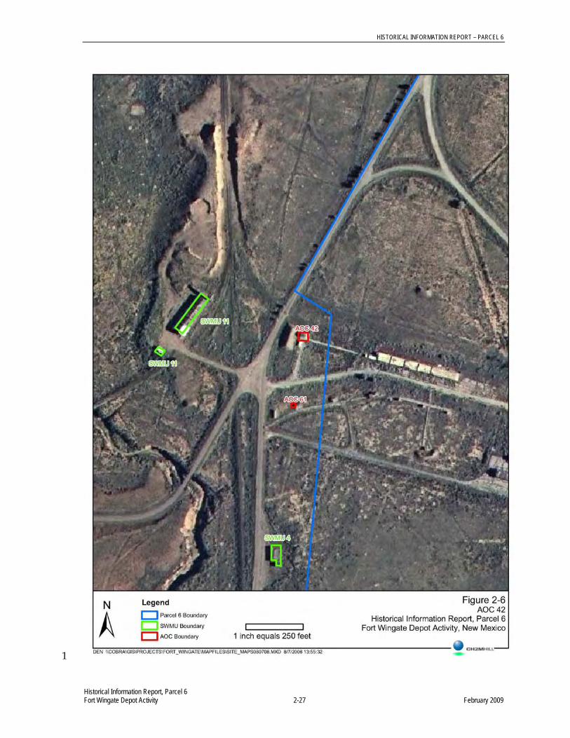
HISTORICAL INFORMATION REPORT – PARCEL 6
Historical Information Report, Parcel 6 Fort Wingate Depot Activity 2-27 February 2009
1

HISTORICAL INFORMATION REPORT – PARCEL 6
Historical Information Report, Parcel 6 Fort Wingate Depot Activity 2-28 February 2009
Aerial Report; Environmental Research, Inc., 2006 1 This report documents aerial imagery obtained during a search of government and commercial 2 records. The photographs were analyzed utilizing a stereoscope to locate potential sources of 3 contamination and to record any findings inside the boundaries of the known SWMUs and AOCs. 4 Aerial images dated from 1935 to 1997 were catalogued. The summary of the imagery analysis 5 provided for AOC 42 is as follows: 6
1935 – No significant findings 7
1948 – Building 516 present; no significant findings 8
1952 – No significant findings 9
1958 – No significant findings 10
1962 – No significant findings 11
1966 – No significant findings 12
1973 – No significant findings 13
1978 – No significant findings 14
1985 – No significant findings 15
1991 – No significant findings 16
1993 – No photo coverage 17
1997 – No significant findings 18
While not specifically stated in the summary from the report above, Building 516 is visible from 1948 19 to 1997. 20
Letter Archival Report; SAIC, 2007 21 This archival report is a reference to documents on file at Fort Worth District Corp of Engineers as of 22 July 2006. It cites the following report on file for Building 516: Environmental Baseline Survey 23 (EMD, 1999). No other reports are directly listed for Building 516 or AOC 42. 24
2.7 AOC 61: Building 507 (Smokeless Powder Magazine) 25
A summary of information contained in available documents is presented below. Appendix H1 26 presents relevant pages from the historical reports summarized below. Appendix H2 presents the 27 available aerial photograph figures. Appendix H3 presents the available historical photographs and 28 drawings. 29
2.7.1 Site Description and Operational History 30
Building 507 is located in the ammunition workshop area to the north of Building 539 and to the west 31 of Building 515 (Figure 2-7). Building 507 is listed as the smokeless powder magazine and was 32 constructed in 1948. This building has 100 square feet of usable area and is constructed of concrete 33 with an earth fill covering and a reinforced concrete floor (FWDA, 1961). This building has no water 34 service and was not connected to the sanitary sewer. There was no specific information available in 35 the provided documents relating to the operational history of this building. 36
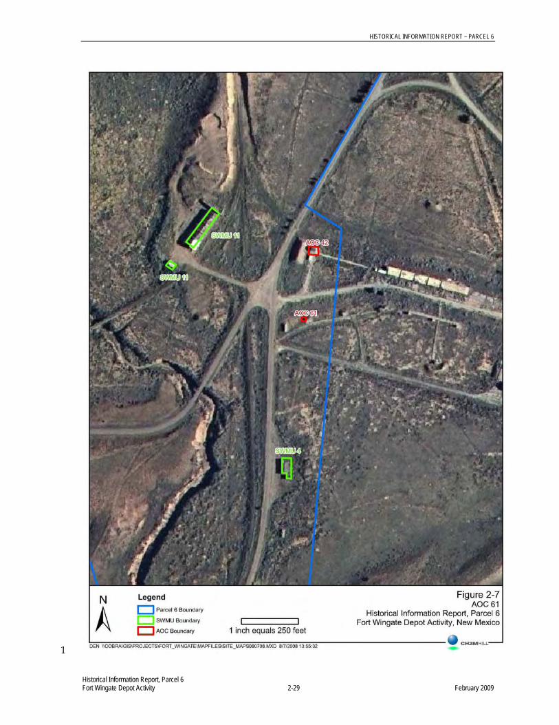
HISTORICAL INFORMATION REPORT – PARCEL 6
Historical Information Report, Parcel 6 Fort Wingate Depot Activity 2-29 February 2009
1

HISTORICAL INFORMATION REPORT – PARCEL 6
Historical Information Report, Parcel 6 Fort Wingate Depot Activity 2-30 February 2009
2.7.2 Previous Investigation 1
Facilities Data; FWDA, 1961 2 This report includes relevant construction information for Building 507. 3
Aerial Report; Environmental Research, Inc., 2006 4 This report documents aerial imagery obtained during a search of government and commercial 5 records. The photographs were analyzed utilizing a stereoscope to locate potential sources of 6 contamination and to record any findings inside the boundaries of the known SWMUs and AOCs. 7 Aerial images dated from 1935 to 1997 were catalogued. The summary of the imagery analysis 8 provided for AOC 61 is as follows: 9
1935 – No significant findings 10
1948 – Building 507 present; no significant findings 11
1952 – Building 507 present; no significant findings 12
1958 – No significant findings 13
1962 – No significant findings 14
1966 – No significant findings 15
1973 – No significant findings 16
1978 – No significant findings 17
1985 – No significant findings 18
1991 – No significant findings 19
1993 – No photo coverage 20
1997 – No significant findings 21
While not specifically stated in the summary from the report above, Building 507 is visible from 1948 22 to 1997. 23
Letter Archival Report; SAIC, 2007 24 This archival report is a reference to documents on file at Fort Worth District Corp of Engineers as of 25 July 2006. It does not cite any reports for Building 507 or AOC 61, only a record of drawings on file. 26
2.8 AOC 75: Electrical Transformers 27
A summary of information contained in available documents is presented below. Little specific 28 information exists regarding the electrical transformers located within Parcel 6. Therefore no aerial 29 photographs are presented as specific locations are unknown. Appendix I1 presents relevant pages 30 from the available document summarized below. Appendix I2 presents the available historical 31 photographs and drawings. 32

HISTORICAL INFORMATION REPORT – PARCEL 6
Historical Information Report, Parcel 6 Fort Wingate Depot Activity 2-31 February 2009
2.8.1 Site Description and Operational History 1
There are at least 65 former or existing transformers within multiple Parcels that are included as 2 AOC 75. Transformers are located within Parcels 6, 7, 11, 12, 13, 19, 21, and 22. 3
2.8.2 Previous Investigations 4
Baseline Realignment and Closure (BRAC) Cleanup Plan; PMC, 2006 5 All historical data refers to AOC 75 as the main transformer bank, Structure 81. There is no specific 6 information available regarding the transformers located within Parcel 6. 7
2.9 AOC 78/82: Feature 18 8
A summary of information contained in available documents is presented below. Appendix J1 9 presents relevant pages from the historical reports summarized below. Appendix J2 presents the 10 available aerial photograph figures. Appendix J3 presents the available historical photographs and 11 drawings. 12
2.9.1 Site Description and Operational History 13
AOC 78/82 is described as Feature 18 on 1973 aerial photo (API-5) in the 1995 Archive Search 14 Report (Figure 2-8 and Appendix J3). The 1995 Archive Search Report lists the 1973 aerial photo in a 15 table without further description. Therefore this report has not been included in the previous 16 investigation section below. AOC 78/82 is located in the far southwestern corner of Parcel 6 and is 17 approximately 4.4 acres in size. Review of historical aerial photographs indicates that grading and 18 construction of a pond were completed at this site. However, the pond feature may just be an artifact 19 of natural drainage collecting adjacent to where the western patrol road crosses the main local 20 drainage feature. 21
Review of historical FWDA maps for this area lists the four northern features of AOC 78/82 as Open 22 Storage Sites or a Standard Ammunition Magazine. Temporary building numbers of Z-223 or X-23; 23 Z-227; Z-224 or X-24; and Z-228 were identified from north to south for the four southern 24 AOC 78/82 features. Included in Appendix J3 is an as-built drawing assumed to be for this type of 25 structure. No additional information is available relating to the operational history of this site. 26

HISTORICAL INFORMATION REPORT – PARCEL 6
Historical Information Report, Parcel 6 Fort Wingate Depot Activity 2-32 February 2009
1

HISTORICAL INFORMATION REPORT – PARCEL 6
Historical Information Report, Parcel 6 Fort Wingate Depot Activity 2-33 February 2009
2.9.2 Previous Investigations 1
Aerial Report; Environmental Research, Inc., 2006 2 This report documents aerial imagery obtained during a search of government and commercial 3 records. The photographs were analyzed utilizing a stereoscope to locate potential sources of 4 contamination and to record any findings inside the boundaries of the known SWMUs and AOCs. 5 Aerial images dated from 1935 to 1997 were catalogued. The summary of the imagery analysis 6 provided for AOC 78/82 is as follows: 7
1935 – No significant findings 8
1948 – Two graded areas are present. 9
1952 – Two graded scarred areas are present. 10
1958 – Two graded areas are present. 11
1962 – One graded area remains. 12
1966 – One of the graded areas remains. 13
1973 – A pond has been constructed in the northernmost area; three scarred or graded areas 14 are present to the south 15
1978 – The pond and two graded areas remain 16
1985 – The pond remains to the north; the graded areas are revegetating 17
1991 – The pond remains to the north; a trench or excavation is visible south of the pond; the 18 former graded areas are mostly revegetating. 19
1993 – No photo coverage 20
1997 – The pond remains to the north 21
Report of Investigation for Potential Environmental Areas of Concern; USACE, 2007 22 This report documents an investigation completed at AOCs located outside of the boundaries of 23 current SWMUs and AOCs. Investigation activities were not completed within AOC 78/82. However, 24 the report includes background information relevant to areas at FWDA that were previously used to 25 temporarily store inert items and ordnance, such as AOC 78/82. The report indicates that buildings 26 designated with an X- identifier were wood-framed structures with a roof but no walls. These 27 buildings had earth or gravel floors and were present at FWDA from approximately 1945 to 1980. 28 Areas with a Z- identifier were either buildings such as those with the X- identifier or were flat open 29 storage areas with no associated building that were present at FWDA from approximately 1945 to 30 1980. 31
2.10 AOC 79: Feature 2 32
A summary of information contained in available documents is presented below. Appendix K1 33 presents relevant pages from the historical reports summarized below. Appendix K2 presents the 34 available aerial photograph figures. Appendix K3 presents the available historical photographs and 35 drawings. 36
HISTORICAL INFORMATION REPORT – PARCEL 6
Historical Information Report, Parcel 6 Fort Wingate Depot Activity 2-34 February 2009
2.10.1 Site Description and Operational History 1
This AOC is described as Feature 2 on the 1973 aerial photo (API-5) in the 1995 Archive Search 2 Report (Figure 2-9 and Appendix K3). The 1995 Archive Search Report lists the 1973 aerial photo in 3 a table without further description. Therefore this report has not been included in the previous 4 investigation section below. AOC 79 is located in the northern portion of Parcel 6 and is 5 approximately 3.6 acres in size. Review of historical aerial photographs indicates that an access road 6 leads to a probable building foundation and a scarred and stained soil area. 7
Review of historical FWDA maps for this area lists a portion of AOC 79 as an Open Storage Site or a 8 Standard Ammunition Magazine. A temporary building number of Z-220 or X-18 is listed for this 9 area. Included in Appendix K3 is an as-built drawing assumed to be for this type of structure. No 10 additional information is available relating to the operational history of this site. 11
2.10.2 Previous Investigations 12
Aerial Report; Environmental Research, Inc., 2006 13 This report documents aerial imagery obtained during a search of government and commercial 14 records. The photographs were analyzed utilizing a stereoscope to locate potential sources of 15 contamination and to record any findings inside the boundaries of the known SWMUs and AOCs. 16 Aerial images dated from 1935 to 1997 were catalogued. The summary of the imagery analysis 17 provided for AOC 79 is as follows: 18
1935 – No significant findings 19
1948 – An access road leads to a probable building foundation 20
1952 – Access road leads to two probable trenches with dark-toned materials 21
1958 – Access roads lead to a scarred and disturbed area 22
1962 – Access roads lead to areas of dark-toned material or staining northwest and southwest 23 of the site 24
1966 – No significant findings 25
1973 – The perimeter of the site has been cleared/graded; the other areas to the south appear 26 as graded or scarred staging or parking areas 27
1978 – An access road leads to a ground scarred area 28
1991 – No significant findings 29
1993 – No photo coverage 30
1997 – The central portion of the site is scarred; however, this may be due to erosion 31

HISTORICAL INFORMATION REPORT – PARCEL 6
Historical Information Report, Parcel 6 Fort Wingate Depot Activity 2-35 February 2009
1

HISTORICAL INFORMATION REPORT – PARCEL 6
Historical Information Report, Parcel 6 Fort Wingate Depot Activity 2-36 February 2009
Report of Investigation for Potential Environmental Areas of Concern; USACE, 2007 1 This report documents an investigation completed at AOCs located outside of the boundaries of 2 current SWMUs and AOCs. Investigation activities were not completed within AOC 79. However, 3 the report includes background information relevant to areas at FWDA that were previously used to 4 temporarily store inert items and ordnance, such as AOC 79. The report indicates that buildings 5 designated with an X- identifier were wood-framed structures with a roof but no walls. These 6 buildings had earth or gravel floors and were present at FWDA from approximately 1945 to 1980. 7 Areas with a Z- identifier were either buildings such as those with the X- identifier or were flat open 8 storage areas with no associated building that were present at FWDA from approximately 1945 to 9 1980. 10
2.11 AOC 80: Feature 9 11
A summary of information contained in available documents is presented below. Appendix L1 12 presents relevant pages from the historical reports summarized below. Appendix L2 presents the 13 available aerial photograph figures. Appendix L3 presents the available historical photographs and 14 drawings. 15
2.11.1 Site Description and Operational History 16
This AOC is described as Feature 9 on the 1962 aerial photo (API-3) in the 1995 Archive Search 17 Report (Figure 2-10 and Appendix L3). The 1995 Archive Search Report lists the 1962 aerial photo in 18 a table without further description. Therefore this report has not been included in the previous 19 investigation section below. AOC 80 is located in the northwest portion of Parcel 6. Review of 20 historical aerial photographs indicates this site is a scarred and stained soil area. No additional 21 information is available relating to the operational history of this site. 22
2.11.2 Previous Investigations 23
Aerial Report; Environmental Research, Inc., 2006 24 This report documents aerial imagery obtained during a search of government and commercial 25 records. The photographs were analyzed utilizing a stereoscope to locate potential sources of 26 contamination and to record any findings inside the boundaries of the known SWMUs and AOCs. 27 Aerial images dated from 1935 to 1997 were catalogued. The summary of the imagery analysis 28 provided for AOC 80 is as follows: 29
1935 – No significant findings 30
1948 – Disturbed ground, light-toned material and a ground scar are present 31
1952 – Disturbed ground, light-toned material and a ground scar are present 32
1958 – Disturbed ground, light-toned material and a ground scar are present 33
1962 – Disturbed ground and light-toned material are present 34
1966 – No significant findings 35
1973 – Disturbed ground and light-toned material are present 36
1978 – Disturbed ground and light-toned material remain 37
1985 – Disturbed ground and light-toned material remain 38

HISTORICAL INFORMATION REPORT – PARCEL 6
Historical Information Report, Parcel 6 Fort Wingate Depot Activity 2-37 February 2009
1

HISTORICAL INFORMATION REPORT – PARCEL 6
Historical Information Report, Parcel 6 Fort Wingate Depot Activity 2-38 February 2009
1991 – Disturbed ground and light-toned material remain 1
1993 – No photo coverage 2
1997 – No significant findings 3
2.12 AOC 81: Feature 11 4
A summary of information contained in available documents is presented below. Appendix M1 5 presents relevant pages from the historical reports summarized below. Appendix M2 presents the 6 available aerial photograph figures. Appendix M3 presents the available historical photographs and 7 drawings. 8
2.12.1 Site Description and Operational History 9
This AOC is described as Feature 11 on the 1962 aerial photo (API-3) in the 1995 Archive Search 10 Report (Figure 2-11 and Appendix M3). The 1995 Archive Search Report lists the 1962 aerial photo 11 in a table without further description. Therefore this report has not been included in the previous 12 investigation section below. AOC 81 is located in the central portion of Parcel 6. Review of historical 13 aerial photographs indicates this site previously contained a rectangular building and a stained soil 14 area. 15
Review of historical FWDA maps for this area lists AOC 81 as an Open Storage Site or a Standard 16 Ammunition Magazine. A temporary building number of X-19 or T-330 is listed for this area. 17 Included in Appendix M3 is an as-built drawing assumed to be for this type of structure. No 18 additional information is available relating to the operational history of this site. 19
2.12.2 Previous Investigations 20
Aerial Report; Environmental Research, Inc., 2006 21 This report documents aerial imagery obtained during a search of government and commercial 22 records. The photographs were analyzed utilizing a stereoscope to locate potential sources of 23 contamination and to record any findings inside the boundaries of the known SWMUs and AOCs. 24 Aerial images dated from 1935 to 1997 were catalogued. The summary of the imagery analysis 25 provided for AOC 81 is as follows: 26
1935 – No significant findings 27
1948 – A rectangular building is present; no significant findings 28
1952 – Rectangular scar/building foundation; no significant findings 29
1958 – No significant findings 30
1962 – Dark-toned material or staining is present west and south of the site 31
1966 – No significant findings 32
1973 – No significant findings 33
1978 – No significant findings 34
1985 – No significant findings 35
1991 – No significant findings 36

HISTORICAL INFORMATION REPORT – PARCEL 6
Historical Information Report, Parcel 6 Fort Wingate Depot Activity 2-39 February 2009
1

HISTORICAL INFORMATION REPORT – PARCEL 6
Historical Information Report, Parcel 6 Fort Wingate Depot Activity 2-40 February 2009
1993 – No photo coverage 1
1997 – No significant findings 2
Report of Investigation for Potential Environmental Areas of Concern; USACE, 2007 3 This report documents an investigation completed at AOCs located outside of the boundaries of 4 current SWMUs and AOCs. Investigation activities were not completed within AOC 81. However, 5 the report includes background information relevant to areas at FWDA that were previously used to 6 temporarily store inert items and ordnance, such as AOC 81. The report indicates that buildings 7 designated with an X- identifier were wood-framed structures with a roof but no walls. These 8 buildings had earth or gravel floors and were present at FWDA from approximately 1945 to 1980. 9 Areas with a T- identifier were flat open storage areas with no associated building that were present at 10 FWDA from approximately 1945 to 1948. 11
2.13 AOC 83: Feature 22 12
A summary of information contained in available documents is presented below. Appendix N1 13 presents relevant pages from the historical reports summarized below. Appendix N2 presents the 14 available aerial photograph figures. Appendix N3 presents the available historical photographs and 15 drawings. 16
2.13.1 Site Description and Operational History 17
This AOC is described as Feature 22 on 1973 aerial photo (API-5) in the 1995 Archive Search Report 18 (Figure 2-12 and Appendix N3). The 1995 Archive Search Report lists the 1973 aerial photo in a 19 table without further description. Therefore this report has not been included in the previous 20 investigation section below. This AOC also appears to be listed under SWMU 40 as Structure 63. 21 AOC 83 is located in the west-central portion of Parcel 6. Review of historical aerial photographs 22 indicates this site previously contained a building, stacked material, and disturbed ground. Review of 23 historical FWDA maps for this area lists a portion of AOC 83 as an Open Storage Site or a Standard 24 Ammunition Magazine. A temporary building number of Z-332 or X-20 is listed for this area. 25 Included in Appendix N3 is an as-built drawing assumed to be for this type of structure. No additional 26 information is available relating to the operational history of this site. 27
2.13.2 Previous Investigations 28
Aerial Report; Environmental Research, Inc., 2006 29 This report documents aerial imagery obtained during a search of government and commercial 30 records. The photographs were analyzed utilizing a stereoscope to locate potential sources of 31 contamination and to record any findings inside the boundaries of the known SWMUs and AOCs. 32 Aerial images dated from 1935 to 1997 were catalogued. The summary of the imagery analysis 33 provided for AOC 83 is as follows: 34
1935 – No significant findings 35
1948 – A building is present; no significant findings 36
1952 – A building is present; no significant findings 37
1958 – A building is present; no significant findings 38
1962 – A building is present; no significant findings 39

HISTORICAL INFORMATION REPORT – PARCEL 6
Historical Information Report, Parcel 6 Fort Wingate Depot Activity 2-41 February 2009
1

HISTORICAL INFORMATION REPORT – PARCEL 6
Historical Information Report, Parcel 6 Fort Wingate Depot Activity 2-42 February 2009
1966 – The building seen in 1962 has been removed 1
1973 – Stacked material is present onsite; disturbed ground and erosional features are present 2 to the east 3
1978 – A graded area is present with probable stacked material 4
1985 – No significant findings 5
1991 – No significant findings 6
1993 – No photo coverage 7
1997 – No significant findings 8
Report of Investigation for Potential Environmental Areas of Concern; USACE, 2007 9 This report documents an investigation completed at AOCs located outside of the boundaries of 10 current SWMUs and AOCs. Investigation activities were not completed within AOC 83. However, 11 the report includes background information relevant to areas at FWDA that were previously used to 12 temporarily store inert items and ordnance, such as AOC 83. The report indicates that buildings 13 designated with an X- identifier were wood framed structures with a roof but no walls. These 14 buildings had earth or gravel floors and were present at FWDA from approximately 1945 to 1980. 15 Areas with a Z- identifier were either buildings such as those with the X- identifier or were flat open 16 storage areas with no associated building that were present at FWDA from approximately 1945 to 17 1980. 18
2.14 AOC 84: Feature 12 19
A summary of information contained in available documents is presented below. Appendix O1 20 presents relevant pages from the historical reports summarized below. Appendix O2 presents the 21 available aerial photograph figures. Appendix O3 presents the available historical photographs and 22 drawings. 23
2.14.1 Site Description and Operational History 24
This AOC is described as Feature 12 on 1962 aerial photo (API-3) in the 1995 Archive Search Report 25 (Figure 2-13 and Appendix O3). The 1995 Archive Search Report lists the 1962 aerial photo in a 26 table without further description. Therefore this report has not been included in the previous 27 investigation section below. AOC 84 is located in the central portion of Parcel 6. Review of historical 28 aerial photographs indicates this site is a scarred and stained soil area. No additional information is 29 available relating to the operational history of this site. 30

HISTORICAL INFORMATION REPORT – PARCEL 6
Historical Information Report, Parcel 6 Fort Wingate Depot Activity 2-43 February 2009
1

HISTORICAL INFORMATION REPORT – PARCEL 6
Historical Information Report, Parcel 6 Fort Wingate Depot Activity 2-44 February 2009
2.14.2 Previous Investigations 1
Aerial Report; Environmental Research, Inc., 2006 2 This report documents aerial imagery obtained during a search of government and commercial 3 records. The photographs were analyzed utilizing a stereoscope to locate potential sources of 4 contamination and to record any findings inside the boundaries of the known SWMUs and AOCs. 5 Aerial images dated from 1935 to 1997 were catalogued. The summary of the imagery analysis 6 provided for AOC 84 is as follows: 7
1935 – No significant findings 8
1948 – No significant findings 9
1952 – No significant findings 10
1958 – No significant findings 11
1962 – Disturbed ground and dark-toned material are present 12
1966 – No significant findings 13
1973 – No significant findings 14
1978 – No significant findings 15
1985 – No significant findings 16
1991 – No significant findings 17
1993 – No photo coverage 18
1997 – No significant findings 19

HISTORICAL INFORMATION REPORT – PARCEL 6
Historical Information Report, Parcel 6 Fort Wingate Depot Activity 3-1 February 2009
3.0 References 1
CCC Group, 1996. BRAC Remediation Projects (Phase I) PCB Remediation Soil Removal Buildings 2 536/537. November 13, 1996. 3
CCC Group, 1998. Removal and Disposal of PCBs and Pesticide Soils Closure Report. July 29, 1998. 4
Daniel, C.L., 1994. New Mexico Historic Building Inventory Form. Various Dates. 5
Environmental Research, Inc., 2006. Aerial Photographic Site Analysis Fort Wingate Depot Activity: 6 Fort Wingate, NM. September 2006. 7
ERM Program Management Company, 1997. Document No. 97-5, Fort Wingate Depot Activity, 8 Gallup, NM: Final Remedial Investigation/Feasibility Study & RCRA Corrective Act. November 9 1997. 10
ESE, 1981. Document No. 80-3. Final Report Environmental Survey of Ft. Wingate Depot Activity, 11 Gallup, New Mexico. September 1981. 12
FWDA, 1961. Facilities Data, Fort Wingate Ordinance Depot, Gallup, New Mexico. May 1961. 13
Pickering Environmental, 1990. Document No. 90-74, Final Asbestos Survey Report, Volume II, 14 Book 1. November 2, 1990. 15
PIKA, 2008. Onsite Treatment/Desensitization of 16 Boxes of Abandoned Energetics. March 2008. 16
PRC Environmental Management, 1990. Fort Wingate Depot Activity, NM6213820974, Gallup, NM: 17 RCRA Facility Assessment Report. September 1990. 18
PMC Environmental, 2000. Fort Wingate Depot Activity: Final Work Plan Environmental 19 Characterization Buildings 542 and 600. November 15, 2000. 20
PMC Environmental, 2002. Fort Wingate Depot Activity, Gallup, NM: Final Phase I RCRA Facility 21 Investigation Report Buildings 542 and 600. December 4, 2002. 22
PMC Environmental, 2003. Final Fort Wingate Depot Activity, Gallup, NM: Soil Characterization 23 Work Plan Building 537. February 20, 2003. 24
PMC Environmental, 2004. Fort Wingate Depot Activity, Gallup, NM: Field Investigation Report 25 Building 537. March 31, 2004. 26
SAIC, 2007. Archival Search for Fort Wingate Depot Activity Information. March 2007. 27
Terranear PMC, 2006. Fort Wingate Depot Activity, Gallup, NM: Base Realignment and Closure 28 (BRAC) Cleanup Plan. April 17, 2006. 29
Terranear PMC, 2006. Community Relations Plan Version 1: Fort Wingate Depot Activity, McKinley 30 County, NM. August 29, 2006. 31
TtNUS, 2000. Final Release Assessments Report. December 2000. 32
USACE, 1995. Defense Environmental Restoration Program for Property Owned by the Department 33 of Defense Ordnance and Explosive Waste Chemical Warfare Materials Archives Search Report Fort 34 Wingate. July 1995. 35

HISTORICAL INFORMATION REPORT – PARCEL 6
Historical Information Report, Parcel 6 Fort Wingate Depot Activity 3-2 February 2009
USACE, 1997. Summary of Sampling and Analysis Event to Delineate PCB Contamination, 1 Building 536 and 537. August 1997. 2
USACE, 2000. Draft Environmental Baseline Survey for the Transfer of Lands at Fort Wingate 3 Depot Activity, New Mexico. May 15, 2000. 4
USACE, 2003. Environmental Baseline Survey Base Realignment and Closure (BRAC) Parcels 6 5 and 22 at Fort Wingate Depot Activity, Gallup, NM. November 2002; revised June 2003. 6
USACE, 2005. Final Report Removal and Disposal of Western Landfill, Volume 1. 2005. 7
USATHMA, 1980. Final Report Installation Assessment of Fort Wingate Army Depot Activity, 8 Gallup, NM: Report No. 136. January 1980. 9