Historic Streetcar Systems in Georgia
268
Y Y e HISTORIC STReeTCaR SYSTeMS GeORGIa In ertyrtf ertyrtf
-
Upload
nguyenthien -
Category
Documents
-
view
216 -
download
1
Transcript of Historic Streetcar Systems in Georgia
Ya
HISTORICSTReeTCaRSYSTeMSGeORGIa
In
YeHISTORICSTReeTCaRSYSTeMSGeORGIa
In
ertyrtf
ertyrtf

YeHISTORICSTReeTCaRSYSTeMSGeORGIa
Context and Inventory
GDOT Contract No. AEOELENV100147
Report submitted to: Georgia Department of Transportation • One Peachtree Center • 600 West Peachtree NW • Atlanta, Georgia 30308
Report prepared by: New South Associates • 6150 East Ponce de Leon Avenue • Stone Mountain, Georgia 30083
Mary Beth Reed – Principal Investigator
Patrick Sullivan – Historian and Co-AuthorW. Matthew Tankersley – Archaeologist and Co-Author
Mary Beth Reed- Co-AuthorSara Gale - Co-Author
Mary Hammock - Co-Author
January 31, 2012 • Final ReportNew South Associates Technical Report 1987
In

ii
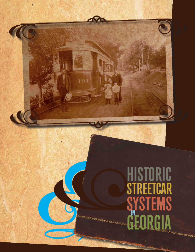
Cover Image Source: Cover Image: William Ragsdale and Family Posing with Georgia Railway and Power Streetcar, Atlanta, 1908. From left to right: Unidentified man; Unidentified Streetcar Operator; William L. Ragsdale (white hat, son); Katie B. Ragsdale (wife, in window); Chloe B. Ragsdale (dark hat, son); Streetcar Operator William B. Ragsdale. Photograph Courtesy of Paul Jarrell.

Yiii
HISTORICSTReeTCaRSYSTeMSGeORGIa
In
Table of ConTenTs
1. InTRoDUCTIon: ReseaRCh MeThoDs, lITeRaTURe seaRCh sUMMaRy ........................................................ 1
2. ConTexT ....................................................................................................................................................................................17
3. Map analysIs anD fIelD assessMenT .....................................................................................................................67
4. pRopeRTy Types ...................................................................................................................................................................97
5. IDenTIfICaTIon ................................................................................................................................................................... 137
6. naTIonal RegIsTeR of hIsToRIC plaCes evalUaTIon ................................................................................... 159
7. fUTURe ReseaRCh anD ConTexTs ............................................................................................................................ 183
sUggesTeD ReaDIng anD noTable lInks ...........................................................................................................187
RefeRenCes..........................................................................................................................................................................191
appenDIx: CoMpIlaTIon of sTReeTCaR lInes In soMe of geoRgIa’s CITIes anD Towns ......205

iv

Y1
HISTORICSTReeTCaRSYSTeMSGeORGIa
In
1. InTRoDUCTIonReseaRCh MeThoDs, lITeRaTURe seaRCh sUMMaRy
INTRODUCTION
The Georgia Department of Transportation (GDOT) and the Federal Highway Administration
(FHWA) have funded the development of a context for resources associated with Georgia’s
historic streetcar systems, with a focus on the metro Atlanta area, to provide GDOT staff and other
preservation professionals a better understanding of these unique resources and to present a
framework for their evaluation under Section 106 of the National Historic Preservation Act (NHPA).
This Act requires federal and state agencies to assess the effects of their undertakings on cultural
resources that are eligible for listing in the National Register of Historic Places (NRHP). Because
remnants of streetcar tracks and associated properties are historic, they are surveyed and
recorded; yet, their evaluation is often hampered by a lack of understanding of their significance
by archaeologists and historians.
Tracks covered by cement, streetcar barns adapted for reuse, street configurations defined
by streetcar right-of-way, bridges and culverts, cuts, and a host other features are reminders
of the remarkable history of the streetcar, which moved urban Georgians from home to work to
play between 1869 and 1949. These features can exist individually or, more likely, as groups
of resources. It is the interaction of the built environment with archaeological and landscape
components that truly convey the sense of streetcar history in the state. Though the geography
of the streetcar past can be obscured by the progress of time, clues remain in the landscape,
buildings, and streetscape. Understanding their interaction is important and developing eligibility
evaluation guidelines for these elements is the objective of this study.
Popularly known as the trolley, or more formally referred to as the street railroad or street railway,
the streetcar provided marvelous opportunities, opening up a new economic and social geography
over the course of the late nineteenth and early twentieth centuries. Young African Americans in
the Shermantown neighborhood of Stone Mountain no longer looked to the mountain’s quarries
for work, educations could be pursued, and a wider variety of jobs were possible. Streetcars
brought intown workers home to the suburbs and then back the next morning to work. Businesses,
neighborhoods, and schools were tied into the new transportation system that provided movement
to places people wanted or needed to go, or new places yet to be established. Social relations

1 Introduction
2
Figure 1.1. Georgia Railway and Power Company Advertisement for the Emory University Line. Source: Georgia Power 1927.

Y3
HISTORICSTReeTCaRSYSTeMSGeORGIa
In
changed as they brought white and black riders into close contact within the Jim Crow South.
The history of streetcars is as large and as colorful as history gets. Expansive, fast, noisy, and
romantic, they were much loved by urban Georgians, as well as most urbanites around the country
(Figure 1.1). While trackless trolleys and the personal automobile would bring an end to their use,
funeral parties in many cities honoring “the last trolley ride” were held testifying to their hold on
the public.
Georgia’s historic streetcar resources can take the form of buildings, structures, objects, sites,
landscape elements, and districts. Ironically, finding a historic streetcar that once negotiated
Atlanta’s streets would be a challenge. Destroyed for scrap or sold to other countries, few examples
exist. However, a wealth of other associated properties remain in place, sometimes covered or
in full view, but they are typically not identified as historic or even streetcar related (Figures 1.2
and 1.3). Paving and other street improvements have disguised the rail lines or resulted in their
removal. Former streetcar company-owned and maintained private rights-of-way along some
lines has often been adapted for reuse as trails or utility corridors. If recognized in a community
setting, streetcar resources are often considered as a building, structure, or landscape feature
contributing to a historic district. Their immediate geography often trumps consideration of their
potential to reflect the transportation history of a streetcar system, making them one of the least
recognized and studied of linear resources in terms of their historical significance.
There are two pioneering studies that have greatly informed this work regarding the identification,
evaluation, and treatment of historic streetcar resources. In Georgia, a point of departure has
been established for archaeological investigation of these resources. Recognizing a disparity
in the documentation of streetcar resources, archaeologist Mary Elizabeth Gantt developed a
comprehensive documentation of buried track in Cultural Resources Survey and Evaluation of the
Lakewood Avenue Trolley Line (Gantt 1998). Her work demonstrated that specific archaeological
data could be recorded in areas with a high potential for preserved track and provided analysis of
streetcar track types. This was a pioneering study that few have emulated since. On a national
level, “Streetcar and Bus Resources of Washington D.C.(1862-1962)” is a standout multiple
property nomination for historic streetcar and bus resources. Produced by EHT Traceries, Inc. in
2005 as part of a multi-phased study, the nomination provides a strong model in terms of context
and resource identification of property types associated with the development of streetcar and
subsequent bus public transportation in the nation’s capital.
Different disciplines have generally produced different data sets in their examination of streetcar-
related resources. A search in Historical Archaeology identified no articles that focused on, or even
tangentially dealt with, streetcar resources. Searching IA, the Journal of the Society for Industrial
Archaeology, produced similar results. In contrast, social historians, historians of technology,

1 Introduction
4Source: ESRI Streetmaps 2010, GNAHRGIS 2011.
Figure 1.2. Identified Historic Resources Associated with Georgia Streetcar Systems.

Y5
HISTORICSTReeTCaRSYSTeMSGeORGIa
In
Source: ESRI Streetmaps 2010, GNAHRGIS 2011.
Figure 1.3. Identified Archaeological Sites Associated with the Atlanta Streetcar System.

1 Introduction
6
urban historians, and railroad enthusiasts have claimed the topic; some dealing with streetcars
as part of a larger topical study, while others approached them for their engineering or prominent
role in the spatial development of urban geographies. These studies as well as the Washington
D.C. example provide a wealth of information about these early transportation systems and their
character-defining features.
The scope of work outlined three deliverables for this project: the development of a context
and evaluation guidelines; a Geographic Information Systems (GIS) database documenting the
location of formerly active streetcar lines; and a website that provides information to the public.
This study fulfills the first objective. While focused primarily on the Metropolitan Atlanta system,
it also treats the development of historic street railroad transit in the cities and towns throughout
Georgia, demonstrating the streetcar’s allure as a symbol of modernity during the late nineteenth
and early twentieth centuries.
HISTORICAL RESEARCH METHODS
This discussion of research methods is offered here as a model of research for future streetcar
studies in other municipalities in Georgia, listing the sources and repositories that are the most
salient to the understanding of streetcar transit history in the state. Historical research was
conducted in order to identify the significant historical themes present in streetcar history. Study
of the major street railroad lines and their eras of operation was undertaken to establish the
significant companies, individuals, events, changes in technology and other historical parameters
that enveloped this prevalent transportation industry in Georgia. Additionally, the research was
focused on understanding the character-defining features of resources from each era of streetcar
development. Cartographic, photographic, and research materials at the state’s major research
libraries were examined, and historic maps were digitized and geo-referenced for use in GIS.
Although the broad history of streetcar development in the United States has been well documented,
comprehensive research of local street railroad systems in Georgia remains relatively fragmented.
Google.com’s online access to digital scans of late nineteenth- and early twentieth-century industry
trade publications such as The Street Railway Journal, Electric Railway Journal, and the McGraw
Electric Railway Manual proved to be invaluable resources for providing detailed information
about the periods of operation and inventories of Georgia streetcar companies. Jean Martin’s
Mule to MARTA, Volumes 1-2, Trolley Titans by O.E. ‘Gene’ Carson, and Wade Wright’s History
of the Georgia Power Company 1855-1956, all provided detailed and exhaustive chronicles of
the oftentimes tangled history of the streetcar in the Metro Atlanta area. The same can be said
for Henry Eason’s The Savannah Electric and Power Company (1866-1971) and Beth D’Alonzo’s
Y7
HISTORICSTReeTCaRSYSTeMSGeORGIa
In
Streetcars of Chatham County for their treatment of Savannah’s transit and electric utility history.
Another notable work is Albert and Mary Langley’s Trolleys in the Valley, which documents the
Augusta streetcar system in general, and the operation of the Augusta-Aiken interurban line in
particular.
Information about streetcar development in other municipalities, however, is often given shorter
treatment within the larger scope of city and county history books. Therefore, in an effort to provide
a clearer and more in-depth portrayal of the history of the streetcar in Georgia, research materials
were collected from a number of archives, local historical societies, and other repositories located
throughout the state. These included: the Atlanta History Center; Atlanta-Fulton County Central
Public Library; Aiken (SC) Historical Society; Auburn Avenue Research Library; Augusta History
Museum; Augusta-Richmond County Public Library; Brunswick-Glynn County Public Library;
City of Brunswick Engineering Department; Columbus Public Library; DeKalb County History
Center; DeKalb County Public Library; East Point Historical Society Museum and Archives; Emory
University; Georgia Archives; Georgia Historical Society; Georgia State University Library; Georgia
Institute of Technology Library; Griffin-Spalding Historical Society; Historic Columbus Foundation;
the Metropolitan Rapid Transit Agency (MARTA); Middle Georgia Archives at the Washington
Memorial Library in Macon; Newton County Library-Covington Branch; Old Campbell Historical
Society; Rome Area History Museum; Rome-Floyd County Public Library; Savannah Public Library-
Bull Street Branch; Savannah Research Library and Municipal Archives; Savannah Roundhouse
Railroad Museum; Smyrna History Museum; Southeastern Railway Museum; Thronateeska
Heritage Center in Albany; University of Georgia Hargrett Rare Book and Manuscript Library;
University of Georgia Map Library; Valdosta Museum and Lowndes County Historical Society;
and the Waycross-Ware County Public Library. In addition, personal photographs and research
collections provided by Dr. George M. Coletti, Fred Dodds, Paul Grether, Paul Jarrell, Hugh Jordan,
Travis L. Kovacs, Miriam Pinnell, and Chris Sanfino have also been used in the creation of this
document.
LITERATURE SEARCH SUMMARY
To learn about resources previously identified through cultural resources studies, a literature
search for streetcar-related resources was made on the state’s Georgia Natural, Archaeological,
and Historic Resources Geographic Information System (GNAHRGIS). GNAHRGIS is the result of
collaboration between GDOT, the Georgia Department of Natural Resources, Historic Preservation
Division (HPD), the University of Georgia, and the Georgia Department of Community Affairs
to create a searchable online database of Georgia’s environmental and cultural resources. A
corresponding search was conducted within HPD files. Additionally, contact was made with the

1 Introduction
8
state’s regional planners and knowledgeable individuals on historic streetcar systems. Table 1.1
provides a summary of the 18 previously identified resources and a brief description of each
follows, organized by county.
Table 1.1. Identified Historical and Archaeological Resources Relating to Streetcars
County Name Date NRHP StatusBibb Macon Railway and Light Substation 1900 Listed Individually
Clarke Whitehall Dam and Power House 1910-1915 Recommended Eligible
Clarke Trolley Stop 1900 Recommended Eligible
DeKalb A.R.T. Station 1913 Listed as contributing to Stone Mountain Historic District
DeKalb 9DA445 - Ponce-Druid Hills Trolley Track Site
Circa 1925 Recommended Eligible
DeKalb Metropolitan Railway Features 1920s Status Unknown
DeKalb 9DA(DOT)3 - Georgia Avenue - Inman Park Line Site
Circa 1930 Recommended Eligible
DeKalb Old South Decatur Trolley Line Circa 1920 Not Assessed
Fulton Inman Park Trolley Barn 1889 Listed as contributing to the Inman Park Historic District
Fulton Ashby Street Car Barn 1927 Listed Individually
Fulton Morgan Falls Dam and Hydroelectric Plant 1904 Recommended Eligible
Fulton 9FU324 - Lakewood Avenue Trolley Track Site
Circa 1925 Recommended Eligible
Fulton 9FU245 - Kelly Street Trolley Track Site Circa 1925 Potentially Eligible
Fulton 9FU(DOT)15 - Moreland Avenue Trolley Track Site
Circa 1900 Recommended Not Eligible
Fulton 9FU(DOT)16 - D.L. Hollowell Pkwy Trolley Track Site
Circa 1900 Recommended Not Eligible
Fulton 9FU(DOT)17 - Mitchell Street Bridge Trolley Track
Circa 1925 Recommended Not Eligible
Habersham Tallulah Falls Power Development Plant 1913 Potentially Eligible
Habersham Tugaloo Power Plant 1922 Potentially Eligible
Lowndes Bus Stop; Trolley Stop 1918 Status Unknown

Y9
HISTORICSTReeTCaRSYSTeMSGeORGIa
In
Figure 1.5. Trolley Stop, Cedar and South Lumpkin Streets, Athens, 2010.
Description of Identified ResourcesBibb County
Macon Railway and light SubStation
The Macon Railway and Light Company Substation is located on Riverside Drive, in
Macon, north of downtown on a bluff adjacent to the Ocmulgee River. It is a three-
story brick industrial building erected in 1915. The L-shaped building was constructed
as an addition to a complex of barns and shops associated with the Macon Railway
and Light Company, a streetcar company, housing transformers and other power
generation equipment (Battin 2001). The substation powered streetcar service
in Macon until 1934. The building features architectural details such as corbelled
arches, pilasters, and parapets (Figure 1.4).
The building has operated as a restaurant since the 1980s, a use that has involved alterations
in its interior spaces. It was listed on the NRHP in 2006. The extant shops and barns of
the Macon Railway and Light Company adjacent to the substation, which began operation in
1895 and were consolidated under the Georgia Power Company in 1928, were not included in
the nomination (Battin 2001). Additionally, this listed property does not appear in the online
database GNAHRGIS.
Clarke County
whitehall daM and PoweR houSe
Whitehall Dam is located at the south end of Phoenix Road, approximately one and one-half
miles south of Whitehall, Georgia. The power generation facility was initially built around 1910
to supply electricity for cotton mills at the Whitehall Manufacturing Company. Electricity from
the plant would later power transit in the city of Athens, specifically the Athens Railway and
Electric Company. At the time of documentation, the property was in fair condition and was
recommended eligible for inclusion on the NRHP (Cullison 1992a).
tRolley StoP
The Trolley Stop is a structure located on the northeast corner of Cedar and South Lumpkin
streets in Athens (Figure 1.5). The square, one-room post and beam structure features a
pyramidal roof. The date of construction is estimated as the turn of the twentieth century.
Figure 1.4. Macon Railway and Light Substation, 2010.
1 Introduction
10
Architectural details are in the Queen Anne style. The structure represents the last remaining
trolley stop in Athens. Documented in 1992, the structure was recommended eligible for
inclusion on the NRHP (Cullison 1992b).
DeKalb County
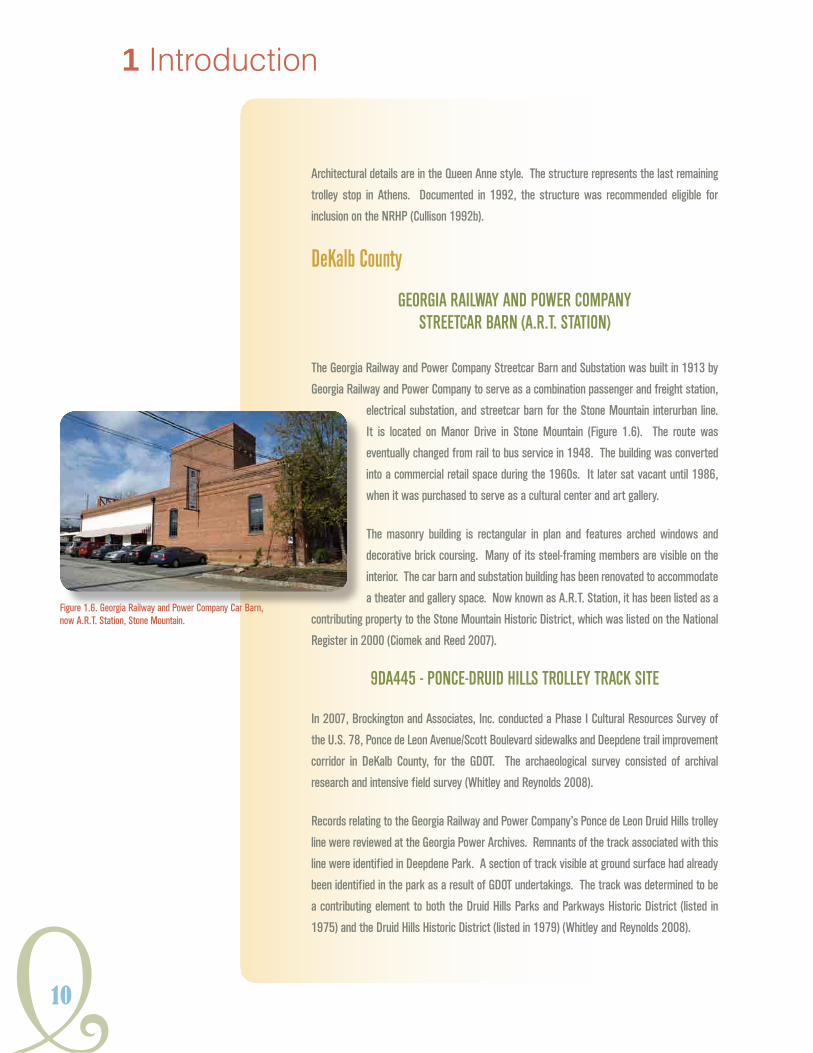
geoRgia Railway and PoweR coMPany StReetcaR baRn (a.R.t. Station)
The Georgia Railway and Power Company Streetcar Barn and Substation was built in 1913 by
Georgia Railway and Power Company to serve as a combination passenger and freight station,
electrical substation, and streetcar barn for the Stone Mountain interurban line.
It is located on Manor Drive in Stone Mountain (Figure 1.6). The route was
eventually changed from rail to bus service in 1948. The building was converted
into a commercial retail space during the 1960s. It later sat vacant until 1986,
when it was purchased to serve as a cultural center and art gallery.
The masonry building is rectangular in plan and features arched windows and
decorative brick coursing. Many of its steel-framing members are visible on the
interior. The car barn and substation building has been renovated to accommodate
a theater and gallery space. Now known as A.R.T. Station, it has been listed as a
contributing property to the Stone Mountain Historic District, which was listed on the National
Register in 2000 (Ciomek and Reed 2007).
9da445 - Ponce-dRuid hillS tRolley tRacK Site
In 2007, Brockington and Associates, Inc. conducted a Phase I Cultural Resources Survey of
the U.S. 78, Ponce de Leon Avenue/Scott Boulevard sidewalks and Deepdene trail improvement
corridor in DeKalb County, for the GDOT. The archaeological survey consisted of archival
research and intensive field survey (Whitley and Reynolds 2008).
Records relating to the Georgia Railway and Power Company’s Ponce de Leon Druid Hills trolley
line were reviewed at the Georgia Power Archives. Remnants of the track associated with this
line were identified in Deepdene Park. A section of track visible at ground surface had already
been identified in the park as a result of GDOT undertakings. The track was determined to be
a contributing element to both the Druid Hills Parks and Parkways Historic District (listed in
1975) and the Druid Hills Historic District (listed in 1979) (Whitley and Reynolds 2008).
Figure 1.6. Georgia Railway and Power Company Car Barn, now A.R.T. Station, Stone Mountain.

Y11
HISTORICSTReeTCaRSYSTeMSGeORGIa
In
Figure 1.7. Streetcar Waiting Structure and Historical Marker at 9DA445.
Phase I Archaeological Survey efforts consisted of intensive shovel testing in the project corridor
to determine if archaeological resources were present. Additional Phase II Archaeological
Testing included metal detector survey and the excavation of six trenches. Phase II testing
revealed 39 feet (11.8 meters) of trolley tracks located in the park. Eleven feet of this track
comprises the previously identified section that is visible at ground surface. Additionally,
229 feet of the gravel rail bed, including crosstie remnants and/or rail spikes, were
identified (Whitley and Reynolds 2008). The site currently features a reconstructed
streetcar stop waiting structure and a historical marker outlining the significance of the
streetcar to the site (Figure 1.7).
9da(dot)3 - geoRgia avenue- inMan PaRKtRolley tRacK line Site
The Georgia Avenue-Inman Park Line is identified on the Beeler Organization Consultants Map
of Active Lines trolley map from 1924. This line started at Edgewood Avenue, then made its
way north to Oxford Road. The line terminated in front of the Emory gate at the intersection
of Oxford Road and North Decatur Road. The subsurface track is still intact with girder rail,
wooden crossties, and macadam paving. The line was opened in the 1920s and ended its run
in 1946.
old South decatuR tRolley line conveRSion PRoject aRea
In 1993, the Jaeger Company documented a number of streetcar-related structures and
landscape features associated with the conversion of a former streetcar right-of-way into a
multi-use recreational trail. The original South Decatur Line ran east from downtown Atlanta
into what is now the McDonough, Adams, and Kings Highway District of Decatur. The corridor
was operated originally under the Metropolitan Street Railroad Company (1883) and ran
continuously through the twentieth century. The identified features included stone retaining
walls in the south lawn of Fred A. Toomer School at the intersection of Hosea Williams
Boulevard and Rogers Street, and in the Kirkwood neighborhood of Atlanta, as well as a granite
culvert at the intersection of Green and South McDonough streets just south of the Agnes
Scott College Campus in Decatur. Both resources likely represent 1920s system improvements
and are preserved (The Jaeger Company 1993).

1 Introduction
12
Figure 1.8. Inman Park Trolley Barn, 2010.
Fulton County
inMan PaRK hiStoRic diStRict
The residential neighborhood of Inman Park was conceived and designed by Joel
Hurt in 1888. Two years before that date, Hurt formed the Atlanta and Edgewood
Street Railway Company, which became the first streetcar system in Georgia to
use electric traction. The line serviced Atlanta’s new Inman Park development via
Edgewood Avenue, connecting the neighborhood with downtown.
In addition to the streetcar line, a trolley barn was constructed in Inman Park in
1889. The Inman Park Trolley Barn is situated on Edgewood Avenue between
Waverly Way and Elizabeth Street (Figure 1.8). It features Queen Anne elements
such as a round turret and long brackets under the eaves. The barn’s exterior
has been restored to its nineteenth-century appearance after falling into disrepair in the late
twentieth century and remains a landmark building within the neighborhood. The district
(including the Inman Park Trolley Barn) was nominated to the NRHP in 1973 and was granted
a boundary increase in 2001 (GNAHRGIS 2010a, 2010b).
aShby StReet caR baRn
The Ashby Street Car Barn is located on the west side of Atlanta at 981 Ashby Street. The
Atlanta Northern Railway Company first developed the property around 1904; a storage facility
and a power substation were constructed on the site. A second outbuilding located
southwest of the barn was constructed in 1918 as an oil house to the maintenance
operations building in 1927. The rectangular building measures approximately
100 feet wide by 230 feet long and likely occupies the footprint of the original
structure. A clerestory vault has steel framed single pane windows running its
entire length (Figure 1.9). Additionally, the 1918 oil house is still present on the
property, as well as historic period power poles along the southwest side (MSAA
2010).
The building served as a facility for the Atlanta-Marietta interurban line until 1946.
It was nominated and listed to the NRHP in 1998. It currently is used as office
space for several companies. The roofline still retains the clerestory windows and its historic
identity as a car barn can be read from its exterior (HPD 2008).
Figure 1.9. Ashby Street Car Barn and Oil House Building.

Y13
HISTORICSTReeTCaRSYSTeMSGeORGIa
In
9Fu(dot)15 - MoReland avenue tRolley tRacK Site
A plan view and partial profile of the track were visible during road survey work on Moreland
Avenue on the east side of Atlanta (Figure 1.10). The track consists of T-rail with
intact crossties encased in macadam paving. It was part of the Georgia Ave.-Inman
Park route, which is identified on the 1924 Beeler Organization Consultants Map of
Active Lines. The route traveled on the east side of Atlanta from Edgewood Avenue
along Euclid Avenue before connecting with Moreland Avenue where it continued
heading north. It terminated in front of Emory University. The route was extended
in 1895 and ended its run in 1946. The use of T-rail was typically reserved for
less trafficked public streets or on Georgia Power-owned private rights-of-way. This
section does not appear to have been part of the system upgrade that occurred at
other locations along this route.
9Fu(dot)16 - d.l. hollowell PaRKway tRolley tRacK Site
Westbound and eastbound streetcar tracks were identified between the surface travel lanes
along D.L. Hollowell Parkway in Northwest Atlanta. The tracks were part of the streetcar
route known as the “River Line,” which was originally developed by the Collins Park and
Belt Railroad Company circa 1891. The line was active until 1949, making it Atlanta’s last
operating streetcar line. The identified track included T-rail, which was typically reserved for
less heavily trafficked streetcar routes on public streets or on Georgia Power-owned private
rights-of-way.
9Fu(dot)17 -Mitchell StReet bRidge tRolley tRacK Site
Streetcar double tracking was found in 2010 during reconstruction of the Mitchell Street
Bridge over the Norfolk Southern Railroad in downtown Atlanta. The tracks consisted of
twentieth-century girder rails anchored to creosote soaked wood crossties with macadam
paving between the rails. Several layers of asphalt have covered the tracks since the line was
abandoned in the 1940s. The section of track once constituted part of the Orme-Magnolia
route, which extended from downtown Atlanta to Griffin Street on the city’s West Side and
passed by the old Terminal Station. This line was established in Atlanta between 1871-
1891 by the Atlanta Street Railway Company and may have originally been powered by mule
traction prior to electric streetcar service. Sections of T-rail, possibly associated with late
nineteenth-century transit development, were found adjacent to Mitchell Street on the slope
of the Norfolk Southern Railroad right-of-way.
Figure 1.10. Moreland Avenue Trolley Track Site, 2011.

1 Introduction
14
MoRgan FallS daM andhydRoelectRic Plant
Morgan Falls Dam and Hydroelectric Plant is located in North Fulton County on the Chattahoochee
River near the City of Sandy Springs. The S. Morgan Smith Company and the Atlanta Water and
Electric Company constructed the Morgan Falls Dam and Hydroelectric Plant in
1904 by flooding the Chattahoochee River forming Bull Sluice Lake (Figure 1.11).
Smith owned a Pennsylvania-based company that was one of the largest suppliers
of water turbines in the United States. In 1902, all of the street railway, electric
light and power, and steam properties in Atlanta were consolidated under the
Georgia Railway and Electric Company. The development at Morgan Falls was the
first in a series of hydroelectric facilities built to fuel Atlanta’s need for electric
traction. In 1912, Georgia Railway and Electric Company reorganized into Georgia
Railway and Power Company and later Georgia Power (Stallings 2005).
The Morgan Falls Dam and Hydroelectric Plant was determined eligible for the
NRHP as part of the Georgia Power Company’s efforts to renew licenses with the Federal
Energy Regulatory Commission (Stallings 2005).
9Fu324 - laKewood avenue tRolley tRacK Site
The Lakewood Avenue Trolley Track Site is located at the intersection of the Norfolk Southern
Railroad and Lakewood Avenue (Figure 1.12). A 1996 literature review for archaeological
resources identified the buried track under Lakewood Avenue as a significant resource (Gantt
1998).
In 1997 and 1998, archaeological evaluation of the track
revealed two sets of tracks dating to the mid-1920s and
potential evidence of an earlier set of tracks. The project
provided detailed documentation of the identified tracks
through trench excavation, mapping and photographing
of trench profiles, and subsurface features. The Lakewood Avenue trolley line study (Site
9FU324) has demonstrated the potential to yield significant information on the construction of
the street railway system outside of Atlanta’s downtown area and the importance of the trolley
to communities along its route. For these reasons, Site 9FU324 was recommended eligible as
it was considered to meet Criterion D for eligibility to the NRHP at the local level of significance
(Gantt 1998:10-11).
Figure 1.11. Morgan Falls Dam, Fulton County, 2006.
Figure 1.12. Lakewood Avenue Trolley Track Profile, 1998.
Y15
HISTORICSTReeTCaRSYSTeMSGeORGIa
In
Figure 1.14. Valdosta Bus Stop Trolley Stop, 2010.
9Fu245 - Kelly StReet tRolley tRacK Site
Site 9FU245 is located on the southern margin of Interstate 20 west of the intersection
with Hill Street in Atlanta. GDOT archaeologists documented the site in September 1993. It
consisted of a section of intact track between Glenwood Avenue and the Interstate 20 right-
of-way. The Georgia Archaeological Site form reveals that the site was considered a “historic
transportation corridor” in consultation with the Georgia HPD. This corridor operated as a line
throughout the history of streetcar service in Atlanta beginning as the Metropolitan Railway
and discontinuing service under Georgia Power in 1949. The
site was recommended eligible for inclusion on the NRHP
(Fernandez-Sardina 1993).
Habersham County
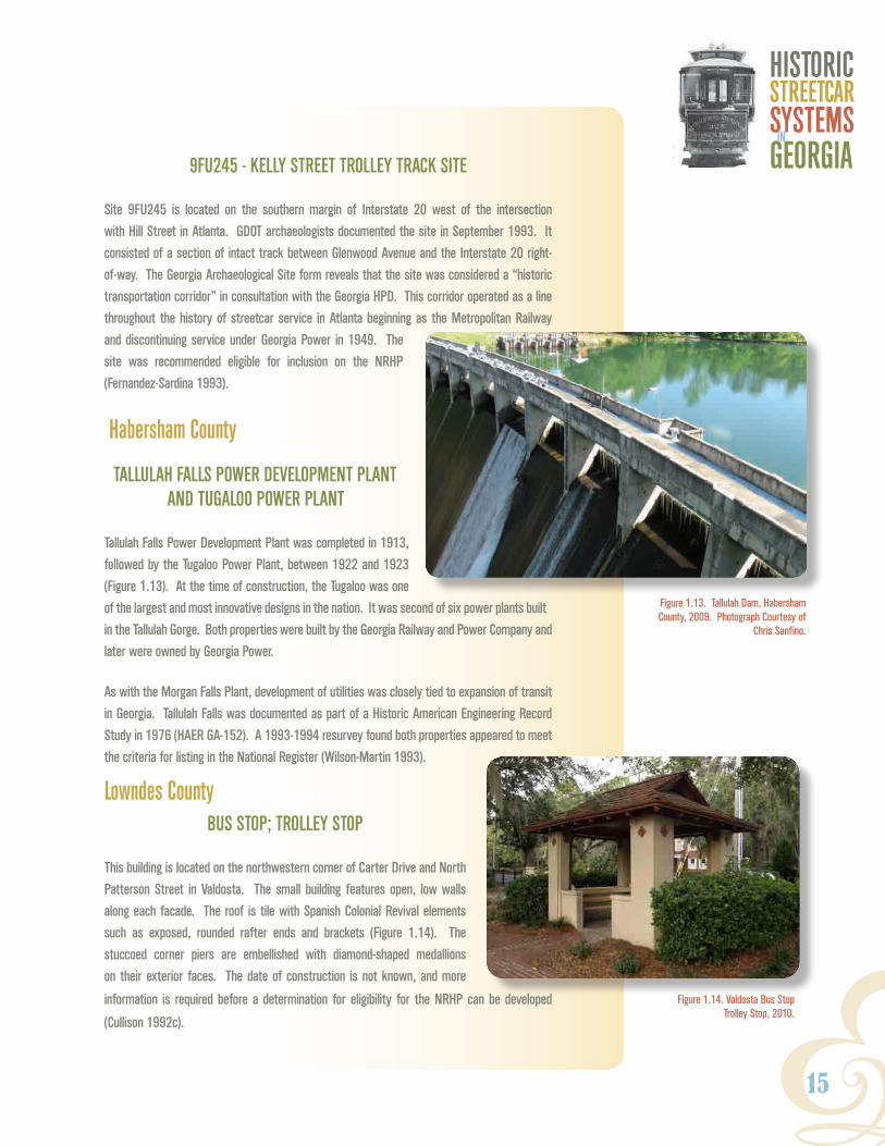
tallulah FallS PoweR develoPMent Plant and tugaloo PoweR Plant
Tallulah Falls Power Development Plant was completed in 1913,
followed by the Tugaloo Power Plant, between 1922 and 1923
(Figure 1.13). At the time of construction, the Tugaloo was one
of the largest and most innovative designs in the nation. It was second of six power plants built
in the Tallulah Gorge. Both properties were built by the Georgia Railway and Power Company and
later were owned by Georgia Power.
As with the Morgan Falls Plant, development of utilities was closely tied to expansion of transit
in Georgia. Tallulah Falls was documented as part of a Historic American Engineering Record
Study in 1976 (HAER GA-152). A 1993-1994 resurvey found both properties appeared to meet
the criteria for listing in the National Register (Wilson-Martin 1993).
Lowndes CountybuS StoP; tRolley StoP
This building is located on the northwestern corner of Carter Drive and North
Patterson Street in Valdosta. The small building features open, low walls
along each facade. The roof is tile with Spanish Colonial Revival elements
such as exposed, rounded rafter ends and brackets (Figure 1.14). The
stuccoed corner piers are embellished with diamond-shaped medallions
on their exterior faces. The date of construction is not known, and more
information is required before a determination for eligibility for the NRHP can be developed
(Cullison 1992c).
Figure 1.13. Tallulah Dam, Habersham County, 2009. Photograph Courtesy of
Chris Sanfino.

1 Introduction
16
Finally, the authors recognize that there are additional streetcar-related resources that are
contributing to listed NRHP districts; however, the majority of these properties are considered
significant under other contexts and not specifically as transportation resources. For example,
Savannah’s Landmark Historic District likely contains a wealth of streetcar-related resources, yet
none are necessarily individually recognized.
PUBLIC INPUT
At the close of research, field verification was performed in areas that had strong cultural resource
potential, with geophysical sampling conducted by the GDOT Archaeology Unit. The results of
the research and fieldwork were presented at a December 2010 meeting attended by the GDOT
Cultural Resources Section, Historic Preservation Division staff, Atlanta Regional Commission
members, faculty and students of the Georgia State University Heritage Preservation Program,
and the general public. Input from this meeting has informed this study. At the close of the
presentation and discussion, all attendees agreed that streetcar-related resources were significant
in the area of transportation and identifying them as a system within this context gave them greater
merit. This document follows that guidance.
DOCUMENT ORGANIZATION
Chapter 2 provides a historical context for Atlanta and the state’s historic streetcar systems.
Chapter 3 describes fieldwork results. Chapter 4 provides descriptions of the property types
that are found in the historical literature, that have been identified through survey, and that have
been previously recorded. Chapter 5 provides tools for identification, while Chapter 6 gives
guidelines for evaluation. The final chapter identifies areas for further research. The appendix
contains an alphabetical compilation of town and cities in Georgia that had streetcar lines. A brief
history is presented on each, as well as available maps and historic images. While some of these
overviews provide much of what is available on that town’s streetcar system, other overviews, such
as Savannah’s, only provide a preliminary look at a complex system that is arguably worthy of its
own context.

Y17
HISTORICSTREETCARSYSTEMSGEORGIAIn
2. ContextPrior to the rise of the automobile in the 1920s, streetcar service provided the American public
with an unprecedented level and scope of public transit access for countless people of varying
economic and social classes in cities and towns throughout the country. Horsecar lines, and
later electric streetcar lines, exerted a strong influence on the patterns of urban and suburban
development during the late nineteenth and early twentieth centuries. In addition to their primary
transportation function, streetcars were employed to provide a host of ancillary commercial and
municipal services, such as delivery and freight transport, group charters. Road paving and
infrastructure improvements were also a by-product of streetcar route construction. In Georgia
and elsewhere in the South during the Jim Crow Era, the streetcar sadly became a focal point
of racial antagonism and violence. Finally, streetcar companies and investors commonly also
developed local recreational areas and tourism spots as “traffic generators” to increase ridership
for their transit businesses. Today, residents often consider these places, which include garden
cemeteries and public parks, as valued community landmarks.
NiNteeNth-CeNtury street railroad developmeNt
The formation of street railway transportation systems in cities and towns across northern Europe
and North America was directly tied to the sweeping socioeconomic changes and technological
advancements wrought by the Industrial Revolution during the early decades of the nineteenth
century. Fed by railroad and canal transportation improvements, industrialization produced
unprecedented population growth and displacement as people migrated from the country to
the crowded, industrial towns in search of employment and higher wages (Mumford 1989:448-
449). Between 1800 and 1840, London’s population rose from 958,863 to over 1.9 million, while
industrial cities in the North of England, such as Manchester, exploded from 95,000 in 1800
to 455,000 by 1850. Over that same time, New York City had grown from 33,111 residents to
202,589, far surpassing Philadelphia as the largest city in the United States (Historical Census
Browser 2004).
Population growth during this period had an impact on urban development as cities began
expanding rapidly outward from concentrated centers to less dense peripheries (Blumenfield
1969:167). Downtown areas that were once completely accessible on foot began to spread out
over greater distances, creating a need for some method of public transportation to accommodate
working and middle-class urban residents who were unable to afford the costs of owning or renting

18
their own horse and carriage for the commute.
The establishment of omnibus service in
Paris in 1819, which consisted of scheduled
horse-drawn stagecoach routes, appears to
have been the first successful example of an
organized urban public transportation system
(Figure 2.1). Over the next 10 years, omnibus
transit was introduced in cities such as Boston,
London, New York, and Philadelphia (Middleton
1987:12).
the First street railway CompaNies
Despite its initial popularity, there were efforts to improve upon the low speed, uncomfortable ride,
and limited passenger capacity of omnibus service. The answer proved to be a technological
amalgam of the horse-powered omnibus coach running on a more efficient, modified railroad
track structure built within the right-of-way of city streets (Middleton 1987:13). The Swansea and
Mumbles Railroad Company pioneered passenger horsecar service in 1807 with an intercity
line connecting the coastal towns of Swansea and Mumbles in Wales. Popularly known as the
“Mumbles Train,” it was later converted to electric power and remained in operation until 1960
(Kneath 2006).
In August 1831, over 20 years after the development of the Swansea and Mumbles line, the
New York and Harlem Railroad was chartered by the state of New York as the first street railway
company in the United States. As with other utility enterprises during the nineteenth century
(e.g. gas lighting, canals, and railroads), the streetcar was strictly financed by private enterprise
(Meinig 1993:2:252). John Mason (1774-1839), president of the Chemical Bank of New York and a
wealthy landowner in the city, served as the head of the company and primary investors included
the politician and real-estate baron Samuel B. Ruggles (1800-1881). From the outset, streetcar
transit served as an auxiliary mechanism to facilitate real-estate development (Carman 1919:23).
The design and operation of the New York and Harlem Railroad streetcar system was prototypical
of those later established in other municipalities throughout the country during the nineteenth
century. The company’s charter allowed for the transportation of people and property “by the
power and force of steam, of animals, or of any mechanical or other power, or any combination of
them the said company may choose to employ” (Carman 1919:17). Irish-born coachbuilder, John
Stephenson (1809-1893), was commissioned to design the company’s first cars, which resembled
2 Context
Figure 2.1. Illustration of the Great Western Railway Omnibus, London. Source: Life Magazine 1901.

Y19
HISTORICSTREETCARSYSTEMSGEORGIAIn
the horse-drawn omnibus modified to run on
railroad track (Figure 2.2). They featured cast-
iron wheels, cloth padded wall interiors with a
40-passenger capacity, and doors located at the
rear of the car (Rowsome 1956:21). The track
consisted of cast-iron strap rail that was laid on
public streets in such a way “so as to cause no
impediment to the common and ordinary use
of the streets for all other purposes” (Carman
1919:22).
The Fourth Avenue Line, placed along Bowery
Street and Fourth Avenue between Fourteenth
Street and Prince Street, was the first section of built track and was put into operation as a horse-
drawn route in November 1832 (Middleton 1987:15). Over the next 10 years, the company converted
a segment of its Manhattan service to truncated steam locomotives, which were commonly known
as ‘dummy’ cars. However, complaints by downtown business owners and residents about the
noise and smoke of the dummy lines limited their operation to the neighborhoods located north
of Forty-second Street. By the 1850s, the company had extended its streetcar lines into Harlem
and as far north as White Plains and was conveying over 18 million passengers a year (Carman
1919:23-25 and Middleton 1987:21).
In 1835, two years after the start of the New York and Harlem Railroad line, the New Orleans
and Carrollton Railroad Company in New Orleans started
operations as the second street railway in the United
States. Like the New York system, the New Orleans
streetcar line was part of a real estate scheme to attract
development to the city. The first line consisted of horse-
drawn, double-decked cars pulled along a 1.75-mile route
on St. Charles Avenue from Canal Street in the downtown
district to Jackson Avenue in what was then the residential
suburb of Lafayette (Figure 2.3). The St. Charles Avenue
line remains the oldest continuously operating streetcar
line in the United States (American Society of Mechanical Engineers [ASME] 1984:2).
Despite the success of the New York and New Orleans streetcar lines, development of systems in
other cities throughout the United States stalled over the next 20 years (Middleton 1987:15). The
blame for this lack of expansion appears to be due to the Panic of 1837 and an ensuing five-year
Figure 2.2. New York and Harlem Railroad Car, circa 1850. Source: Middleton 1987.
Figure 2.3. Horse-drawn Streetcar on Canal Street, New Orleans, circa 1885. Source: Library of Congress Prints and Photographs Division.
20
depression, which resulted in a national collapse of the speculative real estate and infrastructure
markets, as well as high levels of unemployment (Meinig 1993:2:252). By the early 1850s, street
railroad development resumed as the economic outlook began to improve. In 1853, the New York
and Harlem Railroad started adding new lines to its system and the Brooklyn City Railroad Company
began operation of its horsecar line. Two competing streetcar lines were established in Boston
and the adjacent city of Cambridge three years later, in 1856. By 1858, horsecar public transit was
in operation in Philadelphia. On the eve of the Civil War in 1860, street railway service had been
established in more mid-size cities such as Baltimore and was spreading west into the young but
flourishing cities of Cincinnati, Louisville, Pittsburgh, and Chicago (Rowsome 1956:21).
From the beginning, steam dummy engines and horse-drawn streetcars were criticized by many
as both dangerous and dirty. Dummy engines were often prohibited from city streets because of
their noise and pollution, while disfiguring accidents and pedestrian deaths caused by frightened
horses and out-of-control streetcars were not uncommon in the bustling streets of many late
nineteenth-century American cities. The animals generally produced an average of ten-and-a-
half pounds of manure a day and an editorial in the 1886 New York World decried that “For filth,
dilapidation, and general appearance of squalor and slovenliness some streetcar lines in this
city cannot be surpassed in the civilized world” (Middleton 1987:21). Like their predecessor,
the omnibus, horse-drawn cars came to be viewed as cramped, poorly ventilated, and slow,
with average speeds normally reaching only five to six miles per hour. Capital and operating
costs for expenses for food and stabling could also be high. For the large streetcar companies in
cities such as New York, Boston, and Chicago, high numbers of horses or mules were needed to
maintain operations of the lines. Constant stopping and starting of loaded cars was hard on the
animals and most only worked a few hours a day over a period of three to five years before they
were retired from service (Rowsome 1976:24-25).
early street railways iN GeorGia
Streetcar operations in Georgia were delayed until after the Civil War. Unlike the commercial and
industrial cities of the Northeast and Midwest, antebellum Georgia, like other southern states,
was predominantly rural with an economy based on agricultural production, specifically cotton
and corn (Coleman 1991:163-165). Even by 1860, the urban population totals in Georgia, as with
other cities in the Southeast, remained low and were not conducive to the development of public
transportation (Table 2.1). Within the Deep South, only Nashville, Tennessee and New Orleans,
Louisiana had established street railway service prior to the war (Nashville Metropolitan Transit
Agency 2010).
2 Context

Y21
HISTORICSTREETCARSYSTEMSGEORGIAIn
table 2.1. 1860 population totals of southeastern Cities
City population (1860) National rank in population size
New Orleans, LA 168,675 6
Charleston, SC 40,522 22
Savannah, GA 22,292 41
Memphis, TN 22,623 38
Nashville, TN 16,988 54
Augusta, GA 12,493 77
Columbus, GA 9,621 97
Atlanta, GA 9,554 99
Macon, GA 8,132 Not Ranked in Top 100
Source: U.S. Bureau of Census 2010.
Following the close of the Civil War in April 1865, Georgia’s agricultural economy and much of its railroad infrastructure was in ruins. Despite the destruction, major municipalities within the state witnessed a relatively quick recovery and unprecedented population growth in the decades after the war. Mining and lumber industries were established in the northern and southern reaches of Georgia, while former cotton markets such as Augusta, Athens, Columbus, and Macon turned to textile manufacturing. It was the city of Atlanta, however, which benefited the most during the Reconstruction Era of the late nineteenth century, as it developed into a major distribution and financial center in the state and region due to its extensive railroad connections (Coleman 1991:233-236). In 1870, five years after the Civil War, Atlanta’s population stood at 21,798, more than double its pre-war total. By 1880, the number of Atlanta residents had exploded to 37,409 (U.S. Bureau of Census 2010).
The charter of four street railway companies in Atlanta, Augusta, Columbus, and Savannah by the Georgia General Assembly in 1866 appears to be an early indication of anticipated economic growth and urbanization among business and civic leaders in each respective city. The charters for the Atlanta Street Railway Company, the Augusta and Summerville Railroad Company, the Columbus Railroad Company, and the Savannah City Railway Company (later renamed the Savannah, Skidaway and Seaboard Railroad), all stipulated the necessary amount of capital stock required for each company, the right to convey both passengers and freight, and specific limits on track construction and placement. Both Atlanta’s and Columbus’ charters prohibited the use of steam engines on city streets. Other general regulations governed the operating speeds of streetcars, as well as right-of-way priorities with regard to other vehicles on the road (Thomas 1895:350-384). In Georgia and throughout the South, transit companies generally preferred to
use mules for streetcar service because they were typically cheaper to purchase and feed than
horses, less affected by the heat, and only slightly less strong (Rowsome 1956:25).

22
augusta and summerville railroad
The Augusta and Summerville Railroad,
which became the first streetcar line in
Georgia, began operation on January 9,
1868. The network consisted of seven
miles of mule-drawn passenger lines and
one-and-a-half miles of steam locomotive
freight track (Figure 2.4). The Augusta
and Summerville Railroad originally ran
from the lower market house on Broad
Street in downtown Augusta out to the
U.S. Arsenal (now the site of Augusta
State University) in the suburb of
Summerville (Langley and Langley 1972:1). Bells were hung on
the harnesses of the horses as a way to notify riders of the impending arrival of the streetcars
(Augusta Unit of the WPA Writer’s Program, n.d.).
savannah, skidaway and seaboard railroad
In July 1868, the Savannah, Skidaway, and Seaboard Railroad (S. S. and S.) began preparatory work on the construction of the company’s car barn and preliminary 11-mile streetcar line from Savannah to the Isle of Hope resort, with two branches to the coastal leisure areas of Montgomery and White Bluff (D’Alonzo 1999:11). The partially constructed route was opened in January 1869 as the second horsecar street railway in the state (Figure 2.5). Track work was eventually completed and service began in March 1870 to the Isle of Hope, a popular leisure destination among Savannah residents (Eason 1971:13). The branch lines to Montgomery and White Bluff were opened just over a year later in April 1871. Over the next few years, other Savannah businessmen who sensed that there were profits that could be made by providing mass transit and tourist access to outlying suburban resort areas, began investing in and organizing rival streetcar companies. The Savannah, Thunderbolt, and Isle of Hope Railroad Company was incorporated in 1871 and began developing a line to the Thunderbolt, Beaulieu, and Montgomery suburbs before it was purchased by the S. S. and S. in 1874. The Coast Line Railway Company (originally chartered as the Wilmington Railroad Company in October 1868 and reorganized in 1872) proved to be the biggest competitor to the S. S. and S. Starting in 1873, the Coast Line Railway began developing alternate lines along city streets and to the resort community of Thunderbolt with stops
in Bonaventure and Catholic cemeteries (D’Alonzo 1999:10,15,17).
2 Context
Figure 2.4. Streetcars Traveling Along Broad Street in Augusta, circa 1880. Source: Vanishing Georgia, Georgia Division of Archives and History, Office of Secretary of State.

Y23
HISTORICSTREETCARSYSTEMSGEORGIAIn
atlanta street railway
Although one of the first street railways incorporated in the state and backed by prominent Atlanta
citizens and businessmen, the initial franchise of the Atlanta Street Railway Company was delayed
due to burdensome demands issued by the Atlanta City Council
regarding fare limits and track construction. By 1870, sudden
post-war growth had pushed the Atlanta city boundaries to a
radius of three miles and the need for a public transportation
system became more urgent. The solution came in April 1871,
when Atlanta businessmen George W. Adair (1823-1899) and
Richard Peters (1810-1889) purchased the original charter
and franchise of the Atlanta Street Railway Company (Martin
1975:1:2). Both Peters and Adair had deep ties to the young
city, having worked on the construction of the Central of
Georgia railroad line to Atlanta in the 1840s. After the Civil
War, the two men became heavily involved in real estate and
viewed streetcar service as a marketing tool for the suburban
development of their property in the north and southwest
sections of the city (Figure 2.6) (Klima 1982:68).
The Atlanta Street Railway Company’s first mulecar route,
known as the ‘West End’ line, was partially opened with free
rides for the public on September 9, 1871. The two-mile line was
Figure 2.5. Savannah, Skidaway, and Seaboard Railroad Company Horsecar, circa 1869. Source: D’Alonzo 1999.
Figure 2.6. Adair Company Real Estate Advertisement for West End, 1883. Source: Klima 1983

24
built of cast-iron track and began near Peters’ home at Mitchell and Forsyth streets in downtown
Atlanta (Figure 2.7). From there, it traveled southwesterly along Whitehall, Mitchell, Forsyth, and
Peters streets where it ended at Adair’s property opposite the McPherson Barracks (near present-
day Spelman College). The streetcar company was the city’s fourth chartered utility after the steam
railway, telegraph, and gas service (Garrett 1988:1:863-864). Between 1871 and 1878, existing
routes were extended and additional lines were built along Peachtree Street to the popular Ponce
de Leon Springs Park to the north of downtown, south along Washington and McDonough streets
(now Capital Avenue), to the northwest along Marietta Street, and east along Decatur Street to
Oakland Cemetery (Martin 1975:1:6-8). The Atlanta Street Railway erected its livery stables and
two-story masonry car shed across from one another on Line Street (now Exchange Place) near
the intersection with Ivy Street (now Peachtree Center Avenue) in 1874. By 1881, the company
owned 17 cars, 114 mules, and operated six lines totaling 11 miles of track throughout the city
2 Context
Figure 2.7. Atlanta Street Railway Cars on Whitehall Street, circa 1872. Source: Carson 1981.

Y25
HISTORICSTREETCARSYSTEMSGEORGIAIn
(Figure 2.8) (King 1939:252). The Atlanta Street Railway Company enjoyed a near monopoly of
the streetcar business until the incorporation of the Metropolitan Street Railroad Company in 1883.
It was also the largest public transportation system in the city before its merger with the Atlanta
Consolidated Street Railway in 1891 (Klima 1982:73).
Figure 2.8. Extent of Atlanta Street Railway Company System, 1871-1891.

1 Introduction
26
The Metropolitan Street Railway was organized by prominent businessmen Lemuel P. Grant and
Jacob Haas to develop real estate in the southeastern section of Atlanta (Figure 2.9). Grant
donated the land comprising Grant Park to the City of Atlanta as a means of generating traffic
for the line and attracting potential home buyers to the prospective neighborhood. In 1887, the
Metropolitan Street Railway began powering its lines with steam dummy locomotives and in 1891
it became the first streetcar company in Atlanta to extend service to nearby Decatur (Figure 2.10)
(Carson 1981:9-11).
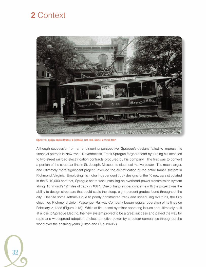
additional streetcar systems in Georgia
Due to the relatively low start-up costs needed to establish horse-drawn streetcar service, public
transit systems were developed throughout the state during the 1870s and 1880s. The streetcar
was viewed as a defining symbol of municipal growth and civic progress for local political and
business leaders. The Macon Street Railroad Company, which was incorporated in 1868, started
construction of its mule-drawn streetcar line in September 1871 and began service throughout
the city shortly thereafter (Thomas 1895:364, Young et al. 1950:312). Macon was followed by the
Gainesville Street Railway Company, which was organized in 1875 and ran a two-mile track from
the Southern Depot through the central downtown and out to Gower Springs, just northwest of the
city (Norton 2001:20). Although the Columbus Street Railroad Company was one of the first transit
companies in Georgia to receive a charter, implementation of streetcar service was delayed until
1884 when two miles of track were laid and the system began operation (Karfunkle et al. 1977:2).
In 1887, the Columbus Street Railroad, under the new ownership of local businessmen and real-
estate developers, John F. Flournoy and L.F. Garrard, operated three miles of track and 18 cars
that were powered by 32 mules (Atlanta Historical Association 1975:2:613 [1895]; Poor’s Railroad
Manual Company 1887:237). The Rome Street Railway Company and the Classic City Street
Railway Company in Athens both began service in 1885 (Aycock 1981:255, Barrow 1923:18).
Until the 1890s, many of Georgia’s large and mid-sized cities supported multiple lines built by
competing transit companies, while those in smaller towns consisted of nothing more than a few
horses or mules, one or two secondhand passenger cars, and a strip of iron track laid through
the center of the main street (Carson 1981:IX). In 1888, the Brunswick Company developed a
small mulecar line on the St. Simons Island beach resort to ferry tourists from the pier to nearby
Hotel St. Simons (Figure 2.11) (Bagwell 2010a). That same year, the Covington and Oxford Street
Railway Company finally established a horsecar line for the conveyance of city residents and
Emory College students. It was believed to have been the last animal-powered line in existence

Y27
HISTORICSTREETCARSYSTEMSGEORGIAIn
2 Context
Figure 2.10. Metropolitan Street Railroad Routes, 1883-1891.
Figure 2.9. Metropolitan Street Railroad Steam Dummy Engine. Source: Carson 1981

28
when it discontinued service in 1917 (Atlanta Chamber of Commerce 1917:24). Both Griffin and
LaGrange also briefly featured streetcar lines during the 1890s (Melton 1959:204; Troup County
Historical Society 1993).
searCh For other Forms oF motive power
At the same time as new streetcar lines were being established throughout Georgia during the
1870s and 1880s, many older transit companies located in the more urbanized regions of the North
and West were strongly committed to finding cheaper, relatively cleaner, and more reliable forms
of traction to replace existing horse-powered lines. The “Great Epizootic,” a virulent outbreak
of equine influenza that spread south from Canada, throughout the Northeast and Mid-Atlantic
states, then into Louisiana during the fall of 1872, proved to be a major impetus for developing
newer systems of mechanical streetcar operation. Over the course of the epidemic, the stable-
borne disease killed between 175 and 200 horses a day in some cities and drastically curtailed
or eliminated streetcar service in affected areas (Rowsome 1956:28). In desperation, a few
companies temporarily employed oxen and even men (Figure 2.12).
Noisy and dirty steam-powered dummy locomotives, which had long been banned from public
streets in some municipalities, were generally not considered to be a viable substitute for widespread
streetcar use despite efforts to develop so-called “fireless-engine” cars that operated on gas and
liquid ammonia, compressed air, gasoline, or soda water (Middleton 1987:34). Andrew S. Hallidie
(1836-1900), a London-born San Francisco businessman, produced one of the more successful
mechanized streetcar alternatives with his invention of the cable railway in the 1870s. The simple
2 Context
Figure 2.11. St. Simons Island Mule-Drawn Railway, circa 1890. Source: Coastal Georgia Historical Society 1973.

Y29
HISTORICSTREETCARSYSTEMSGEORGIAIn
system, which powered streetcars by allowing them to grip spinning loops of underground cable
wire, was designed to scale the steep grades in San Francisco that were often insurmountable by
horsecar (Figure 2.13). Hallidie’s first operational cable car line was installed along Clay Street
in 1873, with additional routes on Sutter Street in 1877 and California
Street shortly thereafter (Rowsome 1956:51-52). Based on the system’s
success in San Francisco, the cable car replaced horsecar service in 28
other cities across the United States, including Chicago, Denver, New
York, St. Louis, and Washington D.C. Nevertheless, high installation
costs and difficulties associated with maintaining and repairing cables
limited its widespread adoption in the period before electrification
(Middleton 1987:48-50).
Enterprising American and European inventors first began conducting
experiments using primitive electric batteries as a source of locomotive
power during the 1820s and 1830s. It was not until the successful
development of electric generators, or dynamos, between 1860 and
Figure 2.12. Illustration of Human–Pulled Streetcar in New York City During the Great Epizootic, circa 1870. Source: Middleton 1987.
Figure 2.13. Cut-Away Illustration of Cable Railway Car. Source: Street Railway Journal April 1884.

30
1870 that great strides were made in developing
preliminary electric railroad systems over the
ensuing decades (Middleton 1987:54-55). In
1880, Thomas A. Edison constructed a small
electric railway capable of reaching 40 miles
per hour at his Menlo Park, New Jersey
laboratories; however, his general interest
in electrical applications for streetcar transit
remained limited (Figure 2.14). German inventor Ernst Werner von Seimens (1816-1892) is often credited with building the first commercial electric railroad prototype at Lichterfelde, near Berlin in 1881, but the system’s design flaw, providing supply power through the running rails, often shocked bystanders and animals (Rowsome 1956:67-68). Other notable, but ultimately unsuccessful early electrified systems, included British inventor Leo Daft’s (1843-1922) tractor-based streetcar model that ran in Baltimore, Maryland, Asbury Park, New Jersey, and Los Angeles, California, among other cities during the late 1880s (Figure 2.15); the Bentley-Knight Company’s underground conduit system was briefly used in Cleveland, Ohio, Allegheny City, Pennsylvania, and Boston, Massachusetts from 1885 to 1889; overhead electric wire lines developed by Belgian-born inventor and businessman Charles J. Van Depoele (1846-1892), in a number of cities such as South Bend, Indiana, Scranton, Pennsylvania, and Appleton, Wisconsin between 1885 and 1886. Van Depoele has the distinction of installing the world’s first fully electrified system in Montgomery, Alabama in 1886, and he is also recognized as perfecting the widely adopted, spring-raised troller, or trolley pole, which transmitted overhead current collection to the car motor (Due and Hilton 1960:6). Despite some advances, these pioneer systems ultimately
proved to be unreliable for sustained commercial service and were often replaced just a few years
after implementation (Middleton 1987:59, 62 ,64-65).
FraNk J. spraGue aNd the eleCtriC streetCar
The ground-breaking innovations of
one man in particular, engineer Frank
J. Sprague (1857-1934), are generally
credited with the development and
expansive growth of the modern electric
2 Context
Figure 2.15. Illustration of Daft Electric Railway System in Baltimore, 1887. Source: Street
Railway Journal April 1887.
Figure 2.14. Illustration of Thomas Edison’s Menlo Park Electric Railway, 1880. Source: Middleton 1987.

Y31
HISTORICSTREETCARSYSTEMSGEORGIAIn
streetcar in the United States and abroad during the late nineteenth century (Figure 2.16). A native
of Milford, Connecticut, Sprague developed an interest in electricity while still an undergraduate
at the U.S. Naval Academy in Annapolis, Maryland (Street
Railway Journal [SRJ] 1894:10:111). Following his resignation
from the Navy in 1883, he took a job as an assistant to Thomas
Edison in Menlo Park. In 1884, Sprague founded his own
company, Sprague Electric Railway and Motor Company, to
concentrate on the development of railway electrification, an
idea that had fascinated him since his time spent riding the
London steam-locomotive underground railway during the
early 1860s (Rowsome 1956:82).
Sprague’s initial work was sponsored by New York financier
Jay Gould and focused on converting the city’s elevated
transit system from steam power to electric. It was through
these experiments, conducted along a 200-foot section of
track wedged in a small alley off East Twenty-fourth Street in
Manhattan in 1886, that Sprague began producing designs for
spring-mounted, two gear-drive motor, independent truck frames. These “wheelbarrow fashion”
mounts, as Sprague referred to them, would soon revolutionize the streetcar industry (Figure 2.17).
Another of his engineering innovations was “regenerative braking” that used the car motors as
power generators during the braking process (Middleton 1987:67 and Rowsome 1956:85-86).
Figure 2.17. Illustration of the Sprague Electric Motor. Source: Street Railway Journal June 1887.
Figure 2.16. Frank J. Sprague (1857-1934). Source: Middleton 1987.
32
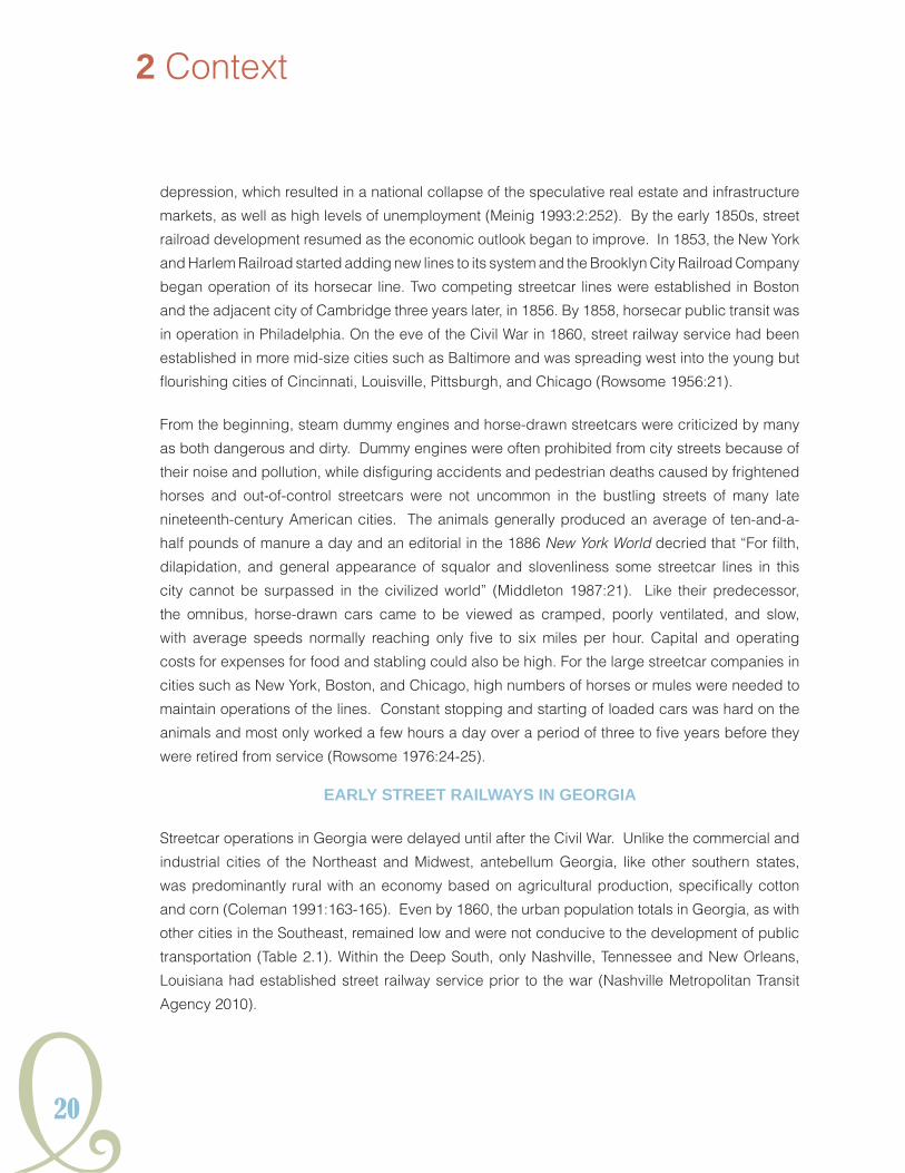
Although successful from an engineering perspective, Sprague’s designs failed to impress his
financial patrons in New York. Nevertheless, Frank Sprague forged ahead by turning his attention
to two street railroad electrification contracts procured by his company. The first was to convert
a portion of the streetcar line in St. Joseph, Missouri to electrical motive power. The much larger,
and ultimately more significant project, involved the electrification of the entire transit system in
Richmond, Virginia. Employing his motor independent truck designs for the 40 new cars stipulated
in the $110,000 contract, Sprague set to work installing an overhead power transmission system
along Richmond’s 12 miles of track in 1887. One of his principal concerns with the project was the
ability to design streetcars that could scale the steep, eight percent grades found throughout the
city. Despite some setbacks due to poorly constructed track and scheduling overruns, the fully
electrified Richmond Union Passenger Railway Company began regular operation of its lines on
February 2, 1888 (Figure 2.18). While at first beset by minor operating issues and ultimately built
at a loss to Sprague Electric, the new system proved to be a great success and paved the way for
rapid and widespread adoption of electric motive power by streetcar companies throughout the
world over the ensuing years (Hilton and Due 1960:7).
2 Context
Figure 2.18. Sprague Electric Streetcar in Richmond, circa 1888. Source: Middleton 1987.

Y33
HISTORICSTREETCARSYSTEMSGEORGIAIn
eleCtriFiCatioN iN GeorGia
Prior to 1888 and Sprague’s Richmond streetcar installation, only 86 miles of track in the United
States were powered by electricity. By the turn of the century, there were more than 22,000 miles
of electrified track (Middleton 1981:73, 77). In major metropolitan areas, the horsecar and steam
dummy engine lines became an instant anachronism, although the older systems generally found
continued use in smaller towns and communities. The electric streetcar, which offered cheaper,
faster, and more efficient service than the horsecar, became a symbol of modernity for many
during the late nineteenth and early twentieth centuries.
Atlanta businessman Joel Hurt (1850-
1926) was the first to establish an
electrified streetcar system in Georgia
(Figure 2.19). Hurt was a native of
Alabama and had studied as a civil
engineer before his arrival in Atlanta in
1875. He quickly established himself as
a shrewd and successful businessman,
organizing the Atlanta Home Insurance
Company in 1882 and the East Atlanta
Land Company in 1886 to promote
his development of the Inman Park
neighborhood, the city’s first planned
residential suburb (Garrett 1988:2:188).
Hampered by a lack of direct access
to the eastern edges of the Atlanta city
limits and intrigued by the novelty and
reliability of Sprague’s success with
electric traction, Hurt began planning for
the construction of a streetcar line as part
of his real estate venture (Simms Edge
1953:142).
The Atlanta and Edgewood Street Railroad Company was chartered in 1886 with Hurt as the primary
incorporator and proponent of the line. Construction of the streetcar began in September 1888
along the newly opened Edgewood Avenue corridor that stretched from Pryor Street in downtown
Atlanta to Inman Park, two miles to the east (Figure 2.20). Operation of the first electrified line
began on August 22, 1889 as a single Atlanta and Edgewood Street Railroad car made its maiden
Figure 2.19. Joel Hurt (1850-1926). Source: Martin 1975.

34
voyage along Edgewood Avenue with Joel Hurt at the helm (Garrett 1988:2:189). Afterwards,
three cars maintained a regular 30-minute round-trip schedule from downtown to Inman Park
(Figure 2.21). The route soon became a favorite excursion for Atlanta residents and trailers were
added to the cars on Sundays to accommodate sightseers (Carson 1981:16).
2 Context
Figure 2.20. Atlanta and Edgewood Street Railroad Routes, 1889-1891.

Y35
HISTORICSTREETCARSYSTEMSGEORGIAIn
Following Joel Hurt’s success in August of 1889,
additional electric streetcar companies were
quickly established in Atlanta and throughout
Georgia. The Fulton County Street Railroad
Company was the second electric traction
system in the state, commencing operations in
December 1889 (Figure 2.22). The transit line
was originally incorporated in 1883 with the
purpose of attracting real estate development
to the Copenhill area in the present day Old
Fourth Ward, Poncey-Highlands, and Virginia-
Highlands neighborhoods of Atlanta. The
company’s “Nine-Mile Circle” round trip
excursion through the forested northeastern
section of the city became a popular picnic and
sightseeing route among middle-class white
Atlantans during the 1890s (Martin 1975:1:27).
Figure 2.21. Atlanta and Edgewood Street Railroad Cars Traveling West Along Edgewood Avenue, 1889. Source: Street Railway Journal, September 1889.
Figure 2.22. Fulton Street Railroad Car at Baltimore Place, circa 1890. Source: Carson 1981.

36
Surprisingly, the middle Georgia town of Americus appears to have been the second municipality
to establish electric streetcar service in January 1890, but the line was discontinued just a year later
due to lack of sufficient ridership (MSS Series Mules to Marta, MSS 619, Carson to Martin, April 13,
1977). Americus was followed later that year by the Savannah Street Railway Company (D’Alonzo
1999:30). Over the next two years, Athens, Augusta, Macon, Columbus, and Rome would all
feature one or more competing electrified transit lines (Figure 2.23). The lure of electric streetcar
service as a standard for municipal progress proved to be strong for small and growing cities in
Georgia through the early years of the twentieth century, even with the precipitous rise in automobile
ownership during this period. Valdosta established an electric streetcar network in 1900, while
Gainesville and Brunswick systems began service in 1903 and 1909, respectively (Figure 2.24).
2 Context
Figure 2.23. City Electric Railway Streetcar, Rome, circa 1900. Source: Rome Area History Museum.

Y37
HISTORICSTREETCARSYSTEMSGEORGIAIn
Albany and Waycross developed
electric streetcar systems as late as
1911; however, both lines proved to
be financially, as well as practically,
unfeasible and were relatively short-
lived (Nicholas 1914:43 and McGraw-
Hill Company 1920:25).
streetCar expaNsioN aNddeCliNe iN the tweNtieth CeNtury
street railroad CoNsolidatioN
Within two years of Joel Hurt’s establishment of the first electrified streetcar line in Atlanta, he began
setting plans in motion to consolidate many of the larger transit systems operating in the city, both
electric and non-electric, under his control. Along with principal incorporators Charles Coffin,
Judge H.E.W. Palmer, and Alfred Glasier of Boston, Massachusetts, Hurt coordinated the merger
of the Atlanta and Edgewood Street Railroad Company, Richard Peters’ Atlanta Street Railway
Company, the Fulton County Street Railroad Company, the Gate City Street Railroad Company,
and the West End and Atlanta Street Railroad Company. Most of these older companies were
either financially unwilling or unable to invest in the required infrastructure needed for electric
traction. With $2 million in capital stock, Hurt’s new venture, the Atlanta Consolidated Street
Railway Company was chartered by the State of Georgia on May 16, 1891. Final approval of the
five mergers was formalized on September 22, 1892. Two months later, on November 22, 1892,
the Metropolitan Street Railroad Company was acquired. The Lithia Springs Railway was the last
company to be purchased in 1895 (Carson 1981:21-22).
During the decade of the 1890s, Joel Hurt reigned over the most expansive and profitable
streetcar company in Atlanta. The first few years of Atlanta Consolidated’s history were dedicated
to converting most of the inherited horsecar and steam dummy lines to the modern technology of
the Thomson-Houston Company electrified systems, eliminating redundant routes, and extending
service into developing areas. Retracking proved to be an unexpected costly undertaking due
Figure 2.24. Valdosta Street Railway Streetcar, circa 1905. Source: Valdosta Museum and Lowndes County Historical Society.

38
2 Context
Figure 2.25. Streetcar Track Construction at Marietta and Broad Streets, Atlanta, 1891. Source: Tracy O’Neal Photographic Collection, Special Collections Department, Georgia State University Library.
to the city’s requirements that upgraded streets were to be paved at the company’s expense (Figure 2.25) (Martin 1975:1:37). In 1894, the Atlanta Consolidated owned 40 cars running along approximately 54 miles of track throughout the city, of which 44 miles was electrified (Figure 2.26). Mulecars still ran along the mile-long Wheat Street line (later Auburn Avenue) in the African American neighborhood east of the downtown district and dummy locomotives were retained for the nine miles of track along the South Decatur and Soldiers Home lines in the east and southeast parts of the city (Carson 1981:23).
Despite the financial panics of 1873 and again in 1893, Atlanta’s growth had continued relatively unabated since the end of the Civil War, transforming the former primitive railroad junction into the self-proclaimed “Capital of the New South” over the latter half of the nineteenth century. In 1890, the population stood at 65,533 residents, making it the forty-second largest city in the nation (U.S. Census). In addition to the Atlanta Consolidated Street Railway Company, Atlanta also supported
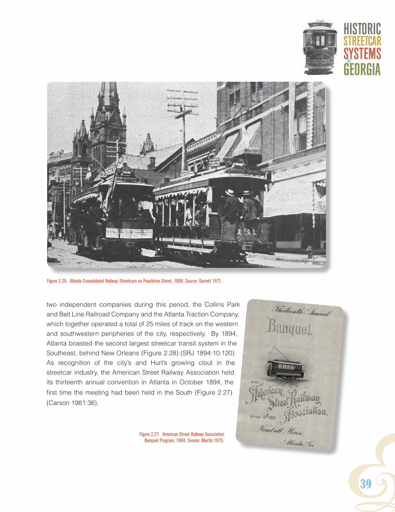
Y39
HISTORICSTREETCARSYSTEMSGEORGIAIn
two independent companies during this period, the Collins Park and Belt Line Railroad Company and the Atlanta Traction Company, which together operated a total of 25 miles of track on the western and southwestern peripheries of the city, respectively. By 1894, Atlanta boasted the second largest streetcar transit system in the Southeast, behind New Orleans (Figure 2.28) (SRJ 1894:10:120). As recognition of the city’s and Hurt’s growing clout in the streetcar industry, the American Street Railway Association held its thirteenth annual convention in Atlanta in October 1894, the
first time the meeting had been held in the South (Figure 2.27)
(Carson 1981:36).
Figure 2.26. Atlanta Consolidated Railway Streetcars on Peachtree Street, 1898. Source: Garrett 1971.
Figure 2.27. American Street Railway Association Banquet Program, 1894. Source: Martin 1975.

1 Introduction
40
Figure 2.28. Extent of Nineteenth-Century Atlanta Streetcar System Expansion, 1871-1895. Source: Atlanta Regional Commission
2 Context

Y41
HISTORICSTREETCARSYSTEMSGEORGIAIn

42
the seCoNd Battle oF atlaNta
As Joel Hurt was solidifying his control of the Atlanta
streetcar industry with Atlanta Consolidated Railway
Company, his future rival, Henry M. Atkinson (1862-
1939) was building the foundations of his own
fledgling utility, the Georgia Electric Light Company,
whose successor, the Georgia Railway and Power
Company would come to dominate both public
transportation and electrical power production
throughout the state during the twentieth century
(Figure 2.29). Atkinson was born into wealth in
Brookline, Massachusetts and graduated from
Harvard University in 1884 before moving to Atlanta
in 1886 and becoming involved in cotton trading and
2 Context
Figure 2.29. Henry M. Atkinson (1862-1939). Source: Wright 1957.
Figure 2.30. Davis Street Steam Generating Plant, circa 1892. Source: Wright 1957.

Y43
HISTORICSTREETCARSYSTEMSGEORGIAIn
banking interests in the city (Garrett 1988:2:243). Looking to capitalize on the lack of adequate
electric power facilities in Atlanta, Atkinson bought controlling stock in the Georgia Electric Light
Company in September 1891 with financial backing provided by investors located in his native
Boston (Wright 1957:31-32). That same year, he also cofounded the Southern Banking and Trust
Company and was made president of the Atlanta Traction Company, his first foray into the electric
streetcar business (Martin 1975:1:44-45).
In 1892, work was completed on the Georgia Electric Light Company’s Davis Street Plant, the first
steam generating facility in Atlanta, which was capable of supplying power to 305 arc lamps and
64 incandescent lamps (Figure 2.30) (Garrett 1988:2:243). By 1897, the company produced net
earnings over $78,000 a year, with over 400 customers listed in Atlanta. Among those served
were contracts for the City of Atlanta, a portion of the electrical requirements of Joel Hurt’s Atlanta
Consolidated Railway, and all of the power needed to operate the small Atlanta Railway Company,
which was organized in 1895 (Wright 1957:41).
The public and personal clash
between Joel Hurt and Henry
Atkinson for the monopolization of
Atlanta’s public utilities, popularly
known as the “Second Battle of
Atlanta,” flared across the pages
of city newspapers in 1899
(Figure 2.31). The fight began
during preliminary negotiations
held between Hurt and Atkinson
to navigate a merger of the
Atlanta Consolidated Railway
with the smaller Atlanta Railway
and Atlanta Electric Railway
companies. Hurt’s plans to build
a new power generating plant
as part of the deal seemed to
have struck Atkinson as an open
challenge to Georgia Electric
Light (Martin 1975:1:76).
Figure 2.31. Atlanta Newspaper Cartoon Deriding Street Railway Monopolization, circa 1900. Source: Martin 1975.

44
In reality, however, it appears Atkinson was also preparing to wrest control of the city’s streetcar
system from Hurt’s command. As accusations and recriminations played out in public, Atkinson
skirted Georgia laws that prohibited electric companies from engaging in street railroad operations
by independently purchasing controlling interest in the financially struggling Collins Park and Belt
Railroad. Changing the name of the company to Atlanta Rapid Transit Company, Atkinson applied
to the city for a franchise to develop competing lines along 50 streets that paralleled the most
profitable routes of Atlanta Consolidated (Carson 1981:41).
Through the spring and summer of 1899, Hurt battled Atkinson with court injunctions to deny
the franchise routes that would severely undercut Atlanta Consolidated’s profits (reorganized as
the Atlanta Railway and Power Company in July 1899). Meanwhile, Atkinson accused Hurt of
engaging in monopolistic practices and sought to curry favor with the Atlanta City Council by
offering to pay for a portion of the construction of the Whitehall Street Viaduct over the railroad
tracks in return for operation privileges along Hurt’s lines along segments of Peachtree, Alabama,
and Mitchell streets with compensation (Wright 1957:26-47). The franchises were finally granted
in August 1899 and work began on Atlanta Rapid Transit’s new lines in early 1900. By the end of
1901, Atkinson’s Atlanta Rapid Transit Company had installed approximately 33.3 miles of track
adjacent to existing Atlanta Railway and Power Company routes and was undercutting Hurt by
charging just over three cents per ride on its operational lines (Figure 2.32). Prodded by investors
and recognizing the declining value of his company, Joel Hurt finally agreed to exit the streetcar
2 Context
Figure 2.32. Atlanta Rapid Transit Company Streetcar, circa 1900. Source: Garrett 1971.
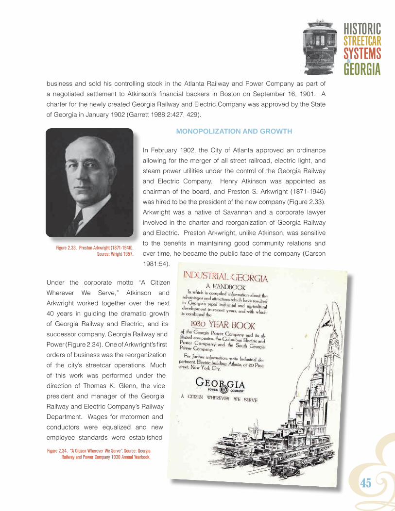
Y45
HISTORICSTREETCARSYSTEMSGEORGIAIn
business and sold his controlling stock in the Atlanta Railway and Power Company as part of
a negotiated settlement to Atkinson’s financial backers in Boston on September 16, 1901. A
charter for the newly created Georgia Railway and Electric Company was approved by the State
of Georgia in January 1902 (Garrett 1988:2:427, 429).
moNopolizatioN aNd Growth
In February 1902, the City of Atlanta approved an ordinance
allowing for the merger of all street railroad, electric light, and
steam power utilities under the control of the Georgia Railway
and Electric Company. Henry Atkinson was appointed as
chairman of the board, and Preston S. Arkwright (1871-1946)
was hired to be the president of the new company (Figure 2.33).
Arkwright was a native of Savannah and a corporate lawyer
involved in the charter and reorganization of Georgia Railway
and Electric. Preston Arkwright, unlike Atkinson, was sensitive
to the benefits in maintaining good community relations and
over time, he became the public face of the company (Carson
1981:54).
Under the corporate motto “A Citizen
Wherever We Serve,” Atkinson and
Arkwright worked together over the next
40 years in guiding the dramatic growth
of Georgia Railway and Electric, and its
successor company, Georgia Railway and
Power (Figure 2.34). One of Arkwright’s first
orders of business was the reorganization
of the city’s streetcar operations. Much
of this work was performed under the
direction of Thomas K. Glenn, the vice
president and manager of the Georgia
Railway and Electric Company’s Railway
Department. Wages for motormen and
conductors were equalized and new
employee standards were established
Figure 2.33. Preston Arkwright (1871-1946). Source: Wright 1957.
Figure 2.34. “A Citizen Wherever We Serve”. Source: Georgia Railway and Power Company 1930 Annual Yearbook.

46
(Wright 11957:80, 101). Redundant lines built as part of the brief, but fierce competition between
the two streetcar interests during the “Second Battle of Atlanta,” were abandoned, while profitable
routes were upgraded and double-tracked for more efficient service (Figure 2.35). Suburban
expansion began in 1902 with the extension of the East Point line to College Park and the opening
of branch lines in 1907 to Buckhead north of
Atlanta and Hapeville south of the city (Figure
2.36) (Garrett 1988:2:429). The company’s first
interurban line from Atlanta to Marietta, which
was operated by the subsidiary Atlanta Northern
Railway Company, opened in 1905. By 1913,
Georgia Railway and Power had doubled the
number of streetcars in operation from 116
to 264 (Martin 1977:31). Street railroad track
mileage was expanded from approximately 138
miles at the time of the merger in 1901, to 200
miles by 1914 (Beeler 1924a:74). Only Salt Lake
City eclipsed Atlanta as having the highest ratio
of street railroad track mileage per 1,000 people
(Wright 1957:47).
To power the growing streetcar system and consumer market in Atlanta and other parts of Georgia,
the Georgia Railway and Electric also embarked on a massive infrastructure improvement
campaign. Among the company’s existing power plants were the Davis Street Steam Plant and
the Butler Street Steam Plant, which had been acquired in the merger with Atlanta Railway and
Power. The Atlanta Gas Light Company was acquired in 1903 and the Morgan Falls Hydroelectric
Plant, located on the Chattahoochee River 17 miles north of Atlanta, was completed in October
1904. Plans for additional hydroelectric power were drawn up in 1910 for a larger plant at Tallulah
Falls in the North Georgia region (Figures 2.37 and 2.38). In 1911, the Georgia Railway and Power
Company was organized as to garner capital financing for the project; however, the Georgia
2 Context
Figure 2.36. Streetcar on the East Point Line, circa 1910. Source: East Point Historical Society.
Figure 2.35. Double-tracking of Streetcar Lines Along Memorial Drive, 1910. Source: Carson 1981.

Y47
HISTORICSTREETCARSYSTEMSGEORGIAIn
Figure 2.37. Outline of Tallulah Falls Development, circa 1904. Source: Historic American Engineering Record, GA-152 1976.
Figure 2.38. 1910 Plans of Tallulah Dam Development and Construction, circa 1912. Sources: Library of Congress, Prints and Photographs Division, Historic American Engineering Record, GA-152, 1976 and Vanishing Georgia Collection, Georgia Archives.

48
2 Context
Figure 2.39. Georgia Railway and Power Company Substation Facilities. Source: Georgia Railway and Power Company 1929 Annual Yearbook.

Y49
HISTORICSTREETCARSYSTEMSGEORGIAIn
Railway and Electric Company was allowed to maintain its own corporate structure in name as a
means of satisfying state legal requirements. The Tallulah Falls Dam was completed in 1913 with
a generating capacity of 60,000 kW (Garrett 1988:2:431; Wright 1957:122,143).
Between 1910 and 1920, substations were erected within Atlanta and adjacent suburbs to
convert high voltage power received from the hydroelectric plants in the north into lower voltages
needed for commercial and streetcar use. An inventory of Georgia Railway and Power Company
properties completed by the Beeler Consulting firm in 1924 identified a total of 11 substations
supplying railway power within the Atlanta streetcar system including the aforementioned Butler
and Davis street plants, as well as facilities located in or near East Point, Emory University,
Lakewood, Moreland Avenue, Piedmont Avenue, and Stewart (now Metropolitan) Avenue (Figure
2.39) (Beeler 1924c:78).
While the Georgia Railway and Power Company was expanding its business to satisfy the
transportation and electrical needs of the growing Atlanta market, it also began to acquire
municipal interests in other parts of the state. In 1916, it purchased all holdings of the Gainesville
Railway and Power Company and discontinued service of the city’s street railway service a year
later (Wright 1957:146). By the 1920s, other local electric utilities often found themselves unable to
secure additional funding to meet increasing commercial power demands due to asset holdings,
which had become tied up in increasingly unprofitable street railway operations. On April 1,
1926, Georgia Railway and Power acquired controlling interests in the Athens Railway and Electric
Company and the Rome Railway and Light Company. The Macon Railway and Light Company
was consolidated in September 1928 and the Georgia-based properties of the Augusta-Aiken
Railway and Electric Company in December 1928. The Columbus Electric and Power Company
merged operations just under a year later in August 1929 (Wright 1957:229, 241, 254).
streetCar traNsit iN the Jim Crow era
Shortly after consolidation of its streetcar service in Atlanta, the Georgia Railway and Electric
Company found itself targeted by emerging political forces in the state seeking to enforce a
code of strict racial segregation and completely disenfranchise African Americans of the right
to vote. Since the introduction of street railroad service in Georgia and the Southeast during the
late nineteenth century, segregation on street railways was often haphazardly enforced by the
streetcar companies and had become a source of concern among Southern whites due to the
confining environment of crowded cars. Under the Republican Reconstruction Era governments
of the 1870s and 1880s, exclusion of African American passengers was prohibited but segregation
of public transit facilities was often left at the discretion of the streetcar company (Rabinowitz
1996:183). Providing separate cars for black and white passengers was often difficult and

50
expensive to operate for animal-powered lines, which could generally only pull one car at a time.
This limitation did not present a problem for steam dummy lines, such as the Metropolitan Street
Railway Company, which began service in Atlanta in 1888 and maintained a yellow-painted car for
white passengers and a red car for blacks (Carson 1981:11). In most cases, streetcar companies
required black passengers to sit at the rear of the car.
In 1891, the State of Georgia was the first in the South to establish de facto, Jim Crow laws
mandating racial segregation of all forms of public conveyance, including the streetcar. The law
provided police powers to streetcar operators as a means of enforcing Jim Crow, stating that:
all conductors of dummy, electric, and street cars shall be required and are hereby
empowered, to assign all passengers to seats on the cars under their charge, so as to
separate the white and colored races as much as practicable (Kelley 2010:176).
Following the Supreme Court’s 1896 ruling in the case of Plessy v. Ferguson, which allowed for
separate but equal accommodations for the races, the establishment of more stringent racial
codes for streetcar transit swept throughout southern state houses. African Americans throughout
the South found segregation on public streetcars and railroads to be particularly odious “because
of its publicly insulting character” according to W.E.B. DuBois. Organized boycotts in Atlanta,
Augusta, Savannah, and Rome caused considerable financial losses for public transportation
companies and temporarily defeated enforcement of Jim Crow segregation on municipal streetcar
systems during the 1890s (Barnes 1983:10-11). Atlanta’s African American leaders even took the
Atlanta Consolidated Railway to court in 1896 in an unsuccessful attempt to prohibit conductors
and motormen from forcibly ejecting black passengers who would not comply with racial seating
patterns that relegated them to the rear of the streetcar (Mixon 2005:35).
In 1900, the Atlanta City Council unanimously passed an ordinance designed to re-enforce the
state’s 1891 segregation law mandating separate streetcars for the white and black passengers.
The ordinance set off a yearlong organized boycott of Atlanta streetcar companies by African
American riders. Both Joel Hurt’s Atlanta Railway and Power Company and Henry Atkinson’s
Atlanta Rapid Transit Company (and later, the Georgia Railway and Electric Company) ignored
the city’s separate car requirement and continued to segregate passengers based on the back-
to-front seating arrangement for black riders (Figure 2.40) (Martin 1977:15-17).
Disenfranchisement of African American voters became an overriding issue during the 1906
Georgia gubernatorial campaign. Over the course of the summer, Atlanta newspapers were rife
with sensational and often fictional accounts of black crime that were intended to stir the fears of
white voters. To white supremacists, the streetcars, often crowded with black and white riders in
2 Context

Y51
HISTORICSTREETCARSYSTEMSGEORGIAIn
close proximity, were a particular source of agitation
and racial animosity. They became symbols of anti-
urban bias among the state’s rural whites and also
represented unrestrained black and corporate
power in Atlanta at the turn of the century (Mixon
2005:79).
The racial violence that had been brewing
throughout the summer of 1906 finally boiled over
on the evening of Saturday, September 22, when a
number of African American streetcar passengers
became the victims of deadly and vicious attacks
on the downtown streets of Atlanta by roaming
mobs of enraged working-class whites. Over
the course of the night, during what was later
called the Atlanta Race Riot, black passengers,
both men and women, were pulled from the cars
and beaten, stabbed, and shot (Figure 2.41).
Figure 2.40. White and Black Passengers on an Atlanta Consolidated Streetcar, circa 1895. Source: Rose 2007.
Figure 2.41. Depiction of the 1906 Atlanta Race Riot in Le Petit Journal. Source: Mixon 2005.

52
An assessment by the Georgia Railway and Electric Company reported 11 African American
passengers were killed and eight streetcars were damaged in the riot. In addition, two black
barbers were murdered in their store and their bodies were dumped in an alley next to the
company’s new offices on Marietta Street (Garrett 1988:500-501; Mixon 2005:37).
The 1906 Race Riot had a terrorizing effect on African American protests in Atlanta and beyond.
Future threats of white violence led to the collapse of a long-running transit boycott in Savannah
and large-scale organized protests against segregation on streetcars remained rare during the
early half of the twentieth century. Opposition to Jim Crow on public transportation systems often
became a personal matter, with many African Americans choosing to walk rather than suffer
the indignity of standing on crowded streetcars because they were not allowed to sit in white
designated areas (Kuhn et al. 2005:80).
the iNterurBaNs
Rapid expansion of streetcar systems in urban environments soon paved the way for the
introduction of rural and intercity electric railway service during the short period from the late
nineteenth century through the First World War. Commonly known as interurbans, these heavier
and faster electric-powered lines generally operated as an extension of city public transit service
into outlying suburban areas and towns (Hilton and Due 1960:7, 9). Interurbans also served as a
cheaper alternative for riders than the major railroad companies, which were generally abandoning
commuter service during this time in favor of more profitable long-haul passenger and freight
service (Beeler 1925:1). One of the first interurban lines put into operation in the United States was
the Newark and Granville Street Railway in Ohio, which began service in December 1889. While
Interurban service proved popular throughout the Northeast, Midwest, and in California, very few
lines were developed in the Southeast (Hilton and Due 1960:326). Only four interurban-type
commuter lines were developed in Georgia during the early decades of the twentieth century: the
Augusta-Aiken Railway; the Atlanta Northern Railway connecting Atlanta and Marietta; the Stone
Mountain Line from Decatur to Stone Mountain; and the South Fulton County line from Fairburn to
College Park, which was operated by the Fairburn
and Atlanta Railway and Electric Company.
The Augusta-Aiken Railway began regular service
on December 9, 1902 as the first interurban line
in Georgia and at 25 miles in length, one of the
longest in the Southeast (Figure 2.42) (Hilton and
Figure 2.42. Augusta-Aiken Railway Freight Car, circa 1915. Source: Langley and Langley 1972.
2 Context
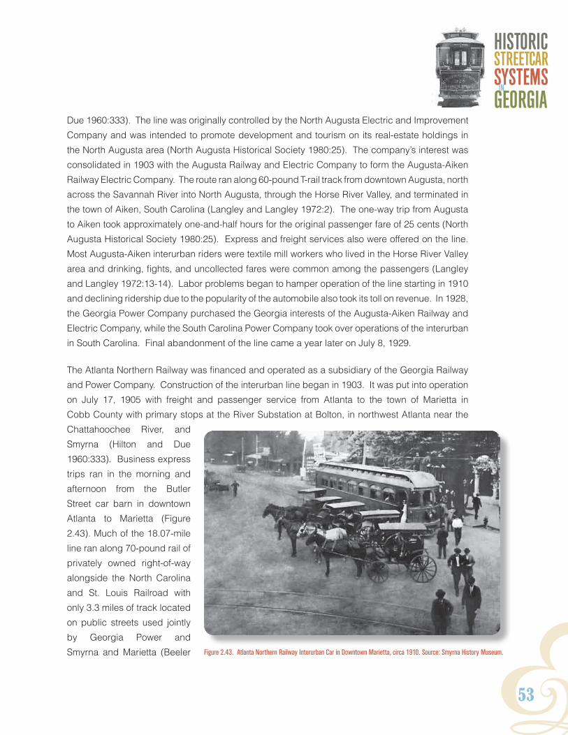
Y53
HISTORICSTREETCARSYSTEMSGEORGIAIn
Due 1960:333). The line was originally controlled by the North Augusta Electric and Improvement
Company and was intended to promote development and tourism on its real-estate holdings in
the North Augusta area (North Augusta Historical Society 1980:25). The company’s interest was
consolidated in 1903 with the Augusta Railway and Electric Company to form the Augusta-Aiken
Railway Electric Company. The route ran along 60-pound T-rail track from downtown Augusta, north
across the Savannah River into North Augusta, through the Horse River Valley, and terminated in
the town of Aiken, South Carolina (Langley and Langley 1972:2). The one-way trip from Augusta
to Aiken took approximately one-and-half hours for the original passenger fare of 25 cents (North
Augusta Historical Society 1980:25). Express and freight services also were offered on the line.
Most Augusta-Aiken interurban riders were textile mill workers who lived in the Horse River Valley
area and drinking, fights, and uncollected fares were common among the passengers (Langley
and Langley 1972:13-14). Labor problems began to hamper operation of the line starting in 1910
and declining ridership due to the popularity of the automobile also took its toll on revenue. In 1928,
the Georgia Power Company purchased the Georgia interests of the Augusta-Aiken Railway and
Electric Company, while the South Carolina Power Company took over operations of the interurban
in South Carolina. Final abandonment of the line came a year later on July 8, 1929.
The Atlanta Northern Railway was financed and operated as a subsidiary of the Georgia Railway
and Power Company. Construction of the interurban line began in 1903. It was put into operation
on July 17, 1905 with freight and passenger service from Atlanta to the town of Marietta in
Cobb County with primary stops at the River Substation at Bolton, in northwest Atlanta near the
Chattahoochee River, and
Smyrna (Hilton and Due
1960:333). Business express
trips ran in the morning and
afternoon from the Butler
Street car barn in downtown
Atlanta to Marietta (Figure
2.43). Much of the 18.07-mile
line ran along 70-pound rail of
privately owned right-of-way
alongside the North Carolina
and St. Louis Railroad with
only 3.3 miles of track located
on public streets used jointly
by Georgia Power and
Smyrna and Marietta (Beeler Figure 2.43. Atlanta Northern Railway Interurban Car in Downtown Marietta, circa 1910. Source: Smyrna History Museum.

54
1925:2, 4, 17). Over the course of its operation, the Atlanta Northern Railway proved to be
financially successful with increased ridership during World War I and especially World War II,
following the development of the Marietta Aircraft Assembly Plant (popularly referred to as the Bell
Bomber Plant) in 1943 (Carson 1981:115, 121). Competition from bus lines servicing the same
route and Atlanta Mayor William Hartsfield’s demand to remove streetcars from all city streets by
December 1947 spelled the end of the Atlanta-Marietta interurban after the war. All properties
of the Atlanta Northern Railway were sold off and the line was abandoned on January 31, 1947
(Carson 1981:133).
Unlike the Atlanta Northern Railway, the Georgia Railway and Electric Company maintained direct
operation of the 17.4-mile Stone Mountain interurban line. Plans for the service were announced
in 1911, and the line began operation in November 1913 (Carson 1981:134; Hilton and Due
1960:333). The route mirrored the Central of Georgia Railroad and ran along a combination of
private rights-of-way and city streets from downtown Atlanta to the City of Decatur before continuing
east through the towns of Ingleside (renamed Avondale Estates in 1927), Scottdale, and Clarkston,
before terminating at a car barn and substation facility on Church Street in Stone Mountain and
then looping back to Atlanta. Passenger fares were fixed at 25 cents between Decatur and Stone
Mountain, and express and freight services were offered. Despite modest profit surpluses over
its first 10 years of operation, the line began to suffer in ridership during the late 1920s due to the
rising popularity of the automobile. The Stone Mountain Line was granted a reprieve as patronage
levels rose during the years of the Great Depression and World War II. Georgia Power eventually
discontinued operation of the electrified interurban line on March 14, 1948 in favor of gasoline-
powered bus service (Figure 2.44) (Wright 1957:130).
2 Context
Figure 2.44. Last Ride on the Stone Mountain Interurban Line, March 14,1948. Courtesy of George Coletti.

Y55
HISTORICSTREETCARSYSTEMSGEORGIAIn
The Fairburn and Atlanta Railway and Electric Company line was organized by a group of Fairburn
civic and business leaders in 1908 as a gasoline-powered suburban line that connected the
communities of Fairburn and Union City in Campbell County (now the southwestern end of Fulton
County) to the small municipality of College Park. From there, passengers were allowed to transfer
to the Georgia Railway and Power Company streetcar system to Atlanta (Hilton and Due 1960:333).
The 10.25-mile line was built along the north side of the Atlanta and Western Pacific Railroad in
1910 and regular service began on June 25, 1911 with 38 passengers in tow (Figure 2.45). Fares
for the 35-minute ride were originally set at 20 cents. Passenger capacity was increased with
purchase of a car trailer in 1915 (Cornell 2009:25-26, 33, 40). By the early 1920s, the Fairburn
and Atlanta Railway and Electric Railway, like other interurban lines throughout Georgia and the
country, began to experience decreased ridership because of increased competition from the
automobile. In 1925, the company abandoned its rail service in favor of motorized buses; however,
the inauguration of Inter-City Coach Lines (ICL) bus route along Highway 29 from Fairburn and
College in March 1929 forced executives to discontinue service altogether that same year (Carson
1997:8).
streetCar CoNduCtors, motormeN, aNd work Crews
From the beginning of Atlanta’s streetcar history in the late nineteenth century, only white Protestant
men were employed as streetcar operators. Native-born men who were raised in the country
and unfamiliar with unions were typically preferred (Kuhn et al. 2005:74). African American men
comprised the bulk of the track construction, paving, and repair workforce, while white men filled
Figure 2.45. First Run of the Fairburn and Atlanta Railway and Electric Company, 1911. Source: Old Campbell County Historical Society.

56
maintenance and mechanical
positions requiring skilled labor
(Figure 2.46). With the advent
of electrification, streetcar
operation became a two-man
affair; motormen piloted the car
while conductors collected and
sold fares and indicated to the
motorman when to stop for passengers. Under Georgia’s Jim Crow law of 1891, white operators
were given broad police powers to enforce the color line on the streetcars.
During the early decades of the twentieth century,
streetcar companies prohibited unionism among
its employees and long, 12-hour days working
in exposed outdoors on open vestibule cars
was common. In an effort to improve working
conditions and gain union recognition, Georgia
Power motormen and conductors went on strike
in 1916 and again in 1918 (Carson 1981:68-
70). Violent streetcar strikes also erupted
in Augusta in 1912 and Macon in 1906 and
again in 1919 (Electric Railway Journal [ERJ]
1912: 631; Macon Telegraph [MT] August 10,
1906; and ERJ August 2, 1919:253). Georgia
Power eventually allowed its operators the
right to unionize in the 1920s and began to
offer employee benefits as well as company
activities and social clubs in an effort to
create a more amicable labor environment
(Figure 2.47) (GP 1927:287-291).
2 Context
Figure 2.46. Mechanical Crew at Work in Repair Shops of Fulton County Plant, Atlanta, 1943. Source: Lane Brothers Commercial Photographers Photograph
Collection, Special Collections, Georgia State University Library.
Figure 2.47. Georgia Railway and Power Company Employee Social Groups. Source: Georgia Railway and Power Company Yearbook, 1927-1928.
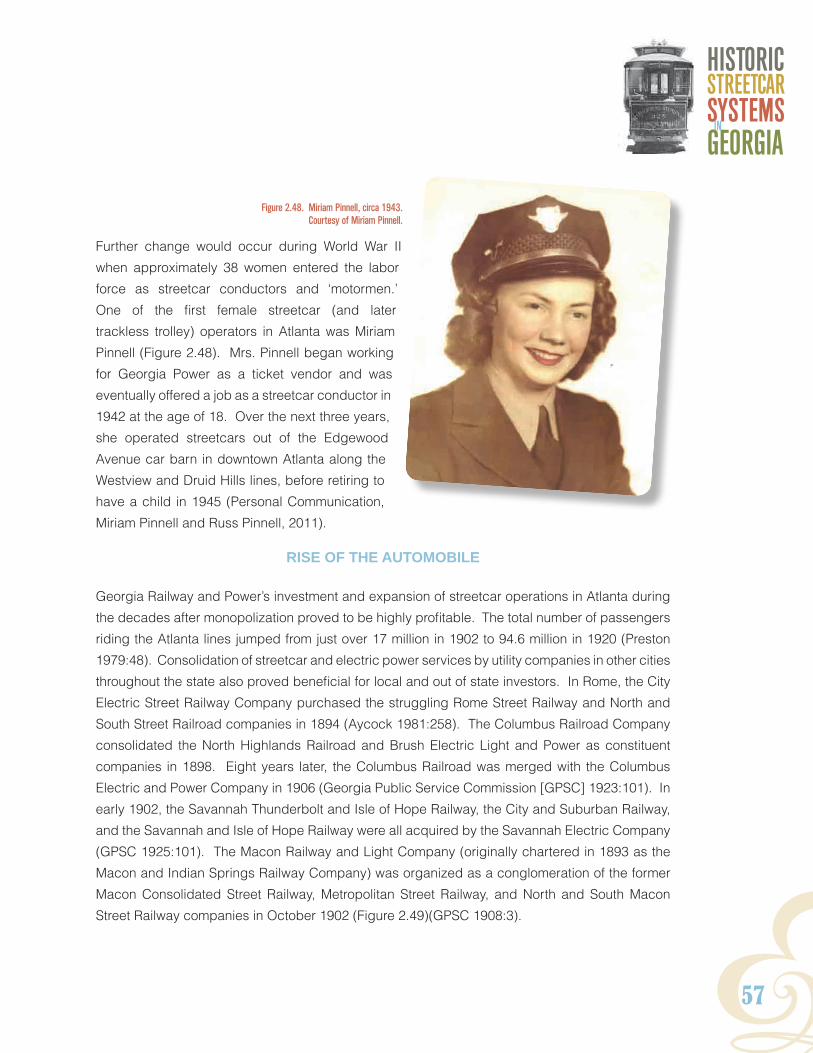
Y57
HISTORICSTREETCARSYSTEMSGEORGIAIn
Further change would occur during World War II
when approximately 38 women entered the labor
force as streetcar conductors and ‘motormen.’
One of the first female streetcar (and later
trackless trolley) operators in Atlanta was Miriam
Pinnell (Figure 2.48). Mrs. Pinnell began working
for Georgia Power as a ticket vendor and was
eventually offered a job as a streetcar conductor in
1942 at the age of 18. Over the next three years,
she operated streetcars out of the Edgewood
Avenue car barn in downtown Atlanta along the
Westview and Druid Hills lines, before retiring to
have a child in 1945 (Personal Communication,
Miriam Pinnell and Russ Pinnell, 2011).
rise oF the automoBile
Georgia Railway and Power’s investment and expansion of streetcar operations in Atlanta during
the decades after monopolization proved to be highly profitable. The total number of passengers
riding the Atlanta lines jumped from just over 17 million in 1902 to 94.6 million in 1920 (Preston
1979:48). Consolidation of streetcar and electric power services by utility companies in other cities
throughout the state also proved beneficial for local and out of state investors. In Rome, the City
Electric Street Railway Company purchased the struggling Rome Street Railway and North and
South Street Railroad companies in 1894 (Aycock 1981:258). The Columbus Railroad Company
consolidated the North Highlands Railroad and Brush Electric Light and Power as constituent
companies in 1898. Eight years later, the Columbus Railroad was merged with the Columbus
Electric and Power Company in 1906 (Georgia Public Service Commission [GPSC] 1923:101). In
early 1902, the Savannah Thunderbolt and Isle of Hope Railway, the City and Suburban Railway,
and the Savannah and Isle of Hope Railway were all acquired by the Savannah Electric Company
(GPSC 1925:101). The Macon Railway and Light Company (originally chartered in 1893 as the
Macon and Indian Springs Railway Company) was organized as a conglomeration of the former
Macon Consolidated Street Railway, Metropolitan Street Railway, and North and South Macon
Street Railway companies in October 1902 (Figure 2.49)(GPSC 1908:3).
Figure 2.48. Miriam Pinnell, circa 1943.Courtesy of Miriam Pinnell.

58
It was also during this period that the
demise of the streetcar was sown
as the automobile began its rise to
prominence as the most popular
mode of transit among Americans in
the new century. In 1900, Georgia
ranked twentieth in the nation for the
number of motor vehicles registered
in the state at 80. In 1905, Georgia ranked twenty-forth with 780 vehicles registered; however,
that number spiked considerably to 4,490 automobiles just five years later in 1910 (Flink 1979:76).
Because of the rapid rise in car ownership rates, public transit companies throughout the country
were blindsided by the onslaught of unlicensed taxi operators, known as ‘jitneys,’ that flooded city
streets competing for passenger fares with the streetcars. Jitney service, which got its name for
the slang term of a five-cent fare, or ‘jit,’ was first recorded in Los Angeles in 1914. The streetcar
companies, which were usually obligated to pave and improve public streets upon which they
operated at 40 percent of cost, believed they were subsidizing their own competition and viewed
the jitneys as a business threat (Martin 1977:37). The jitney phenomenon had spread to Atlanta
by April 1915 and set off a 10-year fight on the part of Georgia Railway and Power Company to
rein in and eventually eradicate unlicensed taxi service on city streets (Preston 1979:56-57). The
Atlanta City Council passed an ineffectual jitney ordinance in 1919. It wasn’t until the 1924 release
of Georgia Railway and Power Company-sponsored transit study entitled Beeler Report to the
City of Atlanta and threats of
abandonment that the City of
Atlanta took definitive steps
to rein in unlicensed jitney
and bus operators in March
1925 (Carson 1981:85).
Although the jitney threat had
been curbed, increases in
private automobile ownership
among Atlantans continued
unabated throughout the
2 Context
Figure 2.49. Macon Railway and Light Streetcar, 1912. Source: Middle Georgia Archives Washington Memorial Library, Macon Georgia.
Figure 2.50. Downtown Atlanta, 1925. Source: Georgia Railway and Power Company 1927.

Y59
HISTORICSTREETCARSYSTEMSGEORGIAIn
1920s as a result of a booming economy and the relative affordability of some manufactures such
as the Ford Model T. In 1918, motor vehicle registration in Fulton County stood at 12,065. By 1928,
it ballooned to 57,445 automobiles (Preston 1979:51). Narrow, downtown Atlanta streets became
a clogged jumble of darting automobiles, pedestrians, and streetcars (Figure 2.50). During the
1920s, residential suburbanization, originally prompted by streetcar development during the
1870s, was now driven by the individualized mobility afforded by the automobile. Affluent and
middle-class whites began relocating from central core of Atlanta to the newer, more spacious
neighborhoods on the city’s periphery (Crimmins 1982:84).
moderNizatioN
Beginning in 1921, Preston Arkwright started work on a multi-faceted modernization program
of the Georgia Railway and Power Company’s streetcar operations and resources as part of an
effort to combat negative public attitudes about the company that had arisen over labor strikes,
fare increases, and the jitney battles during the years following World War I (Martin 1977:56). The
plan called for improvements in four
key areas: personnel; infrastructure
maintenance and service; public
relations and merchandising; and
financing. Company social activities,
stock and home-ownership incentives
and the “My Job Means Something
to Me” campaign were designed to
increase employee moral (Wright
1957:198 and Georgia Power
Company [GP] 1927:287-291).
Between 1921 and 1926, 203 modern
cars were purchased and 178 cars
were retired. The new streetcars
and interurban were larger, faster,
and allowed for one-man operation,
which increased passenger revenue
and lowering operating costs
associated with delayed service
and employee wages (Figure 2.51).
The single front door entrance on
Figure 2.51. New One-Man Operation Streetcars. Source: Georgia Railway and Power Company 1927.

60
the new streetcars was also touted for reducing physical
contact between white and African American passengers
during crowded conditions (GP 1927:173). Implementation
of automatic track switching systems and the use of low-
cost, electric track welding technologies also provided
reduced cost benefits. In the realm of public relations,
the utility expanded the scope of its advertising campaign
in traditional magazines and newspapers and with the
weekly editions of its Two Bells brochure on all streetcars
and buses (Figure 2.52).
Additional recommendations outlined in the
1924 Beeler Report were also incorporated.
These called for the re-routing and
elimination of unprofitable routes, and
the introduction of motor coach lines in
the Virginia Highlands, Morningside, and
Ansley Park neighborhoods, as well as
“other lines to be added as needed to meet
the transportation needs of the city” (Beeler
1924a:v). Fifteen double-deck buses and
10 single deck coaches were purchased
and put into operation on March 8, 1925
(Figure 2.53) (GP 1927:47). In general, the motorbuses functioned as “coaches” along downtown
routes or “feeder buses” that augmented streetcar operations in more auto-oriented suburban areas
of the city (Carson 1981:97).
2 Context
Figure 2.52. Two Bells Magazine. Source: Georgia Railway and Power Company 1927.
Figure 2.53. Advertisement for Motorized Coach Service. Source: Georgia Railway and Power Company 1927.

Y61
HISTORICSTREETCARSYSTEMSGEORGIAIn
aBaNdoNmeNt oF the liNes
Electric streetcar transit in the United States had unknowingly reached its zenith during the period
just before World War I (Rowsome 1956:170). In the following years, Georgia streetcar companies
began to suffer from the national trend of decreasing profitability within the industry. Unprofitable
lines in Gainesville, Valdosta, Albany, and Waycross had been discontinued altogether as early
as 1920.
Increased operating expenses in conjunction with declining passenger revenues due to the
popularity of the automobile, followed by the economic collapse of Great Depression, hastened
the demise of streetcar operations in most mid-size cities and smaller towns in the state during the
1920s and 1930s (Wright 1957:229). While motorized buses were introduced to augment existing
streetcar service in Atlanta, Georgia Railway and Power began using them to replace the systems
operating in Augusta, Athens, Columbus, Gainesville, and Rome starting in the late 1920s, often
despite the objections of local politicians and residents. The Rome streetcar system, which had
been operating at a loss since 1923, was replaced with motor coach service in September 1929
amidst public outcry (MCA 1978:15). Athens streetcars were halted in March 1930 (Ray 2005:61).
Bus lines were partially introduced in Macon in 1932; however, opposition to the replacement of the
Macon streetcar delayed full implementation of bus service until November 1934 (MT September
1 1934). By 1936, the Columbus streetcar system had been abandoned in favor of buses and
Augusta followed a year later in 1937 (Columbus Ledger-Enquirer [CLE] October 18, 1953:21E
and Augusta Unit of the WPA Writer’s Program, n.d.).
In the cases of the Atlanta and Savannah streetcars, the decline was more drawn out and
discontinuation of the lines was reserved until after World War II. Both the Georgia Railway
and Power Company and the Savannah Electric and Power Company had made considerable
infrastructure improvements and investments in their primary streetcar systems during the 1920s.
As a result, the two companies were reticent to completely abandon service in the face of mounting
revenue losses (Wright 1957:310 and Savannah Morning News [SMN] November 18, 1922:14).
Like Atlanta, Savannah instituted motorized bus service as a means of supplementing existing
streetcar routes, starting in 1929 with the replacement of the Daffin Park Line and express service
along Forty-Sixth Street (Eason 1971:81). By 1935, the streetcar tracks had been removed along
Abercorn and Broad streets to make way for general traffic, and Savannah Mayor Thomas Gamble
was advocating for full replacement of the streetcar lines in the city (SMN August 18, 1935 and
September 4, 1935). In December 1945, the Savannah Electric and Power Company exited
the public transportation business altogether, selling its transit holdings to the newly organized
Savannah Transit Company (Eason 1971:94). The end of streetcar service in Savannah came

62
2 Context
a year later in 1946 as the lines were phased
out. The final run was made with much fanfare
along the Habersham and Isle of Hope route
in the early morning of August 25, 1946 (Nall
September 10, 1966).
The Atlanta streetcar system held out for
three more years until 1949. Although diesel
motor bus service had been instituted during
the mid-1920s, replacement of the city’s
streetcars began in earnest nearly 12 years
earlier on June 27, 1937 with the conversion
of the East Point-College Park-Hapeville line
to “trackless trolley” coaches (Figure 2.54)
(GP 1937:np). The trackless trolley, which
essentially was a rubber-tired bus powered
by the electrical overhead wire network used
by the streetcar, became the key component
of a second “rails to rubber” modernization
program initiated by Georgia Railway and
Power during the war years of the 1940s
(Figure 2.55). The Oglethorpe line became
the second trackless trolley route in 1940. Rubber shortages caused by World War II temporarily
delayed additional trackless trolley line conversions; however, streetcar tracks continued to be
abandoned in favor of the company’s existing gasoline-powered bus fleet (Carson 1981:101). In
December 1943, the Mayor William Hartsfield and City of Atlanta spelled the end of streetcars in
Atlanta by calling for Georgia Power to replace all existing street railroad track with trackless and
motor bus service by 1947 (Wright 1957:313). Following the war, Georgia Power’s implementation
of trackless trolley conversion resumed at a rapid pace with 340 trackless coaches put into
operation (Figure 2.56). Finally, on April 10, 1949, 78 years of continued streetcar operation
ended with a somber ride on the final run of Car 897 along the Riverline route. A year later, on
June 22, 1950, Georgia Power sold its entire Atlanta transit business to the privately owned Atlanta
Transit Company for $4.2 million (Carson 1981:104, 147-149).
Figure 2.54. Announcement of Trackless Trolley Service on East Point Line, 1937. Source: Two Bells June 1937.
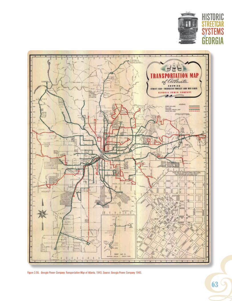
Y63
HISTORICSTREETCARSYSTEMSGEORGIAIn
Figure 2.55. Georgia Power Company Transportation Map of Atlanta, 1943. Source: Georgia Power Company 1943.

64
remNaNts oF the streetCar aGe
Following the discontinuation of
streetcar systems throughout the state
in the years before and after World
War II, the associated properties
were often disposed of (sold, reused,
or redeveloped), and the track
infrastructure was either removed or
paved over (Figure 2.57). Streetcars
were often auctioned off to foreign cities
for continued transportation service or
to individual buyers for use as diners,
hunting cabins, or residential and
farm outbuildings. Fifty-two Atlanta
streetcars were sold to Korea in 1949.
2 Context
Figure 2.56. Buckhead Trackless Trolley Express Line, circa 1950. Source: Carson 1997.
Figure 2.57. Removal of Streetcar Track on Forsyth Street in Downtown Atlanta, 1952. Source: Tracy O'Neal Photographic Collection, Special Collections Department, Georgia State University Library.

Y65
HISTORICSTREETCARSYSTEMSGEORGIAIn
Thirty-two cars were sent to Pusan and 20 to Seoul (Figure 2.58). These exported cars generally
remained in operation until Korea abandoned streetcar service in 1968 (Carson 1981:140). In cities
such as Valdosta and Macon, where streetcar operations were abandoned before World War II,
track was often pulled up and recycled for the war effort, and little remains intact today. In Atlanta
and Savannah, however, where streetcars remained in service until the mid-to-late 1940s, there
appears to be a greater likelihood of buried track as a result of successive street paving. Streetcar-
related buildings, such as car barns and substations were either demolished and redeveloped by
Georgia Power or other businesses, adaptively used as commercial office or warehouse space, or
as bus storage facilities
for successor transit
companies (Figure 2.59).
Figure 2.58. Former Atlanta Streetcars in use in Seoul, Korea, 1965. Source: Carson 1981.
2.59. Renovation of Stone Mountain Car Barn for Retail Use, circa 1955. Courtesy Hugh Jordan.
66
2 Context
CoNClusioN
Over the course of almost 80 years, between 1871 and 1949, streetcars functioned as an integral
part of the urban and suburban environment of Atlanta and other major municipalities throughout
Georgia. Within this timeframe, streetcar development in Atlanta generally fell into three distinct
periods based on the evolution of different modes of traction: animal (horse and/or mule-drawn)
traction (1871-1895); steam locomotive traction (1887-1895); and electric traction (1889-1949).
As systems changed over time, so did the accompanying technologies needed to maintain and
operate each system. The progression from the plodding mule to the modern electric streetcar
required the construction of a range of buildings and structures designed to support the changing
systems including: car barns, stables, substations, bridges, overhead wire supports, track
construction, and new rail types.
More than just a mode of public transportation, the streetcar also had a great impact in other areas.
The advent of electric traction spurred the industrial growth of hydroelectric power generation and
transmission in Georgia and streetcars were used for the conveyance of commercial freight and
services. In Atlanta and throughout the South during the Jim Crow Era of the late nineteenth and
early twentieth centuries, streetcars became a contested symbol for black and white riders and
targets of racial violence by white segregationists. The streetcar also served as a tool to drive real-
estate speculation and suburbanization at the periphery of the downtown central business district.
In effort to increase ridership, streetcar companies also developed or owned recreational areas
such as parks, fairgrounds, and other associated sites.

Y67
HISTORICSTReeTCaRSYSTeMSGeORGIaIn
3. Map analysis and Field assessMent The history of Georgia’s streetcar systems lies buried not only under asphalt or behind adaptive
reuse but also within the state’s cultural resource documentation. While streetcar-related resources
have likely been identified as historic and are included in cultural resource documentation, they
have often not been associated with the development of streetcar systems in their respective
locales and are therefore not easily identified. Because of this difficulty, other tools and research
materials, such as historic maps, have to be used to identify areas of high probability. This chapter
provides a discussion of the geography of streetcar systems in Georgia based upon analysis of
historic maps and fieldwork and could serve as a model for areas outside of Atlanta.
Historic Map analysis
Historical research produced a number of portraits of Atlanta’s streetcar system in the form of
maps throughout time. Maps of all kinds were collected to compile a timeline for the construction
and removal of rail, the location support structures, and the identification of buildings associated
with the system. The research emphasized maps with a minimal amount of distortion to shape,
distance, or area of man-made and natural landscape features, and maps that were drawn at
a scale to provide enough resolution to isolate streetcar-related features. Historic map images
were digitized and analyzed in GIS (Geographic Information Systems) to identify various system
resources like tracking, trestles, or car barns, over time.
One of the earliest maps depicting Atlanta’s streetcar system is the City Atlas of Atlanta from
1878 (Hopkins 1878). This collection of maps is divided into an index and 20 map plates. The
map plates are drawn at a 1-inch-equals-1,200-feet scale. In addition to providing the name of
parcel owners within the city, the City Atlas of Atlanta shows horsecar routes within the city limits.
Additionally, the map’s legend identifies brick and frame buildings, brick and frame stables, and
sheds, as well as the lines themselves (Figure 3.1). Stables and sheds along these routes would
likely have served as support buildings for the horsecar lines.
The inventory and engineering evaluation of the Atlanta streetcar system provided by the Beeler
Organization Consultants in 1924 as part of a Georgia Power Company-sponsored transit study
(see page 58) provides another snapshot of routes active during the early twentieth century.
Although the 1924 Beeler Map provides less street-level detail than the nineteenth-century map,
it depicts the system beyond the city limits of Atlanta. It uses more representative symbols for the
individual routes, but offers period street names for each segment of track, as well as a general
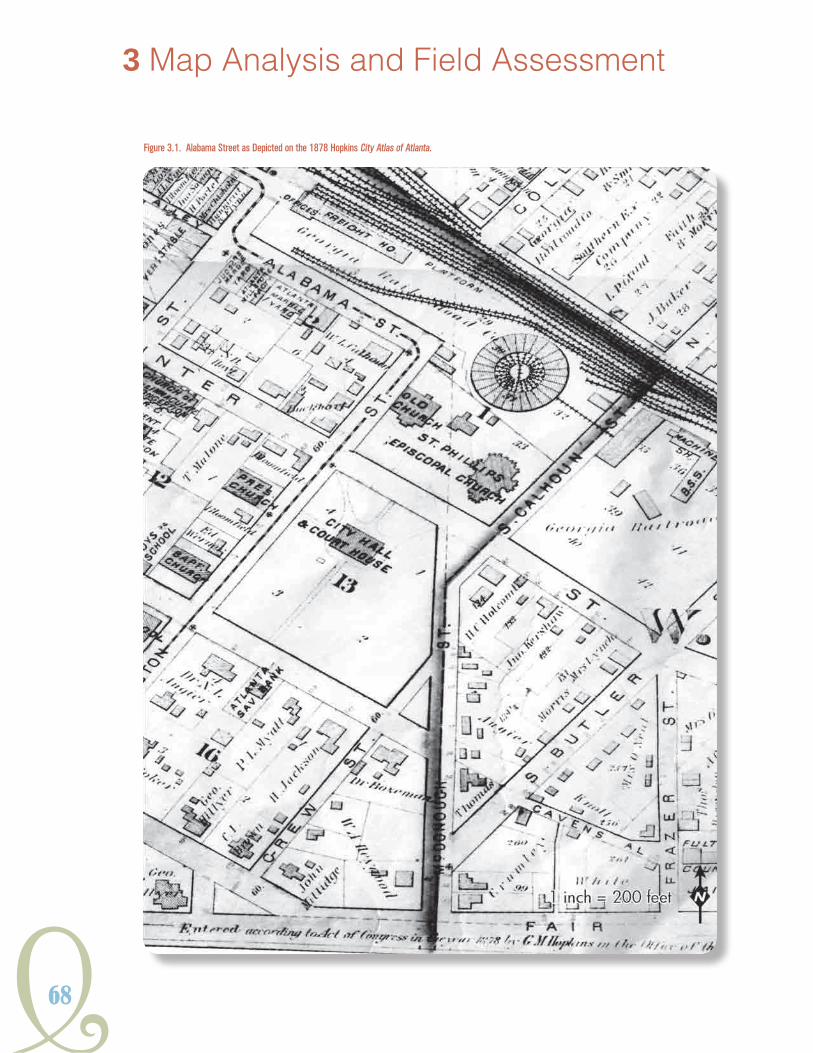
68
Figure 3.1. Alabama Street as Depicted on the 1878 Hopkins City Atlas of Atlanta.
3 Map Analysis and Field Assessment

Y69
HISTORICSTReeTCaRSYSTeMSGeORGIaIn
Figure 3.2. The Beeler Organization Consultants 1924 Map of Active Lines.
location of support facilities like shops and barns (Figure 3.2). When used in conjunction with text
descriptions of individual routes within the report itself, a fairly accurate and detailed portrait of the
system emerges (Beeler 1924b).
Atlanta’s Construction Department conducted a comprehensive land survey of the city and
surrounding areas in 1928 (Floore 1928a, 1928b). The resulting Topographic Atlas of Atlanta
provides the most accurate representation of the streetscape, as well as the landscape of Atlanta
prior to 1930. The maps were drawn at a 1-inch-equals-200-feet scale and featured contour lines
at a two-foot interval (Figure 3.3). The map’s scale provides details of the landscape like hilltops,
creek drainages, and graded corridors, as well as aspects of the built environment. Building
footprints are included on the Topographic Atlas of Atlanta maps, and streetcar tracks are depicted
as either double or single-track lines. The high resolution of the maps also reveals the presence
of rail sidings, or rail spurs, and support buildings. The collection includes 50 sheets at a 1-inch-
equals-200-feet scale, while the maps of the vicinity feature a larger scale.

70
Figure 3.3. The Butler Street Car Barn and Substation shown on the 1928 Topographic Atlas of Atlanta.
3 Map Analysis and Field Assessment
Butler streetcar Barn

Y71
HISTORICSTReeTCaRSYSTeMSGeORGIaIn
Figure 3.4. The 1928 Topographic Maps of the City of Atlanta and Vicinity Showing the Intersection of the Marietta Interurban and River Line with the Chattahoochee River.

72
3 Map Analysis and Field Assessment
The 1928 Topographic Maps of City of Atlanta and Vicinity were produced at a scale of 1 inch equals 1,100 feet (Floore 1928b). These maps also offer contour lines at an interval of five feet (Figure 3.4). Like the City of Atlanta maps, track is depicted as either double or single track. Building locations are more symbolic, however, appearing as black squares or polygons.
Since the 1928 survey maps provided the most spatially accurate and highest degree of detail, they were subjected to simple georectification in GIS. Georectification is the process by which a map image is warped to align with a specified geographic coordinate system (e.g., Latitude/Longitude or State Plane). Locations based on the nominated coordinate system can then be assigned to the georectified map’s features placing them in real space. Georectification is a two-dimensional process by which a historical map image overlays another, spatially referenced, image. Control points marking common locations in each image are marked and serve as points to pull and push the historic map into place.
Commonalities were identified between the 1928 maps and modern aerial photography, as well as current spatial datasets from state and local agencies like the Georgia Department of Transportation (GDOT) and the Atlanta Regional Commission. Most of the common points identified between the 1928 map and modern spatial data consisted of landscape features and building footprints. These elements served as control points for georectification rather than elements found in the streetscape like right-of-way, curbing, or intersection orientation because streetscape elements are subject to change over time with infrastructure improvements.
GDOT provided a geodatabase of street centerlines that served as base data to extract and digitize details of the 1928 streetcar system into GIS data. Street centerlines that corresponded with track depicted on the 1928 map were extracted, and attributes were added to each GDOT street centerline describing whether the track is double or single and the name of the map from which the data references. Additionally, the location of support buildings like car barns and shops were digitized into spatial data by their XY locations. Where track veered away from the street right-of-way onto private right-of-way, new lines were drawn tracing the track, and the new lines featured complementary attributes to the GDOT centerlines (Figure 3.5). The georectified 1928 atlas and digitized routes and structures were then compared with other maps depicting the system over time to identify changes in the system components and areas in the city that could potentially retain preserved resources.
FielDWorK
Results of the analysis of the historical map images were used to identify areas for examination
with ground-penetrating radar (GPR) and field survey (Figure 3.6). GPR is a geophysical method
that emits electromagnetic energy waves into the ground from a surface antenna, which reflect
off buried objects, features, or bedding contacts and is then detected back at the ground surface
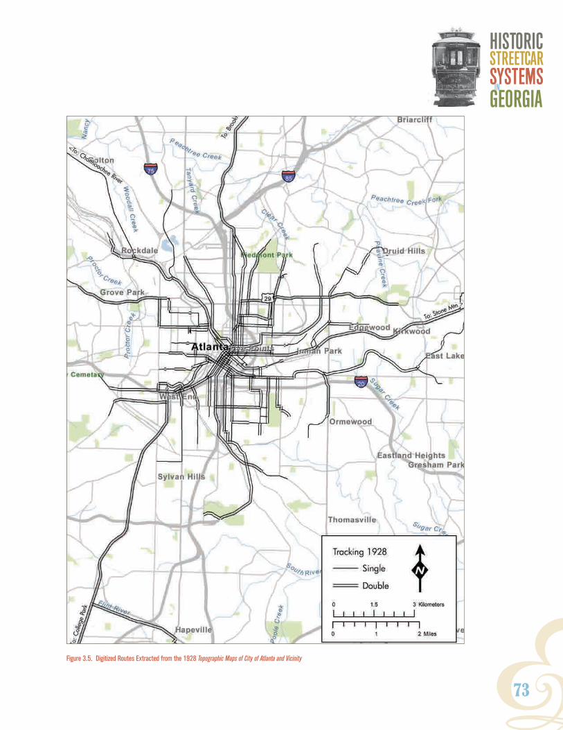
Y73
HISTORICSTReeTCaRSYSTeMSGeORGIaIn
Figure 3.5. Digitized Routes Extracted from the 1928 Topographic Maps of City of Atlanta and Vicinity

74
3 Map Analysis and Field Assessment
Figure 3.6. Atlanta Locations of GPR Survey. Source: ESRI StreetMap 2010.
Figure 3.7. GPR Survey along Irwin Street. (Inset) GPR Reading of Tracks on D.L. Hollowell Parkway showing a void where one rail was removed.

Y75
HISTORICSTReeTCaRSYSTeMSGeORGIaIn
with a receiving antenna (Figure 3.7). The greater the contrast in the physical and chemical
properties between two materials, the stronger the reflected signal will appear. Segments of
streets were subjected to GPR to ascertain if subsurface features associated with the operation of
streetcars were evident and if so, what kind of archaeological signatures remained. Metal trolley
track rails under most subsurface conditions are easily discernable as high-amplitude hyperbolic
reflections located at consistent depths and separations. This method is useful in determining
the presence or absence of buried track, the separation of the track, the existence of a double or
single line, how the track was constructed at intersections, separation of crossties, and potentially
the existence and extent of intact bedding.
In conjunction with the GPR examination, selected corridors along streetcar routes were surveyed
to identify sites, structures, and buildings associated with the system but not yet inventoried. This
involved walking the selected project areas and checking its general conditions for the presence
of streetcar track surface features or other streetcar-related artifacts. In addition, previously
identified resources located throughout the state, such as the Valdosta Bus and Trolley Stop, were
revisited to assess their current use and condition. Table 3.1 summarizes the recorded resources
revisited during the fieldwork phase of the project (See Chapter I for more descriptive information).
Table 3.1. Resurveyed Previously Identified Historical Resources
name county current condition
current use
Macon Railway & Light Substation Bibb Extant; Renovated
Adapted for Reuse
Trolley Stop DeKalb Reconstructed Historical Marker
ART Station DeKalb Extant; Renovated
Adapted for Reuse
Inman Park Historic District (Trolley Barn)
Fulton Extant; Renovated
Events Facility
Ashby Street Car Bar Fulton Extant; Renovated
Office Space
Bus Stop; Trolley Stop Lowndes Extant Streetscape Feature
A number of locales were identified during GIS analysis from period maps that had a potential
for preserved resources. These resources were primarily identified in the Atlanta Metro area, but
some were identified in other Georgia cities. A majority of these resources consisted of historic
substation locations associated with the electric traction period of Georgia’s streetcar history.
However, other structures, like bridges and tunnels, were visited to confirm their existence and to
assess the impacts from modernization on each resource.

76
3 Map Analysis and Field Assessment
Numerous substations associated with Georgia’s streetcars were inventoried from historic maps
(Figure 3.8). Examination of modern aerial photography revealed that many of these buildings
had been razed or converted into modern electrical facilities. Three substation locations were
identified from historical research as potentially having preserved features and were surveyed: the
Stewart Avenue Substation, the Spring Street Substation, and the Emory Substation.
The Stewart Avenue Substation was built circa 1920 as part of the Georgia Railway and Electric
Company’s expansion of electrical distribution facilities within the Atlanta Seven Mile Limit area
(Wright 195:149-150). The secondary, “step-down” substation property was not listed in the
1919 Baehr Inventory of the Georgia Railway and Electric Company transportation department;
however, it was identified as one of 11 “Substations Supplying Railway Power, 1919-1923” in the
1924 inventory summary prepared by the Beeler Consulting firm of New York (Baehr 1919:77 and
Beeler 1924c:78). The Italian Renaissance Revival style brick masonry building is approximately
two stories in height with a simple, massed plan (Figure 3.9). Large windows flank a large brick
arched entrance centered in a symmetrical facade. The brick building extends out of a poured
concrete foundation and has concrete details like arch keystones. It is believed the building was
designed by the Georgia Railway and Power Company consulting architect Isaac Moscowitz.
Moscowitz also designed the Spring Street facility as well as the powerhouse buildings of larger
hydroelectric plants in North Georgia. Like most of the substations of the period, electrical
Figure 3.8. Location Map of Surveyed Substations.

Y77
HISTORICSTReeTCaRSYSTeMSGeORGIaIn
transmission equipment was enclosed inside
the building, unlike the open design common
to substation facilities of today. The property
is now vacant and located on the east side
of what is now Metropolitan Parkway between
Wells and Green streets.
Like the Stewart Avenue Substation, the Emory
Substation was originally built circa 1920,
and the facility is first identified in the 1924
Beeler inventory and appraisal of the Georgia
Railway and Electric Company, Railway
Department (Beeler 1924c:78). Unlike the
Stewart Avenue facility, the Emory Substation
was later redeveloped and is an active facility.
It now features a modern, open design layout;
however, a small, detached brick building
located adjacent to the intersection of Eagle
Row and Oxford Road likely dates to the early
twentieth century based on its brickwork and
windows. The historic portion of the substation
has a rectangular plan and features two large
windows on its southern facade and a single
door on the northern facade. Additional
research will be necessary to confirm its
construction date, but based on the current
reconnaissance, it was likely associated with
the transmission of electrical current for street
rail use prior to the discontinuation of the
streetcar system in 1949.
The Spring Street Substation was also
designed by the Georgia Railway and Power
Company resident architect Isaac Moscowitiz
and was built in 1926 as “the first automatic
and noiseless substation in the South”
(GP 1927:248). The facility’s transmission
equipment is located at the rear of the lot and
Figure 3.9. Surveyed Substations. Stewart Avenue Substation (Top), Spring Street Substation (Middle), Historic Portion of the Emory Substation (Bottom).
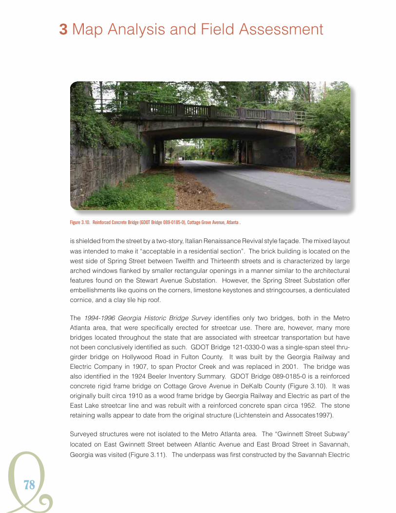
78
3 Map Analysis and Field Assessment
is shielded from the street by a two-story, Italian Renaissance Revival style façade. The mixed layout
was intended to make it “acceptable in a residential section”. The brick building is located on the west side of Spring Street between Twelfth and Thirteenth streets and is characterized by large arched windows flanked by smaller rectangular openings in a manner similar to the architectural features found on the Stewart Avenue Substation. However, the Spring Street Substation offer embellishments like quoins on the corners, limestone keystones and stringcourses, a denticulated cornice, and a clay tile hip roof.
The 1994-1996 Georgia Historic Bridge Survey identifies only two bridges, both in the Metro Atlanta area, that were specifically erected for streetcar use. There are, however, many more bridges located throughout the state that are associated with streetcar transportation but have not been conclusively identified as such. GDOT Bridge 121-0330-0 was a single-span steel thru-girder bridge on Hollywood Road in Fulton County. It was built by the Georgia Railway and Electric Company in 1907, to span Proctor Creek and was replaced in 2001. The bridge was also identified in the 1924 Beeler Inventory Summary. GDOT Bridge 089-0185-0 is a reinforced concrete rigid frame bridge on Cottage Grove Avenue in DeKalb County (Figure 3.10). It was originally built circa 1910 as a wood frame bridge by Georgia Railway and Electric as part of the East Lake streetcar line and was rebuilt with a reinforced concrete span circa 1952. The stone retaining walls appear to date from the original structure (Lichtenstein and Assocates1997).
Surveyed structures were not isolated to the Metro Atlanta area. The “Gwinnett Street Subway”
located on East Gwinnett Street between Atlantic Avenue and East Broad Street in Savannah,
Georgia was visited (Figure 3.11). The underpass was first constructed by the Savannah Electric
Figure 3.10. Reinforced Concrete Bridge (GDOT Bridge 089-0185-0), Cottage Grove Avenue, Atlanta .

Y79
HISTORICSTReeTCaRSYSTeMSGeORGIaIn
Figure 3.11. Gwinnett Street Subway Underpass, Savannah.
Company for its Thunderbolt line in 1905 to surmount the Atlantic Coast Line Railroad (SMN May
6, 1905:12). A steel girder trestle supports the former railroad line, and the underpass features
concrete retaining walls on either side. Now serving as a depressed two-lane city street, streetcar
tracking is no longer evident. This Gwinnett Street Subway is an example of bridge infrastructure
associated with streetcar development that was not surveyed as part of the 1994-1996 Georgia
Historic Bridge Survey.
survey oF streetcar corriDors
To supplement the on-site visits to potential individual resources, surveys were conducted along
sections of metro area streetcar routes. Resources along these corridors were documented or
reexamined if previously inventoried (Figure 3.12). Surveyed sections included portions of the Old
South Decatur Trolley Line Conversion Project in Kirkwood and at Arkwright Place near Moreland
Avenue, the Stone Mountain interurban line from Avondale Estates to Stone Mountain, and sections
along Hollywood Road in West Atlanta and Bolton Road near the intersection with Marietta Road
in Bolton.
Survey was conducted in the Kirkwood neighborhood of Atlanta from Hosea L. Williams Drive
and Woodbine Avenue through Gilliam Park and east to the athletic fields of Fred A. Toomer
Elementary School. Woodbine Avenue is divided into two single one-way lanes by a grass median
north of Hosea L. Williams Drive. The remaining eastern lane continues on a gentle grade to the
northeast forming a cut between Woodbine and the other lane, becoming Wade Avenue. As
Woodbine terminates at Gilliam Park, the curving grade becomes the “Trolley Trail” portion of the PATH Foundations network of paved bicycle and pedestrian trails (PATH Foundation 2010).

80
3 Map Analysis and Field Assessment
The trail continues around Gilliam Park to intersect with Rogers Street. Retaining walls were still evident in the south lawn of the Toomer Elementary School. They appeared much as they did when documented by The Jaeger Company in 1995 (Figure 3.13). The alignment of the grade and walls suggest the past route the trolley line took across the block to connect with Hosea L. Williams Drive.
The second section examined was at South McDonough and Green streets, south of Agnes Scott College, in Decatur. Near this intersection, surveyors encountered a granite block and concrete culvert spanning an unnamed drainage (The Jaeger Company 1995). Upon revisit, the structure seemed to have shifted from the position photographed in 1995 (Figure 3.14).
The Trolley Trail path follows the streetcar line to the west to Arkwright Place in the Atlanta neighborhood of Edgewood. It was surveyed to the intersection with Flat Shoals Road. While no support structures were identified along Arkwright Place, it was noted that the entire thoroughfare was divided, either by a concrete or grass median for its entire length, suggesting a more transit-oriented streetscape in the past (Figures 3.15 and 3.16). The divided streetscape continued west across Moreland Avenue into the Reynoldstown neighborhood where Flat Shoals Road extends west and southeast from the intersection with Arkwright Place. Both of these avenues are also divided. In addition to the evidence of streetcar activity in the landscape, the influence of the
streetcar line is reflected in the polygonal commercial buildings that conform to the right-of-ways
established by the trolley routes at the intersection of Arkwright Place and Flat Shoals Road.
Figure 3.12. Location Map of Surveyed Resources Along the Old South Decatur Trolley Line Conversion Project Corridor.

Y81
HISTORICSTReeTCaRSYSTeMSGeORGIaIn
Figure 3.14. Masonry Culvert at South McDonough and Green Streets in Decatur .
Figure 3.13. Remnants of Retaining Walls on the Fred A. Toomer Elementary School Property in Atlanta.
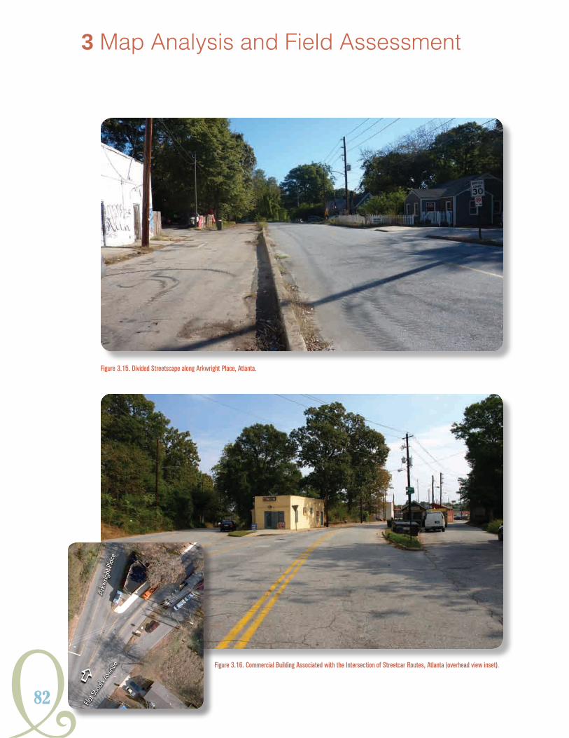
82
Figure 3.16. Commercial Building Associated with the Intersection of Streetcar Routes, Atlanta (overhead view inset).
Figure 3.15. Divided Streetscape along Arkwright Place, Atlanta.
3 Map Analysis and Field Assessment
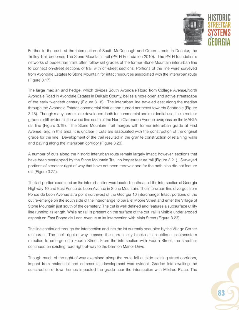
Y83
HISTORICSTReeTCaRSYSTeMSGeORGIaIn
Further to the east, at the intersection of South McDonough and Green streets in Decatur, the Trolley Trail becomes The Stone Mountain Trail (PATH Foundation 2010). The PATH foundation’s networks of pedestrian trails often follow rail grades of the former Stone Mountain interurban line to connect on-street sections of trail with off-street sections. Portions of the line were surveyed from Avondale Estates to Stone Mountain for intact resources associated with the interurban route (Figure 3.17).
The large median and hedge, which divides South Avondale Road from College Avenue/North Avondale Road in Avondale Estates in DeKalb County, belies a more open and active streetscape of the early twentieth century (Figure 3.18). The interurban line traveled east along the median through the Avondale Estates commercial district and turned northeast towards Scottdale (Figure 3.18). Though many parcels are developed, both for commercial and residential use, the streetcar grade is still evident in the wood line south of the North Clarendon Avenue overpass on the MARTA rail line (Figure 3.19). The Stone Mountain Trail merges with former interurban grade at First Avenue, and in this area, it is unclear if cuts are associated with the construction of the original grade for the line. Development of the trail resulted in the granite construction of retaining walls and paving along the interurban corridor (Figure 3.20).
A number of cuts along the historic interurban route remain largely intact; however, sections that have been overlapped by the Stone Mountain Trail no longer feature rail (Figure 3.21). Surveyed portions of streetcar right-of-way that have not been redeveloped for the path also did not feature rail (Figure 3.22).
The last portion examined on the interurban line was located southeast of the intersection of Georgia Highway 10 and East Ponce de Leon Avenue in Stone Mountain. The interurban line diverges from Ponce de Leon Avenue at a point northwest of the Georgia 10 interchange. Intact portions of the cut re-emerge on the south side of the interchange to parallel Moore Street and enter the Village of Stone Mountain just south of the cemetery. The cut is well defined and features a subsurface utility line running its length. While no rail is present on the surface of the cut, rail is visible under eroded asphalt on East Ponce de Leon Avenue at its intersection with Main Street (Figure 3.23).
The line continued through the intersection and into the lot currently occupied by the Village Corner restaurant. The line’s right-of-way crossed the current city blocks at an oblique, southeastern direction to emerge onto Fourth Street. From the intersection with Fourth Street, the streetcar continued on existing road right-of-way to the barn on Manor Drive.
Though much of the right-of-way examined along the route fell outside existing street corridors, impact from residential and commercial development was evident. Graded lots awaiting the construction of town homes impacted the grade near the intersection with Mildred Place. The

84
3 Map Analysis and Field Assessment
Figure 3.18. Median and Hedge Occupying the Former Streetcar Right-of-Way through Avondale Estates.
Figure 3.17. Location Map of Surveyed Resources in Avondale Estates.

Y85
HISTORICSTReeTCaRSYSTeMSGeORGIaIn
Figure 3.19. Interurban Grade in Woods South of the North Clarendon Avenue Overpass near the MARTA Rail Line (Delineated in White Dashed Line).
Figure 3.20. Paving Associated with the Development of the Stone Mountain Trail, Clarkston.
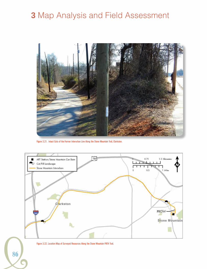
86
3 Map Analysis and Field Assessment
Figure 3.21. Intact Cuts of the Former Interurban Line Along the Stone Mountain Trail, Clarkston.
Figure 3.22. Location Map of Surveyed Resources Along the Stone Mountain PATH Trail.

Y87
HISTORICSTReeTCaRSYSTeMSGeORGIaIn
Figure 3.24. View Foundation Ruin Near Fourth Street, Stone Mountain.
Figure 3.23. Views East and West of the Interurban Cut Running Parallel with Moore Street, Stone Mountain.

88
corridor often featured buried utilities as observed in the cut leading into the Village of Stone
Mountain.Support structures like electrical hardware/power poles along existing streets were not
observed.
The portions of right-of-way found off existing streets was marked by a gravel surface obscured
by vegetation and, at times, was raised in relation to the natural ground surface. The former right-
of-way between Third and Fourth
streets was currently being used as a
wooded pedestrian path. A concrete
foundation within the right-of-way and
oriented flush against the path of the
tracks was noted near the intersection
with Fourth Street (Figure 3.24). It
is unclear if this foundation ruin is
associated with a streetcar-related
structure or the nearby residences,
but it is very likely, given its proximity
and orientation, that it is related to the
line.
Survey was conducted along corridors
adjacent to Hollywood Road, in west
Fulton County, from Mildred Place
to the intersection of Bolton and
Marietta roads (Figure 3.25). This
section of Atlanta’s streetcar system
was called the “River Line.” This route
was established in 1889 and would
be one of the last lines to cease
operations in the 1940s. Sections of
the River Line followed private right-
of-way and veered clear of the impact
of modern road development and
maintenance. A number of structures
likely associated with the operation of
the line were identified.
3 Map Analysis and Field Assessment
Figure 3.25. Location Map of Surveyed Resources along Hollywood and Bolton roads, Atlanta.

Y89
HISTORICSTReeTCaRSYSTeMSGeORGIaIn
At the River Line’s intersection with Brooks Avenue and an unnamed branch of Proctor Creek,
remnants of a retaining wall of large granite block was observed along with guardrail partitioning
the creek along its edge (Figure 3.26). The block was similar in character to those identified in
athletic fields of the Fred A. Toomer School and the guardrail was comprised of treated railroad
ties. The grade of the route roughly followed the drainage toward its confluence with Proctor
Creek. A second, more intact retaining wall was noted south of the intersection of Lotus Avenue
with Hollywood Road. This was also comprised of granite but featured a more intact bond between
the stones. The wall ran parallel with the creek until passing under the modern pavement in the
parking lot of a nearby church (Figure 3.27).
The River Line intersects the right-of-way of Hollywood Road at Lotus Avenue. A second historic
commercial building was noted south of that intersection at 1194 Hollywood Road. The building
is trapezoidal in plan and its western facade conformed tightly to the streetcar right-of-way. While
Figure 3.26. Retaining Wall and Guard Rail Remnant Located along the River Line Route, Atlanta.

90
3 Map Analysis and Field Assessment
now serving as a church building, it is likely that
the retail and office commercial building type
originally served as a business (Figure 3.28).
The River Line departs the roadway after the
intersection of Hollywood and Bolton roads and
goes northward. Much of this private right-of-way
runs along the northwestern edges of residential
and civic parcels until intersecting a landfill and
reemerging near the Norfolk-Southern Railroad.
The portion of the right-of-way that extended onto
the landfill property was completely transformed
by earth-moving equipment.
Figure 3.27. Retaining Wall near the Intersection of the River Line Route and Hollywood Road, Atlanta.
Figure 3.28. Former Commercial Building Located along the River Line Route Right-of-Way, Atlanta.
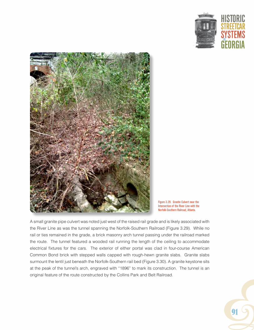
Y91
HISTORICSTReeTCaRSYSTeMSGeORGIaIn
A small granite pipe culvert was noted just west of the raised rail grade and is likely associated with
the River Line as was the tunnel spanning the Norfolk-Southern Railroad (Figure 3.29). While no
rail or ties remained in the grade, a brick masonry arch tunnel passing under the railroad marked
the route. The tunnel featured a wooded rail running the length of the ceiling to accommodate
electrical fixtures for the cars. The exterior of either portal was clad in four-course American
Common Bond brick with stepped walls capped with rough-hewn granite slabs. Granite slabs
surmount the lentil just beneath the Norfolk-Southern rail bed (Figure 3.30). A granite keystone sits
at the peak of the tunnel’s arch, engraved with “1896” to mark its construction. The tunnel is an
original feature of the route constructed by the Collins Park and Belt Railroad.
Figure 3.29. Granite Culvert near the Intersection of the River Line with the Norfolk-Southern Railroad, Atlanta.

92
3 Map Analysis and Field Assessment
Figure 3.30. Views of the River Line Masonry Arch Tunnel, Atlanta.
Further north of the intersection with the railroad, the River Line rejoins existing streets at Marietta
Road and terminates at a brick structure that acted as a waiting room and substation for the
Marietta Interurban line beginning in 1905. The River Substation is well preserved, and like many
of the commercial buildings identified along streetcar lines, it features a distinctive trapezoidal
shape, conforming to the streetcar right-of-way (Figure 3.31). The brick bond consisted of six-
course American Common Bond. The windows were boarded up but presented brick arches
on the surrounds, while the roof line was marked by raised coursing that stepped out to meet a
modern metal roof. Electrical fixtures associated with powering the cars were present along the
east side of the building. It was unclear if the building fell on property owned by Georgia Power,
the PATH Foundation, or another neighboring industrial lot.
Approximately 450 feet northwest of the River Substation, the Marietta Interurban route crosses
the Chattahoochee River. Remnants of the bridge spanning the river are evident on the Fulton
County side of Chattahoochee, as well as on two small rocky pads in the stream. The only remains

Y93
HISTORICSTReeTCaRSYSTeMSGeORGIaIn
Figure 3.31. Views of the River Substation, Atlanta.

94
3 Map Analysis and Field Assessment
of the bridge consisted of fragments of masonry associated with the footing and the rocky islands
constructed as foundations supports for the span (Figure 3.32). Although the structure is no longer
extant, archaeological resources remain.
A majority of the streetcar corridors examined did not possess intact buildings or structures and the
presence of archaeological sites is unknown. However, the impression of the system still remains
on the landscape in the form of cuts and fill used to maintain grade. As with historic railroad
corridors in Georgia, these historic streetcar landscapes can be defined in the earthworks that are
produced in their construction and maintenance, and these features remain even after surrounding
areas have developed. In addition to the landscape, the built environment often reflects the impact
of streetcar development in the form of commercial buildings constructed against the streetcar
right-of-way, often at major intersections. These commercial nodes can be large like the one found
at the intersection of Arkwright Place and Flat Shoals Road or consist of a lone structure as at the
intersection of the River Line with Hollywood Road. At times these buildings are not apparent from
the level of the street due to alterations over time, but when viewed from above, the imprint of the
streetcar is evident in building footprints constructed to accommodate the transit corridor (Figure
3.33). The expression of streetcar history in landscape features and commercial buildings will be
discussed further in the following section.
Figure 3.32. Archaeological Remains of the Marietta Interurban Line Bridge Foundations in the Chattahoochee River, Atlanta.

Y95
HISTORICSTReeTCaRSYSTeMSGeORGIaIn
Atlanta’s streetcar system has not been active for approximately
60 years. Before this study, vestiges of the system were only
evident and recognized in isolated pockets of the city and few
resources were identified as streetcar related. The analysis
of historic maps and the collection of reference materials
revealed a broader geography to Atlanta’s streetcars that was
far more encompassing than expected. The map analysis and
field assessment attempted to quantify some of the various
kinds of streetcar-related resources in terms of archaeological
and cultural resource survey. One result was an expanding
perspective as to the complexity of the streetcar’s effects on Atlanta and its surrounding cities.
The geography of the streetcar can be read in the architecture along its routes, in the landscape
through which it cuts, and under the pavement of the streets. This geography had been subtly
masked over time under the ever-changing streetscape of the city and the relentless progression
of technology. However, when historic features were drawn out of the maps and these areas were
examined with eyes informed to the myriad of resources associated with the system, its many
preserved features came to light. The next chapter examines these features as property types.
Figure 3.33. View of 816 Woodland Avenue from the Street (Above) and on the 1928 Topographic Atlas of Atlanta (Left).

96

Y97
HISTORICSTReeTCaRSYSTeMSGeORGIaIn
4. ProPerty tyPeSProPerty tyPes AssociAtedwith historic streetcAr systems
This context uses the National Register Property and Resource Types guidelines for defining property
types (US Department of the Interior 1997:15). These types include buildings, structures, objects,
sites, and districts. Examples of buildings related to streetcar systems are fairly self-explanatory.
They would include: powerhouses, car sheds, stables, etc. Structures are constructions made
for purposes other than providing shelter such as bridges, culverts, railroad grades, cut and fill
areas, retaining walls, and the individual streetcars themselves. Buried streetcar track is the most
wide ranging and ubiquitous streetcar property type encountered. Although streetcar track is
considered a structure, it is investigated archaeologically. Objects are generally those properties
that are primarily artistic or commemorative in nature, small in scale, and simply built. These may
include civic monuments, mile markers, or historic markers that are 50 years of age or older. Sites
are locations of a significant event or activity where the location itself possesses historic, cultural,
or archaeological value. These could include properties that were once strongly associated with
the development and expansion of streetcar systems in the state such as recreational parks and
fairgrounds, military installations and schools, and the locations of segregation or labor-related
transportation strife.
While buildings, structures, objects, and sites are individual properties, districts represent an
assembly of various property types linked by design or through a specific historic theme that,
when examined collectively, visually communicate historical significance. Examples of similarly
listed districts include transportation networks, as well as industrial complexes, both of which can
be applied to Georgia’s streetcar resources.
Activity associated with the construction and maintenance of Georgia’s streetcar systems has
produced numerous properties of varying types as defined by the National Register. This section
is organized by property type to serve as a field guide for surveyors to identify and assess potential
streetcar related resources. Examining these resource types as elements of larger local or regional
systems can clarify the historical value of those properties that may lack individual distinction.

98
4 Property Types
BUiLdiNGs
stABLes
Between 1868 and the onset of electrification in the early
1890s, stables were key facilities for mule-drawn streetcar
companies in Georgia. Due to the taxing nature of the work,
large numbers of horses or mules were required to maintain
operation of the lines. For some of the larger systems,
the inventory of horses often outnumbered the company’s
car stock by a nine to one ratio and costs associated with
stabling, feeding, and routine upkeep of the animals was
often considerable. Therefore, the size of stable buildings
corresponded to the relative size and extent of the respective
streetcar system. In Georgia, larger transit companies like
Atlanta and Macon, maintained contingents of 150 and
90 horses and mules, respectively, while smaller systems,
such as Athens, retained 30 mules (SRJ 1887b:351-353).
Streetcar companies tended to locate stables near the end
route lines where land costs were often cheaper, usually
on the periphery of central business districts (McShane
and Tarr 2007:106). Car barns could be incorporated
with the stable, but were usually located in close proximity. Industry standards from that period
recommend that street railroad stables be one-story buildings with well-lighted, spacious, and well-
ventilated interiors (Figure 4.1).
Stables could be wood frame
or built with brick masonry wall
construction to provide some
measure of fireproofing. Roofs
were either gabled or hipped
and sometimes featured a
clerestory deck roof running the
length of the structure. Exterior
yards were important for manure
collection (Rugg 1884:3).
Figure 4.1. Illustration of Streetcar Stable Interior. Source Fairchild 1892.
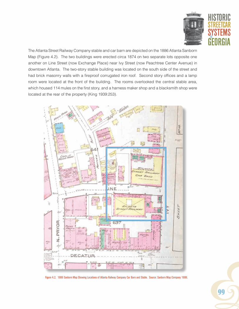
Y99
HISTORICSTReeTCaRSYSTeMSGeORGIaIn
The Atlanta Street Railway Company stable and car barn are depicted on the 1886 Atlanta Sanborn
Map (Figure 4.2). The two buildings were erected circa 1874 on two separate lots opposite one
another on Line Street (now Exchange Place) near Ivy Street (now Peachtree Center Avenue) in
downtown Atlanta. The two-story stable building was located on the south side of the street and
had brick masonry walls with a fireproof corrugated iron roof. Second story offices and a lamp
room were located at the front of the building. The rooms overlooked the central stable area,
which housed 114 mules on the first story, and a harness maker shop and a blacksmith shop were
located at the rear of the property (King 1939:253).
Figure 4.2. 1886 Sanborn Map Showing Locations of Atlanta Railway Company Car Barn and Stable. Source: Sanborn Map Company 1886.

100
4 Property Types
cAr BArNs
Car Barns have been an essential element of street rail transportation throughout its history. They were constructed along side stables during the early years of animal traction and later with power stations as electricity was adopted. The overall plan and purpose of these buildings mirrored their counterparts found in conventional rail yards. Numerous rail sidings led cars off the line and into buildings for maintenance or repair. Overtime these properties grew in complexity, as system needs changed and technology was upgraded.
Critical elements for identifying car barns are access points and scale. Barns will be located on a siding or directly adjacent to a line. Facilities erected during the early twentieth century are generally functional in design and are often built of steel reinforced brick masonry with concrete foundations and American common bond red brick exteriors. Older electric streetcar barns built during the late nineteenth century also generally featured brick masonry construction but may include more stylistic
detailing, such as arched windows, stepped parapet walls, and corbelling. Facades on car barns contain large, single or multiple bay openings to accommodate cars. These properties were constructed not only to service cars but to also house them, so they were constructed at a scale to accommodate multiple vehicles. Car barns may be either one or two-story and often employ a sub level or pits to provide access to the cars from underneath. Although the American Electric Railway Engineering Society recommended that a flat roof was “the only suitable [type] for a car house,” shallow-pitched gable and shed roofs are also common. Sawtooth skylights, clerestories, or monitors are often used to provide natural interior light (Richey and Greenough 1915:109). The functional nature of this building type makes them suitable for reuse (Figure 4.3). This continued use can sometimes obscure streetcar related features, such as the removal of track, enclosure of bay openings, or filled sub-floor pits. There is also potential for the identification of brick or frame support structures and secondary buildings associated with car barns, such as foundries, oil houses, and storerooms.
Atlanta’s extant car barns provide two examples from two different eras. The Inman Park Trolley Barn on Edgewood Avenue is a long linear building paralleling the route to the north. It features architectural details reflective of its construction in 1889 like bracketed eaves, wood shingle
siding, and a large Queen Anne Style turret (Figure 4.4). Windows and large bays are clustered
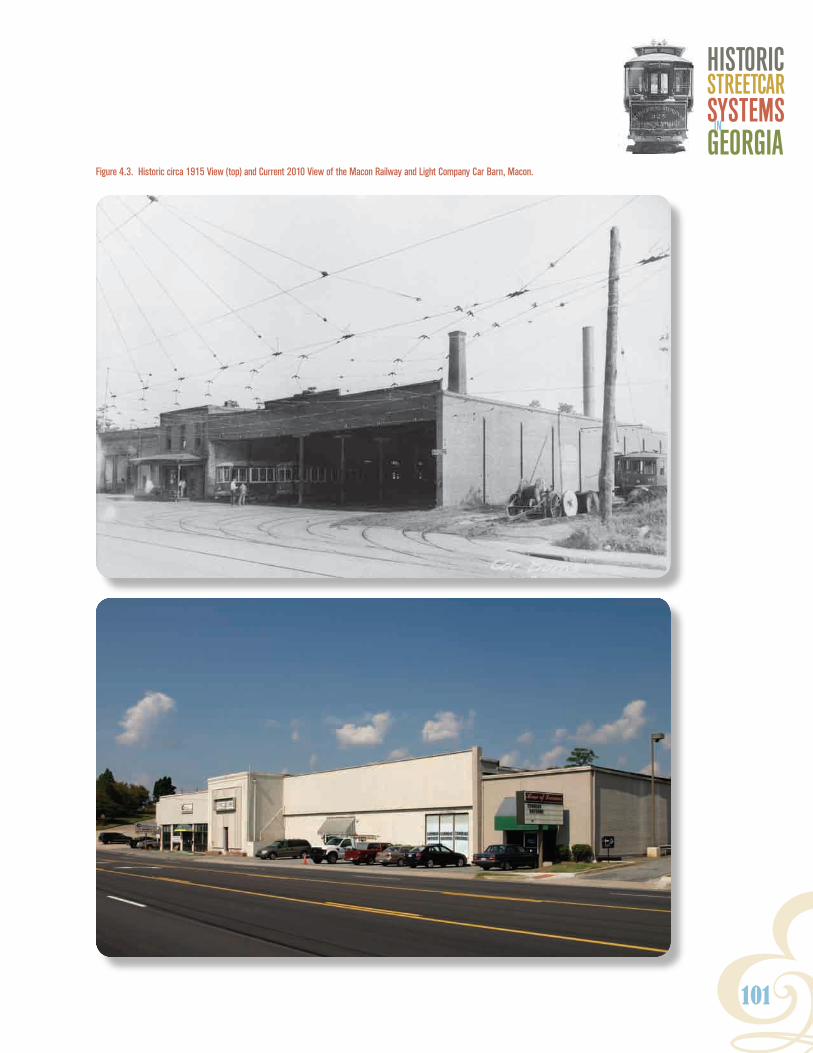
Y101
HISTORICSTReeTCaRSYSTeMSGeORGIaIn
Figure 4.3. Historic circa 1915 View (top) and Current 2010 View of the Macon Railway and Light Company Car Barn, Macon.

102
4 Property Types
at either end of the barn, which reaches two-stories in height. Conversely, the Ashby Street Car
Barn reflects the utilitarian design of industrial buildings of the 1920s with common bond brick
masonry construction; large, open bays; and a clerestory vault with steel framed windows running
the length of the roofline (Figure 4.5). Both buildings are rectangular and straddle sidings to
accommodate route traffic, but the Ashby Street property also possesses the secondary oil house
building, illustrating the potential presence of support buildings.
Figure 4.4. Inman Park Trolley Barn, 2011.
Figure 4.5. Ashby Street Car Barn, 2010.

Y103
HISTORICSTReeTCaRSYSTeMSGeORGIaIn
AdmiNistrAtive offices
In most cases, the central administrative offices of streetcar companies were typically rented space in shared commercial office and retail buildings located in downtown central business districts. Central offices were not necessarily located adjacent to streetcar lines and would often change locations over the life of the company. Some of the larger transit and public utility companies, like Georgia Railway and Power, also developed their own, dedicated office buildings (Figure 4.6). Consultation of historic city directories and Sanborn Fire Insurance Maps are often the best resources used to find the former addresses of streetcar company
offices.
troLLey wAitiNG stAtioNs
The design and building materials of streetcar waiting stops often depended on the street railroad company and particular line. The functional structures could be of frame or masonry construction and were usually open on all sides. They were often furnished with wood or concrete benches. Waiting stations in downtown areas were often nothing more than raised concrete center islands (Figure 4.7). Georgia Railway and Power Company employed a number of frame trolley stations with benches and wood shingle gabled canopies on their more suburban lines throughout Metro Atlanta (Figures 4.8 and 4.9). Local neighborhood groups or gardening clubs were sometimes allowed to embellish the appearance of some stops, such as the Springhill station in Smyrna on the Atlanta Northern Railway interurban line, which featured a thatched roof. Both the Marietta and Stone Mountain interurban lines also
featured interior passenger-waiting areas in the substation
and car barn facilities along the routes.
Figure 4.6. Former Georgia Power Office Building on Marietta Street, Atlanta.

104
4 Property Types
Figure 4.7. Center Island Waiting Areas in downtown Atlanta, 1926. Source: Georgia Power Company 1927.

Y105
HISTORICSTReeTCaRSYSTeMSGeORGIaIn
Figure 4.9. Avondale Estates Trolley Stop (altered), 2011.
Figure 4.8. Streetcar Stop on Fourth Street in Stone Mountain, circa 1940. Courtesy of George Coletti.
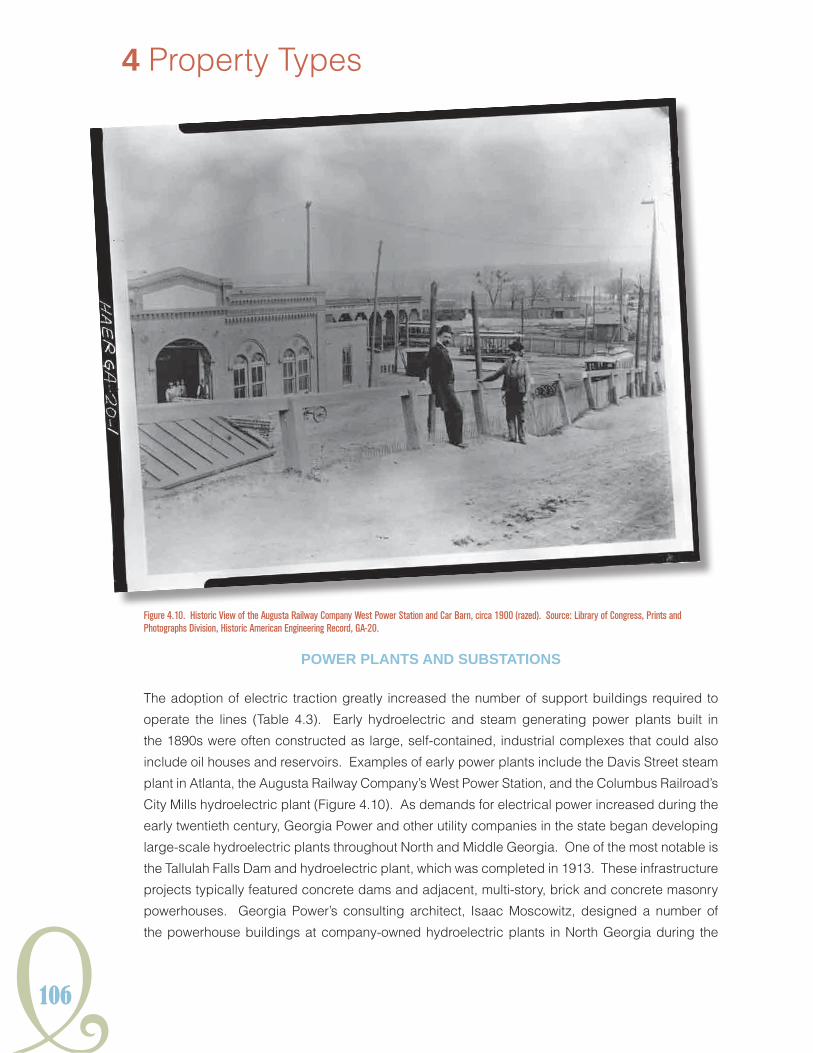
106
4 Property Types
Figure 4.10. Historic View of the Augusta Railway Company West Power Station and Car Barn, circa 1900 (razed). Source: Library of Congress, Prints and Photographs Division, Historic American Engineering Record, GA-20.
Power PLANts ANd sUBstAtioNs
The adoption of electric traction greatly increased the number of support buildings required to
operate the lines (Table 4.3). Early hydroelectric and steam generating power plants built in
the 1890s were often constructed as large, self-contained, industrial complexes that could also
include oil houses and reservoirs. Examples of early power plants include the Davis Street steam
plant in Atlanta, the Augusta Railway Company’s West Power Station, and the Columbus Railroad’s
City Mills hydroelectric plant (Figure 4.10). As demands for electrical power increased during the
early twentieth century, Georgia Power and other utility companies in the state began developing
large-scale hydroelectric plants throughout North and Middle Georgia. One of the most notable is
the Tallulah Falls Dam and hydroelectric plant, which was completed in 1913. These infrastructure
projects typically featured concrete dams and adjacent, multi-story, brick and concrete masonry
powerhouses. Georgia Power’s consulting architect, Isaac Moscowitz, designed a number of
the powerhouse buildings at company-owned hydroelectric plants in North Georgia during the

Y107
HISTORICSTReeTCaRSYSTeMSGeORGIaIn
mid 1920s, including Nacoochee, Terrora, Tugaloo, and Yonah (Figure 4.11). The powerhouses
generally were designed with similar Italian Renaissance Revival style elements such as red brick
exteriors with limestone detailing; high, arched windows; and low pitched, hipped roofs covered
with barrel clay tile (Pellerin 2009).
table 4.3. Atlanta substations Providing railway Power
Name current condition
Butler Street Razed; redeveloped
Camp Gordon Unknown
Davis Street Plant Razed; redeveloped
Decatur Razed; redeveloped
East Point Razed; redeveloped
Emory Partially razed
Lakewood Unknown
Moreland Avenue Razed; redeveloped
Piedmont Avenue Razed; redeveloped
River Station Extant
Spring Street Extant
Stewart Avenue Extant
Source: Beeler 1924c and Georgia Power Yearbook 1927-1928
Figure 4.11. Tugaloo Dam and Powerhouse, 2006. Photograph Courtesy of Travis L. Kovacs.

108
4 Property Types
Meanwhile, substations and other support buildings were located along lines and in conjunction
with shops and barns to protect power generating and transmission equipment. Unlike modern,
open design transformer facilities of the mid and late twentieth century, early electrical substation
equipment required manual switching operation; therefore, it was housed inside buildings. With
the onset of automation substation facilities began to take on a modern configuration. Since the
growth of street rail and energy production are so closely linked and the buildings and equipment
of individual companies would eventually be incorporated into a consolidated system under the
Georgia Railway and Power Company, many of these properties are impacted by system-wide
grid upgrades and maintenance. Therefore, preservation of original buildings and structures are
less likely over time.
Energy facilities were an established part of the streetscape in the first decades of the twentieth
century. Substation buildings typically would be two-story masonry, composed primarily of brick
and concrete. Atlanta examples have red brick masonry exteriors, with Italian Renaissance
Figure 4.12. East Point Substation and Car Barn, circa 1915 (razed).

Y109
HISTORICSTReeTCaRSYSTeMSGeORGIaIn
Revival style features and brick masonry details like quoins, denticulated entablatures, and large
arched windows capped in keystones. These buildings would generally have an open plan
allowing for the servicing and operation of large power generation equipment. The former East
Point Substation and currently extant Stewart Avenue Substation illustrate this type of plan and
these architectural details (Figure 4.12). The Spring Street Substation also possesses many of
these architectural details on its façade but its modernized design as an automated and noiseless
station allowed for much of its transformer equipment to be located in an open enclosure at the
rear of the two-story building. On the other end of the spectrum, the Emory Substation features a
small, single room building potentially dating to the streetcar era while the remainder of the facility
is modern and devoid or any historic architectural details.
Historic power plants and substations constructed during this period might have provided electricity
to the transit system. However, not all the extant power plant and substation facilities from this
period are streetcar-related. For example, the multi-story substation at 148 Edgewood Avenue and
the larger Boulevard Substation complex on Monroe Drive in Atlanta, are contemporaries of other
period substations but transmitted electricity for commercial and residential consumption rather
than streetcar operations (Beeler 1924c:78). Therefore, historical research into the property’s
use is critical when examining a potential resource. The presence of other electrical structures,
like poles and wires, near these properties can help clarify their role in energy production and
transmission for a transit system.
strUctUres
streetcArs
Individual streetcars, or trolleys, like other transportation-
related historic resources, such as trains, boats, and aircraft,
may also be eligible for the National Register of Historic Places
as structures. The streetcars themselves are most popularly
associated with the history of street railway transportation in
Georgia by the general public. Once lines were abandoned,
transit companies often demolished trolleys for scrap or
sold them off either domestically or abroad for adaptive use;
therefore, intact examples of these resources with a historic
link to Georgia are rare when considering the number of
cars that were built and operated during the period of street
railway service in the state from the 1870s through the
1940s. At present, only seven existing streetcars associated

110
4 Property Types
with Georgia’s street railway history have been verified as part of this study (Table 4.1). All date
from the electric traction era of the late nineteenth and early twentieth centuries. None of these
resources have been listed in the National Register of Historic Places.
Six of the known existing cars are housed in history and transportation museums in Georgia and
Connecticut (Figure 4.13). The body and truck of Atlanta streetcar No. 948 was completely restored
and is currently on display at the Shoreline Trolley Museum in East Haven, Connecticut. Jaspar
County Commissioner Neal Leggett donated Georgia Railway and Power Company Car No. 636
to the Southeastern Train Museum in 1998. Georgia Power had sold the stripped streetcar body to
Leggett’s grandmother in the late 1940s, and she had incorporated it into the design of her house in
Monticello, Georgia (Figure 4.14). The Savannah Roundhouse
Museum has the bodies of two 1920s Birney Safety Cars, Nos.
630 and 636, in storage. These small one-man operation cars
had once served as part of the Savannah Electric and Power
Company transit system (Terry Koller, Roundhouse Railroad
Museum Manager of Operations, personal communication,
2011). The body of Americus Street Railroad Company Car
No. 2 is on display in the Lake Blackshear Regional Library in
Figure 4.13. Augusta-Aiken Railway Co. Birney Safety Car. Source: Augusta Museum of History.
Figure 4.14. Removal and Transport of Georgia Railway and Power Car No. 636, 1996. Courtesy of Fred Dodds and the Southeastern Railway Museum.

Y111
HISTORICSTReeTCaRSYSTeMSGeORGIaIn
Americus, Georgia. The electric car had been part of the city’s streetcar system during the 1890s
and was later sold to a private party and used as a camping and hunting lodge (Lake Blackshear
Regional Library 2010).
Table 4.1. Verified Extant Georgia Streetcars
car Number
company year Built
Builder condition status Location
2 Americus Street Railroad Co.
Circa 1890
J.G. Brill Co. Body only On Display Lake Blackshear Regional Library, Americus, GA
269 Georgia Railway and Power Co.
1921 Cincinnati Car Co.
Body only In Storage Southeastern Train Museum, Duluth, GA
415 Augusta-Aiken Railway Co.
1923 Perley Thomas Body and Truck
On Display Augusta Museum of History, Augusta, GA
630 Savannah Electric and Power Co.
1923 St. Louis Car Co.
Body only In Storage Savannah Roundhouse Museum Savannah, GA
636 Georgia Railway and Power Co.
1924 Georgia Railway and Power Co.
Body only In Storage Southeastern Train Museum, Duluth, GA
636 Savannah Electric and Power Co.
1923 American Car Co.
Body only In Storage Savannah Roundhouse Museum Savannah, GA
948 Georgia Railway and Power Co.
1926 Cincinnati Car Co.
Body and Truck
On Display Shoreline Trolley Museum, East Haven, CT
Other intact streetcar bodies associated with street railway transit systems in Georgia may still
exist throughout the state and country, or even internationally. When sold, streetcars were typically
stripped of their electrical and mechanical equipment and converted for use as outbuildings,
hunting cabins, diners, or were incorporated into existing residences or other buildings and
structures as new rooms or porches. Identification of these properties may be difficult due to
general decay, material changes, and additions that may have obscured their historic appearance
and character-defining features over time.
All historic streetcar types (animal-drawn, steam-powered, or electric) consisted of two primary
components, the car body and the mechanical trucks. Georgia streetcar companies generally
purchased their rolling stock from the industry’s major carbuilders, which included: the American
Car Company of St. Louis, Missouri (1891-1931); the Baldwin Locomotive Works (1825-1972) and
the J.G. Brill Company (1868-1956) of Philadelphia, Pennsylvania; the Cincinnati Car Company
of Cincinnati, Ohio (1902-1938); the St. Louis Car Company, St. Louis, Missouri (1887-1972); the
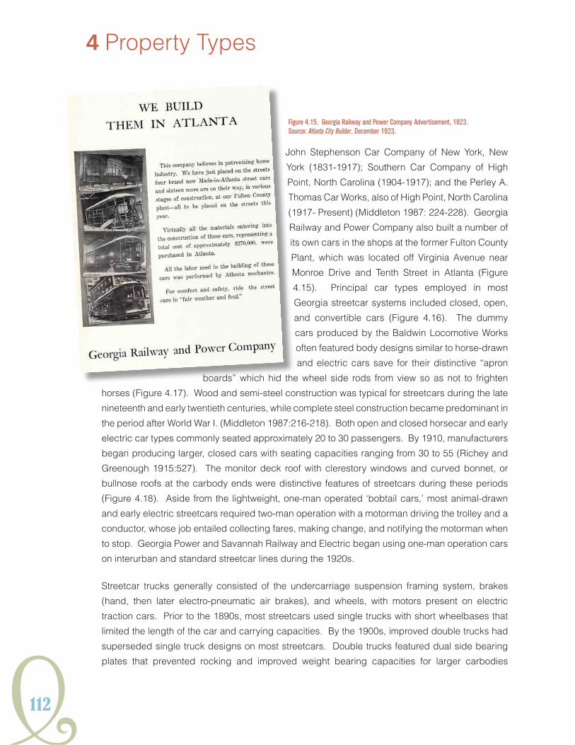
112
John Stephenson Car Company of New York, New
York (1831-1917); Southern Car Company of High
Point, North Carolina (1904-1917); and the Perley A.
Thomas Car Works, also of High Point, North Carolina
(1917- Present) (Middleton 1987: 224-228). Georgia
Railway and Power Company also built a number of
its own cars in the shops at the former Fulton County
Plant, which was located off Virginia Avenue near
Monroe Drive and Tenth Street in Atlanta (Figure
4.15). Principal car types employed in most
Georgia streetcar systems included closed, open,
and convertible cars (Figure 4.16). The dummy
cars produced by the Baldwin Locomotive Works
often featured body designs similar to horse-drawn
and electric cars save for their distinctive “apron
boards” which hid the wheel side rods from view so as not to frighten
horses (Figure 4.17). Wood and semi-steel construction was typical for streetcars during the late
nineteenth and early twentieth centuries, while complete steel construction became predominant in
the period after World War I. (Middleton 1987:216-218). Both open and closed horsecar and early
electric car types commonly seated approximately 20 to 30 passengers. By 1910, manufacturers
began producing larger, closed cars with seating capacities ranging from 30 to 55 (Richey and
Greenough 1915:527). The monitor deck roof with clerestory windows and curved bonnet, or
bullnose roofs at the carbody ends were distinctive features of streetcars during these periods
(Figure 4.18). Aside from the lightweight, one-man operated ‘bobtail cars,’ most animal-drawn
and early electric streetcars required two-man operation with a motorman driving the trolley and a
conductor, whose job entailed collecting fares, making change, and notifying the motorman when
to stop. Georgia Power and Savannah Railway and Electric began using one-man operation cars
on interurban and standard streetcar lines during the 1920s.
Streetcar trucks generally consisted of the undercarriage suspension framing system, brakes
(hand, then later electro-pneumatic air brakes), and wheels, with motors present on electric
traction cars. Prior to the 1890s, most streetcars used single trucks with short wheelbases that
limited the length of the car and carrying capacities. By the 1900s, improved double trucks had
superseded single truck designs on most streetcars. Double trucks featured dual side bearing
plates that prevented rocking and improved weight bearing capacities for larger carbodies
4 Property Types
Figure 4.15. Georgia Railway and Power Company Advertisement, 1923. Source: Atlanta City Builder, December 1923.

Y113
HISTORICSTReeTCaRSYSTeMSGeORGIaIn
Figure 4.17. Baldwin Locomotive Works Steam Dummy Car. Source: Street Railway Journal 1891.
Figure 4.18. Twentieth-Century Closed Car Type. Source: Middleton 1987.
Figure 4.16. Illustrations of Early Car Types. Sources: Fairchild 1892 and the Street Railway Journal.
Closed Car
Open Car
Convertible Car

114
4 Property Types
(Figure 4.19). Among the major electric motor and truck suppliers were: the Allis-Chalmers
Company of Milwaukee, Wisconsin; the Barney and Smith Car Company of Dayton, Ohio (1849-
1923), which built both cars and trucks; the aforementioned J.G. Brill Company; General Electric
(which was formed in 1892 with the merger of the Thomson-Houston and Edison General Electric
companies); the McGuire-Cummings Manufacturing Company of Paris, Illinois (1888-1943); and
the Westinghouse Electric and Manufacturing Company (Middleton 1987: 219,224-228).
BridGes, UNderPAsses, ANd trestLes
Street railroad companies commonly erected bridges and underpasses on privately-owned rights-
of-way to provide unobstructed clearance at intersections with railroad corridors or to span rivers and
uneven terrain. During the 1870s and 1880s, bridges carrying horse-drawn streetcars were often
iron and wood trestles, which were economical in terms of both cost of materials and construction.
With advancements in steel manufacturing during the later decades of the nineteenth century,
larger spans and more permanent bridge designs became possible (National Research Council
[NRC] 2005: 2-6 and 2-13). By the mid-1920s, five types of bridge and underpass structures
were identified within the Atlanta streetcar system that had been built, owned, or maintained by
Figure 4.19. Streetcar Truck Designs. Source: Fairchild 1892 and the Street Railway Journal 1889.
Single Truck
Double Truck

Y115
HISTORICSTReeTCaRSYSTeMSGeORGIaIn
Georgia Railway and Power: the masonry arch bridge; the
plate girder underpass; the reinforced concrete bridge; the
steel thru truss bridge; and the timber trestle bridge (Beeler
1924c:131).
Although masonry arch bridge construction dates from
ancient Rome and Greece, the inability to produce high load
capacities and long spans, limited common use of the bridge
type for railroad projects in the United States until the 1830s.
Masonry arch bridges may contain brick, ashlar stone work,
or a combination of both materials (NRC 2005:3-50). Arch
bridges were valued by railroad companies for their strength
and durability and were often designed with aesthetic
embellishments for public acceptance. They could also
be costly and time consuming to build. Common features
of the bridge type include brick or ashlar stone masonry
construction, an arch ring with voussoirs and keystone,
barrel spandrel walls, and abutments or wingwalls (Solomon
2008:16). An excellent example of a masonry arch bridge
is the River Line Western and Atlantic Underpass Bridge,
which was built in 1896 by the Collins Park and Belt Railroad Company and was later inherited by
Georgia Railway and Power for use on the company’s River Line route (Figure 4.20).
The plate girder bridge
is a reinforced concrete
bridge supported by two
or more built-up structural
steel plates or I- beams
that are welded or riveted
together. Wood, steel, and
reinforced concrete were
common decking materials.
Substructures for plate
girder bridges are often
stone or concrete masonry
abutments. The first plate
girder bridge was developed
by James Millholland for the Figure 4.20. Western and Atlantic (now Norfolk-Southern) Masonry Arch Underpass, 2010.
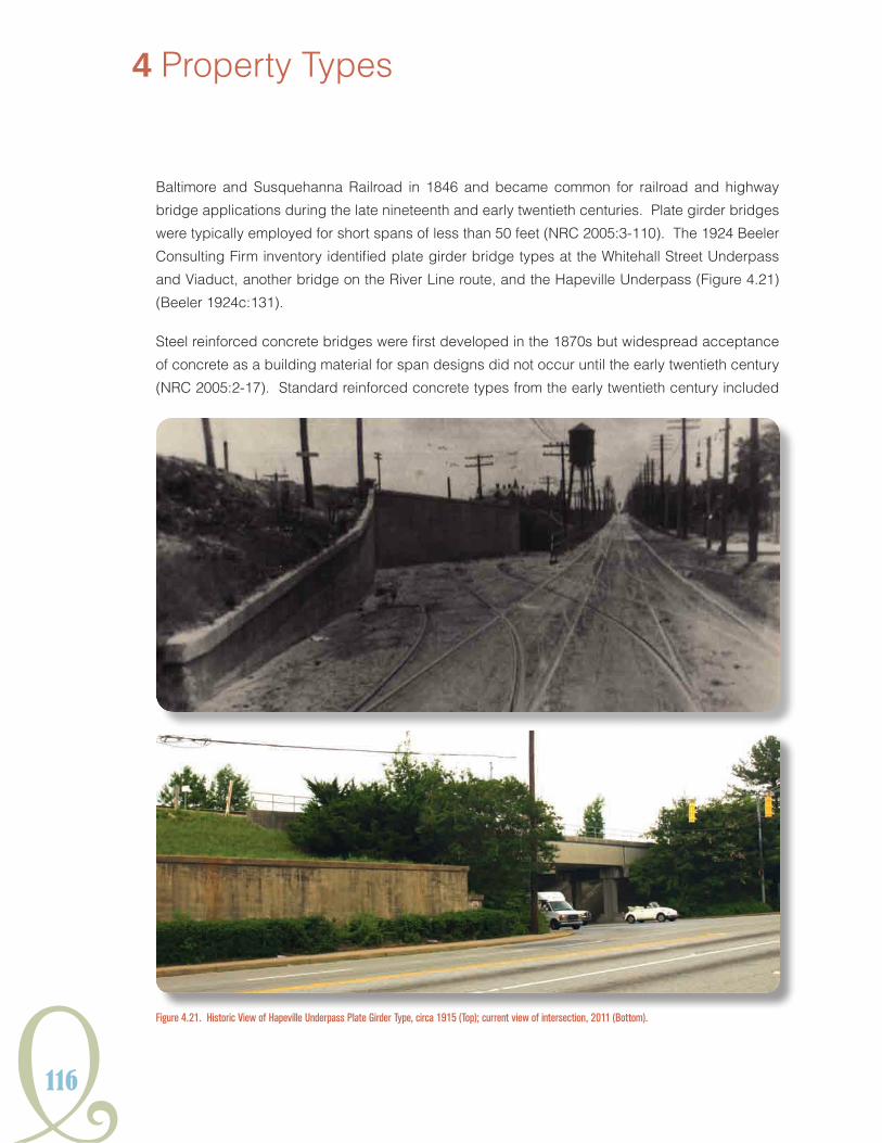
116
4 Property Types
Baltimore and Susquehanna Railroad in 1846 and became common for railroad and highway
bridge applications during the late nineteenth and early twentieth centuries. Plate girder bridges
were typically employed for short spans of less than 50 feet (NRC 2005:3-110). The 1924 Beeler
Consulting Firm inventory identified plate girder bridge types at the Whitehall Street Underpass
and Viaduct, another bridge on the River Line route, and the Hapeville Underpass (Figure 4.21)
(Beeler 1924c:131).
Steel reinforced concrete bridges were first developed in the 1870s but widespread acceptance
of concrete as a building material for span designs did not occur until the early twentieth century
(NRC 2005:2-17). Standard reinforced concrete types from the early twentieth century included
Figure 4.21. Historic View of Hapeville Underpass Plate Girder Type, circa 1915 (Top); current view of intersection, 2011 (Bottom).
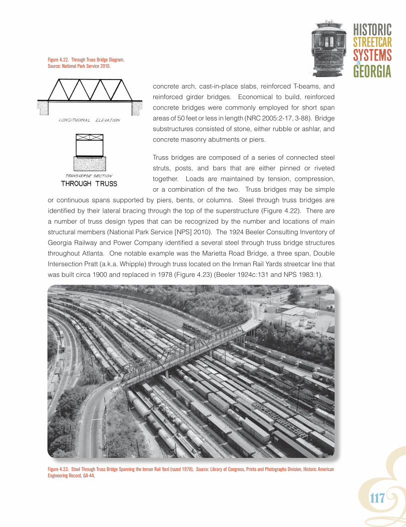
Y117
HISTORICSTReeTCaRSYSTeMSGeORGIaIn
concrete arch, cast-in-place slabs, reinforced T-beams, and
reinforced girder bridges. Economical to build, reinforced
concrete bridges were commonly employed for short span
areas of 50 feet or less in length (NRC 2005:2-17, 3-88). Bridge
substructures consisted of stone, either rubble or ashlar, and
concrete masonry abutments or piers.
Truss bridges are composed of a series of connected steel
struts, posts, and bars that are either pinned or riveted
together. Loads are maintained by tension, compression,
or a combination of the two. Truss bridges may be simple
or continuous spans supported by piers, bents, or columns. Steel through truss bridges are
identified by their lateral bracing through the top of the superstructure (Figure 4.22). There are
a number of truss design types that can be recognized by the number and locations of main
structural members (National Park Service [NPS] 2010). The 1924 Beeler Consulting Inventory of
Georgia Railway and Power Company identified a several steel through truss bridge structures
throughout Atlanta. One notable example was the Marietta Road Bridge, a three span, Double
Intersection Pratt (a.k.a. Whipple) through truss located on the Inman Rail Yards streetcar line that
was built circa 1900 and replaced in 1978 (Figure 4.23) (Beeler 1924c:131 and NPS 1983:1).
Figure 4.23. Steel Through Truss Bridge Spanning the Inman Rail Yard (razed 1978). Source: Library of Congress, Prints and Photographs Division, Historic American Engineering Record, GA-44.
Figure 4.22. Through Truss Bridge Diagram. Source: National Park Service 2010.

118
4 Property Types
Figure 4.25. Wood Trestle on Marietta Interurban Line Near River Substation, 1942 (razed). Source: Carson 1981.
Figure 4.24. Illustration of Wood Trestle Construction. Source: Willard 1915.
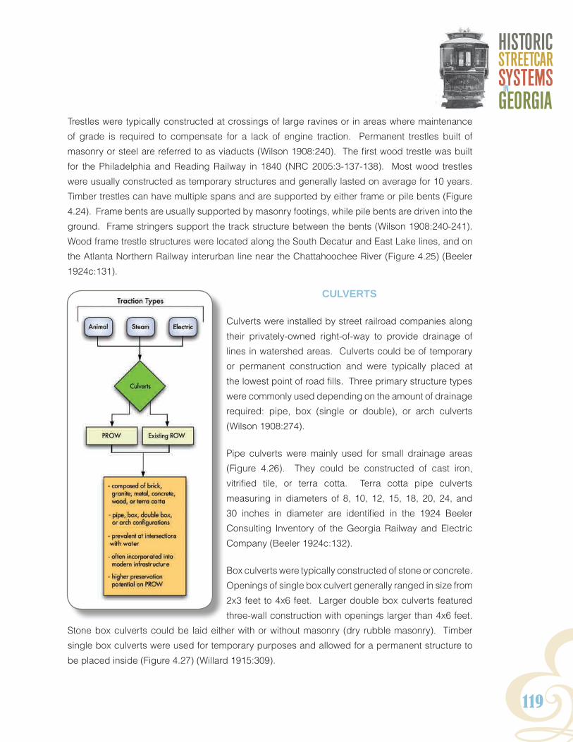
Y119
HISTORICSTReeTCaRSYSTeMSGeORGIaIn
Trestles were typically constructed at crossings of large ravines or in areas where maintenance
of grade is required to compensate for a lack of engine traction. Permanent trestles built of
masonry or steel are referred to as viaducts (Wilson 1908:240). The first wood trestle was built
for the Philadelphia and Reading Railway in 1840 (NRC 2005:3-137-138). Most wood trestles
were usually constructed as temporary structures and generally lasted on average for 10 years.
Timber trestles can have multiple spans and are supported by either frame or pile bents (Figure
4.24). Frame bents are usually supported by masonry footings, while pile bents are driven into the
ground. Frame stringers support the track structure between the bents (Wilson 1908:240-241).
Wood frame trestle structures were located along the South Decatur and East Lake lines, and on
the Atlanta Northern Railway interurban line near the Chattahoochee River (Figure 4.25) (Beeler
1924c:131).
cULverts
Culverts were installed by street railroad companies along
their privately-owned right-of-way to provide drainage of
lines in watershed areas. Culverts could be of temporary
or permanent construction and were typically placed at
the lowest point of road fills. Three primary structure types
were commonly used depending on the amount of drainage
required: pipe, box (single or double), or arch culverts
(Wilson 1908:274).
Pipe culverts were mainly used for small drainage areas
(Figure 4.26). They could be constructed of cast iron,
vitrified tile, or terra cotta. Terra cotta pipe culverts
measuring in diameters of 8, 10, 12, 15, 18, 20, 24, and
30 inches in diameter are identified in the 1924 Beeler
Consulting Inventory of the Georgia Railway and Electric
Company (Beeler 1924c:132).
Box culverts were typically constructed of stone or concrete.
Openings of single box culvert generally ranged in size from
2x3 feet to 4x6 feet. Larger double box culverts featured
three-wall construction with openings larger than 4x6 feet.
Stone box culverts could be laid either with or without masonry (dry rubble masonry). Timber
single box culverts were used for temporary purposes and allowed for a permanent structure to
be placed inside (Figure 4.27) (Willard 1915:309).

120
4 Property Types
Arch culverts were used for drainage areas that
required openings larger than 48 square feet. The
featured semi-circular arches typically exceeding
6-foot spans (Figure 4.28). Early arch culverts were
usually built of stone masonry, while later systems were
primarily concrete or steel reinforced concrete lined
with brick or stone (Wilson 1908:281). Arch culverts
on McClendon Avenue and at Proctor Creek are
listed in the 1912 Baehr Inventory (Baehr 1912a:41).
The 1924 Beeler Consulting Inventory identified the
locations of concrete arch culverts along the South
Decatur streetcar line at the intersections of Sugar
Creek, Anniston Avenue, and East Lake Junction
(Beeler 1924c:132). The locations or conditions of
these potential resources have not been confirmed.
Figure 4.27. Illustrated Diagram of Single Timber Box Culvert. Source: Williard 1915.
Figure 4.28. Illustrated Diagram of Masonry Arch Culvert. (Source: Wilson 1908).
Figure 4.26. Illustrated Profile of a Pipe Culvert. Source: Wilson 1908.
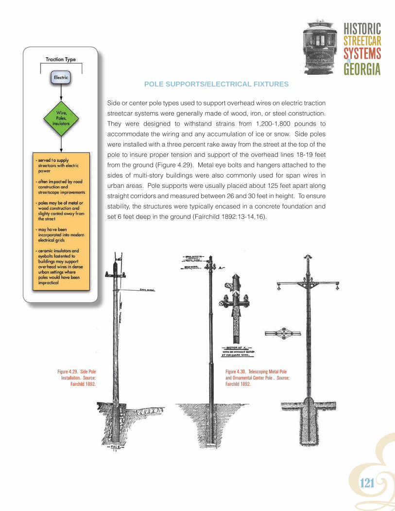
Y121
HISTORICSTReeTCaRSYSTeMSGeORGIaIn
PoLe sUPPorts/eLectricAL fixtUres
Side or center pole types used to support overhead wires on electric traction
streetcar systems were generally made of wood, iron, or steel construction.
They were designed to withstand strains from 1,200-1,800 pounds to
accommodate the wiring and any accumulation of ice or snow. Side poles
were installed with a three percent rake away from the street at the top of the
pole to insure proper tension and support of the overhead lines 18-19 feet
from the ground (Figure 4.29). Metal eye bolts and hangers attached to the
sides of multi-story buildings were also commonly used for span wires in
urban areas. Pole supports were usually placed about 125 feet apart along
straight corridors and measured between 26 and 30 feet in height. To ensure
stability, the structures were typically encased in a concrete foundation and
set 6 feet deep in the ground (Fairchild 1892:13-14,16).
Figure 4.30. Telescoping Metal Pole and Ornamental Center Pole . Source: Fairchild 1892.
Figure 4.29. Side Pole Installation. Source:
Fairchild 1892.
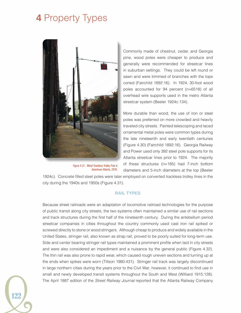
122
4 Property Types
Commonly made of chestnut, cedar, and Georgia
pine, wood poles were cheaper to produce and
generally were recommended for streetcar lines
in suburban settings. They could be left round or
sawn and were trimmed of branches with the tops
coned (Fairchild 1892:16). In 1924, 30-foot wood
poles accounted for 94 percent (n=6518) of all
overhead wire supports used in the metro Atlanta
streetcar system (Beeler 1924c:134).
More durable than wood, the use of iron or steel
poles was preferred on more crowded and heavily
traveled city streets. Painted telescoping and laced
ornamental metal poles were common types during
the late nineteenth and early twentieth centuries
(Figure 4.30) (Fairchild 1892:16). Georgia Railway
and Power used only 392 steel pole supports for its
Atlanta streetcar lines prior to 1924. The majority
of these structures (n=185) had 7-inch bottom
diameters and 5-inch diameters at the top (Beeler
1924c). Concrete filled steel poles were later employed on converted trackless trolley lines in the
city during the 1940s and 1950s (Figure 4.31).
rAiL tyPes
Because street railroads were an adaptation of locomotive railroad technologies for the purpose
of public transit along city streets, the two systems often maintained a similar use of rail sections
and track structures during the first half of the nineteenth century. During the antebellum period
streetcar companies in cities throughout the country commonly used cast iron rail spiked or
screwed directly to stone or wood stringers. Although cheap to produce and widely available in the
United States, stringer rail, also known as strap rail, proved to be poorly suited for long-term use.
Side and center bearing stringer rail types maintained a prominent profile when laid in city streets
and were also considered an impediment and a nuisance by the general public (Figure 4.32).
The thin rail was also prone to rapid wear, which caused rough uneven sections and turning up at
the ends when spikes were worn (Tillson 1980:431). Stringer rail track was largely discontinued
in large northern cities during the years prior to the Civil War; however, it continued to find use in
small and newly developed transit systems throughout the South and West (Williard 1915:128).
The April 1887 edition of the Street Railway Journal reported that the Atlanta Railway Company
Figure 4.31. Metal Trackless Trolley Pole in downtown Atlanta, 2010.

Y123
HISTORICSTReeTCaRSYSTeMSGeORGIaIn
operated its mule-drawn rolling stock
over cast and wrought iron 42 lb. section
center bearing stringer rail over 13 miles
of track (Figure 4.20) (SRJ 1887b:351).
In 1830, Colonel Robert Stevens of the
Camden and Amboy Railway invented the
flange, or T-rail (Figure 4.33). Early T-rail
sections were manufactured in cast and
wrought iron and often of poor quality; how-
ever, the rail type soon proved to be the
most economical to produce and maintain
(Tratman 1897:54-55). In 1865, the first
Bessemer steel cast rails rolled in the Unit-
ed States at the North Chicago Rolling Mill
near Detroit, Michigan (Bianculli 2003:18).
Steel T-rail was considerably more durable
than its iron counterpart and was quickly
adopted for railroad and street railway use
throughout the United States during the
middle and late nineteenth century. In 1887,
the Classic City Street Railway in Athens,
Georgia used 16 and 20 lb. T-rail sections
on its four-mile mule-drawn system. Other
motive systems, like the steam locomotive-
powered Metropolitan Street Railroad Com-
pany, also in Atlanta, ran on 20 lb. T-rail
while the Augusta and Summerville Rail-
road Company employed 30 lb. sections
on its combination freight and passenger
lines (SRJ 1887b:351). The interurban lines
of the early twentieth century, like the Atlanta Northern Railway, employed heavier 70 and 80 lb.
T-rail to handle the service’s larger passenger cars and faster operating speeds (Baehr 1912b).
Girder rail, or tram rail, was designed in three main profiles: side bearing, center bearing, and
grooved (also referred to as ‘Trilby Rail’) (Figure 4.34). Girder rail gained widespread adoption
among street railroad companies in the United States during the period of electrification in the

124
4 Property Types
Figure 4.34. Girder Rail Profiles. Source: Pratt and Alden 1898.
Figure 4.32. Stringer Rail Profile Types. Source: Pratt and Alden 1898.
Figure 4.33. T-rail Profile. Source: Williard 1915.
Side Bearing Center Bearing Grooved (“Trilby”)

Y125
HISTORICSTReeTCaRSYSTeMSGeORGIaIn
1890s. First developed in the 1860s, preliminary designs of girder rail were put into use for
streetcar service in France and Britain during the 1870s (Clark 1894:330). Over time, street railroad
companies preferred to use girder rail in pavement on heavily used city streets because it presented
less obstruction for other public traffic. The vertical strength of girder rail also negated the need
for a wood stringer in paved lines. With the advent of girder and grooved rail, T-rail was primarily
relegated for track along private right-of-way or in suburban areas where traffic would be relatively
light. The American Electric Railway Engineering Association (A.E.R.E.A) eventually standardized
the design for seven inch, eight-and-a-half inch, and nine-inch girder rail in 1922 (Tillson 1900:436).
trAck coNstrUctioN/PAviNG
Streetcar companies in the state generally adhered to the standard U.S. track gauge for their lines
with a spacing of four feet, eight-and-a-half inches wide between the inner heads of the track rail.
Early street railroad track construction in Georgia cities during the 1870s was basic and typically
followed the methods used by the conventional railroads. The track was simply laid in the center
of the street. Stringer rail or T-rail was spiked to longitudinal timber stringers on transversely laid
crossties, and the space between the tracks was filled with dirt or masonry block paving (Figure
4.35). Charters sometimes only required the company to maintain the area within the tracks or just
a few feet outside (Tillson 1900:424).
As streetcar service expanded in the 1870s and 1880s, companies were required to improve the
streets upon which tracks were laid. Cheap granite block (also known as Belgian Block), quarried
from Stone Mountain and Arabia Mountain, became the most common paving material use in the
heavily trafficked areas of downtown Atlanta (Figure 4.36). According to an article in the Street
Railway Journal, by 1894, almost 50 miles of Atlanta city streets had been paved with granite
block (SRJ 1894). The Atlanta Consolidated Railway Company’s trackwork consisted of 40 pound
Figure 4.35. Profile of Center Bearing Stringer Rail on Wood Ties and Paved with Granite Block. Source: Fairchild 1892.
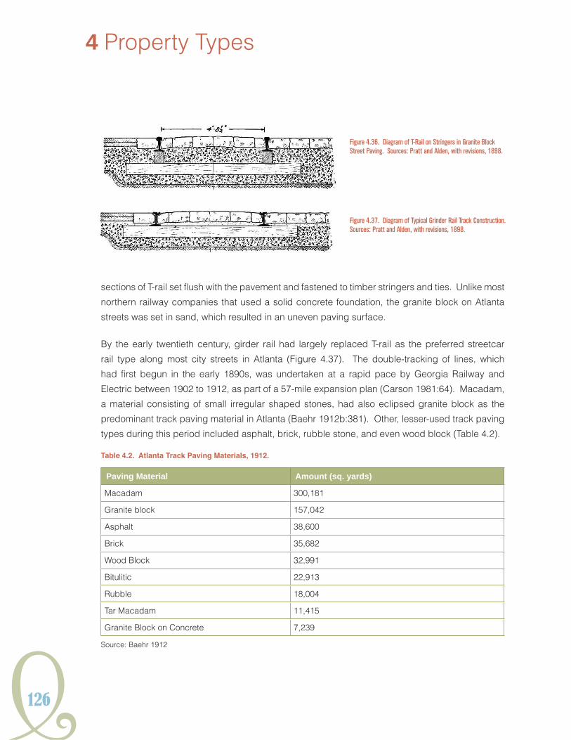
126
4 Property Types
sections of T-rail set flush with the pavement and fastened to timber stringers and ties. Unlike most
northern railway companies that used a solid concrete foundation, the granite block on Atlanta
streets was set in sand, which resulted in an uneven paving surface.
By the early twentieth century, girder rail had largely replaced T-rail as the preferred streetcar
rail type along most city streets in Atlanta (Figure 4.37). The double-tracking of lines, which
had first begun in the early 1890s, was undertaken at a rapid pace by Georgia Railway and
Electric between 1902 to 1912, as part of a 57-mile expansion plan (Carson 1981:64). Macadam,
a material consisting of small irregular shaped stones, had also eclipsed granite block as the
predominant track paving material in Atlanta (Baehr 1912b:381). Other, lesser-used track paving
types during this period included asphalt, brick, rubble stone, and even wood block (Table 4.2).
Table 4.2. Atlanta Track Paving Materials, 1912.
Paving material Amount (sq. yards)
Macadam 300,181
Granite block 157,042
Asphalt 38,600
Brick 35,682
Wood Block 32,991
Bitulitic 22,913
Rubble 18,004
Tar Macadam 11,415
Granite Block on Concrete 7,239
Source: Baehr 1912
Figure 4.36. Diagram of T-Rail on Stringers in Granite Block Street Paving. Sources: Pratt and Alden, with revisions, 1898.
Figure 4.37. Diagram of Typical Grinder Rail Track Construction. Sources: Pratt and Alden, with revisions, 1898.
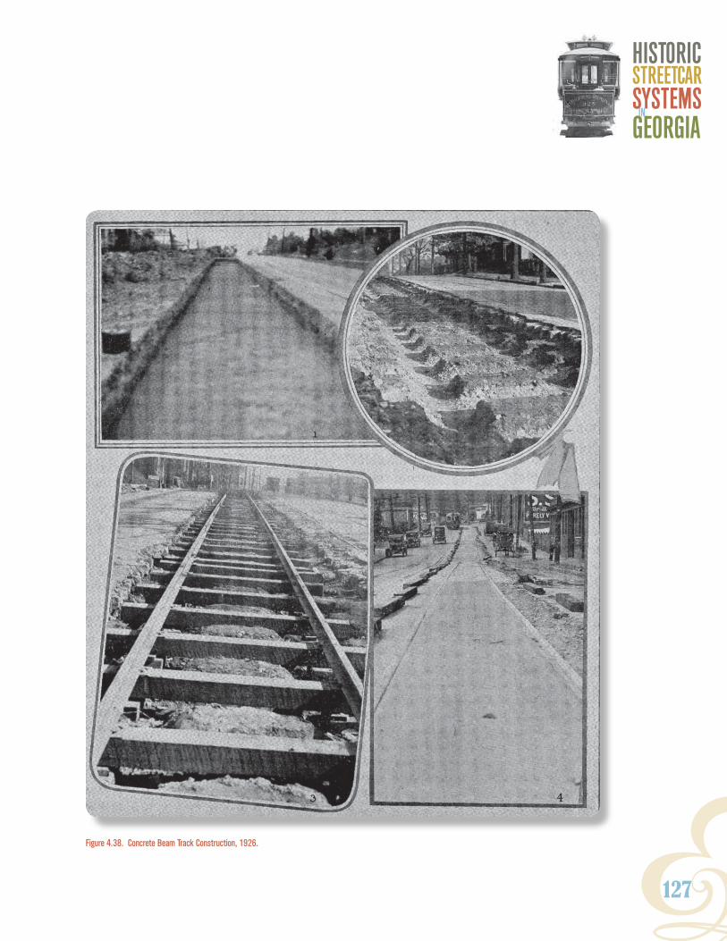
Y127
HISTORICSTReeTCaRSYSTeMSGeORGIaIn
Figure 4.38. Concrete Beam Track Construction, 1926.
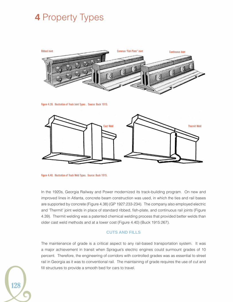
128
4 Property Types
In the 1920s, Georgia Railway and Power modernized its track-building program. On new and
improved lines in Atlanta, concrete beam construction was used, in which the ties and rail bases
are supported by concrete (Figure 4.38) (GP 1927:233-234). The company also employed electric
and ‘Thermit’ joint welds in place of standard ribbed, fish-plate, and continuous rail joints (Figure
4.39). Thermit welding was a patented chemical welding process that provided better welds than
older cast weld methods and at a lower cost (Figure 4.40) (Buck 1915:267).
cUts ANd fiLLs
The maintenance of grade is a critical aspect to any rail-based transportation system. It was
a major achievement in transit when Sprague’s electric engines could surmount grades of 10
percent. Therefore, the engineering of corridors with controlled grades was as essential to street
rail in Georgia as it was to conventional rail. The maintaining of grade requires the use of cut and
fill structures to provide a smooth bed for cars to travel.
Figure 4.39. Illustration of Track Joint Types . Source: Buck 1915.
Figure 4.40. Illustration of Track Weld Types. Source: Buck 1915.
Ribbed Joint Common ‘Fish Plate” Joint Continuous Joint
Cast Weld Thermit Weld

Y129
HISTORICSTReeTCaRSYSTeMSGeORGIaIn
The most intact cuts associated with Georgia’s
streetcar systems are located off existing road
right-of-ways. When streetcar routes follow
existing road or railroad there is a greater
potential for the elements of the streetcar
grade to be obscured by the maintenance
of active transportation corridors. However,
preserved cut and fill structures can be
impacted by forms of development other than
road and railroad maintenance. As observed
in Stone Mountain and along Hollywood
Road, former streetcar right-of-way is often
conscripted into use as utility corridors for
sanitary sewers and fiber optic cable, as well
as converted into multi-use pathways.
cuts
Cuts can appear as distinct trenches
excavated laterally along hillsides to provide
a level surface. These cuts typically have
one vertical wall to one side (Figure 4.41).
Figure 4.41 Segment of the Cut Associated with the Stone Mountain Line, DeKalb County.
130
4 Property Types
Cuts that bisect landforms have two steep vertical walls and relatively even grade along the bed.
Beds associated with streetcar grade are typically narrower than conventional railroad, allowing
for narrower cuts. Beds examined during the current study measured approximately 10-15 feet
wide for a single track. Cuts are often found in conjunction with retaining walls.
fills
Earth is removed to maintain grade over terrain; conversely fill is required to provide earthen
aprons for the construction of streetcar rail bed across low areas. Preservation of fill corridors will
occur in areas segregated from modern development.
oBJects
No historic statuary, monuments, boundary markers, or fountains were identified that were related
to streetcar systems in Georgia. A history marker located along Ponce de Leon Avenue honoring
the end of the Ponce Line at Deepdene Park in Atlanta was identified (see Chapter 3); however, it
does not meet the 50-year age requirement for National Register eligibility. Electric poles are not
considered objects but structures.
sites
Sites associated with streetcars can incorporate numerous resource types requiring archaeological
examination. These sites can consist of architectural ruins of streetcar-related buildings or
support structures like bridges. Additionally, sites may include, but are not limited to, cuts and fills
associated with the maintenance of track grade, buried rail and/or rail bedding, and the presence
of intact paving. When examined archaeologically the features can provide information concerning
the technology and engineering of streetcar systems. Subsurface resources can also contribute
information about surface resources like buildings, structures, and streetscapes.
districts
During the survey of multiple segments of Atlanta’s streetcar routes, it became evident that intact resources directly involved in the operation of the streetcar system still exist throughout the city. In addition to the buildings and structures directly involved with the system’s operation, a number of historic buildings with similar shape and function were noted at system intersections. These
buildings were initially constructed to serve as stores or for some other commercial purpose, and they were situated against a streetcar right-of-way, usually at an intersection with another line or at a transition from private right-of-way to street grade. These buildings in question feature unique footprints that conform to the streetcar line producing a trapezoidal plan reminiscent of the Flatiron Building in New York City. These commercial node buildings were noted along the River Line and
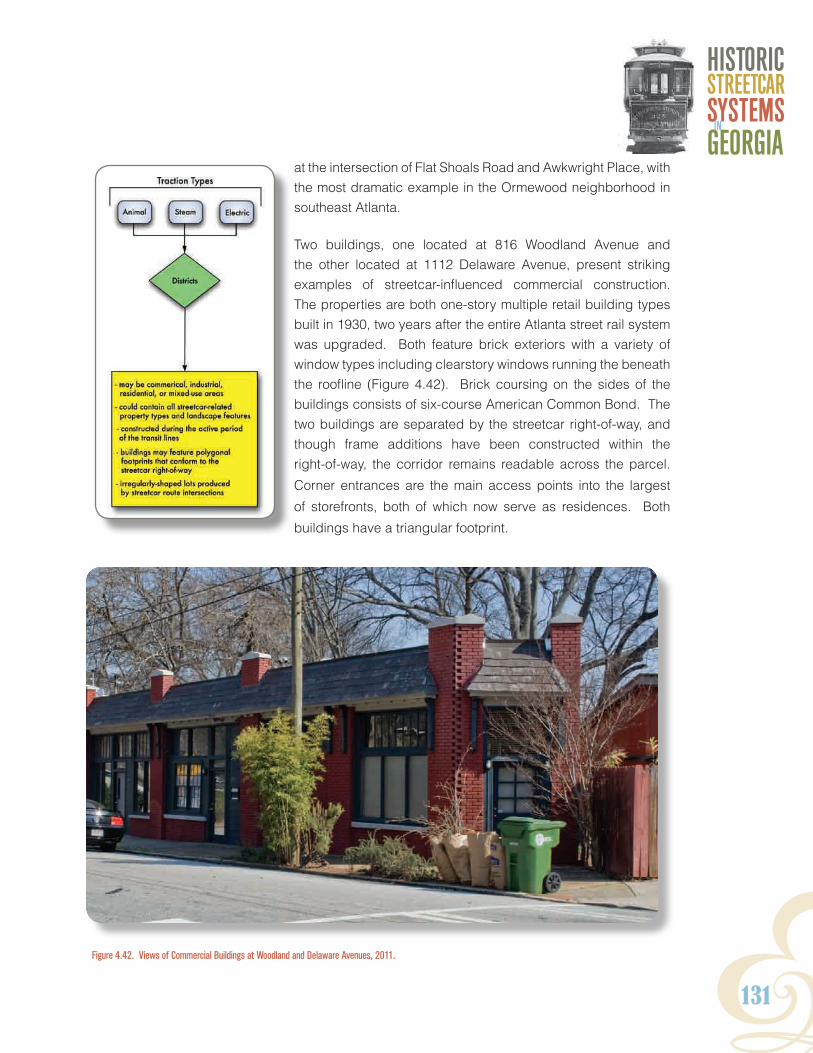
Y131
HISTORICSTReeTCaRSYSTeMSGeORGIaIn
at the intersection of Flat Shoals Road and Awkwright Place, with the most dramatic example in the Ormewood neighborhood in southeast Atlanta.
Two buildings, one located at 816 Woodland Avenue and the other located at 1112 Delaware Avenue, present striking examples of streetcar-influenced commercial construction. The properties are both one-story multiple retail building types built in 1930, two years after the entire Atlanta street rail system was upgraded. Both feature brick exteriors with a variety of window types including clearstory windows running the beneath the roofline (Figure 4.42). Brick coursing on the sides of the buildings consists of six-course American Common Bond. The two buildings are separated by the streetcar right-of-way, and though frame additions have been constructed within the right-of-way, the corridor remains readable across the parcel.
Corner entrances are the main access points into the largest
of storefronts, both of which now serve as residences. Both
buildings have a triangular footprint.
Figure 4.42. Views of Commercial Buildings at Woodland and Delaware Avenues, 2011.

132
4 Property Types
Commercial node buildings were observed both individually and in clusters. The buildings noted
during the current study were brick, consisting of one and two stories. Construction dates typically
overlap with the active period of the line. These types of commercial buildings can serve as an
indicator of the presence of a historic streetcar line in places where elements of the local streetcar
system are unidentified. Additionally, when paired with surviving streetcar-related streetscape
features, like medians and concrete divides; the collection of these features and resources could
contribute to the overall significance of a historic district.
Additional collections of resources shaped by Georgia’s streetcar history are historic residential
districts. The National Register bulletin, Historic Residential Suburbs, identifies transportation
as a major trend contributing to suburban development in the United States. Atlanta, and other
cities throughout the state, feature a number of historic districts dating from the late nineteenth
and early twentieth centuries that were greatly influenced by the streetcar system (Ames and
McClelland 2002:16). Originally developed for middle and upper class white residents, these
streetcar suburbs are often located at what was once the periphery of the city, where the costs
associated with land and new houses was cheaper. As mentioned in previous sections, Inman
Park was a neighborhood that, from its initial planning, included street rail transit. The Trolley
Barn on Edgewood serves as a tangible reminder of that heritage (see Figure 4.35). However,
many other neighborhoods including West End Historic District, Kirkwood Historic District, and
other older residential neighborhoods, such as Capitol View, were marketed and populated with
the aid of streetcars, including horse-drawn, steam-powered, and electric. While few identified
resources in these Atlanta communities have been attributed directly to the development of street
railway transportation, other unidentified resources could remain, with the significance of these
resources associated with streetcars going unrecognized. The influence of the streetcar system
on residential development can vary from one neighborhood to another and these effects are
sometimes documented in historic district nomination materials. As with commercial node areas,
these groups of resources can serve as contributing elements to a larger streetcar district.
AssociAted ProPerties
The property types discussed above, depending on their state of preservation, may have the
potential to yield significant archaeological information about the design, layout, and technology
of streetcar transportation systems and their influence on the community patterns of development
of the various municipalities throughout the state where they operated. Although the relationship
between late nineteenth and early twentieth-century streetcar service and early residential
suburbanization has been noted, there are also a number of other sites and properties that
are historically associated with street railway transit. These include garden cemeteries, public
parks or fairgrounds, colleges, private amusement parks, and tourism spots, or the locations
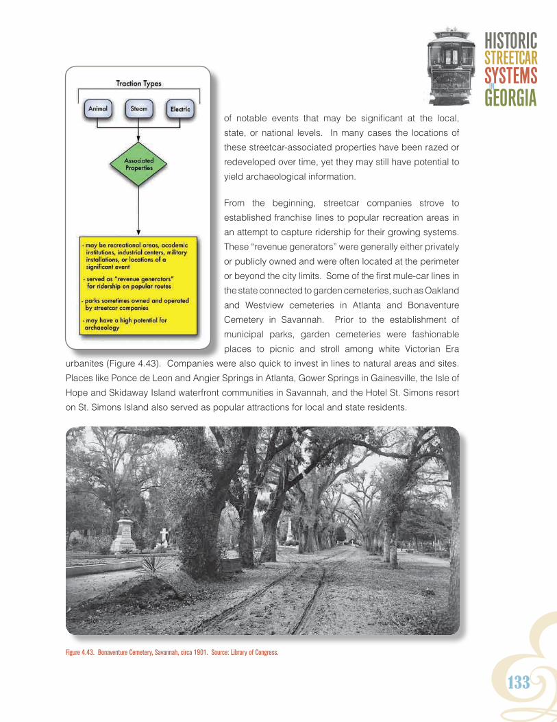
Y133
HISTORICSTReeTCaRSYSTeMSGeORGIaIn
of notable events that may be significant at the local,
state, or national levels. In many cases the locations of
these streetcar-associated properties have been razed or
redeveloped over time, yet they may still have potential to
yield archaeological information.
From the beginning, streetcar companies strove to
established franchise lines to popular recreation areas in
an attempt to capture ridership for their growing systems.
These “revenue generators” were generally either privately
or publicly owned and were often located at the perimeter
or beyond the city limits. Some of the first mule-car lines in
the state connected to garden cemeteries, such as Oakland
and Westview cemeteries in Atlanta and Bonaventure
Cemetery in Savannah. Prior to the establishment of
municipal parks, garden cemeteries were fashionable
places to picnic and stroll among white Victorian Era
urbanites (Figure 4.43). Companies were also quick to invest in lines to natural areas and sites.
Places like Ponce de Leon and Angier Springs in Atlanta, Gower Springs in Gainesville, the Isle of
Hope and Skidaway Island waterfront communities in Savannah, and the Hotel St. Simons resort
on St. Simons Island also served as popular attractions for local and state residents.
Figure 4.43. Bonaventure Cemetery, Savannah, circa 1901. Source: Library of Congress.

134
4 Property Types
By the late 1870s and through the 1890s, the creation of city-owned parks and exposition fairgrounds
provided the impetus for streetcar development and increased suburbanization. Local landmarks
such as Grant Park, Oglethorpe Park (redeveloped as Exposition Cotton Mills, no longer extant)
and Piedmont Park, site of the 1895 International Cotton States Exposition, in Atlanta, as well
as the Valdosta Fairgrounds (now the
site of Valdosta State University) are
all associated with the expansion of
streetcar service in these respective
municipalities. At the turn of the century,
amusement parks, sports stadiums, and
other recreation areas, some owned and
operated by the streetcar companies
themselves, also drove streetcar
development. In Atlanta, lines were
developed for Lakewood Fairgrounds,
the White City Amusement Park near
Grant Park, East Lake Golf Club, and
Stone Mountain, just east of the city.
Ponce de Leon Amusement Park was built on the
site of the former Ponce de Leon Springs, and was later
redeveloped as Ponce de Leon Baseball Park for the
Atlanta Crackers (Figure 4.44). Georgia Railway and Power Company President Preston Arkwright
owned both the new stadium and the baseball team during the early 1900s. In Macon, the Macon
and Indian Springs Railway Company established service to the Ocmulgee Fairgrounds, while the
City Electric Railway Company owned the Mobley Park (later DeSoto Park) resort in Rome. The
Gainesville Street Railway Company owned Chattahoochee Park as well as a baseball stadium on
the present site of the Riverside Military Academy (Norton 2000).
In some cities, the history of streetcar transit is also directly linked to the presence of academic
institutions, large industrial centers, and military installations. Streetcar companies provided
connectivity for student population at schools like the Oglethorpe University in Atlanta, University
of Georgia in Athens, Emory College (now Oxford College of Emory University) in Covington and
Oxford, the Georgia Experiment Station, a University of Georgia-affiliated agricultural research
center in Griffin, and the LaGrange College in LaGrange, Georgia. Working class employees, who
typically did not have ready access to automobiles, often rode the streetcars and interurban lines
to job locations such as the Inman Rail Yards in Atlanta, the Bell Bomber Plant (now Lockheed-
Martin) in Marietta, various textile mills in the Horse Creek Valley between Aiken, South Carolina
and Augusta, and the Strickland Cotton Mills in Remerton just northwest of Valdosta. The same
Figure 4.44. Aerial View of Ponce de Leon Ballpark (razed), Atlanta, circa 1953. Source: Tracy O’Neal Photograph Collection, Special Collections, Georgia State University Library.

Y135
HISTORICSTReeTCaRSYSTeMSGeORGIaIn
was also true for soldiers and other military personnel stationed in or near major cities in Georgia
during the late nineteenth and early twentieth centuries. The U.S. Arsenal, located in the suburb
of Summerville in Augusta (present-day site of Augusta State University), and the McPherson
Barracks (later Fort McPherson) in Atlanta are two notable examples of military installations served
by streetcar transit.
A site or associated property may also pertain to a location of a significant event related to
street railway transportation in Georgia, such as the 1906 Atlanta Race Riot. Within the city’s
Five Points commercial district, African Americans were pulled from trolleys, beaten, and killed,
and roving white mobs vandalized black-owned businesses. The violence of the riot resulted in
stronger enforcement of racial segregation laws on streetcars in Atlanta and dissuaded organized
boycotts of transit companies by African Americans in other cities throughout the state. Other
sites or properties associated with significant events my include locations of streetcar segregation
boycotts or notable transit labor strikes.
sUmmAry
This identification of streetcar-related property types is based upon our knowledge of previously
recorded resources, historical research, and preliminary field assessment. Some are only known
from fire insurance maps or historic photography while others are embedded within modern trail
systems or are buildings that have been adaptively used for either public or private use. In the past,
surviving streetcar-related resources have been evaluated for their National Register eligibility as
individual resources or as contributing to a historic district that may or may not derive significance
from its historic function as a transportation-related property. The next chapter provides tools for
the identification of these transportation-related property types.

136

Y137
HISTORICSTReeTCaRSYSTeMSGeORGIaIn
5. IDENTIFICATION
This chapter guides researchers through the process of successfully identifying and documenting
streetcar-associated resources. The historic context has demonstrated that the potential for
historic streetcar resources in urban projects or studies is great within the Metropolitan Atlanta area.
However their identification is challenging and in most cases, where multiple types of properties
are encountered, will require a multi-disciplinary approach employing archaeologists, historians,
and architectural historians. Because all municipal streetcar and interurban lines in Georgia had
been abandoned in the years just after World War II, many of the properties historically linked
with streetcar transportation have often been significantly altered, obscured, or demolished. The
identification of these resources begins with background or desktop research, may be expanded
by additional historical research, and ends with fieldwork. The following sections give steps to
follow for each of these tasks.
Background research
The first stage in the identification of streetcar resources is to conduct background research. This
context is a starting point and provides information on streetcar transportation systems that were
established in every major city in Georgia over the course of the late nineteenth and early twentieth
centuries. While the histories and scope of streetcar operations in some places like Atlanta,
Macon, Rome, and Savannah are relatively well known; information remains relatively vague about
less extensive, or short-lived systems in municipalities such as Brunswick or Griffin. Brief historical
sketches and maps of identified historic streetcar systems that once operated in cities and towns
throughout Georgia are presented in the appendix. However, there may be a number of smaller
communities in the state where the history of streetcar transit remains undocumented.
Preservation professionals working in the Metropolitan Atlanta area should consult GDOT’s Atlanta
Streetcar GIS Database to determine whether buried streetcar lines may exist within a project
area. The database contains spatial data extracted from historic maps and aerials and other
materials and provides locations of streetcar track and associated properties, as they existed
over the course of the late nineteenth and twentieth centuries. Key attribute data includes dates
of operation, traction type, company ownership, and the presence of single or double track.
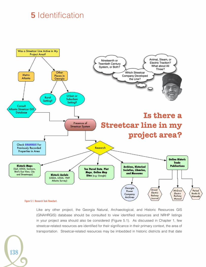
138
5 Identification
Figure 5.1. Research Task Flowchart.
Like any other project, the Georgia Natural, Archaeological, and Historic Resources GIS
(GNAHRGIS) database should be consulted to view identified resources and NRHP listings
in your project area should also be considered (Figure 5.1). As discussed in Chapter 1, few
streetcar-related resources are identified for their significance in their primary context, the area of
transportation. Streetcar-related resources may be imbedded in historic districts and that date
Is there a Streetcar line in my
project area?

Y139
HISTORICSTReeTCaRSYSTeMSGeORGIaIn
to the period of significance or later. If background research suggests the potential for streetcar-
related resources for projects outside of Metropolitan Atlanta, contact with Main Street managers,
historic preservation commissions, and local historical societies may be useful to help to identify
resources that were historically streetcar related within their communities.
The context provided in Chapter 2 and the Atlanta Streetcar GIS provide the background for
streetcar systems in Metropolitan Atlanta. For those surveying in other parts of Georgia, a quick
and simple first step to determine the probability of encountering historic streetcar resources is
by reviewing the location and general setting of your project area. Streetcar transit was a product
of urbanization and a significant factor in early suburbanization in Georgia and throughout the
nation. Therefore, a majority of resources are more probable in urban and suburban settings that
were developed prior to the mid-twentieth century rather than historically rural locales or built
environments dating from the post-World War II Era. In addition, the urban settings of downtown
central business districts are likely to contain greater concentrations of streetcar-related resources
than lower density suburban areas that were serviced by transit lines.
historical research
Surveyors in the Atlanta area who want to know if streetcar systems are present in their project
area should consult the historic context presented in Chapter 2 of this document and the Atlanta
Streetcar GIS database. For projects outside of Atlanta, knowledge of the project area combined
with a review of current aerial photography is critical. First, is the project in an urban area or late
nineteenth century to early twentieth-century suburb? If so, there is the potential for streetcar
resources and current aerial photograph should be consulted. Akin to surveying railroad corridors
but more complicated due to their urban/suburban environment, identification of streetcar-related
resources relies heavily on current aerial map research. Visual clues that may be found in aerial
views would include diagonal corridors of right-of-way cutting across through neighborhoods,
abandoned linear corridors offset from existing roads, triangular shaped buildings, roadways with
expanded medians, and other signs of street car property types as presented in Chapter 4. In
the Atlanta area, aerial views can potentially provide clues as to the location of small, unmapped
arterial tracking or corridors constructed after 1928. This aerial photography review is critical to
getting the big picture and assessing if one’s project area may contain historic streetcar routes.
As seen in Chapter 4, Georgia’s historic streetcar resources appear in a variety of forms including
buildings, structures, archaeological sites, and landscape elements. Equally important, these
properties can exist individually or, more likely, as groups of resources. The challenge is to
identify them as part of a transportation system and current aerials offer many clues to historic
transportation routes.

140
5 Identification
If the project’s location and review of aerial photographs suggests the potential for streetcar
resources, comprehensive historic map research is the next step in identifying the locations of
former streetcar routes and associated properties. Although high-resolution U.S. Geological
Survey (USGS) topographic maps and U.S. Department of Agriculture county soil survey maps
dating from the late nineteenth and early twentieth centuries generally do not indicate routes on
city streets, electric lines traversing suburban and rural areas are often shown. Of particular note
are the 1919 Aiken, South Carolina and 1923 Warrenville, South Carolina USGS maps, which
Figure 5.2. 1911 Soil Survey of Chatham County Map Showing Savannah Electric Company Streetcar Routes. Source: USDA Bureau of Soils, 1912, Digital Library of Georgia in association with the University of Georgia Map Library.
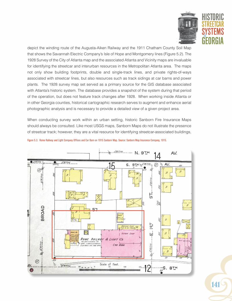
Y141
HISTORICSTReeTCaRSYSTeMSGeORGIaIn
Figure 5.3. Rome Railway and Light Company Offices and Car Barn on 1915 Sanborn Map. Source: Sanborn Map Insurance Company, 1915.
depict the winding route of the Augusta-Aiken Railway and the 1911 Chatham County Soil Map
that shows the Savannah Electric Company’s Isle of Hope and Montgomery lines (Figure 5.2). The
1928 Survey of the City of Atlanta map and the associated Atlanta and Vicinity maps are invaluable
for identifying the streetcar and interurban resources in the Metropolitan Atlanta area. The maps
not only show building footprints, double and single-track lines, and private rights-of-ways
associated with streetcar lines, but also resources such as track sidings at car barns and power
plants. The 1928 survey map set served as a primary source for the GIS database associated
with Atlanta’s historic system. The database provides a snapshot of the system during that period
of the operation, but does not feature track changes after 1928. When working inside Atlanta or
in other Georgia counties, historical cartographic research serves to augment and enhance aerial
photographic analysis and is necessary to provide a detailed view of a given project area.
When conducting survey work within an urban setting, historic Sanborn Fire Insurance Maps
should always be consulted. Like most USGS maps, Sanborn Maps do not illustrate the presence
of streetcar track; however, they are a vital resource for identifying streetcar-associated buildings,
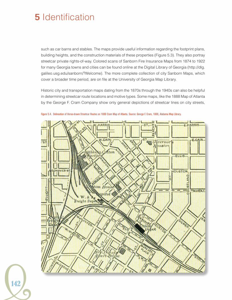
142
5 Identification
such as car barns and stables. The maps provide useful information regarding the footprint plans,
building heights, and the construction materials of these properties (Figure 5.3). They also portray
streetcar private rights-of-way. Colored scans of Sanborn Fire Insurance Maps from 1874 to 1922
for many Georgia towns and cities can be found online at the Digital Library of Georgia (http://dlg.
galileo.usg.edu/sanborn/?Welcome). The more complete collection of city Sanborn Maps, which
cover a broader time period, are on file at the University of Georgia Map Library.
Historic city and transportation maps dating from the 1870s through the 1940s can also be helpful
in determining streetcar route locations and motive types. Some maps, like the 1888 Map of Atlanta
by the George F. Cram Company show only general depictions of streetcar lines on city streets,
Figure 5.4. Delineation of Horse-drawn Streetcar Routes on 1888 Cram Map of Atlanta. Source: George F. Cram, 1888, Alabama Map Library.
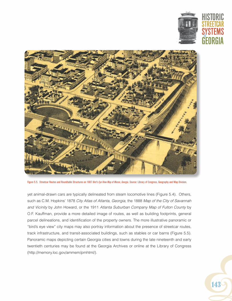
Y143
HISTORICSTReeTCaRSYSTeMSGeORGIaIn
Figure 5.5. Streetcar Routes and Roundtable Structures on 1887 Bird’s Eye View Map of Macon, Georgia. Source: Library of Congress, Geography and Map Division.
yet animal-drawn cars are typically delineated from steam locomotive lines (Figure 5.4). Others,
such as C.M. Hopkins’ 1878 City Atlas of Atlanta, Georgia, the 1888 Map of the City of Savannah
and Vicinity by John Howard, or the 1911 Atlanta Suburban Company Map of Fulton County by
O.F. Kauffman, provide a more detailed image of routes, as well as building footprints, general
parcel delineations, and identification of the property owners. The more illustrative panoramic or
“bird’s eye view” city maps may also portray information about the presence of streetcar routes,
track infrastructure, and transit-associated buildings, such as stables or car barns (Figure 5.5).
Panoramic maps depicting certain Georgia cities and towns during the late nineteenth and early
twentieth centuries may be found at the Georgia Archives or online at the Library of Congress
(http://memory.loc.gov/ammem/pmhtml/).
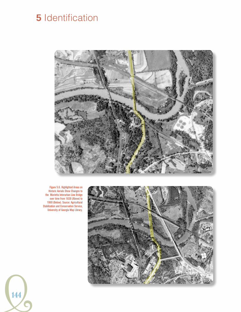
144
5 Identification
Figure 5.6. Highlighted Areas on Historic Aerials Show Changes to
the Marietta Interurban Line Bridge over time from 1838 (Above) to
1960 (Below). Source: Agricultural Stabilization and Conservation Service,
University of Georgia Map Library.
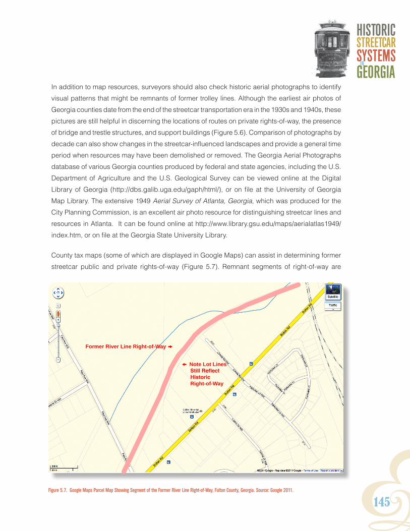
Y145
HISTORICSTReeTCaRSYSTeMSGeORGIaIn
In addition to map resources, surveyors should also check historic aerial photographs to identify
visual patterns that might be remnants of former trolley lines. Although the earliest air photos of
Georgia counties date from the end of the streetcar transportation era in the 1930s and 1940s, these
pictures are still helpful in discerning the locations of routes on private rights-of-way, the presence
of bridge and trestle structures, and support buildings (Figure 5.6). Comparison of photographs by
decade can also show changes in the streetcar-influenced landscapes and provide a general time
period when resources may have been demolished or removed. The Georgia Aerial Photographs
database of various Georgia counties produced by federal and state agencies, including the U.S.
Department of Agriculture and the U.S. Geological Survey can be viewed online at the Digital
Library of Georgia (http://dbs.galib.uga.edu/gaph/html/), or on file at the University of Georgia
Map Library. The extensive 1949 Aerial Survey of Atlanta, Georgia, which was produced for the
City Planning Commission, is an excellent air photo resource for distinguishing streetcar lines and
resources in Atlanta. It can be found online at http://www.library.gsu.edu/maps/aerialatlas1949/
index.htm, or on file at the Georgia State University Library.
County tax maps (some of which are displayed in Google Maps) can assist in determining former
streetcar public and private rights-of-way (Figure 5.7). Remnant segments of right-of-way are
Figure 5.7. Google Maps Parcel Map Showing Segment of the Former River Line Right-of-Way, Fulton County, Georgia. Source: Google 2011.
Former river line right-of-Way k
o note lot lines Still Reflect Historic
right-of-Way

146
often reflected in parcel boundaries and were sometimes repurposed as alleyways or driveways.
Historic plat maps may also incidentally show the presence of streetcar lines or locations of
streetcar-related buildings.
Those seeking to do more detailed research of particular streetcar systems in Georgia should
consult the collections of various state, regional, and local archives and museums, historical
societies, and public and university libraries. These repositories may include, but are not limited
to: the Georgia Archives, the Middle Georgia Archives, the Georgia Historical Society, the Augusta
Museum of History, the Atlanta History Center, the City of Savannah Research Library and Municipal
Archives, the Southeastern Railway Museum, and the University of Georgia Hargrett Rare Book and
Manuscript Library. The Georgia Power Corporation Archives may contain the most comprehensive
collection of historic materials related to
the Atlanta streetcar network and those
systems in other Georgia cities consolidated
by the company during the early 1920s
(e.g. Athens, Augusta, Gainesville, Macon
and Rome). City engineering and planning
departments that maintain records and
historic maps of street construction and
maintenance projects may also be a good
source for identifying track routes, as well as
original locations of support structures such
as overhead wire pole supports and trolley
waiting stops.
Archives and transportation museums in
other states may also have information
pertinent to the history of streetcar systems
in Georgia. The Historical Society of
Pennsylvania owns the collection of the J.G.
Brill Company Records from 1877 to 1920,
the St. Louis Car Company Records are
held in the Washington University Libraries
5 Identification
REMEMBER:The important point, regardless of one’s discipline, is to recognize (1) that the identification process must stem from the recognition of a streetcar-related resource or resources as part of a system that has a significant historic context in transportation history and that (2) its associated property types are recognized and documented within that context.
Other contexts may apply, but the first stab at identification should hone in on the resource’s ability to convey significance as a streetcar-related resource within its transportation context.

Y147
HISTORICSTReeTCaRSYSTeMSGeORGIaIn
Department of Special Collections, and the American Car and Foundry Company Collection is
housed at the John W. Barriger III National Railroad Library at the University of Missouri-St. Louis.
The Shore Line Trolley Museum in East Haven, Connecticut (bera.org) is one of the largest and
oldest streetcar museums in the United States. The museum has a collection of 100 vintage
trolleys as well as an extensive streetcar document and photograph archive.
Period trade journals and manuals, many of which have
been scanned and made available online by Google
Books (http://books.google.com/) are an excellent
source of information chronicling the changes and
growth of streetcar transportation in the United States
and North America from the 1880s through the
1940s (Figure 5.8). The Street Railway Journal and
its successor, the Electric Railway Journal, were the
leading industry periodicals targeted towards both
those working in the transportation field and the
public at large. Another notable serial publication
was the McGraw Electric Railway Manual, an annual
financial review of all street railway companies that
operated throughout the country. The McGraw
Electric Railway Manual not only presented yearly
information about the capital investments for each
company, but also provided names of executives,
office addresses, rolling stock inventories, rail
types used, and the amount of operable track
employed by each system. A number of books
were written during this era documenting industry
best practices and construction standards. These
include among others: Street-Railroad Roadbed (1898) by Mason D.
Pratt and C.A. Alden, C.B. Fairchild’s Street Railways: Their Construction,
Operation and Maintenance (1892), and the Electric Railway Handbook (1915) by authors Albert
S. Richey and William C. Greenough.
Figure 5.8. 1892 Street Railway Journal. Source: McGraw Publishing Company 1892.

148
5 Identification
FieldWork
A few basic questions should be asked prior to field survey. Which company, or companies,
developed the routes? Do the streetcar lines date from the late nineteenth century only, the
twentieth century, or do they span the two time periods? What period-specific technology was
employed on the streetcar lines? Were the lines mule-drawn, steam locomotive, electric traction,
or were all three motive types used on the route over its history of operation? Knowing the answers
to these questions will help identify potential property types associated with each type of streetcar
technology.
Identification of streetcar resources is contingent on factors associated with setting and the
interplay of landscape, structural, and archaeological features. Chapter 4 provides the range of
property types that may be present within a historic streetcar transportation corridor such as tracks,
buildings, structures, objects, and street patterns. These types collectively define a streetcar
corridor. Their identification is the first step. The second step of the identification process involves
identifying how these property types are spatially related within their setting. To capture this big
picture view of the urban landscape, the researcher must be willing to look up, down, and around.
Streetcars evolved as a transportation system and thus need to be considered systemically. The
sidebar at the end of this section provides some tips for reading the urban landscape for hidden
streetcar resources, giving urban researchers a starting point for identification. Using these tools
will hopefully yield a new recognition of preserved features with the Atlanta metropolitan area’s
streetcar corridor and help inform further research on how streetcar systems shaped the urban
landscape.
A researcher may have to wear several “disciplinary” hats in a small project for the identification
process but even tentative recognition and description of the full complement of streetcar
properties present will yield a stronger basis for future project planning. Knowing the property
types discussed in this context and aided by aerial photography and map research, a researcher
should be able to identify the location and some features of a streetcar system in a specific project
area. However, the survey of longer streetcar segments and the evaluation of streetcar resources
may require multiple methods and specialists, including: architectural survey, landscape analysis,
archaeological survey, GIS mapping to geo-reference historic maps showing streetcar routes onto
the existing environment, remote sensing through ground penetrating radar (GPR), and possibly
excavation. Most of these will require the involvement of specialists in archaeology, history,
architectural history, and GIS.
Y149
HISTORICSTReeTCaRSYSTeMSGeORGIaIn
gis and gPs
Streetcars are spatial, and accurately recording their locations is a key element of survey.
Geographic Information Systems (GIS), with its mapping capabilities, is a powerful tool for
identifying and evaluating streetcar resources. GIS can be used to geo-reference historic maps
showing streetcar lines and to overlay this information on maps and datasets representing the
current built environment. This in turn allows researchers to evaluate the properties and integrity
of the segment of a line they have surveyed within the context of the line as a whole. Where large
segments or even entire systems are surveyed, GIS can be used to link geographic locations
with property types, allowing large-scale properties to be recorded and assessed. Capturing the
identified property’s geographic location using Geographical Positioning System (GPS) is key to
recognizing what particular line or route is involved and allows the researcher to more effectively
use this context as a tool in the identification process. GPS locations are helpful for recording a
property with GNAHRGIS.
architectural survey
Architectural survey methods are shaped by state or agency guidelines and generally
involve photographic documentation, mapping, note taking, and creating a project GIS. For
example, guidelines for architectural survey for GDOT are contained in GDOT’s Environmental
Procedures Manual found at www.dot.state.ga.us/doingbusiness/PoliciesManuals/roads/Pages/
EnvironmentalProceduresManual.aspx. The Georgia Historic Resource Survey Manual, on file
at HPD, should also be consulted. Finally, National Register Bulletin 16 presents information
on completing a National Register form www.nps.gov/nr/publications/bulletins/nrb16a. Typically,
surveys include the documentation of buildings, structures, objects, and districts. Where multiple
associated property types are identified, the surveyor should pay particular attention to the spatial
relationships of the properties to determine how they are related. Landscape analysis typically
employs the same tools but the analysis is more physically contextual, looking for what ties the
corridor’s properties and features into a cohesive urban transportation landscape. National
Register Bulletin 46 Historic Residential Suburbs (Ames and McClelland 2002) is a primary source
for streetcar researchers as it deals with the relationship between transportation routes and urban
development and the landscape that evolved from that relationship.

150
archaeological aPProaches
Remnant track and cut and fill areas are most likely encountered by archaeologists during
transportation projects. Streetcar track represents the most common physical remnant of Georgia’s
streetcar past and is primarily found buried under layers of modern paving. By its nature,
track must be examined archaeologically. If a project area is located within a NRHP District,
subsurface features could potentially contribute to the significance of the district. Additionally,
project areas located outside districts could retain elements of the transportation system that
are underrepresented in the historical documentation, like those associated with animal traction.
These resources have the potential to provide critical information concerning design and operation
of historically significant streetcar systems.
When identifying and evaluating a streetcar resource, archaeologists should consider the processes
involved in creating track, a term that encompasses rail, bedding, and associated paving.
Production of grade often involves the removal or addition of soil to produce a level surface. Rail
bedding is laid to provide an engineered substrate for crossties and rails. The size, orientation,
and configuration of track components change over time and often reflect the mode of traction
servicing route and the period it was active. Additionally, the transition to double track, addition
or removal of paving, and the application of modern asphalt over track can impact preservation
of these components. Subsurface features lacking rail could still provide significant information
concerning engineering and design, especially when dated to the nineteenth century.
Background research can provide some foresight as to the nature of potential subsurface features
associated with track. For example, many of the nineteenth-century routes were active well
into the twentieth century, combining fabric from multiple periods. Similarly, some nineteenth-
century track was abandoned during the consolidation at the turn of the twentieth century. These
archaeological deposits could provide details of composition and design undisturbed by later
systems. Research can provide insight into what may be expected in a project area.
Evaluation of the existing road surface can provide clues as to the presence of rails. Undulations
in the existing paving as well as cracks along buried track can serve as clues to features that lie
beneath. If permitted within a project’s scope, non-invasive subsurface examination with tools like
ground penetrating radar (GPR) can narrow the project focus prior to excavation. GPR survey can
also provide information concerning the orientation of track, preliminary dimensions of bedding,
5 Identification

Y151
HISTORICSTReeTCaRSYSTeMSGeORGIaIn
and the number of rails. Once the presence, or potential presence, of buried track has been
established through review of reference material and surface survey, sampling of target areas
through excavation, if feasible given the project setting, may be the next step in documentation.
As noted in Chapter I, Mary Elizabeth Gantt, R.S. Webb and Associates, conducted an
archaeological evaluation of a section of track (9FU324) associated with the Lakewood line of
Atlanta’s system in December of 1996. The examination of the subsurface resources under the
street at 9FU324 can serve as a model for the archaeological documentation of streetcar-related
features. A preliminary literature review of primary and secondary historical resources indicated
the likely presence of track, although there was no surface indication of buried features. In addition,
oral accounts of streetcar activity along the Lakewood line was documented.
The site was sampled through the mechanical excavation of a trench within the street right-of-
way. The excavation revealed a cross-section of rail, crossties, and track bedding material.
The systematic mechanical stripping involved the removal of modern asphalt and evaluation of
substrate. Double tracked rails were noted under the modern asphalt, encased in concrete. The
position of the track in relation to the current curbing and road alignments was noted. Further
excavation produced a sample of rail and the composition of track bedding. Rail identification
markers, as described in the sidebar “Look for These Signs” that follows, as well as the rail profile
were documented from the sampled sections. Measured drawings and photographs were taken
of the trench profile, revealing a disparity in the depths of rail and bedding between the double
tracks. The differences in depths suggested the reuse of older track in the twentieth century
double track configuration.
The approach provided by the excavation of 9FU324 provides an approach to documenting
archaeological remains associated with streetcar track where subsurface investigations were
warranted and feasible. Comprehensive preliminary background research established the
nature of potential subsurface features. Systematic excavation, collection, and documentation of
exposed features revealed details of design and materials, as well as suggested the progression
of streetcars from single to double track.
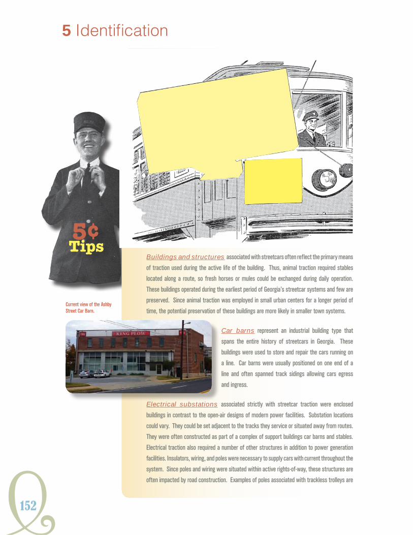
152
5 Identification
Buildings and structures associated with streetcars often reflect the primary means
of traction used during the active life of the building. Thus, animal traction required stables
located along a route, so fresh horses or mules could be exchanged during daily operation.
These buildings operated during the earliest period of Georgia’s streetcar systems and few are
preserved. Since animal traction was employed in small urban centers for a longer period of
time, the potential preservation of these buildings are more likely in smaller town systems.
Car barns represent an industrial building type that
spans the entire history of streetcars in Georgia. These
buildings were used to store and repair the cars running on
a line. Car barns were usually positioned on one end of a
line and often spanned track sidings allowing cars egress
and ingress.
Electrical substations associated strictly with streetcar traction were enclosed
buildings in contrast to the open-air designs of modern power facilities. Substation locations
could vary. They could be set adjacent to the tracks they service or situated away from routes.
They were often constructed as part of a complex of support buildings car barns and stables.
Electrical traction also required a number of other structures in addition to power generation
facilities. Insulators, wiring, and poles were necessary to supply cars with current throughout the
system. Since poles and wiring were situated within active rights-of-way, these structures are
often impacted by road construction. Examples of poles associated with trackless trolleys are
Current view of the Ashby Street Car Barn.
5¢Tips

Y153
HISTORICSTReeTCaRSYSTeMSGeORGIaIn
telescoping and slightly canted away from the street. These poles have been incorporated
into the modern electrical grid and carry service wires. In addition to poles, ceramic insulators
and other hardware were bolted to building facades to hold system wires. These would be
located at intersections within central business districts where formal electrical poles would
be impractical.
In addition to industrial buildings and structures, streetcar systems possessed
trolley waiting stations situated along routes or at major intersections
of routes. Few waiting areas or street-side stops have been documented in
Georgia. These functional structures were generally small, with unenclosed
sides, and one story. They can be comprised of wood or masonry materials and
can have stylistic elements like stick-style brackets or no formal architectural
style.
Streetcars also influenced commercial building design. Commercial buildings
located at major trolley intersections reflected the influence the system, often having a
footprint that is oriented against the trolley right-of-way. These footprints are characteristically
triangular or trapezoidal and were constructed during the active period of the streetcar.
Commercial buildings like these are often situated on the acutely angled lots created by the
intersection or dividing of routes and can occur individually or in clusters.
East Point Substation (on right) c 1915. Source: East Point Historical Society.
Commercial buildings on the northeast corner of Delaware and Woodland Avenues.
Valdosta Trolley Wait Station.

154
5 Identification
After the abandonment of streetcar operations, rail tracks and track bed was
frequently interred in road asphalt or rails were removed. Ground penetrating radar (GPR) is
the most efficient means for non-invasively identifying subsurface streetcar features (see
Chapter 3). However, when GPR or excavation is not available, surface evaluation can be
used to identify potentially buried resources. W hen track is covered in the asphalt of modern
roads its presence can become evident over time in cracks that identify the
rail location. These cracks can also be used to identify double and single
track locations under existing roadways. Additionally, asphalt erodes with
continual usage exposing the metal of intact rails. Bedding material, in
the absence of track, is often evident along private rights-of-way existing
outside active roadways. These beds are marked by a concentration of
gravel, which is frequently mounded up to a fixed grade.
Streetcar rail that has been extracted can be assessed to determine its general period of
use. Cast-iron stringer rail nailed directly to wood or stone stringers was typically used in older,
nineteenth-century animal-drawn systems. T-rail found wider use during
the 1880s, while girder rail became more prominent after the introduction
of electric streetcar systems in the 1890s (see Chapter 4).
Measurement of the base or height of exposed rail sections is the best
method for identifying specific rail weights. Lighter sections of T-rail,
weighing from 10lb. to 40lb., are more likely to date from earliest period of
electrification. Most electric rail used during the first half of the twentieth
century weighed ranged from 60lb. to 80lb. sections. In 1893, the
American Society of Civil Engineers (A.S.C.E.) released recommendations
Graded Cut located northwest of Moore Street, Stone Mountain.
(Below) A.S.C.E. Standards Profile Measurements. Source: Harmer Steel Company, 2010.
(Above) Rail Identification Standards (Source: Unitrac Railroad Materials Inc., 2010).
Cracks in Asphalt on Park Avenue Indicating Buried Streetcar Track, Atlanta, 2010.

Y155
HISTORICSTReeTCaRSYSTeMSGeORGIaIn
5¢Tips
to improve and standardize the more than 300 rail section designs in use at the time. The
A.S.C.E standards established rail weights from 40-100 lb. per yard with 5 lb. increments.
For all weights, the height of the rail was to be equal to the width of the base. In 1908, the
American Railway Association (A.R.A) released additional standards addressing specifications
for heavier rail sections over 85 lb. that were increasingly required for the electric interurban
lines and long-haul freight and passenger railroads (Willard 1915:129). By 1910, the American
Railway Engineering and Maintenance of Way Association had also developed standardized
section lengths of 33 feet and a system of identification markers identifying weight, section,
rolling method (Bessemer or the later open hearth process), mill brand, and the year and month
of manufacture (American Railway Engineering
Maintenance of Way Association 1910:608).
The maintenance of grade along a
streetcar route produces landscape features in
addition to building and archaeological deposits.
These features take the form of cut and filled
corridors that have survived outside existing
roadways. Landscape features such as these
often appear as an unnaturally level corridor
approximately the width of a single lane of typical
residential street. Historically, these were private
rights-of-way used exclusively by the streetcar.
Some sections of private rights-of-way evolved into modern automobile thoroughfares. However,
private right-of-way that did not become modern roadway often retains landscape features and
associated structures like raised track bedding, grade cuts, culverts, guardrails, and bridge
remnants. These corridors are frequently reused as subsurface utility lines or as formal and
informal recreational land. While this reuse can impact the preservation of certain aspects the
overall feel of the landscape is not diminished.
The layout of streets and the streetscape itself can retain elements of
the streetcar system as well. Intersections resulting from the meeting of curvilinear streets,
producing long parcels with acute angles on its corners can suggest the former presence of
tracked travel lanes. These intersections are often populated with commercial buildings whose
footprints reflect the systems right-of-way, creating commercial enclaves fueled by trolley
ridership. Additionally, divided travel lanes, either by grass median or raised curbing, can be
remnant of the divisions between streetcar and other roadway traffic. At times the trolley’s
travel lane will be the raised median separating automobile corridors.
Former Streetcar Right-of-Way along Oakview Road in the Kirkwood
Neighborhood of Atlanta.

156
All Types
- grass median or raised concrete curbing
- trolley travel lane can be raised median separating automobile corridors
- intersections often feature long commercial lots comprised of acute angles
- typically associated with nineteenth- century track construction
- cast iron construction
- nailed directly to stone or wood stringers
- paving including packed earth, wood blocks, brick, and granite block
- track may or may not be flush with the street
STABLES CAR BARN/REPAIR SHOP
ADMINISTRATIVEOFFICES
STOPS/ WAITINGPLATFORMS
POWER PLANTS/SUBSTATIONS
STREETCARBODIES / TRUCKS
ASSOCIATEDPROPERTIESDISTRICTSSITESOBJECTS
WIRES, POLES,INSULATORS
CUT/FILLSTREETSCAPE
RAIL, PAVING,BEDDINGCULVERTS
BRIDGES,UNDERPASSES,
TRESTLES
PROP
ERTY
TYP
ES
PROWAnimal Steam Electric
Stringer Rail T-Rail Girder Rail Cuts, Embankments
DividedStreetscapes
Character-Defining Features
Property Type
Traction Type
All Types
- clad in masonry, wood, or a combination of materials
- typically featured a series of animal stalls with an open yard and possibly blackmith shops
- one or two stories- located on, or
adjacent to the lines they serviced
- primarily a nineteenth- century resource
- potential preservation of these buildings are more likely in smaller town systems
ElectricAll TypesAll Types All Types
- possess bays on at least two sides
- likely positioned at one end of a line and often spanned track sidings
- constructed in the late nineteenth and early twentieth centuries
- interiors often contain service repair pitssystems
- often located in city central business districts
- identification through deed/corporation research
- usually continually used as commercial office properties
- small, functional structures
- one story and open air
- built of wood or masonry
- may, or may not have a formal architectural style
- situated along routes or at major intersections of routes
- primarily brick masonry construction
- may be situated adjacent to or away from streetcar routes
- often constructed as part of a complex of support buildings
- earliest steam and hydroelectric power plants date from the late nineteenth century
- Atlanta examples feature Italian Renaissance Revival architectural style
- older car bodies could be closed, open, or convertible types
- wood construction typical for older streetcars; steel construction common after World War I
- lighter, horse-drawn cars had single truck undercarriages
- electric cars had double truck designs
- car bodies sometimes adaptively reused as outbuildings
CHAR
ACTE
R-DE
FINI
NG F
EATU
RES
TRAC
TION All TypesAll Types
- composed of brick, granite, metal, concrete, wood, or terra cotta
- pipe, box, double box, or arch configurations
- prevalent at intersections with water
- often incorporated into modern infrastructure
- higher preservation potential on PROW
- composed of brick, granite, metal, concrete, wood, or terra cotta
- prevalent at intersections with water, railroads, and uneven terrain
- often incorporated into modern infrastructure
Electric
- served to supply streetcars with electrical power
- often impacted by road construction and streetscape improvements
- poles may be of metal or wood construction and slightly canted away from the street
- may have been incorporated into modern electrical grids
- ceramic insulators and eyebolts fastened to buildings may support overhead wires in dense urban settings where poles would have been impractical
PROW ExistingROW PROW Existing
ROW- may be historic
statuary, boundary markers, foundations, etc. that are associated with streetcar companies or streetcar development
All Types
may contain numerous property types requiring archaeological investigation such as:
- buried track- ruins of buildings
or structures- cute or fill
landscape features - intact track
bedding
All Types
may be commercial, industrial, residential or mixed-use areas
- could contain all streetcar-related property types and landscape features
- constructed during the active period of the transit lines
- buildings may feature polygonal footprints that conform to the streetcar right-of-way
- irregularly-shaped lots produced by streetcar route intersections
All Types
- may be recreational areas, academic institutions, or locations of a significant event
- served as “revenue generators” for ridership on popular routes
- parks sometimes owned and operated by streetcar companies
- may have a high potential or archaeology
All TypesAll TypesAll Types
PROW ExistingROW
- grass median or raised concrete curbing
- trolley travel lane can be raised median separating automobile corridors
- intersections often feature long commercial lots comprised of acute angles
- associated with nineteenth and twentieth-century track construction
- generally featured steel construction, although older cast iron T-Rail may exist
-sometimes nailed directly to wood stringer
- used with horse-drawn, steam, and electric traction systems
- rail sections weighing from 10 lbs. to 40 lbs. likely to date from nineteenth century
- paving materials included gravel, brick, macadam, granite block
- track may or may not be flush with the street
- consist of raised earthen embankments or depressed graded corridors
- often reused as utility corridors or recreational trails
- higher potential for preservation of other structures like bridges and culverts
PROW
ExistingROW Existing Right of Way
Private Right of Way
Animal
5 Identification
Property Types At A Glance
Characterize Your DataAfter survey data is gathered and the context is consulted, a characterization of the surveyed property should occur. Did you identify a nineteenth- or twentieth-century property or both? What form of energy was used for the study system? Is the property type considered significant under that context? This flowchart is presented to assist with identification and the dating process. It lists the property types and their character-defining features for each mode of traction used for streetcar systems in Georgia over the course of the late nineteenth and early twentieth centuries, thus providing a tool for dating and classifying these resources.

Y157
HISTORICSTReeTCaRSYSTeMSGeORGIaIn
All Types
- grass median or raised concrete curbing
- trolley travel lane can be raised median separating automobile corridors
- intersections often feature long commercial lots comprised of acute angles
- typically associated with nineteenth- century track construction
- cast iron construction
- nailed directly to stone or wood stringers
- paving including packed earth, wood blocks, brick, and granite block
- track may or may not be flush with the street
STABLES CAR BARN/REPAIR SHOP
ADMINISTRATIVEOFFICES
STOPS/ WAITINGPLATFORMS
POWER PLANTS/SUBSTATIONS
STREETCARBODIES / TRUCKS
ASSOCIATEDPROPERTIESDISTRICTSSITESOBJECTS
WIRES, POLES,INSULATORS
CUT/FILLSTREETSCAPE
RAIL, PAVING,BEDDINGCULVERTS
BRIDGES,UNDERPASSES,
TRESTLES
PROP
ERTY
TYP
ES
PROWAnimal Steam Electric
Stringer Rail T-Rail Girder Rail Cuts, Embankments
DividedStreetscapes
Character-Defining Features
Property Type
Traction Type
All Types
- clad in masonry, wood, or a combination of materials
- typically featured a series of animal stalls with an open yard and possibly blackmith shops
- one or two stories- located on, or
adjacent to the lines they serviced
- primarily a nineteenth- century resource
- potential preservation of these buildings are more likely in smaller town systems
ElectricAll TypesAll Types All Types
- possess bays on at least two sides
- likely positioned at one end of a line and often spanned track sidings
- constructed in the late nineteenth and early twentieth centuries
- interiors often contain service repair pitssystems
- often located in city central business districts
- identification through deed/corporation research
- usually continually used as commercial office properties
- small, functional structures
- one story and open air
- built of wood or masonry
- may, or may not have a formal architectural style
- situated along routes or at major intersections of routes
- primarily brick masonry construction
- may be situated adjacent to or away from streetcar routes
- often constructed as part of a complex of support buildings
- earliest steam and hydroelectric power plants date from the late nineteenth century
- Atlanta examples feature Italian Renaissance Revival architectural style
- older car bodies could be closed, open, or convertible types
- wood construction typical for older streetcars; steel construction common after World War I
- lighter, horse-drawn cars had single truck undercarriages
- electric cars had double truck designs
- car bodies sometimes adaptively reused as outbuildings
CHAR
ACTE
R-DE
FINI
NG F
EATU
RES
TRAC
TION All TypesAll Types
- composed of brick, granite, metal, concrete, wood, or terra cotta
- pipe, box, double box, or arch configurations
- prevalent at intersections with water
- often incorporated into modern infrastructure
- higher preservation potential on PROW
- composed of brick, granite, metal, concrete, wood, or terra cotta
- prevalent at intersections with water, railroads, and uneven terrain
- often incorporated into modern infrastructure
Electric
- served to supply streetcars with electrical power
- often impacted by road construction and streetscape improvements
- poles may be of metal or wood construction and slightly canted away from the street
- may have been incorporated into modern electrical grids
- ceramic insulators and eyebolts fastened to buildings may support overhead wires in dense urban settings where poles would have been impractical
PROW ExistingROW PROW Existing
ROW- may be historic
statuary, boundary markers, foundations, etc. that are associated with streetcar companies or streetcar development
All Types
may contain numerous property types requiring archaeological investigation such as:
- buried track- ruins of buildings
or structures- cute or fill
landscape features - intact track
bedding
All Types
may be commercial, industrial, residential or mixed-use areas
- could contain all streetcar-related property types and landscape features
- constructed during the active period of the transit lines
- buildings may feature polygonal footprints that conform to the streetcar right-of-way
- irregularly-shaped lots produced by streetcar route intersections
All Types
- may be recreational areas, academic institutions, or locations of a significant event
- served as “revenue generators” for ridership on popular routes
- parks sometimes owned and operated by streetcar companies
- may have a high potential or archaeology
All TypesAll TypesAll Types
PROW ExistingROW
- grass median or raised concrete curbing
- trolley travel lane can be raised median separating automobile corridors
- intersections often feature long commercial lots comprised of acute angles
- associated with nineteenth and twentieth-century track construction
- generally featured steel construction, although older cast iron T-Rail may exist
-sometimes nailed directly to wood stringer
- used with horse-drawn, steam, and electric traction systems
- rail sections weighing from 10 lbs. to 40 lbs. likely to date from nineteenth century
- paving materials included gravel, brick, macadam, granite block
- track may or may not be flush with the street
- consist of raised earthen embankments or depressed graded corridors
- often reused as utility corridors or recreational trails
- higher potential for preservation of other structures like bridges and culverts
PROW
ExistingROW Existing Right of Way
Private Right of Way
Animal

158
summary
The successful identification of streetcar properties demands a holistic approach and the
researcher must learn to look at all aspects of the streetcar corridor to discern what patterns
and elements are preserved. The identification tools needed to identify and document individual
properties, districts, and transportation corridors are already in place, spelled out in state or agency
survey guidelines. Typically, these include the completion of field photography, the creation of
site plans, architectural and landscape descriptions, GPR, visual or subsurface investigations
for archaeological remains, and GIS. The real change in the approach lies in the recognition that
an integrated multi-disciplinary approach is needed to locate, identify, describe and portray the
character-defining features of the historic landscape, site, structure, building or object that convey
information about the streetcar era.
5 Identification

Y159
HISTORICSTReeTCaRSYSTeMSGeORGIaIn
6. NATIONAL REGISTER OF HISTORIC PLACES EVALUATIONThe previous chapters in this historic context have described the history of streetcar systems in the
metro Atlanta area, the property types associated with these systems, and have provided tools for
their identification. This context has established that streetcar properties can be buildings, structures,
sites, and objects. They can appear in isolation or in tandem with other properties, and, in some
cases, streetcar landscapes may be encountered. This recognition of the range of associated
property types within historic streetcar systems is arguably the most significant contribution of the
study. The initial focus of this document was to provide an evaluative methodology for the National
Register eligibility of archaeological resources associated with nineteenth and twentieth century
Atlanta streetcar systems. However, the subsequent contextual research of streetcar transportation
in Atlanta and in other municipalities throughout Georgia has produced a more comprehensive
understanding of the scope and range of possible historic streetcar property types. As a result,
this broader view has led to the development of a more inclusive evaluative framework that not only
relates specific properties to the broad patterns of streetcar transportation history, but also provides
a richer definition of their meaning and significance within that context. This framework is the focus
of this chapter and it is offered as a guide to the process of evaluation for streetcar properties.
The National Park Service Bulletin How to Apply the National Register Criteria for Evaluation
(1998) provides the methods and standards for evaluating the historic significance of streetcar-
related resources for the National Register of Historic Places. Individual or grouped properties
must be evaluated within their historic context, or contexts, which provide a framework within
which the National Register criteria are applied. Properties may be eligible under Criterion A
for their association with important events or Criterion B if they are associated with the lives of
important persons significant in our past. Also, buildings, objects, structures, and districts that
are significant for design, method of construction, or association with a notable architect may be
eligible under Criterion C. Finally, properties that are likely to yield important historical information
may be eligible under Criterion D.
In the past, streetcar-related properties, when identified and evaluated, were evaluated individually
or under multiple contexts. This context provides sufficient information that will allow these
properties to be evaluated under their primary area of significance, transportation, as well as
other closely associated contexts.

160
6 National Register of Historic Places Evaluation
STATEMENT OF SIGNIFICANCE
Depending on their relevant historic contexts, streetcar-associated properties may be significant
at the local, state, and even national levels under all National Register Criteria.
STREETCAR PROPERTY EVALUATION UNDER CRITERION A
Individual and grouped streetcar properties are likely to be eligible at the state and local level
under Criterion A, in the areas of:
• Transportation;
• Engineering;
• Industry;
• Commerce; and
• Community Planning and Development.
Streetcar systems served as the first principal form of public transit in Georgia cities and towns
during the late nineteenth and twentieth centuries and over the course of their use produced
technological advancements in modes of traction (animal, steam, electric) as well as street rail
construction. As transit systems became electrified, they contributed to the rapid industrial growth
of electric power generation and transmission infrastructure throughout the state. Hydroelectric
dams, steam power plants, substations, and intricate networks of wire and track were built and
maintained to supply the consuming energy demands of streetcar operations. Streetcar systems
impacted not only the movement of people, but of commercial freight products as well, and
fed the expansion and eventual monopolization of electric public-private utilities by companies
like Georgia Power and Savannah Electric and Power. The streetcar also served as a primary
instrument of real-estate speculation and urban decentralization, providing late nineteenth-century,
white, middle-class Georgians with access to newly developed garden suburbs on lands that had
once constituted remote city peripheries like West End and Inman Park in Atlanta, Mobley Park in
Rome, and Thunderbolt in Savannah.
Georgia’s streetcar resources may also by eligible on the national level of significance in the
area of Social History for their role in the enforcement of segregation on a public transit system.
Georgia was the first state in the country to pass legislation enforcing Jim Crow segregation on
public transit. These laws granted police powers to trolley conductors to maintain the color line on
streetcars. At the turn of the century, the streetcar became a symbol of racial tension, becoming
the object of boycotts by black riders in many cities throughout Georgia and ultimately serving as
a setting for violence during the Atlanta Race Riot of 1906.
Y161
HISTORICSTReeTCaRSYSTeMSGeORGIaIn
STREETCAR PROPERTY EVALUATION UNDER CRITERION B
Streetcar properties may be eligible under Criterion B for their association with the lives of
significant individuals at the state and local levels. Properties may be eligible such as the Hurt
Building or Georgia Power Administrative Offices for their association with streetcar pioneers such
as Hurt or Henry Atkinson respectively.
STREETCAR PROPERTY EVALUATION UNDER CRITERION C
Streetcar systems and individual resources may be eligible for distinctive characteristics of their type, period, method of construction, or as the work of a notable architect at the state and local levels. Criterion C can be broadly applied to numerous property types, from buildings such as car barns to structures like embankments and track, to objects such as monuments or commemorative markers. Preserved features that reflect the material progression of trolley service through the various modes of traction and their associated track types, support structures, buildings, and objects may be eligible under this criterion.
Properties associated with significant engineers, noted architects, important businessmen or industrialists who managed streetcar development could be evaluated under Criterion C. For
example, the Georgia Power industrial facilities designed by notable architect Isaac Moscowitz,
such as the Spring Street Substation or the Tugaloo Dam Powerhouse, are examples of streetcar
resources that may be eligible under Criterion C.
STREETCAR PROPERTY EVALUATION UNDER CRITERION D
Streetcar properties and subsurface features that have information that contributes to our understanding of nineteenth and twentieth-century transit history may be considered eligible under this criterion. This would include preserved archeological resources, largely consisting of track and track bedding that have demonstrated the potential to yield significant data addressing important research questions related to their design, materials, and construction or workmanship. Other resources can include archaeological remains of streetcar-related buildings and structures. Archaeological properties associated with the earliest periods of Georgia’s streetcar history, which include the horse-car and steam traction eras, are underrepresented in the survey record and would be considered significant due to their scarcity and lack of documentation. In contrast, archaeological properties associated with twentieth-century electric streetcar systems, which have strong documentary records, would not be considered significant unless they are distinctive in their design or materials.
Finally, streetcar properties may be eligible under different contexts and all applicable contexts
should be considered in their evaluation.

162
PERIOD OF SIGNIFICANCE
The period of significance for streetcar development in Metropolitan Atlanta is from 1871 to 1949.
These dates incorporate the beginning of streetcar transit with the establishment of the West
End Line by the Atlanta Street Railway Company to the abandonment of the last Atlanta electric
streetcar line in 1949. Other Georgia municipalities may have had different periods of significance,
but, for most, the date of establishment of the streetcar and the date when operations ended may
frame the streetcar’s period of significance in these cities.
INTEGRITY
Integrity refers to the ability of a property to convey associations with a historic context. The
concept of integrity refers to individual properties as well as the interplay between a group of
resources, and it is fundamental to determining historic significance. The seven aspects of integrity
are: location, design, setting, materials, workmanship, feeling, and association. National Register
properties must exemplify most of the aspects of integrity. No particular aspect is more significant
to the evaluation of integrity than another. Additionally, the weight of importance placed on each
applicable aspect is reliant on the nature of the property itself (National Park Service 1990).
A streetcar system often collectively features architecture, archaeological features, and landscape
elements, but can also be represented by individual buildings, structures, or sites. The association
of elements and their visibility and readability in the urban fabric are critical to assessing integrity.
Aspects of a well-preserved streetcar-related property would be legible in industrial and commercial
buildings in proximity to buried track as well as in associated surface support structures like
waiting stops, bridges, or trestles. Additionally, it should be possible to relate these resources
to specific points in Georgia’s streetcar past or significant historical themes. Properties that only
retain one aspect of integrity or those that have lost their character-defining features would be
considered to have poor integrity.
Although streetcar resources are primarily associated with an urban milieu, streetcar properties
can also be viewed as historic landscapes as defined by the National Register. Historic landscape
characteristics associated with urban and suburban streetcar development typically include
influences on land use, patterns of spatial organization, and the development of transportation
networks. Assessing the integrity of a landscape involves considering the interrelationships
between cultural and historical practices. Examples of streetcar transportation landscape features
include the derivation from the natural topography through the maintenance of track grade, radial
growth of commercial and residential development along streetcar corridors, and the organization
of the built environment, such as building setbacks, lot sizes, and shapes. Often these landscapes
6 National Register of Historic Places Evaluation

Y163
HISTORICSTReeTCaRSYSTeMSGeORGIaIn
are comprised of discrete parts isolated by modern urban development and intrusive growth, but
when viewed collectively may reflect the streetcar transit system as a whole. Historical landscapes
retaining integrity would ideally exhibit preservation of the elements of transportation networks.
Conversely, substantial alterations to the land and components or the additions of patently modern
and incompatible elements would detract from integrity (McClelland et al. 1999:22-23).
Because streetcar resources primarily fall within urban and suburban areas numerous factors
can affect the integrity of properties. Primarily the ongoing maintenance of roads in the form of
paving and realignments can destroy rail, track bedding, and secondary lines and rail spurs.
Often, streetcar associated buildings and structures located on commercial and industrial parcels
have been razed to make room for new development. Conversely, reuse of some streetcar-
related buildings, like the barn in Inman Park and the shops on Ashby Street, has led to building
preservation. Additionally, aspects of rail, track bedding, and support structures can remain along
private rights-of-way and under modern paving.
Just as a multi-disciplinary approach is used in the identification of surface and subsurface properties
associated with streetcar transportation networks, their evaluation requires an interdisciplinary
perspective. The aspects of integrity must be considered for interrelated resources to ascertain
historical significance for complex properties, often comprised of many different resource types.
These aspects, as they relate to streetcar systems, are described below.
LOCATION
Location is the place where the historic property was built or the historic event took place. The
relationship between the property and its location can be important for understanding why the
property was created, providing a sense of the property’s association with historic events and
people (National Park Service 1990). For buildings, structures, sites and objects associated
with Georgia’s streetcars, having integrity of location means the property remains in its original
location.
However, some objects and structures, like trolley cars and waiting platforms, could be moved
from their original location, and the timing and associations of such moves must be considered
in assessing integrity. Trolley cars by their nature are mobile, so despite a change of location
they can retain integrity because of their association with transportation, like a boat or locomotive
car. Since Georgia’s streetcars were sold for reuse or were decommissioned as they aged, few
examples survive today. Thus if any examples with a Georgia provenance that retain integrity
were identified, they may be considered highly significant.
164
6 National Register of Historic Places Evaluation
For landscapes, integrity of location refers to the geographical factors that influenced development.
Assessing integrity should consider whether geographical features, like road patterns, grade cuts,
raised berms or off-street right-of-way, are still present and evident (McClelland et al. 1999:22).
DESIGN
Design refers to the combination of elements that create the form, plan, space, structure, and style
of a property. It reflects deliberate choices made during the original conception and planning
of a property (or its significant alteration). A property’s design manifests historic functions and
technologies as well as aesthetics (National Park Service 1990). Resources associated with a
streetcar network can be viewed somewhat differently because expansion and alteration of modes
of traction, support technology, and geographic scope are inherent to an urban transportation
system. Consideration of integrity of design must therefore look a resource’s original components
or layout as well as its ability to illustrate its evolution through time.
A streetcar-related site should have enough of its original components to illustrate critical workings
of the system. This could take the form of buried rail or track bedding as well as ruins of related
structures or buildings. Additionally, landscape elements like grade cuts and raised berms, by
necessity, would require archaeological examination. The organization of such broad landscape
features in themselves can convey the overall design of the system during its active life. Streetcar
sites should retain enough fabric to illustrate the standard of technology of a particular period
or the technological progression of the system. For example, archaeological excavation of Site
9FU324 revealed the technology employed in rail and bedding for the double-tracked Lakewood
line. Likewise, the archaeological remains of buildings should convey, through their plan or
features, their specialized role in the transportation system. Preserved service pits in a former car
barn would have integrity of design as well as the preserved layout of stables and yards at a site
associated with the animal-traction era.
The design of streetcar buildings is inseparably tied to their role in the transportation network.
Therefore, for a property’s design to retain integrity it should reflect its function in the active system.
For example, car barns and shops were designed to provide a workspace for maintenance of
trolley cars, so these buildings featured open plans with large bay openings and often pits for
accessing car undercarriages. Similarly, early electrical substations were buildings enclosing
electrical generation equipment that required manual operation. These buildings would also have
an open plan fitting its industrial purposes. Preservation of these types of architectural elements
would possess a high degree of integrity. Similarly, structures served critical support roles in the
transportation network. Though many were abandoned or reused for automobile traffic, bridges
and trestles can retain the elements of design that convey their function. Electrical equipment

Y165
HISTORICSTReeTCaRSYSTeMSGeORGIaIn
6 National Register of Historic Places Evaluation
like support poles and insulators also meet a similar end by being reused for modern power
infrastructure. Though repurposed, the overall integrity of design is largely preserved and should
be considered when assessed.
Design can apply to districts as well as individual resources. In this case, the concept covers
the way buildings, sites, or structures are related (National Park Service 1990). In the case of a
streetcar district, integrity of design could consider how shops and barns, associated commercial
enclaves, preserved track, private right-of-way and other features were arranged with respect
to one another and/or within their physical context. For historic landscapes, integrity of design
refers to the composition of natural and cultural elements that comprise the form, plan, and spatial
organization of a property. This aspect would also apply to the layout of streets and rights-of-way
as well as the presence and orientation of graded cuts and berms. It reflects deliberate choices
and inadvertent outcomes of land use practices, building placement, and other characteristics
over time (McClelland et al. 1999:22).
SETTING
Setting is the physical environment of a historic property. Unlike location, integrity of setting refers
to the character of the place in which the property achieved historical significance. This aspect
of integrity deals with how the property is situated and its relationship to surrounding features and
open space. Physical features that make up the setting of a historic property can be natural or
manmade and should be examined not just with the boundaries of the property but also between
the property and its surroundings (National Park Service 1990; McClelland et al. 1999).
Streetcar properties are generally found in an urban setting and can include industrial and
commercial buildings, track, berms, grade cuts, bridges, trestles, and tunnels. The presence of
these system components can contribute to the overall setting. Because these types of resource
lie within an ever-changing urban fabric, historic setting is often impacted by modern development.
Preserved commercial enclaves whose origins were influenced by the operation of a streetcar
line would likely contribute to the integrity of setting of any given property type, as would period
residential development that was spurred by the construction of suburban routes.
For historic landscapes, setting refers to the physical environment within and surrounding a
property. Large features, such as bodies of water, mountains, and others strongly influence integrity
of setting, as do smaller elements such as guardrails, milestones, and equipment (McClelland et
al. 1999:22). Aspects of setting for a historic streetcar landscape would include streets divided by
medians of grass or other barriers to incorporate trolley right-of-way into street traffic or guardrails
and other support structures at stream and railroad crossings.
166
6 National Register of Historic Places Evaluation
MATERIALS
Materials are the physical elements that were combined or deposited during a specific time period
and in a particular pattern or configuration to form a historic property (National Park Service
1990:45). While integrity of materials typically requires the retention of original structural fabric,
streetcar track, bedding, and associated buildings often experienced modifications and repair,
especially as a result of changes associated with technological improvements. The move from
animal power to electrical power is a case in point. This transition created new types of buildings and
structures; substations replaced stables and electric transmission infrastructure was developed.
The integrity of materials associated with subsurface remains should convey the period in which
they were constructed. Rail type, track bedding, and paving changed over time with the advent of
new technology and larger, faster trolley cars. Therefore intact subsurface features that illustrate this
progression would be considered as possessing a high degree of integrity. Archaeological sites
in which structures such as track are found that reflect drastic impacts from modern development,
like disarticulated bedding material or rails, would possess low integrity.
In regard to buildings and structures, changes in exterior cladding and inappropriate choices for
replacement window and doors may occur. Buildings associated with streetcar operations that
have undergone radical alteration to their fabric including changes in the building materials may
be considered as having low integrity.
Integrity of materials in a historic landscape considers elements such as the construction materials
of structures. Therefore the presence of period curbing and streetscape components would
enhance the integrity of materials within a historic streetcar landscape. Additionally, original fabric
associated with bridges, trestles, and tunnels would also add to a landscapes material integrity.
WORKMANSHIP
Workmanship constitutes the physical evidence of the crafts of a particular culture or people
during a given period of prehistory or history. It reflects artisans’ labor and skill in constructing
or altering a building, structure, object, or site. Workmanship can apply to an entire property
or individual components and may be expressed as vernacular methods and techniques or as
highly sophisticated work. In addition, it may reflect traditional work or innovations associated
with particular periods or movements. It can indicate technologies of craft, illustrate aesthetic
principals of a period, and reveal individual, local, regional, or national applications of technological
processes (National Park Service 1990:45). This aspect of integrity is most often applied under
Criterion C, which emphasizes design, construction, and craftsmanship.

Y167
HISTORICSTReeTCaRSYSTeMSGeORGIaIn
Elements of a streetcar resource should retain evidence of period technology or reflect the
craftsmanship or aesthetics of the era it was created. Streetcar structures should illustrate the
engineering employed to construct and maintain them. For example, the brickwork and stonework
found in the tunnel along the Riverline in Bolton has an exceptional degree of workmanship. For
historic landscapes, workmanship reflects the ways people have arranged their environments for
functional or decorative purposes and may include the ways they construct buildings and fences
or techniques and systems of land use (McClelland et al. 1999:23). Workmanship at a streetcar
landscape would therefore include some of the same characteristics as noted above but could
also refer to how a streetcar system operated (i.e. elements particular to the mode of traction).
To have integrity of workmanship, extant streetcar features should convey the techniques used to
create them.
FEELING
Integrity of feeling considers how a resource expresses the aesthetic or historic sense of a
particular time period. To have integrity, a site must contain physical features and characteristics
that, when considered together, convey the site’s historic qualities or enhance its ability to do so
(National Park Service 1990:45). Georgia’s streetcar systems are no longer active and their most
emblematic feature, street-level rail, is often buried under asphalt. This encroachment by modern
development has affected the integrity of feeling for entire systems, however the networks can still
be read in the layout and design of streets and the support buildings and structures that remain.
Historic feeling can be conveyed when these subtle aspects are recognized.
For historic landscapes, feeling is evoked by the presence of physical characteristics that reflect
the historic scene. The sense of time and place arises from the cumulative effect of setting, design,
materials, and workmanship that evoke the sense of a historic streetcar system. Modern alterations
and additions to the landscape detract from the integrity of feeling (McClelland et al. 1999:23).
Historic feeling is conveyed most clearly when buildings, landscape features, and archaeological
elements work in concert to express an inactive, yet significant, historic transit system.
ASSOCIATION
Association relates to the direct link between an important historic event or person and a historic
property. A resource is considered to have integrity of association if it is the place where an event
or activity took place and is sufficiently intact to convey that relationship. It requires physical
features that demonstrate the associations and historic qualities (National Park Service 1990:45).
168
6 National Register of Historic Places Evaluation
Individual streetcar properties and multiple associated properties possess integrity of association
after identification of their historical association and an assessment of the place where they were
found as to its ability to convey information about their past. To have integrity of association as
a historic landscape, a streetcar property must reflect the relationship between itself and the
important events or persons that shaped it (McClelland et al. 1999:23). In the case of a section of
street containing trolley-related resources, this characteristic would entail the landscape conveying
its link to a particular period of historic significance through extant buildings and structures
associated with transit. Additionally, street patterns and streetscape elements, like divided lanes
or private right-of-way, bolster the association with the streetcar past.
SUMMARY
In summary, integrity is the ability of a historic property to convey its significance. A streetcar-
related resource is significant if it remains in its original location, possesses intact character-
defining features, retains its principal historic building materials, and reflects the basic features
of its design. The diversity of resource types found in the historic context of streetcars requires
combined assessment of resources above and below ground. When viewed together, architectural,
structural and sub-surface properties within a project area are more likely to convey the historic
feeling of Georgia’s streetcar past. Therefore, the presence of a group of streetcar property types
within a project area requires the evaluation of the integrity of the group to convey their significance.
These property assemblages may be National Register eligible as a district under the streetcar
context or may contribute to an overlapping historic district. There is also potential for National
Register eligibility under a multiple property nomination if significant tangible remains of related
streetcar systems or the discontiguous remains of one system are identified.
Finally, grouped resources can convey the significance of a streetcar system with more strength
and clarity than isolated resources. Thus the evaluation of subsurface features may be partially
reliant on the presence and integrity of accompanying surface features like buildings, structures,
and landscapes. In order to weigh these issues in your evaluation, the process is documented in
the diagram opposite this page.
DEFINING NATIONAL REGISTER DISTRICT BOUNDARIES
The definition of a boundary should follow the guidelines outlined in National Park Service Bulletin
Guidelines for Completing National Register Registration Form (1997). These are summarized
here. For all properties including individual or historic districts, the selected boundary should
encompass the property and land area that composes it, capturing what makes the property
historically significant. Defining boundaries for archaeological sites or districts depends to a great
extent on the scale and horizontal area that contains the significant features.
Evaluation Process for Subsurface Remains

Y169
HISTORICSTReeTCaRSYSTeMSGeORGIaIn
If the resource is an individually eligible building, use the legal property boundary where
appropriate. In some cases, the footprint of the building, structure, or object can be used if no
other contributing features are located within the legal property boundary. In other cases, the
boundary could be expanded beyond the legal property boundary to include a related structure
or object.
Research reveals potential for streetcar resources.Conduct excavation, GPR, and/or pedestrian survey to determine the presence of
surface or subsurface features.
In a National Register Historic
District
Outside a National Register
District
Subsurface Features Present
Surface Features Present
Surface Features Present
Surface Features Absent
Subsurface Features Present
Nineteenth Century
Twentieth Century
Nineteenthand/or
Twentieth Century
Nineteenth Century
Twentieth Century
Nineteenthand/or
Twentieth Century
May Be Eligible for the NRHP
May Not Be Eligible for the NRHP
Evaluation Process for Subsurface Remains

170
6 National Register of Historic Places Evaluation
If a district has been identified, the boundary should encompass the area of land that contains
the significant concentration of buildings, sites, structures or objects that have a shared context.
With streetcar systems, this may involve a linear corridor containing the line adjoined by lots where
associated properties are located.
Streetcar districts can be discontiguous when visual continuity is not a factor of historic significance,
where the resources are geographically distinct, or when the intervening space lacks significance
and thus does not contribute to the district (US Department of Interior 1997). It can also occur when
a portion of the district has been separated by intervening development that does not contribute
to the district. Given the streetcar’s urban and ever-changing environment, discontiguous districts
may occur in which modern development has created preserved segments of a streetcar line
but has compromised the integrity of a whole line. As streetcars moved from point a to point b
through the city and suburbs, visual continuity of the whole line is not a factor of its significance.
A good example of a discontiguous streetcar district may be the remnant sections of the Stone
Mountain Interurban Line where buildings and structures are clearly but intermittently visible in the
landscape over the extent of the line. Like a linear resource, it can have contributing and non-
contributing sections.
For streetcar structures found through subsurface investigations, evidence obtained through
testing, surface observation, inspection of land alterations, and through examination of historic
maps and engineering documents can be used to determine boundaries. The site’s physical
attributes and setting will suggest the approach to use. It should also be noted that archaeological
districts can contain discontiguous elements when a portion of an outlying site(s) ties into the
significance of the overall district and when the intervening space has no known significant
resources. Therefore, if a portion of an animal-powered, nineteenth-century streetcar line has been
identified archaeologically and has no preserved associated buildings or objects or landscape
features, it may be eligible either individually or may contribute as a discontiguous member of a
district.
This chapter has laid out a framework for the evaluation of streetcar properties. Three case
studies follow that use the recommended approach. As more survey and identification occurs, this
framework may change based on our expanding knowledge of preserved streetcar properties, but
for now it provides the basic knowledge and tools necessary to identify, document and evaluate
these important properties that speak to a short but dramatic growth in Georgia’s transportation
and urban history.
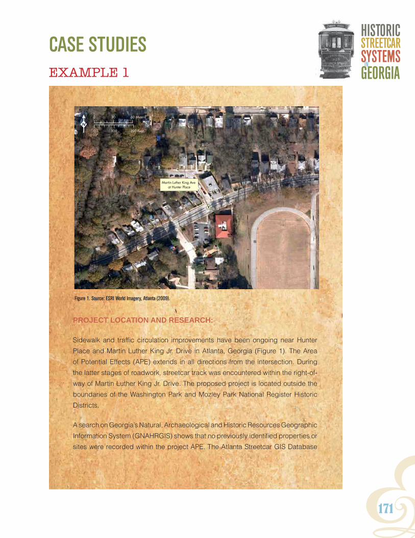
Y171
HISTORICSTReeTCaRSYSTeMSGeORGIaIn
PROJECT LOCATION AND RESEARCH:
Sidewalk and traffic circulation improvements have been ongoing near Hunter
Place and Martin Luther King Jr. Drive in Atlanta, Georgia (Figure 1). The Area
of Potential Effects (APE) extends in all directions from the intersection. During
the latter stages of roadwork, streetcar track was encountered within the right-of-
way of Martin Luther King Jr. Drive. The proposed project is located outside the
boundaries of the Washington Park and Mozley Park National Register Historic
Districts.
A search on Georgia’s Natural, Archaeological and Historic Resources Geographic
Information System (GNAHRGIS) shows that no previously identified properties or
sites were recorded within the project APE. The Atlanta Streetcar GIS Database
EXAMPLE 1
#0
Martin Luther King Ave at Hunter Place
0 100 200 Feet
0 30 60 Meters
K
Figure 1. Source: ESRI World Imagery, Atlanta (2009).
CASE StudIES

172
6 National Register of Historic Places Evaluation
#0
Martin Luther King Ave at Hunter Place
End of Hunter Street Line (1928)
0 350 700 Feet
0 100 200 Meters
K
indicates Martin Luther King Jr. Drive (formerly Hunter Street) was single-tracked
up to the intersection with Joseph E. Lowery Boulevard (formerly Ashby Street)
by Georgia Power in 1928. Therefore, any track located west of the intersection
would have been constructed during a later period (Figure 2).
FIELDWORK:
Road improvement construction uncovered single tracking consisting of 9-inch
grooved girder rail in the westbound lane of Martin Luther King Jr. Drive at Hunter
Place. The rail was embedded in concrete that spanned wood ties (Figure 3).
The rail is a structure associated with Atlanta’s streetcar system and was
constructed sometime after 1928. No other buildings or structures that preceded
development of the streetcar line were noted within the project area.
Figure 2. 1928 topographic Maps of the City of Atlanta and Vicinity

Y173
HISTORICSTReeTCaRSYSTeMSGeORGIaIn
6 National Register of Historic Places Evaluation
Figure 3. Rail and bedding structures exposed during construction.
EVALUATION:
The method of construction of twentieth-century track has been thoroughly
documented. Research suggested that no earlier track operated along this
portion of Martin Luther King Jr. Drive prior to 1928. Therefore, track and bedding
from this period may not be considered eligible for the NRHP under Criterion D
as a resource that has information contributing to our understanding of twentieth
century streetcar history.

174
6 National Register of Historic Places Evaluation
EXAMPLE 2
PROJECT LOCATION AND RESEARCH:
Intersection improvements are planned at Ormewood and Confederate avenues
in the Grant Park neighborhood of Atlanta, Georgia. The APE extends in all
directions from the intersection (Figure 1). Prior to work, a story is published in the
newspaper about a former streetcar-related building at 727 Confederate Avenue
located within the APE (Figure 2).
Research begins in applicable databases and repositories. GNAHRGIS revealed
the project area falls within the Grant Park National Register Historic District.
The Atlanta streetcar GIS Database indicates Confederate Avenue was single-
tracked by Georgia Power by 1928, and three commercial/industrial buildings
were present at 727 Confederate Avenue (Figure 3).
A search of the Fulton County Property Tax Database reveals late twentieth-
century photography showing the buildings as an active automobile shop, with
two buildings photographed. The shape and orientation of parcel boundaries
are unique on the street and are suggestive of industrial or commercial usages.
Confederate Avenue andOrmewood Avenue
#0
727 Confederate Avenue
0 100 200 Feet
0 30 60 Meters
K
Figure 1. Source: ESRI World Imagery, Atlanta (2009).

Y175
HISTORICSTReeTCaRSYSTeMSGeORGIaIn
6 National Register of Historic Places Evaluation
Figure 2. Atlanta Journal Constitution , March 2011.
Figure 3. topographic Atlas of Atlanta (1928)

176
6 National Register of Historic Places Evaluation
Figure 4. Source: Fulton County tax GIS (2011).
Figure 5. Source: Sanborn Fire Insurance Map (1911).
Y177
HISTORICSTReeTCaRSYSTeMSGeORGIaIn
6 National Register of Historic Places Evaluation
Additionally, parcel boundaries reveal a corridor evident between Confederate
Avenue and Eloise Street and directly across from the buildings that may
potentially represent private right-of-way (Figure 4).
Online research of trade journals exposes the planned interurban line of the
“Atlanta and Carolina Railway Company” in 1910 to originate from Confederate
Avenue. Historic Sanborn Fire Insurance Maps from 1911 do not depict the
project area, but feature the White City Amusement Park to the northeast. The
same map also shows a building identified as a “small locomotive house” on the
White City site and located in the vicinity of the private right-of-way as suggested
by tax parcel boundary maps (Figure 5). Sanborn Maps from the mid-twentieth
century show three buildings: two labeled as an auto repair shop with a dwelling
behind them.
FIELDWORK:
The brick masonry two commercial and/or industrial buildings were once used
as an automotive repair business and have more recently been extensively
altered for residential use. The sites of the former White City Amusement Park
and small locomotive house have been completely redeveloped and are now
the location of the Parkside Elementary School.
Research documents the presence of a single-track line on Confederate Avenue
by 1928 and two parallel cracks are currently evident in the street’s pavement.
The two buildings located at 727 Confederate Avenue have a footprint and
orientation that suggest they may have been associated with the streetcar line.
The project area is situated near a historic period recreation site, and anecdotal
and trade journal research shows a possible connection of the buildings at
727 Confederate Avenue with a proposed interurban streetcar line as early as
1910. Examination of parcel boundaries reveals a potential off-street corridor of
privately-owned right-of-way extending east connecting with the historic location
of the White City Amusement Park and the locomotive house.
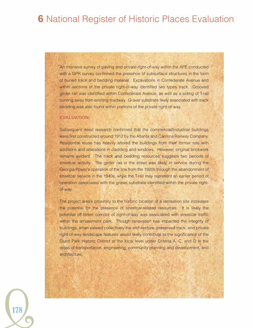
178
6 National Register of Historic Places Evaluation
An intensive survey of paving and private right-of-way within the APE conducted
with a GPR survey confirmed the presence of subsurface structures in the form
of buried track and bedding material. Excavations in Confederate Avenue and
within sections of the private right-of-way identified two types track. Grooved
girder rail was identified within Confederate Avenue, as well as a siding of T-rail
curving away from existing roadway. Gravel substrate likely associated with track
bedding was also found within portions of the private right-of-way.
EVALUATION:
Subsequent deed research confirmed that the commercial/industrial buildings
were first constructed around 1912 by the Atlanta and Carolina Railway Company.
Residential reuse has heavily altered the buildings from their former role with
additions and alterations in cladding and windows. However, original brickwork
remains evident. The track and bedding resources suggests two periods of
streetcar activity. The girder rail in the street was likely in service during the
Georgia Power’s operation of the line from the 1920s through the abandonment of
streetcar service in the 1940s, while the T-rail may represent an earlier period of
operation associated with the gravel substrate identified within the private right-
of-way.
The project area’s proximity to the historic location of a recreation site increases
the potential for the presence of streetcar-related resources. It is likely the
potential off-street corridor of right-of-way was associated with streetcar traffic
within the amusement park. Though renovation has impacted the integrity of
buildings, when viewed collectively the architecture, preserved track, and private
right-of-way landscape features would likely contribute to the significance of the
Grant Park Historic District at the local level under Criteria A, C, and D in the
areas of transportation, engineering, community planning and development, and
architecture.

Y179
HISTORICSTReeTCaRSYSTeMSGeORGIaIn
PROJECT LOCATION AND RESEARCH:
Widening and bike lane improvements are planned at the intersection of Emory
Street and East George Street in Oxford, Georgia near Covington. The APE
extends in all directions from the intersection. What appears to be a historic,
two-story brick masonry building is located on the west side of the intersection
within the APE (Figure 1). The project is located outside the boundaries of both
the Oxford and Covington National Register Historic Districts.
The building has not been previously surveyed and there is no record of it on
GNAHRGIS. No previously recorded archaeological sites are located within the
APE as well. Preliminary research of local histories of Covington and Newton County
reveals that the Covington and Oxford Street Railway Company was incorporated
in 1888 and operated three miles of horse-drawn streetcar lines between the
two cities (Figure 2). In 1917, the Atlanta City Builder described the system as
EXAMPLE 3
#0
Emory Street andEast Oxford Street
Trolley Barn/Stable
0 100 200 Feet
0 30 60 Meters
K
Figure 1. Source: ESRI World Imagery, Atlanta (2009).

180
6 National Register of Historic Places Evaluation
the last animal-powered line
in operation in the United
States. The 1895 Sanborn
Fire Insurance Map identifies
a streetcar stable just west of
the intersection of Emory and
East George Street (Figure
3).
FIELDWORK:
The two-story brick and frame
industrial building features
arched bay windows. Window
openings on the first story
have been filled and covered
with plywood, while those
on the second story have
been removed. The historic
brick exterior is three-course
American common bond.
Sections of the composition
roof have been destroyed,
however parapets are still
present. A frame shed
addition is located on the
eastern facade. The property
is in a state of disrepair and is
currently vacant (Figure 4).
EVALUATION:
Historic deed and building
permit research confirms that
the property was constructed Figure 3. Source: Sanborn Fire Insurance Map (1895).
Figure 2. Court House and House Covington Georgia, Vanishing Georgia Collection, Georgia Archives.

Y181
HISTORICSTReeTCaRSYSTeMSGeORGIaIn
Figure 4. Conditions noted during field survey.
and owned by the Covington and Oxford Street Railway Company. Despite some
modern alterations of the historic fenestration and facade, the industrial building
still retains its integrity and conveys significance for its historic role as a stable.
Additionally, there is potential for undiscovered subsurface features like rail
sidings and shed foundations on the property. The stable building’s association
with nineteenth-century streetcar operation during the animal-traction era from
1888 to 1917 and would likely make it eligible for the NRHP under Criteria A and
C at the local level in the areas of transportation and architecture.

182

Y183
HISTORICSTReeTCaRSYSTeMSGeORGIaIn
7. Future research and contextsThis context is not an exhaustive history of Georgia’s entire streetcar past. It largely focused on
Atlanta and was framed to provide guidance for resource evaluation and promote future research.
Further GIS analysis could contribute a greater understanding of streetcar history in Georgia.
Specifically, a better definition of the system’s growth after 1928 could be determined through
cartographic analysis of maps housed at the Georgia Power Company Archives, the successor
company that owned and operated the transit system from 1902-1949. The records held at this
private archive were not open for research during this study. Also, the authors feel that as more
discussion of this topic occurs via the context and the streetcar website to be developed and
hosted by GDOT, our knowledge of preserved streetcar associated resources will expand through
local community participation and possibly oral history.
Streetcars affected numerous aspects of life through time, and this effect is reflected in the urban
landscape. It brought individuals together in a confined space for a specific purpose, sometimes
with dramatic outcomes. Their complex history has produced a myriad of resources and historic
contexts that remain to be explored.
The state’s racial history was greatly affected by the streetcar as was demonstrated in the context.
Future research could lead to a better understanding of the streetcar’s specific role in historic
events like the race-related boycotts of the twentieth century and the application of Jim Crow laws
on public transit. This context has national relevance.
Figure 7.1. Georgia State Militia on Peachtree Street in downtown Atlanta in the aftermath of the 1906 Race Riot. Source: Rose 2007.

184
7 Future Research and Contexts
Additional historic contexts could include bus transit in Georgia. The advent of trackless trolley
service marked the end of rail traffic in Atlanta and the beginning of the motorbus’s significant role
in Georgia public transportation. This transition was not uniform and its significance is unique to
each community. Many of the resources associated with this era are becoming fifty years or older,
and therefore are eligible for inclusion on the NRHP.
Understanding streetcar history in other Georgia metropolitan areas is also critical. While the
Appendix provides some insight into the trolleys of smaller cities, further research in these areas
could yield resources yet undocumented. For example, the City of Savannah maintained the
second largest streetcar system and has some of the oldest resources in the state. An entire
context could be dedicated to Savannah’s trolley past which is enhanced by the only currently
active streetcar route in Georgia, along River Street.
Figure 7.2. View of Broughton Street, Savannah, circa 1905. Source: Detroit Publishing Company Photograph Collection, Library of Congress Prints and Photographs Division.

Y185
HISTORICSTReeTCaRSYSTeMSGeORGIaIn
The role of streetcars in the lives of Georgians can still be explored through oral history. Many
members of the public were riders and their experiences have yet to be captured.
Research for the context elicited the identification of two women trolley conductors who were
willing to talk about their careers in transit service. An oral history project that used the streetcar
as its point of departure could provide a more public history approach to understanding the trolley
and its diverse influence on Georgians.
Finally, the linear nature and wide range of property types associated with Georgia’s streetcar
history begs consideration of the development of a Multiple Properties Listing (MPL) to the National
Register of Places for, in particular, metro-Atlanta’s historic resources. Following the model set in
the District of Columbia in 2006, a regionally based MPL for Atlanta’s streetcar resources could be
an efficient means of organizing, recognizing, and preserving the associated historic properties.
It could also be the basis for further public outreach on these significant resources and may prove
to be extremely relevant to future urban planning should the streetcar reemerge in the 21st century
as an urban transportation choice.

186
Y187
HISTORICSTReeTCaRSYSTeMSGeORGIaIn
suggested reading and notable linksAtlanta and Georgia Streetcar Systems
Beeler, John A.
1924 Report To the City of Atlanta On A Plan For Local Transportation. John A. Beeler, Consulting Engineer, New York. Copies on file at that the Atlanta-Fulton County Central Library and the Atlanta History Center, Atlanta, Georgial
Carson, O.E.
The Trolley Titans: A Mobile History of Atlanta.1981 Interurban Press, Glendale, California.
1997 Atlanta. Motor Coach Age XLVIII:3-29.
D’Alonzo, Mary Beth
Streetcars of Chatham County: Photographs from the Collection of the Georgia 1982 Historical Society. Arcadia Publishing, Charleston, South Carolina.
Georgia Power Company
1927 Presentation of Georgia Power Company, Atlanta Georgia, In Competition For the Charles A. Coffin Award. Published by Georgia Power Company. On file at the Atlanta-Fulton County Central Library, Atlanta, Georgia.
Langley, A.M., Jr. and Mary L.
1972 Trolleys in the Valley: a History of the Street & Interurban Railways of Augusta, Georgia, North Augusta, South Carolina, the Horse Creek Valley, Aiken, South Carolina. No publisher, Aiken, South Carolina.
Martin, Jean and the Atlanta Historical Society
1975 Mule to MARTA, Volumes 1 and 2. Atlanta Historical Society, Atlanta, Georgia.
Wright, Wade H.
1957 History of the Georgia Power Company (1855-1956). Georgia Power Company, Atlanta, Georgia.
General Streetcar History
Hilton, George W. and John F. Due
1960 The Electric Interurban Railways in America. Stanford University Press, Stanford, California.

188
Suggested Reading and Notable Links
Middleton, William D.
1987 The Time of the Trolley, Vol. 1. Golden West Books, San Marino, California.
The Streetcar and Racial Segregation
Barnes, Catherine A.
1983 Journey From Jim Crow. Columbia University Press, New York.
Kelly, Blair M.
2010 Right to Ride. University of North Carolina Press, Chapel Hill, North Carolina.
Rabinowitz, Howard N.
1996 Race Relations in the Urban South, 1865-1890. University of Georgia Press, Athens, Georgia.
Industry Trade Journals and Books
Electric Railway Journal (see also, Street Railway Journal).
Many volumes of this trade industry publication have been scanned and made available online at Google.com (http://books.google.com/).
Fairchild, Charles B.
1892 Street Railways: Their Construction, Operation, and Maintenance. Street Railway Publishing Company, New York. A copy of this work has been scanned and made available online at Google.com (http://books.google.com/).
McGraw Electric Railway Manual
Many volumes of this trade industry publication have been scanned and made available online at Google.com (http://books.google.com/).
Pratt, Mason D. and C.A. Alden
1898 Street-Railway Roadbed. John Wiley & Sons, New York, New York. A copy of this work has been scanned and made available online at Google.com (http://books.google.com/).
Street Railway Journal (see Electric Railway Journal)
Tillson, George William
1908 Street Pavements and Paving Materials. John Wiley & Sons, New York. A copy of this work has been scanned and made available online at Google.com (http://books.google.com/).
Tratman, E.E. Russell
1897 Railway Track and Track Work. The Engineering News Publishing Company, New York. A copy of this work has been scanned and made available online at Google.com (http://books.google.com/).
Y189
HISTORICSTReeTCaRSYSTeMSGeORGIaIn
Willard, William Clyde
1915 Maintenance of Way and Structures. McGraw-Hill Book Company, Inc., New York. A copy of this work has been scanned and made available online at Google.com (http://books.google.com/).
Wilson, Winter L.
1908 Elements of Railroad Track and Construction. John Wiley & Sons, New York. A copy of this work has been scanned and made available online at Google.com (http://books.google.com/).
Links
Digital Library of Georgia (http://dlg.galileo.usg.edu/?Welcome)
This website, based at the University of Georgia, provides a wealth of information for streetcar research in the way of online access to historic Sanborn Fire Insurance Maps, aerial photography, topographic maps, and historic newspaper archives for the cities of Atlanta, Athens, Columbus, Macon, and others.
RailGA.com (http://railga.com/)
A basic overview of the railroad history and development in Georgia with some attention paid to streetcar transit.
Shoreline Trolley Museum (http://www.bera.org/)
Located in East Haven, Connecticut, the Shoreline Trolley Museum is a National Historic Site and one of the largest museums in the country dedicated to the history and preservation of America’s streetcar transit past.

1 Introduction
190

Y191
HISTORICSTReeTCaRSYSTeMSGeORGIaIn
reFerences American Railway Engineering and Maintenance of Way Association
1910 The American Railway Engineering and Maintenance of Way Association, Specifications for Steel Rails. Railway Age Gazette, Vol. 48:608.
American Society of Mechanical Engineers (ASME)
1984 St. Charles Avenue Streetcar Line, 1835. American Society of Mechanical Engineers. Electronic document, www.ASME.org, accessed February 7, 2011.
Ames, David L. and Linda Flint McClelland
2002 Historic Residential Suburbs: Guidelines For Evaluation and Documentation For the National Register of Historic Places. U.S. Department of the Interior, National Park Service, National Register of Historic Places, Washington D.C.
Anderson, Alan
2009 A Chronology of Americus and Sumter County, Georgia 1540-1914. Sumter County Genealogy website, Electronic document, www.sumtercountyhistory.com/history/1540_1914.htm, accessed on February 16, 2011.
Atlanta Chamber of Commerce
Last of the Mule Cars.1917 The City Builder Vol. 2:24.
Atlanta Historical Association
1975 [1895] Memoirs of Georgia, Vol. II. Southern Historical Press, Easley, South Carolina.
Augusta Unit of the WPA Writer’s Program
n.d. Street Transportation in Augusta. Augusta Scrapbook. On file at the Augusta-Richmond County Public Library, Augusta, Georgia.
Aycock, Roger
All Roads Lead to Rome1981 . W.H. Wolfe Associates, Roswell, Georgia.
Baehr Consulting Company
1912a Inventory Physical Property, Georgia Railway and Electric Company, Atlanta Georgia, Vol. 12. William A. Baehr Consulting Engineer, Chicago, Illinois. Submitted to Compiled for the Georgia Railway and Power Company. Copy on file at the Atlanta Historical Society, Manuscript MSS 619.
1912b Inventory Physical Property, Atlanta Northern Railway Company, Atlanta Georgia, Vol. 14. William A. Baehr Consulting Engineer, Chicago, Illinois. Submitted to Compiled for the Georgia Railway and Power Company. Copy on file at the Atlanta Historical Society, Manuscript MSS 619.

192
References
Bagwell, Tyler E.
2008a The Hotel St. Simons: A turn of the century island resort. Jekyll Island History. Electronic document, www.jekyllislandhistory.com/hotelstsimons.shtml. Accessed January 17, 2011.
2008b The Streetcar Days of Glynn County. Jekyll Island History. Electronic document, www.jekyllislandhistory.com/streetcar.shtml, accessed January 17, 2011.
Barnes, Catherine A.
1983 Journey From Jim Crow. Columbia University Press, New York.
Barrow, David Crenshaw (editor)
History of Athens and Clarke County1923 . H.J. Rowe Publisher, Athens, Georgia.
Battin, Maryel
2001 Historic District Information Form: North Macon Substation Building. Submitted to and copies available from the Georgia Department of Natural Resources, Historic Preservation Division, Atlanta, Georgia.
Beeler, John A.
1924a Report To the City of Atlanta On A Plan For Local Transportation. John A. Beeler, Consulting Engineer, New York.
1924b Present Routes City of Atlanta. John A. Beeler, Consulting Engineer, New York. June 1924. Submitted to the Georgia Railway and Electric Company. Copy on file at the Atlanta Historical Society, Mule To MARTA Manuscript MSS 619.
1924c Inventory and Appraisal, Georgia Railway and Electric Company Railway Department. John A. Beeler Consulting Engineer, New York. Submitted to the Georgia Railway and Electric Company. Copy on file at the Atlanta Historical Society, Mule To MARTA Manuscript MSS 619.
1925 Report on the Atlanta Northern Railway and Stone Mountain Railway. Submitted to the Georgia Railway and Electric Company. Copy on file at the Atlanta Historical Society, Mule To MARTA Manuscript MSS 619.
Bianculli, Anthony J.
2003 Trains and Technology Vol. 3. Associated University Presses, Cranbury, New Jersey.
Buck, A. Morris
1915 The Electric Railway. McGraw-Hill Book Company, New York.
Blumenfield, Hans
1969 The Modern Metropolis. In American Urban History, edited by Alexander B. Callow, Jr., pp.166-177.Oxford University Press, London.

Y193
HISTORICSTReeTCaRSYSTeMSGeORGIaIn
Boylston, Raymond P., Jr.
n.d. Aiken-Augusta Trolley Line. Manuscript on file at the Aiken County Public Library, Aiken, South Carolina.
Caldwell, Wilber W.
2001 The Courthouse and the Depot: The Architecture of Hope in an Age of Despair: A Narrative Guide to Railroad Expansion and Its Impact on Public Architecture in Georgia, 1833-1910. Mercer University Press, Macon, Georgia.
Carman, Harry James
1919 The Street Surface Railway Franchises of New York City. Doctoral dissertation, Faculty of Political Science, Columbia University, New York City, New York.
Carson, O.E.
The Trolley Titans: A Mobile History of Atlanta.1981 Interurban Press, Glendale, California.
1997 Atlanta. Motor Coach Age XLVIII:3-29.
Cashin, Edward
1980 The Story of Augusta. Richmond County Board of Education, Augusta, Georgia.
Ciomek, Summer and Mary Beth Reed
2007 Architectural Resurvey of the city of Stone Mountain, DeKalb County, Georgia. Report prepared by New South Associates, Stone Mountain, Georgia and submitted to the City of Stone Mountain, Georgia.
City of Fairburn
2011 History of Fairburn. The City of Fairburn, Georgia website, electronic document, www.fairburn.com, accessed on January 13, 2011.
Clark, Daniel Kinnear
1894 Tramways: Their Construction and History. Crosby, Lockwood and Son, London.
Coastal Georgia Historical Society
1973 Historic Glimpses of St. Simons Island, Georgia 1736-1924. Coastal Georgia Historical Society, Brunswick, Georgia.
Columbus Ledger-Enquirer (CLE) [Columbus, Georgia]
1953 “Columbusites Have Ridden To Town Via Horsecar, Streetcar, Dummy, Bus.” 18 October:21E. Columbus, Georgia.
Cornell, Nancy J.
Fairburn-The First Hundred Years2009 . No publisher, Fairburn, Georgia.

194
References
Cram, Georgia F.
1888 Map of Atlanta. Georgia F. Cram Engraver and Publisher, Chicago, Illinois.
Cullison, David
1992a Georgia Historic Resources Form, Resource No. FU-SS-148. Submitted to and copies available from the Georgia Department of Natural Resources, Historic Preservation Division, Atlanta, Georgia.
1992b NAHRGIS Historic Resource 4576. Electronic document, www.itos.uga.edu/nahrgisjsp/historic/queryResource.jsp?resource_id=4576, accessed October 2010.
1992c NAHRGIS Historic Resource 44130. Electronic document, www.itos.uga.edu/nahrgisjsp/historic/queryResource.jsp?resource_id=44130, accessed October 2010.
D’Alonzo, Mary Beth
1999 Streetcars of Chatham County: Photographs from the Collection of the Georgia Historical Society. Arcadia Publishing, Charleston, South Carolina.
Daughters of the American Revolution, General James Jackson Chapter
1995 History of Lowndes County, 1825-1941. Originally published 1942, General James Jackson Chapter, D.A.R., Valdosta, Georgia.
Eason, Henry
1971 The Savannah Electric and Power Company (1866-1971). Historic Services, Savannah, Georgia.
Electrical Railway Journal (ERJ)
1909a Fairburn & Atlanta Railway & Electric Company, Fairburn, Ga. Electrical Railway Journal 32:48.
1909b Construction News. Electrical Railway Journal 33:1062.
1910 Franchises. Electrical Railway Journal 35:211.
1912 Strike in Augusta. Electric Railway Journal 40:631
1916 Manufactures and Supplies. Electric Railway Journal 47:296.
1917 Construction News. Electric Railway Journal 49.1:58.
1919 News Notes. Electric Railway Journal 54:253.
Electrical World and Engineer
1902 Citizens of Fairburn are Agitating. Electrical World and Engineer 40:681.
Y195
HISTORICSTReeTCaRSYSTeMSGeORGIaIn
Engineering and Contracting
The Fairburn & Atlanta Ry. & Electric Co., of Fairburn, Ga., has Completed its 1910 Grade. Engineering and Contracting. 34:398.
Fairchild, Charles B.
1892 Street Railways: Their Construction, Operation, and Maintenance. Street Railway Publishing Company, New York.
Fernandez-Sardina, Ricardo
1993 Georgia Archaeological Site Form: 9FU245. On file at the Archaeological Site File, Athens, Georgia.
Flanigen, Cameron D.
c. 1936 Development of Local Transportation System in Athens. Manuscript on file, University of Georgia, Athens.
Flink, James J.
America Adopts the Automobile, 1895-19101979 . The MIT Press, Cambridge, Massachusetts.
Floore, S.P.
1928a City of Atlanta Map, Atlanta Construction Department. University of Georgia Map Room, Athens.
1928b City of Atlanta Map and Vicinity, Atlanta Construction Department. University of Georgia Map Room, Athens.
Gantt, Mary Elizabeth
1998 Cultural Resources Survey and Evaluation of the Lakewood Avenue Trolley Lone (Site 9Fu324). Prepared by R.S. Webb and Associates, Inc. Atlanta, Georgia, for the Georgia Department of Transportation, Atlanta, Georgia .
Garrett, Franklin M.
1988 Atlanta and Environs, Vols. I & II. Originally published 1954. University of Georgia Press, Athens, Georgia.
Georgia General Assembly (GGA)
Incorporating the Washington Street Railway Company. 1887 Acts and Resolutions of the General Assembly of the State of Georgia, 1886-7. Volume 2:307-311. Atlanta.
Acts and Resolutions of the General Assembly of the State of Georgia, 1888-9, 1888 Vol. II. W.J. Campbell, State Printer, Atlanta, Georgia.
Georgia Historic Preservation Division (HPD)
1998 “Ashby Street Car Barn.” National Register of Historic Places Nomination Materials. On file at the Georgia Department of Natural Resources, Historic Preservation Division, Atlanta, Georgia.

196
References
Georgia Natural, Archaeological, and Historic Resource GIS (GANAHRGIS)
2010a NAHRGIS Historic Resources 81157. Electronic document, www.itos.uga.edu/nahrgisjsp/historic/queryResource.jsp?resource_id=81157, accessed October 2010.
2010b NAHRGIS Historic Resources 81667. Electronic document, www.itos.uga.edu/nahrgisjsp/historic/queryResource.jsp?resource_id=81667, accessed October 2010.
Georgia Power Company (GP)
1927 Presentation of Georgia Power Company, Atlanta Georgia, In Competition For the Charles A. Coffin Award. Published by Georgia Power Company. On file at the Atlanta-Fulton County Central Library, Atlanta, Georgia.
1937 Now-Trackless Trolleys Join the Streetcar And Motor Bus. Two Bells 11:np. On file at the Atlanta History Center.
Georgia Public Service Commission (GPSC)
1903 Annual Reports of the Railroad Commission of Georgia, Macon Railway and Light Company, Macon, Georgia. Report on file at the Georgia Department of Archives and History, Morrow, Georgia.
1911a Annual Reports of the Railroad Commission of Georgia, Augusta-Aiken Railway and Electric Corporation of South Carolina. Report on file at the Georgia Department of Archives and History, Morrow, Georgia.
1911b Annual Reports of the Railroad Commission of Georgia, Gainesville Railway and Power Company, Gainesville, Georgia. Report on file at the Georgia Department of Archives and History, Morrow, Georgia.
1916 Annual Reports of the Railroad Commission of Georgia, Fairburn & Atlanta Railway & Electric Company, Fairburn, Georgia. Report on file at the Georgia Department of Archives and History, Morrow, Georgia.
1918 Annual Reports of the Railroad Commission of Georgia, Athens Railway and Electric Company, Athens, Georgia. Report on file at the Georgia Department of Archives and History, Morrow, Georgia.
1921 Annual Reports of the Railroad Commission of Georgia, Fairburn & Atlanta Railway & Electric Company, Fairburn, Georgia. Report on file at the Georgia Department of Archives and History, Morrow, Georgia.
1923 Annual Reports of the Railroad Commission of Georgia, Columbus Electric and Power Company, Columbus, Georgia. Report on file at the Georgia Department of Archives and History, Morrow, Georgia.
1925 Annual Reports of the Railroad Commission of Georgia, Savannah Electric and Power Company, Savannah, Georgia. Report on file at the Georgia Department of Archives and History, Morrow, Georgia.

Y197
HISTORICSTReeTCaRSYSTeMSGeORGIaIn
1926 Annual Reports of the Railroad Commission of Georgia, Fairburn & Atlanta Railway & Electric Company, Fairburn, Georgia. Report on file at the Georgia Department of Archives and History, Morrow, Georgia.
Harmer Steel Products Company
2010 80-lb/yd ASCE Rail. Harmer Steel Co. Electronic document, http://www.harmersteel.com/catalog/tee-rails/80-lbyd-asce-rail/, accessed May 17, 2011.
Hill, J.A.
Car Built in Small Shop is Driven by Automobile Motor. 1917 Electric Railway Journal 49:126.
Hilton, George W. and John F. Due
The Electric Interurban Railways in America.1960 Stanford University Press, Stanford, California.
Hopkins, C. M.
1878 City Atlas of Atlanta, Georgia, Ivan Allen Collection Fulton County Library, Atlanta, Georgia.
Jaeger Company
1993 History of the South Decatur Streetcar Railway and Its Impact on the Growth of Surrounding Communities. Report prepared by the The Jaeger Company for the Atlanta Urban Design Commission and City of Atlanta Bureau of Planning, Department of Planning and Development.
Karfunkle, J.B., Barbara A. Kimmelman, and John S. Lupold
1977 The Power Station of the Columbus Railroad Company, GA-27. Submitted to the Historic American Engineering Record (HAER), U.S. Department of the Interior, National Park Service, Washington D.C.
Kelly, Blair M.
2010 Right to Ride. University of North Carolina Press, Chapel Hill, North Carolina.
King, Augusta Wylie
1939 Atlanta’s First Car Barn – (1874). Atlanta Historical Bulletin IV:252-255.
Klima, Don L.
1982 Streetcars and Suburban Development, 1872-1900. Atlanta Historical Journal XXVI:67-81.
Kneath, Royston
2006 World’s first: The Mumbles Train. British Broadcasting Company (BBC). Electronic document, www.bbc.co.uk/wales/southwest/sites/local_history/pages/mumbles_train.html, accessed February 7, 2011.
198
References
Koch, Augustus
1892 Bird’s eye view of Atlanta, Fulton Co., State capital, Georgia. Saunders and Klin Co.
Kuhn, Clifford M., Harlon E. Joye, and E. Bernard West
2005 Living Atlanta: An Oral History of the City, 1914-1948. Originally published 1990. University of Georgia Press, Athens, Georgia.
Lake Blackshear Regional Library
2010 Americus Electric Car No. 2. Electronic Document, http://www.lbrls.org/home-mainmenu-1/51?task=view, accessed November 3, 2010.
Lamberson, Peggy
1995 Main Street, Covington. Thompson-Shore, Inc., Dexter, Michigan.
Langley, A.M., Jr. and Mary L.
1972 Trolleys in the Valley: a History of the Street & Interurban Railways of Augusta, Georgia, North Augusta, South Carolina, the Horse Creek Valley, Aiken, South Carolina. No publisher, Aiken, South Carolina.
Lichtenstein & Associates
1997 The 1994-1996 Georgia Historic Bridge Survey. Georgia Department of Transportation, Office of Environment and Location, Atlanta, Georgia.
Lofton, Scott
1999 “The Electrification of Athens, 1890-1940.” Electronic document, http://mgagnon.myweb.uga.edu/students/Lofton.htm, accessed January 5, 2011.
Lowndes County Historical Society
1972 Information about the following families is still needed... Lowndes County Historical Society Newsletter 1:1.
1974 A Cool Ride to the Fair. Lowndes County Historical Society Newsletter 3:1, 3.
Macon Daily Telegraph (MDT) [Macon, Georgia]
1915 “Council Adopts Report on New Routes for Street Cars.” March 10:1, 8. Macon, Georgia.
1918 Announcement placed by Macon Railway and Light Company. September 30 4. Macon, Georgia.
1922 “Ocmulgee Line Tracks Junked.” January 25. Macon, Georgia.
Macon Telegraph (MT) [Macon, Georgia]
1906 “Streeetcar men will form a union at meeting tonight” August 10. Macon, Georgia.

Y199
HISTORICSTReeTCaRSYSTeMSGeORGIaIn
1934a “Small Group Stages Fight for Trolleys” August 22:1. Macon, Georgia.
1934b “Contract Signed for New Bus Line.” September 1. Macon, Georgia.
1942 “Old Trolley Rail Salvage to Be Started.” October 7. Macon, Georgia.
Marietta Street Artery Association (MSAA)
2010 Ashby St. Trolley Car Barn. Electronic document, http://www.artery.org/TrollyBarn.htm, accessed October 2010.
Martin, Jean and the Atlanta Historical Society
1975 Mule to MARTA, Vol. 1. Atlanta Historical Society, Atlanta, Georgia.
1977 Mule to MARTA, Vol. 2. Atlanta Historical Society, Atlanta, Georgia.
McGraw-Hill Company, Inc.
1920 McGraw Electric Railway Directory. McGraw-Hill Company, Inc., New York.
McShane, Clay and Joel A. Tarr
2007 Horse in the City: Living Machines in the Nineteenth Century. John Hopkins University Press, Baltimore, Maryland.
Meinig, D.W.
1993 The Shaping of America, Vol. II. Yale University Press, New Haven.
Melton, Quimby, Jr.
1959 History of Griffin, 1840-1900. Griffin Daily News, Griffin, Georgia.
Middleton, William D.
1987 The Time of the Trolley, Vol. 1. Golden West Books, San Marino, California.
Moon, Joseph C.
2003 An Uncommon Place. Bookhouse Group, Inc., Atlanta, Georgia.
Motor Coach Age (MCA)
1978 Rome Transit Department. Motor Coach Age XXX.1:14-17.
Nall, Dan
1966 They Were Singing When Era Came to End. Savannah Evening Press, September 10. Savannah, Georgia.
Newton County Historical Society
1988 History of Newton County, Georgia. Newton County Historical Society, Covington, Georgia.
200
References
Nashville Metropolitan Transit Authority (MTA)
2010 A History of Transit in Nashville. Nashville MTA. Electronic document, http://www.nashvillemta.org/setpage.asp?page=mta_history.html, accessed February 9, 2011.
National Park Service (NPS)
1983 Marietta Road Bridge, GA-44. Submitted to the Historic American Engineering Record (HAER), U.S. Department of the Interior, National Park Service, Washington D.C.
2010 Trusses: A Study by the Historic American Engineering Record. U.S. Department of the Interior, National Park Service, Washington D.C.
National Research Council (NRC)
2005 A Context for Common Historic Bridge Types. Prepared by Parsons Brinckerhoff and Engineering and Industrial Heritage for the National Cooperative Highway Research Program, Project 25-25. Electronic document, www.trb.org/NotesDocs/25-25(15)_FR.pdf., accessed February 12, 2011.
Nicholas, Frederick (editor)
1913 McGraw Electric Railway Manual. McGraw Publishing Company, Inc., New York.
1914 McGraw Electric Railway Manual. McGraw Publishing Company, Inc., New York.
North Augusta Historical Society
1980 History of North Augusta, South Carolina, First Edition. Walsworth Publishing Co., Marceline, Missouri.
Northen, William J.
1912 Men of Mark in Georgia, Vol. VI. A.B. Caldwell Publisher, Atlanta, Georgia.
Norton, William Jr. (editor)
2000 Historic Gainesville & Hall County. Hall County Historical Society, Inc., San Antonio.
PATH Foundation
2010 “Stone Mountain Trail and Trolley Trail.” Electronic document, pathfoundation.org/wp-content/uploads/2010/12/stone-mtn-and-trolley.pdf. Accessed 22 February 2011.
Pellerin, Amanda
2009 Georgia Power Spring Street Substation (a.k.a. North Side Station). Paper written for the Heritage Preservation Masters Program, Georgia State University, Atlanta, Georgia.

Y201
HISTORICSTReeTCaRSYSTeMSGeORGIaIn
Phillips, Randy
1975 METRA fighting history in drive for passengers. Columbus Sunday Ledger-Enquirer, March 9:B6. Columbus, Georgia.
Poor’s Railroad Manual Company
Poor’s Directory of Railroad Officials1887 . Buff Printing House, New York.
Pratt, Mason D. and C.A. Alden
1898 Street-Railway Roadbed. John Wiley & Sons, New York, New York.
Purdom, Larry and Joe Ballentine
2003 By the Way…It Happened in Waycross. Brantley Printing Co., Waycross, Georgia.
R.L. Polk and Company
1913 Waycross, Georgia City Directory, 1912-1913, Vol. 2. R.L. Polk & Co., Publishers, Jacksonville, Florida.
Rabinowitz, Howard N.
1996 Race Relations in the Urban South, 1865-1890. University of Georgia Press, Athens, Georgia.
Ray, David Winter
2005 A History of Streetcar Service in Athens, Georgia and Some Possibilities for its Reintroduction. M.A. dissertation, College of Environment and Design, University of Georgia, Athens.
Reap, James K.
Athens: A Pictorial History.1985 Donning Publishing Company, Virginia Beach, Virginia.
Richey, Abert S. and William C. Greenough
1915 Electric Railway Handbook. First Edition. McGraw-Hill Book Company, Inc., New York, New York.
Rowsome, Frank Jr. and Stephen D. Maguire
1956 Trolley Car Treasury. McGraw-Hill Book Company, New York, New York.
Rugg, J.E.
1884 Stables and Care of Horses. Street Railway Journal, Vol.1, November 3.
Sanborn Map and Publishing Company
1886 Fire Insurance Map of Atlanta, Georgia No. 18. Sanborn Map and Publishing Co., New York, New York.

202
References
1889 Fire Insurance Map of Columbus, Georgia No.24. Sanborn Map and Publishing Co., New York, New York.
1909 Fire Insurance Map of Washington, Georgia No.3. Sanborn Map and Publishing Co., New York, New York.
1915 Fire Insurance Map of Rome, Georgia No. 15. Sanborn Map and Publishing Co., New York, New York.
1921 Fire Insurance Map of Fairburn, Georgia No. 5. Sanborn Map and Publishing Co., New York, New York.
Savannah Morning News (SMN) [Savannah, Georgia]
1905 “First Car Went Through Subway.” May 6:12. Savannah, Georgia.
1922 “Order 30 One-Man Cars For Savannah.” November 18:14. Savannah, Georgia.
1935 “Car Tracks Off East Broad and Abercorn Streets.” August 18. Savannah, Georgia.
1935 “Mayor Advocates Trolley Removal.” September 4. Savannah, Georgia.
Shelton, Jane Twitty
2001 Pines and Pioneers. Originally published 1976, Lowndes County Historical Society, Valdosta, Georgia.
Solomon, Brian
2008 North American Railroad Bridges. Voyageur Press, St. Paul, Minnesota.
Stallings , F. Patricia
2005 Morgan Falls Project 100 Years of Energy: Historic Hydro-Engineering Report Fulton and Cobb Counties, Georgia FERC #2237. Prepared by Brockington and Associates, Inc. Atlanta, Georgia for the Georgia Power Company, Atlanta, Georgia.
Street Railway Journal (SRJ)
1885 Street Railway Journal. Volume 1.
1886 Street Railway Journal. Volume 2.
1887a Notes and Items. Street Railway Journal. March Volume 3.
1887b Street Railways in the United States and Canada. Street Railway Journal, Volume 3. April:35.
1887c Street Railways: Notes and Items, City and Suburban Railway Company. May 1887. Volume 3
1888a Directory of Street Railways in the United States and Canada. Street Railway Journal.

Y203
HISTORICSTReeTCaRSYSTeMSGeORGIaIn
1888b Street Railway Journal. Volume 4.
1889 Street Railway Journal. Volume 5.
1891 Street Railway Journal. Volume 7.
1892a Street Railway Journal: Western Notes, February 1892. Volume 8.
1892b Notes and Items, September 1892, Volume 8.
1894 Atlanta, GA, the present home of the American Street Railway Association. Street Railway Journal, Vol. 5. February:120-123.
1903 Map of Augusta, GA and Vicinity. American Street Railway Investments 10: 33.
1903 American Street Railway Investments. Street Railway Journal 10:31-33.
1906 American Street Railway Investments. Street Railway Journal. 10:39-43.
Southland Corp.
1969 Daily Times. Southland Corp., Gainesville, Georgia.
Steiner, Alan J.
1977 Augusta Railway Co. West Power Station, GA-20. Submitted to the Historic American Engineering Record (HAER), U.S. Department of the Interior, National Park Service, Washington D.C.
Thomas, Henry W.
1895 Digest of the Railroad Laws of Georgia. Franklin Printing and Publishing Company, Atlanta.
Tillson, George William
1908 Street Pavements and Paving Materials. John Wiley & Sons, New York.
Tratman, E.E. Russell
1897 Railway Track and Track Work. The Engineering News Publishing Company, New York.
Troup County Historical Society (TCHS)
1993 Treasures of Troup County. Communicorp, Inc., Columbus, Georgia.
Whitley, Thomas G. and Michael Reynolds
2008 Phase I Archaeological Survey: Ponce de Leon Avenue/Scott Boulevard Improvements Corridor and Phase I and Phase II Testing: Deepdene Park Pedestrian Trail Corridor. Report prepared by Brockington and Associates Inc., Atlanta, Georgia for the Georgia Department of Transportation, Atlanta, Georgia.
204
References
Willard, William Clyde
1915 Maintenance of Way and Structures. McGraw-Hill Book Company, Inc., New York.
Wilson, Winter L.
1908 Elements of Railroad Track and Construction. John Wiley & Sons, New York.
Wilson-Martin, Catherine
1993 NAHRGIS Historic Resources 38382. On file at the Georgia Department of Natural Resources, Historic Preservation Division, Atlanta, Georgia.
Wright, Wade H.
1957 History of the Georgia Power Company (1855-1956). Georgia Power Company, Atlanta, Georgia.
Writers’ Program of the Works Progress Administration of Georgia [WPA]
1941 The Story of Washington-Wilkes. University of Georgia Press, Athens, Georgia.
Young, Ida, Julius Gholson, and Clara Nell Hargrove [Young et. al]
1950 History of Macon, Georgia. Lyon, Marshall & Brooks, Macon, Georgia.

Y205
HISTORICSTReeTCaRSYSTeMSGeORGIaIn
Appendix:CompilAtion of StreetCAr lineS
in Some ofGeorGiA’S CitieS And townS

206
Appendix

Y207
HISTORICSTReeTCaRSYSTeMSGeORGIaIn
PREFACE
This appendix summarizes the research on streetcar systems in Georgia’s cities outside the
Atlanta metro area compiled from local histories, trade journals devoted to the streetcar industry,
historic maps and photographs, and business incorporation records. The dates given for the
lines pertain to the company’s charter date if known, or to the start of operations if the charter
date is unknown. End dates for operations of service has been provided where known. It is not
comprehensive in scope but does show how the phenomena of streetcar development took place
in both large and small urban venues and its role in the economy, commerce, and social history of
those communities. Other cities not listed here that had streetcar transit or considered having the
service may possibly be gleaned from source materials like those used here. It should be noted
that not all company charters of operation were fulfilled; therefore the organization of a streetcar
charter did not necessarily culminate in the development of an established line. Finally, the history
of streetcars in Savannah is worthy of a separate context. A full treatment of the city’s streetcar
history is beyond the scope of this project. Instead Savannah’s major streetcar companies and
their periods of development are noted, along with their dates of establishment, and historic maps
delineating the routes. The authors see this as a working document that can be added to as more
information is gathered on the historic streetcar systems in Georgia.

208
Appendix
ALBANYLiNE(S): ALBANY StREEt RAiLwAY ComPANY (1888-1894)
ARtESiAN CitY RAiLRoAd ComPANY (1889-1896) ALBANY tRANSit ComPANY (1911-1920)
As the center of a regional cotton market and a hub of seven railroads that serviced southwest
Georgia, Albany was a city through which a mass of goods and people flowed daily during the
late nineteenth century. In addition, the city’s network of artesian wells also served as a popular
tourist attraction. Albany’s tremendous growth and burgeoning economy necessitated a more
efficient way to move both goods and people in and out of town. Several entrepreneurs in the
town saw a streetcar system as solution, and organized the Albany Street Railway Company in
1888. The planned route was to run “from the Union depot along Washington and Broad Streets
to the artesian well” (SRJ 1888b:104). In May, the company received a city franchise to build and
operate streetcar lines within Albany. Other businessmen sought to invest in what was assuredly
a lucrative venture, and by July of 1889, a second, competing company, the Artesian City Railroad
Company, was also organized (SRJ 1889:200).
Construction of the Albany Street Railway line was completed sometime in 1891. The new line
was powered by steam dummy locomotives and began operating freight transport service. The
Artesian City Railroad line was also completed by 1891. It operated two, horse and mule-drawn
open cars over roughly three miles of track. Intially, both lines were fairly successful. In 1891,
rumors began circulating that the Albany Street Railway might soon carry passengers in addition
to freight. Plans for an additional belt line were also discussed (SRJ 1891:97). By September of
1892, the Artesian City Rail line was planning both a quarter mile extension and the addition of
two more cars by the end of the year (SRJ 1892: 556). But Albany could not support the projected
growth of the two competing lines. By 1894, the Albany Street Railway Company had dissolved
and service on the Artesian City Rail line was still limited to two mule-drawn cars. The Artesian
City Railroad Company ended operations shortly thereafter in 1896.
No record of streetcar service in Albany exists for the period between 1896 and 1911. Despite the
failure of the previous lines however, streetcar service returned to the city in the second decade
of the twentieth century. The Albany Transit Company was organized August 1, 1911. The new
company operated electric traction streetcars along roughly five miles of track from Taft Park to
the cemetery, Broad Street to Madison Street, and Pine Street to the baseball park. By 1914, the
company owned a total of eight cars, four of them electric motor cars (Nicholas 1914: 39). Due
to financial issues, the service was restructured in 1917 to run from Taft Park to the baseball park,
and from the cemetery to Madison Street. The section of track running from Broad Street to 3rd

Y209
HISTORICSTReeTCaRSYSTeMSGeORGIaIn
Street was removed. It was too little, too late, and by 1920, despite installation of an additional
mile of track and construction of its own power station at Flint and Front streets, the Albany Transit
Company discontinued streetcar service (McGraw-Hill Company, Inc. 1920:25).

210
Appendix
AmERiCuSLiNE(S): AmERiCuS StREEt RAiLwAY ComPANY, LAtER KNowN AS AmERiCuS ELECtRiC StREEt RAiLwAY (1889-1892)
In 1889, an electric street railway seemed only appropriate to a group of progressive-minded
Americus businessmen, led by Mayor John B. Felder, for one of the most rapidly expanding
cities in Georgia. Organizing in January of 1889 as the Americus Street Railway Company, they
worked rapidly, completing surveys and estimates, and applying for and receiving a charter for
operation within two months of formation (SRJ 1889:15, 42). In April, the company had contracted
a New York company to immediately begin construction on the line, which would be eight miles
in length, standard gauge, operated by electricity, and powered by electric motors (SRJ 1889:98,
131). By June of that year, the Americus Street Railway was well underway, with crossties for
the entire eight miles of track already distributed, and installation of the rails themselves ready to
begin. Additionally, the company entered into a contract with the Thomas-Houston Company to
construct an electric power plant on Plum Street (SRJ 1889:162). Ground was broken September
2, 1889 for the newly renamed Americus Electric Street Railway, with hopes that the line would be
complete within 60 days (SRJ 1889: 316). On January 8, 1890, the line began operations, making
it the second electric street railway to operate in Georgia after Joel Hurt’s Atlanta and Edgewood
Americus Electric Street Railway Car. Source: Steve Storey, 2004.

Y211
HISTORICSTReeTCaRSYSTeMSGeORGIaIn
Street Railway Company (MSS Series Mules to Marta, Mss 619, Carson to Martin, April 13, 1977).
Located on Plum Street, the railway company consisted of a frame car barn, later ironclad, and an
electric power plant, as indicated by the 1890 and 1895 Americus Sanborn maps.
Unfortunately, Americus simply did not have the population to sustain such an expensive line
and the company almost immediately found itself in financial trouble. By June of 1891, the line
suspended operations and by August, the Americus Electric Street Railway Company had entered
receivership until it eventually was sold (SRJ 1891: 322, 438). The new owner attempted to turn
a profit with the line, briefly resuming operations in June of 1892 (Anderson 2009). After only
two months however, the line was permanently abandoned in August of 1892 and its parts were
sold to other systems. By February of 1894, the electric street railway track had been removed
(MSS Series Mule to Marta, Mss 619, Carson to Martin, April 13, 1977). The car barn on Plum
Street was converted into a warehouse for the power company sometime in the early 1900s,
as indicated by the 1912 Americus Sanborn map and was later torn down. The only remaining
vestige of the Americus Electric Street Railway is a salvaged trolley car, the No. 2, which, after
undergoing extensive restoration work, has been installed at the Lake Blackshear Regional Library
in Americus.

212
Appendix
AthENSLiNE(S): CLASSiC CitY StREEt RAiLwAY (1885-1889) AthENS RAiLwAY ComPANY (1891- 1893) AthENS ELECtRiC RAiLwAY (1895-1910) AthENS RAiLwAY ANd ELECtRiC ComPANY (1910-1926)
Although a street railway system dedicated to freight transport had been established in 1870, it
was not until 1885, that the first passenger transit railway was chartered in Athens. The Classic
City Street Railway was a small, three-car system, owned by a Texan named Snodgrass and
powered by Texas mules. The cars were christened “Lucy Cobb,” “Pocahontas,” and “No. 2.”
Snodgrass’ organization of the Athens streetcar system followed a process he had employed in
other cities, whereby he profited from bond sales for the system after expenses had been paid
off (Reap 1985:78). The line traveled on 18-pound rails along Broad, College, Clayton, Lumpkin,
Hancock, Pulaski, Prince, and Milledge streets (Barrow 1923:18). The Streetcar Railway Journal
reported in 1887: “The Classic City St. Ry. Co., not hitherto reported in our Directory, has 3.5 miles
of track of 4 ft. gauge, 16 and 20 lb. T rail, 4 cars, 30 mules” (SRJ 1887: 271). The streetcars
1893 City Map of Athens, Georgia. Source: University of Georgia, Hargrett Library.
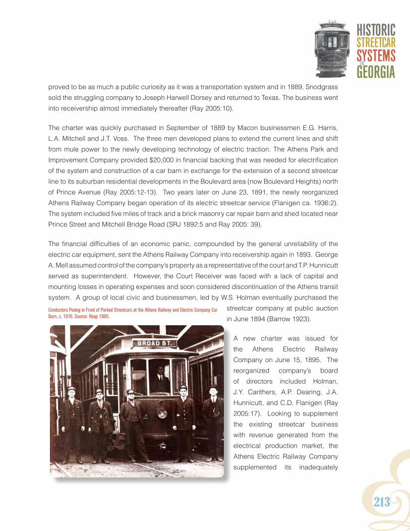
Y213
HISTORICSTReeTCaRSYSTeMSGeORGIaIn
proved to be as much a public curiosity as it was a transportation system and in 1889, Snodgrass
sold the struggling company to Joseph Harwell Dorsey and returned to Texas. The business went
into receivership almost immediately thereafter (Ray 2005:10).
The charter was quickly purchased in September of 1889 by Macon businessmen E.G. Harris,
L.A. Mitchell and J.T. Voss. The three men developed plans to extend the current lines and shift
from mule power to the newly developing technology of electric traction. The Athens Park and
Improvement Company provided $20,000 in financial backing that was needed for electrification
of the system and construction of a car barn in exchange for the extension of a second streetcar
line to its suburban residential developments in the Boulevard area (now Boulevard Heights) north
of Prince Avenue (Ray 2005:12-13). Two years later on June 23, 1891, the newly reorganized
Athens Railway Company began operation of its electric streetcar service (Flanigen ca. 1936:2).
The system included five miles of track and a brick masonry car repair barn and shed located near
Prince Street and Mitchell Bridge Road (SRJ 1892:5 and Ray 2005: 39).
The financial difficulties of an economic panic, compounded by the general unreliability of the
electric car equipment, sent the Athens Railway Company into receivership again in 1893. George
A. Mell assumed control of the company’s property as a representative of the court and T.P. Hunnicutt
served as superintendent. However, the Court Receiver was faced with a lack of capital and
mounting losses in operating expenses and soon considered discontinuation of the Athens transit
system. A group of local civic and businessmen, led by W.S. Holman eventually purchased the
streetcar company at public auction
in June 1894 (Barrow 1923).
A new charter was issued for
the Athens Electric Railway
Company on June 15, 1895. The
reorganized company’s board
of directors included Holman,
J.Y. Carithers, A.P. Dearing, J.A.
Hunnicutt, and C.D. Flanigen (Ray
2005:17). Looking to supplement
the existing streetcar business
with revenue generated from the
electrical production market, the
Athens Electric Railway Company
supplemented its inadequately
Conductors Posing in Front of Parked Streetcars at the Athens Railway and Electric Company Car Barn, c. 1910. Source: Reap 1985.

214
Appendix
powered steam plant north of Boulevard with a new dam and hydroelectric substation on the
Oconee River near Mitchell Bridge. The new plant was put into operation in October 1896. In
December of that year, Brumby’s Drug Store became the first Athens business to be lighted
with power generated by the Mitchell Bridge plant. Two years later, in 1898, the company was
awarded the contract to supply electricity for the city’s streetlights (Flanigen ca.1936: 3-4). To
handle growing energy demands, a second hydroelectric plant was built at Tallassee Shoals
and a substation was erected on Prince Avenue in 1900. By 1901, the Athens Electric Railway
Company owned nine streetcars and operated a total of 6.53 miles of single track. The majority of
the line serviced a central loop in the Athens downtown area along the primary corridors of Broad,
Clayton, College, Hancock, Lumpkin, Prince, Thomas, and Washington streets (Ray 2005:18). In
1906, the company relocated its office headquarters from the Shackelford Building at the corner
of Clayton and College to a new, three-story, Second Empire style building on College Avenue at
Hancock Avenue (Reap 1985: 114).
Four years later, on April 1, 1910, all holdings of the Athens Electric Railway Company were
transferred to Athens Railway and Electric Company. The company’s former secretary, W.T.
Bryan, was made president of the business, while J.Y. Carithers, and C.D. Flanigen served as
first and second vice-presidents, respectively (Flanigen ca.1936: 5). As a result of the capital
investment raised as part of the reorganization, the company initiated a series of upgrades and
expansions of existing routes and services. The Milledge Avenue line was extended into the newly
developing Five Points neighborhood, pushing the total amount of track to 8.9 miles (Nicholas
1914:39). Between 1905 and 1910 a second, larger car barn was built near the existing shed and
steam-generating plant. Simply known as the “Boulevard facility,” the new, three-bay barn and
car repair building was constructed of reinforced concrete and had six tracks and three pits (Ray
2005:44, 50). Increased energy capacity was added in 1911 when the 3,700 horsepower Barnett
Shoals hydroelectric plant, located on the Oconee River 11 miles south of Athens, was put online
(Flanigen ca.1936:5).
In 1913, controlling stock in the Athens Railway and Electric Company was sold to New York-
based interests represented by Henry L. Doherty and Company (Flanigen ca.1936:5). The Athens
Railway and Electric Company had become one of the largest electricity suppliers to many of the
city’s residential and commercial consumers, including the Athens Water Works, the Southern
Manufacturing Company, the Athens Foundry and Machine Works, and the Coco-Cola Bottling
Company (Reap 1985:79). By 1920, the company maintained an inventory of 16 passenger
cars, two work cars and approximately 10 miles of track; however, electricity production had
begun to compete with the streetcar operations as a primary revenue generator (McGraw-Hill
Company, Inc. 1920:25, Ray 2005:58). Between 1910 and 1920, the Athens population doubled

Y215
HISTORICSTReeTCaRSYSTeMSGeORGIaIn
from 10,000 to 20,000 residents, causing a local demand for electricity that began to outpace
supply. Industrial production requirements imposed by World War I also contributed energy
shortages in the city during this period (Lofton 1999). Drought in 1925 and increased electricity
demands led to the consolidation of the Athens Railway and Electric Company and Athens Gas
Light and Fuel Company under the control of the Southeastern Power and Light in 1926.

216
Appendix
AuguStALiNE(S): AuguStA ANd SomERviLLE RAiLRoAd ComPANY (1868-1893) AuguStA ANd whELESS RAiLwAY ComPANY (1889) AuguStA ANd FAiRmoNt RAiLwAY ComPANY (1889) ComPANY BELt LiNE (1889) AuguStA AiKEN ELECtRiC RAiLRoAd (BEgAN oPERAtioN iN 1902 AuguStA RAiLwAY ComPANY AuguStA RAiLwAY ANd ELECtRiC ComPANY AuguStA ANd CoLumBiA RAiLwAY ComPANY (1906) AuguStA-AiKEN RAiLwAY ANd ELECtRiC CoRPoRAtioN oF South CARoLiNA (1906-1928) South CARoLiNA PowER ComPANY (1928-1937)
The Augusta and Summerville Railroad began service in 1868 carrying passengers from Augusta
to Summerville through the Pinched Gut neighborhood, Augusta’s downtown, Broad Street,
Harrisburg—West End, and Summerville. Local historian Edward Cashin (1980:154) described
the initial service as “two mules, bedecked with sleigh bells, that drew a single car from Broad
Street to the Arsenal Gate” (Cashin 1980:154). The firm prospered along with Augusta in the
Augusta Railway and Aiken Electric Railway Map. Source: American Street Railway Investments, Vol. 11, 1904.
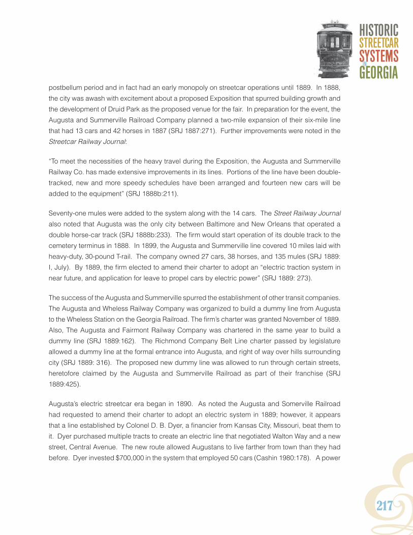
Y217
HISTORICSTReeTCaRSYSTeMSGeORGIaIn
postbellum period and in fact had an early monopoly on streetcar operations until 1889. In 1888,
the city was awash with excitement about a proposed Exposition that spurred building growth and
the development of Druid Park as the proposed venue for the fair. In preparation for the event, the
Augusta and Summerville Railroad Company planned a two-mile expansion of their six-mile line
that had 13 cars and 42 horses in 1887 (SRJ 1887:271). Further improvements were noted in the
Streetcar Railway Journal:
“To meet the necessities of the heavy travel during the Exposition, the Augusta and Summerville
Railway Co. has made extensive improvements in its lines. Portions of the line have been double-
tracked, new and more speedy schedules have been arranged and fourteen new cars will be
added to the equipment” (SRJ 1888b:211).
Seventy-one mules were added to the system along with the 14 cars. The Street Railway Journal
also noted that Augusta was the only city between Baltimore and New Orleans that operated a
double horse-car track (SRJ 1888b:233). The firm would start operation of its double track to the
cemetery terminus in 1888. In 1899, the Augusta and Summerville line covered 10 miles laid with
heavy-duty, 30-pound T-rail. The company owned 27 cars, 38 horses, and 135 mules (SRJ 1889:
I, July). By 1889, the firm elected to amend their charter to adopt an “electric traction system in
near future, and application for leave to propel cars by electric power” (SRJ 1889: 273).
The success of the Augusta and Summerville spurred the establishment of other transit companies.
The Augusta and Wheless Railway Company was organized to build a dummy line from Augusta
to the Wheless Station on the Georgia Railroad. The firm’s charter was granted November of 1889.
Also, The Augusta and Fairmont Railway Company was chartered in the same year to build a
dummy line (SRJ 1889:162). The Richmond Company Belt Line charter passed by legislature
allowed a dummy line at the formal entrance into Augusta, and right of way over hills surrounding
city (SRJ 1889: 316). The proposed new dummy line was allowed to run through certain streets,
heretofore claimed by the Augusta and Summerville Railroad as part of their franchise (SRJ
1889:425).
Augusta’s electric streetcar era began in 1890. As noted the Augusta and Somerville Railroad
had requested to amend their charter to adopt an electric system in 1889; however, it appears
that a line established by Colonel D. B. Dyer, a financier from Kansas City, Missouri, beat them to
it. Dyer purchased multiple tracts to create an electric line that negotiated Walton Way and a new
street, Central Avenue. The new route allowed Augustans to live farther from town than they had
before. Dyer invested $700,000 in the system that employed 50 cars (Cashin 1980:178). A power

218
Appendix
station was established at 15th Street. In 1902, Dyer, now enamored with the automobile, sold his
interest in the line to the Augusta-Aiken Electric Railroad. The South Carolina-based firm operated
the route connecting Augusta, Georgia to the cities of North Augusta and Aiken in South Carolina.
James U. Jackson, considered the “Father of North Augusta” was president of the Augusta-Aiken
Electric Railroad, which was purportedly the longest interurban line in the country when it was
completed in 1902 (Cashin 1980:196).
The interurban line had originally been organized by the Augusta Railway and Electric Company
in May 7, 1896, and reorganized from the Augusta Railway Company by an Act of the Georgia
General Assembly, approved December 17, 1892. Further reorganizations would occur. In 1906,
it changed from the Augusta and Columbia Railway Company to the Augusta-Aiken Railway and
Electric Corporation of South Carolina (GPSC 1911b). A labor strike in September 1912 culminated
in Augusta being placed under martial law (ERJ 1912: 631). The mayor settled the strike,
persuading the company to raise wages 12.5 percent (Cashin 1980:212). High fares (10 cents)
were an ongoing issue between the City and the streetcar company and the City endorsed the use
of jitneys of which there were 96 licensed vehicles in Augusta by July 1921 (Cashin 1980:228). The
streetcar company retaliated by stopping its service without informing the city. The city answered
by licensing more jitneys. However, these vehicles could not replace the streetcars, as they did
Augusta Railway and Electric Company Car in Summerville, Richmond County, c. 1900. Source: Vanishing Georgia, Georgia Archives, Office of Secretary of State.
Y219
HISTORICSTReeTCaRSYSTeMSGeORGIaIn
not run in bad weather, late at night or even keep to a schedule. The streetcar company and city
struck a compromise: jitneys were to stay a block away from streetcars and streetcars could still
charge 10 cents but would offer reduced rate tokens to commuters (Cashin 1980:229).
In 1928, the Georgia Power Company purchased the Georgia-based interests of the Augusta-
Aiken Railway and Electric Company, which primarily consisted of the Augusta municipal streetcar
system. Meanwhile South Carolina Power Company took over operations of the interurban line
in South Carolina. The financially troubled interuban line was discontinued a year later on July 8,
1929. Georgia Power continued service on the Augusta streetcar system until December 1937,
when the electric cars were replaced by motor buses (Langley 1972: 2). An example of an
Augusta Railway Streetcar Company Birney Safety Car has been restored and is currently on
display at the Augusta Museum of History.

220
Appendix
BRuNSwiCK ANd CoAStAL gEoRgiALiNE(S): BRuNSwiCK StREEt RAiLRoAd ComPANY (1885-C.1900) St. SimoNS tRANSit ComPANY (1885-C.1925) tuRtLE RivER RAiLRoAd ComPANY (1889) CitY ANd SuBuRBAN RAiLwAY ComPANY (1909-1921) BRuNSwiCK ANd iNtERuRBAN RAiLwAY ComPANY (1921-1926)
While much of the South remained in the economic depression that accompanied Reconstruction,
communities in coastal Georgia flourished in large part due to the construction of one of the
nation’s largest lumber mills on St. Simons Island in 1874, and the area’s emergence as a vacation
destination among Gilded Age capitalists. The Rockefellers, Vanderbilts, Morgans, Macys, Fields,
Pulitzers, and Goodyears all built winter resort homes on Jekyll Island and other nearby ‘Golden
Isles’ in the late 1880s. Meanwhile, the grand Oglethorpe Hotel in Brunswick and the Hotel St.
Simons attracted large tourists from throughout Georgia. The city desperately needed an efficient
and modern way to move people around the city and the islands. A group of progressive-minded
Brunswick entrepreneurs, known as the Brunswick Company, sought to introduce streetcar
service to the growing city. The Brunswick Street Railroad Company was organized in 1885 and
its subsidiary, the St. Simons Transit Company, formed a few years later in 1888 (SRJ1885: 228).
The Brunswick Company, seeking to develop the city “as a seaport and a fashionable winter
resort,” completed construction of a horse and mule-drawn streetcar line in Brunswick in 1888,
before turning its attention to St. Simons (SRJ 1888b:336). Developers and owners of both the
Brunswick Streetcars Along Norwich Street Route, c. 1920. Source: Vanishing Georgia, Georgia Archives, Office of Secretary of State.

Y221
HISTORICSTReeTCaRSYSTeMSGeORGIaIn
Oglethorpe Hotel and the Hotel St. Simons resort, the company utilized the lines both to convey
guests and, at the open and close of the season, furniture, to and from the ports and depots, and
between the hotels.
Research indicates that another Brunswick-based streetcar company may have existed during
this period. Known as the Turtle River Railroad Company, it sought incorporation in February 1889
for steam locomotive lines. No other information was found on the history of this company.
By 1889, the Brunswick Street Railroad line consisted of 4.5 miles of track, laid with 38-pound
steel T-rail track and served by teams of 25 mules and horses, pulling six streetcars (SRJ January
1889: VI.) The St. Simon line, consisting of trolley cars drawn by pairs of mules, ran ferried tourists
from the island pier, up the middle of Railroad Avenue, to the Hotel St. Simons. According to
local historian Tyler Bagwell, “The trolley was later replaced by the ‘Limited’ drawn by a small
engine, and still later [by] a motor-driven streetcar carried vacationers to hotels, boarding houses
or cottages” (Bagwell 2008: Streetcars of Glynn County). The St Simons Island streetcar line
maintained operation well into the 1920s, when the construction of a road between Brunswick and
St. Simons, completed in July of 1924, led to the discontinuation of passenger boat service to the
island; thus eliminating the need for a tourist streetcar line.
The beginning of the twentieth century was an era of great technological advancements, and
Brunswick, with its burgeoning population and public coffers, proved eager to take part in the
progressive municipal improvements that characterized the ‘New South.’ The City and Suburban
Railway Company was organized for electric streetcar service in the summer of 1909 with the aim
of installing a network of electric car lines throughout the City of Brunswick. The company was
based at 1525 Grant Street. Construction of the line was completed in 1911, and service began
shortly thereafter. The company failed within a decade however, and the line entered receivership
sometime around 1921. The new owners reorganized the railway company as the Brunswick
and Interurban Railway Company. The company’s streetcars of the early 1920s were yellow, with
glassed-in windows. Fares were set at around a dime for rides. The cars’ seats were made of
woven straw and, as one citizen reminisced, “the vehicles [would] briefly spark…whenever the
pole on the roof re-engaged with the electric line (Bagwell 2008, Streetcar Days of Glynn County).
Segregation on the Brunswick line was more stringent than other cities throughout the Georgia
and the Southeast. African Americans were banned from riding the city’s streetcars and forced to
rely on taxis for transit. During the 1920s, a push to construction and improve the roads system
throughout the region seriously impacted the ridership and profitability of the line. By 1926, just
five years after its reorganization, the service on the Brunswick and Interurban Railway line had
been discontinued. The fall of the streetcar in Brunswick and St. Simons Island coincided with the
rise of automobile ownership in coastal Georgia, as it did throughout much of the nation.

222
Appendix
CoLumBuSLiNE(S): CoLumBuS StREEt RAiLRoAd ComPANY (1885) giRARd ANd BRowNEviLLE StREEt RAiLwAY ComPANY (1888) CoLumBuS ANd wYNtoN StREEt RAiLwAY ComPANY (1889 NoRth highLANdS RAiLRoAd ComPANY (ChARtEREd 1890-1898) BRuSh ELECtRiC Light ANd PowER ComPANY (1882-1898) CoLumBuS RAiLRoAd (1898-1906) CoLumBuS ELECtRiC ANd PowER ComPANY (1906-1929) gEoRgiA RAiLwAY ANd PowER ComPANY (1929-1936)
Although the Columbus Street Railroad
Company received a charter in 1866, the
original investors delayed development
of the streetcar system, deeming the
proposed venture to be unprofitable due
to burdensome operation regulations
imposed by Columbus city government.
Despite protests over lack of service
by city boosters, mule-drawn streetcar
service was not implemented in the city
until 1884 with the construction of two
miles of track in the commercial business
district (Karfunkle et al. 1977:2). The
Street Railway Journal reported in 1888 that the Columbus Street Railroad Company was under
new management (SRJ January 1888b: 25-26). The company intended to expand the existing
system and to incorporate dummy engines. They shortly completed 6 miles of track and had
an additional four miles under construction. In 1888, the transfer from animal-drawn streetcars
to steam locomotive power was accomplished (SRJ 1888b:79). The SRJ provides the following
description of the line in 1889. The line had seven miles of 4-8.5 gauge, 16 and 25 pound T rails
laid with 16 cars and 54 horses. Their assets also included an additional seven miles of “rapid
transit” 40-pound steel rails negotiated by six cars (SRJ 1889: VII June). The company had
extended its Broad Street Line from 7th to 4th at an estimated cost of $5000 (SRJ 1889: 318).
The Columbus Street Railroad headquarters were located at Second Avenue and 17th Street.
The property included a stable, car shed, support buildings, office and a yard (City of Columbus
Sanborn Fire Insurance Maps 1889, No. 24).
In addition to the Columbus Street Railroad Company, the Street Railway Journal reported the
existence of other transit companies in the city during the late nineteenth century; however, neither
line appears to have been developed. The Girard and Browneville Street Railway Co is noted
Streetcars in Downtown Columbus, c.1895. Source: Vanishing Georgia, Georgia Archives, Office of Secretary of State.

Y223
HISTORICSTReeTCaRSYSTeMSGeORGIaIn
as building a dummy railway in 1888 (SRJ 1888b:338). Also, the Columbus and Wynton Street
Railway Company’s organization was identified in 1889, citing rumors that their street railroad and
dummy line management were making arrangements to extend the dummy line to run freight (SRJ
1889: 275).
1925 Columbus Comprehensive City Plan Map. Source: Historic Columbus, Inc.

224
Appendix
The North Highlands Railroad Company was chartered in 1890 and began operation of an
electrified streetcar system two years later. This spurred the rival Columbus Street Railroad to
convert from horse-drawn lines to electric operation by 1894. As part of the move to electricity,
the Columbus Street Railroad erected the city’s first hydroelectric power plant in 1895 (Karfunkle
et al. 1977:1-2).
In 1898, Columbus would begin the process of consolidating its lines. The Columbus Railroad,
North Highlands Railroad Company and Brush Electric Light and Power Company were
consolidated at the annual meeting of the Columbus Railroad on March 2. In 1906, the Columbus
Railroad merged with the Columbus Electric and Power Company and the Gas Light Company of
Columbus to form a consolidated streetcar and electric power utility (GPSC 1923:01).
In 1926, the Columbus Electric and Power Company charted the Columbus Transportation
Company to provide motorized bus service. Three years later in 1929, Columbus Electric
and Power Company was acquired by the Commonwealth and Southern Corporation. Both
conglomerates were folded into the Georgia Power Company in 1930 (Wright 1957:254). By
1936, electric streetcar service in Columbus had come to a close, when the system was entirely
converted to bus transit (Phillips 1975:B6).

Y225
HISTORICSTReeTCaRSYSTeMSGeORGIaIn
CoviNgtoNLiNE(S): CoviNgtoN ANd oxFoRd StREEt RAiLwAY ComPANY (1888-1917 BEtwEEN CoviNgtoN ANd EmoRY) CoviNgtoN ANd oxFoRd StREEt RAiLwAY ComPANY (1888 -1920S BEtwEEN CoviNgtoN ANd gEoRgiA RAiLRoAd dEPot)
Civic enthusiasm for a street railway system connecting the Newton County seat of Covington
to nearby Oxford, the home of Emory College, first gained a foothold in 1873. The idea for a
mule-powered streetcar line was to provide passenger and freight transportation for residents
and college students between the two towns and to the Georgia Railroad depot (Newton County
Historical Society [NCHS] 1988:299). In February 1873, a group predominantly comprised of
Oxford businessmen petitioned the Georgia General Assembly for a charter to incorporate the
Covington and Oxford Street Railway Company. Although the charter was granted, the new
company experienced problems generating the necessary capital for construction of the line.
Throughout the summer, contractors began grading and laying down crossties for the track, but
the work was constantly plagued by delays. Construction was finally halted in November and the
troubled company was dissolved the following September in 1874 (Lamberson 1995:157-159).
Covington and Oxford Street Railway Car in Downtown Covington, c. 1915. Source: Vanishing Georgia, Georgia Archives, Office of Secretary of State.

226
Appendix
Despite the setback, investors in Covington and Oxford attempted to establish a line. The Streetcar
Railway Journal reported that W.C. Clark and Company were considering constructing a 1.5 mile
long line in 1886 and again described a street railway to be built in 1888 between Covington
and Oxford” (SRJ 1886: 441, SRJ 1888b: 26). “It is expected that the work of construction will
commence by April 1. The first purchase of material will be for 1 mile. They will use T-rail,
weighing from 25 to 30 lbs to the yard, and will have 2 cars at first” (SRJ 1888b: 105). In 1889, the
journal noted that the Covington and Oxford Railroad Company was three miles in length laid with
4-8.5 gauge, 30-pound T rails. Ten horses pulled their 6 cars (SRJ 1889: VII. June.). The old mule
car line between Covington and Emory College in Oxford was finally retired in favor of bus transit
in November 1917. Mule cars continued to run however, between downtown Covington and the
Georgia Railroad depot into the 1920s. This was believed to be the last operating mule car line in
the United States (Atlanta Chamber of Commerce 1917:24).

Y227
HISTORICSTReeTCaRSYSTeMSGeORGIaIn
FAiRBuRN / CoLLEgE PARKLiNE: FAiRBuRN ANd AtLANtA RAiLwAY ANd ELECtRiC ComPANY (1908-1929)
The Fairburn and Atlanta Railway and Electric Company was established by a progressive-minded
group of Fairburn civic and business leaders to develop a commuter line servicing the outlying
communities in Campbell County (now the southern end of Fulton County) between Fairburn and
College Park. Between 1908 and 1929, the line operated as one of only four interurban transit
systems in Georgia during the early twentieth century. From College Park, passengers could
transfer to the Georgia Railway and Power Company streetcar network for access to downtown
Atlanta for entertainment, jobs, and shopping. As an ancillary service, the Fairburn and Atlanta
Railway and Electric Company also provided electrical power for businesses and residences in
Fairburn and the immediate surrounds.
Fairburn residents had been clamoring for a transit line connecting their town to Atlanta, as early
as 1902 (Electrical World and Engineer 1902:681). Located approximately 19 miles southwest of
Atlanta, Fairburn maintained a population of about 1,300 at the turn of the century, and was hailed
in the Electric Railway Journal as “becoming a very prosperous residential and manufacturing
suburban district” (ERJ 1916:296). An application for a company charter was advertised in October
Fairburn and Atlanta Railway and Electric Company Gasoline Engine Car, c. 1920. Source: Old Campbell County Historical Society.

228
Appendix
1908 and a survey of a potential route between Fairburn and College Park was conducted in
November of that year. A 10.25-mile right-of-way was selected for the line along the north side of
the Atlantic and Western Pacific Railroad (Cornell 2009:25-26). The Fairburn and Atlanta Railway
and Electric Company was organized just over a month later on December 22, 1908 and with
capital stock reserves of $75,000 (GPSC 1916:101 and ERJ 1909a:48). Campbell County native,
William Thomas Roberts, a prominent financier in Fairburn and president of the Fairburn Marble
Works also served as president of the new railway business (Northern 1912:146).
By 1910, the company had erected a car barn, offices and power plant at the southern periphery
of Fairburn on West Broad Street (now U.S. Highway 29) just south of the intersection with Church
Street (Nancy J. Cornell, personal communication 2010). The Fairburn and Atlanta Railway and
Electric Company complex included an attached, one-story brick masonry car barn and car
repair shop, a two, story, hollow-tile brick office building, a one-story masonry pump station and
transformer house, as well as a 100,000 gallon reservoir and clear water basin (Sanborn Fire
Insurance Map Company 1921). In November 1910, the journal Engineering and Contracting
reported that the company had completed its grade for the commuter line and was beginning
to lay track. Although originally envisioned as an electric railway, company directors were also
exploring the use of gasoline power for the cars (ERJ 1909:1062, Engineering and Contracting
1910:398).
The first run for the Fairburn and Atlanta Railway and Electric Company interurban line ran on June
25, 1911 from Fairburn to College Park and carried 38 passengers. The ride took 35 minutes with
stops in the Union City, Stonewall, and Red Oak communities. Cars were originally scheduled to
run every hour and fares were set at 20 cents (Cornell 2009:33).
Stockholders made plans to electrify the system in 1913, yet nothing came of it. The company
maintained the line with a fleet of gasoline-powered streetcars, popularly referred to as ‘dummies’
(Cornell 2009:35). Over time however, operation the gas dummy engines proved to be problematic
and the cars were often subject to horrific fires and explosions. A car caught fire and exploded
on the track in August 1913. Three months later, an operating error resulted in a second car
explosion, killing a 32-year old mechanic. A third car burst into flames on the line near College
Park in January 1916, although no one was hurt during the incident (Cornell 2009:36, 41-42).
In 1915, the company purchased a car trailer as a means of increasing passenger capacity (Cornell
2009:40). Following the destruction of the No. 1 car in 1916, company mechanics designed and
constructed their own gas-powered streetcar using a six-cylinder engine from an old Mitchell

Y229
HISTORICSTReeTCaRSYSTeMSGeORGIaIn
automobile (Hill 1917:126). The locally built car had a 28-passenger seating capacity and made
its first run on July 8, 1917. Aesthetically crude but effective, it cost approximately, one-third the
amount of the company’s other (Cornell 2009:49).
Like other interurban and streetcar operations in Georgia and around the country, the Fairburn
and Atlanta Railway and Electric Company line remained a relatively profitable enterprise until it
began to fall victim to the rise of automobile and bus transit during the 1920s. The emergence of
competing bus routes between College Park and Fairburn, such as the Perkerson Independent
Bus Line, began eating into the Fairburn and Atlanta Railway and Electric Company’s profits. The
company reported $43,379.71 in total revenues from transportation for the 1921 fiscal year. In
April 1923, the Perkerson Bus Line cut its fares to 10 cents, which forced the Fairburn and Atlanta
Railway and Electric Company to do likewise, which considerably weakened profits. By 1926,
the company’s transportation revenue had dropped to $28,270 (GPSC 1921:302 and 1926:302).
Over the course of 1927 and 1928, the board of directors made a number of leadership changes
intended to return the company to profitability; however, losses mounted and operation of the line
ceased altogether in 1929 (Cornell 2009:76,79, City of Fairburn 2011).
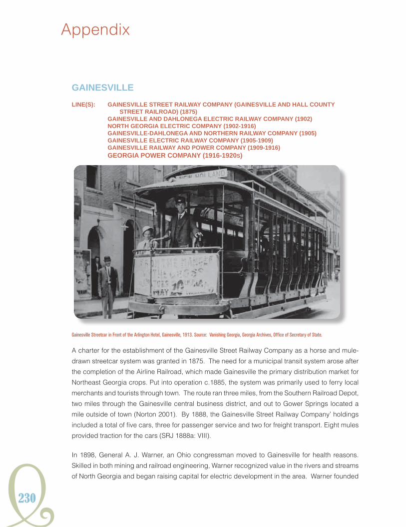
230
Appendix
gAiNESviLLELiNE(S): gAiNESviLLE StREEt RAiLwAY ComPANY (gAiNESviLLE ANd hALL CouNtY
StREEt RAiLRoAd) (1875) gAiNESviLLE ANd dAhLoNEgA ELECtRiC RAiLwAY ComPANY (1902) NoRth gEoRgiA ELECtRiC ComPANY (1902-1916) gAiNESviLLE-dAhLoNEgA ANd NoRthERN RAiLwAY ComPANY (1905) gAiNESviLLE ELECtRiC RAiLwAY ComPANY (1905-1909) gAiNESviLLE RAiLwAY ANd PowER ComPANY (1909-1916) gEoRgiA PowER ComPANY (1916-1920S)
A charter for the establishment of the Gainesville Street Railway Company as a horse and mule-
drawn streetcar system was granted in 1875. The need for a municipal transit system arose after
the completion of the Airline Railroad, which made Gainesville the primary distribution market for
Northeast Georgia crops. Put into operation c.1885, the system was primarily used to ferry local
merchants and tourists through town. The route ran three miles, from the Southern Railroad Depot,
two miles through the Gainesville central business district, and out to Gower Springs located a
mile outside of town (Norton 2001). By 1888, the Gainesville Street Railway Company’ holdings
included a total of five cars, three for passenger service and two for freight transport. Eight mules
provided traction for the cars (SRJ 1888a: VIII).
In 1898, General A. J. Warner, an Ohio congressman moved to Gainesville for health reasons.
Skilled in both mining and railroad engineering, Warner recognized value in the rivers and streams
of North Georgia and began raising capital for electric development in the area. Warner founded
Gainesville Streetcar in Front of the Arlington Hotel, Gainesville, 1913. Source: Vanishing Georgia, Georgia Archives, Office of Secretary of State.

Y231
HISTORICSTReeTCaRSYSTeMSGeORGIaIn
both the North Georgia Electric Company and the Gainesville and Dahlonega Electric Railway
Company in 1902. The New Bridge Chestatee River Plant, a dam and hydroelectric plant, was
completed in 1903 to provide power for the transit line and consumer electrical service to the
communities of Gainesville and Dahlonega (Norton 2001:10,11). The new electric streetcar line,
which replaced the old mule-car system, completed its first successful run on January 21, 1903
(Southland Corp. 1969). By the end of 1903, the North Georgia Electric Company had begun
construction of an electric interurban line connecting Dahlonega to Gainesville (SRJ 1903:32, 33).
The 1915 Sanborn map shows the company’s streetcar facilities located on South Maple Street.
The frame car barn had an earth floor and housed 11 cars. It also included an office, a detached
brick oil house, and a storage facility.
Development of the interurban line between Gainesville and Dahlonega stalled and the holdings
eventually fell into foreclosure. In March 1905, stockholders of the Gainesville and Dahlonega
Electric Railway Company reorganized the enterprise as the Gainesville Railway and Power
Company. Four years later in June 1909, the financially troubled company reorganized again
as the Gainesville Railway and Power Company. In 1911, the company operated six electric
passenger cars and one freight car on almost 6 miles of track. Lines ran through Gainesville to
the New Holland suburb and out to “Chattahoochee Park,” a company-owned fairground located
near the Chattahoochee River (GPSC 1911b).
In July 1916, the Georgia Railway and Power Company purchased the Gainesville Railway and
Power Company and all of its streetcar and electric distribution and generation holdings, including
the Chestateee River hydroelectric plant. The railway system was later sold at public auction
to pay a lien held by the City against the railway for street paving charges (Wright 1957:146).
By the 1920s, the line had been abandoned (Norton 2001). A charter for the establishment
of the Gainesville Street Railway Company as a horse and mule-drawn streetcar system was
granted in 1875. The need for a municipal transit system arose after the completion of the Airline
Railroad, which made Gainesville the primary distribution market for Northeast Georgia crops.
Put into operation c.1885, the system was primarily used to ferry local merchants and tourists
through town. The route ran three miles, from the Southern Railroad Depot, two miles through
the Gainesville central business district, and out to Gower Springs located a mile outside of town
(Norton 2001). By 1888, the Gainesville Street Railway Company’ holdings included a total of five
cars, three for passenger service and two for freight transport. Eight mules provided traction for
the cars (SRJ 1888a: VIII).
In 1898, General A. J. Warner, an Ohio congressman moved to Gainesville for health reasons.
Skilled in both mining and railroad engineering, Warner recognized value in the rivers and streams
of North Georgia and began raising capital for electric development in the area. Warner founded

232
Appendix
both the North Georgia Electric Company and the Gainesville and Dahlonega Electric Railway
Company in 1902. The New Bridge Chestatee River Plant, a dam and hydroelectric plant, was
completed in 1903 to provide power for the transit line and consumer electrical service to the
communities of Gainesville and Dahlonega (Norton 2001:10,11). The new electric streetcar line,
which replaced the old mule-car system, completed its first successful run on January 21, 1903
(Southland Corp. 1969). By the end of 1903, the North Georgia Electric Company had begun
construction of an electric interurban line connecting Dahlonega to Gainesville (SRJ 1903:32, 33).
The 1915 Sanborn map shows the company’s streetcar facilities located on South Maple Street.
The frame car barn had an earth floor and housed 11 cars. It also included an office, a detached
brick oil house, and a storage facility.
Development of the interurban line between Gainesville and Dahlonega stalled and the holdings
eventually fell into foreclosure. In March 1905, stockholders of the Gainesville and Dahlonega
Electric Railway Company reorganized the enterprise as the Gainesville Railway and Power
Company. Four years later in June 1909, the financially troubled company reorganized again
as the Gainesville Railway and Power Company. In 1911, the company operated six electric
passenger cars and one freight car on almost 6 miles of track. Lines ran through Gainesville to
the New Holland suburb and out to “Chattahoochee Park,” a company-owned fairground located
near the Chattahoochee River (GPSC 1911b).
In July 1916, the Georgia Railway and Power Company purchased the Gainesville Railway and
Power Company and all of its streetcar and electric distribution and generation holdings, including
the Chestateee River hydroelectric plant. The railway system was later sold at public auction to
pay a lien held by the City against the railway for street paving charges (Wright 1957:146). By the
1920s, the line had been abandoned (Norton 2001).

Y233
HISTORICSTReeTCaRSYSTeMSGeORGIaIn
gRiFFiNLiNE: gRiFFiN StREEt RAiLwAY ComPANY (1888-1900)
The Griffin Street Railway Company was incorporated in December of 1888, but was apparently
unable to continue development, as in 1891, both the Middle Georgia Improvement Company and
the Griffin Real Estate Investment Company were investigating the construction of Griffin’s first
street railway (Streetcar Railway Journal [SRJ] 1891: 42, 161). By spring of that year, construction
of the Griffin Street Railway Company was finally underway, with operations anticipated to begin
shortly thereafter (SRJ 1891:209). The line was financially troubled from the start, and in June of
the same year, the company successfully petitioned the state of Georgia for relief of payment of
taxes for the next five years (SRJ 1891:323). The tax break worked, and by 1893, the company
was extending service to Experimental Station, and to Camp Northern. The Camp Northern route
featured a steep hill, and according to local citizens, at the crest of the hill, the mule drawing the
car was unhitched, and the car allowed to coast to the hill’s bottom (Melton, Jr. 1959:204). The
line gradually fell out of use, and ceased operation around 1900.

234
Appendix
LAgRANgELiNE: LAgRANgE StREEt RAiLRoAd ComPANY (1887-1894)
LaGrange was a bustling town of colleges and commerce at the end of the nineteenth century,
home to two women’s colleges: the LaGrange Female College, later LaGrange College, founded
in 1831, and the now defunct Southern Female College, founded in 1842. Both colleges, strongly
associated with the Methodist and Baptist denominations, were extremely concerned with the
delicacy of their students, and required a way to convey students and their luggage from the
train depot in town out to the school, and from school to town for supplies, with as much ease
and speed as possible. Additionally, as a railroad stop, LaGrange was the destination for area
farmers seeking to sell their crops, predominantly cotton. Local businessmen settled on the idea
of a street railway to meet the needs of the town and colleges, and organized and chartered the
LaGrange Street Railroad Company in 1887. The line was to run from the Atlanta and West Point
Railroad Depot west along Depot street to Main Street, then north along Main Street to the square,
around the square and out Broad Street, west to LaGrange Female College, and potentially on to
Ferrell Terraces, and from the square north along Church Street to the Southern Female College
LaGrange Street Railroad Horse-drawn Car on Broad Street, 1889. Source: Vanishing Georgia, Georgia Archives, Office of Secretary of State.

Y235
HISTORICSTReeTCaRSYSTeMSGeORGIaIn
and on to Hill View Cemetery, and from the square along Hines, Vernow, Franklin, and Bull streets
to their ends (GGA 1887:239-40). By July of 1891, the company had received a franchise from the
LaGrange city council and was ready to begin construction of the line (SRJ 1891:214).
The actual route of the LaGrange Street Railroad was far shorter than originally planned, extending
only from the Depot to Main Street and around the square, west along Broad Street to the LaGrange
Female College, and north along Church Street to the Southern Female College (TCHS 1993). The
rails were laid down the middle of each street along its route, and were traversed by horse-drawn
streetcars permitted to convey both passengers and freight. The endeavor ceased in 1894, when
the streetcar “Nancy Hanks” was retired (TCHS 1993). The line, something of a joke to residents
of LaGrange, failed due to lack of patronage, less than five years after its completion.

236
Appendix
mACoNLiNE(S): mACoN CitY ANd SuBuRBAN StREEt RAiLRoAd ComPANY (1884-1892) CENtRAL CitY ComPANY (1888-1892) mEtRoPoLitAN StREEt RAiLwAY ComPANY oF mACoN (1890-1902) hoRNE ELECtRiC RAiLwAY ComPANY (C.1890) mACoN ANd iNdiAN SPRiNgS RAiLwAY ComPANY LAtER KNowN AS mACoN
ELECtRiC Light ANd RAiLwAY ComPANY(1892-1902) mACoN CoNSoLidAtEd ComPANY (thomAS-houStoN ELECtRiC ComPANY) (1892-1902) mACoN RAiLwAY ANd Light ComPANY (1902-1928) gEoRgiA PowER ComPANY (1928-1934)
By the end of the nineteenth century, Macon had become the exponentially expanding city, with a
population doubling in just six years time, in large part due to the influx of railroads passing through
town: seven by 1886. A large manufacturing town as well, Macon was home to the large Bibb
Manufacturing Company, organized in 1876 and operating multiple textile plants in town. The first
of Macon’s streetcar services was conceived and constructed in 1871, and on September 21 of
that year, the mayor and city fathers caused quite a stir as they rode the first of Macon’s streetcars
from Cherry Street to the State Fairgrounds, chased by a pack of small boys and dogs (Young
Macon Railway and Light Company Car and Conductors, Macon, c.1905. Source: Middle Georgia Archives, Washington Memorial Library, Macon, Georgia.

Y237
HISTORICSTReeTCaRSYSTeMSGeORGIaIn
et. al 1950: 312). The streetcar system was thought to be “the greatest contribution to [Macon’s]
progress possible” by the editors of the Macon Telegraph and Messenger (Young et. al 1950:312).
By 1880, several streetcar lines had sprung up and promptly failed due to local preference of
City Map of Macon, Georgia, c.1893. Source: Middle Georgia Archives, Washington Memorial Library, Macon, Georgia.

238
Appendix
horse-drawn hacks over streetcars. The editors of Macon’s newspapers, however, were adamant
that Macon establish “good lines” to “bring the city up to modern standards” (Young et al. 1950:
382). The local businessmen of Macon took heed, and in February of 1884, announced the
formation of a new streetcar company: the Macon City and Suburban Street Railroad Company.
The belt line, beginning operations in April of 1885, expanded rapidly, adding two miles of new track
in December of the same year, and by the following February, held 12 cars, 60 mules and horses,
and five miles of railway with further plans to extend (SRJ 1885: 285, SRJ 1886: 48). The line
extended further that year, adding service to east Macon, with further plans to extend to southwest
Macon. The company also replaced its “small Texas horses and mules” with larger, sturdier
animals, and made improvements to the quality of the existing track, installing double track and
switches to further speed circuit completion along the routes (SRJ 1886: 117, 390). Encouraged
by the success of this latest company, a competing company, the Central City Company, organized
and began to plan a dummy line to Vineville. Though apprehensive due to other cities’ troubles
with the volatile, dirty, and noisy dummy engines, Macon granted the company right of way, and
construction was completed in the fall of 1888. The line was four miles in length, and served by
three dummy engines powering seven cars (SRJ 1888a: X). The company planned the installation
of a traffic generator, “an elaborate recreation park, casino, and theater” at the terminus of the line,
but after both the depot and one of the company’s streetcars were destroyed by storm, that plan
was scrapped (Young et al. 1950: 383). This and other misfortunes, including several lawsuits
against the company, one amounting to $50,000 in damages, eventually caused the beleaguered
company to enter receivership in 1889.
The Macon City and Suburban Street Railroad, fairing far better than its competitor, had continued
to expand, and by 1888 had brought its total length of track to 12 miles of 20 pound T rail, over
which the company operated a total of 26 cars, drawn by any of their 90 mules (SRJ 1888a: X).
The company changed hands several times that year, eventually ending up in the hands of a pair
of businessmen, George F. Work of Philadelphia, and Henry Horne, of Macon, who purchased the
system, comprised of “thirteen lines of belt, 110 head of mules, twenty-six cars, shops, tools, real
estate, and the franchise” for $79,700 (Young et al. 1950:383). The new owners, anxious to turn a
profit with the railway, petitioned for permission to convert the system to electricity, but city council
members were skeptical. After several months of bickering and persuading, on September
4, 1889, the council granted the company’s petition, and plans were promptly set in motion to
begin conversion of the track, but conversion was completed on only one line (Young et al. 1950:
383). Still no more improvements had been made by 1891, when word reached Macon, already
outraged by the lack of progress on the line, and by the monopoly the Macon City and Suburban
Street Railroad Company held, that Work, its majority holder, had been arrested in Philadelphia.
The company, along with the Central City Company, owed over $70,000 to the Thomas-Houston

Y239
HISTORICSTReeTCaRSYSTeMSGeORGIaIn
Electric Company, and a lien of that amount had been placed on the railways (Young et al. 1950:
384). Both companies entered receivership in April of that year, with E.E. Winters appointed their
permanent receiver.
While the older companies floundered, the Metropolitan Street Railway Company of Macon, the
Horne Electric Railway Company, and the Progress, Loan, Improvement, and Manufacturing
Company had also received charters and were endeavoring to install lines in various parts of
Macon. Macon’s transit lines were an utter disaster, as an 1891 editorial from the Macon Telegraph
confirmed, denouncing Macon’s street car system as “the worst in the state” (Young et al. 1950:
384). By 1892, the Metropolitan Street Railway was operating a line to the new Macon suburb
of Bellevue, and had constructed a traffic generator, a recreation hall and park, along the route
(Young et al. 1950: 384). Winters, receiver for the failed Central City and Macon City and Suburban
Street railways, successfully converted about six miles of line to the electric system, before being
removed as receiver in 1892 after failing to successfully negotiate an extension of service to
Vineville.
The companies were sold publicly to the Thomas-Houston Electric Company, who formed the
Macon Consolidated Company to manage the lines, and quickly set to the task of finishing the lines’
conversion to electricity. The company made rapid improvements, building its own powerhouse
over the summer of 1892, and finishing the conversion of the South Macon car line by February of
1893. By 1895, when Macon Consolidated, then owned by New York’s General Electric Company,
was sold to Tucker, Anthony, and Company, of Boston, for $450,000, Macon had twenty miles
of electric street rail: four around the belt, four to Bellevue, three to Vineville, and nine to the city
park, Rose Hill, South and West Macon, and Ocmulgee Land (Young et al. 1950: 385). Plans were
immediately laid to further extend Macon Consolidated’s service via a belt line to East Macon and
Cross Keys. The failure of so many street rail lines in Macon was little deterrent to new companies,
and in 1892, the Macon and Indian Springs Railway Company received a franchise for a rapid
transit electric line to the city limits, which began operation on April 22, 1893. The line, originating
at the Brown House on Fourth Street, had four cars, two running east, and two running west (Young
et. al 1950: 385). By 1895, the company was planning to further extend its service to the Central
City Park. After a troubled start, Macon had become a city of streetcar lines, with no less than
three electric railway companies operating service within the city and its suburbs.
By 1902, three railway companies was two too many for Macon, and on October 23, 1902, the
Macon Railway and Light Company was organized from the merger of the Macon Consolidated
Street Railway Company; the Macon Electric Light and Railway Company, formerly the Macon and
Indian Spring Railway Company; and the Metropolitan Street Railway Company of Macon. The
Macon Railway and Light Company, controlled by the Railways and Light Company of America,

240
Appendix
located in Richmond, Virginia, would control all street railway service within Macon, in addition to
the city’s electric lighting plants, provided that they first agree to immediately spend $150,000 on
improvements within Macon city limits (SRJ 1903:33). The improvements were made, and service
continued uninterrupted through Macon through the first decade of the new century.
In 1907, the company was sold to a group of Macon businessmen, who promptly obtained a
charter to construct an electric interurban line to be called the Macon, Americus, and Albany
Railway, and though work began on various points of the road, the line was never realized (Young
et al. 1950: 454-5). Service was, however, successfully extended to Rice Mill Park, to the south,
and out the Forsyth Road to the Idle Hour Club (Young et al 1950: 455). In addition, several of the
lines were modified, improved, or rerouted in 1915, and further affected in 1918, when the Macon
Railway and Light Company discontinued service, by order of the U.S. Fuel Administration, to
more than a hundred stops on six of its lines (MDT 1915, MDT 1918). As roads were improved
and the automobile became more affordable, the streetcar lines suffered.
In 1922, service on the Ocmulgee Line was shortened, as the three-quarters of a mile of track that
extended from the Macon city limits out to Ocmulgee Park were torn up and junked (MDT 1922).
Operations continued uninterrupted through the Macon Railway and Light Company’s merger with
the Georgia Power Company, occurring on September 25, 1928 (Wright 1957: 241). The railway
continued to operate an estimated 34 miles of electric track in and around Macon and its suburbs
until 1933, when Georgia Power applied for and received permission from the city council to
begin replacing streetcar services with buses, despite the objections of local citizens (Young et
al 1950: 588). A group of local citizens fought the changeover into 1934, but were unsuccessful,
and Macon’s streetcars ceased operations by November of that year (MT 1934a, 1934b). The
tracks were subsequently paved over, and left undisturbed until 1942, when the Metals Reserve
Company began tearing up the streets of Macon to retrieve the abandoned tracks for the war
effort (MT 1942). Today, the only existing remnants of Macon’s extensive streetcar system are the
Macon Railway and Light Company’s substation and car barn, located on Riverside Drive. The
substation was added to the National Register of Historic Places in 2006.

Y241
HISTORICSTReeTCaRSYSTeMSGeORGIaIn
RomELiNE(S): RomE StREEt RAiLwAY ComPANY (1884-1894) NoRth ANd South StREEt RAiLRoAd ComPANY (1888-1894) CitY ELECtRiC StREEt RAiLwAY ComPANY (1888-1906) RomE RAiLwAY ANd Light ComPANY (1906-1924) gEoRgiA PowER ComPANY (1924-1929)
Rome’s connection to the Western and Atlantic Railroad, coupled with local farmers’ switch to cotton
as their primary crop after the Civil War, led Rome to become one of the largest cotton exporters
for both northwest Georgia and northeast Alabama in the 1870s. The resulting economic boom in
Rome during the 1880s allowed for a number of municipal improvements, including the introductin
of electric light and long distance telephone service, as well as the construction of both a new city
hall and the Nevins Opera House. Seeking to improve upon this period of modernization, the Rome
Street Railway Company was incorporated December 12, 1884. After receiving official approval in
April 1885,, construction on the city’s first streetcar line began. Service of the mule-drawn system
started on August 1, 1885 (SRJ 1885:225). The new line proved to be a popular success in the
way of public transit, primarily due to the deplorable condition of Rome’s streets, which were
Rome Railway and Light Company Car and Conductors, Rome, c.1915. Source: Rome Area History Museum.

242
Appendix
often reduced to a “river of mire” (Aycock 1981:255). The cars, furnished by the Brownwell and
Wight Car Company of St. Louis, were enclosed, with windows along each side, were painted
yellow, and trimmed in blue. They were drawn by a pair of mules strung with bells (SRJ 1885:225,
Aycock 1981:255). The streetcars, costing a nickel a ride, caused a great sensation with crowds
of people, adults and children alike, following them around the streets.
Rome’s often flooded streets caused a great many difficulties for the fledgling railway company,
which was immediately charged with the Herculean task of filling in a particularly troublesome
low spot along its route on East Second Avenue at the approach to the Etowah River bridge. At
great expense, the area was filled to an acceptable level, but it was only the first of many issues
the railway would have with the muddy streets. The combined weight of the mule teams and
cars, traveling dozens of times a day along the route, wreaked further havoc on the rail route. The
tracks, which were merely “flat metal strips spiked to wooden runners laid on crossties” could not
stand up to both the streetcars and the muddy and uneven streets. The company unsuccessully
sought to rectify these deficiences at its own expense, by raising the level of the street and paving
it with a macadamized surface (Aycock 1981: 256). On April 1, 1886, the Oostanaula River,
swelled by early, heavy seasonal rains, rose over 15 feet above flood level, to a depth of 40 feet.
The water was so deep that a steamboat sailed down Broad Street. Rome was utterly decimated,
and as the waters receded, adamant that this disaster would not befall it again. As reconstruction
began, the decision was made to gradually but substantially raise Broad Street, and the first
floors of buildings along the thoroughfare were slowly filled in or enclosed as basements as the
street was elevated. The streetcar line would rise with it, but was still plagued elsewhere along
its route with unsanitary conditions. In response, the 1886 city council declared the rail line a
“public nuisance and menace to the community’s health, and ordered the company to clean up
its right-of-way or surrender its franchise” (Aycock 1981: 256). The forward thinking Rome Land
Company saw this ultimatum by the city council as an opportunity. It led the charge to improve
the city’s transportation system by purchasing the Rome Street Railway in 1887, and immediately
implemented plans to run cars powered by dummy steam engines along with the mules.
Later that same year, the Rome Street Railway completed construction of two dummy lines,
running to East and West Rome. By 1888, it was operating six cars over seven miles of 20 and
25-pound rail line, using both mules, and two dummy engines as motive power (SRJ 1887:510,
SRJ 1888a:XIII). Within six months, the Rome Street Railway would add an additional two cars
and increase their total number of mules to 20 (SRJ 1889:XIII. Jul.). As the Rome Street Railway
flourished, other businessmen of Rome took notice, and organized into a competing company,
the North and South Street Railroad Company in 1888, completing construction of the line the
same year. The North and South Street Railroad line intersected that of the Rome Street Railway’s,

Y243
HISTORICSTReeTCaRSYSTeMSGeORGIaIn
but the two lines served separate parts of the growing city. Within a year of formation, the North
and South Street Railroad line ran three mule-drawn cars over 2.5 miles, with franchises to power
additional lines by “steam, electricity, underground cables, or an other means invented in the
future” (Aycock 1981:257). The mule and the steam engine traction cars were soon to be things
of the past, as the Rome Gas Company completed construction of Rome’s first electric generating
plant in 1887. Rival companies also constructed electric power plants in the city, and by 1889, the
City of Rome was completely illuminated by electric light (Aycock 1981:258). Taking advantage of
this new power infrastructure, the City Electric Street Railway Company was created in 1888.
Not much notice was taken of this new company, however, as both the North and South Street
Railroad Company and the Rome Street Railway Company were embroiled in a legal battle with
the City of Rome. The dispute, which came to a head in 1891, was over which entity would incur
the costs associated with the raising and macadamizing of tracks on the newly elevated Broad
Street. The dispute was resolved in October of that year with all three parties agreeing to share
the costs, but it proved still to be too much for the Rome Street Railway Company, which fell into
foreclosure in 1894, and was absorbed by the City Electric Street Railway Company (Aycock
1981: 258). The City Electric Street Railway also acquired the North and South Street Railroad
Company that same year as part of its expansion.
The street railways of Rome had become electrified. In 1904, City Electric constructed a line to the
Massachusetts Mill Company’s textile plant in Lindale, and acquired Mobley Park, located midway
along the Lindale extension (Aycock 1981: 258). Mobley Park was quickly developed into the
central community recreation area in Rome, and proved quite lucrative as a traffic generator for
the City Electric Street Railway Company, who was approached in 1906 by a Louisville, Kentucky-
based company looking to acquire the company and its holdings. The street railway, power
plant, park, and other assets were sold for $100,000, and the Rome Railway and Light Company
was born (Aycock 1981:259). In 1911, it had 18 cars in operation, and 60 employees (MCA
1978:14). The 1915 Sanborn map of Rome indicates that the Rome Railway and Light Company
had established a large complex on South 8th Avenue between Broad and East 1st Streets, the
headquarters of the former City Electric Street Railway Co, consisting of a large brick car barn
structure and repair shop, with an attached, frame machine shop, a separate frame oil house, and
a frame office building attached to a fireproof warehouse, walled in brick, with a roof and floor of
concrete. But numbers were dwindling, as indicated by the 1925 addition to Rome of a new silk
mill. Constructed a half mile from the end of the North Rome car line, the weakest on the system,
and with funds lacking, the Rome Railway and Light Company elected to run a bus service from
the end of the line to the mill, rather than extend the line (MCA 1978:15). The time of the streetcar
in Rome was on the decline.

244
Appendix
Map of Rome, Georgia c.1910 with Delineated Streetcar Routes. Source: Rome Area History Musuem.

Y245
HISTORICSTReeTCaRSYSTeMSGeORGIaIn
On November 16, 1926, the Rome Railway and Light Company was consolidated by the Georgia
Power Company. Failing to provide even an eight percent return on investment since 1920 and
operating at a loss since 1923, the streetcar system was a burden on the finances of Georgia
Power who sought permission from Rome’s city commission to discontinue streetcar service in
favor of a bus service early in 1929 (MCA 1978: 15). The City of Rome, who had been counting on
Georgia Power to pay for a large portion of desperately needed street repairs, due to the charter
agreement it had taken on when acquiring Rome Railway and Light, refused. After an additional
four more unsuccessful petitions to the city, on September 16, 1929, to great controversy, Georgia
Power discontinued streetcar service, replacing the electric cars with buses (MCA 1978: 15). To
ensure that the streetcars could not be returned to service, employees of Georgia Power were
ordered to tear down the portion of the overhead transmission wires running from the car barn on
8th Avenue all the way to 9th Avenue. The city fought Georgia Power to have the streetcar system
restored, but in 1930 was forced to abandon its battle after the Public Service Commission ruled
that the city could not force Georgia Power to operate streetcars at a loss (MCA 1978:15). The
age of the streetcar had given way to the age of the automobile. Today, a modern office building
stands on the site of the old car barn on 8th Avenue, and few traces of Rome’s streetcar heritage
remain.
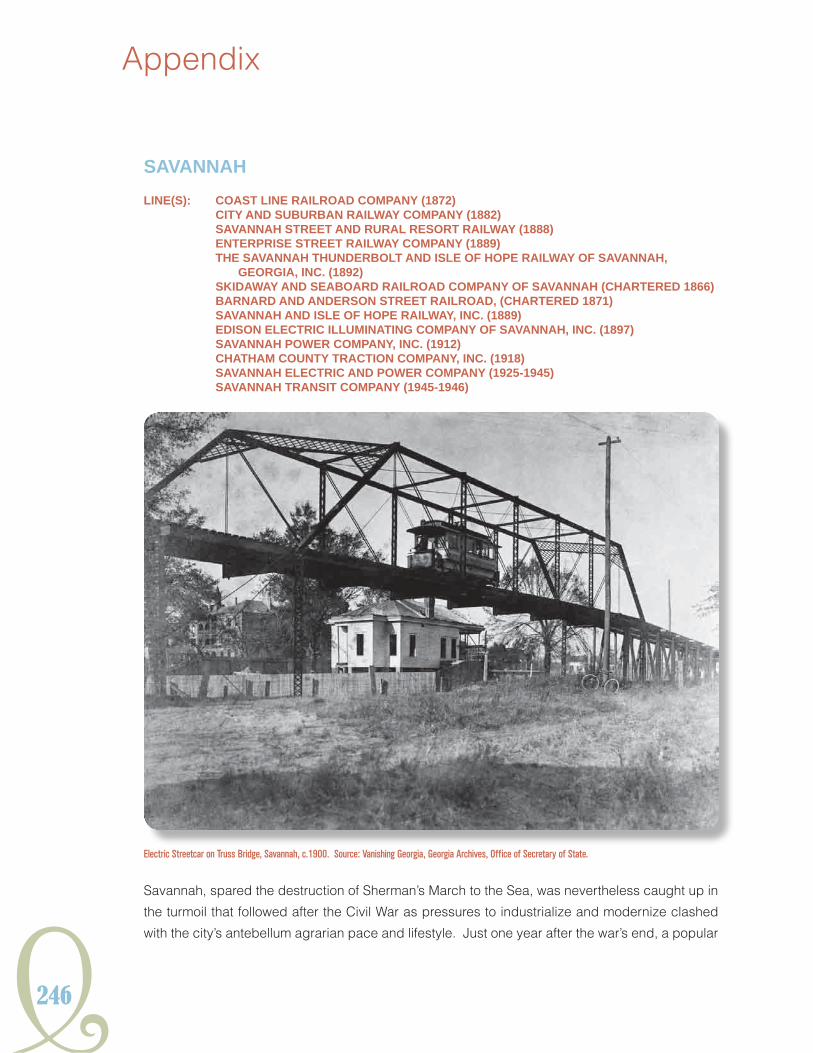
246
Appendix
SAvANNAhLiNE(S): CoASt LiNE RAiLRoAd ComPANY (1872) CitY ANd SuBuRBAN RAiLwAY ComPANY (1882) SAvANNAh StREEt ANd RuRAL RESoRt RAiLwAY (1888) ENtERPRiSE StREEt RAiLwAY ComPANY (1889) thE SAvANNAh thuNdERBoLt ANd iSLE oF hoPE RAiLwAY oF SAvANNAh,
gEoRgiA, iNC. (1892) SKidAwAY ANd SEABoARd RAiLRoAd ComPANY oF SAvANNAh (ChARtEREd 1866) BARNARd ANd ANdERSoN StREEt RAiLRoAd, (ChARtEREd 1871) SAvANNAh ANd iSLE oF hoPE RAiLwAY, iNC. (1889) EdiSoN ELECtRiC iLLumiNAtiNg ComPANY oF SAvANNAh, iNC. (1897) SAvANNAh PowER ComPANY, iNC. (1912) ChAthAm CouNtY tRACtioN ComPANY, iNC. (1918) SAvANNAh ELECtRiC ANd PowER ComPANY (1925-1945) SAvANNAh tRANSit ComPANY (1945-1946)
Savannah, spared the destruction of Sherman’s March to the Sea, was nevertheless caught up in
the turmoil that followed after the Civil War as pressures to industrialize and modernize clashed
with the city’s antebellum agrarian pace and lifestyle. Just one year after the war’s end, a popular
Electric Streetcar on Truss Bridge, Savannah, c.1900. Source: Vanishing Georgia, Georgia Archives, Office of Secretary of State.

Y247
HISTORICSTReeTCaRSYSTeMSGeORGIaIn
movement sought to bring a streetcar system to the city. In December of 1866, the Savannah,
Skidaway and Seaboard Railroad Company received its charter from the state legislature.
Savannah’s first street railway was to run from Savannah to the suburban resort enclaves of the Isle
of Hope, Skidaway, Montgomery, White Bluff, Thunderbolt, and Green Island, under either steam
or horse power (Eason 1971:11). The value of such a route, allowing citizens who worked in the
city to live outside of it, in far less expensive areas, was immediately recognized by the populace
and the suburbanization of Savannah began. After two years of preparations and fundraising,
the Savannah, Skidaway and Seaboard Railroad Company broke ground in July of 1868. As
construction commenced on the suburban lines, the company set its sights on the city itself, and
received permission that fall for an expansion of service via construction of an interurban line
through Savannah (Eason 1971:11).
As work continued on the Savannah, Skidaway and Seaboard Railroad, other businessmen in the
city, inspired by the enthusiasm the first rail company had generated, formed to create a competing
company. In October of 1868, the Wilmington Railroad Company was formed to run routes to
Wilmington Island, Thunderbolt, Bonaventure, and to operate ferry service from Wilmington to
Whitmarsh (Eason 1971: 13). The project would languish in the fundraising stages until 1872,
when an infusion of new stockholders and a new name, the Coast Line Railroad Company, would
get construction underway (Eason 1971:14). As the Wilmington Railroad Company languished,
the Savannah, Skidaway and Seaboard Railroad completed its first planned line, and began
service on January 27, 1869. The first two cars, each pulled by one bell-bedecked horse, could
transport 12 passengers at a time. Heated by wood or coal stoves, and lit with kerosene lamps,
the cars ran every 15 minutes from seven in the morning until eight at night, costing 10 cents a trip,
less if purchased in bulk (Eason 1971:14). In the spring of that year, the interurban line, partially
completed, had also begun service. By August, the company was also running interurban freight
service three days a week.
Driven by the success of the Savannah, Skidaway and Seaboard Railroad, a third group of investors
formed the Savannah and Thunderbolt Railroad in 1871, to run streetcar routes from Savannah’s
city limits to Thunderbolt, Beaulieu, and Montgomery, terminating at the picturesque Laurel Grove
Cemetery, a popular recreation spot (Eason 1971: 15). Savannah’s oldest street railway company,
the Savannah, Skidaway and Seaboard Railroad Company, recognized the value of the planned
endeavor, and purchased the Savannah and Thunderbolt Railroad in 1873, before construction of
the line was complete (Eason 1971: 17). They would complete the line in 1875, and, inspired by
its success, continue to construct lines to popular recreation areas, often also providing the area’s
entertainment and amenities (D’Alonzo 1999:19).

248
Appendix
The year of 1872 saw the creation of yet another street railroad company, the Barnard and Anderson
Street Railroad, as investors sought to capitalize on the streetcar craze. This line would also provide
service to Laurel Grove Cemetery via horse drawn cars. Delays pushed the completion of the line
back five years. It finally became operational in the summer of 1877, running from the City Market
in Savannah to the cemetery (D’Alonzo 1999:21). The company set plans for further expansion
into the city that same year.
In the summer of 1872, the new streetcars became the site of racial conflict. The cars were
segregated, with some cars reserved for “whites only,” and on July 20, racial tensions over the
segregation of the cars, and the city, came to a head after several black citizens boarded a “whites
only” car and were forcibly ejected. The situation escalated into a full riot, involving both gunfire
and the city’s police. The Savannah mayor pro tem, Alfred Haywood, issued a proclamation
that afternoon permitting forms of vigilantism in the city’s white citizens in order to quell the riot
(D’Alonzo 1999:16). The cars would remain segregated for the entirety of the lines’ existences.
By the summer of 1873, the streetcar lines were becoming fully integrated into much of the
Savannah metro area, with service beginning on Abercorn Street with much fanfare June 17, 1873
(Eason 1971: 17). That winter, the Savannah, Skidaway and Seaboard Railroad Company would
install its first turntable at Bay and Drayton Streets, in order to better“ facilitate the freight activities
of the road on the waterfront” (Eason 1971 :17). By 1874, the Coast Line Railroad Company,
who had begun suburban operations shortly after reorganization in 1872, was expanding, adding
three new cars, and a stable on Bolton Street to accommodate the new mules it had ordered from
Kentucky for the new interurban line, which began operation on September 16, 1874. The city
line operated every weekday, with cars departing every 20 minutes from six in the morning until
half past eight in the evenings (Eason 1971:18). The Savannah, Skidaway and Seaboard Railroad
was also expanding, installing a turntable at West Broad Street between Liberty and Stone to
accommodate heavier traffic and use, and opening both the Laurel Grove Cemetery line and its
later expansion to White Bluff, and a new “excursion” line to the Isle of Hope in 1875. The company
began in earnest that year “to escalate its emphasis on creating on the peripheral isles and water
spots around Savannah national tourist centers,” to further increase its own profits (Eason 1971:
19-20). Many of the tourist centers’ activities were actually sponsored by the railroad company,
including tournaments, contests, and races held during the busy summer tourist season.
Heavy patronage of the railways enabled further expansions, and on January 1, 1876, the Coast
Line Railroad opened its new Thunderbolt line. (Eason 1971: 21) Emboldened by their early
successes, both the Coast Line Railroad Company and the Savannah, Skidaway and Seaboard
found themselves extended beyond their means and began to experience financial uncertainty
by 1879, as the smaller Barnard and Anderson Street Railroad Company continued to expand
Y249
HISTORICSTReeTCaRSYSTeMSGeORGIaIn
(D’Alonzo 1999:24). While the big companies struggled, new, smaller streetcar companies
inundated the Savannah area, and by 1882, four additional companies, the Liberty Street Railroad,
Tybee Railroad, the Savannah, Florida and Western Railway, and the People’s Railway, were
operating urban and suburban lines in the Savannah area (Eason 1971: 20). A fifth new company
was created that year, the City and Suburban Railway Company, which acquired the franchise,
assets, and rights and privileges of the Savannah, Skidaway and Seaboard Railroad Company,
whose old road was to then be united with the Barnard and Anderson lines, then extended (Eason
1971:20-1). The new City and Suburban Railway Company, eager to capitalize on highly profitable
traffic generators, constructed both a dance pavilion and large bathing house for its patrons at the
Isle of Hope in June of the same year (Eason 1971: 21). The sound financial practice of the traffic
generators proved highly profitable for the fledgling company, and by 1884, as it ran booming
weekend train and ferry services to the islands, it found itself financially able to replace its lines’
old iron track with steel, expand its city route, construct a new belt line, and purchase opulent new
passenger cars (Eason 1971: 22).
The success of yet another street railroad company, coupled with Savannah’s burgeoning tourism
industry, was encouraging to investors and in 1883, an additional rail company was incorporated.
The Savannah Street and Rural Resort Railway, a six-mile route planned to connect the city with its
southern suburbs, began operations in 1888, with cars furnished by the famous Pullman Palace
Car Company (Eason 1971: 22-23, SRJ 1887:276). Meanwhile, the rapidly expanding City and
Suburban Railway Company quietly acquired Barnard and Anderson and by the middle of 1877
owned 12.5 miles of steam freight line, an additional six miles of passenger line, 40 street cars,
12 steam cars, 130 horses, and three engines (Eason 1971: 22, SRJ 1887:423). The Coast Line
was also enjoying some newfound success, reporting seven miles of track, five of it suburban and
steam, 17 cars, one engine, and 35 horses in 1887. The following year it had completed a new
waiting room, stables, barn and car shed, additional siding tracks. Almost a mile of track extensions
were built, which included new switches, and two new cars, with plans for seven more by winter to
service the expanded route (SRJ 1887:510, SRJ 1888b:164-5). Savannah Street and Rural Resort
Railway, upon opening its first four miles of track, anticipated a completed line of seven miles of 50
pound rail, with plans for 20 cars, and 110 horses and mules (SRJ January 1888b: XX). By 1889,
however, a new innovation would revolutionize the streetcar lines of Savannah: electricity.
Though both the City and Suburban and the Coast Line rail companies scrambled to be the first
to convert their lines to the new overhead electric conduit system, they were beaten to the punch
by the Savannah Street Railway Company, formerly the Savannah Street and Rural Resort Railway
Company (SRJ 1889: 363, Eason 1971: 24-25). The first electric car, furnished by the Thomas-
Houston Company, navigated the streets of Savannah after nightfall on November 24, 1890,
reaching speeds of 12 miles per hour in its astonishing 42 minute circuit (Eason 1971:24-25). The
250
Appendix
following week, the company had put seven more electric cars into service. By early December,
three additional railroad companies had elected to join the fray of providers; the Suburban and
West End Railway, incorporated to run service from Savannah west to the Louisville and Augusta
Roads, and to Jasper Springs, where the city’s most popular racecourse was located; the Electric
Street Railway Company, formed one week after the first electric car exhibition; and the Savannah
and Isle of Hope Railway Company, who after completing construction of its line, elected to lease
it to the Electric Street Railway Company, rather than operate it itself (Eason 1971:25-26). The
following year, two of these new companies would take part in one of the largest corporate mergers
in Savannah history.
In October of 1891, the Savannah Street Railway Company elected to merge with the Electric
Railway Company, creating “the largest street and suburban system in the city” (Eason 1971:
26). A period of intense competition for ridership would begin. Early in 1892, the old Coast Line
Railroad Company was sold and immediately reorganized into the Savannah, Thunderbolt, and
Isle of Hope Railway (Eason 1971: 27). There were now three major transit powers competing in
Savannah: the City and Suburban Company; the Savannah, Thunderbolt, and Isle of Hope Railway
Company; and the Electric Street Railway Copmany. The holdings of these three lines, coupled
with the smaller, independent lines such as
like Suburban and West End, combined to
create a comprehensive network of street
and suburban railways in Savannah.
By the close of the nineteenth century, of the
numerous companies that had begun the
streecar era in the city, only two remained:
the City and Suburban Railway, and the
Savannah, Thunderbolt, and Isle of Hope
Railway, which had incorporated the Electric
Railway Company in 1897, and purchased
the Suburban and West End Railroad by 1900
(Eason 1971: 27). But the consolidations
were not quite over, and on November 27,
1901, the Savannah Electric Company was
organized from the consolidation of the
City and Suburban Railway Company, the
Savannah, Thunderbolt, and Isle of Hope
Railway Company, and the Edison Electric
Illuminating Company of Savannah. The Savannah Electric Streetcar and Conductor, c.1907. Source: Vanishing Georgia, Georgia Archives, Office of Secretary of State.

Y251
HISTORICSTReeTCaRSYSTeMSGeORGIaIn
new company could build and operate street railways, freight and parcel cars, electric light and
power plants, and could furnish and sell electric heat, light, and power under its charter from the
state legislature (Eason 1971: 28). The age of competing streetcar companies was finished.
The Savannah Electric Company continued many of its constituent companies’ financial practices,
routinely upgrading and updating the systems, and running traffic generators throughout the city.
In 1907, the company overhauled the Savannah Electric Railway system, improving the tracks,
upgrading equipment, and giving safety-training instruction to all streetcar operators. This and
the department’s general reorganization were in reaction to a number of streetcar accidents,
attributed faulty equipment or improper judgment by the streetcar operators (Eason 1971: 30).
The Savannah Electric Company also maintained a casino on Thunderbolt Island, where it hosted,
dances, operas, vaudeville shows, and even the new “movie.” The venture proved extremely
profitable for Savannah Electric, pulling in $1,000 a week (Eason 1971:30). Entertainment and
recreation continued to prove a huge revenue generator for the electric company and its streetcar
systems, as in 1909, the lines were taxed to capacity by the arrival in town of the Buffalo Bill, Sells
Brothers, and Barnum and Bailey traveling shows (Eason 1971:30). As booming as business
was in the first decade of the new century, the era of the streetcar was drawing to an end in
Savannah.
In 1910, the city, seeking to cope with the newest, noisy, dirty technological innovation, passed its
first ordinance to regulate city traffic: the automobile had arrived (Eason 1971:33). In 1916, the
first death knoll for the streetcar would sound from Detroit, Michigan, as Mr. Ford began operations
of his new automobile assembly line, which would drive automobile prices down drastically. At
World War I’s conclusion, as the soldiers came home, new suburbs of Savannah began to pop
up, and in April of 1918, the Chatham County Traction Company incorporated to construct a line
from Savannah to the upcoming Port Wentworth development (Eason 1971:33). The line, upon
completion, was leased to the Savannah Electric Company in October of that year.
In October of 1921, Savannah Electric, and its competitor, the Savannah Power Company, begun
in 1912, consolidated as the Savannah Electric and Power Company, also absorbing the Chatham
County Transit Company. The new company would be a public utility company, operating electric
plants furnishing light, heat, and power for the city, and suburban and urban streetcar lines (Eason
1971:71). ,By the close of 1921, the new Savannah Electric and Power Company owned 33.4
miles of urban track, and an additional 29 miles of suburban track (Eason 1971:71). Seeking to
boost lagging profits, the Savannah Electric and Power Company placed an order for 30 Birney
one man operator safety cars in March of the following year. The new cars were placed into
service on July 5, with the hope that fewer operators required to run the lines, the lower operating
costs would boost higher profits margins (Eason 1971:75). Due to the increased availability

252
Appendix
and growing popularity of the automobile however, ridership continued to dwindle. In 1929, the
company purchased two, Twin Coach buses to replace trolley service on the Daffin Park Line. By
year’s end, rail service would be partially or completely replaced by bus service on the Habersham
Line, Montgomery Street, and in the Chatham Crescent suburban development (Eason 1971:81).
Rail service was slowly phased out, and the unused track was removed during the Depression,
as buses proved both cheaper and more convenient to operate than the streetcars. Seeking to
dump the unprofitable streetcar systems, the Savannah Electric and Power Company accepted
an offer by the new Savannah Transit Company to purchase the systems in December 1945. With
no interest in maintaining the electric streetcar system, the Savannah Transit Company completely
replaced streetcar-serviced routes with motorized buses by the end of 1946 (Eason 1971:94).

Y253
HISTORICSTReeTCaRSYSTeMSGeORGIaIn
vALdoStALiNE: vALdoStA StREEt RAiLwAY ComPANY (1898-1924)
Development of a streetcar system was an inevitability for Valdosta, a town founded by the arrival of
the Atlantic and Gulf Railroad in the 1850s. The Valdosta Street Railway Company was organized
July 12, 1898, and quickly secured the right to operate streetcars in downtown Valdosta, but
progress soon stalled, perhaps as all of Valdosta became consumed with preparations to host
the 1899 Georgia State Fair, the first to be held in south Georgia. Construction on the line did not
begin until May of 1900, after Valdosta learned it would again be hosting the Georgia State Fair in
1900 (Caldwell 2001: 217). Anxious to impress and improve upon the fair of the previous year, the
company quickly completed construction of the line over the summer. The previous decade had
been one of tremendous growth in Valdosta, culminating in the arrival of another major railroad, a
doubling population, and the establisment of municipal services including electric lights, sanitation
system, and official fire department in the city. Valdostans viewed themselves as an emerging
economic center of the New South.
The Valdosta streetcar line began operation in September, a little over a month before the official
start of the fair, running four electric railcars, Laclede cars with Bates engines, over four miles
of track (SRJ 1903: 33). The route ran through town and out to the exposition grounds in Pine
Park. Despite its recent growth, Valdosta was reportedly one of the smallest towns in the country
to have a street railway system, with just over 5600 people at the time of the line’s construction.
By 1903, the line had been expanded to connect Valdosta with Remerton and extended beyond
Pine Park, to the Strickland Cotton Mills. A decade later, the Valdosta Street Railway Company
Valdosta Street Railroad Company Streetcar, Downtown Valdosta, c.1920. Source: Valdosta Museum and Lowndes County Historical Society.
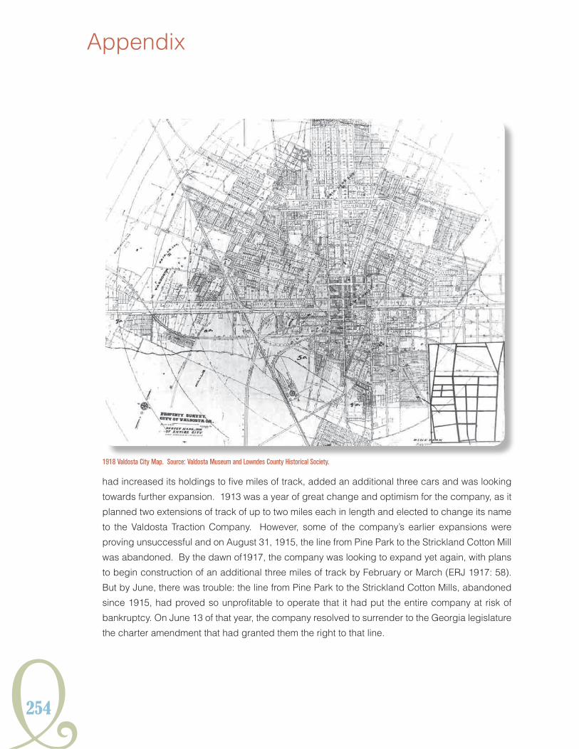
254
Appendix
had increased its holdings to five miles of track, added an additional three cars and was looking
towards further expansion. 1913 was a year of great change and optimism for the company, as it
planned two extensions of track of up to two miles each in length and elected to change its name
to the Valdosta Traction Company. However, some of the company’s earlier expansions were
proving unsuccessful and on August 31, 1915, the line from Pine Park to the Strickland Cotton Mill
was abandoned. By the dawn of1917, the company was looking to expand yet again, with plans
to begin construction of an additional three miles of track by February or March (ERJ 1917: 58).
But by June, there was trouble: the line from Pine Park to the Strickland Cotton Mills, abandoned
since 1915, had proved so unprofitable to operate that it had put the entire company at risk of
bankruptcy. On June 13 of that year, the company resolved to surrender to the Georgia legislature
the charter amendment that had granted them the right to that line.
1918 Valdosta City Map. Source: Valdosta Museum and Lowndes County Historical Society.

Y255
HISTORICSTReeTCaRSYSTeMSGeORGIaIn
The failure of the Strickland Mill line did not bankrupt the Valdosta Traction Company, yet it did
mark the beginning of the end for streetcar service in Valdosta. While a 1922 Sanborn Fire
Insurance map of the city shows a frame constructed car barn with capacity for 15 cars, in 1920,
the company had only six passenger cars, operating on five miles of line. The Valdosta streetcar
system was abandoned in 1924 and the tracks eventually scrapped in the 1940s for the World War
II war effort. A small, stucco-clad, covered waiting station, located at 1500 N. Patterson Street, is
the only physical remnant of the street railway in Valdosta.

256
Appendix
wAShiNgtoNLiNE: wAShiNgtoN StREEt RAiLwAY ComPANY (1889-1920)
Slow to emerge from the economic depression that accompanied Reconstruction, Washington
was uninterested or unable to initiate modernization of its infrastructure until the mid 1880s, when
the establishment of both a wire fence plant and guano factory touched off a period of moderate
prosperity and expansion. City electric and water plants began operation, as did a telephone
service. The central business district began expanding at such a rapid rate that by 1889, a special
session of the Wilkes County Superior Court had to be called to accommodate the number of
charter requests for new enterprises (WPA 1941:67-69). Several enterprising businessmen,
hoping to capitalize on this sudden growth, thought the time ripe for a street railway system to
conduct both passengers and freight from the city’s commercial center out to the railroad depot.
The Washington Street Railway Company was incorporated by an act of the Georgia General
Assembly on October 24, 1887. The state granted the company a 50-year franchise, authorizing
them to use any kind of motive power by which to operate the street railway, save steam engines
and the ability to convey both freight and passengers throughout the community (GGA 1887: 307-
11). Beginning construction in the fall of 1889, the short, mule-drawn streetcar line connected
Washington Street Railway Horsecar in front of the Fitzpatrick Hotel, Washington, c.1890. Source: Vanishing Georgia, Georgia Archives, Office of Secretary of State.

Y257
HISTORICSTReeTCaRSYSTeMSGeORGIaIn
the Georgia Railroad Depot with the commercial district (SRJ 1889: 279). The route, less than a
mile in length, was a relative financial success, paying semi-annual dividends at four percent to
stockholders and two percent to the surplus fund by 1891(SRJ 1891: 267).
By March of 1906, the Washington Street Railway Company was operating two passenger cars and
four freight cars, still drawn by horses and mules, through downtown Washington (SRJ 1906:43).
But Washington, striving to stay current with modern advancements, was beginning to move away
from rail travel, as evidenced by the 1908 paving of the commercial section of Main Street with
creosoted wooden blocks (WPA 1941:81). By 1909, the street railway, now operating as The
Washington Transit Company had established a substantial complex on Spring Street between
Main and Liberty streets, consisting of a small brick office, frame barn and stables, blacksmith
shop, and a storage structure, as indicated on the 1909 Sanborn map of Washington. But the end
of the rail line was impending, as 1912 saw the streets of downtown Washington paved. The line
was finally discontinued in the early 1920s.

258
Appendix
wAYCRoSSLiNE: wAYCRoSS StREEt ANd SuBuRBAN RAiLwAY ComPANY (1912-1917)
The citizens of newly incorporated Waycross were captivated by the idea of a street rail system
as early as early as the 1880s, organizing the Waycross Street Railway Company in 1889 to bring
streetcar service to downtown Waycross (SRJ1889:206). Organizers publicized their intention
to use dummy engines to power the cars, but the company dissolved before it could begin
construction of the lines (SRJ 1889:323). As the new century dawned, Waycross expanded at
a rapid rate, its population nearly tripling between 1900 and 1910, leading some to call it “the
Atlanta of south Georgia.” The electrification of Waycross in 1909 by the Waycross Gas and
Construction Company, led the president of the company, Burdette Loomis, to believe the time
was finally right for an electric street railway system in town. That same year, Loomis applied for
and was granted a franchise to construct a line; however, the project stalled yet again. Progress
wouldn’t be made until 1911, when the franchise was transferred to the Waycross Street and
Suburban Railway Company
Shortly after receiving their official charter in 1912, the Waycross Street and Suburban Railway
Company began and completed construction of the city’s first streetcar line and the system began
operation that same year. According to the 1913 Sanborn map of Waycross, the company’s rolling
stock was housed in a frame car barn located on Johnson Avenue at Genoa Street. Never a
financial success, the system entered receivership in 1914. At the time, it consisted of just over
Waycross Street and Suburban Railway Company Car, 1912. Source: Larry Gattis and the City of Waycross, Georgia.

Y259
HISTORICSTReeTCaRSYSTeMSGeORGIaIn
seven miles of track, and operated five motorcars, three trail cars, and one service car (Nicholas
1914:43). In May of 1917, the closure of the Waycross street railway system was complete when
the Superior Court approved sale of the company’s assets. Waycross Savings and Trust, who may
have held the company’s mortgage, acquired the assets the following month. The assets were sold
to the Southern Iron and Equipment Company of Fulton County, Georgia, who hired the Park Morand
Company to dismantle and remove the rail tracks, and restore the streets (Larry Gattis, personal
communication, 2011).
1916 City Map of Waycross, Georgia. Source: Larry Gattis and the City of Waycross, Georgia.

260
Appendix
NotES
Primarily From Streetcar Railway Journal and Franchise Incorporation Records for Other Georgia Cities and
Towns:
Bainbridge: State senate passed bill for incorporation of the Bainbridge, Lake Douglass and Suburban
Street Railway Company, November 1889.
Carrollton: Street railway organized, October 1889.
Cartersville: The Georgia Land Company expected to build a dummy railway (SRJ 1888 Vol. IV, no 12).
Cartersville Street Railroad Company incorporated December 1889.
Clarksville: Bill passed authorizing incorporation of a street railway December 1889.
Cedartown: Contract for construction of street railway awarded and work commenced, September 1 (SRJ
1888 Vol. IV No. 10). Dummy line to Cove Springs, 9 miles, projected (SRJ 1889 Vol. 5, no. 7: 201).
dalton: “A new company has been organized here for building a street railway, and the stock has all been
subscribed” (SRJ 1887 Vol. III no. 7: 420). “Dalton St. Ry. Company organized and the Board of Directors…
were instructed to build, and at once invited bids for furnishing iron, cars, etc.” (SRJ 1887 Vol. III, no 8:
506).
Flovilla: Dummy line between Flovilla and Indian Springs. Est. cost at 15,000 to 20,000. 2 miles. (SRJ 1888
Vol. IV, no. 9)
irwinton: Proposed dummy line 3.5 miles long. Surveyed, connecting to Georgia Central Railway...(SRJ 1888
Vol. IV, no. 12).
Lexington: “Lexington Terminal R.R. Co. 4 miles, 4-8.5 g, 30 lb r., Pres. H. McWhorter, Sec. T. G. Lester” (SRJ
Vol. 4: XVIII).
Lindall: Interest in building a dummy line to Rome (SRJ 1889 Vol. V, no. 6:166).
marietta: The Marietta Street Railway Co incorporated 1889. “Chartered to build a line from a point two miles
south of the city to Kennesaw Mountain, a distance of five miles. Work will be commenced in the spring” (SRJ
1889 Vol. 5, no. 2)
milledgeville: “A dummy line is to be built from the two depots to the asylum, passing the fair grounds…”
(SRJ 1888 Vol. IV no. 7:187). Opened October 1.4 miles long (SRJ 1888 Vol. IV ,no. 8). “Milledgeville and
Asylum Dummy Line Railroad…” Received second engine due to increase in freight hauling. Passenger
traffic averaging 30 a day in December 1888, new passenger car ordered (SRJ 1889 Vol. 5 ,no 2).
Rockmart: “A line is projected here by S.E. Smith and others” (SRJ 1887 Vol. III, no. 8:510)
tallahassee: Street railway organized (SRJ 1889 Vol. 5, no. 5:138).
thomasville: “A street railway franchise has been granted to H.W. Hopkins “(SRJ 1888 Vol. IV, no. 7:190).
Charter granted for construction (SRJ 1889 Vol. V, no. 10).
waynesboro: “Street railway company organized” (SRJ 1889 Vol. 5, no. 5: 138).

Y261
HISTORICSTReeTCaRSYSTeMSGeORGIaIn
ertyrtf
ertyrtf