
Historic and Scenic Corridors Project
112
Historic and Scenic Corridors Project Final Report Historic and Scenic Corridors Project Final Report
Transcript of Historic and Scenic Corridors Project

Historic and Scenic Corridors ProjectFinal Report
Historic and Scenic Corridors ProjectFinal Report

Front cover image: West side road along Snoqualmie Valley near Vincent (now West Snoqualmie Valley Road), looking north, n.d. Courtesy of King County Archives
Back cover image: West Snoqualmie Valley Road near Vincent, looking north, 2009. Photo by Ned Ahrens, King County

Historic and Scenic Corridors ProjectFinal Report
For more information, please call King County Road Services Division at 206-296-6590or visit our Web site at www.kingcounty.gov/roads
printed on recycled paper
Prepared for King County in collaboration with 4Culture
Department of TransportationHarold S. Taniguchi, Director
Road Services DivisionLinda Dougherty, Division DirectorJennifer Lindwall, Capital Improvement Program and Planning Section ManagerJay Osborne, Acting Capital Improvement Program and Planning Section Manager
This project is a collaboration between the King County Road Services Divison, King County HistoricPreservation Program and 4Culture. Funding is provided by a grant from the Federal Transportation Enhancement Program.
Project Team Margo Christianson, Road Services Division Ruth Harvey, Road Services Division Julie Koler, Historic Preservation Program Flo Lentz, 4Culture Brandi Link, 4Culture Fennelle Miller, FDM Consultants Tom Minichillo, Road Services Division Charlie Sundberg, Historic Preservation Program Katelyn Wright, University of Washington Intern
Thank you to ENTRIX for contributions to Chapter IV.
Photos by Brandi Link unless otherwise noted.
Acknowledgements
Alternative Formats Available206-296-7380 TTY Relay: 711

Introduction ....................................................................................1
Chapter I. Project Methodology ........................................................5
Chapter II. Synopsis of Road History .............................................11
Chapter III. Inventory of King County Heritage Corridors ..............19Cedarhurst Road/Westside Highway
Dockton Road Green Valley Road Issaquah-Fall City Road Old Cascade Scenic Highway Osceola Loop West Snoqualmie River Road West Snoqualmie Valley Road/Carnation Farm Road Old Sunset Highway
Chapter IV. Corridor Management Considerations ..........................95
Appendix A. Index of Surveyed King County Roads ......................107
Appendix B. King County Roads: History of Overland Transportation ....................................................................113
Chapter I. Footpaths and Early Pack Trails (1790-1851) Chapter II. Wagon, Military and Mine-to-market Roads (1852-1873) Chapter III. Farm-to-market Roads (1874-1899) Chapter IV. Good Roads for the Automobile (1900-1929) Chapter V. Modern Highways (1930-1960) Endnotes
Appendix C. Bibliography .............................................................163Published sources
Government documents Other sources Maps
Contents


King County Historic and Scenic Corridors Project Final Report, December 2009 Introduction | 1
Introduction BackgroundPublic road building in King County dates back more than 150 years to 1854, when the Territorial Legislature fi rst authorized county commissioners to collect a tax for the construction of wagon roads and bridges. Many of the oldest roads in King County are now unrecognizable as such, due to multiple road improvement projects and decades of surrounding growth and urban development. But other roads, primarily in areas that remain rural, still retain tangible scenic qualities and the fl avor of an earlier time.
King County is a large (2,130 square miles) and populous (1.8 million) county with diverse environmental settings, from marine islands in the west to the crest of the Cascade Mountains in the east. It contains the City of Seattle, 38 other incorporated cities, and 1,740 square miles of mostly rural unincorporated area including extensive forest and farmland. The King County Department of Transporta-tion Road Services Division (Road Services) today maintains a network of approximately1,800 miles of roads and 200 bridges in unincorporated areas. Some of the most evocative historic and scenic corridors in the county are among them. These picturesque routes add much to the quality of life of residents who live along them, and of those who travel them on a regular basis. Often, they provide satisfying day trips and weekend outings for tourists and
people from more urban parts of the county. Local, county-maintained roads are also important links to regional and community history. There is an untapped opportunity to provide the public with interpretive material that helps explain that history. Unspoiled scenic vistas, intriguing heritage sites, and roadways reminiscent of an earlier era together make the public’s travel experience along these corridors particularly memorable. Recognizing these values, Road Services began searching several years ago for an objective approach to identifying and preserving such roads. Three major highways that pass through King County (I-90, U.S. 2 and U.S. 410) have been offi cially designatedas National Scenic Byways and one, State Route 202 (SR 202), as a State Scenic Byway, but county roads are rarely eligible for these honorary designations. In fact, the vast majority of “scenic byway” programs in the United States are state or national in focus. There are few models or tools available to counties or cities wanting to preserve and enhance local historic road corridors.
The King County Historic and Scenic Corridors Project was launched in 2007 by Road Services to meet this specifi c need. The process resulted in a new approach to identifying, evaluating, and protecting roads of exceptional character at the local level. The result is this report and the King County

Introduction | 2 Final Report, December 2009 King County Historic and Scenic Corridors Project
Heritage Corridors Program, a non-regulatory, honorifi c, and educational framework for celebrating these distinctive linear treasures.
Project goalsThe goals of this project were to:
• Compile the history of King County roads as a basis for understanding the evolution of the system
• Rationally identify, study, and select King County roads in unincorporated areas still possessing the highest level of scenic and heritage qualities
• Thoroughly document the roadway features, historic sites, views and vistas that give those corridors distinctive character
• Establish a mechanism within King County for formal recognition of these corridors, involving no new regulatory impacts on property owners
• Provide the information needed to help the county and other public agencies in the region avoid or mitigate impacts to local historic roads during road improvement and maintenance or other public works projects
• Provide information that will help to expedite the cultural resources screening process for transportation projects and the identifi cation of potential impacts under federal, state, and local regulations, and therefore save time and money as well as improve the predictability of transportation project permitting
• Raise awareness and pride among people living along heritage corridors, and encourage participation in stewardship of the corridors
• Promote wider enjoyment and appreciation of heritage corridors among the public,through follow-up development of educational tools such as a Web site, corridor maps, travel guides, interpretive signage, and other corridor history activities
• Support the development of heritage tourism in rural King County
FundingFunding for this project was provided by a 2006 Federal Transportation Enhancement Program grant, administered by the Wash-ington State Department of Transportation.The funding request was specifically targeted toward research and documentationof the county’s road system, survey and inventory of potential historic and scenic roads, and the prioritization for their preservation, enhancement, and promotion as heritage tourism routes.
Partnerships and rolesThis project has been an on-going collabora-tion among three agencies–the King CountyRoad Services Division, the King County Historic Preservation Program and 4Culture, the county’s cultural services agency.
Road Services provided administration, policy direction, public outreach and overall project

King County Historic and Scenic Corridors Project Final Report, December 2009 Introduction | 3
management. Mapping and graphic design services for public presentations and the project Website were also performed by the division. The Historic Preservation Program participated in team meetings throughout the process, and provided feedback on survey, report fi ndings and recommendations.
Preservation 4Culture staff served as the project consultants. Their responsibilities included development of project methodology, conduct of contextual research and fi eld surveys, and preparation of the fi nal report. ENTRIX, Inc., an environmental and natural resources fi rm, contributed recommendations specifi c to management considerations found in Chapter 4 of this report.

Introduction | 4 Final Report, December 2009 King County Historic and Scenic Corridors Project
This page left intentionally blank

King County Historic and Scenic Corridors Project Final Report, December 2009 Project Methodology | 5
Phase one: Planning and preparationIn addition to assembling personnel and developing a detailed scope of work and budget, the fi rst several months of the project were spent refi ning a fi eld methodology. An initial advisory group consisting of projectadministrators from Road Services, Historic Preservation Program staff, consultants from 4Culture, and a cultural landscape specialist from the U.S. National Park Service worked collaboratively to come up with an approach that was practical, defensible, and meaningful.
Some of the questions considered were: • How do we combine the concepts of
“scenic” and “historic”?
• What tools shall we use to objectively identify potential survey routes?
• What historic property documentation needs are we trying to meet?
• What criteria shall we use at each level of corridor evaluation?
In preparation for fi eld survey, ArcView GIS software was used in several ways to identifypotential windshield survey areas. With geo-referenced images from the county’s Roads on the Ground and Roads Estab-lishment map books as background, and an incorporated cities polygon as a mask, all roads in rural King County built before 1960 were identified. Two development polygon shapefi les were then added to view
Chapter I. Project Methodology While established cultural resource
methodologies offered some useful techniques, they did not
meet the overall goals of the Historic and Scenic Corridors Project. Existing approachesto survey/inventory, cultural landscape documentation, and scenic byways assessment simply did not translate into a practical model for this effort. This was so for several reasons; it was not a goal of the project to study the evolution of the cultural landscape beyond the right-of-way, nor to conduct an aesthetic evaluation of scenery outside the right-of-way. Further, it was not the intent of this project to satisfy all of King County’s future cultural resource compliance needs along these roads.
Instead, a new project methodology was developed to provide a framework for assessingboth the historic and scenic character of roadways and their immediate corridor settings. The chosenapproach allowed for combining context research with field documentation, and for selectively adding new entries to the county’s Historic Resource Inventory (HRI) and the state’s Historic Property Inventory (HPI). It also allowed for systematically vetting the strongest corridors, and for formally designating the best of these corridors without ramifi cations for private property owners.
The resulting project methodology included four distinct phases: front-end planning and preparation, context research and windshield survey, intensive survey and evaluation, and analysis and reporting.
“...a new project methodology was shaped to provide a framework for
assessing both the historic and scenic
character of roadways and their immediate corridor settings.”

Project Methodology | 6 Final Report, December 2009 King County Historic and Scenic Corridors Project
collected. With these preliminary research fi ndings, the team developed an outline for the historic context statement. In the fi eld, each road recommended for windshield survey was split into segments for ease of recording visual information. In a paperless survey, the consultants recorded observations, mileage, and rating for each segment on a laptop in a master tracker Excel spreadsheet. At least two digital pictures were taken for each road segment, one showing the “typical best” and the other the “typical worst” for that segment.
For each segment of road, three categories of historic integrity, and one category of scenic quality were rated. These rating criteria were based on a combination of National Register of Historic Places integrity standards, and on Federal Highway Administration visual quality standards:
• Roadway–rated for integrity of location, materials, design, and feeling
• Built environment–rated for integrity of materials, design, feeling, and continuity of use
• Cultural landscape–rated for integrity of setting, design, feeling, and continuity of land use
• Scenic quality–vividness, intactness, and unity
Each criterion under all four categories was worth up to three points. The fi rst three categories–roadway, built environment, and
signifi cant periods of commercial and resi-dential development. Road Services took this process a step further, and digitized the maps in the Roads Establishment book and the Roads on the Ground book. These two hand-drawn map sets were scanned at high-resolution and then rectifi ed to match the major landmarks for each section. All of the rectifi ed sections were then tiled togetherand are now useable background layers in King County’s GIS.
This phase of work resulted in Evaluation No. 1: a rational slate of 77 routes recom-mended for windshield survey (Appendix A),consisting of pre-1960s roads, in unincorporatedKing County and without signifi cant post-1960s development.
Phase two: Context research and windshield survey Broad contextual research on the history of overland transportation in King County began during this phase. The consultants contacted local and state archives, libraries, historical societies, and museums to make general inquiries about pertinent holdings. This was followed up with repository visits, at which time useful historic maps, photographs, road records, etc. were examined, and noted for further reference and/or reproduction. Existing cultural resource management stud-ies held by the county, Washington State, and the U.S. Department of Agriculture Forest Service (Forest Service) were also
-::- -::- -::- Evaluation No.1: A rational slate of 77 routes
recommended for windshield
survey, consisting of pre-1960s
roads, in unincorporated King
County and without signifi cant
post-1960s development.
-::- -::- -::-

King County Historic and Scenic Corridors Project Final Report, December 2009 Project Methodology | 7
cultural landscape–were therefore worth up to a total of twelve points each, and scenic quality was worth up to a total of nine points. To be recommended for intensive survey, a road must have scored at least half as much as the possible total in three out of the four categories. Windshield survey results yield-ed 24 roads that met the historic integrity and scenic quality threshold. The project team (consisting of Road Services, Historic Preserva-tion Program, and 4Culture) then met to ap-ply an additional fi lter of practical manage-ment considerations, including road length and functional classifi cation. This resulted in Evaluation No. 2: A list of 20 roads recom-mended for intensive survey (Appendix A).
Phase three: Intensive survey and evaluationThe consultant team conducted intensive survey of the selected 20 roads over a fi ve-month period. Prior to going into the fi eld, they gathered corridor-specifi c data including historic maps, aerial photos, and any existing inventory or landmark registration forms. In the fi eld, the team again entered all data onto a laptop spreadsheet and added digital photos. They prepared mile-by-mile descriptions of the roadway and adjacent cultural landscape–including land uses, spatial arrangements, views, vegetation, etc.
An early decision was made to limit the level of documentation of historic resources along the road to that which would ultimately
be most useful in designating, illustrating, and promoting heritage corridors. For pre-1960s properties that retained clear integrity, the team entered descriptions of key buildings and site features. Follow-up work involved additional research on individual sites through oral interviews with property ownersand further archives research. Finally, the team entered 67 historic properties into both King County’s HRI and Washington State’s HPI. This material adds context and color to the story of each road, and serves as baseline documentation should property owners wish to pursue King County Landmark or
Image shows the results of the Windshield Survey for SE 456th Way. A short description along with a “typical best” and “typical worst” photo illustrates the character of the road. The blue box shows the averaged scores of the four rating criteria for the road.
-::- -::- -::-Evaluation No. 2:
A list of 20 roads recommended for intensive survey.
-::- -::- -::-

Project Methodology | 8 Final Report, December 2009 King County Historic and Scenic Corridors Project
National Register of Historic Places nominations.
During this phase, Road Services began to actively engage the interest of the publicand inform them about the project. The division created a Web site explaining the project and identifying the roads under consideration. Three evening open-houses were held over
the summer months, in collaboration with local historic societies.
At these sessions, the project team presented and shared research materials gathered to date. Residents along the intensive survey routes were invited to attend and encouraged to contribute stories, photographs, or further information about their roads. New fi ndingswere then incorporated into the survey fi les. The open houses gave Road Services an opportunity to answer questions about the implications of corridor designation and about the intended fi nal products of the project.
At the close of this phase, fi nal selection of roadways for a King County Heritage Corridors Program occurred. Applying an additional layer of practical consider-ations–including connectivity and arterial/collector status–4Culture consultants recom-mended a short list of potential corridors. The entire team then re-drove each road as a fi nal quality control check, and met to discuss. This process concluded with Evaluation No. 3: Selection of nine proposed Heritage Corridors (Appendix A).
Phase four: Reporting and designationPhase Four of the project compiled project fi ndings in this report, which includes:
• A history of King County roads through 1960, with a detailed bibliography (Appendix B and C)
Historic Resource Inventory form for newly inventoried property along Westside Highway; part of corridor project evaluation phase.
-::- -::- -::-Evaluation No. 3:
Selection of nine proposed Heritage Corridors.
-::- -::- -::-

King County Historic and Scenic Corridors Project Final Report, December 2009 Project Methodology | 9
Image is a screen shot from the Excel spreadsheet, showing the results of the Intensive Survey. Roads are named in the far left column (highlighted in blue). Other columns include survey date, length of road, start and end points, historic names and road numbers, and reasons for recommending or not recommending road for fi nal corridor selection.

Project Methodology | 10 Final Report, December 2009 King County Historic and Scenic Corridors Project
materials, including a project PowerPoint, an updated King County Heritage Corridor Program Web site, and a master map.
• A heritage corridors list, describing overall character, historical development, locations of note, and mile-by-mile features (Chapter 3)
• Management considerations for the Heritage Corridors Program, including: road maintenance and design principles and practices; community involvement; opportunities for education and promotion, interpretation, signage, and historic site preservation (Chapter 4)
Designation as King County community landmarks was the mechanism chosen to formally recognize the identifi ed Heritage Corridors. This honorary designation is bestowed on special places in the community by the King County Landmarks Commission and carries no associated land use regulations or restrictions. King County Code 20.62.020 states: “E. ‘Community landmark’ is an historic resource which has been designated pursuant to K.C.C. 20.62.040 but which may be altered or changed without application for or approval of a certifi cate of appropriateness.” The designation allows the county to recognize the unique qualities of the corridors while retaining the fl exibility necessary to maintain them as public roadways. Formal community landmark designation of eight heritage corridors occurred June 25, 2009 at the King County Landmark Commission meeting.Road Services will use consultant data and visual products from the study to prepare additional public outreach and educational
“ ‘Community landmark’ is an historic resource which has been
designated pursuant to K.C.C. 20.62.040 but which may be altered or changed without application for or approval of
a certifi cate of appropriateness.”

King County Historic and Scenic Corridors Project Final Report, December 2009 Synopsis of Road History | 11
Chapter II. Synopsis of Road HistoryThe fi rst highways in the area now
known as King County were neither surveyed, nor graded, nor overland.
They were the lakes, rivers and streams that laced the landscape and provided the area’s fi rst people with nourishment and a ready means of transportation across the region’s varied topography. Therefore the county’s earliest overland trails closely followed or connectedthese major bodies of water. These trails would eventually become the foundation for the modern network of roads in use today.
Public road building in King County began shortly after its establishment in 1852. The earliest road law governing roads and the building of bridges was enacted in 1854 at the fi rst meeting of the Washington Territorial Legislature. Over the next half-century, however, very little was expended on road development and maintenance due to the dominance of the railroads and the county’s continued dependency on water transportation. The monopoly of rail and water on transportation would fi nally break during the second decade of the 20th century, with the mass production of the automobile and push for road reform by national organizations like the Good Roads Association. Throughout the rest of the 20th century, transportation priorities would focus on road improvement and expansion.
Footpaths and early pack trails (1790-1851)For centuries the Native Americans that inhabited the area that encompasses King
County–the Duwamish, Muckleshoot, Puyallup, Skykomish, Snoqualmie, Suquamish, and Tulalip peoples–developed thriving cultures with broad economic ties. Their relationships with the land, and the social connections they cultivated with neighboring coastal and eastern interior tribes, necessitated a sophisticated transportation system. Puget Sound, fresh water lakes and rivers offered a ready means of transport; and the canoe, designed for light travel, made it possible to penetrate far inland. Travel between settlements, as well as to and from resource areas, did necessitate some overland travel. In these instances, trails provided the shorter– if more challenging–route.
The most traveled footpaths through the mountains crossed over the passes of lowest elevation. Trails leading into King County from the east over Naches, Snoqualmie and Yakima Passes all followed the Yakima River to its headwaters in the Cascades, and then down the western slope along the Snoqualmie and White Rivers to Puget Sound. The trail over Stevens Pass traced the Wenatchee River to its headwaters, and then dropped into the watershed of the Skykomish River and eventually out to the Sound.
When the fi rst Euro-American explorers came into the King County area in the 1830s, they took advantage of this existing network of native trails. One of the earliest pathways by land into the area was the Cowlitz River Trail, which brought travelers not over the

Synopsis of Road History | 12 Final Report, December 2009 King County Historic and Scenic Corridors Project
Cascades, but north from the Columbia River through forested western lowlands to southern Puget Sound. Until the 1850s, this was the only overland path available to emigrants who wanted to settle in the Puget Sound country, since it was the only one that could accommodate wagons, livestock and supplies.
Several shorter trails that connected existing native settlements to local resource areas were also adopted by settlers. General Land Offi ce (GLO) maps from the mid-19th century, show trails leading from Lake Washington to Lake Sammamish, from Lake Sammamish to Fall City, and from Snoqualmie Falls along the Snoqualmie River, north. Portage trails also connected Lake Union to Lake Washington, and Vashon to Maury Islands. These GLO maps also show trails connecting the native settlements of Auburn village (Ilwaco) to Black River village (S’babadil), the Black River village to Lake Youngs, and resources like the Meridian Prairie to junction of Green and White rivers, and the Green River to Renton.1
Wagons west, military roads and the fi rst urban roads (1852-1873) When Washington Territory was formally established in 1853, increasing numbers of pioneers began arriving in King County, forming
1 U.S. General Land Offi ce maps for Washington Territory can
be accessed from the U.S. Department of Interior, Bureau of Land
Management online database at www.blm.gov/or/landrecords/
survey/ySrvy1.php.
Government Land Offi ce map showing the Muckleshoot Reservation, 1867. Courtesy of Bureau of Land Management, online Land Status & Cadastral Records Viewer

King County Historic and Scenic Corridors Project Final Report, December 2009 Synopsis of Road History | 13
settlements around the Black River (Renton), White River (Kent-Auburn), and Porter’s Prairie (Enumclaw Plateau).2 Thick forests with heavy undergrowth blanketed much of King County at this time, so readily cultivatable land was limited to the prairies and clearings maintained by Native peoples through seasonal burnings. Early settlers therefore gravitated to these open prairies, situated alongside or close to the main rivers that bisected the county–the Duwamish River,White River, Black River and Cedar River. The relative ease of water travel made it the favored mode of transport for both people and commodities well into the second half of the nineteenth century.
Despite the population growth the county experienced from 1851 to the mid-1870s, overland transportation remained primitive. Rough traces through the forest primarily serviced wagons and cattle, as well as early coal and lumber activities. Cleared dirt paths wound around the path of least resistance, going over hills and down dales, around large rocks and dense stands of trees, with the primary objective of connecting man, beast, and goods to bodies of water. These early roads were crude, jarring and seasonally impassible due to heavy snow, rain or mud. To mitigate the situation, corduroy (whole logs
2 Charles Payton, “Overview of King County History” Historical
Paper No. 1 (Seattle: Heritage 4Culture Publications Program,
2005), p. 7.
of varying sizes placed perpendicular to the direction of travel), or puncheon (split or hewn logs laid with the fl at surface up) were used to create a more permanent, hard surface. Plank roads (with stringers laid parallel to the direction of travel, and then planks placed perpendicular atop those) were also used.
During this period the majority of roads continued to be constructed and funded by private individuals, although military roads and those developed by private industries were important exceptions. During the Indian Wars of the 1850s, federal funds were allocated to improve some existing trails for military use. The Cowlitz River Trail and the Naches Pass Trail were two such roads in King County, although they were never actually completed as military projects. Some of the county’s mine-to-market roads were also developed as early as the 1860s. Originallyconstructed as tram or service roads, they created an industrial network that would later become part of the foundation of the county’s road system. By 1862 a road had been built from the Squak coal mines to Lake Sammamish, where the coal was then transferred to barges and fl oated to Seattle for distribution.3 Anoth-er road was used to transport coal over-land from Lake Washington to Seattle
3 Clarence B. Bagley, History of King County, Washington.
(Seattle: S. J. Clarke Publishing Company, 1929), p. 284.

Synopsis of Road History | 14 Final Report, December 2009 King County Historic and Scenic Corridors Project
wharves.4 Early skid roads (trails along which newly cut logs were transported) developed by local lumber operations were also important antecedents of the county’s road network.
4 Frederick James Grant, History of Seattle, Washington;
with illustrations and biographical sketches of some of its
prominent men and pioneers (New York: American, 1891),
p. 429.
From mud holes to good roads (1874-1899)In the last three decades of the 19th century, King County began to experience signifi cant growth. By the late 1870s expanding markets for timber products, coal, salmon and produceopened the area to national and internationaltrade. From 1880-1890, the county’s population grew from 6,970 (up from just over 2,000 in the 1870s) to 63,989. Of that total, over two thirds were counted in Seattle, making it the state’s largest city.5 The discovery of gold in the Yukon and the resurgence of agricultural industries in 1897, brought King County back from a short but deep recession, launching it forward as an economic leader into the 20th century.
The expansion of railroads throughout the region in the 1880s was responsible for much of that progress. When the Northern Pacifi c Railroad crossed the Cascades via Stampede Pass in 1887, with its terminus at Tacoma, it provided the fi rst direct rail access from the east to the southern Puget Sound area. In 1893, the Great Northern Railroad opened its line over Stevens Pass into Seattle, greatly improving rail access to the county. Local lines like the Seattle, Lake Shore and Eastern Railway serviced both local industry and population, transporting people and products from mines, mills and farms to commercial/urban centers like Ballard (connected 1886),
5 Alexander Norbert MacDonald, Seattle’s economic
development 1880-1910 (Seattle: MacDonald, 1959), p. 145.
Bicycle beside wagon road, 1896. University of Washington, Special Collections, WAT082

King County Historic and Scenic Corridors Project Final Report, December 2009 Synopsis of Road History | 15
Brooklyn (in what is now west University District), Yesler (now part of Laurelhurst), Bothell (1887) and towns out to Gilman (now Issaquah).6 It was during this period when rail and water transportation networks became highly developed and together dominated local commerce.
Until the 1890s, roads were universally considered a local responsibility. Supervision fell to an elected county offi cial but they were still built and maintained by local residents. To have a road declared a public thoroughfare, local residents would have to submit a petition to the county, then the road would go through a process of viewing, establishing and surveying. However, during the last decade of the 19th century, county offi cials were given moreresponsibility for the initiation, and actual construction and maintenance of public roads. This created a top-down approach to road development for the fi rst time. The United States government also began taking a much more active role in road development at this time. In 1893 the federal government created the Offi ce of Road Inquiry, whose duty it was to advise state and local offi cials on the best methods of improving their roads. All levels of government were beginning to feel pressure from “good roads” advocates nationwide, which fi rst took the form of bicycle organizations, and then of early motorcar enthusiasts like the
6 Paul Dorpat, Seattle: Now & Then Vol. 3 (Seattle: Tartu
Publications, 1994), p. 28.
Washington State Association of Good Roads, founded in 1899.
As in the preceding period, roads established and constructed during this era were still designed with an easy route in mind. They frequently had dips and rises, curves, and no shaped shoulders. There was no provision to eliminate trees, boulders, and other things that today would be considered roadside hazards, so these items would be found immediately adjacent to the traveling surface. Roads looked “hemmed in”. Wherever practical, alignments followed section lines or property boundaries. Road surfacing continued to include dirt, puncheon, corduroy, and plank. In the later years of the 19th century, gravel began to be employed in certain areas where wetness created year-round problems. King County first experimented with a macadamized surface (mixing wet clay and gravel, and placing it over a prepared bed of rock) in 1894.7
During the 1860s and ‘70s planning primarily focused on establishing roads along main lines of travel between resource areas and/or larger settlements. By the late 1890s, however, several shorter roads (around 0.5-.75 mile long) began to appear on maps in areas like the Duwamish Valley, Enumclaw Plateau and Snoqualmie Valley. These areas had been
7 King County (Wash.), Harold Laufer & Harry Hall
Sisler, State Golden Jubilee: Fifth Annual Report of the County
Road Engineer, 1939 (Seattle, 1939), p. 83.
Road above Vashon Wharf, 1891. University of Washington, Special Collections, VAN002

Synopsis of Road History | 16 Final Report, December 2009 King County Historic and Scenic Corridors Project
settled early, and had grown into thriving agricultural centers by this time. These smaller roads were mainly connector roads from private farms to the main lines of travel, which had been extended the previous decade. By the end of the 19th century, around 600 roads had been established and built in King County.8 Around the same time, county roadwork began to focus on improvements to
existing roads, rather than new construction.
The automobile (1900-1929)The fi rst two decades of the 20th century saw another boom in many of King County’sindustries and urban centers. Companies like Boeing and the naval shipyards attracted numerous workers to the area, especially around World War I. The development of the electric trolleys, the interurban railway, and improved ferry service allowed residents to live further from work centers, spurring residential growth in communities like Shoreline, Bellevue, and Burien.
Although the automobile made its fi rst appearance in Seattle on July 23rd, 1900, it was not until the 1910s when they began to be
8 King County (Wash.), Index to Road Records. 1853–1914.
Sunset Highway at Snoqualmie Pass, c. 1913. University of Washington Libraries, Special Collections, WAS1009
readily mass-produced, making them easily affordable to the general public.9 As more people began to own and drive cars, they demanded better and more extensive road systems. With the creation of the Washington State Highway Department in 1905 and the enactment of the State Aid Law in 1907, the road building process within each county became more structured. State roads were now funded, constructed and maintained out of the state highway fund, and overseen by a commissioned board. In 1911, the Permanent Highway Act increased federal funds for state highway construction as well as setting road standards for the fi rst time.
Improved grading and paving practices including brick, and various types of asphalt,improved communication and access to rural areas of the county. By this time the Pacifi c Highway was built from Vancouver to Everett (via Bothell), and a hard-surfacedroad extended the entire perimeter aroundLake Washington.10 In 1915, the opening of the Sunset Highway as an engineered route over Snoqualmie Pass provided new opportu-nities for commerce and passenger transport between the east and west sides of the state. By 1916 there were 54 miles of paved roads, and over 1400 miles of gravel or dirt roads in the county.11
9 The Seattle Times, September 3, 1916.
10 Payton, p. 16.
11 Payton, p. 16.

King County Historic and Scenic Corridors Project Final Report, December 2009 Synopsis of Road History | 17
In 1925 the Federal-Aid Highway Act had established the concept of a continuous-national system of highways that would provide uniform standards for state and local roads. In order to meet the needs of an expanded road system, the implementation of hard-surfacing systems for all heavily traveled roads became a priority, as did regulated traffi c control devices like road signs and traffi c lights. The main highways in King County were all extended or re-routed, and then paved by the late-1920s. Some local roads that serviced urban residents, or provided egress from valley farms to commercial centers, began to be paved at this time, although others remained dirt well into the 1930s.
Modern road system (1930-1960)As in many communities across the nation, the onset of the Great Depression in the early 1930s severely crippled the economy in the Puget Sound area. Major lumber milling and coal mining operations declined or closed completely. “Hooverville” shantieswere erected, in the industrial area south of Seattle’s downtown, and around King County thousands of jobless workers became migrants looking for work or handouts.12 At this time the county partnered with federal agencies to provided economic relief and accomplish a variety of public work
12 Jesse Jackson, “The Story of Seattle’s Hooverville,” in
Calvin F. Schmid, Social Trends in Seattle (Seattle: The
University of Washington Press, 1944), p. 286-287.
Construction of Lake Washington Floating Bridge, 1939. Courtesy of AAA

Synopsis of Road History | 18 Final Report, December 2009 King County Historic and Scenic Corridors Project
programs improving existing transportation systems.
During the Great Depression, road building shifted from state controlled and maintained, back to the local purview. Most of the state’s share of federal funds was diverted to the counties so they could hire the unemployed in the area and determine their own priorities.13
In King County, the fi rst Lake Washington fl oating bridge was funded by a 1938 Public Works Administration allocation, and was completed in 1940.
During World War II, road building ground to a halt as road aid funds were frozen and all roadwork was suspended on roads that were not considered essential to the national defense. In King County however, a number of defense contracts helped simulate several local industries, including aviation, ship-building, agriculture and automotive. After the war, the county experienced another boom in population and commerce as these industries continued to thrive, drawing more people to the area.
The post WWII economy allowed more Americans to buy cars, and by 1950, the majority of the nation’s freight was being
13 From 1933-1934, approximately 7,000 men were em-
ployed on 151 projects around the state, mostly involving road
maintenance, repairs and landscaping. See Paul Dorpat &
Genevieve McCoy, Building Washington: A History of Washington
State Public Works (Seattle: Tartu Publications, 1998), p. 86.
hauled by truck instead of rail.14 The post-war push for new roads in King County was driven as much by suburban residential growth as by commerce. The 1950s and ‘60s witnessed the largest road constructionprojects in the county to date, including the $75 million bond issue passed by the State Legislature in 1957 to build the Tacoma-Seattle-Everett Freeway, which later became I-5. By 1960, 935,000 people lived in King County, a 30 percent increase over 10 years previous.15 Into the next decade and beyond, road building and planning continue to struggle to keep pace with suburban expansion.
14 Dorpat & McCoy, p. 91.
15 Dorpat & McCoy, p. 97.

King County Historic and Scenic Corridors Project Final Report, December 2009 Inventory of Heritage Corridors | 19
Nine historic and scenic corridors comprise the King County Heritage Corridors system. These are:
• Cedarhurst Road/Westside Highway• Dockton Road• Green Valley Road• Issaquah-Fall City Road• Old Cascade Scenic Highway• Osceola Loop• West Snoqualmie River Road• West Snoqualmie Valley Road/ Carnation Farm Road• Old Sunset Highway
The King County Landmarks Commission designated eight of these road corridors as Community Landmarks at a public hearingon June 25, 2009. The ninth corridor, the Old Sunset Highway, consists of one short segment of county road, with other segments under the management of the Forest Service and the Washington State Department of Transportation. While the Sunset Highway’s rich cultural significance to King Countymakes its long-term recognition a high priority, it has not been proposed for community landmark designation at this time. King County would like to collaboratewith the other agencies regarding formal recognition of this corridor in the future.
The historical evolution of these corridors can be traced through King County road records, multiple map sources, and early
Chapter III.Inventory of King County Heritage Corridors
images. Map vault records of Road Services, including road history packets and road survey packets, follow the petitioning, viewing, surveying and establishment process. Road alignments, relocations, abandonments, and straightening projects can be documented with a range of maps–from GLO plat maps to the crisp 1920s and ‘30s county atlases of the Kroll and Metsker map companies. Historic images, particularly early 20th century record photographs taken by the County Engineer and housed today at the King County Archives, reveal details about road construction and corridor setting not available anywhere else.
Together these very diverse corridors tell the story of King County’s history through its most formative decades of development, from the 1870s through the 1930s. They touch on regional industrial, commercial, agricultural, and maritime themes. The roads themselves embody a layered record of the human determination to overcome seemingly insurmountable terrain through engineering, to link products to market, and to transport people effortlessly though the magic of the automobile. The broader corridorsillustrate a place-oriented intersection of economic and cultural activity, revealing a landscape that is altered but still rich with meaning. On each of the nine heritage cor-ridors, travelers will experience a distinctive place in time.
Please note: Some of the sites mentioned in the Mile-by-mile Corridor Tours are located on private property. Please respect the privacy of property owners and only enter sites that are clearly posted as being open to the public.

Inventory of Heritage Corridors | 20 Final Report, December 2009 King County Historic and Scenic Corridors Project
PugetSound
Kitsap County
Island Center Forest
Vash
on H
wy
SW
SW 204th St
SW Cove Rd
SW 220th St
SW Cemetery Rd
Glen Acres R
d
Beal
l Rd
SW
Rid
ge R
d S
W
111t
h Av
e SW
91st
Ave
SW
Old
Mill
Rd
SW
Wes
tsid
e H
wy
SW
SW 156th St
Mon
umen
t Rd
SW
87th
Ave
SW
SW 188th St
103r
d A
ve S
W
SW 216th St
Dockton R
d SW
115th Ave SW
SW Dilworth Rd
SW 192nd St
SW Gorsuch Rd
107t
h W
ay S
W
121st Ave SW
Burma R
d SW
Thor
sen
Rd
SW
Rob
inw
ood
Rd
SW
Sing
er R
d S
W
SW 148th St
SW Van Olinda Rd
SW 158th St
107t
h Av
e S
W
SW Quartermaster Dr
121t
h Av
e S
W
81st
Ave
SW
SW 171st St
97th Pl S
W
Priv
ate
Rd
137t
h Av
e S
W
SW Madrona Rd
SW Bank Rd
SW 184th St
SW 160th St
Sunset Rd S
W
SW 224th St
SW Soper Rd
SW 140th St
SW 196th St
100t
h Av
e S
W
119t
h Av
e SW
SW 153rd St
SW 161st St
Verm
ontv
ille
Rd
SW
SW 180th St
SW 151st St
94th
Pl S
W
86th
Pl S
W
Cre
scen
t Dr S
W
Ced
arhu
rst R
d SW
141s
t Ave
SW
SW 165th St
131st Pl SW
SW 208th St
SW 212th St
SW 145th Pl
Olympic Dr
SW 183rd Pl
SW 210th St
94th
Ave
SW
112t
h Av
e SW
77th
Pl S
W
127t
h Av
e S
W
Access Rd
101s
t Ln
SW
SW 214th Pl
Priv
ate
Rd
Private Rd
103r
d A
ve S
W
SW Bank Rd
Priv
ate
Rd
Private Rd
115t
h Av
e SW
Wes
tsid
e H
wy
SW
SW 216th St
Private Rd
SW 2
08th
St
Priv
ate
Rd
Private Rd
107t
h Av
e S
W
Private Rd
SW 156th St
107t
h Av
e S
W
Private Rd
Private Rd
Private Rd
Private Rd
SW 158th St
Road Services DivisionHistoric and Scenic Corridors Project
For more information please visit our website at: http://www.kingcounty.gov/kcdot/roads/cip/or call King County Roads Services Division at (206) 296-3745jabba/users/campear/mxd/sceniccorridors_zoom.mxd
-
The information included on this map has been compilied by KingCounty staff from a variety of sources and is subject to changewithout notice. King County makes no representations orwarranties, express or implied, as to accuracy, completeness,timeliness, or rights to the use of such information.King County shall not be liable for any general, special,indirect, incidental, or consequential damages including, but notlimited to, lost revenues or lost profits resulting from the useor misuse of the information containted on this map. Any sale of this map or information on this map is prohibitedexcept by written permission of King County.
Cedarhurst Road/Westside Highway
LegendLegend
Proposed Heritage CorridorsProposed Heritage Corridors
RoadsRoads
CitiesCities
ParksParks

King County Historic and Scenic Corridors Project Final Report, December 2009 Inventory of Heritage Corridors | 21
Cedarhurst Road/Westside Highway Heritage Corridor Location: Vashon IslandLength: 8.2 milesBegins: Cedarhurst Road at Vashon Highway Ends: SW 220th Street
Includes the entire length of SW CedarhurstRoad running west from Vashon HighwaySW, and continuing south as WestsideHighway SW to the intersection of SW 220th Street.
Road history in local contextCedarhurst Road, the northernmost segment of the Cedarhurst Road/Westside Highway Heritage Corridor, drops abruptly from the crest of Vashon Island down into the forested canyon of Shinglemill Creek. Here Native inhabitants found bracken fern and camas, berries and cattail growing in abundance. At the mouth of the creek at Fern Cove, settlers established a homestead and a shinglemill in the early 1880s. From 1908 to 1942, the family of Dr. Belle Baldwin owned Fern Cove, and their property improvements became an anchor in the development of this remote corner of the island. A public dock was put in along the shoreline just north of the cove in 1916, and the community was named Cedarhurst.
Increased settlement at Cedarhurst, as well as the opening of the auto ferry at Vashon
Heights in 1919, no doubt spurred completionof a good road to the island’s crest. Cedarhurst Road was established as a county road during the 1920s. Alignments on the steep upper grade have changed at least three times. A graded and graveled road was in place by 1926 and appears on a Kroll map of that date. Along the west shore of Vashon, other small settlements at Colvos, Cove, and Lisabeula fl ourished in the early 20th century. Once early logging operations had cleared lands for agriculture, a popula-tion of Scandinavian farmers, boat builders, and fi sherman arrived. Each named community featured a post offi ce, sometimes a boatyard, a store and a dock serviced by small local freight, and passenger steamboats collectively known as the “Mosquito Fleet.” By the 1910s, farming on the island’s west side focused on strawberries, fruit orchards, inten-sive poultry farming, and even some greenhouse horticulture.
Westside Highway proper, as a county road, was constructed in increments between 1891 and 1923. King County road records docu-ment these segments–first named after the petitioner or landowner who requested creation of the road. These names includedthe Langill Road, Thorson Road, SimmonsRoad, Priest Road, McIntyre Road, and Lamb Road. These newly established
Westside Highway at Colvos, 1923. Used by permission of Vashon-Maury Island Heritage Association, img004-011

Inventory of Heritage Corridors | 22 Final Report, December 2009 King County Historic and Scenic Corridors Project
sections provided rudimentary access up steep slopes from the beach, or connected fl edgling farmsteads on the heights. Often they tied into existing logging roads.
The McIntyre Road No. 857, for instance, was fi led by petitioner G.A. McIntyre in 1906 and established in 1908. Some thirty landowners quit-claimed real estate to King County for this major section of today’s Westside Highway. It was laid out as the long straight stretch at the north end of the corridor, between Colvos and Cove.
A 1936 aerial photograph of Vashon depicts a fully cultivated corridor along Westside Highway, with an amazing number of orchards, berry fi elds and row crops stretching from Colvos south as far as the intersection with Thorson Road. According to the aerial, the roadway itself had been straightened in the previous ten years, with several major curves eliminated. Agricultural buildingsstanding in 1936 include multiple examples of long narrow barns, very likely chicken coops. Structures of the little resort at Lisabeula are visibleat the southern end of the corridor.The resort was easily accessible then by water as well as land, off the stretch of Westside Highway then still known as Lamb Road.
McIntyre Road, 1906. From King County Road Services Division Map Vault Database; Road History Packet, Road No. 857
Sources: King County records: Assessor’s Property Record
Cards, Land Use and Aerial Survey - 1936-1941, Historic
Preservation Program HR database, Index to Roads Records,
Engineer’s Road Establishment Atlas – 1913, Roads’
Map Vault database. Maps: Anderson – 1888, 1907;
Kroll – 1912, 1913, 1926, 1930, 1936, 1938; Metsker
– 1926, 1936; Washington Map & Blueprint Co. –
1900, 1905, 1908. Shinglemill Creek Watershed Stories
(Vashon Maury Island Land Trust, 1998); Vashon Island’s
Agricultural Roots: Tales of Tilth (Writers Club Press, 2002).
King County Historic and Scenic Corridors Project Final Report, December 2009 Inventory of Heritage Corridors | 23
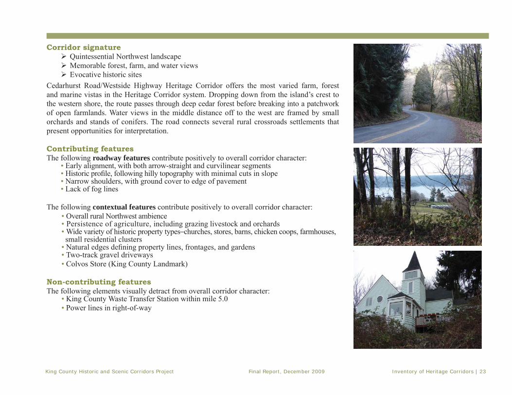
Corridor signature Quintessential Northwest landscapeMemorable forest, farm, and water viewsEvocative historic sites
Cedarhurst Road/Westside Highway Heritage Corridor offers the most varied farm, forest and marine vistas in the Heritage Corridor system. Dropping down from the island’s crest to the western shore, the route passes through deep cedar forest before breaking into a patchwork of open farmlands. Water views in the middle distance off to the west are framed by small orchards and stands of conifers. The road connects several rural crossroads settlements that present opportunities for interpretation.
Contributing featuresThe following roadway features contribute positively to overall corridor character:
• Early alignment, with both arrow-straight and curvilinear segments• Historic profi le, following hilly topography with minimal cuts in slope• Narrow shoulders, with ground cover to edge of pavement• Lack of fog lines
The following contextual features contribute positively to overall corridor character:• Overall rural Northwest ambience• Persistence of agriculture, including grazing livestock and orchards• Wide variety of historic property types–churches, stores, barns, chicken coops, farmhouses, small residential clusters• Natural edges defi ning property lines, frontages, and gardens• Two-track gravel driveways • Colvos Store (King County Landmark)
Non-contributing featuresThe following elements visually detract from overall corridor character:
• King County Waste Transfer Station within mile 5.0• Power lines in right-of-way

Inventory of Heritage Corridors | 24 Final Report, December 2009 King County Historic and Scenic Corridors Project
Mile-by-mile Corridor Tour: Cedarhurst Road/Westside Highway
Cedarhurst Road SWMile 0.0 - 1.0
• Corridor begins at Cedarhurst Road, left turn off Vashon Highway. Curvi-linear road descends steep slopes through pockets of deep forest to island’s west shoreline. Dirt lanes and mailboxes mark location of residences, most well set back in the trees.
Mile 1.0 – 2.0
• At mile 1.0, dirt lane to right leads to Fern Cove Preserve, a public park dedicated to freshwater wetland/estuarine habitat. Site of Rose Cottage, designed by architect Harlan Thomas for family of Dr. Belle Baldwin in 1912, now a King County Landmark.
• Continue on Cedarhurst Road west through dense forest of mixed vegetation–blackberry, fern, and ivy, pine, fi r, cedar, maple, and alder trees. At mile 1.5 road crosses historic Shinglemill Creek.
• At mile 1.9, pass the small settlement of Colvos, largely screened by vegetation. Here Cedarhurst Road bears left to join Westside Highway.
Westside Highway SWMile2.0 – 3.0
• Head south on Westside Highway past cluster of homes at Colvos. Fleeting views of Colvos Passage and Olympic Peninsula visible through the trees to the west.
• At mile 2.6 is historic Golgotha Lutheran Free Church, built 1926, now the Hauvrat Ee Shalom Synagogue.
• Landscape opens to cleared pastureland and orchards. Across open fi eld to west is old Ben Huseby Poultry Farm with 1920s agricultural structures typical of this corridor.
• At mile 2.7 on hillside to east is early Rubicz Barn, built in 1908, partially with heavy timber framing.
• At mile 2.8 is nostalgic Colvos Store, a combination country store and gas station–once the focus of rural Scandinavian community, now a King County Landmark.

King County Historic and Scenic Corridors Project Final Report, December 2009 Inventory of Heritage Corridors | 25
Mile3.0 – 4.0
• Continue past gambrel-roofed barns, chicken coops and farmhouses typical of agricultural subsistence along corridor. Post and wire fencing, blackberry hedges, and gravel lanes organize landscape.
• At mile 3.5 is a small, shingle-clad cottage with orchard west of the road– a good example of vernacular building along corridor.
• Pockets of forest obscure views, then fall away to reveal open pastures and waterfront homes.
• At mile 3.8 above road to east is Cove’s historic Norwegian/Danish Methodist/Episcopal Church, now a private residence, built in 1923.
Mile4.0 – 5.0
• At mile 4.1 begins the small bungalow community of Cove; another early settlement of Scandinavian farmers and fi shermen.
• At mile 4.4 is old R.B. McClinton House, a particularly intact example of Vashon farmhouse design, built in 1920 on one of many prosperous poultry farms along the corridor.
• Continue past a commercial shrubbery operation, more barns, and small fruit orchards with open fi elds behind the tree line.
• At mile 4.9 is a Conservation Farm of Merit.
Mile5.0 – 6.0
• View of foothills and Sound to west, past open pastures and fi elds. • Road veers east through corridor of Madrone, fi r, and pine trees past contemporary homes.
• From mile 5.6 to 5.8 is a well-screened King County Landfi ll, followed by forested corridor.

Inventory of Heritage Corridors | 26 Final Report, December 2009 King County Historic and Scenic Corridors Project
Mile6.0 – 7.0
• At 6.2 miles, the road connects with Cemetery Road, heads west, then south again. • Modern homes appear on both sides of roadway, well-hidden trees and shrubbery. Frequent dirt lanes wind off into woods. • Corridor remains enclosed and forested.
Mile7.0 – 8.0
• At mile 7.4 is Westside Stables, offering equestrian training and summer camps.
• Historic Mather Barn, built c., 1917, visible to the east across large open pasture.
• Road ends at 7.9 miles, a short distance from Misty Isle Farms.

King County Historic and Scenic Corridors Project Final Report, December 2009 Inventory of Heritage Corridors | 27
This page left intentionally blank

Inventory of Heritage Corridors | 28 Final Report, December 2009 King County Historic and Scenic Corridors Project
QuartermasterHarbor
Maury Island Marine Park
Doc
kton
Rd
SW
SW 248th St
Vash
on H
wy
SW
75th
Ave
SW
SW Luana Beach Rd
SW 260th St
SW 240th St
Dock St
SW Quartermaster Dr
SW Point Robinson Rd
Mon
umen
t Rd
SW
SW 216th St
SW 244th St
Kingsbury Rd S
W
SW Harbor Dr
SW Burton Dr
86th
Pl S
W
59th
Ave
SW
79th
Ave
SW
Private
Rd
SW B
ayvie
w Dr
SW Maury Park Rd
SW Ellisport Rd
99th
Ave
SW
63rd
Ave
SW
Gold B
each
Dr S
W
60th Pl S
W
47th
Ave
SW
48th
Pl S
W
Tramp H
arbor Rd SW
SW 256th St
49th
Ave
SW
49th
Pl S
W
71st
Ave
SW
97th
Ave
SW
MF Hatcher Rd
SW 255th St
Dugw
ay Rd S
W
SW 210th St
SW 211th St
SW 209th St
77th
Ave
SW
Stuc
key
Ave
SW
SW Luana Ln
SW 228th St
SW 208th St
SW Governors Ln
96th Pl SW
SW 222nd Pl
SW 219th St
SW 257th St
SW Elisha Ln
SW 238th St
101s
t Ln
SW
91st
Pl S
W
SW 245th St
68th
Ave
SWSW 246
th St
43rd
Ave
SW
102n
d Ln
SW
SW 259th St
Private Rd
Priv
ate
Rd
SW Point Robinson Rd
Priv
ate
Rd
Private Rd
75th
Ave
SW
Priv
ate
Rd
Priv
ate
Rd
SW 216th St
Private Rd
Private Rd
Private Rd
Priv
ate
Rd
Private Rd
Priv
ate
Rd
Road Services DivisionHistoric and Scenic Corridors Project
For more information please visit our website at: http://www.kingcounty.gov/kcdot/roads/cip/or call King County Roads Services Division at (206) 296-3745jabba/users/campear/mxd/sceniccorridors_zoom.mxd
-
The information included on this map has been compilied by KingCounty staff from a variety of sources and is subject to changewithout notice. King County makes no representations orwarranties, express or implied, as to accuracy, completeness,timeliness, or rights to the use of such information.King County shall not be liable for any general, special,indirect, incidental, or consequential damages including, but notlimited to, lost revenues or lost profits resulting from the useor misuse of the information containted on this map. Any sale of this map or information on this map is prohibitedexcept by written permission of King County.
Dockton Road
LegendLegend
Proposed Heritage CorridorsProposed Heritage Corridors
RoadsRoads
CitiesCities
ParksParks

King County Historic and Scenic Corridors Project Final Report, December 2009 Inventory of Heritage Corridors | 29
Dockton Road Heritage Corridor Location: Vashon-Maury IslandLength: 4.7 milesBegins: Chautauqua Beach RoadEnds: 99th Avenue SW in Dockton
Includes the upper portion of Dockton Road (between Ellisport and Portage) along Tramp Harbor, continues as Dockton Road SW proper (from Portage to Dockton), and continues as Dock Street to 99th Avenue SW (in the village of Dockton).
Road history in local contextOne of the earliest detailed road maps of Vashon-Maury Island (Anderson 1907) depicts a rudimentary trace through the woods above the western shoreline of Vashon, from the Chautauqua grounds at Heyer Point to the isthmus at Portage. From the late 1880s, Chautauqua had welcomed hundreds of visitors to educational programs at its 600-acre site. The dirt road connected this popular destination to Portage, a strategic shipment point and important island crossroads.
South of Portage, the dirt road angled west through the woods and farmlands of MauryIsland, toward the Pt. Robinson lighthouse and fog whistle. Another branch went south atop pilings, hugging the shoreline of Kings-bury Beach and crossing the lagoon on a trestle. A third branch (today’s Dockton Road) struck due south on higher ground along the
centerline of Section 16 and 21. Interestingly, it did not yet connect to the little settlement of Dockton on Quartermaster Harbor. Although, since the 1890s, Dockton had enjoyed a very active dry dock operation and fi shing industry. In 1907, it was still accessed chiefl y by water.
Island development spurred road improve-ments and extensions during the 1910s. When the fi rst cross-Sound auto ferry service to Des Moines began in 1916, the county built a sturdy dock on Tramp Harbor, midway between Ellisport and Portage. The beachfront road of today was completed that year to serve the ferry dock. Growth of the Martinolich Shipyard at Dockton in the 1910s was no doubt a factor in completion of the road from Portage to Dockton, in place by 1913. It ran south along what is now 75th Avenue SW, and turned sharply right onto 260th Street SW, dropping down into Dockton.
King County road records trace the gradual realignment of Dockton Road through the 1920s and 1930s. Here, as elsewhere around the island, upgrades were made in increments. Early road segments, fi rst established at right angles around section lines and property boundaries, were straightened by slicing through farm and forest.
Looking north from Portage, 1914. Used by permission of Vashon-Maury Island Heritage Association, img004-003

Inventory of Heritage Corridors | 30 Final Report, December 2009 King County Historic and Scenic Corridors Project
In 1923, the Quartermaster to Dockton Road was “declared a necessity” and scheduled for improvement under the Permanent Highway Act. This resulted in a good direct route from the main highway on Vashon to Maury Island. Soon afterward, the county declared Road No. 274 connecting Dockton to Portage a “main traveled road.”
A 1926 Kroll map shows the Dockton Road in much the same alignment it has today. It included the triangle confi guration still seen at Pt. Robinson Road, where the KIRO Broadcasting Station now stands. The road veered to the southwest from SW 240th Street, following the terrain along the same general route it takes into Dockton today.
In 1936, the Dockton to Portage Road was ordered improved as a secondary road, and was paved for the fi rst time. Further improvements came in 1947, 1955, and 1964. Quieter now than in the glory days of Chautauqua and the Mosquito fl eet, the communities of Ellisport, Portage and Dockton remain key points of interest along the Dockton Road Heritage Corridor.
Sources: King County records: Assessor’s Property Record
Cards, Land Use and Aerial Survey - 1936-1941, Historic
Preservation Program HR database, Index to Roads Records,
Engineer’s Road Establishment Book – 1913, Roads’
Map Vault database. Maps: Anderson – 1888, 1907;
Kroll – 1912, 1913, 1926, 1930, 1936, 1938; Metsker –
1926, 1936; Washington Map & Blueprint Co. – 1900,
1905, 1908. Ellisport Creek Watershed Stories (Vashon-
Maury Island Land Trust, 1999); “Dockton Historic Trail”
interpretive text (2008).
Kroll map showing Dockton Road, 1926
Piano Row in Dockton, ca. 1908. Used by permission of Vashon-Maury Island Heritage Association, img004-021

King County Historic and Scenic Corridors Project Final Report, December 2009 Inventory of Heritage Corridors | 31
Corridor signature Splendid water viewsRichly varied landscapeEvidence of maritime history
Dockton Road Heritage Corridor is the only maritime-themed road in the Heritage Corridorsystem. Winding past beaches, farms, and woods, it offers surprising, unobstructed views across water, as well as direct access to the shoreline. From an early date, Dockton Road linked the small communities of Ellisport, Portage and Dockton. Each has a distinctive heritage and offers unique interpretive opportunities.
Contributing featuresThe following roadway features contribute positively to overall corridor character:
• Curvilinear alignment following lay of the land• Unobstructed water view from right-of-way along Tramp Harbor• Rural character of intersection at Portage (SW Portage Way)• Minimal vegetation cuts through wooded stretches
The following contextual features contribute positively to overall corridor character:• Multiple water vistas• Public access points to water• Mix of wooded and open settings• Historic resources clustered in Ellisport, Portage, and Dockton• Island ambiance
Non-contributing featuresThe following elements visually detract from overall corridor character:
• Chain-link fencing at Tramp Harbor fi shing dock, mile 0.3 • Segments of galvanized steel guard rail• Prominent power lines in right-of-way• Large paved parking lot, unscreened, above Dockton Park

Inventory of Heritage Corridors | 32 Final Report, December 2009 King County Historic and Scenic Corridors Project
Mile 0.0 - 1.0
• Corridor begins at mile 0.0 with expansive vista of Tramp Harbor and distant views across Puget Sound. Residential enclave of Ellisport, and remnants of historic Ellisport dock visible to the north.
• At 0.3 is the Tramp Harbor fi shing dock, third wharf in this location where auto ferry to Vashon once operated.
• Rounding bend at mile 0.5 is the historic community of Portage, the isthmus between Vashon and Maury islands. Here stands the old Van Olinda Store built in 1910.
• Post Offi ce, built in 1900 (moved in 1910). Portage wharf built here in the late 1890s to ship produce to market, receive supplies, and transport passengers via steamer to the mainland. Now a pastoral crossroads, lush with beach and marsh vegetation, blackberry brambles and Madrone trees.
• Historic residences stand at mile 0.6 and at 0.75 (the Maggie Van Olinda Residence, 1928).
• At mile 0.9 road curves south; the 1929 Gertrude Watts Residence stands east of road.
• Beyond Portage, road continues southeast. Views of picturesque Quartermaster Harbor open up on west, town of Burton visible across water. Cluster of beach bungalows date from 1910s, ‘20s, and ’30s.
Mile 1.0 – 2.0
• Road ascends toward southeast, turning away from water views toward a fl at plateau area with larger parcels and open pastures.
• At mile 1.3 is a classic 1948 Shell Auto Service Station with canopy and service bays intact, still providing full range of services.
• Art Deco-styled 1943 KIRO broadcasting station, built during the war years to provide radio communications to isolated island communities.
• Road bears east; at mile 1.3 is house and barn historically associated with Cyrus Mentzer, owner of important early sawmill operation located on nearby cove at Mileta on Quartermaster Harbor.
• At mile 1.4 is a 1930 brick farmhouse and barn, once the Carl Castle Cattle Ranch. Road turns south, passing fl ower and produce farms.
Mile-by-mile Corridor Tour: Dockton Road

King County Historic and Scenic Corridors Project Final Report, December 2009 Inventory of Heritage Corridors | 33
Mile2.0 – 3.0
• Corridor continues past typical island produce stands, a sheep farm, and larger residential parcels. Road bears southwest at mile 2.4, running along-side beautiful Vashon Island Golf and Country Club.
• At mile 2.6 on the right is Mileta Farm, the former estate of Dr. Miles Hatch. He gained fame on the island for his large dairy operation that employed 75 men, and he later started Mileta Ice Cream Company in Tacoma. Note the 1900 English-styled barn, tennis court, and little brick clubhouse.
• Views of golf course continue until mile 2.8. Gravel lanes lead down wooded slopes to private waterfront homes on west and cleared pastures to east.
Mile3.0 – 4.0
• At mile 3.0 is Sutter Castle, barely visible to the west, through the forest. An elaborate, Queen Anne-styled residence built in 1889 by Henry Sutter, who successfully manufactured boat-building machinery and tools on the beach in front of his home.
• Corridor becomes deeply forested. Road rises and falls over hilly topography with steep slopes to west. Vegetation grows close to road. Occasional mid- range views of Quartermaster Harbor.
Mile4.0 – 5.0
• At mile 4.0, Quartermaster Harbor opens to full view as road continues west toward water. At mile 4.3 is turnout for Dockton Park, a small King County park built by WPA during the Great Depression. Facilities include beach, boat docks, playground, and picnic shelter.
• Continue west into town of Dockton, a residential community steeped in maritime history. Dockton Historic Interpretive Trail soon to guide visitors on short walking tour. Ten interpretive signs will summarize story of traditional boat-building and fi shing by local Croatian and Norwegian community. See “Piano Row” houses, the site of large dry-dock and shipyard, a traditional net shed, and the community store, now a King County Landmark.

Inventory of Heritage Corridors | 34 Final Report, December 2009 King County Historic and Scenic Corridors Project
rs169
Green River Natural Area
SE 400th St
SR 1
8
SE 416th St
SR 1
69
SE 384th St
244t
h Av
e S
E
Auburn-Enumclaw Rd
236t
h Av
e S
E
180t
h Av
e S
E
Auburn Way S
Aubu
rn B
lack
Diam
ond
Rd
SE 380th St
SE Green Valley Rd
Green Valley Rd
3rd Ave
SE Lake Holm Rd
212t
h Av
e S
E
SE 312th St
Roberts Dr
124t
h Av
e S
E
116t
h Av
e SE
208t
h Av
e S
E
196t
h Av
e S
E
53rd St SE
264t
h Av
e S
E
Thomas Rd
SE 368th St
Kent Black Diamond Rd
SE 376th St
Enum
claw
-Blk
Dia
mon
d R
dSE 358th St
Acad
emy
Dr S
E
SE 304th St
SE 346th St
SE 392nd St
268t
h Av
e S
E
200t
h Av
e S
E
SE 320th St
SE 354th St
228t
h Av
e S
E
249th Ave SE
SE Lake Moneysmith Rd
5th Ave
164t
h Av
e S
E
188t
h Av
e S
E
144t
h Av
e S
E
SR 1
8 R
amp
132n
d Av
e S
E
SE 164th S
t
Priva
te R
d
224th Ave SE
Stuck River Dr
Morgan St
SE 367th St
258t
h Av
e S
E25
7th
Ave
SE
Green River Gorge Rd
Uni
on D
r
55th St SE
Enum
claw
Fran
klin
Rd
170t
h Av
e S
E
SE 383rd St
160th Pl SE
272n
d Av
e S
E
SE 326th St
148t
h Av
e S
E
SE 299th St
129t
h Av
e S
E
Lake Sawyer Rd SE
Hanging Gardens Park AcRd
S 388th St
Lake Ginder Rd
SE 3
05th
Way
Abra
ms
Ave
190th Ave SE
SE 387th St
202n
d Av
e S
E
SE 331st St
SE 340th St
SE 328th Pl
SE 342nd St
SE 353rd St
Thomas R
d SE
Scenic Dr
Brid
get A
ve S
E
SE 374th St
SE 368th Pl
181s
t Ave
SE
176t
h Av
e S
E
156t
h Av
e S
E
SE 363rd St
218t
h Av
e S
E
186t
h Av
e S
E
Railroad Ave
192nd Pl SE
160t
h Av
e S
E
185t
h Av
e S
E
Maple Dr
265t
h P
l SE
392nd Ave SE
SE 344th St
168t
h Av
e S
E
158t
h Av
e S
E
256t
h Av
e S
E
207th Pl S
E
SE 396th StSE 394th St
SE 410th St
SE 310th St
SE 300th St
192n
d Av
e S
E
SE 408th St
220th Pl SE
SE 315th Pl
SE 406th St
157t
h Pl
SE
SE 388th St
190th
Pl SE
141s
t Pl S
E
127th Pl S
E
SE 378th St
250t
h Av
e S
E
162n
d Av
e S
E
228th Pl SE
Kanasket Dr
SE 299th Pl
112th Pl S
E
SE 329th St
260t
h Av
e S
E
SE 328th St
310th St SE
Hem
lock
St S
E
168th Way SE
238t
h Av
e
222nd Ave SE
Botts
Dr S
E
135t
h Av
e SE
272n
d Av
e
SE 323rd St
SE 373rd St
254t
h Av
e S
E
SE 372nd St
151s
t Ave
SE
SE 348th St
Plass Rd
SE 351st St
SE 409th St
SE 318th StSE 314th Pl
SE 332nd PlSE 330th St
SE 343rd St
SE 336th St
SE 338th St
SE 303rd Pl
16th St SE
S 403rd St
SE 352nd St
232n
d Av
e S
E
118t
h P
l SE
248t
h Av
e S
E
SE 356th St
183rd Ave SE
241s
t Pl S
E
146t
h Av
e S
E
172n
d Av
e S
E
197t
h Av
e S
E
252n
d Av
e S
E
204th Ave SE
SE 324th St
219t
h Av
e SE
SE 306th St
Wagon R
d
Ran
dall
Ave
SE
221s
t Ave
SE
SE 371st St
SE 306th Pl
170th Pl SE
SE 303rd St
SE 403rd St
133r
d A
ve S
E
SE 359th St
SE 308th Pl
224th Pl S
E
178t
h P
l SE
Noble C
t SE
Fir S
t SE
229th Pl SE
SE 314th St
SE 321st Pl
War
d Av
e S
E
SE 326th Pl
378th St
SE 390th St
Park St
165th Ave SE
SE 334th St
232nd Pl SE
153rd Pl SE
SE 302nd Pl
149t
h Av
e S
E
202n
d Av
e S
E
Priva
te R
d
SE 392nd St
SE 300th St
196t
h Av
e S
E
204t
h Av
e S
E
Private Rd
SE 372nd St
SE 354th St
148t
h Av
e S
E
Auburn Black D
iamond Rd
200t
h Av
e S
E
188t
h Av
e S
E181st Ave SE
212t
h Av
e S
E
218th Ave SE
SR 18 Ramp
SE 329th St
172n
d Av
e S
E
Private Rd
190t
h Av
e S
E
SR 18
Private Rd
Private Rd
SE Green Valley Rd
SE 304th StSE 304th St
SE 312th St
SE 300th St
218th Ave SE17
6th
Ave
SE
170th Ave SE
SE 416th St
236t
h Av
e S
E
SE 384th St
SE 331st St
Private Rd
SR 169
Priva
te R
d
188th Ave SE
224th Ave SE
Road Services DivisionHistoric and Scenic Corridors Project
For more information please visit our website at: http://www.kingcounty.gov/kcdot/roads/cip/or call King County Roads Services Division at (206) 296-3745jabba/users/campear/mxd/sceniccorridors_zoom.mxd
-
The information included on this map has been compilied by KingCounty staff from a variety of sources and is subject to changewithout notice. King County makes no representations orwarranties, express or implied, as to accuracy, completeness,timeliness, or rights to the use of such information.King County shall not be liable for any general, special,indirect, incidental, or consequential damages including, but notlimited to, lost revenues or lost profits resulting from the useor misuse of the information containted on this map. Any sale of this map or information on this map is prohibitedexcept by written permission of King County.
Green Valley Road
LegendLegend
Proposed Heritage CorridorsProposed Heritage Corridors
RoadsRoads
CitiesCities
ParksParks

King County Historic and Scenic Corridors Project Final Report, December 2009 Inventory of Heritage Corridors | 35
disappeared from the landscape. The east section of today’s Green Valley Road was County Road No. 130, established in 1886. It extended straight as an arrow along a section line from the current site of Flaming Geyser State Park to the tiny settlement of Kummer.
The C.C. Dubois Road No. 217 ran from Auburn, then still known as Slaughter, for about 3.5 miles east where it joined the Lytz Road. Established in 1888, the DuBois Road also followed an old trail that appears on GLO maps. The hand-written petition for DuBois Road is found in the County’s Index of Road Records:
217: (Petitioned by C. C. Dubois et al). Beg. on old Green River road 3.63 chns. E of ¼ Sec. cor. on line between Sec. 17 & 18 T 21 R 5E runs thence easterly to Green River Bridge crossing same …thence easterly to Slough near Mike Burns place, cross slough thence easterly to Sec. Line between Ranges 4 and 6 about 10 rods from NE cor. Sec. 25, T21 R. 5 S.
All of the Green Valley Road appears in a Washington Map & Blueprint Co. atlas
Green Valley Road Heritage Corridor Location: Southeast King County Length: 11.0 milesBegins: SR 18 and SE Auburn-Black Diamond RoadEnds: SR 169
Corridor runs the entire length of SE Green Valley Road, beginning at a point just east of the intersection of SR 18 and SE Auburn-Black Diamond Road, and continuing to its end at SR 169.
Road history in local contextThe Green Valley Road has an old and venerable history, and is very little altered from its late 19th century alignment. It has been known variously as the Lytz Road and the Dubois Road, the Green River Road, and more recently the SE Green Valley Road. The visual character of this corridor has always been agricultural, but its proximity to Green River coal and clay fi elds has shaped its history as well.
Today the road follows sections of trail and early wagon roads recorded on early GLO plat maps. The fi rst county-built section was the W.D. Lytz Road No. 128, petitioned in 1884. It forms the central section of today’s 11-mile corridor. Originally the Lytz Road turned due north, toward the coal mines of Black Diamond, at a point just opposite today’s Flaming Geyser State Park. That northern extension of the Lytz Road has since
Green Valley Road, c.1911. Courtesy of King County Archives

Inventory of Heritage Corridors | 36 Final Report, December 2009 King County Historic and Scenic Corridors Project
of 1900, and similarly on a 1907 Anderson map. Comparisons with Kroll and Metsker maps from the 1920s and ‘30s indicate how little the align-ment had changed over those decades. But unlike the Naches Pass Highway (now SR 410) to the south, Green Valley Road remained an unim-
proved dirt road through a secluded rural val-ley until at least 1936.
Since 1894, entry to the west end of this corridor (then the DuBois Road) has been
marked by the distinctive King County Landmarked Aaron Neely Mansion. The ornately decorated two-story frame farmhouse was built on a 320-acre spread bordered on the west by the Muckleshoot Indian Reservation. Throughout the early 20th century, other fertile valley tracts bordering the road were improved, and many subdi-vided into 40 and 80-acre dairy farms. Entire sections of forested land to the northeast remained under the control of Pacifi c Coast Coal, NW Improvement Co., and Weyerhaeuser Co.
Flaming Geyser State Park fi rst appears midway along the road on a Metsker map of 1936. Subdivided lots along the south bank of a sharp bend in the river may indicate auto campsites. It operated as a private camp from the 1920s until purchased by Washington State Parks in the 1960s.
At far eastern end of Green Valley Road, around the Columbia & Puget Sound rail stop at Kummer, were holdings of the Denny Renton Clay and Coal Co., subsequently known as Gladding McBean Co. This fi rm operated silicon sand mines in the region, and manufactured the artistic terra cotta cladding on many Seattle commercial build-ings of that era. The Kummer School,built for the children of District 123, still stands in small community of Kummer, a mining town established in the 1880s.
Residents of GreenValley Road histori-cally formed a close-knit community in this somewhat isolated valley. Up until about 1970, a large sign at the west end of the road listed the names of all the families and how far up they lived on the “Green River Valley Road.”
Sources: King County records: Assessor’s Property Record
Cards, Land Use and Aerial Survey - 1936-1941, Historic
Preservation Program HR database, Index to Roads Records,
Engineer’s Road Establishment Atlas – 1913, Roads’ Map Vault
database. Maps: Anderson – 1888, 1907; Kroll – 1912, 1913,
1926, 1930, 1936, 1938; Metsker – 1926, 1936; Washington
Map & Blueprint Co. – 1900, 1905, 1908.
Metzker Map of the Green River Valley, 1936.
Whitney Bridge, looking south from Green Valley Road, c. 1930 Courtesy of King County Archives.

King County Historic and Scenic Corridors Project Final Report, December 2009 Inventory of Heritage Corridors | 37
Corridor signature Continuous but diverse agricultural landscapeSecluded valley settingQuality agri-tourism attractions
Green Valley Road Heritage Corridor is a classic farm-to-market road, and the longest singleroad in the Heritage Corridor system. It showcases traditional yet evolving agricultural land-uses, with many picturesque historic barns dotting the landscape. Along the route are occasional visitor-friendly seasonal farms and produce stands.
Contributing featuresThe following roadway features contribute positively to overall corridor character:
• Historic, curvilinear alignment along valley fl oor• Mature trees in right-of-way overhanging roadway• A stunning close-up view of the Green River at mile 8.0
The following contextual features contribute positively to overall corridor character:• Neely Mansion, King County Landmark• Intimate scale of narrow river valley• Backdrop of forested hills• Expansive views across cultivated fi elds and pastures• Intact historic farmsteads and barns• Private river-rock wall fronting right-of-way at mile 8.3
Non-contributing featuresThe following elements in the right-of-way visually detract from overall corridor character:
• Sections of wide paved shoulder• Rumble strips • Chain link fencing right-of-way at mile 8.0, obscuring corridor’s best river view • Temporary jersey barriers at mile 8.4

Inventory of Heritage Corridors | 38 Final Report, December 2009 King County Historic and Scenic Corridors Project
Mile 0.0 - 1.0
• Corridor diverges from Auburn-Black Diamond Road just beyond SR 18 over-pass. At mile 0.0 is view of historic Neely Mansion, a King County Land-mark. Built in 1892, it was imposing farmhouse of pioneer David Neely and subsequent immigrant Asian farm families.
• Road curves south into Green River Valley Agricultural Production District. • Midrange views of forested foothills to the southwest and northeast. • At mile 0.3 is the Auburn Meat Packing Plant, an important agricultural
industry dating back to early 1930s. Road bends east past open fi elds.• West of road at mile 0.8 is the old Sabeniah Crisp Farm, with handsome 1920s bungalow built by Wesley Brown when he established his prosperous dairy here.
Mile 1.0 – 2.0
• At mile 1.0 is the Mosby Brothers Farms, a contemporary u-pick farming operation on the site of a former dairy, seasonally open to the public.
• The gambrel-roofed barn at mile 1.2 is part of historic Arthur Bull Farm, currently operated as a horse boarding facility under the name “Frosty’s Stable.”
• Here road turns away from hillside and runs toward center of valley with cleared farmlands to either side.
• At mile 1.6 a contemporary bridge crosses the Green River.
Mile2.0 – 3.0
• Mature trees border the entire road at intervals, clustered around long-established farmsteads.
• At mile 2.0 on north side of road is the working Horath Dairy, with its immense 1906 hay barn, silo, milk house, and milking parlor.
• Barns dot the landscape, along curvy alignment built up along the valley fl oor. • At mile 2.4, south of the road, is the Hamakami Farm, one of the longest-
lived Japanese American berry farms in the area. The long low shed in fi eld is thought to be last intact rhubarb shed in valley.
• Mature trees hug pavement and branches overhang road, creating pastoral sense of place. Valley landscape priodically narrows and widens, alternating secluded stretches with open expanses.
• The 1891 Brannon farmhouse, one of the oldest and most intact of its type in the valley, is hidden in the trees and brambles at mile 2.9.
Mile-by-mile Corridor Tour: Green Valley Road

King County Historic and Scenic Corridors Project Final Report, December 2009 Inventory of Heritage Corridors | 39
Mile3.0 – 4.0
• The road veers north following forested foothills, then opens to broad views of pasture lands to the south. Occasional abandoned orchards dot valley fl oor.
• At mile 3.2 is picturesque view of historic French Dairy across pasture at base of hillside on north edge of valley. Exceptionally intact, working farmstead complex with hay barn, silo, milk house and milking barn dating from the 1920s.
• At mile 3.8 is large Christmas tree farm on south side of road, with a pumpkin patch to the north.
Mile4.0 – 5.0
• Beginning at about mile 4.6, notice the herd of llamas to the southeast. • At mile 4.9 is clear view of the historic Selma Rodgers Farm to the north,
with its massive gambrel-roofed hay barn.
Mile5.0 – 6.0
• At mile 5.5 south of road is paved entrance to Metzler Park, part of Green River Natural area.
• At mile 5.7 to the north is Canter-Berry Farms, a u-pick blueberry farm and horse stables. Features an 1879 timber-frame barn, selling jam, gifts and farm products in season.

Inventory of Heritage Corridors | 40 Final Report, December 2009 King County Historic and Scenic Corridors Project
Mile6.0 – 7.0
• Road continues to wind along valley fl oor.
Mile7.0 – 8.0
• At mile 7.5, resting in a pasture just off to the south side of the road, is a surplused steel truss bridge – the former Whitney Hill Bridge, replaced with a new span in 2007.
• Looking southeast along 212th Way, notice the Argus Ranch, on the south bank of the Green River. Immense gambrel-roofed hay barn now converted to a residence, and former dairy to a commercial dog training facility.
• Access the river here for boating and fi shing at King County’s East Green River Park.
Mile8.0 – 9.0
• At mile 8.0, brief stunning view of Green River rapids. • Entrance to Flaming Geyser State Park at mile 8.1, a 480-acre day-use park with picnicking, and recreational access to Green River.
• Road heads sharply uphill, with sweeping views of valley, hillsides beyond, and river.
• Distinctive river-rock wall borders right-of-way on south side, screening a private home from the road.

King County Historic and Scenic Corridors Project Final Report, December 2009 Inventory of Heritage Corridors | 41
Mile9.0 – 10.0
• On plateau at top of hill, forest recedes at mile 9.5; manicured lawns and pastures dominate. Road heads due east toward community of Kummer, along historic alignment.
• On south side of road at mile 9.7 is Sweet Briar Farm, selling honey to the public.
Mile10.0 – 11.0
• At mile 10.5 to south is little Kummer School House, once part of a close-knit mining and farming community. School was active until late 1920s.
• Opposite to north side is tidy little bow-truss dairy barn once owned by the Gladding McBean Co., miners of sand and clay for the manufacture of terra cotta cladding for downtown Seattle commercial buildings.
• At mile 10.9 to the north is Big Dipper Farm, an innovation nursery and events center.
• Corridor ends at mile 11.0 at junction with SR 169, Enumclaw-Black Diamond Road.

Inventory of Heritage Corridors | 42 Final Report, December 2009 King County Historic and Scenic Corridors Project
Grand Ridge Park Mitchell Hill Connector Forest
Duthie Hill Park
Fall City Natural Area
SR 202
SE Issaquah Fall City Rd
SE D
uthi
e Hi
ll Rd
SR 203
Neal Rd SE
324t
h Av
e S
E
SE 44th St
SE 40th St
SE 63rd St
SE 43rd St
SE 41st St
322n
d Av
e S
E
SE 24th St
SE 58th St
Pres
ton F
all C
ity R
d SE
286t
h Av
e S
E
SE 31st St
290t
h Av
e SE
300t
h Av
e S
E
261s
t Ave
SE
SE 64th St
324th Pl SE
SE 48th St
SE 28th St
SE 2
7th
St
316t
h Av
e S
E
309t
h Av
e SE
SE 54th St
287th Ave SE
328t
h P
l SE
303r
d A
ve S
E
283rd Ave SE
SE 26th St
278t
h Av
e S
E
308t
h Av
e S
E
Dik
e R
d
262n
d Av
e SE
328th Way SE
292n
d Av
e S
E
SE 37th St27
4th
Ave
SE
SE Black Nugget Rd
272nd Way SE
325t
h P
l SE
281st Pl SE
SE 33rd St
SE Old Black Nugget Rd
328t
h Av
e S
E
SE 43rd Pl
266th Ave SE32
9th
Ave
SE
SE 45th St
SE 60th St
SE 39th St
SE 34th St
298t
h Av
e SE
264t
h Av
e SE
273r
d A
ve S
E271s
t Ave
SE
NE Harrison Dr
SE 25th St
SE 65th St
SE 38th St
SE 2
5th
Pl
285th Ave SE
295t
h Av
e S
E
SE 67th St
SE 62nd St
270t
h Av
e S
E
280t
h Av
e S
E
321st Ave SE
35th
Ave
NE
SE 3
0th
St26
0th
Pl S
E
36th Ave SE
34th
Ave
NE
32nd
Ave
NE
331s
t Ave
SE
275th Ct SE
323r
d A
ve S
E
SE 42nd Pl
330t
h P
l SE
263rd Pl S
E
33rd
Ave
NE
SE 43rd Ct
310t
h Av
e S
E
263r
d Av
e SE
268th Pl SE
299t
h Ave
SE
329t
h P
l SE
327t
h P
l SE
36th St
SE 64th St
SE 64th St
287t
h Av
e S
E
328t
h P
l SE
308t
h Av
e S
E30
8th
Ave
SE
SE 48th St
316t
h Av
e S
E
SE 40th St
Road Services DivisionHistoric and Scenic Corridors Project
For more information please visit our website at: http://www.kingcounty.gov/kcdot/roads/cip/or call King County Roads Services Division at (206) 296-3745jabba/users/campear/mxd/sceniccorridors_zoom.mxd
-
The information included on this map has been compilied by KingCounty staff from a variety of sources and is subject to changewithout notice. King County makes no representations orwarranties, express or implied, as to accuracy, completeness,timeliness, or rights to the use of such information.King County shall not be liable for any general, special,indirect, incidental, or consequential damages including, but notlimited to, lost revenues or lost profits resulting from the useor misuse of the information containted on this map. Any sale of this map or information on this map is prohibitedexcept by written permission of King County.
Issaquah-Fall City Road
LegendLegend
Proposed Heritage CorridorsProposed Heritage Corridors
RoadsRoads
CitiesCities
ParksParks

King County Historic and Scenic Corridors Project Final Report, December 2009 Inventory of Heritage Corridors | 43
this road in 1883 as the D.H. Thomas Road No. 99, formally connecting Fall City to Rentonvia the village of Squak. From the south end of Lake Sammamish, it climbed the forested ridge in the same prominent fashion as it does today. Over the crest of the ridge–that portion which comprises the HeritageCorridor–several segments were re-aligned and abandoned over the next three decades, and show up as dotted lines in the offi cial King County Roads Establishment book.
Jeremiah and Kate Borst offi cially platted a townsite at Fall City in 1887, in the hopes of attracting the Seattle Lake Shore and Eastern Railway. The arrival of this line from the growing city of Seattle later that year opened up both valleys to a larger world. Gilman (renamed Issaquah) in the Squak Valley prospered with expansion of its coal, logging and sawmill industries. As an effi cient transporter of produce, coal, and people, the railroad soon dominated transportation, so the D.H. Thomas Road No. 99 remained a secondary route of access into Fall City.
At the threshold of the auto era in 1903, the corridor was extended anew at either end. The George Coutts Road No. 683 was established as a new alignment for the west end. The Orin Baxter Road was established at the east end, just past the Kinnear-Ambold Farm
Metzker Map of the Issaquah-Fall City Road, 1926
Issaquah-Fall City Road Heritage Corridor
Location: Sammamish Plateau, Snoqualmie ValleyLength: 4.8 milesBegins: SE Duthie Hill Road Ends: 328th Avenue SE in Fall City
Corridor is limited to a central stretch of the larger SE Issaquah-Fall City Road. The heritage corridor begins at the junction of Duthie Hill Road SE (which continues as the main arterial), veering generally east along SE Issaquah-Fall City Road over the forested ridge. It continues as far as 328th Avenue SE, where the road becomes SE 46th Street in Fall City.
Road history in local contextFarming and coal mining set the stage for wagon roads in central King County. Two of the earliest locations of Euro-American settlement were the fertile Snoqualmie and Squak valleys. The town of “Falls City” was fi rst settled in 1869, near the base of Snoqualmie Falls. It soon became an important river shipping point for fl at-bottomed steam-boats hauling produce raised on the prairieabove the Falls. At Squak, where coal had been discovered as early as 1862, hop ranchingand later dairy farming gained a foothold.
Today’s Issaquah-Fall City Road appears to follow the route of a very early trace depicted on GLO maps. King County fi rst established

Inventory of Heritage Corridors | 44 Final Report, December 2009 King County Historic and Scenic Corridors Project
(HRI No. 763) and leading into Fall City. Despite these continued extensions and improvements, the road remained basic and rough. A 1912 photograph of the Kinnear property, showing a barn that still stands today, depicts just how primitive it was. Nonetheless, a Kroll map of that same date indicates there were multiple, private ownerships of 40 to 160 acres along the road, as well as larger timber holdings by Weyerhaeuser, Northern Pacifi c Railroad, and the State of Washington.
In 1915, when the Sunset Highway was designated as the major route for motorized travel from Seattle over Snoqualmie Pass, this old wagon road into Fall City reverted to true back-road status, primarily serving local residents and farms. As the primary access into the Snoqualmie Valley from Issaquah, it had been superseded by the new Preston– Fall City Road.
A snapshot in time, the old Issaquah-Fall City Road appears on a 1926 Metsker map in its present-day alignment–graded and graveled but still unpaved. Its location, early roadwaycharacter and rural setting speak to its brief (1883-1915) but important role as the primary wagon route from Squak to Fall City.
Sources: King County records: Assessor’s Property Record
Cards, Land Use and Aerial Survey - 1936-1941, Historic
Preservation Program HR database, Index to Roads Records,
Engineer’s Road Establishment Atlas – 1913, Roads’ Map Vault
database. Maps: AAA – 1917-1929: Anderson – 1888, 1907;
Kroll – 1912, 1913, 1926, 1930, 1936, 1938; Metsker – 1926,
1936; Washington Map & Blueprint Co. – 1900, 1905, 1908.
Issaquah-Fall City Road and Kinnear-Ambold Farm, c. 1912. Courtesy of King County Archives
Four miles northeast of Issaquah on Coutts Road, 1932. Courtesy of King County Archives

King County Historic and Scenic Corridors Project Final Report, December 2009 Inventory of Heritage Corridors | 45
Corridor signature Strategic wagon road historyEvocative roadway characterVaried forest and farmland views
Issaquah-Fall City Road Heritage Corridor follows the route of the oldest wagon road into the Snoqualmie Valley, pre-dating the arrival of the railroad. This farm-to-market route linked Fall City to Issaquah from as early as 1883. The evocative central segment over the forested ridge retains some of the most intact roadway design elements of any in the Heritage Corridor system.
Contributing featuresThe following roadway features contribute positively to overall corridor character:
• Historic curvilinear alignment• Early profi le hugging rolling terrain• No built-up bed; no visible drainage ditches• Flat roadbed without crown• Narrow or non-existent shoulders with ground vegetation to edge of pavement• Lush vegetation and mature trees bordering roadway; narrow vegetation cuts within right-of-way
The following contextual features contribute positively to overall corridor character:• Varied near- and mid-distance forest and farmland views• Views across Snoqualmie Valley at eastern end• Adjacent late 19th and early 20th century farmsteads• Set back residences well-screened by vegetation• Informal rural landscaping; gravel lanes
Non-contributing featuresThe following elements visually detract from overall corridor character:
• Formal gated entrances • Large-scale residences with suburban-style landscaping

Inventory of Heritage Corridors | 46 Final Report, December 2009 King County Historic and Scenic Corridors Project
Mile 0.0 - 1.0
• Corridor begins at mile 0.0, where SE Issaquah-Fall City Road veers rightoff arterial that continues as Duthie Hill Road. Landscape suddenly becomes more natural, forest is denser and built environment more hidden.
• Access to Grand Ridge Park, a 1200-acre King County forested trail system, is located to the southeast.
• Road continues to drop in elevation; curves and rolls with lay of land, has very little crown. Mix of residential construction, most screened by vegetation.
Mile 1.0 – 2.0
• At mile 1.4 is entrance to Cleveland Memorial Forest. Road curves east again and distant views of the Cascade Mountains peak through treetops.
Mile2.0 – 3.0
• Vegetation growing close to road, with some branches overhanging, imparts sense of place. Distant views of the Cascades; road dips and climbs with topography.
• At mile 2.6, visible across fi elds to the northeast, is historic J.M. Butler Farm/Jackson Poultry Ranch. Two unusually large, square chicken coops made this early dairy into one of largest poultry farms in the area by 1950s.
• Turn right to continue on Issaquah-Fall City Road.
Mile-by-mile Corridor Tour: Issaquah-Fall City Road

King County Historic and Scenic Corridors Project Final Report, December 2009 Inventory of Heritage Corridors | 47
Mile3.0 – 4.0
• Road descends into Snoqualmie Valley. Horse and hobby farms visible from roadway.
Mile4.0 – 5.0
• Mid-range and distant views open up across the valley fl oor–north, east and south. Large fi elds on both sides of road overgrown with grasses and blackberry bushes. Road follows its original path and contour.
• At mile 4.4 is old Kinnear-Ambold Farm with its rare silo, aging farmhouse, horse and hay barns. Early 160-acre spread fi rst owned by R.M. Kinnear in the early 1900s, and was one of fi rst farmsteads on this corridor.
• At mile 4.8 is another early corridor farmhouse, home to W.J.B. Kirkpatrick, one of Fall City’s fi rst sheriffs.
• Road ends in a developed, older edge neighborhood of Fall City.

Inventory of Heritage Corridors | 48 Final Report, December 2009 King County Historic and Scenic Corridors Project
£¤2
Snohomish County
Chelan County
NE Old Cascade Hwy
NE Old Cascade Hwy
NE Old
Casca
de H
wy
Segment 3
Segment 2
Segment 1
Stevens Pass
Skykomish
Alpine Lakes Wilderness
Wild Sky Wilderness
Henry JacksonWilderness
Road Services DivisionHistoric and Scenic Corridors Project
For more information please visit our website at: http://www.kingcounty.gov/kcdot/roads/cip/or call King County Roads Services Division at (206) 296-3745jabba/users/campear/mxd/sceniccorridors_zoom.mxd
-
The information included on this map has been compilied by KingCounty staff from a variety of sources and is subject to changewithout notice. King County makes no representations orwarranties, express or implied, as to accuracy, completeness,timeliness, or rights to the use of such information.King County shall not be liable for any general, special,indirect, incidental, or consequential damages including, but notlimited to, lost revenues or lost profits resulting from the useor misuse of the information containted on this map. Any sale of this map or information on this map is prohibitedexcept by written permission of King County.
Old Cascade Scenic Highway
LegendLegend
Proposed Heritage CorridorsProposed Heritage Corridors
RoadsRoads
CitiesCities
ParksParks

King County Historic and Scenic Corridors Project Final Report, December 2009 Inventory of Heritage Corridors | 49
Old Cascade Scenic Highway Heritage CorridorLocation: Northeast King CountyLength: 13.3 milesBegins: Stevens Pass Ski AreaEnds: U.S. 2 (Money Creek Bridge)
Corridor includes three discontiguous remnants of the old highway over Stevens Pass, each accessible from present-day U.S. 2. These three road segments are currently named NE Old Cascade Highway. Beginning at Stevens Pass, and heading west:• Segment No. 1 begins at a gravel turn-off on the north side of U.S. 2, just west of Stevens Pass Ski Area, and continues 4.9 miles west to a bicycle/pedestrian bridge (autos must re-trace route to ski area).
• Segment No. 2 begins at a marked turn-off to Iron Goat Trail, and ends 3.9 miles west where it reconnects with U.S. 2.
• Segment No. 3 begins at a south turn-off east of Skykomish, and ends just west of Money Creek Campground, where it reconnects with U.S. 2.
Road history in local contextConstruction of a serviceable road over Stevens Pass came relatively late to King County. The elevation and rugged terrain made this route a poor second choice to Sno-qualmie Pass, where efforts to build and main-tain a wagon road had begun at a very early date. Instead, the focus remained on the sur-vey and construction of the Great Northern
Railroad and its terminus in Seattle. Even after its completion in 1893, severe problems with the railroad’s mountain crossing forced con-tinuous changes in its alignment and engineer-ing for several decades to follow.
The earliest rudimentary road on this route may have been built by the railroad as a tote road for use in connection with the construction of its grades and tunnels. An 1893 map by the Ames & Adams shows a wagon road in existence along the Tye River above the present- day location of Skykomish all the way to the Pass. This road is undocumented on maps datedfrom 1900-08. Road records indicate that the Skykomish Tote Road (County Road No. 851) connected the towns along the rail line at least
Ames & Adams Map of Stevens Pass, 1893
Cascade Scenic Highway, 1917. Courtesy of AAA

Inventory of Heritage Corridors | 50 Final Report, December 2009 King County Historic and Scenic Corridors Project
as far as Skykomish. Photographs of the same era indicate a rough graveled road at Baring, Berlin and Skykomish, with a few rustic recre-ational accommodations in operation. In 1912, King County citizens along the rail corridor formed a Good Roads Club to promote a cross-Cascades highway. The boosterism had its desired effect and, in 1913, a historic collaboration was jointly announced by King, Chelan, and Snohomish counties to build an auto route over Stevens Pass. In May, the Board of King County Commissioners resolved:
Whereas, it is deemed advisable by the Board of County Commissioners, King County, Washington, by unanimous vote, that a road known as the Stevens Pass Road be established not less that 60 feet nor more the 100 feet in width. Said road being described as follows: Beginning at the Snohomish County boundary; thence southeasterly and easterly connecting with the towns of Baring, Grotto, Berlin and Skykomish to the east boundary of King County in [Stevens Pass] following the most practicable route.
This route was formally and immediately named the Cascade Scenic Highway (King County Road No. 999). The route was quick-ly surveyed by the County Engineer in May 1913. Not surprisingly, much of the alignment at the upper end west of the Pass would follow the original Great Northern Railroad switch-backs. Over the following year, the Cascade Scenic Highway involved 27 takings of prop-
erty in King County, most of which was held by timber companies–Weyerhaeuser Timber Co., Grotto Lumber Co., Baring Cedar Co. and Skykomish Lumber Co. John Maloney, founder of the town of Skykomish, relin-quished some 8.5 acres of private land.
Completion of the entire highway was delayed by World War I, and by funding and construction delays on the part of ChelanCounty. King County, however, essentially completed its 28-mile share by 1917. The Forest Service contributed $90,000 to the road as a means of providing better access to recreation and fi re suppression on forest lands. Nonetheless, the road remained in-complete. It was not until 1924 that the fi rst automobiles even attempted a crossing, and the official opening of the highway did not take place until July of 1925. On a sunny day, 1200 people and 283 cars arrived at Stevens Pass with picnics in tow. Governor Hartley, county commissioners, state highway and national forest service offi cials celebrated the occasion together. Ms. Peggy Green of Monroe was named the queen of Stevens Pass.
Sources: King County records: Assessor’s Property Record
Cards, Land Use and Aerial Survey - 1936-1941, Historic
Preservation Program HR database, Index to Roads Records,
Engineer’s Road Establishment Book – 1913, Roads’ Map Vault
database. Anderson – 1888, 1907; Kroll – 1912, 1913, 1926,
1930, 1936, 1938; Metsker – 1926, 1936; Washington Map &
Blueprint Co. – 1900, 1905, 1908. JoAnn Roe, Stevens Pass
(Mountaineers, 1995).
Cascade Scenic Highway through Skykomish. Image courtesy of Skykomish Historical Society

King County Historic and Scenic Corridors Project Final Report, December 2009 Inventory of Heritage Corridors | 51
Corridor signature Forest and mountain immersionAuthentic auto-tourism experienceConnection to early railroad history
The Old Cascade Scenic Highway Heritage Corridor represents three remnant sections of the 1914 - 1925 cross-mountain highway over Stevens Pass. This corridor takes the travelerback in time to the sights, sounds, and smells of early 20th century travel in the forested Cascade Range. Historic resources relate to the history of the Great Northern Railroad, Stevens Pass Historic District, logging and mining, and include the picturesque railroad and mill town of Skykomish. Today this corridor is a part of the Stevens Pass Greenway, a National Scenic Byway.
Contributing featuresThe following roadway features contribute positively to overall corridor character:
• Narrow roadway width throughout• Historic curvilinear alignment• Profi le rises and dips, follows terrain• Lack of roadway crown• Lack of centerline some sections; faded striping some sections
The following contextual features contribute positively to overall corridor character:• Scale of road within setting• Majestic mountain views• Forest environments varying by elevation• Aged stumps with springboard cuts
Non-contributing featuresThe following elements visually detract from overall corridor character:
• Some high tension wires in right-of-way• Wide vegetation cuts in some sections• Industrial clearings
• Minimal shoulders; natural vegetation over shoulders to edge of road• Narrow vegetation cuts; trees closely bordering or overhanging roadbed• Miller River Bridge (King County Landmark)
• Railroad-related features on Iron Goat Trail at Wellington and Scenic • Skykomish Historic District• King County Landmarked Skykomish Masonic Hall
• Modern railroad and highway maintenance facilities

Inventory of Heritage Corridors | 52 Final Report, December 2009 King County Historic and Scenic Corridors Project
Mile-by-mile Corridor Tour: Old Cascade Scenic Highway
Segment No. 1: NE Old Cascade Highway (also known as Old Stevens Pass Highway or Tye Road)
Mile 0.0 - 1.0
• Corridor Segment No. 1 begins just west of Stevens Pass ski area, with a right turn onto gravel road just off U.S. 2. Views of ski lodge and runs, and surrounding views of Mt. Baker-Snoqualmie National Forest.
• At mile 0.1 to the south is a Forest Service snow study area with shed and testing equipment. High mountain vegetation fl anks the road; there are distant views of rocky peaks and stands of conifer forest.
• Road crosses under power lines with heavy wooden support towers at mile 0.2 and continues generally southwest.
• Forest consists of a mix of fir, pine, and alder alternately receding, then closing in on road.
• Roadway is medium to narrow in width, and conditions vary greatly. • At mile 0.9 are open views across valley to the highway.
Mile 1.0 – 2.0
• Road drops steeply in elevation, with spectacular mountain views to south and east. Patches of snow dot the slopes, even in late summer. Tributary streams fl ow toward road creating small cascades.
• Road varies in condition, with sections of old asphalt, and sections of gravel where washouts have occurred.
• At mile 1.3 is a hairpin turn. Wooden power poles visible after this turn. • Road turns south again at mile 1.5, then bears west where power lines cross the road at mile 1.6.
• At mile 1.9, U.S. 2 is visible again to the east.

King County Historic and Scenic Corridors Project Final Report, December 2009 Inventory of Heritage Corridors | 53
Mile2.0 – 3.0
• Corridor continues to drop in elevation through a series of hairpin turns. Mid-range vistas of forested mountains to the east, south and west.
• Major switchback at mile 2.3, reversing travel direction from west to east; intermittent views back towards Stevens Pass ski area.
• Road follows topography of the land with multiple dips and curves. Frequent brushy mountain meadow areas devoid of trees, allowing views of peaks to the southeast. Sounds of rushing water and birds audible through quiet stretch of forest.
• At mile 2.8 is turnoff to Wellington Trailhead - part of Iron Goat Trail along upper and lower sections of abandoned Great Northern Railway grade. Park and hike the trail to see portal of fi rst Cascade Tunnel opened 1900, site of Wellington Avalanche, all–concrete snowshed complete 1911, and other railroad history features.
• Just beyond trailhead turn-off, a rushing tributary stream passes under road draining into Tye River.
Mile3.0 – 4.0
• Corridor follows leisurely course to southwest. Wide vistas allow glimpses of foothills toward west.
• Conifer trees overhang road. Frequent gravel stretches in paved roadbed.
Mile4.0 – 5.0
• Views up slopes to west of Great Northern Railroad concrete snow sheds, built after the disastrous avalanche at Wellington.
• Around mile 4.3, notice the massive stumps with visible springboard scars west of the road, a sign of early days logging activity in watershed.
• A sign at mile 4.6 warns of road ending in 500 feet. • At mile 4.9, corridor segment ends at circular turn-around with views of nearby
Tye River. A footbridge allows bicycle/pedestrian crossing and continuation to the reconnection with U.S. 2., while autos must retrace route.

Inventory of Heritage Corridors | 54 Final Report, December 2009 King County Historic and Scenic Corridors Project
Segment No. 2: NE Old Cascade HighwayMile 0.1 – 1.0
• Corridor Segment No. 2 begins from north turn off U.S. 2, at Iron Goat Trail sign near Milepost 58.
• Immediately to right is gravel parking area, and entrance to new Iron Goat Trail interpretive site and trailhead with red caboose on display. From here, you can hike west to Martin Creek on barrier-free wheelchair-accessible trail, or climb steep switchback trail to Windy Point Tunnel.
• To continue on road, bear west, or left, along Tye River. Dense undergrowth approaches the road edges–shrubs, ferns and a variety of herbaceous plants. Trees overhang the road–fi r, hemlock, alder and maple.
• Road continues meandering west along river; at mile 0.5 U.S. 2 is visible across river to south.
• Exit the Mt. Baker-Snoqualmie National Forest at mile 0.6.
Mile 1.0 – 2.0
• At mile 1.1 road ascends and the river drops away; road narrows, with dense vegetation on both sides.
• Much evidence of logging on forest fl oor, including stumps and fallen logs. • Mossy rock outcroppings, overhanging branches and tributary streams rushing under road to river give corridor characteristic forest feel.
• At mile 1.4 gravel Forest Road 6710 provides access to Iron Goat Trail’s Martin Creek Trailhead and other forest roads.
Mile2.0 – 3.0
• By mile 2.2 road rises higher above riverbed, and continues to climb. • Mature cedar trees border the road, branches overhanging. Sounds of birds and rushing water.
• At mile 2.5 is a concrete and metal bridge crossing some rapids in the vicinity of Deception Falls, accessible off of U.S. 2.

King County Historic and Scenic Corridors Project Final Report, December 2009 Inventory of Heritage Corridors | 55
Mile3.0 – 4.0
• Road continues west past fl eeting views of Tye River. • At mile 3.5, highway becomes visible through the trees; road ends at mile
3.7, remerging with U.S. 2 at Milepost 55.
Segment No. 3: NE Old Cascades HighwayMile0.1 – 1.0
• Corridor Segment No. 3 begins with left hand turn off of U.S. 2 onto NE Old Cascades Highway. Road bears west, just beyond Burlington Northern-Santa Fe Railroad tracks.
• Road continues along old alignment into colorful railroad town of Skykomish. • From mile 0.3 through 0.5, pass the Skykomish airport, a Road Services maintenance shop, a King County gravel yard, and a WSDOT fueling site and maintenance facility.
• At mile 0.7, railroad tracks re-enter view through trees and parallel the road. Skykomish rail yard, once a strategic station on the Great Northern line, becomes visible at mile 0.8.
• Road crosses tracks and enters Skykomish. • Continue past modest worker houses against backdrop of steep mountains and thick forest.

Inventory of Heritage Corridors | 56 Final Report, December 2009 King County Historic and Scenic Corridors Project
Mile1.0 – 2.0
• At mile 1.2 is old Forest Service compound south of road, a cohesive complex of historic buildings.
• Pass more modest vernacular dwellings on south to mile 1.3, where corridor accesses Skykomish Historic District fronting Railroad Avenue.
• If desired, turn right to cross the tracks (use caution–this is an active rail line), for a closer view of the old Cascadia Hotel, Olympia Tavern, Skykomish Hotel, Maloney’s Store, and Skykomish Museum in the old Manual Training Building.
• Continuing west on NE Old Cascade Highway, pass the King County Land-mark wood-framed Skykomish Masonic Hall, built in 1924 by its railroad and millworker membership.
• Along north side of road, to about mile 1.6, is string of four 1917 millworker cottages, built by local mill company in 1917. Important employer in town was Skykomish Lumber Co. Saw, Planning, and Shingle Mill, founded in 1898, acquired by Bloedel-Donovan, and operated until about 1950.
• Site of expansive sawmill lies just beyond west edge of town, north of road, now overtaken by forest.
Mile2.0 – 3. 0
• More modest millworker houses along this forested stretch of corridor.• Road parallels railroad tracks on north.

King County Historic and Scenic Corridors Project Final Report, December 2009 Inventory of Heritage Corridors | 57
Mile3.0 – 4.0
• Cross the Skykomish River at mile 3.3 on the Miller River Bridge, a steel truss with wood deck bridge built in 1922, now a designated King County Landmark.
• Good views of a Burlington Northern Railroad crossing visible to the north. • At mile 3.5, Miller River and Money Creek Roads connect with NE Old
Cascade Highway.
Mile4.0 – 5.0
• Money Creek Campground, a Forest Service campground dating back to the late-1920s, becomes visible on the right; entrance at mile 4.5 on both sides of road.
• At mile 4.6, road crosses Skykomish River on modern bridge with concrete deck. • Corridor ends where road re-merges with U.S. 2 at mile 4.7.

Inventory of Heritage Corridors | 58 Final Report, December 2009 King County Historic and Scenic Corridors Project
Mahler ParkSE 436th St
SE 448th St
SR 4
10
244t
h Av
e S
E
SE 4
56th
Way
SE 464th St
Sem
ansk
i St
208t
h Av
e S
E196t
h Av
e S
E
Farre
lly S
t
216t
h Av
e S
E
SE 456th St
228t
h Av
e S
E
SE 436th Way
Griffin Ave
212t
h Av
e S
E
248t
h W
ay S
E
220t
h Av
e S
E
SE 440th St
Mud Mountain Rd
McDougall Ave
Gos
sard
Pl
SE 473rd St
SE 468th St
Kibler Ave
Hig
hpoi
nt D
r
Wynalda Dr
Mai
n St
Elmont Ave
236t
h Av
e S
E
Link Ave
SE 444th St
241s
t Ave
SE
SE 468th Way
Sem
ansk
i St S
Vict
or S
t
241s
t Pl S
E
SE 474th St
SE 450th St
SE 452nd St
Edel Ave
239t
h Av
e S
E
Private Rd
Berilla Dr
Clo
verc
rest
St
240t
h P
l SE
Ease
men
t
234t
h P
l SE
Wetherbee Ln
SE 471st St22
4th
Ave
SE
Christianson Ave
Garland Pl
Initial Ave
Ran
dall
Pl
Hamilton Pl
SE 460th St
Hig
h Po
int S
t24
8th
Ave
SE
Haz
el P
l
Splri
ng P
lAl
med
on S
t
Chelsea Ln
199t
h Av
e S
E
463rd Ave SE
Roosevelt Ave E
Ollie Ann Pl
Haw
k C
t
SE 437th Ln
School District R
d
252nd Ave SE
Vane
rbec
k St
Lincoln Ave
235t
h Ave
SE
SE 456th Way
Priv
ate
Rd
SE 440th St
Ease
men
t
Farre
lly S
t
228t
h Av
e S
E
Easement
Priv
ate
Rd
Ease
men
t
Road Services DivisionHistoric and Scenic Corridors Project
For more information please visit our website at: http://www.kingcounty.gov/kcdot/roads/cip/or call King County Roads Services Division at (206) 296-3745jabba/users/campear/mxd/sceniccorridors_zoom.mxd
-
The information included on this map has been compilied by KingCounty staff from a variety of sources and is subject to changewithout notice. King County makes no representations orwarranties, express or implied, as to accuracy, completeness,timeliness, or rights to the use of such information.King County shall not be liable for any general, special,indirect, incidental, or consequential damages including, but notlimited to, lost revenues or lost profits resulting from the useor misuse of the information containted on this map. Any sale of this map or information on this map is prohibitedexcept by written permission of King County.
Osceola Loop
LegendLegend
Heritage Corridors Heritage Corridors
RoadsRoads
CitiesCities
ParksParks

King County Historic and Scenic Corridors Project Final Report, December 2009 Inventory of Heritage Corridors | 59
ning this same year. With very minor realign-ments over the years, several of them form today’s Osceola Loop Heritage Corridor.
SE 456th Way is one of the earliest in the Plateau’s network of community connectors. According to GLO records, a portion of it was in use as early as 1867. Local settlers George Vanderbeck, Louis Smith, and E.G. White offi cially petitioned for the creation of Porters Prairie Road in May of 1877. A citizen crew was chosen by the county to view, survey, and lay out this road in August of that year. The report of the viewers is colorful:
Having fi rst duly sworn the viewers E.G. White, L.C. Smith and Geo.Vanderbeck, and C.H. Mason, W.D. Smith Chainmen and Henry Grotenand Bob Puck (Indian) and Big John (Indian) Axmen, I set a maple post marked “R” for the ini-tial point of the Road near the N.E. corner of W.D. Smith’s garden and on the west Bank of White River…
Porter’s Prairie Road was subsequently extend-ed, relocated, and vacated in various increments in 1881, 1889, and 1917. The west end of SW 456th Way is a remnant of the old Road No. 67, also known as the L.C. Smith Road.
Osceola Loop Heritage Corridor
Location: Southeast King County, Enumclaw PlateauLength: 7.2 miles Begins: SE 448th Street, at 196th Avenue SE Ends: Point of beginning
Corridor follows SE 448th Street east from 196th Avenue SE; turns south at 244th Avenue SE; returns west along SE 456th Way; and turns north again on 196th Avenue SE to point of beginning.
Road history in local contextThe south edge of the Enumclaw Plateau bordering on the White River is an area of very early settlement in King County. Porter’s Prairie, claimed by Allen Porter in 1853, was criss-crossed with both trails and rudimentary roads that show up on GLO maps and early atlases of King County. A major route over the Cascades–the Naches Pass Highway (SR 410)–was once partly aligned along this corridor.
Newcomers to Porter’s Prairie in the 1850s and ‘60s faced a tangle of fallen timber, ground cover, and second growth trees from forest fi res. Logging was a fi rst priority and numerous portable mills traversed the area. Porter’s Prairie was renamed Osceola when a post offi ce was established there in 1877. This no doubt encouraged the formal estab-lishment of county roads in the area, begin- Looking east toward 228th. Courtesy of King County Archives

Inventory of Heritage Corridors | 60 Final Report, December 2009 King County Historic and Scenic Corridors Project
The mid-section of SE 456th Way in Section 28 came into being as the Silas Smith Road No.108, to be laid out as follows: “from Porter’s Ford on White River to the School house in Section 27, Town 20 N., R. 6 E. ...dated at Slaughter Post Offi ce, August 1883.” The west end of the 456th was established as the F. Sunding Road No. 292 in 1891. By 1913, this entire southern leg of the Osceola Loop was in place in its current confi guration.
During this period, the Enumclaw Plateau developed as a prime agricultural district of King County.Small, ethnic settlements across the Plateau declined in identityas Enumclaw, with the advantageof a Northern Pacifi c Railroad siding,
grew in commercial importance. Subsistence farming gave way to hop ranching, followed by diversification in berries, vegetables, and poultry. Dairy farming predominated for nearly a century, and is still in evidence today. The 1920s, ‘30s and ‘40s were particularly stable and prosperous times for the Enumclaw Plateau and its agricultural community.
The northern leg of the Osceola Loop–SE 448th Street–took shape during this later period, and appears to have been constructed sometime between 1926 and 1936. Its primary segment on the east is the W.F. Stump Road No. 908, established 1910, and the H.C. Hansen Road No. 1062, established 1915. No road appears along here in a 1926 Metsker map, although it is important to note that not all established roads were actually constructed. The entire stretch is in place, however, and labeled as the Stump Road in a 1936 atlas of the county. Aerial photographs from 1937 show a fully developed agricultural landscape, with fenced pastures, cultivated fi elds, and orchards. The crossroads community of Osceola, and the still extant Osceola schoolhouse, are clearly visible.
Sources: King County records: Assessor’s Property Record
Cards, Land Use and Aerial Survey - 1936-1941, Historic
Preservation Program HR database, Index to Roads Records,
Engineer’s Road Establishment Atlas – 1913, Roads’ Map Vault
database. Maps: Anderson – 1888, 1907; Kroll – 1912, 1913, 1926,
1930, 1936, 1938; Metsker – 1926, 1936; Washington Map &
Blueprint Co. – 1900, 1905, 1908.
J.C. Vandame Rd, 1909. From King County Road Services Map Vault Database; Survey Packet, No. 939
Osceola’s 3rd Schoolhouse, 1914, Courtesy of Enumclaw Plateau Historical Society Museum, 2002.1.04-2

King County Historic and Scenic Corridors Project Final Report, December 2009 Inventory of Heritage Corridors | 61
Corridor signature Exceptional Mt. Rainier vistasEarly settlement historyPicturesque farmscapes
The Osceola Loop Heritage Corridor on historic Porter’s Prairie includes the oldest road in the Heritage Corridor system. It also represents the best and least developed of scenic routes on the Enumclaw Plateau, with sweeping views across open dairy and horse farms toward Mt. Rainier in the distance. Two historic schools and a pickle factory mark the former agricultural crossroads of Osceola, established in 1877.
Contributing featuresThe following roadway features contribute positively to overall corridor character:
• Historic alignments, with curvilinear segments along White River• Low roadbed profi le hugging fl at terrain• Minimal roadway crown• Narrow shoulders, with ground cover to edge of pavement• Lack of fog lines
The following contextual features contribute positively to overall corridor character:• Unobstructed vistas toward Mt. Rainier• Flat plateau and hummock topography• Open agricultural fi elds, mostly in pasture• Tidy farmsteads marked by small stands of conifers• Wood/wire fencing and rail fencing bordering right-of-way
Non-contributing featuresThe following elements visually detract from overall corridor character:
• Views toward Enumclaw of encroaching residential development • Occasional large-scale homes with formal suburban landscaping • Occasional unkempt properties

Inventory of Heritage Corridors | 62 Final Report, December 2009 King County Historic and Scenic Corridors Project
SE 448th StreetMile 0.0 - 1.0
• Begin Corridor loop at 0.0 miles turning east off 196th Ave SE onto SE 448th Street. Open pastures in the foreground, with mid-range views of forested hummocks rising from Enumclaw Plateau, and Mt. Rainier in distance to southeast.
• At mile 0.1 on the south is a typical 1920s plateau farmstead, the Lafe Wilson Dairy, the fi rst of many on corridor.
• An earlier, turn-of-the-19th-century farmhouse with old-fashioned Victorian detailing is visible to northeast at mile 0.3 facing the crossroad 208th Avenue SE.
• At 0.6 on the north side is the former Felchlin Dairy with its 1890s hay barn and early-day milk house where cans of fresh milk were kept cool until pick-up. Earlier this farm was associated with hop farming, prevalent on the Plateau before the rise of dairying.
Mile 1.0 – 2.0
• At mile 1.0 is the old Frank Minchler Farmstead, a former dairy with a distinctive Tudor-style house, matching garage and hay barn.
• Note another massive dairy hay barn with that distinctive milk house addition, just across road to north at the old George Schuieckle Dairy.
• At mile 1.8 south of road are surviving wooden barns and sheds of old Osceola Pickle Factory. Three generations of the Jokumsen family grew and pickled cucumbers here from 1929-76.
• Across to the north is Killian’s Patchwork Farm, a former dairy and poultry farm that still has a long, low chicken house standing just west of the old barn.
Mile2.0 – 3.0
• Tidy dairy farmsteads sprinkled along next mile, illustrating Enumclaw farming district much as it was in early 20th century. Note diversity of hay barns –large and small–with distinctive hay “hoods” overhanging big hayloft doors, telltale tiny milk houses, and more modern tank houses.
• At mile 3.0, turn right (south) onto 244th Ave SE, and continue 0.5 mile to intersection of SE 456th Way.
Mile-by-mile Corridor Tour: Osceola Loop

King County Historic and Scenic Corridors Project Final Report, December 2009 Inventory of Heritage Corridors | 63
SE 456th WayMile3.0 – 4.0
• Turn right (west) onto SE 456th Way. • At mile 3.7 is historic Hans P. Nelson Farmstead north of road, complete
with sturdy 1915 farmhouse, barns and a windmill.
Mile4.0 – 5.0
• At mile 4.1 on the north side is F. Ronling House, one of oldest farmhouses on corridor. This two-story side-gable style is typical of late 19th century houses on plateau.
• Clear views of Enumclaw Plateau and Mt. Rainier open up to south; note wide variety of rural fencing types.
• At mile 4.2 is another substantial historic farmstead to south–the former Andrew Holn Dairy–with large four-square farmhouse, and massive gambrel-roofed hay barn with milk house. Turn left to stay on 456th Way.
• At mile 4.6, on the north, is historic Melody Poultry Farm/Daniel Pederson Farm–once a prosperous poultry ranch with 20 chicken coops, three brooder houses, an egg house, and three mink shelters. Handsome Craftsman-style farmhouse still stands, dates to 1927.
• Road curves south, past scattered fruit trees.
Mile5.0 – 6.0
• Continue west past a commercial mule ranch, south side of the road. Variety of dairy operations visible to south and southeast.
• At mile 5.3 on south side is historic Osceola Schoolhouse, now a private residence but still showing its distinctive schoolhouse form. Built in 1913, served local farm community until consolidation with Enumclaw in 1935.
• Just behind schoolhouse to south, on 220th Ave SE, is “old” Osceola School, built mid-1890s. Served many years as Osceola Community Club.
• Road curves slightly southwest, past gambrel-roofed dairy barns, milk houses and silos to the north.
• At mile 5.7, on south, note old chicken house at the old VanHoof Dairy, recognizable by its long low profi le.

Inventory of Heritage Corridors | 64 Final Report, December 2009 King County Historic and Scenic Corridors Project
Mile6.0 – 7.0
• Pass a large modern-day horse ranch to north at mile 6.0, with arena for jumping. Across road to south is fi ne example of gable-roofed dairy barn and milk house, and Craftsman-style farmhouse at the old Julius Ahman Dairy.
• Look north across plateau to see variety of commercial agricultural propertiesand historic farmsteads. Interesting mix of rural fence types–wood rail, wood and wire–separating properties from one another.
• Continue east past large Tom De Santo Greenhouses, a wholesale ornamental nursery operation with a series of greenhouses, all bordered by white wood rail fencing.
• Road runs past historic farmsteads, both sides of road; sweeping views back toward Mt. Rainier and foothills to east. Road curves northwest near wooded banks of White River, crossing deep ravine of tributary steam.
• Continuing north, road becomes 196th Avenue SE, passing still more historic farms, to point of beginning.

King County Historic and Scenic Corridors Project Final Report, December 2009 Inventory of Heritage Corridors | 65
This page left intentionally blank
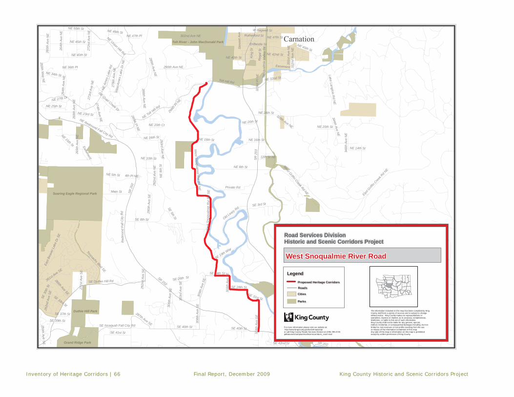
Inventory of Heritage Corridors | 66 Final Report, December 2009 King County Historic and Scenic Corridors Project
Soaring Eagle Regional Park
Tolt River - John MacDonald Park
Duthie Hill Park
Grand Ridge Park
SR 2
03
SR 202
Neal Rd SE
Tolt Hill Rd
NE 8th St
SE Duthie Hill Rd
356th Dr S
E
NE 45th St
NE
Ames
Lak
e R
d
Lake Marie Rd
East G
riffin
Creek R
d NE
290t
h Av
e S
E
NE Redmond Fall City Rd
NE 32nd St
SE 39th Pl
Entwistle St
Main St
West Snoqualm
ie Rvr R
d NE
NE 50th St
292n
d Av
e N
E
NE Tolt Hill R
d
324t
h Av
e S
E
SE 40th StSE Issaquah Fall City Rd
SE 8th St
King
St
285th Pl NE
NE 16th St
288th Ave NE
Private Rd
364th Way SE
Old Leary Rd
290th Ave NE
NE Union Hill Rd
302nd Ave NE
264t
h Av
e N
E
Wes
t Sno
qual
mie
Rvr
Rd
SE
SE 3rd St
308t
h Av
e S
E
SE 41st St
344th Ave NE
NE 27th Dr
NE 34th St
SE 24th St
268t
h Av
e N
E
NE 40th St
272n
d Av
e N
E
Lake Langlois Rd N
E
Red
mon
d Fa
ll C
ity R
d
SE 42nd St
NE 25th St
4th Pl NESnoqualmie Valley Trl
SE 19th Way
Rutherford St
NE 18th St
300t
h Av
e S
E
NE Quail Creek Dr
261st Ave SE
NE 42nd St
259th Way N
E
SE 28th St
NE 14th St
298th
Pl N
E
Stew
art A
ve
309t
h Av
e SE
Trossachs Blvd SE
Wes
t Am
es L
ake
Dr N
E
287th Ave SE
Reg
al S
t
11th St NE
West Griffin Creek Rd NE
SE 34th St
332n
d Av
e N
E
303r
d A
ve S
E
SE 31st St
Easement
SE 26th St
331s
t Ave
NE
NE 47th St
262n
d Av
e SE
NE 20th Ct
292n
d Av
e S
E
SE 37th St
NE 20th St
SE 32nd St
NE 36th Pl
NE 23rd St
NE 49th St
289th Ave NE
NE 15th St
274th Ave NE
293rd Ave N
E
NE 47th Pl
SE 5th St
East
Bea
ver L
ake
Dr S
E
348t
h Av
e N
E
SE 33rd St
NE 24th St
259th Ave SE
266th Ave SE
NE 10th St
316t
h Av
e S
E
SE 39th St
279t
h Av
e N
E
271s
t Ave
SE
323r
d P
l NE
Access Rd
273r
d A
ve N
E
269t
h Av
e N
E
W Bagwell St
260t
h Av
e N
E
NE 5th St
SE 3
0th
St
328th Ave NE
264t
h Av
e N
E
NE 20th St
SE 40th St
Easement
SR 202
NE
8th
St
SR 2
02
NE 45th St
SE 31st St
SE 39th Pl
NE 16th St
Snoq
ualm
ie V
alle
y Tr
l
NE 40th St
Road Services DivisionHistoric and Scenic Corridors Project
For more information please visit our website at: http://www.kingcounty.gov/kcdot/roads/cip/or call King County Roads Services Division at (206) 296-3745jabba/users/campear/mxd/sceniccorridors_zoom.mxd
-
The information included on this map has been compilied by KingCounty staff from a variety of sources and is subject to changewithout notice. King County makes no representations orwarranties, express or implied, as to accuracy, completeness,timeliness, or rights to the use of such information.King County shall not be liable for any general, special,indirect, incidental, or consequential damages including, but notlimited to, lost revenues or lost profits resulting from the useor misuse of the information containted on this map. Any sale of this map or information on this map is prohibitedexcept by written permission of King County.
West Snoqualmie River Road
LegendLegend
Proposed Heritage CorridorsProposed Heritage Corridors
RoadsRoads
CitiesCities
ParksParks
Carnation
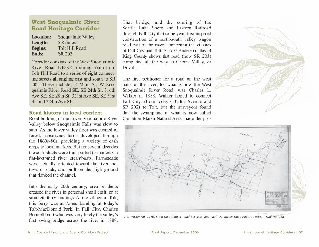
King County Historic and Scenic Corridors Project Final Report, December 2009 Inventory of Heritage Corridors | 67
West Snoqualmie River Road Heritage CorridorLocation: Snoqualmie Valley Length: 5.8 milesBegins: Tolt Hill RoadEnds: SR 202
Corridor consists of the West SnoqualmieRiver Road NE/SE, running south from Tolt Hill Road to a series of eight connect-ing streets all angling east and south to SR 202. These include: E Main St, W Sno-qualmie River Road SE, SE 24th St, 316th Ave SE, SE 28th St, 321st Ave SE, SE 31st St, and 324th Ave SE.
Road history in local contextRoad building in the lower Snoqualmie River Valley below Snoqualmie Falls was slow to start. As the lower valley fl oor was cleared of forest, subsistence farms developed through the 1860s-80s, providing a variety of cash crops to local markets. But for several decades these products were transported to market via fl at-bottomed river steamboats. Farmsteads were actually oriented toward the river, not toward roads, and built on the high ground that fl anked the channel.
Into the early 20th century, area residents crossed the river in personal small craft, or at strategic ferry landings. At the village of Tolt, this ferry was at Ames Landing at today’s Tolt-MacDonald Park. In Fall City, Charles Bonnell built what was very likely the valley’sfi rst swing bridge across the river in 1889.
That bridge, and the coming of the Seattle Lake Shore and Eastern Railroad through Fall City that same year, fi rst inspired construction of a north-south valley wagon road east of the river, connecting the villages of Fall City and Tolt. A 1907 Anderson atlas of King County shows that road (now SR 203) completed all the way to Cherry Valley, or Duvall.
The fi rst petitioner for a road on the west bank of the river, for what is now the West Snoqualmie River Road, was Charles L. Walker in 1888. Walker hoped to connect Fall City, (from today’s 324th Avenue and SR 202) to Tolt, but the surveyors found that the swampland at what is now called Carnation Marsh Natural Area made the pro-
C.L. Walker Rd, 1940, From King County Road Services Map Vault Database; Road History Packet, Road No. 228

Inventory of Heritage Corridors | 68 Final Report, December 2009 King County Historic and Scenic Corridors Project
posed route not practical at the north end. The surveyors also noted in the Viewers’ Report (dated March, 1889), “There are no settlers below this point who would or does [sic] need such a road.” Thus, the Charles Walker Road No. 228 was built all of a piece, but only as far north as the marsh. It is shown as such on the 1907 Anderson map.
West Snoqualmie Road near Pleasant Hill, c. 1911. Courtesy of King County Archives
Tolt Bridge over Snoqualmie River, c. 1911. Courtesy of King County Archives
In 1910, Charles Davies petitioned for completion of the road at its north end, from the marsh to a newly built bridge across the Snoqualmie, just south of the Tolt River. This strategic bridge was later replaced in 1922, and again most recently in 2008. The offi cial surveymap for the Davies Road, dated November 1910, shows the bridge under construction. By 1912, the bridge was in place, and connected to the new Tolt Hill Road over the ridge. The Davies Road extension was completed shortly thereafter.
The West Snoqualmie River Road, complete by 1913, remained a quiet rural corridor in the decades that followed. Dairy farming came to the fore in the fi rst half of the 20th century. Historic farmsteads, whose barns illustrated a progression of types and styles, were built along its length. This road also includes one location of special note. The site of old Fort Patterson, a small fortifi cation built during the Indian Wars of 1855-56 under Territorial Governor Isaac Stevens, is located at an unmarked spot midway along the road on the Fred Keller Farm (HRI #738).
Sources: King County records: Assessor’s Property Record
Cards, Land Use and Aerial Survey - 1936-1941, Historic
Preservation Program HR database, Index to Roads Records, En-
gineer’s Road Establishment Atlas – 1913, Roads’ Map Vault da-
tabase. Maps: AAA – 1917-1929: Anderson – 1888, 1907; Kroll
– 1912, 1913, 1926, 1930, 1936, 1938; Metsker – 1926, 1936;
Washington Map & Blueprint Co. – 1900, 1905, 1908.

King County Historic and Scenic Corridors Project Final Report, December 2009 Inventory of Heritage Corridors | 69
Corridor signature Evocative rural ambianceAuthentic “back road” experienceInviting agri-tourism stops
The Snoqualmie River Road Heritage Corridor steps back to the early 20th century when farming was a way of life and the valley seemed miles from the city. Located in a secluded pocket of the valley with proximity to the meandering river, this corridor offers peaceful ambience, low traffi c levels, and bucolic views. Several working specialty farms on old dairy acreage provide seasonal interest.
Contributing featuresThe following roadway features contribute positively to overall corridor character:
• Historic alignment - curvilinear in north half, right angle in south half• No roadway striping• Minimal shoulders; ground vegetation to edge of roadway• Flat roadway crown• Minimal signage
The following contextual features contribute positively to overall corridor character:• Views across open agricultural lands toward forested foothills• Cut fl ower fi elds, row crops, and pastures• Historic dairy farmsteads, barns, and milk houses• Grazing livestock• Natural features and recreational attractions
Non-contributing featuresThe following elements visually detract from overall corridor character:
• Suburban-style landscaping and monument signs at entrance to Carnation and Tall Chief golf courses• Several newer, non-farm residences

Inventory of Heritage Corridors | 70 Final Report, December 2009 King County Historic and Scenic Corridors Project
West Snoqualmie River Road NE/SEMile 0.0 - 1.0
• Corridor begins just west of new Tolt Bridge, turn south off Tolt Hill Road. W. Snoqualmie River Road winds through forested pockets past occasional residence and fenced pastures.
• Note built-up bed of road, and houses raised above fl ood line.• At 0.5 miles begins the King County Carnation Marsh Wetlands Area,
signed on both sides of the road; natural setting dominates.• Grasslands with sparse fi r trees (many dead) stretch west to foothills, road crossing streams and sloughs throughout.
• At 0.9 miles is concrete bridge with wooden side rails crossing creek.
Mile 1.0 – 2.0
• Vegetation thickens just north of entrance to Carnation Golf Course at mile 1.0, a public course east of road. Fairways are visible, but clubhouse hidden behind screen of trees.
• Small farmsteads become visible and older residences set closer to the road, open pastures on the east, mix of tree types along banks of Snoqualmie River.
• River to the east and dividing property lines.• Marshland continues west of road.• At 1.5 miles on east side is interesting old dairy barn–the Ira Smith barn–
with outbuildings. Waning evidence of dominance of dairy farming during fi rst half of 20th century.
• At 1.6 miles are fl ower farms where the graceful old Faulds barn used to stand on east side of road; Carnation Marshland ends at gravel turnout just across road at mile 1.8.
• Beyond that fencing encloses variety of fl ower fi elds and pasture lands.
Mile-by-mile Corridor Tour: West Snoqualmie River Road

King County Historic and Scenic Corridors Project Final Report, December 2009 Inventory of Heritage Corridors | 71
Mile2.0 – 3.0
• Historic Pete and Rose Angerer Dairy, now Jubilee Farm, is at mile 2.1 on the east side of road. This is an active Community Supported Agriculture (CSA) farm; members buy fresh organic produce from the fertile fi elds where cows used to graze.
• At mile 2.3 road turns into the oddly named E. Main Street, continues due east for .2 miles, then turns south and becomes W. Snoqualmie River Road again.
• Note mature shade trees along the road, framing distant views across pastures to wooded riverbank and far edges of valley.
• At mile 2.9 against backdrop of poplar trees to the west is old Crable-Kendall barn built in 1927, once a dairy but now leased to Hmong fl ower and vegetable growers. Fields bright with color in spring and summer.
Mile3.0 – 4.0
• At mile 3.0, see an old Gothic-arch (bow-truss) barn across river to the east. • Tall Chief Golf Course, with formal entrance, shaded poplar trees at mile
3.1. Views of the fairways and greens continue to mile 3.5. • Road bears southeast, then crosses stream at mile 3.8, just before veering due south at old Hance and Nancy Moore Farmstead, fi rst settled in the 1870s. Aging shed and little red milk house stand close to the road as well as a large handsome dairy barn, two silos, and big chicken house now long gone. In 1850s, this farm was site of Fort Patterson, one of four log forts built along Snoqualmie River during the Indian unrest.

Inventory of Heritage Corridors | 72 Final Report, December 2009 King County Historic and Scenic Corridors Project
SE 24th Street, 316th Avenue SE, SE 28th Street, 321st Ave SE, SE 31st Street, and 324th Avenue SE
Mile4.0 – 5.0
• Turn left on SE 24th Street, then follow road in segments running east and south to SR 202.
• Grassy pastures, fields of flowers, and fence lines overgrown with blackberry bushes are typical. Large trees mark riverbank off to east.
• At mile 4.8 is historic Josie and Fred Gebhart Farm, with picturesque West-ern-style barn and an extremely rare wood silo–one of dozens that used to dot the valley.
• Expansive views open out across the valley. • At mile 4.9 the road bears south and southeast, past fi elds of livestock
and informally landscaped farmhouses. East across Snoqualmie River is Fall City Natural Area, identifi ed by thickets of vegetation and trees around a natural oxbow.
Mile5.0 – 6.0
• Continuing south, at mile 5.6 off to the west is old Ira Smith barn and shed, unaltered reminders of rich dairy farming culture along this corridor.
• Corridor ends at mile 5.8 at junction with SR 202.

King County Historic and Scenic Corridors Project Final Report, December 2009 Inventory of Heritage Corridors | 73
This page left intentionally blank

Inventory of Heritage Corridors | 74 Final Report, December 2009 King County Historic and Scenic Corridors Project
Snohomish County
Kelly Rd N
E
West Snoqualm
ie Val Rd NE
NE Big Rock Rd
NE Novelty Hill Rd
NE 133rd St
SR 2
03
NE Woodinville Duvall Rd
NE Cherry Valley Rd
NE Union Hill Rd
Carnation Duvall Rd NE
NE 60th St
Snoqualmie Valley Trl
Fay
Rd
NE
196t
h Av
e N
E 208t
h Av
e N
E
Mink R
d NE
322n
d Av
e N
E
Avondale Rd N
E
NE 100th St
Duvall-M
onroe Rd NE
204t
h Av
e N
E
Pedestrian Walk
Tolt Pipeline Walk
Bear
Cre
ek R
d
320th Ave NE
NE 147th Pl
NE 98th St
Odell Rd NE
NE 138th St
NE 124th St
NE 67th Pl
NE Carnation Farm Rd
Batten Rd NE
276th Way N
E
NE 150th St
NE 139th St
NE St
osse
l Cre
ek W
ay
296th Ave NE
226t
h Av
e N
E
Carnation D
uvall Rd21
2th
Dr N
E
Wes
t Sno
qual
mie
Rvr
Rd
NE
Tolt
Riv
er R
d N
E
NE 178th Pl
NE 80th St
Trilogy Pkw
y NE
NE 132nd St
NE Lake Joy Rd
300t
h Av
e N
E
Mai
n St
244t
h Av
e N
E
312th Ave NE
NE 155th St
306th Ave NE
209t
h Av
e N
E
NE 143rd Pl
256th Ave NE
NE 183rd St
214th Ave NE
204t
h D
r NE
NE
Red
mon
d R
d
258t
h Av
e N
E
223rd Ave N
E
Stos
sel C
reek
Rd
NE
352n
d Av
e N
E
NE 78th St
322nd Pl NE
NE 200th St
Cherry St
318th Way NE
NE 190th St
NE 145th St
Swan Loop R
d
212t
h Av
e N
E
NE 58th Pl
Miller St
NE 70th St
204th Pl NE
Private Rd
NE 188th St
Manion W
ay NE
324th Ave NE
NE 137th St
215th Way N
E
269th Way NE
278t
h Av
e N
E
292nd Ave NE
284t
h Av
e N
E
NE 198th St
79th St NE
NE 60th Pl
NE 180th Pl
NE 134th St
302nd Way NE
NE 185th Pl
330th Ave NE
NE 156th St
NE 180th St
222nd Way N
E
NE Alder Crest Dr
268t
h Av
e N
E
Virginia St
224t
h Av
e N
E
NE 159th St348th Ave NE
NE Kennedy Dr
NE 85th St
218th Ave NE
262nd Ave NE
310t
h Av
e N
E
345th Pl N
E
NE 154th St
275t
h Av
e N
E
342n
d Av
e N
E
233r
d A
ve N
E
92nd Pl NE
NE 106th St
NE 185th St
254th Ave NE
346th Pl NE
NE 141st St
NE 165th St
NE 161st St
203rd Pl N
E
NE
195t
h S
t
221st Ave NE
216th Ave NE
NE 67th St
NE 53rd St
206t
h Av
e N
E
NE 130th St
308t
h Av
e N
E
248th Ave NE
NE 81st St
344th Ave NE
NE 114th St
NE 108th St
250t
h Av
e N
E
288t
h Av
e N
ENE 102nd St
Easement
NE 181st St
NE 58th St
NE 139th Way
NE 142nd Pl
Swan Mill Rd
NE 112th Way
NE 148th St
NE 147th St
NE 140th St
NE 57th St
NE 64th St
NE 144th Pl
NE 116th St
NE
189t
h S
t
NE 151st St
NE 103rd St
205t
h Av
e NE
194th Ave NE
318t
h Av
e N
E
NE 126th St
243r
d A
ve N
E
NE 194th St
227th Ave NE
245t
h W
ay N
E
NE 87th Pl
NE 129th St
198t
h P
l NE
303rd Pl NE
197t
h P
l NE
NE 54th St
NE 62nd St
197t
h Av
e N
E
NE 170th
Pl
210t
h Av
e N
E
294th Ave NE
NE 202nd St
NE 78th Way
296t
h Pl
NE
247t
h Av
e N
E
261st Ave NE
280t
h Av
e N
E
216th Way NE
227th Way N
E
NE 61st St
195th Ave NE
NE 77th StNE 76th St
NE 120th St
252n
d Av
e N
E
NE 62nd Pl
282nd Pl NE
238t
h Av
e N
E
228t
h P
l NE
314th Ave NE
NE 97th Pl
198t
h Av
e N
E
NE 168th St
NE 144th St
NE 190th Pl
NE 148th Pl
NE Park St
NE 54th Pl
NE 112th St
NE
109t
h S
t
NE 193rd Pl
325th Ave NE
NE 146th Pl
NE 152nd Pl
NE 64th Pl
246t
h Av
e N
E
236t
h Av
e N
E
283rd Ct
304t
h Av
e N
E
NE 156th Pl
NE 117th St
NE 153rd St
232n
d Av
e N
E
NE 121st St
Private Rd
NE 150th St
NE 150th St
218t
h Av
e N
E
NE 161st St
NE 144th St
NE 114th St
NE 124th
St
Priva
te R
d
NE 124th St
Priv
ate
Rd
NE 138th St
NE 124th St
NE 80th St
Priv
ate
Rd
NE
85th
St
NE 145th St
NE 159th St
NE 97th Pl
296t
h Av
e N
E
204t
h Av
e N
E
275t
h Av
e N
E
294th Ave NE
Private Rd
320t
h Av
e N
E
Private Rd
196t
h Av
e N
E
308t
h Av
e N
EPrivate R
d
Stossel Creek R
d NE
Private Rd
224th Ave NE
284t
h Av
e N
E
NE 147th St
Road Services DivisionHistoric and Scenic Corridors Project
For more information please visit our website at: http://www.kingcounty.gov/kcdot/roads/cip/or call King County Roads Services Division at (206) 296-3745jabba/users/campear/mxd/sceniccorridors_zoom.mxd
-
The information included on this map has been compilied by KingCounty staff from a variety of sources and is subject to changewithout notice. King County makes no representations orwarranties, express or implied, as to accuracy, completeness,timeliness, or rights to the use of such information.King County shall not be liable for any general, special,indirect, incidental, or consequential damages including, but notlimited to, lost revenues or lost profits resulting from the useor misuse of the information containted on this map. Any sale of this map or information on this map is prohibitedexcept by written permission of King County.
West Snoqualmie Valley Rd/Carnation Farm Rd
LegendLegend
Proposed Heritage CorridorsProposed Heritage Corridors
RoadsRoads
CitiesCities
ParksParks

King County Historic and Scenic Corridors Project Final Report, December 2009 Inventory of Heritage Corridors | 75
and Cherry Valley (Duvall) benefi ted from this road, now SR 203. That road was largely in place by 1890, and there is good evidence that it altered the tradi-tional pattern of farm-stead development in the lower valley. New dwellings and barns were constructed along the road at the valley’s edge rather than on the valley floor facing the meandering river channel.
GLO maps indicate a rough trace along the west valley wall in the 1860s-’70s; however,no arterial wagon road was formally engineered here for another twenty years. Construction of West Snoqualmie Valley Road was incremental, and had the same effect of shifting settlement patterns and connectingfarms on the west bank. It also gave access out of the valley, fi rst over the ridge to Redmond via Novelty Hill, and a little later to Issaquah and Woodinville on the Tolt Hill and Woodinville-Duvall roads.
A 1907 Anderson map only shows a meander-ing dirt road on the valley fl oor, hugging the west bank of the river south of Duvall as far as the King County Landmarked Platt Farm. This road then veered up over the ridge on
West Snowqualmie Valley Road/Carnation Farm Road Heritage Corridor
Location: Snoqualmie ValleyLength: 11.7 miles Begins: King-Snohomish county lineEnds: SR 203
Corridor follows the West Snoqualmie Valley Road NE from the King-Snohomish county line south to NE 80th Street; turns east on NE 80th Street to meet the NE Carnation Farm Road; and follows Carnation Farm Road to SR 203.
Road history in local contextThe Snoqualmie River served as an exception-ally effective highway north to Puget Sound through the 1860s, ‘70s and ‘80s. During this era, settlers took up claims on the bottomlands and built subsistence farms fronting the river. Flat-bottomed steamboats shipped their pro-duce down river to Snohomish City. After the arrival of the Seattle, Lake Shore and Eastern Railway at Fall City in 1889, access to the prairie above the Falls was easier, and some steamboat traffi c declined. But it continued in the lower valley into the 1900s, particularly for the movement of dairy products to market.
Growth and prosperity in the late 1880s spurred construction of the fi rst north-south wagon road down the east side of the valley, running north toward Snohomish City. The set-tlements of Fall City, Tolt (Carnation), Novelty,
West side road along Snoqualmie Valley near Vincent, looking north, n.d. Courtesy of King County Archives
Cropped view of AAA Triptick showing local auto roads, 1924. Courtesy of AAA

Inventory of Heritage Corridors | 76 Final Report, December 2009 King County Historic and Scenic Corridors Project
a route (Road No. 175) that has long since disappeared. It also branched due south along the hillside, as far as today’s Novelty Hill Road, but there it abruptly ended. King County road records indicate this whole northern section was realigned along the valley wall by 1908, cutting through the stumps of the logged-off hillside as Road No. 513. As Snoqualmie Valley agriculture shifted increasingly toward dairying as a specialty,
green pastures dotted with hay barns and silos fi lled in across the valley fl oor between this rough road and the river.
By 1912, a rough trace continued along the hillside south of Novelty to the little settle-ment of Vincent and beyond. Along this road, west side farm children could walk to the Vincent Schoolhouse (now a King County Landmark), overlooking the valley at NE 80th Street. The one-room school served grades one through eight until 1942.
An important milestone in corridor history took place in 1912, when E.A. Stuart began the construction of barns and other buildings at the Carnation Stock Farm (HRI No. 288), the premier dairy operation of the Carnation Company. Stuart’s purchase of the undeveloped farm in 1908 had no doubt encouraged the creation and improvement of a good road
past the farm. Thus, by 1912, maps show a continuation of the west valley road across the narrow V-shaped corner of the valley at Vincent, along what is now 80th Avenue SE, and around Tolt Hill past Carnation Farm. Continuing east, the road then crossed the Snoqualmie River over a new bridge, (now the King County Landmarked Stossel Bridge), and out along the alignment of today’s 60th Street in Carnation, where it joined SR 203.
In 1932 the West Snoqualmie Valley Road was retraced along the length of the valley, the result of which was a major straightening and re-engineering of its disparate pieces. It took on much of the appearance it has today from Duvall south to Vincent. A 1936 Metsker map shows the road labeled as the West Snoqualmie Valley Road, and improved (graded and graveled) from the Woodinville–Duvall Road south. The Carnation Farm Road was also improved by that date, and refl ected much the same alignment as it has today.
Sources: King County records: Assessor’s Property Record
Cards, Land Use and Aerial Survey - 1936-1941, Historic
Preservation Program HR database, Index to Roads Records,
Engineer’s Road Establishment Atlas – 1913, Roads’ Map Vault
database. Maps: AAA – 1917-1929: Anderson – 1888, 1907;
Kroll – 1912, 1913, 1926, 1930, 1936, 1938; Metsker – 1926,
1936; Washington Map & Blueprint Co. – 1900, 1905, 1908.
Carnation Farm, n.d., Photo Courtesy of Snoqualmie Valley Historical Museum

King County Historic and Scenic Corridors Project Final Report, December 2009 Inventory of Heritage Corridors | 77
Corridor signature Sweeping valley viewsHistoric heart of dairy farming in King CountyPicturesque barns
The Snoqualmie Valley Road Heritage Corridor presents the traveler with a 12-mile panoramaof the Snoqualmie Valley. Stretched along the western hillside overlooking the valley fl oor, this road offers a glimpse at a century of agricultural land use. Pastoral views toward the Cascade Mountains, modern-day specialty farms on historic acreage, and the iconic Carnation Farms are all to be experienced along this corridor.
Contributing featuresThe following roadway features contribute positively to overall corridor character:
• Early alignment along valley wall above fl ood plain• Ground cover over shoulders to edge of pavement• Some segments of narrow vegetation cuts, with trees overhanging roadway• King County Landmarked Stossel Bridge
The following contextual features contribute positively to overall corridor character:• Open vistas east across valley fl oor to foothills and Cascades• Adjacent wooded hillside to west still largely undeveloped• Historic farmsteads, barns, and milk houses in near- and mid-distance• Active agricultural land-use, including some dairying• King County Landmarked Vincent School • Carnation Farm/Camp Korey
Non-contributing featuresThe following elements visually detract from overall corridor character:
• Long stretches of galvanized steel guardrail• Three intersections with traffi c lights, wide paved shoulders• Large new subdivisions visible in distance on east valley wall

Inventory of Heritage Corridors | 78 Final Report, December 2009 King County Historic and Scenic Corridors Project
West Snoqualmie Valley Road NE Mile 0.0 - 1.0
• Corridor begins at Snohomish-King County line, with broad views across Snoqualmie Valley to the east, forested foothills in the distance. Vistas of snow-covered Cascade Mountains to the north, east and south can be seen on clear days. Notice stands of tall poplar trees on valley fl oor, now grown commercially on rich pasture land. Vegetation marks course of meandering river.
• Road traverses hillside, houses and farms interspersed with forested slopes above and open fi elds below.
• At mile 0.2 is typical aging Snoqualmie Valley dairy farm straddling the road, with farmhouse, hay barn, and milking parlor built during fi rst half of 20th century.
• The old Emil Hanish Dairy farm at mile 0.5, west of road, features handsome bow-truss barn and little matching milk house.
• Views of agricultural properties, many former dairy farms now in transition, stretch across valley fl oor.
Mile 1.0 – 2.0
• Road continues south past pastures, houses with small orchards, and occasional stands of poplar trees on valley fl oor.
• At mile 1.3 is Coldsprings Garden Nursery on west side of road, open by appointment.
• Views of growing community of Duvall become visible across valley at about mile 1.6. Town established in 1892, when Great Northern Railroad construction east of river forced relocation of tiny settlement of Cherry Valley.
Mile-by-mile Corridor Tour: West Snoqualmie Valley Road/Carnation Farm Road

King County Historic and Scenic Corridors Project Final Report, December 2009 Inventory of Heritage Corridors | 79
Mile2.0 – 3.0
• Road heads south to mile 2.3, dropping down to pass through major intersection at Woodinville-Duvall Road.
• Vegetation increases, and farmsteads are sparse, as road climbs up along hillside.
Mile3.0 – 4.0
• River winds closer to west side of valley here, marked by trees following its course. Views open up across valley to east and southeast and grazingcattle dot pastures below. Road offers shifting views of forested foothills and mountains.
• At mile 3.1 is historic Anton and Marie Marty Farm, built up as a dairy by Swiss immigrants in the 1930s and ‘40s. Note the distinctive red-roofed hay barn that once housed a herd of 90 cows.
• Historic Platt Farm, a King County Landmark at mile 3.6, is visible across close meander of river–note the tidy farmhouse and aging timber-frame barn built in 1906.
Mile4.0 – 5.0
• At mile 4.1 is the old Theodore Herzog Farm, east of road, another aging dairy farm that enjoyed its heyday in the early 1900s.
• At mile 4.8, road descends gently to major intersection at NE 124th Street, an east-west valley arterial. Recently completed Novelty Bridge across Snoqualmie River, visible on valley fl oor, is third bridge in this location.
• Road climbs hillside again, continuing south past historic and modern-day farmsteads.
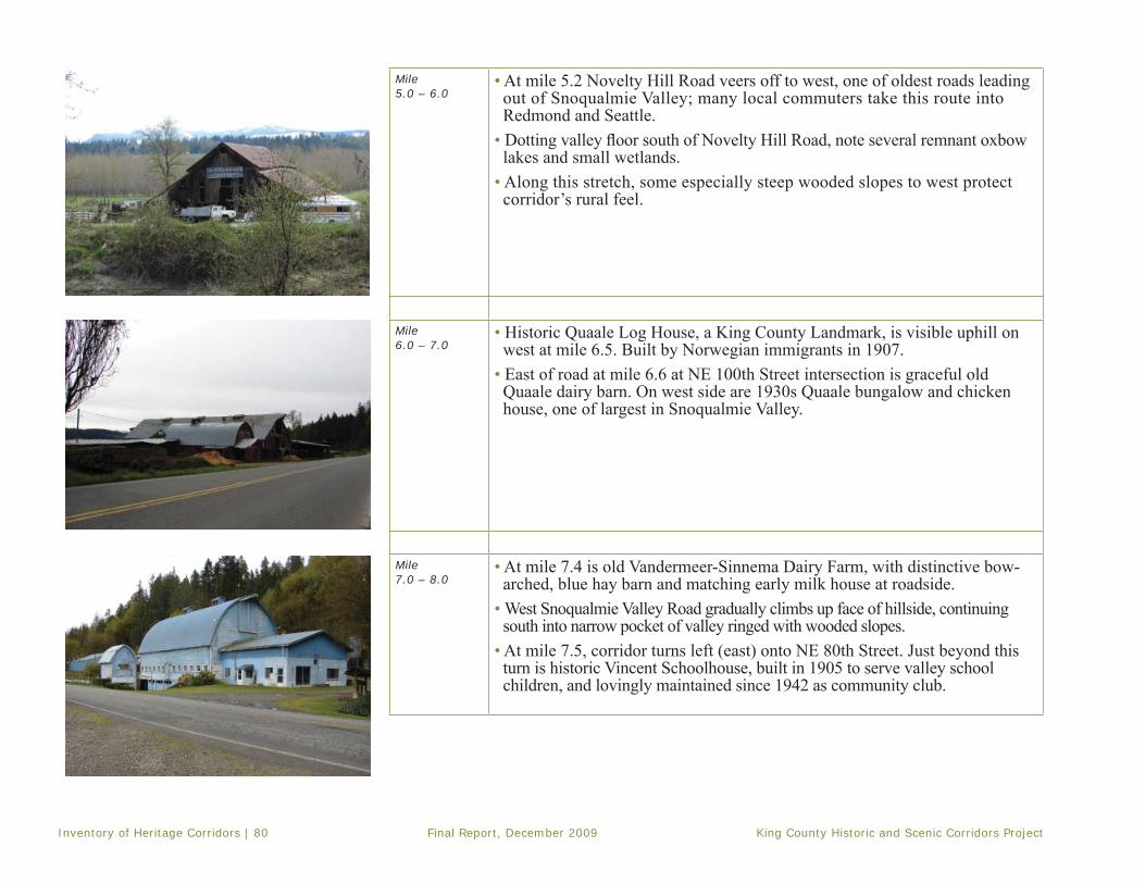
Inventory of Heritage Corridors | 80 Final Report, December 2009 King County Historic and Scenic Corridors Project
Mile5.0 – 6.0
• At mile 5.2 Novelty Hill Road veers off to west, one of oldest roads leading out of Snoqualmie Valley; many local commuters take this route into Redmond and Seattle.
• Dotting valley fl oor south of Novelty Hill Road, note several remnant oxbow lakes and small wetlands.
• Along this stretch, some especially steep wooded slopes to west protect corridor’s rural feel.
Mile6.0 – 7.0
• Historic Quaale Log House, a King County Landmark, is visible uphill on west at mile 6.5. Built by Norwegian immigrants in 1907.
• East of road at mile 6.6 at NE 100th Street intersection is graceful old Quaale dairy barn. On west side are 1930s Quaale bungalow and chicken house, one of largest in Snoqualmie Valley.
Mile7.0 – 8.0
• At mile 7.4 is old Vandermeer-Sinnema Dairy Farm, with distinctive bow-arched, blue hay barn and matching early milk house at roadside.
• West Snoqualmie Valley Road gradually climbs up face of hillside, continuing south into narrow pocket of valley ringed with wooded slopes.
• At mile 7.5, corridor turns left (east) onto NE 80th Street. Just beyond this turn is historic Vincent Schoolhouse, built in 1905 to serve valley school children, and lovingly maintained since 1942 as community club.

King County Historic and Scenic Corridors Project Final Report, December 2009 Inventory of Heritage Corridors | 81
NE Carnation Farm Road Mile8.0 – 9.0
• Cross over the Vincent fl ats and at mile 8.3 turn left onto Ames Lake-Carnation Road, which quickly becomes Carnation Farm Road.
• Continue around curve to east, past views across valley fl oor toward river. Sikes Lake, an oxbow of the Snoqualmie River in the foreground.
• Close to road at right is old Sikes Dairy Farm, established by Ezra and Jennie Sikes in 1888, and once known as Meadowlake Farm. In distance to north is a backside view of Broadacre Farm, a King County Landmark.
• Just past 284th Avenue NE, white fences and barns of River Run Ranch–a modern equestrian training facility–are visible off to north.
Mile9.0 – 10.0
• At mile 9.0 begins the famous Carnation Milk Farm complex, established in 1912 by E.A. Stuart, founder of Carnation Co. It is now owned and operat-ed by non-profi t Camp Korey. Drive past collection of landscaped bungalow residences for management, massive wooden barns, a sprawling loafi ng shed, many outbuildings, and a monument to Possum Sweetheart (a world champion dairy cow).
• Pastureland stretches north to bank of river and former dog and cat research facilities. Continue east past employee residences, a large concrete silage pit.
Mile10.0 – 11.0
• At mile 10.0 begin tracts of reforestation on both sides of road. • Continue past the Chinook Bend Natural Area, a King County park offering public access to the Snoqualmie River.
• Pass entrance to Camp Gilead, a 60-year-old Bible day camp, just before crossing Snoqualmie River on Stossel Bridge, a King County Landmark constructed in 1951.

Inventory of Heritage Corridors | 82 Final Report, December 2009 King County Historic and Scenic Corridors Project
Mile 11.0 – 12.0
• Corridor continues east, built up off fl ood plain, pastures to either side. • Corridor ends at mile 11.7 at junction with SR 203; historic Herman Ansler Farm barn is straight ahead.

King County Historic and Scenic Corridors Project Final Report, December 2009 Inventory of Heritage Corridors | 83
This page left intentionally blank

Inventory of Heritage Corridors | 84 Final Report, December 2009 King County Historic and Scenic Corridors Project
§̈¦90
Segment 3SE Homestead Valley Rd
Segment 2Forest Road 55/Tinkham Rd
Segment 1Forest Road 58/Denny Creek Rd
Olallie State Park
Snoqualmie Pass
Kittitas County
Alpine Lakes Wilderness
Road Services DivisionHistoric and Scenic Corridors Project
For more information please visit our website at: http://www.kingcounty.gov/kcdot/roads/cip/or call King County Roads Services Division at (206) 296-3745jabba/users/campear/mxd/sceniccorridors_zoom.mxd
-
The information included on this map has been compilied by KingCounty staff from a variety of sources and is subject to changewithout notice. King County makes no representations orwarranties, express or implied, as to accuracy, completeness,timeliness, or rights to the use of such information.King County shall not be liable for any general, special,indirect, incidental, or consequential damages including, but notlimited to, lost revenues or lost profits resulting from the useor misuse of the information containted on this map. Any sale of this map or information on this map is prohibitedexcept by written permission of King County.
Old Sunset Highway
LegendLegend
Proposed Heritage CorridorsProposed Heritage Corridors
RoadsRoads
CitiesCities
ParksParks

King County Historic and Scenic Corridors Project Final Report, December 2009 Inventory of Heritage Corridors | 85
Old Sunset Highway Heritage Corridor
Location: Snoqualmie Pass Length: 12.8 milesBegins: Alpental Access RoadEnds: I-90
Corridor includes three discontiguous segments of old routes over Snoqualmie Pass, each segment accessible from I-90. From Summit Recreation Area (I-90 exit 53), head northwest on SR 906 toward Alpental to:
• Segment No. 1, Forest Road 58/Denny Creek Road, bears left off Alpental Access Road, parallels and runs under I-90, drops steeply through dense forest, crossesoverpass over I-90 at mile 4.9 to join Segment No. 2.
• Segment No. 2, Forest Road 55/Tinkham Road, begins at exit 47, parallels south side of freeway, re-connects to I-90 on-ramp at mile 6.0.
• Segment No. 3, SE Homestead Valley Road, begins 3.0 miles further west off exit 38, re-merges onto I-90 onramp at mile 1.9.
Road history in local contextThe earliest push for a wagon road over Snoqualmie Pass originated locally, as the U.S. government was focused on promoting overland migration through the Columbia River Gorge. In 1855, Seattle surveyors, including prominent settlers Dexter Horton
and Charles Boren, fi rst tried to locate a way through the mountains east of the village of Seattle. They explored two routes, one of which followed the South Fork of the Snoqualmie River up from Rattlesnake Prairie, dropping over the 3,022-ft. Snoqualmie Pass, and down to Lake Keechelus. In 1865, after the native-settler confl icts had subsided, another surveywas completed and enough money raised locally to build 25 miles of road from Ranger’s Prairie (the future site of North Bend) toward the Pass. This rough wagon road was completed from Seattle to Ellensburg in 1867.
The Snoqualmie Wagon Roadaltered the economy of the region by providing a directroute for trade and settlers to Puget Sound, putting Seattle on a competitive basis with Portland. Cattle drives from the rangelands of Wash-ington and Oregon territories to Seattle began in 1869. Although maintenance of the road was challenging, cattle-drov-ers and miners continued to rely upon it for east-west travel. In 1883, the road was taken over by the Seattle and Walla Walla Trail and Wagon Road Co., who made investments of money and labor in its improvement. This company operated it as a toll road, and it appears as such on an 1893 Ames & Adams map of King County.
Snoqualmie Pass Wagon Road, ca. 1900. Courtesy of the Eastside Heritage Museum

Inventory of Heritage Corridors | 86 Final Report, December 2009 King County Historic and Scenic Corridors Project
In 1887, completion of the Northern Pacifi c Railroad’s Cascades line to its terminus in Tacoma captured most of this overland freight. The wagon road fell into serious disrepair, and ultimately reverted to the jurisdiction of King County. In 1899, David Denny contracted with the county to make repairs. He laid corduroy road, built bridges, blasted rock, and improved alignments. Over the course of that summer he counted 1148 horses and 94 wagons and carriages carryingsettlers crossing Snoqualmie Pass. Just six
years later, in 1905, the fi rst automobiles would cross the Pass on the old wagon road, signaling the dawn of a new era.
Still, no major upgrades would take place for nearly another decade, because the Chicago, Milwaukee and St. Paul Railroad, completed over Snoqualmie Pass in 1909, effectively absorbed most commercial and passenger traffi c. It was not until 1909, when the Alaska-Yukon-Pacifi c Exposition’s transcontinental auto race over Snoqualmie Pass generated widespread publicity that focus shifted to improving this road for the motorcar.
In the push for improvements to Washington’s highways, the Good Roads Association joined the efforts of local auto clubs in 1912. They proposed three trunk highways be built within the state. One would be named the “Sunset Highway,” to run west from the Idaho line, over Snoqualmie Pass and down into Fall City. From there, it would continue south around Lake Washington and into Seattle. In March 1914, the State Highway Board accepted bids for clearing, grading, drainingand bridging about 23.4 miles of the Sunset Highway between North Bend and Cle Elum. At its dedication in 1915, Governor Lister hailed the Sunset Highway as the “fi rst passable route between east and west sides of the mountains.”
The Sunset Highway replaced some of the old wagon road’s most treacherous grades with Horses towing two Buicks along Sunset Highway, 1916. Photo
Courtesy of Snoqualmie Historical Museum
Showing old and new highways, near Denny Creek campground, ca., 1920s Photo Courtesy of Snoqualmie Historical Museum

King County Historic and Scenic Corridors Project Final Report, December 2009 Inventory of Heritage Corridors | 87
a series of switchbacks. Forest Road 58 with its hairpin turns is part of this original 1915 alignment (Segment No. 1); this abandoned stretch was then turned over to King County and fi nally to the Forest Service. The Sunset Highway ran north of the river, in the path of today’s I-90 freeway, completely bypass-ing the old wagon road south of the river (Tinkham Road, Segment No. 2). The fi nal stretch of the Sunset Highway just east of North Bend again crossed to the south bank of the river along the original wagon road alignment, past present-day Ollalie State Park (Segment No. 3). From there, it crossed back over the river, climbed northwest over Grouse Ridge, and dropped down into North Bend.
For about 13 years, the much-touted Sunset Highway remained a graded gravel road. Automobile enthusiasts popularized the route, despite the constant maintenance it required. Services and recreation opportunities are marked on maps of the era, including early-day strip maps of the Automobile Clubs of Seattle and Western Washington. As early as 1917, the Summit Inn at Snoqualmie Pass, and a camp known as Bide-A-Wee (and laterCamp Mason) were open for business. In the mid-1920s, Denny Creek Campground, Snoqualmie Falls Lodge, and Maloney’s Grove in North Bend, appear on these maps. The Sunset Highway was also included and marked as part of the nationally publicized Yellowstone Trail route from Chicago and Seattle to Yellowstone National Park.
Beginning in 1923 and continuing into the 1930s, major improvements to the Sunset Highway were accomplished with federal dollars made available under the Federal Highway Act of 1921. These improvements, initiated as Federal Aid Project #142, included hard-surface pav-ing and some important new alignments. The upper switch-backs of 1914-15 were perma-nently bypassed at this time. The road remained open for the fi rst time through-out the winter of 1931. By 1934, all sections of highway paving were complete from Seattle to the Pass. During this time frame, the Sunset Highway received offi cial designations as State Road No. 2, Primary State Route No. 2, and U.S. Highway 10 – but the name persisted and is still alive in place names from Renton to Spokane.
Sources: King County records: Assessor’s Property Record
Cards, Historic Preservation Program HR database, Index to
Roads Records, Engineer’s Road Establishment Atlas – 1913,
Roads’ Map Vault database. Maps: AAA – 1917-1929; Ames
& Adams – 1893; Metsker – 1926, 1936; Washington Map &
Blueprint Co. – 1908. Prater, Yvonne, Snoqualmie Pass: From
Indian Trail to Interstate. (The Mountaineers, 1981). NW Ar-
cheological Associates, National Register of Historic Places As-
sessment of the South Fork Snoqualmie River Bridge, 2002
AAA triptik showing road from Snoqualmie Pass to North Bend, 1924. Courtesy of AAA

Inventory of Heritage Corridors | 88 Final Report, December 2009 King County Historic and Scenic Corridors Project
Corridor signature Key chapter in King County road historyAuthentic auto-tourism experienceForest and mountain immersion
The Old Sunset Highway Heritage Corridor uniquely illustrates the evolution of road development in King County, re-tracing extant portions of the 1915 automobile route over Snoqualmie Pass. Partially under the jurisdiction of Mt. Baker-Snoqualmie National Forest, this corridor offers a taste of early 20th century motoring in a rugged mountain environment, and provides access to multiple recreational activities. Corridor lies within Mountain-to-Sound Greenway, a National Scenic Byway. Contributing featuresThe following roadway features contribute positively to overall corridor character:
• Historic alignments • Sections of historic profi le hugging lay of land• Narrow vegetation cuts• Stone wall, concrete radiator trough, painted Yellowstone Trail marker (segment No. 1)• Concrete pour panels, bridge railings, vestigial alignments (segment No. 3)
The following contextual features contribute positively to overall corridor character:• Deep forest environments at varying elevations• Close-range views of mountain peaks to east• Distant territorial views to west• River proximity• Springboard scars on old growth stumps show remnants of logging activity• Access to adjacent Snoqualmie Wagon Road segments
Non-contribuing featuresThe following elements visually detract from overall corridor character:
• Built-up roadbed (segment No. 2)• Chain link fence along Olallie Dam (segment No. 3)

King County Historic and Scenic Corridors Project Final Report, December 2009 Inventory of Heritage Corridors | 89
Segment No. 1: Forest Road 58/Denny Creek RoadMile 0.0 - 1.0
• Corridor segment No. 1 (1915 Sunset Highway) diverges off Alpental Road, paralleling I-90 to the west, passing under I-90 at 0.2 miles. On north side is a low masonry wall fashioned of fl at-topped ashlar rock. Falls of South Fork Snoqualmie River visible below.
• Paved road descends, fi rst hugging then diverging from I-90; at mile 0.6 are views of river.
• At mile 0.8 road enters a grove of trees; emerges to sweeping views across steep valley, I-90 westbound lanes visible in distance.
Mile 1.0 – 2.0
• At mile 1.1 begins most dramatic series of 1915 switchbacks through open boulder fi eld. Views to northwest, across valley.
• Road re-enters forested area at mile 1.5. On southeast edge of road is an old radiator water fi ll, built to service early model cars making the steep uphill grade. Rubble concrete trough, about 5’ long, 2’wide, and 14” high, now nearly buried with sediment and mostly hidden by vegetation.
• At mile 1.8 begins second set of switchbacks.• Road continues to wind downward along narrow right-of-way, without shoulders or centerline.
Mile2.0 – 3.0
• At mile 2.0, road runs shoulder to shoulder with Franklin Falls Trail No. 1036, visible by its log railings. Sounds of rushing river and falls in ravine below.
• Springboard cuts in old growth stumps become visible, either side of road. • At mile 2.5 on north side is turn off to National Forest Road 5830. Opposite,
on south side, is small interpretive sign marking access to hikeable, one-mile section of old Snoqualmie Pass Wagon Road.
• Entrance to Forest Service Denny Creek Campground is at mile 2.7. Located on Lodge Creek tributary, campground offers 32 campsites, access to Franklin Falls.
Mile-by-mile Corridor Tour: Old Sunset Highway

Inventory of Heritage Corridors | 90 Final Report, December 2009 King County Historic and Scenic Corridors Project
Mile3.0 – 4.0
• At mile 3.0, just before bridge crossing, is site of former small store/resort known as Granite Mountain Lodge. Between road and river bank, remnants of concrete foundations, a stone chimney and other features still visible.
• Just around bend is new Forest Service bridge over South Fork Snoqualmie, built with rust-fi nished steel frame, and wood decking in spirit of original bridge (a 90-foot Pratt truss built 1914).
• Just across bridge, at northwest side of road is Yellowstone Trail marker painted on rock face. Yellow arrow within black circle points east, showing route marked in 1910s by Yellowstone Trail Association.
• At mile 3.4, watch for springboard cuts visible in the forest.• Over next half-mile forest closes in, with branches obscuring the sky and heavy overhang; intermittent views of the river to the southeast, with tributary streams entering from the northwest.
• At mile 3.8, I-90 becomes visible again to north
Mile4.0 – 5.0
• At mile 4.4, look to the left for a large grove of cedar trees, some of which show possible signs of bark striped for use in native basketry.
• More springboard cuts are visible on old-growth stumps at mile 4.6• Views of the South Fork Snoqualmie open up at mile 4.7• At mile 4.8 the road bisects an access road that provides entry to westbound
I-90.
Segment No. 2: Forest Road 55/Tinkham RoadMile0.0 – 1.0
• Continue south over I-90 and across a modern concrete bridge over the river. At mile 0.0, bear west onto corridor segment No. 2, Tinkham Road.
• Gravel road generally follows old route of Snoqualmie Wagon Road along south bank of river–this segment not part of Sunset Highway alignment.
• Shallow tributary streams enter from south.• Watch for multiple springboard cuts on massive old-growth stumps in forest.• Views obscured by deep fi r, hemlock, and cedar trees.
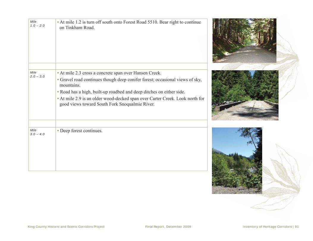
King County Historic and Scenic Corridors Project Final Report, December 2009 Inventory of Heritage Corridors | 91
Mile1.0 – 2.0
• At mile 1.2 is turn off south onto Forest Road 5510. Bear right to continue on Tinkham Road.
Mile2.0 – 3.0
• At mile 2.3 cross a concrete span over Hansen Creek. • Gravel road continues though deep conifer forest; occasional views of sky, mountains.
• Road has a high, built-up roadbed and deep ditches on either side.• At mile 2.9 is an older wood-decked span over Carter Creek. Look north for
good views toward South Fork Snoqualmie River.
Mile3.0 – 4.0
• Deep forest continues.
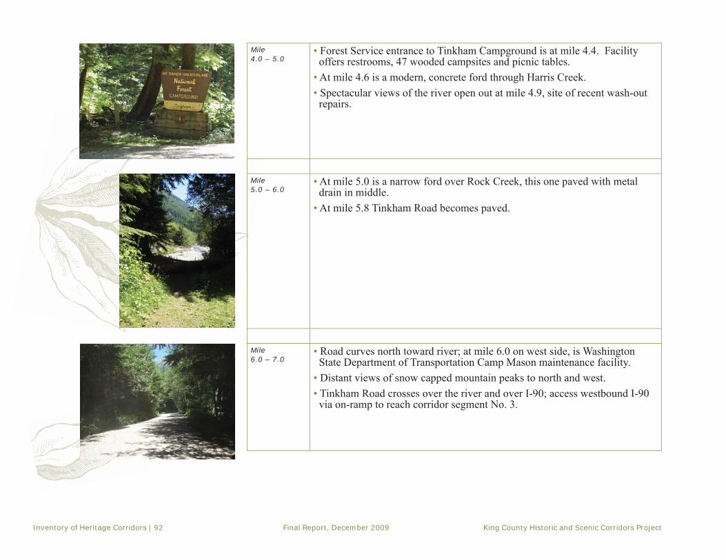
Inventory of Heritage Corridors | 92 Final Report, December 2009 King County Historic and Scenic Corridors Project
Mile4.0 – 5.0
• Forest Service entrance to Tinkham Campground is at mile 4.4. Facility offers restrooms, 47 wooded campsites and picnic tables.
• At mile 4.6 is a modern, concrete ford through Harris Creek. • Spectacular views of the river open out at mile 4.9, site of recent wash-out repairs.
Mile 5.0 – 6.0
• At mile 5.0 is a narrow ford over Rock Creek, this one paved with metal drain in middle.
• At mile 5.8 Tinkham Road becomes paved.
Mile6.0 – 7.0
• Road curves north toward river; at mile 6.0 on west side, is Washington State Department of Transportation Camp Mason maintenance facility.
• Distant views of snow capped mountain peaks to north and west.• Tinkham Road crosses over the river and over I-90; access westbound I-90 via on-ramp to reach corridor segment No. 3.

King County Historic and Scenic Corridors Project Final Report, December 2009 Inventory of Heritage Corridors | 93
Segment No. 3: SE Homestead Valley RoadMile0.0 – 1.0
• Continue west on I-90 to Exit 38. Follow exit road to left under freeway, to beginning of corridor segment No. 3, SE Homestead Valley Road.
• Paved road follows both Snoqualmie Wagon Road and later Sunset Highway alignments along south bank of South Fork Snoqualmie River.
• Mid-range views of forested foothills, and distant views of mountain peaks and rock formations.
• Olallie Dam is at mile 0.5 is on north side of road–no public access allowed. • At mile 0.7 begins a low, asphalt curb on north side along wide shoulder at
base of guardrail. • 1930s-style concrete pour panel pavement begins at mile 0.9.
Mile1.0 – 2.0
• At mile 1.0 is a concrete 1950s span over Hall Creek.• At mile 1.2 is the entrance to Olallie State Park. This day-use park features
Twin Falls Natural Area with trails to the 100’ Twin Falls, a fi sh wier and small hydroelectric station at Weeks Falls, cliff formations, and old-growth trees up to 14-feet in diameter.
• At mile 1.2 begins interesting section of parallel, double highway alignments, from two eras. One is paved with early 1930s-style concrete pour panels.
• Side-by-side concrete bridges over Change Creek illustrate both eras. Earlier bridge date stamped 1953.
• On south side of road at mile 1.7 begins a long rock retaining wall, date uncertain, in two sections. Just to northwest is entrance to Twin Falls/Iron Horse Trailhead.
• At mile 1.8 road crosses a modern bridge with open views of South Fork Snoqualmie River. Road continues under I-90, and reconnects on north side to westbound freeway at on-ramp.

Inventory of Heritage Corridors | 94 Final Report, December 2009 King County Historic and Scenic Corridors Project
This page left intentionally blank

King County Historic and Scenic Corridors Project Final Report, December 2009 Corridor Management Considerations | 95
Chapter IV. Corridor Management ConsiderationsThis chapter provides recommenda-
tions for the ongoing management of the road corridors identifi ed in this
report and included in the new King CountyHeritage Corridors Program. The suggestions outlined will help to preserve the special qualities of the roads and adjacent landscapes that led to the corridors’ designation as Community Landmarks. The recommendations include approaches to road maintenance and road improvement projects as well as ideas for public education and outreach to encourage pride of heritage and community stewardship.
The safety of public roadways is an overarching goal of King County. None of the following recommendations are intended to lessen the commitment to safety or lower its priority. Rather, preserving the scenic and historic qualities of these special road corridors is an additional goal that should be given careful consideration in all future activities.
Intensifying growth in King County may lead to higher traffi c volumes on identifi ed Heritage Corridors and potential confl icts between road upkeep and improvement needs and historic and scenic character. New private construction, both directly adjacent to the corridors and in their surrounding view sheds, could also impact their historic qualities over time.
Preserving the historic and scenic ambience of the heritage corridors will require not only thoughtful management of the roadway and
its associated structures, but active discussion of preservation goals with local residents. The owners of properties that surround the corridors, other users of the roads, community groups, and government agencies should all be included in a lively public involvement effort that includes educational outreach.
While the issues are interrelated, this chapter is divided into two areas of corridor management. The fi rst section discusses proposed principles and practices for maintenance and design of the road right-of-way and views from it, while the second section addresses community involvement strategies and opportunities for historic preservation along the corridor.
Roadway practices and principlesProtecting the essential historic and scenic qualities of the heritage corridors requires giving careful consideration to their character-defi ning features while maintaining essential road safety and public use. Key considerations relate primarily to roadway confi guration and to vegetation within the right-of-way, but also to the viewshed experienced by travelers along the roads.
Although each identifi ed heritage corridor has unique elements, they are generally characterized by a paved surface, single lane with no or minimal shoulders, and often a curvilinear footprint. Some of the roads feature distinctive elements such as historic bridges, culverts, and seawalls associated with periods of substantial public
“The safety of public roadways is an overarching goal of King County [and] preserving the scenic and historic qualities of these special road corridors is an additional goal that should be given careful consideration...”

Corridor Management Considerations | 96 Final Report, December 2009 King County Historic and Scenic Corridors Project
investment, such as Franklin Roosevelt’s New Deal programs. Many of the roads also featuredramatic changes in grade as they move through the landscape.
The roads are bordered by a wide variety of vegetation ranging from the dense conifers that line segments of the Old Sunset Highway to the fern understory on Vashon’s Cedarhurst Road/Westside Highway. Some of this vegetation, such as fruit trees in the Snoqualmie Valley, is connected to historical uses of the land. Vegetation that lies within, along the boundary of, and just beyond the right-of-way greatly affects corridor character and the traveler’s sense of place.
The corridors often exhibit transitions between close-in vegetation and distant vistas into the landscape. These view sheds are defi ned by distinct combinations of texture, color, materials, and light. Low ambient noise levels (due to limited road traffi c) and the presence of equestrians, pedestrians, bicyclists and agricultural machinery further enhances the rural character of the corridors. As such, many of the heritage corridors function as “mixed use” roads and a goal of the management of these corridors should be to support that rural mixed use.
The contextual experience is also conveyed by persistent evidence of historic land-use practices that occurred in the area–whetherthe grazing lands of the Enumclaw Plateau,the fishing villages of Vashon Island,
agricultural lands in the Snoqualmie River Valley, or remnants of logging operations in the midst of a second or third growth forest.
Road design and maintenanceMaintenance and design within the heritage corridor system should refl ect common preservation practices and the philosophies that form the basis of the Secretary of the Interior’s Standards for Rehabilitation of Historic Properties.
The following recommendations can be adapted to each specifi c corridor. The emphasis for individual corridors may be different and based upon the special features of each.
GENERAL PRINCIPLES• Adopt historic design elements for repair or
replacement of road materials
• Utilize appropriate in-kind materials for repairs, when these features contribute to the heritage corridor. If in-kind materials are not appropriate for safety or other reasons, consider visually similar materials to preserve character:
◦ Paving type◦ Guard rail◦ Fencing or walls◦ Culverts and bridges◦ Water drainage ditches/gutters
• Use modern materials that reduce costs and enhance durability so as not to detract from the historical character of the roads and corridors
“...view sheds are defi ned by distinct combinations of texture, color, materials, and light.”

King County Historic and Scenic Corridors Project Final Report, December 2009 Corridor Management Considerations | 97
• Combine new materials with traditional to visually blend
• Consider historic and scenic character of the corridor when making decisions about traffi c markings and signs
• Encourage the use of more developed parallel routes for through traffi c
• Maintain historic road alignment. Where possible preserve:
◦ Horizontal alignment (i.e., curves) ◦ Vertical alignment (i.e., rises) ◦ and dips ◦ Shoulder width and materials ◦ Road width ◦ Road profi le
• For new private developments along these corridors it may be necessary to obtain a variance from the County Road Engineer to maintain the desired historic and scenic road character. This would need to be evaluated and addressed on a case-by- case basis in consultation with a Cultural Resources Specialist and appropriate county engineering staff
• Protect signifi cant trees and plantings during construction and maintenance activities with fencing, etc.
VEGETATION MANAGEMENT• Maintain and when feasible, restore historic vegetation patterns, especially in regard to corridor-width, canopies, and nat-ural and planned vistas
• Where safety permits, reduce the width of vegetation cuts along the roadway; allow healthy trees abutting and overhanging roadway to remain where possible
• Maintain existing types of vegetation:◦ Replace damaged/diseased vegetation
with similar species
◦ Replace noxious weeds and invasive species with plantings that are similar to native or plants and crops tradition-ally grown in the area
◦ Decorative plantings such as wildfl owers may be utilized, but only if in keeping with native vegetation
• Promote bank stabilization through the use of vegetation
• Review the vegetation conditions of each heritage corridor with the following goals:◦ Observe and note the condition of
signifi cant trees or plantings adjacent to roadway
◦ Provide regular maintenance that protects the existing vegetation and view sheds:▪ Trim vegetation or replace with appropriate low-growing species to preserve outstanding distant views▪ Replace damaged or diseased trees in areas of dense growth
▪ Remove noxious species that may destroy native or traditional plantings
“Adopt historic design elements for repair or replacement of road materials.”

Corridor Management Considerations | 98 Final Report, December 2009 King County Historic and Scenic Corridors Project
▪ Promote natural cutting of over-grown trees; no topping of trees
▪ Provide corridor information and guidance to utilities within the right-of-way
VIEW SHED PRESERVATION• Provide regular maintenance that protects the existing vegetation and view sheds as noted above
• Avoid use of permanent sound barriers/wall panels
• Avoid use of chain link fencing
• Utilize low walls and guardrails to maintain views:
◦ When new guardrails are required,utilize weathering steel or similar approved materials as safety re-quirements permit
◦ Employ steel-backed wood guard-rails in areas with special views or features as safety requirements permit
• Promote public awareness of the view corridor
• Maintain historic roadway structures such as bridges, culverts, and seawalls with like materials when appropriate and permitted
• When new structures are required, utilize design elements that help blend them with the historic character of the corridor
Tools to support appropriate maintenance and designROAD CORRIDOR FEATURE SHEETS/DATABASE
In the process of identifying heritage corridors, King County developed a spreadsheet of character-defi ning features, roughly describing the physical characteristics of each roadway, including notable paving types, presence of sidewalk or shoulder, guard rail types, and facilities such as bridges. Elements of each road segment design were also noted, including horizontal and vertical alignment, shoulders, drop-offs, and width of vegetation cuts. King County should consider developing a feature sheet based on this data, to be included in maintenance handbooks or a database available to maintenance crews and designers/planners involved in larger design projects. King County should develop a process and schedule of additional surveys to keep the data up-to-date.
STAFF TRAINING
King County should consider providing training to both the maintenance staff and road designers that provides an overview of the Historic Corridors Program, general maintenance considerations, and the use of the feature sheets or datbase that describes the signifi cant features for each corridor.
DESIGN REVIEW FOR MAJOR ROAD PROJECTS
Any major road improvement project that occurs on a historic corridor should be reviewed by a Cultural Resources Specialist to ensure that the character-defi ning features are
Green Valley Road now.
Green Valley Road then...

King County Historic and Scenic Corridors Project Final Report, December 2009 Corridor Management Considerations | 99
preserved. Additionally, projects that occur on a road intersecting a historic corridor should also be reviewed due to the potential to compro-mise historic features. For example, during construction re-routes or from increased noise and dirt in the area.
INCLUSION OF HISTORIC CHARACTER AS A COMPONENT OF OTHER PROGRAMS/GUIDELINES
As King County adopts new programs or reviews existing ones, the principles for maintaining the character of heritage corridors should be included. For example, if King County adopts guidelines on plantings there should be a section that discusses the importance of identifying historic plantings and following the design principles. The recommendations of this report should be incorporated into future updates to the King County Road Design and Construction Standards. Policies related to the Heritage Corridors should also be incorporated into future updates to the transportation element of the King County Comprehensive Plan.
Community education and involvement in historic preservationPreserving and protecting the corridors in the King County Heritage Corridors Program will rely in part upon the development of a positive and distinctive identity. People need to be aware that the corridors have been specially recognized, and why, in order to care about them.
SUGGESTED EDUCATIONAL ACTIVITIES • Establish a signage program uti-
lizing the content unique to each corridor; employ durable materials and fabrication methods; build in a maintenance plan
• Further develop the program Web site, with a page for each corridor, changing images, and featured public or commercial attractions
• Develop individual corridor self-driving/biking tour guides with attractive images and rich interpre-tive detail; consider web and audio formats as well as print
• Distribute simple program brochures, or the corridor guides, at adjacent recreational sites, businesses and cultural facilities
• Collaborate broadly with local chambers, heritage organizations, and/or governments to incorpo-rate program information into their visitor promotions
• Partner with 4Culture’s “Destination Heritage” program to add content on newly designated corridors to that project’s Web site, and to its future television, audio, and brochure updates
• Partner with the WSU King County Extension on the annual Harvest Farm Tour to promote agricultural corridors and
Westside Highway now.
Westside Highway then...

Corridor Management Considerations | 100 Final Report, December 2009 King County Historic and Scenic Corridors Project
those farmsteads open to the public along corridors; explore other collabora- tions that support sustain- able agriculture
• • Strategically partner with advertising generated by local businesses (bed-and- breakfasts, u-pick farms, local restaurants) designed to draw visitors out into rural King County
• Sponsor an annual open house that showcases the farms, businesses, and cultural organizations that contribute to heritage cor- ridor vitality
COMMUNITY INVOLVEMENT Community support and stewardship are al-ways essential to achieving historic preserva-tion in the face of on-going growth and chang-ing patterns of land use around the county. This is particularly true for the Heritage Corridors Program in that many of the aspects that impart character and integrity to the corridor lie beyond the right-of-way. The qualities that make these roads memorable experiences are established by interrelated elements that include not only the roadway itself, but also the surrounding built environment, recreational attractions, resource-based businesses, and cultural practices of nearby communities. The land-use activities of private and public property
owners,both adjacent to the corridor and with-in the larger view shed, are thus key to main-taining distinctive corridor character.
Heritage corridors border rural property owned by farmers and other private landholders, conservation and nonprofi t groups, educationalinstitutions, the Forest Service, WashingtonState Parks, and other government agencies.Seeking input from all these property owners in shaping the program would help to build a solid base of support for their designation and protection. Going forward, it will be important to maintain the visibility of the heritage corridor system by promoting an understanding of road history and offering related educational and cultural opportunities, in order to encourage long-term stewardship of the corridors.
In addition to their own activities, Road Services and the Historic Preservation Program should partner with other agencies and non-profi ts. For example, collaborations with WSU King County Extension, the Association of King County Historical Organizations, and with 4Culture may result in creative new approaches to heritage corridor stewardship as yet undefi ned. Joint initiatives to promote sustainable farming, to interpret local history,to empower private preservation efforts, and to expand local heritage tourism are possible outcomes. Partnerships with local chambersof commerce or tourist services also offer potential for promoting the goals of the Heritage Corridor Program.
John Alfred Jokumsen II, with his son, John Alfred Jokumsen III, ca., 1937. Images courtesy of Jeanne Jokumsen.

King County Historic and Scenic Corridors Project Final Report, December 2009 Corridor Management Considerations | 101
An important first collaboration would involve King County partnering with the Forest Service to recognize the Old Sunset Highway. While this corridor has rich culturalsignifi cance to King County, the majority of the route is not under county ownership. For a number of years, the Mt. Baker - Snoqualmie National Forest has carefully documented and protected resources along this most signifi cant of historic roads. A joint programof recognition and interpretation of the remnant segments of the early day wagon road, and the later Sunset Highway, presents a unique opportunity for collaboration with the federal government on an historic site of high value to both jurisdictions.
PROPERTY OWNER INVOLVEMENT
Prior to implementing the King County Heritage Corridors Program, King County communicated with all property owners in the vicinity of the proposed corridors. Public outreach included: • Informal public open houses, co-sponsored with local historical organizations, presenting an overview of the project and some of the historic research related to local roads
• Property owner mailings, with updates on special meetings and references to the evolving project Web site
• Responses to inquiries from property owners and other members of the public
• Media outreach
FUTURE PROPERTY OWNER INVOLVEMENT
EFFORTS
• Provide regular King County communi- cations–through letter, Web site, and possible public meetings–to update owners on what the Heritage Corridor Program is, what King County is doing to recognize and protect each corridor, and how property owners can get involved
• Encourage citizen participation through formation of “Adopt-a-Road”- style groups through local businesses or schools, to improve visual quality and build community pride along each corridor
Please join us for a trip down Memory Lane...Please join us for a trip down Memory Lane...
www.kingcounty.gov/roads
SE 400th St (Krain-Wabash Rd)SE 448th St
SE 456th WaySE Green River Gorge Rd
SE Green Valley RdSE Highpoint Way
SE Issaquah-Fall City RdNE Carnation Farm Rd West Snoqualmie River Rd NEWest Snoqualmie Valley Rd NE Old Cascades Hwy (Stevens Pass) Old Sunset Hwy (Snoqualmie Pass) SW Cedarhurst RdWestside Hwy SWDockton Rd SW
King County Historic and Scenic Corridors Project
University of Washington Libraries, Special Collections, WAT162
SE 400th St (Krain-Wabash Rd)SE 448th St
SE 456th WaySE Green River Gorge Rd
SE Green Valley RdSE Highpoint Way
SE Issaquah-Fall City RdNE Carnation Farm Rd West Snoqualmie River Rd NEWest Snoqualmie Valley Rd NE Old Cascades Hwy (Stevens Pass) Old Sunset Hwy (Snoqualmie Pass) SW Cedarhurst RdWestside Hwy SWDockton Rd SW

Corridor Management Considerations | 102 Final Report, December 2009 King County Historic and Scenic Corridors Project
• Encourage owner participation through formation of grass-roots “Friends” groups, modeled after the national scenic byway organizations; consider empowering them to take lead on long-range planning for corridor promotion, protection, and management at local level. Such groups could take advantage of resources available for non-profi ts to fund specials events, or joint tourism promotions
• Periodically attend scheduled city council meetings, heritage society gatherings, farmers markets and local festivals to communicate news and updates on the Heritage Corridors Program
• Sponsor occasional public meetings with key county staff on hand to provide pertinent technical information on county programs that could contribute to corridor protection– appropriate development, vegetation maintenance, land and water conservation programs, historic preservation (see below), etc.
• King County could develop a set of recommended principles for making new development compatible for rural character. Some ideas might include clustering buildings, setting building clusters well back from the road, screening new buildings with trees and other tall vegetation, and using agricultural building forms for non-agricultural buildings
EXISTING CONSERVATION PROGRAMS AND RESOURCES
Existing programs operating in King County that encourage conservation–of agriculture, natural areas, open space, wetlands and working resource areas–may help to preserve cor-ridor character more widely. Information on these programs and their applicability to in-dividual holdings along the corridors should be shared proactively with corridor owners, both public and private: King County Assessor’s Offi ce www.kingcounty.gov/Assessor/Exemptions
o Forestland 206-296-3969o Farm and Agricultural Lands 206-296-3969
King County Department of Natural Resources and Parks www.kingcounty.gov/environment/dnrp
o Farmland Preservation 206-296-1470o Transfer of Development Rights 206-263-0435o Natural Areas and Working Resource Lands 206-263-6371o Public Benefi t Rating System 206-205-5170
(applies to several types of rural resources, including natural, historic and scenic) o Timberland Program 206-205-5170o Puget Sound Fresh www.pugetsoundfresh.org/ 206-632-0606
(a program of Cascade Harvest Coalition) King Conservation District www.kingcd.org
o Farm Management Services 425-282-1903o Fish and Wildlife Enhancement 425-282-1897
King County Extension www.king.wsu.eduo Programs in collaboration with King Conservation District, King County
Department of Natural Resources and Parks, and Washington State Department of Natural Resources

King County Historic and Scenic Corridors Project Final Report, December 2009 Corridor Management Considerations | 103 ations
Historic preservation toolsKing County Heritage Corridors tangibly illustrate the developmental history of this area through some 242 identifi ed historic sites, structures, and landscapes situated adjacent to, and in some cases within, the right-of-way. These include farmsteads, dwellings, barns, schoolhouses, churches, country stores, and bridges. Eight properties are designated as King County Landmarks, 168 properties were previously listed in the King County Historic Resource Inventory, and another 67 properties have been recently added to this inventory as a result of the heritage corridors study.
Stewards of historic properties are an important sub-set of heritage corridor property owners. Their efforts to maintain the historic integrity of these resources will have a direct impact on the sustainability of the Heritage Corridor Program over the long term. King County Landmark owners have access to a number of incentives that can encourage them to rehabilitate or restore their property, rather than to demolish and redevelop. Owners of inventoried sites are also well positioned to take advantage of these incentives, should they choose to move forward with King County Landmark designation. Some historic properties are also eligible for, or already listed in, the National Register of Historic Places, opening up additional sources of support.
King County Historic Preservation Program staff (www.kingcounty.gov/exec/bred/historic)
can assist with preserving corridor character by empowering and encouraging historic property owners to take advantage of the many existing tools for preservation. Through one-on-one owner contacts, public meetings geared toward preservation tools for corridor historic property owners, or through collaborative workshops, the King County Historic Preservation Program can work with local owners to increase their awareness of incentives.
PRESERVATION TOOL INCENTIVES Current Use Taxation–King County Landmark property eligible for tax relief under
the CUT Program. Owners qualify for 50 percent reduction in taxable value for the land portion of their property assessment. If other eligible categories apply–such as wetlands, stream buffers, special habitat, etc.–the percentage may be higher
Loans–low-interest loans available for the restoration or rehabilitation of privately- owned residential and commercial properties designated as King County Landmarks
Special valuation–during a 10-year special valuation period, property taxes do not refl ect substantial improvements made to a designated King County Landmark
IRS investment tax credits–owners of income-producing buildings, such as barns, listed in the National Register of Historic Places can take a 20 percent income tax credit on the cost of rehabilitating their buildings
Other well-established preservation incentiveprograms are offered by local, state, and federal entities to landmark owners. Specifi c program staff are available to assist corridor property owners with accessing them. Funders could partner with one another, with Road Services, and/or with King County Historic Preservation Program to offer community work-shops where the most applicable preservation incentives are explained and illustrated.

Corridor Management Considerations | 104 Final Report, December 2009 King County Historic and Scenic Corridors Project
WELL-ESTABLISHED PRESERVATION INCENTIVE PROGRAMS
4Culture Landmark Rehabilitation Program Direct grants ($3,000-$10,000) to King County Landmark owners for construction-related preservation www.4culture.org/preservation/funding/landmark
4Culture Landmark Challenge Grants Matching grants ($10,000-$25,000) to King County Landmark owners for construction-related preservation www.4culture.org/preservation/funding/challenge
4Culture Heritage Special ProjectsSmall grants for topical research, education, and interpretative projects www.4culture.org/heritage/funding/projects
WA Trust for Historic Preservation, Val Sivinski Washington Preserves Fund Seed money for organizations for preservation construction or education www.wa-trust.org/preservesfund.htm
WA Trust for Historic Preservation, Washington State Heritage Barn Grants Grants available for preservation of barns listed on State Barn Register www.dahp.wa.gov/pages/HistoricSites/HeritageBarnRegister.htm
National Trust for Historic Preservation, NT Preservation Fund Small grants for planning, design, education www.preservationnation.org/about-us/regional-offi ces/western/
National Park Service, Preserve America Larger grants for heritage tourism-related projects www.nps.gov/history/hps/hpg/preserveamerica

King County Historic and Scenic Corridors Project Final Report, December 2009 Corridor Management Considerations | 105
POTENTIAL NEW TOOLS OR PROGRAMS
King County, specifi cally, the Historic Preservation Program, is exploring possible development of new programs or changes to existing programs to improve the tools available for historic preservation along heritage corridors and in the rural area in general.
While it is beyond the scope of this study, the exploration should certainly continue, with an emphasis on voluntary programs and property owner incentives to encourage historic preservation.
ConclusionsCareful corridor maintenance and design, focused building of corridor and program identity, community involvement, partnerships and historic preservation are each a critical building block of the new King County Heritage Corridors Program. For an active, effective program that gains the support of residents, King County will want to consider a variety of ways to make full use of the historic research, corridor analysis, and recommendations put forth in this report. The Heritage Corridors Program has the potential to launch an enthusiastic and sustainable new commitment to saving the best of King County’s historic and scenic corridor legacy, for many years to come.
www.kingcounty.gov/roads
Osceola Loop (SE 448th Street - SE 456th Way)SE Green Valley RoadSE Issaquah-Fall City RoadDockton Road SWWestside Highway SW - SW Cedarhurst RoadW Snoqualmie River Road W Snoqualmie Valley Road -NE Carnation Farm RoadOld Cascade Scenic Highway (Stevens Pass)Old Sunset Highway (Snoqualmie Pass)
King County Historic and Scenic Corridors Project
Preserving Our Heritage CorridorsKing County, Washington
Preserving Our Heritage CorridorsKing County, Washington
Peter Bernhardt and Dennis Fleming, participants in the 2009 Ocean-
to-Ocean Model T Endurance Rally, discuss logistics of the King County
leg at the Summit Lodge at Snoqualmie Pass, WA, July 10th, 2009. The
event was part the centennial celebration of the 1909 Alaska-Yukon-
Pacifi c Exposition in Seattle., Photo by M. Christianson, King County

Sammamish
Issaquah
Snoqualmie
Fall City
Preston
Maple Valley
Black Diamond
North Bend
Covington
Bellevue
Kent
Redmond
Carnation
West Tiger Mountain
NRCA
Iron Horse State Park
Taylor Mountain Forest
Grand Ridge Park
Squak Mountain State Park
Rattlesnake Mountain Scenic Area
Cougar Mountain Regional Wildland Park
Lake Sammamish State Park
Olallie State Park
Tolt River - John MacDonald Park
Green River Natural Area
Maple Ridge Highlands Open Space
Black Diamond Natural Area
SR 202
SR 169
SR 203
SR 900
Issaquah Hobart Rd
228t
h A
ve S
E
SE May Valley Rd
SE Petrovitsky Rd
Presto
n Fa
ll
City
Rd
SE North Bend
SE Issaq
uah-Fall
City Rd
228t
h A
ve N
E
SR 516
SE D
uthie Hill Rd
Auburn Black Diamond
Sahalee Way
Fron
t St N
SE 43rd Way
9th Ave N
E
E North Bend Way
NW Sammamish Rd
192nd Ave SE
SE North Bend Way
FS-5
8 D
enny
Cre
ek R
d
FS-55 Tinkham Rd
Unnamed
SR 516
SE May V
alley R
d
18
90
KING
KING
Snoqualmie Pass
KITTITAS
KITTIT
AS
Sa
mm
ami s
h
Ch
es t e r M o r s e L a k e
The information included on this map has been compilied by King County staff from a variety of sources and is subject to change without notice. King County makes no representations or warranties, express or implied, as to accuracy, completeness,timeliness, or rights to the use of such information.King County shall not be liable for any general, special,indirect, incidental, or consequential damages including, but notlimited to, lost revenues or lost profits resulting from the useor misuse of the information containted on this map.Any sale of this map or information on this map is prohibitedexcept by written permission of King County.
Calligan Lake
Lake Sawyer
Lake D
orothy
Green
River
S Fork Snoqualmie
River
Cedar
River
M F
ork
Snoq
ualm
ie
River
N F
ork
Snoq
ualm
ieR
iver
Snoqualmie
River
Legend
Parks
Cities
Roads
Alaska-Yukon-Pacific Centennial Route
County border
Sunset Highway Heritage Corridor
The Preston-Fall City Road, that leads up the Raging River canyon, and was built in 1915 as part of the new Sunset Highway.
Four horse power Buick Roadster, 1916
Photo courtesy of Snoqualmie Valley Historical Museum
the old sunset highwayKIN
G COUNTY, WASHINGTON
King County Historic and Scenic Corridors Projectwww.kingcounty.gov/roads
Native American trail to rough-hewn wagon road1854 Lt. Abiel Tinkham explores the Native American trail up the South Fork of the Snoqualmie River from Rattlesnake Prairie, over the 3,022-ft. Snoqualmie Pass, and down to Lake Keechelus for the northern railroad survey.
1855 Seattle surveyors, including Dexter Horton and Charles Boren, first attempt to locate a route through the mountains east of the village of Seattle.
1865 Another survey is completed and money is raised locally to build 25 miles of road from Ranger’s Prairie (the future site of North Bend) toward the pass.
Snoqualmie Wagon Road—miners, cattlemen, settlers1867 The Snoqualmie Wagon Road is completed from Seattle to Ellensburg.
1869 Cattle drives take place from eastern rangelands of Washington and Oregon territories to Seattle.
1883 The Seattle and Walla Walla Trail and Wagon Road Co. adopt the road, invest money and labor in its improvement, and operate it as a toll road.
1887 Completion of Northern Pacific Railroad’s Cascades Line to NP terminus in Tacoma captures most of the overland freight. The road falls into disrepair and eventually reverts to the jurisdiction of King County.
1899 David Denny contracts with King County to make repairs. He lays corduroy road, builds bridges, blasts rock, and improves alignments. Over the course of the summer he counts 1148 horses and 94 wagons and carriages of settlers crossing Snoqualmie Pass.
1905 The first automobiles cross the pass on the old wagon road.
Advent of automobile and Alaska-Yukon-Pacific (AYP) auto race1909 The Chicago, Milwaukee and St. Paul Railroad is completed over Snoqualmie Pass and absorbs most of the commercial and passenger traffic.
1909 Alaska-Yukon-Pacific Exposition’s transcontinental auto race over Snoqualmie Pass generates widespread publicity and shifts focus towards improving this road for the motorcar.
1912 In the push for improvements to Washington’s highways, the Good Roads Association joins the efforts of local auto clubs. They propose three trunk highways be built within the state. One they name the “Sunset Highway,” running west from the Idaho line, over
Snoqualmie Pass and down into Fall City. From there, it continues south around Lake Washington and into Seattle.
1914 The State Highway Board accepts bids for clearing, grading, draining and bridging about 23.4 miles of the Sunset Highway between North Bend and Cle Elum.
Sunset Highway opens 1915 At its dedication, Governor Lister hails the Sunset Highway as the “first passable route between east and west sides of the mountains.” Many of the more treacherous grades are improved with a series of switchbacks and realignments and the road is graded and graveled.
1917 The Summit Inn at Snoqualmie Pass, and a camp known as Bide-A-Wee (and later Camp Mason) are open for business providing services and recreational opportunities.
Major road improvements and recreation Mid-1920s Denny Creek Campground, Snoqualmie Falls Lodge, and Maloney’s Grove in North Bend, appear on maps. The Sunset Highway is also included and marked as part of the nationally publicized Yellowstone Trail route from Chicago and Seattle to Yellowstone National Park.
Major improvements to the Sunset Highway are accomplished with federal dollars made available under the Federal Highway Act of 1921. Improvements including hard-surface paving and some important new alignments are made. The upper switchbacks of 1914-15 are permanently bypassed at this time.
1931 The road remains open for the first time throughout the winter.
Arrival of the interstate 1934 Paving is completed from Seattle to the pass. The Sunset Highway receives official designation as State Road 2, Primary State Route 2, and U.S. Highway 10, but the name persists and is still alive in place names from Renton to Spokane.
1970 State Route 10 is redesignated as Interstate 90; the construction of the four-lane interstate begins.
1980 Seattle to Thorp is designated as the ‘Mountains To Sound Greenway’ to protect its outstanding scenic and cultural resources.
2009 Alaska-Yukon-Pacific Exposition Centennial celebrates the ushering in of the age of the automobile and better roads through the reenactment of the 1909 transcontinental auto race.
The Sunset Highway replaced some of the old wagon road’s most treacherous grades with a series of switchbacks. Forest Service Road 58 with its hairpin turns is part of this original 1915 alignment—this abandoned stretch was then turned over to King County and finally to the USDA Forest Service.
The Sunset Highway ran north of the river, in the path of today’s I-90 freeway, completely bypassing the old wagon road south of the river.
Just east of North Bend, the final stretch of the Sunset Highway again crossed to the south bank of the river along the original wagon road alignment, past present-day Ollalie State Park.
From here, the route crossed back over the river, climbed northwest over Grouse Ridge, and dropped down into North Bend.
Funding provided by a Federal Transportation Enhancement Program grant.
Until 1940, Fall City was a strategic crossroads in King County. Here below the falls of the Snoqualmie, the earliest wagon roads and the 1915 Sunset Highway split in two, leading travelers north or south around Lake Washington to Seattle.
The prairie landscape of Meadowbrook Farm was cultivated for thousands of years— first as a camas grounds of the Snoqualmie Tribe, then as the world’s largest hops farm, and finally as a renowned commercial dairy in the early 1900s.
Photo courtesy of King County Archives
KING COUNTY, WASHINGTON
a dream of connection – a legacy of perseverance
printed on recycled stock
Four horse power Buick Roadster, 1916
Photo courtesy of Snoqualmie Valley Historical Museum
Lower switchback on Snoqualmie Pass Photo courtesy of Snoqualmie Valley Historical Museum
University of Washington Libraries, Special Collec
tions,
Nowell
x220
4
M. R
obert Guggenheim, Bert Scott (?), C.J. Smith and Henry Ford at Drumhell
er Fo
unta
in -
AY
P, Ju
ne 2
3, 1
909
Miles
0 52.5


