Highlights of recent RC Drilling at Sorpresa Trench 31 Area · Sorpresa gold and silver mineralised...
22
1 Friday, 4 th December 2015 Company Announcement Office Australian Securities Exchange ________________________________________________________________ New results include 9m @ 18.15g/t gold at Sorpresa, Fifield NSW RC Drilling continues at Trench 31 area within the Oxide Zone Rimfire Pacific Mining NL (ASX:RIM) (“Rimfire” or “The Company”) is pleased to report a series of very positive gold and silver results from its ongoing RC drilling program (6 holes for 252m) at the Trench 31 area within the known Sorpresa gold and silver mineralised system at Fifield NSW. Additional RC drilling is ongoing at Trench 31 area. Highlights of recent RC Drilling at Sorpresa Trench 31 Area Hole Fi 0689 with 9m @ 18.15g/t Au & 100g/t Ag from 18m is the 3 rd best hole ever returned o Located 50m from Hole Fi 0160, which returned 14m @ 21.9g/t Au & 6m @ 94 g/t Ag from 34m reported in 2012, it gives encouragement for continued high grades to emerge from this work The Sorpresa Gold and Silver drilling continues to provide consistent high grade results in the known mineralised zone at Trench 31 area at shallow depths (typically 0~40m). o There appears to be a strong corridor, broadly North-South, with high grade Au and Ag, not previously understood until the last few months of drilling Highest individual assay results in this reporting for 1 or 2m intervals (>20g/t Au) included: o Fi 0689 with 1m @ 69.0g/t Au; 1m @ 38.6g/t Au o Fi 0687 with 2m @ 14.85g/t Au; Fi 0690 with 1m @ 24.1g/t Au o Fi 0689 also return 1m @ 448g/t Ag, the highest assay for silver at Trench 31 to date The RC drilling is part of an ongoing assessment of the structural controls and orientation of high grade lens areas within Sorpresa. The Company continues to encounter a significant proportion of high grade results in the program, providing further encouragement for economic feasibility assessment. This latest drilling supports previously reported drilling in October and November 2015 (which had a combined 1,975m of drilling). RC Drilling Highlights for Sorpresa Gold and Silver Lens Assessment (Trench 31 Area) Best Gold and Silver grade intersections (in ranked order, for >10 gm-metre Au) included: Hole (location) Main Intersection(s) Including Intersection(s) Fi 0689 (Trench31) 9m @ 18.15g/t Au & 100g/t Ag from 18m and 1m @ 0.78 g/t Au from 35m 1m @ 16.75g/t Au & 140g/t Ag from 18m 1m @ 6.45g/t Au & 448g/t Ag from 19m 1m @ 69.00g/t Au & 254g/t Ag from 20m 1m @ 15.35g/t Au & 23g/t Ag from 21m 1m @ 38.60g/t Au & 10g/t Ag from 24m 1m @ 11.40g/t Au & 5g/t Ag from 25m Fi 0687 (Trench31) 7m @ 6.80g/t Au & 9g/t Ag from 20m 2m @ 14.85g/t Au & 16g/t Ag from 20m Fi 0690 (Trench31) 8m @ 4.62g/t Au & 4g/t Ag from 18m 1m @ 6.69g/t Au & 9g/t Ag from 23m and 1m @ 24.10g/t Au & 9g/t Ag from 24m Fi 0686 (Trench31) 2m @ 2.05g/t Au & 138g/t Ag from 16m and 5m @ 3.64g/t Au & 6g/t Ag from 24m 1m @ 1.53g/t Au & 226g/t Ag from 16m and 1m @ 4.35g/t Au & 4g/t Ag from 24m and 1m @ 8.79g/t Au & 4g/t Ag from 25m Fi 0688 (Trench31) 1m @ 1.62g/t Au from 19m and 4m @ 3.64g/t Au & 4g/t Ag from 22m 1m @ 7.45g/t Au & 9g/t Ag from 22m (See Figures 1 & 2, and Table 2 for complete assay details) rimfire pacific mining nl a.c.n. 006 911 744 ASX Code “RIM” Exchange Tower Suite 411, 530 Little Collins Street Melbourne Victoria Australia. 3000 T 61 3 9620 5866 F 61 3 9620 5822 E [email protected] W www.rimfire.com.au For personal use only
Transcript of Highlights of recent RC Drilling at Sorpresa Trench 31 Area · Sorpresa gold and silver mineralised...
1
Friday, 4th
December 2015
Company Announcement Office
Australian Securities Exchange
________________________________________________________________
New results include 9m @ 18.15g/t gold at Sorpresa, Fifield NSW RC Drilling continues at Trench 31 area within the Oxide Zone
Rimfire Pacific Mining NL (ASX:RIM) (“Rimfire” or “The Company”) is pleased to report a series of very positive gold and silver results from its ongoing RC drilling program (6 holes for 252m) at the Trench 31 area within the known Sorpresa gold and silver mineralised system at Fifield NSW. Additional RC drilling is ongoing at Trench 31 area.
Highlights of recent RC Drilling at Sorpresa Trench 31 Area
Hole Fi 0689 with 9m @ 18.15g/t Au & 100g/t Ag from 18m is the 3rd best hole ever returned
o Located 50m from Hole Fi 0160, which returned 14m @ 21.9g/t Au & 6m @ 94 g/t Ag from 34m reported in 2012, it gives encouragement for continued high grades to emerge from this work
The Sorpresa Gold and Silver drilling continues to provide consistent high grade results in the known mineralised zone at Trench 31 area at shallow depths (typically 0~40m).
o There appears to be a strong corridor, broadly North-South, with high grade Au and Ag, not previously understood until the last few months of drilling
Highest individual assay results in this reporting for 1 or 2m intervals (>20g/t Au) included:
o Fi 0689 with 1m @ 69.0g/t Au; 1m @ 38.6g/t Au
o Fi 0687 with 2m @ 14.85g/t Au; Fi 0690 with 1m @ 24.1g/t Au
o Fi 0689 also return 1m @ 448g/t Ag, the highest assay for silver at Trench 31 to date
The RC drilling is part of an ongoing assessment of the structural controls and orientation of high grade lens areas within Sorpresa. The Company continues to encounter a significant proportion of high grade results in the program, providing further encouragement for economic feasibility assessment. This latest drilling supports previously reported drilling in October and November 2015 (which had a combined 1,975m of drilling).
RC Drilling Highlights for Sorpresa Gold and Silver Lens Assessment (Trench 31 Area)
Best Gold and Silver grade intersections (in ranked order, for >10 gm-metre Au) included:
Hole (location)
Main Intersection(s) Including Intersection(s)
Fi 0689 (Trench31)
9m @ 18.15g/t Au & 100g/t Ag from 18m and
1m @ 0.78 g/t Au from 35m
1m @ 16.75g/t Au & 140g/t Ag from 18m
1m @ 6.45g/t Au & 448g/t Ag from 19m
1m @ 69.00g/t Au & 254g/t Ag from 20m
1m @ 15.35g/t Au & 23g/t Ag from 21m
1m @ 38.60g/t Au & 10g/t Ag from 24m
1m @ 11.40g/t Au & 5g/t Ag from 25m
Fi 0687 (Trench31)
7m @ 6.80g/t Au & 9g/t Ag from 20m 2m @ 14.85g/t Au & 16g/t Ag from 20m
Fi 0690 (Trench31)
8m @ 4.62g/t Au & 4g/t Ag from 18m 1m @ 6.69g/t Au & 9g/t Ag from 23m and
1m @ 24.10g/t Au & 9g/t Ag from 24m
Fi 0686 (Trench31)
2m @ 2.05g/t Au & 138g/t Ag from 16m and
5m @ 3.64g/t Au & 6g/t Ag from 24m
1m @ 1.53g/t Au & 226g/t Ag from 16m and
1m @ 4.35g/t Au & 4g/t Ag from 24m and
1m @ 8.79g/t Au & 4g/t Ag from 25m
Fi 0688 (Trench31)
1m @ 1.62g/t Au from 19m and
4m @ 3.64g/t Au & 4g/t Ag from 22m 1m @ 7.45g/t Au & 9g/t Ag from 22m
(See Figures 1 & 2, and Table 2 for complete assay details)
rimfire pacific mining nl a.c.n. 006 911 744
ASX Code “RIM”
Exchange Tower Suite 411, 530 Little Collins Street Melbourne Victoria Australia. 3000 T 61 3 9620 5866 F 61 3 9620 5822 E [email protected] W www.rimfire.com.au
For
per
sona
l use
onl
y

2
The RC drilling continues to improve the knowledge of the orientation and controls operating on the higher grade gold and silver, with new results reinforcing the robustness of these zones.
The Company will keep assessing the Sorpresa mineralisation in the oxide zone aiming to increase grades, ounces and the commercial context, attempting to move towards viable mining.
This recent drilling (and subsequent work to follow) will contribute to parts of the resource at
Sorpresa moving to measured status in due course with model upgrades.
CEO and Managing Director, John Kaminsky commented:
“The results in the last few months at Trench 31 area, including these most recent results, provides good evidence of continuity within the higher grade gold lenses in the oxide zone (0~60m) at Sorpresa. “Our third best drill hole at Fifield, in Fi 0689, with 9m @ 18.15g/t Au & 100g/t Ag from 18m shows Sorpresa still has many positive surprises in store. We have now hit high grades across a wide spatial setting on the 1.5km strike Sorpresa system. “This recent drilling, is telling us to look for more high grade results in other locations, using a
similar strategy of close spaced drilling. “The frequency of the higher grade results (>10g/t Au) including results above 30g/t Au in numerous places, gives more impetus to the commercial assessment for potential prioritised development at Sorpresa. “This assists both delineation and extension discovery strategies for Sorpresa, including projections into previously undrilled areas outside the existing resource boundary. There is a priority to focus our efforts on increasing the gold resource that is suited to shallow open-cut mining, with ideas emerging from the recent work for new shallow extensions. “The knowledge being gained adds to the Company’s capacity to seek further upside within the current Sorpresa resource for gold and silver, whilst looking to turn the current Sorpresa resource into a profitable mining operation. If you take a look at Figure 2 (page 7), the shapes and corridors are starting to emerge for a potential mining operation at Trench 31. More locations are planned for drilling at Trench 31 and Roadside accordingly. Annual General Meeting, Rights Issue and New Website “The Company conducted its Annual General Meeting 27th November in Melbourne, providing shareholders an opportunity to further understand the Company, its project areas, exploration strategies and engage with guest presenters on key trends within the industry. The Company, Board and management were favourably benchmarked within the industry and received strong endorsement from shareholders with all resolutions comfortably passed. “The non-renounceable rights issue (NRRI) of 1 new share at 2.0 cents, plus a free option at 3.5 cents (expiry May 2017), for every 7 existing shares held, was completed during the week raising $1.043M in the first instance. “We thank new and existing shareholders who have participated in the capital raising as the Company looks to continue with the following: Sorpresa resource, further definition, discovery growth and economic assessment towards mining feasibility
o Continue the definition and understanding of the high grade lens areas with further drilling
o Seek to extend the discovery growth into new adjacent areas, as only 10% of the known geology is tested
Continue discussions with potential commercial partners for the Company’s project areas, aiming to:
o Assist accelerated outcomes in discovery growth through additional committed expenditure
o Look at development opportunities for the Sorpresa resource
Maintain a discovery growth focus on the regional opportunities for gold, silver, copper and platinum “The Company has launched its new website, providing more information for shareholders and stakeholders. Over time the site will be further streamlined for its presentation and content. We encourage shareholders to sign-up to receive future distributions of ASX news bulletins. “The Company strategy continues to pursue the Sorpresa resource definition, discovery growth and economic
potential in parallel with the regional discovery advancement primarily within a 6km radius of Sorpresa.”
For
per
sona
l use
onl
y

3
For context, given the related nature of the programs at Trench 31, recent historic RC drilling is also provided.
Previous Recent Drilling Highlights at Sorpresa Trench 31 (Reported November 2015)
RC drilling program (20 holes for 833m) at the Trench 31 area previously reported 20th November 2015 with
greater than 10 gram-metres summarized as follows:
Hole (location)
Main Intersection(s) Including Intersection(s)
Fi 0680 (Trench31)
3m @ 0.58g/t Au from 13m and
13m @ 8.46g/t Au from 17m
1m @ 9.06g/t Au from 20m and
2m @ 31.35g/t Au from 21m and
2m @ 9.69g/t Au from 25m
Fi 0685 (Trench31)
2m @ 0.59g/t Au from 4m and
3m @ 18.93g/t Au & 47g/t Ag from 13m 1m @ 54.20g/t Au & 121g/t Ag from 14m
Fi 0675 (Trench31)
1m @ 0.67g/t Au from 16m and
4m @ 0.62g/t Au from 22m and
8m @ 5.36g/t Au from 26m
1m @ 11.75g/t Au from 28m and
2m @ 9.20g/t Au & 17g/t Ag from 30m
Fi 0672 (Trench31)
4m @ 9.73g/t Au from 6m and
1m @ 0.66g/t Au from 26m 1m @ 36.10g/t Au from 8m
Fi 0684 (Trench31)
4m @ 6.18g/t Au from 10m 1m @ 21.50g/t Au from 11m
Fi 0679 (Trench31)
8m @ 2.49g/t Au from 16m and
3m @ 2.47g/t Au from 26m 2m @ 6.53g/t Au from 18m
Fi 0676 (Trench31)
2m @ 0.58g/t Au from 6m and
3m @ 1.83g/t Au & 16g/t Ag from 30m and
3m @ 4.44g/t Au from 37m
1m @ 4.12g/t Au & 32g/t Ag from 30m and
2m @ 6.08g/t Au & 10g/t Ag from 38m
Fi 0677 (Trench31)
2m @ 0.48g/t Au & 9g/t Ag from 45m and
1m @ 8.93g/t Au & 14g/t Ag from 47m
Previous Recent Drilling Highlights at Sorpresa Trench 31 (Reported October 2015)
RC drilling program (28 holes for 1,142m) at the Trench 31 area previously reported 20th October 2015 with
greater than 10 gram-metres summarized as follows:
Hole (location)
Main Intersection(s) Including Intersection(s)
Fi 0662 (Trench31)
3m @ 20.42g/t Au & 26g/t Ag from 20m and
1m @ 5.47g/t Au & 53g/t Ag from 36m and
7m @ 0.50g/t Au & 5g/t Ag from 38m and
4m @ 5.34g/t Au & 18g/t Ag from 45m
1m @ 39.6g/t Au & 58g/t Ag from 21m and
-
1m @ 1.55g/t Au & 4g/t Ag from 40m and
1m @ 16.75g/t Au & 27g/t Ag from 46m
Fi 0548 (Trench31)
2m @ 28.65g/t Au & 53g/t Ag from 39m 1m @ 53.30g/t Au & 74g/t Ag from 39m
Fi 0658 (Trench31)
2m @ 26.94g/t Au & 36g/t Ag from 37m 1m @ 50.00g/t Au & 55g/t Ag from 37m
Fi 0663 (Trench31)
10m @ 2.29g/t Au & 12g/t Ag from 21m and
7m @ 3.37g/t Au & 14g/t Ag from 35m
1m @ 7.96g/t Au & 66g/t Ag from 21m and
1m @ 11.55g/t Au & 24g/t Ag from 36m
Fi 0659 (Trench31)
5m @ 8.73g/t Au & 22g/t Ag from 47m and
1m @ 0.85g/t Au & 17g/t Ag from 53m
1m @ 33.70g/t Au & 31g/t Ag from 47m
Fi 0547 (Trench31) 3m @ 8.08g/t Au & 11g/t Ag from 15m 2m @ 11.25g/t Au & 14g/t Ag from 15m
Fi 0660 (Trench31)
3m @ 3.92g/t Au & 47g/t Ag from 54m 1m @ 5.52g/t Au & 73g/t Ag from 54m
For
per
sona
l use
onl
y

4
Rimfire Rig drilling at Trench 31
Geological interpretation for the recent drilling at Sorpresa The recent drilling indicates that the gold (with silver) is following a variety of structures, not just a select set of structures that were active in the mineralising era.
This implies a strong gold pulse at this location, with gold using whatever structural plumbing that was available. The geological reasons behind such a centred gold pulse are important in both peripheral and more distant area selection going forward. The footwall topography looks to be an important factor. The gold wraps around a central high in the footwall topography. This central high could have an important but indirect connection to the gold distribution. This high is also a surface topographic high and could reflect silicification or slight metamorphism from a cupola below, with abnormal hardness areas possibly focusing structures. An alternative is that the rising hot water fluids may have moved towards the highs in the structural plumbing system. A prominent east-west fault, referred to as the magnetic step, features within the Trench 31 area and extends 6km. The gold in this fault appears to penetrate into the footwall
occasionally. This characteristic is seen along strike where gold follows the magnetic step, but is not in the Sorpresa carbonaceous receptive horizon. This all implies that the magnetic step was part of the conduit for rising hot, gold bearing water. This east-west fault orientation is likely to have parallel faults. This will influence the search for additional gold. The magnetic step is obvious on the footwall topography so can be tracked reasonably. Some of the gold areas seen at Trench 31 sit on the actual footwall contact. Additional Summary comments on drilling at Trench 31 The Trench 31 area (within the overall Sorpresa resource) is yielding impressive intersections and coherent gold rich zones which are helping better define the resource geometry at this location. This is important in assisting the establishment of potential commercial implications for parts of Sorpresa. The drilling programs are successfully achieving a number of outcomes:
Providing a better understanding of the 3D gold lens shapes. This required drilling at 5 to 10m spacing along lines
that are 10 to 20m apart in the potentially higher grade parts of the resource and more accurate 3D shapes are now emerging.
The drill delineation of high grade gold has the potential to increase the resource size, if that high grade was
under represented in the original wider spaced drilling (as appears to be the case). The new high grade gold shapes allow more precision in projecting the gold into any surrounding un-drilled
ground. This is important for potential discovery growth, particularly to the west, south and east of Trench31 area.
The delineation of high grade gold and silver is focused to advance the Sorpresa resource into a feasible mining operation. The Overall Sorpresa Resource Currently the Sorpresa Deposit has a combined strike length of greater than 1.5km, and comprises 6.4Mt for 7.9Moz of silver and 125kOz of gold (at 0.5g/t Au & 25g/t Ag cutoff) as an Inferred and (predominantly) Indicated Mineral Resource, equating to approx. 250,000oz gold equivalent. The Company believes that potential upside exists at Sorpresa by defining additional resources in under explored areas along strike to the south and at depth, down dip to the east and also in gap areas between mineralised domains.
_____________________________________________________________
For
per
sona
l use
onl
y

5
In addition to the results provided in this report, the Company has continued a broad spectrum of work and a brief update on these Company activities is provided below. A summary of other activities either completed or currently underway at Fifield include:
Regional creek and soil sampling plus mapping programs - ongoing
Examination of new Tenement area EL8401 for concept and target development - ongoing
Ongoing definition of high grade lens areas for Au/Ag at Sorpresa - RC drilling underway Trench 31
Additional metallurgical testing within the Sorpresa resource, to assist economic studies –Under interpretation
Rehabilitation of previously drilled areas - Underway
The Company intends to maintain manageable work programs that continue to advance the opportunities at Fifield, within the financial constraints currently facing the industry.
JOHN KAMINSKY CEO and Managing Director
For
per
sona
l use
onl
y

6
Figure 1: Fifield Prospect and Concept Map with location of the Sorpresa Resource and New RC Drilling reported in December 2015 and Regional program
Auger Drilling Lines for Au Geochemistry – Started April 2015
RC Drilling Planned 1Q 2016
Sorpresa Deposit 7.9Moz Ag and 125kOz Au (0.5g/t Au @ 25g/t Ag cutoff)
RC Drilling Lines Tr31 Area for Au and Ag structure and orientation ongoing RC drilling within Sorpresa.
6 new holes for 252m completed results Dec 2015
For
per
sona
l use
onl
y
7
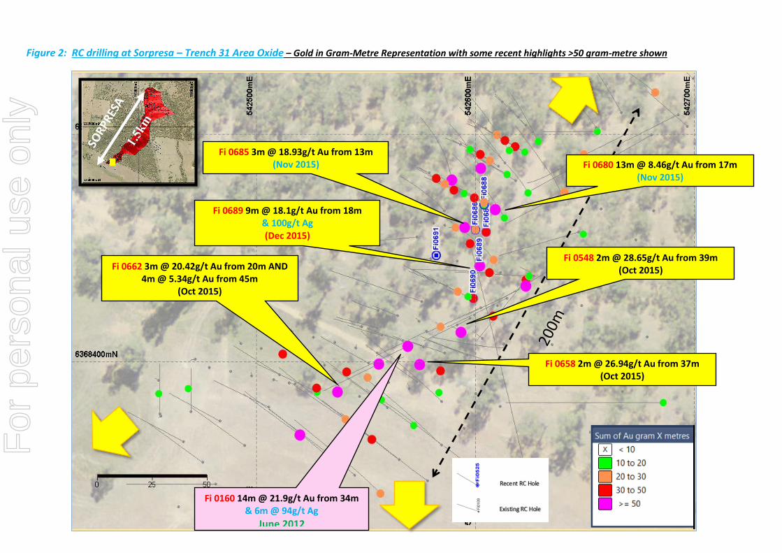
Figure 2: RC drilling at Sorpresa – Trench 31 Area Oxide – Gold in Gram-Metre Representation with some recent highlights >50 gram-metre shown
Fi 0680 13m @ 8.46g/t Au from 17m (Nov 2015)
Fi 0685 3m @ 18.93g/t Au from 13m (Nov 2015)
Fi 0662 3m @ 20.42g/t Au from 20m AND 4m @ 5.34g/t Au from 45m
(Oct 2015)
Fi 0658 2m @ 26.94g/t Au from 37m (Oct 2015)
Fi 0548 2m @ 28.65g/t Au from 39m (Oct 2015)
Fi 0689 9m @ 18.1g/t Au from 18m & 100g/t Ag (Dec 2015)
Fi 0160 14m @ 21.9g/t Au from 34m & 6m @ 94g/t Ag
June 2012
For
per
sona
l use
onl
y
8
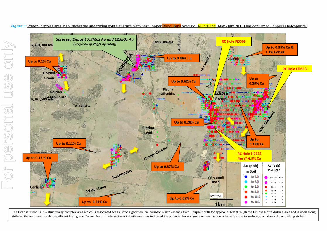
Figure 3: Wider Sorpresa area Map, shows the underlying gold signature, with best Copper Rock Chips overlaid. RC drilling (May~July 2015) has confirmed Copper (Chalcopyrite)
The Eclipse Trend is in a structurally complex area which is associated with a strong geochemical corridor which extends from Eclipse South for approx 3.0km through the Eclipse North drilling area and is open along
strike to the north and south. Significant high grade Cu and Au drill intersections in both areas has indicated the potential for ore grade mineralisation relatively close to surface, open down dip and along strike.
Golden Green
Golden Green South
Glen Iris
Jacks Lookout
Platina Lead
Platina Gillenbine
Carlisle
Twin Shafts
Yarrabandi Road
Up to 0.35% Cu & 1.1% Cobalt
Up to 0.29% Cu Up to 0.62% Cu
Up to 0.11% Cu
Up to 0.16 % Cu
Up to 0.03% Cu Up to 0.33% Cu
Up to 0.1% Cu Up to 0.04% Cu
Up to 0.37% Cu Au (ppb) in Auger
1km
Up to 0.13% Cu
Up to 0.28% Cu
RC Hole Fi0563
RC Hole Fi0588 4m @ 6.5% Cu
RC Hole Fi0569
Eclipse
Group
Sorpresa Deposit 7.9Moz Ag and 125kOz Au (0.5g/t Au @ 25g/t Ag cutoff)
For
per
sona
l use
onl
y

9
Hole IDEasting
(m GDA94)
Northing
(m GDA94)
Survey
Base
RL
(mAHD)
Dip
(°)
GDA
Azimuth
(°)
Depth
(m)
Drilling
TypeProspect
From
(m)
To
(m)
Down
hole
Length
(m)
Au
(g/t)
Ag
(g/t)
Fi0686 542600 6368458 GPS 292 -90 0 36 RC Trench 31 16 18 2 2.05 138
and 24 29 5 3.64 6
incl. 25 26 1 8.79 4
and 29 30 1 0.25 4
Fi0687 542605 6368457 GPS 292 -90 0 38 RC Trench 31 4 16 12 0.13 Nil
and 20 27 7 6.80 9
incl. 20 22 2 14.85 16
and 27 30 3 0.35 4
Fi0688 542604 6368469 GPS 292 -90 0 33 RC Trench 31 2 14 12 0.27 Nil
and 14 17 3 0.67 5
and 19 20 1 1.62 1
and 22 26 4 2.29 4
incl. 22 23 1 7.45 10
and 26 27 1 0.32 2
Fi0689 542602 6368442 GPS 292 -90 0 57 RC Trench 31 18 27 9 18.15 100
incl. 18 19 1 16.75 140
incl. 19 20 1 6.45 448
incl. 20 21 1 69.00 254
incl. 21 22 1 15.35 23
incl. 24 25 1 38.60 10
incl. 25 26 1 11.40 5
and 27 29 2 0.20 3
and 35 36 1 0.78 1
Fi0690 542599 6368428 GPS 292 -90 0 52 RC Trench 31 12 18 6 0.15 2
and 18 26 8 4.62 4
incl. 23 24 1 6.69 9
incl. 24 25 1 24.10 9
Fi0691 542582 6368447 GPS 292 -90 0 36 RC Trench 31 0 3 3 0.31 nil
and 3 5 2 2.20 1
Table 2: Assay Results from recent RC drilling at Sorpresa – Trench 31 Area Oxide
Note: Intersections calculated on >0.1 g/t Au with <2m internal dilution. Samples taken as 1m composites
For
per
sona
l use
onl
y
10
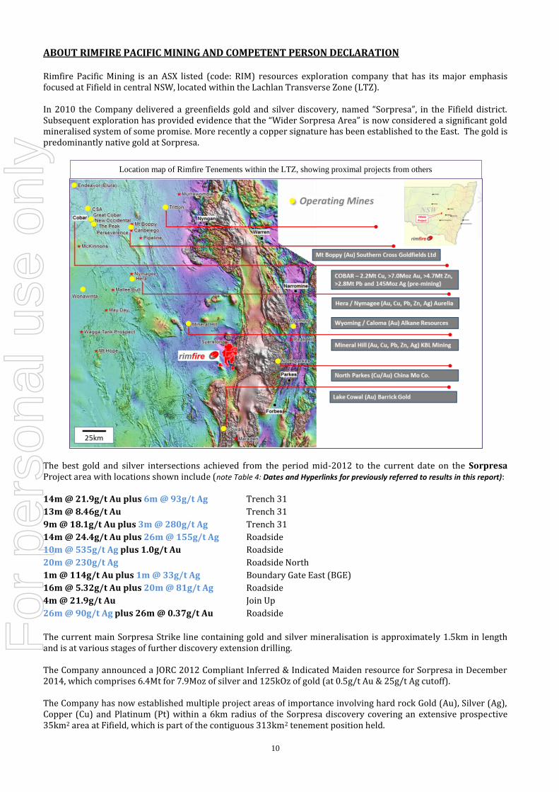
ABOUT RIMFIRE PACIFIC MINING AND COMPETENT PERSON DECLARATION Rimfire Pacific Mining is an ASX listed (code: RIM) resources exploration company that has its major emphasis focused at Fifield in central NSW, located within the Lachlan Transverse Zone (LTZ). In 2010 the Company delivered a greenfields gold and silver discovery, named “Sorpresa”, in the Fifield district. Subsequent exploration has provided evidence that the “Wider Sorpresa Area” is now considered a significant gold mineralised system of some promise. More recently a copper signature has been established to the East. The gold is predominantly native gold at Sorpresa.
The best gold and silver intersections achieved from the period mid-2012 to the current date on the Sorpresa Project area with locations shown include (note Table 4: Dates and Hyperlinks for previously referred to results in this report): 14m @ 21.9g/t Au plus 6m @ 93g/t Ag Trench 31
13m @ 8.46g/t Au Trench 31
9m @ 18.1g/t Au plus 3m @ 280g/t Ag Trench 31
14m @ 24.4g/t Au plus 26m @ 155g/t Ag Roadside
10m @ 535g/t Ag plus 1.0g/t Au Roadside
20m @ 230g/t Ag Roadside North
1m @ 114g/t Au plus 1m @ 33g/t Ag Boundary Gate East (BGE)
16m @ 5.32g/t Au plus 20m @ 81g/t Ag Roadside
4m @ 21.9g/t Au Join Up
26m @ 90g/t Ag plus 26m @ 0.37g/t Au Roadside
The current main Sorpresa Strike line containing gold and silver mineralisation is approximately 1.5km in length and is at various stages of further discovery extension drilling. The Company announced a JORC 2012 Compliant Inferred & Indicated Maiden resource for Sorpresa in December 2014, which comprises 6.4Mt for 7.9Moz of silver and 125kOz of gold (at 0.5g/t Au & 25g/t Ag cutoff). The Company has now established multiple project areas of importance involving hard rock Gold (Au), Silver (Ag), Copper (Cu) and Platinum (Pt) within a 6km radius of the Sorpresa discovery covering an extensive prospective 35km2 area at Fifield, which is part of the contiguous 313km2 tenement position held.
Location map of Rimfire Tenements within the LTZ, showing proximal projects from others
For
per
sona
l use
onl
y

11
The latest presentations on the Company are at hyperlinks: Rimfire CEO Presentation - AGM 27 November 2015 – John Kaminsky
Benchmarking - AGM 27 November 2015 – Richard Schodde
Resources Industry Presentation trends in Investment – AGM 27 November 2015 – Hedley Widdup
A 3D Exploration Model, as at May 2014, depicting gold mineralisation at Sorpresa with a description of the RC drill program goals at that time is available as a video by hyperlink: Click Here.
Regional Prospects within 6km Radius of Sorpresa Project Area at Fifield Prioritized current prospects and targets within 6kms of Sorpresa are being systematically assessed. Rimfire interprets a rift basin setting at Fifield, Back Arc to the World Class Macquarie Arc, and traversed by the crustal scale Lachlan Transverse Zone (LTZ) and cross cut by other major crustal structures, which is host to multiple styles of significant mineralisation, with combined multimillion ounce gold equivalent potential. To date more than 30 targets are revealed at Fifield.
The prospect pyramid below ranks these prospects which are grouped into 7 manageable “Target Domains”, for gold and base metals, in terms of their logistical, spatial, deposit style and exploration stage; Rimfire Prospect Pyramid illustrated at increasing stages of advancement from Conceptual targets, Emerging and Advanced Geochemical Anomalies, Prospects with High Grade intersections, and Advanced Targets, and a Resource at Sorpresa. 1. Sorpresa (Carbonate Base Metal Epithermal Au/Ag) – Roadside North, Roadside, Original Sorpresa
2. Sorpresa (Carbonate Base Metal Epithermal Au) – Join-Up, Boundary Gate, Boundary Gate East, Trench 31
3. Eclipse Trend (Au-Copper, VMS / Epithermal) – McConnell’s, Transit, Eclipse North, Eclipse, Eurimbla,
Golden Chrome, Roseneath, Watt’s Lane, Carlisle.
4. Yoes Lookout (Skarn style and Structurally controlled Greenstone and Sediment hosted Au, possible
Porpyhry Cu-Au target style)
5. Orogenics (Structurally controlled Greenstone and Sediment hosted Au)- Golden Green, Golden Green
South, Twin Shafts, Rabbit Hill, Golden Green East.
6. Sorpresa Extensions – Sorpresa North, Quartzite Hill, Fifield Lead, Southern Gravity, Red Mist
7. Conceptual – Jack’s Lookout, Gravity Gradient, Raggatt Volcanics, Glen Iris,
Work programs are at various stages of development on the prospects.
For
per
sona
l use
onl
y

12
Table 3: Ranked Prospect Portfolio at Fifield NSW
Company Strategy
The Company has committed to pursue a prospect portfolio strategy of developing the regional prospects at Fifield to suitable stages, in parallel with the Sorpresa project area to achieve outcomes as follows: Enhance and highlight the Fifield district’s appeal to deliver more discoveries within 6km radius of Sorpresa
Metals being pursued include Gold, Silver, Copper and Platinum
Ensure the Company has the opportunity to make the best discoveries possible in its prospect portfolio
Continue discovery growth at Sorpresa, looking for important contributions in the next phases of drilling
Grow the maiden resource at Sorpresa (23 Dec 2014), currently published as inferred and indicated
comprising 6.4Mt for 7.9Moz of silver and 125kOz of gold (at 0.5g/t Au & 25g/t Ag cutoff)
Examine economic potential, as appropriate to the stage of the project area
Competent Persons Declarations The information in the report to which this statement is attached that relates to Exploration and Resource Results is based
on information reviewed and compiled by Colin Plumridge who is deemed to be a Competent Person and is a Member of
The Australasian Institute of Mining and Metallurgy.
Mr Plumridge has over 45 years’ experience in the mineral and mining industry. Mr Plumridge is employed by Plumridge
& Associates Pty. Ltd. and is a consulting geologist to the Company. Colin Plumridge has sufficient experience that is
relevant to the style of mineralisation and type of deposit under consideration and to the activity being undertaken to
qualify as a Competent Person as defined in the 2012 Edition of the ‘Australasian Code for Reporting of Exploration
Results, Mineral Resources and Ore Reserves’. Colin Plumridge has previously consented to the inclusion of the matters
based on the information in the form and context in which it appears.
Historic information and previously published material under 2004 JORC standard that is referenced in this report:
The information provided in “About Rimfire Pacific Mining” is extracted from the reports entitled and listed in the table
below created on the dates shown and is available to view additionally on the Company Website at hyperlink: ASX
Announcements. The company confirms that it is not aware of any new information or data that materially affects the
information included in the original market announcements.
In addition, the Company confirms that the form and context in which the Competent Person’s findings are presented have
not been materially modified from the original market announcements which operated under the 2004 JORC reporting
For
per
sona
l use
onl
y

13
requirements. Mr Colin Plumridge as a Competent Person consented to the inclusion in the original reports in the form
and context in which each appeared, please refer to the Competent Persons declaration above for additional information.
Table 4 Dates and Hyperlinks for previously referred to results in this report
ASX November 9th
2007 Golden Green Gold Prospect Returns Encouraging Assay
ASX July 25th
2008 Quarterly Report For the period April 1st to June 30
th 2008
ASX March 30th
2012 Coherent Gold geochemistry at Yoes Lookout Confirmed – Fifield NSW
ASX September 17th
2012 First Gold Sections Created at Sorpresa Project, Fifield NSW
ASX June 13th
2012 High Grade Gold Intersection Sorpresa Project – Fifield NSW
ASX July 26th
2012 Successful Intersections at Sorpresa Gold Project
ASX October 10th
2012 Highest Gold and Silver Grades seen to date at Sorpresa Project
ASX December 18th
2012 Sorpresa Project Produces More Encouraging Results
ASX March 27th
2013 Additional Assays at Sorpresa Gold Project
ASX June 13th
2013 Further Positive RC Drilling Results at Sorpresa Project
ASX July 17th
2013 Diamond Drilling Reveals Bonanza Grade of 1m @ 114g/t Au
ASX October 21st 2013 Results Confirm Extensions of Gold and Silver at Sorpresa Project
ASX December 20th
2013 High Grade Silver extensions continue at Roadside
ASX February 14th
2014 Gold Intersections Confirm New Intersections at Sorpresa
ASX May 16th
May 2014 4,000m RC Drilling Program at Sorpresa Project – Regional Intersection 2m @ 9.11g/t Gold
ASX May 30th
May 2014 Drilling Update and 3D Exploration Model for Sorpresa Project – 2m @ 7.49g/t Gold intersected
ASX July 23rd
2014 Encouraging Regional Rock Chip Results up to 13.7g/t Gold, Fifield NSW
ASX August 18th
2014 New High Grade Rock Chip Results up to 23g/t Au at Fifield NSW
ASX August 26th
2014 Sorpresa Gold and Silver Mineralisation Extended at Fifield, NSW
ASX November 28th
2014 Encouraging Gold Results Intersected in New Shallow Oxide Position at Sorpresa
ASX December 8th
2014 High Grades Intersected in Sorpresa Resource Definition Drilling
ASX December 23rd
2014 Sorpresa Maiden Resource Fifield NSW – 6.4Mt for 125kOz of gold and 7.9Moz of silver
ASX January 30th
2015 December Quarter Exploration Report
ASX February 20th
2015 Sorpresa RC Drilling Assays Finalised, New RC Drilling underway to extend mineralisation
ASX February 23rd
2015 Gold Intersections confirmed from Surface at Carlisle, Fifield NSW
ASX 23rd
March 2015 Encouraging Results including 2m @ 10.09g/t Gold Intersected at Sorpresa
ASX 13th
April 2015 Skarn style mineralisation intersected with Copper Anomalism at Yoes Lookout Prospect
ASX 20th
May 2015 Yoes Area Assays confirm Copper Anomalism with Gold Present
ASX 16th
June 2015 RC Drill Assays Confirm Copper Anomalism and Gold at Eclipse Trend
ASX 23rd
July2015 4m @ 6.5% Cu and 2.3g/t Au Massive Chalcopyrite at Eclipse
ASX 26th
August 2015 Sorpresa Drilling Continues best intersection of 14m @ 5.24g/t gold & 156g/t silver from 21m
ASX 20th
October 2015 Sorpresa Drilling - Best Intersection of 3m @ 20.42g/t Au AND 4m @ 5.34g/t Au
ASX 20th
November 2015 Sorpresa Drilling gives 13m @ 8.46g/t gold (incl. 2m @ 31.35g/t) at shallow depths
For
per
sona
l use
onl
y
14
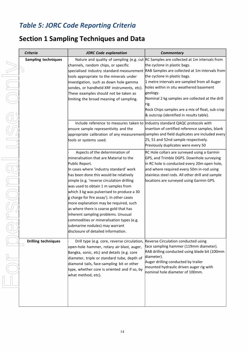
Table 5: JORC Code Reporting Criteria
Section 1 Sampling Techniques and Data
Criteria JORC Code explanation Commentary
Sampling techniques ∙ Nature and quality of sampling (e.g. cut
channels, random chips, or specific
specialised industry standard measurement
tools appropriate to the minerals under
investigation, such as down hole gamma
sondes, or handheld XRF instruments, etc).
These examples should not be taken as
limiting the broad meaning of sampling.
RC Samples are collected at 1m intervals from
the cyclone in plastic bags.
RAB Samples are collected at 1m intervals from
the cyclone in plastic bags.
1 metre intervals are sampled from all Auger
holes within in situ weathered basement
geology.
Nominal 2 kg samples are collected at the drill
rig.
Rock Chips samples are a mix of float, sub crop
& outcrop (identified in results table).
∙ Include reference to measures taken to
ensure sample representivity and the
appropriate calibration of any measurement
tools or systems used.
Industry standard QAQC protocols with
insertion of certified reference samples, blank
samples and field duplicates are included every
25, 51 and 52nd sample respectively.
Previously duplicates were every 50
· Aspects of the determination of
mineralisation that are Material to the
Public Report.
In cases where ‘industry standard’ work
has been done this would be relatively
simple (e.g. ‘reverse circulation drilling
was used to obtain 1 m samples from
which 3 kg was pulverised to produce a 30
g charge for fire assay’). In other cases
more explanation may be required, such
as where there is coarse gold that has
inherent sampling problems. Unusual
commodities or mineralisation types (e.g.
submarine nodules) may warrant
disclosure of detailed information.
RC Hole collars are surveyed using a Garmin
GPS, and Trimble DGPS. Downhole surveying
in RC hole is conducted every 20m open hole,
and where required every 50m in-rod using
stainless steel rods. All other drill and sample
locations are surveyed using Garmin GPS.
Drilling techniques ∙ Drill type (e.g. core, reverse circulation,
open‐hole hammer, rotary air blast, auger,
Bangka, sonic, etc) and details (e.g. core
diameter, triple or standard tube, depth of
diamond tails, face‐sampling bit or other
type, whether core is oriented and if so, by
what method, etc).
Reverse Circulation conducted using face sampling hammer (119mm diameter).
RAB drilling conducted using blade bit (100mm diameter).
Auger drilling conducted by trailer mounted hydraulic driven auger rig with nominal hole diameter of 100mm.
For
per
sona
l use
onl
y
15
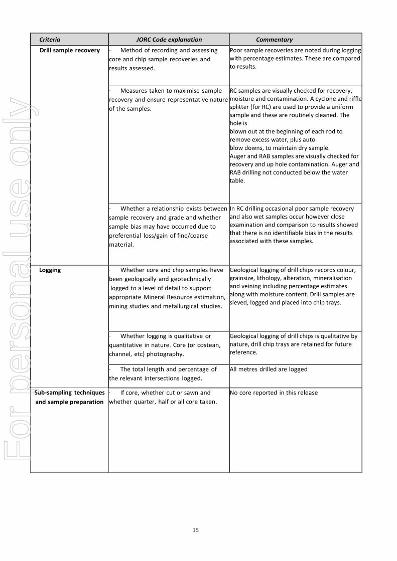
Criteria JORC Code explanation Commentary
Drill sample recovery ∙ Method of recording and assessing
core and chip sample recoveries and
results assessed.
Poor sample recoveries are noted during logging with percentage estimates. These are compared to results.
∙ Measures taken to maximise sample
recovery and ensure representative nature
of the samples.
RC samples are visually checked for recovery, moisture and contamination. A cyclone and riffle splitter (for RC) are used to provide a uniform sample and these are routinely cleaned. The hole is
blown out at the beginning of each rod to remove excess water, plus auto‐ blow downs, to maintain dry sample.
Auger and RAB samples are visually checked for recovery and up hole contamination. Auger and RAB drilling not conducted below the water table.
∙ Whether a relationship exists between
sample recovery and grade and whether
sample bias may have occurred due to
preferential loss/gain of fine/coarse
material.
In RC drilling occasional poor sample recovery and also wet samples occur however close examination and comparison to results showed that there is no identifiable bias in the results associated with these samples.
Logging ∙ Whether core and chip samples have
been geologically and geotechnically
logged to a level of detail to support
appropriate Mineral Resource estimation,
mining studies and metallurgical studies.
Geological logging of drill chips records colour, grainsize, lithology, alteration, mineralisation and veining including percentage estimates along with moisture content. Drill samples are sieved, logged and placed into chip trays.
∙ Whether logging is qualitative or
quantitative in nature. Core (or costean,
channel, etc) photography.
Geological logging of drill chips is qualitative by nature, drill chip trays are retained for future reference.
∙ The total length and percentage of
the relevant intersections logged.
All metres drilled are logged
Sub‐sampling techniques
and sample preparation
∙ If core, whether cut or sawn and
whether quarter, half or all core taken.
No core reported in this release
For
per
sona
l use
onl
y

16
Criteria JORC Code explanation Commentary
Sub‐sampling techniques
and sample preparation
continued.
∙ If non‐core, whether riffled, tube
sampled, rotary split, etc and whether
sampled wet or dry.
Reported RC results have been riffle split. Lower priority RC intervals are speared samples and if found to be anomalous will be subsequently riffle split and re-assayed. Wet samples are not put through riffle splitter but homogenized and subsampled using small spear. Sample returned from 1 metre RAB interval is homogenized and speared and composited and maximum composite interval within significant intersection is provided with result. Sample returned from 1 metre auger interval is homogenized in collection tray and speared. All RAB and Auger samples were dry. Rock Chips are sawn in half with half submitted for analysis.
∙ For all sample types, the nature,
quality and appropriateness of the
sample preparation technique.
∙
Sub‐samples obtained from riffle splitting are
submitted as 1m intervals or composited to 2m
(equal weights) to produce a bulk 2kg sample,
subsamples of occasional wet metres are
composited similarly. Lower priority zones are
speared and composited on 4m intervals. The
homogenization and spearing method
is typical for sampling RAB and auger returns
and QAQC results identify that the methods
used are appropriate to the style of
mineralisation.
Quality control procedures adopted for
all sub‐sampling stages to maximise
representivity of samples.
Industry standard QAQC protocols with insertion of certified reference samples, blank samples and field duplicates are included every 50, 51 and 52nd sample respectively. No wet samples are put through the riffle splitter which is checked between samples and cleaned (when necessary) between samples. Equal weights (estimated from equal volumes) are collected for composited intervals.
Measures taken to ensure that the
sampling is representative of the in situ
material collected, including for instance
results for field duplicate/second-half
sampling.
QAQC results of field duplicate analysis identify
that the methods used are appropriate to the
style of mineralisation.
· Whether sample sizes are appropriate
to the grain size of the material being
sampled.
QAQC results of field duplicate analysis identify
that the methods used are appropriate to the
style of mineralisation.
For
per
sona
l use
onl
y

17
Criteria JORC Code explanation Commentary
Quality of assay data and
laboratory tests
∙ The nature, quality and
appropriateness of the assaying
and laboratory procedures used
and whether the technique is
considered partial or total.
Reported RC samples are dispatched to ALS Laboratories
with Au determined by Au_AA26.
RAB and Auger samples are dispatched to ALS
Laboratories with Au determined by fire assay methods
Au-AA22 (or PGM-ICP24) which returns Au to 2ppb (or 1
ppb) respectively, PGM-ICP24 includes Pt to 5 ppb and Pd
to 1 ppb on a 50g charge. Selected auger samples were
also submitted for full suite multi‐element analysis are
via Four Acid Digest method ME‐MS61.
Rock chip samples are submitted to ALS Laboratories for
Au via Fire Assay method Au-AA22 to 2 ppb and full suite
multi‐element analysis are via Four Acid Digest method
ME‐MS61.
Fire Assay analysis for gold and Four Acid digest for
multielement analysis are considered as total techniques
in the absence of coarse metal. Screen Fire Assay for gold
is considered as total technique when coarse gold is
present.
∙ For geophysical tools,
spectrometers, handheld XRF
instruments (fpXRF), etc, the
parameters used in determining
the analysis including instrument
make and model, reading times,
calibrations factors applied and
their derivation, etc.
All significant results reported from NATA accredited
laboratory.
Handheld XRF (fpXRF) (Olympus Delta50) is used to
determine sample character and type applied to 1m riffle
split or composite. All data is collected using a 30
seconds reading time (this is sometimes modified to
15secs, if stable readings are achievable) for each of the
3 beams in soil mode. XRF analysis is typically applied to
a single point on the sample bag of interest. Results may
be cross checked with additional XRF readings, including
further subsamples. The known limitations of XRF,
particularly element strengths and weaknesses, are
considered. XRF is a scoping and order of magnitude
tool, the Company is an expert user of XRF. Trends and
comparisons in XRF readings are examined. Laboratory
assays may be sought for further validation. XRF results
are considered as guidance for subsequent laboratory
assay
∙ Nature of quality control
procedures adopted (e.g.
standards, blanks, duplicates,
external laboratory checks) and
whether acceptable levels of
accuracy (i.e. lack of bias) and
precision have been established.
Reviews of internal QAQC results has shown that the
field sampling, riffle splitting compositing methods used
are appropriate to the mineralisation being tested.
External laboratory analysis of "umpire" samples confirm
results from the primary laboratory. For
per
sona
l use
onl
y

18
Criteria JORC Code explanation Commentary
Verification of sampling and assaying
∙ The verification of significant
intersections by either independent or
alternative company personnel.
All reported intersections are independently
reviewed by 2 company personnel
∙ The use of twinned holes. Hole Twinning when used, is reported.
∙ Documentation of primary data, data
entry procedures, data verification, data
storage (physical and electronic) protocols.
Primary field data is captured electronically
using established templates. Assay data
from laboratory is merged and loaded into
Access based database after passing QAQC
checks. Database audit of loaded batches is
conducted on a monthly basis.
∙ Discuss any adjustment to assay
data.
“<” values are converted
into “-“ values and for geochemical analysis results returning less than detection are ascribed to half the detection limit.
Location of data points ∙ Accuracy and quality of surveys used to
locate drill holes (collar and down‐ hole
surveys), trenches, mine workings and other
locations used in Mineral Resource
estimation.
Drill collars are located using handheld Garmin GPS and are RC collars are picked up by a Trimble Differential GPS.
Downhole digital multi‐shot surveys are conducted every 20m, open hole where practical, or in stainless steel rods every 50m.
Specification of the grid system used. GDA94 zone55
∙ Quality and adequacy of
topographic control.
Collar elevation data from digital terrain model derived from detailed ground gravity survey DGPS data used as an interim measure prior to DGPS pick up of collar location. Other elevation data sourced from handheld GPS.
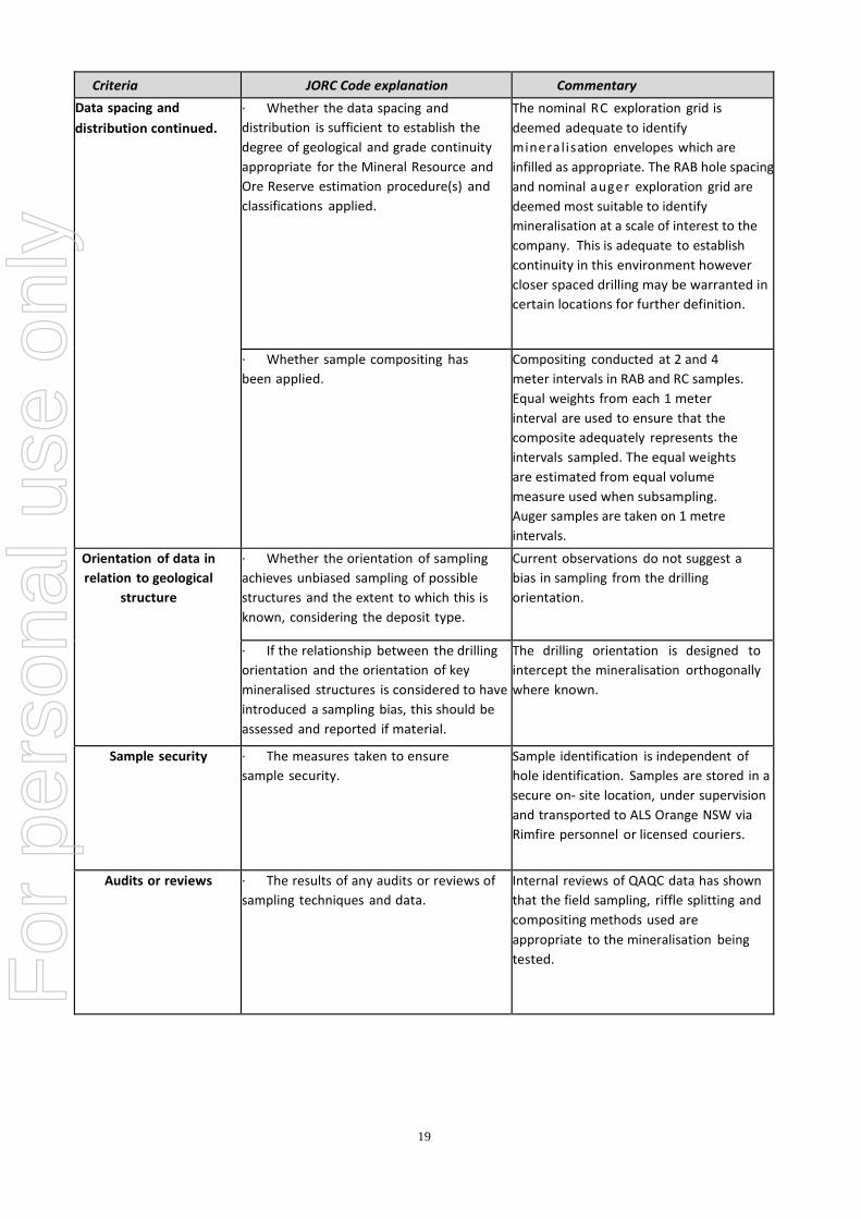
Data spacing and distribution
∙ Data spacing for reporting of
Exploration Results.
RC Exploration was on nominal 80 X
100m grid down to 40 X 40m grid and
then down to 20 X 20m grid, or as
described.
RAB exploration conducted on traverses
with coverage on 60 ° dipping holes.
Auger exploration currently on a nominal
100 X 20m grid or as described. Rock
Chip samples not on a defined grid
pattern.
For
per
sona
l use
onl
y
19
Criteria JORC Code explanation Commentary
Data spacing and
distribution continued.
∙ Whether the data spacing and
distribution is sufficient to establish the
degree of geological and grade continuity
appropriate for the Mineral Resource and
Ore Reserve estimation procedure(s) and
classifications applied.
The nominal RC exploration grid is
deemed adequate to identify
mineralisation envelopes which are
infilled as appropriate. The RAB hole spacing
and nominal auger exploration grid are
deemed most suitable to identify
mineralisation at a scale of interest to the
company. This is adequate to establish
continuity in this environment however
closer spaced drilling may be warranted in
certain locations for further definition.
∙ Whether sample compositing has
been applied.
Compositing conducted at 2 and 4
meter intervals in RAB and RC samples.
Equal weights from each 1 meter
interval are used to ensure that the
composite adequately represents the
intervals sampled. The equal weights
are estimated from equal volume
measure used when subsampling.
Auger samples are taken on 1 metre
intervals.
Orientation of data in
relation to geological
structure
∙ Whether the orientation of sampling
achieves unbiased sampling of possible
structures and the extent to which this is
known, considering the deposit type.
Current observations do not suggest a
bias in sampling from the drilling
orientation.
∙ If the relationship between the drilling
orientation and the orientation of key
mineralised structures is considered to have
introduced a sampling bias, this should be
assessed and reported if material.
The drilling orientation is designed to
intercept the mineralisation orthogonally
where known.
Sample security ∙ The measures taken to ensure
sample security.
Sample identification is independent of
hole identification. Samples are stored in a
secure on‐ site location, under supervision
and transported to ALS Orange NSW via
Rimfire personnel or licensed couriers.
Audits or reviews ∙ The results of any audits or reviews of
sampling techniques and data.
Internal reviews of QAQC data has shown
that the field sampling, riffle splitting and
compositing methods used are
appropriate to the mineralisation being
tested.
For
per
sona
l use
onl
y

20
Section 2 Reporting of Exploration Results
Criteria JORC Code explanation Commentary
Mineral tenement and
land tenure status
∙ Type, reference name/number,
location and ownership including
agreements or material issues with
third parties such as joint ventures,
partnerships, overriding royalties,
native title interests, historical sites,
wilderness or national park and
environmental settings.
Reported results all from 100% Rimfire Pacific
Mining NL tenements at Fifield NSW, which may
include EL5534, EL6241, EL7058, EL7959, EL5565,
MC(L)305, MC(L)306.
All samples were taken on Private Freehold and /
or Common Land (prescribed for mining).
No native title exists.
The land is used primarily for grazing and
cropping.
∙ The security of the tenure held at the
time of reporting along with any
known impediments to obtaining a
license to operate in the area.
The tenement is in good standing, and all work is
conducted under specific approvals from NSW
Trade and Investment, Mineral Resources.
Exploration done by other parties
∙ Acknowledgment and appraisal
of exploration by other parties.
Recent systematic exploration (1980 onwards)
has been conducted by Ausplat Minerals NL in
JV with Golden Shamrock Mines Ltd and Mount
Gipps Ltd, Titan Resources and also Helix
Resources and Black Range Minerals NL. Prior
to this Exploration for various metals in the
Fifield area has been conducted by a number of
companies since the late 1960's including
Anaconda, CRA Exploration Pty Ltd, Platina
Developments NL, Mines Search Pty Ltd, Broken
Hill Proprietary Company Ltd, Mt Hope Minerals
and Shell.
Geology ∙ Deposit type, geological setting
and style of mineralisation.
The mineralisation currently being pursued at
Sorpresa appears to have many similarities with
typical carbonate base metal epithermal gold
style, in a Siluro Devonian back arc basin setting.
Other mineralisation styles include sediment and
greenstone hosted orogenic gold and VMS.
Drill hole Information ∙ A summary of all information
material to the understanding of the
exploration results including a
tabulation of the following
information for all Material drill holes:
Plans showing location of drill holes and also
location of significant results and interpreted
trends are provided in the figures of report.
Any new significant RC results are provided in
tables within the report.
Any new significant RAB results are provided in
tables in within the report.
easting and northing of the drill hole
collar
elevation or RL (Reduced Level –
elevation above sea level in metres) of
the drill hole collar
For
per
sona
l use
onl
y

21
Criteria JORC Code explanation Commentary
Drill hole Information
Continued.
dip and azimuth of the hole Any new significant rock chip results are
provided in tables within the report.
Any new significant Auger results are provided
in figures within the report.
down hole length and interception
depth
∙ If the exclusion of this
information is justified on the basis
that the information is not Material
and this exclusion does not detract
from the understanding of the
report, the Competent Person
should clearly explain why this is the
case.
Information is provided in significant results
tables.
Data aggregation methods ∙ In reporting Exploration Results,
weighting averaging techniques,
maximum and/or minimum grade
truncations (e.g. cutting of high
grades) and cut‐off grades are
usually
Material and should be stated.
No averaging or cut-off values are applied to
auger or rock chip results. Only significant RAB
results >0.1g/t Au are reported using thickness
weighted average for intervals with < or = 2m
internal dilution. For RC results thickness
weighted averages are reported for all
intervals. Reported intervals are calculated
using ≥ 0.1g/t Au and or ≥ 10g/t Ag cut off and
≤ 2m Internal Dilution.
∙ Where aggregate intercepts
incorporate short lengths of high
grade results and longer lengths
of low grade results, the
procedure used for such
aggregation should be stated and
some typical examples of such
aggregations should be shown in
detail.
High grade intervals within in larger
intersections are reported as included intervals
and noted in results table. Aggregation utilises
thickness weighted mean calculations.
∙ The assumptions used for any
reporting of metal equivalent
values should be clearly stated.
Metal equivalents are not reported.
Relationship between
mineralisation widths and
intercept lengths
∙ These relationships are
particularly important in the
reporting of Exploration Results.
Drill holes are designed to intersect the plane of
mineralisation (where this is known) at 90° so
that reported intersections represent true
thickness.
· If the geometry of the
mineralisation with respect to the
drill hole angle is known, its nature
should be reported. If it is not known
and only the down hole lengths are
reported, there should be a clear
statement to this effect (e.g. ‘down
hole length, true width not known’).
All intersections are subsequently presented as
downhole lengths. If down hole length varies
significantly from known true width then
appropriate notes are provided.
For
per
sona
l use
onl
y

22
Criteria JORC Code explanation Commentary
Diagrams ∙ Appropriate maps and sections
(with scales) and tabulations of
intercepts should be included for
any significant discovery being
reported These should include, but
not be limited to a plan view of drill
hole collar locations and
appropriate sectional views.
Refer to Figures
Balanced reporting ∙ Where comprehensive
reporting of all Exploration Results
is not practicable, representative
reporting of both low and high
grades and/or widths should be
practiced to avoid misleading
reporting of Exploration Results.
This information is provided in results Table and comments in the report.
Other substantive
exploration data
∙ Other exploration data, if
meaningful and material, should be
reported including (but not limited
to): geological observations;
geophysical survey results;
geochemical survey results; bulk
samples – size and method of
treatment; metallurgical test results;
bulk density, groundwater,
geotechnical and rock
characteristics; potential deleterious
or contaminating substances.
There is currently no other substantive
exploration data that is meaningful and material
to report, beyond that reported already, in this or
previous reports.
Further work ∙ The nature and scale of
planned further work (e.g. tests for
lateral extensions or depth
extensions or large‐scale step‐out
drilling).
Further work is discussed in the document in
relation to the exploration results.
∙ Diagrams clearly highlighting the
areas of possible extensions,
including the main geological
interpretations and future drilling
areas, provided this information is
not commercially sensitive.
Refer to Figures
For
per
sona
l use
onl
y