Highlights - Rolta · Highlights New Features in Rolta Geomatica 2017 1 New: Rolta Geomatica Object...
5
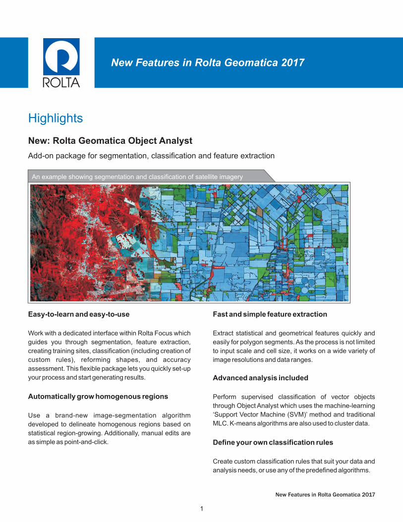
Highlights New Features in Rolta Geomatica 2017 1 New: Rolta Geomatica Object Analyst Add-on package for segmentation, classification and feature extraction New Features in Rolta Geomatica 2017 An example showing segmentation and classification of satellite imagery Easy-to-learn and easy-to-use Work with a dedicated interface within Rolta Focus which guides you through segmentation, feature extraction, creating training sites, classification (including creation of custom rules), reforming shapes, and accuracy assessment. This flexible package lets you quickly set-up your process and start generating results. Automatically grow homogenous regions Use a brand-new image-segmentation algorithm developed to delineate homogenous regions based on statistical region-growing. Additionally, manual edits are as simple as point-and-click. Fast and simple feature extraction Extract statistical and geometrical features quickly and easily for polygon segments. As the process is not limited to input scale and cell size, it works on a wide variety of image resolutions and data ranges. Advanced analysis included Perform supervised classification of vector objects through Object Analyst which uses the machine-learning ‘Support Vector Machine (SVM)’ method and traditional MLC. K-means algorithms are also used to cluster data. Define your own classification rules Create custom classification rules that suit your data and analysis needs, or use any of the predefined algorithms.
Transcript of Highlights - Rolta · Highlights New Features in Rolta Geomatica 2017 1 New: Rolta Geomatica Object...
Highlights
New Features in Rolta Geomatica 2017
1
New: Rolta Geomatica Object Analyst
Add-on package for segmentation, classification and feature extraction
New Features in Rolta Geomatica 2017
An example showing segmentation and classification of satellite imagery
Easy-to-learn and easy-to-use
Work with a dedicated interface within Rolta Focus which
guides you through segmentation, feature extraction,
creating training sites, classification (including creation of
custom rules), reforming shapes, and accuracy
assessment. This flexible package lets you quickly set-up
your process and start generating results.
Automatically grow homogenous regions
Use a brand-new image-segmentation algorithm
developed to delineate homogenous regions based on
statistical region-growing. Additionally, manual edits are
as simple as point-and-click.
Fast and simple feature extraction
Extract statistical and geometrical features quickly and
easily for polygon segments. As the process is not limited
to input scale and cell size, it works on a wide variety of
image resolutions and data ranges.
Advanced analysis included
Perform supervised classification of vector objects
through Object Analyst which uses the machine-learning
‘Support Vector Machine (SVM)’ method and traditional
MLC. K-means algorithms are also used to cluster data.
Define your own classification rules
Create custom classification rules that suit your data and
analysis needs, or use any of the predefined algorithms.
Highlights
2
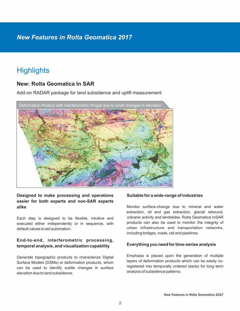
New: Rolta Geomatica In SAR
Add-on RADAR package for land subsidence and uplift measurement
New Features in Rolta Geomatica 2017
Deformation Product with interferometric fringes due to small changes in elevation
Designed to make processing and operations
easier for both experts and non-SAR experts
alike
Each step is designed to be flexible, intuitive and
executed either independently or in sequence, with
default values to aid automation.
End-to-end, interferometric processing,
temporal analysis, and visualization capability
Generate topographic products to characterize Digital
Surface Models (DSMs) or deformation products, which
can be used to identify subtle changes in surface
elevation due to land subsidence.
Suitable for a wide-range of industries
Monitor surface-change due to mineral and water
extraction, oil and gas extraction, glacial rebound,
volcanic activity and landslides. Rolta Geomatica InSAR
products can also be used to monitor the integrity of
urban infrastructure and transportation networks,
including bridges, roads, rail and pipelines.
Everything you need for time-series analysis
Emphasis is placed upon the generation of multiple
layers of deformation products which can be easily co-
registered into temporally ordered stacks for long term
analysis of subsidence patterns.
New Features in Rolta Geomatica 2017
More Highlights
6
New Features in Rolta Geomatica 2017
Rolta Ortho Engine
Mosaicking
The 2017 release includes a number of updates within
Rolta OrthoEngine, all designed to make users more
productive and allow easier project management.
Project Overview
§Improved point display, image thumbnails and
reference image backdrops make it easier to see how
your project fits together.
Residual reports and editing
§New control over the information reports, along with
residual point classification tools improve quality
control for bundle adjustment and complement faster
model calculations.
Other improvements
§GCP import
§Kappa editing
§Project set-up
In Rolta Geomatica 2017, the MOS* mosaicking
functions and the Rolta Mosaic Tool include the capability
to mosaic multi-resolution data.
Aerotriangulation
DEM Editing
Sensor Support Updates
Improved tie-point collection
§New capabilities have been added to the automatic
tie-point collection which now collects more multi-ray
points that are better distributed over the imagery.
Point refinement
§Addition of new functions for blunder detection and
point thinning.
§Blunder detection and point thinning can be run prior
to the point refinement workflow.
Addition of new editing tools which includes the creation
and use of breaklines and stabilization points.
The following sensors are newly supported:
§PlanetScope: L3A/3B support including data
visualization and atmospheric correction
§TeLEOS-1: L1 /2 data v isua l iza t ion and
orthorectification support
§ZY3-2: TIFF/RPC full support
New Features in Rolta Geomatica 2017
4
New Features in Rolta Geomatica 2017
The following sensors have upgraded support:
§CBERS-4: Atmospheric correction now supported
§Pleiades: Additional support for “projected” product
type
§Rapid-Eye: Additional support for “Planet” version of
product, including new data levels
§Sentinel-2: Atmospheric correction now supported for
Level 1C
§TH-01: Pan-sharpening and DEM extraction now
supported
§Kompsat-5: New GeoTIFF distribution format
supported
The following sensors are suitable for InSAR
processing:
§Fully supported for interferogram generation and
analysis:
§RadarSat-2
§TerraSar-X
§Interferogram generation only:
§Cosmo-SkyMed
§Kompsat-5
§PALSAR-2
§TANDEM-X
New Features in Rolta Geomatica 2017
5
New Features in Rolta Geomatica 2017
New Features in Rolta Geomatica 2017
Details on improvements and new capabilities
The following functions have been added in Rolta
Geomatica 2017:
ADS functions
§ADSCOPYCORR: Copies model-correction terms
from one segment to another, specific to the Leica
Airborne Digital Sensor (ADS)
§ADSL0TOL1: Converts ADS products from Level 0 to
Level 1
DEM functions
§DEMADJUST: Raises or lowers a raster DEM so that
it better fits vector elevation reference points
§EPIPOLARDSM: Creates a raster Digital Surface
Model (DSM) from epipolar stereo pairs using the
Semi-Global Matching (SGM) method
InSAR functions
§INSADJUST: Adjusts interferometric phase for
baseline offset and orbital drift errors
§INSCALDEFO: Adjusts unwrapped displacement
values to zero at all points in a vector layer
§INSCOREG: Automatically co-registers and
resamples the dependent file to the reference file
§INSINFO: Generates a text file of the sensor and
interferometric parameters for the given reference
and the dependent file configuration(s)
§INSRAW: Produces the raw interferogram using the
specified reference file and the resampled dependent
file generated by the INSCOREG module
§INSSTACK: Converts a number of co-registered SAR
interferograms, or terrain displacement channels
derived from them, into a time-ordered stack of
interferometric phases, ground velocities or
displacements
§INSTOPO: Adjusts the phase of a raw interferogram
to compensate for flat earth and topographic effects
§INSUNWRAP: Unwraps phases o f SAR
interferograms using the open-source software
SNAPPHU
OrthoEngine functions
§OEBLUNDER: Automatically detects and removes
blunders in images, tie points and ground control
points in OrthoEngine project files
§OEPNTTHIN: Removes redundant tie points and
ground control points from OrthoEngine project files
§RECALC: Recomputes the math model of an existing
OrthoEngine project and writes the result to the
output OrthoEngine project file
§RMPROJ: Deletes an existing OrthoEngine project
file
As a standard part of any Rolta software release, we have
spent a great deal of time modifying the Rolta Geomatica
environment and its processes based on direct customer
feedback. Over 100 customer- requests have been
addressed in the Rolta Geomatica 2017 release.
User Feedback and Requests