ZONED PEGMATITES OF THE MICANITE DISTRICT FREMONT & PARK COUNTIES

1""
""
13"May,"2016""
New$vein$graphite$targets$verified$on$Lanka$Graphite$exploration$tenements$!$$Highlights$$•! Lanka$Graphite$identifies$several$vein$graphite$targets$at$historical$sites$
resulting$from$exploration$mapping$across$EL307$and$EL308$
•! Mapping$continues$to$define$the$presence$of$old$graphite$workings$and$to$interpret$geological$controls.$$
•! Results$of$the$mapping$will$underpin$detailed$geophysical$surveying$and$it$is$anticipated$that$this$will$identify$targets$for$core$drilling$in$2016.$
"Lanka"Graphite"Limited"(ASX:"LGR)"is"pleased"to"announce"the"second"set"of"results"from"an"ongoing"reconnaissance"geological"mapping"exercise"being"undertaken"by"GSMB"Technical"Services"(Pvt)"Ltd"over"its"Exploration"Licences"in"southwestern"Sri"Lanka,"completed"in"January"2016.""""Geological"mapping"has"identified"more"than"20"existing"pits,"shafts"and"adits"on"Exploration"Licences"(EL)"EL307"and"EL308."The"mapping"also"highlighted" structural"and" lithological" trends" that"may"be"related"to"vein"graphite"mineralisation."""Lanka"Executive"Chairman"Mr"Jitto"Arulampalam"said,"“The"reconnaissance"mapping"continues"to"yield"encouraging" results" in" our" campaign" to" identify" economic" vein" graphite" resources" in" Lanka’s"tenements"in"southwestern"Sri"Lanka.""In"conjunction"with"previous"mapping"and"VLF"survey"results"from"EL266,"267"and"268,"these"results"will"help"to"focus"a"detailed"geophysical"surveying"phase"to"enable"drilling"planning.”""Geological$model"
Sri"Lankan"graphite"generally"occurs"as"highYpurity"veins"(>95%),"ranging"in"thickness"from"veinlets"less"than"1"mm"thick"to"massive"veins"more"than"1"m"thick."The"veins"are"usually"located"in"the"hinge"zones"of" antiforms" within" highly" metamorphosed," granulite" facies," rocks" of" the" Precambrian" Basement"terrain"that"underlies"much"of"Sri"Lanka.""
For
per
sona
l use
onl
y

2""
Vein"graphite"mineralisation"is"commonly"associated"with"pegmatites"and"vein"quartz,"both"related"to"tensional"zones"of"open"space"in"fold"hinges"and"cross"cutting"structures."The"graphite"veins"follow"linear,"subYvertical,"zones"aligned"with"the"axes"of"antiforms"and"are"considered"to"have"been"derived"from"CO2"in"late"hydrothermal"fluids,"produced"during"metamorphism.""
Graphite"was"also"deposited"in"secondary"fractures"at"right"angles"or"at"steep"angles"to"the"strike"of"the"antiformal"hinge"zones,"although"not"all"such"fractures"are"so"infilled."These"types"of"secondary"fracture"veins"can"form"the"bulk"of"the"graphite"resource"in"a"deposit"in"Sri"Lanka.""
Given"that"Sri"Lanka"was"previously"a"major"world"supplier"of"highYquality"vein"graphite,"extensive"mining"and"prospecting"for"graphite"occurred"in"the"country"over"the"past"two"centuries."Old"shafts,"adits"and"prospecting"pits"are"therefore"a"common"starting"point"for"present"day"exploration.""
"Figure'1:' Location'of'Lanka’s'tenements'in'south6western'Sri'Lanka.'VLF'survey'grids'reported'in'November'
2016'shown'as'green'squares''
Geological$mapping$$
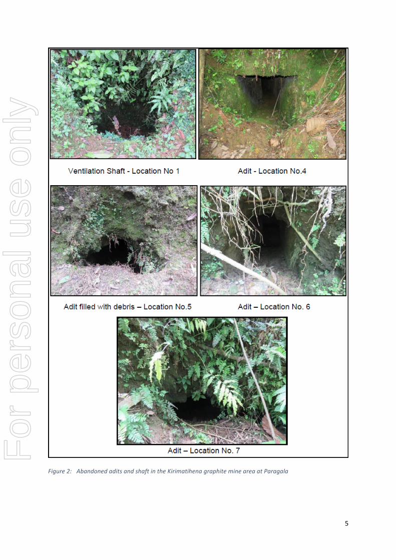
Reconnaissance"geological"mapping"has"been"completed"by"GSMB"over"portions"of"EL307"and"308,"which"are"located"near"Mapagama"in"the"Ratnapura"District"(Figure"1)."Twenty"two"historical"graphite"pits,"shafts"and"adits"were"identified"and"mapped;"an"example"of"the"historical"workings"is"shown"in"Figure"2."The"distribution"of"the"graphite"occurrences"together"with"geological"information"will"assist"in"prioritising"targets"for"followYup.""EL307$
Reconnaisance"geological"mapping"was"carried"out"on"grids"3,"4,"6"and"7"of"Zone"2"of"EL307"in"the"Paragala"area,"north"of"Mapagama"where"seven"old"workings"were" identified"(Table"1)."The"target"area"is"underlain"by"rocks"of"the"Highland"Complex"and"consist"of"granulite"grade"metamorphic"rocks"such"as"charnockite"gneiss,"sillimanite"gneiss"and"bitoiteYhornblend"gneiss."The"rocks"generally"strike"
For
per
sona
l use
onl
y

3""
northwest"to"southeast"and"follow"synformal"and"antiformal"structures,"and"prominent"shear"zones"crosscut"by"faults,"fractures"and"major"joints"with"strike"westYnorthwest"(Figure"3)."GraphiteYbearing"veins"were"mapped"and"noted"to"trend"northeast,"which"is"a"similar"direction"to"that"inferred"by"the"alignment"of"old"shafts"and"pits.""$EL308$
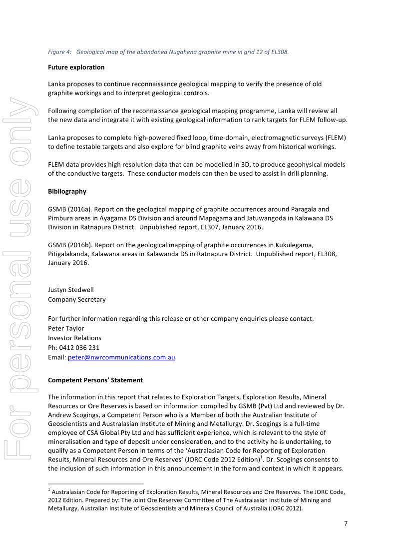
Reconnaisance"geological"mapping"was"carried"out"on"grids"6,"7,"11,"12,"16"and"17"of"EL308"around"the"abandoned"Nugahena"graphite"mine"located"in"Zone"1"(Figure"4),"where"fifteen"old"workings"were"identified"("
Table"2).""The"target"area"is"underlain"by"rocks"of"the"Highland"Complex"and"consist"of"granulite"grade"metamorphic"rocks"including"charnockite"gneiss,"sillimanite"gneiss"and"bitoiteYhornblend"gneiss."Flake"graphite"was"observed"in"some"of"the"charnockite"outcrops,"in"addition"to"needle"vein"graphite"in"a"road"cutting"in"the"Nugahenagama"area."
The"rocks"underlying"grid"12"are"tightly"folded"and"generally"strike"northYnorthwest"with"interpreted""prominent"shear"zones"parallel"to"the"regional"structural"grain"and"which"are"interpreted"to"be"cross"cut"by"eastYnortheasterly"trending"faults,"fractures"and"major"joints"(Figure"4)."The"alignment"of"old"shafts"and"pits"suggests"that"the"graphiteYbearing"veins"trend"northYnorthwest.""""Table'1:' Summary'of'old'workings'identified'in'the'Kirimatihena'mine'area,'EL307'
Locality" Easting"" Northing" Working"type" Shape" Size" Type"of"Fill"
1" 152173" 155500" Ventilation"shaft" Round" 1"m" Debris""
2" 152117" 155520" Main"adit" Rectangular" 2"x"1.5"m" Soil/Water"
3" 152109" 155500" Ventilation"shaft" Round" 1.5"m" Debris"
4" 152101" 155541" Adit" Rectangular" 1"x1"m" Debris"
5" 152197" 155513" Adit" Round" 1"m" Debris"
6" 152186" 155499" Adit" Rectangular" 1.5"x"1"m" Debris"
7" 152204" 155492" Adit" Collapsed" Y" Debris"'
Table'2:' Summary'data'for'old'workings'identified'in'the'Nugahena'mine'area,'EL308'
Locality" X" Y" Working"type" Shape" Size" Type"of"fill"
3" 154465" 146297" Shaft" Round" 4"m" Debris"
4" 154220" 146325" Shaft" Rectangular" 5"m"x"3"m" Debris/water"
5" 154263" 146231" Vein" Vein" 0.1"m" Cover"by"road"
7" 154267" 146166" Vent."shaft" Round" 1"m" Debris"
8" 154272" 146166" Vent."shaft/adit" Rectangular" 1"m"x"1.5"m" Debris"
9" 154275" 146166" Vent."shaft/adit" Round" 4"m" Debris"
10" 154275" 146156" Vent."shaft" Round" 1.5"m" Debris"
11" 154286" 146137" Shaft/adit" Rectangular" 1"m"x"1.5"m" Debris"
For
per
sona
l use
onl
y

4""
12" 154292" 146138" Shaft/adit" Round" 1.5"m" Debris"
13" 154263" 146175" Main"Shaft" Rectangular" 5"m"x"4"m" Debris"
14" 154270" 146184" Adit" Rectangular" 1"m"x"0.8"m" Debris"
15" 154272" 146247" Shaft" Rectangular" 4"m"x"3"m" Debris"
"
"
"
"
For
per
sona
l use
onl
y
5""
""Figure'2:' Abandoned'adits'and'shaft'in'the'Kirimatihena'graphite'mine'area'at'Paragala'
For
per
sona
l use
onl
y

6""
$
Figure'3:' Geological'map'of'the'abandoned'Kirimatihena'graphite'mine'in'grid'7'of'EL307.''
$
For
per
sona
l use
onl
y
7""
Figure'4:' Geological'map'of'the'abandoned'Nugahena'graphite'mine'in'grid'12'of'EL308.'
Future$exploration$
Lanka"proposes"to"continue"reconnaissance"geological"mapping"to"verify"the"presence"of"old"graphite"workings"and"to"interpret"geological"controls."""Following"completion"of"the"reconnaissance"geological"mapping"programme,"Lanka"will"review"all"the"new"data"and"integrate"it"with"existing"geological"information"to"rank"targets"for"FLEM"followYup."""Lanka"proposes"to"complete"highYpowered"fixed"loop,"timeYdomain,"electromagnetic"surveys"(FLEM)"to"define"testable"targets"and"also"explore"for"blind"graphite"veins"away"from"historical"workings."""""FLEM"data"provides"high"resolution"data"that"can"be"modelled"in"3D,"to"produce"geophysical"models"of"the"conductive"targets.""These"conductor"models"can"then"be"used"to"assist"in"drill"planning.""""Bibliography$"GSMB"(2016a)."Report"on"the"geological"mapping"of"graphite"occurrences"around"Paragala"and"Pimbura"areas"in"Ayagama"DS"Division"and"around"Mapagama"and"Jatuwangoda"in"Kalawana"DS"Division"in"Ratnapura"District.""Unpublished"report,"EL307,"January"2016.""GSMB"(2016b)."Report"on"the"geological"mapping"of"graphite"occurrences"in"Kukulegama,"Pitigalakanda,"Kalawana"areas"in"Kalawanda"DS"in"Ratnapura"District.""Unpublished"report,"EL308,"January"2016."""Justyn"Stedwell"Company"Secretary""For"further"information"regarding"this"release"or"other"company"enquiries"please"contact:"Peter"Taylor"Investor"Relations"Ph:"0412"036"231"Email:"[email protected]"
"Competent$Persons’$Statement"
The"information"in"this"report"that"relates"to"Exploration"Targets,"Exploration"Results,"Mineral"Resources"or"Ore"Reserves"is"based"on"information"compiled"by"GSMB"(Pvt)"Ltd"and"reviewed"by"Dr."Andrew"Scogings,"a"Competent"Person"who"is"a"Member"of"both"the"Australian"Institute"of"Geoscientists"and"Australasian"Institute"of"Mining"and"Metallurgy."Dr."Scogings"is"a"fullYtime"employee"of"CSA"Global"Pty"Ltd"and"has"sufficient"experience,"which"is"relevant"to"the"style"of"mineralisation"and"type"of"deposit"under"consideration,"and"to"the"activity"he"is"undertaking,"to"qualify"as"a"Competent"Person"in"terms"of"the"‘Australasian"Code"for"Reporting"of"Exploration"Results,"Mineral"Resources"and"Ore"Reserves’"(JORC"Code"2012"Edition)1."Dr."Scogings"consents"to"the"inclusion"of"such"information"in"this"announcement"in"the"form"and"context"in"which"it"appears.""
"""""""""""""""""""""""""""""""""""""""""""""""""""""""""""""1"Australasian"Code"for"Reporting"of"Exploration"Results,"Mineral"Resources"and"Ore"Reserves."The"JORC"Code,"2012"Edition."Prepared"by:"The"Joint"Ore"Reserves"Committee"of"The"Australasian"Institute"of"Mining"and"Metallurgy,"Australian"Institute"of"Geoscientists"and"Minerals"Council"of"Australia"(JORC"2012)."
For
per
sona
l use
onl
y

8""
About$Lanka$Graphite$Limited$Lanka"Graphite"Limited"(ASX:LGR)" is"an"ASX"listed"graphite"exploration"company"that" is"focused"on"exploration"of"a"number"of"historic"and"new"exploration"and"mining"tenements"in"Central"and"South"Western"Sri"Lanka."Historical"mining"at"a"number"of"the"granted"tenements"produced"very"high"grade"‘lump’"or"vein"style"graphite"with"grades">95"%"C."High"purity"vein"graphite"was"historically"produced"from" Lanka’s" tenements" at" a" grade" that" is" believed" to" be" suited" for" graphene" derivation." Lanka"Graphite"will"continue"exploration"of"its"granted"tenements"with"the"intention"to"develop"high"grade"graphite"production"that"can"supply"nearby"Asian"end"user"companies"particularly"focussed"on"new"technology"graphene"applications.""
For
per
sona
l use
onl
y
9""
JORC%Code,%2012%Edition%–%Table%1%
Section 1 Sampling Techniques and Data – Lanka Graphite Reconnaissance Mapping
(Criteria"in"this"section"apply"to"all"succeeding"sections.)"Criteria' JORC'Code'explanation' Commentary'Sampling'techniques'
•! Nature!and!quality!of!sampling!(e.g.!cut!channels,!random!chips,!
or!specific!specialised!industry!standard!measurement!tools!
appropriate!to!the!minerals!under!investigation,!such!as!down;
hole!gamma!sondes,!or!handheld!XRF!instruments,!etc.).!These!
examples!should!not!be!taken!as!limiting!the!broad!meaning!of!
sampling.!
•! Include!reference!to!measures!taken!to!ensure!sample!
representivity!and!the!appropriate!calibration!of!any!
measurement!tools!or!systems!used.!
•! Aspects!of!the!determination!of!mineralisation!that!are!Material!
to!the!Public!Report.!
•! In!cases!where!‘industry!standard’!work!has!been!done!this!
would!be!relatively!simple!(e.g.!‘reverse!circulation!drilling!was!
used!to!obtain!1!m!samples!from!which!3!kg!was!pulverised!to!
produce!a!30!g!charge!for!fire!assay’).!In!other!cases!more!
explanation!may!be!required,!such!as!where!there!is!coarse!gold!
that!has!inherent!sampling!problems.!Unusual!commodities!or!
mineralisation!types!(e.g.!submarine!nodules)!may!warrant!
disclosure!of!detailed!information.!
•! No!samples!were!collected!for!analytical!purposes,!as!
representative!veins!were!not!accessible!in!the!mostly!filled!old!
shafts!and!adits.!!
Drilling'techniques'
•! Drill!type!(e.g.!core,!reverse!circulation,!open;hole!hammer,!
rotary!air!blast,!auger,!Bangka,!sonic,!etc.)!and!details!(e.g.!core!
diameter,!triple!or!standard!tube,!depth!of!diamond!tails,!face;
sampling!bit!or!other!type,!whether!core!is!oriented!and!if!so,!by!
what!method,!etc.).!
•! Not!applicable,!as!this!was!a!reconnaissance!geological!
mapping!exercise.!
Drill'sample'recovery'
•! Method!of!recording!and!assessing!core!and!chip!sample!
recoveries!and!results!assessed.!
•! Measures!taken!to!maximise!sample!recovery!and!ensure!
representative!nature!of!the!samples.!
•! Not!applicable,!as!this!was!a!reconnaissance!geological!
mapping!exercise.!For
per
sona
l use
onl
y

10""
Criteria' JORC'Code'explanation' Commentary'•! Whether!a!relationship!exists!between!sample!recovery!and!
grade!and!whether!sample!bias!may!have!occurred!due!to!
preferential!loss/gain!of!fine/coarse!material.!
Logging' •! Whether!core!and!chip!samples!have!been!geologically!and!
geotechnically!logged!to!a!level!of!detail!to!support!appropriate!
Mineral!Resource!estimation,!mining!studies!and!metallurgical!
studies.!
•! Whether!logging!is!qualitative!or!quantitative!in!nature.!Core!(or!
costean,!channel,!etc.)!photography.!
•! The!total!length!and!percentage!of!the!relevant!intersections!
logged.!
•! Not!applicable,!as!this!was!a!reconnaissance!geological!
mapping!exercise.!
Sub>sampling'techniques'and'sample'preparation'
•! If!core,!whether!cut!or!sawn!and!whether!quarter,!half!or!all!core!
taken.!
•! If!non;core,!whether!riffled,!tube!sampled,!rotary!split,!etc.!and!
whether!sampled!wet!or!dry.!
•! For!all!sample!types,!the!nature,!quality!and!appropriateness!of!
the!sample!preparation!technique.!
•! Quality!control!procedures!adopted!for!all!sub;sampling!stages!
to!maximise!representivity!of!samples.!
•! Measures!taken!to!ensure!that!the!sampling!is!representative!of!
the!in!situ!material!collected,!including!for!instance!results!for!
field!duplicate/second;half!sampling.!
•! Whether!sample!sizes!are!appropriate!to!the!grain!size!of!the!
material!being!sampled.!
•! Not!applicable,!as!this!was!a!reconnaissance!geological!
mapping!exercise.!
Quality'of'assay'data'and'laboratory'tests'
•! The!nature,!quality!and!appropriateness!of!the!assaying!and!
laboratory!procedures!used!and!whether!the!technique!is!
considered!partial!or!total.!
•! For!geophysical!tools,!spectrometers,!handheld!XRF!
instruments,!etc.,!the!parameters!used!in!determining!the!
analysis!including!instrument!make!and!model,!reading!times,!
calibrations!factors!applied!and!their!derivation,!etc.!
•! Nature!of!quality!control!procedures!adopted!(e.g.!standards,!
blanks,!duplicates,!external!laboratory!checks)!and!whether!
•! Not!applicable,!as!this!was!a!reconnaissance!geological!
mapping!exercise.!
For
per
sona
l use
onl
y

11""
Criteria' JORC'Code'explanation' Commentary'acceptable!levels!of!accuracy!(i.e.!lack!of!bias)!and!precision!
have!been!established.!
Verification'of'sampling'and'assaying'
•! The!verification!of!significant!intersections!by!either!independent!
or!alternative!company!personnel.!
•! The!use!of!twinned!holes.!
•! Documentation!of!primary!data,!data!entry!procedures,!data!
verification,!data!storage!(physical!and!electronic)!protocols.!
•! Discuss!any!adjustment!to!assay!data.!
•! Not!applicable,!as!this!was!a!reconnaissance!geological!
mapping!exercise.!
Location'of'data'points'
•! Accuracy!and!quality!of!surveys!used!to!locate!drill!holes!(collar!
and!down;hole!surveys),!trenches,!mine!workings!and!other!
locations!used!in!Mineral!Resource!estimation.!
•! Specification!of!the!grid!system!used.!
•! Quality!and!adequacy!of!topographic!control.!
•! The!co;ordinate!survey!system!in!Sri!Lanka!is!based!on!the!Transverse!Mercator!Projection!with!the!origin!of!the!projection!being!200,000m!south!and!200,000m!west!of!Pidurutalagala!or!7°!00ʹ!01.729ʺ!N!and!80°!46ʹ!18.160ʺ!E.!!
•! The!EL!and!grid!descriptions!are:!EL!307!(grids!3,!4,!6!and!7)!and!EL!308!(grids!6,!7,!11,!12,!16!and!17).!
•! !
Data'spacing'and'distribution'
•! Data!spacing!for!reporting!of!Exploration!Results.!
•! Whether!the!data!spacing!and!distribution!is!sufficient!to!
establish!the!degree!of!geological!and!grade!continuity!
appropriate!for!the!Mineral!Resource!and!Ore!Reserve!
estimation!procedure(s)!and!classifications!applied.!
•! Whether!sample!compositing!has!been!applied.!
•! Not!applicable,!as!this!was!a!reconnaissance!geological!
mapping!exercise.!
Orientation'of'data'in'relation'to'geological'structure'
•! Whether!the!orientation!of!sampling!achieves!unbiased!sampling!
of!possible!structures!and!the!extent!to!which!this!is!known,!
considering!the!deposit!type.!
•! If!the!relationship!between!the!drilling!orientation!and!the!
orientation!of!key!mineralised!structures!is!considered!to!have!
introduced!a!sampling!bias,!this!should!be!assessed!and!
reported!if!material.!
•! Not!applicable,!as!this!was!a!reconnaissance!geological!
mapping!exercise.!
Sample'security'
•! The!measures!taken!to!ensure!sample!security.! •! Not!applicable,!as!this!was!a!reconnaissance!geological!
mapping!exercise!
Audits'or'reviews'
•! The!results!of!any!audits!or!reviews!of!sampling!techniques!and!
data.!
•! Not!applicable,!as!this!was!a!reconnaissance!geological!
mapping!exercise.!
For
per
sona
l use
onl
y

12""
Section 2 Reporting of Exploration Results – Lanka Graphite Reconnaissance Mapping
(Criteria"listed"in"the"preceding"section"also"apply"to"this"section.)"Criteria' JORC'Code'explanation' Commentary'Mineral'tenement'and'land'tenure'status'
•! Type,!reference!name/number,!location!and!ownership!including!
agreements!or!material!issues!with!third!parties!such!as!joint!
ventures,!partnerships,!overriding!royalties,!native!title!interests,!
historical!sites,!wilderness!or!national!park!and!environmental!
settings.!
•! The!security!of!the!tenure!held!at!the!time!of!reporting!along!with!
any!known!impediments!to!obtaining!a!licence!to!operate!in!the!
area.!
•! The!targets!surveyed!are!within!granted!tenements!EL307!and!
EL308.!!These!are!referenced!on!a!map!in!the!accompanying!
text.!
•! The!prospects!are!located!in!southwestern!Sri!Lanka.!
•! The!tenements!are!in!good!standing!and!no!known!impediments!
exist.!
Exploration'done'by'other'parties'
•! Acknowledgment!and!appraisal!of!exploration!by!other!parties.! •! There!is!evidence!of!old!workings!assumed!to!be!for!graphite,!
however!no!recorded!assay!results!or!vein!widths.!The!spoil!
heaps!are!often!small!which!suggests!limited!excavation.!
•! The!Sri!Lankan!geological!Survey!has!mapped!the!target!areas!
at!1:100,000!scale!(Sheet!16,!Colombo;Ratnapura,!1996d!Sheet!
19,!Aluthgama;Galle,!2000).!
Geology' •! Deposit!type,!geological!setting!and!style!of!mineralisation.! •! Exploration!is!targeting!vein!graphite.!
•! Sri!Lankan!graphite!generally!occurs!in!the!form!of!veins,!
ranging!in!thickness!from!veinlets!less!than!1mm!thick!to!
massive!veins!over!1m!thick.!The!veins!are!usually!located!in!the!
hinge!zones!of!antiforms!within!granulite!facies!zones!of!the!
Precambrian!Basement!terrain!that!underlies!much!of!Sri!Lanka.!
Secondary!fractures!associated!with!structural!hinge!zones!can!
also!act!as!tensional!areas!suitable!for!graphite!deposition.!
•! Vein!graphite!deposition!is!commonly!associated!with!syngenetic!
formation!of!pegmatites!and!vein!quartz.!When!associated!with!
vein!graphite!formation!the!pegmatites!and!quartz!veins!can!
contain!graphite!within!the!rocks.!
•! Target!zones!for!vein!graphite!in!Sri!Lanka!are!focussed!on!
tightly!folded!anticlines!and!synclines!with!the!former!being!the!
prime!target!zones.!
•! Old!shafts,!adits!and!prospect!pits!are!used!to!identify!target!
areas!for!present!day!prospecting.!!
For
per
sona
l use
onl
y
13""
Criteria' JORC'Code'explanation' Commentary'•! !
Drill'hole'Information'
•! A!summary!of!all!information!material!to!the!understanding!of!the!
exploration!results!including!a!tabulation!of!the!following!
information!for!all!Material!drill!holes:!
o! easting!and!northing!of!the!drill!hole!collar!
o! elevation!or!RL!(Reduced!Level!–!elevation!above!sea!
level!in!metres)!of!the!drill!hole!collar!
o! dip!and!azimuth!of!the!hole!
o! down!hole!length!and!interception!depth!
o! hole!length.!
•! If!the!exclusion!of!this!information!is!justified!on!the!basis!that!
the!information!is!not!Material!and!this!exclusion!does!not!
detract!from!the!understanding!of!the!report,!the!Competent!
Person!should!clearly!explain!why!this!is!the!case.!
•! Not!applicable,!as!this!was!a!reconnaissance!geological!
mapping!exercise.!
Data'aggregation'methods'
•! In!reporting!Exploration!Results,!weighting!averaging!
techniques,!maximum!and/or!minimum!grade!truncations!(e.g.!
cutting!of!high!grades)!and!cut;off!grades!are!usually!Material!
and!should!be!stated.!
•! Where!aggregate!intercepts!incorporate!short!lengths!of!high!
grade!results!and!longer!lengths!of!low!grade!results,!the!
procedure!used!for!such!aggregation!should!be!stated!and!some!
typical!examples!of!such!aggregations!should!be!shown!in!detail.!
•! The!assumptions!used!for!any!reporting!of!metal!equivalent!
values!should!be!clearly!stated.!
Not!applicable,!as!this!was!a!reconnaissance!geological!
mapping!exercise.!
Relationship'between'mineralisation'widths'and'intercept'lengths'
•! These!relationships!are!particularly!important!in!the!reporting!of!
Exploration!Results.!
•! If!the!geometry!of!the!mineralisation!with!respect!to!the!drill;hole!
angle!is!known,!its!nature!should!be!reported.!
•! If!it!is!not!known!and!only!the!down!hole!lengths!are!reported,!
there!should!be!a!clear!statement!to!this!effect!(e.g.!‘down!hole!
length,!true!width!not!known’).!
•! Not!applicable,!as!this!was!a!reconnaissance!geological!
mapping!exercise.!Based!on!other!locations!in!Sri!Lanka,!it!is!
likely!that!graphite!veins!are!narrow!(up!to!approximately!1m!in!
width)!and!steep!dipping.!
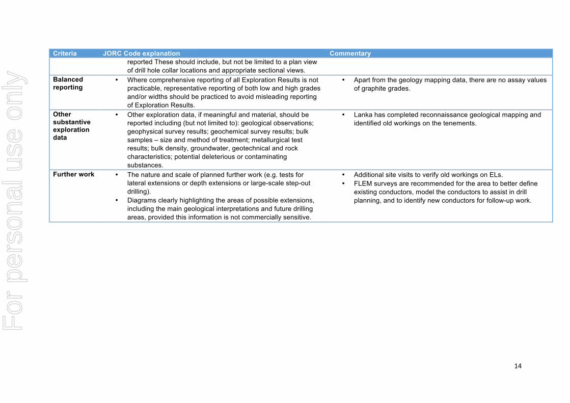
Diagrams' •! Appropriate!maps!and!sections!(with!scales)!and!tabulations!of!
intercepts!should!be!included!for!any!significant!discovery!being!
•! These!are!included!in!the!body!of!the!text!
For
per
sona
l use
onl
y
14""
Criteria' JORC'Code'explanation' Commentary'reported!These!should!include,!but!not!be!limited!to!a!plan!view!
of!drill!hole!collar!locations!and!appropriate!sectional!views.!
Balanced'reporting'
•! Where!comprehensive!reporting!of!all!Exploration!Results!is!not!
practicable,!representative!reporting!of!both!low!and!high!grades!
and/or!widths!should!be!practiced!to!avoid!misleading!reporting!
of!Exploration!Results.!
•! Apart!from!the!geology!mapping!data,!there!are!no!assay!values!
of!graphite!grades.!!
Other'substantive'exploration'data'
•! Other!exploration!data,!if!meaningful!and!material,!should!be!
reported!including!(but!not!limited!to):!geological!observationsd!
geophysical!survey!resultsd!geochemical!survey!resultsd!bulk!
samples!–!size!and!method!of!treatmentd!metallurgical!test!
resultsd!bulk!density,!groundwater,!geotechnical!and!rock!
characteristicsd!potential!deleterious!or!contaminating!
substances.!
•! Lanka!has!completed!reconnaissance!geological!mapping!and!
identified!old!workings!on!the!tenements.!!
Further'work' •! The!nature!and!scale!of!planned!further!work!(e.g.!tests!for!
lateral!extensions!or!depth!extensions!or!large;scale!step;out!
drilling).!
•! Diagrams!clearly!highlighting!the!areas!of!possible!extensions,!
including!the!main!geological!interpretations!and!future!drilling!
areas,!provided!this!information!is!not!commercially!sensitive.!
•! Additional!site!visits!to!verify!old!workings!on!ELs.!
•! FLEM!surveys!are!recommended!for!the!area!to!better!define!
existing!conductors,!model!the!conductors!to!assist!in!drill!
planning,!and!to!identify!new!conductors!for!follow;up!work.!!!
%
For
per
sona
l use
onl
y