High Path Estate, South Wimbledon Visual Impact Study October … · 2019-11-22 · ctober 2016...
24
High Path Estate, South Wimbledon Visual Impact Study October 2016 SD30
Transcript of High Path Estate, South Wimbledon Visual Impact Study October … · 2019-11-22 · ctober 2016...

High Path Estate, South WimbledonVisual Impact StudyOctober 2016
SD30

High Path Estate, South WimbledonVisual Impact StudyOctober 2016
3234_8300 | 17 October 2016 5:04 PM
Contents
Introduction 3
Views and Visual Impact 4
1 | Morden Road 6
2 | Morden Road, south of High Path 7
3 | High Path 8
4 | Station Road 9
5 | Meadow Road 10
6 | Abbey Parade 11
7 | Haydons Road 12
8 | Nelson Road 13
9 | Merton High Street 14
10 | Merton Road, near to Balfour Road junction 15
11 | Kingston Road 16
12 | Hamilton Road 17
13 | Rodney Place 18
14 | High Path, looking west 19
15 | Pincott Road 20
Conclusions 21
ClientCircle Housing
ArchitectPRP Architects Limited
Project ManagerMace Limited
Planning ConsultantSavills
Townscape ConsultantPeter Stewart Consultancy
VisualisationMillerhare

High Path Estate, South Wimbledon Visual Impact Study October 20162

October 2016 Visual Impact Study High Path Estate, South Wimbledon 3
Introduction
1. This Visual Impact Assessment has been prepared by Peter Stewart Consultancy as part of the evidence base for the case for regeneration of the High Path Estate. The Visual Impact Assessment will analyse the visual impact of the estate in its existing form, and in particular the visual impact from the surrounding streets towards the estate.
2. The analysis of the existing situation around the estate will be carried out primarily through the consideration of images that have been taken from key locations surrounding the site. The selection of these viewpoints is made following the exam-ination of maps and aerial photographs, as well as site visits and with the aim of including a range of locations from which the site is visible. It includes viewpoints from local conserva-tion areas. The viewpoint locations have been agreed with the London Borough of Merton.
3. Sue McGlynn was commissioned to carry out an urban design review in 2014, which would examine the quality of the built environment of the estate. The present report builds on that review by introducing more information on visual considera-tions of the townscape around the estate.
The Site
4. The Site is the High Path Estate, in South Wimbledon, Merton, and is bound by Morden Road to the west, High Path to the south, Abbey Road to the east and Merton High Street to the north.
Context
5. The High Path Estate was developed between the 1950s and 1970s and is formed of low rise blocks, high rise blocks and terraces. Architecturally the estate is varied, typical of local authority housing of its period but unremarkable. Some elements, including the 12 storey blocks, appear dated and detract from the character of the area.
6. The Site is distinctly different in character from much of its surroundings. To the north of the High Path Estate lies Merton High Street, a Victorian high street with a mix of uses, which is currently fairly run down. The listed Wimbledon South Tube Station is located on this street close to the estate. North of the high street are streets lined with Victorian terraces, mostly laid out on a north-south axis.
7. Along the west boundary of the estate is Morden Road, a busy street with a variety of uses along it, including residen-tial, industrial and large retail. The street, unlike Merton High Street, has little street frontage along much of its length, with few active frontages. Opposite the estate, on Morden Road is also a recently completed residential block of 8 storeys, with a 9th floor set back at the top.
8. South of the Site and the High Path Estate is a strip of land which is occupied by the locally listed St John’s Church and
Nelson Gardens – a small charming public garden along Morden Road accessible from High Path and Merantun Way – , a primary school and a few nondescript warehouse-style buildings. Further south is the Morden Industrial Estate.
9. To the west of the High Path Estate, on the other side of Morden Road, is a large late 19th-early 20th century residen-tial estate, comprising two storey terraced houses.
10. Similarly, to the east of the Estate there are streets with 19th and 20th century terraced houses, here oriented along an east-west axis. Immediately to the east of these terraces lies the River Wandle, to the east of which are the Abbey Mills – originally part of Merton Priory and after the 1600 the location of the local textile industry. To the southeast, along Rodney Place and immediately adjacent to the Site, are some 20th century cottages of some architectural interest, which were built around the same time as the South Wimbledon tube station. They are two storeys in height and built of yellow brick. They have landscaped front gardens, with hedges defining the boundary to the pavement.
11. As discussed in the Urban Design Review for High Path by Sue McGlynn, the High Path Estate is not very successful in terms of urban structure and design. There is a lack of legibility and permeability, with often short and illegible pedestrian routes through the Estate. There is a lack of defensible space for ground floor homes, and a lack of active frontages along some streets, especially where garages and the tower blocks are located. There is little distinction between the public and semi-public open spaces in the Estate, with often minimal natural surveillance, which has led to them being underused.

High Path Estate, South Wimbledon Visual Impact Study October 20164
Views and Visual Impact
12. This report will include and describe fifteen views that have been identified by Peter Stewart Consultancy and agreed with the Local Authority, in order to give an understanding of the existing townscape character in the areas surrounding the High Path Estate.
13. The viewpoint locations have been agreed by Merton Council on the basis of a desktop analysis (using google maps and working knowledge of the estates). The location of view-points was considered by identifying a study area centred on the estate and limited to locations from which the estate and buildings in it can be seen. Within this study area, candidate viewpoint locations were identified based on an examination of maps and aerial photographs, maps of conservation areas, and maps and lists of listed buildings. The final selection of viewpoints was made following a site visit and with the aim of including a range of typical townscape locations from different directions from which the estate is seen, and from which the effect on other points nearby can be deduced.
14. The assessment of individual views and the conclusion (which has been informed by the view assessment) consider the townscape and views as they would be experienced by viewers in reality. Photographic images of townscape are no more than an approximation to this, for a number of reasons:
• Viewers have peripheral vision; their view is not restricted by borders as a photograph is, and they can move their eyes and heads to take in a wide field of view when standing in once place;
• Viewpoints themselves are not generally fixed. Townscape is experienced for the most part as a progres-sion of views or vistas by people who are moving through streets or spaces rather than standing still;
• Photographs do not reflect perception of depth of field as experienced by the human viewer due to parallax;
• The photographs illustrate the views in conditions that are particular in respect of time of day and time of year, daylight and sunlight, and weather, and the view will appear differently to varying degrees when any of these things vary (for example a photograph with deciduous trees will look different in summer and in winter. Once the trees lose their leaf in winter, they can be perceived as smaller and more will be visible in their background); and
• Townscape is experienced not by the eye alone but by the interpretation by the mind of what the eye sees, considered in the light of experience, knowledge and memory.
15. Opposite is a map indicating the positions from which these images were taken.

View location map
October 2016 Visual Impact Study High Path Estate, South Wimbledon 5

High Path Estate, South Wimbledon Visual Impact Study October 20166
1 Morden Road
Existing
3234
_110
1
3234
_110
1
16. This photograph was taken from Morden Road, south of the High Path Estate, facing north, towards it. The blocks along the Morden Road are visible in the left of the image, though the predominant features in this image are the road itself and the trees in Nelson Gardens, south of the estate. The locally listed church is fully screened from view by the line of trees, when these are in leaf.

October 2016 Visual Impact Study High Path Estate, South Wimbledon 7
2Morden Road, south of High Path
Existing
3234
_320
1
3234
_320
1
17. This image was taken from the west side of Morden Road, south of the junction with High Path, looking north towards the edge of the estate. The main aspect of this photograph is the road itself. The trees and the buildings, including the four storey blocks of the High Path Estate, frame it on either side. The flank of the recently completed 9 storey building on Morden Road can be seen to the left of the image.

High Path Estate, South Wimbledon Visual Impact Study October 20168
3 High Path
Existing
3234
_260
1
3234
_260
1
18. This photograph was taken from Morden Road, opposite High Path, facing east towards High Path and the estate. The buildings of the High Path estate become much more prominent in this image. The four storey blocks along Morden Road are clearly visible to the left of the image. These blocks can be seen along High Path as well. To the centre of the image one of the twelve storey tower blocks is also visible, though not prominent from here. The trees and landscaping of Nelson Gardens are seen to the right of the image.

October 2016 Visual Impact Study High Path Estate, South Wimbledon 9
4Station Road
Existing
3234
_130
1
3234
_130
1
19. This viewpoint is located in the Wandle Valley Conservation Area – Sub Area 3: Merton Priory. It faces west, towards the High Path Estate. From here the Victorian cottages along Station Road are clearly visible, as is the wall across the street from them, to the left of the image. Centrally, in the distance, the three 12 storey towers in the High Path Estate are seen rising above the modern four storey development at the end of Station Road, along Abbey Road.

High Path Estate, South Wimbledon Visual Impact Study October 201610
5 Meadow Road
Existing
3234
_140
1
3234
_140
1
20. This viewpoint is located to the east of the High Path Estate, on Meadow Road, facing west towards the estate. It is a typical view along a Victorian street, with houses and trees lining each side. One of the High Path Estate towers terminates the view in the centre of the image.

October 2016 Visual Impact Study High Path Estate, South Wimbledon 11
6Abbey Parade
Existing
3234
_150
1
3234
_150
1
21. This image was taken from Merton High Street, along Abbey Parade, looking west towards the High Path Estate. The predominant feature in this view is the street itself, which is lined with the high street buildings and trees on either side. The buildings are mostly Victorian brick buildings with ground floor retail uses, though many of them are visibly run down.

High Path Estate, South Wimbledon Visual Impact Study October 201612
7 Haydons Road
Existing
3234
_160
1
3234
_160
1
22. This image was taken from the eastern side of Haydons Road, facing south towards the High Path Estate. The image is framed by two brick buildings on either side of the street and termi-nates with the large trees on the north edge of the High Path Estate. The estate buildings are barely visible through the trees.

October 2016 Visual Impact Study High Path Estate, South Wimbledon 13
8Nelson Road
Existing
3234
_270
1
3234
_270
1
23. This image was taken from the southern end of Nelson Road, facing south towards the High Path Estate. Either side of the view are Victorian brick buildings with commercial uses at ground level. In the centre of the image, Nelson Road meets Merton High Street. Beyond Merton High Street are the terraces of the High Path Estate and Pincott Road beyond. The High Path Estate buildings, including one of the towers, are partly obscured by the large trees along Merton High Street.

High Path Estate, South Wimbledon Visual Impact Study October 201614
9 Merton High Street
Existing
3234
_280
1
3234
_280
1
24. This image was taken from the western edge of Merton High Street, near the crossroads with Merton Road, looking southeast towards the High Path Estate. The main element in this view is the Kilkenny Tavern façade, with the road in the foreground. To the centre of the image the three storey terraces and one of the towers of the High Path Estate can be seen. The open space between the terraces and the high street is also visible, an example of the lack of front-ages that the High Path Estate has along the high street.

October 2016 Visual Impact Study High Path Estate, South Wimbledon 15
10Merton Road, near to Balfour Road junction
Existing
3234
_290
1
3234
_290
1
25. This picture was taken from the southern end of Merton Road, near the junction with Balfour Road, looking south towards the South Wimbledon underground station. The focal point of this view is the South Wimbledon underground station seen in the centre of the image, with Merton Road leading up to it. The Victorian buildings along Merton Road also frame the view. In the background, beyond South Wimbledon station, one of the blocks of the High Path Estate can be seen.

High Path Estate, South Wimbledon Visual Impact Study October 201616
11 Kingston Road
Existing
3234
_300
1
3234
_300
1
26. This image has been taken from Kingston Road, near the junction with Merton Road, facing east towards South Wimbledon underground station and the High Path Estate. The main feature in this image is the junction between Kingston Road, Merton Road, Merton High Street and Morden Road, as well as the under-ground station beyond it. One of the towers from the estate can be seen rising behind the station building, and some of the terraces along Merton High street are just about visible beyond the Kilkenny Tavern, behind the trees.

October 2016 Visual Impact Study High Path Estate, South Wimbledon 17
12Hamilton Road
Existing
3234
_250
1
3234
_250
1
27. This image was taken from the west side of Hamilton Road, facing south, towards the High Path Estate. The view is characteristic of a Victorian street, with terraced houses either side and hedges and trees in front of them. Merton High Street and some of the estate’s buildings are seen in the background, at the end of Hamilton Road. One of the twelve storey towers is also seen rising above the terraces to the left of the image.

High Path Estate, South Wimbledon Visual Impact Study October 201618
13 Rodney Place
Existing
3234
_310
1
3234
_310
1
28. This viewpoint is located at Rodney Place facing west, towards the High Path Estate. The fore-ground of this view is rather cluttered, though the main focal point are the warehouse build-ings to the left and centre and the three towers rising in the background. The hedges in front of the cottages that line either side of the street are also prominent in this view.
October 2016 Visual Impact Study High Path Estate, South Wimbledon 19
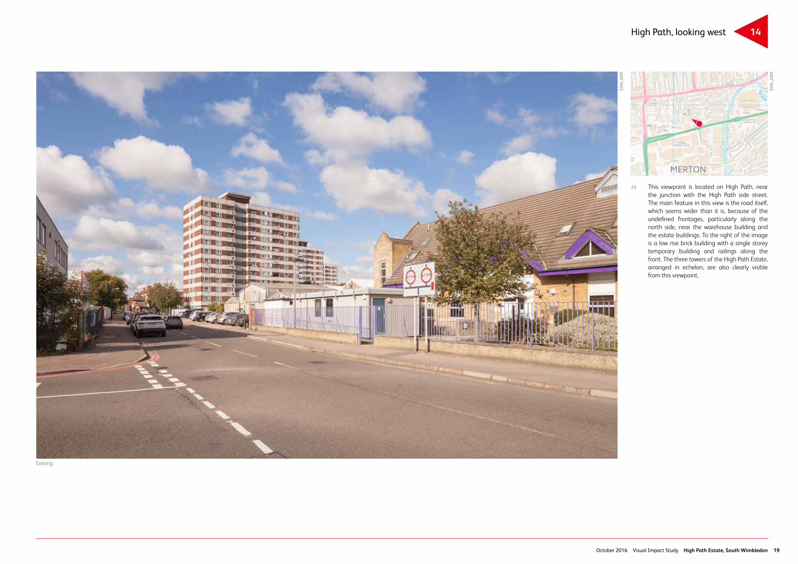
14High Path, looking west
Existing
3234
_220
1
3234
_220
1
29. This viewpoint is located on High Path, near the junction with the High Path side street. The main feature in this view is the road itself, which seems wider than it is, because of the undefined frontages, particularly along the north side, near the warehouse building and the estate buildings. To the right of the image is a low rise brick building with a single storey temporary building and railings along the front. The three towers of the High Path Estate, arranged in echelon, are also clearly visible from this viewpoint.

High Path Estate, South Wimbledon Visual Impact Study October 201620
15 Pincott Road
Existing
3234
_230
1
3234
_230
1
30. This image was taken from the southern end of Pincott Road, looking north along the road and towards Merton High Street. The main characteristic in this image is that of ‘space’, but where the street edge and the public and private spaces are not clearly defined, making it hard to focus on anything in particular. The focal element of this image is Merton High Street in the centre of the image, though due to its distance, it is not clearly visible. The land-scaping and various buildings of the High Path Estate are also clearly visible in this image.

October 2016 Visual Impact Study High Path Estate, South Wimbledon 21
Conclusions
31. The townscape surrounding the High Path Estate has a mixed character of varying quality. The residential streets to the north and east of the High Path Estate are rather charming, but as seen in views 3, 4, 6, 7, 11 and 14 in particular, the presence of the High Path Estate terminates these views rather abruptly, as it does not follow the same urban grid as its surrounding streets.
32. The three 12 storey tower blocks of the estate are clearly visible from many locations around the site. Due to their poor architecture, they impact rather negatively on the wider area in terms of townscape quality.
33. The High Path Estate is located on a prominent site, along two main roads and behind a busy underground station. It is a highly visible development, which due to its poor urban design layout and, in some cases, poor architectural quality, has a negative visual impact on the immediately surrounding areas. The urban design and architectural defects identified in the Urban Design Review of the estate by Sue McGlynn and noted in paragraph 11 above, are apparent in any view that includes sections of the estate.
34. In terms of visual impact of the High Path Estate, the views that are primarily affected by the estate in its existing layout are those immediately adjoining or within the estate, which show the ground level conditions and layout and which expose the respective urban design defects of the estate. Viewpoints located further away are not particularly affected by the presence of the estate. The three 12 storey towers are visible from some of the further viewpoints discussed in this report. Because of their poor architectural quality, they cannot be said to add anything positive to the more distant views in which they appear.