High Grade Historical Cobalt Mine Acquisition For personal ... · The Georgi Adit contains...
18
1 Don Carroll Non-Executive Chairman Nathan Taylor Non-Executive Director Eddie King Non-Executive Director David Palumbo Company Secretary 27 February 2017 High Grade Historical Cobalt Mine Acquisition Multiple cobalt-nickel sulphide target zones include: o Northern (Zemberg-Terezian) Vein System: 1,500m strike, 300m depth and 0.7-1.5m wide sulphide mineralisation. Lower extents veins exploited at grades of averaging 4% Co and 16% Ni and results of up to 8% Co & 17% Ni. Upper levels reported grade of 1-7% Cu, 200-900 g/t Ag, 0.6-5.9% Sb, 0.1- 0.3% Co and 0.1-0.6% Ni. o Southern (Georgi- Martini) Vein System: ~1,500m strike length, grades of up to 2% Co and 28% Ni Historical production of 430,000t of high grade Cobalt- Nickel in early to late 19 th Century; ore was hand sorted and shipped to England for smelting Collation of all historical data relating to the Project presently underway Cobalt price has risen by 100% over past 12 months Quartz-carbonate vein with impregnations of Ni-Co sulpho- arsensides with Erythrite (Co 3 (AsO 4 ) 2 8H 2 O) from Stredna Terezia Adit Quartz-ankerite-gersdorffite (Ni, Co, Fe) As S), dump sample from Maria II Adit For personal use only
Transcript of High Grade Historical Cobalt Mine Acquisition For personal ... · The Georgi Adit contains...

1
Don Carroll Non-Executive Chairman
Nathan Taylor
Non-Executive Director
Eddie King Non-Executive Director
David Palumbo
Company Secretary
27 February 2017
High Grade Historical Cobalt Mine Acquisition
Multiple cobalt-nickel sulphide target zones include:
o Northern (Zemberg-Terezian) Vein System: 1,500m
strike, 300m depth and 0.7-1.5m wide sulphide
mineralisation. Lower extents veins exploited at
grades of averaging 4% Co and 16% Ni and results
of up to 8% Co & 17% Ni. Upper levels reported
grade of 1-7% Cu, 200-900 g/t Ag, 0.6-5.9% Sb, 0.1-
0.3% Co and 0.1-0.6% Ni.
o Southern (Georgi- Martini) Vein System: ~1,500m
strike length, grades of up to 2% Co and 28% Ni
Historical production of 430,000t of high grade Cobalt-
Nickel in early to late 19th Century; ore was hand sorted
and shipped to England for smelting
Collation of all historical data relating to the Project
presently underway
Cobalt price has risen by 100% over past 12 months
Quartz-carbonate vein with
impregnations of Ni-Co sulpho-
arsensides with Erythrite (Co
3(AsO
4)2 8H
2O) from Stredna
Terezia Adit
Quartz-ankerite-gersdorffite (Ni,
Co, Fe) As S), dump sample from
Maria II Adit
For
per
sona
l use
onl
y

2
Western Mining Network Limited (ASX: WMN, “the Company”) is pleased to
announce that is has entered into a binding Heads of Agreement (“HOA”) to
acquire 100% of the Dobsina Cobalt-Nickel Project (“Dobsina” or “the Project”)
located in Slovakia.
PROJECT SUMMARY
Location:
The Dobsina Project is located in central Slovakia, directly to the north of the
small mining town of Dobsina. Excellent infrastructure exists within the vicinity
of Dobsina including power, water and proximity to a railhead.
Figure 1: Project Location Plan & Historical Mines
For
per
sona
l use
onl
y

3
Project Geology & Metallogenesis:
The tectonic evolution and metallogeny of Slovakia is dominated by Hercynian
and Alpine orogenic events. The present geologic architecture of Slovakia
was formed during the Alpine orogeny that started in middle to late
Cretaceous and lead to thin-skin thrust faulting and development of mountain
core complexes of the Alpine-Carpathian system. The Dobsina area lies at a
major thrust contact between two regional tectonostratigraphic units called
Veporicum (crystallinicum), and Gemericum (green-schist facies
metamorphic rocks).
The following styles of mineralisation are observed at Dobsina:
1. Siderite hydrothermal veining (siderite-ankerite, quartz and sulphides).
Based on the sulphides composition and abundance, these veins are
subdivided into the four following categories:
a. Siderite-sulphide- Cu Veins
b. Antimony-Bismuth Veins
c. Carbonate-quartz-sulphide-Ni-Co Veins
d. Barite-Siderite veins with Cu-Hg
2. Metasomatic Fe-carbonate replacement
3. Stratiform sediment hosted Ag-Au
4. Stratiform sediment hosted magnetite-hematite
Figure 2: Geological and Mineralisation Model (Adapted From Grecula, 1995)
The siderite-quartz cobalt-nickel veins are located within two main east-west
tectonic zones along a fault contact between a gneiss-amphibolite and
underlying phyllite-green schist. The contact- a shear zone- is marked by
occurrence of black carbon-rich lenses and are inferred as being a
hydrothermal solution conduit, with solutions rising along fault structures into
the overlying gneiss and amphibolite. The veins cut across foliation and are
generally steeply dipping to the south.
For
per
sona
l use
onl
y

4
Historical Mining:
Iron ore was initially mined within the Project in the 13th century and continued
through to the early 20th century, several smelters operated in the vicinity of the
Project. Mining of copper ore commenced in the 14th century, with intermittent
production to the 19th century.
In 1780 a Saxony miner discovered the presence of Co and Ni at Dobsina,
which triggered the mines expansion that lasted to the end of the 19th century.
Whilst most of the cobalt-nickel mineralisation was found in hydrothermal vein
systems cutting the gneiss-amphibolite, cobalt-nickel mineralisation was also
found in other settings such as veinlet disseminated in siderite-ankerite lenses
as well as in veins hosted in the unfolded overlying carboniferous sedimentary
rocks.
Figure 5: Historical Underground Plans (Dobsnia Cobalt-nickel and iron)
Extensive historical production records are presently being digitised and
translated. Further releases will be made upon completion of this digitising
process.
Figure 4: Historical Waste Dump at Dobsina Figure 3: Gothard Underground Drive
For
per
sona
l use
onl
y

5
A report, “Banske Mesto Dobsina, 2013” prepared by the Slovak Ministry of
Interior, documents a summary of the historical production grades for the
Dobsina Project.
Many of the historical stopes and drives are accessible and as part of the due
diligence process will be explored.
Figure 6: Historical Mining Activity Dobsina Project
Northern (Terezian) Vein System:
1,500m strike, 300m depth and 0.7-1.5m wide mineralisation. Distinct metal
zonation is evident with more copper abundant mineralisation in the upper
parts whereas nickel-cobalt dominant mineralisation occurs in the lower part
of the vein system. Lower extents veins exploited at grades of up to 8% Co and
17% Ni. Upper levels reported grade of 1-7% Cu, 200-900 g/t Ag, 0.6-5.9% Sb,
0.1-0.3% Co and 0.1-0.6% Ni
Zemberg Vein System:
The Zemberg Vein system consists of three discrete vein sets, Severna, Hlavna
and Juzna. The mineral assemblage of the veins consist of siderite, ankerite,
quartz, sulphides and abundant nickel-cobalt sulphide minerals. Minor siderite-
barite and copper minerals are also present. Veins commonly display crack
seal texture. Rozlozsnika, 1935 commented “Zemberg ore contained an
average of 4% Cobalt and 16% Ni”
For
per
sona
l use
onl
y

6
Southern (Georgi- Martini) Vein System:
The Georgi-Martini vein system extends over a ~1,500m strike length, grades of
up to 2% Co and 28% Ni. The Georgi Adit contains east-west trending siderite
bodies with sulphide and sulphoarsenide veinlets.
Martini vein mineralisation is located along the contact of gneiss and
Carboniferous clastic sediments. The vein strikes east-west and dips 80 to 90o.
Vein matrix comprises of major coarse siderite and minor milky quartz cut by
gersdorffite veinlets with minor chalcopyrite and rare arsenopyrite
ABOUT COBALT
Cobalt has reached a current spot price of US$48,000/t representing a 100%
increase in price over the past year. The primary drivers for this price increase
include:
Recent surge in demand from the energy storage market;
Supply challenges associated with the Democratic Republic of Congo
(DRC) producing 60% of global cobalt production; and
Lack of recent exploration discoveries.
Figure 7: 12 Month Cobalt Price Chart (LME,2017)
For
per
sona
l use
onl
y

7
COMMERCIAL TERMS
The Company has entered into a binding Heads of Agreement (“HOA”) to
purchase 100% of the shares in NiCo Minerals Pty Ltd (“NiCo”). The corporate
structure post completion of the acquisition is illustrated below:
The Company has secured a 60 day exclusive option period to acquire 100%
of NiCo Minerals Pty Ltd and its 100% wholly owned subsidiary CE Metals s.r.o,
owner of 100% of the Dobsina Licence (License number 2466/2017-5.3). At any
point during this exclusive option period, WMN, at is sole discretion, may elect
to exercise the option to proceed with the acquisition.
Upon successful completion of due diligence and exercise of the option, the
total consideration, including all milestone payments would be 378,333,335
fully paid ordinary shares in WMN (“Shares”). This consideration will comprise
of the issue of 18,333,334 non-refundable option fee shares (“Option Fee”)
issued on or about execution of the Heads of Agreement, 286,666,667 initial
consideration Shares (“Initial Consideration”) and 73,333,334 performance
shares which will each convert to one ordinary Share upon completion of the
milestones set out below (“Performance Shares”).
The Initial Consideration and Performance Shares will be issued on completion
of the acquisition (which is subject to the satisfaction of due diligence and
WMN obtaining all regulatory and shareholder approvals including
confirmation from ASX that the Company will not have to re-comply with
Chapter 1 and 2 of the Listing Rules).
Western Mining Network Ltd
NiCo Minerals Pty Ltd
CE Metals s.r.o
Dobsina Licence (24/66/2017-5.3)
For
per
sona
l use
onl
y

8
The Performance Shares are issued and will vest upon the completion and
announcement of:
Performance Milestone 1: WMN will issue 36,666,667 fully paid ordinary
shares upon the delineation of a minimum of 500,000t at a minimum
grade of 0.5% Cobalt equivalence in accordance with the JORC 2012
Edition Guidelines or 50,000t of ore sold/processed at a minimum of 0.5%
Cobalt equivalence;
Performance Milestone 2: WMN will issue 36,666,667 fully paid ordinary
shares upon the delineation of a minimum of 1,000,000t at a minimum
grade of 0.5% Cobalt equivalence in accordance with the JORC 2012
Edition Guidelines or 100,000t of ore sold/processed at a minimum of
0.5% Cobalt equivalence.
The Performance Shares will otherwise be on standard terms and which are
approved by ASX and the shareholders of WMN in general meeting (which is
expected to be held in mid April).
Vendors are to retain a 2% Net Smelter Royalty on all minerals produced from
the Dobsina Licence.
FUNDING
In conjunction with entering into the Agreement, the Company has secured
commitments for a placement of up to 84,615,385 ordinary shares in the
Company (pursuant to the Company’s placement capacity approved on the
29th November 2016 at the Company’s AGM) at an issue price of $0.013 per
share to sophisticated investors, to raise $1,100,000 before costs associated
with the issue.
Funds raised will be applied to progress the proposed acquisition of Dobsina,
exploration activities across the Company’s Western Australian gold portfolio
and general working capital purposes.
SLOVAK MINING CODE
The Slovak Republic has separate Mining and Exploration Codes, both dating
back to 1988 but amended many times since. Exploration is governed by the
so called Geological Law. The basic premise is to attract private investment
to exploration by awarding exclusive exploration licenses that can be
converted to mining license on an exclusive basis by the Licensee. Exploration
licenses are awarded on a first-come first- served basis.
A resources company is restricted to four exploration permits with a maximum
of 250 km2 per permit. The exploration permits are valid up to 4 years and can
extend multiple times.
For
per
sona
l use
onl
y

9
The application must be filed either by a citizen of Slovakia or by a Slovak-
registered company. Although not mandatory it is good practice to approach
the local communities and discuss exploration plans before they are
contacted by the Licensing authority.
REFERENCES:
All historical production information and historically quoted assay grades are
quoted from “Bankse Mestro Dobsina” a publication prepared by the Slovak
Ministry of Interior, published in Kosice 2013 (ISBN 978-80-97005-7-8).
LOCATIONS OF HISTORICAL ADITS SHAFTS & SIGNIFICANT RESULTS REPORTED:
Table 1: Adit/Shaft Access Locations (All Coordinates Lat/Long WGS84)
Adit/Shaft Longitude Latitude Comment
Agnesa 20.39151 48.8411
Amalia 20.38492 48.83337
Anna 20.39275 48.83064
Antonia 20.39921 48.83582
Bezmenna I 20.38926 48.83976
Bezmenna II 20.39403 48.8354
Bezmenna III 20.39804 48.8384
Bezmenna IV 20.40195 48.83666
Bezmenna V 20.40242 48.83688
Bezmenna VI 20.40006 48.83697
Dedicna 20.38685 48.82191
Dionyz 20.38358 48.83721
Ezechiel 20.39121 48.82913
Fridrich 20.38325 48.84056
Georgi 20.39126 48.82874 1,500m strike length, grades of up to 2% Co and 28%
Ni
Gotthard 20.38954 48.84128
Gugl I 20.40533 48.84153
Gugl II 20.40139 48.84492
Harmatova Luka 20.39497 48.83408
Jan 20.38377 48.84209
Jodocus 20.39246 48.84181
Joremeny 20.39124 48.84343
Jozef I 20.3855 48.84284
Jozef II 20.39789 48.83652
Jozef III 20.39597 48.83478
Karol 20.38353 48.83974
Klementa 20.39118 48.84439
For
per
sona
l use
onl
y

10
Adit/Shaft Longitude Latitude Comment
Langenberg 20.38621 48.84355
Ludovici 20.39394 48.83704
Ludwig 20.40389 48.83632
Magdalena 20.39071 48.84125
Maria I 20.40483 48.84795
Maria II 20.40431 48.84757
Maximilian 20.38629 48.83613
Michael Zubau 20.39318 48.83999
Michal 20.40244 48.82976
Miksa 20.38601 48.83615
Paulus 20.3849 48.8403
Pavol 20.38425 48.84238
Ruffiny 20.38085 48.83127
Samuel 20.38325 48.84117
Samueli 20.39311 48.83762
Sigmund 20.39634 48.83611
Spodna Terezia 20.39691 48.83865
Steinberg 20.38377 48.83292
Stredna Terezia 20.39859 48.84174 1,500m strike, 300m depth and 0.7-1.5m wide
sulphide mineralisation. Lower extents veins
exploited at grades of averaging 4% Co and 16% Ni
& results of up to 8% Co and 17% Ni. Upper levels
reported grade of 1-7% Cu, 200-900 g/t Ag, 0.6-5.9%
Sb, 0.1-0.3% Co and 0.1-0.6% Ni.
Stredny Ondrej 20.3985 48.84424
Simon 20.39742 48.83646
Stefan 20.39452 48.83797
Timotheus 20.39674 48.83492
Viktor 20.40356 48.83055
Vrchna Joremny 20.3921 48.84373
Vrchny Ondrej 20.39874 48.84508
Vrchna Terezia 20.39953 48.84334
For
per
sona
l use
onl
y

11
DISCLAIMER
Forward-looking statements are statements that are not historical facts. Words such as
“expect(s)”, “feel(s)”, “believe(s)”, “will”, “may”, “anticipate(s)” and similar expressions
are intended to identify forward-looking statements. These statements include, but are
not limited to statements regarding future production, resources or reserves and
exploration results. All of such statements are subject to certain risks and uncertainties,
many of which are difficult to predict and generally beyond the control of the
Company, that could cause actual results to differ materially from those expressed in,
or implied or projected by, the forward-looking information and statements. These risks
and uncertainties include, but are not limited to: (i) those relating to the interpretation
of drill results, the geology, grade and continuity of mineral deposits and conclusions
of economic evaluations, (ii) risks relating to possible variations in reserves, grade,
planned mining dilution and ore loss, or recovery rates and changes in project
parameters as plans continue to be refined, (iii) the potential for delays in exploration
or development activities or the completion of feasibility studies, (iv) risks related to
commodity price and foreign exchange rate fluctuations, (v) risks related to failure to
obtain adequate financing on a timely basis and on acceptable terms or delays in
obtaining governmental approvals or in the completion of development or
construction activities, and (vi) other risks and uncertainties related to the Company’s
prospects, properties and business strategy. Our audience is cautioned not to place
undue reliance on these forward-looking statements that speak only as of the date
hereof, and we do not undertake any obligation to revise and disseminate forward-
looking statements to reflect events or circumstances after the date hereof, or to
reflect the occurrence of or non-occurrence of any events.
COMPETENT PERSONS STATEMENT:
The information in this announcement that relates to the historical Exploration Results is based
on information compiled and fairly represented by Mr Robert Jewson, who is a Member of the
Australian Institute of Geoscientists and a Director of NiCo Minerals Pty Ltd. Mr Jewson has
sufficient experience relevant to the style of mineralisation and type of deposit under
consideration, and to the activity which he has undertaken, to qualify as a Competent Person
as defined in the 2012 Edition of the Joint Ore Reserves Committee (JORC) Australasian Code
for Reporting of Exploration Results, Mineral Resources and Ore Reserves. Mr Jewson consents to
the inclusion in this report of the matters based on this information in the form and context in
which it appears. Mr Jewson is both a Director and shareholder of NiCo Minerals Pty Ltd.
For
per
sona
l use
onl
y
12
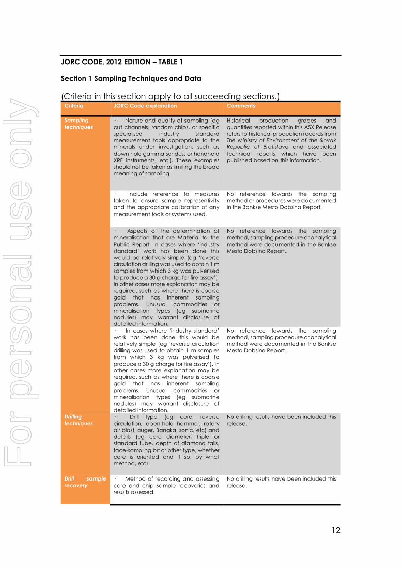
JORC CODE, 2012 EDITION – TABLE 1
Section 1 Sampling Techniques and Data
(Criteria in this section apply to all succeeding sections.) Criteria JORC Code explanation Comments
Sampling
techniques
· Nature and quality of sampling (eg
cut channels, random chips, or specific
specialised industry standard
measurement tools appropriate to the
minerals under investigation, such as
down hole gamma sondes, or handheld
XRF instruments, etc.). These examples
should not be taken as limiting the broad
meaning of sampling.
Historical production grades and
quantities reported within this ASX Release
refers to historical production records from
The Ministry of Environment of the Slovak
Republic of Bratislava and associated
technical reports which have been
published based on this information.
· Include reference to measures
taken to ensure sample representivity
and the appropriate calibration of any
measurement tools or systems used.
No reference towards the sampling
method or procedures were documented
in the Bankse Mesto Dobsina Report.
· Aspects of the determination of
mineralisation that are Material to the
Public Report. In cases where ‘industry
standard’ work has been done this
would be relatively simple (eg ‘reverse
circulation drilling was used to obtain 1 m
samples from which 3 kg was pulverised
to produce a 30 g charge for fire assay’).
In other cases more explanation may be
required, such as where there is coarse
gold that has inherent sampling
problems. Unusual commodities or
mineralisation types (eg submarine
nodules) may warrant disclosure of
detailed information.
No reference towards the sampling
method, sampling procedure or analytical
method were documented in the Bankse
Mesto Dobsina Report..
· In cases where ‘industry standard’
work has been done this would be
relatively simple (eg ‘reverse circulation
drilling was used to obtain 1 m samples
from which 3 kg was pulverised to
produce a 30 g charge for fire assay’). In
other cases more explanation may be
required, such as where there is coarse
gold that has inherent sampling
problems. Unusual commodities or
mineralisation types (eg submarine
nodules) may warrant disclosure of
detailed information.
No reference towards the sampling
method, sampling procedure or analytical
method were documented in the Bankse
Mesto Dobsina Report..
Drilling
techniques · Drill type (eg core, reverse
circulation, open-hole hammer, rotary
air blast, auger, Bangka, sonic, etc) and
details (eg core diameter, triple or
standard tube, depth of diamond tails,
face-sampling bit or other type, whether
core is oriented and if so, by what
method, etc).
No drilling results have been included this
release.
Drill sample
recovery
· Method of recording and assessing
core and chip sample recoveries and
results assessed.
No drilling results have been included this
release.
For
per
sona
l use
onl
y
13
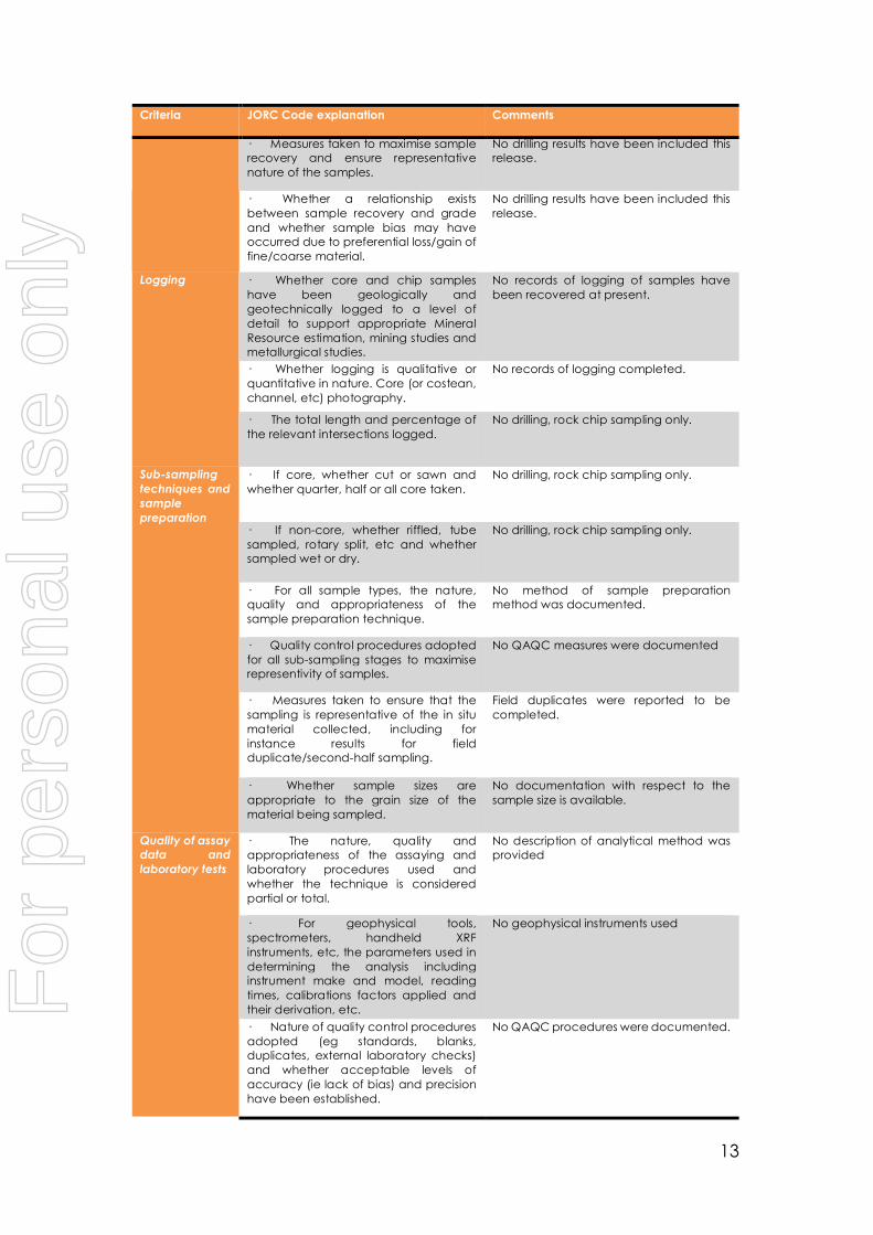
Criteria JORC Code explanation Comments
· Measures taken to maximise sample
recovery and ensure representative
nature of the samples.
No drilling results have been included this
release.
· Whether a relationship exists
between sample recovery and grade
and whether sample bias may have
occurred due to preferential loss/gain of
fine/coarse material.
No drilling results have been included this
release.
Logging · Whether core and chip samples
have been geologically and
geotechnically logged to a level of
detail to support appropriate Mineral
Resource estimation, mining studies and
metallurgical studies.
No records of logging of samples have
been recovered at present.
· Whether logging is qualitative or
quantitative in nature. Core (or costean,
channel, etc) photography.
No records of logging completed.
· The total length and percentage of
the relevant intersections logged.
No drilling, rock chip sampling only.
Sub-sampling
techniques and
sample
preparation
· If core, whether cut or sawn and
whether quarter, half or all core taken.
No drilling, rock chip sampling only.
· If non-core, whether riffled, tube
sampled, rotary split, etc and whether
sampled wet or dry.
No drilling, rock chip sampling only.
· For all sample types, the nature,
quality and appropriateness of the
sample preparation technique.
No method of sample preparation
method was documented.
· Quality control procedures adopted
for all sub-sampling stages to maximise
representivity of samples.
No QAQC measures were documented
· Measures taken to ensure that the
sampling is representative of the in situ
material collected, including for
instance results for field
duplicate/second-half sampling.
Field duplicates were reported to be
completed.
· Whether sample sizes are
appropriate to the grain size of the
material being sampled.
No documentation with respect to the
sample size is available.
Quality of assay
data and
laboratory tests
· The nature, quality and
appropriateness of the assaying and
laboratory procedures used and
whether the technique is considered
partial or total.
No description of analytical method was
provided
· For geophysical tools,
spectrometers, handheld XRF
instruments, etc, the parameters used in
determining the analysis including
instrument make and model, reading
times, calibrations factors applied and
their derivation, etc.
No geophysical instruments used
· Nature of quality control procedures
adopted (eg standards, blanks,
duplicates, external laboratory checks)
and whether acceptable levels of
accuracy (ie lack of bias) and precision
have been established.
No QAQC procedures were documented.
For
per
sona
l use
onl
y

14
Criteria JORC Code explanation Comments
Verification of
sampling and
assaying
· The verification of significant
intersections by either independent or
alternative company personnel.
No drilling, rock chip sampling only..
· The use of twinned holes. No drilling, rock chip sampling only.
· Documentation of primary data,
data entry procedures, data verification,
data storage (physical and electronic)
protocols.
Paper records converted to digital format.
· Discuss any adjustment to assay
data.
No adjustments were made to assay data
presented in this report
Location of
data points
· Accuracy and quality of surveys
used to locate drill holes (collar and
down-hole surveys), trenches, mine
workings and other locations used in
Mineral Resource estimation.
No drilling, rock chip sampling only.
· Specification of the grid system
used.
Latitude-Longitude WGS 84
· Quality and adequacy of
topographic control.
A digital terrain model was generated
from 1:100,000 topographic map. The
quality of the DTM is sufficient for the stage
of exploration for the Project. Data spacing
and distribution
· Data spacing for reporting of
Exploration Results.
Rock chip information gathered from
selected localities within historical
workings. The spacing is irregular
· Whether the data spacing and
distribution is sufficient to establish the
degree of geological and grade
continuity appropriate for the Mineral
Resource and Ore Reserve estimation
procedure(s) and classifications applied.
Not attempting to establish a mineral
resource only guide the prospectivity and
future drilling
· Whether sample compositing has
been applied.
No sample compositing is completed.
Orientation of
data in relation
to geological
structure
· Whether the orientation of sampling
achieves unbiased sampling of possible
structures and the extent to which this is
known, considering the deposit type.
No documentation with respect to the
orientation of samples and potential of
bias.
· If the relationship between the
drilling orientation and the orientation of
key mineralised structures is considered
to have introduced a sampling bias, this
should be assessed and reported if
material.
No drilling, rock chip sampling only.
Sample security · The measures taken to ensure
sample security.
No records available on the sample
security chain of custody process.
Audits or
reviews
· The results of any audits or reviews of
sampling techniques and data.
None conducted
For
per
sona
l use
onl
y

15
SECTION 2 REPORTING OF EXPLORATION RESULTS
(Criteria listed in the preceding section also apply to this section.) Criteria JORC Code explanation Commentary
Mineral tenement
and land tenure
status
· Type, reference
name/number, location
and ownership including
agreements or material
issues with third parties
such as joint ventures,
partnerships, overriding
royalties, native title
interests, historical sites,
wilderness or national park
and environmental
settings.
Dobsina consists of a granted Licence (License
number 2466/2017-5.3) covering a land area of
6.97km2, held by CE Metals s.r.o, a 100% wholly
owned subsidiary of NiCo Minerals Pty Ltd. Western
Mining Network has the exclusive option to acquire
100% of the Dobsina Project via the acquisition of
NiCo Minerals Pty Ltd. Payment consideration
includes:
- Non-refundable Option Fee payment of
11,666,666.00 shares and Non-refundable
reimbursement of prior expenses
payable via the issue of 6,666,668 shares
- 286,666,667 fully paid ordinary shares if
WMN elects to proceed with the
Acquisition
- 73,333,334 Performance Shares (subject
to ASX approval per Listing Rule 6.1) on
the following terms and conditions being:
o 36,666,667 Class A Performance
Shares for the achievement of
an Inferred Mineral Resource in
accordance with the JORC
2012 Edition Guidelines of not
less than 500,000 tonnes at a
minimum grade of 0.5% Cobalt
equivalence within the Dobsina
Licence or the sale/processing
of a minimum of 50,000t of ore
sold/processed at a minimum
grade of 0.5% Cobalt
equivalence (Performance
Shares Milestone 1)
o 36,666,667 Class B Performance
Shares for the achievement of
an Inferred Mineral Resource in
accordance with the JORC
2012 Edition Guidelines of not
less than 1,000,000 tonnes at a
minimum grade of 0.5% Cobalt
equivalence within the Dobsina
Licence or the sale/processing
of a minimum of 100,000t of ore
sold/processed at a minimum
grade of 0.5% Cobalt
equivalence (Performance
Shares Milestone 1)
- Payment of a 2% Net Smelter Royalty
(“NSR”) on the production of any minerals
from the Dobsina Licence
At present WMN has paid the Non-Refundable
Option Fee and Non-Refundable Reimbursement
of Prior Expenses Consideration and is conducting
due diligence.
· The security of the
tenure held at the time of
reporting along with any
known impediments to
obtaining a licence to
operate in the area.
No known impediments exist with respect to the
exploration or development of Dobsina Project.
Exploration done by
other parties
· Acknowledgment and
appraisal of exploration by
other parties.
At present the information utilised within this release
is sourced from “Bankse Mestro Dobsina” a
publication prepared by the Slovak Ministry of
Interior, published in Kosice 2013 (ISBN 978-80-
For
per
sona
l use
onl
y

16
Criteria JORC Code explanation Commentary
97005-7-8). Extensive exploration and production
activities have been undertaken by prior operators.
A process of digitising and translating of these
reports is presently underway and further market
releases will be prepared upon the completion of
the digitising and translation process.
Geology · Deposit type,
geological setting and
style of mineralisation.
The Dobsina Project lies at a major thrust contact
between two regional tectonostratigraphic units
called Veporicum and Gemericum.
Mineralisation at Dobsina is characterised by the
following styles:
- Siderite hydrothermal veins (siderite-
ankerite, quartz sulphide)
- Metasomatic Fe-Carbonate
replacement
- Stratiform sediment hosted Ag-Au
- Stratiform sediment hosted magnetite-
hematite
Siderite hydrothermal veins prospective for Co-Ni
veins are located in two main east-west tectonic
zones along a fault contact between geniss-
amphibole and underlying phyllite green schist.
Drill hole Information · A summary of all
information material to the
understanding of the
exploration results
including a tabulation of
the following information
for all Material drill holes:
No drilling performed
o easting and northing of
the drill hole collar
No drilling performed
o elevation or RL
(Reduced Level –
elevation above sea level
in metres) of the drill hole
collar
No drilling performed
o dip and azimuth of the
hole
No drilling performed
o down hole length and
interception depth
No drilling performed
o hole length. No drilling performed
· If the exclusion of this
information is justified on
the basis that the
information is not Material
and this exclusion does not
detract from the
understanding of the
report, the Competent
Person should clearly
explain why this is the case.
All available information has been released.
Data aggregation
methods
· In reporting Exploration
Results, weighting
averaging techniques,
maximum and/or minimum
grade truncations (eg
cutting of high grades) and
cut-off grades are usually
Material and should be
stated.
No aggregation methods applied
For
per
sona
l use
onl
y

17
Criteria JORC Code explanation Commentary
· Where aggregate
intercepts incorporate
short lengths of high grade
results and longer lengths
of low grade results, the
procedure used for such
aggregation should be
stated and some typical
examples of such
aggregations should be
shown in detail.
No aggregation methods applied
· The assumptions used
for any reporting of metal
equivalent values should
be clearly stated.
No metal equivalence are reported.
Relationship
between
mineralisation
widths and intercept
lengths
· These relationships are
particularly important in
the reporting of Exploration
Results.
No drilling performed
· If the geometry of the
mineralisation with respect
to the drill hole angle is
known, its nature should be
reported.
No drilling performed
· If it is not known and
only the down hole lengths
are reported, there should
be a clear statement to this
effect (eg ‘down hole
length, true width not
known’).
No drilling performed
Diagrams · Appropriate maps and
sections (with scales) and
tabulations of intercepts
should be included for any
significant discovery being
reported These should
include, but not be limited
to a plan view of drill hole
collar locations and
appropriate sectional
views.
Maps and plans have been included in
announcement.
Balanced reporting · Where comprehensive
reporting of all Exploration
Results is not practicable,
representative reporting of
both low and high grades
and/or widths should be
practiced to avoid
misleading reporting of
Exploration Results.
All results including those with no significant results
have been reported.
Other substantive
exploration data
· Other exploration
data, if meaningful and
material, should be
reported including (but not
limited to): geological
observations; geophysical
survey results;
geochemical survey
results; bulk samples – size
and method of treatment;
metallurgical test results;
bulk density, groundwater,
geotechnical and rock
characteristics; potential
deleterious or
contaminating substances.
No other exploration data is considered
meaningful and material to this announcement.
For
per
sona
l use
onl
y

18
Criteria JORC Code explanation Commentary
Further work · The nature and scale
of planned further work (eg
tests for lateral extensions
or depth extensions or
large-scale step-out
drilling).
Translation of all available information is presently
underway. Further releases will be made to market
upon collation of this information. In addition field
reconnaissance mapping and sampling of
historical underground workings and waste dump
material is planned to be undertaken.
· Diagrams clearly
highlighting the areas of
possible extensions,
including the main
geological interpretations
and future drilling areas,
provided this information is
not commercially sensitive.
Further activities will be planned upon completion
of the data digitising, translation and collation
process.
For
per
sona
l use
onl
y