HERITAGE AND CONSERVATION REGISTER - … · PORT OF NEWCASTLE HERITAGE AND CONSERVATION REGISTER...
69
November 2014 Prepared by Port of Newcastle and EJE Heritage HERITAGE AND CONSERVATION REGISTER
Transcript of HERITAGE AND CONSERVATION REGISTER - … · PORT OF NEWCASTLE HERITAGE AND CONSERVATION REGISTER...

November 2014
Prepared by Port of Newcastle and EJE Heritage
HERITAGE AND CONSERVATION REGISTER

PORT OF NEWCASTLE
HERITAGE AND CONSERVATION REGISTER
Prepared by EJE Heritage
Nominated Architect – Peter Campbell No. 4294 Page
10309-HACR-001 Issue
PART I
HISTORICAL BACKGROUND
PORT OF NEWCASTLE
HERITAGE AND CONSERVATION REGISTER
Prepared by EJE Heritage
Nominated Architect – Peter Campbell No. 4294 Page
10309-HACR-001 Issue
TABLE OF CONTENTS
1. Forward ......................................................................................................................................... 4
1.1 General.................................................................................................................................. 4 1.2 Methodology .......................................................................................................................... 5 1.3 Constraints and Limitations..................................................................................................... 5 1.4 Acknowledgements ................................................................................................................ 5 1.5 Abbreviations ......................................................................................................................... 5
2. Historical Context .................................................................................................................... 6
2.1 PREAMBLE ........................................................................................................................... 7 2.2 INTRODUCTION.................................................................................................................... 8 2.3 1770-1801: “A GREAT ACQUISITION” ................................................................................. . 9 2.4 1801-1850: NEWCASTLE IS A VERY DANGEROUS PLACE............................................... 11 2.5 ADMINISTRATION.............................................................................................................. . 12 2.6 HARBOUR IMPROVEMENTS ............................................................................................. . 13 2.7 Wharfage ............................................................................................................................. 18 2.8 NAVIGATION................................................................................................................. ...... 20 2.9 Overview.............................................................................................................................. 21 2.10 WHARFAGE ........................................................................................................................ 31 2.11 Boat Harbours ...................................................................................................................... 35 2.12 NAVIGATION....................................................................................................................... 37 2.13 Overview............................................................................................................................. . 40 2.14 Walsh Island Dockyard ......................................................................................................... 44 2.15 NSW State Dockyard............................................................................................................ 45 2.16 Wharfage ............................................................................................................................. 47 2.17 Overview............................................................................................................................. . 51 2.18 HARBOUR IMPROVEMENTS .............................................................................................. 53 2.19 Coal Loading Facilities......................................................................................................... . 56 2.20 Grain Handling ..................................................................................................................... 60 2.21 General Cargo...................................................................................................................... 61 2.22 Overview............................................................................................................................. . 62 2.23 CONCLUSION ..................................................................................................................... 64 2.24 Recent Developments .......................................................................................................... 65 2.25 BIBLIOGRAPHY................................................................................................................... 67

PORT OF NEWCASTLE
HERITAGE AND CONSERVATION REGISTER
Prepared by EJE Heritage
Nominated Architect – Peter Campbell No. 4294 Page
10309-HACR-001 Issue
1. FORWARD
1.1 General
Port of Newcastle (PON) is the long term lessee of the Port of Newcastle, having commenced a 98
year lease of the port from the NSW State Government on 31 May 2014. Port of Newcastle Lessor
Pty Limited, a NSW State government entity is the registered proprietor of the land the subject of the
Port Lease.
Clause 17(b) of the Port Lease requires that the Port Lessee must at its own cost, discharge any
obligations imposed on Port Lessor under the Heritage Act 1977 (NSW) relating to the Total
Concession Area as described in the lease. This includes the Leased Area and adjoining wet lands.
Section 170 of the Heritage Act 1977 requires government agencies to prepare a Heritage and
Conservation Register. This is a list of heritage assets owned, occupied or managed by the agency
and includes an assessment of their heritage significance. It also includes a thematic history of the
agency. The register identifies buildings, but may also include natural, movable and Aboriginal
heritage. The purpose of the register is to assist agencies care for their heritage assets and make
decisions about their future conservation and development.
A number of heritage assets are contained within the Port lease area or adjoining wetlands.
Accordingly, a Heritage and Conservation Register has been prepared in accordance with section
170 of the Heritage Act 1977 on behalf of Port of Newcastle Lessor Pty Limited, in compliance with
PON’s obligations under the Port Lease.
EJE Heritage has been requested to prepare the Port of Newcastle Heritage and Conservation
Register. PON manage a number of heritage items, as set out within the Heritage and Conservation
Register.
The project team undertaking the project consisted of
Barney Collins – (Director), Conservation Architect
David Campbell – Heritage Consultant
The History of the Port of Newcastle was written by Hunter History Consultants Pty Ltd.

PORT OF NEWCASTLE
HERITAGE AND CONSERVATION REGISTER
Prepared by EJE Heritage
Nominated Architect – Peter Campbell No. 4294 Page
10309-HACR-001 Issue
1.2 Methodology
This report has been undertaken in accordance with the following publications and guidelines:
Assessing Heritage Significance;1
The Burra Charter: the Australia ICOMOS Charter for Places of Cultural Significance 2013;2
Statements of Heritage Impact;3
NSW Heritage Office, Preparing a Maintenance Plan;4
NSW Heritage Office, How to Prepare Archival Records of Heritage Items;5 and
NSW Heritage Office, Photographic Recording of Heritage Items using Film or Digital Capture.6
NSW Treasury Heritage Asset Management Guideline (Total Asset Management).7
1.3 Constraints and Limitations
EJE is not qualified to offer structural opinions. This report is not intended to convey any opinion
as to the structural adequacy or integrity of any building or asset, nor should it in any way
be construed as so doing. Similarly, the author’s observations are limited to fabric only: he does
not comment as to the capacity, adequacy, or statutory compliance of any building services.
1.4 Acknowledgements
EJE Heritage acknowledges the assistance of Ms Wendy West in undertaking the Review of the
Heritage and Conservation Register.
Hunter History Consultants acknowledges the assistance of Ken Bayliss and Stephen Aitchison; of
Ted Coulin (former MSB employee); of Gail Orchard and Ross Zimmerman from the Local Studies
section of Newcastle Region Library; and of Judy Barnard of Newcastle City Council Plan Room.
1.5 Abbreviations
CHL Commonwealth Heritage List
CMP Conservation Management Plan
HAMS Heritage Asset Management Strategy
HCR Heritage and Conservation Register
Heritage Guide
State Agency Heritage Guide: Management of Heritage Assets by New South Wales Government Agencies
LEP Local Environmental Plan
PON Port of Newcastle
SOHI Statement of Heritage Impact
1 Parramatta: NSW Heritage Office, 2001. 2 Burwood: Australia ICOMOS, 2013. 3 Sydney: Department of Planning, 1991. 4 Parramatta: NSW Heritage Office, 1998. 5 (3rd ed) Parramatta: NSW Heritage Office, 1998. 6
Parramatta: NSW Heritage Office, 2006. 7 Sydney: NSW Treasury, 2004.
PORT OF NEWCASTLE
HERITAGE AND CONSERVATION REGISTER
Prepared by EJE Heritage
Nominated Architect – Peter Campbell No. 4294 Page
10309-HACR-001 Issue
2. HISTORICAL CONTEXT
The presence of vast deposits of coal and the area’s developments as an industrial centre have
provided ongoing incentive to dredge, reclaim, develop and maintain a deep sea port capable of
handling increasingly large cargoes of coal and other products.8 The development and
operation of the Port of Newcastle since the beginning of European settlement in 1804 is largely
focussed around three main themes:
Administration;
Physical development of the harbour and foreshores, including the
provision of wharves and loading facilities; and
Navigation of vessels into and within the port.
After a brief discussion of the discovery and early mapping of the harbour, the history of the port
may be explored within a framework of four major, and roughly equal, timeframes.
The first phase (1804-1850) saw relatively slow development due to Newcastle's role as a penal
colony until 1823, followed by the Australian Agricultural Company's government-assisted
domination of coalmining in the area. This period was followed by one of enormous development
(1850-1900) stimulated by the shipping needs of Newcastle's developing coal industry. The third
period (1900-1950) was characterised by the establishment of the Steelworks at Mayfield, and the
completion of further harbour developments, while the post-war period (1950-present) saw a major
expansion of the overseas coal trade, which prompted further port developments. Also significant in
this period was the eventual achievement of port autonomy in 1995.
For two centuries, the development of Newcastle has been closely linked to its harbour, which has
provided trading facilities, wide-ranging employment opportunities and a place of recreation for the
community. Since the early years of the 19th Century, the estuary of the Hunter River has been
transformed from a series of mudflats and shallow channels to a major deepwater trading port.
Encouraged initially by the area's large coal deposits and then by the establishment of BHP's iron
and steel works at Port Waratah, the government invested significant amounts of money in
reshaping the harbour through dredging, rock blasting and reclamation work. An upsurge in
overseas trading after World War II provided the impetus for reforms which saw major advances in
loading technology and also in port management. The engineering achievements in the port were
recognised in 1989 when it was declared a National Engineering Landmark by the Institution of
Engineers, Australia. In recent years the Port has become the world’s largest coal export port.
8 J.E. Gallagher, "The Outports of New South Wales: a paradigm", PhD Thesis, University of Newcastle, 1979, Chapter 1.
PORT OF NEWCASTLE
HERITAGE AND CONSERVATION REGISTER
Prepared by EJE Heritage
Nominated Architect – Peter Campbell No. 4294 Page
10309-HACR-001 Issue
A HISTORY OF THE PORT OF NEWCASTLE9
The history of the Port of Newcastle is multi-faceted and extraordinarily rich. While this study provides a
context for the assessment of the port, more detailed information on various aspects of the Port's
development and its social history may be found in a wide range of sources available in the Newcastle
Local Studies Library.
2.1 PREAMBLE
The Port of Newcastle is located 60 nautical miles north of Sydney, at the mouth of the Hunter River. It is
now managed by the Port Authority of New South Wales, providing a pilot service for approximately 3,000
shipping movements annually.
Initially little more than a shallow estuary with a difficult entry, the harbour has been transformed over the
years to become one of Australia's most significant ports, and the largest coal export port in the world.
Other goods shipped include general cargo, aluminium, wheat, lead and zinc concentrates, fertilisers, raw
materials for aluminium production, vegetable oils and cotton seed.
As well as catering for trading vessels, the port is home to a substantial fishing fleet, and recreational
boating is increasing steadily. Shipbuilding and repair has also played a significant role in the history of
Newcastle and its harbour, which has seen the rise and subsequent closure of two State-owned dockyards.
These industries are now operated by private concerns.
A regular passenger ferry service crosses the harbour to link Newcastle to Stockton, on the northern
shore. Road access to Stockton is via t h e Stockton Bridge, opened in 1971 to replace a vehicular
ferry service.
Initially little more than a shall estuary with a difficult entry, the harbour has been transformed over the
years to become one of Australia’s most significant ports, and the largest coal export port in the world.
Other goods shipped include general cargo, aluminium, wheat, lead and zinc concentrates, fertilisers, raw
materials for aluminium production, vegetable oils and cotton seed.
9 Prepared by Hunter Heritage Consultants. Not to be reproduced without written permission.
PORT OF NEWCASTLE
HERITAGE AND CONSERVATION REGISTER
Prepared by EJE Heritage
Nominated Architect – Peter Campbell No. 4294 Page
10309-HACR-001 Issue
2.2 INTRODUCTION In his thesis, "The Outports of New South Wales: a paradigm"10, James Gallagher argued that one of
the most enduring dreams of those involved in the development of New South Wales coastal towns has
been the development of a deep sea port, linked to its hinterland by a road or railway system.
Realisation of this dream, claimed Gallagher, would lead to the development of commercial and trading
centres which would, in turn, bring "major progress and independence" to previously undeveloped seaside
towns. Despite the ambitions of many commercially-oriented townsmen, these dreams often remained
unrealised because of an inability to capture sufficient trade to attract government funding for port
development.
At Newcastle, however, the presence of vast deposits of coal and the area’s development as an industrial
centre have provided ongoing incentive to dredge, reclaim, develop and maintain a deepsea port capable
of handling increasingly large cargoes of coal and other products. 10
The development and operation of the Port of Newcastle since the beginning of European settlement in
1804 is largely focussed around three main themes:
• Administration;
• Physical development of the harbour and foreshores, including the provision of wharves and loading
facilities; and
• Navigation of vessels into and within the port.
After a brief discussion of the discovery and early mapping of the harbour, the history of the port may be
explored within a framework of four major, and roughly equal, timeframes.
The first phase (1804-1850) saw relatively slow development due to Newcastle's role as a penal colony until
1823, followed by the Australian Agricultural Company's government-assisted domination of coalmining in
the area. This period was followed by one of enormous development (1850-1900) stimulated by the shipping
needs of Newcastle's developing coal industry. The third period (1900-1950) was characterised by the
establishment of the Steelworks at Mayfield, and the completion of further harbour developments, while the
post-war period (1950-present) saw a major expansion of the overseas coal trade, which prompted further
port developments. Also significant in this period was the eventual achievement of port autonomy in 1995.
10
J.E. Gallagher, "The Outports of New South Wales: a paradigm", PhD Thesis, University of Newcastle, 1979, Chapter 1.

PORT OF NEWCASTLE
HERITAGE AND CONSERVATION REGISTER
Prepared by EJE Heritage
Nominated Architect – Peter Campbell No. 4294 Page
10309-HACR-001 Issue
2.3 1770-1801: “A GREAT ACQUISITION” The first recorded sighting of the Newcastle area by Europeans was in May 1770 when Lieut. James Cook
noted “a small clump of an island lying close in shore S.82deg. West; dist. Off shore, about 2 leagues.
Latitude obs’d 32 deg. 53’.” 11
At that time the coastal areas of the Hunter Region were occupied primarily by the Awabakal and Worimi
groups, who enjoyed the abundant supplies of fish and wildlife. Early artistic representations of the river
estuary depict Aborigines hunting and fishing, and resting around a campfire on the shores of the harbour.
Shellfish were harvested for thousands of years, their discarded shells forming enormous middens which
were exploited by Europeans during the 19th Century for lime burning purposes.
Plate 1: Aborigines resting by camp fire, near mouth of the Hunter River, Newcastle. Joseph Lycett (1775-
c.1828) Reproduced in J. Turner & G. Blyton The Aboriginals of Lake Macquarie: a Brief History.
Seven years elapsed before Lieut. John Shortland, leading an expedition in search of escaped convicts,
discovered the river which he named after the governor of New South Wales, John Hunter. However,
many of the geographic names which appeared on Shortland’s “Eye Sketch of Hunter’s River” were not
retained. They included Point Bass, Point Flinders, Point Kent, Mangrove Point, George's Point, Hacking
Point, and Braithwaites Head. Early names for the settlement - Kings Town and the Coal Harbour – were
also short-lived and in March 1804 it was officially named Newcastle12.
11 D. O’Donnell, The History of Early Newcastle 1800-1870, Newcastle, undated, p.7. 12 Government and General Order, 24 March 1804, in F.M. Bladen (ed) Historical Records of NSW, Facsimile reprint, Sydney,1979. Vol.5, p.365.

PORT OF NEWCASTLE
HERITAGE AND CONSERVATION REGISTER
Prepared by EJE Heritage
Nominated Architect – Peter Campbell No. 4294 Page
10309-HACR-001 Issue
Figure 2: “An Eye Sketch of Hunter’s River” 1797. Reproduced from F. Gregory, Selected Source
Material.
Shortland predicted that the newly discovered river and its surrounding coal deposits would become “a
great acquisition” to the British government, and private traders soon began to exploit the area’s natural
resources.13 A survey of the river was subsequently carried out in June 1801 by Lieut. James Grant who,
after locating Nobby’s island, described the entry into the harbour:
We found the entrance very narrow, with a reef on one side, and a very heavy surf breaking on it.
On the other side were some heavy sand breakers, and the passage in very much troubled, and
all but breaking … Finding this to be the case, I at one time put the boat’s head round to the
swell, and pulled out but the risk of bringing in the two vessels, without exactly ascertaining the
channel, made me determine to attempt it, and accordingly we pulled through, and carried from
five to four and three and half fathoms with us close to the island.
The party then landed on Nobby’s Island and clambered to its summit from where they obtained “a
beautiful view of the river, interspersed with islands, and extending as far as the eye can reach”. A Union
Jack was hoisted and the island declared to be “well calculated for defending the River’s entrance, and a
proper place for erecting a signal tower or light-house”.14
13 Lieut J. Shortland to J. Shortland Sen, 10 September 1798, cited in ibid. 14 J. Grant, The Narrative of a Voyage of Discovery, London, 1803, reprinted by Heritage Publications, Melbourne, pp.151-2
PORT OF NEWCASTLE
HERITAGE AND CONSERVATION REGISTER
Prepared by EJE Heritage
Nominated Architect – Peter Campbell No. 4294 Page
10309-HACR-001 Issue
When placed in the broad geological history of the Newcastle area, the estuary discovered by Shortland
in 1797 was relatively young. In her book, The Geology of the Hunter Valley, Beryl Nashar points out
that “at a time when the shoreline stood about 270 feet lower than it does now, the mouth of the
Hunter River oscillated from time to time over a wide area lying between Nobby’s and Morna Point”.
The coastal area was later submerged, allowing the sea to extend far into the valley. During this period,
the Paterson and Williams Rivers entered the sea independently and the land on which Newcastle
now stands was an island, as were Nobbys and Shepherds Hill.15 By the time Cook sailed past Nobbys
in 1770, the combined effects of silt deposits and falling sea levels had produced a landscape closely
resembling that which we know today.
However, since the establishment of a permanent European settlement in 1804 significant and ongoing
developments have been carried out in the estuary of the Hunter River to create a commercially
viable port.
2.4 1801-1850: NEWCASTLE IS A VERY DANGEROUS PLACE16
A small party of convicts and soldiers set up camp on the shores of the Hunter River in 1801 for
the purpose of “procur[ing] coals, timber and lime for the service of Government”.17 This settlement was
unsuccessful and was abandoned after six months, and for the next two years the only Europeans to
visit the area were Sydney traders seeking coal and timber. Following a convict revolt at Castle Hill in
1804, the Coal River settlement was re-opened to allow the most troublesome convicts to be
segregated from the main settlements in the Sydney area. Many of these convicts were put to work
in the government’s coalmines, which are now believed to have been the first in the southern
hemisphere.
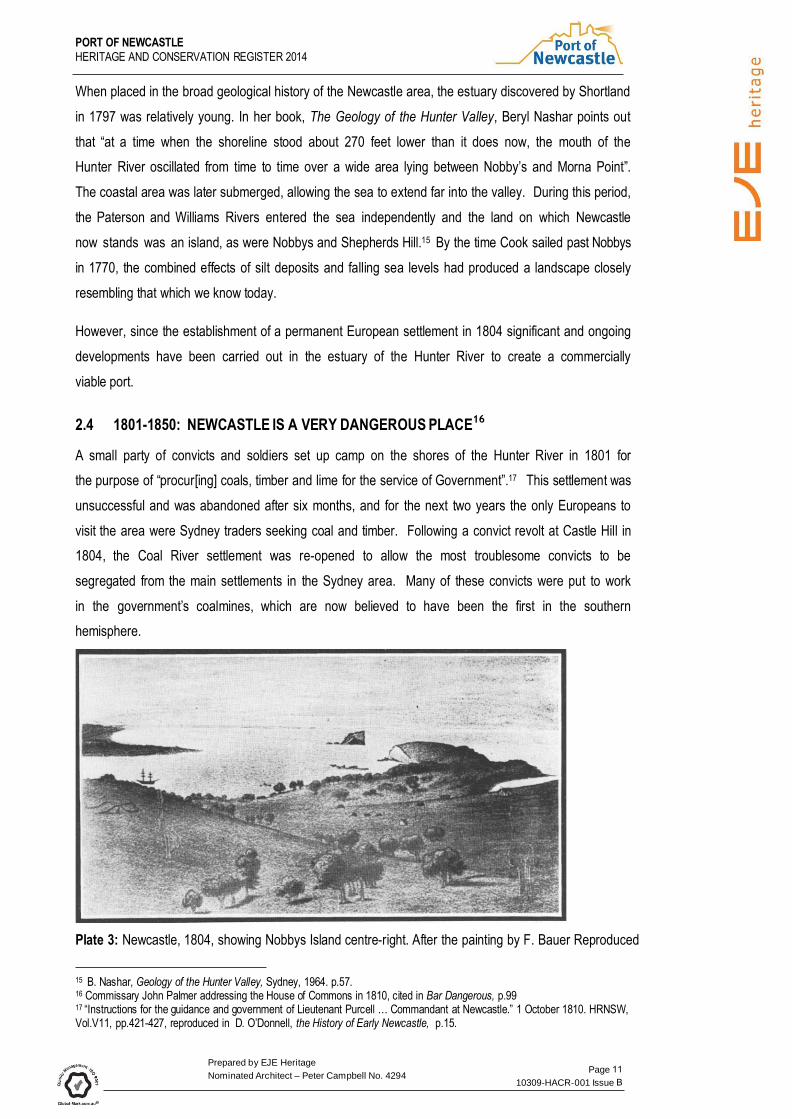
Plate 3: Newcastle, 1804, showing Nobbys Island centre-right. After the painting by F. Bauer Reproduced
15 B. Nashar, Geology of the Hunter Valley, Sydney, 1964. p.57. 16 Commissary John Palmer addressing the House of Commons in 1810, cited in Bar Dangerous, p.99 17 “Instructions for the guidance and government of Lieutenant Purcell … Commandant at Newcastle.” 1 October 1810. HRNSW, Vol.V11, pp.421-427, reproduced in D. O’Donnell, the History of Early Newcastle, p.15.

PORT OF NEWCASTLE
HERITAGE AND CONSERVATION REGISTER
Prepared by EJE Heritage
Nominated Architect – Peter Campbell No. 4294 Page
10309-HACR-001 Issue
in F. Gregory, Selected Source Material
Development of the harbour was limited during the convict period but after closure of the penal station in
1823 Newcastle was declared an open port (the first north of Sydney) However, free settlers were
attracted to the developing towns of the Hunter Valley rather than the abandoned convict settlement.
Newcastle’s population declined and the town was replaced by Morpeth as the main shipping port on the
Hunter. In 1827, convicts were still employed in the government’s coal mines but the town was described
by a visitor as being “in a state of decay”.
Although the Australian Agricultural Company began to load coal from its wharf in 1831, its monopoly of
the industry until 1847 discouraged the government from allocating funding for port development.
Coal exports from Newcastle increased dramatically as the A.A. Company developed its mines to meet the
demand created by the introduction of the steamship. In its first year of operation the company raised
5,000 tons. In 1840, the company’s mines produced 30,000 tons of coal and by 1842 the annual output
had risen to 40,000 tons.18 Despite this increase, demand outstripped production and ships waited from
four to five weeks to load.19
The harbour at this time was characterised by a series of mud flats and sand spits separated by channels.
Coal loading was often a drawn out process, as the entrance to the “coal channel”, which led to the A.A.
Company’s coal wharves, was not deep enough to allow a large ship to load fully. These vessels were
moved into deeper water and the loading completed from lighters. Until at least 1839, the company
intensified the problem in the channel and at its wharf by discharging water from the Church Street mine
into the harbour below.20
2.5 ADMINISTRATION
Newcastle was established as a penal outpost of Sydney, which retained control of the newly formed
town and its port. The first local administrators of the port were Commandants of the convict settlement,
initially Lieutenant Charles Menzies in 1804. Lieutenant Charles Throsby was also appointed at that time
to take control of public works and was responsible for the issue of general orders, including those relating
to the port. Throsby's first recorded order was issued in May 1804 and although its clarity may have
dimmed with the passage of time, its authority is unmistakable:
Weekly private signals being directed, to be shown from the flagstaff at Kings Town, in Newcastle
District, on the arrival of all vessels at that Port, the masters will be careful not to anchor until they
18 J.W. Turner, Coal Mining in Newcastle, 1801-1900, Newcastle, p33. 19 T. Callen, Bar Dangerous, Newcastle, 1986, p.34. 20 ibid., p.35.

PORT OF NEWCASTLE
HERITAGE AND CONSERVATION REGISTER
Prepared by EJE Heritage
Nominated Architect – Peter Campbell No. 4294 Page
10309-HACR-001 Issue
have observed the signal indicated, for which purpose they will receive a sealed paper containing
the signals for a fortnight after their departure from hence at the time they receive their certificate,
which sealed paper is not to be opened until they are within the Coal Island.
After Newcastle became a free settlement, port administration remained under the control of the Engineer-
in-Charge of Public Works until 1846, when Captain Alexander Livingstone was appointed to the position
of Harbour Master. However, the provision and maintenance of wharves and general port development
work continued to be supervised by the Engineer-in-Charge.21
2.6 HARBOUR IMPROVEMENTS
2.6.1 Macquarie Pier
Newcastle was dependent on sea transport for supplies from Sydney, and it soon became apparent that
Governor King’s fears relating to the harbour entrance were justified. The first victim of the Oyster Bank
was the Francis, lost in 1805 and by 1816, when Lieutenant C. Jeffries produced a detailed map of the
port, at least five additional vessels had been destroyed in the Newcastle area. Jeffries’ own vessel,
Kangaroo, had struck three times when negotiating the channel between Signal Hill and Pirate Point.22
A major factor contributing to the hazardous entry was the surge entering the estuary between Signal Hill
and Nobbys. This opening, “between the island and the main” had been noted in 1801 by Grant, who
commented that the expanse of water “of about three cables’ length [was] full of rocks, with a heavy surf
breaking over them”. The only safe entry to the harbour, he wrote, was “round the island”.23 Governor
King also expressed concern about the entry, believing that it would limit the usefulness of the harbour.
This navigational problem was overcome with the construction of Macquarie Pier, the first major
improvement to Newcastle Harbour and the main legacy of the convict period. Construction of the pier,
linking Nobbys to the mainland, commenced in 1818 after Governor Lachlan Macquarie visited the site in
August of that year. He recorded the event in his journal:
At 1 p.m. I went along with Capt. Wallis to look and examine the channel dividing Coal Island
(Nobby) from the South Head of Newcastle Harbour, with the view of filling it up entirely by
constructing a strong mound or causeway between the island and the main for the purpose of
deepening the main channel or entrance into the harbour. We landed on the island and sounded
the channel between it and South Head, which does not exceed 7 feet in depth at low water and
only about a quarter of a mile in breadth. After examining both sides of the channel, it was finally
determined to commence forthwith filling it up by constructing a strong causeway of 30 feet broad
21 A.J. Enver, “A Brief History of Port Administration at Newcastle” in Port of Sydney, Vol.7, June 1961. p.154-158. 22 T. Callen, Bar Dangerous, Newcastle, 1986, Appendix 1 and Jeffries map. 23 Grant, The Narrative of a Voyage, p.152.

PORT OF NEWCASTLE
HERITAGE AND CONSERVATION REGISTER
Prepared by EJE Heritage
Nominated Architect – Peter Campbell No. 4294 Page
10309-HACR-001 Issue
from South head to Coal Island.24 With characteristic vigour, Macquarie approved the huge undertaking after a couple of hours’ inspection
and the next day he returned to the site to lay the foundation stone.
At 4 p.m. accompanied by Capt. Wallis, Revd. Mr. Cowper, Major Antill, Lt. Macquarie, Ensn.
Roberts and Mr. Meehan, I went to the shore of the channel dividing Coal Island from the South-
Head, for the purpose of laying the foundation and first stone of the causeway or pier to be
constructed across from the main to the island; and the stone being cut and ready, with an
inscription, it was laid accordingly with all due form in presence of the artificers & labourers to be
employed in the construction of it; and Capt. Wallis having proposed that it should bear my name
it was accordingly called after me Macquarie Pier, which [with] the present year 1818 was cut and
inscribed on the foundation stone. After the foundation stone had been laid the artificers and
labourers were served with an allowance of spirits to drink success to the undertaking, which they
did with 3 hearty cheers.25
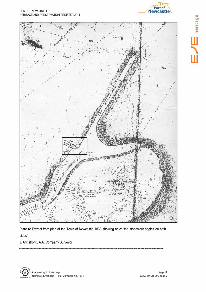
The location of the foundation stone is not known but a map prepared in 1831 by the A. A. Company
surveyor Armstrong (Plate 6) shows the point of commencement of the stonework
Work on Macquarie Pier began shortly after the Governor’s visit and continued until 1822, when the
Hunter Valley was opened to free settlers and Newcastle’s convict population transferred to a new penal
settlement at Port Macquarie. Work recommenced in 1832 and in 1846 the link between Nobbys and the
mainland was complete, but was often breached by heavy seas and needed continuing repairs.
24 L. Macquarie, Journals of his Tours, Sydney, 1979, pp.135-6.

PORT OF NEWCASTLE
HERITAGE AND CONSERVATION REGISTER
Prepared by EJE Heritage
Nominated Architect – Peter Campbell No. 4294 Page
10309-HACR-001 Issue
Plate 4: Macquarie Pier in 1853, shortly after completion as sketched by F.C. Therry . New South Wales Illustrated: The Sketches of F.C. Therry with introduction by James Murray.

Prepared by EJE Heritage
Nominated Architect – Peter Campbell No. 4294 Page
10309-HACR-001 Issue
PORT OF NEWCASTLE
HERITAGE AND CONSERVATION REGISTER
Plate 5: Jeffries' map of Newcastle, 1816.
Prepared by EJE Heritage
Nominated Architect – Peter Campbell No. 4294
Page
10309-HACR-001 Issue
PORT OF NEWCASTLE
HERITAGE AND CONSERVATION REGISTER
Plate 6: Extract from plan of the Town of Newcastle 1830 showing note: “the stonework begins on both
sides”
J. Armstrong, A.A. Company Surveyor

28 Discussion with Capt. I. McLeod, 3 February Prepared by EJE Heritage
Nominated Architect – Peter Campbell No. 4294
Page
10309-HACR-001 Issue
PORT OF NEWCASTLE
HERITAGE AND CONSERVATION REGISTER
2.6.2 Dredging Begins in the Harbour
In response to a government review of harbour facilities at Newcastle in 1843, residents of Morpeth
commissioned a survey of the Hunter River by Surveyor G.B. White. Steamers travelling between
Newcastle and Morpeth were sometimes grounded on the mudbanks near Fullerton Cove but the
Government was not prepared to provide the requested funds for deepening the river. Instead, the
dredge, Hercules, was sent from Sydney in March 1845 with a crew of thirty prisoners. The work of
dredging a channel through the “flats” was more tedious than anticipated due to numerous difficulties with
the crewmembers, described as being “extremely tenacious of control and of excitable temperament”.26
Dredging began in May, just after the first Newcastle Regatta which was held on 5 April. The condition of
the river led to an official complaint after John Hannell’s crew jumped out of his boat and pushed if off a
sandbank:
The sailing match, which was for a Silver Cup, for all classes of boats, was well contested to the
end, although Mr. John Hannell of Hexham, got the lead at starting, and kept it the whole way,
coming in about twenty minutes before Mr. Wallace, and leaving all the others a good distance
astern. It seems there is some dispute about the race, respecting the running on a sandbank,
which is to be referred to the decision of the Regatta Club of Sydney.27
The dispute was subsequently settled by Captain Moriarty, who awarded the Silver Cup to John Hannell.
The Regatta continued on an annual basis until the outbreak of World War II. On Australia Day 1984, the
tradition was revived as a result of efforts by retired Harbourmaster Ken Hopper who was then President
of the Maritime Museum. His goal was to raise funds for the museum and while success in this area has
been limited, the Regatta is a highly popular event in the city, providing an opportunity for the community
to enjoy the various aquatic activities or take advantage of a wide range of activities on the foreshore.28
2.7 Wharfage
2.7.1 1806: The harbour’s first jetty
One of the first tasks after the establishment of settlement was the construction of a jetty, 108 feet long
and 13 feet wide, at the foot of George Street (later renamed Watt Street). A small lagoon adjacent to the
jetty served as a boat harbour. Coal loading methods remained primitive, and the mines at Newcastle
seen as “the cause of the wretched state of Newcastle” by a Sydney Morning Herald journalist:
The coal is doled out in miserable thimblefuls and drawn about the wharf in wheelbarrows. Five
26 L. Coltheart, Between Wind and Water, p.40. and E. Coulin, "Port of Newcastle: the Formative Years, 1844-1862" unpublished manuscript. p.42. 27 Maitland Mercury, 5 April 1845, cited in Ports and People: a Social History of the Hunter River, p.23.

28 Discussion with Capt. I. McLeod, 3 February Prepared by EJE Heritage
Nominated Architect – Peter Campbell No. 4294
Page
10309-HACR-001 Issue
PORT OF NEWCASTLE
HERITAGE AND CONSERVATION REGISTER
or six prisoners to a barrow is common, and so often is the coal shifted about from baskets to
bullock carts, from bullock carts to the wharf, from wharf to the pier, from pier to lighter, and from
lighter to ship, that by the time it arrives in Sydney for sale, this fine coal is nothing but dust, and
difficult to be had at any price sometimes, in winter months.29
2.7.2 1831: A.A. Company wharf and coal loading facility
The government retained its coalmines in Newcastle but as early as 1825 the Australian Agricultural
Company (A.A. Company) was expressing an interest in the mines. The company had been established
in London in 1824 to raise fine woolled sheep on a one million acre grant in New South Wales. In addition
to its large grant, the A.A. Company also obtained a 2,000 acre grant in the Newcastle area, with the right
to mine coal. Under an agreement signed in 1828, the A.A. Company became the sole coal producer in
NSW, after the government agreed that no further coal rights would be issued, or convicts assigned for
coalmining, for the next 31 years.30 However, the agreement was terminated in February 1847 after a
legal challenge by rival miner James Brown.31
Plate 7: “City of Newcastle” showing Ballast Wharf. C.1845. LHM B333.3/16
Mechanised coal loading was introduced to Newcastle by the A.A. Company, which sank its first shaft at
the corner of the present Brown and Church Streets. The mine was officially opened on 10 December
1831, when decorated wagons loaded with coal descended an inclined plane to a newly-erected wharf
29 Sydney Morning Herald, 31 January 1827, cited in Callen, Bar Dangerous, p.31. 30 P. Pemberton, Pure Merinos and Others: the Shipping Lists of the Australian Agricultural Company, Canberra, 1986, p.31.
28 Discussion with Capt. I. McLeod, 3 February Prepared by EJE Heritage
Nominated Architect – Peter Campbell No. 4294
Page
10309-HACR-001 Issue
PORT OF NEWCASTLE
HERITAGE AND CONSERVATION REGISTER
below, where the steamer Sophia Jane waited to receive the load. After the coal was released into her holds
by a single hammer blow, two more wagons descended from the mine, their weight causing the empty wagons
to return to the pit head for refilling.
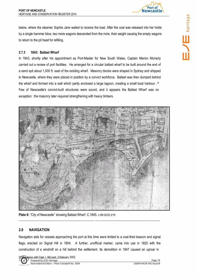
2.7.3 1843: Ballast Wharf
In 1843, shortly after his appointment as Port-Master for New South Wales, Captain Merion Moriarty
carried out a review of port facilities. He arranged for a circular ballast wharf to be built around the end of
a sand spit about 1,000 ft. east of the existing wharf. Masonry blocks were shaped in Sydney and shipped
to Newcastle, where they were placed in position by a convict workforce. Ballast was then dumped behind
the wharf and formed into a wall which partly enclosed a large lagoon, creating a small boat harbour .32
Few of Newcastle's convict-built structures were sound, and it appears the Ballast Wharf was no
exception: the masonry later required strengthening with heavy timbers.
Plate 8: “City of Newcastle” showing Ballast Wharf. C.1845. LHM B333.3/16
2.8 NAVIGATION
Navigation aids for vessels approaching the port at this time were limited to a coal-fired beacon and signal
flags, erected on Signal Hill in 1804. A further, unofficial marker, came into use in 1820 with the
construction of a windmill on a hill behind the settlement. Its demolition in 1847 caused an uproar in

37 “Early Development of the Ports of Sydney and Newcastle” unpublished manuscript, NPC Prepared by EJE Heritage
Nominated Architect – Peter Campbell No. 4294
Page
10309-HACR-001 Issue
PORT OF NEWCASTLE
HERITAGE AND CONSERVATION REGISTER
maritime circles, resulting in the erection of a masonry obelisk in 1850. Although no longer serving its
intended purpose, the obelisk is a well known local landmark.
As area of the harbour were dry at low tide, bringing a vessel safety to a berth at any time would have been
difficult. During this early period, one ship’s captain commented that the task was easier at night time,
using a light at the A. A. Company mine at the top of Brown Street and a basket light on the wharf at the
foot of Watt Street as guides.33
Until the establishment in 1812 of a pilot service (comprising pilot, whaleboat and convict crew) ships’
masters negotiated the entrance unaided. Early pilots were William Eckford, appointed in 1812 and
William Cromarty, who took up the position after Eckford’s death in 1833. Cromarty held the position until
1836, when he resigned after being badly injured while at work.
Subsequent pilots carried the title of Pilot and Harbourmaster until 1858 when Captain David Allen
became the first to carry the title of Harbourmaster. His residence was at Signal Hill, which was for many
years known as Captain Allen’s Hill.34
The first pilot station occupied part of the old Stockade and the boat was beached on the riverbank until a
boatshed was built in 1840.35
2.9 Overview
The first half of the nineteenth century saw the establishment of Newcastle as a free port following closure
of the penal settlement. Coal from the A.A. Company mines was the primary export, generally destined
for Australian ports but in the late 1840s small shipments of coal and cargoes of sheep, cattle and horses
were sent to New Zealand.36 With the cessation of the A.A. Company’s monopoly, other mining
companies began to export coal which was loaded from staithes adjacent to the three A.A. Company
staithes, or direct from the jetty by means of wheelbarrows.37 Recognition of the area’s coalmining
potential encouraged the government to allocate funding for the construction of Macquarie Pier and the
beginnings of a dredging programme to increase the depth of the port. However, these achievements
were but a drop in the ocean compared to the massive undertakings of the next fifty years.
2.9.1 1850-1900: “A HARBOUR FROM A CREEK”
With the breaking of the A.A. Company’s coal monopoly, mining in the area escalated rapidly. Newcastle’s
place as a major trading port was secured, overtaking Morpeth which subsequently declined in
33 Callen, Bar Dangerous, p.187. 34 Ports and People, p.12. 35 ibid, p.11. 36 ibid.,p.24.

41 ibid., Prepared by EJE Heritage
Nominated Architect – Peter Campbell No. 4294
Page
10309-HACR-001 Issue
PORT OF NEWCASTLE
HERITAGE AND CONSERVATION REGISTER
significance as a port. As Australia’s population increased, especially after the goldrushes of the 1850s, the
demand for coal for industrial, railway and domestic purposes incr4eased. Shipments to foreign and
interstate ports rose steadily, from less that 500,000 tons in the mid-860s to just under 4,000,000 tons in
1900.38 More local coal was shipped to Victoria than elsewhere, but the overseas market improved
following the Californian goldrushes and in October 1850, sixteen of the twenty-two ships waiting to load
coal were from North America.39
While coal was by far the major export for Newcastle, wool, timber, livestock and general cargo were also
shipped. However, the expansion of trade was hampered by the harbour’s natural disadvantages which
created a hazardous shipping environment and also limited the size of vessels which could visit the port.
The government responded by undertaking a series of major developments in the port which led to vastly
improved shipping facilities with a corresponding effect on the city’s prosperity. However, while the
benefits to Newcastle and the surrounding region were undeniable, the government’s approach to the
control and development of the port drew intense local criticism.
2.9.2 ADMINISTRATION
Despite increasing agitation for local control of the port during this period, power remained firmly in the
hands of the State Government in Sydney, with responsibility divided between three departments.
Administration was in the hands of the Navigation Board until 1871 when a Local Marine Board was
established under the Navigation Act (1871). Hopes of local autonomy at this time were short-lived, as the
local Board’s subservience to the Marine Board of New South Wales ensured that control remained with
the central body.
Construction of wharves, management of dredging and reclamation work was controlled by the NSW
Public Works Department. As well as being responsible for construction and maintenance of port facilities
and harbour development, the PWD was involved in construction of the Hunter River district water supply
scheme and electricity installations for coal loading equipment at Bullock Island. A workshop was
established at the southern end of The Dyke, where repairs to dredges and other equipment were carried
out, together with the construction of valves, hydrants, engines and boilers for the water supply scheme.40
The Department was a major employer in Newcastle, providing work for 400 men in 1898 with an
additional 200 employed by contractors on Newcastle harbour works.41
During this period the Department of Railways also became a key player in port administration. In the early
38 Newcastle Chamber of Commerce Annual Reports, passim. 39 S. Marsden, "Coals to Newcastle: a history of coal loading at the Port of Newcastle, New South Wales, 1797-1997", unpublished manuscript, p.11, and Coltheart, Between Wind and Water, p.40 40 Coltheart, Between Wind and Water, p.92

42 E. Coulin, "Port of Newcastle, the Formative Years", unpublished manuscript Prepared by EJE Heritage
Nominated Architect – Peter Campbell No. 4294
Page
10309-HACR-001 Issue
PORT OF NEWCASTLE
HERITAGE AND CONSERVATION REGISTER
Years of coal production, loading facilities were provided by private mining companies but with the
extension of the Great Northern Railway to Newcastle and along to Queens Wharf in 1858, the
Department of Railways became the chief railway provider, levying its own rates and charges. After 1863
the Department also provided steam cranes for coal loading. It owned and operated the coal loading plant
which was established at Bullock Island during this period, provided the wharves and facilities, and
controlled the berthing arrangements.
In the eyes of the Newcastle business community, such a complicated administrative system was
detrimental to port development. These concerns were well founded, as poor communication between the
various controlling bodies inhibited the development of comprehensive and cohesive planning. Local
frustrations were further intensified by the perceived preference of the central body to direct funding
towards Sydney rather than outports such as Newcastle.
2.9.3 HARBOUR IMPROVEMENTS
The completion of Macquarie Pier had improved the entrance to the harbour, creating additional shelter for
ships and reducing the swell at the wharves. However, while the altered direction of the outward current
had produced some scouring of the northern shore, the shallow depth in the harbour continued to be its
main drawback, preventing many ships from visiting Newcastle.
Moreover, the Newcastle Harbour Master reported in 1852 that the harbour depth was further decreased
by “ballast being thrown out of the sailing vessels going up the river, when getting aground on the flats,
much to the injury of the river and the vessels trading up and down”42. If full advantage was to be taken of
the area’s rich coal deposits, considerable expenditure would be required to create a safe, navigable
harbour with adequate wharfage and loading facilities. The government began working towards this goal
in the early 1850s
In 1851 Lieut. John Lort Stokes, R.N. carried out a survey of the harbour which highlighted the hazardous
rocks, reefs and channels through the mudflats. This survey was followed in 1854 by the formulation of a
Harbour Development Plan by a civil engineer, J. Woolston Ellis. His plan, which incorporated
construction of The Dyke with a shipping basin behind it and training walls for the river to Fullerton Cove,
foreshadowed the future shape of the harbour. However, the ambitious plan which transformed the port
has been attributed to Edward Orpen Moriarty, son of Merion Moriarty.
2.9.4 The Moriarty Plan
E.O. Moriarty had broad engineering experience in breakwater construction, railway works, surveying,

46 Callen, Bar Safe, Prepared by EJE Heritage
Nominated Architect – Peter Campbell No. 4294
Page
10309-HACR-001 Issue
PORT OF NEWCASTLE
HERITAGE AND CONSERVATION REGISTER
construction and shipbuilding. He had worked as a cadet engineer on the Isle of Portland breakwater in
Ireland before emigrating to New South Wales with his family in 1843. After working as a consulting
engineer and surveyor in Sydney for several years, he became an assistant in the Surveyor-General’s
Department. In 1853 he became Engineer-Surveyor of the Steam Navigation Board (which he later
Chaired), followed by his appointment to Newcastle in 1855 as Engineer for Hunter River improvements.43
After leaving Newcastle in 1858 he became Engineer in Chief, Harbours and Rivers for the Public Works
Department.44
Plate 9: E.O. Moriarty J.
Armstrong, Shaping the Hunter
Moriarty produced a report on the navigation problems of the harbour, identifying “two natural drawbacks
of the harbour”: a rock ledge and unusual current at the entrance, and the extensive banks of sand within.”
He predicted the removal of the rock ledge, or the carving of a channel through it, “at some future time”,45
but laid down a three stage plan to reduce the levels of silt and sand within the harbour. These steps were
summarised by maritime historian Terry Callen:
The first stage was the “continuation of the river” plan and involved the building of a large stone
dyke curving from Port Waratah to opposite the Australian Agricultural Company’s wharf (Crown
Street). The second stage was to build a similar stone wall from near Crown Street curving
slightly until it met Macquarie Pier. The third stage was a small stone guidewall or breakwater on
the northern side of the harbour at Pirate Point. All three features were planned to work together
in concentrating the outgoing current into one stream which would scour out the harbour and the
bar.46
43 Armstrong, Shaping the Hunter, p.15. 44 ibid.,. 45 Coltheart, Between Wind and Water, p.41.

47 N. Cushing, "Creating the Coalopolis: Perceptions of Newcastle 1770-1935", PhD Thesis, University of Newcastle, 1995, Prepared by EJE Heritage
Nominated Architect – Peter Campbell No. 4294
Page
10309-HACR-001 Issue
PORT OF NEWCASTLE
HERITAGE AND CONSERVATION REGISTER
For many years the government raised funds for Newcastle harbour improvements by levying of tonnage
dues. This scheme operated from 1858 until the 1873 when the Repeal of Tonnage Dues Act was passed,
following pressure from local politicians who resented the expenditure of locally raised funds in other
areas.47
Plate 10: Plan of Newcastle Harbour with manmade foreshores shown in broken lines from T.Callen, Bar
Dangerous.
Stage 1: The Dyke
Construction of The Dyke at Bullock Island served a dual purpose in Moriarty’s plan. While its eastern face
would improve the flow of the river, it would also support a line of wharves for coal loading purposes.
Reclamation work behind The Dyke would create an area of land which could be devoted to loading
activities.
A sand bank of about 650 hectares ran north-south on the east of the Bullock Island, and Moriarty
proposed depositing a layer of ballast along the margin of the bank to prevent it flooding at high tide and to
divert the flow of the river to scour a channel to the east of the Dyke. In 1862, two ballast jetties were built
and ships began depositing ballast heaps on the line of the embankment, while sand dredged from the
harbour was pumped behind the newly created wall.
The diverse nature of the ground on the man-made island was highlighted by a local newspaper:
49 Coltheart, Between Wind and Water, 50 Port of Newcastle Surveyed by Captain Stokes RN
Prepared by EJE Heritage
Nominated Architect – Peter Campbell No. 4294
Page
10309-HACR-001 Issue
PORT OF NEWCASTLE
HERITAGE AND CONSERVATION REGISTER
Here we have geographical specimens from every part of the world. The whole expanse of ground
has been built up of ballast from the ships that come to our harbour. In one place we tread upon
a layer of London flint, next a collection of stones from the shores of the sunny Mediterranean.
These are succeeded by a rocky mound from Scandinavian coasts and these in turn give place to
blue stone from Melbourne, green trap from New Zealand, limestone from Singapore and even
the sun burnt bricks and glazed uncouth carvings from a dismantled village in far off China.48
By 1874 the stone bank was complete, enabling contracts to be let for the construction of wharves.
Reclamation work continued on Bullock Island and by 1890, a series of mudflats had been transformed
into 121 acres of usable land.
Enlargement of the basin behind The Dyke in 1892 involved pumping sand through a pipe laid under the
main railway line to swampy land north of the hydraulic engine house. Rock at the entrance to the new
basin was removed by drilling and blasting, using a specially built rockbreaker, Posiedon. 49
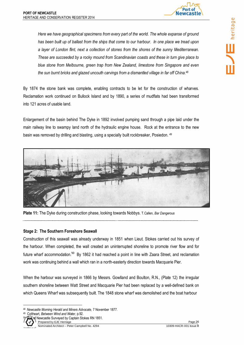
Plate 11: The Dyke during construction phase, looking towards Nobbys. T.Callen, Bar Dangerous
Stage 2: The Southern Foreshore Seawall
Construction of this seawall was already underway in 1851 when Lieut. Stokes carried out his survey of
the harbour. When completed, the wall created an uninterrupted shoreline to promote river flow and for
future wharf accommodation.50 By 1862 it had reached a point in line with Zaara Street, and reclamation
work was continuing behind a wall which ran in a north-easterly direction towards Macquarie Pier.
When the harbour was surveyed in 1866 by Messrs. Gowlland and Boulton, R.N., (Plate 12) the irregular
southern shoreline between Watt Street and Macquarie Pier had been replaced by a well-defined bank on
which Queens Wharf was subsequently built. The 1848 stone wharf was demolished and the boat harbour
48 Newcastle Morning Herald and Miners Advocate, 7 November 1877.

Prepared by EJE Heritage
Nominated Architect – Peter Campbell No. 4294
Page 27
10309-HACR-001 Issue B
PORT OF NEWCASTLE
HERITAGE AND CONSERVATION REGISTER
Behind it resumed in a reclamation programme associated with the construction of Newcastle Railway
Station in 1857. A new boat harbour, its banks lined with masonry from the Watt Street wharf, was built at
the foot of Markey Street.
A small beach, now known as Horseshoe Beach, remained between the eastern end of the seawall and
Macquarie Pier. The low lying ground behind it was reclaimed to create an enlarged area of foreshore
land, shown on Plate 12 below.
Plate 12: Extract from Gowlland & Boulton Survey, 1866 Taken from PWD microfilm by MSB Engineering, Ncle 1976
Stage 3: The Pirate Point Guidewall
Between 1861 and 1872 a small breakwater was built towards the sea from Pirate Point on the Stockton
peninsular. A wall was built of ballast, mostly Melbourne bluestone, which was discharged at a small
wharf on the south-eastern tip of the peninsular.51 As the wall progressed, railway tracks were laid on to
carry wagons of ballast to the end, where they were tipped to build up the next section.52 This breakwater
was rebuilt between 1871 and 1886, and was also reinforced with Waratah sandstone. It continues to
serve as a wave-trap to reduce the damage to ships moored in the harbour.53
Dredges were a key component in Moriarty’s plan and they worked constantly, excavating berths and
channels then using the dredged material to reclaim new waterfrontage. As well as the training walls
51 Callen, Bar Dangerous, p.173. 52 Coltheart, Between Wind and Water, p.53. 53 Callen, Bar Dangerous, p.173.

Prepared by EJE Heritage
Nominated Architect – Peter Campbell No. 4294
Page 28
10309-HACR-001 Issue B
PORT OF NEWCASTLE
HERITAGE AND CONSERVATION REGISTER
mentioned above, similar structures were built up as far as Fullerton Cove and the western shore of
Stockton Pennisular was reclaimed.
Further developments at Stockton were made as a result of outbreaks of bubonic plague in the late 19th
Century. This aroused much concern in Newcastle because of the city’s close contact with the maritime
industry. In an attempt to minimise the risk of infection, a new jetty was built at Stockton in 1899 for the
dumping of ballast from infected ports and a Quarantine Station, which later became Stockton Hospital,
was built soon after.54
Moriarty’s plan had vastly improved the harbour, but as ships became larger the need for additional
deepening took on a degree of urgency. In 1890 the Chamber of Commerce reported that several English
merchants had complained that they were incurring “very great loss … in consequence of a number of
vessels not being allowed to load to their full draughts”. Turnaround times were also a problem, with some
ships waiting up to 2 months for a berth, lying up to 5 abreast. In many cases, the ships were sent to
Sydney rather than Newcastle to load.55
Arrival of the rockbreaker, Poseidon, in 1892 brought some hope for improved navigation of the harbour.
The channel was deepened to 25 feet, a navigational hazard known as the Lightship Rock was removed
and rock was excavated to deepen the wool berths at Queens Wharf to 24 feet, the depth required for
larger ocean steamers.56
However, silt continued to wash down the river and after severe flooding in 1893, the depth was reduced
from 27-28 feet to only 12 feet in some places. Seven dredges, including Dorus and Juno which were
added to the fleet at the time, worked constantly to clear shipping channels, removing one and a quarter
million tons of silt from the north channel alone.57 Henry Deane Walsh, Engineer-in-Chief of the Sydney
Harbour Trust, believed that constant dredging would maintain sufficient depth in the harbour “for many
years to come”. While he acknowledged that it may be necessary in the future to cut away a
“considerable portion” of the rock at the harbour entrance, he described such a task as “a bigger job that
the removal of Hell’s Gates”.58
54 Coltheart, Between Wind and Water, p.93. and Chamber of Commerce Annual Report, 1901. 55 Fifth Annual Report, Newcastle Chamber of Commerce, Newcastle, 1891, p.9. 1888 Improvements, p.112 56 Coltheart, Between Wind and Water, p.92. 57 Henry Deane Walsh, evidence to Parliamentary Standing Committee on Public Works. Minutes of Evidence – Hunter River Flood Prevention, 20 December 1901, P.96. Chamber of Commerce Report, 1893 58 Walsh, evidence to Parliamentary Standing Committee on Public Works, Hunter River Flood Prevention, 20 December 1901, p.95.

Prepared by EJE Heritage
Nominated Architect – Peter Campbell No. 4294
Page 29
10309-HACR-001 Issue B
PORT OF NEWCASTLE
HERITAGE AND CONSERVATION REGISTER
2.9.5 Macquarie Pier Although the link between Nobbys and the mainland had been completed in 1846, Macquarie Pier was not
strongly built and was often breached by heavy seas. The stone from signal hill which was used to
construct the pier was “of a very indifferent character” and “fretted away, partly by the action of the sea
and partly by the action of the atmosphere”.59
Hoping to create a beach which would protect the convict-built structure, Moriarty built two groynes near
the centre of the pier b u t they were partially destroyed in a gale.60 Recalling his arrival in Newcastle in
1867, PWD Engineer Cecil Darley commented that:
… the breakwater was breached through, and the sea was breaking heavily through several gaps
into the harbour. One gap was so washed out that at high tide it was almost possible to take a
boat into the harbour through it. I found that a contract was in existence when I arrived for
repairing that structure … with ships’ ballast bluestone, which was being carried out from the end
of Queen’s Wharf. There was no crane at the end of the wharf in those days, and the ballast was
run out on a siding and tipped there. I watched these operations for a short time, and found that
the ballast was altogether too light for the work which it was expected to do. Every sea used to
wash away the stonework.61
Rather than using ships ballast to repair the breaches, he argued that larger rocks were needed if the pier
was be effective. In 1869 a quarry (subsequently known as “Harbour and Rivers Department No.1
Quarry”) was established on the Waratah Coal Company’s estate at Lambton. An arrangement was made
with the coal company whereby the government paid for the use of their rail line to transport stone from
the quarry to the eastern end of Queens Wharf.
Progress was continually hampered by the Government’s reluctance to grant more than £5,000 at a time
for such work. As Darley pointed out, this prevented the acquisition of necessary plant so work was
undertaken with “indifferent appliances, and when we got fairly into swing with the work, and the men all
trained to it, the money ran out, the works were stopped, and the men were scattered all over the Colony”.
By 1870 all gaps had been filled but the pier was sound for only three quarters of its length. Gales once
again caused damage in the following year, and a grant of £5,000 which was intended to finance
completion of the pier was devoted to repairs.62 The project was finally completed in February 1872. The
inner harbour face was later built with roughly-dressed blocks of stone “so as to get the benefit of the
59 C.W. Darley, evidence to Parliamentary Standing Committee in Public Works, Proposed Harbour Improvements at Newcastle, 21 March 1895, p.7 60 Callen, Bar Safe, p.26. 61 C.W. Darley, evidence to Parliamentary Standing Committee in Public Works, Proposed Harbour Improvements at Newcastle, 21 March 1895, p.7 62 ibid

65 R. Melville, “Macquarie Pier and Nobbys Head”, in Conservation Management Plan for the site prepared by Suters Prepared by EJE Heritage
Nominated Architect – Peter Campbell No. 4294
Page 30
10309-HACR-001 Issue B
PORT OF NEWCASTLE
HERITAGE AND CONSERVATION REGISTER
whole width on the top, and make it a public promenade.” 63 Early maps of the harbour show lifeboat sheds on Stony Point, located mid-way along the inner face of
Macquarie Pier. Although the lifeboat sheds were relocated to the Pilot Station c.1866. later photographs
indicate structures (possibly houses) near the site. A set of steps in this vicinity, sometimes erroneously
known as “the convict steps”, probably provided access to the buildings on Stony Point.
2.9.6 Southern Breakwater
The first breakwater extension beyond Nobbys was built between 1875 and 1883 to protect ships from the
reef which extended towards Big Ben Rock. The Government exceeded its previous allocation of funds
for such work, and voted £10,000. Aspects of the undertaking were described by Cecil Darley:
The first thing … to be done was to form a railway round to Nobby’s. All our appliances had to be
dismantled and carried out to Nobby’s for the purpose of constructing the new extension. The
work was then proceeded with, and the first stone was tipped beyond Nobby’s on the 7th January,
1875. On the 7th March, 1876, work ceased for want of funds. In 1876 the Government voted
£35,000m and the work was resumed on the 7th July 1876. It went on continuously then till the
4th August 1880, and had to cease again through the money being exhausted. That was the
longest spell of work that we had, being a period of four years. In 1881 a further sum of £20,000
was voted, and the work was proceeded with again and finished in 1883. …
Darley commented that the completed breakwater “covered” Big Ben, “so that a ship, if she [kept] clear of
the breakwater, [would] have to keep clear of Big Ben, which was the serious danger.”64
A large fog warning bell was installed on the breakwater in 1878. The sound of this bell, “rung with three
distinct beats with an interval of half a minute before the next three beats”, became a familiar sound to city
dwellers and could be heard a great distance out to sea. The bell, which weighs half a ton, was cast in the
local foundry of Morison and Bearby and mounted on a timber frame. It was operated by staff at Nobbys
Signal Station until it was replaced by an electronic system in the 1950s. It is now housed in the
Newcastle Maritime Museum.65
The breakwater was repaired and extended by 300 ft. in 1896, when the railway line was re-laid to carry
new plant which could carry stones weighing up to 30 tons. The last 100ft. of the extension was
strengthened by increasing it to three times the former width.
63 ibid. 64 ibid., pp.6-8

Prepared by EJE Heritage
Nominated Architect – Peter Campbell No. 4294
Page 31
10309-HACR-001 Issue B
PORT OF NEWCASTLE
HERITAGE AND CONSERVATION REGISTER
2.10 WHARFAGE As Newcastle’s coal industry expanded, increasing numbers of ships visited the harbour, creating a need
for additional wharf accommodation. This was facilitated by the construction of Moriarty’s training walls,
which created unbroken shorelines with unrestricted access across newly reclaimed land.
On the southern shores of the harbour, additional coal loading staithes were built to the west of the Market
Street wharf. By 1865 there were five operated by the A.A. Company and four by the Newcastle Coal and
Copper Company. Further up the river, the Port Waratah Company had four at Port Waratah and at
Hexham, J & A Brown filled their ships from three staithes.66
2.10.1 Queens Wharf
This period also saw the construction of Queens Wharf, in the area between Watt Street and the area now
occupied by the Pilot Station. To build this wharf, it was necessary to fill in the old boat harbour and
demolish the 1846 circular wharf. A new boat harbour was built near Market Street in 1852 and masonry
from the demolished wharf used to face the banks.
Construction began in 1858 and by the early 1860s, it provided 1,500 ft. of wharf accommodation,
equipped with rail tracks and steam cranes for coal loading.67 Two steam cranes had been erected by the
Wallsend Coal Company and a third came into operation shortly afterwards. They were unreliable and
often collapsed under load. After a court case associated with the use of the cranes by other companies,
and the continued poor performance of the cranes, they were replaced by eight government-owned
cranes, the largest with a capacity of 15 tons.
The removal of coal loading to The Dyke eased the congestion on Queens Wharf, which could then be
used primarily for general cargo. The steam cranes were phased out and by 1888 only two remained on
the wharf, while three had been moved to The Dyke.68 Bases of two of these cranes have survived, one
near the entrance to the Pilot Station and the other a short distance to the west. At intervals along the
wharf were several sets of watermen’s boat stairs, as well as stairs for the various ferry-steamers travelling
to Stockton, Bullock Island, Waratah and Raymond Terrace.
In 1895, Queens Wharf was enlarged to create two new berths for loading wool and frozen meat, which
had first been exported in 1892.69
66 J. Armstrong, Shaping the Hunter, p.18. 67 ibid., p.17. 68 J. Windross, The Newcastle Nautical Compendium, 1892, p.13 69 Coltheart, Between Wind and Water, p.92. and Newcastle Chamber of Commerce Annual Report,1896-7, p.20.

Prepared by EJE Heritage
Nominated Architect – Peter Campbell No. 4294
Page 32
10309-HACR-001 Issue B
PORT OF NEWCASTLE
HERITAGE AND CONSERVATION REGISTER
Plate 13: Steam Cranes on Queens Wharf, c.1891. Cadell
Collection NRPL.
2.10.2 Coal Loading Moves to The Dyke
Contracts were let in 1874 for the construction of wharves on the eastern side of Bullock Island, in
preparation for the transfer of coal loading activities from the southern side of the harbour. Archaeologist,
Damaris Bairstow, documented the development of these wharves between 1875 and 1877:
Along the Dyke, wharves were built in 30 metre sections, 60 metres apart starting about 230
metres from the southern end. Seventeen were built in 1875, the same year as the branch
railway crossed Throsby’s Creek on the east side of the island. By 1876, including all sidings,
some eleven kilometres of single track had been laid, all in steel, designed to last six times as
long as the iron rails normally used. In 1876-7, concrete foundations for the first four hydraulic
cranes were laid at Berths 4,5,6 and 7, ninety metres apart. [These bases supported the cranes
which later became known as Nos.7, 8, 9 and 10] In the course of the latter year, the first ten
wharves were connected to form a continuous timber-built wharf 838 metres long.70
Hydraulic powered cranes were selected for The Dyke coal loading berths, and tenders were called for
“the erection of the engine house, boiler house, smoke stack and hydraulic towers” in April 1876. The
building was erected by private contractors employed by Harbours and Rivers section of the Public Works
Department but design of the building has sometimes been attributed to the Government Architect, James
Barnet. Built on “huge blocks of shining white sandstone” (now grey in colour), and featuring the same
yellow bricks from local brick maker, Bowtell, that had been used in the Customs House, the building drew
favourable comment:
On heavy foundations, then thought essential for any major building on reclaimed land, this
70 D. Bairstow, “The Bullock Island Hydraulic Power House”, unpublished manuscript in possession of the author. Identification of cranes in relation to surviving bases was carried out by B. Collins and R. Melville following close study of documentary and physical evidence.
Prepared by EJE Heritage
Nominated Architect – Peter Campbell No. 4294
Page 33
10309-HACR-001 Issue B
PORT OF NEWCASTLE
HERITAGE AND CONSERVATION REGISTER
Classic Revival edifice is of yellow, compressed brick, with Sydney sandstone quoins, architrave,
frieze and pediment. The roof was boarded and slated. The overall length was 43.9 metres, the
depth 26.9 metres. The engine room measured 21.3 by 12.3 metres.71
Contracts for the hydraulic pumps and associated hydraulic loading cranes were awarded to the
Armstrong Hydraulic Machinery Co., Elswick, England.72 In February 1878, Moriarty witnessed a test lift
and on 19th March, 1878 the first shipment of coal loaded by hydraulic cranes left Newcastle Harbour
aboard the Downiemount, which had brought the cranes from Britain on her previous voyage.
The cranes were described in the Town and country Journal in March 1879 as “the chief glory of
Newcastle”:
These beautiful pieces of mechanism … represent the last achievements of mechanical science
in hydraulic machinery. They could be manipulated by a child. The wagons of coal are brought
into position by a rope worked by an hydraulic windlass. The man in charge has simply to press
his foot on the treadle, while he draws in the rope, and the irresistible water pressure does the
rest. The wagon being in position, the hooks of the chains are fastened in it, and the man
standing on the platform of the hydraulic crane moves a lever, and the giant lifts the top of the
truck as easily as a mother would lift her child, without a sound swings it over the ship’s
hatchway, where the lumpers knock out the pins which fasten the bottom of the truck, and then
the coal disappears into the hold of the vessel. The whole process takes only a minute and a
half.73
71 Suters Architects, "Macquarie Pier and Nobbys Head Conservation Management Plan", p.11. 72 For a detailed description of this equipment see P. Cockbain, “The Engineering Heritage Associated with Coal Shipment from Newcastle 1877 to 1967, paper presented to National Engineering Heritage Conference, 1997. 73 cited in D. Bairstow, archaeological report on various industrial sites in Newcastle, unpublished manuscript in possession of author.

Prepared by EJE Heritage
Nominated Architect – Peter Campbell No. 4294
Page 34
10309-HACR-001 Issue B
PORT OF NEWCASTLE
HERITAGE AND CONSERVATION REGISTER
Plate 14: Hydraulic Power House showing two chimneys which have now been demolished. Newcastle
Region Public Library.
Four more cranes – two of 15 tons and two of 25 tons – were ordered in 1877 and in 1879, two more
boilers and another engine arrived. It was 1880 before the first of the 25 ton cranes arrived and was
installed north of the existing cranes. In 1884-5 contracts were let for a northern extension to the wharf
and by 1886 the Dyke was almost three kilometres long. Four 9 ton cranes were ordered, but they were
not erected until early in 1888, bringing the number of cranes to twelve.
Congestion continued to be experienced, and three steam cranes were transferred from Queens Wharf to
ease the situation. Electric light was installed in 1891 to allow loading to continue around the clock.
While coal loading was the primary activity at the Dyke wharves, an area an the northern end was leased
to the Sulphide Corporation in the 1890s.74 Cattle and sheep wharves were established at the northern
end. Horses were shipped from this wharf during the Boer War (1899-1902) with the men who had
enlisted from the Hunter.75
In the recently completed Basin behind The Dyke, tie up dolphins were provided but wharves were not
completed until after 1900.
74 M. Sparke, "Newcastle Waterside Workers: Their Home Port, Working Environment and Unionism, 1885 to 1917, MA Thesis, University of Newcastle, 1997. p.48. 75 Ports and People, p.44.

76 R.C. Knaggs, The Newcastle Nautical Almanac, Newcastle, 1887, Prepared by EJE Heritage
Nominated Architect – Peter Campbell No. 4294
Page 35
10309-HACR-001 Issue B
PORT OF NEWCASTLE
HERITAGE AND CONSERVATION REGISTER
Plate 15: Hydraulic Power Crane. One of the three hydraulic crannes still in operation in 1959. Note the horse to the right of the coal wagon. Port of Sydney, March
1959.
2.11 Boat Harbours
As well as providing wharf accommodation for ocean going vessels, it was necessary cater for the small
boats which brought produce to Newcastle from farms further up the river, and for ferries and other small
craft.
Boat harbours were built at Stockton, The Dyke, and at the foot of Market Street. In 1887 the Market
Street boat harbour, which had recently been enlarged, was described in The Newcastle Nautical
Almanac:
The Newcastle Boat Harbour, in connection with the Market, is situated at the northern extremity
of Market-street, and has been enlarged and improved, and now provides frontage of 510 feet, of
which 250 feet is reserved for the use of settlers for landing produce, 160 feet for accommodation
for watermen’s boats, and 100 feet for slips and sheds, to contain boats belonging to the various
Government Departments. A market for the accommodation of settlers to vend their produce has
been erected close to this frontage.76
The Market Street boat harbour was resumed for railway expansion and was replaced by the Perkins St.
Boat Harbour, opened in 1902. After providing a safe harbour for small boats and launches for nearly
77 N. Barney, History in our Streets, Newcastle, 1997, Prepared by EJE Heritage
Nominated Architect – Peter Campbell No. 4294
Page
10309-HACR-001 Issue
PORT OF NEWCASTLE
HERITAGE AND CONSERVATION REGISTER
sixty years, the Perkins Street Boat Harbour was demolished in 1960.77
The boat harbour at The Dyke contained provision for slipping boats and wharfage for landing produce. It
also allowed vessels to lower their boats into the water while loading. as the strong current made it
dangerous to moor boats alongside the wharf.
Driven largely by the demands of the coal industry, wharf accommodation in the port had increased
enormously by the end of the 19th Century:
On the south or town side of the harbour there is a continuous line of wharf, 3,607 feet long,
belonging to the Government, 2,130 feet of which is occupied for cargo berths for deep-draught
vessels; 500 feet reserved for Sydney passenger steamers; and the remaining 977 feet is used
as a general cargo wharf, including a lumber berth for loading vessels with timber. The whole
length of this wharf is lit with gas.
At Bullock Island, on the western side of the harbour, a substantial timber Government wharf,
7,760 feet in length, and four ballast jetties, each 50 feet long and 200 feet apart, has been
constructed along the face and round the south end of what was formerly known as the Ballast
Dyke; at present 5,550 feet of this wharf is set apart for the shipment of coal. The loading is
performed by hydraulic cranes, of which twelve are erected, capable of shipping 1,000 tons of
coal each in twenty-four hours – six being 15 ton, four 9 ton, and two 25 ton cranes, the latter for
discharging heavy machinery etc. and three 15 ton steam cranes.
The remainder of the wharf and the ballast jetties are used by vessels discharging ballast or
waiting their turn to load. Ships of the largest class can load under the hydraulic cranes, and
proceed direct to sea through deep-water channels recently dredged. It is proposed to spend
immediately £150,000 to further increase the shipping facilities at Bullock Island. This wharf is
now lit by electric light, which greatly facilitates the loading of coal at night, and is one of the finest
systems of electric lighting in existence, consisting of fifty large arc lamps, each 5,000 candle
power.
In addition to these Government cranes, the Australian Agricultural Company have three large
private shoots capable of delivering 2,000 to 3,000 tons of coal per diem. Vessels loading from
them can discharge their ballast onto the Company’s ballast wharf, lying alongside at a draught of
18ft. 6in. And upwards. Vessels drawing 22 feet can load at the Company’s shoots. The
Waratah Company also have a shoot at Port Waratah capable of shipping about 50 tons per
79 Callen Bar Dangerous, Prepared by EJE Heritage
Nominated Architect – Peter Campbell No. 4294
Page
10309-HACR-001 Issue B
PORT OF NEWCASTLE
HERITAGE AND CONSERVATION REGISTER
house and Messrs. J. & A Brown have two shoots on the Hunter River, at Hexham, 10 miles from
Newcastle, capable of shipping 100 tons per hour.78
A 600ft. long wharf, equipped with two steam cranes for loading coal was also built at Stockton during this
period.
2.12 NAVIGATION
Newcastle’s disastrous tally of shipwrecks cause many sailors to fear entering the port – between 1850
and 1900 at least 35 ships were lost in Newcastle Bight and on Stockton Beach, and the dreaded Oyster
Bank claimed more than 23. One of the most significant disasters was the wreck of the paddle steamer
Cawarra, which struck the Oyster Bank in a heavy gale in 1866 with the loss of 60 lives. The victims were
buried in Newcastle Cathedral cemetery, many being placed in a mass grave where some tombstones
may still be seen. 79
Navigation aids in 1850 were limited to a signal station and beacon fire on Signal Hill, a number of
beacons and the newly erected obelisk which replaced a windmill which had stood on the hill behind the
town since 1820. This windmill had been used as a guide by ships approaching the port, and its
demolition in 1847 caused an uproar in maritime circles.
Vessels were assisted into port by private tugs as early as 1854 but for several years during 1850s the
harbour was without a tug service. Appeals to Sydney for a government funded tug were unsuccessful,
despite the support of Merion Moriarty who declared that “The harbour at Newcastle is a very dangerous
one indeed. It should have a tug to prevent accidents”. In September 1859 a second privately own tug
commenced operations and towage services were subsequently provided by firms such as J & A Brown,
The Newcastle Co-Operative Steam Tug Company, Daltons and Fenwicks.
2.12.1 Nobbys Lighthouse
As the coal trade developed, increasing numbers of ships were visiting Newcastle and the need for a
better lighthouse became urgent. The beacon on Signal Hill was unsatisfactory as it was located about
half a mile south of the entrance to the port and this was confusing to navigators, particularly in bad
weather. A Select Committee was appointed in 1852 to recommend a suitable site and design. It was
agreed that Nobbys should be reduced in height, fuelling rumours that the island was to be destroyed
entirely. The top of the island was subsequently levelled and tenders called for the construction of a
lighthouse in 1857.
78 Newcastle Morning Herald, 2 January 1895.
Prepared by EJE Heritage
Nominated Architect – Peter Campbell No. 4294
Page 38
10309-HACR-001 Issue B
PORT OF NEWCASTLE
HERITAGE AND CONSERVATION REGISTER
Two houses for the keepers were also erected, together with a large brick well. The houses were
demolished in 1941 and the existing cottages were built the following year. During construction, No.1
house was hit by a shell fired from a Japanese submarine but the shell did not explode. The cottages
were occupied by the military until January 1945 when civilian keepers resumed occupation of the site.80
The cottages have recently been vacated and are now unoccupied.
2.12.2 Signal Station
In conjunction with the construction of the lighthouse, a new, weatherboard signal station was built on
Nobbys to replace the Signal Hill structure. It was replaced in 1953 by a four storeyed brick building in
which storerooms and offices occupied the two lower levels, and signalling sections occupied the top two
levels. This building underwent a major upgrade in the 1980s. Signal station functions are now located at
the Pilot Station.
2.12.3 Leading Light Towers
While the lighthouse guided ships to the entrance of the harbour, negotiating the channel remained a
difficult task. Two stone leading light towers were built in 1865, one in Perkins Street near St. Mary’s
Church and the other in Tyrrell Street. The rear tower, which still stands, displayed a white light and the
other, of which only the base remains, displayed a red light. 81
These lights came under much criticism from mariners, who claimed that they were too close together, and
ships could stray up to 200ft. from the centre of the channel before the lights appeared to “open”.
Following the loss of a number of ships on the Oyster Bank, the lights were dubbed the ”misleading lights”
and were treated with mistrust by the pilots. Despite continued pressure on the government for new lights,
they were not replaced until 1917 with lights located below Church Street and on the harbour foreshore.82
2.12.4 Pilot Station & Boat Harbour
In 1864 the section of old convict stockade occupied by the pilots collapsed, destroying two whaleboats.
The other section of the structure had been destroyed by fire in 1852. It was possibly this loss which
prompted the construction of a new Pilot Boat Harbour and associated buildings.
In February 1866 the Government announced the commencement of work on a pilot boat harbour at the
80 Suters Architects, Macquarie Pier and Nobbys Head Conservation Management Plan 81 Callen, Bar Dangerous, p.187. 82 Callen, Bar Dangerous, p.188

Prepared by EJE Heritage
Nominated Architect – Peter Campbell No. 4294
Page 39
10309-HACR-001 Issue B
PORT OF NEWCASTLE
HERITAGE AND CONSERVATION REGISTER
eastern extremity of Queens Wharf.83 The evolution of this harbour, which enabled the pilotage service to
move from its original site on the beach near the old stockade, is documented in maps of c.1864, 1866
and 1874.
Tenders were called in April 1866 for the deposit of stone ballast in the embankment “leading from the
eastern end of Newcastle wharf to the Southern Breakwater” A “waiting room” and lifeboat shed followed
in 1867 and a pilot station building and residence in 1869. Additional pilots quarters were built near the
base of Signal Hill in 1871.84 The pilot station was a three storeyed building, containing the Assistant
Harbour Master’s office and waiting room facilities. A lifeboat shed was built in 1867 and until its
termination in 1946, the lifeboat service was also based at the Pilot Station.
Further additions were made at the Pilot Station in 1881 when it was incorporated in the defence system
for Newcastle. Included in the plans for Fort Scratchley was the construction of a submarine mining depot
on the eastern side of the entrance to the Pilot Boat Harbour. This system involved cables which were
used to position the mines in the shipping channel between Stockton and the Pilot Boat Harbour, and to
fire them by electrical impulse. These cables were stored in the observation bunker, where a concrete
cable tank still exists.
Plate 16: Pilot Boat Harbour, 1902. Newcastle Region Library
According to military historian Graham Davidson, in 1894 the bunker was equipped with one 37 mm
Nordenfelt Quickfiring gun to protect it from torpedo boats. The remains of the mount for this gun can be
seen on the roof of the bunker. The western side of the Pilot Boat Harbour was also reconstructed in
83 Newcastle Chronicle, 10 February 1866. 84 Turner, “A History of the Newcastle Pilot Boat Harbour” and Fletcher, Capt. James, Notes on the history of the Newcastle Pilot Service, undated manuscript.
Prepared by EJE Heritage
Nominated Architect – Peter Campbell No. 4294
Page 40
10309-HACR-001 Issue A
PORT OF NEWCASTLE
HERITAGE AND CONSERVATION REGISTER
1881. The Pilot Station also served as headquarters of the lifeboat service from about 1869 until 1846 when it
was terminated.
Plans to demolish the Pilot Station and adjoining cottage in 1939 and to erect a new complex were
abandoned when World War II broke out. Instead, the cottage was rebuilt and occupied by either the
Boatswains or the officer in charge of the station. The Pilot Station was demolished and a new building
erected in 1959. The automatic tide gauge which was replaced at this time has been retained at the Pilot
Station.
In 1988 an old amenities building in the south-east corner of the site was demolished and replaced with a
new workshop and storeroom. In the course of construction, a large number of 32 pounder round shot
was found stacked in a trench in pyramid formation. After examination they were left in the ground and
covered for protection.85
2.13 Overview
At the end of the 19th Century, Newcastle Harbour had undergone remarkable changes, eloquently
described by, Harbour Master and later Deputy Supt., Department of Navigation, Newcastle, Captain
Henry Newton, who declared that “by engineering skill and the expenditure of money, it has been made, I
may say, a harbour from a creek”.
2.13.1 1900-1950: “WE ARE NOT GETTING A FAIR DEAL”86
Funding for port development was limited in this period, in which Australia weathered two World Wars and
the Great Depression. Nevertheless, there were repeated outbursts of frustration at the Government’s
failure to upgrade the port’s facilities. Resentment also continued to simmer, as unsuccessful attempts to
gain local control were blamed on “the determined opposition of officials whose interests centre in
Sydney".87
Although the Public Works Department was almost continuously occupied with dredging and reclamation
work, there was much of dissatisfaction in Newcastle about the inadequate wharf accommodation and
equipment. At least two Sydney firms were prepared to ship wheat through Newcastle in 1922, but their
85 Turner, “A History of the Newcastle Pilot Boat Harbour” 86 John C. Reid, President Newcastle Chamber of Commerce quoted in Newcastle Chamber of Commerce Annual Report, 1919 87 Newcastle Chamber of Commerce, Annual Report, 1924
91 A.J. Enever, “A Brief History of Port Administration at Newcastle”, Port of Sydney, Vol.7, June 1961, Prepared by EJE Heritage Page 41
Nominated Architect – Peter Campbell No. 4294 10309-HACR-001 Issue A
PORT OF NEWCASTLE
HERITAGE AND CONSERVATION REGISTER
trade was lost because the Government declined to provide the necessary facilities.88 But perhaps the
strongest attacks were directed at the Railway Commissioners for their failure to improve coal loading
facilities, while reaping significant profits from their Newcastle operations.
2.13.2 ADMINISTRATION
The divided control which hampered development and decision making in the port continued, with the
Department of Railways gaining complete control of coal handling in 1913 with the takeover of the last
privately owned operation.
In 1921 the Government re-introduced a system of port charges, under the Harbour and Tonnage Rates
Act, to raise money for harbour works. This produced much dissatisfaction in Newcastle, where over
£10,000 per month was raised but with no corresponding investment in harbour improvements.89
Continued agitation, driven largely by the local Chamber of Commerce, led to the appointment of a Royal
Commission in 1923 to enquire into “all matters relating to the Port of Newcastle” Local interests were
optimistic that they might finally escape the tentacles of “the ever grasping Sydney octopus”. To their
dismay, the Commission’s recommendation that a local trust be appointed to control the wharves, leaving
coal loading in the hands of the Railway Commissioners, failed to eventuate.
The Premier was agreeable to the formation of a local trust, and the Minister for Public Works had
previously expressed his willingness to be “relieved of the responsibility” of the Newcastle port. However,
the proposal was resisted strongly by three powerful players. The Railway Commissioners, who stood to
lose the considerable profits generated by their coal loading operations, and two influential private
interests – BHP and the coalmining industry – which feared the imposition of a levy to finance
operations.90
The establishment of the Maritime Services Board in 1935 made very little difference to port management
in Newcastle. The MSB took over the functions of the Department of Navigation, but all other aspects of
port control remained unchanged. However, a statutory body, the Port of Newcastle Advisory Committee,
was established to advise the Board on matters relating to control of the port. It consisted of eight
members, one nominated by the Board and the remainder being nominated by the Minister to represent
interests concerned with port matters. 91
88 Newcastle Chamber of Commerce, Annual Report, 1923 89 Newcastle Chamber of Commerce, Annual Report, 1922 90 R. Melville, “In the Shadow of the McMyler Hoist? Coal Loading in the Port of Newcastle 1900-1960”. Unpublished manuscript, 1996.
96 Report of Conference on Subject of Harbour Improvements, Newcastle, 1920, Prepared by EJE Heritage
Nominated Architect – Peter Campbell No. 4294
Page
10309-HACR-001 Issue
PORT OF NEWCASTLE
HERITAGE AND CONSERVATION REGISTER
2.13.3 HARBOUR IMPROVEMENTS While great progress has been made with harbour improvements in eth second half of eth 19 th Century
ships were becoming bigger and the harbour depth at the entrance continued to be a problem.
Following agitation by the Newcastle Chamber of Commerce, the State Government agreed to an
extensive programme of improvements which included harbour deepening and additional wharfage. The
work was carried out under the direction of Percy Allen, who was appointed as the Department’s Chief
Engineer in Newcastle in 1908. He had been trained as a civil engineer by the PWD and served as an
Assistant Engineer for Roads and Bridges before coming to Newcastle.
Under the direction of Allen, a detailed survey of the harbour was made which revealed that the wreck of
the Regent Murray was impeding the tidal scour. Its removal, together with the modification of dredging
procedures, increased the depth of the harbour from 20 ft. to 22 ½ ft. An extra foot of depth was achieved
following the removal of a large number of boulders, previously believed to be solid rock, leaving only a
small area of rock to be removed to increase the low water spring tide depth to 25 ft. Percy Allen also
stressed the importance of “sweeping” with a bar to maintain a uniform depth, as well as taking
soundings.92
Work continued slowly, but in 1927 the Chamber of Commerce reported that the equipment was
inadequate for the task and although a large quantity of rock had been removed, much more needed to be
removed before a channel of 26ft. or 27ft. could be provided.93 This was not achieved in the immediate
future, as in its Annual Report for 1931, the Newcastle Chamber of Commerce reported that with a few
weeks the channel would be “500 ft. wide being the full extent of the entrance from the leads-in-line to the
northern breakwater with a depth of 25ft. 6in. at low water ordinary spring tides”.94 By 1936 the width of
the channel had been increased to 750ft.95
During this period dredges worked continuously removing silt from the harbour, with concerted efforts
being made in the steelworks channel in association with the establishment of the iron and steelworks in
1915. While BHP planned to construct its own wharves, it was not prepared to bear the cost of deepening
the harbour to provide access for the import of raw materials and export of the finished product. As the
State Government was anxious to facilitate BHP’s operations at Newcastle, the Minister for Public Works
agreed to undertake the work, declaring that “if Mr. Delprat wanted a depth of 35 feet in order to get
modern ships up to the company’s wharves, he would get it.”96 The outcome was a government guarantee
92 Armstrong, Shaping the Hunter, p.19. 93 Report of the Council of the Newcastle Chamber of Commerce, 1927. 94 Report of the Council of the Newcastle Chamber of Commerce, 1931, p.72.. 95 Report of the Council of the Newcastle Chamber of Commerce, 1936, p.45.
Prepared by EJE Heritage
Nominated Architect – Peter Campbell No. 4294
Page 43
10309-HACR-001 Issue B
PORT OF NEWCASTLE
HERITAGE AND CONSERVATION REGISTER
To maintain a depth of 25 feet at the wharves, and a swinging basin for ships.97 2.13.4 Northern Breakwater (Shipwreck Walk) The impact on harbour depth as a result of construction of the Pirate Point guidewall was disappointing, as
sand built up against it and continued to flow into the harbour. Waves also “entered the harbour more
freely, and made the water very disturbed … during heavy weather at Queen’s Wharf, where they loaded
coal”98. While the problem of increased wave action was largely overcome following the extension of the
southern breakwater, the build-up of sand continued.99 A Public Works Department committee was
established to investigate the matter and although it was recommended that the guidewall be extended, it
was eventually decided to build a new breakwater starting from the beach opposite King Street.
Stone for the breakwater came from a new quarry, known as No.2 Quarry, at Platts Hill near Waratah. It
was transported by rail to Hamilton, then to Bullock Island and up to a wharf at North Carrington, where it
was transferred to punts and towed to a gantry at the end of Clyde Street, Stockton. From there the rock
was loaded onto wagons which were pulled by a small steam locomotive across the ballast ground to the
construction site.
Work began in October 1898 and by the end of 1900 it had reached 1,180 feet. A number of wrecked
vessels lay along the proposed line of the breakwater and after the large French barque, Adolphe, was
added to the ghostly row of hulks, it was decided to fill in the gaps quickly to prevent sand entering the
harbour:
In 1905, two old passenger steamers, Elamang and Katoomba were scuttled in a straight line
between Regent Murray wreck and Adolphe and in the path of the breakwater. Smaller gaps
were filled by sinking old mud punts into position. The scouring problem was overcome as a
result of these scuttlings, so too was the movement of sand into the harbour.
A further extension of the Stockton breakwater was completed in 1912, bringing it to a final length of 3,400
feet with a 60 ft. diameter roundhead at the end. In the following year, the top of the newly completed
section was concreted. In memory of the vessels which lie beneath it, the breakwater is now known as
“Shipwreck Walk”100
97 Armstrong, Shaping the Hunter, p.23. 98 C.W. Darley, evidence to Parliamentary Standing Committee in Public Works, Proposed Harbour Improvements at Newcastle, 21 March 1895, p.9 99 ibid. 100 Callen, Bar Safe, pp.61-5.

Prepared by EJE Heritage
Nominated Architect – Peter Campbell No. 4294
Page 44
10309-HACR-001 Issue B
PORT OF NEWCASTLE
HERITAGE AND CONSERVATION REGISTER
2.13.5 Southern Breakwater Extension
Completion of the Northern Breakwater drew criticism from shipping companies and mariners, who claimed
that new currents were created which forced ships onto sandbanks in the harbour. To overcome the
problem it was decided in 1913 to extend the southern breakwater by 460 feet.101
The decision would
not have been popular by some members of the community who was felt that such an extension would
inhibit the escape of floodwaters, thereby intensifying the impact of the flood further up the river.102
After severe storms in 1921, repair work involved dumping reinforced concrete and five 50 ton concrete
blocks on the breakwater. Five more of the massive blocks were used to fill a large hole in 1925.103
2.13.6 Walsh Island
Removing silt from the harbour was an ongoing process, but the cost of carrying it out to sea for dumping
was expensive. In heavy weather, it was impossible. As a means of disposing of the silt in an economical
way, it was decided to reclaim an area between Carrington and Stockton which would include three small
islands (Goat Island, Spectacle Island and Pig Island) and a large mud flat. Work began in 1897 with the
construction of a stone wall at the southern end of the site, and all material previously dumped at sea was
discharged into this area. The newly formed island was named after a senior Public Works engineer,
Henry Deane Walsh.104 Reclamation work continued until 1918, when the island reached about 400
acres.
2.14 Walsh Island Dockyard105
Following the sale of the Cockatoo Island Dockyard to the Federal Government in 1913, the NSW Labor
Government sought to establish a dockyard at Newcastle where dredge repair, construction and general
engineering work could be carried out.
One of the reasons for choosing a site at Newcastle was the government’s desire to reassure its electors it
was committed to State industry, even though plans for a State steelworks had been shelved in favour of
BHP’s proposal to establish its works at Port Waratah. Walsh Island was viewed favourably as a site
because it was removed from the economically valuable coal and wheat loading areas, and was large
enough to build workshops and slips with room for future expansion if required. By this time, an area of
101 Callen, Bar Safe, p.64-7. Coltheart, Between Wind and Water, p.95 102 Napier Bell, C. "Flood Prevention in the Hunter", Report to the NSW Legislative Assembly, 3 August 1899, 3rd Session, p..7. 103 Coltheart, Between Wind and Water, pp. 95, 114. 104 T.W. Keele, Principal Engineer, Harbours & Rivers Branch, PWD, evidence to Parliamentary Standing Committee on Public Works, Minutes of Evidence – Hunter River Flood Prevention. 18 November 1901. p.40. 105 J. Docherty, Newcastle: The Making of an Australian City, Sydney, 1982, p.42 and D. Cameron, “Towards the Wage-Earners’ Welfare State? The Establishment of the Walsh Island Dockyard, 1910-1918. Honours Thesis, University of Newcastle History Department, 1994

Prepared by EJE Heritage
Nominated Architect – Peter Campbell No. 4294
Page 45
10309-HACR-001 Issue B
PORT OF NEWCASTLE
HERITAGE AND CONSERVATION REGISTER
between 70 and 80 acres had already been reclaimed but only 32 acres was required for the dockyard.
Work began early in 1913 and the dockyard was officially opened on 27 November 1914. One of the
largest workshops in Australia at the time, it was operated by the Public Works Department which
transferred the bulk of its activities from The Dyke to the new facility. At the time of opening, the Dockyard
included “central workshops, housing the light and heavy machine and boiler shops, [which] consisted of
five bays covering a total of 62,500 square feet…the three larger building berths were nearing completion.”
A pipe foundry was completed in 1915, and additions continued in the following year.
The outbreak of World War I restricted operations and further development but the dockyard contributed
significantly to the war effort, producing shell casings, machine guns, a radio controlled torpedo for coastal
defence, aircraft engines, airframe parts and components. The Walsh Island Dockyard also played a role
in the establishment of heavy engineering and manufacture in New South Wales, especially in the
Newcastle area, by filling orders which would usually have been sourced overseas.
With the war over and funding limited, the Commonwealth government’s shipbuilding programme ceased
in 1921. Facing high operating costs and few orders, the Dockyard was unsuccessfully offered for sale in
1922. Thereafter, its focus gradually changed to general engineering works, constructing steel railway
carriages, bridges, cast iron pipes, cranes, punts and dredges. A floating dock was completed in 1930,
but the Walsh Island Dockyard had struggled to survival since the 1920s and was eventually closed in
February 1933. Much of the plant and several buildings were sold. The site was abandoned and the
Public Works Department re-established its workshop on the original site at the southern end of The Dyke.
Apart from a few small remnants on the waterfront, all trace has disappeared of the dockyard on Walsh
Island.
2.15 NSW State Dockyard106
With the outbreak of World War II, the State Government considered rehabilitating the abandoned Walsh
Island Dockyard, described at the time as presenting:
…a most unattractive and depressing spectacle. Nature’s relentless elements had taken a
heavy toll of the neglected materials. The coverings of the buildings had long since ceased to
protect their sadly-diminished contents. The Building Berths, which had been denuded of their
lifting facilities, were covered with a shroud of scrub extending to wharves so dilapidated as to
106 For a detailed study of this site, see “Record of the State Dockyard, Newcastle, NSW”, prepared by The EJE Group in Association with Peter Fenwick for the MSB Hunter Port Authority, April 1993.
Prepared by EJE Heritage
Nominated Architect – Peter Campbell No. 4294
Page 46
10309-HACR-001 Issue B
PORT OF NEWCASTLE
HERITAGE AND CONSERVATION REGISTER
form a fitting frame to a dreary picture of industrial desolation.107
In 1941, it was decided to establish a combined Engineering and Shipbuilding Works at the southern end
of The Dyke, where a small dredge repair shop was already operating.
Construction began in January 1942. The State Government proudly announced that the capital outlay for
the project was relatively small, as 90% of the structural steel in the buildings and the major proportion of
the machine tools, cranes and equipment from the Walsh Island site were resurrected:
Investigation of Walsh Island’s remaining facilities revealed some encouraging possibilities. The
structural steel components of the workshops were still satisfactory, and a number of cranes and
engineering machine tools were found to be in a reconditionable state. Practically all the original
ship construction machinery only required overhauling to be made thoroughly satisfactory. Of
particular importance was the fact that a considerable volume of Electric Motors and associated
equipment was available.108
In the absence of crane facilities, girders replaced roof trusses on top of columns of one of the Walsh
Island Engineering Shops. The columns were braced to give lateral stability and were spaced on each
side of the building berth to suit the span of one of the overhead travelling cranes.109
Also utilised was the 15,000 ton floating dock, which had previously operated in three sections at Walsh
Island. It was joined and moved to a site at Carrington in 1943.
The State Dockyard continued to operate after the War, building ships and maintaining the Government's
dredge and harbour fleet. It also carried out general engineering work, which included the manufacture of
plant and equipment for power generation and machinery for the State Brickworks in Sydney. However,
by the 1970s, shipbuilding had become less profitable so in 1977 the Dockyard became involved in the
construction of modular building units, under the tradename “Enclosed Spaces”.
Among the ships built at the State Dockyard were the John Hunter, a 24,000 tonne oil tanker and the
Flinders Range and Selwyn Range¸ both 25,000 tonne bulk carriers, launched in 1976 and 1977
respectively. The last vessel to be launched was the Sydney ferry, Queenscliff’ on 4 December 1982 but
the Dockyard continued to carry out general engineering work until it was closed on 6 March 1987.
107 The State Dockyard, Newcastle, NSW: Its Wartime Establishment and Production, January 1942-December 1945. Government Printer, Sydney, 1946. 108 Ibid. 109 ibid., p.18

110 J.W. Turner, “Honeysuckle Historical Study”, 1994, Prepared by EJE Heritage
Nominated Architect – Peter Campbell No. 4294
Page 47
10309-HACR-001 Issue B
PORT OF NEWCASTLE
HERITAGE AND CONSERVATION REGISTER
Plate 17: Aerial view of State Dockyard September 1945 The State Dockyard Newcastle NSW, 1945
2.16 Wharfage
2.16.1 Throsby Basin
As the port continued to develop, wharves on the southern side of the harbour were extended westwards
and by 1900 there was need for a further extension. This was achieved by transforming the lower reaches
of the shallow, winding Throsby Creek into a large deepwater basin capable of handling ocean going
ships. Honeysuckle Point and part of Bullock Island were removed, stone retaining walls constructed and
the area behind was reclaimed.110
2.16.2 The Dyke
In comparison with the developments of the previous fifty years, there was little effective change to coal
loading facilities during the first half of the 20th Century.
In 1909 the Railway Commissioners made an ambitious but ill-considered decision which highlighted the
problems associated with divided, remote control of the port. In direct opposition to the wishes of local

112 Coulin, “The Evolution of Coal Loading,… ”, Prepared by EJE Heritage
Nominated Architect – Peter Campbell No. 4294
Page
10309-HACR-001 Issue
PORT OF NEWCASTLE
HERITAGE AND CONSERVATION REGISTER
shipping interests, the Commissioners purchased four McMyler hoist from America. They were brought in
anticipation of future needs, being designed to lift forty ton wagons as opposed to the 10 ton wagons then
in use at Newcastle.
The McMyler Hoist was erected on the Dyke between cranes Nos.14 and 15. No.15 crane was moved to
make way for the new loading equipment, and No.14 could not be used because it was too close. The
three steam cranes at the Dyke were also removed at this time.
It was found that the hoist’s efficiency was considerably reduced when the smaller wagons were used, and
the coal was inclined to break as it was dropped into the ships’ holds. Criticism was intense, and several
coal owners refused to allow its use in the loading of their coal. A subsequent Royal Commission into the
disastrous purchase found that the hoist was “wholly unsuitable for loading at this port”. The three
remaining hoists were never brought into service, their parts left to rust on the ground at Carrington for
many years, while the erected McMyler Hoist was officially closed in February 1916. It was not
demolished until May 11, 1933.111
To compensate for the failure of the McMyler hoist two cranes, Nos. 12 and 13, were replaced by two
cranes of 15 ton capacity, and Nos. 7,8,9 and 10 were raised twelve feet higher at the base to allow them
to bunker larger vessels. Plans were formulated in 1913 for the construction of a conveyor belt-loading
system but the scheme was shelved when war broke out in 1914.
A further advance in coal loading technology was introduced at the Dyke in 1914 when horses, which had
traditionally been used to place coal trucks alongside the cranes, were replaced by hydraulic powered
capstans. Tractors replaced horses at Western Basin in 1925, and at Eastern Basin in 1927, bringing to
an end the role of the horse in coal loading operations at Newcastle.112
2.16.3 Eastern Basin
Between 1898 and 1903, wharves for coal loading purposes were built along the eastern side of the newly
formed Basin. Six hydraulic cranes were imported from England, the first three commencing operation in
1903. The remaining three could not be installed until the last section of wharfage was completed in 1907.
Unlike the fixed cranes on The Dyke, these cranes were moveable and could traverse along the wharf.
This allowed ships to be filled by two cranes at the same time and removed the need to move the ship
along the wharf.
2.16.4 Western Basin
Construction of wharves on the Western Basin began in 1913. This wharf was one of the strongest timber
111 Coulin, “Evolution of Coal Loading in the Port of Newcastle” and R. Melville, “In the Shadow of the McMyler Hoist?”

117 Newcastle Morning Herald, 22 November Prepared by EJE Heritage
Nominated Architect – Peter Campbell No. 4294
Page
10309-HACR-001 Issue
PORT OF NEWCASTLE
HERITAGE AND CONSERVATION REGISTER
wharves in the world at the time, and was designed to carry six large electric travelling cranes. The first two
electric cranes came into service in May 1916 and the remaining four were in operation by April 1917.
These electric cranes handled the bulk of coal loading operations in the port.113
The Bunker and Bunker Extended Wharves were built at the southern end of the Carrington peninsula
between 1914 and 1917. In 1934, after much agitation by the Newcastle Chamber of Commerce,
construction of wheat silos for the bulk shipment of wheat began in this area. As well as adding to the
business of the port, the Chamber estimated the new silos would produce a saving of at least 4d. per
bushel on handling charges while also protecting the wheat from the weather and “the depredations of
mice”.114 The terminal elevator and loading equipment were completed during 1936 and bulk shipments
began the following year.115
The Bunker Wharves were renamed Nos. 1 and 2 Silo Berths, and in 1945, No.2 silo wharf was extended
and additional storage facilities provided.116 These wharves later became known as No.2 Western Basin.
2.16.5 Kings Wharf (formerly Queens Wharf)
With the death of Queen Victoria in 1901 and the accession of Edward VII, the name of the wharf in front
of the Customs House changed accordingly but it continued to be the major general cargo berth in the
port. Plans were made during this period to extend the wharf, but did not eventuate due to the financial
strain of World War II and were officially dropped in the late 1940s. 117
In anticipation of increased trade through the port, extensive maintenance work was carried out at Kings
Wharf after wool sales began in Newcastle in 1928.
2.16.6 A.A. Company Wharves
Having phased out its Newcastle coal mines after nearly a century of operation, the A.A. Company sold its
waterfront land to the Government in 1923. However, it was over twenty years before the Merewether
Street Wharf was built on the site.
2.16.7 Lee Wharf
Following the appointment of a board in 1905 to investigate demands for improved wharf accommodation
in Newcastle, it was recommended that 1200 ft. of wharfage be erected between Merewether Street and
the Carrington bridge. It was to be built in conjunction with the construction of the new Carrington Basin
and coal loading facilities.
Spoil taken from the new basin was used in the reclamation of the southern foreshore and by 1907 work
113 ibid. p.162. 114 Annual Report, Newcastle Chamber of Commerce, 1935, p.53 115 Annual Report, Newcastle Chamber of Commerce, 1937, p.66. 116 Coltheart, Between Wind and Water, p.117

125 Turner, “Honeysuckle Historical Study”, Prepared by EJE Heritage
Nominated Architect – Peter Campbell No. 4294
Page
10309-HACR-001 Issue
PORT OF NEWCASTLE
HERITAGE AND CONSERVATION REGISTER
had begun on the new berths. Lee Wharf, named after the Minister for Works, C.A. Lee, was opened on 2
June 1910. About 1,000 ft. had been completed, corresponding to the existing Lee 1 and 2 sections.
The wharf had a 30ft. apron and two sheds, 150ft. x 50ft, behind it. There was a rail connection to the
main line at Honeysuckle Point and a 90ft. unsealed road.118
While the new wharf was a welcome addition to the port’s facilities, agitation soon began for its extension.
In 1912, the Newcastle Chamber of Commerce complained that:
Lee Wharf is now being largely utilised, and commodious as it was deemed to be, when built, it is
thus early found to be inadequate to meet the demands made upon it. Your Council noted this
fact, and in June last applied to the Minister for the completion of the wharf by placing a line of
rails thereon running along the water’s edge to facilitate the discharge of cargo into railway
trucks.119
After much delay, completion of a 540 ft. extension to the wharf was completed in 1927. A road and
railway with a concrete bridge over Cottage Creek linked Lee Wharf and the inflammable liquids berth with
Hannell Street.120
A third shed was added in 1930, primarily for the storage of wheat but also to be available for other cargos
as well.121 Two more sheds, each measuring 340 ft. x 50 ft., were completed by the mid-1940s.122
In the mid-1930s a low-level 460 ft. long wharf was built to the west of Lee Wharf, to be used primarily for
the handling of inward cargoes of timber but also for the shipment of frozen meat.123 This wharf was
known as No.4 Lee Wharf and was provided with a railway siding for the handling of various types of bulk
cargo.
2.16.8 Wickham Oil Wharf
A wharf for the discharge of inflammable liquids was built on the Wickham side of Cottage Creek in
1925.124 It provided unloading facilities for The Atlantic Oil Company (Now BP), which established a large
oil terminal on a nine acre site in the Wickham area. Tankers berthed at a wharf near the southern end of
Hannell Street, and fuel was pumped from there to the terminal.125
In February 1930 there was a sensational fire aboard an oil tanker, British Honour, as it lay at the wharf. A
valve had been left open after her last delivery in Sydney and when pumping began, fuel was discharged
118 Newcastle Morning Herald, 22 December 1969. 119 Annual Report, Newcastle Chamber of Commerce, 1912, p.26. 120 Annual Report, Newcastle Chamber of Commerce, 1928, 121 Annual Report, Newcastle Chamber of commerce, 1930, p.56. 122 "Development of General Cargo Handling Facilities – Newcastle. Port of Sydney, June 1969. 123 Annual Report, Newcastle Chamber of Commerce, 1934, p.44. 124 Annual Report, Newcastle Chamber of Commerce,, 1926

128 Maritime Services Board of New South Wales, Annual Report, Prepared by EJE Heritage
Nominated Architect – Peter Campbell No. 4294
Page
10309-HACR-001 Issue
PORT OF NEWCASTLE
HERITAGE AND CONSERVATION REGISTER
into the harbour. Apparently ignited by sparks from the Myall Timber Company’s mill in Hannel Street, the
burning fuel flashed across the surface of the water to the ship. The fire was eventually brought under
control, but not before it had ignited a number of rockets and a series of explosions had blown away the
top of the navigation bridge.
The British Honour incident reinforced community concerns about the advisability of placing such a facility
so close to residential areas and within sight of the Wickham Superior School, but it was 1971 before
serious thought was given to an alternative site.
Plans were prepared in 1971 for a bulk liquids berth at "Rotten Row", to the north of the Bulk Dry Cargo
Berth at Kooragang Island. The site was desirable because, in the event of a spillage, it is possible to
confine the affected area by running a boom across the entrance to Rotten Row.126 However, this plan did
not eventuate and the Wickham facility it remained in operation until the 1980s when a pipeline was
installed to bring flammable liquids to Newcastle.127 The berth was demolished in March 1993.128
2.17 Overview
In stark comparison to the progress of the previous fifty years, the first half of the twentieth century was
characterised by ongoing expressions of frustration and discontent by those using the port. While the
establishment of BHP's steelworks and the State Dockyard contributed to significant advances in harbour
deepening and breakwater construction, the divided administrative system inhibited the provision of much
need improvements to coal loading facilities. However, improvements to wharf accommodation were
achieved on the southern side of the harbour and at Western Basin where facilities were provided for the
shipment of wheat through the port.
2.17.1 1950-1999
During the 1950s, the development of Japan’s steel industry led to increased demands for raw materials.
Supplies which had been obtained from possessions within Korea and Manchuria were no longer available
after World War II, and this led to an escalation of trade between Japan and Australia. Newcastle's coal
exports increased dramatically, providing the impetus for a widespread transformation of port operation
and management.
In 1966, the MSB released details of a ten year port development programme for Sydney and Newcastle
ports to meet the changing trends in ship design and cargo handling techniques. In Newcastle, the
harbour was deepened and "obsolete and derelict structures" were demolished prior to embarking on a
programme of modernisation and reconstruction of wharfage and construction of new berths.
126 W.H. Brotherson, “Developments in the Port of Newcastle”, Port of Sydney, July 1971, p.155. 127 Turner, “Honeysuckle Historical Study", p.37.

132 “Newcastle Port Expansion”, Contracting and Construction Engineer, August 1968, p.72 and NPC Prepared by EJE Heritage Page 52
Nominated Architect – Peter Campbell No. 4294 10309-HACR-001 Issue B
PORT OF NEWCASTLE
HERITAGE AND CONSERVATION REGISTER
Another major development undertaken was the Islands Reclamation Scheme which saw the creation of a
large industrial estate and adjacent wetlands reserve between the north and south arms of the Hunter
River.
This period also saw the final realisation of an autonomous port, with the establishment of the Newcastle
Port Corporation in 1995.
In September 1999, the BHP steelworks closed and as a consequence the shipping of iron ore into basic
steel making closed.129
2.17.2 ADMINISTRATION
As the overseas export market increased, it became apparent that the divided control of Newcastle’s port
mitigated against Australia’s overseas trade prospects. This handicap was overcome in 1960 when the
State Government passed the Maritime Services (Amendment) Act, which placed all port concerns under
the control of a single authority, the Maritime Services Board.130 Control remained in Sydney, but the port
was at last free of the crippling inertia arising from divided control and the way was clear for a unified
approach to port development.
The Maritime Services Board assumed responsibility for port operations, development and administration
on May 1st, 1961. However, decades of neglect had taken their toll. leading the President of the MSB, Mr.
L.V. Smith, to comment that the Board was taking over a “run down” port.131
Port administrative functions had been based at Newcastle Customs House but in 1968 the MSB moved
to its new branch office at the corner of Scott and Newcomen Streets. The Board engaged architects
Stephenson and Turner to design the five storey office block, which was constructed by the local building
firm, F.H. Compton and Sons.132 The three lower floors are were occupied by the Board, while the two
upper two levels were leased out.
A further change to port management was introduced in 1989 with appointment of a Board of Directors for
the MSB Hunter Port Authority. Control, however, remained with the MSB in Sydney. The final step
towards an independent port came in 1995 following the State Government's decision to corporatise the
State’s ports, which led to abolition of the Maritime Services Board and the establishment of the Newcastle
Port Corporation.
129 NPC, 2007 130 B.F. Ramage, unpublished manuscript, p.11. 131 Newcastle Morning Herald, 5 May 1961.
134 NPC, Prepared by EJE Heritage
Nominated Architect – Peter Campbell No. 4294
Page
10309-HACR-001 Issue
PORT OF NEWCASTLE
HERITAGE AND CONSERVATION REGISTER
2.18 HARBOUR IMPROVEMENTS
2.18.1 Islands Reclamation Scheme
The most obvious physical change to Newcastle harbour over the last fifty years has been the creation of
Kooragang Island, a reclamation programme carried out by the Public Works Department. Commencing
in 1951, the project involved reclaiming the tidal flats between five low-lying islands in the Hunter River
estuary, using silt and other materials dredged from the bed of the river and from the harbour.
Greenleaf Fertilizers Pty. Ltd. was the first industry to be established on the newly reclaimed land when it
purchased 80 acres on Walsh Point in 1964. Soon afterwards, Eastern Nitrogen established the largest
nitrogenous fertilizer plant in Australia on an adjacent site. The State Government undertook to build a rail
link to the island and bulk unloading wharf at the former Rotten Row to serve the fertilizer works - a move
which opened the way for the future development of coal loading operations on the island.133
Part of the reclamation was achieved through disposal of waste products from the BHP steel works. The
contaminated areas of the island are subject to ongoing monitoring134.
2.18.2 Harbour Deepening
By 1950 the depth of the harbour was inadequate for the increasingly large ships, particularly those
carrying coal from Australia to Japan. The most significant problems were two bars of rock – one at the
entrance in line with Nobbys and another smaller bar near the tip of the Dyke. Until this time, rock
breakers had been used from time to time to chip the rock away, but only about half a metre had been
removed in forty years.
An intensive programme of work was proposed in 1950 to increase the depth to 10.5 metres but by 1961
ships wishing to enter the port had increased and a further metre of depth was required. Dillinghams, an
internationally experienced contractor, was engaged to carry out the work and shortly after assuming
control of the port in May 1961, the MSB oversaw the completion of the project which involved drilling and
blasting rock from the entrance bar to a depth of 11.6m. By 1966 work was proceeding on deepening the
channels to the same depth.
By the mid-1970s it was becoming apparent that this depth was no longer adequate and a contract was let
in 1977 to Westham Dredging Ltd. for further deepening to 15.2 metres. Work was completed in 1983
and, according to the Institution of Engineers, Australia,
133 J.W. Turner, "A History of the Hunter River Islands", unpublished manuscript in possession of author.

140 Newcastle Morning Herald, 23 October Prepared by EJE Heritage
Nominated Architect – Peter Campbell No. 4294
Page
10309-HACR-001 Issue
PORT OF NEWCASTLE
HERITAGE AND CONSERVATION REGISTER
This rock removal programme was by far the largest of its type in Australia and one for which
there was little precedent anywhere in the world. Special drill rigs were designed and built in
Newcastle to support the drilling platform on spuds jacked down to the channel floor. A buoy to
measure wave height was designed by PWD to give warning of rising seas. 135
Also in this period, Newcastle City Council reclaimed an area of the harbour between the old vehicular
ferry wharf and Watt Street to provide space for road widening and parkland. Following completion of this
work, the MSB constructed a stone retaining wall along the foreshore and the passenger ferry wharf was
rebuilt.
Further harbour works were carried out in 1993 when an inlet behind Eastern Basin Berth 2, was
reclaimed in 1993 using fill from the former stacking area of The Basin Coal Loader.136
2.18.3 Wharfage
This period saw the removal of all port cargo operations from the southern side of the harbour and
redevelopment of the foreshore areas for recreational, commercial and residential purposes. In 1992,
ownership of the former State Dockyard site was passed to the Maritime Service Board in exchange for
wharves and land on the southern side of the harbour which were relinquished for the Honeysuckle
Development Scheme.137 As recommended in The Basin Redevelopment Plan, progressive demolition
and removal of obsolete structures was carried out to facilitate the provision of additional general cargo
handling areas.138
2.18.4 Kings Wharf
By the late 1950s, the all-timber wharf was in such poor condition that black bans were placed on it by
maritime unions. Kings Wharf was withdrawn from use for commercial shipping in 1959 and it became a
tie-up berth for the port’s tugs.
Part of Kings Wharf, together with the Hunter River Steamship Company’s wharf near Market Street, was
demolished in 1963139 and in 1970 the remainder of King’s wharf was demolished to make way for four
dolphin type tug berths connected to the shore by a catwalk.140 As part of the Board’s port enhancement
works, a seawall was constructed to connect the new berths with the completed wall near the Pilot
135 Institution of Engineers, Australia, ”The Significance of Newcastle Harbour", documentation relating to declaration of the Port of Newcastle as a National Engineering Heritage Landmark. 136 The Maritime Services Board of New South Wales, Annual Report, 1994, p.20. 137 EJE Group in Association with Peter Fenwick, Record of the State Dockyard, Newcastle, NSW”, April 1993. 138 The Maritime Services Board of New South Wales, Annual Report, 1993, p.20. 139 Newcastle Morning Herald, 23 December 1969

145 Newcastle Morning Herald, 23 December Prepared by EJE Heritage
Nominated Architect – Peter Campbell No. 4294
Page
10309-HACR-001 Issue
PORT OF NEWCASTLE
HERITAGE AND CONSERVATION REGISTER
Station. 141 These berths now lie idle, the tugs having been relocated to Nos 4 and 5 Lee Wharves. 2.18.5 Mereweather St. Wharf Plans to build the wharf on the old A.A. Company land had begun in 1924 but it was 1945 before approval
was given for the construction of the Mereweather Street wharf, for the use of small coastal companies.
Work did not begin until 1950 and was delayed several times before coming to a halt in 1952 due to a
shortage of finance. The site remained idle for four years, but the wharf which was provided with two
small sheds, each 60ft. by 40 ft., was finally completed in 1957.142 This wharf was transferred to the
Honeysuckle Development Corporation in the early 1990s and has since been rebuilt to support
commercial offices, harbour side eateries and residential units
2.18.6 Lee Wharves
The last of the Lee Wharves, No.5, was completed in 1965. It was an open berth but was also equipped
with two 5 ton travelling cranes for the movement of cargo. Measuring 560 ft. by 55 ft. in depth, No.5 Lee
Wharf had a larger back up area than the earlier wharves.143
In August 1993, 30.6 hectares of surplus MSB land was transferred to the Honeysuckle Development
Corporation. Lee Wharves 4 and 5 were leased back for up to five years, during which time general cargo
operations were transferred to the Carrington Basin area.144 These wharves were transferred to the
Honeysuckle Development Corporation in the early 1990s. Lee Wharves 1, 2 and 3 have been partly
demolished, Lee Wharves 4 and 5 were for sometime used as tug berths. Two of the wharf sheds have
been retained and renovated to provide an ongoing heritage record of the Port during an era when this
area was central to the Port’s operations.
2.18.7 Throsby Basin
The Throsby Basin scheme had been announced by the State Government before World War I but did not
proceed at that stage. After assuming control of the port in 1961, the MSB began construction of Throsby
No.1 Berth, which required removal of remnants of the old oil berth. Delays arose in 1962 due to a need
to revise the design to accommodate unfavourable site conditions, and again in 1966 to meet the needs of
container and other heavy cargoes, but the new berth was finally completed in 1969. 145
As only a limited area of waterfront land was available for storage and cargo handling, the Board
purchased a number of nearby properties, acquired a section of public roadway and constructed an
alternative road and a traffic bridge across Cottage Creek. The wharf was 650 ft. long with a deck of
141 W.H Brotherson, “Developments in the Port of Newcastle”, Port of Sydney, July 1971, p.155. 142 Coltheart, Between Wind and Water, p.117 and “Development of General Cargo Handling Facilities – Newcastle”, Port of Sydney, June 1969, p.13. 143 “Development of General Cargo Handling Facilities – Newcastle”, Port of Sydney, June 1969,p.12. 144 Maritime Services Board of New South Wales, Annual Report, 1994.

147 Newcastle Morning Herald, 23 December Prepared by EJE Heritage
Nominated Architect – Peter Campbell No. 4294
Page
10309-HACR-001 Issue
PORT OF NEWCASTLE
HERITAGE AND CONSERVATION REGISTER
Reinforced concrete supported on steel and concrete piles driven into rock. In some cases the piles extended more than 120ft. under the low water level.146 A large cargo shed, measuring 434ft. by 120ft., was built behind the wharf:
This shed, which incorporates amenity and administration buildings, has a total floor space of
46,800 square feet – exclusive of amenity areas – without any internal obstruction in the form of
roof supporting pillars and, with high, wide doorways, was specially designed to cater for the
particular requirements of the port, after consultation with local shipping, transport and
commercial interests.
To cater for the heavy wheel loadings associated with the latest cargo handling methods,
including unit loads and containerised traffic, the wharf apron … the floor of the transit shed, and
the wharf areas for the movement and stacking of cargo, have been specially strengthened to
modern standards. Two lines of rail tracks have been provided along the front of the wharf apron
and an order has been placed for a 26-ton level-luffing travelling crane to be installed, capable of
movement along the full length of the berthing face.147
Throsby No.1 Wharf was included in the Honeysuckle Development Corporation transfer under the same
conditions as Lee Wharves 4 and 5. Throsby No.1 Wharf was used for the occasional visit by small cruise
and navy vessels whilst under the management of the Honeysuckle Development Corporation.
2.19 Coal Loading Facilities
Newstan Coal Loader
As the quantity of coal being handled through the port increased, the aborted plans for a conveyor belt-
loading system were revived by the Railways Department in 1952, but in 1955 it was still unfinished: This
state of affairs was the subject of a damning article in the journal, Australian Coal, Shipping and the
Harbour, in its July, 1955 edition:
In the Carrington railway yards there is a partly-constructed coal loading plant which stands as a
monument to inefficiency and waste of public money. This plant was under construction by the
Railway Department some four or five years ago, and when its cost exceeded £105,000, for
some reason work there ceased suddenly … construction of the plant has never been renewed.
The whole set-up of the coal loading equipment at Bullock Island (The Basin and Dyke) is indeed
146 “Newcastle Port Expansion”, Contracting and Construction Engineer, August 1968, p. 69
152 Interview with E. Coulin, cited in R. Melville, “In the Shadow of the McMyler Hoist”, unpublished Prepared by EJE Heritage Page 57
Nominated Architect – Peter Campbell No. 4294 10309-HACR-001 Issue B
PORT OF NEWCASTLE
HERITAGE AND CONSERVATION REGISTER
a sorry spectacle and a glaring example of the complete inefficiency of departmental control” 148
Frustrated by the antiquated equipment and inefficient labour force provided by the Railways Department
the colliery owner approached the Minister for Transport with a proposal to construct and operate their own
coal loading plant at Carrington. The result was the Newstan coal loader, built with private funding but
incorporating the partly built Railways Department loader. It commenced operation in July 1958.149
This was the first conveyor type loader which relied on direct feed from rail wagons as there were no
stockpiles or bins150.
In 1961 the Maritime Services Board took over from the Railways Department the ownership and
operation of coal loading appliances, such as tractors and cranes, and the collection of loading charges. It
also assumed responsibility for the coal loader formerly operated by Newstan Colliery Pty. Ltd.151
2.19.1 The Basin Coal Loader
Federal government moves to upgrade coal loading facilities in New South Wales resulted in financial
assistance for the construction of a new coal loader which was commenced in 1964 and came into
operation in 1967.152 It replaced the 15 ton hydraulic cranes on the eastern side of The Basin and the
electric cranes on the western side of The Basin.
148 “Newcastle’s Inadequate Port Facilities”, Australian Coal, Shipping, Steel and The Harbour, July 1, 1955, p.34. 149 “Temporary Coal Loader”, Australian Coal, Shipping, Steel and the Harbour, 1 July, 1958, p.54. 150 NPC, 2007 151 Newcastle Morning Herald, 24 April 1961.

Prepared by EJE Heritage
Nominated Architect – Peter Campbell No. 4294
Page
10309-HACR-001 Issue
PORT OF NEWCASTLE
HERITAGE AND CONSERVATION REGISTER
Plate 18: The basin coal loader, 1968. Port of Sydney, March 1971
When the Basin Coal Loader was being planned there was a significant divergence of views on where the
loading heads should be situated. Newcastle interests wanted the new loader to be on the Dyke, loading
vessels berthed in the Steelworks Channel. The MSB, however, were strongly influenced by the effects of
a major flood in 1955 on the main channel, and the also by the hydraulic effect of large ships passing
moored vessels in the channel. The Boards preference, therefore, was to locate the new loader in The
Basin where siltation would be less and where loading ships would not be affected by other operations on
the harbour. After some spirited meetings, the MSB finally decided to locate the new loader in The Basin.
A new berth at Eastern Basin was constructed for the MSB by the PWD, and the equipment was
constructed and commissioned by the local engineering firm, A. Goninan & Co. The new loader was
described in Contracting and Construction Engineer in August 1968:
The new berth has a longshore wharf 1,200 ft. long with dolphins providing extensions to 1,640 ft
for mooring vessels waiting to use the loader or to depart after loading. It has two travelling
loaders each with a capacity of 1,000 tons per hour. Coal brought to the site by rail will be
discharged into underground track hoppers by bottom dumping or tippling. From the
underground hoppers, the coal is moved by conveyor belt either direct to the ship or to a four-

156 Maritime Services Board of New South Wales, Annual Report, 1989, Prepared by EJE Heritage
Nominated Architect – Peter Campbell No. 4294
Page
10309-HACR-001 Issue
PORT OF NEWCASTLE
HERITAGE AND CONSERVATION REGISTER
Section stacking area where it will be stacked by boom stackers according to grade, type and anticipated ship arrival.
When required for shiploading, the stacked coal is moved by a bucketwheel reclaimer and placed
on the conveyors.
All coal being shipped either direct from the underground hopper or from the stacking areas will
enter large surge bins which will regulate fluctuations in delivery inwards to a constant rate
outwards, and from which coal will be moved by conveyors to the two wharf-mounted
shiploaders. 153
The operation capacity of the Basin Coal Loader was initially 7 million tonnes per annum154.
Construction of this facility allowed the wharfage on the western side of The Basin to be reconstructed for
general cargo.
In 1968 Canwan Coal Pty Ltd established a stockpile operations on land leased from the Railways near
where the Carrington Coal terminal now stands which was linked to the Basin Loader in 1970 increasing
capacity to 11 million tonnes per annum155.
The Basin coal loader was decommissioned in December 1988156 and the area redeveloped for general
cargo purposes. This redevelopment included some reclamation work at the Dyke and provision of
substantial stacking areas for cargo behind the Eastern Basin wharves.
2.19.2 Dyke Berths 4 and 5
In the early 1970s, as coal exported continued to grow, it became clear that additional coal loading
facilities were required in the port.
Canwan Pty Ltd was bought by Gollin & Co., a Sydney firm which traded coal and other products into
Japan. Gollin prepared a plan to develop a new loader to load 15 million tons per annum over new berths
to be built in the Steelworks Channel, south of the BHP steelworks.
Gollin and Co. encountered finiacial difficulties. A group of coal shippers and Japanese investors formed
Port Waratah Coal Services to acquire the project and assume responsibility for the funding, construction
153 “Newcastle Port Expansion”, Contracting and Construction Engineer, August 1968, pp.68-69. 154 NPC, 2007 155 NPC, 2007

160 Annual Report, 1983-84, The Maritime Services Board of New South Wales, Prepared by EJE Heritage
Nominated Architect – Peter Campbell No. 4294
Page
10309-HACR-001 Issue
PORT OF NEWCASTLE
HERITAGE AND CONSERVATION REGISTER
and operation of the new terminal157. At the request of both Gollin & Co. and the Japanese interests, CSR
took over the control and management of the project.
PWCS commenced operation in October 1976 with a throughput capacity of 16 million tonnes per
annum158. The plant was expanded in 1983 to consist of two berths (Nos.4 and 5 Dyke) and three loading
heads each capable of operating at 2,500 tons per hour. The throughput capacity became 25 million
tonnes per annum159.
2.19.3 Kooragang Island Berths 4, 5 and 6
Coal loading operations expanded to Kooragang Island in 1984 with the opening of Stage 1 of the
Kooragang Coal Loader. It was constructed and operated by Kooragang Coal Loader Ltd., which had
shareholdings of BHP (30%), the MSB (20%), Newcastle Coal Shippers (27.5%), Howard Smith (12.5%)
and Japanese utilities (10%). The facility was capable of loading vessels ranging in size from 40,000 to
140,000 dwt. The wharf was approximately 300 long and fitted with a radar-based berth approach aid
system to assist pilots.160
In 1990, the State Government decided to relinquish the MSB's coal loading operations. The Kooragang
coal loader was sold to PWCS thus making Kooragang Coal Loader Limited a wholly owned subsidiary of
PWCS. The PWCS shareholding was restructured with the principle shareholders being Newcastle Coal
Shippers, Coal and Allied and Japanese interests. The loading capacity of the Kooragang Coal Terminal
was 31 million tonnes (a combined capacity with Carrington of 46 million tonnes per annum). With the
completion of stage 2 including a second ship loader at Kooragang in 1996, the loading capacity increased
to 64 million tonnes 9a combined capacity with Carrington of 89 million tonnes per annum). The facilities at
Kooragang included three berths (Kooragang 4, 5 and 6) and three loading heads, each capable of
loading up to 10,500 tons per hour.
2.20 Grain Handling
Seeking economies of scale, shippers began to favour the use of larger, more economical ships for the
transport of bulk items such as coal, oil and wheat. It was generally agreed that the ideal grain loading
facility was a single berth with massive loading facilities, rather than a number of berths with relatively
small loading facilities.
In response to this trend, the Maritime Services Board of NSW constructed new bulk wheat terminals in
Sydney and Newcastle.
157 NPC 158 NPC 159 NPC

162 “New Wharfage at Newcastle”, Port of Sydney, July 1972, Prepared by EJE Heritage
Nominated Architect – Peter Campbell No. 4294
Page
10309-HACR-001 Issue
PORT OF NEWCASTLE
HERITAGE AND CONSERVATION REGISTER
With the removal of coal loading operations from the western side of The Basin in 1967, work began on
construction of the new terminal on the site. The Newcastle facility, which was larger than its Sydney
counterpart, was officially opened in July 1970. Known as No.3 Western Basin, it caters for bulk carriers up to
50,000 tons, which are loaded from four high speed gantry loaders at the rate of 4,000 tons per hour,
one of the fastest loading rates in the world at the time.
The old grain berth (No.2 Western Basin) fell into disrepair and was subsequently demolished. 161
Plate 19: The grain
terminal, 1971 Port of
Sydney, March 1971.
2.21 General Cargo
In 1972, No.4 Western Basin, formerly used for coal loading, was reconstructed for general cargo use at a
cost of $3.5 million. It was suitable for cargoes which did not require covered shed accommodation, but
required extensive areas of flat land for storage. The new wharf was 800 ft. long with a depth of 38 ft
provided alongside. Approximately seven acres of paved land adjoined the berth, which was serviced by
two old 15 ton electric cranes. An amenities block for port workers was also provided on the berth.162 A
new container crane was also installed on this wharf by private interests.
161 W.H. Brotherson, “The Development of New South Wales Bulk Wheat Berths”, Port of Sydney, March 1971, p.124-9
165 Title of an article in Australian Coal, Shipping, Steel and the Harbour, September Prepared by EJE Heritage
Nominated Architect – Peter Campbell No. 4294
Page
10309-HACR-001 Issue
PORT OF NEWCASTLE
HERITAGE AND CONSERVATION REGISTER
As previously mentioned, following decommissioning of the Basin Coal Loader in 1988 the eastern side of
the basin was also redeveloped for general cargo purposes. 2.21.1 Kooragang Nos.2 & 3 Bulk Berths
To service the early industries on Kooragang Island, a 600 ft. long bulk berth known as Kooragang 2 was
constructed. It was provided with two wharf-mounted unloaders was provided. Mooring dolphins at each
end of the berth provided an additional 300 feet of tie-up berthing for vessels waiting to load or unload.163
Kooragang 3 was completed in the early 1980s for the import of alumina and petroleum coke for
aluminium smelters at Tomago and Kurri.164
2.22 Overview
By the end of the 20th Century, the much-hoped for port autonomy had finally been achieved. Significant
developments during the period included major harbour deepening and wharf construction but perhaps the
most significant change could be seen in coal handling technology which saw the "Newcastle coal loading
muddle"165 transformed into an operation of world class standard in that area. A further major change to
the harbour scene was the removal of port-related cargo activities from the southern foreshores following
redevelopment of land previously occupied by the Railways Department.
2.22.1 2000 - PRESENT
Information for this section was provided by Newcastle Port Corporation Records (2007).
2.22.2 Administration
In 2003, the NSW Government released the NSW Ports Growth Plan which established a framework for
the State’s three main commercial ports. To this end the Government committed itself to facilitate the
construction of a new coal loader by the private sector to add to the Port’s coal loading capacity. The NSW
Ports Growth Plan sought further consideration of the environmental impacts of a possible further
expansion at Port Botany and nominated the Port of Newcastle as the state’s second container port once
the capacity of Botany has been reached. However, with the later agreed expansion of Port Botany it is
not expected that significant container facilities will be required at the Port of Newcastle until 2030.
In 2006, the then NSW Government rejected a proposal by the Chamber of Automotive Industries to
import motor vehicles through the Port of Newcastle, supposedly because this role had previously been
163 “Kooragang Island – Port of Newcastle”, Port of Sydney, March 1970, pp.63-68. 164 Annual Report 1983-84, The Maritime Services Board of New South Wales, p.22.

Prepared by EJE Heritage
Nominated Architect – Peter Campbell No. 4294
Page 63
10309-HACR-001 Issue A
PORT OF NEWCASTLE
HERITAGE AND CONSERVATION REGISTER
designated to Port Kembla under the NSW Ports Growth Plan. In 2012 the State Government again
postponed the development of a container terminal on part of the BHP site, in favour of an expansion of
the facilities at Port Botany.
2.22.3 Harbour Improvements
Reclamation of the former BHP steelworks land
The former BHP Steelworks land consisted of a 150 hectares site suitable for port, freight and general
industrial and commercial issues. It provides the largest available portion of port-side land in NSW.
The NSW Government established the Regional Land Management Council (RLMC) as a State owned
Corporation to manage land previously owned by BHP which was transferred to the NSW Government as
part of a settlement to transfer responsibility of site remediation from BHP to the NSW Government.
In 2002 NPC launched a Call for Preliminary Proposals for the design, construction, financing, operation
and maintenance of the Newcastle Multi-Purpose Terminal on 37 hectares of the site. This was followed in
2004 for a call for proposals from respondents and in 2005 a call for final proposals from the short listed
respondents.
With the NSW Government’s decision to allow the expansion of containerisation at Port Botany in 2005,
the economic viability of the project became unattractive to the proponents.
BHP Billiton completed the demolition of steel plant structures in 2004. RLMC in conjunction with the
Department of Environment and Conservation (DEC) developed a $110 million remediation strategy. This
work involved the construction of a 1.4 kilometre underground barrier. A further $8.1 million was allocated
for the construction of other critical infrastructure including upgrade of rail and road infrastructure on the
site. NPC is to fund the refurbishment of a former ore wharf and the establishment of an allocated hard
stand.
In 2007, RLMC issued a call for proposals to develop the site following the completion of the remediation
work. In the absence of government approval for an additional coal loader on the site, it is now proposed
that parts of it will be leased for port-related operations under the Mayfield Site Port-Related Activities
Concept Plan, for which the new Mayfield No. 4 berth is now available.
2.22.4 Channel Deepening
In 2005, a proposal was developed to further deepen the channel and berth pockets at the Kooragang
coal berths. This was in response to the inability to move from the harbour full loaded vessels in excess of
around 120,000dwt. These vessels were required to leave the Port less than fully loaded, whist at some

Prepared by EJE Heritage
Nominated Architect – Peter Campbell No. 4294
Page 64
10309-HACR-001 Issue A
PORT OF NEWCASTLE
HERITAGE AND CONSERVATION REGISTER
other Australian coal export ports they could be fully loaded reducing the cost of competitiveness of the
Port of Newcastle for this vessel size. The business case tested options for deepening of the channel to
maintained depths of 16m, 16.5m and 17m.
Whist the NSW Government had legislative power to levy coal shipments to finance the deepening project
they were reluctant to do so when the Coal mining industry asserted that there were more crucial land
based infrastructure requirements in the coal logistic supply chain which provided a better return on
infrastructure investment.
2.22.5 Coal Loading Facilities
In July 2004 the NSW Government invited detail proposals for the use of surplus Crown land at
Kooragang at the Port of Newcastle. The successful proponent proposing a coal terminal was Newcastle
Coal infrastructure Group (NCIG). NCIG consisted of BHP Billiton, Excel Coal and some other Hunter
Valley coal miners. Their proposal was for a 66 million tonne coal loader facility, with the first stage being a
33 million tonne capacity. This having been completed, the next stage is now under consideration.
PWCS completed their stage 3 (‘T3’) expansion of the Kooragang Coal Terminal in 2002 increasing the
capacity to 64 million tonnes per annum (a combined capacity with Carrington of 89 million tonnes per
annum).
In May 2007, PWCS completed the “Project 3D” expansion which increased capacity to 77 million tonnes
per annum (a combined capacity with Carrington of 102 million tonnes). Also in May 2007, the NSW
Government granted planning approval which would allow PWCS to expand to a combined capacity of
120 million tonnes.
2.22.6 Bulk Liquid and Solids
With the increasing demand for build liquids and solids at Kooragang Island, work commenced in 2007 to
expand K2 to allow the simultaneous berthing of two small vessels at this berth.
Bulk liquid facilities were being developed in 2007 at the Dyke 1 wharf to allow BP to recommence the
delivery by sea of petroleum products to their Carrington oil terminal.
2.23 CONCLUSION
For two centuries, the development of Newcastle has been closely linked to its harbour, which has
provided trading facilities, wide-ranging employment opportunities and a place of recreation for the
community. Since the early years of the 19th Century, the estuary of the Hunter River has been
transformed from a series of mudflats and shallow channels to a major deepwater trading port.

Explored’, Newcastle Herald, 9 April 2013; ‘More Doubt over T4 Coal Loader’, Newcastle Herald, 2 May Prepared by EJE Heritage Page 65
Nominated Architect – Peter Campbell No. 4294 10309-HACR-001 Issue A
PORT OF NEWCASTLE
HERITAGE AND CONSERVATION REGISTER
Encouraged initially by t h e area's large coal deposits and then by the establishment of BHP's iron and
steel works at Port Waratah, the government invested significant amounts of money in reshaping the
harbour through dredging, rock blasting and reclamation work. While the provision of wharves and coal
loading facilities was hampered for many years by a clumsy administrative system, an upsurge in
overseas trading after World War II provided the impetus for reforms which saw major advances in loading
technology and also in port management. The engineering achievements in the port were recognised in
1989 when it was declared a National Engineering Landmark by the Institution of Engineers, Australia. In
recent years the Port has become one of the world’s largest coal export ports.
**********************************************************
2.24 Recent Developments166
2.24.1 T4 Coal Terminal
In 2011, dredging was completed for a new 15.2 metre-deep channel in the South Arm of the Hunter River
to allow colliers to reach a new coal terminal being built by Newcastle Coal Infrastructure Group. The final
stage of this facility was opened by the Premier, Barry O’Farrell MLA, on 20 September 2013.167 This
forms part of a general expansion in coal handling capacity at the Port of Newcastle. Another project is
also planned. Called Terminal 4, or more usually ‘T4’, the facility is planned to meet the long term needs
of Hunter Valley coal producers within the Long Term Commercial Framework (‘LTCF’). This, authorised
by the Australian Competition and Consumer Commission, seeks to address capacity bottlenecks in the
Hunter Valley coal chain, and to provide extra loading capacity once the limits of the existing terminals has
been reached. Involving the development of approximately 310ha of land to the west of the existing Port
Waratah Coal Services operations, it is to include railway facilities, coal stockyards, marine infrastructure
and ship loading facilities, and is to increase exports by up to 120,000,000 tons per annum.168
Changing patterns of supply and demand have delayed work on T4, although it is intended to continue
with the development approvals process.169
2.24.2 Cruise Terminal
In or about the year 2000, the Port Corporation, Newcastle City Council and regional tourism authorities
began to consider in earnest the economic potential of visits by cruise ships, and the possibility of home
porting some of these. These ambitions came to fruition with the establishment of the agency known as
Cruise Hunter in 2002. At first administered by Council, the project became so successful in attracting
visits that in 2007 it was transferred to the Port Corporation, which convinced the Peninsular and Oriental
166
Written by David Campbell of EJE Heritage. 167
See Newcastle Herald, 20 September 2013. 168
PWCS Expansion – Project T4’, http://www.pwcs.com.au/pages/projects/t4.php 169
‘Port Waratah Coal Services Pushes Back T4 to 2017’, Mining Weekly 14 June 2012; ‘T4 Delayed Again as Options

accessed 20 September . Prepared by EJE Heritage
Nominated Architect – Peter Campbell No. 4294
Page 66
10309-HACR-001 Issue B
PORT OF NEWCASTLE
HERITAGE AND CONSERVATION REGISTER
Steam Navigation Company Ltd (P&O) to home port a vessel at Newcastle. In 2012 it was decided to
establish a permanent cruise terminal at the Channel Berth at The Dyke. The benefits of such a facility to
both the Port Corporation and the City of Newcastle must prove substantial.
2.24.3 Proposed Leasing of the Port of Newcastle
In 2013, the then State Treasurer, Michael Baird MLA, announced that Treasury would initiate a scoping
study of a possible long-term lease of the assets of the Port of Newcastle. This would address the
commercial, regulatory, financial and policy issues associated with the proposed lease. Mr Baird said that
such a transaction would occur only if the scoping study found it was clearly in the State’s interest, and
would deliver value for money for taxpayers.170
On 30 April 2014, it was announced that Port of Newcastle Investments Pty Ltd, the shareholders of which
consist of The Infrastructure Fund (managed by Hastings Funds Management) and China Merchants, had
been successful in obtaining a 98-year lease of the Port of Newcastle. On 30 May 2014, Port of Newcastle
Investments (trading as Port of Newcastle) commenced the 98-year lease from the New South Wales
Government. The lease includes responsibility for vessel scheduling, property management and port
development, trade development, cruise shipping, dredging and survey, wharf and berth services,
maintenance of major port assets, and pricing for associated services.
170 NSW Treasury website, ‘Port of Newcastle Transaction’ http://www.treasury.nsw.gov.au/port_newcastle_transaction ,

Prepared by EJE Heritage
Nominated Architect – Peter Campbell No. 4294
Page 67
10309-HACR-001 Issue B
PORT OF NEWCASTLE
HERITAGE AND CONSERVATION REGISTER
2.25 BIBLIOGRAPHY
2.25.1 Books
Anon The State Dockyard, Newcastle, NSW: Its Wartime Establishment and Production, January 1942-December 1945. Government Printer, Sydney, 1946.
Anon Report of Conference on Subject of Harbour Improvements, Newcastle, 1920.
Armstrong, J. (ed) Shaping the Hunter: The Engineering Heritage, Newcastle, 1983.
Barney, N History in our Streets, Newcastle, 1997.
Bladen, F.M. (ed) Historical Records of New South Wales, Facsimile reprint, Sydney, 1979. Callen, T. Bar Dangerous, Newcastle, 1986.
Bar Safe, Newcastle, 1994.
Coltheart, L. Between Wind & Water: A history of the ports and coastal waterways of New
South Wales, Sydney, 1997.
Docherty, J. Newcastle: The Making of an Australian City, Sydney, 1982.
Grant, J. The Narrative of a Voyage of Discovery, London, 1803, reprinted by Heritage
Publications, Melbourne.
Gregory, F.M Selected Source Material on the Early History of Newcastle and the Lower
Hunter Area, Raymond Terrace Historical Society, 1981.
Knaggs, R.C. The Newcastle Nautical Almanac, Newcastle, 1887.
Murray. J. (ed) New South Wales Illustrated: the Sketches of F.C. Terry with introduction by
James Murray. Sydney, 1973.
Macquarie, L. Journals of his Tours, Sydney, 1979.
Nashar, B. Geology of the Hunter Valley, Sydney, 1964.
Newcastle and Hunter District Historical Society. Ports and People: a Social History of the Hunter River, Newcastle, Newcastle and Hunter District Historical Society, undated.
O’Donnell, D. The History of Early Newcastle 1800-1870, Newcastle, undated. Pemberton, P.
Pure Merinos and Others: the Shipping Lists of the Australian Agricultural Company, Canberra, 1986.
Turner, J.W. Coal Mining in Newcastle 1901-1900, Newcastle,
1982. Windross, J. The Newcastle Nautical Compendium, 1892.
2.25.2 Articles
Anon Development of General Cargo Handling Facilities – Newcastle. Port of
Sydney, June 1969.

Prepared by EJE Heritage
Nominated Architect – Peter Campbell No. 4294
Page 68
10309-HACR-001 Issue B
PORT OF NEWCASTLE
HERITAGE AND CONSERVATION REGISTER
Enver, A.J. “A Brief History of Port Administration at Newcastle” in Port of Sydney, Vol.7, June 1961.
Coulin, E. "Evolution of Coal Loading Plant at Newcastle", Port of Sydney, March 1959.
Brotherson, W.H., “Developments in the Port of Newcastle”, Port of Sydney, July 1971.
2.25.3 Unpublished Manuscripts and Reports
Anon “Early Development of the Ports of Sydney and Newcastle” Newcastle Port
Corporation files.
Bairstow, D. Archaeological report on various industrial sites in Newcastle, unpublished manuscript in possession of author.
Cockbain, P. “The Engineering Heritage Associated with Coal Shipment from Newcastle
1877 to 1967, paper presented to National Engineering Heritage Conference, 1997.
Coulin, E. "Port of Newcastle: the Formative Years, 1844-1862" unpublished manuscript.
Fletcher, Capt. James, Notes on the history of the Newcastle Pilot Service, undated manuscript.
Marsden, S. "Coals to Newcastle: a history of coal loading at the Port of Newcastle, New
South Wales, 1797-1997".
Suters Architects Macquarie Pier and Nobbys Head Conservation Management Plan.
Turner, J.W. “Honeysuckle Historical Study”, 1994. "Newcastle Pilot Boat Harbour”, c.1994.
2.25.4 Theses
Cameron, D. “Towards the Wage-Earners’ Welfare State? The Establishment of the Walsh Island Dockyard, 1910-1918”. Honours Thesis, University of Newcastle History Department, 1994.
Cushing, N. Creating the Coalopolis: Perceptions of Newcastle 1770-1935, PhD Thesis,
University of Newcastle, 1995.
Gallagher, J.E. The Outports of New South Wales: a paradigm, PhD Thesis, University of
Newcastle, 1979.
Spark, M.A. Newcastle Waterside Workers: Their Home Port, Working Environment and Unionism, 1885 to 1917. MA Thesis, University of Newcastle, 1997.
2.25.5 Parliamentary Papers
Parliamentary Standing Committee on Public Works. Minutes of Evidence – Hunter River Flood Prevention, Sydney, December 1901.
Parliamentary Standing Committee on Public Works, Report, together with Minutes of Evidence, Appendices and Plans relating to Proposed Harbour Improvements at Newcastle, Sydney, March 1895.

Prepared by EJE Heritage
Nominated Architect – Peter Campbell No. 4294
Page 69
10309-HACR-001 Issue B
PORT OF NEWCASTLE
HERITAGE AND CONSERVATION REGISTER
Napier Bell, C. "Flood Prevention in the Hunter", Report to the NSW Legislative Assembly, 3 August 1899,
3rd Session.
Annual Reports of the Newcastle Chamber of Commerce.
Annual Reports of the Maritime Services Board of NSW.