Henderson Valley Park - Auckland Council Plan is intended as a guide for the ... 3.2Waitakere City...
19
1 Henderson Valley Park Reserve Management Plan, Waitakere City Council 1 The purpose of a Management Plan is to: “provide for and ensure the use, enjoyment, protection and preservation, as the case may require, and to the extent that the administering body’s resources permit, the development, as appropriate, of the Reserve for the purposes for which it was classified.” This document is a Management Plan for Henderson Valley Park. This Plan is intended as a guide for the future protection, use and development of the Park. Funding to implement the objectives of the Plan will be allocated through the Annual Plan process. The project team is appreciative of all those who contributed to the preparation of this Plan and in particular, those who participated in the consultation process. Adopted December 2009 By the Infrastructure and Works Committee Prepared by Waitakere City Council Parks Planning Unit Henderson Valley Park RESERVES MANAGEMENT PLAN
Transcript of Henderson Valley Park - Auckland Council Plan is intended as a guide for the ... 3.2Waitakere City...

1Henderson Valley Park Reserve Management Plan, Waitakere City Council 1
The purpose of a Management Plan is to:
“provide for and ensure the use, enjoyment, protection and preservation, as the case may require, and to the extent that the administering body’s resources permit, the development, as appropriate, of the Reserve for the purposes for which it was classified.”
This document is a Management Plan for Henderson Valley Park. This Plan is intended as a guide for the future protection, use and development of the Park. Funding to implement the objectives of the Plan will be allocated through the Annual Plan process.
The project team is appreciative of all those who contributed to the preparation of this Plan and in particular, those who participated in the consultation process.
Adopted
December 2009
By the
Infrastructure and Works Committee
Prepared by
Waitakere City Council
Parks Planning Unit
Henderson Valley ParkReseRves ManageMent Plan

Henderson Valley Park Reserve Management Plan, Waitakere City Council22
Part One PageIntroduction and Background
Summary 3
1.0 Context 4
1.1 Henderson Valley Park 4
1.2 Purpose of the Reserve Management Plan 4
1.3 Management Plan Process 4
1.4 How to Use this Management Plan 5
1.5 Summary of existing Reserve Management Plan 5
2.0 statutory Requirements 6
2.1 Reserves Act 1977 6
2.2 Resource Management Act 1991 6
2.3 Waitakere City Council District Plan 7
2.4 Historic Places Amendment Act 1975 7
2.5 Reserve Classifications 8
3.0 strategic Context 9
3.1 Waitakere City Council Strategic Platforms 9
3.1.1 Green Network 9
3.1.2 Urban and Rural Villages 9
3.1.3 Strong Communities 10
3.1.4 Three Waters 10
3.2 Waitakere City Council draft Open Space Strategy 10
3.3 Waitakere City Council Weed Strategies 10
3.4 Waitakere City Council draft Leisure Strategy 10
3.5 Waitakere City Council Biodiversity Strategy 11
3.6 Te Kawerau A Maki Trust Resource Management Statement 11
3.7 Ngati Whatua 11
4.0 Management Plan Objectives 12
4.1 An Integrated Vision for the Reserves 12
4.2 Approach to Preparing Policies 12
4.3 Community Expectations for the Reserves 12
5.0 Reserve value Descriptions 12
5.1 Natural Environment 12
5.1.1 Geology and Soils 12
5.1.2 Vegetation 13
5.1.3 Fauna 16
5.1.4 Landscape 16
5.2 Cultural Heritage and History 17
5.2.1 Pre-European History 17
5.2.2 Colonial and Post-Colonial History 17
5.3 Recreation and Use 18
Part Two Objectives and Policies
1.0 vision statement 20
2.0 ecological values 20
3.0 landscape values 21
4.0 Recreation and Use 23
5.0 access and Parking 25
6.0 Park Furniture 26
7.0 Maori Cultural Heritage 26
8.0 european Cultural Heritage 27
9.0 administration and Management 28
Contents

3Henderson Valley Park Reserve Management Plan, Waitakere City Council 3
1Introduction and Background
SummaryThis is a Reserve Management Plan for Henderson Valley Park (the park). Henderson Valley Park has a distinctive rural nature, important in a residential area increasing in density. The park is the location of Henderson Valley Pony Club and the Riding for the Disabled. Both of these organisations attract local community and people from the wider Auckland region. The main frontage of the park is to Henderson Valley Road, lined with an attractive row of oak trees. There are two other entrances to the reserve, from Tabitha Crescent and Border Road. Henderson Valley Park adds to the amenity of the surrounding area through providing a visual link to the vegetated backdrop of the Opanuku Stream, as well as a sense of rural green open space in this residential area.
Currently, the major issues and considerations for the park are enhancing ecological values of the stream and the park, retaining the rural character of the Park, the balance of informal and formal recreation, the two playgrounds, and catering for developments proposed by the Henderson Valley Pony Club and Riding for the Disabled.
This Reserve Management Plan offers an opportunity to outline a future vision, and to develop objectives and policies to guide the management for the park. The concept plan that accompanies this Management Plan illustrates how this vision will enhance the parks amenity and aesthetic values, as well incorporating the future plans of the Henderson Valley Pony Club and the Riding for the Disabled. This Management Plan has been produced within the context of the wider goals and objectives of Waitakere City Council and within the framework of the Parks and Open Space Strategic Plan and draft Leisure Strategy.
The objectives of the Reserve Management Plan are outlined below:
To continue to allow the use of the park for formal • equestrian and casual recreational opportunities in a manner that helps to achieve the other objectives of the Management Plan;To improve the aesthetic value of the park;• To allow for the developments on behalf of the • Henderson Valley Pony Club and the Henderson Riding for the Disabled, if those developments are in line with the objectives and policies of this Reserve Management Plan;To provide for appropriate Council management for • the park to enable the enjoyment of the city’s asset, now and in the future.To improve the ecological values of the Park.• To retain the rural character of the Park.•
Oak trees at Henderson Valley Road frontage

Henderson Valley Park Reserve Management Plan, Waitakere City Council44
1.0 Context
1.1 Henderson Valley ParkHenderson Valley Park is a Recreation Reserve, in the Henderson Ward of Waitakere. This land was vested in Council as a reserve in the 1970s.
The majority of the park is leased by the Henderson Valley Pony Club, who have been on the park since the land was vested in Council. The presence of the Henderson Valley Pony Club ensures that the park is classified as a Citywide Park under the draft Parks and Open Space Strategy. The Henderson Valley Pony Club attracts users from all over the city, and the wider Auckland region. The Pony Club hold many events at the park.
Henderson Valley Park has two playgrounds, one at the Henderson Valley Road frontage, and one at the Tabitha Crescent frontage. A recently upgraded toilet block is at the Henderson Valley Road frontage of the park. The Opanuku Stream provides a pleasant green backdrop to the park, and views to the Waitakere Ranges are evident from many places in the park. Vegetation at the reserve frontage consists of heritage oak trees, large macrocarpa trees, and Trees for Babies planting. Within the Henderson Valley Pony Club leased area there are scattered specimen trees, a remnant orchard, and old corrugated iron packing sheds. This ensures the park has a rural element to it which is desirable to retain as it references the past landuse of the area, and therefore gives the park a sense of place.
The park sits in an urban residential setting, and is surrounded by recent subdivision development, as well as older residential housing. The Opanuku Stream runs along the northern edge of the park, and provides a buffer zone, to the new subdivision development. The park is situated at the base of the foothills of the Waitakere Ranges.
1.2 The Purpose of the Reserves Management PlanThe purpose of this Management Plan is to provide and strengthen the values of Henderson Valley Park and provide facilities in a manner that reflects and retains the existing character of the Henderson Valley area. This Management Plan outlines the management objectives and policies intended to achieve this purpose. The Plan has been produced within the context of Waitakere’s wider objectives, as well as Councils Strategic Priorities and Platforms.
1.3 The Management Plan ProcessThe process that was followed in the production of this Plan was in accordance with the provisions of the Reserves Act 1977 and included extensive public consultation.
Below is a table outlining the steps taken in this process.
January 2008 Reports approving the public notification of
the Reserve Management Plan, and selection
of Members for an Advisory Group.
February 2008 Public Notification of intention to prepare draft Reserve
Management Plan submission period opens.
February – March 2008 Background research and initial contact with
interest groups. Issues identified and included
in draft Reserve Management Plan.
March – April 2008 Open days on Reserve Management Plan issues and
suggestions for the draft Reserve Management Plan.
Meetings with interest and user groups. Issues and
suggestions evaluated for inclusion into the Reserve
Management Plan. Submission period closes.
Part One – Introduction and Background continued
5Henderson Valley Park Reserve Management Plan, Waitakere City Council
July/August 2008 Preliminary draft Reserve Management Plan
prepared and presented to Advisory Group.
September 2008 Draft Reserve Management Plan presented to
Infrastructure and Works Committee for approval
to publicly notify. Draft Reserve Management
Plan publicly notified for submissions.
December 2008
Submission period for draft Reserve
Management Plan closes.
January 2008 Hearing of submission to draft Plan by Infrastructure
and Works Committee, and decisions on
recommended changes to the HVPRMP based on
submissions. Adoption of Reserve Management
Plan on behalf of Council, pending signoff by
Chairman of amendments to the HVPRMP
1.4 How to use this Management PlanThis Management Plan is presented in four parts:
Part 1 is the background that includes an introduction to the park and its context. There is a brief explanation of the statutory and strategic framework of this Reserve Management Plan. Part 1 also contains the legal classification of the park.
Part 2 contains detailed Objectives for the management of the reserve and an explanation of these. It outlines Policies which will enable the Objectives to be met and the method of their implementation.
Part 3 includes a Concept Plan showing how future development is to be implemented in specific detail.
The appendices contain detailed material relating to particular aspects of this Plan.
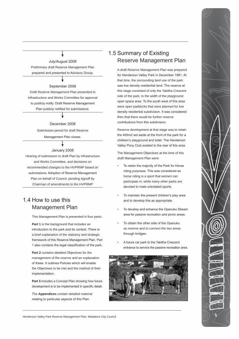
1.5 Summary of Existing Reserve Management Plan A draft Reserve Management Plan was prepared for Henderson Valley Park in December 1981. At that time, the surrounding land use of the park was low density residential land. The reserve at this stage consisted of only the Tabitha Crescent side of the park, to the width of the playground open space area. To the south west of this area were open paddocks that were planned for low density residential subdivision. It was considered then that there would be further reserve contributions from this subdivision.
Reserve development at that stage was to retain the 400m2 set aside at the front of the park for a children’s playground and toilet. The Henderson Valley Pony Club existed to the rear of this area.
The Management Objectives at the time of this draft Management Plan were:
• To retain the majority of the Park for Horse riding purposes. This was considered as horse riding is a sport that women can participate in, while many other parks are devoted to male orientated sports.
• To maintain the present children’s play area and to develop this as appropriate.
• To develop and enhance the Opanuku Stream area for passive recreation and picnic areas.
• To obtain the other side of the Opanuku as reserve and to connect the two areas through bridges.
• A future car park to the Tabitha Crescent entrance to service the passive recreation area.

Henderson Valley Park Reserve Management Plan, Waitakere City Council66
2.0 Statutory RequirementsThe section contains the background information relating to the statutory framework within which the Reserve Management Plan has been prepared.
2.1 Reserves Act 1977The current legislation for administering reserves in New Zealand is the Reserves Act 1977. The purpose of the Reserves Act is set out in Section Three of that Act, and is quoted below. The Act is administered in the Department of Conservation for the purpose of:
Providing, for the preservation and management for the benefit and enjoyment of the public areas of New Zealand possessing—
Recreational use or potential, whether active or passive; or
Wildlife; or
Indigenous flora or fauna; or
Environmental and landscape amenity or interest; or
Natural, scenic, historic, cultural, archaeological, biological, geological, scientific, educational, community, or other special features or value:
Ensuring, as far as possible, the survival of all indigenous species of flora and fauna, both rare and commonplace, in their natural communities and habitats, and the preservation of representative samples of all classes of natural ecosystems and landscape, which in aggregate originally gave New Zealand its own recognisable character;
Ensuring, as far as possible the preservation of access for the public to and along the sea coast, its bays and inlets and offshore islands, lakeshores and riverbanks, and fostering and promoting the preservation of the natural character of
the coastal environment and the margins of lakes and rivers and the protection of them from unnecessary subdivision and development.
The Reserves Act requires that every reserve have a Management Plan prepared for it. Once this Plan has been adopted by the responsible authority, it is subject to continuous review so that it adapts to changing circumstances or increased knowledge about the reserve. The review procedure is outlined in the Reserves Act and requires a public notification and submission process.
The Reserves Act also requires that all Reserves be classified and gazetted according to the classifications laid down by the Act. The reserves covered by this Plan have different classifications under the Act.
It is important to note that classification under the Reserves Act is not the same as Waitakere City Council Parks Strategy classification. The Reserves Act is a legally- binding national classification administered by the Crown.
2.2 Resource Management Act 1991The purpose of the Resource Management Act (RMA) is to,
“Promote the sustainable management of natural and physical resources.”
The RMA requires this Management Plan to consider the following “matters of national importance”:
(b) The protection of outstanding natural features and landscapes from inappropriate subdivision, use, and development,
(c) The protection of areas of significant indigenous vegetation and significant habitats of indigenous fauna,
(d) The maintenance and enhancement of public access to and along the coastal marine area, lakes and rivers,
Part One – Introduction and Background continued
7Henderson Valley Park Reserve Management Plan, Waitakere City Council 7
(e) The relationship of Maori and their culture and traditions with their ancestral lands, water, sites, waahi tapu and other taonga.
2.3 Waitakere City Council District PlanThe Waitakere City Council District Plan classifies Waitakere into two zones, the Human Environment and the Natural Environment. The Human Environment classification is based on characteristics of the land in terms of human use and development. Under this, Waitakere’s Reserves are identified as Open Space Environment, which has policies and rules affecting factors such as the location and design of buildings and structures on reserves.
The Natural Area identification is based on the natural characteristics of the landscape, such as the quality of native vegetation and the presence of streams.
The six Natural Areas are as follows:
The Protected Natural Area is the very best areas of native vegetation, or landforms that are considered to be ‘outstanding’ (in terms of section 6(b) of the Resource Management Act. Several reserves covered by this Management Plan contain the Protected Natural Area classification, and it is important that these areas are given a high degree of protection;
The Managed Natural Area is areas of native vegetation considered to be significant (in terms of section 6(c) of the Resource Management Act). Clearance or disturbance of this vegetation should be avoided as much as possible;
The Coastal Natural Area is areas which are considered to have high coastal natural character, and it is important that development does not reduce this coastal characteristic;
The Riparian Margins/Coastal Edges Natural Area is the margins of streams and the coast where strict development restrictions are imposed. Most of the reserves covered by this management plan have a 20m Coastal Edge Natural Area;
The Restoration Natural Area is where there is vegetation with a native component, but which is not considered to be ‘significant’. Nevertheless, this vegetation has ecological and landscape value, and its retention and enhancement should be considered where appropriate;
The General Natural Area is where there are no particular natural features, and the most appropriate location for any development.
Additionally, there are areas identified as Ecological Linkage Opportunities, or Restoration Natural Areas, where it could be appropriate to revegetate to establish linkages between areas of existing native vegetation. These areas make up the ‘Green Network’ that is protected through policies and rules under the District Plan.
The policies of this Reserve Management Plan are consistent with the District Plan Rules. This Management Plan will be used to manage impacts and effects of activities through the provision of a management and planning framework that relates and identifies the specific qualities and values of the reserves.
Henderson Valley Park is zoned Open Space in the Waitakere City Council District Plan. The surrounding areas are zoned General Natural area and Living Environments.
2.4 Historic Places Act 1993The purpose of the Historic Places Act 1993 is described below.
(1) The purpose of this Act is to promote the identification, protection, preservation, and conservation of the historical and cultural heritage of New Zealand.
(2) In achieving the purpose of this Act, all persons exercising functions and powers under it shall recognise —
(a) The principle that historic places have lasting value in their own right and provide evidence of the origins of New Zealand’s distinct society; and
Henderson Valley Park Reserve Management Plan, Waitakere City Council88
(b) The principle that the identification protection, preservation, and conservation of New Zealand’s historical and cultural heritage should —
(i) Take account of all relevant cultural values, knowledge, and disciplines; and
(ii) Take account of material of cultural heritage value and involve the least possible alteration or loss of it; and
(iii) Safeguard the options of present and future generations; and
(iv) Be fully researched, documented, and recorded, where culturally appropriate; and
The relationship of Maori and their culture and traditions with their ancestral lands, water, sites, wahi tapu, and other taonga
The definition of a Historic Site under the Historic Places Act 1993 is,
Archaeological site means any place in New Zealand that —
(a) Either —
(i) Was associated with human activity that occurred before 1900; or
(ii) Is the site of the wreck of any vessel where that wreck occurred before 1900; and
(b) Is or may be able through investigation by archaeological methods to provide evidence relating to the history of New Zealand:
The listing of any other type of heritage site on the register of archaeological sites (NZAA) does not mean the site is protected. Waitakere City Council has the responsibility to protect historic areas and places by listing items and rules within the District Plan.
There is one listed Cultural heritage Item on Henderson Valley Park, which is a tree. This is CHI 2298, Historical Botanic Site.
Part One – Introduction and Background continued
2.5 Reserve Classifications
Legal Description Area Reserve Act Classifi cation
LOT 3 DP 8632 4.35040 Recreation Reserve Gaz 1980 1642
PT LOT 5 DP 8632 3.48940 Subject to Reserves Act
LOT 63 DP 77869 0.25830 Automatically classifi ed Recreation Reserve, Sec 3 clause b of the Reserve Amendment Act.
LOT 2 DP 35704 3.92540 Recreation Reserve Gaz 1980 1642
PT LOT 3 DP 92358 3.14640 Subject to Reserve Act
LOT 5 DP 92358 0.03130 Subject to Reserve Act
LOT 5 DP 81723 0.05090 Subject to Reserve Act
LOT 17 DP 75203 0.49000 Automatically classifi ed Local Purpose Reserve by Sec 4 Clause (11b) of the Reserve Amendment Act, however, it is recommended that this be reclassifi ed to Recreation Reserve.
9Henderson Valley Park Reserve Management Plan, Waitakere City Council
3.0 Strategic ContextThis section contains the background information relating to the strategic framework within which the Reserve Management Plan must be prepared.
3.1 Waitakere City Council Strategic PlatformsWaitakere City Council has developed Nine Strategic Platforms for council that provide an overarching vision for 2020, in key areas. The platforms that relate to this Reserve Management Plan are Urban and Rural Villages, Strong Communities and the Green Network.
3.1.1 Green Network
The Green Network physically describes the network of green open space, streams, forest, street trees, residential gardens, storm water ponds, and any area that could potentially support plants and animals in Waitakere. The Green Network concept was developed with a focus on the community, and is primarily about people being a key part of the natural environment. The Green Network therefore includes the interactions between the human environment and the natural environment. These interactions are between the urban areas and its associated infrastructure, and the physical aspects of the Green Network described above. In essence, communities living in and interacting with the natural environment.
These different types of interactions that exist within the Green Network are referred to as ‘roles’ and provide a framework for ways in which the Green Network can be managed and nurtured in Waitakere. The five roles of the Green Network are;
• Intrinsic Value/Biodiversity – This refers to the natural element of the Green Network, the natural environment. The intrinsic values of the natural environment are elements that are essential to its functioning which lead to biodiversity. Biodiversity is the variety of plant and animal species that make up the natural environment. Biodiversity includes genetic
diversity (variation in genetic makeup among individuals within a single species), species diversity (the variety of species within a particular geographical area), and ecosystem diversity (the variety of ecosystem types and their communities that interact). This role therefore provides the platform for the other roles to operate.
• Ecosystem Services - This encompasses the natural environment and what is discussed above, but looks at the functions that come out of the natural ecosystem processes. These functions have a direct benefit for people and how we live and operate in the environment. Examples of these are, pollination, and decomposition of organic matter to form soil.
• Ecosystem products – This is the natural environment and its ecosystems that produce products that people can use. Examples are building products, inks and medicines.
• Relaxation and inspiration – These are the range of benefits and enjoyments that are gained from our day to day interaction with nature. This includes recreation and play, amenity, sense of place, history, belonging, culture, and spiritual inspiration.
• Community involvement and care – This is where the community are encouraged to be involved in the nurturing of the Green Network. Such involvement encourages sense of place and ownership for communities.
Henderson Valley Park is important to the Green Network and contributes to all five of the above roles, in particular relaxation and inspiration and community involvement and care.
3.1.2 Urban and Rural Villages
The 2020 vision in regard to Urban and Rural Villages is,
“for Town Centres to be thriving, providing exciting options for people to work, live and play. Public facilities, streets and places are alive and busy.”

Henderson Valley Park Reserve Management Plan, Waitakere City Council1010
3.1.3 Strong Communities
The 2020 vision in regard to Strong Communities is,
“that people are active, healthy and content. They feel safe and there is a strong sense of community. We enjoy our diversity and lifestyles of people.”
The Park is of importance to this Strategic Platform as they have the potential to provide for a community focus and offer significant recreational opportunities. The reserves can reflect community identity, contribute to sense of place, and also provide opportunity for community stewardship of reserves.
3.1.4 Three Waters
The 2020 vision is in regard to ensuring that,
“Waitakere takes an innovative approach in managing drinking water supply, wastewater and stormwater together, under the heading of the Three Waters.”
The reserves are important to this Strategic Platform, as the reserve carries stormwater into the Opanuku Stream. There exists potential in the reserves to design innovative management approaches in regard to stormwater and outfall structures.
3.2 Parks and Open Space Strategic PlanThe Parks and Open Space Strategic Plan has been developed in accordance with Waitakere City’s Green print and provides guidelines for the management of parks within the City. The Parks Strategy outlines an integrated vision for the future of Waitakere City parks and proposes ten objectives to provide a framework for all park management.
The objectives are:
• Increase the use and enjoyment of parks
• Extend and improve the city’s natural ecosystems
• Increase the opportunities for people to enjoy nature on parks
• Sustainably manage parks as part of the wider landscape
• Increase the use, range and quality of sports facilities within the city
• Protect the heritage values within the city
• Provide quality local and neighbourhood parks that are within walking distance throughout the city
• Work in partnership with iwi on the management of Waahi Tapu
• Involve communities in the design and management of parks
• Improve the management and administration of parks.
3.3 Weed Strategy The goal of the Waitakere City Council Weed Strategy is the
“Protection of the quality, resilience, biodiversity and ecological integrity of Waitakere City’s natural habitat from the impacts of environmental weeds.”
The Strategy directs Council’s approach to the management of environmental weeds. It describes Council’s long term goals and objectives, and provides a framework to guide the Council in carrying out its roles and responsibilities with regard to identifying, prioritising and managing weed impacts.
3.4 Draft Leisure Strategy This document outlines the Council’s goals for improving leisure opportunities in Waitakere in the future. The Council aims to improve the happiness and health of the City’s people and communities by promoting:
• The enjoyment of life and leisure time that comes from taking part in fun activities which build self-confidence, skills, physical health or fitness;
Part One – Introduction and Background continued
11Henderson Valley Park Reserve Management Plan, Waitakere City Council 11
• Opportunities for outdoor recreation in our abundant green natural settings;
• A sense of belonging, and ‘community’ and City identity.
The Strategy offers these guidelines as a way of achieving the goals:
• Diversify leisure services to focus and improve provision for different groups and communities.
• Improve natural amenity by building on the unique ‘green’ and ‘blue’ images of Waitakere City.
• Develop community focal points near where people live and shop, with an atmosphere of enjoyment and availability of low-cost casual leisure activities.
3.5 Biodiversity Strategy and Action Plan The purpose of this Strategy is to refocus polices and actions already adopted by Council to propose new actions to ensure good biodiversity outcomes from all land management practices. Waitakere has an obligation to protect indigenous biodiversity, under legislation such as the Resource Management Act 1991 and the Biosecurity Act 1993.
The vision for biodiversity in Waitakere has been divided into four categories. These are forests, freshwater habitats, coast and the urban area. Relevant to this Management Plan are the visions for freshwater habitats and the urban area. The vision for freshwater habitats is to have a continually vegetated riparian margin along streams, with inanga and giant kökopu becoming common in streams. For the urban area, the vision is for expansion and enhancement of the native forests in the urban area, having kereru visit gardens in the urban area and wildlife refugees established in reserves.
3.6 Te Kawerau A Maki Trust Resource Management StatementIn 1840, John White, a travelling European in the west, observes that “in the produce of the land and sea, Kawerau do not pay tribute to any chief, nor could they be commanded by any adjoining tribe or hapu to assist in any act whatever, nor could a chief go to any of the Kawerau fishing grounds without the express permission of the Kawerau people” (Rules Section, District Plan 1998 p3).
The Resource Management Statement outlines the concerns and goals of the Kawerau a Maki Trust with regard to the sustainable management of the Taonga within the tribal area of Te Kawerau A Maki. Resource management issues are addressed by the Kawerau A Maki Trust within the context of achieving a balance between:
• the maintenance of spiritual and cultural values,
• environmental and heritage protection and enhancement, and
• social and economic development.
3.7 Ngati Whatua Ngati Whatua exercises kaitiakitanga over the material and non-material resources of their tribal area through their relationship with Council (see section 6 RMA91). Ngati Whatua customary rights are sourced in the continued occupation and use of resources within this area. Implicit in the Maori resource management principle (kaitiakitanga) is reciprocity. Tangata Whenua are therefore obligated to protect and restore the natural and cultural resources of the same area. These ancestral resources since 1840, the time of European settlement, have declined dramatically. Ngati Whatua through their relationship with Council therefore seeks:
• the restoration of the mauri and protection of waterways

Henderson Valley Park Reserve Management Plan, Waitakere City Council1212
• the restoration and protection of bio-diversity.
• the restoration and protection of customary practices such as food gathering.
4.0 Management Plan Objectives
4.1 Approach to Preparing PoliciesThis plan has drafted policies that consider the key objectives of this Management Plan and the desires of Henderson Valley Pony Club and the Riding for the Disabled. As well, desires of the community have been taken into consideration.
The objectives and policies will be a guide for the future management of Henderson Valley Park, and will reflect the existing uses and values of the park. The concept plan in Part Three of this Management Plan will present the objectives and policies in a visual manner.
4.2 Community Expectations for Henderson Valley ParkThe process of preparing this Management Plan began with public notification of the intention to prepare a Reserve Management Plan in January 2008.
An Advisory Group including members of the Infrastructure and Works Committee, Henderson Community Board, and Council staff was established to oversee the development of the Plan.
Open days were held during the submission process, as well as meetings with individual user groups. The draft Reserve Management Plan was prepared May – August, incorporating comments received to the first round of submissions.
5.0 Reserve Value Descriptions“The picturesque Henderson Valley, at the foot of the forest clad Waitakere Ranges, where banks slope to the cooling Opanuku Stream, and native shrubs and ferns deck the pathways, it would be difficult indeed to find a more enchanting spot for human holiday, rest or reverie.”
From Henderson School and District Diamond Jubilee, Sixty Years of School and District History.
5.1 Natural Environment The Henderson area lies within the Tamaki Ecological District, referenced also as the Waitakere Lowlands. This Waitakere Lowlands extends from the foothills of the Waitakere Ranges, across the undulating lowland of the Waitemata sediments, to the low-lying area of Tauranga pumecious sediments and out to the Waitemata Harbour Coastline. The origins of the Waitemata sediments and the pumecious sediments that underlie the Henderson area are described below.
5.1.1 Geology and Soils
The age of rock that underlies the Waitakere Lowlands is varied, from over 200 million years to just a few thousand years.
Part One – Introduction and Background continued
Opanuku Stream
13Henderson Valley Park Reserve Management Plan, Waitakere City Council
The oldest rocks are basement greywacke and argillites that were formed in the Jurassic period. At this time the Rangitata Orogeny occurred, a major geological event where these rocks were uplifted from beneath the sea, joining the super continent Gondwanaland. These uplifted rocks later became the landmass of New Zealand. The separation of the New Zealand Islands from Gondwanaland occurred when the Tasman Sea opened around 80 million years ago.
Around 20 million years ago, a sea level rise occurred that deposited further sediments onto the greywacke base. The deposits were made up of sandstones and muddy siltstones, which are now known as the Waitemata Group of sediments. These sediments underlie much of the Tämaki Ecological District.
The Waitakere Arc of volcanoes was erupting at this time, and this was when the Waitakere Ranges were uplifted. Over time, the softer Waitemata sediments described above eroded. This has formed the landscape condition seen today, of the low-lying landscape adjacent to the Waitemata Harbour, with the backdrop of the bush clad Waitakere Ranges.
In the last 2 million years the geology of the Tamaki Ecological district has been impacted by volcanic eruptions in the Taupo Volcanic zone. Large quantities of rhyolitic lava and ash being erupted and reaching Auckland in the form of ash showers, or as sediment transported by the Waikato River which at that time flowed into the Hauraki Gulf.
These sediments contained pumiceous deposits, and today make up much of the low-lying areas of the Tamaki Ecological District. Low lying areas are defined as being less than 20m in elevation. The pumiceous deposits have since weathered to a soft clay and are possibly the source of the ceramic clays found the western soils.
Soils within the Takaki Ecological District vary considerably. This in turn impacts vegetation patterns. The soil parent material of the lowland areas of the Tamaki Ecological District, particularly on pumecious soils are generally fertile yellow-brown loams.
5.1.2 Vegetation
Pre-human vegetation of the low lying areas of the Tamaki ecological district was dependant on moisture, and areas of wet and dry varied in the district. Stands of totara, matai, puriri, taraire, kohekohe, karaka and titoki are likely to have grown in well drained areas. On wetter ground, kahikatea, pukatea, maire tawake and ti (cabbage tree) would have grown.
The pre-European vegetation consisted of a broad area of scrubland, between the Waitemata Harbour and the Waitakere Ranges. This is based off quotes from William Colenso, who in February 1842 travelled the area on foot.
“We travelled on, over open and barren heaths, in a northerly direction until sunset, we saw nothing in these dreary and sterile wilds, save the Dracophyllum.”
However, it is a certainty that there were patches of mature kauri forest, due to the milling industries that were located in the Henderson area.
Today, the Opanuku Stream is of great importance to the overall ecological values of the park, and provides a green belt due to the thick expanse of native vegetation upon the steep stream banks of the Opanuku. This area therefore has the potential to support habitat for a variety of flora and fauna.
The natural ecology of the park has been modified for the most part due to the current land use of the Henderson Valley Pony club, who have fenced off paddocks and have jumps scattered across the landscape. Ground stability including riparian areas is unstable, due to lack of suitable vegetation.
Infestation from invasive weeds poses a significant threat to this potential native habitat.
Today, most native vegetation on the park is largely over run with invasive weeds. Neighbouring properties pose a threat to the reserve due to invasive weeds on their boundaries. Such species are Salix sp. (willows), Convolvulus sp, (bindweed), Agapanthus orientalis, (agapanthus), Acmena/Syzgium

Henderson Valley Park Reserve Management Plan, Waitakere City Council1414
Spp. (monkey apple), Monstera deliciosa, (fruit salad plant), Zantedeschia aethiopica (arum lily), Acanthus mollis (bears breeches) Solanum jasminoides (potato vine).
The park has been divided into five areas. Following is a description of the vegetation types found within these areas. A map of these areas is provided below.
Area one contains tributaries to the Opanuku Stream. There are various invasive weeds present along the tributaries. The tributary between 205 A and 205 E Henderson Valley Road, has the aquatic plant pest Myriophyllum aquaticum (parrots feather, wandering jew, convolvulus sp., Cyperus sp., Polygonum sp. Willow weed, and tree privet seedlings. The
Ecological areas
Part One – Introduction and Background continued

15Henderson Valley Park Reserve Management Plan, Waitakere City Council 15
waterway itself is also chocked by weeds. A small planting here has been undertaken, and some weed control. Planted species consist of kauri, cabbage tree and carex sp.
The tributary continues to the north, and has some native plants, mainly flax and karamu. Invasive weeds in this area include, Japanese honeysuckle, dock, kikuyu, Chinese and tree privet, convolvulus, ox tongue, montbretia, cleavers, plantain, wolly nighshade, inkweed, and a large mature buddleia.
The stream joins with the eastern running tributary of the Opanuku. This stream flows through an area of wattles and pines that are large and mature, with scattered natives of varied maturity, including, mapou, lemonwood, karo and cabbage trees. Weed species in this area consists of wandering jew, bamboo, black berry, convoulous, montbretia, Chinese and tree privets, japanese honeysuckle, and ink weed.
This area is of great significance as it is upstream of the Opanuku and contains many tributaries that flow into the main stream. Communication with adjacent landowners in this matter is important, as some weeds are entering the park from this source.
Area Two contains a second access way to the park. The driveway is lined with oak trees and the fence line to the west of this entrance is planted with maturing natives including lemonwood, karo, cabbage trees, karake, karamu and titoki. Weed species are present here also, consisting
of, kikuyu, tree and Chinese privets, seedlings and juveniles, convolvulus, gorse, plantain, ivy, monkey apple and dock. Also in this area is a fenced off corner off weeds, containing, fennel, wattles, convolvulus, arum lily, dock, kikuyu, cleavers dock, ox tongue, scotch thistle, montbretia, plantain, gorse, and ivy.
This area contains an artificial pond, with a planting that consists of, hebe sp., flax, mahoe, cabbage trees, kanuka, mänuka, wine berry, toetoe, ferns, carex olearia, dianella, coprosma, kawakawa, tussock, kahikatea and karamu. This planting combination lacks in riparian species. Weed species in this planted area consist of ox tongue, Chinese privet, convovlous, dock, plaintain.
The remainder of area two is paddocks, with a newly developed residential area to Misty Valley Drive. The western tributary comes from the Misty Valley development. This waterway is chocked with aquatic weeds with the occasional native being present. Such natives present are, ferns, karamu, and cabbage trees.
A remnant orchard is situated in this area, towards the Opanuku Stream, along the western boundary.
Area three is the Henderson Valley Park reach of the Opanuku Stream. This stream is under pressure from urbanisation and flows over a large area with diverse land uses. The native bush strip between the paddock and the stream consists of, ferns, carex, harakeke, kahikatea,
Weedy tributary in Area One Area Two

Henderson Valley Park Reserve Management Plan, Waitakere City Council1616
kanuka, karaka, karamu, lacebark, mahoe, mapou, mänuka, nikau, rimu, toatoa, ti kouka/cabbage tree, titoki. Weeds are prevalent in this area, species observed were, tree and Chinese privet, nasturtium, bracken, wholly nightshade, three cornered garlic, ginger, arum lily, Japanese honeysuckle, mistflower, convolvulus, sweet grass, pampas, climbing dock, poplar, tutsan.
The outcrop of land that juts into the stream in this area contains club moss and plectranthus, bamboo and wandering jew. Sweet grass, naturism, chinese privet, kikuyu, thistles, wandering jew, arum lily, ginger are in the area of streamside vegetation that stretches up to Border Road. There are occasional natives in this area.
Area four comprises much of the paddocks. Specimen trees such as pine and poplars have been planting along the boundary fences. In the playground area at the Tabitha Crescent frontage is lemonwood, banksia, and other exotic specimen trees.
Area five is the playground at the Henderson Valley Road frontage. The accesway to the Henderson Valley Pony Club is lined with oak trees. To the left of the entrance is Trees for Babies planting.
Specimen trees, mainly oak, macrocarpa, she oak and a large puriri are dotted around the paddocks and open space in this area. Weed species in this area are Chinese privet, ivy, bamboo, ink weed, Japanese spindle tree, arum lily.
5.1.3 Fauna
The reach of the Opanuku Stream adjacent to the Park has the potential to provide key habitat for diverse terrestrial and aquatic flora and fauna, as this reach is relatively intact ecologically.
The stream is important to migratory species of native fish such as inanga, and the banded and giant köpuku.
Birds observed on the Park were pukekos, tui, wax-eyes, plovers, magpies, welcome swallows, mallard ducks, paradise ducks, black-backed gulls and red-billed gulls. These species were noted particularly around the artificial pond area.
5.1.4 Landscape
Henderson Valley Park has a distinct rural, pastoral feel. The remnant orchard and the corrugated iron packing sheds on the park contribute to the rural character, as does the pony club fences, horses and paddocks. The vegetated backdrop of the Opanuku Stream and the distant vista of the Waitakere Ranges frame the park and form an attractive backdrop to the park’s rural setting.
Henderson Valley Park can be divided into four areas with four distinct landscape conditions. These areas are, open space to Henderson Valley Road frontage, open space to the Tabitha Crescent frontage, the Pony Club leased area and the Opanuku Stream area.
The Henderson Valley Road frontage contains a playground, open space specimen trees, aging macrocarpas, picnic table and a toilet block. An attractive row of heritage oak trees line the Henderson Valley Road frontage to the park. The main entrance to the Pony Club is at the eastern edge of this area, and the western edge is bounded by residential housing. A post and wire fence separates this area from the Pony Club leased area, with a stile for access. The open nature of this boundary provides views into the entire park from this area.
The Tabitha Crescent frontage contains an area of open space and a playground, with specimen trees dotted throughout. Views to the Waitakere
Part One – Introduction and Background continued
Area Three

17Henderson Valley Park Reserve Management Plan, Waitakere City Council
Ranges are present in the background. A post and wire fence separates this area from the Pony Club leased area, including a stile for access.
The Pony Club lease the majority of the park, and very much contribute to the rural nature of the park. Jumps are scattered across the landscape and post and wire fencing separate the paddocks. Specimen trees are dotted around the paddocks, with one listed heritage tree. The Pony Club leased area includes a remnant orchard and packing shed from the times this area was a nursery/horticultural site. Other plants such as rhododendrons are also remains from the nursery. To the western side of the Pony Club leased area is a constructed wetland. The area around this is very boggy in winter.
Area four is the Opanuku Stream area. The landform gently undulates towards the stream. A peninsula juts out into the stream in this area. A cycleway is proposed here that connects the Border Road entrance of the Park, along the rear of Henderson Valley Park, through Henderson Valley Green and to Henderson Valley Road.
5.2 Cultural Heritage and History5.2.1 Pre-European History
A report from Te Kawerau A Maki is currently being prepared. Both Te Kawerau A Maki and Ngati Whatua are consulted as part of the process to prepare this Reserve Management Plan.
5.2.2 Colonial and Post-Colonial History
“There are probably few districts in which such a variety of trees and plants grow as in Henderson. Fruits that delight in cold climates, such as the gooseberry, apple, pear, etc., are all grown to perfection in Henderson.”
An enthusiast From Henderson School and District Diamond Jubilee, Sixty Years of School and District History.
Henderson; once covered in Kauri forest and mänuka scrubland soon became barren gum fields when the kauri was removed. These barren swathes of land were later transformed into pasture, through the introduction of grass. This led to the planting of orchards and market gardens. Gooseberry, apple, pear, peaches, Japanese plums, lemon, orange, pomelo, sweet oranges, passion fruit and other tropical fruits were grown in Henderson. Grapefruit, known locally as poormans orange, grew well in Henderson, when it was becoming popular as a breakfast fruit. Grape growing also started, and although people were sceptical of the success of grape growing in Henderson, local wines grew in popularity. Dairy farming also started in the Henderson area, and with the transformation of clay tracks to well formed metal roads, the industry boomed.
Introduced species were popular for windbreaks for the new industry. Blue gum, and Black wattle, the latter considered now an invasive weed. The following quote sums up the intentions of the time,…. “all of which played their part as shelter trees and in later years provided much valuable timber for building purposes, fruit cases, posts etc and will continue to do so as the native timber gets worked out.”
Natives trees however were used also for windbreaks, species such as olearia, karaka, totara, tanekaha, and pittosporum used commonly.
Ornamental trees were considered a means for beautifying the Henderson Area. “The district has proved its suitability to grow introductions from many parts of the earth…. What presents a finer sight than the English Oak… when clothed in a
Packing shed
Henderson Valley Park Reserve Management Plan, Waitakere City Council1818
mantle of fresh green leaves,..” Rhododendrons, palms, and bougainvilleas were planted in the district.
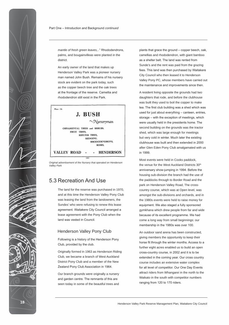
An early owner of the land that makes up Henderson Valley Park was a pioneer nursery man named John Bush. Remains of his nursery stock are evident on the park today, such as the copper beech tree and the oak trees at the frontage of the reserve. Camellia and rhododendron still exist in the Park.
5.3 Recreation And Use The land for the reserve was purchased in 1970, and at this time the Henderson Valley Pony Club was leasing the land from the landowners, the Sundes’ who were refusing to renew this lease agreement. Waitakere City Council arranged a lease agreement with the Pony Club when the land was vested in Council.
Henderson Valley Pony Club
Following is a history of the Henderson Pony Club, provided by the club.
Originally formed in 1963 as Henderson Riding Club, we became a branch of West Auckland District Pony Club and a member of the New Zealand Pony Club Association in 1964.
Our branch grounds were originally a nursery and garden centre. The remnants of this are seen today in some of the beautiful trees and
plants that grace the ground – copper beech, oak, camellias and rhododendron, with giant bamboo as a shelter belt. The land was rented from Sunde’s and the rent was paid from the grazing fees. This land was then purchased by Waitakere City Council who then leased it to Henderson Valley Pony PC, whose members have carried out the maintenance and improvements since then.
A resident living opposite the grounds had two daughters that rode, and before the clubhouse was built they used to boil the copper to make tea. The first club building was a shed which was used for just about everything – canteen, entries, storage – with the exception of meetings, which were usually held in the presidents home. The second building on the grounds was the tractor shed, which was large enough for meetings but very cold in winter. Much later the existing clubhouse was built and then extended in 2000 after Glen Eden Pony Club amalgamated with us in 1999.
Most events were held in Cooks paddock, the venue for the West Auckland Districts 30th anniversary show-jumping in 1994. Before the housing sub-division the branch had the use of the paddocks through to Border Road and the park on Henderson Valley Road, The cross-country course, which was at Open level, was amongst the sub-divisions and orchards, and in the 1980s events were held to raise money for equipment. We also staged a fully sponsored gymkhana which drew people from far and wide because of its excellent programme. We had come a long way from small beginnings: our membership in the 1980s was over 100.
An outdoor sand arena has been constructed, giving members the opportunity to keep their horse fit through the winter months. Access to a further eight acres enabled us to build an open cross-country course, in 2002 and it is to be extended in the coming year. Our cross country course includes an extensive water complex for all level of competitor. Our One Day Events attract riders from Whangarei in the north to the Waikato in the south with competitor numbers ranging from 120 to 170 riders.
Original advertisement of the Nursery that operated on Henderson Valley Park
Part One – Introduction and Background continued

19Henderson Valley Park Reserve Management Plan, Waitakere City Council 19
Between 1993 and 2005, we had our equestrian education programme, the idea of Grant Kelly, a past president. The programme was designed to every year give three children from Waitakere aged between nine and twelve, the chance to have their own pony. The only cost to them was shoeing every six weeks. Henderson branch picks up the tab for the horse, grazing, tack, PC membership, instruction and vet bills. Unfortunately this scheme is currently in remission but the ponies owned by RDA are still leased out enabling children to feel the joy of owning their own pony.
A cycleway is proposed to the rear of the Park, adjacent to the Opanuku Stream. The cycleway is proposed from the Border Road entrance to the Park, through to Henderson Valley Road. This is considered important to open this area of the Park for public access.
Henderson Riding for the Disabled
The RDA is a voluntary, non-profit organisation who provides horse riding therapy for people with disabilities. This group was established in 1976 by the Henderson Valley Pony Club and operate two days per week during school terms, sharing the grounds and facilities with the Pony Club.
Like other RDA groups around the world, Henderson RDA provides confidence, independence and well being for people with disabilities through therapeutic horse riding and horse care. More than 20 volunteers work an average of 8 hours per week in their various capacities as instructors, therapists, horse handlers, side walkers, equipment managers, and committee officers and so on. The service that the Henderson RDA provides is in high demand because of the close proximity to the suburbs of West Auckland.
The Arena