Headquarters Western Defense Command and … Western Defense Command and Fourth Army Presidio of San...
81
Headquarters Western Defense Command and Fourth Army Presidio of San Francisco, California Public Proclamation No. 2 March 16, 1942 Digitized for FRASER http://fraser.stlouisfed.org/ Federal Reserve Bank of St. Louis
Transcript of Headquarters Western Defense Command and … Western Defense Command and Fourth Army Presidio of San...

Headquarters
Western Defense Command
and Fourth Army
Presidio of San Francisco, California
Public Proclamation No. 2
March 16, 1942
Digitized for FRASER http://fraser.stlouisfed.org/ Federal Reserve Bank of St. Louis

HEADQUARTERS WESTERN DEFENSE COMMANDAND FOURTH ARMY
PRESIDIO OF SAN FRANCISCO, CALIFORNIAPUBLIC PROCLAMATION NO. 2.
March 16, 1942.
TO: The people, within the States of Washington, Oregon, Cali-fornia, Montana, Idaho, Nevada, Utah and Arizona, and thePublic Generally.
WHEREAS, By virtue of orders issued by the War Department onDecember 11, 1941, that portion of the United States lying withinthe States of Washington, Oregon, California, Montana, Idaho,Nevada, Utah and Arizona and the. Territory of Alaska has beenestablished as the Western Defense Command and designated asa Theatre of Operations under my command; and
WHEREAS, By Executive Order No. 9066, dated February 19,1942, the President of the United States authorized and directedthe Secretary of War and the Military Commanders whom he mayfrom time to time designate, whenever he or any such designatedcommander deems such action necessary or desirable, to prescribemilitary areas in such places and of such extent as he or the ap-propriate Military Commander may determine, from which anyor all persons may be excluded, and with respect to which theright of any persons to enter, remain in, or leave shall be subjectto whatever restrictions the Secretary of War or the appropriate,Military Commander may impose in his discretion; and
WHEREAS, The Secretary of War on February 20, 1942, desig-nated the undersigned as the Military Commander to carry outthe duties and responsibilities imposed by said Executive Orderfor that portion of the United States embraced in the WesternDefense Command; and
WHEREAS, The Western Defense Command by its geographicallocation is particularly subject to attack, to "attempted invasion bythe, armed forces of nations with which the United States is nowat war, and, in connection therewith, is subject to espionage andacts of sabotage, thereby requiring the adoption of military meas-ures necessary to establish safeguards against such enemy opera-tions :
Now THEREFORE, I, J. L. DEWITT, Lieutenant General, U. S.Army, by virtue of the authority vested in me by the Presidentof the United States and by the Secretary of War and my powers
( 1 )
Digitized for FRASER http://fraser.stlouisfed.org/ Federal Reserve Bank of St. Louis

and prerogatives as Commanding General of the Western DefenseCommand, do hereby declare that:
1. The present situation requires as a matter of military neces-sity the establishment in the territory embraced by the WesternDefense Command of Military Areas and Zones in addition tothose established in Public Proclamation No. 1, this headquarters,dated March 2, 1942.
2. Pursuant to the determination and statement of militarynecessity in paragraph 1 hereof, there are hereby designated andestablished the following Military Areas:
Military Area No. 3, embracing the entire State of Idaho.Military Area No. 4, embracing the entire State of Montana.Military Area No. 5, embracing the entire State of Nevada.Military Area No. 6, embracing the entire State of Utah.
3. Within Military Areas Nos. 1 and 2 as designated and estab-lished in Public Proclamation No. 1, above mentioned, and withinMilitary Areas Nos. 3, 4, 5 and 6, as defined herein, there arehereby established, pursuant to paragraph 1 hereof, Zones A-100to A-1033, inclusive, all as more particularly described and definedin Exhibit 1, hereto attached, and as generally shown on the mapsattached hereto and marked Exhibits 2, 3, 4, 5, 6, 7, 8 and 9.
4. Such persons or classes of persons as the situation may re-quire will by subsequent proclamation be excluded from ZonesA-100 to A-1033, inclusive.
The designation of Military Areas Nos. 3, 4, 5 and 6 as suchdoes not contemplate any prohibition, regulation or restriction ex-cept with respect to the Zones established therein, and except asprovided in paragraph 5 hereof.
5. Any Japanese, German or Italian alien, or any person ofJapanese ancestry now resident in the states of the Western De-fense Command, namely, Washington, Oregon, California, Mon-tana, Idaho, Nevada, Utah and Arizona, who changes his place ofhabitual residence is hereby required to obtain and execute a"Change of Residence Notice" at any United States Post Officewithin any of the states mentioned. Such notice must be executedat any such Post Office not more than five nor less than one dayprior to any such change of residence. Nothing contained hereinshall be construed to affect the existing regulations of the U. S.Attorney General which require aliens of enemy nationalities to
( 2 )
Digitized for FRASER http://fraser.stlouisfed.org/ Federal Reserve Bank of St. Louis
obtain travel permits from U. S. Attorneys and to notify the Fed-eral Bureau of Investigation and the Commissioner of Immigra-tion of any change in permanent address.
6. The duty and responsibility of the Federal Bureau of In-vestigation with respect to the investigation of alleged acts ofespionage and sabotage are not altered by this proclamation.
J. L. DEWITT,
Lieutenant General, U. S. Army,Commanding.
EXHIBIT No. 1.
Description of Zones A-100-A-1033, Inclusive.
Each of the following described zones includes the particularplant or facility and the grounds appurtenant thereto, the reser-vation, range, airport, bridge, tunnel or other installation; andalso includes the adjoining area within a distance of one mile un-less expressly noted otherwise in the specific case.
ARIZONA
Zone A-100. Tucson Municipal Airport No. 2, at or nearTucson, Arizona.
Zone A-101. Davis-Monthan Field, at or near Tucson, Arizona.
Zone A-102. Luke Field, at or near Phoenix, Arizona.
ZoneA-103. William-Higley Field, at or near Chandler, Ari-zona.
Zone A-104. Gila Bend Airport, at or near Gila, Arizona.
Zone A-105. Gila Bend Gunnery Range, at or near Gila, Ari-zona.
Zone A-106. Thunderbird Airport, at or near Glendale, Ari-zona.
Zone A-107. Sky Harbor Airport, at or near Phoenix, Arizona.
Zone A-108. Auxiliary Field No. 1, at or near Whitman, Ari-zona, described as beginning at the NE Cor. Section 31, T5N,R2W, Gila and Salt River Base and Meridian; thence West 4miles; thence South 3 miles; thence East 4 miles; thence North3 miles to the point of beginning.
( 3 )
Digitized for FRASER http://fraser.stlouisfed.org/ Federal Reserve Bank of St. Louis

Zone A-109. Auxiliary Field No. 2, at or near Whitman, Ari-zona, described as beginning at the NE Cor. Section 6, T4N,R1W, Gila and Salt River Base and Meridian; thence West 3miles; thence South 3 miles; thence East 3 miles; thence North 3miles to the point of beginning.
Zone A-110. Auxiliary Field No. 3, at or near Beardsley, Ari-zona, described as beginning at the NW Cor. Section 20, T4N,R1W, Gila and Salt River Base and Meridian; thence South 5miles; thence East 3 miles; thence North 3 miles; thence West 1mile; thence North 2 miles; thence West 2 miles to the point ofbeginning.
Zone A-lll. Auxiliary Field No. 4, at or near Castle HotSprings, Arizona, described as beginning at the NE Cor. Section19, T5N, R3W, Gila and Salt River Base and Meridian; thenceWest 3i/2 miles; thence South 3 miles; thence East 3% miles;thence North 3 miles to the point of beginning.
Zone A-112. Auxiliary Field No. 5, at or near Hassayampa,Arizona, described as beginning at the NE Cor. SE14 Section 9,TIN, R4W, Gila and Salt River Base and Meridian; thence West3 miles; thence South 3 miles; thence East 3 miles; thence North3 miles to the point of beginning.
Zone A-113. Auxiliary Field No. 6, at' or near Litchfield, Ari-zona, described as beginning at the NW Cor. Section 2, TIN,R3W, Gila and Salt River Base and Meridian; thence South 3miles; thence East 3% miles; thence North 3 miles; thence West3y2 miles to the point of beginning.
Zone A-114. Auxiliary Field No. 7, at or near Hassayampa,Arizona, described as beginning at the NE Cor. Section 35, TIN,R5W, Gila and Salt River Base and Meridian; thence West 3miles; thence South 3 miles; thence East 3 miles; thence North 3miles to the point of beginning.
Zone A-115. Auxiliary Field No. 8, at or near Gillespie Dam,Arizona, described as beginning at the NE Cor. SE14 Section 34,T2S, R4W, Gila and Salt River Base and Meridian; thence West3^2 niiles; thence South 3 miles; thence East 3 ^ miles; thenceNorth 3 miles to the point of beginning.
Zone A-116. Atchison, Topeka and Santa Fe Railroad Co.Bridge No. 106 A, at Mile Post 106 plus 4450 feet, near Parker,Arizona.
( 4 )
Digitized for FRASER http://fraser.stlouisfed.org/ Federal Reserve Bank of St. Louis

WASHINGTON
Zone A-117. Felts Field, at or near Spokane, Washington.
Zone A-118. Geiger Field, at or near Spokane, Washington.
ZoneA-119. Seven Mile Camp, at or near Spokane, Wash-ington.
ZoneA-120. Ephrata Bombing Range No. 1, at or nearEphrata, Washington, described as beginning at the northeastcorner of Section 15, T18N, R27E, Willamette Base and Meridian,thence West 3 miles; thence South'2 miles; thence East 3 miles;thence North 2 miles to the point of beginning.
ZoneA-121. Ephrata Bombing Range No. 2, at or nearEphrata, Washington, described as beginning at the Northwestcorner of the SE14 Section 9, T18N, R25E, Willamette Baseand Meridian; thence East 2 miles; thence South 2 miles; thenceWest 2 miles; thence North 2 miles to the point of beginning.
Zone A-122. Ephrata Bombing Range No. 3, at or neaxEphrata, Washington, described as beginning at the Northwestcorner SEi/4 Section 10, T16N, R25E, Willamette Base andMeridian; thence East 2 miles; thence South 2 miles; thenceWest 2 miles; thence North 2 miles to the point of beginning.
ZoneA-123. Ephrata Bombing Range No. 4, at or nearEphrata, Washington, described as beginning at the Northwestcorner Section 9, T16N, R27E, Willamette Base and Meridian;thence East 4 miles; thence South 2 miles; thence West 4 miles;thence North 2 miles to the point of beginning.
Zone A-124. Ephrata Ground Gunnery Range at or nearEphrata, Washington, described as beginning at the NW Cor.Section 12, T21N, R26E; thence South 1 mile; thence East %mile; thence South y2 mile; thence East % mile; thence South 1mile; thence East ^ mile; thence South 1% miles; thence East% mile; thence South 14 mile; thence East ^4 mile; thence South% mile; thence East 1 ^ miles; thence North 1 4 miles; thenceWest % mile; thence North % mile; thence East % mile; thenceNorth y± mile; thence in a Northeasterly direction to a point1000 feet West of the Northeast corner of the Northwest quarterof Section 16, T21N, R27E; thence East to the Northeast cornerof the Northeast quarter of said section, township and range;thence North 1 mile; thence West 3 miles; thence North 1 mile;thence West 1 mile to the point of beginning.
( 5 )
Digitized for FRASER http://fraser.stlouisfed.org/ Federal Reserve Bank of St. Louis

Zone A-125. Harder Bombing Range at or near Marengo,Washington, described as beginning at the Northeast corner Sec-tion 4, T17N, R37E, Willamette Base and Meridian; thence West2 miles; thence South 2 miles; thence East 2 miles; thence North2 miles to the point of beginning.
ZoneA-126. The prohibited area in the City of Spokane,Washington, is as described below and specifically stated to bebounded on the North by Sprague Avenue, on the East byMcClellan Street, on the South by Fifth Avenue, and on theWest by Post Street.
Zone A-127. The prohibited area in the City of Walla Walla,Washington, is as described below and specifically stated to bebounded on the North by Sumach Street, on the East by PalouseStreet, on the South by Newell Street, and on the West by 4thStreet.
Zone A-128. The prohibited area in the City of Wenatchee,Washington, is as described below and specifically stated to bebounded on the North by Palouse Street, on the East byColumbia Street, on the South by Thurston Street, and on theWest by Oregon Street.
Zone A-129. The prohibited area in the City of Yakima,Washington, is as described below and specifically stated to bebounded on the North by West " B " Street, on the East byFront Street, on the South by West Walnut Street, and on theWest by 5th Avenue.
Zone A-130. The prohibited area in the City of Wilbur, Wash-ington, is as described below and specifically stated to bebounded on the North by North Street, on the East by BraceStreet, on the South by May Street, and on the West by KingStreet.
(See hereinafter additional Zones A-908 to A-1033, inclusive,located in Military Areas Nos. 1 and 2.)
ZoneA-131. Boardman Bombing Range, at or near lone,Oregon. Beginning at the northeast corner Section 25, T4N,R24W, Willamette Base and Meridian; thence West 12 miles;thence South 12 miles; thence East 12 miles; thence North 12miles to the point of beginning.
ZoneA-132. Cold Springs Bombing Range, at or near ColdSprings, Oregon. Beginning at the Northeast corner Section 5,T4N, R30E, Willamette Base and Meridian; thence West 2 miles;
( 6 )
Digitized for FRASER http://fraser.stlouisfed.org/ Federal Reserve Bank of St. Louis
thence South 2 miles; thence East 2 miles; thence North 2 milesto the point of beginning.
ZoneA-133. Pendleton Air Base, at or near Pendleton,Oregon.
ZoneA-134. The prohibited area in the City of The Dalles,Oregon, is as described below and specifically stated to bebounded on the Northwest by Lincoln Street, on the Northeastby Water Street, on the Southeast by Laughlin Street, and onthe Southwest by alley between 7th and 8th Streets.
Zone A-135. The prohibited area in the City of Klamath Falls,Oregon, is as describe4 below and specifically stated to bebounded on the Northwest by Main Waterway Canal and Com-mercial Street, on the Northeast by Commercial Street and PlumStreet, on the Southeast by 3rd Street, and on the Southwest byLincoln Street.
Zone A-1'36. The prohibited area in the City of Bend, Oregon,is as described below and specifically stated to be bounded on theNorthwest by Congress Avenue and Deschutes River, on theNortheast by Greenwood Avenue and Harriman Street, on theSoutheast by Harriman Street and Sisemore Avenue, and on theSouthwest by Kansas Avenue.
Zone A-137. The prohibited area in the City of Baker, Oregon,is as described below and specifically stated to be bounded on theNorth by Church Street, on the Eiast by Powder River, on theSouth by Auburn Street, and on the West by 4th Street.
Zone A-138. Pacific Telephone and Telegraph Co. property atTroutdale, Oregon.
Located in Sec. 25, TIN, R3E, Willamette Base and Meridian.
ZoneA-139. Radio Station KIJE, Pendleton Municipal Air-port, at or near Pendleton, Oregon.
ZoneA-140. Union Pacific Railroad Co. Bridge at Milepost63.32, near Hood River, Oregon.
ZoneA-141. Union Pacific Railroad Co. Tunnel at Milepost66.90, near Mosier, Oregon.
ZoneA-142. Union Pacific Railroad Co. Tunnel at Milepost71.44, near The Dalles, Oregon.
Zone A-143. Union Pacific Railroad Co. Tunnel at Milepost74.12, near The Dalles, Oregon.
( 7 )
Digitized for FRASER http://fraser.stlouisfed.org/ Federal Reserve Bank of St. Louis
ZoneA-144. Union Pacific Railroad Co. Bridge at Milepost114.32, near Eufus, Oregon.
ZoneA-145. Union Pacific Railroad Co. Bridge at Milepost181.68, near Hermiston, Oregon.
ZoneA-146. Union Pacific Railroad Co. Bridge at Milepost182.58, near Umatilla, Oregon.
Zone A-147. Union Pacific Railroad Co. Tunnel at Milepost198.26, near Nolin, Oregon.
ZoneA-148. Union Pacific Railroad Co. Tunnel at Milepost204.13, near Rieth, Oregon.
ZoneA-149. Union Pacific Railroad Co. Bridge at Milepost204.91, near Rieth, Oregon.
ZoneA-150. Union Pacific Railroad Co. Bridge at Milepost205.84, near Rieth, Oregon.
ZoneA-151. Union Pacific Railroad Co. Bridge at Milepost206.21, near Rieth, Oregon.
ZoneA-152. Union Pacific Railroad Co. Bridge at Milepost214.42, near Pendleton, Oregon.
ZoneA-153. Union Pacific Railroad Co. Bridge at Milepost262.91, near Meacham, Oregon.
ZoneA-154. Union Pacific Railroad Co. Tunnel at Milepost264.01, near Meacham, Oregon.
ZoneA-155. Union Pacific Railroad Co. Tunnel at Milepost317.26, near North Powder, Oregon.
ZoneA-156. Union Pacific Railroad Co. Tunnel at Milepost378.77, near Durkee, Oregon.
ZoneA-157. Union Pacific Railroad Co. Bridge over SnakeRiver, near Nyssa, Oregon.
Zone A-158. Union Pacific Railroad Co. Bridge over SnakeRiver, near Payette, Idaho.
Zone A-159. U.S. Highway #30, Crown Point Viaduct, about560 feet long, 23.83 miles East of Portland, Oregon.
ZoneA-160. U.S. Highway #30, W. Multnomah Falls Via-duct, 31.86 miles East of Portland, Oregon.
Zone A-161. UJ3. Highway #30, E. Multnomah Falls Viaduct,32.34 miles East of Portland, Oregon.
( 8 )
Digitized for FRASER http://fraser.stlouisfed.org/ Federal Reserve Bank of St. Louis
ZoneA-162. U.S. Highway #30, Deschutes River Bridge#332, 106.44 miles East of Portland, Oregon.
Zone A-163. U.S. Highway #30, Umatilla River Bridge #2117,230.20 miles East of Portland, Oregon.
Zone A-164. U.S. Highway #30, Grande Ronde River Bridge#1248, 280.05 miles East of Portland, Oregon.
ZoneA-165. U.S. Highway #30, Grande Ronde River Rail-road over-crossing #635, 280.60 miles East of Portland, Oregon.
ZoneA-166. U.S. Highway #30, Grande Ronde River Rail-road over-crossing #626, 282.60 miles East of Portland, Oregon.
Zone A-167. U.S. Highway #30, Grande Ronde River Bridge#693, 283.68 miles East of Portland, Oregon.
Zone A-168. U.S. Highway #30, Grande Ronde River Bridge#796, 285.98 miles East of Portland, Oregon.
ZoneA-169. U.S. Highway #30, Snake River Bridge atNyssa #1463, 431.19 miles East of Portland, Oregon.
Zone A-170. U.S. Highway #97, Crooked River Canyon Bridge#600, 98.65 miles Sonth of Biggs, Oregon.
ZoneA-171. Interstate Bridge at Hood River SpanningColumbia River to White Salmon, Washington.
CALIFORNIA
ZoneA-172. Lost Hills Airport, at or near Lost Hills, Cali-fornia.
Zone A-173. Modesto Municipal Airport, at or near Modesto,California.
ZoneA-174. Merced Municipal Airport, at or near Merced,California.
Zone A-175. Delano Airport, at or near Delano, California.
ZoneA-176. Tehachapi Airport, at or near Tehachapi, Cali-fornia.
Zone A-177. Coalinga Airport, at or near Coalinga, California.
ZoneA-178. Los Banos Airport, at or near Los Banos, Cali-fornia.
Zone A-179. Hammer Field, at or near Fresno, California.
Zone A-180. Visalia Airport, at or near Visalia, California.
( 9 )
Digitized for FRASER http://fraser.stlouisfed.org/ Federal Reserve Bank of St. Louis

Zone A-181. Muroe Bombing Range, at or near Muroc, Cali-fornia.
Location: All of Township 8, 9, ION, Range 6, 7, 8, 9 and 10W,San Bernardino Base and Meridian.
Zone A-182. March Field, at or near Riverside, California.
Zone A-183. March Field Radio Station, at or near Riverside,California.
ZoneA-184. McClellan Field, at or near Sacramento, Cali-fornia.
Zone A-185. Air Corps Basic Flying School, at or near Chico,California.
Zone A-186. Minter Field, at or near Bakersfield, California.
Zone A-187. Air Corps Training Field, at or near Hemet,California.
Zone A-188. Army Air Base, at or near Merced, California.
Zone A-189. Gardner Field, at or near Taft, California.
Zone A-190. Mather Field, at or near Sacramento, California.
ZoneA-191. Air Corps Training Field, at or near Tnlare,California.
ZoneA-192. Air Corps Advanced Flying School, at or nearStockton, California.
Zone A-193. Army Air Base, at or near Victorville, California.
Zone A-194. Army Air Base, at or near Lemoore, California.
ZoneA-195. That prohibited area in the city of Bakersfield,California, as described below and specifically stated to bebounded on the North by 23rd Street, on the East by " P "Street, on the South by 17th Street, and on the West by " F "Street.
ZoneA-196. American Telephone & Telegraph Co. property,at or near Dixon, California.
Location: Latitude 38° 24' 38" North, Longitude 121° 46' 27"West.
ZoneA-197. That prohibited area in the City of Dunsmuir,California, as described below and specifically stated to bebounded on the North by Cedar Street extended to Beverly Way,on the East by Sacramento River, on the South by Bronsteller
(10)
Digitized for FRASER http://fraser.stlouisfed.org/ Federal Reserve Bank of St. Louis

Street, and on the West by Beverly Way and Beverly Wayextended.
Zone A-198. That prohibited area in the City of Fresno, Cali-fornia, as described below and specifically stated to be boundedon the North by San Joaquin Street, on the East by " H " Street,on the South by Fresno Street, and on the West by " N " Street.
Zone A-199. Pacific Telephone & Telegraph Co. property, ator near Lodi Junction, California.
Located in Sections 3 and 4, T3N, R6E, Mt. Diablo Base andMeridian.
Zone A-200. That prohibited area within the City of Merced,California, as described below and specifically stated to bebounded on the North by 20th Street, on the East by " J" Street,on the South by Southern Pacific Railroad Company tracks, andon the West by " N " Street.
Zone A-201. That prohibited area within the City of Modesto,California, as described below and specifically stated to bebounded on the North by " M " Street, on the East by 13thStreet, on the South by " H " Street, and on the West by 8thStreet.
ZoneA-202. That prohibited area within the City of Sacra-mento, California, as described below and specifically stated tobe bounded on the North by Raymond Street, on the East by aline 1000 feet east of 24th Street, on the South by Del PasoBoulevard, and on the West by 22nd Street.
ZoneA-203. Pacific Telephone & Telegraph Co. property,about 18 miles North of Redding, California.
Location: Section 16, T34N, R4W, Mt. Diablo Base andMeridian.
Zone A-204. That prohibited area within the City of Redding,California, as described below and specifically stated to bebounded on the North by Tehama Street, on the East by LibertyStreet, on the South by Gold Street, and on the West by OregonStreet.
ZoneA-205. That prohibited area within the City of Sacra-mento, California, as described below and specifically stated tobe bounded on the North by " G " Street, on the East by 17thStreet, on the South by " L " Street, and on the West by 12thStreet.
Digitized for FRASER http://fraser.stlouisfed.org/ Federal Reserve Bank of St. Louis

Zone A-206. That prohibited area within the City of Stockton,California, as described below and specifically stated to bebounded on the North by East Park Street, on the East by NorthAmerican Street, on the South by East "Weber Street, and on theWest by North Center Street.
ZoneA-207. Pacific Telephone & Telegraph Co. property, ator near Tipton, California.
Location: Southeast corner junction U.S. Highway #99 andan unnamed county road near Tipton, California.
ZoneA-208. Pacific Telephone & Telegraph Co. property, ator near Weed, California.
Location: West side of U.S. Highway #99, approximately one-quarter mile South of Weed, California.
ZoneA-209. Pacific Telephone & Telegraph Co. property, ator near Lamoine, California.
Location: Sections 2 and 11, T36N, E5W, Mt. Diablo Base andMeridian.
ZoneA-210. Pacific Telephone & Telegraph Co. property, ator near Nelson Junction, California.
Location: Section 33, T20N, R2E, Mt. Diablo Base andMeridian.
Zone A-211. That prohibited area within the City of San Ber-nardino, California, as described below and specifically stated tobe bounded on the North by Court Street, on the East by Arrow-head Avenue, on the South by Santa Fe Railroad Companytracks, and on the West by " F " Street.
ZoneA-212. Southern California Telephone Co. property, ator near Whitewater, California.
Location: Section 11, T3S, R3E, San Bernardino Base andMeridian.
Zone A-213. Southern California Telephone Co. property at ornear Essex, California.
Location: Section 2, T6N, R15E, San Bernardino Base andMeridian.
Zone A-214. That prohibited area within the City of River-side, California, as described below and specifically stated to bebounded on the North by 4th Street, on the East by Vine Street,on the South by 10th Street, and on the West by FairmontStreet.
(12)
Digitized for FRASER http://fraser.stlouisfed.org/ Federal Reserve Bank of St. Louis

ZoneA-215. Southern California Telephone Co. property, ator near Barstow, California.
Location: Section 36, T10N, R1E, San Bernardino Base andMeridian.
Zone A-216. Western Pacific Railroad Co. Tnnnel #4 , locatedat Milepost #207 pins 1005 feet, near Oroville, California.
ZoneA-217. Western Pacific Railroad Co. Bridge #212.36,located at Milepost #212 pins 1900 feet, near Bidwell, California.
ZoneA-218. Western Pacific Railroad Co. Bridge #221.84,located at Milepost #221 pins 4435 feet, near Las Plnmas, Cali-fornia.
Zone A-219. Western Pacific Railroad Co. Tnnnel # 5 , locatedat Milepost #222 pins 5175 feet, near Berry Creek, California.
Zone A-220. Western Pacific Railroad Co. Tnnnel #6 , locatedat Milepost #224, pins 3695 feet, near Berry Creek, California.
Zone A-221. Western Pacific Railroad Co. Tnnnel #7 , locatedat Milepost #226 pins 1795 feet, near Berry Creek, California.
Zone A-222. Western Pacific Railroad Co. Tnnnel #8 , locatedat Milepost #226 pins 4750 feet, near Blinzig, California.
Zone A-223. Western Pacific Railroad Co. Tnnnel #9 , locatedat Milepost #236 plus 1955 feet, near Pulga, California.
Zone A-224. Western Pacific Railroad Co. Tnnnel #10, locatedat Milepost #237, plus 55 feet, near Pulga, California.
Zone A-225. Western Pacific Railroad Co. Tunnel #11, locatedat Milepost #237 plus 1740 feet,, near Pulga, California.
ZoneA-226. Western Pacific Railroad Co. Bridge #237.62,located at Milepost #237 plus 3645 feet, near Pulga, California.
Zone A-227. Western Pacific Railroad Co. Tunnel #12, locatedat Milepost #237 plus 3645 feet, near Pulga, California.
ZoneA-228. Western Pacific Railroad Co. Bridge #238.51,located at Milepost #238 plus 2695 feet, near Pulga, California.
Zone A-229. Western Pacific Railroad Co. Tunnel #13, locatedat Milepost #244 plus 4860 feet, near Cresta, California.
Zone A-230. Western Pacific Railroad Co. Tunnel #14, locatedat Milepost #245 plus 1320 feet, near Cresta, California.
(13)
Digitized for FRASER http://fraser.stlouisfed.org/ Federal Reserve Bank of St. Louis
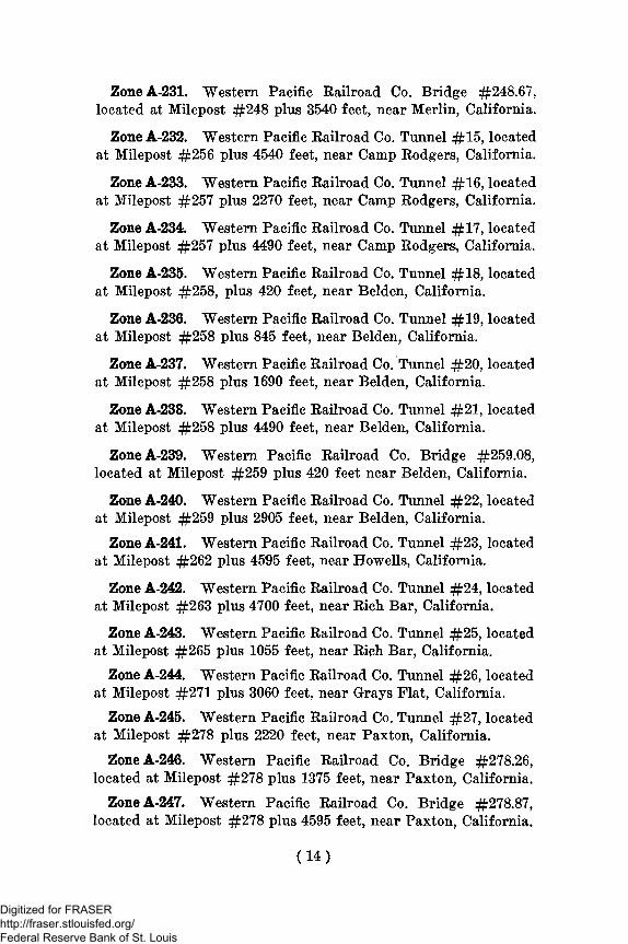
ZoneA-231. Western Pacific Railroad Co. Bridge #248.67,located at Milepost #248 plus 3540 feet, near Merlin, California.
Zone A-232. Western Pacific Railroad Co. Tunnel #15, locatedat Milepost #256 plus 4540 feet, near Camp Rodgers, California.
Zone A-233. Western Pacific Railroad Co. Tunnel #16, locatedat Milepost #257 plus 2270 feet, near Camp Rodgers, California.
Zone A-234. Western Pacific Railroad Co. Tunnel #17, locatedat Milepost #257 plus 4490 feet, near Camp Rodgers, California.
Zone A-235. Western Pacific Railroad Co. Tunnel #18, locatedat Milepost #258, plus 420 feet, near Belden, California.
Zone A-236. Western Pacific Railroad Co. Tunnel #19, locatedat Milepost #258 plus 845 feet, near Belden, California.
Zone A-237. Western Pacific Railroad Co. Tunnel #20, locatedat Milepost #258 plus 1690 feet, near Belden, California.
Zone A-238. Western Pacific Railroad Co. Tunnel #21 , locatedat Milepost #258 plus 4490 feet, near Belden, California.
ZoneA-239. Western Pacific Railroad Co. Bridge #259.08,located at Milepost #259 plus 420 feet near Belden, California.
Zone A-240. Western Pacific Railroad Co. Tunnel #22, locatedat Milepost #259 plus 2905 feet, near Belden, California.
Zone A-241. Western Pacific Railroad Co. Tunnel #23, locatedat Milepost #262 plus 4595 feet, near Howells, California.
Zone A-242. Western Pacific Railroad Co. Tunnel #24, locatedat Milepost #263 plus 4700 feet, near Rich Bar, California.
Zone A-243. Western Pacific Railroad Co. Tunnel #25, locatedat Milepost #265 plus 1055 feet, near Rich Bar, California.
Zone A-244. Western Pacific Railroad Co. Tunnel #26, locatedat Milepost #271 plus 3060 feet, near Grays Flat, California.
Zone A-245. Western Pacific Railroad Co. Tunnel #27, locatedat Milepost #278 plus 2220 feet, near Paxton, California.
ZoneA-246. Western Pacific Railroad Co. Bridge #278.26,located at Milepost #278 plus 1375 feet, near Paxton, California.
ZoneA-247. Western Pacific Railroad Co. Bridge #278.87,located at Milepost #278 plus 4595 feet, near Paxton, California.
(14)
Digitized for FRASER http://fraser.stlouisfed.org/ Federal Reserve Bank of St. Louis

Zone A-248. Western Pacific Railroad Co. Tunnel #28, locatedat Milepost #278, plus 5070 feet, near Paxton, California.
Zone A-249. Western Pacific Railroad Co. Tunnel #29, locatedat Milepost #279 plus 1005 feet, near Paxton, California.
Zone A-250. Western Pacific Railroad Co. Tunnel #30, locatedat Milepost #279 plus 2905 feet, near Paxton, California.
Zone A-251. Western Pacific Railroad Co. Tunnel #31, locatedat Milepost #280 plus 420 feet, near Paxton, California.
ZoneA-252. Western Pacific Railroad Co. Bridges #280.27and 280.51, located at Milepost #280 plus 1425 feet and 2695feet respectively, near Keddie, California.
Zone A-253. Western Pacific Railroad Co. Ttamel #32, locatedat Milepost #280 plus 4595 feet, near Keddie, California.
Zone A-254. Western Pacific Railroad Co. Tunnel #33, locatedat Milepost #283* plus 315 feet, near Sierra, California.
Zone A-255. Western Pacific Railroad Co. Tunnel #34, locatedat Milepost #283 plus 3750 feet, near Sierra, California.
ZoneA-256. Western Pacific Railroad Co. Bridge #288.76,located at Milepost #288 plus 4010 feet, near Quincy Junction,California.
Zone A-257. Western Pacific Railroad Co. Tunnel #35, locatedat Milepost #297 plus 950 feet, near Spring Garden, California.
ZoneA-258. Western Pacific Railroad Co. Bridge #301.07,located at Milepost #301 plus 370 feet, near Sloat, California.
ZoneA-259. Western Pacific Railroad Co. Bridge #309.91,located at Milepost #309 plus 4805 feet, near Feather River Inn,California.
ZoneA-260. Western Pacific Railroad Co. Bridge #314.36,located at Milepost #314 plus 1900 feet, near Clio, California.
Zone A-261. Western Pacific Railroad Co. Tunnel #36, locatedat Milepost #316 plus 00 feet, near Clio, California.
ZoneA-262. Western Pacific Railroad Co. Bridge #316.76,located at Milepost #316 plus 4010 feet, near Clio, California.
ZoneA-263. Western Pacific Railroad Co. Bridge #317.43,located at Milepost #317 plus 2270 feet, near Clio, California.
ZoneA-264. Western Pacific Railroad Co. Bridge #320.01,located at Milepost #320 plus 55 feet, near Portola, California.
(15)
Digitized for FRASER http://fraser.stlouisfed.org/ Federal Reserve Bank of St. Louis
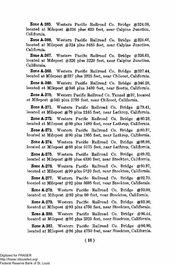
ZoneA-265. Western Pacific Eailroad Co. Bridge #324.08,located at Milepost #324 plus 420 feet, near Calpine Junction,California.
ZoneA-266. Western Pacific Railroad Co. Bridge #324.66,located at Milepost #324 plus 3485 feet, near Calpine Junction,California.
ZoneA-267. Western Pacific Railroad Co. Bridge #326.61,located at Milepost #326 plus 3220 feet, near Calpine Junction,California.
ZoneA-268. Western Pacific Railroad Co. Bridge #337.44,located at Milepost #337 plus 2325 feet, near Chilcoot, California.
ZoneA-269. Western Pacific Railroad Co. Bridge #346.28,located at Milepost #346 plus 1480 feet, near Scotts, California.
Zone A-270. Western Pacific Railroad Co. Tunnel #37, locatedat Milepost #340 plus 1795 feet, near Chilcoot, California.
ZoneA-271. Western Pacific Railroad Co. Bridge #79.41,located at Milepost #79 plus 2165 feet, near Lathrop, California.
ZoneA-272. Western Pacific Railroad Co. Bridge #80.28,located at Milepost #80 plus 1480 feet, near Lathrop, California.
ZoneA-273. Western Pacific Railroad Co. Bridge #80.37,located at Milepost #80 plus 1955 feet, near Lathrop, California.
ZoneA-274. Western Pacific Railroad Co. Bridge #88.98,located at Milepost #88 plus 5175 feet, near Lathrop, California.
ZoneA-275. Western Pacific Railroad Co. Bridge #89.82,located at Milepost #89 plus 4330 feet, near Stockton, California.
ZaneA-276. Western Pacific Railroad Co. Bridge #90.97,located at Milepost #90 plus 5120 feet, near Stockton, California.
ZoneA-277. Western Pacific Railroad Co. Bridge #92.70,located at Milepost #92 plus 3695 feet, near Stockton, California.
ZoneA-278. Western Pacific Railroad Co. Bridge #93.00,located at Milepost #93 plus 00 feet, near Stockton, California.
ZoneA-279. Western Pacific Railroad Co. Bridge #93.90,located at Milepost #93 plus 4750 feet, near Stockton, California.
ZoneA-280. Western Pacific Railroad Co. Bridge #96.44,located at Milepost #96 plus 2325 feet, near Stockton, California.
ZoneA-281. Western Pacific Railroad Co. Bridge #96.90,located at Milepost #96 plus 4750 feet, near Stockton, California.
(16)
Digitized for FRASER http://fraser.stlouisfed.org/ Federal Reserve Bank of St. Louis

ZoneA-282. Western Pacific Railroad Co. Bridge #99.08,located at Milepost #99 plus 420 feet, near Stockton, California.
ZoneA-283. Western Pacific Railroad Co. Bridge #99.62,located at Milepost #99 plus 3280 feet, near Kingdon, California.
ZoneA-284. Western Pacific Railroad Co. Bridge #100.18,located at Milepost #100, plus 950 feet, near Kingdon, California.
ZoneA-285. Western Pacific Railroad Co. Bridge #112.26,located at Milepost #112 plus 1375 feet, near Thornton, Cali-fornia.
ZoneA-286. Western Pacific Railroad Co. Bridge #112.38,located at Milepost #112 plus 2005 feet, near Thornton, Cali-fornia.
ZoneA-287. Western Pacific Railroad Co. Bridge #115.95,located at Milepost #115 plus 5015 feet, near Thornton, Cali-fornia.
ZoneA-288. Western Pacific Railroad Co. Bridge #116.07,located at Milepost #116 plus 370 feet, near Thornton, Cali-fornia.
ZoneA-289. Western Pacific Railroad Co. Bridge #116.28,located at Milepost #116 plus 1480 feet, near Thornton, Cali-fornia.
ZoneA-290. Western Pacific Railroad Co. Bridge #116.37,located at Milepost #116 plus 1955 feet, near Thornton, Cali-fornia.
ZoneA-291. Western Pacific Railroad Co. Bridge #117.06,located at Milepost #117 plus 315 feet, near Glannvale, Cali-fornia.
ZoneA-292. Western Pacific Railroad Co. Bridge #117.89,located at Milepost #117 plus 4700 feet, near Glannvale, Cali-fornia.
ZoneA-293. Western Pacific Railroad Co. Bridge #123.91,located at Milepost #123 plus 4805 feet, near Franklin, Cali-fornia.
ZoneA-294. Western Pacific Railroad Co. Bridge #126.51,located at Milepost #126 plus 2695 feet, near Franklin, Cali-fornia.
ZoneA-295. Western Pacific Railroad Co. Bridge #129.77,located at Milepost #129 plus 4065 feet, near Runyon, Cali-fornia.
(17)
Digitized for FRASER http://fraser.stlouisfed.org/ Federal Reserve Bank of St. Louis
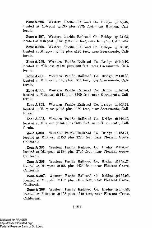
ZoneA-296. Western Pacific Railroad Co. Bridge #130.45,located at Milepost #130 plus 2375 feet, near Runyon, Cali-fornia.
ZoneA-297. Western Pacific Railroad Co. Bridge #131.03,located at Milepost #131 plus 160 feet, near Runyon, California.
ZoneA-298. Western Pacific Railroad Co. Bridge #139.78,located at Milepost #139 plus 4120 feet, near Sacramento, Cali-fornia.
ZoneA-299. Western Pacific Railroad Co. Bridge #140.10,located at Milepost #140 plus 530 feet, near Sacramento, Cali-fornia.
ZoneA-300. Western Pacific Railroad Co. Bridge #140.20,located at Milepost #140 plus 1055 feet, near Sacramento, Cali-fornia.
ZoneA-301. Western Pacific Railroad Co. Bridge #141.74,located at Milepost #141 plus 3905 feet, near Sacramento, Cali-fornia.
ZoneA-302. Western Pacific Railroad Co. Bridge #143.22,located at Milepost #143 plus 1160 feet, near Sacramento, Cali-fornia.
ZoneA-303. Western Pacific Railroad Co. Bridge #144.49,located at Milepost #144 plus 2585 feet, near Sacramento, Cali-fornia.
ZoneA-304. Western Pacific Railroad Co. Bridge #153.61,located at Milepost #153 plus 3220 feet, near Pleasant Grove,California.
ZoneA-305. Western Pacific Railroad Co. Bridge #154.52,located at Milepost #154 plus 2745 feet, near Pleasant Grove,California.
ZoneA-306. Western Pacific Railroad Co. Bridge #155.27,located at Milepost #155 plus 1425 feet, near Pleasant Grove,California.
ZoneA-307. Western Pacific Railroad Co. Bridge #157.95,located at Milepost #157 plus 5015 feet, near Pleasant Grove,California.
ZaneA-308. Western Pacific Railroad Co. Bridge #158.86,located at Milepost #158 plus 4540 feet, near Pleasant Grove,California.
(18)
Digitized for FRASER http://fraser.stlouisfed.org/ Federal Reserve Bank of St. Louis

ZoneA-309. Western Pacific Railroad Co. Bridge #160.93,located at Milepost #160 plus 4910 feet, near Trowbridge, Cali-fornia.
ZoneA-310. Western Pacific Railroad Co. Bridge #160.97,located at Milepost #160 plus 5120 feet, near Trowbridge, Cali-fornia.
ZoneA-311. Western Pacific Railroad €o. Bridge #164.38,located at Milepost #164 plus 2005 feet, near Trowbridge, Cali-fornia.
ZoneA-312. Western Pacific Railroad Co. Bridge #164.70,located at Milepost #164 plus 3695 feet, near Trowbridge, Cali-fornia.
ZoneA-313. Western Pacific Railroad Co. Bridge #165.16,located at Milepost #165 plus 845 feet, near Trowbridge, Cali-fornia.
ZoneA-314. Western Pacific Railroad Co. Bridge #165.50,located at Milepost #165 plus 2640 feet, near Trowbridge, Cali-fornia.
ZoneA-315. Western Pacific Railroad Co. Bridge #165.89,located at Milepost #165 plus 4700 feet, near Trowbridge, Cali-fornia.
ZoneA-316. Western Pacific Railroad Co. Bridge #166.25,located at Milepost #166 plus 1320 feet, near Arboga, California.
ZoneA-317. Western Pacific Railroad Co. Bridge #171.26,located at Milepost #171 plus 1375 feet, near Arboga, California.
ZoneA-318. Western Pacific Railroad Co. Bridge #175.45,located at Milepost #175 plus 2375 feet, near Marysville, Cali-*fornia.
ZoneA-319. Western Pacific Railroad Co. Bridge #176.73,located at Milepost #176 plus 3855 feet, near Marysville, Cali-fornia.
ZoneA-320. Western Pacific Railroad Co. Bridge #177.80,located at Milepost #177 plus 4225 feet, near Marysville, Cali-fornia.
ZoneA-321. Western Pacific Railroad Co. Bridge #178.18,located at Milepost #178 plus 950 feet, near Marysville, Cali-fornia.
(19)
Digitized for FRASER http://fraser.stlouisfed.org/ Federal Reserve Bank of St. Louis

ZoneA-322. Western Pacific Railroad Co. Bridge #178.79,located at Milepost #178 plus 4170 feet, near Marysville, Cali-fornia.
ZoneA-323. Western Pacific Railroad Co. Bridge #179.40,located at Milepost #179 plus 2110 feet, near Marysville, Cali-fornia.
ZoneA-324. Western Pacific Railroad Co. Bridge #179.53,located at Milepost #179 plus 2800 feet, near Marysville, Cali-fornia.
ZoneA-325. Western Pacific Railroad Co. Bridge #180.99,located at Milepost #180 plus 5225 feet, near Marysville, Cali-fornia.
ZoneA-326. Western Pacific Railroad Co. Bridge #190.40,located at Milepost #190 plus 2110 feet, near Craig, California.
ZoneA-327. Western Pacific Railroad Co. Bridge #190.68,located at Milepost #190 plus 3590 feet, near Craig, California.
ZoneA-328. Western Pacific Railroad Co. Bridge #190.84,located at Milepost #190 plus 4435 feet, near Craig, California.
ZoneA-329. Western Pacific Railroad Co. Bridge #191.66,located at Milepost #191 plus 3485 feet, near Craig, California.
ZoneA-330. Western Pacific Railroad Co. Bridge #193.76,located at Milepost #193 plus 4010 feet, near Craig, California.
ZoneA-331. Western Pacific Railroad Co. Bridge #196.70,located at Milepost #196 plus 3695 feet, near Palermo, Cali-fornia.
ZoneA-332. Western Pacific Railroad Co. Bridge #200.16,located at Milepost #200 plus 845 feet, neat Palermo, Cali-fornia.
ZoneA-333. Western Pacific Railroad Co. Bridge #204.26,located at Milepost #204 plus 1375 feet, near Oroville, California.
ZoneA-334. Western Pacific Railroad Co. Bridge #204.74,located at Milepost #204 plus 3905 feet, near Oroville, California.
ZoneA-335. Western Pacific Railroad Co. Bridge #204.82,located at Milepost #204 plus 4330 feet, near Oroville, California.
ZoneA-336. Western Pacific Railroad Co. Bridge #204.89,located at Milepost #204 plus 4700 feet, in Oroville, California.
(20)
Digitized for FRASER http://fraser.stlouisfed.org/ Federal Reserve Bank of St. Louis

Zone A-337. Southern Pacific Railroad Co. Bridge located atMilepost #111 plus 1109 feet, near Roeklin, California.
Zone A-338. Southern Pacific Railroad Co. Tunnel #15, locatedat Milepost #114 plus 1110 feet, near Rocklin, California.
Zone A-339. Southern Pacific Railroad Co. Tunnel #16, locatedat Milepost #114 plus 3696 feet, near Rocklin, California.
ZoneA-340. Southern Pacific Railroad Tunnel #17, locatedat Milepost #117 plus 1584 feet, near Penryn, California.
Zone A-341. Southern Pacific Railroad Co. Tunnel #18, locatedat Milepost #120 plus 2640 feet, near Newcastle, California.
ZoneA-342. Southern Pacific Railroad Co. Bridge, located atMilepost #123 plus 3221 feet, near Auburn, California.
ZoneA-34'3. Southern Pacific Railroad Co. Tunnel #19, lo-cated at Milepost #122 plus 3696 feet, near Auburn, California.
ZoneA-344. Southern Pacific Railroad Co. Tunnel #20, lo-cated at Milepost #123 plus 528 feet, near Auburn, California.
ZoneA-345. Southern Pacific Railroad Co. Tunnel #21, lo-cated at Milepost #124 plus 3170 feet, near Auburn, California.
ZoneA-346. Southern Pacific Railroad Co. Tunnel #22, lo-cated at Milepost #131 plus 1056 feet, near Clipper Gap, Cali-fornia.
ZoneA-347. Southern Pacific Railroad Co. Tunnel #23, lo-cated at Milepost #132 plus 3696 feet, near Applegate, Cali-fornia.
ZoneA-348. Southern Pacific Railroad Co. Tunnel #24, lo-cated at Milepost #132 plus 4752 feet, near Applegate, Cali-fornia.
ZoneA-349. Southern Pacific Railroad Co. Tunnel #25, lo-cated at Milepost #133 plus 528 feet, near Applegate, California.
ZoneA-350. Southern Pacific Railroad Co. Tunnel #26, lo-cated at Milepost #133 plus 1584 feet, near Applegate, Cali-fornia.
ZoneA-351. Southern Pacific Railroad Co. Tunnel #27, lo-cated at Milepost #133 plus 4224 feet, near Applegate, Cali-fornia.
(21)
Digitized for FRASER http://fraser.stlouisfed.org/ Federal Reserve Bank of St. Louis
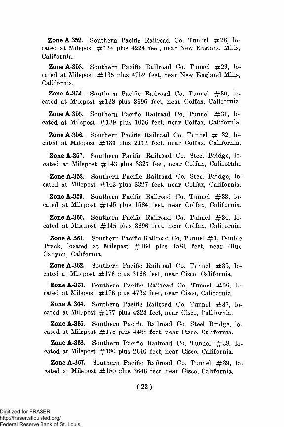
ZoneA-352. Southern Pacific Railroad Co. Tunnel #28, lo-cated at Milepost #134 plus 4224 feet, near New England Mills,California.
ZoneA-353. Southern Pacific Railroad Co. Tunnel #29, lo-cated at Milepost #135 plus 4752 feet, near New England Mills,California.
ZoneA-354. Southern Pacific Railroad Co. Tunnel #30, lo-cated at Milepost #138 plus 3696 feet, near Colfax, California.
ZoneA-355. Southern Pacific Railroad Co. Tunnel #31 , lo-cated at Milepost #139 plus 1056 feet, near Colfax, California.
ZoneA-356. Southern Pacific Railroad Co. Tunnel # 32, lo-cated at Milepost #139 plus 2112 feet, near Colfax, California.
ZoneA-357. Southern Pacific Railroad Co. Steel Bridge, lo-cated at Milepost #143 plus 3327 feet, near Colfax, California.
ZoneA-358. Southern Pacific Railroad Co. Steel Bridge, lo-cated at Milepost #143 plus 3327 feet, near Colfax, California.
ZoneA-359. Southern Pacific Railroad Co. Tunnel #33, lo-cated at Milepost #145 plus 1584 feet, near Colfax, California.
ZoneA-360. Southern Pacific Railroad Co. Tunnel #34, lo-cated at Milepost #145 plus 3696 feet, near Colfax, California.
Zone A-361. Southern Pacific Railroad Co. Tunnel # 1 , DoubleTrack, located at Milepost #164 plus 1584 feet, near BlueCanyon, California.
ZoneA-362. Southern Pacific Railroad Co. Tunnel #35, lo-cated at Milepost #176 plus 3168 feet, near Cisco, California.
ZoneA-363. Southern Pacific Railroad Co. Tunnel #36, lo-cated at Milepost #176 plus 4732 feet, near Cisco, California.
ZoneA-364. Southern Pacific Railroad Co. Tunnel #37, lo-cated at Milepost #177 plus 4224 feet, near Cisco, California.
ZoneA-365. Southern Pacific Railroad Co. Steel Bridge, lo-cated at Milepost #178 plus 4488 feet, near Cisco, California.
ZoneA-366. Southern Pacific Railroad Co. Tunnel #38, lo-cated at Milepost #180 plus 2640 feet, near Cisco, California,
ZoneA-367. Southern Pacific Railroad Co. Tunnel #39, lo-cated at Milepost #180 plus 3646 feet, near Cisco, California.
(22 )
Digitized for FRASER http://fraser.stlouisfed.org/ Federal Reserve Bank of St. Louis

ZoneA-368. Southern Pacific Eailroad Co. Tunnel # 3 , lo-cated at Milepost #180 plus 3696 feet, near Cisco, California.
ZoneA-369. Southern Pacific Railroad Co. Tunnel # 4 , lo-cated at Milepost #181 plus 4752 feet, near Cisco, California.
ZoneA-370. Southern Pacific Railroad Co. Tunnel #40, lo-cated at Milepost #185 plus 1584 feet, near Soda Springs, Cali-fornia.
ZoneA-371. Southern Pacific Railroad Co. Steel Bridge, lo-cated at Milepost #186 plus 3432 feet, near Soda Springs, Cali-fornia.
ZoneA-372. Southern Pacific Railroad Co. Steel Bridge, lo-cated at Milepost #187 plus 2112 feet, near Soda Springs, Cali-fornia.
ZoneA-373. Southern Pacific Railroad Co. Tunnel # 4 , lo-cated at Milepost #193 plus 1584 feet, near Norden, California.
ZoneA-374. Southern Pacific Railroad Co. Tunnel # 6 , lo-cated at Milepost #193 plus 1584 feet, near Norden, California.
ZoneA-375. Southern Pacific Railroad Co. Tunnel # 7 , lo-cated at Milepost #194 plus 528 feet, near Norden, California.
ZoneA-376. Southern Pacific Railroad Co. Tunnel # 8 , lo-cated at Milepost #194 plus 1584 feet, near Norden, California.
ZoneA-377. Southern Pacific Railroad Co. Tunnel # 9 , lo-cated at Milepost #194 plus 4752 feet, near Norden, California.
ZoneA-378. Southern Pacific Railroad Co. Tunnel #10, lo-cated at Milepost #195 plus 528 feet, near Norden, California.
ZoneA-379. Southern Pacific Railroad Co. Tunnel #11 , lo-cated at Milepost #195 plus 2112 feet, near Norden, California.
ZoneA-380. Southern Pacific Railroad Co. Tunnel #12, lo-cated at Milepost #195 plus 3696 feet, near Norden, California.
ZoneA-381. Southern Pacific Railroad Co. Tunnel #13, lo-cated at Milepost #200 plus 528 feet, near Truckee, California.
ZaneA-382. Southern Pacific Railroad Co. Tunnel #42, lo-cated at Milepost #200 plus 528 feet, near Truckee, California.
ZoneA-383. Southern Pacific Railroad Co. Tunnel # % , lo-cated at Milepost #332 plus 3170 feet, near Caliente, California.
(23 )
Digitized for FRASER http://fraser.stlouisfed.org/ Federal Reserve Bank of St. Louis

Zone A-384. Southern Pacific Railroad Co. Tunnel # 1 , locatedat Milepost #336 plus 4750 feet, near Caliente, California.
Zone A-385. Southern Pacific Railroad Co. Tunnel #2 , locatedat Milepost #337 plus 4220 feet, near Caliente, California.
Zone A-386. Southern Pacific Railroad Co. Tunnel # 3 , locatedat Milepost #340 plus 4220 feet, near Caliente, California.
Zone A-387. Southern Pacific Railroad Co. Tunnel #4 , locatedat Milepost #341, near Caliente, California.
Zone A-388. Southern Pacific Railroad Co. Tunnel # 5 , locatedat Milepost #341 plus 3170 feet, near Caliente, California.
Zone A-389. Southern Pacific Railroad Co. Tunnel #6 , locatedat Milepost #341 plus 4750 feet, near Caliente, California.
Zone A-390. Southern Pacific Railroad Co. Tunnel #7 , locatedat Milepost #343 plus 3700 feet, near Woodford, California.
Zone A-391. Southern Pacific Railroad Co. Tunnel # 8 , locatedat Milepost #344 plus 1060 feet, near Woodford, California.
ZoneA-392. Southern Pacific Railroad Co. Steel Bridge, lo-cated at Milepost #346 plus 4380 feet, near Woodford, Cali-fornia.
ZoneA-393. Southern Pacific Railroad Co. Steel Bridge, lo-cated at Milepost #349 plus 3810 feet, near Woodford, Cali-fornia.
ZoneA-394. Southern Pacific Railroad Co. Steel Bridge, lo-cated at Milepost #350 plus 1380 feet, near Woodford, Cali-fornia.
Zone A-395. Southern Pacific Railroad Co. Tunnel #9 , locatedat Milepost #351, near Woodford, California.
ZoneA-396. Southern Pacific Railroad Co. Tunnel #10, lo-cated at Milepost #352 plus 1580 feet, near Woodford, Cali-fornia.
ZoneA-397. Southern Pacific Railroad Co. Tunnel #11 , lo-cated at Milepost #353, near Woodford, California.
ZoneA-398. Southern Pacific Railroad Co. Tunnel #14, lo-cated at Milepost #355 plus 2110 feet, near Woodford, Cali-fornia.
ZoneA-399. Southern Pacific Railroad Co. Tunnel #15, lo-cated at Milepost #355 plus 3700 feet, near Woodford, Cali-fornia.
(24)
Digitized for FRASER http://fraser.stlouisfed.org/ Federal Reserve Bank of St. Louis
ZoneA-400. Southern Pacific Railroad Co. Tunnel #16, lo-cated at Milepost #355 plus 4750 feet, near Woodford, Cali-fornia.
ZoneA-401. Southern Pacific Eailroad Co. Tunnel #17, lo-cated at Milepost #356, near Tehachapi, California.
ZoneA-402. Atchison Topeka and Santa Fe Railroad Co.Bridge, located at Milepost #565 plus 4650 feet, near Topock,Arizona.
ZoneA-403. Atchison Topeka and Santa Fe Railroad Co.Bridge, located at Milepost #746 plus 4717 feet, near Barstow,California.
ZoneA-404. Atchison Topeka and Santa Fe Railroad Co.Bridge, located at Milepost #34 plus 595 feet and 579 feet, nearVictorville, California.
ZoneA-405. Atchison Topeka and Santa Fe Railroad Co.Bridge, located at Milepost #39 plus 649 feet, near Victorville,California.
ZoneA-406. Atchison Topeka and Santa Fe Railroad Co.Cajon Tunnel # 1 , about 380 feet long, located at Milepost #58Aplus 4575 feet, near Alray, California.
ZoneA-407. Atchison Topeka and Santa Fe Railroad Co.Cajon Tunnel #2 , about 468 feet long, located at Milepost 59Aplus 959 feet, near Alray, California.
ZoneA-408. Atchison Topeka and Santa Fe Railroad Co.Bridge, located at Milepost #63, near Cajon, California.
ZoneA-409. Atchison Topeka and Santa Fe Railroad Co.Bridge, located at Milepost #82 plus 489 feet, near San Ber-nardino, California.
ZoneA-410. U.S. Highway #66, Bridge #54-10, approxi-mately 576 feet long over the Mojave River at or near Victor-ville, California.
Zone A-411. U.S. Highway #91-466, Bridge #54-12, approxi-mately 748 feet long over the Mojave River at or near Barstow,California.
ZoneA-412. U.S. Highway #66, Bridge #54-13, approxi-mately 832 feet long over the Colorado River at or near Topock,Arizona.
(25)
Digitized for FRASER http://fraser.stlouisfed.org/ Federal Reserve Bank of St. Louis

ZoneA-413. U.S. Highway #60-70, Bridge #56-08, approxi-mately 1028 feet long over the Colorado River at or near Ehren-berg, California.
ZoneA-414. U.S. Highway #40, Bridge #17-23, about 4miles West of Cisco, California.
ZoneA-415. U.S. Highway #40, Bridge #17-21, about 2miles West of Cisco, California.
Zone 416. U.S. Highway #40, Bridge #17-18, at or nearDonner Summit, California.
ZoneA-417. U.S. Highway #40, Bridge #17-14, about 4miles East of Truckee, California.
ZoneA-418. U.S. Highway #40, Bridge #17-13, about 6miles of East of Truckee, California.
ZoneA-419. U.S. Highway #40, Bridge #17-12, about 6y2
miles East of Truckee, California.
ZoneA-420. U.S. Highway #40, Bridge #17-11, about 9miles East of Truckee, California.
ZoneA-421. California State Highway #24, Bridge #9-15,approximately 618 feet long over Spanish Creek, about 1 mileWest of Keddie, California.
ZoneA-422. California State Highway #24, Bridge #9-14,about 3V miles West of Keddie, California.
ZoneA-423. California State Highway #24, Bridge #9-09,about 2 miles West of Belden, California.
ZoneA-424. California State Highway #24, Bridge #9-08,at or near Belden, California.
ZoaeA-425. California State Highway #24, Bridge #9-04,approximately 292 feet long, over North Fork Feather River,about 7 miles South of Belden, California.
ZoneA-426. California State Highway #24, Bridge #9-03,approximately 361 feet long, over North Fork Feather River,about 9 miles South of Belden, California.
ZoneA-427. California State Highway #24, Bridge #9-02,approximately 329 feet long, over North Fork Feather River,about 12 miles South of Belden, California.
(26 )
Digitized for FRASER http://fraser.stlouisfed.org/ Federal Reserve Bank of St. Louis

ZoneA-428. California State Highway #24, Bridge #12-38,approximately 681 feet long, over North Fork Feather River,about 28 miles North of Oroville, California.
ZonfcA-429. California State Highway #24, Bridge #12-36,about 16 miles North of Oroville, California.
ZoneA-430. California State Highway #24, Bridge #12-35,about 5 miles North of Oroville, California.
Zone A-431. U.S. Highway #40, Tunnel under part of townand railroad tracks in Newcastle, California.
ZoneA-432. California State Highway #24, Elephant ButteTunnel #9-24, located about 14 miles South of Belden, Cali-fornia.
ZoneA-433. California State Highway #24, Grizzley DomeTunnel #9-01, located about 15 miles South of Belden, Cali-fornia.
Zone A-434. California State Highway #24, Arch Eock Tun-nel #12-109, located about 16 miles South of Belden, California.
ZoneA-435. Army Air Field, between Lone Pine and Inde-pendence, California, located in Sections 2, 3, 11, T14S, R35E,Mt. Diablo Base and Meridian.
Military Area No. 3, comprising the State of Idaho, withinwhich are located Zones A-436 to A-526 inclusive, particularlydescribed below:
Zone A-436. Gowen Field, at or near Boise, Idaho.
ZoneA-437. Boise Bombing Range, at or near Boise, Idaho.Beginning at the NE corner Section 6, T2S, R2E, Boise Baseand Meridian, thence West 2 miles, thence South 2 miles;thence East 2 miles; thence North 2 miles to the point of beginning.
ZoneA-438. Arrow Rock Dam, at or near Boise, Idaho. Lo-cation : Section 13, T3N, R4E, Boise Base and Meridian.
ZoneA-439. Cove Hydro Electric Plant, at or near Grace,Idaho. Located at Section 21, T10S, R40E, Boise Base andMeridian.
Zone A-440. Oneida Hydro Electric Plant, at or near Preston,Idaho. Located at Section 26, T13S, R40E, Boise Base andMeridian.
(27 )
Digitized for FRASER http://fraser.stlouisfed.org/ Federal Reserve Bank of St. Louis
ZoneA-441. Lifton Pumping Plant, at or near St. Charles,Idaho. Located at Section 16, T15S, R44E, Boise Base andMeridian.
ZoneA-442. U.S. Government Dam, at or near AmericanFalls, Idaho. Located at Sections 29, 30, 31, and 32, T7S, R31E,Boise Base and Meridian. The prohibited area is the areawithin a distance of one-quarter mile of the dam proper andadjoining installations.
Zone A-443. Northern Pacific Railroad Co. Tunnel, located atMilepost #85 plus 4750 feet, near Cabinet, Idaho.
Zone A-444. Northern Pacific Railroad Co. Bridge, located atMilepost #92 plus 5269 feet, near Clarks Fork, Idaho.
Zone A-445. Northern Pacific Railroad Co. Bridge, located atMilepost # 3 plus 4652 feet, Sand Point, Idaho.
Zone A-446. Northern Pacific Railroad Co. Bridge, located atMilepost #25 plus 827 feet, Granite, Idaho.
Zone A-447. Northern Pacific Railroad Co. Tunnel, located atMilepost #25 plus 4950 feet, Granite, Idaho.
ZoneA-448. Union Pacific Railroad Co. Bridge, located atMilepost #239.8, near American Falls, Idaho. The prohibitedarea is the area within one-quarter of a mile of the bridge.
ZoneA-449. Union Pacific Railroad Co. Bridge at Milepost#466.7, one mile West of Caldwell, Idaho.
. ZoneA-450. Union Pacific Railroad Co. Bridge, located atMilepost #486.8, two miles East of Nyssa, Idaho.
ZoneA-451. Union Pacific Railroad Co. Bridge, located atMilepost #487.7, one mile East of Nyssa, Idaho.
ZoneA-452. Union Pacific Railroad Co. Bridge, located atMilepost #499.8, one mile West of Ontario, Oregon.
ZoneA-453. Union Pacific Railroad Co. Bridge, located atMilepost #500.2, one and one-quarter mile West of Ontario,Oregon.
ZoneA-454. Union Pacific Railroad Co. Bridge, located atMilepost #502.4, 0.4 mile East of Payette, Idaho.
ZoneA-455. Union Pacific Railroad Co. Bridge, located atMilepost #536.5, 2.5 miles East of Huntington, Idaho.
(28 )
Digitized for FRASER http://fraser.stlouisfed.org/ Federal Reserve Bank of St. Louis

ZoneA-456. Union Pacific Railroad Co. Bridge, located atMilepost #187.3, 3 miles North of Idaho Falls, Idaho.
ZoneA-457. Chicago, Milwaukee, St. Paul and Pacific Rail-road Co. Tunnel #21 located at Milepost #1752.49 near Roland,Idaho.
ZoneA-458. Chicago, Milwaukee, St. Paul and Pacific Rail-road Co. Tunnel #22 located at Milepost #1753.45 near Roland,Idaho.
ZoneA-459. Chicago, Milwaukee, St. Paul and Pacific Rail-road Co. Tunnel #23 located at Milepost #1754.20 near Roland,Idaho.
ZoneA-460. Chicago, Milwaukee, St. Paul and Pacific Rail-road Co. Tunnel #24 located at Milepost #1754.35 near Roland,Idaho.
ZoneA-461. Chicago, Milwaukee, St. Paul and Pacific Rail-road Co. Bridge #DD-216 located at Milepost #1754.44 nearRoland, Idaho.
ZoneA-462. Chicago, Milwaukee, St. Paul and Pacific Rail-road Co. Bridge #DD-218 located at Milepost #1754.75 nearAdair, Idaho.
ZoneA-463. Chicago, Milwaukee, St. Paul and Pacific Rail-road Co. Bridge #DD-220 located at Milepost #1755.32 nearAdair, Idaho.
ZoneA-464. Chicago, Milwaukee, St. Paul and Pacific Rail-road Co. Tunnel #25 located at Milepost #1756.20 near Adair,Idaho.
ZoneA-465. Chicago, Milwaukee, St. Paul and Pacific Rail-road Co. Tunnel #26 located at Milepost #1756.46 near Adair,Idaho.
ZoneA-466. Chicago, Milwaukee, St. Paul and Pacific Rail-road Co. Bridge #DD-224 located at Milepost #1757.18 nearAdair, Idaho.
ZoneA-467. Chicago, Milwaukee, St. Paul and Pacific Rail-road Co. Bridge #DD-226 located at Milepost #1757.71 nearAdair, Idaho.
ZoneA-468. Chicago, Milwaukee, St. Paul and Pacific Rail-road Co. Bridge #DD-228 located at Milepost #1758.30 nearFalcon, Idaho.
(29)
Digitized for FRASER http://fraser.stlouisfed.org/ Federal Reserve Bank of St. Louis

ZoneA-469. Chicago, Milwaukee, St. Paul and Pacific Rail-road Co. Bridge #DD-230 located at Milepost #1758.75 nearFalcon, Idaho.
ZoneA-470. Chicago, Milwaukee, St. Paul and Pacific Rail-road Co. Tunnel #27 located at Milepost #1759.02 near Falcon,Idaho.
ZoneA-471. Chicago, Milwaukee, St. Paul and Pacific Rail-road Co. Tunnel #28 located at Milepost #1759.26 near Falcon,Idaho.
ZoneA-472. Chicago, Milwaukee, St. Paul and Pacific Rail-road Co. Tunnel #29 located at Milepost #1763.18 near Pearson,Idaho.
ZoneA-473. Chicago, Milwaukee, St. Paul and Pacific Rail-road Co. Tunnel #30 located at Milepost #1764.05 near Pearson,Idaho.
ZoneA-474. Chicago, Milwaukee, St. Paul and Pacific Rail-road Co. Tunnel #31 located at Milepost #1764.55 near Pearson,Idaho.
ZoneA-475. Chicago, Milwaukee, St. Paul and Pacific Rail-road Co. Bridge #DD-250 located at Milepost #1764.95 nearKyle, Idaho.
ZoneA-476. Chicago, Milwaukee, St. Paul and Pacific Rail-road Co. Tunnel #32 located at Milepost #1765.21 near Kyle,Idaho.
ZoneA-477. Chicago, Milwaukee, St. Paul and Pacific Rail-road Co. Tunnel #33 located at Milepost #1766.22 near Kyle,Idaho.
ZoneA-478. Chicago, Milwaukee, St. Paul and Pacific Rail-road Co. Bridge #DD-254 located at Milepost #1767.78 nearStetson, Idaho.
ZoneA-479. Chicago, Milwaukee, St. Paul and Pacific Rail-road Co. Tunnel #34 located at Milepost #1768.45 near Stetson,Idaho.
ZoneA-480. Chicago, Milwaukee, St. Paul and Pacific Rail-road Co. Tunnel #35 located at Milepost #1769.95 near Stetson,Idaho.
ZoneA-481. Chicago, Milwaukee, St. Paul and Pacific Rail-road Co. Tunnel #36 located at Milepost #1770.45 near Stetson,Idaho.
(30)
Digitized for FRASER http://fraser.stlouisfed.org/ Federal Reserve Bank of St. Louis
ZoneA-482. Chicago, Milwaukee, St. Paul and Pacific Rail-road Co. Bridge #EE-2 located at Milepost #1779.95 nearEthelton, Idaho.
ZoneA-483. Chicago, Milwaukee, St. Paul and Pacific Rail-road Co. Tunnel #37 located at Milepost #1790.05 near Herrick,Idaho.
ZoneA-484. Chicago, Milwaukee, St. Paul and Pacific Rail-road Co. Tunnel #40 located at Milepost #1824.33 near Rams-dell, Idaho.
ZoneA-485. Chicago, Milwaukee, St. Paul and Pacific Rail-road Co. Bridge #EE-44 located at Milepost #1824.80 nearRamsdell, Idaho.
ZoneA-486. Chicago, Milwaukee, St. Paul and Pacific Rail-road Co. Bridge #EE-50 located at Milepost #1828.55 nearPedee, Idaho.
ZoneA-487. Chicago, Milwaukee, St. Paul and Pacific Rail-road Co. Bridge #EE-52 located at Milepost #1829.20 nearPedee, Idaho.
ZoneA-488. Chicago, Milwaukee, St. Paul and Pacific Rail-road Co. Tunnel #41 located at Milepost #1840.50 near Sar-rento, Idaho.
Zone A-489. The Great Northern Railroad Co. Timber Bridge#208 located at Milepost #1371 plus 1600 feet, near Leonia,Idaho.
ZoneA-490. The Great Northern Railroad Co. Tunnel #10.1located at Milepost #1374 plus 800 feet, near Katka, Idaho.
ZoneA-491. The Great Northern Railroad Co. Tunnel #10.2located at Milepost #1376 plus 1300 feet, near Katka, Idaho.
ZoneA-492. The Great Northern Railroad Co. Bridge #210located at Milepost #1376 plus 1900 feet, near Katka, Idaho.
ZoneA-493. The Great Northern Railroad Co. Steel Bridge#220 located at Milepost #1391 plus 4100 feet, near Moravia,Idaho.
ZoneA-494. The Great Northern Railroad Co. Bridge #244located at Milepost #1423 plus 3000 feet, near Dover, Idaho.
ZoneA-495. The Great Northern Railroad Co. Steel Bridge#249 located at Milepost #1428 plus 2600 feet, near Wrencoe,Idaho.
(31)
Digitized for FRASER http://fraser.stlouisfed.org/ Federal Reserve Bank of St. Louis

Zone A-496. The Great Northern Railroad Co. Tunnel #10.3located at Milepost #1442 plus 4100 feet, near Priest River,Idaho.
ZoneA-497. The Great Northern Railroad Co. Steel Bridge#260 located at Milepost #1443 plus 1700 feet, near PriestRiver, Idaho.
ZoneA-498. The Great Northern Railroad Co. Tunnel #11located at Milepost #1443 plus 4600 feet, near Priest River,Idaho.
Zone A-499. U.S. Highway #95, Bridge over Kootenai River,at or near Bonners Ferry, Idaho. The prohibited area is the areawithin 100 yards of the bridge.
ZoneA-500. U.S. Highway #95, Bridge over Pend OreilleRiver, at or near Sandpoint, Idaho.
ZoneA-501. U.S. Highway #195 Bridge over Priest River,at or near Priest River, Idaho. The prohibited area is the areawithin 100 yards of the bridge.
ZoneA-502. U.S. Highway #195 Bridge over Pend Oreille,about 1 mile North, near Newport, Washington.
ZoneA-503. U.S. Highway #10 Bridge over Coeur D'AleneRiver, at or near Cataldo, Idaho.
ZoneA-504. U.S. Highway #10 Fourth of July Tunnel,about 12 miles Northwest of Cataldo, Idaho.
ZoneA-505. U.S. Highway #410 18th Street Bridge overClearwater River, at or near Lewiston, Idaho. The prohibitedarea is the area within 100 yards of the bridge.
ZoneA-506. U.S. Highway #410 Interstate Bridge overSnake River in Lewiston, Idaho. The prohibited area is thearea within 100 yards of the bridge.
ZoneA-507. U.S. Highway #30 Bridge over Snake River,about 1 mile North of Fruitland, Idaho.
ZoneA-508. U.S. Highway #95 Bridge over Salmon River,about 2 miles North of Riggins, Idaho.
ZoneA-509. U.S. Highway #93 Jerome Bridge over SnakeRiver, about 1 mile North of Twin Falls, Idaho. The prohibitedarea is the area within one-quarter mile of the bridge.
( 3 2 )
Digitized for FRASER http://fraser.stlouisfed.org/ Federal Reserve Bank of St. Louis
ZoneA-510. U.S. Highway #91 Bridge over Snake River inIdaho Falls, Idaho. The prohibited area is the area within 100yards of the bridge.
ZoneA-511. U.S. Highway #191 Bridge over Snake River,near Rigby, Idaho.
ZoneA-512. Radio Station KIDO, Hotel Boise, Boise, Idaho.The prohibited area is limited to the entire property, whether
devoted exclusively or partially to radio broadcasting, includ-ing broadcasting studios whether contained in a separate buildingor a portion of a building and property whereon a transmitteror other broadcasting equipment is located.
ZoneA-513. Radio Station KID, KID Building, Idaho Falls,Idaho.
The prohibited area is limited to the entire property, whetherdevoted exclusively or partially to radio broadcasting, includ-ing broadcasting studios whether contained in a separate buildingor a portion of a building and property whereon a transmitteror other broadcasting equipment is located.
ZoneA-514. Radio Station KRLC, Lewis-Clark Hotel, Lewis-ton, Idaho.
The prohibited area is limited to the entire property, whetherdevoted exclusively or partially to radio broadcasting, includ-ing broadcasting studios whether contained in a separate buildingor a portion of a building and property whereon a transmitteror other broadcasting equipment is located.
Zone A-515. Radio Station KSEI, Radio Service Corporation,Pocatello, Idaho.
The prohibited area is limited to the entire property, whetherdevoted exclusively or partially to radio broadcasting, includ-ing broadcasting studios whether contained in a separate buildingor a portion of a building and property whereon a transmitteror other broadcasting equipment is located.
ZoneA-516. Radio Station KTFI, Twin Radio Center, TwinFalls, Idaho.
The prohibited area is limited to the entire property, whetherdevoted exclusively or partially to radio broadcasting, includ-ing broadcasting studios whether contained in a separate buildingor a portion of a building and property whereon a transmitteror other broadcasting equipment is located.
( 33 )
Digitized for FRASER http://fraser.stlouisfed.org/ Federal Reserve Bank of St. Louis

Zone A-517. Airport, at or near Caldwell, Idaho. Location:Section 21, T4N, E3B, Boise Base and Meridian.
The prohibited area is the area within 100 yards of the bound-aries of the airport.
ZoneA-518. Airport, at or near Boise, Idaho, described asall of Section 28; all of Section 29; the South half of the Southhalf of Section 20; the South half of the South half of Section21; the South half of the Southwest, quarter of Section 22; theWest half of Section 27; the Northwest quarter and the Northhalf of the Southwest quarter of Section 34; the North half andthe North half of the South half of Section 33; the North halfand the North half of the South half of Section 32; all in Town-ship 3 North of Eange 2 East, Boise Base and Meridian.
Zone A-519. Airport, at or near Lewiston, Idaho, describedas the Northeast quarter of the Southeast quarter of the South-west quarter, and the Southwest quarter of the Southeast quar-ter of the Southwest quarter of Section 7; and the Northeastquarter of the Northeast quarter of the Northwest quarter ofSection 18, Township 35 North, Range 5 West, Boise Base andMeridian.
Zone A-520. Airport, at or near Idaho Falls, Idaho, describedas South half Section 1; South half Section 2; all Section 11;all Section 12; North half Section 13; North half Section 14;all in Township 2 North, Range 37 East, Boise Base andMeridian.
Zone A-521. Airport, at or near Pocatello, Idaho, describedas the Southeast quarter and the South half of the Southwestquarter of Section 1; all of Section 12 and the North half of theNorth half of Section 13, all in Township 6 South, Range 33East, Boise Base and Meridian, and the West half of the South-west quarter of Section 6 and all of Section 7, except the Easthalf of said Section 7, all in Township 6 South, Range 34 East,Boise Base and Meridian.
ZoneA-522. Airport, at or near Twin Falls, Idaho, describedas Southeast quarter of Southeast quarter of Section 8; Southhalf of Southwest quarter Section 9; South half Southeastquarter Section 9; Southwest quarter of Southwest quarterSection 10; West half Northwest quarter Section 15; Northwestquarter of Southwest quarter Section 15; North half Southeast
(34)
Digitized for FRASER http://fraser.stlouisfed.org/ Federal Reserve Bank of St. Louis

quarter Section 16; Southwest half of Southeast quarter Sec-tion 16; Northwest quarter of Northeast quarter Section 21;North half of Northwest quarter Section 21; Northeast quarterof Northeast quarter Section 20; East half Southeast quarterSection 17; East half Northwest quarter Section 17; all inTownship 11, Range 17 East, Boise Base and Meridian.
ZoneA-523. Black Canyon Dam and Hydro Electric Plant,at or near Emmett, Idaho, located in Section 22, T7N, R1W,Boise Base and Meridian.
Zone A-524. Deadwood Dam, Valley County, Idaho, locatedin Section 8, TUN, R7E, Boise Base and Meridian.
ZoneA-525. Soda Hydro Electric Plant, at or near Alex-ander, Idaho, located in Section 17, T9S, R41E, Boise Baseand Meridian.
Zone A-526. Grace Hydro Electric Plant, at or near Grace,Idaho, located in Section 21, T10S, R40E, Boise Base andMeridian.
Military Area #4 , comprising the State of Montana, withinwhich are located Zones A-527 to A-709, inclusive, particularlydescribed below:
Zone A-527. Smelter of the Anaconda Copper Co., at or nearAnaconda, Montana, located in Section 12, T4N, RIW, ButteBase and Meridian.
ZoneA-528. Smelter of the American Smelter and RefiningCo., at or near East Helena, Montana, located in Section 36,T10N, R3W, Butte Base and Meridian. The prohibited area isthe area within one-quarter mile of the smelter property.
Zone A-529. Smelter of the Anaconda Copper Co., at or nearGreat Falls, Montana, located in Sections 31, 32, T21N, R4E, andSections 5, 6, T20N, R4E, Butte Base and Meridian.
ZoneA-530. Oil and Gas Field of the Montana Power Co.,at or near Cut Bank, Montana, located in Sections 1-36 inc. ofT32, 33, 34, 35, 36N, R4, 5, 6W, Butte Base and Meridian.
ZoneA-531. Refinery, Montana Power Co., at or near CutBank, Montana, located in Section 32, T33N, R5W, Butte Baseand Meridian.
(35)
Digitized for FRASER http://fraser.stlouisfed.org/ Federal Reserve Bank of St. Louis

Zone A-532. Tank site of the Montana Power Co., at or nearCut Bank, Montana, being in all of Section 7, T33N, E5W,Butte Base and Meridian.
ZoneA-533. Oil Pump Station # 1 of Montana Power Co.,at or near Cut Bank, Montana, located in Section 6, T33N,R5W, Butte Base and Meridian.
ZoneA-534. Oil Pump Station # 2 of Montana Power Co.,at or near Cut Bank, Montana, located in Section 4, T32N, R5W,Butte Base and Meridian.
ZoneA-535. Standby Tank of the Montana Power Co., at ornear Butte, Montana, located in Section 14, T3N, R8W, ButteBase and Meridian. The prohibited area is that area within100 yards of the property.
ZoneA-536. Black Eagle Hydro Electric Plant and Dam,near Great Palls, Montana, located in Section 5, T20N, R4E,Butte Base and Meridian.
ZoneA-537. Canyon Ferry Hydro Electric Plant and Dam,near Helena, Montana, located in Section 10, T10N, R1W, ButteBase and Meridian.
ZoneA-538. Hauser Hydro Electric Plant and Dam, nearHelena, Montana, located in Section 29, T12N, R2W, Butte Baseand Meridian.
ZoneA-539. Kerr Hydro Electric Plant and Dam, near Pol-son, Montana, located in Section 12, T22N, R21W, Butte Baseand Meridian.
ZoneA-540. Morony Hydro Electric Plant and Dam, nearGreat Falls, Montana, located in Section 14, T21N, R5E, ButteBase and Meridian.
ZoneA-541. Mystic Hydro Electric Plant and Dam, nearColumbus, Montana, located !in Sections 7 and 9, T7S, R16E,Butte Base and Meridian.
ZoneA-542. Rainbow Hydro Electric Plant and Dam, nearGreat Falls, Montana, located in Sections 34 and 35, T21N,R4E, Butte Base and Meridian.
ZoneA-543. Ryan Hydro Electric Plant and Dam, nearGreat Falls, Montana, located in Sections 17 and 20, T21N,R5E, Butte Base and Meridian.
( 3 6 )
Digitized for FRASER http://fraser.stlouisfed.org/ Federal Reserve Bank of St. Louis
ZoneA-544. Thompson Falls Hydro Electric Plant and Danl,near Thompson Falls, Montana, located in Sections 7 and 8,T21N, R29W, Butte Base and Meridian.
Zone A-545. Holter Hydro Electric Plant and Dam, nearHelena, Montana, located in Sections 5 and 8, T14N, R3W,Butte Base and Meridian.
ZoneA-546. Fort Peck Dam, Fort Peck Spillway and townof Fort Peck, Montana, located in Section 13, T26N, K40E;Sections 9, 10, 14, 15, 16, 17, 18, 19, 20, 21, 22, 23, T26N, R41E;and Sections 6, 7, T26N, R42E, Butte Base and Meridian.
ZoneA-547. Northern Pacific Railroad Co. Bridge locatedat Milepost #47 plus 619 feet from Glendive, Montana, nearBlatchford, Montana.
ZoneA-548. Northern Pacific Railroad Co. Bridge locatedat Milepost #78 plus 5129 feet from Glendive, Montana, nearMiles City, Montana.
ZoneA-549. Northern Pacific Railroad Co. Bridge locatedat Milepost #167 plus 4367 feet from Glendive, Montana, nearBig Horn, Montana.
ZoneA-550. Northern Pacific Railroad Co. Tunnel locatedat Milepost #170 plus 1006 feet from Glendive, Montana, nearBig Horn, Montana.
ZoneA-551. Northern Pacific Railroad Co. Bridge locatedat Milepost #223 plus 4204 feet from Glendive, Montana, nearHuntley, Montana.
ZoneA-552. Northern Pacific Railroad Co. Bridge locatedat Milepost #51 plus 2651 feet from, Billings, Montana, nearCraver, Montana.
ZoneA-553. Northern Pacific Railroad Co. Bridge located atMilepost #113 plus 4224 feet from Billings, Montana, near Liv-ingston, Montana.
Zone A-554. Northern Pacific Railroad Co. Tunnel located atMilepost #123 plus 5194 feet from Billings, Montana, near Hop-pers, Montana.
Zone A-555. Northern Pacific Railroad Co. Tunnel located atMilepost #127 plus 2334 feet from Billings, Montana, near Chest-nut, Montana.
( 3 7 )
Digitized for FRASER http://fraser.stlouisfed.org/ Federal Reserve Bank of St. Louis

Zone A-556. Northern Pacific Railroad Co. Tunnel located atMilepost #52 plus 528 feet from Helena, Montana, near Garri-son, Montana.
Zone A-557. Northern Pacific Railroad Co. Tunnel located atMilepost #90 plus 4224 feet from Helena, Montana, near Nim-rod, Montana.
Zone A-558. Northern Pacific Railroad Co. Tunnel located atMilepost #94 plus 2112 feet from Helena, Montana, near Bonita,Montana.
ZoneA-559. Northern Pacific Railroad Co. Bridge located atMilepost #113 plus 4388 feet from Helena, Montana, near Mis-soula, Montana.
ZoneA-560. Northern Pacific Railroad Co. Bridge located atMilepost #114 plus 1597 feet from Helena, Montana, near Mis-soula, Montana.
ZoneA-561. Northern Pacific Railroad Co. Bridge located atMilepost #116 plus 300 feet from Helena, Montana, near Mis-soula, Montana.
ZoneA-562. Northern Pacific Railroad Co. Bridge located atMilepost #133 plus 458 feet from Helena, Montana, near Evaro,Montana.
ZoneA-563. Northern Pacific Railroad Co. Bridge located atMilepost #181 plus 864 feet from Helena, Montana, nearKnowles, Montana.
Zone A-564. Northern Pacific Railroad Co. Bridge located atMilepost #36 plus 3082 feet from Paradise, Montana, near Bel-knap, Montana.
ZoneA-565. Northern Pacific Railroad Co. Bridge located atMilepost #50 plus 3532 feet from Paradise, Montana, near TroutCreek, Montana.
ZoneA-566. Northern Pacific Railroad Co. Bridge located atMilepost #55 plus 346 feet from Paradise, Montana, near TroutCreek, Montana.
ZoneA-567. Northern Pacific Railroad Co. Bridge located atMilepost #60 plus 4712 feet from Paradise, Montana, nearTuscor, Montana.
Zone A-568. Northern Pacific Railroad Co. Bridge located atMilepost #51 plus 2504 feet from Logan, Montana, near SpireRock, Montana.
(38)
Digitized for FRASER http://fraser.stlouisfed.org/ Federal Reserve Bank of St. Louis

Zone A-569. Northern Pacific Railroad Co. Bridge located atMilepost #52 plus 3961 feet from Logan, Montana, near SpireRock, Montana.
Zone A-570. Northern Pacific Railroad Co. Tunnel located atMilepost #57 plus 2475 feet from Logan, Montana, near Welch,Montana.
Zone A-571. Northern Pacific Railroad Co. Tunnel located atMilepost #60 plus 4904 feet from Logan, Montana, near Home-stake, Montana.
Zone A-572. Northern Pacific Railroad Co. Tunnel located atMilepost # 6 1 plus 3732 feet from Logan, Montana, near Home-stake, Montana.
Zone A-573. Northern Pacific Railroad Co. Bridge located atMilepost #63 plus 3837 feet from Logan, Montana, near Home-stake, Montana.
ZoneA-574. Chicago, Milwaukee, St. Paul and Pacific Rail-road Co. Bridge #AA-424, located at Milepost #1085.50, nearCalypso, Montana.
ZoneA-575. Chicago, Milwaukee, St. Paul and Pacific Rail-road Co. Bridge #AA-478, located at Milepost #1108.60, nearKinsey, Montana.
ZoneA-576. Chicago, Milwaukee, St. Paul and Pacific Rail-road Co. Bridge #BB-8. located at Milepost #1124.55, nearParagon, Montana.
ZoneA-577. Chicago, Milwaukee, St. Paul and Pacific Rail-road Co. Tunnel # 2 , located at Milepost #1398.90, near Fana-lulu, Montana.
ZoneA-578. Chicago, Milwaukee, St. Paul and Pacific Rail-road Co. Tunnel # 3 , located at Milepost #1408.17, near Canyon,Montana.
ZoneA-579. Chicago, Milwaukee, St. Paul and Pacific Rail-road Co. Bridge #CC188, located at Milepost #1408.45, nearCanyon, Montana.
ZoneA-580. Chicago, Milwaukee, St. Paul and Pacific Rail-road Co. Tunnel #4 , located at Milepost #1408.50, near Canyon,Montana.
ZoneA-581. Chicago, Milwaukee, St. Paul and Pacific Rail-road Co. Tunnel # 5 , located at Milepost #1410.15, near Francis,Montana.
(39)
Digitized for FRASER http://fraser.stlouisfed.org/ Federal Reserve Bank of St. Louis

ZaneA-582. Chicago, Milwaukee, St. Paul and Pacific Rail-road Co. Tunnel #6 , located at Milepost #1421.40, near DeerPark, Montana.
ZoneA-583. Chicago, Milwaukee, St. Paul and Pacific Rail-road Co. Tunnel # 7 , located at Milepost #1422.10, near DeerPark, Montana.
ZoneA-584. Chicago, Milwaukee, St. Paul and Pacific Rail-road Co. Tunnel #8 , located at Milepost #1423.70, near DeerPark, Montana.
ZoneA-585. Chicago, Milwaukee, St. Paul and Pacific Rail-road Co. Tunnel #9 , located at Milepost #1429.80, near Lom-bard, Montana.
ZoneA-586. Chicago, Milwaukee, St. Paul and Pacific Rail-road Co. Bridge #CC-274, located at Milepost #1430.90, nearLombard, Montana.
ZoneA-587. Chicago, Milwaukee, St. Paul and Pacific Rail-road Co. Tunnel #10, located at Milepost #1496.75, near Grace,Montana.
ZoneA-588. Chicago, Milwaukee, St. Paul and Pacific Rail-road Co. Bridge #CC-344, located at Milepost #1497.09, nearGrace, Montana.
ZoneA-589. Chicago, Milwaukee, St. Paul and Pacific Rail-road Co. Bridge #CC-346, located at Milepost #1502.05, nearDonald, Montana.
Zone A-590. Chicago, Milwaukee, St. Paul and Pacific Rail-road Co. Tunnel #11 , located at Milepost #1505.50, near Pen-field, Montana.
ZoneA-591. Chicago, Milwaukee, St. Paul and Pacific Rail-road Co. Bridge #CC-348, located at Milepost #1507.05, nearPenfield, Montana.
ZoneA-592. Chicago, Milwaukee, St. Paul and Pacific Rail-road Co. Tunnel #12, located at Milepost #1507.75, near Pen-field, Montana.
ZoneA-593. Chicago, Milwaukee, St. Paul and Pacific Rail-road Co. Tunnel #13, located at Milepost #1508.72, near Pen-field, Montana.
ZoneA-594. Chicago, Milwaukee, St. Paul and Pacific Rail-road Co. Tunnel #14, located at Milepost #1573.80, near Garri-son, Montana,
(40 )
Digitized for FRASER http://fraser.stlouisfed.org/ Federal Reserve Bank of St. Louis
ZoneA-595. Chicago, Milwaukee, St. Paul and Pacific Rail-road Co. Tunnel #15, located at Milepost #1612.48, near Ra-venna, Montana.
ZoneA-596. Chicago, Milwaukee, St. Paul and Pacific Rail-road Co. Tunnel #16, located at Milepost #1616.10, near Ra-venna, Montana.
ZoneA-597. Chicago, Milwaukee, St. Paul and Pacific Rail-road Co. Tunnel #16%, located at Milepost #1635.70, near Bon-ner Jet., Montana.
ZoneA-598. Chicago, Milwaukee, St. Paul and Pacific Rail-road Co. Bridge #DD-80, located at Milepost #1643.5, nearMissoula, Montana.
ZoneA-599. Chicago, Milwaukee, St. Paul and Pacific Rail-road Co. Bridge #DD-82A, located at Milepost #1643.6, nearMissoula, Montana.
ZoneA-600. Chicago, Milwaukee, St. Paul and Pacific Rail-road Co. Bridge #DD-82B, located at Milepost #1643.65, nearMissoula, Montana.
Zone A-601. Chicago, Milwaukee, St. Paul and Pacific Rail-road Co. Bridge #DD-134, located at Milepost #1666.7, nearSoudan, Montana.
ZoneA-602. Chicago, Milwaukee, St. Paul and Pacific Rail-road Co. Tunnel #17, located at Milepost #1668.36, near Sou-dan, Montana.
ZoneA-603. Chicago, Milwaukee, St. Paul and Pacific Rail-road Co. Tunnel #18, located at Milepost #1677.08, near Cyr,Montana.
ZoneA-604. Chicago, Milwaukee, St. Paul and Pacific Rail-road Co. Tunnel #DD-142, located at Milepost #1678.21, nearCyr, Montana.
ZoneA-605. Chicago, Milwaukee, St. Paul and Pacific Rail-road Co. Bridge #DD-144, located at Milepost #1682.30, nearCyr, Montana.
ZoneA-606. Chicago, Milwaukee, St. Paul and Pacific Rail-road Co. Bridge #DD-146, located at Milepost #1690.46, nearTarkio, Montana.
ZoneA-607. Chicago, Milwaukee, St. Paul and Pacific Rail-road Co. Bridge #DD-170, located at Milepost #1716.35, nearSt. Regis, Montana.
(41)
Digitized for FRASER http://fraser.stlouisfed.org/ Federal Reserve Bank of St. Louis
ZoneA-608. Chicago, Milwaukee, St. Paul and Pacific Bail-road Co. Bridge #DD-190, located at Milepost #1740.60, nearSaltese, Montana.
ZoneA-609. Chicago, Milwaukee, St. Paul and Pacific Rail-road Co. Bridge #DD-198, located at Milepost #1745.45, nearBryson, Montana.
ZoneA-610. Chicago, Milwaukee, St. Paul and Pacific Rail-road Co. Tunnel #19, located at Milepost #1745.60, near Bryson,Montana.
ZoneA-611. Chicago, Milwaukee, St. Paul and Pacific Rail-road Co. Tunnel #20, located at Milepost #1749.27, near EastPortal, Montana.
Zone A-612. Great Northern Railway Co. Bridge #68, locatedat Milepost #1090 plus 4300 feet, near Cut Bank, Montana.
Zone A-613. Great Northern Railway Co. Bridge #95, locatedat Milepost #1137 plus 1200 feet, near Glacier Park, Montana.
Zone A-614. Great Northern Railway Co. Bridge #97, locatedat Milepost #1138 plus 1300 feet, near Bison, Montana.
Zone A-615. Great Northern Railway Co. Tunnel # 1 , locatedat Milepost #1158 plus 2900 feet, near Singleshot, Montana.
ZoneA-616. Great Northern Railway Co. Tunnel # 1 % , lo-cated at Milepost #1160 plus 1500 feet, near Singleshot, Montana.
ZoneA-617. Great Northern Railway Co. Bridge #116, lo-cated at Milepost #1165 plus 3100 feet, near Walton, Montana.
ZoneA-618. Great Northern Railway Co. Bridge #117, lo-cated at Milepost #1166 plus 3700 feet, near Walton, Montana.
ZoneA-619. Great Northern Railway Co. Bridge #122, lo-cated at Milepost #1173 plus 3000 feet, near Pinnacle, Montana.
Zone A-620. Great Northern Railway Co. Tunnel #2 , locatedat Milepost #1176 plus 1500 feet, near Hidden Lake, Montana.
Zone A-621. Great Northern Railway Co. Tunnel # 3 , locatedat Milepost #1176 plus 4400 feet, near Hidden Lake, Montana.
Zone A-622. Great Northern Railway Co. Bridge #125, locatedat Milepost #1179 plus 600 feet, near Hidden Lake, Montana.
ZoneA-623. Great Northern Railway Co. Bridge #126, lo-cated at Milepost #1181 plus 900 feet, near Red Eagle, Montana.
(42)
Digitized for FRASER http://fraser.stlouisfed.org/ Federal Reserve Bank of St. Louis

ZoneA-624. Great Northern Railway Co. Bridge #127, lo-cated at Milepost #1181 plus 2200 feet, near Red Eagle, Mon-tana.
Zone A-625. Great Northern Railway Co. Tunnel #4 , locatedat Milepost #1194 plus 2900 feet, near Belton, Montana.
ZoneA-626. Great Northern Railway Co. Bridge #140, lo-cated at Milepost #1204 plus 4800 feet, near Citadel, Montana.
Zone A-627. Great Northern Railway Co. Tunnel # 5 , locatedat Milepost #1207 plus 3200 feet, near Columbia Falls, Montana.
ZoneA-628. Great Northern Railway Co. Bridge #14, locatedat Milepost #1219 plus 5000 feet, near Whitefish, Montana.
ZoneA-629. Great Northern Railway*Co. Tunnel #5-A, lo-cated at Milepost #1226 plus 4600 feet, near Depew, Montana.
Zone A-630. Great Northern Railway Co. Bridge #66, locatedat Milepost #1237 plus 3100 feet, near Olney, Montana.
ZoneA-631. Great Northern Railway Co. Bridge #106, lo-cated at Milepost #1258, near Fortine, Montana.
ZoneA-632. Great Northern Railway Co. Bridge #116, lo-cated at Milepost #1263 plus 4500 feet, near Tobacco, Montana.
ZoneA-633. Great Northern Railway Co. Bridge #131, lo-cated at Milepost #1269 plus 4600 feet, near Eureka, Montana.
ZoneA-634. Great Northern Railway Co. Bridge #147, lo-cated at Milepost #1275 plus 3000 feet, near Rexford, Montana.
ZoneA-635. Great Northern Railway Co. Tunnel #5-B, lo-cated at Milepost #1276 plus 4100 feet, near Rexford, Montana.
ZoneA-636. Great Northern Railway Co. Bridge #156, lo-cated at Milepost #1276 plus 4800 feet, near Rexford, Montana.
ZoneA-637. Great Northern Railway Co. Bridge #187.5, lo-cated at Milepost #1335, near Libby, Montana.
Zone A-638. Great Northern Railway Co. Tunnel #6 , locatedat Milepost #1352 plus 1600 feet, near Troy, Montana.
ZoneA-639. Great Northern Railway Co. Bridge #196-A,located at Milepost #1352 plus 4400 feet, near Troy, Montana.
ZoneA-640. Great Northern Railway Co. Bridge #642, lo-cated at Milepost #43 plus 1551 feet, near Virgelle, Montana.
ZoneA-641. Great Northern Railway Co. Bridge #659, lo-cated at Milepost #62 plus 2729 feet, near Chappell, Montana.
(43)
Digitized for FRASER http://fraser.stlouisfed.org/ Federal Reserve Bank of St. Louis
Zone A-642. Great Northern Railway Co. Tunnel #12, locatedat Milepost #68 plus 2567 feet, near Teton, Montana.
Zone A-643. Great Northern Railway Co. Tunnel #13, locatedat Milepost #74 plus 344 feet, near Port Benton, Montana.
ZoneA-644. Great Northern Railway Co. Bridge #737, lo-cated at Milepost #104 plus 666 feet, near Portage, Montana.
ZoneA-645. Great Northern Railway Co. Bridge #738, lo-cated at Milepost #113 plus 2344 feet, near Rainbow, Montana.
ZoneA-646. Great Northern Railway Co. Bridge #755, lo-cated at Milepost #119 plus 1719 feet, near Great Palls, Montana.
The prohibited area is the area within 100 yards of thebridge.
Zone A-647. Great Northern Railway Co. Bridge #754, locatedat Milepost #117 plus 1230 feet, near Great Falls, Montana.
Zone A-648. Great Northern Railway Co. Tunnel # 1 , locatedat Milepost #155 plus 1087 feet, near Hardy, Montana.
ZoneA-649. Great Northern Railway Co. Tunnel #2 , locatedat Milepost #161 plus 3660 feet, near Mid Canyon, Montana.
Zone A-650. Great Northern Railway Co. Tunnel # 3 , locatedat Milepost #164 plus 3760 feet, near Mid Canyon, Montana.
Zone A-651. Great Northern Railway Co. Tunnel #4 , locatedat Milepost #181 plus 2853 feet, near Wolf Creek, Montana.
ZoneA-652. Great Northern Railway Co. Tunnel # 5 , locatedat Milepost #183 plus 3340 feet, near Wolf Creek, Montana.
Zone A-653. Great Northern Railway Co. Bridge #98, locatedat Milepost #236 plus 519 feet, near Jefferson, Montana.
Zone A-654. Great Northern Railway Co. Tunnel # 6 , locatedat Milepost #241 plus 100 feet, near Wickes, Montana.
Zone A-655. Great Northern Railway Co. Tunnel #7 , locatedat Milepost #254 plus 2090 feet, near Fuller, Montana.
ZoneA-656. Great Northern Railway Co. Tunnel # 8 , locatedat Milepost #264 plus 885 feet, near Bernice, Montana.
Zone A-657. Great Northern Railway Co. Tunnel #9 , locatedat Milepost #265 plus 299 feet, near Bernice, Montana.
Zone A-658. Great Northern Railway Co. Tunnel #10, locatedat Milepost #279 plus 1810 feet, near Woodville, Montana.
(44)
Digitized for FRASER http://fraser.stlouisfed.org/ Federal Reserve Bank of St. Louis

Zone A-659. Great Northern Railway Co. Bridge #164, locatedat Milepost #283 plus 2658 feet, near Mountain Junction, Mon-tana.
Zone A-660. Great Northern Railway Co. Bridge #166, locatedat Milepost #284 plus 495 feet, near Mountain Junction, Mon-tana.
Zone A-661. Great Northern Railway Co. Tunnel Q-l, locatedat Milepost #12 plus 2491 feet, near Shorey, Montana.
Zone A-662. Great Northern Railway Co. Tunnel Q-2, locatedat Milepost #44 plus 853 feet, near Painted Robe, Montana.
Zone A-663. Great Northern Railway Co. Bridge #135, locatedat Milepost #57 plus 1713 feet, near Slayton, Montana.
Zone A-664. Great Northern Railway Co. Tunnel Q-3, locatedat Milepost #149 plus 385 feet, near Windham, Montana.
Zone A-665. Great Northern Railway Co. Tunnel Q-4, locatedat Milepost #160 plus 85 feet, near Dover, Montana.
Zone A-666. Great Northern Railway Co. Tunnel Q-5, locatedat Milepost #200 plus 1630 feet, near Wayne, Montana.
Zone A-667. Great Northern Railway Co. Bridge #298, locatedat Milepost #44 plus 1453 feet from Gi eat Palls, Montana, nearCollins, Montana.
Zone A-668. Great Northern Railway Co. Bridge #299, locatedat Milepost #45 plus 3491 feet, from Great Falls, Montana, nearCollins, Montana.
Zone A-669. Great Northern Railway Co. Bridge #325, locatedat Milepost #88 plus 4964 feet from Great Falls, Montana, nearNaismith, Montana.
Zone A-670. Butte, Anaconda and Pacific Railroad Co. Tunnel,located at Milepost # 4 plus 539 feet from Rocker, Montana,near Butte, Montana. The prohibited area is the area within 100yards of the tunnel.
Zone A-671. Butte, Anaconda and Pacific Railroad Co. Tunnel,located at Milepost # 4 plus 1657 feet from Rocker, Montana,near Butte, Montana.
Zone A-672. Butte, Anaconda and Pacific Railroad Co. Bridge,located at Milepost #10 plus 5122 feet from Butte, Montana,near Dawson, Montana.
(45)
Digitized for FRASER http://fraser.stlouisfed.org/ Federal Reserve Bank of St. Louis

Zone A-673. Butte, Anaconda and Pacific Railroad Co. Bridge,located at Milepost # H P^us 106 feet from Butte, Montana,near Dawson, Montana.
Zone A-674. U.S. Highway # 2 , Bridge over South Fork Flat-head River, 6 miles East of Columbia Falls, Montana.
Zone A-675. U.S. Highway #2 , Bridge over Middlefork Flat-head River, 3 miles West of Java, Montana.
ZoneA-676. U.S. Highway #2 , Bridge over Two MedicineCreek, 2 ^ miles East of Glacier, Montana.
Zone A-677. U.S. Highway #2 , Bridge over Cut Bank Creek,1 mile West of Cut Bank, Montana.
ZoneA-678. Montana State Highway #16, Bridge over Mis-souri River, 3 miles Southeast of Culbertson, Montana.
ZoneA-679. Montana State Highway #13, Bridge over Mis-souri River, 7 miles Southeast of Wolfpoint, Montana.
Zone A-680. Montana State Highway # 3 , Bridge over Clark-fork, Columbia River, 1 mile Northwest of Troutcreek, Montana.
Zone A-681. Montana State Highway # 3 , Bridge over Clark-fork, Columbia River, y% mile West of Thompson Falls, Montana.The prohibited area is the area within one quarter mile of thebridge.
ZoneA-682. U.S. Highway #10 and #12, Bridge over Yel-lowstone River, 1 mile West of Huntley, Montana.
ZoneA-683. U.S. Highway #10 and #12, Bridge over Big-horn River, 3 miles East of Custer, Montana.
Zone A-684. U.S. Highway #10, Bridge over Powder River,7 miles West of Terry, Montana.
ZoneA-685. U.S. Highway #10, Bridge over YellowstoneRiver, 11 miles East of Terry, Montana.
ZoneA-686. U.S. Highway #12, Bridge over Powder River,29 miles East of Miles City, Montana.
ZoneA-687. U.S. Highway #10, Bridge over O'Fallon Creek,4 miles East of Terry, Montana.
Zone A-688. Montana State Highway #22, Bridge over Yel-lowstone Creek, 1 mile Northwest of Miles City, Montana. Theprohibited area is the area within one-half mile of the bridge.
(46)
Digitized for FRASER http://fraser.stlouisfed.org/ Federal Reserve Bank of St. Louis
ZoneA-689. U.S. Highway #87, Bridge over Bighorn Eiver,2 miles East of Hardin, Montana.
ZoneA-690. U.S. Highway #10, Bridge over YellowstoneRiver y2
m^Q West of Glendive, Montana. The prohibited areais the area within one-fourth mile of the bridge.
ZoneA-691. U.S. Highway #310, Bridge over ClarkforkEiver, 2 miles South of Bridger, Montana.
ZaneA-692. U.S. Highway #12 and #310, Bridge over Yel-lowstone River, 1 mile South of Laurel, Montana.
ZoneA-693. U.S. Highway #89, Bridge over YellowstoneRiver, in Gardiner, Montana. The prohibited area is the areawithin 100 yards of the bridge.
ZoneA-694. U.S. Highway #91, Bridge over Missouri River,2 miles East of Wolfcreek, Montana.
ZoneA-695. U.S. Highway #91 , Bridge over Missouri River,10 miles Southwest of Cascade, Montana.
ZoneA-696. U.S. Highway #91, Bridge over Missouri River,in Great Falls, Montana. The prohibited area is the area within100 yards of the bridge.
ZoneA-697. Montana State Highway #29, Bridge over Mis-souri River, y2 mile North of Great Falls, Montana. The pro-hibited area is the area within one-fourth mile of the bridge.
Zone A-698. Montana State Highway #29, Bridge over MariasCreek, in Loma, Montana.
ZoneA-699. U.S. Highway #91, Bridge over Marias Creek,6 miles South of Shelby, Montana.
Zone A-700. Radio Station KGHL, located at Fifth and NorthBroadway, Billings, Montana.
The prohibited area is limited to the entire property, whetherdevoted exclusively or partially to radio broadcasting, includingbroadcasting studios, and whether contained in a separate build-ing or a portion of a building and property whereon a trans-mitter or other broadcasting equipment is located.
Zone A-701. Radio Station KGIR, located at Butte, Montana.The prohibited area is limited to the entire property, whether
devoted exclusively or partially to radio broadcasting, includingbroadcasting studios, and whether contained in a separate build-ing or a portion of a building and property whereon a trans-mitter or other broadcasting equipment is located.
(47 )
Digitized for FRASER http://fraser.stlouisfed.org/ Federal Reserve Bank of St. Louis

ZoneA-702. Radio Station KFBB, located at 1st NationalBank Building, Great Falls, Montana.
The prohibited area is limited to the entire property, whetherdevoted exclusively or partially to radio broadcasting, includingbroadcasting studios, and whether contained in a separate build-ing or a portion of a building and property whereon a trans-mitter or other broadcasting equipment is located.
Zone A-703. Radio Station KPFA, located at 1306 11th Ave-nue, Helena, Montana.
The prohibited area is limited to the entire property, whetherdevoted exclusively or partially to radio broadcasting, includingbroadcasting studios, and whether contained in a separate build-ing or a portion of a building and property whereon a trans-mitter or other broadcasting equipment is located.
Zone A-704. Radio Station KGVO, located at 132 West FrontStreet, Missoula, Montana.
The prohibited area is limited to the entire property, whetherdevoted exclusively or partially to radio broadcasting, includingbroadcasting studios, and whether contained in a separate build-ing or a portion of a building and property whereon a trans-mitter or other broadcasting equipment is located.
ZoneA-705. Billings, Montana, Airport, located in Sec. 30,TIN, R26E, Butte Base and Meridian.
Zone A-706. Butte, Montana, Airport, located in Sec. 5, T2N,R7W, Butte Base and Meridian.
Zone A-707. Great Falls, Montana Airport, located in Sec. 16,T20N, R3E, Butte Base and Meridian.
ZoneA-708. Helena, Montana, Airport, located in Sec. 21,T10N, R3W, Butte Base and Meridian.
Zone A-709. Missoula, Montana, Airport, located in Sec. 2,T13N, R20W, Butte Base and Meridian. The prohibited area isthe area within one-fourth mile of the Airport.
Military Area # 5 , comprising the State of Nevada, withinwhich are located Zones A-710—A-833, inclusive, particularly de-scribed below:
Zone A-710. Boulder Dam, at or near Boulder City, Nevada,located in all of the Sections within T22S, R64E and T23S, R64E,Mt. Diablo Base and Meridian, and T30N, R23W and T31N,R23W, Gila and Salt River Base and Meridian.
( 4 8 )
Digitized for FRASER http://fraser.stlouisfed.org/ Federal Reserve Bank of St. Louis

Zone A-711. Air Corps Gunnery Range, at or near Las Vegas,Nevada, described as beginning at the NW Cor. Section 15, T19S,R61E, Mt. Diablo Base and Meridian, thence South 6 miles;thence East 3 miles; thence South 2 miles; thence East 6 miles;thence North 10 miles; thence West 6 miles; thence South 2miles; thence West 3 miles to the point of beginning.
Zone A-712. Naval Ammunition Depot, at or near Hawthorne,Nevada, located in all of the Section within T7 and 8N, R28,29, 30E and Section 31, T9N, R31E, Mt. Diablo Base and Me-ridian. The prohibited area is limited to the boundaries of thedepot.
ZoneA-713. Radio Station KENO, Las Vegas, Nevada.The prohibited area is limited to the entire property, whether
devoted exclusively or partially to radio broadcasting, includingbroadcasting studios, and whether contained in a separate build-ing or a portion of a building and property whereon a trans-mitter or other broadcasting equipment is located.
ZoneA-714. Radio Station KOH, 343 Stevenson St., Reno,Nevada.
The prohibited area is limited to the entire property, whetherdevoted exclusively or partially to radio broadcasting, includingbroadcasting studios, whether contained in a separate buildingor a portion of a building and property whereon a transmitteror other broadcasting equipment is located.
ZoneA-715. Reno, Nevada, Municipal Airport, at or nearReno, Nevada.
Zone A-716. Elko Municipal Airport, at or near Elko, Nevada.
ZoneA-717. Las Vegas Municipal Airport, at or near LasVegas, Nevada.
Zone A-718. The prohibited area in the City of Reno, Nevada,is as described below and specifically stated to be bounded onthe North by Southern Pacific Railroad Company tracks, on theEast by Rock Street, on the South by Mill Street, and on theWest by Fulton Place.
Zone A-719. The prohibited area in the City of Elko, Nevada,is as described below and specifically stated to be bounded onthe North by 11th Street, on the East by Silver Street, on theSouth by 5th Street, and on the West by Oak Street.
(49)
Digitized for FRASER http://fraser.stlouisfed.org/ Federal Reserve Bank of St. Louis

Zone A-720. Southern Pacific Railroad Co. Bridge at Milepost#249 plus 4423 feet, near Sparks, Nevada.
Zone A-721. Southern Pacific Railroad Co. Bridge at Milepost#250 plus 5264 feet, near Sparks, Nevada.
Zone A-722. Southern Pacific Railroad Co. Bridge at Milepost#258 plus 303 feet, near Sparks, Nevada.
Zone A-723. Southern Pacific Railroad Co. Bridge at Milepost#262 plus 2676 feet, near Fernley, Nevada.
Zone A-724. Southern Pacific Railroad Co. Bridge at Milepost#264 plus 2513 feet, near Fernley, Nevada.
Zone A-725. Southern Pacific Railroad Co. Bridge at Milepost#264 plus 3692 feet, near Fernley, Nevada.
Zone A-726. Southern Pacific Railroad Co. Bridge at Milepost#268 plus 1286 feet,' near Fernley, Nevada.
Zone A-727. Southern Pacific Railroad Co. Bridge at Milepost#268 plus 3651 feet, near Fernley, Nevada.
Zone A-728. Southern Pacific Railroad Co. Bridge at Milepost#269 plus 2306 feet, near Fernley, Nevada.
Zone A-729. Southern Pacific Railroad Co. Bridge at Milepost#436 pltis 028 feet, near Golconda, Nevada.
Zone A-730. Southern Pacific Railroad Co. Bridge at Milepost#441 plus 2743 feet, near Red House, Nevada.
Zone A-731. Southern Pacific Railroad Co. Bridge at Milepost#518 plus 1689 feet, near Palisade, Nevada.
Zone A-732. Southern Pacific Railroad Co. Bridge at Milepost#518 plus 2852 feet, near Palisade, Nevada.
Zone A-733. Southern Pacific Railroad Co. Bridge at Milepost#518 plus 4010 feet, near Palisade, Nevada.
Zone A-734. Southern Pacific Railroad Co. Bridge at Milepost#519 plus 951 feet, near Palisade, Nevada.
Zone A-735. Southern Pacific Railroad Co. Bridge at Milepost#519 plus 3573 feet, near Palisade, Nevada.
Zone A-736. Southern Pacific Railroad Co. Bridge at Milepost#520 plus 825 feet, near Palisade, Nevada.
Zone A-737. Southern Pacific Railroad Co. Bridge at Milepost#520 plus 2000 feet, near Palisade, Nevada.
(50)
Digitized for FRASER http://fraser.stlouisfed.org/ Federal Reserve Bank of St. Louis

Zone A-738. Southern Pacific Railroad Co. Bridge at Milepost#520 plus 4896 feet, near Palisade, Nevada.
Zone A-739. Southern Pacific Railroad Co. Bridge at Milepost#522 plus 394 feet, near Palisade, Nevada.
Zone A-740. Southern Pacific Railroad Co. Bridge at Milepost#522 plus 1924 feet, near Palisade, Nevada.
Zone A-741. Southern Pacific Railroad Co. Bridge at Milepost#523 plus 1782 feet, near Palisade, Nevada.
Zone A-742. Southern Pacific Railroad Co. Bridge at Milepost#525 plus 777 feet, near Carlin, Nevada.
Zone A-743. Southern Pacific Railroad Co. Tunnel # 1 at Mile-post #526 plus 1046 feet, near Carlin, Nevada.
Zone A-744. Southern Pacific Railroad Co. Bridge at Milepost#525 plus 2218 feet, near Carlin, Nevada.
Zone A-745. Southern Pacific Railroad Co. Bridge at Milepost#538 plus 1191 feet, near Carlin, Nevada.
Zone A-746. Southern Pacific Railroad Co. Bridge at Milepost#538 plus 4866 feet, near Carlin, Nevada.
Zone A-747. Southern Pacific Railroad Co. Bridge at Milepost#539 plus 2497 feet, near Carlin, Nevada.
Zone A-748. Southern Pacific Railroad Co. Tunnel # 2 at Mile-post #539 plus 2884 feet, near Elko, Nevada.
Zone A-749. Southern Pacific Railroad Co. Bridge at Milepost#539 plus 4939 feet, near Elko, Nevada.
Zone A-750. Southern Pacific Railroad Co. Bridge at Milepost#540 plus 4692 feet, near Elko, Nevada.
Zone A-751. Southern Pacific Railroad Co. Bridge at Milepost#541 plus 829 feet, near Elko, Nevada.
Zone A-752. Southern Pacific Railroad Co. Bridge at Milepost#541 plus 3376 feet, near Elko, Nevada.
Zone A-753. Southern Pacific Railroad Co. Bridge at Milepost#542 plus 2353 feet, near Elko, Nevada.
Zone A-754. Southern Pacific Railroad Co. Tunnel # 3 at Mile-post #566 plus 2911 feet, near Halleck, Nevada.
Zone A-755. Southern Pacific Railroad Co. Bridge at Milepost#567 plus 1010 feet, near Halleck, Nevada.
(51)
Digitized for FRASER http://fraser.stlouisfed.org/ Federal Reserve Bank of St. Louis

Zone A-756. Southern Pacific Eailroad Co. Bridge at Milepost#568 plus 1371 feet, near Halleck, Nevada.
Zone A-757. Southern Pacific Railroad Co. Tunnel # 4 at Mile-post #568 plus 3618 feet, near Halleck, Nevada.
Zone A-758. Southern Pacific Railroad Co. Bridge at Milepost#569 plus 4469 feet, near Halleck, Nevada.
Zone A-759. Southern Pacific Railroad Co. Bridge at Milepost#570 plus 1919 feet, near Halleck, Nevada.
Zone A-760. Southern Pacific Railroad Co. Tunnel # 5 at Mile-post #570 plus 3000 feet, near Halleck, Nevada.
Zone A-761. Southern Pacific Railroad Co. Trestle at Milepost#670 plus 280 feet, near Tecoma, Nevada.
Zone A-762. Southern Pacific Railroad Co. Trestle at Milepost#672 plus 761 feet, at or near Tecoma, Nevada.
Zone A-763. Southern Pacific Railroad Co. Bridge at Milepost#297.20, near Rugby, Nevada.
Zone A-764. Southern Pacific Railroad Co. Bridge at Milepost#315.31, near Churchill, Nevada.
Zone A-765. Southern Pacific Railroad Co. Bridge at Milepost#331.58, near Lux, Nevada.
Zone A-766. Southern Pacific Railroad Co. Bridge at Milepost#354.24, near Schurz, Nevada.
Zone A-767. Western Pacific Railroad Co. Bridge #392.53 atMilepost #392 plus 2800 feet, near Sand Pass, Nevada.
Zone A-768. Western Pacific Railroad Co. Bridge #395.42 atMilepost #395 plus 2270 feet, near Sand Pass, Nevada.
Zone A-769. Western Pacific Railroad Co. Bridge #533.17 atMilepost #533 plus 900 feet, near Winnemucca, Nevada.
Zone A-770. Western Pacific Railroad Co. Bridge #550.55 atMilepost #550 plus 2905 feet, near Golconda, Nevada.
Zone A-771. Western Pacific Railroad Co. Bridge #555.93 atMilepost #555 plus 4910 feet, near Red House, Nevada.
ZoneA-772. Western Pacific Railroad Co. Bridge #557.82 atMilepost #557 plus 4330 feet, near Red House, Nevada.
Zone A-773. Western Pacific Railroad Co. Bridge #594.21 atMilepost #594 plus 1110 feet, near N. Battle Mountain, Nevada.
(52)
Digitized for FRASER http://fraser.stlouisfed.org/ Federal Reserve Bank of St. Louis

Zone A-774. Western Pacific Railroad Co. Bridge #599.07 atMilepost #599 plus 370 feet, near Kampos, Nevada.
Zone A-775. Western Pacific Railroad Co. Bridge #599.93 atMilepost #599 plus 4910 feet, near Kampos, Nevada.
Zone A-776. Western Pacific Railroad Co. Bridge #610.20 atMilepost #610 plus 1055 feet, near Dunphy, Nevada.
ZoneA-777. Western Pacific Railroad Co. Bridge #610.96 atMilepost #610 plus 5070 feet, near Dunphy, Nevada.
ZoneA-778. Western Pacific Railroad Co. Bridge #624.89 atMilepost #624 plus 4700 feet, near Cluro, Nevada.
ZoneA-779. Western Pacific Railroad Co. Tunnel #38 atMilepost #628 plus 3855 feet, near Cluro, Nevada.
Zone A-780. Western Pacific Railroad Co. Bridge #628.89 atMilepost #628 plus 4700 feet, near Cluro, Nevada.
Zone A-781. Western Pacific Railroad Co. Bridge #629.21 atMilepost #629 plus HID feet, near Cluro, Nevada.
Zone A-782. Western Pacific Railroad Co. Bridge #630.46 atMilepost #630 plus 2430 feet, near Cluro, Nevada.
Zone A-783. Western Pacific Railroad Co. Bridge #630.81 atMilepost #630 plus 4275 feet, near Cluro, Nevada.
ZoneA-784. Western Pacific Railroad Co. Bridge #633.29 atMilepost #633 plus 1530 feet, near Palisade, Nevada.
Zone A-785. Western Pacific Railroad Co. Bridge #633.47 atMilepost #633 plus 2480 feet, near Palisade, Nevada.
Zone A-786. Western Pacific Railroad Co. Bridge #634.89 atMilepost #634 plus 4700 feet, near Palisade, Nevada.
Zone A-787. Western Pacific Railroad Co. Bridge #635.33 atMilepost #635 plus 1740 feet, near Palisade, Nevada.
ZoneA-788. Western Pacific Railroad Co. Tunnel #39 atMilepost #635 plus 1955 feet, near Palisade, Nevada.
ZoneA-789. Western Pacific Railroad Co. Tunnel #40 atMilepost #636 plus 4224 feet, near Palisade, Nevada.
Zone A-790. Western Pacific Railroad Co. Bridge #643.58 atMilepost #643 plus 3060 feet, near Carlin, Nevada.
ZoneA-791. Western Pacific Railroad Co. Bridge #646.05 atMilepost #646 plus 265 feet, near Carlin, Nevada,
(53)
Digitized for FRASER http://fraser.stlouisfed.org/ Federal Reserve Bank of St. Louis
Zone A-792. Western Pacific Railroad Co. Bridge #648.02 atMilepost #648 plus 105 feet, near Carlin, Nevada.
ZoneA-793. Western Pacific Eailroad Co. Tunnel #41 atMilepost #649 plus 1265 feet, near Carlin, Nevada.
ZoneA-794. Western Pacific Railroad Co. Tunnel #42 atMilepost #650 plus 3750 feet, near Carlin, Nevada.
Zone A-795. Western Pacific Railroad Co. Bridge #650.95 atMilepost #650 plus 5015 feet, near Carlin, Nevada.
Zone A-796. Western Pacific Railroad Co. Bridge #651.42 atMilepost #651 plus 2220 feet, near Carlin, Nevada.
Zone A-797. Western Pacific Railroad Co. Bridge #657.39 atMilepost #657 plus 2060 feet, near Elko, Nevada.
ZoneA-798. Western Pacific Railroad Co. Bridge #663.99 atMilepost #663 plus 5225 feet, near Elko, Nevada.
ZoneA-799. Western Pacific Railroad Co. Bridge #664.20 atMilepost #664 plus 1055 feet, near Elko, Nevada.
ZoneA-800. Western Pacific Railroad Co. Bridge #671.85 atMilepost #671 plus 4990 feet, near Elko, Nevada.
Zone A-801. Western Pacific Railroad Co. Bridge #672.08 atMilepost #672 plus 420 feet, near Elko, Nevada.
ZoneA-802. Western Pacific Railroad Co. Bridge #675.32 atMilepost #675 plus 1690 feet, near Elburz, Nevada.
Zone A-803. Western Pacific Railroad Co. Bridge #676.89 atMilepost #676 plus 4700 feet, near Elburz, Nevada.
Zone A-804. Western Pacific Railroad Co. Bridge #678.00 atMilepost #678, near Elburz, Nevada.
ZoneA-805. Western Pacific Railroad Co. Bridge #678.44 atMilepost #678 plus 2325 feet, near Elburz, Nevada.
ZoneA-806. Western Pacific Railroad Co. Bridge #679.56 atMilepost #679 plus 2955 feet, near Elburz, Nevada.
ZoneA-807. Western Pacific Railroad Co. Bridge #680.51 atMilepost #680 plus 2695 feet, near Elburz, Nevada.
Zone A-808. Western Pacific Railroad Co. Bridge #681.28 atMilepost #681 plus 1480 feet, near Elburz, Nevada.
Zone A-809. Western Pacific Railroad Co. Bridge #685.50 atMilepost #685 DIUS 2640 feet, near Halleck, Nevada.
(54)
Digitized for FRASER http://fraser.stlouisfed.org/ Federal Reserve Bank of St. Louis

ZoneA-810. Western Pacific Railroad Co. Bridge #686.62 atMilepost #686 plus 3275 feet, near Halleck, Nevada.
ZoneA-811. Western Pacific Railroad Co. Bridge #686.87 atMilepost #686 plus 4595 feet, near Halleck, Nevada.
Zone A-812. Western Pacific Railroad Co. Bridge #697.06 atMilepost #697 plus 315 feet, near Deeth, Nevada.
Zone A-813. Western Pacific Railroad Co. Bridge #701.08 atMilepost #701 plus 420 feet, near Deeth, Nevada.
ZoneA-814. Western Pacific Railroad Co. Tunnel #43 atMilepost #753 plus 3645 feet, near Hogan, Nevada.
ZoneA-815. Western Pacific Railroad Co. Bridge #782.22 atMilepost #782 plus 1160 feet, near Proctor, Nevada.
Zone A-816. Western Pacific Railroad Co. Bridge #801.79 atMilepost #801 plus 4170 feet, near Ola, Nevada.
ZoneA-817. Union Pacific Railroad Co. Tunnel at Milepost#430.49, near Leith, Nevada.
ZoneA-818. Union Pacific Railroad Co. Tunnel at Milepost#433.56, near Kyle, Nevada.
ZoneA-819. Union Pacific Railroad Co. Tunnel at Milepost#437.22, near Elgin, Nevada.
ZoneA-820. Union Pacific Railroad Co. Tunnel at Milepost#441.90, near Elgin, Nevada.
ZoneA-821. Union Pacific Railroad Co. Tunnel at Milepost#449.01, near Stine, Nevada.
ZoneA-822. Union Pacific Railroad Co. Tunnel at Milepost#450.89, near Stine, Nevada.
ZoneA-823. Union Pacific Railroad Co. Tunnel at Milepost#451.33, near Stine, Nevada.
ZoneA-824. Union Pacific Railroad Co. Tunnel at Milepost#453.25, near Etna, Nevada.
ZoneA-825. Union Pacific Railroad Co. Tunnel at Milepost#455.91, near Etna, Nevada.
ZoneA-826. Union Pacific Railroad Co. Tunnel at Milepost#462.66, near Eccles, Nevada.
ZoneA-827. Union Pacific Railroad Co. Tunnel at Milepost#463.22, near Eccles, Nevada.
(55)
Digitized for FRASER http://fraser.stlouisfed.org/ Federal Reserve Bank of St. Louis

ZoneA-828. Union Pacific Railroad Co. Tunnel at Milepost#471.32, near Men, Nevada.
ZoneA-829. Union Pacific Eailroad Co. Tunnel at Milepost#472.75, near Islen, Nevada.
ZoneA-830. Union Pacific Railroad Co. Tunnel at Milepost#473.95, near Islen, Nevada.
ZoneA-831. Union Pacific Railroad Co. Tunnel at Milepost#474.23, near Islen, Nevada.
ZoneA-832. Union Pacific Railroad Co. Tunnel at Milepost#474.61, near Islen, Nevada.
ZoneA-833. Union Pacific Railroad Co. Tunnel at Milepost#487.87, near Brown, Nevada.
Military Area #6 , comprising the State of Utah, within whichare located Zones A-834—A-906, inclusive, particularly describedbelow:
Zone A-834. Wendover Bombing Range at or near Wendover,Utah, described as being all those lands contained within an areabeginning at the Northeast Cor. Section 13, T10N, R13W, thence24 miles West; thence 30 miles South; thence 6 miles West;thence 6 miles South; thence 12 miles West; thence 24 milesSouth; thence 24 miles East; thence 18 miles South; thence 16miles East; thence 12 miles South; thence 20 miles East; thence6 miles North; thence 6 miles East; thence 6 miles North; thence18 miles West; thence 60 miles North; thence 3 miles West;thence 6 miles North; thence 3 miles West; thence 12 milesNorth to the point of beginning, all in the State of Utah.
Zone A-835. Salt Lake Air Base, at or near Salt Lake City,Utah.
ZoneA-836. Salt Lake Municipal Airport, at or near SaltLake City, Utah. The prohibited area is the area within 300yards of the airport.
Zone A-837. Pioneer Hydro Electric Plant, at or near Ogden,Utah, located in Section 21, T6N, R1W, Salt Lake Base andMeridian.
ZoneA-838. Riverdale Hydro Electric Plant, at or near Og-den, Utah, located in Section 19, T5N, R1W, Salt Lake Baseand Meridian.
(56)
Digitized for FRASER http://fraser.stlouisfed.org/ Federal Reserve Bank of St. Louis

Zone A-839. Weber Hydro Electric Plant, at or near Ogden,Utah, located in Section 30, T5N, R1W, Salt Lake Base andMeridian.
ZoneA-840. Sevier Bridge Reservoir and Dam, at or nearDelta, Utah, located in Section 1, T17S, E2W, Salt Lake Baseand Meridian.
ZoneA-841. Piute Reservoir and Dam, at or near Salina,Utah, located in Section 3, T29S, R3W, Salt Lake Base andMeridian.
Zone A-842. Otter Creek Reservoir and Dam, at or near Rich-field, Utah, located in Section 28, T30S, R2W, Salt Lake Baseand Meridian.
Zone A-843. Pine View Dam and Reservoir, at or near Og-den, Utah, located in Sections 4, 5, 6, 7, 8, 9, 15, 21, T6N, R1E,Salt Lake Base and Meridian.
Zone A-844. Echo Dam and Reservoir, at or near Salt LakeCity, Utah, located in Sections 3, 4, 7, 8, 9, T2N, R6E, Salt LakeBase and Meridian.
Zone A-845. Ogden Ordnance Depot, at or near Ogden, Utah.
ZoneA-846. Utah General Depot, at or near Ogden, Utah.
Zone A-847. Utah Ordnance Depot, at or near Salt Lake City,Utah.
Zone A-848. Southern Pacific Railroad Co. Trestle at Milepost#740 plus 1582 feet, near Lucin, Utah.
Zone A-849. Southern Pacific Railroad Co. Trestle at Milepost#762 plus 3889 feet, near Lucin, Utah.
Zone A-850. Southern Pacific Railroad Co. Bridge at Milepost#774 plus 1302 feet, near Ogden, Utah.
Zone A-851. Southern Pacific Railroad Co. Bridge at Milepost#778 plus 2736 feet, near Ogden, Utah.
ZoneA-852. Union Pacific Railroad Co. Bridge at Milepost#43.04, near Wheelon, Utah.
ZoneA-853. Union Pacific Railroad Co. Tunnel at Milepost#45.2, near Wheelon, Utah.
ZoneA-854. Union Pacific Railroad Co. Bridge at Milepost#45.89, near Wheelon, Utah.
( 5 7 )
Digitized for FRASER http://fraser.stlouisfed.org/ Federal Reserve Bank of St. Louis

ZoneA-855. Union Pacific Eailroad Co. Bridge at Milepost#49.61, near Cache Junction, Utah.
ZoneA-856. Union Pacific Railroad Co. Tunnel at Milepost#928.3, near Wasatch, Utah.
ZoneA-857. Union Pacific Railroad Co. Tunnel at Milepost#930.1, near Wasatch, Utah.
ZoneA-858. Union Pacific Railroad Co. Tunnel at Milepost#931.3W, near Wasatch, Utah.
ZoneA-859. Union Pacific Railroad Co. Tunnel at Milepost#931.3E, near Wasatch, Utah.
ZoneA-860. Union Pacific Railroad Co. Tunnel at Milepost#935.5, near Castle Rock, Utah.
Zone A-861. Union Pacific Railroad Co. Tunnels at Milepost#963.2, near Devils Slide, Utah.
ZoneA-862. Union Pacific Railroad Co. Tunnels at Milepost#964.0, near Devils Slide, Utah.
ZoaeA-863. Union Pacific Railroad Co. Bridge at Milepost#981.01, near Strawberry, Utah.
ZoneA-864. Union Pacific Railroad Co. Tunnel at Milepost#982.1, near Uintah, Utah.
Zone A-865. Western Pacific Railroad Co. Bridge #868.97 atMilepost #868 plus 5120 feet, near Delle, Utah.
Zone A-866. Western Pacific Railroad Co. Bridge #881.96 atMilepost #881 plus 5070 feet, near Delle, Utah.
ZoneA-867. Western Pacific Railroad Co. Bridge #886.16 atMilepost #886 plus 845 feet, near Timpie, Utah.
Zone A-868. Western Pacific Railroad Co. Bridge #901.84 atMilepost #901 plus 4435 feet, near Spray, Utah.
Zone A-869. Western Pacific Railroad Co. Bridge #911.20 atMilepost #911 plus 1055 feet, near Garfield, Utah.
Zone A-870. Western Pacific Railroad Co. Bridge #924.59 atMilepost #924 plus 3115 feet, near Salt Lake City, Utah.
Zone A-871. Western Pacific Railroad Co. Bridge #926.49 atMilepost #926 plus 2585 feet, near Salt Lake City, Utah.
ZoneA-872. Denver and Rio Grande Western Railroad Co.Bridge at Milepost #489.30, between Westwater and Cotton-wood, Utah.
(58)
Digitized for FRASER http://fraser.stlouisfed.org/ Federal Reserve Bank of St. Louis

Zone A-873. Denver and Rio Grande Western Eailroad Co.Bridge at Milepost #554.15, between Daly and Green River,Utah.
Zone A-874. Denver and Rio Grande Western Railroad Co.Bridge at Milepost #596.78, between Cedar and Verde, Utah.
ZoneA-875. Denver and Rio Grande Western Railroad Co.Bridge, at Milepost #596.78, between Cedar and Verde, Utah.
ZoneA-876. Denver and Rio Grande Western Railroad Co.Bridge, at Milepost #598.70, between Cedar and Verde, Utah.
ZoneA-877. Denver and Rio Grande Western Railroad Co.Tunnel, at Milepost #636.13-E, between Nolan and Kyune,Utah.
ZoneA-878. Denver and Rio Grande Western Railroad Co.Tunnel, at Milepost #636.13-W, between Nolan and Kyune,Utah.
ZoneA-879. Denver and Rio Grande Western Railroad Co.Tunnel, at Milepost #638.70-E, between Nolan and Kyune,Utah.
ZoneA-880. Denver and Rio Grande Western Railroad Co.Tunnel, at Milepost #638.70-W, between Nolan and Kyune,Utah.
ZoneA-881. Denver and Rio Grande Western Railroad Co.Bridge, at Milepost #780.61, between Roy and Ogden, Utah.The prohibited area is the area within 200 yards of the bridge.
ZoneA-882. Bingham and Garfield Railroad Co. Bridge, atMilepost #17, plus 3374 feet, near Yampa, Utah.
ZoneA-883. Bingham and Garfield Railroad Co. Tunnel # 1 ,at Milepost #18 plus 771 feet, near Yampa, Utah.
ZoneA-884. Bingham and Garfield Railroad Co. Tunnel # 2 ,at Milepost #18 plus 4572 feet, near Yampa, Utah.
ZoneA-885. Bingham and Garfield Railroad Co. Tunnel # 3 ,at Milepost #19 plus 370 feet, near Bingham, Utah.
ZoneA-886. Bingham and Garfield Railroad Co. Tunnel #4 ,at Milepost #19 plus 2936 feet, near Bingham, Utah.
ZoneA-887. Bingham and Garfield Railroad Co. MarkhamBridge, at Milepost #19 plus 4319 feet, near Bingham, Utah.
(59)
Digitized for FRASER http://fraser.stlouisfed.org/ Federal Reserve Bank of St. Louis
ZoneA-888. Bingham and Garfield Railroad Co. Carr ForkBridge, at Milepost #20 plus 1589 feet, near Bingham, Utah.
ZoneA-889. U.S. Highway #30S-189 Bridge, about 120 feetlong, approximately 30.6 miles East of Ogden, Utah.
ZoneA-890. U.S. Highway #30S-189 Bridge, about 170 feetlong, approximately 35.3 miles East of Ogden, Utalr.
ZoneA-891. U.S. Highway #30S-189 Bridge, about 134 feetlong, approximately 35.4 miles East of Ogden, Utah.
ZoneA-892. U.S. Highway #91 Bridge, about 219 feet 6inches long, approximately 281.4 miles South of Salt Lake City,Utah.
ZoneA-893. U.S. Highway #50 Bridge, about 392 feet 2inches long, approximately 45.6 miles East of Spanish Fork,Utah.
Zone A-894. U.S. Highway #40 Fill, about 28 miles long,extending from a point two miles East of Wendover to Knolls,Utah.
ZoneA-895. Radio Station KLO, Hotel Ben Lomond, Ogden,Utah.
The prohibited area is limited to the entire property, whetherdevoted exclusively or partially to radio broadcasting, includingbroadcasting studios, whether contained in a separate buildingor a portion of a building and property whereon a transmitteror other broadcasting equipment is located.
ZoneA-896. Radio Station KOVO, 108 W. Center Street,Provo, Utah.
The prohibited area is limited to the entire property, whetherdevoted exclusively or partially to radio broadcasting, includingbroadcasting studios, whether contained in a separate buildingor a portion of a building and property whereon a transmitteror other broadcasting equipment is located.
ZoneA-897. Radio Station KDYL, 143 S. Main Street, SaltLake City, Utah, and transmitter in Section 26, T1S, R1W, SaltLake Base and Meridian.
The prohibited area is limited to the entire property, whetherdevoted exclusively or partially to radio broadcasting, includingbroadcasting studios, whether contained in a separate buildingor a portion of a building and property whereon a transmitteror other broadcasting equipment is located.
(60)
Digitized for FRASER http://fraser.stlouisfed.org/ Federal Reserve Bank of St. Louis

Zone A-898. Eadio Station KSL, Union Pacific Building, SaltLake City, Utah, and transmitter located in Section 32, TIN,E2W, Salt Lake Base and Meridian.
The prohibited area is limited to the entire property, whetherdevoted exclusively or partially to radio broadcasting, includingbroadcasting studios, whether contained in' a separate buildingor a portion of a building and property whereon a transmitteror other broadcasting equipment is located.
ZoneA-899. Radio Station KUTA, 29 South State Street,Salt Lake City, Utah.
The prohibited area is limited to the entire property, whetherdevoted exclusively or partially to radio broadcasting, includingbroadcasting studios, whether contained in; a separate buildingor a portion of a building and property whereon a transmitteror other broadcasting equipment is located.
ZoneA-900. Smelter of the American Smelting and RefiningCo., at or near Garfield, Utah. The prohibited area is describedas beginning at the intersection of 2400 South Street and 8000West Street (Riter Road) located at the NE corner of SE%Section 20, T1S, R2W, Salt Lake Base and Meridian, thenceNorth along the said 8000 West Street to the South right of wayboundary of the Los Angeles and Salt Lake Railroad; thenceWesterly along said railroad company's south right of wayboundary to the junction of U.S. Highway #40 and U.S. High-way #50 ; thence Southeasterly along the Salt Lake County-Tooele County Line to the SW corner of the S E ^ Section 20,T1S, R3W, Salt Lake Base and Meridian; thence Easterly to theSE corner Section 22, thence South to the SE corner of NE*4Section 27; thence East to the center of Section 30, T1S, R2W,Salt Lake Base and Meridian; thence North to the center ofSection 19; thence East to point of beginning, all inclusive.
Zone A-901. Hercules Powder Co., at or near Bacchus, Utah.The prohibited area is described as beginning at the SE cornerof SEi/4 Section 6; thence South to the SW corner Section 8;thence East to SE corner Section 9 (Intersection of 7200 WestStreet and 5400 South Street); thence North along said 7200West Street to SE corner Section 4; thence West to point ofbeginning, all in T2S, R2W, Salt Lake Base and Meridian, allinclusive.
(61)
Digitized for FRASER http://fraser.stlouisfed.org/ Federal Reserve Bank of St. Louis

ZoneA-902. Utah Copper Company, at or near Bingham,Utah. The prohibited area is described as beginning at the SWcorner of Section 34; thence East to the SE corner of SW^iSection 36; thence North to SE corner of SW*4 of Section 13;thence West to SE corner Section 15; thence South to SE corner,Section 22; thence West to SW corner Section 22; thence Southto point of beginning, all in T3S, R3W, Salt Lake Base andMeridian, all inclusive.
Zone A-90'3. Cutler Hydro Electric Plant, at or near Collins-ton, Utah, located in Section 27, T13N, R2W, Salt Lake Baseand Meridian.
Zone A-904. Jordan Electric Plant, at or near Salt Lake City,Utah, located in Section 2, T1S, R1W, Salt Lake Base andMeridian. The prohibited area is the area within a distance ofone-quarter mile of the property.
Zone A-905. Terminal Substation, at or near Salt Lake City,Utah, located in Section 1, T1S, R2W, Salt Lake Base andMeridian.
ZoneA-906. Orkm Electric Plant, at or near Provo, Utah,located in Section 7, T6S, R3E, Salt Lake Base and Meridian.
Zones A-907 to A-1033 in Military Areas No. 1 and No. 2 in theStates of Washington and Arizona.
Zone A-907. Quartermaster Depot, at or near Pasco, Wash-ington, located in Sections 7, 17, 18 and 20, T6N, R30E, Wil-lamette Base and Meridian.
Zone A-908. Northern Pacific Railroad Co. Bridge, at Mile-post #62 plus 3731 feet, near Irvin, Washington.
ZoneA-909. Northern Pacific Railroad Co. Bridge, at Mile-post #62 plus 2890 feet, near Irvin, Washington.
ZoneA-910. Northern Pacific Railroad Co. Bridge, over Co-lumbia River, at Milepost # 1 plus 1695 feet, near Pasco, Wash-ington.
Zone A-911. Northern Pacific Railroad Co. Bridge, at Mile-post #91 plus 4346 feet, near Yakima, Washington.
Zone A-912. Northern Pacific Railroad Co. Bridge, at Mile-post #96 plus 2382 feet, near Pomona, Washington.
( 6 2 )
Digitized for FRASER http://fraser.stlouisfed.org/ Federal Reserve Bank of St. Louis

ZoneA-913. Northern Pacific Eailroad Co. Tunnel, at Mile-post #46 plus 3527 feet, near Stampede, Washington.
ZoneA-914. Northern Pacific Railroad Co. Tunnel #4 , atMilepost #49 plus 2357 feet, near Stampede, Washington.
Zone A-915. Northern Pacific Eailroad Co. Bridge, at Mile-post #56 plus 1576 feet, near Lester, Washington.
ZoneA-916. Northern Pacific Railroad Co. Tunnel #7 , atMilepost #75 plus 3528 feet, near Baldi, Washington.
ZoneA-917. Northern Pacific Railroad Co. Tunnel # 8 , atMilepost #78 plus 4253 feet, near Eagle Gorge, Washington.
ZoneA-918. Spokane, Portland and Seattle Railway Co.Bridge #24.8, over Washougal River, about 0.4 miles East ofCamas, Washington.
ZoneA-919. Spokane, Portland and Seattle Railway Co.Tunnel # 1 , about 7.3 miles East of Washougal, Washington.
Zone A-920. Spokane, Portland and Seattle Railway Co.Bridge #58.8, over Wind River, about 1.1 miles East of Carson,Washington.
Zone A-921. Spokane, Portland and Seattle Railway Co.Bridge #66.4, over Little White Salmon River, about 0.6 milesEast of Cooks, Washington.
ZoneA-922. Spokane, Portland and Seattle Railway Co.Tunnel #2 , about 1.8 miles East of Cooks, Washington.
Zone A-92'3. Spokane, Portland and Seattle Railway Co.Tunnel # 3 , about 2.1 miles East of Cooks, Washington.
Zone A-924. Spokane, Portland and Seattle Railway Co.Tunnel #4, about 2.6 miles East of Cooks, Washington.
ZoneA-925. Spokane, Portland and Seattle Railway Co.Tunnel #5 , about 3.3 miles East of Cooks, Washington.
ZoneA-926. Spokane, Portland and Seattle Railway Co.Tunnel #6 , about 3.9 miles East of Cooks, Washington.
ZoneA-927. Spokane, Portland and Seattle Railway Co.Bridge #72.8, over White Salmon River, about 0.2 miles Eastof Underwood, Washington.
ZoneA-928. Spokane, Portland and Seattle Railway Co.Tunnel #7 , about 2,5 miles West of Lyle, Washington.
( 6 3 )
Digitized for FRASER http://fraser.stlouisfed.org/ Federal Reserve Bank of St. Louis

ZoneA-929. Spokane, Portland and Seattle Railway Co.Tunnel # 8 , about 2.2 miles West of Lyle, Washington.
ZoneA-930. Spokane, Portland and Seattle Railway Co.Tunnel # 9 , about 2 miles West of Lyle, Washington.
ZoneA-931. Spokane, Portland and Seattle Railway Co.Tunnel #10, about 1.8 miles West of Lyle, Washington.
ZoneA-932. Spokane, Portland and Seattle Railway Co.Bridge #84.9, over Kliekitat River, about 0.4 miles West ofLyle, Washington.
ZoneA-933. Spokane, Portland and Seattle Railway Co.Tunnel #11 , about 0.6 miles East of Lyle, Washington.
ZoneA-934. Spokane, Portland and Seattle Railway Co.Tunnel #12, about 2 miles East of Wishram, Washington.
ZoneA-935. Spokane, Portland and Seattle Railway Co.Tunnel #13, about 1 mile East of Plymouth, Washington.
Zone A-936. Spokane, Portland and Seattle Railway Co.Tunnel #14, about 5 miles West of Farrington, Washington.
ZoneA-937. Spokane, Portland and Seattle Railway Co.Bridge #265.8, over Burr Canyon, about 2.9 miles West ofFarrington, Washington.
Zone A-938. Spokane, Portland and Seattle Railway Co.Tunnel #15, about 2.4 miles West of Farrington, Washington.
ZoneA-939. Spokane, Portland and Seattle Railway Co.Bridge #267.6, over Bouvey Canyon, about 1.1 miles West ofFarrington, Washington.
Zone A-940. Spokane, Portland and Seattle Railway Co.Bridge #269.1, over Wilson Canyon, about 0.4 miles East ofFarrington, Washington.
ZoneA-941. Spokane, Portland and Seattle Railway Co.Bridge #270.0, over Box Canyon, about 1.3 miles East of Far-rington, Washington.
ZoneA-942. Spokane, Portland and Seattle Railway Co.Tunnel #16, about 3.3 miles East of Farrington, Washington.
ZoneA-943. Spokane, Portland and Seattle Railway Co.Tunnel #17, about 1.3 miles West of Kahlotus, Washington.
(64)
Digitized for FRASER http://fraser.stlouisfed.org/ Federal Reserve Bank of St. Louis

ZoneA-944. Spokane, Portland and Seattle Eailway Co.Bridge #291.4, about 0.4 miles East of Kahlotus, Washington.
ZoneA-945. Spokane, Portland and Seattle Railway Co.Tunnel #18, about 3.4 miles East of Hooper, Washington.
ZoneA-946. Spokane, Portland and Seattle Railway Co.Bridge #304.4, over Cow Creek, about 4.2 miles East of Hooper,Washington.
ZoneA-947. Spokane, Portland and Seattle Railway Co.Tunnel #19, 3 miles West of Spokane, Washington.
ZoneA-948. Great Northern Railway Co. Bridge #269, atMilepost #1476 plus 3100 feet, near Spokane, Washington.
ZoneA-949. Great Northern Railway Co. Bridge #273, atMilepost #1477 plus 3600 feet, near Spokane, Washington.
ZoneA-950. Great Northern Railway Co. Bridge #274, atMilepost #1479 plus 2900 feet, near Fort Wright, Washington.
ZoneA-951. Great Northern Railway Co. Tunnel #11.1, atMilepost #1621 plus 3100 feet, near Crater, Washington.
ZoneA-952. Great Northern Railway Co. Bridge #359, atMilepost #1641 plus 500 feet, near Malaga, Washington.
ZoneA-95'3. Great Northern Railway Co. Tunnel #13, atMilepost #1680 plus 2300 feet, near Chumstick, Washington.
ZoneA-954. Great Northern Railway Co. Tunnel #13.5, atMilepost #1682 plus 4700 feet, near Winton, Washington.
ZoneA-955. Great Northern Railway Co. Tunnel #14, atMilepost #1684 plus 2200 feet, near Winton, Washington.
ZoneA-956. Great Northern Railway Co. Bridge #385, atMilepost #1696 plus 3400 feet, near Berne, Washington.
ZoneA-957. Great Northern Railway Co. Cascade Tunnel#15, at Milepost #1700 plus 1708 feet, near Berne, Washington.
ZoneA-958. Great Northern Railway Co. Bridge #408, atMilepost #1724 plus 4000 feet, near Scenic, Washington.
ZoneA-959. Great Northern Railway Co. Bridge #418, atMilepost #1728 plus 1000 feet, near Grotto, Washington.
ZoneA-960. Chicago, Milwaukee, St. Paul and Pacific Rail-road Co. Bridge #EE-62, at Milepost #1852.77, near Tekoa,Washington.
( 65 )
Digitized for FRASER http://fraser.stlouisfed.org/ Federal Reserve Bank of St. Louis

ZoneA-961. Chicago, Milwaukee, St. Paul and Pacific Rail-road Co. Bridge #EE-70A, at Milepost #1860.27, near Seabury,Washington.
ZoneA-962. Chicago, Milwaukee, St. Paul and Pacific Kail-road Co. Bridge #EE-90A, at Milepost #1871, near Eosalia,Washington.
ZoneA-963. Chicago, Milwaukee, St. Paul and Pacific Rail-road Co. Bridge #EE-90B, at Milepost #1871.35, near Rosalia,Washington.
ZoneA-964. Chicago, Milwaukee, St. Paul and Pacific Rail-road Co. Bridge #EE-96, at Milepost #1872.85, near Rosalia,Washington.
ZoneA-965. Chicago, Milwaukee, St. Paul and Pacific Rail-road Co. Bridge #EE-122, at Milepost #1890-42, near Kenova,Washington.
ZoneA-966. Chicago, Milwaukee, St. Paul and Pacific Rail-road Co. Tunnel #43, at Milepost #1892.20, near Rock Lake,Washington.
ZoneA-967. Chicago, Milwaukee, St. Paul and Pacific Rail-road Co. Bridge #EE-130, at Milepost #1893.40, near RockLake, Washington.
ZoneA-968. Chicago, Milwaukee, St. Paul and Pacific Rail-road Co. Tunnel #44, at Milepost #1893.50, near Rock Lake,Washington.
ZoneA-969. Chicago, Milwaukee, St. Paul and Pacific Rail-road Co. Bridge #EE-164, at Milepost #1930.60, near Hillcrest,Washington.
Zone A-970. Chicago, Milwaukee, St. Paul and Pacific Rail-road Co. Bridge #EE-194A, at Milepost #1952.60, near Lind,Washington.
Zone A-971. Chicago, Milwaukee, St. Paul and Pacific Rail-road Co. Bridge #EE-266, at Milepost #2026.00, near Beverly,Washington.
ZoneA-972. Chicago, Milwaukee, St. Paul and Pacific Rail-road Co. Tunnel #45, at Milepost #2043.20, near Boylston,Washington.
( 6 6 )
Digitized for FRASER http://fraser.stlouisfed.org/ Federal Reserve Bank of St. Louis

ZoneA-973. Chicago, Milwaukee, St. Paul and Pacific Railroad Co. Bridge #EE-384B, at Milepost #2064.88, -nearWoldale, Washington.
ZoneA-974. Chicago, Milwaukee, St. Paul and Pacific Rail-road Co. Bridge #EE-386B, at Milepost #2065.75, nearWoldale, Washington.
ZoneA-975. Chicago, Milwaukee, St. Paul and Pacific Rail-road Co. Tunnel #46, at Milepost #2072.35, near Horlick,Washington.
ZoneA-976. Chicago, Milwaukee, St. Paul and Pacific Rail-road Co. Tunnel #47, at Milepost #2073.30, near Horlick,Washington.
ZoneA-977. Chicago, Milwaukee, St. Paul and Pacific Rail-road Co. Tunnel #48, at Milepost #2098.82, near Easton,Washington.
ZoneA-978. Chicago, Milwaukee, St. Paul and Pacific Rail-road Co. Bridge #FF-16, at Milepost #2099.25, near Easton,Washington.
ZoneA-979. Chicago, Milwaukee, St. Paul and Pacific Rail-road Co. Bridge #FF-18, at Milepost #2100.12, near Easton,Washington.
ZoneA-980. Chicago, Milwaukee, St. Paul and Pacific Rail-road Co. Tunnel #49, at Milepost #2104.93, near Whittier,Washington.
ZoneA-981. Chicago, Milwaukee, St. Paul and Pacific Rail-road Co. Tunnel #50, at Milepost #2115.6, near Hyak, Wash-ington.
ZoneA-982. Chicago, Milwaukee, St. Paul and Pacific Rail-road Co. Bridge #FF-88, at Milepost #2122.05, near Bandera,Washington.
ZoneA-983. Chicago, Milwaukee, St. Paul and Pacific Rail-road Co. Bridge #FF-106, at Milepost #2129.00, near Garcia,Washington.
ZoneA-984. Chicago, Milwaukee, St. Paul and Pacific Rail-road Co. Bridge #FF-108, at Milepost #2130.35, near Garcia,Washington.
ZoneA-985. Chicago, Milwaukee, St. Paul and Pacific Rail-road Co. Bridge #FF-112, at Milepost #2130.70, near Garcia,Washington.
(67 )
Digitized for FRASER http://fraser.stlouisfed.org/ Federal Reserve Bank of St. Louis

ZoneA-986. Chicago, Milwaukee, St. Paul and Pacific Rail-road -Co. Bridge #FF-116, at Milepost #2133.37, near Ragnar,Washington.
ZoneA-987. Chicago, Milwaukee, St. Paul and Pacific Rail-road Co. Tunnel #51 , at Milepost #2149.48, near Landsburg,Washington.
Zone A-988. U.S. Highway #830 Bridge over White SalmonRiver, about 63.71 miles East of Vancouver, Washington.
ZoneA-989. U.S. Highway #10 Bridge over SnoqualmieRiver, at Fall City, Washington.
ZoneA-990. U.S. Highway #10 Bridge over SnoqualmieRiver, at North Bend, Washington.
ZoneA-991. U.S. Highway #10 Bridge over Lower Cross-ing of Snoqualmie River, South East of North Bend, Wash-ington.
ZoneA-992. U.S. Highway #10 Bridge over Middle Cross-ing of Snoqualmie River, South East of North Bend, Wash-ington.
ZoneA-993. U.S. Highway #10 Bridge over First CrossingYakima River, near Easton, Washington.
ZoneA-994. U.S. Highway #10 Bridge over Second Cross-ing Yakima River, South of Easton, Washington.
ZoneA-995. U.S. Highway #10 Bridge over Mouth ofWenatchee River, about 4 miles North of Wenatchee, Wash-ington.
ZoneA-996. U.S. Highway #10 Bridge over Columbia Riverat Wenatchee, Washington.
ZoneA-997. Washington State Highway # 7 Bridge overColumbia River at Vantage, Washington.
ZoneA-998. Washington State Highway #10B Bridge overColumbia River at Brewster, Washington.
ZoneA-999. U.S. Highway #10 Bridge over Spokane Riverat Washington-Idaho State Line.
ZoneA-1000. Washington State Highway # 3 Bridge overYakima River, about 3 miles North of Yakima, Washington.
(68)
Digitized for FRASER http://fraser.stlouisfed.org/ Federal Reserve Bank of St. Louis
ZoneA-1001. Washington State Highway # 3 Bridge overNaches River, 3 miles North of Yakima, Washington.
ZoneA-1002. Washington State Highway # 3 Bridge overYakima River at Prosser, Washington.
ZoneA-1003. Washington State Highway # 3 Bridge overColumbia River, from Kennewick to Pasco, Washington.
ZoneA-1004. Washington State Highway # 3 Bridge overSnake River, between Pasco and Burbank, Washington.
ZoneA-1005. Washington State Highway # 3 Bridge overSnake River, between Clarkeston, Washington and the Wash-ington-Idaho State Line.
ZoneA-1006. Washington State Highway # 3 Bridge overPalouse River at Colfax, Washington.
ZoneA-1'007. Washington State Highway # 3 Bridge overSnake River at Central Ferry, Washington.
ZoneA-1008. Washington State Highway # 3 F Bridge overPalouse River at Palouse, Washington.
Zone A-1009. Radio Station KGA, at 325 E. Rowan, Spokane,Washington.
Zone A-1010. Radio Station KHQ, at 4012 S. Regal, Spokane,Washington.
ZoneA-1011. Radio Station KFIO, at 526 Riverside Avenue,Spokane, Washington.
ZoneA-1012. Radio Station KFPY, Spokane, Washington.
ZoneA-1013. Radio Station KEJ, Marcus Whitman Hotel,Walla Walla, Washington.
ZoneA-1014. Radio Station KVWW, Airport, Walla Walla,Washington.
ZoneA-1015. Radio Station KIT, Northern Pacific RailroadCo. right of way, one mile South of the City of Yakima, Wash-ington.
ZoneA-1016. Radio Station KARY, Airport, Yakima, Wash-ington.
ZoneA-1017. Atchison, Topeka and Santa Fe Railroad Co.Bridge #A313, at Milepost #316, near Canyon Diablo, Arizona.
(69)
Digitized for FRASER http://fraser.stlouisfed.org/ Federal Reserve Bank of St. Louis
ZoneA-1018. Atchison, Topeka and Santa Fe Railroad Co.Bridge, at Milepost #429 plus 5212 feet, near Seligman, Arizona.
ZoneA-1019. Atchison, Topeka and Santa Fe Railroad Co.Nelson Canyon Tunnel, at Milepost #457 plus 2144 feet, nearFields, Arizona.
ZoneA-1020. Atchison, Topeka and Santa Fe Railroad Co.Bridge, at Milepost #480 plus 3802 feet, near Crozier, Arizona.
ZoneA-1021. Atchison, Topeka and Santa Fe Railroad Co.Bridge, at Milepost #517 plus 1590 feet, near Kingman, Arizona.
ZoneA-1022. Atchison, Topeka and Santa Fe Railroad Co.Bridge, at Milepost #518 plus 3430 feet, near Kingman, Arizona.
ZoneA-1023. Atchison, Topeka and Santa Fe Railroad Co.Bridge, at Milepost #519 plus 2269 feet, near Kingman, Arizona.
ZoneA-1024. Atchison, Topeka and Santa Fe Railroad Co.Bridge, at Milepost #544, near Yucca, Arizona.
Zone A-1025. Atchison, Topeka and Santa Fe Railroad Co.Bridge, at Milepost #562 plus 4108 feet, near Powell, Arizona.
ZoneA-1026. Atchison, Topeka and Santa Fe Railroad Co.Bridge #14, located at Milepost #14 from Ash Fork, Arizona,near Drake, Arizona.
Zone A-1027. Atchison, Topeka and Santa Fe Railroad Co.Bridge #B-22, at Milepost #22 from Ash Fork, Arizona, nearDrake, Arizona.
ZoneA-1028. Atchison, Topeka and Santa Fe Railroad Co.Puro Water Supply facility, at Puro, Arizona.
ZoneA-1029. Coolidge Dam, on Gila River, U.S. Highway#70, about 28 miles SE of Globe, Arizona; being all of T3S,R18E, Gila and Salt River Base and Meridian.
Zone A-1030. Roosevelt Dam, on Salt River, 36 miles North-west of Globe, Arizona; located in all of T4N, R21E, Gila andSalt River Base and Meridian.
Zone A-1031. Radio Station KCRJ, located at 711 HampshireBlvd., Jerome, Arizona.
ZoneA-1032. Radio Station KYCA, located at SouthwestBroadcasting Co., Prescott, Arizona.
(70 )
Digitized for FRASER http://fraser.stlouisfed.org/ Federal Reserve Bank of St. Louis
ZoneA-1033. U.S. Highway #89, Navajo Bridge over theColorado River, 6 miles Southwest of Lees Ferry, Arizona, 42miles East of Jacobs Lake, Arizona.
NOTE:Each and every reference made in the foregoing descriptions
of the military areas and zones thereof hereby established andproclaimed to the "line" of any highway, street, or road, refersto and is hereby proclaimed to mean the boundary line of thelegal right-of-way of such highway, street, or road, as now lo-cated. Each and every highwTay, street, or road hereinaboveproclaimed to be a part of the boundary line of any of saidmilitary area or zone thereof between the limits of its legalright-of-way is hereby declared and proclaimed to be outsideof and not a part of the said military area or zone thereofwhich it bounds and defines.
For the purposes of this Proclamation and such further Ordersand Proclamations as may subsequently be made affecting themilitary areas and zones thereof hereby established and pro-claimed, any sidewalk or pedestrian path lying immediately adja-cent and parallel to any such highway, street, or road shall bedeemed to be and is hereby proclaimed to be within the "l ine"of such highway, street, or road referred to in the foregoing de-scriptions.
Each and every highway, street, road and railway right-of-waylocated in or passing through any military area or zone thereof(and not a part of its boundaries) is hereby proclaimed to beexpressly included in such area or zone thereof and to be subjectto regulations and restrictions applicable thereto.
Buildings, structures, and other premises and properties situ-ated on that side of the said highways, streets, and roads oppositeand across from the said military areas and zones thereof, boundedby said highways, streets, and roads, are not included therein.Buildings, structures, and other premises and properties situatedon that side of such highways, streets, and roads which are withinthe said military areas and zones thereof, bounded by suchhighways, streets, and roads, are hereby expressly proclaimedand declared to be included in the designation of such militaryareas and zones, and to be subject to regulations and restric-tions applicable thereto.
(71)
Digitized for FRASER http://fraser.stlouisfed.org/ Federal Reserve Bank of St. Louis

ExhibitNo. Z.
"V /
c*'
MILITARY Ar^EAS NO I 8> 2_EGEND
, Prohibited Zone "A- l "Restricted Zone " B "Prohbitec Zores"L 100 " A 116 a AIOI7-AIO33'
(i ) Military Areo NO I composed of
Prohibited Zone A - f a Restricted
Zon* *B"
( 2 ) Military Area NO 2 all mat areo
oi Arizona excluded from Military Areo
AIO33AI020AI0I9AlO2l-AIO23inc.AI024A10I8AIO25AI026 & AIO27AIO28AI032AI03IAI0I7AII6AMIAI08AI09AII2AIIOA102AII3AII4AI06A107A 103A 115A 104A 105A 100 SAIOIAI029AI030
\
\
(72)
Digitized for FRASER http://fraser.stlouisfed.org/ Federal Reserve Bank of St. Louis
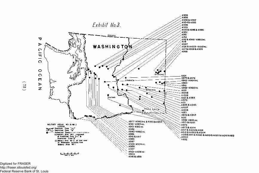
Exhibit Aio.d.
MILITARY AREAS NOLEGEND
• > ^ « g » Prohibited Zont "A- I» - J - ^ ^ Restricted Zont• Prohibittd Zonei
(L) Military Area NO I compoctdof Prohibittd Zont V l " 8Rtstncttd Zone'B"
(2)Milttory Area NO 2 oil that areaof Washington excluded fromMilitary Area NO I
O \ A977-A980 inc. a A993 a A994^^ \^A98I-A985inc.
.\A9I3-A9l5inc.^ A982\A990-A992inc.
.A986A9l6aA9l7A989
.A987A928-A934mc.A988A927A92l-A926incA920A9I8SA9I9
A959A958A956aA957A954SA955A998A953AI28aA995SA996A952A95IAI30AII8aA948-A950inc.AII9A947AI26aAIOO9-AIOI2inc.AII7aA908aA909A999
AI24A975aA976A962-A964inc.A960A96IA965-A968inc.AI20AI008A 1006AI25aA969
- AI2I.A945aA946.AI007- AI005- AI23
A943SA944AI22
- A936-A942mc.- A97I aA997-A972-A973 8A974
. -AI27aAIOI3aAIOI4\ \ \ A9I0 a AI003 a AI004v X AI29aA9ll aAI0O0aAIOOiaAIOI5aAIOI6aA9l2
XAIOO2A935
Digitized for FRASER http://fraser.stlouisfed.org/ Federal Reserve Bank of St. Louis

Exhibit No.4.
MILITARY AREAS N0.iaN0.2iLegend
r •*""* Prohibited Zone "A- l "
- - * - Restricted Zone "B"
Prohibited Zones A131-AI7I
(I) Military Area NO Icomposed of ProhibitedZone "A-1" & RestrictedZone"B"
(2) Military Areo NO. 2
oil of thot orea of Oregon excluded
from Military Area NO I
OREGON
"QAJFQRNIA
Digitized for FRASER http://fraser.stlouisfed.org/ Federal Reserve Bank of St. Louis

A2r9-A222lnc.A218A2I0A2I7A2I6 a A333-A336mc a A428-A430incA33iaA332A326-A33Oinc.A38I8A382A4l6-A420inc.A373-A380lnc.A37O-A372incA362-A369mc.A36IA318-A325inc.A3I6 a A3I7A354-A360inc.A352 a A353A347-A35llnc.A346A342-A345mc.A34ISA43IA 340A337-A339inc.A309-A3l5inc.A304-A308incA202 a A205 a A298-A303mc.A184 a AI90A196
A 208AI97A209A203A204AI85A223-A228iflC_A229&A230A23IA232-A234inc
^_ A235-A240ine aA423-A427lnc./ _ A24I - A243lnc (A432-A434inc
A244A245-A25lmc.A252 a A253 a A42I a A422A254&A255aA256A257A258A259A260-A263inc.A264aA4l4aA4l5A265-A267inc.A269A268 a A270
383-A389inc390-A400 me76 8 A 401
,404aA405aA4IO»k406-A408me.2II8A409!82aAI83aA2l4
Exhibit No. 5.MILITARY AREAS NO. I S NO. 2
Legend
• • r n v Prohibited Zone "A- l "
— — Restricted Zone "B"
• Prohibited Zones "AI72-A435
(Military Area NO 2 all of area of California•xcluded from Militory Area NO I)
( 7 5 )
Digitized for FRASER http://fraser.stlouisfed.org/ Federal Reserve Bank of St. Louis
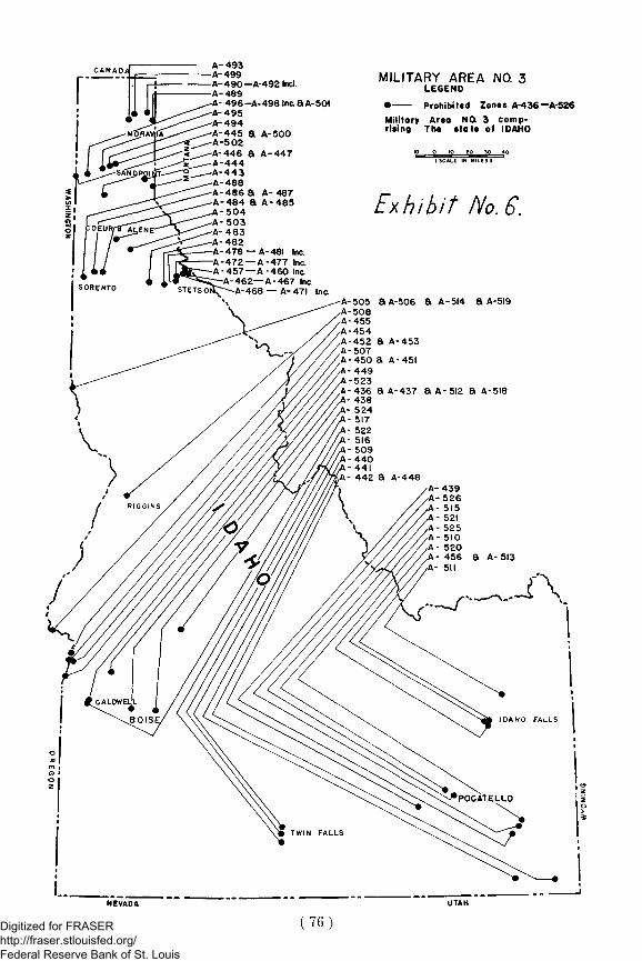
A-493A-499A-490— A-492 Incl.A-489
496-A-498 Inc. a A-501A- 495-A-494A-445 a A-500A-502-A-446 a A-447A-444A-443A-488A-486 a A-487A-484 a A-485
-504-A-503A- 483-A-482A-478 — A-481 Inc.-A-472 — A-477 Inc.
457 —A -460 Inc.-462—A-467 Inc.A-468 —A-471 Inc.
MILITARY AREA NO. 3LEGEND
• Prohibited Zonts A-436—A-526Military Area NO. 3 comp-rising The statt of IDAHO
IP ?0 3O 40( SCALE. IN MILES)
Exhibit No. 6.
a A-506 a A-5i4 a A-519
a A-437 a A-512 a A-518
( 7 6 )Digitized for FRASER http://fraser.stlouisfed.org/ Federal Reserve Bank of St. Louis

k 539I 69 a A 544
i I S a A 566 a A680I 567k 563I 562k 601 a A 602k 607k 603- A 605 me. 608k 609- A 610k 611X 606t 644k 540 a A 542 a A 543a A 645k 707» 529 a A 536 a A 646 8 A 647\ 697 a A 696 a A 702k 559 a A 560 a A 704k 598 a A 600 a A 561k 7094 597k 666, 558, 595 a A 596
557651 a A 652545694649 a A 650695648538537556 8 A 594528708703653654656 8 A 657327
i 655. 659 a A 660. 658i '535, A 670, A 671, A 701
690, 672 a A 673> 590-A593 inc.
589587 a A 588
4 370- A 573 inc.k 566 a A 569
585 a A 586> 582-A 584 inc, 581
578 a A579 a A580577555554
A 667A 574A 547A 684A 575A 686A548aA68«A 576A 663A 549-A 550 ft A 683-A 662
• Prohibited ZenitA 5 2 7 - A 709
Military Area NO. 4 comp-osed of the «tote of Montana
Exhibit No. 7.
Digitized for FRASER http://fraser.stlouisfed.org/ Federal Reserve Bank of St. Louis

Exhibit No.
a A-809—A-8H me
A-7 30A-771a A-772A-761 a A-762
A-812 a A-813A-754-A-760A- 815
814-816•802—A-808 me748—A-753inc a A-797—A-80'mcA- (\ 9
716—A-747inc a A-790—A" 796 me
731 — A-74linc. a A-784—A-789inc778—A-783inc
A-776 a A-777A-774 a A-775A-773A-770A-729A-769A-767 a A-768A-723—A-728 meA-714 a A-716A-720—A-722mcA-763A-715A-764A-765A-766A-712A-821—A-823tncA-824 a A-825A-826 a A-827A-819 a A-820A-818A-828—A-832.ncA-833A-817 .A-7II a A-713 a A-717A-710
MILITARY AREA * 5LEGEND
Prohibits Zonts A-7IO—A-833
( 7 8 )
Digitized for FRASER http://fraser.stlouisfed.org/ Federal Reserve Bank of St. Louis

A 855A 852-A 854 inc.A 903A 848, A 849, A 834, A 894A 845, A 846A 895A 850, A 851A 839 A 637A 843A 838A 856- A 859 inc.A 881
U T A
864863861, A 862, A 889844, A 890, A 891835, A 836
A 897, A 898, A 899A 904, A 905A 870, A 871A 847A 869A 90!A 900A 868A 882 - A 884 inc.A 902A 885-A 888 inc.A 867A 865, A 866A 896A 906A 893A 877- A 880 inc.A 874-A 876 inc.A 840A 873A 841A 842A 892
ARIZONA*"*
Exhibit No. 7.MILITARY AREA NO. 6
LEGEND# Prohibited Zones
A 834 to A 9 0 6Military Areo NO. 6 composedof the State of UTAH
K> , O *» * 0 * > *<>
( 7 9 )
Digitized for FRASER http://fraser.stlouisfed.org/ Federal Reserve Bank of St. Louis

PRINTED BYPERNAU-WALSH PRINTING CO.
755 MARKET STREETSAN FRANCISCO
Digitized for FRASER http://fraser.stlouisfed.org/ Federal Reserve Bank of St. Louis