Headingley and Hyde Park NDS and HP NDS.pdf6 1.1 A Neighbourhood Design Statement (NDS) builds on...
56
1 Leeds Local Development Framework Headingley and Hyde Park Neighbourhood Design Statement Supplementary Planning Document Adopted … 2010 Leeds Local Development Framework Headingley and Hyde Park Neighbourhood Design Statement Supplementary Planning Document Adopted August 2010 Leeds Local Development Framework Headingley and Hyde Park Neighbourhood Design Statement Supplementary Planning Document Adopted September 2010
Transcript of Headingley and Hyde Park NDS and HP NDS.pdf6 1.1 A Neighbourhood Design Statement (NDS) builds on...
1
Leeds Local Development Framework
Headingleyand Hyde ParkNeighbourhood Design Statement
Supplementary Planning DocumentAdopted … 2010
Leeds Local Development Framework
Headingleyand Hyde ParkNeighbourhood Design Statement
Supplementary Planning DocumentAdopted August 2010
Leeds Local Development Framework
Headingleyand Hyde ParkNeighbourhood Design Statement
Supplementary Planning DocumentAdopted September 2010

2
Table of Contents pageForeword 3Message from Cllr Chastney 41 Purpose of the Neighbourhood Design Statement 62 Status of the Neighbourhood Design Statement 63 The Neighbourhood and its Character Areas 74 The Design of the Neighbourhood 75 The Statement and Community Involvement 86 Leeds’ Number One Suburb 107 Planning Policy Context 128 Character Areas 149 Headingley Centre 1610 Wood Lane Area 2011 Headingley Hill 2212 Hyde Park 2613 South Headingley 3014 Cardigan Triangle 3415 The Turnways Triangle, and the Stadium 3716 Ash Road Area 4017 Headingley ‘Green Girdle’ 4318 Design Policy and Guidelines for the Neighbourhood 4719 Management Plan for the Neighbourhood 49
Appendix 1 Relevant Planning Policies 51Appendix 2 Other Planning and Related Policies 51Appendix 3 Designated Sites and Spaces 53Appendix 4 The Neighbourhood Questionnaire 54Acknowledgements 55
Front Cover: Headingley Village Green and Town School (photo: Tony Ray)“The Parish Hall in St Michael’s Road … was once the Headingley ‘Town School’ … The charming,
well-tended garden to the front, a small oasis in the asphalt environment, is all that remains now of the former village green.” Eveleigh Bradford, Headingley (2008) pp127, 138.

3
Foreword
Panorama of Headingley from Batcliffe Wood
Photo: Andrew Helm
Headingley is ‘Leeds Number One Suburb’. Yet the neighbourhood is subject to very particular pressures. For this reason, local residents, with the support of Leeds City Council, have produced a Neighbourhood Design Statement (NDS) for our area, intended to sustain its distinctive character (see Section 1). Its purpose is to help to realise the first Strategic Aim of Leeds’ Unitary Development Plan (UDP), “protecting existing good environment.” In doing so, it supplements city-wide planning policies, with reference to a particular neighbourhood. As a Supplementary Planning Document (SPD) the NDS builds on saved and emerging planning policy, and thereby contributes to Leeds’ emerging Local Development Framework (see Section 2).
Headingley at the turn of the millennium experienced its greatest demographic upheaval since the expansion of the neighbourhood as a suburb in the nineteenth century. As a result of the demand for accommodation by the students of Leeds’ expanding universities, the majority of the settled residents were replaced by a transient (and seasonal) population. This upheaval has had an impact on every aspect of the community, including the quality of the built environment, the street scene, open spaces and their management. The Headingley & Hyde Park NDS is a response to this environmental impact.
The present document is a Statement whose preparation was led by local residents, and
is adopted as a Supplementary Planning Document by Leeds City Council. It is based upon detailed observation by residents and wide consultation with residents and other stakeholders, and it summarises what it is they value about the character of their local environment. We trust that it will lead to a renewed appreciation of the quality of our neighbourhood. It is concerned with the Neighbourhood focussed on Central Headingley, and including South Headingley, Headingley Hill and Hyde Park. The NDS is a material consideration, prepared by the local community, for any proposals for future development in their Neighbourhood.
Dr Richard Tyler, Chair, Headingley & Hyde Park NDS Steering Group, 2007-2010
The Headingley & Hyde Park Neighbourhood Design Statement was produced by Headingley Development Trust

4
Message from Cllr Ben ChastneyChair, Inner NW Area Committee
I am delighted to express my support for this Neighbourhood Design Statement on behalf of the Inner NW Area Committee. Our Committee recognised the unique challenges faced by Headingley and Hyde Park and commissioned this study from Headingley Development Trust. I am delighted with the outcome and fully agree that the Statement is ‘based upon detailed observation by residents and wide consultation with residents’. It is precisely this consistently resident-focused approach which provides the document with the legitimacy, accuracy and credibility we all wished to see. It is also why I am confident it will be taken seriously in relation to future plans and development of the area. The Statement clearly sets out what local residents see as key to the character of our area and provides a valuable tool for protecting these features we cherish. Indeed, its sister Far Headingley Neighbourhood Design Statement has already provided vital, formally-recognised supplementary planning guidance since its introduction in 2005 and I sincerely hope that we will see similar benefits from this document here in Headingley and Hyde Park. I stress again my formal support for this Neighbourhood Design Statement and would like to thank all the organisations and individuals who were involved in taking this project through, from a worthy idea to the fine completed document we see today.
Headingley & Hyde Park Neighbourhood Design Statement was funded by Leeds City Council’s Inner North West Area Committee.

5

6
1.1 A Neighbourhood Design Statement (NDS) builds on existing local planning policy to ensure that changes in the neighbourhood recognise its past heritage and contribute to its future sustainability, to the quality of its buildings, its open spaces and its accessibility, and to its social cohesion. Design Statements were originally introduced in 1996 by the Countryside Agency in order “to protect the character of rural England.” Produced by local people with the support of the local authority, they established a means whereby a whole community could take part in the planning process. They are supported by Leeds City Council,
2 Status of the Neighbourhood Design Statement
1 Purpose of the Neighbourhood Design Statement
and many have now been adopted as formal planning documents. In 2005, Far Headingley pioneered the concept of Neighbourhood Design Statements for urban areas.
1.2 The present document is intended to appraise the existing character of the neighbourhood, to identify for the local community and for prospective developers the key characteristics of the neighbourhood, providing a local design framework (see Section 18), and to propose ways of improving the neighbourhood, through a Management Plan (see Section 19). Thereby, the NDS will guide the design of all future development, large or small, to maintain and
enhance the character of the neighbourhood. See Section 8 for guidance to the document.
1.3 Major developments, road and utility maintenance, small extensions and garden alterations, all have an effect on the character of the neighbourhood. The NDS is addressed to all those who are likely to make changes to the area, however large or small: developers, builders and their agents; architects, landscape architects, highway engineers; householders, local businesses, public bodies; and planners and Plans Panel members.
2.1 The Development Plan for Leeds is the Leeds Unitary Development Plan (Review) 2006 (UDP). In accordance with changes introduced by the Planning & Compulsory Purchase Act 2004, Leeds City Council is required to replace the UDP with a Local Development Framework (LDF). The LDF will comprise (amongst others) Development Plan Documents and Supplementary Planning Documents (SPDs). In the interim, ‘saved’ policies in the UDP and existing Supplementary Planning Guidance will continue to apply until they are replaced.
2.2 As SPD, the NDS relates to and expands upon existing higher level policies. In the UDP, the first Strategic Aim, SA1, aims “to secure the highest possible quality of the environment throughout the District, by protecting existing good environment, conserving and enhancing where there is scope for improvement.” SA1 is elaborated by a suite of saved UDP policies, and this NDS expands on a number
of the policies concerned with design and conservation in a local context. These policies are detailed in Appendix 1. The NDS accords also with Policy SC8 on Design, Conservation and Landscape in the emerging Core Strategy of the LDF, see Appendix 2. Many factors govern the development of the urban environment and so this NDS should also be read alongside the local and national policy and guidance also outlined in Appendix 2.
2.3 The NDS has been prepared in accordance with guidance in the Statement of Community Involvement, part of the LDF. The document identifies key features for the Local Planning Authority and developers to act upon when considering development proposals in the area (see Section 18). These Guidelines will be used by the City Council in determining planning applications in the Neighbourhood. And it also proposes actions to improve the neighbourhood through a Management Plan (see
Section 19). Note that, while these actions are based on residents’ recommendations and have all been the subject of consultation with Leeds City Council, the Council has made no specific commitments to their implementation. However, where appropriate, they should be taken into account by developers, and they will also assist in justifying any future bids for funding.
2.4 Leeds City Council welcomes this initiative and supports the aims of NDSs as expressions of both the local characteristics valued by local people and of their aspirations in guiding new development. The Headingley and Hyde Park NDS was adopted by Leeds City Council on 17 September 2010 as a Supplementary Planning Document, forming part of the emerging LDF. The recommendations of the NDS should accordingly be read in conjunction with the relevant Development Plan Policies.

7
3.1 Headingley emerged as thefirst suburb of Leeds, situated in the north-west of the city, on the ridge which rises to Headingley Hill, between the valleys of the River Aire and Meanwood Beck. It is centred on the old village of Headingley, at a cross-roads on the major arterial route from Leeds into the Dales. Its natural boundaries are the railway cutting and Batcliffe Wood to the west, and Woodhouse Ridge and Woodhouse Moor to the east; and its social boundaries are Far Headingley to
4 The Design of the Neighbourhood
3 The Neighbourhood and its Character Areas
the north and Burley to the south.
3.2 The built Neighbourhood comprises eight distinctive Character Areas. From the city centre, via Woodhouse Moor, it is entered at Hyde Park, with predominantly terraced development on either hand. Beyond, north of Headingley Lane, lie the open and larger villa plots of Headingley Hill. To the south are the regular and compact terraces of South Headingley. Headingley Lane leads on to the
dense and varied development around Headingley Centre itself. Again, the area around Wood Lane is more open with some large villa plots, while that around Ash Road is characterised by more regular and terraced streets. Further west, against the railway line, lie two distinctive triangles, the Turnways Triangle, overlooked by Headingley Stadium, and Cardigan Triangle, based on the old Botanical Gardens. The ‘green girdle’ to the east and west of the Neighbourhood forms a ninth Character Area.
The distinctiveness of each Character Area in the Neighbourhood derives from its overall layout, in which three aspects can be identified.
4.1 First of all, of course, there are the Buildings, which may be distinctive in a number of ways - their form (detached or semi, terrace or apartments), their scale (storeys), their materials (brick, stone, etc), their features and details (roofs, windows, entrances, etc). Some buildings, singly or together, may be notable landmarks.
4.2 Almost equally important are the Spaces between the buildings. They may be wide open or enclosed, they may be divided, revealed or hidden by particular boundaries (fences, walls, hedges, etc), and of course, they make room for the natural environment, especially mature trees. Some spaces may provide distinctive views.
4.3 Finally, the Area is not a neighbourhood without Access. Roads and paths have their own character (surfaces, edges) and their own furniture (seating, signs, lighting, etc). And they may encourage movement, or inhibit it - through poor maintenance, or intensive traffic, or parked vehicles.

8
5.1 The present Statement is based on broad and deep consultationand participation, in and by the local community. The idea emerged in the summer of 2005 from discussions by South Headingley Community Association, North Hyde Park Neighbourhood Association, Headingley Network and Cardigan Triangle, and on their behalf, it was proposed by Leeds HMO Lobby (the campaigning coalition of local associations) to the Inner NW Area Committee. Meanwhile, it was also proposed as a key Action in Headingley Renaissance, the local vision statement published in 2005. The following year, the concept was adopted by the Area Committee’s Area Delivery Plan (Action PD5) and funds were allocated. Finally, the Committee resolved to commission
5 The Statement and Community Involvement
Headingley Development Trust (HDT, the community-based social enterprise) to prepare the Statement.
5.2 Early in 2007, HDT nominated a Project Director, appointed a Planning Consultant, and invited the Area’s Community Planner to participate. In order to form a Steering Group, each of the five local community associations was invited to nominate representatives. This Group has guided the subsequent development of the NDS (see Acknowledgements). The preparation of the NDS has followed the guidelines in the Council’s Statement of Community Involvement (2007), part of the LDF.
5.3 The NDS project was formally launched on 15 September 2007 by Greg Mulholland MP (Leeds
NW) at Headingley St Columba United Reformed Church. Some 75 residents from all corners of the Neighbourhood heard a presentation by the Planning Consultant, and saw an exhibition on the past, present and future of the Neighbourhood 5a.
5.4 Also launched was the Neighbourhood Questionnaire, to canvass residents’ views of their environment. The Questionnaire was disseminated through local community associations, through Headway (the community newsletter), through local outlets, and online (see Appendix 4). As Questionnaires were returned, a Contacts List of engaged residents was compiled.
5.5 The launch was followed by a
9
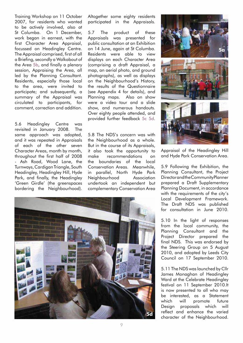
Training Workshop on 11 October 2007, for residents who wanted to be actively involved, also at St Columba. On 1 December, work began in earnest, with the first Character Area Appraisal, focussed on Headingley Centre. The Appraisal comprised, first of all a Briefing, secondly a Walkabout of the Area 5b, and finally a plenary session, Appraising the Area, all led by the Planning Consultant. Residents, especially those local to the area, were invited to participate; and subsequently, a summary of the Appraisal was circulated to participants, for comment, correction and addition.
5.6 Headingley Centre was revisited in January 2008. The same approach was adopted, and it was repeated in Appraisals of each of the other seven Character Areas, month by month, throughout the first half of 2008 - Ash Road, Wood Lane, the Turnways, Cardigan Triangle, South Headingley, Headingley Hill, Hyde Park, and finally, the Headingley ‘Green Girdle’ (the greenspaces bordering the Neighbourhood).
Altogether some eighty residents participated in the Appraisals.
5.7 The product of these Appraisals was presented for public consultation at an Exhibition on 14 June, again at St Columba. Residents were able to view displays on each Character Area (comprising a draft Appraisal, a map, an aerial photo, and ground photographs), as well as displays on the Neighbourhood’s History, the results of the Questionnaire (see Appendix 4 for details), and Planning maps. Also on show were a video tour and a slide show, and numerous handouts. Over eighty people attended, and provided further feedback 5c 5d.
5.8 The NDS’s concern was with the Neighbourhood as a whole. But in the course of its Appraisals, it also took the opportunity to make recommendations on the boundaries of the local Conservation Areas. Meanwhile, in parallel, North Hyde Park Neighbourhood Association undertook an independent but complementary Conservation Area
Appraisal of the Headingley Hill and Hyde Park Conservation Area.
5.9 Following the Exhibition, the Planning Consultant, the Project Director and the Community Planner prepared a Draft Supplementary Planning Document, in accordance with the requirements of the city’s Local Development Framework. The Draft NDS was published for consultation in June 2010.
5.10 In the light of responses from the local community, the Planning Consultant and the Project Director prepared the final NDS. This was endorsed by the Steering Group on 5 August 2010, and adopted by Leeds City Council on 17 September 2010.
5.11 The NDS was launched by Cllr James Monaghan of Headingley Ward at the Celebrate Headingley festival on 11 September 2010.It is now presented to all who may be interested, as a Statement which will promote future Design proposals which will reflect and enhance the varied character of the Neighbourhood.
5a
5b
5c
5d

10
6.1 Headingley, the first suburb of the city of Leeds, was for a thousand years or more just a small village set in open country with a few outlying farms and cottages. It was the site of the Shire Oak (Skyrack), an Anglo-Saxon meeting place. William the Conqueror gave the land to one of his barons, whose descendant in the fourteenth century granted it to Kirkstall Abbey. At the Dissolution of the monasteries, it passed to the Savile family, and then in the seventeenth century, it was inherited by the Brudenell family, Earls of Cardigan.
6.2 Even in 1831 there were only 45 houses in the neighbourhood. But the fresh air of Headingley Hill attracted settlement from the smoky city, and the suburbanisation that began in the late 1820s dramatically transformed its rural character. Development was slow and piecemeal before 1850, with individual villas and cottages, by which time there were a thousand houses in Headingley (see Map 1).
6.3 Suburbanisation depends on supply (of land) and demand (by residents). When the
6 Leeds’ Number One Suburb
Neighbourhood was acquired by the Earls of Cardigan in the seventeenth century, they soon disposed of Headingley Hill, and they sold small parcels of land throughout the nineteenth century. But the majority of their Headingley estates came onto the market in the great four-day Cardigan Sale of 1888. Demand came through the increasing prosperity of virtually all social groups after 1850, which meant that more people could afford to live away from the centre of Leeds.
6.4 Good local transport connected demand and supply. The Leeds-Otley Turnpike opened in 1754. The first horse-drawn bus service started in 1837, replaced by horse-drawn trams in 1871. A few years later steam trams trundled up and down Otley Road and Headingley Lane, and in 1897 they were electrified. Motor buses were introduced in 1905. The No 1 Bus Service still runs through Headingley.
6.5 The pace of suburbanisation quickened in the latter part of the nineteenth century, with systematic
development of villas and terraces, and by 1911 there were ten thousand houses (see Map 2). In-fill continued throughout the twentieth century. Between the wars this mostly took the form of semi-detached houses.The second half of the twentieth century saw relatively less new development, with the exception of the Arndale Centre, but significant socio-economic changes. These include the impact of the growth of the two universities, the rapid increase in the number of Houses in Multiple Occupation (HMOs), the dramatic increase in traffic, notably on Headingley Lane-Otley Road (A660), and the impact of Headingley Stadium as a national/international sporting venue.
6.6 The purpose of the Neighbourhood Design Statement is to recognise this unique history and to ensure that all new development respects and enhances this heritage and the character of the area, thereby maintaining Headingley’s position as Leeds’ ‘number one’ suburb in the twenty-first century.
Map 1: Tithe Map of Headingley 1846

11
Map
4
Sca
le: 1
:700
0 @
A3
This
map
is b
ased
upo
n th
e O
rdna
nce
Surv
ey’s
Dig
ital D
ata
with
the
perm
issi
on o
f the
Ord
nanc
e su
rvey
on
beha
lf of
the
Con
trolle
r of H
er M
ajes
ty’s
Sta
tione
ry O
ffice
.©
Una
utho
rised
repr
oduc
tion
infri
nges
Cro
wn
Cop
yrig
ht a
nd m
ay le
ad to
pro
secu
tion
of c
ivil
proc
eedi
ngs.
© C
row
n C
opyr
ight
. All
right
s re
serv
ed. L
eeds
City
Cou
ncil
O.S
. Lic
ence
No.
– 1
0001
9567
- 20
09M
ap
2:
OS
Ma
p o
f H
ea
din
gle
y 1909

12
7.1 The Neighbourhood of Headingley and Hyde Park lies to the north west of Leeds city centre and adjoins the Leeds University Quarter, separated only by Woodhouse Moor. This, together with the close proximity of the Leeds Met University campus at Beckett’s Park, has resulted in a preponderance of student accommodation and multi-occupancy.
7.2 Housing The whole Neighbourhood, and beyond, is now designated an ‘area of housing mix’ (Policy H15 in the Leeds UDP Review) to discourage loss of family housing and promote a more diverse housing stock generally. In addition the Hyde Park area is designated an area of ‘housing in multiple occupation’ (Policy H18) better to control the environmental impact of HMOs.
7.3 Associated with this was the approval, in 2006, of a ‘Regulation 7 Direction’ under the Advertising Regulations which requires express consent for ‘to let’ boards by Leeds City Council for much of the area to the south of Headingley Lane. An accompanying code of practice controls the size and position of such boards and also applies voluntarily to the whole of the ‘area of housing mix’. The Direction has been renewed to 2015.
7.4 Centres The heart of Headingley lies between the Shaw Lane/St. Anne’s Road junction and St. Michael’s Church on Otley Road and together with North Lane is designated a ‘town centre’ (S2) in the Leeds Unitary Development Plan and in the emerging Core Strategy (Policy SC2). The wider centre of Headingley was the subject of a community-led strategy and action
7 Planning Policy Context
plan, Headingley Renaissance, published in November 2005 with the support of Leeds City Council. One of its recommendations was to ‘undertake a full character appraisal of the area and publish a Neighbourhood Design Statement’.
7.5 Hyde Park Corner acts as a gateway to Headingley approaching from Woodhouse Moor and is designated as a local centre in the UDP (S4), and Core Strategy (SC2). Part of Cardigan Road is also designated as another local centre in the Core Strategy.
7.6 Conservation Much of Headingley is designated a Conservation Area (N18-22), including Headingley Hill, Hyde Park, the Wood Lane area, Cardigan Road, and Headingley Centre itself and the principle of extending the Area to include Woodhouse Moor and Woodhouse Ridge has been approved. Headingley Hill and Hyde Park are currently the subject of a detailed Conservation Area Appraisal. Here and elsewhere, there are numerous Listed Buildings.
7.7 Environment The Neighbourhood is bounded on the east by an ‘urban green corridor’ (N8) (Core Strategy G1) linking Woodhouse Moor, a ‘protected green space’ (N1), with Woodhouse Ridge, a ‘Leeds Nature Area’ (N50). Another urban green corridor borders the area to the northwest including Batcliffe Wood and the Ash Road Allotments (N1A). Within the Neighbourhood there are a number of ‘protected playing pitches’ (N6) but, away from the surrounding green corridors, the area is deficient in public green space and is designated a ‘priority
area for improving green space provision’ (N3).
7.8 Transport The Neighbourhood is structured along the A660 radial road, Headingley Lane and Otley Road, which is an important bus route but suffers from high volumes of traffic throughout the day. Congestion on that road spills over into ‘rat-runs’ throughout the area resulting in a community wish for further traffic management and traffic calming measures in many residential streets (T23).
7.9 An associated problem is car parking, by commuters, shoppers, visitors to the Headingley Stadium on match days and especially as a by-product of multi-occupancy. Though not a matter of planning policy, Residents Parking Zones have been implemented in some places as a result.
7.10 The A660 remains a key issue with various proposals over time to introduce improved public transport schemes. Current proposals are for a new public transport system called New Generation Transport (NGT), using trolley technology. The proposed north line from the city centre runs along the A660 (including a central Headingley NGT bypass) to a Park and Ride site at Bodington and potentially a link to Holt Park. NGT, and whatever proposals arise in the future, must recognise that, despite the traffic, Headingley Lane-Otley Road still presents an attractive streetscape. All proposals under the New Generation Transport scheme within the boundaries of the Conservation Area should be in keeping with the character of this Area and seek to enhance the setting of the Area. See Map 3
For a schedule of relevant saved Planning, emerging Core Strategy and other policies see Appendix 1 & 2.

13
Ma
p 3
: Si
tes
an
d S
pa
ces
Desi
gn
ate
d in
th
e U
DP
an
d E
lsew
here

14
A Character Area is a part of the Neighbourhood with its own distinctive environmental character. Headingley and Hyde Park are very diverse in their make-up. The Neighbourhood Design Statement therefore identifies eight Character Areas (Sections 9-16) and a ‘Green Girdle’ (Section 17) (see Section 3 and Map 4). The description of each begins with a thumb-nail sketch.
8.1 Sub-section (1) of each Character Area outlines the Area, with notes supplementing the general history of the Neighbourhood in Section 6.
8.2 Sub-section (2) comprises a descriptive summary of the Buildings & Layout of the Area.
8.3 Sub-section (3) describes the Spaces of the Area.
8.4 Sub-section (4) lists the Key Features of the Area, which distil the essential characteristics making
8 CHARACTER AREAS
the Area distinctive (see Section 4), the “existing good environment” of Strategic Aim SA1, “the distinct identity of places within the District” (SC8). Together with the guidance in Section 18, they should shape and guide future development for the Neighbourhood, supplementing existing planning policies. This should be respected by any future developments (in some cases, negative features to be avoided are also noted).
8.5 Sub-section (5) recommends particular Actions for improving the Area. These are by no means comprehensive. Note that, while they are based on residents’ recommendations and have all been the subject of consultation with Leeds City Council, the Council has made no specific commitments to their implementation. Together with the recommendations in Section 19, they constitute a Management Plan for the Neighbourhood.
8.6 Finally, in sub-section (6), a Schedule identifies designated sites and spaces within the Area, outlined in Section 7: these include Conservation Areas, Listed Buildings, trees and open spaces, residents parking zones, letting boards and other designations. Information on how to find out more about these is in Appendix 3.

15
Ma
p 4
: C
ha
ract
er
Are
as

16
The Town Centre: a typically dense and diverse centre, consisting of commercial, community and residential buildings, showing its history, from original village stone cottages on Otley Road, to the out-of-scale Arndale Centre opposite. Despite the variety, the centre is unified by its historical continuity and the overall human scale of its streetscape.
9a
9b
9c
9d
9 HEADINGLEY CENTRE
9.1 The Area9.1.1 ‘Headingley Centre’ is understood in various ways, for different purposes. For the purpose of this NDS, Headingley Centre comprises Otley Road (from Spring Road to Shaw Lane), North Lane, Cardigan Road (from North Lane to Spring Road) and Spring Road itself, and the area enclosed by those streets.
9.1.2 The approach to the Centre from Headingley Lane 9a is visually attractive as the road gently winds downhill to the junction with St. Michael’s Road and views of St. Michael’s Church (1886) 9b with its 200ft spire, and the Skyrack pub present themselves. The Original Oak pub and the War Memorial both add to the sense of place and arrival at this point, the
original village green (a fragment of which survives in front of the Parish Hall, see front cover) 9c.
9.1.3 The old Shire Oak (which fell at last in 1941), the village green and the church, have been the focal point of Headingley through the ages. The first school in Headingley was opened next to the church in 1783, and the two pubs, both named after the Oak, are amongst the scanty remains of the old village, both built in the eighteenth century.
9.2 Buildings and Layout9.2.1 Headingley Centre today presents a wide variety of nineteenth and twentieth century developments but may be subdivided into a number of distinct quarters.
9.2.2 The Town Centre comprises the frontages along Otley Road and North Lane, and is defined as such in the UDP (No16).
9.2.3 Progression along Otley Road 9d reveals a mixture of building styles ranging from the out of scale modernist Arndale Centre (1965) 9e to the converted original village stone cottages near the junction with St.Anne’s Road, including a new dry stone wall. The Methodist Chapel (1844) is a

17
9f
9g
9h
9j
9k
9e
notable building but, in contrast, the parade of shops on the corner of North Lane and Otley Road is a negative feature. Other notable buildings include the Skyrack pub and the Taps pub, the latter previously being a pumping station on the main water pipeline to Leeds from Eccup reservoir.
9.2.4 Generally the frontage properties are two to three storeys which gives coherence to the street scene and the two taller office blocks are set behind the parade of shops between Wood Lane and Shire Oak Road (so located to flank the now abandoned Headingley by-pass).
9.2.5 North Lane experienced similar changes 9f. Before the 1850s it was a narrow, irregular road set amongst fields with a scattering of cottages - Ivy Cottage on Cross Chapel Street is one that remains to this day. North Lane has retained some of the characteristics of a local high street with the Rose Garden acting as a focal point and hosting the farmer’s market. The former Lounge Cinema (1916) with its recent extension, The Arc, add to this sense of place.
9.2.6 The Chapel Quarter lies in the northern angle of the North Lane junction with Otley Road. Cardigan estate land around the Methodist Chapel was sold in 1850, and the stone-built Chapel Terrace
9g, Chapel Square and Chapel Street were constructed. Apart from the dominant Chapel (1844), buildings are characteristically small (two-storey only) and densely packed. Many streets are distinguished by original cobbles, paving, kerbs, walls and copings. A good example of a brick terrace with an original cobbled street is Ash Terrace. One of the gems of Headingley is Alma Cottages 9h, an unusual group of mock-Tudor semi-detached houses, built following the Battle of Alma (1854).
9.2.7 The HEART Quarter is sandwiched in the southern angle between Otley Road, North Lane and St. Michael’s Road. Following the Cardigan Sale of 1888, part of the area was filled with working class terraced and back-to-back housing with cobbled streets (the Granbys) 9p. Bennett Road includes HEART (Headingley Enterprise & Arts Centre) itself 9j, and consists of terraced houses of which nos 13-27 turn their backs to the road with long gardens facing south. The area also contains a number of notable buildings including the former St. Michael’s School, the Parochial Institute, and Bleak House (now the New Headingley Club). A few original village buildings remain in the area, notably St. Michael’s Cottage off St. Michael’s Lane 9k, and Deans Cottage in Kings Place, off St. Michael’s Road.
9.2.8 The St. Michael’s Quarter around the Church extends along St. Michael’s Lane and Cardigan Road down to Spring Road. The quarter is characterised by larger Victorian and Edwardian houses, with a substantial terrace on St. Michael’s Crescent 9l, and predominantly semi-detached villas on Cardigan Road, Bainbrigge Road and Spring Road. Chapel Lane 9m forms an attractive cobbled and stone walled ginnel behind St. Michael’s Crescent. St. Michael’s Church remains the key landmark but the area also contains the Original Oak pub and other late 18th - early 19th century stone properties associated with the original village, most notably the Parish Hall with the remnants of the village green. The 20th century development of the telephone exchange is out of scale and character 9o with the area but St.Columba’s Church is far more sympathetic.
9.2.9 Small inter-war semis are to be found at the junction of Spring Road and Bainbrigge Road and on Dennistead Crescent, at either end of Headingley Centre.
18
new stone wall on the St. Anne’s Road side and to give more of a sense of a ‘gateway’ to the centre.
9.5.5 The implementation of the New Generation Transport (NGT) scheme, or other public transport proposals, should provide an opportunity to improve the Otley Road/Shaw Lane junction.
9.5.6 The road closure on Bennett Road would benefit from softening with planters.
9.5.7 On-street parking by commuters to Leeds city centre and people visiting and working in Headingley needs an overall survey and comprehensive management by some form of parking scheme (in progress).
9.5.8 The green space to the rear of nos 77-83 Otley Road and at the junction with Dennistead Crescent also needs improving, together with the car parking adjoining No 77.
9.5.9 Apart from the Rose Garden area, the whole of North Lane should be enhanced by a coherent approach to paving, shop fronts and the introduction of planters or trees where practicable.
9.5.10 In summary, the whole of Headingley Centre needs an overall Design and Management Plan as befits its Conservation Area status.
9.4 Key Features ofHeadingley Centre
9.4.1 Buildings are predominantly two- or three-storey, of stone or brick, and characterised by a vertical emphasis (with pitched roofs), so maintaining a coherent rhythm to existing street frontages.
9.4.2 Significant locations (e.g. entry-points) are distinguished by landmark buildings (St Michael’s Church, South Parade Baptist Church).
9.4.3 Many streets retain their original setts, paving, walls, etc.
9.4.4 Some post-war additions are unsympathetic, including the Arndale Centre, White Rose House, the former telephone exchange and the ‘Oddbins’ corner, which are out-of-scale, of distinctly different materials, and with a horizontal emphasis.
9m
9m
9l
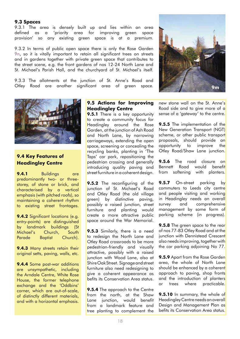
9.3 Spaces9.3.1 The area is densely built up and lies within an area defined as a ‘priority area for improving green space provision’ so any existing green space is at a premium.
9.3.2 In terms of public open space there is only the Rose Garden 9n, so it is vitally important to retain all significant trees on streets and in gardens together with private green space that contributes to the street scene, e.g. the front gardens of nos 12-24 North Lane and St. Michael’s Parish Hall, and the churchyard of St. Michael’s itself.
9.3.3 The allotments at the junction of St. Anne’s Road and Otley Road are another significant area of green space.
9.5 Actions for Improving Headingley Centre9.5.1 There is a key opportunity to create a community focus for Headingley around the Rose Garden, at the junction of Ash Road and North Lane, by narrowing carriageways, extending the open space, screening or concealing the recycling banks, planting in ‘The Taps’ car park, repositioning the pedestrian crossing and generally introducing quality paving and street furniture in a coherent design.
9.5.2 The reconfiguring of the junction of St. Michael’s Road and Otley Road (the old village green) by distinctive paving, possibly a raised junction, street furniture and planting would create a more attractive public space around the War Memorial.
9.5.3 Similarly, there is a need to redesign the North Lane and Otley Road crossroads to be more pedestrian-friendly and visually attractive, possibly with a raised junction with Wood Lane, also at Shire Oak Street. Signage and street furniture also need redesigning to give a coherent appearance as befits its Conservation Area status.
9.5.4 The approach to the Centre from the north, at the Shaw Lane junction, would benefit from a landmark feature and tree planting to complement the

19
9.6 Schedule of Designated Sites and Spaces in Headingley Centre
9.6.1 Conservation Area The whole of Headingley Centre lies within the Headingley Conservation Area, with the exception of the Arndale Centre and Dennistead Crescent.
9.6.2 Listed BuildingsChurch of St. Michael, Headingley Lane (465404) – Grade 2* and Ancient Monument no138 – 1885 • – including walls and gate piers (465418)Muir Court, St. Michael’s Road (Willow Cottage) (465237) – c1830 • War Memorial, St. Michael’s Road (465243) - 1920 • Headingley Parish Hall, St. Michael’s Road (465241) –1844 - including bollards and railings to front • (465242) Spring House, 9 St. Michael’s Road (465238) – c1864 • 11-13 St. Michael’s Road and 1 Sagar Place (465239) – early C19th • 76-78 St. Michael’s Road (465240) – mid C19th• Deans Cottage, Kings Place, off St. Michael’s Road (465920) – C17th/18th• Former Parochial Institute, Bennett Road (465488) – 1877 • 1-8 Alma Cottages and outbuildings (464747, 464753, 464773, 464776) – c1860 • Headingley Methodist Church, Otley Road and Church Hall, Chapel Street (466204) – including walls • and gates2-4 Chapel Street (465795) – mid C19th • 5-21 Chapel Street (465797, 465805) – midC19th • 6-14 Chapel Street includes 1-8 Chapel Square and 1-9 Chapel Terrace (465800) • 69-73 Otley Road (466200) – mid C19th• 79-83 Otley Road (466202) – early C19th - with C18th outbuildings• The Taps PH (Pumping Station), North Lane/ Bennett Road (466144) – 1880 • Ivy Cottage, 6 Cross Chapel Street (466126) – early C19th• The Original Oak PH, Otley Road (466206) – early C19th • Skyrack PH, 2 Otley Road (466199) – early C19th • 3 telephone kiosks outside the Telecom Exchange, Headingley Lane (465424)• 63 Headingley Lane and The Hollies, 5 Bainbrigge Road (465397) – late C18th • 70 Headingley Lane, Lodge, originally to Headingley Castle (465399) – 1866 • Ivy Lodge, 74 Headingley Lane (465400) – early C18th •
9.6.3 Tree Preservation Orders outside Conservation Areas
23/1990 - Rear of 42-52 • Dennistead Crescent, 75-83 Otley Road and corner of Dennistead Crescent and Otley Road75/1996 - Rear of 4a-5a • Alma Cottages
9.6.4 Protected Green SpacesSt Anne’s Road Allotments • (N1A)
9.6.5 Residents Parking Zones
Permit zone: Alma Cottages• Permit zone: Granby Avenue/• Grove (& Back Grove)/Mount/Place/ Road/Street/Terrace/ViewPermit zone: St Michael’s • Crescent
9.6.6 Regulation 7 Direction All streets west of Headingley • Lane-Otley Road and the west side of the Lane-Road.
9.6.7 Town Centre: Headingley is designated a Town Centre (Policy S2)
9.6.8 Area of Housing Mix: the whole area lies within the Area of Housing Mix (Policy H15).
9n 9o 9p

20
10 WOOD LANE AREA
A ‘Victorian Villa’ Townscape: dominated by leafy avenues characterised by large stone Victorian villas set back in large plots with mature trees and stone boundary walls; together with a block of interwar ‘sunshine’ houses in distinctive art deco style.
10.1 The Area10.1.1 The Wood Lane area is bounded by Grove Lane to the north, Woodhouse Ridge and Headingley Hill to the east and south and the properties fronting Otley Road which fall within Headingley Centre to the west.
10.1.2 By the middle of the nineteenth century, exclusive streets and large villas were under construction just east of Headingley village, including along Wood Lane, originally a footpath, known as Oil Mill Lane as it led to a mill in the Meanwood valley.
10.2 Buildings and Layout 10.2.1 The nineteenth century development was structured around four leafy avenues running off at right angles to Otley Road,
namely Grove Lane, Alma Road, Wood Lane 10a and Shire Oak Road 10b (and has similar characteristics to Headingley Hill, which adjoins it to the southeast). The avenues were characterised by large stone Victorian villas set back from the street frontage in large plots with mature trees and stone boundary walls and gate posts. Despite some inappropriate twentieth century infill, such as Mary Morris Hall 10c, and the loss of some villas and garden spaces, this overall character remains to this day. A good example of recent infill can be seen at the junction of Wood Lane and Grove Road 10d.
10.2.2 All this area is in a Conservation Area and many of the villas are listed buildings, notably Moorfield House on
10a
10b
10c
Alma Road, Wheatfield House on Wood Lane 10e, and Headingley Castle (The Elms) off Headingley Lane. The oldest property is Headingley Hall on Shire Oak Road which has been substantially modified since it was first built in the middle ages as the Manor House and as a result is not listed.
10.2.3 Two other notable listed buildings in contrasting styles are Brodrick Court (Oakfield) on Alma Road designed by Cuthbert Brodrick in 1859 and Redhill on Shire Oak Road, an Arts and Crafts house designed by Bedford and Kitson in 1901 10f.
10.2.4 One area of infill in the 1930s did introduce a different character, namely the ‘sunshine’ houses on Alma Road/Grove
10d

21
Lane 10g. These semi-detached dwellings present distinctive art deco characteristics including flat roofed porches, curved corner windows, and decorative brick detailing. They are also in the Conservation Area.
10.2.5 Another area with a different character, this time outside the Conservation Area, is the group of semi-detached houses with one long brick terrace around Woodland Park Road - Balbec Avenue.
10.3 Spaces10.3.1 While there are no formal green spaces within the area, the remaining large plots and extensive mature tree cover produce a feeling of spaciousness with many of the buildings set in the landscape rather than dominating it. This is especially noticeable along Wood Lane and much of Shire Oak Road. Wood Lane ends with views over the Meanwood Valley.
10.4 Key Features of the Wood Lane Area
10.4.1 The area as a whole comprises tree-lined avenues, with stone walls and grass verges.
10.4.2 The avenues are dominated by large buildings, of two- or three-storeys, of redbrick or stone, in a variety of styles with distinctive f e a t u r e s / o r n a m e n t a t i o n .
10.4.3 The houses are set in spacious, wooded grounds.
10.4.4 The sunshine houses in Alma Road/Grove Lane are in original art deco style, with their own distinctive detailing.
10.5 Actions for Improving the Wood Lane Area10.5.1 The implementation of the New Generation Transport (NGT) scheme, or other public transport proposals, would have an impact on the area, particularly if they involved a ‘by - pass’ of Headingley Centre. Any such proposal should be sensitively undertaken to create a ‘green corridor’ with accompanying pedestrian and cycleways, so minimising the impact on the mature landscape of the area.
10.6 Schedule of Designated Sites and Spaces in the Wood Lane Area
10.6.1 Conservation Area The whole of the Wood Lane area lies within the Headingley Conservation Area, with the exception of the Woodland Park Road-Balbec Avenue area.
10.6.2 Listed BuildingsPrinces Grove, 1-6 Shaw Lane (465296) – c1860 • 4-6 Shire Oak Road (465297) – 1893 • Arncliffe, 22A-C Shire Oak Road (465300) – 1893 including • summer house and garden wall (465305)22D Shire Oak Road (465307) - 1893 including stables and coach • house Red Hill, 33 Shire Oak Road (465308) – 1901 • Headingley Castle (The Elms), Headingley Lane (465425) – 1846 • Moorfield House, 11 Alma Road (464803) – 1856 • Brodrick Court (Oakfield), 7 Alma Road (464786) – 1859 - including • walls and gate piers (464790)9 Alma Road (Oak Bank) (464793) – c1860 • Wheatfield House, Wood Lane (465763) – c1855 – including coach • house and stables (465764) Ashfield, Grove Road (465267) – c1860•
10.6.3 Civic Trust Blue PlaqueHeadingley Hall, Shire Oak Road: home of the agent for the Earl • of Cardigan.
10.6.4 Tree Preservation Orders outside Conservation Areas29/1982 - Rear of Woodland Park Road - Balbec Avenue.•
10.6.5 Protected Green Spaces - none
10.6 6 Residents Parking Zones - none
10.6.7 Regulation 7 Direction - not applicable.
10.6.8 Area of Housing Mix: the whole area lies within the Area of Housing Mix (Policy H15).
10g
10.5.2 The retention and restoration of stone kerbs is important within the Conservation Area to protect its character.
10.5.3 On-street parking by commuters and people visiting Headingley needs management by some form of parking scheme.
10.5.4 Grove Lane has a wide grass verge on its south side which needs protection on the road side from damage by parked vehicles, and additional tree planting.
10e 10f10f
10g

22
11 HEADINGLEY HILL
A ‘Victorian Villa’ Townscape dominated by leafy avenues characterised by large stone Victorian villas set back in large plots with mature trees and stone boundary walls, on either side of Headingley Lane which is similarly lined by stone walls, mature trees and stone paving.
11b
11a
11c
11d
11.1 The Area11.1.1 Headingley Hill lies along Headingley Lane between Woodhouse Ridge and Victoria Road. The majority of the area is north of Headingley Lane and is laid out around a number of parallel access roads ending at The Ridge.
11.1.2 The process of suburbanisation in Headingley began with the sale of villa building plots on both sides of Headingley Lane, to cater for well-to-do families who wished to escape the smoky atmosphere of Leeds. Headingley Hill was bought by the Walker family from the Earls of Cardigan in the seventeenth century. In the early nineteenth century, it was sold for building plots. Much was purchased by George Bischoff, a
woollen merchant-cum-property speculator, who constructed new roads such as North Hill Road, to allow for the erection of villas set in large grounds. Headingley Lane is lined with remarkable villas, but the most prominent landmark is the former Wesleyan College, opened in 1868 (now Hinsley Hall). The arrival of Leeds Girls’ High School in 1905 helped to preserve some, though not all, of the grand houses on the south side of Headingley Lane.
11.2 Buildings and Layout11.2.1 The streetscape of Headingley Lane is central to the character of the area 11a. It is lined by original stone walls and gate piers (or new walls and appropriate railings), and
by mature trees, especially on the north side, and still retains stone kerbs and stone-flagged pavements. This gives a unity to the streetscape which only breaks down where the dry-cleaning depot, on the site of an old petrol station, is located. The overall ambience of the road is, however, marred by high volumes of traffic.
11.2.2 Headingley Lane was originally flanked by villas on both sides. On the south side, only half the original Victorian villas survive, but all those remaining are listed. They turned their backs to Headingley Lane, to face south to take advantage of the sunny aspect and the views over the Kirkstall Valley. All originally had gardens running down

23
to Victoria Road, but the only surviving remnants are at Spring Bank, Ford House (Buckingham Villas) and Rose Court (1842) whose gardens are now school playing fields 11b. The remaining outbuildings, mature trees and boundary walls, however, continue to add to the character of the area. Otherwise, the villas’ grounds have been developed for offices, school buildings or for housing (Buckingham House). Many of the twentieth century infill buildings do not relate comfortably either to the streetscape of Headingley Lane or Victoria Road, or are out of character with their surroundings such as Headingley Office Park.
11.2.3 On the north side of Headingley Lane all but one of the original villas still remain. They are set well back from the road with very long front gardens, except in the case of Headingley Terrace which has a service road at the front 11d. All but one of them is listed but this has not prevented a totally unsympathetic extension to the rear of Highfield House 11e. Also on the frontage is the former Congregational Chapel, attributed to Cuthbert Brodrick in 1864-6, and which is also listed.
11.2.4 Behind these frontage properties, four leafy avenues run north: Grosvenor Road 11f, Cumberland Road, North Hill Road and North Grange Road 11g.
11e
11f
11g
11h
11j
11k
They were originally developed in the mid-nineteenth century with very large, predominantly stone detached and semi-detached villas set in large plots 11h. The exception was a row of terraced houses, Grosvenor Terrace (1841-3 and listed) 11j. A second phase of building took place in the later Victorian period and included Ashwood Villas and Terrace.
11.2.5 One particularly unusual development took place in 1912 with the construction of the first block of mansion style flats in Leeds at Grange Court on North Grange Mount.
11.2.6 Infill development continued throughout the twentieth century, many in brick 11c, but the basic character of the area remains, reinforced by extensive stone boundary walls, mature trees, stone kerbs and flags and in the case of Ashwood Villas and Terrace, stone setts too 11k.
11.2.7 One key unifying feature is the narrow ginnel with high stone walls on both sides which leads from Woodhouse Ridge diagonally across the area to Woodhouse Cliff and thence to Woodhouse Moor 11l. Other ginnels and footpath links add interest and permeability for those exploring the area on foot.
11.2.8 The coherent character of the area breaks down in the vicinity of Hinsley Hall 11m with the three short cul-de-sacs of Orville Gardens, The Poplars and Oakfield, although the latter is built sympathetically in stone. The recent development at the entrance to the Poplars (the site of an original Victorian villa) with a stone clad block of flats and a new stone boundary wall does contribute positively to the streetscape of Headingley Lane.

24
11.2.9 One other significant area has remained undeveloped (firstly because of a proposed Headingley by-pass road, then a super-tram route, and now a possible New Generation Transport scheme which would bisect the site), which is the field used for horse grazing on Headingley Lane between the entrance to Hinsley Hall and St. Columba’s Church 11o. A fine row of trees lines the road behind a stone wall which continues the attractive streetscape of Headingley Lane, particularly on the northern side.
11.3 Spaces
11.3.1 Despite the infill over the last century significant spaces remain, partly as private gardens, e.g. Hilly Ridge House, Ridgeway House, Hinsley Hall and Rosehurst, partly as school playing fields at Spring Bank, Ford House and Rose Court, but also as public space at Dagmar Wood on Grosvenor Road where community events take place 11n.
11.4 Key Features of Headingley Hill
11.4.1 The area is dominated by Headingley Lane, a broad avenue lined by stone walls, mature trees and stone paving, accompanied by avenues at right-angles, also tree-lined, with stone walls and setts.
11.4.2 The avenues are dominated by very large buildings, often three or more storeys, of brick or stone, in a variety of grand styles with distinctive f e a t u r e s / o r n a m e n t a t i o n .
11.4.3 The houses are set in spacious, wooded grounds.
11.4.4 The avenues are linked by ginnels and other footpaths which enhance permeability, most notably the diagonal route from Woodhouse Cliff to Woodhouse Ridge.
11.4.5 Many twentieth century infill buildings do not relate comfortably either to the streetscape or to their surroundings.
11.5 Actions for Improving Headingley Hill
11.5.1 Opportunities to redevelop the later twentieth century slab blocks on both sides of Headingley Lane with developments more sympathetic in scale, proportion, and materials to the Conservation Area and its numerous Listed Buildings.
11.5.2 The key opportunity for enhancement is the re-use of the Leeds Girls’ High School site which falls within the Headingley Conservation Area. The retention of the original Main School building and other ‘positive’ buildings and walls, the restoration of the setting to the ‘listed’ Rose Court, the removal of unsympathetic twentieth century buildings, together with sympathetic new build in a landscape setting, are all key opportunities. The re-use of the site also presents an opportunity to provide public access through the site between
11m
11l
11n 11o
Victoria Road and Headingley Lane. [At the time of preparing this draft, planning applications have been received for the main school site and these are currently being assessed by the Council.]
11.5.3 The grazing field beside Hinsley Hall lies within a priority area for improving green space provision, and whilst it remains undeveloped, provides a good opportunity to do so, in accordance with Policy N3. If NGT goes ahead, a ‘green corridor’ with accompanying pedestrian and cycleways could be included.
11.5.4 Any proposal under the New Generation Transport scheme within the boundaries of the Conservation Area should be in keeping with the character of this Area and seek to enhance the setting of the Area.
11.5.5 On-street parking by commuters needs management by some form of parking scheme.

25
11.6 Schedule of Designated Sites and Spaces on Headingley Hill
11.6.1 Conservation Area The whole of Headingley Hill lies within the Headingley Conservation Area.
11.6.2 Listed Buildings1-5 Headingley Terrace, Headingley Lane (465427) – c1840 – including garden studio and walls • (465260)1-3-5 Grosvenor Mount (465167) – mid C19th - including walls (465169)• Grosvenor House, 2 Grosvenor Mount (465249) – mid C19th - including terrace and walls (465250)• 1-5 Grosvenor Terrace (465253) – 1845 including walls and gateways (465254, 465258)• Hilly Ridge House, Grosvenor Road (465262) – 1839 including gateways and railings (465265)• 1 Ashwood Villas and 46 Headingley Lane (465004) – 1870 • 44a Headingley Lane (ex URC Church) (465379) – 1864 including walls and gates (465380)• Rose Court, 29 Headingley Lane (465363) – 1842 – including terrace and gate piers (465366)• Devonshire Hall, Cumberland Road (466218) – 1928 – including gatehouse (466228) and late C19th • stables and cottage block (466227)Regent Villas, Cumberland Road (466220 and 466229) – mid C19th • Elmfield, 12-13 Cumberland Road (466194) – 1846 - stone including gate piers and walls (466208)• Spring Hill, 14 Cumberland Road (466201) – 1846 - including coach house/stables and walls • (466203)Ridgeway House, 24 Cumberland Road (466230) – 1848 – including coach house and stables • (466210) and gates and walls (465251)Cumberland Priory, Cumberland Road (466214)– c1840 - including walls and gates (465384)• Ashwood, 48 Headingley Lane (465381) – c1836 • 50-52 Headingley Lane (465385) – midC19th • Highfield House, 54 Headingley Lane (465392) – c1830 • North Grange, 1 North Grange Road (466129) – early C19th - including walls and gateway (466130)• Virginia House, 2 North Grange Road (466131) – early C19th - including pump, walls, gate piers and • steps (466133)Holmfield, 1 North Hill Road (466134) – 1835 • Lincolm, 7 North Hill Road (466140) – 1896 • 17 North Hill Road (466141) – mid C19th – including wall and gates (466143)• Hilton Court, 2 North Hill Road (466137) – c1840 • North Hill House, North Grange Mount (466127) – 1846 altered 1881 • Oakfield, 31 Headingley Lane (465439) – c1840 • Elinor Lupton Centre (ex Church of Christ Scientist) (465421)– 1912 (1932) • Buckingham House, Headingley Lane (465402) – c1840 • Ford House (Buckingham Villas) (465648) – late C19th • Lodge House, 62 Headingley Lane (465396) – c1846 • Hinsley Hall (Mount St. Josephs College) ex Wesleyan College (465429) – 1868 – including pair of • detached houses (465436, 465438)Spring Bank, 53 Headingley Lane (465386) – 1857 – including Spring Bank Cottage (465443) and • outbuildings (465389)
11.6.3 Tree Preservation Orders outside Conservation Areas - none
11.6.4 Protected Green Spaces and Environmentally Sensitive AreasDagmar Wood – Green Space (N1) and Local Nature Area (No033)• Ford House and Rose Court (LGHS) - Protected Playing Pitches (N6)• Spring Bank – Protected Playing Pitches (N6)•
11.6.5 Public Right of WayFootpath 85: ginnel from Cumberland Road to Grosvenor Road•
11.6.6 Residents Parking Zones - none
11.6.7 Regulation 7 Direction All streets south of Headingley Lane and the south side of the Lane itself.
11.6.8 Area of Housing Mix: the whole area lies within the Area of Housing Mix (Policy H15).

26
12.1 The Area12.1.1 Hyde Park lies on the eastern edge of the Neighbourhood between Woodhouse Ridge to the north and Woodhouse Moor to the south. It includes Hyde Park Corner itself, the area between Hyde Park Road, Brudenell Road, Back Chestnut Avenue and Victoria Road, to the south, together with the Regent Parks and Cliff Road areas north of Headingley Lane.
12.1.2 The area adjacent to the Moor appears to have been named ‘Hyde Park Corner’ by a local farmer in honour of a visit to London early in the nineteenth century. It was clearly intended to give a prestigious tone to the place.
12.1.3 The Hyde Park pub first appears in the 1860s; the
12 HYDE PARK
A Local Centre: a diverse but compact predominantly residential area of large villas and terraces, based around Hyde Park Corner, the commercial local centre, and bordering Woodhouse Moor.
12c
12d
present building dates from the 1930s when the local authority carried out road improvements at the junction. This junction originally marked the boundary between the Leeds township and the out-township of Headingley.
12.1.4 To the north, Cliff Road leads to a mix of nineteenth century developments while to the south, between Hyde Park Road and Victoria Road, terraces built from 1850 onwards predominate in contrast to the large villas on Headingley Hill.
12.2 Buildings and Layout 12.2.1 Hyde Park is characterised by diverse, compact and irregular development. At its heart is Hyde Park Corner, which acts as a gateway to Headingley from the
city centre, and whose landmark is the tall spire of St. Augustine’s Church (1871) 12a. Its other attractive feature is The Crescent (1906) 12b, an Edwardian row of shops with accommodation above, predominantly in brick and topped off with Dutch gables, which retains many original features. The inter-war mock-tudor Hyde Park public house dominates the junction with Woodhouse Street, and is linked to another attractive row of shops which completes the street frontage on the north side of Headingley Lane.
12.2.2 Further along Headingley Lane, the south side is not so coherent or attractive, being dominated by large advertising hoardings (which obscure views of St. Augustine’s) 12c, a single storey
12b
12c
12a

27
row of shops with more hoardings at one end and a disused petrol filling station. However, on the north side, there is a fine group of seven Victorian stone detached and semi-detached houses which are all listed and set in plots with large mature trees.
12.2.3 Behind these properties are the predominantly brick terraces of Regent Park Terrace and Avenue 12d which have a strong character and attractive details, notably No 6 on the Terrace. Four properties on the Terrace are in stone (Nos 11-17), while the end terrace properties on Grosvenor Road provide particularly attractive ‘book-ends’ to the street. Again mature trees in the long front gardens add to the attractiveness of the Terrace.
12.2.4 The Woodhouse Cliff area along Cliff Road to the north 12e is characterised by a mixture of large detached villas, terraces and even back-to-backs, predominantly from the nineteenth century, together with twentieth century infill of smaller semi-detached and short terraced houses.
12.2.5 The original larger villas were located at the end of Cliff Road, close to Woodhouse Ridge, and on Woodhouse Cliff itself facing Woodhouse Moor, a number of which are Listed Buildings. Many of the original nineteenth century houses have subsequently been converted into flats, notably Montpelier Terrace 12f, while some of the grounds of the original villas have been infilled with groups of houses or flats e.g. Cliff Lodge and Cliff Side. The result is an interesting mix of house types in a variety of layouts with some developments fronting the street, but others at right angles to it, and with some houses set well back from the road, but others at the back of the footpath (51-54 Cliff Road) 12g.
12e 12f
12g
12h
12j
12d
12.2.6 To the south, the area around Hyde Park Terrace between Hyde Park Road and Victoria Road is dominated by long terraces in brick with relatively long front gardens, the longest row being on Ash Grove. Other notable terraces are on Hyde Park Road 12h, Kensington Terrace, and Hyde Park Terrace. It should be noted that Nos 43-49 Kensington Terrace are back to backs. 12.2.7 The one stone - built terrace in the area lies directly fronting the footpath on Victoria Road and includes five listed houses and the listed Bethel Chapel (1886) with an attractive spire 12j. 12.2.8 Stone and stone capped brick boundary walls add character, particularly at the junction of Hyde Park Terrace with Hyde Park Road, as do stone gate posts, particularly on Hyde Park Road, and mature trees in the long front gardens, notably on Ash Grove 12k and Midland Road.

28
12.3 Spaces
12.3.1 Within the Woodhouse Cliff area there are limited but important spaces which form part of the character and setting of the buildings, notably in front of Ridge Mount Terrace and Montpelier Terrace. In addition mature trees in the larger garden plots add to the quality of the environment, notably in the grounds of Cliff Lawn Hotel 12l.
12.3.2 Within the Regent Park and Hyde Park terraced area there is no local public green space, unless you count the small grassed area in front of the advertising hoardings at Hyde Park Corner. The importance of the long front gardens and mature trees in them are therefore particularly important in greening the environment. Concealed behind the Sports Hall of the former Leeds Girls’ High School is a playing field 12m.
12.4 Key Features of Hyde Park
12.4.1 Hyde Park Corner, an important cross-roads and gateway to the Neighbourhood, is distinguished by landmark buildings, including the Crescent, the Hyde Park pub and St Augustine’s Church.
12.4.2 The diversity of development to the north comprises blocks of terraces and semis which are in themselves very coherent; the intensity of development is alleviated by occasional larger buildings and open spaces.
12.4.3 Development to the south comprises numerous diverse but regular terraces; most of these benefit from substantial gardens.
12.4.4 Compact development throughout is also alleviated by a high degree of permeability, by back-streets and ginnels.
12.5 Actions for Improving Hyde Park
12.5.1 The triangular block at the junction between Headingley Lane and Victoria Road is in need of redevelopment.
12.5.2 The advertising hoardings at Hyde Park Corner should be removed to enhance the setting and views of St. Augustine’s Church and create more usable open spaces.
12.5.3 The quality of signage, street furniture, and guard rails at Hyde Park Corner need upgrading as befits its Conservation Area status and to act as a more attractive ‘gateway’ to Headingley 12n. All proposals under the New Generation Transport scheme within the boundaries of the Conservation Area should be in keeping with the character of this Area and seek to enhance the setting of the Area.
12.5.4 The long front gardens with their mature trees need protection and in some cases restoration under the pressure of multiple occupation.
12.5.5 There is a need to retain and restore stone walls, paving flags and setts and remove all tarmac patching of stone pavements and streets.
12.5.6 One site in particular need of enhancement is the surface parking area off Ebberston Grove.
12.5.7 The bottle bank on the edge of Woodhouse Moor should be should be screened or concealed and the adjoining car park and other hardstanding areas surfaced with quality paving.
12k
12l 12m
12n
12n

29
12.6 Schedule of Designated Sites and Spaces in Hyde Park
12.6.1 Conservation Area The whole of Hyde Park lies within the Headingley Conservation Area, with the exception of the area between Ash Grove and the rear of Chestnut Avenue.
12.6.2 Listed Buildings32-34 Headingley Lane (465368, 465370) – c1840 including gate piers (465372)• 36 Headingley Lane (465374) – c1840 – including gate piers (465376)• 38-40 Headingley Lane (Mount View) (465377) – c1840 • 42-44 Headingley Lane (465378) – c1840 • 3-5-7 Victoria Road (465663) – c1840 • 27-29 Victoria Road (465664) – c1840 • 63 Victoria Road (465665) – 1838 • Bethel Church (465667) – 1886 • St. Augustine’s Church (Wrangthorn) (465889) – 1871• Post and Delivery Office, 221 Woodhouse Street (465828) – 1906 • 1 and 2 Woodhouse Cliff (465766) – C19th • 3 and 4 Woodhouse Cliff (465768) – early C19th • 5 Woodhouse Cliff (Cliff House) (465769) – late C17th• 7A Woodhouse Cliff (Sycamore Lodge) (465770) including walls and gate piers (465772) – c1860 •
12.6.3 Civic Trust Blue Plaques6 Ash Grove – home of Arthur Ransome, Author• 56 Cliff Road – home of Atkinson Grimshaw, Painter•
12.6.4 Tree Preservation Orders outside Conservation Areas - none
12.6.5 Protected Green Spaces and Environmentally Sensitive Areas LGHS Protected Playing Pitch (N6)
12.6.6 Public Right of WayFootpath 86: ginnel from Grosvenor Terrace, across Grosvenor Mount, to Cliff Lane.•
12.6.7 Residents Parking Zone Permit zone: Cliff Road, with Sycamore Close, Back Montpelier Terrace, Cliff Side Gardens and •
Cliff Road Gardens.
12.6.8 Regulation 7 Direction All streets south of Headingley Lane and the south side of the Lane itself.
12.6.9 Local Centre: Hyde Park Corner is designated a Local Centre (Policy S4).
12.6.10 Area of Housing Mix: the whole area lies within the Area of Housing Mix (Policy H15).

30
13 SOUTH HEADINGLEY
A Terraced Townscape: a regular and dense residential layout, permeated by back-streets and ginnels. The terraces are primarily two-storey, with small front gardens, distinctive dormers and gables, and diverse chimneys, windows, doorways and brickwork.
13.1 The Area13.1.1 South Headingley lies south of Headingley Hill and Hyde Park, as far as Royal Park Road, between Woodhouse Moor and the Cardigan Triangle
13.1.2 The area was opened up for development following the construction of Victoria Road in 1838 and particularly after the introduction of the tram service from 1889. Cardigan Lane and the Brudenells take their names from the former landowners while the Royal Parks refer to an earlier nineteenth century garden.
13.2 Buildings and Layout13.2.1 In contrast to the large villas of Headingley Hill and the Cardigan Triangle, the area was
developed with more compact housing, predominantly in the form of brick terraces with some back-to-backs, in closely packed parallel streets (reflecting the previous field patterns). The whole area is characterised by a regular and dense layout, but also by permeability with back-streets and ginnels.
13.2.2 While nearly all the terraces are basically two-storey, many have attics and some have basements. There is considerable variety in streetscape, due to differences in the size of front gardens, in the varied roofscapes and in the design details of individual blocks.
13.2.3 The longest front gardens are to be found on the terrace on Brudenell Road between Queen’s Road and Brudenell Grove 13a
while the larger back-to-backs in the Royal Parks have small front gardens 13b in contrast to those, such as in the Elizabeth/John/William Streets, which have none 13c. Many gardens are neglected or concreted.
13.2.4 The roofscape is another source of interest and variety with some blocks having original dormers set within the main roof with decorative features such as finials and bargeboards e.g. Manor Terrace (northside) 13d, Richmond Avenue (upper), Hessle Place, and Wrangthorn Terrace (southside), while others have attractive gable fronts e.g. Manor Terrace (southside), Chestnut Avenue (upper), Norville Terrace and Brudenell Road (southside). Particularly attractive gabled
13a
13b
13c
13d

31
13e
13f
13g
13h
13.3 Spaces13.3.1 There is a complete lack of local public open spaces within the area (apart from one or two pocket parks) and this reinforces the need to retain front gardens and trees.
13.3.2 The street trees in Spring Bank Crescent are particularly noteworthy 13j, while Victoria Road is well tree - lined.
dormers can be seen at the bottom of Richmond Road (eastside) 13e.
13.2.5 Other attractive features include the carved heads on doorways, e.g. Norwood Road, 157-9 Victoria Road, and 20 Royal Park Road 13f, brick detailing around doors, windows and string courses, wrought-iron work on porches and doorway details, such as pillars on Richmond Road, as well as chimney stacks and pots.
13.2.6 There are exceptionally a few individual stone Victorian houses at 46 and 121-125 Victoria Road, 3 Norwood Road and most notably Richmond House.
13.2.7 Later inter-war infill took the form of brick and render semi-detached houses with small gardens in the few remaining fields e.g. Spring Bank Crescent, the blocks between Hessle Avenue and Mayville Road, and in the gardens of Buckingham House.
13.2.8 There are a number of landmark buildings within the area, including the Makkah Masjid (mosque) 13g, Hyde Park Picture House 13h, the converted Co-op on Brudenell Grove, former Royal Park Primary School and the Royal Park Public House.
13k
13j
13g
13l

32
13.4 Key Features of South Headingley
13.4.1 The area is characteristically regular, in plan and in elevation with buildings defining the streetscape.
13.4.2 Buildings are predominantly two-storey red-brick terraces (maybe with attic and/or basement)
13.4.3 Rhythmic roofscapes are especially striking, featuring pitched slate roofs with rows of dormers and gables.
13.4.4 Buildings are finished with distinctive detailing - chimneys, rooflines and edges, brick details, keystones, porches, etc.
13.4.5 The compact development is alleviated by a high degree of permeability (back-streets, ginnels).
13.4.6 Many streets retain their original setts.
13.4.7 Unfortunately, the coherent design and fine features of many terraces have been marred by inappropriate alterations or additions such as non-matching dormers 13l and porches and external security grilles to windows and doors.
13.5 Actions for Improving South Headingley
13.5.1 Consideration should be given to providing detailed design guidance on alterations and extensions, and restricting permitted development rights by an Article 4 Direction (see A2.4).
13.5.2 Improvements to back streets and ginnels are needed where the removal of boundary walls and lack of designated spaces for wheeled bins is particularly unsightly. Stone setts should be retained and reinstated wherever possible. In order to retain permeability and avoid gated communities, alley-gating should be resisted 13k.
13.5.3 The Royal Park ‘Scrapyard’ needs screening or preferably sympathetically developed in keeping with local character and incorporating some open space.
13.5.4 Another area with potential for improvement is the space in front of the parade of shops on Brudenell Road linking with the Hyde Park Picture House 13m. With quality surface materials and street furniture, and improvements to Matthews Yard, this could become an attractive focus for the area.
13.5.5 Plant street trees wherever possible.

33
13.6 Schedule of Designated Sites and Spaces in South Headingley
13.6.1 Conservation Area The whole of South Headingley lies outside the Headingley Conservation Area, with the exception of Chestnut Avenue north of Chestnut Grove and of Hyde Park Road fronting Woodhouse Moor.
13.6.2 Listed BuildingsHyde Park Picture House (465641) – 1908 including gas lamp (465647) • Richmond House, Richmond Mount (465197) – midC19th •
13.6.3 Civic Trust Blue Plaque4 Welton Grove: birthplace of Hedley Verity, cricketer•
13.6.4 Tree Preservation Orders outside Conservation Areas13/1995 - Front of 51-57 Brudenell Road• 52/1993 - Adjoining the Mosque on Brudenell Road• 28/2008 - Corner of Victoria Road/Norwood Grove• 54/1999 - Corner of Norwood Road/Norwood Mount• 32/2002, 60/2002, 4/2003 - Around properties on Victoria Road east of junction with Manor Drive• 34/1990 - South of Richmond House, Richmond Mount• 28/1992, 7/2005 - Front and rear of 35 Richmond Road.• 52/1997 - Rear of 15 Richmond Road• 59/1997 - Front of 5-11 Richmond Road• 53/2006 - Rear of 35 Spring Bank Crescent•
13.6.5 Protected Green Spaces – none, although the area to the north of Welton Road falls within a priority area for improving greenspace provision (N3)
13.6.6 Public Rights of WayPotential path: ginnel from Spring Bank Crescent to Raven Road.• Potential path: ginnel from Queen’s Road to Royal Park Road (behind scrapyard).•
13.6.7 Residents Parking Zones - none
13.6.8 Regulation 7 Direction All of South Headingley falls under the Direction.
13.6.9 Local Centre: part of Cardigan Road is proposed as a Local Centre in the Core Strategy
13.6.10 Area of Housing Mix: the whole area lies within the Area of Housing Mix (Policy H15).
13m

34
of the area is recognised by being included in a Conservation Area.
14.2.2 Cardigan Road is still dominated by the original large Victorian Villas in large plots 14c. Some of the original villas have
14 CARDIGAN TRIANGLE
14.1 The Area14.1.1 The Triangle is bounded by St Michael’s Lane and Spring Road to the north, the railway line to the southwest, and follows the rear boundary of the properties to the east of Cardigan Road (originally the wall of the Leeds Zoological and Botanical Gardens, the ‘Old Gardens’). The Triangle is divided in two by Chapel Lane 14a, which was so named as it was the route from the then Burley village (which had no church) to Headingley village (which did).
14.2 Buildings and Layout14.2.1 The eastern half of the area, on both sides of Cardigan Road, was the site of the ‘Old Gardens’ which opened in 1840. Spring Road was the carriageway entrance from
Headingley Lane, part of which remains together with much of the boundary wall and the Bear Pit 14b. The Gardens were never a great success and the site was sold for development in 1858, initially for large villas. The historic character
14a
14b
14c
14d
14e
A succession of Townscapes of Villas, Terraces and Semis. Victorian villas in large plots dominate the grounds of the original Zoological Gardens to the east, while to the west are brick-and-stone terraces, succeeded by classic inter-war semis.

35
been demolished and replaced with modern apartments, while others have been extensively altered for conversion into flats. Nevertheless, there are a number of fine villa buildings remaining, notably the matching gothic pair at nos114 and 116 14d and Cardigan House (no 84). The latter’s large garden has retained some of the character of the ‘Old Gardens’.
14.2.3 The western half of the area, embracing the Broomfields and Newports, was developed progressively from the 1870s and includes more modest dwellings, terraced initially and later semi-detached.
14.2.4 The dense pattern of terraced streets, with one row of back-to-backs, is predominantly in brick, but some have stone frontages 14e. Rochester Terrace and the Broomfields have retained many of their original features, including boundary walls, while some of the streets and back lanes have retained their stone setts 14f. This all adds to the character of the area and would warrant the extension of the Conservation Area to include them.
14.2.5 Further west, the properties are inter-war semi-detached, in brick and render. All belong to two large developments, each employing a single basic house design, but varied with diverse details. The curve of the frontages on sections of Newport View 14g and St Michael’s Lane adds to their character.
14e
14g
14h
14j
14f
14.3 Spaces14.3.1 Although the area is well covered by mature trees and gardens, especially in the vicinity of Cardigan Road, there is little public green space
14.3.2 Sparrow Park is a triangular group of mature trees at the junction of Cardigan Road and Chapel Lane 14h. Together with the adjacent part of Spring Road, conversion to a public open space has been approved.
14.3.4 There is also a small area at the junction of Rochester Terrace and Broomfield Road which is occasionally used for local events.
14.3.5 This emphasises the need to preserve trees (by means of Tree Preservation Orders outside the Conservation Area) and the need to retain garden space and prevent overdevelopment of sites.
14k

36
14.6 Schedule of Designated Sites and Spaces in the Cardigan Triangle
14.6.1 Conservation Area The eastern half of the Cardigan Triangle around Chapel Lane and Cardigan Road lies within the • Headingley Conservation Area.
14.6.2 Listed BuildingsThe Old Bear Pit, Cardigan Road (465760) – midC19th • Wall of former Zoological Gardens (465341) – 1838 •
14.6.3 Tree Preservation Orders outside Conservation Areas73/1997 - North of Burley station, Chapel Fold• 104/2002 - Front and rear of former Madeleine Joy Hostel, Broomfield Crescent• 70/2002 - Rear of Trenic Drive, adjoining railway •
14.6.4 Protected Green Spaces – none, although all the area falls within a priority area for improving green space provision (N3)
14.6.5 Public Right of WayPotential path: ginnel from Cardigan Road to Chapel Lane (between Cumberland Court and Valley • Court).
14.6.6 Residents Parking Zone Permit zone: Newport View, Newport Crescent, St Michael’s Lane (part)•
14.6.7 Regulation 7 Direction The whole of the Cardigan Triangle falls under the Direction.•
14.6.8 Area of Housing Mix: the whole area lies within the Area of Housing Mix (Policy H15).
14.4 Key Features of the Cardigan Triangle
14.4.1 The grounds of the former Zoological Gardens are mostly occupied by large stone or brick villas of three or more storeys, characterised by a vertical emphasis, set in large gardens, with mature trees, along the broad avenue of Cardigan Road.
14.4.2 The regular terraces to the west are two-storey, of brick and/or stone.
14.4.3 The streets of two-storey semi-detached houses of render and brick all comprise original variations of two basic designs.
14.4.4 Both terraced and semi-detached streets benefit from front gardens.
14.5 Actions for Improving the Cardigan Triangle
14.5.1 Consideration should be given to extending the Conservation Area to include Rochester Terrace and the Broomfields.
14.5.2 There is a need to retain and restore stone walls, paving flags and setts and remove all tarmac patching of stone pavements and streets.
14.5.3 In the light of increased rat-running, and in the interests of the safety of users of Sparrow Park, traffic calming measures should be considered, especially on Chapel Lane and Newport View.
14.5.4 The site of the Bear Pit needs regular maintenance as befits this unique feature.
14.5.5 The bottle bank near the entrance to Burley Station on Chapel Lane needs relocating or screening or concealing 14j. Additional recycling facilities should be considered.
14.5.6 The retention of green space in gardens is important and that includes the restriction of parking in front gardens and use of quality and permeable surfaces where it is unavoidable (e.g. 61-67 Cardigan Road) 14k.

37
15 TURNWAYS TRIANGLE, AND STADIUM
A predominantly ‘Thirties’ Townscape: in the former grounds of Victorian villas, are classic 1930s semi-detached houses, individual properties providing variations on a few basic design themes. The Headingley Stadium site adjoins it to the north dominated by large stands and hospitality suites.
15.1 The Area15.1.1 The area is bound by Kirkstall Lane, the Harrogate railway line and St. Michael’s Lane, and includes the Headingley Stadium site.
15.1.2 Until the first world war the area consisted of a number of large Victorian villas fronting Kirkstall Lane with open land behind. The Headingley cricket and rugby football ground was developed on Cardigan Estate lands in 1889, with the first cricket test match held in 1899.
15.2 Buildings and Layout15.2.1 There are two distinct elements within this area, the residential streets and the Headingley Stadium site.
15.2.2 The Turnways triangle is small but diverse. Kirkstall Lane is still fronted by most of the original and predominantly stone Victorian villas, with the stone boundary walls and gate posts giving an overall coherence to
15a
15b
15c
the frontage. St. Anne’s Tower is particularly impressive with its lodge and stable block, and stone setts in the entrance courtyard 15a.
15.2.3 The original garden areas have subsequently been developed with interwar semi-detached houses and later developments. The houses in The Turnways and Laurel Bank 15b, 15c are classic 1930s semis, larger than those in Greyshiels Avenue 15d, but all consist of a mix of brick and render. There are a few basic designs,

38
but individual houses provide variations on a theme, some with ‘cat-slide’ roofs and others with tile - hanging on bays. The grass verges and low boundary walls give an overall coherence to the area.
15.2.4 Later twentieth century infill developments include bungalows and semis and flats in a mixture of brick, stone and render.
15.2.5 The Headingley Stadium site is the largest single development in the Neighbourhood. It still includes both a cricket and a rugby ground but progressive development up to the present has added substantial stands and other large scale buildings to the site. The Kirkstall Lane entrance 15e has an interesting art work incorporated into the metal gateway, while the St Michael’s Lane entrance incorporates conference and entertainment facilities.
15.2.6 Inevitably the stadium facilities primarily face the grounds, but they also need to give greater respect to the adjoining streetscape. Both frontages suffer as a result. A new pavilion has recently been constructed on Kirkstall Lane 15f.
15.2.7 On St. Michael’s Lane, the actual boundary is marginally more attractive, but affords views only of car parks and the backs of buildings. The stands are excessive in scale in comparison to the houses on the opposite side, aggravated by their blank white facades.
15.3 Spaces15.3.1 The residential area is made particularly attractive by the mature trees both around The Turnways 15h and along the Kirkstall Lane frontage, in the former case as street trees, and in the latter case as garden trees of the original Victorian villas.
15.3.2 The Stadium site includes both the cricket pitch and rugby pitch together with a practice pitch, now largely covered by tarmac for parking.
15d
15e
15f
15g
15h
15e
39
15.4 Key features of the Turnways Triangle
15.4.1 The Triangle is dominated by original classic 1930s semi-detached houses.
15.4.2 The houses are larger or smaller two-storey semis, in brick and render, with tiled roofs; individual houses provide original variations on a few basic designs.
15.4.3 The Turnways itself is lined by grass verges with mature street trees, bordered by low brick walls. An important feature is the old stone walls on the Kirkstall Lane frontages
15.4.4 The Stadium is incoherent, internally, and in relation to surrounding townscapes.
15.5 Actions for Improving the Turnways Triangle
15.5.1 The mature street trees in The Turnways need regular maintenance and a programme of progressive replacement.
15.5.2 On the Kirkstall Lane frontage, consideration should be given to the pedestrian crossing surface materials being integrated with quality paving materials leading to the entrance to the Stadium. The St Michael’s Lane frontage could be improved by screening with further tree planting, landscaping of the car parks, and the introduction of more attractive detailing in the texture and form of the rear facades of the stands 15g.
15.5.3 When the Direction controlling letting boards is reviewed, to consider including the Turnways triangle.
15.6 Schedule of Designated Sites and Spaces in the Turnways Triangle
15.6.1 Conservation Area The whole of the Turnways Triangle lies outside any Conservation Area
15.6.2 Listed Buildings - none
15.6.3 Tree Preservation Orders outside Conservation Areas1/2005 - Fronting St Michaels’s Lane and footpath link to Kirkstall Lane bordering the car park • adjoining railway12/1989, 81/2000 - Around St. Anne’s Tower and Medical Centre on Kirkstall Lane• 6/2001 - Surrounding the Victoria Home• 32/2004 - Rear of 25 The Turnways•
15.6.4 Protected Green Spaces and Environmentally Sensitive AreasHeadingley Stadium cricket, rugby and practice pitches – protected playing pitches (N6)•
15.6.5 Public Right of WayPotential path: ginnel from Kirkstall Lane to St Michael’s Lane (beside Headingley Stadium) with link • to The Turnways.
15.6.6 Residents Parking ZonesPermit zone: The Turnways and Laurel Bank Court• Permit zone: Greyshiels Avenue•
15.6.7 Regulation 7 Direction The Turnways Triangle is excluded from the Direction.•
15.6.8 Area of Housing Mix: the whole area lies within the Area of Housing Mix (Policy H15).
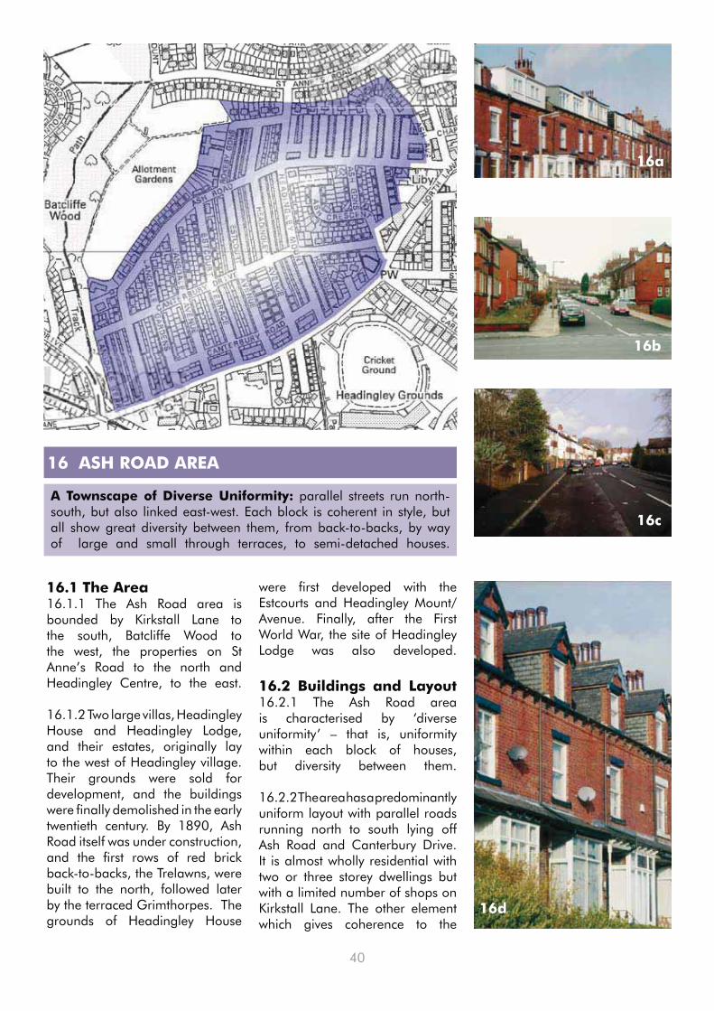
40
16.1 The Area16.1.1 The Ash Road area is bounded by Kirkstall Lane to the south, Batcliffe Wood to the west, the properties on St Anne’s Road to the north and Headingley Centre, to the east.
16.1.2 Two large villas, Headingley House and Headingley Lodge, and their estates, originally lay to the west of Headingley village. Their grounds were sold for development, and the buildings were finally demolished in the early twentieth century. By 1890, Ash Road itself was under construction, and the first rows of red brick back-to-backs, the Trelawns, were built to the north, followed later by the terraced Grimthorpes. The grounds of Headingley House
16 ASH ROAD AREA
A Townscape of Diverse Uniformity: parallel streets run north-south, but also linked east-west. Each block is coherent in style, but all show great diversity between them, from back-to-backs, by way of large and small through terraces, to semi-detached houses.
16d
16a
16b
16c
were first developed with the Estcourts and Headingley Mount/Avenue. Finally, after the First World War, the site of Headingley Lodge was also developed.
16.2 Buildings and Layout16.2.1 The Ash Road area is characterised by ‘diverse uniformity’ – that is, uniformity within each block of houses, but diversity between them.
16.2.2 The area has a predominantly uniform layout with parallel roads running north to south lying off Ash Road and Canterbury Drive. It is almost wholly residential with two or three storey dwellings but with a limited number of shops on Kirkstall Lane. The other element which gives coherence to the

41
area is the fact that all dwellings have small front gardens.
16.2.3 However, there is variety in the house types, from back-to-backs in the Grimthorpes and Trelawns 16a, to long through terraces in the Estcourts and Headingleys 16b, short small terraces in the Langdales, and semi-detached houses on Ash Road and the Ash Gardens area 16c. This often reflects the differences in the age of properties which ranges from late Victorian to the present.
16.2.4 This variety is reinforced by differences in detail on the dwellings, such as doors, porches, dormers, gables, bay windows, finials, and brickwork 16d, 16e. Many windows have mullions with stone lintels and sills while some of the dormers on Kirkstall Lane have large ‘hooded’ gabled roofs.
16.2.5 Boundary walls, coping stones, stone flags and kerbs also contribute to the character of the area.
16e
16f
16g
16k16h
16j
16.2.6 Particularly notable blocks are to be found on Estcourt Avenue, Grimthorpe Terrace, Winston Gardens and the middle section of Headingley Mount, while Ash View has retained its stone setts in the carriageway.
16.2.7 However, other blocks have suffered from inappropriate dormer roof extensions with non-matching materials and windows and, in some cases, from being flush with the main wall rather than being set back into the roof plane 16f, 16g.
16.2.8 South Parade Baptist Church 16h located at the junction where North Lane becomes Kirkstall Lane acts as a landmark building when approached from Cardigan Road.
16.3 Spaces16.3.1 There is very little open space in the area, although it does border on the Ash Road allotments and Batcliffe Wood to the west.
16.3.2 There is an overgrown green area with trees on Rokeby Gardens associated with a derelict garage court 16j.
16.3.3 The lack of green space reinforces the importance of street trees, notably those lining Langdale Avenue 16k and individual trees elsewhere e.g. Headingley Mount, Ash Crescent and the Estcourts.

42
16.4 Key Features of the Ash Road area
16.4.1 The plan of the Area is highly regular, dominated by parallel north/south streets.
16.4.2 The blocks of houses
16.5 Actions for Improving the Ash Road Area
16.5.1 It is important to retain and restore the detailed features of buildings which give character to the area. This includes boundary walls in back ginnels and front gardens, the removal of unnecessary hard surfacing in some cases, and the provision of designated spaces to store wheeled bins.
16.5.2 The protection of existing trees and grass verges together with additional planting of street trees is also necessary to enhance the area, e.g. on Headingley Mount towards its northern end.
16.5.3 The extensive area of hard - standing in front of the new properties on Canterbury Drive at its junction with Langdale Terrace needs reducing and greening.
16.5.4 The area suffers from considerable ‘rat-running’ along Ash Road and Headingley Mount which needs addressing in conjunction with car parking controls at junctions.
16.5.5 The area also suffers from heavy parking, due to a preponderance of HMOs, exacerbated on match days at the nearby Headingley Stadium, and this too needs controlling, perhaps by means of a parking scheme.
16.5.6 In conjunction with the improvements to the streetscape
16.6 Schedule of Designated Sites and Spaces in the Ash Road Area
16.6.1 Conservation Area The whole of the Ash Road area is outside any Conservation Area
16.6.2 Listed BuildingsLodge, 2 Ash Crescent (465001) – late C19th• South Parade Baptist Church (465330) – 1925 and Hall, 1908 •
16.6.3 Tree Preservation Orders outside a Conservation Area6/1993, 7/1993 - At junction of Kirkstall Lane/Langdale • Gardens50/1993 - At junction of Headingley Mount/Derwentwater • Grove51/2006 - Rear of 2 Derwentwater Grove• 24/2007, 34/2009 - Green space on Rokeby Gardens•
16.6.4 Protected Green Spaces - none
16.6.5 Public Right of WayPotential path: ginnel from Ash Avenue to St Anne’s Road.•
16.6.6 Residents Parking Zone - none
16.6.7 Regulation 7 Direction The whole of the Ash Road area falls under the Direction.•
16.6.8 Area of Housing Mix: the whole area lies within the Area of Housing Mix (Policy H15).
16l
are varied, but each is uniform in design; some are designed as a whole.
16.4.3 Buildings are two-storey, maybe with attic and/or basement, finished in brick and/or render.
16.4.4 All streets benefit from front gardens.
16.4.5 The streets to the west are broader, those to the east are more compact; several streets retain original setts, paving, walls, trees and grass verges.
generally at the entrance to Headingley Stadium, the wide pavement area opposite, in front of the shops on Kirkstall Lane at the junction with Headingley Mount, needs enhancement by planting and quality surface materials 16l.
16.5.7 The overgrown area on Rokeby Gardens needs landscape management.

43
17 HEADINGLEY ‘GREEN GIRDLE’
The ‘Green Girdle’: The Headingley and Hyde Park Neighbourhood is bordered to the north by Far Headingley and to the south by Burley but on the eastern and western boundaries it is bounded by green corridors.
17.3 Actions for Improving Batcliffe Wood
17.3.1 Batcliffe Wood would benefit from management and maintenance of the tree cover, signage, and access control fencing, with the main footpath resurfaced and locally graded, to improve all weather accessibility.
17.3.2 The galvanised metal palisade fence to the rear of the Ash Road Allotments should be replaced with a more sympathetic material, or at least painted green or black, to better blend into its environment.
17.1 The Area17.1.1 In the west, the railway in its deep cutting (built in 1849) provides a wildlife corridor on its embankments, which connects with Batcliffe Wood and the Ash Road Allotments towards the north-west of the Neighbourhood.
17.1.2 In the east, the more extensive Woodhouse Ridge and Woodhouse Moor form a distinct ‘green girdle’.
17.1.3 The Neighbourhood is one of the most crowded in the city, and parts of central Headingley are defined as a ‘priority area for improving green space provision’ in the Leeds UDP, so the green spaces of its green girdle are all the more valuable.
17.2 Batcliffe Wood17.2.1 Batcliffe Wood provides a green corridor from Kirkstall Lane to Beckett’s Park separating the Ash Road Area from the Queenswood Drive estate. There is a footpath right through the Wood from Kirkstall Lane to St. Anne’s Road.
17.2.2 The Wood comprises stands of mature forest trees, including horse chestnut, beech and oak 17a, and being on a hill provides the best panoramic view of the
17b
whole Neighbourhood, from the Arndale Centre via the cupola on Hinsley Hall to St. Augustine’s Church at Hyde Park (see pp2-3).
17.2.3 The Ash Road Allotments lie on the south facing slope below Batcliffe Wood, which provides an attractive backdrop, and are well cultivated, providing an important community resource 17b.
17a

44
17.4 Woodhouse Ridge17.4.1 Woodhouse Ridge, much of which was given to the city in 1876, follows the escarpment on the southwest side of the Meanwood valley, from Cardboard Hill at its western end towards Woodhouse in the east. It lies on the route of the Meanwood Valley Trail from Woodhouse Moor (linking to the Dales Way).
17.4.2 The Ridge includes an area of ancient oak woodland known as Batty’s Wood, while the area to the southeast was originally laid out in the nineteenth century with a bandstand 17c, shelters, a fountain, and a children’s playing field, with views across the Meanwood
17.5 Actions for Improving Woodhouse Ridge17.5.1 On Woodhouse Ridge, some of the paths and stepped walkways are in need of repair and maintenance 17h, while some selective thinning of trees could reopen glimpses of the views across the valley along the walkways.
17.5.2 In particular, the ‘glade’ at the key entry point to the ginnel leading to Cumberland Road, and the area around the site of the bandstand, could be ‘opened out’ with more seating and play spaces.
17.5.3 If the footpath under investigation beside City of Leeds School is established as a public right of way, then consideration should be given to re-routing the Meanwood Valley Trail along it.
Valley 17d, as an amenity for the increasing population of the neighbourhood. It is now rather overgrown with trees, and the bandstand and other features have long gone, although the base of the bandstand can still be seen 17e.
17.4.3 The wooded Ridge now offers 42 acres of wildlife habitat for many animals, including roe deer, while Cardboard Hill contains a wildflower meadow and retains open views of the Meanwood Valley. It is recognised as a Local Nature Area (No 114)
17.4.4 The Ridge is bounded on the Headingley Hill side by a fine high stone wall with an entry
17c
17d
point at Cumberland Road 17f, from where a narrow ginnel leads from the Ridge diagonally across the area to Woodhouse Cliff and thence to Woodhouse Moor.
17.4.5 Another footpath connects Woodhouse Ridge and Woodhouse Moor alongside the City of Leeds School (Bedford Fields) site and it provides an important green corridor link which is recognised in the Leeds UDP 17g. This has the potential to form an off-road alternative route from the Moor to the Ridge for the Meanwood Valley Trail and Dales Way.

45
17.6 Woodhouse Moor
17.6.1 Woodhouse Moor, bought as the City’s first public park in 1857 and laid out in the 1870s, forms the largest green space adjoining the Neighbourhood and is predominantly open grass land with avenues of mature trees 17j. It is now the most intensively used green space in Leeds (and suffers abuse, especially from barbecue trays, during the summer term).
17j
17.6.2 It is crossed by Woodhouse Lane 17k which separates the main rectangular Moor to the south from the smaller informal shaped moors to the north, Cinder Moor, Monument Moor 17l, the enclosed ‘Birdcage’ adjoining the Crescent at Hyde Park Corner, and further across Woodhouse Street, Little Moor, adjoining Woodhouse Cliff.
17.6.3 Cinder Moor and parts of Monument Moor are used for
temporary car parking and are in need of proper landscaping. Recreational facilities are provided on the main Moor, including a skate-board park, tennis courts, bowling green, children’s playground, and allotments.
17.6.4 The main Moor is criss-crossed by a number of diagonal paths, together with paths parallel to the surrounding roads, which are all tree lined.
17h
17e
17g
17f

46
17.7 Actions for Improving Woodhouse Moor17.7.1 Woodhouse Moor needs an ongoing programme of general maintenance, including tree planting and replacement, especially along the north side of Woodhouse Lane to reinforce the boulevard effect, around Monument Moor, and to soften the impact of the skate-board park.
17.7.2 A new pedestrian crossing could be considered half way along Woodhouse Lane to connect both sides of the Moor.
17.7.3 There is a need to protect the edges of the green spaces from damage by parked cars, notably opposite Woodhouse Cliff.
17.7.4 Improved signage, footpath maintenance, and redesigning of the main footpath crossing points in the heart of the main Moor and at the Clarendon Road entrance, are required.
17.7.5 The implementation of the New Generation Transport (NGT) scheme, or other public transport proposals, should be handled sensitively to ensure the retention/addition of trees to retain the tree-lined character of Woodhouse Lane where it crosses the Moor.
17.7.6 Improve provision of litter bins and routine collections to ensure the Moor remains a visually attractive green space for all users.
17.8 Schedule of Designated Sites and Spaces in the Green Girdle17.8.1 Conservation Area Woodhouse Moor and Woodhouse Ridge fall within the Conservation Area, but Batcliffe Wood lies outside it.
17.8.2 Listed MonumentsMemorial to Queen Victoria (465817) – 1903 – Grade 2* • Robert Peel Statue (465890) – 1852 • HR Marsden Statue (465820) – 1878• Duke of Wellington Statue – 1858 •
17.8.3 Tree Preservation Orders outside Conservation Areas51/2004 - Surrounding Batcliffe Wood House•
17.8.4 Protected Green Spaces and Environmentally Sensitive AreasBatcliffe Wood – Green Corridor (N1, N8)• Ash Road Allotments – Green Corridor (N1A, N8)• Woodhouse Ridge – Local Nature Area (No114) and Green Corridor (N1, N8)• Bedford Field - Green Corridor (N1, N8) and Protected Playing Pitch (N6) • City of Leeds School - Protected Playing Pitch (N6)• Woodhouse Moor – Local Nature Area (No113)and Green Corridor (N1)• Woodhouse Moor Allotments – Green Corridor (N1A, N8)•
17.8.5 Public Rights of WayPotential path: from Queenswood Drive through Batcliffe Wood to St Anne’s Road.• Footpaths 83, 84, 87 and 88: along and across Woodhouse Ridge.• Note: Meanwood Valley Trail begins at HR Marsden statue on Woodhouse Moor, and runs along • adopted highways (Woodhouse Lane, Rampart Road, Delph Lane) and through Woodhouse Ridge (Footpath 84) to Grove Lane and beyond; it provides a link to the Dales Way.Potential path: from Woodhouse Ridge, beside City of Leeds School, to Woodhouse Street.• Potential paths: all pathways crossing Woodhouse Moor.•
17k
17l
17.7.7 Monument Moor deserves full landscape treatment.

47
18 Design Policy and Guidelines for the Neighbourhood
The Design Policy for the Neighbourhood comprises recommendations 18.1-18.3, together with the specific recommendations in sub-section (4) of each Character Area. It implements Strategic Aim SA1 of the UDP, and supplements the UDP and emerging policies listed in Appendix 1 and 2. Further recommendations provide general guidance on the design of all new developments, including alterations and extensions in the Neighbourhood. Relevant planning policies are listed in Appendices 1 and 2. The Guidelines will be used by the City Council in determining planning applications in the Neighbourhood.
Design Policy
18.1 Understanding context is vitally important in all good design proposals, recognising the streetscape, roofscape, and landscape setting and reflecting the built form, proportions, features and materials of the original or surrounding buildings.
18.2 Local distinctiveness and character should be recognised and enhanced, notably those key features described in sub-section (4) of each Character Area.
18.3 Any new development, alteration or extension should respect and reflect all those aspects and any planning application demonstrate that they have been taken into account in arriving at the proposed design.
Detailed Design Guidance
18.4 Particular attention should be paid to existing or potential landmark sites such as corner sites, focal points at road junctions etc. Where there are opportunities to design notable features in any new building that reflects its key position, these should be taken advantage of.
18.5 Elsewhere, development should reflect the density, house type and rhythm of the adjoining streetscape, including the roofscape, and where part of a group of buildings, their key features.
18.6 There will be a general presumption against infill development. Any development proposing the infill of a site, or the subdivision of a plot, should respond to the scale, proportion, layout, boundary features, and materials of adjacent properties as well as the spaces between
them and the effect this may have on their amenity.
18.7 Extensions, including garages, should not dominate the original building and side extensions should normally be set back from the original frontage. The larger the extension, the further it should be set back from the site boundary. All extensions should be designed to minimise overlooking, overshadowing and visual dominance of neighbouring properties.
Building Materials
18.8 Any infill development, or alterations and extensions to existing houses, including boundary walls and garages, should be designed to match the existing or neighbouring houses in colour and materials including types of courses, bonding and pointing. This is particularly the case in the terraced blocks.

48
18.9 Original details and other distinctive features in house design (brickwork details, doors and architraves, window sills and lintels, etc.) which add interest and local identity should be retained. Paying attention to even very small details can provide interest and a consistency in approach to sympathetic design.
Roofs and Dormers
18.10 Dormer windows should only be acceptable on main/principal frontages, i.e. facing streets or public spaces, where they are appropriate in terms of design, character, scale and materials in relation to both the individual property in question and the wider street
18.11 It is also desirable that rear dormers should only be constructed subordinate to the main roof i.e. should be set back from the eaves, side/party walls, and preferably set down from the ridge line.
18.12 Any dormer or roof extension should match the original roof in pitch, eaves, and materials.
Spaces and Trees
18.13 Incidental public greenspaces, enhanced or provided, particularly in the priority areas for greenspace provision.
18.14 Similarly trees in streets should be retained, replaced or newly planted wherever possible, in association with grass verges where appropriate, especially south of Headingley Lane.
18.15 Front gardens should be retained, with minimal hard surfacing, unless it is permeable.
Other Features
18.16 Wheeled bin stores should be provided and screened wherever practicable.
18.17 Appropriate boundary treatments should be retained and restored to preserve the character and coherence of the streetscape.
18.18 Similarly traditional paving materials should be retained and restored wherever possible, particularly on back streets and along ginnels.
18.19 Street furniture, including lighting and signage, needs to be coherently designed, particularly in Conservation Areas and along shopping parades. Similarly any security fencing should also reflect the character of the area, preferably being painted black or green, avoiding the use of barbed or razor wire wherever practicable.
18.20 Internal rather than external security shutters should be provided on shops and other business frontages, particularly in or adjoining Conservation Areas.
18.21 On residential buildings external grilles should be avoided to both windows and doors, from both a visual amenity and fire safety point of view, where permission is required.

49
19 Management Plan for the Neighbourhood
The following Actions are local aspirations. Note that, while they are based on residents’ recommendations and have all been the subject of consultation with Leeds City Council, the Council has made no specific commitments to their implementation. They do not have the status of Guidelines, but should be taken into account, where appropriate, by developers. The Management Plan comprises the following recommendations, together with the specific actions in sub-section (5) of each Character Area. Implementation of the Plan will require partnership working between the community and various Council service areas (such as Highways, Parks & Countryside, and so on). Aspirations will also assist in justifying any future bids for funding.
Buildings and Layout
19.1 As part of a Conservation Area Management Plan, prepare a detailed public realm design scheme for Hyde Park Corner, Headingley Centre and the A660 corridor with a view to introducing a coherent approach to street furniture, signage, lighting and frontages and the use of a palette of quality materials.
19.2 Undertake a detailed character appraisal of the existing Conservation Areas in the Neighbourhood (see Map 3), including a review of their boundaries, with a view to considering extensions in the light of suggestions made in this NDS at paragraph 14.5.1.
19.3 Consider an Article 4 Direction, particularly in the terraced parts of the neighbourhood, to retain and restore detailed features which give character to the area but which would otherwise be permitted development.
19.4 Undertake an audit of street furniture and signage with a view to reducing clutter, especially within the shopping centres.
19.5 Retain boundary walls wherever possible to maintain a coherent streetscape and minimise parking and hard surfaces in front gardens unless permeable.
19.6 Retain and restore the Yorkstone paving, kerbs, setts and boundary walls wherever practicable, especially in back lanes and ginnels and within the Conservation Area.
19.7 Renew and extend the Regulation 7 Direction on letting boards, to include the Turnways area and to consider the Neighbourhood north of Headingley Lane.

50
Spaces and Trees
19.8 Prepare a long-term Management Strategy for the ‘green girdle’ including Batcliffe Wood, Woodhouse Ridge and Woodhouse Moor.
19.9 Undertake an audit of street trees as part of a Management Strategy to ensure their proper management, retention and replacement, and to incorporate additional planting.
19.10 Review the scope of coverage of Tree Preservation Orders with a view to adding other significant trees in the area, outside the Conservation Area.
19.11 Enhance the existing ‘pocket parks’ in the area, e.g. Sparrow Park and the Rose Garden, and identify locations for new parks in the ‘Priority Area for Improving Green Space Provision’ as part of the forward planning process.
19.12 Preserve grass verges and, where under pressure, protect them and other edges to green spaces from parking by planting, bollards, railings, or raised kerbs.
Traffic and Utilities
19.13 Ensure that the New Generation Transport scheme or any future equivalent respects the particular character of the area and takes advantage of the opportunity to enhance the Conservation Area.
19.14 Review the effectiveness of arrangements for refuse collection, especially for HMOs, in particular the return of bins to properties, and for disposal of waste, including the setting of bottle banks. These problems are generic, but are especially acute in South Headingley and the Ash Road area, where HMOs are concentrated.
19.15 Review the areas covered by Residents Parking Zones, particularly in the vicinity of the Headingley Stadium.
19.16 Introduce traffic management schemes to control ‘rat-running’ in residential areas and in selected areas introduce ‘pedestrian-friendly’ type environmental treatments to the streetscape, as well as ‘cycle-friendly’ features where these are not in conflict.
19.17 Control parking near road junctions, to protect sight-lines and pedestrian safety, and along congested bus routes.
19.18 Make all pathways currently under investigation definitive footpaths.
51
Appendix 1, Relevant Planning Policies
Leeds City Council, Leeds Unitary Development Plan (Review 2006)
Environment
Strategic Aim SA1: to secure the highest possible quality of the environment throughout the District, by protecting existing good environment, conserving and enhancing where there is scope for improvement, including initiating the renewal and restoration of areas of poor environment.
Policies N1, N1A, N6: Greenspace Development of land identified as Protected Greenspace (N1), Allotment Gardens (N1A), Playing Pitches (N6) will not be permitted for purposes other than outdoor recreation …
Policy N3: Greenspace in Residential Areas Priority will be given to improving Greenspace Provision within the identified priority residential areas …
Policy N8: Urban Green Corridors The strategic network of Urban Green Corridors links the main urban area with the countryside.
Policy N12: Urban Design Proposals for development should respect fundamental priorities for urban design
Policy N13: New Buildings The design of all new buildings should be of high quality and have regard to the character and appearance of their surroundings. Good contemporary design which is sympathetic or complementary to its setting will be welcomed.
See also, Appendix A3, Policies BD2, BD3, BD4, BD5, BD6: New BuildingsSee also, Appendix A3, Policy BD7: Shop FrontsSee also, Appendix A3, Policies BD8, BD9, BD10, BD11, BD12: Signs and Hoardings
Appendix 2, Other Planning and Related Policies
A2.1 NATIONAL POLICIES
A2.1.1 Communities & Local Government, Planning Policy Statement 5: Historic Environment (2010)
Local Planning Authorities should • take into account the desirability of new development making a positive contribution to the character and local distinctiveness of the historic environment (HE 7.5).
A2.1.2 Office of the Deputy Prime Minister, Planning Policy Statement 1: Delivering Sustainable Development (2005)
‘• Design which is inappropriate in its context, or which fails to take opportunities for improving the character and quality of an area and the way it functions, should not be accepted’ (para34).‘Seek to promote or reinforce • local distinctiveness particularly where this is supported by clear development plan policies or supplementary planning documents on design’ (para 38).
A2.1.3 Communities & Local Government, Planning Policy Statement 3: Housing (2006, amended 2010)
‘Local Planning Authorities • should develop a shared vision with their local communities’ and set out design policies for the local area aimed at ‘creating places, streets, and spaces which….have their own distinctive identity and maintain and improve local character’ (para 14).The government is seeking • ‘to create sustainable, inclusive, mixed communities in all areas’ (para 9). Proposed developments should ‘contribute to the creation of mixed
Policies N14, N15, N16, N17: Listed Buildings Preservation (N14), Change of Use (N15),Extensions (N16), Character and Appearance (N17).
Policy N18: Conservation Areas Demolition Policy N19: New Buildings All new buildings and extensions within or adjacent to Conservation Areas should preserve or enhance the character or appearance of the area by ensuring that:
The siting and scale of the building • is in harmony with the adjoining buildings and the area as a whole.Detailed design of the buildings, • including the roofscape is such that the proportions of the parts relate to each other and to adjoining buildings.The materials used are appropriate • to the area and sympathetic to adjoining buildings (where a local materials policy exists this should be complied with).Careful attention is given to the • design and quality of boundary and landscape treatment.
Policy N20: Retention of Features Demolition of features which contribute to the character of the Conservation Area … will be resisted.
Policy N22: AssessmentsSee also, Appendix A3, Policies BC7, BC8: Conservation Areas
Policies N23, N24, N25, N26: New Development Incidental open space (N23), Next to Green Corridors (N24), Site Boundaries (N25), Landscape Schemes (N26).Policies N49, N50: Nature Conservation Development will not be permitted which would seriously harm, either directly or indirectly, Habitat Resources (N49) or a Local Nature Area (LNA) (N50).See also, Appendix A3, Policies LD1, LD2: Landscaping and RoadsSee also, Appendix A8.5, Schedule of Leeds Nature Areas

52
communities having regard to the proportions of households that require market or affordable housing and the existing mix of housing in the locality’ (para 24).In respect of • development on garden land, there is no presumption that land that is previously-developed is necessarily suitable for housing development nor that the whole of the curtilage should be developed (para 41).
A2.1.4 Communities & Local Government and Department for Transport, Manual for Streets (2007)
Local identity and • distinctiveness are important design considerations and can be strengthened by using grain, patterns and form sympathetic to the predominant vernacular styles and by using local materials (para 5.11).Planting should be • integrated into street designs wherever possible, particularly street trees (para 11.3)Street furniture and lighting • equipment should also be integrated into the overall appearance of a street (para 10.1).
A2.1.5 English Heritage, Streets for All: Yorkshire and the Humber (2005)
The underlying principles are to • reduce clutter, co-ordinate design, and to reinforce local character whilst maintaining safety for all.
A2.2 REGIONAL POLICIES
A2.2.1 West Yorkshire Local Transport Plan Partnership, West Yorkshire Local Transport Plan 2006-11 (2006)
Under the Quality of Life heading, • the LTP recognises that ‘the quality of public space (including streetscape) is, and will continue to be, an important design consideration in
all transport projects’. Effective asset management • will improve the appearance of transport infrastructure (roads, bus shelters, streetlights etc) and thereby contribute to the quality of public space.
A2.3 LOCAL POLICIES
A2.3.1 Leeds Unitary Development Plan, Saved Policies
Leeds City Council, Leeds Unitary Development Plan (Review 2006)
Transport
Policies T5, T6: Provision for Pedestrians, Disabled People, Cyclists Satisfactory access and provision for pedestrians & cyclists (T5) and for disabled people and other people with mobility problems (T6) will be required.
Policy T13: Protected Routes The lines of the proposed Supertram routes will be reserved and protected.
Policy T23: Traffic management and traffic calming measures will be encouraged particularly alongside main radial roads and within residential areas.
Policies T24, T27: Parking Provision in all development proposals [and] in town centres identified in policy S2, the provision of off street car parking …See also, Appendix A9A, Schedule of General Car Parking Guidelines
HousingPolicy H9: Social Housing Needs To ensure that a balanced provision in terms of size and type of dwellings is made in housing developments (including conversions) …
Policy H15: Student Housing Policy for maintaining a diverse housing stock in the Area of Housing Mix.
Policy H18: HMOs Policies for the change of use or conversion for the multiple occupancy of existing dwellings.
Policy H20A: Residential Institutions Proposals for residential institutions other than hospitals
Shops
Policies S2, S3: Town Centres The vitality and viability of Town Centres will be maintained and enhanced.
Policy S4: Retail Character In order to maintain and enhance the vitality and viability of identified shopping centres, shopping frontage policies SF7and 8 will apply.See also, Appendix 12, Policies SF1A, SF7, SF8: Shopping Frontages
Policy S8: Neighbourhood Shopping Areas Maintenance and enhancement of neighbourhood shopping will be promoted by the local planning authority, including servicing, car parking, pedestrian safety and landscaping.
Area Based Initiatives
Policy R2: Area Based Initiatives Area-based initiatives will be undertaken in order to address area, neighbourhood and community issues [including] … wider Headingley area of housing mix … Headingley Town Centre
Leeds City Council, Neighbourhoods for Living (Supplementary Planning Guidance, 2003)Design Principles:
Identify local character and • enhance positive aspectsRespond to the context in terms • of scale, massing and height.Connect new development into • existing streets and footpaths and the historical network of spacesDesign streets as spaces • for people and design buildings to front onto streetsConnect open space networks and • reinforce existing features and treesCo-ordinate street • furniture – seating, lighting, signage, bollards etc.
A2.3.2 Leeds City Council, Core Strategy: Preferred Approach (2009)This is emerging draft policy, and the wording and policy may change

53
before the Core Strategy is adopted.
Policy G1: Strategic Green InfrastructureThe Strategic Green Infrastructure for the Leeds District is defined on the Key Diagram. Within these areas the Council will safeguard and, in partnership with others, seek ways to enhance key corridors for wildlife and amenity [including] Woodhouse Ridge.
Policy G5: WoodlandThe Council will on its own initiative and through the development process, work towards increasing appropriate species of woodland cover in the District (from 6.45% to 7.5%) by 2026. This will include planting in both urban and rural areas and partnership with the Forestry Commission, Natural England and landowners, to help deliver this.
Policy G5A: Tree Preservation OrdersTree Preservation Orders, Planning Conditions and Legal Agreements, will be used, as appropriate, to ensure that existing trees are protected and the future management of woodland is supported, where appropriate, by the creation of Management Companies or the ownership transferred to the City Council (or a registered organisation), with an adequate commuted sum.
Policy G7: Access to ‘Natural’ / ‘Semi-Natural’ SpacesThe City Council will take Natural England’s ANGSt standards into account, in reviewing and developing standards for Greenspace, natural areas and woodland/Green Infrastructure targets, following conclusion of the PPG 17 Audit, the Council’s objective will be to maximise people’s access to natural and semi natural spaces in planning the future regeneration and growth of the District.
Policy SC2 : Hierarchy of CentresIn order to promote their vitality and viability, the following hierarchy of centres is to be maintained: 1 The City Centre, 2 Town Centres [including Headingley], 3 Local Centres [including Hyde Park Corner and (part of) Cardigan Road], etc.
Policy SC8: Design, Conservation and LandscapeAll development will be expected to
create excellent design that protects and enhances those elements which contribute to the distinct identity of the City and places within the District, including … the residential Victorian, Edwardian and inter-war Suburbs … and the unique historical development of their townscape and landscape.
Leeds City Council, Street Design Guide (Supplementary Planning Document 2009)
A design guide which assists • housing developers in designing new streets for residential areas.
A2.4 Regulations and Orders
Planning (Listed Buildings and Conservation Areas) Act 1990Under the Act, a Conservation Area and numerous Listed Buildings have been designated within the Neighbourhood.
Town & Country Planning (Use Classes) Order 1987, Amendment Orders 2005, 2006 and 2010. The Order defines classes of usage of land or property; change from one use to another usually requires planning permission. Changes of use within Town and Local Centres within the Neighbourhood are restricted. The Amendment of 2010 introduces a new Use Class C4 for HMOs.
Town & Country Planning (General Permitted Development) Order 1995, Amendment Orders 2008 and 2010The Order identifies development which is normally permitted; but it also provides for Article 4 Directions, withdrawing permitted development rights in designated areas. The Amendment 2008 is concerned notably with development within the curtilage of a dwellinghouse.
Town & Country Planning (Trees) Regulations 1999, Amendment Regulations 2008Under the Regulations, Tree Preservation Orders protect a number of trees in the Neighbourhood, outside the Conservation Area.
Town & Country Planning (Control of Advertisements) (England) Regulations 2007Under Regulation 7, a Direction
has withdrawn deemed consent for residential letting boards in a designated area within the Neighbourhood.
Road Traffic Regulation Act 1984This is not planning legislation. But under the Act, Traffic Regulation Orders have implemented a number of Residents Parking Zones in the Neighbourhood.
Appendix 3, Designated Sites and Spaces
A3.1 Conservation Areas: These are ‘areas of special architectural or historic interest, the character or appearance of which it is desirable to preserve or enhance’. Planning controls are stricter than elsewhere. Planning permission is required for demolition of buildings and removal of trees, and any new buildings, alterations and extensions must meet high standards of design. Conservation Areas are designated by local authorities under the Planning (Listed Buildings and Conservation Areas) Act 1990. For more information, contact City Development.
A3.2 Listed Buildings: These are included in the national list of buildings of special architectural or historic interest and given special protection. They are designated by the Secretary of State under the Planning (Listed Buildings and Conservation Areas) Act 1990. Information on listed buildings can be found on the Heritage Gateway website at www.heritagegateway.org.uk and on www.imagesofengland.org.uk
A3.3 Civic Trust Blue Plaques: Leeds Civic Trust set up its Historic Plaques Scheme in 1987 to promote public awareness of the heritage of the city of Leeds. The events, people, institutions or buildings commemorated are of special importance in the history, heritage or shaping of Leeds. Further information is available from the Trust.
A3.4 Tree Preservation Orders: Trees in Conservation Areas are protected. Outside these Areas,

54
Orders can be made by Leeds City Council to prohibit, in the interests of amenity, the cutting down, topping, or lopping of trees, singly or in groups, or woodlands, without the local planning authority’s consent. Orders are made under the Town and Country Planning (Trees) Regulations 1999. Contact the Council’s Landscape Planning Team for further information (quoting the TPO reference number).
A3.5 Protected Greenspaces: A number of policies in the UDP protect green spaces from development, including Urban Greenspace (Policy N1), Allotments (Policy N1A), Protected Playing Pitches (Policy N6) and Local Nature Areas (Policy N50).
A3.6 Public Rights of Way: The Council keeps an updated legal record of all public rights of way in Leeds, together with details of their status, on a Definitive Map. For information contact the PROW Team in Parks & Countryside. ‘Potential path’ means a right of way under investigation.
A3.7 Residents Parking Zones: Within permit zones, parking at any time is permitted by resident permit holders only. Zones are implemented by Traffic Regulation Orders by local authorities under the provisions of the Road Traffic Regulation Act 1984. For further information, contact the Council’s Highways Services.
A3.8 Regulation 7 Direction: The Direction withdraws deemed consent for letting boards in the designated area, except for those which observe the Council’s Code. The Direction is made under Regulation 7 of the Town & Country Planning (Control of Advertisements) (England) Regulations 2007; it was originally made in 2006, and renewed in 2010 (until 2015). The Code restricts the size, style and siting of letting boards; it is mandatory within the designated areas and voluntary without. Details of the Direction and the Code are available from the Community Planner, Inner NW Leeds, City Development.
A3.9 Town and Local Centres: Town and Local Centres are designated in UDP Policy S2 (and Appendix 12), and Core Strategy Policy SC2; within these, retail development is specifically controlled.
A3.10 Area of Housing Mix: Within the Area of Housing Mix, Policy H15 of the Revised UDP resists the development of student housing.
Appendix 4, The Neighbourhood Questionnaire
A4.1 As one of many ways of involving the community, the NDS Steering Group circulated a Neighbourhood Questionnaire. The Questionnaire was published at the launch of the NDS on 15 September 2007. It was available at the launch, it was disseminated through local community associations and through local outlets (like the library), it was circulated with Headway (the local community newsletter), and it was available online.
A4.2 Over a hundred Questionnaires were returned, almost all from local residents - from LS6 1 (South Headingley, a quarter), LS6 2 (north of Headingley Lane, another quarter) and LS6 3 (western Headingley, 40%). Women outnumbered men, two-to-one. 60% were working and a third were retired (5% were students). Three-quarters had been resident for over ten years, and a quarter for over thirty years.
A4.3 Residents were asked, what landmarks gave the area identity? Over half mentioned religious buildings (including St Michael’s Church, the Makkah Masjid mosque, Wrangthorn Church and the Methodist Chapel), a third noted the period features of the local architecture, and 15% each referred to the Stadium, the parks and the Hyde Park Picture House. Numerous other buildings were also noted.
A4.4 A quarter each identified Woodhouse Moor and Woodhouse Ridge as attractive spaces, and another 15% mentioned the Rose Garden. Sparrow Park and Dagmar were also mentioned.
A4.5 The three leading eyesores were badly maintained private rented housing (a quarter), the Arndale Centre (a fifth) and litter (15%). Graffiti, hoardings and wheeled bins were also noted.
A4.6 Many transport problems were identified. Three-quarters of respondents saw traffic generally as excessive, especially on Otley Road, Headingley Mount, Cardigan Road and North Lane. 60% saw car-parking as a widespread problem. And over 40% each saw pedestrian and cycle routes as unattractive and unsafe.
A4.7 Residents were asked about their likes and dislikes. What they especially liked about the Neighbourhood were the variety and character of its buildings and its green spaces and trees, also the community and the shops. What they disliked were the litter and wheeled bins in the streets, the neglected private rented housing, traffic problems and the drink culture. The three things they most wanted to improve were the predominance of private rented housing by conversion back to family housing (a quarter), a reduction of the impact of traffic and parking, and the management of litter, waste disposal and graffiti (15% each).

55
Acknowledgements
The Headingley & Hyde Park NDS Steering Group thanks the following for their contributions:
Dr Richard Tyler, Project Director, Headingley Development Trust• Tony Ray, Planning Consultant• Andrew Crates, Jade Corcoran and Ryan Platten, Community Planners, Inner NW Leeds • Sue Buckle, Mark Burgess, Rachel Harkess, Martin Staniforth, Sue Walker, Helen White, members of the • Steering CommitteeDavid Hall, Far Headingley Village Society• Liz Boyd, Janet Douglas, Andrew Helm, Steve Hunt, Darren Shickle, Iain Smith, for their particular • support.Members of South Headingley Community Association, North Hyde Park Neighbourhood Association, • Headingley Network, Cardigan Triangle and Turnways & Laurel Bank RA.Inner NW Area Committee• Headingley St Columba United Reformed Church•
Headingley & Hyde Park Neighbourhood Design Statement was funded by Leeds City Council’s Inner North West Area Committee.
It was produced by Headingley Development Trust, Reg. Office 20 Woodland Park Road Leeds LS6 2AZ.
Designed and printed by Edwin M Harmer Print & Design, 67A Raglan Road, Leeds LS6 9DZ.

56
Contact Details
Write to:
Telephone:
Email:
Web:
Headingleyand Hyde ParkNeighbourhood Design Statement
Supplementary Planning DocumentAdopted … 2010
Local Development FrameworkForward Planning and ImplementationCity DevelopmentLeeds City Council2 Rossington StreetLEEDS LS2 8HD
0113 247 8423
www.leeds.gov.uk/ldf
Contact Details
Write to:
Telephone:
Email:
Web:
Headingleyand Hyde ParkNeighbourhood Design Statement
Supplementary Planning DocumentAdopted August 2010
Local Development FrameworkForward Planning and ImplementationCity DevelopmentLeeds City Council2 Rossington StreetLEEDS LS2 8HD
0113 247 8423
www.leeds.gov.uk/ldf
Contact Details
Write to:
Telephone:
Email:
Web:
Headingleyand Hyde ParkNeighbourhood Design Statement
Supplementary Planning DocumentAdopted September 2010
Local Development FrameworkForward Planning and ImplementationCity DevelopmentLeeds City Council2 Rossington StreetLEEDS LS2 8HD
0113 247 8423
www.leeds.gov.uk/ldf