heathfieldgcsegeography.files.wordpress.com€¦ · Web view2018-03-15 · Heat can exceed...
35
Name: Teacher: Geography (AQA) Case Study, Example and Fieldwork Booklet 2018 Paper 1: Living with the Physical Environment Tuesday 22 nd May 2018 PM (1hr 30) (35%) Paper 2: Challenges in the Human Environment Tuesday 5 th June 2018 PM (1hr 30) (35%) Paper 3: Geographical Applications
Transcript of heathfieldgcsegeography.files.wordpress.com€¦ · Web view2018-03-15 · Heat can exceed...

Name: Teacher:
Geography (AQA) Case Study, Example and
FieldworkBooklet 2018
Paper 1: Living with the Physical Environment Tuesday 22nd May 2018 PM (1hr 30) (35%)
Paper 2: Challenges in the Human EnvironmentTuesday 5th June 2018 PM (1hr 30) (35%)
Paper 3: Geographical ApplicationsMonday 11th June 2018 PM (1hr 15) (30%)
What is the difference between an “Example” and a “Case Study”?
Examples:

An “Example” is a focus is on a single theme (Coastal Management in one town – Lyme Regis). The place helps to illustrate (or show) the content. Where you can, drop in information about named places to show a better understanding, using phrases such as “for example”. Case Studies: A “Case Study”. Here you are expected to know a range of different themes about a named place/event. For example, Nigeria (an NEE) you need to know….. How important is it political, social, cultural and environmental context of this country Employment (industrial) structure of this country? How it is changing manufacturing stimulating economic development the role of TNCs the advantages and disadvantages of TNCs changing political and trading relationships with the wider world Types of aid, impacts on the country in question
How many 6 and 9 markers do I need to answer?
Paper 1 Paper 2 Paper 3Number of 6
Markers4 4 4
Numbers of 9 Markers
2 2 2
PLEASE NOTE: The content of the 6 and 9 mark questions could be anything!
The answers won’t solely be that of a particular Case Study or an Example in the following booklet!
Mark Schemes of a 6 and 9 mark answer: 6 Marks:
Level 1

6 Marks “use evidence” in the question:
9 Marks + 3 (SPGST):
Level 2
Level 3
Level 1
Level 2
Level 3
Level 1
Level 2

SPGST (Spelling, Punctuation, Grammar and Specialist Terminology):
Examples of 6 and 9 mark questions from any part of the course
You could answer these for revision
Level 3
High performance (3 marks) Learners spell and punctuate with consistent accuracy Learners use rules of grammar with effective control of
meaning overall Learners use a wide range of specialist terms as appropriate
Intermediate performance (2 Marks) Learners spell and punctuate with considerable accuracy Learners use rules of grammar with general control of
meaning overall Learners use a good range of specialist terms as appropriate
Threshold performance (1 Mark) Learners spell and punctuate with reasonable accuracy Learners use rules of grammar with some control of meaning and any errors do not significantly hinder meaning overall Learners use a limited range of specialist terms as appropriate
No marks awarded (0 Marks) The learner writes nothing The learner’s response does not relate to the question

Pape
r 1
6 Markers
‘The weather of the UK is becoming more extreme.’ Use evidence to support this statement.
Describe and explain the features of the vegetation shown in Figure 7 (Rainforest plants).
Using Figure 12 (Spits and bars) and your own knowledge, explain how different landforms may be created by the transport and deposition of sediment along the coast.
Using Figure 16 (Waterfall and gorge), explain the processes involved in the formation of the landforms shown.
Using Figure 2 (Data on LIC and HIC Earthquake) and your own knowledge, suggest why the effects of a tectonic hazard vary between areas of contrasting levels of wealth.
Explain why the diagram shown in Figure 9 (Food web) is an example of nature’s recycling system.
With the help of Figure 12 (Beach nourishment pic), explain how soft engineering is used to protect coastlines from the effects of physical processes
With the help of Figure 14 (Floodplain with houses on), explain how physical and human factors can increase the risk of river flooding
Using Figures 1 and 2 (Map with plate boundaries and NZ on), suggest why both volcanoes and earthquakes occur in New Zealand.
Using Figure 8 (Image of rainforest with no trees) and your own understanding, explain how deforestation can have economic impacts.
Hard engineering strategies are effective in protecting the coastline.’ Do you agree with this statement? Explain your answer.
‘The causes of river flooding are usually the result of human factors.’ Do you agree with this statement? Explain your answer.
9 Markers
Choose either an earthquake or a volcanic eruption. Assess the extent to which primary effects are more significant than secondary effects. Use Figure 5a or 5b (Volcano Ash and Collapsed Buildings) and an example you have studied.
For a hot desert environment or cold environment you have studied, to what extent does that environment provide both opportunities and challenges for development?
Assess the extent to which prediction is the most important factor in reducing the effects of tropical storms.
For a hot desert environment or a cold environment you have studied, assess the importance of management strategies used to reduce the risk of environmental damage.
Using a named example, evaluate the immediate and long-term responses to tropical storms
Choose one of the following environments: Environments on the fringe of hot deserts / Cold environments Tick the box indicating the environment chosen. To what extent is your chosen environment at risk from human activity?

Pape
r 2
6 Markers To what extent do urban areas in lower
income countries (LICs) or newly emerging economies (NEEs) provide social and economic opportunities for people?
With the help of Figures 8 and 9 (Information on fracking process and stakeholder thoughts), explain why the process of fracking for gas causes conflict between different groups of people.
Explain how energy security can be improved Using Figure 3 (Newspaper extract) and
your own knowledge, explain how urban regeneration projects can reduce levels of urban deprivation.
Using Figure 4 (Fact file of a new housing estate) and your own knowledge, discuss how the features of the Greenhouse development will make for more sustainable urban living
To what extent is it preferable to source food locally in the UK rather than import from abroad?
Using an example you have studied, examine how the extraction of a fossil fuel creates both advantages and disadvantages.
Use Figure 3 (image of favela/slum) and a case study of a city in a LIC/NEE to assess the challenge of providing services to the city’s population
Using a case study of a LIC/NEE country, explain how manufacturing industry can encourage economic development.
Using Figure 10 (information on water transfer scheme) and your own understanding, suggest how the proposed water transfer schemes will help meet the changing demand for water in the UK.
Use an example from a LIC/NEE to explain how local strategies are being used to increase sustainable supplies of energy.
9 Markers Evaluate the effectiveness of an
urban transport scheme(s) you have studied.
‘Transnational corporations (TNCs) only bring advantages to the host country.’ Do you agree with this statement?
Evaluate the effectiveness of an urban planning strategy in helping to improve the quality of life for the urban poor. Use an example of a city in a lower income country (LIC) or newly emerging economy (NEE).
Evaluate the effectiveness of tourism in reducing the development gap. Use Figure 9 (Fact file on Haiti tourism) and your own knowledge.
To what extent has urban change created opportunities in a UK city you have studied?
Suggest how one or more strategies might reduce regional differences in the UK.

Pape
r 3
6 Markers With the help of Figure 2 (Resources from Pre
Release Booklet), suggest why economic factors may be more important than physical factors when explaining migration to cities in LICs or NEEs.
Study Figure 4 (Resources from Pre Release Booklet), ‘Challenges of urban growth in LICs/NEEs’, in the resources booklet.
‘Economic development creates environmental problems in urban areas in LICs/NEEs.’ Use Figure 4 (Resources from Pre Release Booklet) and your own understanding to discuss this statement.
Study Figure 5 (Resources from Pre Release Booklet), ‘Urban problems in Kolkata - improving the life of the urban poor’, in the resources booklet. Suggest why people living in cities in LICs/NEEs such as Kolkata are more vulnerable to natural hazards than people living in cities in HICs. Use Figure 5 (Resources from Pre Release Booklet) and your own understanding to support your answer.
State the title of your fieldwork enquiry in which human geography data were collected. Title of fieldwork enquiry: ….. Assess how effective your presentation technique(s) were in representing the data collected in this enquiry.
Suggest why the energy mix in the UK is likely to change in the future
“The physical environment provides opportunities for a range of economic activities”’ Use Figure 2 (Resources from Pre Release Booklet) to help you discuss this statement.
Study Figure 3 (Resources from Pre Release Booklet), ‘Views about the development of Druridge Bay’, in the resource booklet. Explain why this development is an example of an economic/environmental’ conflict.
State the title of your fieldwork enquiry in which human geography data were collected. Assess how effective your presentation technique(s) were in representing the data collected in this enquiry.
Write the title of your human geography fieldwork enquiry. Assess the effectiveness of your data collection method(s).
9 Markers Three projects have been suggested
to try and improve the quality of life for the urban poor in Kolkata. These are described in Figure 5 (Resources from Pre Release Booklet). Which of the three projects do you think will improve the socio-economic and environmental conditions for the urban poor of Kolkata most effectively? Use evidence from the resources booklet and your own understanding to explain why you have reached this decision.
For one of your geography enquiries, to what extent were results of this enquiry helpful in reaching a reliable conclusion(s)?
Do you think that the proposed coal mine development at Druridge Bay should go ahead? Tick the box of your choice. (Yes/No). Use evidence from the resource booklet and your own knowledge to explain your decision.
With reference to your methods, results and conclusions, suggest how one of your geographical enquiries could be improved.
State the title of your fieldwork enquiry in which physical geography data were collected. To what extent were the data collected useful in satisfying the original aim(s) of the enquiry?
For one of your geography enquiries, to what extent were results of this enquiry helpful in reaching a reliable conclusion(s)?
Write the title of your human geography fieldwork enquiry. Assess the effectiveness of your data collection method(s).
Case Study and Example List:
Overall there are 5 “Case Studies” and 14 “Examples”Main Topic Subtopic Description Name of
Example/Case Study
Example (6 Marks) / Case Study (9 marks)?
Tectonic How countries respond to these Chile Earthquake Example x 2

The Challenge of Natural Hazards
Hazards hazards depending on their development (one LIC and one HIC)
and Nepal Earthquake
Weather Hazards
Primary and Secondary effects of a Tropical Storm. Immediate and long term responses to the hazard
Typhoon Haiyan Example
Weather Hazards
Causes, impacts and responses of a UK weather event.
Somerset Levels Flood 2014
Example
The Living World
Local Ecosystems
An example of a UK ecosystem to show the balance between producers, consumers, decomposers, food chain, food web and nutrient cycling
Silk Mills Nature Reserve, Taunton
Example
Tropical Rainforest
A case study of a Tropical Rainforest and why it is being cut down
Malaysia Case Study
Hot Deserts A case study of a hot desert to show what opportunities and challenges exist
Thar Desert, India and Pakistan, Asia
Case Study
Physical Landscapes
in the UK
Coasts An example of a UK coastline with landforms of erosion and deposition
Swanage, Dorset Example
An example of a UK coastal management scheme in the UK to include reasons for the management, what was done, resulting effects and conflict
Lyme Regis, Dorset
Example
Rivers An example of a river valley in the UK with landforms of erosion and deposition
Holford Stream, Somerset
Example
An example of a flood management scheme in the UK. Why was it needed? What were the details of the scheme? What environmental, social and economic issues does this scheme create?
Exeter, Devon Example
Paper 1: Living with the Physical Environment
Main Topic
Description Name of Example/Cas
e Study
Example? Or Case Study?
Urban Issues
and Challenge
A case study of a major city in a LIC or a NEE Where is it located? How important is it? (regionally, nationally and
internationally) Why has it grown? (Migration and natural increase) How has this urbanisation created opportunities? How has urban growth created challenges?
Rio de Janeiro, Brazil, South America
Case Study
An example of how urban planning is improving quality of life for the urban poor
Favela Bairro Project, Rio de Janeiro
Example
A case study of a major city in the UK to Where is the city located? importance of the city to the UK and the wider world
Bristol, South West, UK
Case Study

s impacts of national and international migration on the growth and character of the city
urban change created opportunities (SEE) urban change created challenges (SEE)An example of an urban regeneration project to show why the area needed regenerating and the main features of this project
Broadmead, Bristol
Example
The Changing Economic
World
An example of how the growth of tourism in a LIC or NEE helps to reduce the development gap
Jamaica, Caribbean
Example
A case Study of a LIC or a NEE to show: How important is it political, social, cultural and environmental context
of this country Employment (industrial) structure of this country?
How it is changing manufacturing stimulating economic development the role of TNCs the advantages and disadvantages of TNCs changing political and trading relationships with the
wider world Types of aid, impacts on the country in question Changing quality of life
Nigeria, Africa Case Study
An example of an modern industrial development which is more sustainable
Torr Quarry, Somerset (Merehead)
Example
The Challenge
of Resource Managem
ent
An example to show how the extraction of a fossil fuel has both advantages and disadvantages
Natural Gas Example
An example of a local renewable energy scheme in an LIC or NEE to provide sustainable supplies of energy
The Chambamontera micro-hydro scheme, The Andes
Example
Paper 2: Challenges in the Human Environment
Paper 1: Living with the Physical Environment1. Examples (6 marks) of how countries respond to hazards depending on their
development (one LIC and one HIC): Chile Earthquake and Nepal EarthquakeHIC/NEE: Chile LIC: Nepal
Immediate Responses Immediate Responses International Help to supply field
hospitals (temporary) and bring in satellite phones and floating bridges
Temporary repairs made to main roads to allow access for emergency services
90% of homes had water and power within 10 days
Search and rescue teams Water and medical support from UK,
India and China 500,000 tents needed to provide
shelter for homeless Helicopters used to deliver supplies to
villages in cut off areas of the Himalayas
Long Term Responses Long Term Responses Chilies government launched housing
reconstruction plan for 200,000 people
Chile makes money from Copper and this is a strong export, therefore
Stricter codes when houses rebuilt – not so close together, made with better materials to withstand shaking – How will this be enforced?
Thousands of homes are going to be

affected areas of this trade could be rebuilt without much foreign aid
repaired and homeless rehoused. How long will this take with poor access because of the Himalayas and the low GNI?
Potential Questions: 1. Using named examples, outline how countries respond to natural hazards
depending on their development (6 marks) 2. “The impacts of a natural hazard in LICs is more long-lasting than those that occur
in HICs” Discuss this statement (6 marks)
2. A case study (9 marks) of primary and secondary effects of a Tropical Storm. Immediate and long term responses to the hazard: Typhoon Haiyan
Basic Facts: November 2013 Category 5 storm 170 mph winds Waves 15m high
Primary Effects Secondary Effects 6,300 killed 600,000 homeless Airport badly damaged 30,000 fishing boats destroyed Major flooding from storm surge
14 million people affected 6 million lost source of income
(mainly fishing) Landslides blocking roads Power supplies lost for a month Shortages of food and water Aid slow to arrive – ferries and airlines
disrupted for weeks Looting and violence in Tacloban
Immediate Responses Long Term Responses International Aid 1200 evacuations centres set up for
homeless UK movement sent shelter kits Red cross delivered basic food aid –
e.g. rice, canned food and cooking oil
Rebuilding of roads and bridges Oxfam supported replacement of
fishing boats Homes built away from areas at risk
of flooding (storm surges) “Cash for work” programmes paid
people to clear debris
Potential Questions:

1. “The Secondary effects of a tropical storm are worse than the primary effects” to what extent do you agree with this statement. (9 Marks + 3 SPGST)
2. “Preparation is the most significant of the three Ps in reducing the impacts of a Tropical Storm” (9 Marks + 3 SPGST)
3. An example (6 marks) of causes, impacts and responses of a UK weather event: Somerset Levels Flood 2014
Potential Questions: 1. Explain the social impacts of a UK weather event (6 marks) 2. Using figure XYZ (picture of flooding in UK), suggest the economic effects of a UK
weather event (6 marks) 3. Using figure XYZ (picture of flooding in UK), suggest the environmental effects of a
UK weather event (6 marks)
Causes Wettest January since records began:
Several weather systems brought rain for several weeks, 100mm above average rainfall in Jan and Feb
Storm surge prevented water exiting into the Bristol Channel
Rivers not dredged for 20 years Impacts
600 flooded homes 16 farms evacuated Moorland (village) cut off Power lost £10 million damage 14,000ha of farmland under water for
3-4 weeks Livestock (cows) moved Local roads cut off Railway closed (mainline to Bristol) Floodwater contaminated Debris needed clearing
ResponsesShort term: Sandbags to begin with People used boats to get around Longer term: More regular dredging Homeowners adding flood gates to
their properties

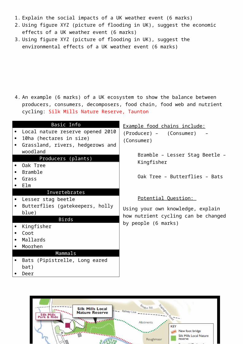
4. An example (6 marks) of a UK ecosystem to show the balance between producers, consumers, decomposers, food chain, food web and nutrient cycling: Silk Mills Nature Reserve, Taunton
Example food chains include:(Producer) – (Consumer) – (Consumer)
Bramble – Lesser Stag Beetle – Kingfisher
Oak Tree – Butterflies – Bats
Potential Question: Using your own knowledge, explain how nutrient cycling can be changed by people (6 marks)
Basic Facts:
Basic Info Local nature reserve opened 2010 10ha (hectares in size) Grassland, rivers, hedgerows and
woodland Producers (plants)
Oak Tree Bramble Grass Elm
Invertebrates Lesser stag beetle Butterflies (gatekeepers, holly blue)
Birds Kingfisher Coot Mallards Moorhen
Mammals Bats (Pipistrelle, Long eared bat) Deer

Malaysia is in Asia 67% of land is covered by Tropical Rainforest The country is very special because of the range of species in the forest, such as the orang-utan The rate of deforestation is faster than any other tropical rainforest in the world Between 2000 - 2013 an area the size of Denmark was cut down!
Causes of DeforestationSubsistence and Commercial Farming Logging
Subsistence = local people/tribes growing crops for their own use, not for selling on for profit. Small scale and sustainable – a small amount
of land is cleared, used and then replanted. “Slash and Burn” areas are burnt to clear the
vegetation, however this means that nutrients are returned to the soil. Sadly these fires can get out of control and cause huge amounts of habitat destruction
Commercial Farming = large scale and for profit It is the largest exporter of palm oil in the
world. A product put in a lot of goods, like peanut butter.
From 1970-80 incentives (money) were given out for the growing of the crop, which sadly encouraged large areas of rainforest to be cleared.
The area was the largest exporter of tropical wood in the 1980s
Woods include mahogany Selective logging now occurs, where only
certain types of tree are cut down, or those a certain size to try and preserve the forest
Mineral Extraction
Tin is mined (taken out of the ground) Rainforest has been cleared and roads put in
to transport it. Drilling for gas and oil has also recently
started in Borneo
Road Building Settlement expansion / Population growth Road construction encourages more
deforestation as larger areas of the forest are more accessible for mining and logging.
The urban poor were encouraged to move to the countryside and set up plantations of crops.
From 1956 to the 1980s 15,000 ha of rainforest was cut down.
5. A case study (9 Marks) of a Tropical Rainforest (9 marks) and why it is being cut down: Malaysia
Potential Questions: 1. Using a named example, to what extent is the deforestation of tropical rainforests
positive? (9 marks + 3 SPGST) 2. “Deforestation has negative impacts on the environment” discuss this statement,
(9marks + 3 SPGST)
6. A case study (9 Marks) of a hot desert to show what opportunities and challenges exist: Thar Desert, India and Pakistan
Basic Facts: Located in India and Pakistan
Covers 200,000 km2 Most densely populated desert in the world It is just slightly smaller than the area of the UK!
Opportunities (Ways of making money) Challenges (Problems)1. Mineral Extraction: Gypsum (for plaster), feldspar (for ceramics like plates), phospherite (for fertiliser) and kaolin (whitener in paper) are extracted and exported all over the world for money
2. Energy: Coal, Oil, Wind and Solar Power are rich resources in the Desert. The world’s largest oil field is found in the desert. The cloudless skies make the area perfect for solar power.
3. Farming: Commercial Farming (growing on a large scale for profit) has recently taken off. The Indria Ghandi Canal built in 1958 has meant that there is a good water supply for crop irrigation (watering crops). Wheat and cotton now thrive in the area.
4. Tourism: Unusual extreme landscapes are becoming more popular with tourist who want to experience something “different”. Tourists can ride camels and attend the yearly “Desert Festival”. Local people benefit as they provide food and shelter for their visitors.
1. Extreme Temperatures: Heat can exceed 50ᵒC, making working in the heat hard, exhausting and with a risk of dehydrating. High rates of evaporation can cause water shortages
2. Water Supply: Population has grown and with farming and industry increasing, supplies are reducing. There are naturally few rivers and although there are aquifers (rocks that hold water) underground, this is salty and poor quality.
3. Accessibility: Getting around in the desert is hard. There are limited roads to take goods and people around. The hot temperatures cause tarmac to melt (road surface). Many places are only accessible by camel, which is slow.
4. Desertification: This is the process of an area turning into desert due to the influence of humans. People overgraze areas, meaning plants and shrubs can’t recover. People also collect too much firewood. Shrubs and plants die, meaning soil isn’t held together by roots and it’s blown or washed away. Eventually turning to desert.
Potential Questions: 1. For either a hot desert or cold
environment you have studied, assess the importance of management strategies used to reduce the risks of environmental damage. (9 marks + 3 SPGST)
2. For either a hot desert or a cold environment you have studied, to what extend does the area provide opportunities and challenges for development? (9 marks + 3 SPGST)
Solutions:1. Water and Soil management Too much irrigation causes salinisation. So low stone walls can be built to encourage water to soak into the soil instead of running off. Educating farmers goes a long way to using the right crops in the right place to reduce environmental damage. For example drought tolerant plants can survive and grow with limited water, reducing the need for irrigation. 2. National Parks Making areas protected by law will reduce desertification as farming is not allowed. In 1992 the Desert National Park was created in the Thar Desert to do just this. 3. Tree Planting Tree roots bind soil and provide shade as well as firewood. However they take time to grow.
Basic Facts: Swanage is in Dorset
There is a sheltered bay and sandy beachBay (created by erosion) Beach (created by deposition)
Bays are formed from bands of hard and soft rock being perpendicular (90ᵒ) to the coastline.
Hard rock erodes slowly, creating headlands
Whereas softer rock erodes quicker, creating bays.
Beaches are created by constructive waves and are normally found in bays
They have a strong swash and a weak backwash
The strong wash has more energy to carry larger material up the shore
A weak backwash means the material

is deposited as there isn’t enough energy to take it back out to sea
Caves, Arches, Stacks and Stumps (Created by erosion) Old Harry Rocks is the name of the stacks and stumps at Swanage
7. An example (6 marks) of a UK coastline with landforms of erosion and deposition: Swanage, Dorset
Potential Question: Using a named example, explain how coastlines can have landforms of erosion and/or deposition (6 marks) 8. An example (6 marks) of a UK coastal management scheme in the UK to include
reasons for the management, what was done, resulting effects and conflict: Lyme Regis, Dorset
Basic Facts: Famous for Fossils!
Population increases from 4,000 to 15,000 in the summer from the influx of tourists!
Phase 1: 1990s Phase 2: Finished 1995 New sea wall and Promenade to the
east 2003-2004: Emergency project of
£1.4 million to stabilise cliffs in the winter.
Nails put in cliff and the slopes steepness reduced to reduce the risk
2005-2007 £22 million spent New sea wall and Promenade along
the main beach Beach nourishment to increase beach
size Rock armour increased at the Cobb

of landslidesPhase 3 Phase 4
Plan was to improve defences to the west of the Cobb however as there is little tourism there, this idea was shelved (not done).
2013-2015 East of the town £20 million spent New 390m sea wall Nailing, pilling and drainage to
stabilise the cliff and protect 240 homes
Conflict? New beaches = larger = more tourists = more money Shops in the town are geared for tourists and not for locals i.e gifts vs.
supermarkets More protected harbour = more fishing = more income Traffic congestion is worse from increased tourists New sea walls my cause problems down coast Stabilising cliffs will reduce fossil discoveries = a conflict
Potential Questions: 1. “Coastal management can cause conflict”. Use your own knowledge to explain this
statement (6 marks)2. Using your own knowledge, explain why
some coastal areas/reports choose to use a combination of both hard and soft engineering techniques (6 marks)
3. Using a named example, explain the positive impacts of a coastal management scheme (6 marks)
4. Explain the benefits of soft engineering strategies in reducing the flood risk. (6 marks)
9. An example (6 marks) of a river valley in the UK with landforms of erosion and deposition: River Holford, Quantock Hills
Basic Info 7km Long Starts on the Quantock Hills
(ANOB) Upper Course
The source at Lady’s Fountain Spring
V Shaped Valley (Right top) Meanders + Oxbow Lake (Right
Middle) Middle Course
Waterfall and Gorge at Holford (Right bottom)
Lower Course River Mouth at Kilve, into the
Bristol Channel Storm beach – sea has a
stronger current, bringing up material (pebbles) to block the river mouth

Potential Questions: 1. With reference to an
example, explain the formation of Oxbow Lakes (6 marks)
2. With reference to XYZ (picture/image on the paper) explain how erosion can create different landforms (6 marks)
10. An example of a flood management scheme in the UK. Why was it needed? What were the details of the scheme? What environmental, social and economic issues does this scheme create? River Exe at Exeter
Basic Facts: Exeter located on the River Exe Source of the Exe is on Exmoor
Why are defences needed? Details of the Schemes: 7 floods in the 20th Century Around the river there is a floodplain
containing the mainline (railway) between Cornwall and London, which is prone to flooding
There is a risk of flooding due to impermeable rock, steep slopes and lots of tributaries in the River Basin
3,000-4,000 homes are at risk of flooding from a 1 in 100 year event. Current flood defences only protect for 1 in 50 year event. With climate change resulting in more weather events, there was a need to “up” the defences in case of a bigger event.
1962: 1 in 50 year scheme The deepening of current channels Relief channels to take extra water
downstream past housing and businesses (Called “weirs” on the map)
Radial gates which control the amount of water flowing in the channels
Grass banks near the river were increased in height to reduce the chances of them being breached
Bridges that were washed away were rebuilt wider to allow more water to flow beneath them
2014 – 2018: 1 in 100 year scheme The scheme will cost £32 million It will protect 3,000 homes and business
from potential flooding. The first phase included deepening a
flood relief channel, reducing the height of weir upstream at the start of the “Trews Flood Relief Channel” and removing one downstream, to increase the amount of water the river holds.
Issues of the SchemesEconomic (Money) Environmental Social (People)

(Landscape)2014 scheme - £32 million pounds which some locals and councillors will argue could be spent on other things, like improving the road network, for example.
Some of the 2014 scheme is happening down river, past the Quay, where there is currently lots of animal habitats (meadows). These areas will be disturbed while the removal of the lower weir takes place.
2014 scheme - Walkers who will use the lower area of the river for recreation will not have an area to use while the works are carried out.
Local people could still worry that if a flood occurs bigger than a 1 in 100 year event, the area will still flood!
Potential Question: Using an example and with reference to economic and environmental issues, justify the implementation of a flood management scheme. (6 marks)Paper 2: Challenges in the Human Environment11. A case study of a major city in a LIC or a NEE – Rio de Jainero, Brazil
Importance of the City; regionally, nationally and internationally
Why has the city grown?
The city is the second most important industrial centre in the country.
The Statue of Christ the Redeemer is one of the Seven New Wonders of the World.
The city is one of the most visited places in the Southern Hemisphere.
Rio de Janeiro is an emerging city in Brazil, South America. It is the second most populated city in Brazil. Recently millions of people from rural areas have migrated to major cities such as Rio de Janeiro to seek better opportunities.
Urban changes that cause opportunities Urban changes that cause challenges (problems)
Rio has one of the highest incomes per person in the country.
The city provides 6% of the country’s total employment.
Increasingly the city is improving people’s access to services such as education and healthcare.
The growth of urban industrial areas can increase economic development.
As the city becomes more industrialized, the city will become wealthier.
Half of the population doesn’t have a local health clinic.
Only half of children continue education beyond 14 due to a lack of schools.
Around 12 per cent of the population has no access to running water.
Blackouts occur due to frequent power cuts.
The city suffers from high crime rates. There is a wide gap between the rich
and poor in terms of wages. Most people who work in favelas work

in the informal sector. There is high employment in the
favelas. Heavy pollution due to
industrialization and poor sanitation. Squatter settlements are built on
unstable hilltops.
Potential Question:
Explain how challenges in Urban areas in poorer parts of the world can be reduced (9 marks + 3 SPGST)
12. An example of how urban planning is improving quality of life for the urban poor. Favela Bairro Project, Rio de Janeiro
Potential Question:
Basic Info Set up since 1996 (Stage 1) Stage 2 – 2000 Stage 3 - 2010
Aims and How they help to improve Quality of Life Improve infrastructure
o Water – clean water – less disease/illnesso Sewerage – Less diseases/illnesso Drainageo Street lighting – to reduce crimeo Street paving – make walkways safer/ easier to useo Parks and sport areas – for community events / sportso Afforestation – Improving the look of the area with trees
Improve social services o Child-care centres – nurseries so parents can go out to work and
earn more money for food, education etc o Social-service centres with an emphasis on families, children and
adolescents. Providing careers advice, counselling services. o Improve facilities for children and adolescents such as improving
income and provide work-generating activities so they can make money and have skills for future jobs. Like being able to read and write.
Community organisation and development – projects to bring the community together so everyone knows each other and feels part of something
Land titling – meaning the residents of favelas own the land they live on. They feel safer in their homes

Using your own knowledge, explain how urban planning can improve the quality of life of the urban poor (6 marks)
13. A case study of a major city in the UK. BristolLocation / Info
South West’s largest city – 44,000 people Developed in the 18th Century as part of triangular trading between West Africa and the West
Indies (Slave Trade) Importance of the City to the UK and Wider World Impact of Migration on the character of the city UK: 2 x universities 2 x cathedrals 8th top tourist destination Lots of culture and entertainment – Bristol
Hippodrome, 02 academy, Colston hall etc Industry – largest concentration of silicon chip
manufacture outside California Wider World: 2 x major docks – Avon mouth and Royal
Portbury Deep sea container port 700,000 cars are
imported each year from japan, Germany and Korea
Links to London and road links via M5 and M4
Air links via Bristol airport to the EU and the USA
Filton – area of engineering and aerospace (planes)
Between 1851 and 1891 – population doubled as economic migrants moved to the city
Migrants work in: Hospitality, retail, health, construction etc
50 countries are represented by the population
Culture in Bristol is heavily influenced by the different migrants – St Pauls Carnival.
Migrants are positiveo Hard workingo Enrich culture o Contribution to the local and national
economy o Help to balance an ageing population
However there are challengeso Pressure on housing and employment o Education for those that don’t have
English as a first language is a challenge. Including adults
o Improving skills where there are shortages
o Challenge of integrating migrants into the community
Urban Changes that cause opportunities Urban Changes that cause challenges (problems) Social and Economic Cultural Mix: Young population means there is a vibrant
music and cultural scene Mix of religions and ethnic minorities mean
that there is lots of culture Recreation + Entertainment 2 x football clubs with new stadiums planned Shopping – see following example on
Broadmead. Cabot Circus build to attract people back to the city centre to increase employment, reduce crime, compete with other cities like Exeter and Cardiff and improve the environment.
Social and Economic Urban Deprivation, Housing Inequalities, Education, Health and Employment. Inner city has become run down, warehouses
are disused (derelict) due to changing employment sectors
Area of Stokes Croft, was housing for industrial workers. Now properties lie abandoned as people have moved away. Squatters have moved in. The area has suffered from Anti-social behaviour and riots. Solution: Lottery funds for community action and Public art.
Filwood (Less well off) and Stoke Bishop

Cultural events such as the Harbour festival – based around the old dock and the M Shed (museum)
Employment: Industry has changed from cigarettes and
sherry to high tech industries in the tertiary and quaternary sector like Aardman Animations, Rolls Royce, Airbus and Hewlett-Packard etc.
Reasons for this change include: an educated workforce (Uni x 2), good road, rail and air links, fast internet connections, close links between the council and university.
Environmental Urban Greening: 2015 awarded “European Green Capital” By 2020 it wants to achieve better transport,
more renewable energy and improved energy efficiency
Integrated Transport Scheme: 2012 – 2nd most congested city in UK 57% of people walk or cycle (higher than any
other UK city) Aims to double cyclists by 2020 Plan is to link different public transport. For
example, public transport links (buses) from the train station to park and ride schemes that go through the city (no loss of connection for travellers throughout the city), making people use it more.
(more well off). Filwood has 1300 crimes a year compared to 300 in Stoke Bishop. 3% are unemployed in stoke Bishop, 50% in Filwood.
Environmental Derelict buildings Due to the changing employment structure
there are many derelict buildings like warehouses and storage facilities
Brownfield sites There are areas of the city that had a
previous use but are now derelict. These sites are more expensive to redevelop as there are building to demolish, for example. Bristol is good at using these sites however with 94% of new homes being built on Brownfield sites since 2006, such as new flats from old factories by the waterfront for young professionals and university students.
Waste disposal Homes have different recycling boxes each
week for different waste. However a larger population means waste processing and its transportation becomes more of an issue.
Impact of Urban Sprawl + Commuter Settlements Demand for new homes has led to urban
sprawl where new houses are built on the edges of towns and cities. This makes them expand.
There is a green belt between Bristol and Bath. An area protected from building to stop the two cities linking up.
Many people now travel to work in the city and live in the rural – urban fringe
However the UKs lack of housing is putting pressure on greenfield sites/green belt and these areas may be built on in the future (a bit like around our school)
These settlements are negative as they mean more people travel by car to work, causing congestion. They also lack historic character and put pressure on local services like schools and hospitals. Furthermore local green space for recreation (walks etc) are reduced.

Information and why regeneration was needed: The name of the street was first recorded in 1383 as Brodemede. The name either
means "broad meadow" or refers to brodemedes, a type of woollen cloth woven only in Bristol
The old centre of Corn and Wine Street were badly damaged in the Bristol Blitz. It was decided that Broadmead would be the main shopping area and rebuilding began in the 1950s
Like most 1950s buildings in Britain, affordable and architecturally interesting utilitarian buildings form the bulk of the Broadmead area
In the 1980s some of these were destroyed to make way for the Galleries shopping centre, which is a three level covered street. Broadmead and several of the surrounding streets were pedestrianized (no cars allowed) to attract more people to shop
In 2008 Cabot’s Circus was finished to attract people back to the centre of Bristol following a loss of trade, since the mid 1990s, to the Mall at Cribbs Causeway
Broadmead + The Galleries (1980/90s) Cabot Circus 2008 An indoor shopping centre with several
floors (The Galleries) was built with large stores like Boots and WHsmith to attract people back to the area. This also provided lots of jobs in construction and in the shopping industry
A new multifunctional area was built to make people spend longer in the area and spend more money. It considered Social, Economic and Environmental ideas.
These included: o Flats above shops (residential) o Rainwater collection and recycling
in public toilets o An open yet covered area for
shopping to reduce heating bills and let in fresh air
o Car parking o A large cinema o Indoor putting (golf) course o Restaurants and eateries o Shops – high street and high end
(expensive) in the “Quaker Friars” area
o Links to bus routes from the Train Station
As a result of the area being rebuilt, Broadmead has been improved too by:
o A Ferris wheel at Christmaso German markets selling goods on
pedestrianized streets o More benches / seating o More greenery (trees) o Public art
Potential Questions: 1. “Urban regeneration can have positive
impacts” use your own knowledge to explain this statement. (6 marks)
2. With reference to XYZ (image in exam paper) and your own knowledge, how does urban regeneration help to improve the area surrounding it? (6 marks)
3. With reference to XYZ (image in exam paper) and your own knowledge explain why urban areas require regenerating (6 marks)

14. An example of an urban regeneration project to show why the area needed regenerating and the main features of this project. Broadmead Bristol
15. An example of how the growth of tourism in a LIC or NEE helps to reduce the development gap. Jamaica, Caribbean
Potential Question: ‘The growth of tourism can reduce the development gap.’ Explain this statement using your own knowledge. (6 marks)
Basic Info Largest island in west indies 2.7 million population Economy based on minerals, agriculture and some manufacturing It has suffered from slow economic growth from debt and high unemployment
over a long period of time Most tourism is via cruise ships – few go out and explore the country beyond
where the boat is moored (parked) How tourism reduces the development gap - positives and negatives
Employment Highest employment sector (24%) - 200,000 in jobs in and around tourism, such
as transport, hotels and banking. However in the main tourist towns. People employed via tourism spend money in local shops and services Those employed learn new skills which improves prospects of a better paid job Infrastructure North coast has had investment in better ports and hotels for cruise ships However road improvements have been slow and some parts of the island are
cut off Quality of Life Northern areas have nice houses and high quality housing from tourism however
there are still many who don’t have access to clean water and a limited food supply in the same area
The Environment Mass tourism (lots of people visiting one place) can cause footpath erosion, extra
waste and harmful emissions However landscaping and conservation (water treatment) of tourist areas
provides jobs for the locals Ecotourism is increasing with low impact accommodation (small guest house)
and local guides providing tourist experiences in more remote areas, with money going directly to the locals instead of a multinational tour company like Thomas Cook

16. A Case Study of a LIC or NEE. Nigeria (An NEE) AfricaCountries Importance
Nigeria is a NEE (Newly Emerging Economy) in West Africa bordered by Benin, Niger, Chad and Cameroon. Nigeria is just north of the Equator and experiences a range of climates and natural environments.
Nigeria is the world’s 21st largest economy and is still experiencing growth. Nigeria is ranked seventh in the world by size of population. Nigeria has the third largest manufacturing sector in Africa. Nigeria has the highest farm output in Africa.
Political, social, cultural and environmental context Changing employment structure Suffered instability with a civil war between 1967-1970. From 1999, the country become stable with free and fair elections. Stability has encouraged global investment from China and USA. Regional conflicts from groups such as the Boko Haram terrorists. Nigeria’s diversity has created rich and varied artistic culture. The country has a rich music, literacy and film industry (i.e. Nollywood).
Once based on agriculture, its economy is now manufacturing and services.
A thriving manufacturing industry is increasing foreign investment and employment opportunities.
TNCs in Nigeria Changing political and trading relationships with wider world
Transnational Corporations (TNCs) have played an important role in Nigeria’s recent economic growth. Importantly the development of Nigeria’s oil and gas industry depended on the investment and expertise of TNCs such as Roya Dutch Shell (UK, Netherlands).
Positives:
TNCs have been the main source of investment in oil and gas explorations by supporting the construction of oil and gas platforms.
The investment has created employment opportunities and raised incomes and contributed hugely to the Nigerian economy.
Many Nigerian companies have benefited from the exploitation of oil and gas by winning contracts with the TNCs.
The government benefits from export taxes, providing money that can be spent on improving education, healthcare and services.
TNCs such as Shell have many international business links. This can help industry to thrive even further.
Negatives:
Tankers transport oil to Europe and the USA where it is refined into petroleum products. This means that profits go abroad rather than benefiting the host country.
TNCs can exploit the low wage economy and avoid paying local or even full taxes.
There have many oil spills in the fragile delta environment, causing water pollution and damaging fisheries.
Oil fares and toxic fumes have increased air pollution. Social unrest in the area has led to theft, sabotage and violent crime. Incentives used to attract TNCs could have been spent supporting Nigerian
companies instead.
Nigeria plays a leading role with the African Union and UN.
Growing links with China with huge investment in infrastructure.
Main imports include petrol from EU, cars from Brazil and phones from China.
International aid and impacts Changing quality of life Receives $5billion per year in aid. Aid groups (Action Aid) have improved health centres, provided anti-mosquito
nets and helped to protect people against AIDS/HIV. Some aid fails to reach the people who need it due to corruption.
Life expectancy has increased from 46 to 53 years.
64% have access to safe water. Typical schooling years have
increased from 7 to 9 years.
17. An example of a modern industrial development which is more sustainable. Torr Quarry, Somerset
Basic Info One of eight limestone quarries on the Mendip Hills 100 employed directly £15million brought into local economy Began extraction in 1940’s Limestone is used for buildings and aggregate (crushed up rock) for roads
How the quarry is being sustainable Economically Locals employed in and around quarry – blasters, transportation etc. Money is spent locally – i.e. workers buy lunches from local shops
Socially Rail transport is used to move limestone. This reduces congestion on the roads
for locals of lorries that would otherwise be moving the limestone.
Environmentally Areas of the quarry where there is no limestone left is being restored by creating
wildlife lakes for recreation (walking etc) and water supply 200+ acres have been landscaped and trees planted to hide the quarry Regular monitoring of noise from blasting, vibration and emissions area carried
out Deepening the quarry instead of expending its size to reduce impact on the
environment
Potential Question: “Modern industrial development can be more sustainable”. Explain this statement with the help of a named example (6 marks)
18. An example to show how the extraction of a fossil fuel has both advantages and disadvantages. Natural Gas
Basic Info

Natural gas is a fossil fuel made from dead plants and animals. Gases created by their decomposition moves to “reservoirs” underground where layers of rock above do not let the gas move through
60% of the world’s gas reserves are in Russia. This is enough for the last 54 years at the current rate of production
Positives of extraction Less risks of environmental accidents than oil Employs 1.2 million Transported in a number of ways – pipelines, tankers More supplies available than other fuels – increasing with the increase of Shale
Gas more recently Power stations can be turned on an off depending on demand
Negatives of Extraction Dangerous if not transported correctly Some gas reserves are unstable and could be used as a political weapon Contributes to Climate Change - C02 and methane emissions during extraction Fracking is controversial – lots of water needed and contamination of
groundwater plus minor earthquakes are possible Pipelines are expensive to build and maintain
Potential Question: Using a named example of a fossil fuel, suggest how its extraction has both advantages and disadvantages. (6 marks)The extraction of fossil fuels has to be carefully managed. Use evidence to back up this statement. (6 marks)
19. An example of a local renewable energy scheme in an LIC or NEE to provide sustainable supplies of energy. The Chambamontera micro-hydro scheme, The Andes
Basic Info The Andes are in South America The area is isolated and 2 hours by a track to the nearest town Area needs energy as without electricity development of the area is slow – no
heat, light or power

With so few people living here it didn’t make financial sense for the national electricity grid to extend to Chambamontera
What is the Scheme? A water channel has been constructed with water diverted from a local river Water flows downhill past a turbine generating HEP (hydroelectric power)
Sustainability Economic Provides “free” renewable energy – won’t run out Low maintenance and low running costs Social Energy used for heating in the winter – less illness Energy used for refrigeration of food and medicine – healthier population Lighting for roads and studying (schooling) after dark – better employment
prospects Reduced fire risks as kerosene light no longer used Reduced rural – urban migration Environmental Reduced risk of flooding due to regulation of river water levels Less need to burn wood – reduced deforestation
Potential Question: Use a named example of a local renewable energy scheme in an LIC/NEE to assess its success in providing a sustainable energy supply. (6 marks)Explain how small scale energy schemes are sustainable (6 marks)
Paper 3: Geographical Applications (25% testing our fieldwork)
Physical Geography Fieldwork Human Geography Fieldwork1. Location and why chosen Holford River, Quantocks, Somerset Chosen because the river valley is small and could be
analysed in a day. Lots of features (meanders, waterfalls, gorge) and nice changes in the river long profile from V-shaped valley to wider valley floor
Human influence of the “tanning pond”. Water in this was used softened leather for the former mill in the middle course of the river
1. Location and why chosen Bristol – South West’s largest city Chosen because recently redeveloped and these have
had knock on effects in the surrounding area – visable effects
2. Investigation Question and Hypothesis How does velocity affect bed load on the Holford River? That bed load will be larger downstream, as a result of
velocity
2. Investigation Question and Hypothesis Has the regeneration of Broadmead improved the area? That the regeneration will have improved the area
3. Theory: Hjulstrom CurveMore water joins the river downstream from tributaries. There
4. Theory Urban Regeneration: Reversing the Urban Decline by

is less water proportionally touching the bed (otherwise causing friction and slowing it down), so the river has more energy and can move larger pebbles / boulders. SO we should find larger pebbles downstream
modernising or redeveloping an area, aiming to improve the local economy
Social Impact: The effects on people’s lives Economic Impact: The effect on the economy of an area Environmental impact: The effect on the landscape of an
area
5. Methods used and why appropriate Velocity: Time how long a cork takes to travel 5 metres
downstream Do this 5 times across the channel to find an averageBedload Size Measure the longest width of 15 pieces of bedload with a
ruler Measure 5 pebbles in 3 places across the channel (near
the banks and in the middle)
We will be able to compare our results to the Hjulstrom Curve to see if larger pebbles are found downstream due to the velocity being greater
6. Methods used and why appropriate Environmental Quality Survey One in each area (4 in Bristol) Photos Visual representation of redevelopment
We can compare each area following the EQS to see which area scored best and see if the whole areas redevelopment has been successful
7. Risks of data collection Drowning in the river Falling over a stone / boulder on the river bed Falling down the steep sides of the Gorge Getting lost in the landscape
7. Risks of data collection Getting lost in the city Being run over by traffic
8. Data presentation and why this type of presentation was chosen
Scatter graph as we are seeing if there is a link between two variables
8. Data presentation and why this type of presentation was chosen
Bar graph. EQS results are separate and not related to each other, hence not doing a line graph.
9. Analysing results If results were 100% accurate the line of best fit should
have sites 1 – 6 on it in order from left to right. We found that as velocity increases bedload size
increases as we expected from the Hjulstrom Curve… however only to the extent that there is a weak positive correlation. Sites are not in order 1-6 from left to right.
Anomalies: Site 4 – Braiding (Human Influence); where the tanning
pond (for softening leather) withdrew water from the river and therefore the river lost energy and deposited material. The channel split up into multiple channels and re-joined into one further downstream of the human influence
Site 6 - Storm Beach; there is a pond at the river mouth Sites 1-4 – Dams (Human Influence) have been built out
of the bedload to reduce flooding downstream by the Quantock Rangers
9. Analysing Results
(Please bear in mind I am writing this before going out to do the trip for the first time, so I am making a logical guess at what we might have found)
The galleries came bottom with the lowest EQS score, followed by Broadmead, Quaker Friars and then Cabot Circus. This is because sustainability principles was at the forefront of building Cabot Circus, to attract people back to the city centre following the Mall taking trade away from the city centre.
10. Conclusion Velocity increased downstream. This is because downstream there is less water touching the bed and banks of the channel proportionally. Therefore the river flows faster. With a quicker velocity the river has more energy to move larger bedload. So as velocity increased, so too did bedload size, as expected.
10. Conclusion Overall the urban redevelopment of Broadmead has improved the area as opportunities to improve all areas such as environmental (Urban greening, attractiveness), social (Recreation, entertainment and culture) and economic (Employment and ITS) have all occurred. However some areas moreso than others such as….
11. Evaluation of Methods Problems with results include: Only taking data from the last 50% of the river so…. Kicking the cork along – making the velocity appear
quicker
11. Evaluation of Methods Problems with results include: EQS is subjective as it’s a personal opinion EQS are only a snapshot in time
The G
alleri
es
Broadm
ead
Quake
rs Fri
ar
Cabot
Circus
010203040 EQS Totals
Location
Scor
e

Only measuring bedload 30cm and under so… Only going out once in October to collect data so…. Secondary data from the Storm Beach that was over 5
years old so….Improvements: Take data from all of the river to… Don’t kick the cork so.. Using a larger tape measure for bedload so… Collect data from the river several times (different
seasons) to gain averages Take primary data from Kilve Beach (Site 6) so…
We couldn’t see all the elements of the EQS from our day out. Relying on the teacher to explain the features of each area, with some potentially missed out.
Photos are a snapshot in time and don’t take in the whole area from every angle
Improvements: Take EQS over time (years) to…. Take extra data, such as questionnaires to gather
opinions of different people, such as…. to…