Hazard Mitigation Plan Antrim Final - Antrim County Michigan
47
Antrim County Michigan Natural Hazards Mitigation Plan 2015
Transcript of Hazard Mitigation Plan Antrim Final - Antrim County Michigan

Antrim County
Michigan
Natural Hazards
Mitigation Plan
2015

2

3
TABLE OF CONTENTS
I. Acknowledgements Page 4
II. Letter of Transmittal Page 5
III. Preface Page 7
IV. Executive Summary Table 1: Planning Goals Table 2: Priority Areas Table 3: Mitigation Strategies
Page 8 Page 8 Page 9 Page 10
V. Purpose of the Plan Page 11
Figure 1: Disaster Declarations for the State of Michigan Page 12
VI. Community Profile Table 4: Geographic features Table 5: Antrim County Population by Municipality Table 6: Poverty Statistics Table 7: Economic Census
Page 13 Page 13 Page 13 Page 14 Page 14
VII. The Development of the Plan Table 8: Critical Facilities and Infrastructure
Natural Flood Insurance Program (NFIP)
Natural Hazards Information Table 9: Flood Events Table 10: Hail Events Table 11: Extreme Winter Weather Events Table 12: Severe Thunderstorm Events Table 13: Tornado Events
Antrim County Natural Hazards Task Force and Public Input
Natural Hazards Priority Areas
Emergency Warning System Coverage
Economic Impact Analysis Table 14: Damage Cost by Natural Hazard Table 15: Geographic Economic Value
Page 15 Page 15 Page 16 Page 16 Page 17 Page 17 Page 17 Page 19 Page 20 Page 21 Page 22 Page 23 Page 24 Page 24 Page 24
VIII. Natural Hazards Mitigation Goals and Objectives Page 25
IX. Identification and Selection of Mitigation Strategies Page 26
X. Participation in the Development of the Natural Hazards Mitigation Plan Table 16: Plan Participation
Page 28 Page 29
XI. Implementation of the Natural Hazards Mitigation Plan
Natural Hazards Mitigation Plan Managers and Technical Assistance
Funding the Implementation of the Plan
Action Agenda Table 17: Action Strategies
Monitoring and Evaluation
Page 30 Page 30 Page 30 Page 31 Page 31 Page 34
XII. Natural Hazards Mitigation Plan Adoption Resolution Page 35
XIII. Appendices A. Glossary B. Detailed Maps C. Population Density Map D. Risk Assessment Worksheet E. Examples of Past Mitigation Projects F. Resources
Page 36 Page 36 Page 39 Page 44 Page 45 Page 46 Page 47

4
I. ACKNOWLEDGEMENTS The Plan is the culmination of the interdisciplinary and interagency planning effort that required the assistance and expertise of numerous agencies, organizations, and individuals. Without the technical assistance and contributions of time and ideas of these agencies, organizations, and individuals, this plan could not have been completed. Each jurisdiction within Antrim County is a continuing participant in the update of the Plan. The following is a list of key contributors who were instrumental in the development of the Antrim County Natural Hazards Mitigation Plan: Antrim County Emergency Management Coordinator Leslie Meyers Antrim County Administrator Peter Garwood Antrim County Planning Department Janet Koch Antrim County Equalization Karleen Heimreich, Director Julie Weston, GIS Analyst Antrim Conservation District Heidi Shaffer Antrim County Road Commission Burt Thompson Organizations American Red Cross Others
Michigan Department of Natural Resources Antrim County School District
Antrim County Sheriff and 911 office Bellaire Fire Dept.
Meadow Brook Health Care Facility Elk Rapids Fire Dept.
Anchor Lamina (Industrial Facility) Star Township Fire Dept.
Commission on Aging Mancelona Fire Dept. Alba Fire Dept. Central Lake Fire Dept.

5
II. FEMA Letter of Approval

6
THIS PAGE LEFT INTENTIONALLY BLANK

7
III. PREFACE Hazard mitigation is any action taken before, during, or after a disaster to permanently eliminate or reduce the long-term risk to human life and property from natural and technological hazards. This procedure is an essential element of emergency management, along with preparedness, response, and recovery. Emergency management includes four phases: a community prepares for a disaster; responds when it occurs; and then there is a transition into the recovery process, during which mitigation measures are evaluated and adopted. The evaluation improves the preparedness posture of the County for the next incident, and so on. When successful, mitigation will lessen the impacts of natural hazards to such a degree that succeeding incidents will remain incidents and not become disasters. The mission of the Antrim County Natural Hazard Mitigation Plan is to permanently eliminate or reduce long-term risks to people and property from natural hazards so that county assets such as transportation, infrastructure, commerce, and tourism can be sustained and strengthened. This can be accomplished through collaborative efforts/activities amongst agencies within Antrim County. Mitigation allows repairs and reconstruction to be completed after an incident occurs in such a way that does not just restore the damaged property as quickly as possible to pre-disaster conditions. This process is needed to ensure that such cycles are broken, that post-disaster repairs and reconstruction take place after damages are analyzed, and that sounder, less vulnerable conditions are produced. Through a combination of regulatory, administrative, and engineering approaches, losses can be limited by reducing susceptibility to damage. Recognizing the importance of reducing community vulnerability to natural hazards, Antrim County is actively addressing the issue through the development and implementation of this plan. The many benefits to be realized from this effort are:
Community Benefits of a Natural Hazard Mitigation Plan
Protection of the public health and safety
Preservation of essential services
Prevention of property damage
Preservation of the local economic base
This process will help ensure that Antrim County remains a vibrant, safe, enjoyable place in which to live, raise
a family, maintain a tourist base, and continue to conduct business.

8
IV. EXECUTIVE SUMMARY In 2000, the Disaster Mitigation Act shifted the Federal Emergency Management Agency’s (FEMA) scope of work to promoting and supporting prevention, or what is called hazard mitigation planning. FEMA now requires government entities to have natural hazards mitigation plans in place as a condition for receiving grant money, such as hazard mitigation grant program funds, in the future. To meet this requirement, the Michigan State Police provided funding to encourage regional cooperation in the development of individual county Natural Hazards Mitigation Plans. The Northwest Michigan Hazard Mitigation Planning Project update was coordinated by the Northwest Michigan Council of Governments (NWMCOG) with Leelanau County being the Fiduciary. The update included Antrim, Kalkaska, Missaukee, Wexford, Grand Traverse, Leelanau, Benzie, and Manistee counties. NWMCOG worked with the Task Forces to update plans for these counties, which includes a general community profile, a comprehensive inventory of existing hazards, a hazard analysis, goals and objectives, and feasible mitigation strategies to address the prioritized hazards. The Antrim County Natural Hazards Mitigation Plan focuses on natural hazards such as drought, wildfires, flooding, shoreline erosion, thunderstorms and high winds, and extreme winter weather, earthquakes and subsidence and was created to protect the health, safety, and economic interests of the residents and businesses by reducing the impacts of natural hazards through planning, awareness, and implementation. Through this Plan, a broad perspective was taken in examining multiple natural hazards mitigation activities and opportunities in Antrim County. Each natural hazard was analyzed from a historical perspective, evaluated for potential risk, and considered for possible mitigative action.
The Plan serves as the foundation for natural hazard mitigation activities and actions within Antrim County, and will be a resource for building coordination and cooperation within the community for local control of future mitigation and community preparedness around the following: Table 1: Planning Goals for Antrim County
Natural Hazards Mitigation Planning Goals for Antrim County
Goal 1: Increase local participation in natural hazards mitigation
Goal 2: Integrate natural hazards mitigation considerations into the County’s comprehensive planning process
Goal 3: Utilize available resources and apply for others for natural hazards mitigation projects
Goal 4: Develop and complete natural hazards mitigation projects in a timely manner

9
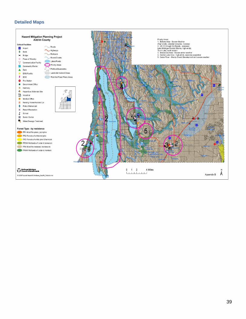
Table 2: Priority Areas for Antrim County
Natural Hazards Mitigation Priority Areas
Priority Area 1: The Village of Bellaire (County Seat) area has a high damage potential from high winds and tornados; and flooding of residential areas. Mitigation Strategies: High Winds, Flooding
Priority Area 2: Highway U.S. 31 through the Village of Elk Rapids and Torch Lake shoreline (Milton, Torch Lake, Central Lake, Forest Home, and Helena Townships). A high damage impact potential from severe thunderstorms and high winds affecting a high seasonal population rate and festivals in the summer. There are erosion concerns along Lake Michigan and Torch Lake coastal areas. Mitigation Strategies: Erosion, Severe Thunderstorm and High Winds
Priority Area 3: Torch Lake shoreline (Central Lake, Helena, Milton, Torch Lake townships and Village of Central Lake) and Village of Mancelona - A high damage impact potential from extreme winter weather including snow and ice hazards. Mitigation Strategies: Extreme Winter Weather
Priority Area 4: The Central Lake area (Village of Central Lake, Central Lake Township) has a high damage impact potential from severe thunderstorms and high winds, specifically affecting seasonal population increases at summer camps such as Camp Hayo-Went-Ha. Mitigation Strategies: Severe Thunderstorms
Priority Area 5: The Cedar River area (Kearney and Custer Townships, Shanty Creek resort), has a high damage impact potential from severe thunderstorms and high winds; snow and ice hazards. Mitigation Strategies: Severe Thunderstorms, Extreme Winter Weather
10
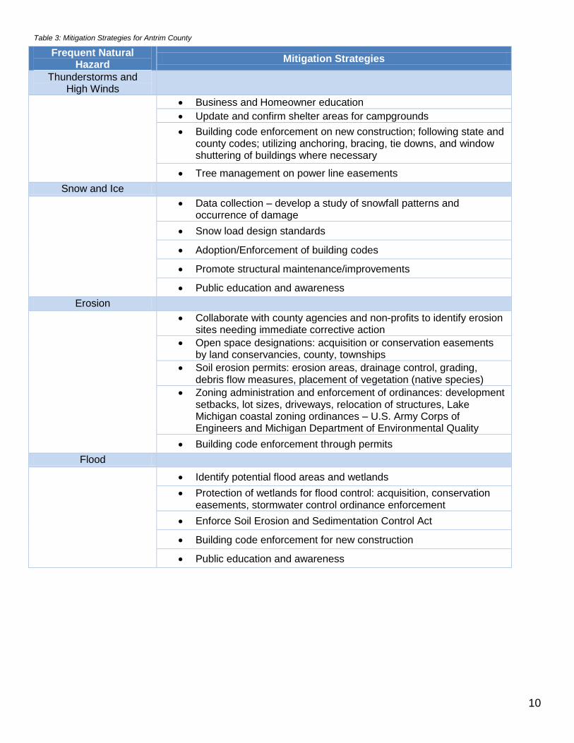
Table 3: Mitigation Strategies for Antrim County
Frequent Natural Hazard
Mitigation Strategies
Thunderstorms and High Winds
Business and Homeowner education
Update and confirm shelter areas for campgrounds
Building code enforcement on new construction; following state and county codes; utilizing anchoring, bracing, tie downs, and window shuttering of buildings where necessary
Tree management on power line easements
Snow and Ice
Data collection – develop a study of snowfall patterns and occurrence of damage
Snow load design standards
Adoption/Enforcement of building codes
Promote structural maintenance/improvements
Public education and awareness
Erosion
Collaborate with county agencies and non-profits to identify erosion sites needing immediate corrective action
Open space designations: acquisition or conservation easements by land conservancies, county, townships
Soil erosion permits: erosion areas, drainage control, grading, debris flow measures, placement of vegetation (native species)
Zoning administration and enforcement of ordinances: development setbacks, lot sizes, driveways, relocation of structures, Lake Michigan coastal zoning ordinances – U.S. Army Corps of Engineers and Michigan Department of Environmental Quality
Building code enforcement through permits
Flood
Identify potential flood areas and wetlands
Protection of wetlands for flood control: acquisition, conservation easements, stormwater control ordinance enforcement
Enforce Soil Erosion and Sedimentation Control Act
Building code enforcement for new construction
Public education and awareness
11
V. PURPOSE OF THE PLAN In 2000, the Disaster Mitigation Act shifted the Federal Emergency Management Agency’s (FEMA) scope of work to promoting and supporting prevention, or what is called hazard mitigation planning. FEMA requires government entities to have natural hazards mitigation plans in place and updated on a 5-year cycle as a condition for receiving grant money related to natural hazard remediation. The purpose of the Antrim County Natural Hazards Mitigation Plan is to find solutions to existing problems, anticipate future problems, prevent wasteful public and private expenditures, protect property values, and allocate land resources. The implementation of the Plan is to prevent injury, loss of life, property damage, breakdown in vital services like transportation and infrastructure, economic slumps, diminished tourist activity, liability issues, and damage to a community’s reputation. For Antrim County in the northwest region of the lower peninsula of Michigan, the planning process utilized the following steps in the development of the Plan. Emphasis was placed on natural hazards that have had significant impact on the community in the past.
Steps in the Planning Process
Identification of natural hazards and risks
Preparation of draft plan
Identification of natural hazards mitigation goals and objectives for emergency management programs
Selection of evaluation criteria
Selection of mitigation strategies using locally chosen criteria
Public Comment
Completion of the final plan
What is a Hazard? A hazard is an event or physical condition that has potential to cause fatalities, injuries, property damage, infrastructure damage, agricultural loss, damage to the environment, interruption of business, or other types of harm or loss. This plan focuses on principle natural hazards that occur in the northern lower region (see Page 12). This Plan is intended to be a resource for building coordination and cooperation within a community for local control of future mitigation and community preparedness.

12
Principle Natural Hazards in Northern Lower Michigan
Severe Storms (Thunderstorms, Winter storms)
High Winds
Tornadoes
Extreme Temperatures
Flooding
Shoreline Hazards
Dam Failures
Drought
Wildfires
Invasive Species
Subsidence
Source: FEMA
Percent of natural hazard events for all formal disaster declarations in the State of Michigan (1953 – 2014)
Figure 1: Disaster Declarations for the State of Michigan
Source: FEMA
What is Mitigation? Mitigation is the sustained action taken to lessen the impact from natural hazards and to work to reduce the long-term risk to human life and property from natural hazards and their effects. This long-term planning distinguishes mitigation from actions geared primarily to emergency preparedness and short-term recovery. This Plan can be used to lessen the impact, to support and be compatible with community goals, to lay out considerations in choosing and evaluating methods, and to look at the feasibility of mitigation strategies. VI. COMMUNITY PROFILE

13
Antrim County is located in Northwest Lower Michigan and is bordered on the west by Lake Michigan and Grand Traverse Bay and on the east by the Mackinaw State Forest, also referred to as the Jordan River Valley. The county is covered with a rolling terrain, with many lakes and rivers throughout the area. Most notable of the lakes is Torch Lake, considered to be one of the most beautiful lakes in the world. This lake is on a chain of lakes that runs from Bellaire, the county seat, to Elk Rapids. Another chain of lakes in the county goes from Bellaire north through Central Lake and Ellsworth, with the largest of these being Intermediate Lake. The largest concentration of people and businesses is in Mancelona located in the southeast corner of the county on US-131. There has not been any major infrastructure development, nor major hazard mitigation efforts, in the county since the last adoption of the Plan in 2007. The following community data is provided to describe Antrim County for planning and implementing mitigation strategies.
Table 4: Geographic features for Antrim County
Feature Measure
Area in Water 31,161 acres
Forest Lands 180,821 acres
Wetlands 6,513 acres
Farmland (2012) 64,167 acres
Operating Farms (2012) 415
Miles of Great Lakes shoreline 27 miles
Source: US Agricultural Census, 2012; County Data
The total County population is 23,580. The projected growth for 2020 is 25,780 and for 2030 it is 26,502. The population numbers from the 2010 Census for the 15 Townships and 5 Villages covered by this plan include:
Table 5: Antrim County Population
Township/City/Village Population Township/City/Village Population
Banks Township 1,260 Mancelona Township 3,010
Central Lake Township 1,246 Milton Township 2,204
Chestonia Township 511 Star Township 926
Custer Township 1,136 Torch Lake Township 1,194
Echo Township 877 Warner Township 416
Elk Rapids Township 989 Village of Ellsworth 349
Forest Home Township 1,239 Village of Central Lake 952
Helena Township 1,001 Village of Elk Rapids 1,642
Jordan Township 992 Village of Bellaire 1,086
Kearney Township 1,160 Village of Mancelona 1,390
Source: U.S. Census Bureau, 2008-2012 American Community Survey
There are 17,749 Housing Units in Antrim County with an average household size of 2.4 people per household.
The number of residents 65 years and over is 22.4% of the population.

14
The number of residents 19 years and under is 22.6% of the population.
The number of residents over 65 with a disability was 32.4% of the population.
The total Number of residents with disability was 14.7% of the population.
The percentage of residents that speak English less than ‘very well’ is 0.5% of the population.
February 2014 Poverty level: o $19,790 Family of 3 o $11,670 Family of 1
Table 6: Poverty Statistics for Antrim County
Poverty Statistics
Families in poverty 10.7%
Income less than $15,000 12.2%
Population in poverty 16.0% Source: U.S. Census Bureau, 2008-2012 American Community Survey
Table 7: Economic Census for Antrim County
Industry Description Number of
Establishments Number of Employees
Manufacturing 40 732
Wholesale Trade 12 41
Retail Trade 89 479
Information 12 46
Real Estate, Rental, Leasing
21 65
Professional, Scientific, Technical Services
36 NA
Administrative, Support, Waste Management, Remediation Services
22 25
Educational Services 3 NA
Health Care, Social Assistance
55 349
Arts, Entertainment, Recreation
9 NA
Accommodation and Food Services
59 1007
Other Services (except administration)
62 253
Source: US Census Bureau: County Business Patters 2008-2012

15
VII. THE DEVELOPMENT OF THE PLAN Data Methodology and Map Development Antrim County staff identified the critical facilities and infrastructure on the base map and provided updated GIS .shp files for mapping purposes.
Table 8: Critical Facilities and Infrastructure in Antrim County
5 Airports
11 Banks
7 Bridges
9 Communications Facilities
33 Community Shelters
3 Dams
9 Emergency Management Systems Facilities
1 Emergency Operations Center
14 Fire Stations
19 Government Buildings
15 Hazardous Materials Sites or Facilities
3 Industrial Sites
5 Medical Buildings (urgent care and clinics)
3 Nursing Homes and/or Assisted Living Facilities
6 Police Stations/Jail
25 Places of Worship
6 Resort/Recreational
15 School buildings
4 Senior Centers
3
Water and Sewage Treatment Facilities
Water: 18.6% public system or private company; 71.1% individual wells;
Sewer: 18.6% public sewer; 79.2% individual septic/cesspool; 2.2% other
1 U.S. Fish and Wildlife Service Fish Hatchery Source: Antrim County Data
Flood Data Flood hazard information may be obtained from the Flood Insurance Rate Maps (FIRM) available for jurisdictions. In order to delineate potential flood plain areas (seasonal floodplains) for each county, NWMCOG overlaid wetland, soils, and elevation data to determine the most likely flood prone areas. Once overlaid; isolated polygons (areas) were removed in order to show a more accurate representation of potential flood prone areas along lakes, rivers, and streams. Sources: Temporary/Seasonally Flooded Areas data are from the National Wetland Inventory of the US Fish and Wildlife Service; hydric soils data are from the county digital soil surveys (where available); and Digital Elevation Model data are from the Center for Geographic Information, Michigan Department of Information Technology.

16
Natural Flood Insurance Program (NFIP) participants: In addition to the current participants, the County is working to establish a baseline elevation figure to determine if property owners in other municipalities qualify for coverage under the NFIP. Table 9: NFIP Participation
Municipality NFIP status
Flood Maps
Year Joined
Banks Township P Y 1988
Elk Rapids Township P N 1988
Milton Township P Y 1983
Torch Lake Township P Y 1992
Village of Elk Rapids P Y 1988
According to an official database associated with the National Flood Insurance Program, Antrim County has no properties currently designated as suffering from repetitive losses in insured flood events. Fire Data Modern forest fire data were obtained from the USDA forest service and the Departments of Natural Resources in Minnesota, Wisconsin, and Michigan. Fire regimes data (fire prone areas) were provided by the USDA Forest Service, North Central Research Station located in Wisconsin. Land type associations, and historical and modern fire rotations were used to identify the fire prone areas. Tornadoes - National Weather Service Damaging Winds - National Weather Service Large Hail - National Weather Service Winter Weather - National Weather Service Landslide/Erosion Shoreline erosion and landslide incident zones were delineated by the US Geological Service. Digital Elevation Model data from the Center for Geographic Information are from the Michigan Department of Information Technology. Other hazards such as earthquakes and subsidence were considered but are not substantial risks in Antrim County. Natural Hazards Recorded Events Data for weather events was compiled from the National Oceanic and Atmospheric Administration’s (NOAA) website utilizing the following sections:
Weather/Climate Events, Information, Assessments
Climatology and Extreme Events
NOAA Storm Event Database; 1950 to present, local storm reports, damage reports, events checked for Antrim County included: Flood (Flash Flood, Flood, Lakeshore Flood), Hail (Hail), Snow and Ice (Blizzard, Extreme Cold/Wind Chill, Freezing Fog, Frost/Freeze, Heavy Snow, Ice Storm, Lake-effect Snow, Sleet, Winter Storm, Winter Weather), Tornado (Tornado, Funnel Cloud), Thunderstorm and High Wind (Heavy Rain, High Wind, Lightning, Strong Wind, Thunderstorm Wind), Wildfire (Wildfire)
The following list includes the frequency, dates, and descriptions of the most severe natural hazard events that have occurred within Antrim County, according to the NOAA Storm Event Database; January 1950 – August 2014. Extreme Winter Weather includes events with ice covering, property damage, and/or up to/over 12 in. of snow. Severe Thunderstorm include 50 knot winds + and property damage figures. Flood/Flash Flood: 1 Event

17
Table 9: Flood Events for Antrim County
Month Year Location Effect Damage Other Event
July 1999 Elk Rapids 4-6 in. watered covered secondary roads
NA Flash Flood
Hail: 18 Events Table 10: Hail Events for Antrim County
Month Year Location Effect Damage
July 1979 County 1.00 in. $0
October 1989 County 0.75 in. $0
July 1996 Eastport 1.50 in. $0
June 2000 Mancelona 0.75 in. $0
May 2001 Kewadin, Eastport 0.75 in. $0
August 2004 Central Lake 0.88 in. $0
June 2005 Mancelona 0.88 in. $0
July 2006 Kewadin 1.0 in. $30,000 (property/crop)
July 2006 Mancelona 1.25 in. $0
March 2007 Ellsworth 0.75 in. $0
October 2007 Mancelona 0.75 in. $0
October 2007 Alba 1.50 in. $0
June 2008 Mancelona 0.88 in. $0
July 2008 Chestonia 0.75 in. $0
August 2008 County 0.75 in. – 1.50 in.
$0
May 2012 Central Lake 1.0 in. $0
May 2013 Clam River, Bellaire, Chestonia
0.75 in. – 1.00 in.
$0
May 2013 County 1.0 in. $0
Extreme Winter Weather: 133 Events Table 11: Extreme Winter Weather Events for Antrim County
Month Year Location Effect Damage Other Event
March 1993 Region 6-12 in. snow $500,000(statewide)
April 1993 Region Snow depth not given
$50,000
January 1994 County Snow depth not given
$5,000,000(statewide)
November 1996 County 21-35 in. snow
NA
December 1996 County 12-18 in. NA
Month Year Location Effect Damage Other Event
December 1998 Region 6-18 in. snow NA
Extreme Winter Weather (continued)

18
January 1999 Region 6-12 in. snow NA
December 1999 Region 12-14 in. snow NA
February 2001 Region 1/4 in. ice NA Ice Storm
December 2001 Region 20 in. snow NA
February 2002 Region 10-16 in. $5,000
January 2003 Region 6-12 in. snow NA
November 2003 Region High Winds NA
December 2003 Region 10-15 in. snow NA
January 2004 County 6-12 in. snow/ drifting
NA
January 2005 Region 1/4 - 1/3 in. ice NA Ice Storm
February 2007 County 20-30 degrees below zero
NA Extreme Cold/Wind Chill
December 2008 Alba 10-15 in. snow NA
January 2009 Mancelona 6-12 in. snow NA
January 2009 Bellaire 8-12 in. snow NA
December 2009 Central Lake 12 in. snow NA
January 2012 Mancelona 8-12 in. Snow NA
March 2012 County 6-14 in. snow/power outages
NA
April 2012 County Killing frost $10,000,000 (crop) Frost/Freeze
December 2012 County
6-10 in. snow/downed trees/power outages
$12,000
November 2013 Central Lake 12 in. snow NA
December 2013 County 18 in. snow NA
January 2014 Bellaire, Ellsworth
12+ in. snow NA
February 2014 County
45 mph winds/wind chill 15-25 degrees below zero
NA

19
Severe Thunderstorms/High Winds: 54 Events Table 12: Storm Events for Antrim County
Month Year Location Effect Damage Other Event
May 1965 County 52 knots NA
July 1995 Bellaire 52 knots $10,000
May 1996 Mancelona 50-60 knots/ building damage
NA
September 1998 Alba 70 knots NA
November 1998 County 50 knots/trees uprooted/ power outages
NA
July 1999 Bellaire 50 knots/trees down/ straight line wind damage
NA
June 2001 Kewadin 50 knots/ trees downed NA
August 2001 Kewadin, Elk Rapids 50 knots/ large limbs down
NA
October 2001 Region 50 knots/ trees and power lines down
NA
April 2002 Kewadin, Mancelona
50-55 knots/ trees and power line down
NA
July 2002 Elk Rapids, Eastport, Kewadin, Alba, Mancelona
50 knots/ trees and power lines down
NA
August 2002 Bellaire, Torch Lake 50-52 knots/ trees down NA
November 2003 Region 52 knots/ trees and power lines down/ power outages
$20,000
August 2004 Central lake Trees down NA
August 2004 Alden 52 knots/ trees down $6,000
June 2005 Alba 50 knots/ hiker injured by falling tree
NA
June 2005 Mancelona 57 knots/ trees down/ building damage
$40,000
September 2005* County 55 knots/ trees and power lines down
$15,000
November 2005 County 52 knots/ trees down $3,000
November 2005 County 52 knots/ trees down $10,000
November 2005 County 52 knots/ trees down $10,000
May 2006 Alba 52 knots/ trees down $4,000
July 2006 Elk Rapids 53 knots/ trees down/crops destroyed
$4,000
July 2006 Bellaire 55 knots/ trees down/ crops destroyed
$25,000
August 2006 Bellaire 52 knots/ trees and power lines down
$6,000
August 2006 Mancelona 52 knots/ trees and power lines down
$7,000
May 2007 Kewadin 52 knots/ trees down/ property damage
$1,500
Severe Thunderstorms/High Winds (continued)
20
Month Year Location Effect Damage Other Event
July 2007 Mancelona 52 knots/ trees down/ waterspout on Torch Lake
$3,000
October 2007 Kewadin 56 knots/ gusts up to 65 mph
NA
April 2008 Elk Rapids 50 knots/ trees down $2,000
April 2008 Bellaire 50 knots/ trees down $1,500
April 2008 Mancelona 52 knots/ trees and power lines down
$5,000
June 2008 Mancelona 52 knots/ gusts 60 mph NA
July 2008 Chestonia 50 knots/ tree limbs down $1,000
July 2008 Alba 50 knots/ metal flag pole down
$1,500
October 2009 County 55 knots/ trees down/ building and vehicle damage
$3,000
May 2011 Alden 55 knots/ trees down $10,000
May 2011 Mancelona 52 knots/ trees and power lines down
$18,000
May 2011 Kewadin 56 knots/ tree limbs down $500,000
June 2011 County 50 knots/ trees down $2,000
June 2012 County Lightning destroyed home $80,000 Lightning
May 2013 Kewadin 55 knots/ trees down $8,000
May 2013 Mancelona 50 knots/ trees down $3,000
September 2013 County 52 knots/ trees down/ vehicle damage
$21,000
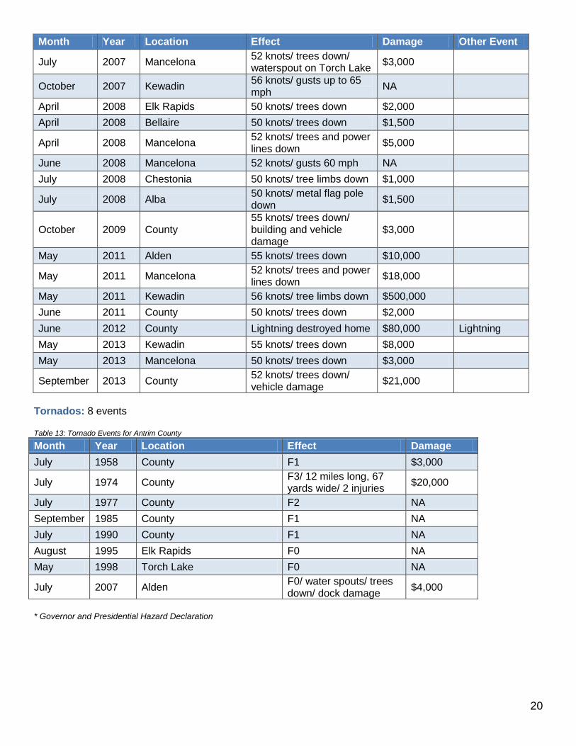
Tornados: 8 events Table 13: Tornado Events for Antrim County
Month Year Location Effect Damage
July 1958 County F1 $3,000
July 1974 County F3/ 12 miles long, 67 yards wide/ 2 injuries
$20,000
July 1977 County F2 NA
September 1985 County F1 NA
July 1990 County F1 NA
August 1995 Elk Rapids F0 NA
May 1998 Torch Lake F0 NA
July 2007 Alden F0/ water spouts/ trees down/ dock damage
$4,000
* Governor and Presidential Hazard Declaration

21
Other Possible Natural Hazard Events Drought In Northern Michigan’s forested regions, drought can adversely impact timber production and some tourism and recreational enterprises. This can also cause a drop in income, which impacts other economic sectors. The biggest problem drought presents, however, is the increased threat of wildfire. Many Northern Michigan counties are heavily forested and are therefore highly vulnerable to drought-related wildfire threats. The most extreme drought was in January 1931, when the Palmer index hit a record low of -8.07. Lengthy drought incidents took place in 1895-1896 (17 months), 1898-1899 (8 months), 1899-1901 (21 months), 1901-1902 (15 months), 1908-1911 (37 months), 1913-1914 (11 months), 1914-1915 (10 months), 1919-1920 (8 months), 1920-1922 (17months), 1925-1926 (17 months), 1929-1931 (28 months), 1935-1936 (20 months), 1955-1956 (13 months), and 1976-1977 (13 months). Wildfires 194 wildfires occurred in Antrim County from 1981 to 2010, affecting nearly 194 acres countywide Pandemics or other Public Health Emergencies Naturally occurring pandemics may cause widespread precautions around the world. The Northwest Michigan Health Department created a pandemic plan that serves Antrim County is used as a template for responding to a large-scale outbreak of influenza and other highly infectious respiratory diseases. Probability of Natural Hazards Natural hazards such as hail, thunderstorm and high wind, tornadoes, snow and ice, flooding, and shoreline erosion that will affect Northwest Michigan is a perennial concern. The magnitude and severity depends on the season, which determines temperature, moisture in the air, ice cover on the lakes, etc. Additionally, the severity of an event is directly proportional with tourist activity throughout the year, the pace of residential development, and an increasing base population that affects overall land use in the region. The events recorded indicate that natural hazard events may be happening more frequently, but the geographic impact of the natural hazards’ impact has remained the same in Antrim County. The areas where natural hazards overlap in Antrim County may include heavy snow that causes trees and power lines down, and then melting, rain and flooding. Rising water levels with high winds can cause coastal landslides/debris flow/erosion. Antrim County Natural Hazards Task Force and Public Input The Natural Hazards Task Force comprised of the County’s Local Planning Team (LPT) which is a collection of first responders and local, regional, and state public entities that ensure the readiness of County entities by recommending equipment purchases, training and exercises, and public education on preparedness issues. The Task Force meetings were scheduled monthly in 2014, held in various locations throughout the county, and open to the public. Participants analyzed and updated the hazard priority maps, goals & objectives, hazard priority areas, mitigation measures, and the action agenda items.
According to the Michigan Hazard Analysis report, 3 Dams are listed as a “Extreme Hazards” should failure occur.
Bellaire area where high winds and tornadoes have occurred in the past; also flooding near the seasonal marina and houses
Mancelona area for snow and ice hazards; the Road Commission’s main maintenance garage is located here, where the most industry and population levels are the largest in the county
Central Lake area concerns thunderstorms and high winds where a large seasonal Camp Hayo–Went-Ha is located
Cedar River area has the large Shanty Creek Resort with three different villages with its own sewer, water tower, communications and potential for high winds
Seasonal population fluctuations, especially festivals:

22
o Elk Rapids: Harbor Days, Paddle Antrim o Bellaire: Rubber Ducky Days o Mancelona: Bass Festival o Central Lake: Antrim Outdoors o Eastport: Petoskey Stone Festival o 4th of July events: Central Lake, South Torch Lake Sand Bar
Over 1,700 oil and gas wells and gathering plants – gas explosion incident in Mancelona
Lakes of the North area – historic fire with no re-growth Natural Hazards Priority Areas were narrowed to the top 5 significant according to the Task Force and the priority areas have not changed since the adoption of the original plan. Top Five Natural Hazards Priority Areas
1. The Village of Bellaire (County Seat) area has a high damage potential from high winds and tornados; and flooding of residential areas.
There is a historical record of high wind events around the village and a few tornadoes in the county. Severe winds or straight line winds that sometimes occur during severe thunderstorms can be very damaging to a community. Severe winds have the potential to cause loss of life from property damage and flying debris. Damage from straight line winds is more widespread than tornadoes and usually affects multiple counties. There is also risk of infrastructure damage from downed power lines from falling trees and limbs.
In addition to “regular” flooding in a riverine floodplain, other flooding may involve low lying areas that collect runoff waters; flaws or shortcomings in existing sewer infrastructure; undersized or poorly designed storm water control practices; collective effects of land use and development trends; illegal diversion of water, or actions that interfere with system function.
2. Highway U.S. 31 through the Village of Elk Rapids and Torch Lake shoreline (Milton, Torch Lake,
Central Lake, Forest Home, and Helena Townships). A high damage impact potential from severe thunderstorms and high winds affecting a high seasonal population rate and festivals in the summer. There are erosion concerns along Lake Michigan and Torch Lake coastal areas. There is a historical record of severe thunderstorms and high wind events affecting the Village of Elk Lake and vicinity. These weather events may produce lightning strikes, flash flooding, hail, strong winds, and tornadoes.
Erosion hazards involve the loss of property as sand or soil is removed by water over time, which may
cause built structures to stand perilously close to waters or bluffs. The foundation of a built structure and/or underground utility pipes may become fully exposed and vulnerable to weather, extreme temperatures, water damage, etc.
Roadways along shorelines are susceptible to banks eroding which causes the road to become more
vulnerable to various types of surface and/or structural degradation.

23
Top Five Natural Hazards Priority Areas (continued)
3. Torch Lake shoreline (Central Lake, Helena, Milton, Torch Lake townships and Village of Central Lake) and Village of Mancelona - The potential for extreme winter weather with snow and ice hazards, the County experiences a large seasonal population flux and is home to the County Road Commission’s main offices and maintenance garage
Antrim County experiences frequent heavy snow events due to its location in a “snow-belt” area. Heavy snow events have the potential of shutting down towns and businesses for a significant period of time. Blowing and drifting snow with blizzard conditions cause driving hazards.
4. The Central Lake area (Village of Central Lake, Central Lake Township) has the potential of severe
thunderstorms and high winds with the concerns of the seasonal population increases at summer camps such as Camp Hayo-Went-Ha.
There is a historical record of severe thunderstorms and high wind events affecting the Village of Elk Lake and vicinity. These weather events may produce lightning strikes, flash flooding, hail, strong winds, and tornadoes. Severe or straight line winds that sometimes occur during severe thunderstorms can be very damaging to a community. Severe winds have the potential to cause loss of life from property damage and flying debris. Damage from straight line winds is more widespread than tornadoes and usually affects multiple counties. There is also risk of infrastructure damage from downed power lines from falling trees and limbs.
5. The Cedar River area (Kearney and Custer Townships, Shanty Creek resort), has the potential for
severe thunderstorms and high winds, snow and ice hazards.
There is a historical record of severe thunderstorms and high wind events in this section of the county with concerns regarding the increase of seasonal population levels. These weather events may produce lightning strikes, flash flooding, hail, strong winds, and/or tornadoes. Severe or straight line winds that sometimes occur during severe thunderstorms can be very damaging to a community. Severe winds have the potential to cause loss of life from property damage and flying debris. Damage from straight line winds is more widespread than tornadoes and usually affects multiple counties. There is also risk of infrastructure damage from downed power lines from falling trees and limbs.
Antrim County experiences frequent heavy snow events due to its location in a “snow-belt” area. Heavy snow events have the potential of shutting down towns and businesses for a significant period of time. Blowing and drifting snow with blizzard conditions cause driving hazards. The Shanty Creek Resort includes three (3) resort villages, a water tower and a communications tower.
Emergency Warning System Coverage Mancelona and Bellaire sirens are not working because there is no funding available for maintenance. Elk Rapids has a working siren with approximately 1,700 people covered plus seasonal influx in the summer.

24
Economic Impact Analysis
The total Damaging Events’ Costs recorded since 1950 with the National Oceanic and Atmospheric Administration for Antrim County, the region, and the state are as follows: Table 14: Damage Cost by Natural Hazard for Antrim County
Antrim County Property Damage Cost Crop Damage Cost
Drought NA NA
Flood $160,000 NA
Hail NA $500,000
Snow and Ice $35,000 NA
Tornado $262,750 NA
Thunderstorm and High Wind
$324,000 NA
Wildfire NA NA
The Antrim County Equalization Department calculated each Priority Area’s economic value through the State Equalized Values (SEV) for real and personal property (residential and commercial). The following includes 2010 Census data and 2014 SEV dollar amount times two (estimated fair market values) for each priority area. According to the 2014 Northwest Michigan Season Population Analysis, assume a 22% increase to account for the average seasonal population within the county. Table 15: Economic Value by Geography for Antrim County
Priority Area(s)
Geography Population State Equalized Value
Antrim County 23,370 $1,986,800,439
1 Village of Bellaire area 3,485 $384,528,160
2 US 31 communities 9,515 $1,582,636,122
3 Torch Lake shoreline area and Village of Mancelona
7,987 $976,449,191
4 Central Lake area 3,156 $174,177,930
5 Cedar River area (including Shanty Creek Resort)
6,376 $356,513,913

25
VIII. NATURAL HAZARDS MITIGATION GOALS AND OBJECTIVES The mission of the Antrim County Natural Hazards Mitigation Plan is to protect the health and safety of the public and property in the County which includes prevention of injury, loss of life, property damage, breakdown in vital services like transportation and infrastructure, economic slumps, maintain tourist base, and liability issues. This is done by taking action to permanently eliminate or reduce the long-term risks from natural hazards. Specific goals and objectives have been established based upon the community’s natural hazards analysis, as well as input from the Task Force participants and the public through meetings, request for comments on the draft plan, and the presentation of the plan to the Antrim County Planning Commission. Goal 1: Increase local awareness and participation in natural hazards mitigation strategies
Encourage cooperation and communication between planning and emergency management officials
Encourage additional local governmental agencies to participate in the natural hazards mitigation process
Encourage public and private organizations to participate, including organizations who advocate for individuals with functional or access needs
Goal 2: Integrate natural hazards mitigation considerations into the community’s
comprehensive planning process
Enforce and/or incorporate natural hazards mitigation provisions in building code standards, ordinances, and procedures; and into the county’s comprehensive master plan
Incorporate natural hazards mitigation into basic land use regulation mechanisms
Update of zoning ordinances to reflect new building codes, shoreline protection rules, etc.
Incorporate natural hazards area classifications into standard zoning classifications
Develop community education and warning systems
Strengthen the role of the Local Emergency Planning Committee in the land development process
Integrate natural hazards mitigation into the capital improvement planning process so that public infrastructure does not lead to development in natural hazards areas
Encourage county agencies to review local roads, bridges, dams, and related transportation infrastructure for natural hazards vulnerability
Goal 3: Utilize available resources and apply for additional funding for natural hazards
Mitigation
Provide a list of desired community mitigation measures to the State for possible future funding
Encourage the application for project funding from diverse entities Goal 4: Develop and complete natural hazards mitigation projects in a timely manner
Encourage public and business involvement in natural hazards mitigation projects
26
IX. IDENTIFICATION AND SELECTION OF MITIGATION STRATEGIES A set of evaluation criteria was developed to determine which mitigation strategies were best suited to address the identified problems in Antrim County.
The measure must be technically feasible.
The measure must be financially feasible.
The measure must be environmentally sound and not cause any permanent, significant environmental concerns.
The measure must be acceptable to those participating in the strategy and/or primarily impacted by the strategy.
By anticipating future problems, the County can reduce potential injury, structure losses, loss of power such as electric and gas, and prevent wasteful public and private expenditures. Priority Area 1: Severe Thunderstorms/High Winds and Flooding - The Village of Bellaire area
Wind Mitigation Strategies
Business and homeowner education; creation of shelters and safe rooms where necessary
Building code enforcement on new construction; follow state and county codes: utilize techniques such as anchoring, bracing, tie downs, and/or window shuttering of buildings
Tree management on power line easements; incorporate urban forestry practices
Flood Mitigation Strategies: (including NFIP participants)
Identify potential flood areas and wetlands
Protection of wetlands for flood control: acquisition, conservation easements
Stormwater Control ordinance enforcement
Building code enforcement for new construction
Public education and awareness Priority Area 2: Severe Thunderstorms/High Winds and Erosion - Highway U.S. 31 through the Village
of Elk Rapids and Torch Lake shoreline (Milton, Torch Lake, Central Lake, Forest Home, and Helena Townships).
Erosion Mitigation Alternatives
Collaborate with county agencies and non-profits to identify erosion sites needing immediate corrective action
Open space designations: acquisition or conservation easements by land conservancies, county, townships
Soil erosion permits: erosion areas, drainage control, grading, debris flow measures, placement of vegetation (native species)
Zoning administration and enforcement of ordinances: development setbacks, lot sizes, driveways, relocation of structures, Lake Michigan coastal zoning ordinances – U.S. Army Corps of Engineers and Michigan Department of Environmental Quality
Building code enforcement through permits

27
Priority Area 2 (continued):
Thunderstorm and High Wind Mitigation Strategies
Business and Homeowner education
Update and confirm shelter areas for campgrounds
Building code enforcement on new construction; follow state and county codes: utilize techniques such as anchoring, bracing, tie downs, and/or window shuttering of buildings
Tree management on power line easements Priority Area 3: Extreme Winter Weather - Torch Lake shoreline (Central Lake, Helena, Milton, Torch
Lake townships and Village of Central Lake) and Village of Mancelona
Snow and Ice Strategies
Data collection – develop a study of snowfall patterns and occurrence of damage
Snow load design standards – develop planning grant for a study of the county areas
Adoption/Enforcement of building codes – state code is 60 lbs. per sq. ft.; consider increase in minimal lbs. per sq. ft.
Promote structural maintenance/improvements – history of pole barns, and heavy industrial warehouse roof cave-ins
Public education and awareness Priority Area 4: Central Lake area (Village of Central Lake, Central Lake Township) – Severe
Thunderstorms/High Winds
Thunderstorm and Wind Mitigation Strategies
Business and homeowner education
Designated shelter areas for camps, campgrounds
Building code enforcement on new construction; follow state and county codes: utilize techniques such as anchoring, bracing, tie downs, and/or window shuttering of buildings
Tree management on power line easements
Snow and Ice Strategies
Data collection – develop a study of snowfall patterns and occurrence of damage
Snow load design standards – develop planning grant for a study of the county areas
Adoption/Enforcement of building codes – state code is 60 lbs. per sq. ft.; consider increase in minimal lbs. per sq. ft.
Promote structural maintenance/improvements – history of pole barns, and heavy industrial warehouse roof cave-ins
Public education and awareness
28
X. PARTICIPATION IN THE DEVELOPMENT OF THE ANTRIM COUNTY NATURAL HAZARDS MITIGATION PLAN
The opportunities for review by other governmental entities and the public included the following:
The Natural Hazards Mitigation Plan was presented to the Antrim County Planning Commission where the meetings are posted in the newspaper and are open to the public.
The Natural Hazards Mitigation Plan was presented to the Antrim County Board of Commissioners where the meetings are posted in the newspaper and are open to the public.
During development of the plan, all townships and villages were provided the opportunity to formally comment on plan drafts and other related materials. They were given the opportunity via mailings of both meeting notices and draft copies of the plan for comment. Notification was also provided to them that the plans were posted on the NWMCOG website and could be reviewed there. While no jurisdictions (other than the county) provided formal written comments, they did provide county staff (particularly the county emergency manager) with feedback via other informal means. This feedback took the form of phone calls, emails and conversations that occurred at various non-mitigation related meetings throughout the county. This information was provided back to NWMCOG staff by the county staff and used in development of the plan, including the risk assessment and community profile sections.
In addition, the townships and villages (whether or not they have their own zoning) have indicated to NWMCOG and the county emergency manager that they will follow the county's lead in identifying mitigation projects and developing grant applications to fund those projects. Land use issues associated with those projects (where applicable) will be handled by each jurisdiction that controls zoning in the project area.
Community planning services are provided by the professional staff of the Antrim County Administration & Planning Department. The Department assists communities in developing plans and zoning ordinances, provides resource information and technical assistance, and convenes communities to address land use issues of common interest. The Antrim County Planning Commission coordinates and reviews local zoning and master plans to ensure consistency across jurisdictional boundaries. Building permits are issued by the Antrim County Construction Code Department

29
The Townships/Villages in the priority areas include:
Village of Bellaire - Zoning Village of Central Lake Village of Elk Rapids - Zoning Forest Home Township - Zoning Milton Township - Zoning Kearney Township - Zoning Torch Lake Township - Zoning Custer Township Central Lake Township Village of Mancelona – Zoning
Table 16: Plan Participation
County/Township/Others Zoning Participation Antrim County No Task Force meetings, review of draft plans:
County Commissioners Emergency Management Coordinator Equalization Department Housing Commission Planning Commissioners Planning Department Road Commission
Banks Yes See last bullet point paragraph, above
Village of Ellsworth Yes See last bullet point paragraph, above
Central Lake No See last bullet point paragraph, above
Village of Central Lake No See last bullet point paragraph, above
Chestonia No See last bullet point paragraph, above
Custer No See last bullet point paragraph, above
Echo No See last bullet point paragraph, above
Elk Rapids Yes See last bullet point paragraph, above
Village of Elk Rapids Yes See last bullet point paragraph, above
Forest Home Yes See last bullet point paragraph, above
Village of Bellaire Yes See last bullet point paragraph, above
Helena Yes See last bullet point paragraph, above
Jordan No See last bullet point paragraph, above
Kearney Yes See last bullet point paragraph, above
Mancelona Yes See last bullet point paragraph, above
Village of Mancelona Yes See last bullet point paragraph, above
Milton Yes See last bullet point paragraph, above
Star No See last bullet point paragraph, above
Torch Lake Yes See last bullet point paragraph, above
Warner No See last bullet point paragraph, above
American Red Cross N/A Task Force meetings, review of draft plans
**The Grand Traverse Band of Indians may adopt the approved County plan as their own. N/A = Not applicable; these are non-governmental authority entities

30
XI. IMPLEMENTATION OF THE ANTRIM COUNTY NATURAL HAZARDS MITIGATION PLAN Natural Hazards Mitigation Plan Managers and Technical Assistance The Antrim County Board of Commissioners will lead the implementation of the Natural Hazards Mitigation Plan, with support from the Emergency Management Coordinator and the Planning Department. Working partnerships can be established with the following agencies to provide technical assistance to accomplish the goals and objectives of the Plan.
Antrim County Government Staff
Townships, cities, and villages
Antrim County Conservation District
Antrim County Road Commission
Grand Traverse Band of Ottawa and Chippewa Indians
Grand Traverse Regional Land Conservancy
The Watershed Center Grand Traverse Bay
New Designs for Growth
Tip of the Mitt Watershed Council
Michigan State University Extension
Michigan Department of Environmental Quality
Michigan Department of Natural Resources
U.S. Environmental Protection Agency
U.S. Army Corps of Engineers
U.S. Department of Agriculture Natural Resources Conservation Service
Insurance Companies
Real Estate Companies All natural hazards mitigation planning could be pursued with the new tool available to the local governments which is the Michigan Public Act 134 of 2010, the Enrolled House Bill Number 6152; and Michigan Public Act 226 of 2003, the Joint Municipal Planning Act. These Acts provides for joint land use planning by cities, villages, and townships and allows two or more municipalities’ legislative bodies to create a single joint planning commission to address planning issues. This tool helps with planning for the “big picture” issues such as natural hazards that cross jurisdictional boundaries. The intent of this legislation is for local governments to consider the following:
Individual units of government modifying their ordinances simultaneously to include language that would incorporate aspects of protection
Developing an overlay zoning district that would cross jurisdictional boundaries that would be incorporated into existing independent units of government’s zoning ordinances
Forming a new joint (multi-jurisdictional) planning commission or zoning board
Sharing zoning administration
Sharing enforcement activities Funding the Implementation of the Plan To assist with the funding of the proposed natural hazards mitigation strategies, here is a list of potential financial assistance entities to help fund the implementation projects of the Plan.
Federal Emergency Management Administration – Hazard Mitigation Grant Program
U.S. Environmental Protection Agency
U.S. Department of Agriculture Natural Resources Conservation Service Funding the Implementation of the Plan (continued)

31
U.S. Department of Agriculture Rural Development: Rural broadband opportunity – high speed telecommunication funding from the Public Telecommunications Facilities
Planning and Construction grants
U.S. Army Corps of Engineers: Apply to research and complete projects preventing erosion of critical Lake Michigan shoreline areas
U.S. Department of Housing and Urban Development
Michigan Department of Environmental Quality
Michigan Department of Natural Resources
National Oceanic and Atmospheric Administration
Community, Regional Foundations
Businesses: Home Depot (local store and Foundation: Educational initiatives that help families prepare their homes for natural disasters. The Home Depot Foundation assists organizations that provide developers and the general public with the information they need to make homes more disaster resistant.
Action Agenda The following is a summary for accomplishing the recommended natural hazards mitigation actions for Antrim County. Table 17: Action Strategies for Antrim County
Priority and Action Strategies Responsible Parties Timeframe
Priority Area 1: Flood Mitigation Strategies
a. Identify potential flood areas and wetlands
Emergency Management Coordinator Drain Commissioner County Conservation District County Planning County Building Inspector GIS Department
1-3 years from adoption of the plan
b. Protection of wetlands for flood control; acquisition, conservation easements
County Conservation District MI Department of Environmental Quality Non-profit conservation organizations Drain Commissioner County Planning
Ongoing
c. Soil erosion and sedimentation control
County Conservation District Drain Commissioner County Planning
Ongoing
d. Building code enforcement for new construction
County Building Inspector Ongoing
e. Public education and awareness
County Planning Emergency Management Coordinator County Conservation District Townships, Villages Drain Commissioner
Ongoing

32
Priority and Action Strategies Responsible Parties Timeframe
Priority Area 2: Erosion Mitigation Strategies
a. Inventory shoreline erosion sites
County Planning Emergency Management Coordinator County Conservation District Townships, Village
1-3 years from adoption of the plan
b. Open space designations: acquisition or conservation easements by land conservancies, county, townships
County Planning County Conservation District MI Department of Environmental Quality Non-profit conservation organizations
Ongoing
c. Soil erosion permits include erosion areas, drainage control, grading, debris flow measures, placement of vegetation (native species)
County Conservation District County Planning
Ongoing
d. Zoning administration and enforcement of ordinances
County Planning Townships, Village
Ongoing
e. Building code enforcement through permits
County Building Inspector
Ongoing
Priority Areas 3, 5: Snow and Ice Mitigation Strategies
a. Data collection – study of snowfall patterns and occurrence of damage
County Planning Emergency Management Coordinator County Building Inspector Village, Township
Ongoing
b. Develop a planning grant for a study of the county areas for snow load design standards
County Planning Emergency Management Coordinator County Building Inspector Village, Township
2-5 years from adoption of the plan
c. Adoption/Enforcement of building codes
County Planning Emergency Management Coordinator County Building Inspector Village, Township
Ongoing
d. Promote structural maintenance/improvements
County Building Inspector Emergency Management Coordinator Village, Township
Ongoing
e. Public education and awareness
County Planning Emergency Management Coordinator County Building Inspector Village, Township
Ongoing
33
Priority and Action Strategies Responsible Parties Timeframe
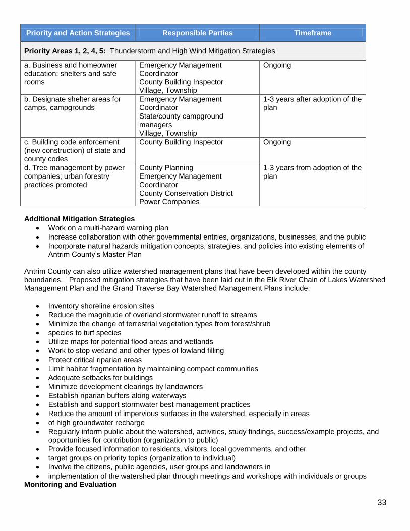
Priority Areas 1, 2, 4, 5: Thunderstorm and High Wind Mitigation Strategies
a. Business and homeowner education; shelters and safe rooms
Emergency Management Coordinator County Building Inspector Village, Township
Ongoing
b. Designate shelter areas for camps, campgrounds
Emergency Management Coordinator State/county campground managers Village, Township
1-3 years after adoption of the plan
c. Building code enforcement (new construction) of state and county codes
County Building Inspector Ongoing
d. Tree management by power companies; urban forestry practices promoted
County Planning Emergency Management Coordinator County Conservation District Power Companies
1-3 years from adoption of the plan
Additional Mitigation Strategies
Work on a multi-hazard warning plan
Increase collaboration with other governmental entities, organizations, businesses, and the public
Incorporate natural hazards mitigation concepts, strategies, and policies into existing elements of Antrim County’s Master Plan
Antrim County can also utilize watershed management plans that have been developed within the county boundaries. Proposed mitigation strategies that have been laid out in the Elk River Chain of Lakes Watershed Management Plan and the Grand Traverse Bay Watershed Management Plans include:
Inventory shoreline erosion sites
Reduce the magnitude of overland stormwater runoff to streams
Minimize the change of terrestrial vegetation types from forest/shrub
species to turf species
Utilize maps for potential flood areas and wetlands
Work to stop wetland and other types of lowland filling
Protect critical riparian areas
Limit habitat fragmentation by maintaining compact communities
Adequate setbacks for buildings
Minimize development clearings by landowners
Establish riparian buffers along waterways
Establish and support stormwater best management practices
Reduce the amount of impervious surfaces in the watershed, especially in areas
of high groundwater recharge
Regularly inform public about the watershed, activities, study findings, success/example projects, and opportunities for contribution (organization to public)
Provide focused information to residents, visitors, local governments, and other
target groups on priority topics (organization to individual)
Involve the citizens, public agencies, user groups and landowners in
implementation of the watershed plan through meetings and workshops with individuals or groups Monitoring and Evaluation

34
The Antrim County Natural Hazards Mitigation Plan will be monitored on a regular basis by the Emergency Management Coordinator and the Planning Department. Because Antrim County is a dynamic, changing county with population growth, it is expected that the plan should be reviewed on an annual basis. To assess the effectiveness of the Plan, some questions to ask include: 1) How many and which mitigation strategies were developed? Implemented? 2) Did any new natural hazards events take place the past year to report? This review will be administered by the Emergency Management Coordinator with the Local Emergency Planning Committee, the County Planning Commission and Department, and the public. If changes are needed, the plan will be presented to the Task Force participants for revisions. Although review of the plan will occur annually, and a formal revision may not be needed each year, a new edition of the plan will be expected within every five year period. New additions of the plan will be based on annual reviews, monitoring, evaluation, and an accumulation of official feedback and public input. When it is appropriate to publish a revised version of the plan, the Task Force participants shall again be involved in the revision process. Each new edition of the plan will again be officially adopted by the Antrim County Board of Commissioners.

35
XII. NATURAL HAZARDS MITIGATION PLAN ADOPTION RESOLUTION

36
XIII. APPENDICES Appendix A Glossary of Mitigation Planning Terms Alluvial fan: A gently sloping fan-shaped landform created over time by the deposition of eroded sediment and debris. Base Flood: A flood having a one percent chance of being equaled or exceeded in any given year. Coastal high hazard area: An area of special flood hazard extending from offshore to the inland limit of a primary frontal dune along an open coast and any other area subject to high velocity wave action from storms. Disaster: A major detrimental impact of a hazard upon the population and economic, social, and built environment of an affected area. Exposure: The number, types, qualities, and monetary values of various types of property or infrastructure and life that may be subject to an undesirable or injurious hazard event. Flood Insurance Rate Map: As defined under the National Flood Insurance Program, an official map of the community on which the administrator of the Flood Insurance Administration has delineated both the special flood hazard areas and the risk premium zones applicable to the community (FIRM). Floodplain or flood prone area: Any land area susceptible to being inundated by water from any source. Floodplain management: The operation of an overall program of corrective and preventive measures for reducing flood damage, including but not limited to emergency preparedness plans, flood control works, and floodplain management regulations. Fuel: Combustible plant material, both living and dead, that is capable of burning in a wildland situation; any other flammable material in the built environment that feeds a wildfire. Hazard: An event or physical condition that has the potential to cause fatalities, injuries, property damage, infrastructure damage, agricultural loss, damage to the environment, interruption of business, or other types of harm or loss. Hazard identification: The process of defining and describing a hazard, including its physical characteristics, magnitude and severity, probability and frequency, causative factors, and locations or areas affected. Lifeline systems: Public works and utilities such as electrical power, gas and liquid fuels, telecommunications, transportation, and water and sewer systems. Major disaster: As defined in the Stafford Act, “any natural catastrophe or, regardless of cause, any fire, flood, or explosion in any part of the United States, which in the determination of the President causes damage of sufficient severity and magnitude to warrant major disaster assistance under this Act to supplement the efforts and available resources of states, local governments, and disaster relief organizations in alleviating the damage, loss, hardship, or suffering caused thereby.” Mitigation: Sustained action taken to reduce or eliminate the long-term risk to human life and property from natural hazards and their effects. Note that this emphasis on long-term risk distinguishes mitigation from actions geared primarily to emergency preparedness and short-term recovery.

37
Multiple-objective management: A holistic approach to floodplain management (or the management of other hazards) that emphasizes the involvement of multiple distinct interests in solving land use problems related to the hazardous area. Natural hazard: Hurricanes, tornadoes, storms, floods, tidal wave, tsunamis, high or wind-driven waters, volcanic eruptions, earthquakes, snowstorms, wildfires, droughts, landslides, and mudslides. One hundred year flood: The flooding event that has a one percent chance of occurring in a particular location in any given year. While this is the most common reference point statistically because it is used for regulatory purposes in the National Flood Insurance Program, the same language applies in referring to other actual or hypothetical events in terms of their statistical probabilities. Risk: The potential losses associated with a hazard, defined in terms of expected probability and frequency, exposure, and consequences. Risk assessment: A process or method for evaluating risk associated with a specific hazard and defined in terms of probability and frequency of occurrence, magnitude and severity, exposure, and consequences. Special flood hazard area: Land in the floodplain within a community subject to one percent or greater chance of flooding in any given year. Stafford Act: The Robert T. Stafford Disaster Relief and Emergency Assistance Act (P.L. 93-288, as amended by P.L. 100-707), which provides the greatest single source of federal disaster assistance. Structure: A walled and roofed building, including a storage tank for gas or liquid that is principally above ground, as well as a manufactured home (trailer parks). Urban Wildfire: A fire moving from a wildland environment, consuming vegetation as fuel, to an environment where the fuel consists primarily of buildings and other structures. Urban/wildland interface: A developed area, also known as the “I-zone,” occupying the boundary between an urban or settled area and a wildland characterized by vegetation that can serve as fuel for a forest fire. Vulnerability: The level of exposure of human life and property to damage from natural hazards. Watershed management: The implementation of a plan or plans for managing the quality of flow of water within a watershed, the naturally defined area within which water flows into a particular lake or river or its tributary. The aims of watershed management are holistic and concern the maintenance of water quality, the minimization of stormwater runoff, the preservation of natural flood controls such as wetlands and pervious surface, and the preservation of natural drainage patterns. Watershed management is, in many ways, an enlargement of most of the concerns that underlie floodplain management. Wildland: An area in which development has not occurred with the exception of some minimal transportation infrastructure such as highways and railroads, and any structures that are widely spaced and serve largely recreational purposes.

38
Tornado Classifications:
F-Scale Number Intensity Phrase Wind
Speed Type of Damage Done
F0 Gale tornado 40-72 mph
Some damage to chimneys, breaks branches off trees, pushes over
shallow-rooted trees, damages sign boards.
F1 Moderate tornado 73-112
mph
The lower limit is the beginning of hurricane wind speed, peels surface off roofs; mobile homes pushed off foundations or overturned, moving
autos pushed off the roads, attached garages may be destroyed.
F2 Significant tornado 113-157
mph
Considerable damage. Roofs torn off frame houses, mobile homes
demolished, boxcars pushed over; large trees snapped or uprooted, light
object missiles generated.
F3 Severe tornado 158-206
mph
Roof and some walls torn off well constructed houses, trains overturned,
most trees in forest uprooted
F4 Devastating tornado 207-260
mph
Well-constructed houses leveled, structures with weak foundations
blown off some distance, cars thrown and large missiles generated.
F5 Incredible tornado 261-318
mph
Strong frame houses lifted off foundations and carried considerable distances to disintegrate, automobile sized missiles fly through the air in
excess of 100 meters, trees debarked, steel reinforced concrete structures
badly damaged.
F6 Inconceivable tornado 319-379
mph
These winds are very unlikely. The small area of damage they might produce would probably not be
recognizable along with the mess produced by F4 and F5 wind that
would surround the F6 winds. Missiles, such as cars and refrigerators would do serious secondary damage that
could not be directly identified as F6 damage. If this level is ever achieved, evidence for it might only be found in some manner of ground swirl pattern, for it may never be identifiable through
engineering studies
Appendix B
39
Detailed Maps

40

41

42

43

44
Appendix C Population Density Map

APPENDIX D
Risk Assessment Summary Table: ANTRIM COUNTY
HAZARD (Years of Record)
Number of Events
Probability** Geographic Size Affected
Population Impacted
Specific Priority Area
Known Damage and Estimated Costs
Flash Flooding (1999)
1 Rare Village of Bellaire area 3,485 1 NA
Hail (1979 – 2014)
18 Occasional
County
$30,000 crop/property
Erosion NA Rare US 31 communities 9,515 2 NA
Extreme Winter Weather (1993 – 2014)
133 Frequent Torch Lake shoreline area
Village of Mancelona Cedar River area
6,597 1,390 6,376
3 5
$5,500,000 (property statewide) $67,000 (property countywide) 10,000,000 (crop statewide)
Thunderstorms and High Winds; Lightning (1965 – 2014)
54 Frequent
Village of Bellaire area US 31 communities Central Lake area Cedar River area
3,485 9,515 3,156 6,376
1 2 4 5
$823,500 property
Tornadoes (1958 – 2014)
8 Occasional
County
23,370 $27,000 property
Wildfire (1981 – 2014)
194 Occasional County 23,370 NA
**Rare - Hazard event is likely to occur less than once every 30 years. Occasional - Hazard event is likely to occur less than once every 5 years, but more often that once every 30 years. Frequent - Hazard event is likely to occur more than once every 5 years.

46
Appendix E
Examples of Past Mitigation Projects
Flood Projects Tornado/Wind Projects Extreme Cold/Winter/Infrastructure Failure Projects
Replace culvert with bridge Modify roof ballast system on airport Insulate municipal water tower
Install stormwater relief drain
Construct storm shelters in public buildings Insulate city infrastructure
Upgrade road culvert Construct storm shelters for homes, facilities Insulate sanitary/storm sewer mains
Elevate floors of homes Wind bracing for microwave/radio towers Insulate water mains
Acquire of floodway properties
Construct mobile home park storm shelter Bury utility lines
Create retention basin Wind retrofitting for municipal buildings Relocate sewer mains
Construct new dike Wind bracing for school facilities Reroute power lines under a river
Upgrade bridge over a creek (for greater stream flow)
Upgrade warning sirens** Install plumbing devices to prevent sewer backup
Install sea wall Install warning sirens** Elevate and build casing for generator for EOC
Install rip rap to protect roadway Purchase/Distribute NOAA radios** Living snow fences for highways and roadways
Re-route various county drains Severe weather monitoring systems**
Purchase back-flow prevention valves
Implement long-term community outreach**
Construct new drains for flood relief
Flood study for home acquisition
Flood study of community's flood risk Thunderstorm/Lightning Projects Wildfire Projects
Flood study for stream, roadways
Elevate electrical equipment in basements Lightning protection (grounding/phasing) Vegetation management for roadways
Floodproof wastewater treatment plant Purchase/Distribute NOAA radios** Vegetation mgmt. for urban interface areas of city
Warning sensor for creek/river Install weather alert monitors** Vegetation mgmt. for homes in fire prone areas
Warning sensor for dam Urban Interface Education Program**
Raise manholes above 100-Yr floodplain
Expand storm sewer network for subdivision
Excavate floodway channel bypass
Establish permanent flood elevation benchmarks**
Increase pump capacity for pump stations
Remove abandoned dam
Construct emergency floodway
Install plumbing devices to prevent sewer backup
**Denotes Hazard Mitigation Grant Program State Discretionary projects (only 5-10% set aside of HMGP funding)
47
Appendix F Resources Benchmarks 2014, Northwest Michigan Council of Governments Confronting Climate Change in the Great Lakes Region, Michigan fact sheet, Union of Concerned Scientists and the Ecological Society of America, April 2003. Integrating Human-Caused Hazards Into Mitigation Planning, State and Local Mitigation Planning how-to guide: Federal Emergency Management Agency, September 2002, FEMA 386-7 CD. Local Hazard Mitigation Planning Workbook: EMD-PUB 207, February 2003, Emergency Management Division, Michigan Department of State Police. Michigan Hazard Analysis 2012, EMD-PUB 103, March 2006, Emergency Management and Homeland, Security Division / Michigan Department of State Police National Oceanic and Atmospheric Administration: Weather/Climate Events, Information, Assessments; Climatology and Extreme Events; U.S. Storm Events Data Base; 1950-present, local storm reports, damage reports, etc. from various sources. www.ncdc.noaa.gov Northwest Michigan County Profiles 2010, Northwest Michigan Council of Governments, November 2002. Northwest Michigan Council of Governments Website Data, nwm.org. Planning for a Disaster-Resistant Community: A One-Day Workshop for City and County Planners, Planning Officials, and Consultants: American Planning Association Research Department, American Planning Association, 2002 in cooperation with the Federal Emergency Management Agency, Planning and Mitigation Branch (materials only). Platte River Watershed Management Plan, Antrim County Conservation District, April 2002. State and Local Mitigation Planning how to guide: Understanding Your Risks, identifying hazards and estimating losses: Federal Emergency Management Agency, August 2001, FEMA 386-2.