HARTFORD, CONNECTICUT - Transportation Research...
24
HARTFORD, CONNECTICUT NEW BRITAIN–HARTFORD BUSWAY
Transcript of HARTFORD, CONNECTICUT - Transportation Research...
HARTFORD, CONNECTICUT NEW BRITAIN–HARTFORD BUSWAY
Table of Contents
HARTFORD, CONNECTICUT (USA) ...............................................1
SUMMARY ................................................................................................................................. 1
CITY CONTEXT......................................................................................................................... 1
PLANNING AND IMPLEMENTATION BACKGROUND.................................................................. 1
THE HARTFORD WEST MAJOR INVESTMENT STUDY ............................................................. 2 PLANNING GOALS................................................................................................................ 2
ALTERNATIVES ANALYZED.................................................................................................. 3
CONSTRUCTION COSTS ........................................................................................................ 4
ESTIMATED CORRIDOR RIDERSHIP....................................................................................... 4
PEAK-PERIOD PERFORMANCE.............................................................................................. 4
PREFERRED ALTERNATIVE................................................................................................... 4
IMPLEMENTATION ISSUES........................................................................................................ 5
THE NEW BRITAIN–HARTFORD BUSWAY ............................................................................... 5 GENERAL FEATURES............................................................................................................ 6
STATION LOCATIONS AND DESIGN....................................................................................... 6
Traffic Controls............................................................................................................. 7
STATION DESIGN CONCEPTS ................................................................................................ 7
Downtown New Britain Station .................................................................................... 7
East Main Street Station ............................................................................................... 8
Cedar Street Station...................................................................................................... 8
Elmwood Station ........................................................................................................... 9
Flatbush Station............................................................................................................ 9
BUSWAY OPERATIONS AND RIDERSHIP................................................................................ 9
Service Types ................................................................................................................ 9
Vehicle Types .............................................................................................................. 10
Service Span, Frequency, and Speeds......................................................................... 10
Bus Fares .................................................................................................................... 10
Marketing.................................................................................................................... 10
Intelligent Transportation System............................................................................... 10
Ridership ..................................................................................................................... 11
DEVELOPMENT OPPORTUNITIES......................................................................................... 11
Hartford, Connecticut ii
FINANCING......................................................................................................................... 11
ASSESSMENT........................................................................................................................... 11 OUTSTANDING ISSUES........................................................................................................ 11
LESSONS LEARNED ............................................................................................................ 12
APPLICABILITY ELSEWHERE .............................................................................................. 12
BIBLIOGRAPHY ................................................................................13
HARTFORD, CONNECTICUT (USA) New Britain–Hartford Busway
SUMMARY
The 9.6-mile, 12-station New Britain-Hartford busway will be located along both an abandoned and an active rail corridor. It will provide a variety of bus rapid transit services and is designed to attract commuters from parallel I-84.
The busway is forecast to attract about 20,000 daily riders and cut transit travel times between Hartford and New Britain in half. Costs are estimated at $75 million to $100 million. It was selected as the preferred option in conjunction with selective improvements along I-84 and arterial roads.
The busway, which would serve New Britain, Newington, West Hartford, and Hartford, is being developed by the Connecticut Department of Transportation (CONN DOT) in association with the Capitol Region Council of Governments (CROG) and Central Connecticut Regional Planning Agency (CCRPA). The busway has received general community support. A Draft Environmental Impact Statement (DEIS) and Section 4(f) Evaluation were submitted on February 2001. Preliminary engineering began in 2002 and is scheduled for completion in 2004. Busway operations will begin in 2007.
CITY CONTEXT
The Hartford West Corridor includes portions of Hartford, West Hartford, New Britain, and Newington in Connecticut (Figure 1). These towns account for about 225,000 residents, more than a quarter of Hartford County’s residents. The towns contain almost 200,000 jobs – about 40% of the county’s total. About 125,000 jobs are located within the 17-square-mile city of Hartford.
There are 52,000 jobs in downtown Hartford, which includes the traditional central business district (CBD) (210 acres [0.85 square km], 30,000 jobs), the State Capitol complex, and the Farmington Asylum office area. Access is constrained by the Connecticut River, Bushnell Park, and Amtrak. Parking space, especially within the traditional CBD, is limited.
Providing suitable transportation between the dispersed residential areas and the concentrated city center, especially from the Hartford West Corridor, has been difficult. Although Connecticut Transit’s bus lines, which focus on the city center, carry more than 50,000 passengers each day, the largest number of riders comes from the city.
PLANNING AND IMPLEMENTATION BACKGROUND
The need to improve road access between downtown Hartford and New Britain has been recognized for more than a half century. The initial Route 6 Expressway alignment (1945)
Hartford, Connecticut 2
followed a “Town Line” route south of Hartford. The desire for a direct route into downtown Hartford led the Connecticut Highway Department to select the present I-84 “railroad” alignment. The six- to eight-lane expressway, which eventually became part of I-84, was built in the 1960s. The expressway has sharp turns, frequent interchanges, left-side access ramps, and short weaving sections. Daily traffic approximates 150,000 and peak-period congestion is common in several sections.
THE HARTFORD WEST MAJOR INVESTMENT STUDY
Congestion and safety deficiencies in the Hartford West Corridor have been long recognized by the Connecticut Department of Transportation (CONN DOT), the Capitol Region Council of Governments (CROG) and the Central Connecticut Regional Planning Agency (CCRPA). The corridor, which extends between downtown Hartford and the Fienemann Road interchange in Farmington, includes I-84, surrounding neighborhoods, parallel arterial roadways, and the Bristol-Hartford and the New Haven–Hartford rail lines.
These concerns led to the Hartford West Major Investment Study that was completed in June 1999. The study analyzed a broad variety of roadway and transit options within existing or available rights-of-way and recommended a New Britain–Hartford Busway with minor upgrading of I-84 and selected arterial roadway improvements as the preferred option (1). This was followed by a Draft Environmental Impact Assessment completed in February 2001 (2).
PLANNING GOALS
The following regional and local planning goals provided the basis for defining reasonable alternative packages of improvements (RAPs).
Regional goals included
• Reduced Peak-Hour Congestion on I-84 and Parallel Arterials,
• Improved I-84 Highway Connectivity,
• Enhanced Access from the Farmington Valley to the Hartford CBD,
• Increased Opportunities for Alternative Modes, and
• Expanded Interregional Transit Service.
Local goals included
• Better Accommodation of Pedestrians and Bicycles,
• Coordination with Economic Development Issues, and
• Enhancement of the Neighborhood Environment.
Hartford, Connecticut 3
ALTERNATIVES ANALYZED
Six reasonable alternative packages were formulated for initial evaluation. These alternatives presented broad themes for future transportation improvements in the corridor. These options were the following:
• RAP 1 – No Build (Base Case) – RAP 1 constitutes the base case condition for evaluation of transportation improvements, including existing and committed projects, safety improvements, and normal maintenance and operation.
• RAP 2 – Transportation Systems Management (TSM), Transportation Demand Management (TDM) and Transit Operations – The TSM, TDM, and Transit Operations Improvements are spread throughout the corridor with TDM improvements focused on downtown Hartford. TSM improvements would include traffic operations and safety improvements. Transit Operations improvements would consist of local and express bus service modifications and intermodal transportation centers.
• RAP 3 – Freeway Reconstruction and Operations – Reconstruction improvements would be directed at areas containing left entrance and exit ramps, partial interchanges, and locations where auxiliary lanes would relieve spot congestion. RAP 3 also included Intelligent Transportation System (ITS) strategies such as Advanced Traveler Information Systems, Ramp Metering, Arterial Signal Coordination, Incident Management, and Traffic Operations Centers.
• RAP 4 – Fixed Guideway Transit – This RAP was divided into (1) Light Rail (LRT), (2) Busway, and (3) Commuter Rail alternatives. The following alignments were under evaluation for each of these modes:
− New Britain/Plainville to Hartford Rail Right-of-Way – Commuter Rail, Light Rail, or Busway;
− I-84 Right-of-Way – Light Rail or Busway; and
− Farmington Avenue – Light Rail.
The potential fixed guideway services were projected to include a package of recommended feeder and connecting bus routes. In some cases, existing bus routes were slightly modified to provide connectivity. In other cases, new bus services were proposed that would be overlaid on existing services.
• RAP 5 – Additional Lane – HOV (high occupancy vehicle) – The HOV system would operate similarly to those in the Capitol Region on Interstate 91 north and Interstate 84 east of the Connecticut River. Access to the Interstate would be provided at designated on-ramps and would be open for use by vehicles with two or more occupants (termed “HOV 2+”). In addition to HOV 2+ automobile traffic, the HOV lane would also enable express buses to enhance travel time and build ridership.
• RAP 6 – Freeway Additional General Purpose Lane – As a result of public outreach and consultation with corridor communities, the Connecticut Department of Transportation (CONN DOT) and the Capitol Regional Council of Governments (CRCOG) dropped consideration of RAP 6 from the study process.
Hartford, Connecticut 4
Each option was analyzed as it related to adopted goals and objectives. Also analyzed were each option’s costs, ridership, and transportation performance, as well as its social, environmental and economic effects.
CONSTRUCTION COSTS
Comparative construction costs for the various options analyzed are shown in Table 1. The New Britain Busway along the railroad rights-of-way had a cost of $75 million as compared with over $150 million for an LRT Line along the same right-of-way. Developing transit facilities along I-84 involved substantially higher costs for both a busway and LRT.
ESTIMATED CORRIDOR RIDERSHIP
The estimated numbers of daily riders for the various transit-related RAPs are shown in Table 2. The New Britain Busway (along the railroad alignments) has the greatest number of total and new transit riders. 28,700 total daily corridor riders, including 8,800 new riders, were estimated for 2020 as compared with about 27,200 total and 7,300 new riders for an LRT line along the same alignment.
The New Britain–Hartford Busway is forecast to have 11,600 peak-period riders, including 4,300 new riders, as compared with 10,700 total and 2,800 new peak-period riders for an LRT Line in the same corridor.
PEAK-PERIOD PERFORMANCE
The New Britain–Hartford Busway would carry 3,720 peak-period riders (2020) – substantially more riders than the other options.
Overall corridor speeds along the New Britain–Hartford Busway option would approximate 22 mph as compared with 16 mph to 19 mph for the other options. The commuter rail options would have peak-period speeds of 35 mph as compared with 24 mph to 27 mph for busway and most LRT options. Street running LRT of Farmington Avenue would have speeds of about 10 mph. The busway has about five times the person-miles per hour rate of the Farmington LRT option and about a 30% higher rate than the commuter rail option.
Busway travel speed would be enhanced by exclusive bus use of the facility. As shown in Table 3, the busway would reduce travel times from downtown New Britain to downtown Hartford from 34 to 20 minutes – a savings of about 14 minutes or 40%. Overall corridor transit passenger speeds with the busway would be 22 mph.
PREFERRED ALTERNATIVE
The New Britain–Hartford Busway was selected as the major public transport component of the preferred alternative because it has higher anticipated ridership, low capital costs, higher overall speeds, and greater operating flexibility when compared with other modal options.
Hartford, Connecticut 5
IMPLEMENTATION ISSUES
The New Britain–Hartford Busway has been accepted by the Connecticut Department of Transportation (CONN DOT), the Capitol Region Council of Governments (CROG), and the Central Connecticut Regional Planning Agency as the preferred transit alternative for the Hartford West Corridor. Reasons cited include lower investment costs; relatively equal, if not greater, ridership; and greater operational flexibility. It is in many aspects a prototype for busways in other corridors. Accordingly, as a follow-up, CROG’s regional Transportation Plan is exploring busways (with BRT) in corridors radiating from downtown Hartford to the northwest, south, and east.
The Major Investment Study (MIS) process contained a public involvement component to provide information, gauge public concerns, and receive input. It included five public informational meetings (with cable access broadcast and network TV news coverage); 20 meetings of advisory committees; three newsletters; a toll-free hotline; maintenance of a 200-person mailing list; and presentations to study area towns, elected officials, and local groups.
Throughout the MIS and draft Enivronmental Impact Assessment, careful attention was given to community needs and concerns and to work with communities in addressing these concerns and achieving consensus at the regional, community, and neighborhood levels. Newsletters prepared throughout the MIS clearly identified issues, options, and features of the various proposals.
Early in the study, the widening of I-84 was screened out, gaining support of the participating communities. West Hartford was opposed to any busway along I-84, which further reinforced the railroad corridor alignment. The cost and operating advantages of the busway – relative to rail – provided a sound basis for refuting proposals of rail advocates.
During the MIS, field trips were made to busways in Ottawa and Pittsburgh and to the St. Louis LRT Line. The Ottawa experience was impressive (especially given the slow pace of development in the Hartford area) and added further evidence to the busway concept.
Along with the state and two regional planning agencies, the towns of Hartford, West Hartford, New Britain, and Newington supported the busway. Connecticut Transit, the main bus operator, also supported the proposal. There was strong support from the Federal Transit Administration (FTA), who included the busway as one of 10 pilot BRT demonstration projects.
THE NEW BRITAIN–HARTFORD BUSWAY
The 9.6-mile (15.4-km) exclusive New Britain–Hartford Busway will provide up to 12 stations. The busway, which will be located along the Amtrak/Conrail Railroad and an abandoned rail right-of-way, will parallel I-84 and provide an alternative for regional trips.
Four basic bus services are planned. The objective is to bring bus rapid transit service closer to travelers’ origins and destinations and to minimize the number of transfers. These four services are the following:
Hartford, Connecticut 6
• Express Bus Service – from outlying areas such as park-and-ride lots in Bristol or Waterbury, buses come in on regional expressways, use the busway as a primarily express (non-stop) facility, then circulate around their destination (primarily downtown Hartford) to get passengers close to their destination. This is a premium fare service.
• Bus Rapid Transit Service – Buses stop at each busway station like a rail transit system, with local circulation at each end.
• Neighborhood Collector Service – Buses circulate in a local area (such as a neighborhood in one of the four study area communities), enter the busway somewhere along its length, and then circulate at their destination.
• Feeder Bus Service – Feeder buses run along local streets and stop at busway stations to allow passengers to transfer to busway routes, but the feeder buses themselves do not use the busway.
GENERAL FEATURES
The 9.6-mile busway would have 18 grade separations and 8 signal-protected grade crossings. It would connect with freeways and city streets in New Britain and with city streets in downtown Hartford. Intermediate bus access is planned at about seven locations. About 1000 parking spaces would be provided at intermediate stations, and direct pedestrian access would be provided to about 2000 available spaces in downtown Hartford. The busway would be illuminated at stations.
The roadway surface would pave over portions of the abandoned and active railroad rights-of-way. This dedicated two-lane roadway (one lane in each direction) would be exclusively reserved for buses. However, at stations, additional lanes would be provided to allow non-stop buses to bypass stopped buses that are receiving or discharging passengers. The roadway would be protected on each side by “Jersey” barriers and fences to keep unauthorized vehicles and people off the roadway. This protection would result in a 30-foot-wide envelope. Typical cross sections are between stations as shown in Figures 2 and 3.
STATION LOCATIONS AND DESIGN
The 12 locations (see Figure 4) were selected based on the available right-of-way owned by CONN DOT (in the southern segment) or Amtrak (in the northern segment), in an attempt to minimize acquisition of additional properties. Locations were also based upon proximity to generators of passenger trips such as housing, employment, educational institutions, shopping areas, and community centers.
All stations would have, at a minimum, two covered platforms for loading or unloading passengers as well as weather refuge, station signage/gateways for visibility, lighting, landscaping, bike racks and so forth.
Most stations, except for three in or near downtown Hartford, would provide a drop-off area (“kiss-and-ride”) for cars to unload passengers. Platform configurations would vary, with some using an “offset” design to conserve right-of-way; in other locations, an “opposite” platform configuration would be more appropriate (Figure 5). Both configurations would permit
Hartford, Connecticut 7
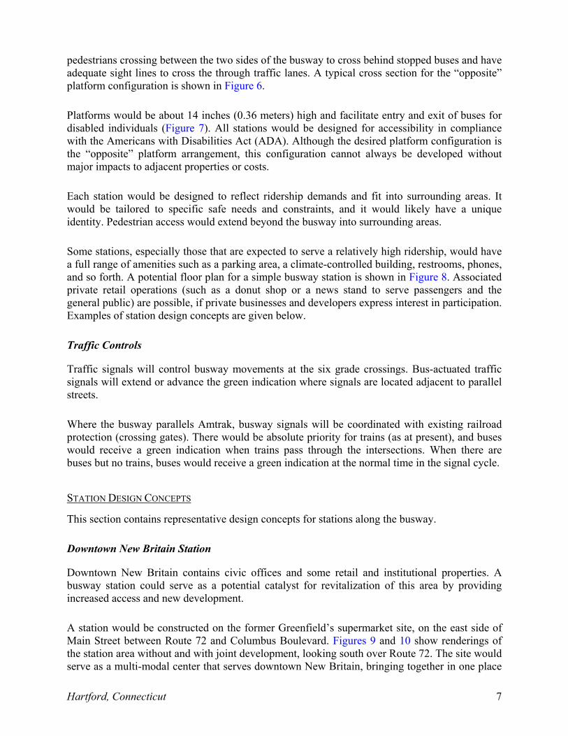
pedestrians crossing between the two sides of the busway to cross behind stopped buses and have adequate sight lines to cross the through traffic lanes. A typical cross section for the “opposite” platform configuration is shown in Figure 6.
Platforms would be about 14 inches (0.36 meters) high and facilitate entry and exit of buses for disabled individuals (Figure 7). All stations would be designed for accessibility in compliance with the Americans with Disabilities Act (ADA). Although the desired platform configuration is the “opposite” platform arrangement, this configuration cannot always be developed without major impacts to adjacent properties or costs.
Each station would be designed to reflect ridership demands and fit into surrounding areas. It would be tailored to specific safe needs and constraints, and it would likely have a unique identity. Pedestrian access would extend beyond the busway into surrounding areas.
Some stations, especially those that are expected to serve a relatively high ridership, would have a full range of amenities such as a parking area, a climate-controlled building, restrooms, phones, and so forth. A potential floor plan for a simple busway station is shown in Figure 8. Associated private retail operations (such as a donut shop or a news stand to serve passengers and the general public) are possible, if private businesses and developers express interest in participation. Examples of station design concepts are given below.
Traffic Controls
Traffic signals will control busway movements at the six grade crossings. Bus-actuated traffic signals will extend or advance the green indication where signals are located adjacent to parallel streets.
Where the busway parallels Amtrak, busway signals will be coordinated with existing railroad protection (crossing gates). There would be absolute priority for trains (as at present), and buses would receive a green indication when trains pass through the intersections. When there are buses but no trains, buses would receive a green indication at the normal time in the signal cycle.
STATION DESIGN CONCEPTS
This section contains representative design concepts for stations along the busway.
Downtown New Britain Station
Downtown New Britain contains civic offices and some retail and institutional properties. A busway station could serve as a potential catalyst for revitalization of this area by providing increased access and new development.
A station would be constructed on the former Greenfield’s supermarket site, on the east side of Main Street between Route 72 and Columbus Boulevard. Figures 9 and 10 show renderings of the station area without and with joint development, looking south over Route 72. The site would serve as a multi-modal center that serves downtown New Britain, bringing together in one place
Hartford, Connecticut 8
not only the busway service, but also interstate coach bus service, taxis, and local buses. This would improve the congested conditions on Bank Street/West Main Street in New Britain’s downtown because both interstate coaches loading/unloading and the local bus stops occur on Bank Street/West Main Street.
The station would not have an attached parking facility because there is plentiful parking available in two lightly used municipal parking garages within a block of the proposed station. Station design could provide sheltered above-grade walkways to carry passengers directly from one of these parking structures to the station.
The station building would front Main Street, thereby providing a visual connection with the other properties to the south and across Route 72 to the north. In addition, a second-story deck is proposed to front the Harry Truman Overpass (Martin Luther King, Jr. Drive) permitting kiss-and-ride passenger drop-offs. Vertical circulation (stairs, escalators, and elevators) would connect people from this level to the main station below. In addition, this would serve as protection from the weather for the platforms below.
The station would be the gateway into the New Britain–Hartford Busway for buses coming from regional locations beyond the study area towns. Eastbound regional express buses from outlying areas such as Bristol and Waterbury would exit the eastbound Route 72 Expressway utilizing a dedicated bus-only off-ramp to access the station and drop off or pick up passengers in downtown New Britain before continuing toward Hartford. Westbound express buses exiting the station would make two right turns to access Route 72 westbound.
East Main Street Station
The East Main Street Station area would be located on the east side of New Britain in a neighborhood with older residences and industrial properties. For one design option, the station would be constructed on the southern edge of a vacant industrial property and the northern edge of the National Guard Armory that borders the abandoned rail line south of East Main Street on the long block between Stanley and Harvard Streets. This station would have a driveway from East Main Street for local bus access. Pedestrian access would be provided from Yale Street and East Main Street. As part of this option, Wilson Street would be closed off with a cul-de-sac at East Main Street to improve safety at the East Main Street at-grade crossing.
Cedar Street Station
The Cedar Street Station area contains the Route 9 Expressway interchange with Fern Road and Cedar Street. Several vacant or underutilized industrial properties line the busway corridor at this area, and Central Connecticut State University (CCSU) is located directly across Route 9 from the busway. CCSU owns several land parcels contiguous to the busway and has expressed intentions to develop these parcels. A small shopping center containing a Stop and Shop Supermarket is near the busway.
Two station options were developed with parking capacities of 100 and 183 spaces respectively. One option includes an across-the-platform transfer for local buses, as well as direct busway access.
Hartford, Connecticut 9
Elmwood Station
The Elmwood section of West Hartford west of the busway is a diverse, established, older village center containing storefront retail shops, a library, a community center, houses of worship, and offices along New Britain Avenue. Heading east and north from the center of Elmwood, New Britain Avenue and New Park Avenue (respectively) have strip commercial developments. There are residential neighborhoods nearby, as well as some industrial properties to the south along the railroad tracks. The station would be located along New Park Avenue and would have most of its amenities (drop-off area, building, main entryway, etc.) on the northeast corner of New Park Avenue and New Britain Avenue, on the site of an existing car wash and automobile maintenance facility. Limited parking would be provided at this location for kiss-and- ride patrons and potential occupants of the station building. Significant additional parking would not be provided because of space limitations and traffic congestion concerns. The Amtrak bridge over Trout Brook would require some reconstruction on its west side to accommodate the busway station.
Direct pedestrian access would be provided to the south side of New Britain Avenue to minimize the need for bus passengers to cross the street at grade. The station would be separated from Amtrak operations by a protective barrier.
Flatbush Station
The busway is planned to overpass Flatbush Avenue – a major east-west arterial – to avoid traffic conflicts. About 220 parking spaces are to be placed in a rectangular parcel immediately adjacent to the busway. Some of the parking space would be shared with commercial/office buildings located just to the north of Union Station. Union Station would serve as the terminus for dedicated busway service before buses circulate through downtown. In addition, future busways could also feed Union Station. The busway and station platform would utilize unused Amtrak tracks. The platforms on the south side of Asylum Street would provide a pedestrian connection down to Asylum Street. The north platform would use the existing rail platform at Union Station and also provide direct pedestrian access to Asylum Street. The busway would continue northward, and a ramp would enable buses to reach street level so they could circulate through downtown northward. The ramp would also provide access for future busways.
BUSWAY OPERATIONS AND RIDERSHIP
The busway will be used by buses and emergency vehicles. Bus drivers using the facility will need certification. Connecticut Transit – the Region’s principal bus operator – will likely provide most service. CONN DOT will own and maintain the busway.
Service Types
Three services will use the busway: (1) premium fare “long distance” express service (operating non-stop), (2) neighborhood collector service (circulating on community streets) and then using all or part of the busway for their “line-haul” trips, and (3) bus rapid transit or “shuttle service” making all busway stops between New Britain and Hartford. Illustrations of these service concepts are shown in Figures 11, 12 and 13.
Hartford, Connecticut 10
In addition, feeder bus service would serve various areas in a town or city and then proceed to the nearest busway station.
Vehicle Types
Because of the mix of busway services, including rerouting many existing services and the need for flexibility in vehicle deployment, the existing (or modernized) Connecticut Transit fleet would constitute about half of the busway vehicles. New vehicles would be acquired for the BRT service, preferably with low-floor designs to make boarding and alighting faster. There would be no external advertising on busway vehicles.
Service Span, Frequency, and Speeds
The busway is initially expected to operate 7 days a week between about 6:00 AM and midnight. During the peak period, 7:00 to 9:00 AM and 4:30 to 6:00 PM, buses would operate at 2- to 5-minute intervals, resulting in 12 to 25 buses per hour. BRT service is envisioned at 15-minute intervals. During off-peak periods, service would be scaled back to meet lower demands and would range from 9 to 19 buses per hour.
Except for the BRT (shuttle) service, routes would begin beyond the busway. All services that reach Hartford are anticipated to circulate in downtown Hartford to provide access to other major destinations in downtown beyond the busway. Local BRT service would take about 18 minutes and express service 15 minutes with speeds of 32 mph and 38 mph, respectively. Along selected straight segments of the corridor without grade crossings or nearby residences, speeds would be as high as 50 mph. In densely populated areas, locations along curves, at grade crossings and at stations, speeds would be limited to 35 mph. Bus drivers would have special training before using the busway.
Consideration is being given to possible proof of payment at busway stations to achieve faster passenger boarding.
Bus Fares
Bus fares will be the same as overall system-wide fares in place at the time. Fares on local, BRT, and feeder routes serving the busway, as well as on other local routes, would be $1.00. Express service fares (including free park-and-ride space) would range from $1.80 to $2.40 depending on the distances involved.
Marketing
Marketing plans remain to be developed. One possibility being considered is a “Name the Busway” concept.
Intelligent Transportation System
ITS will be employed throughout the busway to provide passengers with maximum safety, efficiency, comfort, and information. Sensors will track bus locations to ensure that buses
Hartford, Connecticut 11
approaching grade crossings receive preference at busway traffic signals. Variable message signs at stations will enable waiting passengers to know the estimated arrival time for their next bus.
Ridership
Existing (1997) and projected (2004 and 2020) daily bus boardings in the busway corridor by type of route are given in Table 4. The increases in corridor boardings reflect increased bus service, longer hours of service, increased transfers/connections, and faster travel times. Daily busway ridership would total 19,000 in 2004 and 22,300 in 2020. More than half of the projected riders would be former motorists.
Boardings east of the northern busway terminus indicate those riders boarding at Union Station or on the downtown Hartford circulation route. Those that board west of the southern busway terminus would use the regional express services or neighborhood collectors in New Britain; they account for 27% of the total boardings and almost 40% when the 6,210 CBD boardings are excluded.
DEVELOPMENT OPPORTUNITIES
Three sites were identified as opportunities for joint development. These were (1) expansion of Central Connecticut State University at the Cedar Street Station, (2) Public-private joint development at the Downtown New Britain Station, and (3) public-private office and mixed-use commercial development at the Park Street Station.
FINANCING
Busway financing remains to be finalized. Presumably, FTA financing would be sought through the New Starts Program. Additional resources might become available through part of the FTA’s BRT Demonstration Program.
ASSESSMENT
The New Britain–Hartford Busway represents a medium-sized metropolitan area’s response to providing rapid public transportation. It is designed to bring patrons from a diffused hinterland to a compact city center and to provide relief for I-84.
The busway reflects an important change in previous CONN DOT policy, which is to address traffic congestion by multi-modal approaches rather than highway-only solutions, or, put another way, to use the transitway rather than road widening to increase corridor transport capacity.
OUTSTANDING ISSUES
Although the busway has received both agency and community support, several issues need to be resolved to make the plan a reality. These include (1) refining alignments and/or designs in environmentally sensitive areas; (2) finalizing agreements, purchase price, and track relocations with Amtrak; (3) refining CBD distribution details; (4) establishing parking rates for downtown
Hartford, Connecticut 12
New Britain garages; and (5) establishing a transit-supportive downtown Hartford parking policy.
Downtown Hartford distribution via city streets is being studied by the city of Hartford. Initial thinking involves buses operating in clockwise and counterclockwise loops, possibly in bus only lanes.
There is a sensitive area in New Britain where the proposed busway along an abandoned rail right-of-way passes close to residential areas. Designs were prepared that screened the busway to minimize impacts, and alternative alignments are being explored.
LESSONS LEARNED
Several lessons emerged from the Hartford experience. These are the following:
1. Transportation and land use should be approached from the perspective of the communities involved and presented in their terms. Innovation is possible, but it must be keyed to the realities of the communities involved. In the study corridor, the busway was perceived as more community-compatible than major freeway widening. Stated another way, it is essential to work with neighborhoods to accommodate their needs.
2. State, regional, and town cooperation is possible where a transport improvement reflects the needs of each.
3. The busway was shown to be more cost-effective and provide greater operation flexibility in a medium-sized urban area than rail transit. Further, the existing transit fleet can, for the most part, use the busway. A BRT system can be developed regionally and incrementally in a cost-effective manner.
4. A busway would have fewer traffic impacts than a typical arterial street. Grade separations, while desirable, are not always essential.
5. A railroad right-of-way affords opportunity to develop a busway with minimum community impact. But is also poses problems of little walk-on traffic, limited opportunities for major new land development, and complex negotiations.
6. A busway can provide potential long-term capacity relief in a corridor (unlike freeway widening), and it does not preclude ultimate conversion to rail if warranted by ridership demands.
APPLICABILITY ELSEWHERE
The cooperative state-regional-town partnership, and the strong emphasis on community participation have applicability in many communities. Similarly, multi-faceted service designs to serve multiple markets (express, local, community-busway and feeder) may be appropriate. The use of available rights-of-way (such as abandoned railroads) may also afford promise.
Hartford, Connecticut 13
BIBLIOGRAPHY 1. Final Report Hartford West Major Investment Study, Wilbur Smith Associates, July
1999.
2. Draft Environmental Impact Statement and Section 4(f) Evaluation,
3. FTA-CT–EIS-00-XXD New Britain-Hartford Busway, Wilbur Smith Associates, February 2001.
4. Technical Report #3 Assessment of Transportation Performance Hartford West Major Investment Study.
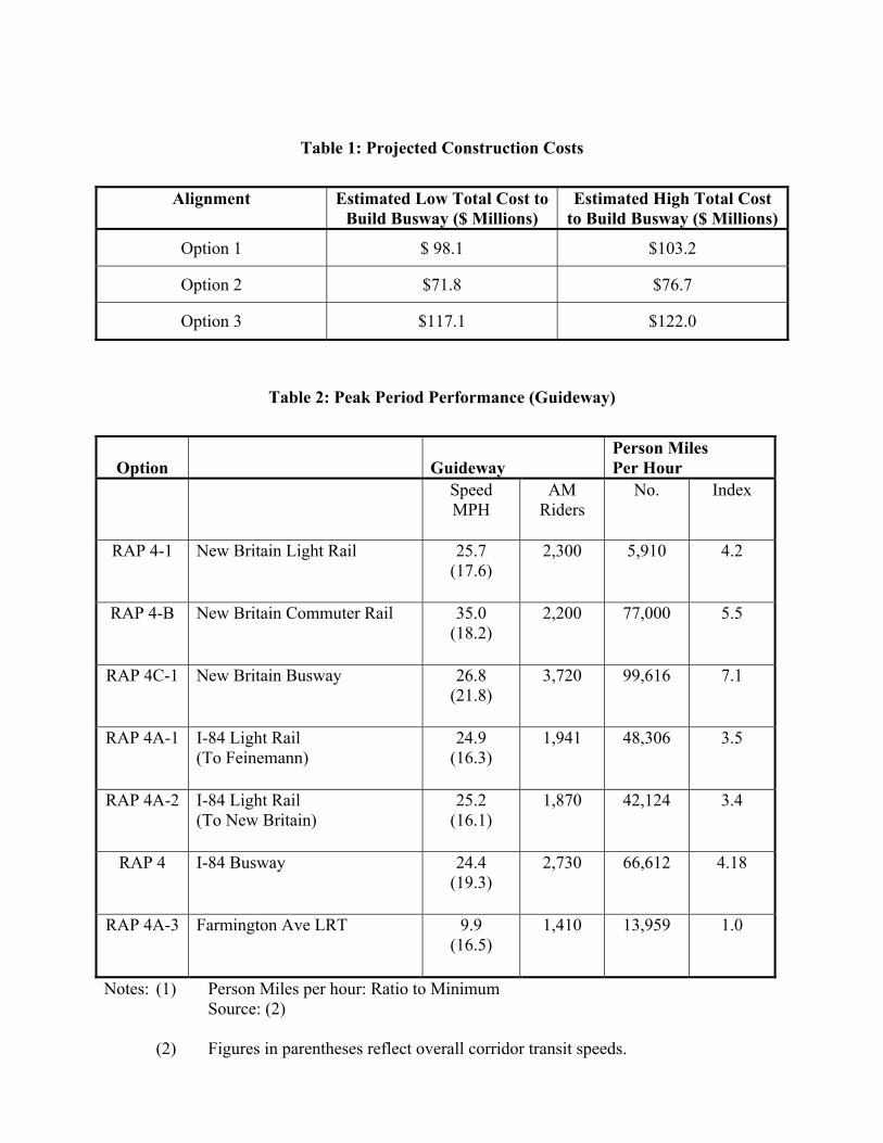
Table 1: Projected Construction Costs
Alignment Estimated Low Total Cost to Build Busway ($ Millions)
Estimated High Total Cost to Build Busway ($ Millions)
Option 1 $ 98.1 $103.2
Option 2 $71.8 $76.7
Option 3 $117.1 $122.0
Table 2: Peak Period Performance (Guideway)
Option
Guideway
Person Miles Per Hour
Speed MPH
AM Riders
No. Index
RAP 4-1 New Britain Light Rail 25.7 (17.6)
2,300 5,910 4.2
RAP 4-B New Britain Commuter Rail 35.0 (18.2)
2,200 77,000 5.5
RAP 4C-1 New Britain Busway 26.8 (21.8)
3,720 99,616 7.1
RAP 4A-1 I-84 Light Rail (To Feinemann)
24.9 (16.3)
1,941 48,306 3.5
RAP 4A-2 I-84 Light Rail (To New Britain)
25.2 (16.1)
1,870 42,124 3.4
RAP 4 I-84 Busway 24.4 (19.3)
2,730 66,612 4.18
RAP 4A-3 Farmington Ave LRT 9.9 (16.5)
1,410 13,959 1.0
Notes: (1) Person Miles per hour: Ratio to Minimum Source: (2)
(2) Figures in parentheses reflect overall corridor transit speeds.
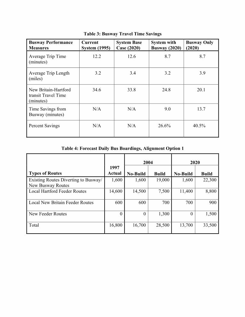
Table 3: Busway Travel Time Savings
Busway Performance Measures
Current System (1995)
System Base Case (2020)
System with Busway (2020)
Busway Only (2020)
Average Trip Time (minutes)
12.2 12.6 8.7 8.7
Average Trip Length (miles)
3.2 3.4 3.2 3.9
New Britain-Hartford transit Travel Time (minutes)
34.6 33.8 24.8 20.1
Time Savings from Busway (minutes)
N/A N/A 9.0 13.7
Percent Savings N/A N/A 26.6% 40.5%
Table 4: Forecast Daily Bus Boardings, Alignment Option 1
2004 2020
Types of Routes 1997
Actual No-Build Build No-Build Build Existing Routes Diverting to Busway/ New Busway Routes
1,600 1,600 19,000 1,600 22,300
Local Hartford Feeder Routes 14,600 14,500 7,500 11,400 8,800
Local New Britain Feeder Routes 600 600 700 700 900
New Feeder Routes 0 0 1,300 0 1,500
Total 16,800 16,700 28,500 13,700 33,500
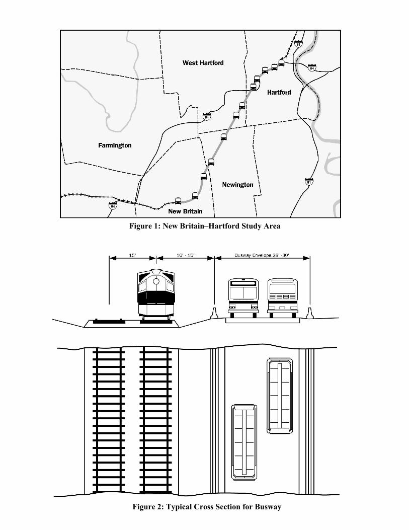
Figure 1: New Britain–Hartford Study Area
Figure 2: Typical Cross Section for Busway

Figure 3: Typical Sections
Figure 4: Station Locations
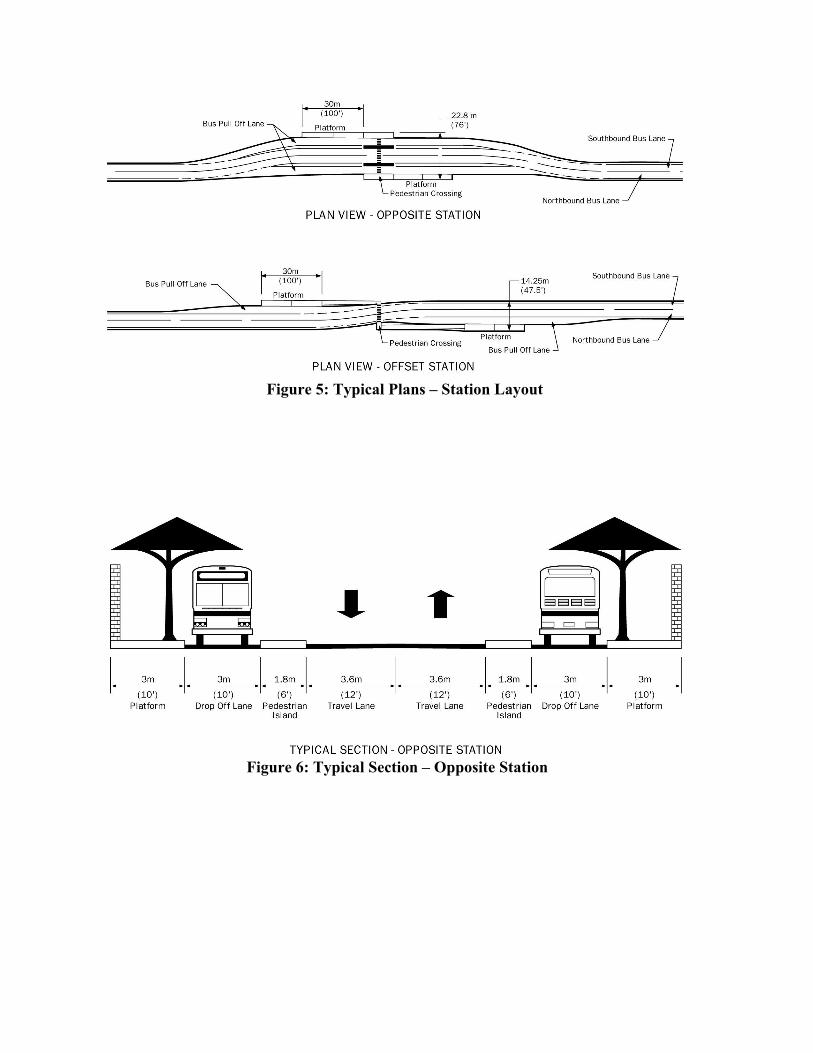
Figure 5: Typical Plans – Station Layout
Figure 6: Typical Section – Opposite Station
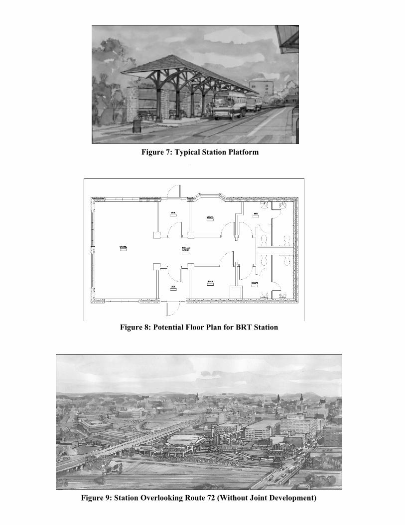
Figure 7: Typical Station Platform
Figure 8: Potential Floor Plan for BRT Station
Figure 9: Station Overlooking Route 72 (Without Joint Development)
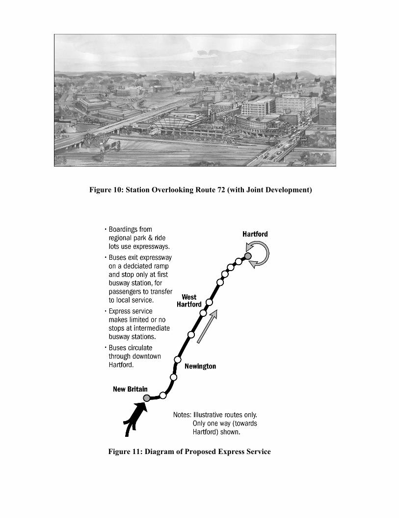
Figure 10: Station Overlooking Route 72 (with Joint Development)
Figure 11: Diagram of Proposed Express Service
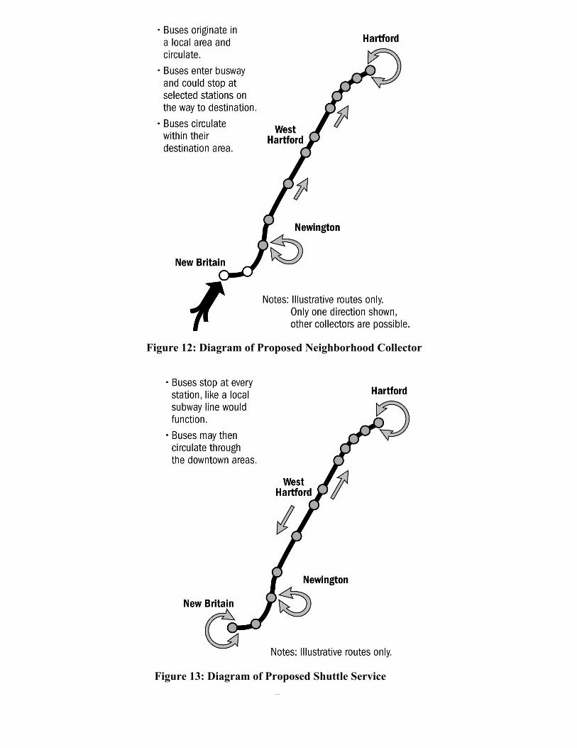
Figure 12: Diagram of Proposed Neighborhood Collector
Figure 13: Diagram of Proposed Shuttle Service