
Halfmile's Pacific Crest Trail Notes - Campo to Tuolumne ... · Halfmile's Pacific Crest Trail...
37
Description Mile Waypoint Elev Map Halfmile's Pacific Crest Trail Notes - Campo to Tuolumne Meadows Driving directions to the Southern Terminus of the PCT At the intersection of Hwy 94 and Forest Gate Rd in Campo drive SE on paved Forest Gate Rd (across the highway from the Trading Post Market & Liquor). Mileage is the distance south from Hwy 94: 4/10 mile - pass the Juvenile Ranch Facility 6/10 mile - continue S on the unpaved road 9/10 mile - continue past the Castle Rock Ranch, the unpaved road curves to the left around the ranch property 1 mile - turn right at the fork of unpaved roads, follow the fence line S uphill 1.2 miles - continue S under the high voltage line, the US border wall and PCT monument are visible in the distance 1.6 miles - arrive at the Southern Terminus of the PCT at the US-Mexico Border Driving to S Terminus -0.0 2,918 A1 Mexican Border, Southern Terminus of the PCT, trail register is behind the monument. MexBorder 0.0 2,918 A1 Juvenile Ranch facility, faucet behind sign. --- WATER ALERT: Next northbound water after the Juvenile Ranch may be the Lake Morena Campground in 18.7 miles. Check the pctwater.com for current water information. WR001 1.2 2,625 A1 PCT joins paved Forest Gate Road for 2/10 mile. RD0001 1.2 2,625 A1 Campo is a small town on the PCT with a small store, pay phone and a post office [619-478-5466]. ------- Campo Post Office [open M-F 8:30-11:30 & 12:30-4:30, Sa 9:30-12]: (Your Name) c/o General Delivery Campo, CA 91906 PO0001 1.4 2,574 A1 PCT departs paved Forrest Gate Road on a trail. RD0001B 1.4 2,586 A1 Trading Post, small store in Campo, 2/10 mile E of PCT. TradingPost 1.4 2,546 A1 Highway 94 Hwy94 2.3 2,470 A1 Railroad tracks RR0003 3.0 2,464 A1 Creeklet WR004 4.4 2,374 A1 Campsite in a dry meadow CS0005 4.6 2,378 A1 Pipe gate GT0005 4.8 2,413 A1 Pipe gate GT0009 8.8 3,355 A1 Unpaved jeep road RD0009 8.8 3,341 A1 Pipe gate GT0009B 8.8 3,361 A1 Unpaved jeep road RD0009B 9.0 3,343 A1 Unpaved jeep road RD0011 10.9 3,369 A2 Pipe gate GT0012 11.8 3,292 A2 Pipe gate GT0012B 12.5 3,141 A2 Powerline PL0014 13.8 2,980 A2 PCT joins unpaved South Boundary Rd for 3/10 mile. Pass an unpaved and unsigned road on your left. Do not take this dead-end road. Continue another 3/10 mile to where the PCT departs South Boundary Rd on a trail with a PCT sign, near a yellow sign in Spanish cautioning travelers. RD0014 14.0 2,939 A2 These notes are provided as a free service to PCT hikers. I believe the information is accurate but they may contain errors. The notes are distributed in the hope that they will be useful, but WITHOUT ANY WARRANTY; without even the implied warranty of MERCHANTABILITY or FITNESS FOR A PARTICULAR PURPOSE. Page 1 - send updates to [email protected] © 2018 - www.pctmap.net - 1/31/2018
Transcript of Halfmile's Pacific Crest Trail Notes - Campo to Tuolumne ... · Halfmile's Pacific Crest Trail...

DescriptionMile Waypoint Elev MapHalfmile's Pacific Crest Trail Notes - Campo to Tuolumne Meadows
Driving directions to the Southern Terminus of the PCTAt the intersection of Hwy 94 and Forest Gate Rd in Campo drive SE onpaved Forest Gate Rd (across the highway from the Trading Post Market &Liquor). Mileage is the distance south from Hwy 94:4/10 mile - pass the Juvenile Ranch Facility6/10 mile - continue S on the unpaved road9/10 mile - continue past the Castle Rock Ranch, the unpaved road curves tothe left around the ranch property1 mile - turn right at the fork of unpaved roads, follow the fence line S uphill1.2 miles - continue S under the high voltage line, the US border wall andPCT monument are visible in the distance1.6 miles - arrive at the Southern Terminus of the PCT at the US-MexicoBorder
Driving to STerminus
-0.0 2,918 A1
Mexican Border, Southern Terminus of the PCT, trail register is behind themonument.
MexBorder0.0 2,918 A1
Juvenile Ranch facility, faucet behind sign.---WATER ALERT: Next northbound water after the Juvenile Ranch may be theLake Morena Campground in 18.7 miles. Check the pctwater.com for currentwater information.
WR0011.2 2,625 A1
PCT joins paved Forest Gate Road for 2/10 mile. RD00011.2 2,625 A1
Campo is a small town on the PCT with a small store, pay phone and a postoffice [619-478-5466].-------Campo Post Office [open M-F 8:30-11:30 & 12:30-4:30, Sa 9:30-12]:(Your Name)c/o General DeliveryCampo, CA 91906
PO00011.4 2,574 A1
PCT departs paved Forrest Gate Road on a trail. RD0001B1.4 2,586 A1
Trading Post, small store in Campo, 2/10 mile E of PCT. TradingPost1.4 2,546 A1
Highway 94 Hwy942.3 2,470 A1
Railroad tracks RR00033.0 2,464 A1
Creeklet WR0044.4 2,374 A1
Campsite in a dry meadow CS00054.6 2,378 A1
Pipe gate GT00054.8 2,413 A1
Pipe gate GT00098.8 3,355 A1
Unpaved jeep road RD00098.8 3,341 A1
Pipe gate GT0009B8.8 3,361 A1
Unpaved jeep road RD0009B9.0 3,343 A1
Unpaved jeep road RD001110.9 3,369 A2
Pipe gate GT001211.8 3,292 A2
Pipe gate GT0012B12.5 3,141 A2
Powerline PL001413.8 2,980 A2
PCT joins unpaved South Boundary Rd for 3/10 mile. Pass an unpaved andunsigned road on your left. Do not take this dead-end road. Continue another3/10 mile to where the PCT departs South Boundary Rd on a trail with a PCTsign, near a yellow sign in Spanish cautioning travelers.
RD001414.0 2,939 A2
These notes are provided as a free service to PCT hikers. I believe the information is accurate but they may contain errors. The notes are distributed in the hopethat they will be useful, but WITHOUT ANY WARRANTY; without even the implied warranty of MERCHANTABILITY or FITNESS FOR A PARTICULARPURPOSE.
Page 1 - send updates to [email protected] © 2018 - www.pctmap.net - 1/31/2018

DescriptionMile Waypoint Elev MapHalfmile's Pacific Crest Trail Notes - Campo to Tuolumne Meadows
Powerline PL0014B14.2 2,911 A2
PCT departs unpaved South Boundary Rd. RD001514.7 2,831 A2
Hauser Creek, often dry, several campsites W of trail. Nearby unpavedHauser Creek road is blocked to vehicle traffic.
WRCS01515.4 2,317 A2
Cottonwood Creek below Lake Morena, follow dirt road 1.6 miles W of PCT. WACS01615.4 1,825 A2
Trailhead parking near Lake Morena Campground. PCT joins paved LakeShore Drive for 2/10 mile N. Campground office is 3/10 mile NW on LakeMorena Drive. Lake Morena Village with small store/deli nearby.---WATER ALERT: Next southbound water after Lake Morena Campground maybe the faucet at the Juvenile Ranch facility in 18.7 miles. Check pctwater.comfor the latest water information.
LakeMorenaCG20.0 3,074 A2
Oak Shore Grocery, small store w/ deli, 4/10 mile SE of PCT in Lake MorenaVillage.
OakShoreGro20.0 3,114 A2
PCT departs paved Lake Shore Drive on a trail. RD002020.2 3,055 A2
Pipe gate GT002120.6 3,050 A2
Cottonwood Creek Bridge, usually dry. WR02424.1 3,065 A3
Cottonwood Creek bed WR02625.5 3,107 A3
Boulder Oaks Campground, outhouse, water, picnic tables. BoulderOakCG26.0 3,183 A3
Interstate Highway 8 Hwy826.6 3,145 A3
Kitchen Creek Falls, 2/10 mile N of PCT mile 28.6. KitchenCrFalls28.6 3,635 A3
Pipe gate GT003029.7 3,910 A3
Kitchen Creek Rd, paved, pipe gate E of road. RD003030.2 3,995 A3
Seasonal Yellow Rose Spring, 4/10 mile N on Kitchen Creek Rd, often haswater early in the hiking season, good camping if you don't mind the nearby(but seldom used) road.
WRCS03030.2 3,842 A4
Fred Canyon, usually dry, campsite W of trail. WRCS03232.0 4,210 A4
Cibbets Flat Campground, 8/10 mile NW of PCT, water, outhouse, picnictables.
CibbetsCG32.6 4,155 A4
Unpaved Fred Canyon Rd, access to Cibbets Flat Campground.-------In May 2009 a Marine helicopter crashed near here. Munitions carried by thehelicopter were scattered as a result of the crash. Signs warn hikers to stayon trail because of a safety hazard from unexploded military ordinances in thisarea.
RD003332.6 4,409 A4
Campsite by large oak tree. CS003636.1 5,292 A4
Long Canyon WR03736.9 5,195 A5
Campsite near Long Creek. CS003737.1 5,247 A5
Campsite among the dead trees. CS003837.6 5,437 A5
Long Canyon Creek ford WR03837.7 5,441 A5
Trail junction to Lower Morris Meadow Spring TR003938.8 5,889 A5
Lower Morris Meadow, spring, campsite, 3/10 mile NW of PCT. WRCS03938.8 5,829 A5
Red Tail Roost volunteer center, parking, outhouse, 4/10 mile W of PCT. RedTailRoost40.5 5,980 A5
"Remote camping" not allowed in the Laguna Mountain Recreation Area. CampingRestriction
41.0 5,815 x
Page 2 - send updates to [email protected] © 2018 - www.pctmap.net - 1/31/2018

DescriptionMile Waypoint Elev MapHalfmile's Pacific Crest Trail Notes - Campo to Tuolumne Meadows
Burnt Rancheria Campground, water, showers, [usually open mid-April toOctober].
BurntRanchCG41.5 5,936 A5
Mount Laguna, 4/10 mile W of PCT. Nearby store, lodge [Lagunamountain.com, 619-473-8533], outfitter [Mount Laguna Sports, 619-473-0450],restaurant and a Post Office [619-473-8341].-------The Laguna Mountain Lodge and store accepts resupply packages [$5] sentby USPS or UPS. Include Name, ETA, and Phone # on your package.Laguna Mountain Lodge USPS Address:(Your Name)c/o Laguna Mountain LodgePO Box 146Mount Laguna, CA 91948---Laguna Mountain Lodge UPS Address:(Your Name)c/o Laguna Mountain Lodge10678 Sunrise HwyMount Laguna, CA 91948---Mount Laguna Post Office [M-F 12-4, Sa 9-11]:(Your Name)c/o General DeliveryMount Laguna, CA 91948
PO004141.5 5,916 A5
Trail junction to Burnt Ranchera Campground and the community of MountLaguna.
TR004141.5 5,955 A5
Burnt Rancheria CG drinking fountain. WR04242.1 5,971 A5
Desert View Picnic Area, outhouse, water, picnic table. WR04342.6 5,956 A6
Cross a paved road, just N of WR043. RD004342.8 5,981 A6
Cross another paved road. RD0043b43.4 5,915 A6
Big Laguna trail junction BigLagunaTr44.4 5,897 A6
Foster Point trail junction FosterPtTr46.4 5,735 A6
Observation deck, trailside bench, access to Mount Laguna Campground 7/10mile SW. Follow paved Sunrise Highway 2/10 mile S to the campgroundentrance road.
Deck004847.5 5,422 A6
Mount Laguna Campground, 7/10 mile SW of PCT, fee, coin-operatedshowers, water, open year round.
LagunaCG47.5 5,510 A6
Noble Canyon trail junction. NobleCynTr48.7 5,433 A6
GART faucet, 1/10 mile W of PCT. WR04948.7 5,431 A6
Garnet Peak trail junction. GarnetPkTr50.2 5,491 A6
Pioneer Mail Picnic Area, outhouse.---"Remote Camping" not allowed in the Laguna Mountain Recreation Area.
WR05352.6 5,274 A7
Campsite in boulder field. CS005655.9 5,201 A7
Sunrise Trailhead Junction. SunriseTr59.5 4,996 A8
Sunrise Trailhead, outhouse, camping in the open field, water 5/10 mile W ofPCT mile 59.5. Can be very windy camping at this location.
WRCS05959.5 4,996 A8
Mason Valley fire tank, 75 yards E of PCT [usually dry]. WR06262.4 4,698 A8
Mason Valley Truck Trail. RD006262.4 4,694 A8
Campsite near dry creekbed just S of Chariot Cyn Rd. CS006463.7 3,864 A8
Page 3 - send updates to [email protected] © 2018 - www.pctmap.net - 1/31/2018

DescriptionMile Waypoint Elev MapHalfmile's Pacific Crest Trail Notes - Campo to Tuolumne Meadows
Seasonal creek crossing Chariot Canyon Rd, shade, 8/10 mile N of PCT mile63.7 [2/10 mile N of the State Park boundary sign].
WR064A63.7 3,661 x
Chariot Canyon Fire Tank, 1.2 miles N of PCT. WR064B63.7 3,611 x
Seasonal Chariot Canyon Spring, 1.4 miles N of PCT, spring is on the W sideof the road hidden from view by several large oak trees.
WR064C63.7 3,491 x
PCT joins Chariot Canyon Rd. RD006463.7 3,857 A8
PCT departs Chariot Canyon Rd. RD0064b64.1 4,084 A8
Pipe gate GT006868.4 3,648 A9
Spring on Rodriguez Spur Truck Trail, 1.1 miles NW of PCT, 50 feet uphillfrom the large rust colored water tank.
WR068B68.4 3,313 x
Rodriguez Spur fire tank, campsite.---WATER ALERT: Next northbound water after the Rodriguez Spur fire tankmay be Barrel Spring in 32.7 miles. This water source was once reliable, buthas gone dry sometimes in 2016 & 2017, check the pctwater.com for currentwater information.
WRCS06868.4 3,653 A9
Small campsite N of trail. CS007373.4 3,132 A9
Pipe gate GT007675.6 2,370 A10
Scissors Crossing, junction of Hwy 78 and S-2. WRCS07777.0 2,278 A10
Highway 78, near Scissors Crossing. Julian is 12 miles W on Highway 78, theStagecoach Trails RV Park is 4 miles SE of the PCT on S2.
Hwy7877.3 2,261 A10
Julian is a small town 12 miles W of the PCT on Hwy 78 with a grocery store,motels, pay phone, restaurants and a post office [760-765-3648].-------Julian Post Office [M-F 9-4, Sa 10-12]:(Your Name)c/o General DeliveryJulian, CA 92036
Julian77.3
The Stagecoach Trails RV Park [stagecoachtrails.com, 760-765-3765] withwater, small store, pool, and showers is 4 miles SE of the PCT on Hwy S2.
Stagecoach RVPark
77.3
Campsite in sandy dry creek bed CS007979.4 2,974 A10
Small bivy campsite, view. BV008079.7 2,962 A10
Bivy campsite in a wash. BV0080B79.9 3,000 A10
Small sandy campsite under dry waterfall, another campsite in the washbelow.
CS0080C80.4 3,066 A10
Several small campsites in wash below the trail. CS008281.6 3,074 A10
Small campsite next to trail, view. CS0082B82.4 3,166 A10
Small bivy campsite in a gully. BV008584.5 3,309 A10
Small campsite next to trail. CS0085B84.7 3,286 A10
Large campsite, better than campsites in the burn area 200 feet before. CS0085C85.4 3,289 A10
Several campsites on saddle of ridge. CS008686.0 3,363 A10
Pipe gate, 1st gate N of Hwy 78. GT008686.0 3,364 A10
Many campsites along wide dry creekbed. CS008786.6 3,237 A11
Pipe gate, 2nd gate N of Highway 78. GT008888.2 3,605 A11
Several small campsites, view. CS008888.2 3,596 A11
Page 4 - send updates to [email protected] © 2018 - www.pctmap.net - 1/31/2018

DescriptionMile Waypoint Elev MapHalfmile's Pacific Crest Trail Notes - Campo to Tuolumne Meadows
Small bivy campsite. BV008988.6 3,608 A11
Small bivy campsite, view. BV0089B88.8 3,568 A11
Small trailside bivy campsite. BV009089.7 3,459 A11
Abandoned jeep road, cleared and used as a firebreak in 2012. RD009090.4 3,462 A11
Pipe gate, 3rd gate N of Hwy 78. GT009191.2 3,559 A11
3rd gate water cache location, 3/10 mile E of PCT mile 91.2. WR09191.2 3,421 A11
Underground cistern, 6/10 mile E of PCT mile 91.2. WR091B91.2 3,353 x
Several small campsites 100 ft N of the 3rd gate, possible shade from bushes,junction with trail to water cache and underground water cistern E of the PCT.
CS09191.2 3,550 A11
Small bivy campsite. BV009292.4 3,838 A11
Small campsite CS009393.2 4,036 A11
Pipe gate, 4th gate N of Highway 78. GT009493.8 4,141 A11
Several small campsites on small ridge, may be hidden from trail by brush. CS009494.4 4,296 A11
Small bivy campsite. BV009595.2 4,268 A12
Small bivy campsite. BV009695.9 4,401 A12
Billy Goat's cave, very small cave, W side of trail. BGCave96.1 4,359 A12
The small community of Ranchita can be seen 3 miles to the NE. RanchitaView96.4 4,351 A12
Pipe gate, 5th gate N of Hwy 78. GT0101100.5 3,667 A12
Pipe gate, 6th gate N of Hwy 78. GT0101B100.6 3,665 A12
Pipe gate, 7th gate N of Highway 78. GT0101C100.6 3,640 A12
Barrel Spring, trough, shade, and campsites. Watch for Poison Oak.---WATER ALERT: Next southbound water after Barrel Spring may be theRodriguez fire tank in 32.7 miles. Check the pctwater.com for currentinformation.-------The Barrel Spring source is 330 ft southbound on the PCT, then follow theunmarked trail W, uphill 150 feet.
WRCS101101.1 3,482 A12
Road S22, Montezuma Valley Rd, paved. RD0101101.2 3,453 A12
Spring-fed cattle trough, 2/10 mile E of PCT. WR104104.1 3,391 A12
Round concrete trough, 2/10 mile W of PCT. WR105104.4 3,292 A12
San Ysidro Creek WRCS105B105.0 3,354 A13
Large metal water tank, two cattle troughs, 2/10 mi S of PCT. WR106B106.1 3,393 A13
Eagle Rock EagleRock106.2 3,524 A13
Spring-fed metal trough, 3/10 mile N of PCT. WR106106.7 3,530 A13
Canada Verde WR108107.9 3,335 A13
Large beach-like campsite CS0109109.0 3,083 A13
Pipe gate GT0109109.2 3,077 A13
Pipe gate GT0109B109.3 3,064 A13
Highway 79, first crossing, small community of Warner Springs 1.2 miles NE. Hwy79109.5 3,045 A13
Page 5 - send updates to [email protected] © 2018 - www.pctmap.net - 1/31/2018

DescriptionMile Waypoint Elev MapHalfmile's Pacific Crest Trail Notes - Campo to Tuolumne Meadows
Warner Springs is a very small community 1.2 miles E of the PCT with ahiker-friendly community center, resort, golf course, and post office [760-782-3166].---The Warner Springs Community Center [about 100 yards E of the PCT at thefirst crossing of Highway 79] has been very hiker-friendly the past few yearsoffering hikers water, computer use, food, and a small store.---The Warner Springs Ranch Resort [warnerspringsranchresort.com, 760-782-4200] has reopened following bankruptcy several years ago. The resort hasnew owners, see web site for the latest updates.-------Warner Springs Post Office [M-F 8-4, Sa 8-1:30]:(Your Name)c/o General DeliveryWarner Springs, CA 92086
Warner Springs109.5 3,045
Private campground PrivateCG111.1 2,926 B13
Hwy 79, 2nd crossing, Agua Caliente Creek. Hwy79B111.4 2,929 B13
Agua Caliente Creek, just past picnic tables. WR113112.6 2,990 B1
Agua Caliente Creek WR115114.7 3,189 B1
Campsite on E side of Agua Caliente Creek CS0115115.0 3,235 B1
Agua Caliente Creek, last crossing. WR115B115.5 3,326 B1
Unmarked spur trail going 100 yards S to Lost Creek Road. TR0118117.9 4,077 B1
100 yard spur trail from Lost Creek Rd to the PCT. TR0118b117.9 4,028 B1
Lost Valley Road, abandoned road. LostValleyRd118.6 4,189 B2
Lost Valley Spring, 2/10 mile N of PCT. WR120119.6 4,349 B2
Several small campsites among the boulders. CS0124123.8 5,020 B2
Spur trail to Mike Herrera's place. TR0127126.9 5,112 B2
Water tank, 2/10 mile E of PCT mile. WR127B127.3 5,079 B2
Chihuahua Valley Rd, unpaved. WR127127.3 5,057 B2
Several campsites on the high ridge near Combs Peak. CS0129129.2 5,592 B3
Pipe gate GT0134134.4 4,118 B3
Pipe gate GT0136136.2 3,733 B4
Tule Canyon Creek WR137136.5 3,593 B4
Tule Spring, 3/10 mile E of PCT.---WATER ALERT: Next northbound water after Tule Spring may be theParadise Cafe in 14.9 miles.
WR137B137.0 3,481 B4
Upaved Tule Canyon Truck Trail RD0137137.0 3,620 B4
Guzzler cistern WR140139.5 3,569 B4
Coyote Canyon Rd, unpaved. RD0140139.7 3,510 B4
Nance Canyon, seasonal creek, several sandy beach-like campsitesdownstream from trail crossing.
WRCS140B140.2 3,347 B4
Unpaved Table Mountain Truck Trail, trail gate. RD0143143.1 4,086 B4
Several campsites among huge boulders. CS0144144.0 4,312 B4
Table Mountain Truck Trail, unpaved, 2nd crossing. RD0147147.0 4,909 B5
Page 6 - send updates to [email protected] © 2018 - www.pctmap.net - 1/31/2018

DescriptionMile Waypoint Elev MapHalfmile's Pacific Crest Trail Notes - Campo to Tuolumne Meadows
The small town of Anza [5.8 miles SW of the Paradise Valley Cafe on Hwy371] has a store, ATM, payphone, restaurants, pharmacy, and a post office[951-763-2074].-------Anza Post Office [open M-F 9-4, Sa 10-1]:(Your Name)c/o General DeliveryAnza, CA 92539
Anza151.9
Highway 74, Idyllwild is 13.5 miles NW on Hwy 74, then 4.5 miles N on Hwy243. The small town of Anza is 1 mile W on Hwy 74, then 5.8 miles SW onHwy 371.
Hwy74151.9 4,924 B5
Paradise Valley Cafe [theparadisevalleycafe.com, 951-659-3663], waterspigot outside, 1 mile W of PCT.---WATER ALERT: Next southbound water after Paradise Cafe may be TuleSpring in 14.9 miles.-------The Paradise Valley Cafe accepts hiker resupply packages via USPS, UPS &FedEx. Include ETA on your Package.(Your Name)c/o Paradise Valley Cafe61721 State Highway 74Mountain Center, CA 92561
WR152151.9 4,792 B5
Shady campsite CS0156155.9 5,182 B6
Campsite CS0157157.4 5,671 B6
Gate, fence. GT0158158.3 5,951 B6
Tunnel Spring, 3/10 mile W of PCT. WR158b158.4 5,688 B6
Trail junction for Live Oak Spring and Tunnel Spring, trail gate 250 feet S ofjunction.
TR0158158.4 5,952 B6
Live Oak Spring, 1 mile E of PCT. WR158158.4 5,436 B6
Small campsite CS0160159.7 6,315 B6
Small shady campsites CS0161161.0 6,820 B7
Cedar Spring Trail Junction CedarSprTr162.6 6,775 B7
Cedar Spring, 1 mile N of PCT. WR162162.6 6,388 B6
Eagle Spring trail junction TR0163163.3 6,943 B7
Seasonal Eagle Spring, 3/10 mile S of PCT. WR163163.3 6,733 B7
Fobes Ranch Trail Junction FobesRanchTr166.5 5,994 B7
Spitler Trail Junction---Many thru-hikers reach the San Jacinto Mountains early in the hiking seasonwhen snow and ice still cover parts of the trail. In 2005 a PCT hiker died in theSan Jacinto's following a snowstorm. Snow often begins on the north side ofApache Peak and continues 21 miles through Fuller Ridge. If you reachApache Peak and are uneasy traveling north you can backtrack 1 mile to theSpitler Peak Trail and hike the Spitler to Idyllwild Alternate [see Halfmile'smaps]. Snow melts quickly, so trail reports more than a few days old may notbe accurate following warm weather.---MOUNTAIN FIRE CLOSURE: 8.6 miles of the PCT from the Spitler Peak TrailN to Tahquitz Creek will remain closed in 2018 due to the 2013 Mountain Fire.Check with PCTA.org or the San Jacinto Ranger Station at 909-382-2921 forupdates. The Spitler to Idyllwild Alternate [See Halfmile maps] bypasses thisclosure.
SpitlerTr168.6 7,009 B8
Page 7 - send updates to [email protected] © 2018 - www.pctmap.net - 1/31/2018

DescriptionMile Waypoint Elev MapHalfmile's Pacific Crest Trail Notes - Campo to Tuolumne Meadows
Apache Spring, 1/2 mile E of PCT, several large campsites, can be verywindy.
WRCS169169.2 6,841 B8
Apache Spring Trail Junction ApacheSprTr169.2 7,352 B8
Campsite CS0171170.9 6,903 B8
Several small campsites CS0172172.2 7,185 B8
Several large campsites CS0175175.4 8,231 B8
Tahquitz Creek---MOUNTAIN FIRE CLOSURE: 8.6 miles of the PCT from the Tahquitz Creek Sto the Spitler Peak Trail will remain closed in 2018 due to the 2013 MountainFire. Check with PCTA.org or the San Jacinto Ranger Station at 909-382-2921 for updates. The Spitler to Idyllwild Alternate bypasses this closure.
WR177177.2 8,155 B8
Tahquitz Valley Trail TqtzValTr177.3 8,134 B8
Tahquitz Peak Trail TqtzPkTr178.0 8,619 B8
Tahquitz Peak, 4/10 mile W of PCT. TqtzPeak178.0 8,825 B8
Idyllwild is a town 5.2 miles W of the PCT with motels, a state parkcampground w/ showers, restaurants, grocery, natural food store, laundry,outfitter, ATM, pay phones, library and a post office [951-659-1969].-------Idyllwild Post Office [open M-F 9-5, Sa pick up only 1:30-3]:(Your Name)c/o General DeliveryIdyllwild, CA 92549
Idyllwild179.4
Saddle Junction, Devils Slide Trail to Humber Park, Idyllwild. SaddleJct179.4 8,114 B9
Campsite CS0180179.5 8,169 B9
Campsite CS0181180.8 9,025 B9
Trail to San Jacinto Peak via Wellman Divide SJTrail181.2 8,992 B9
Several campsites CS0181B181.3 9,066 B9
Strawberry Cienaga WR182182.1 8,597 B9
Several campsites CS0183182.7 8,394 B9
San Jacinto State Park Wilderness, southern boundary. Camping allowedonly in designated camping areas, $5 per person permit required, for 5.4miles to the N.
SanJacintoWild183.1 8,171 B9
Strawberry Trail Camp, outhouse. CS0183B183.3 8,107 B9
Strawberry Junction, Deer Springs Trail to Suicide Rock, Idyllwild. StrawberryJct183.5 8,047 B9
Stone Creek WR184184.1 8,369 B9
Marion Mountain trail junction, Seven Pines Trail junction 100 feet N. MarionMtnTr185.1 8,706 B9
Deer Springs, North Fork San Jacinto River. WR186185.6 8,933 B9
Trail from San Jacinto Peak via Little Round Valley rejoins PCT, in 2011 theonly trail sign here was one pointing to Fuller Ridge.
2SJTrail185.7 8,948 B9
Page 8 - send updates to [email protected] © 2018 - www.pctmap.net - 1/31/2018

DescriptionMile Waypoint Elev MapHalfmile's Pacific Crest Trail Notes - Campo to Tuolumne Meadows
N Fork San Jacinto River Tributary, often the best water source in this area.---WATER ALERT: Next northbound water after N Fork San Jacinto RiverTributary may be the Snow Canyon Road faucet in 19.5 miles.---Be sure to fill up here, a long dry and waterless section of trail is ahead as youmake the descent toward Cabazon. Over the years, a number of hikerrescues have happened in this area due to snow, ice, or navigation issues onFuller Ridge [the next 4.3 miles], or because of heat and dehydration at lowerelevations.
WR186B186.2 8,927 B9
N Fork San Jacinto River WR186C186.4 8,900 B9
San Jacinto State Park Wilderness, northern boundary. Camping allowed onlyin designated camping areas, $5 per person permit required, for 5.4 miles tothe S.
SanJacintoWild2189.0 8,154 B10
Fuller Ridge Trailhead, parking. FullerRidgeTH190.5 7,746 B10
Campsite CS0191190.5 7,710 B10
Black Mountain Road, unpaved. RD0191190.7 7,663 B10
Campsite CS0191B191.4 7,421 B10
Round-about of unpaved roads, small unpaved parking area, possibletrailhead for high clearance vehicles.
RD0193192.6 6,847 B10
Several campsites CS0194193.6 6,463 B10
Seasonal headwaters of the West Fork Snow Creek, campsite, 1/10 mile S ofPCT on unmarked use trail.
WRCS194193.9 6,355 B10
Unmarked use trail to West Fork Snow Creek. TR0194193.9 6,393 B10
Small campsite CS0195195.4 5,658 B10
Campsite CS0197197.2 4,908 B10
Campsite CS0201201.1 3,351 B10
Campsite at the saddle W of knob. CS0202201.7 3,259 B10
Campsite CS0205204.8 2,109 B11
Snow Canyon Road faucet, campsites 150 feet W, PCT joins paved SnowCreek Road.---WATER ALERT: Next southbound water after Snow Canyon Road faucet maybe N Fork San Jacinto River Tributary in 19.5 miles.
WR206205.7 1,730 B11
Gate, blocks vehicle traffic S on paved road. GT0207206.8 1,226 B11
PCT departs the paved road, RD0207207.0 1,235 B11
The small community of Cabazon with a small store and post office [951-849-6233] is 4.5 miles W of the PCT on the service road just S of Hwy 10[between the Interstate and the railroad tracks]. Tamarack Rd [N of Hwy 10]does not go to Cabazon.-------Cabazon Post Office [open M-F 8:30-4]:(Your Name)c/o General DeliveryCabazon, CA 92230
Cabazon209.5 1,337
Interstate Highway 10 Hwy10209.5 1,337 B11
Cross paved Tamarack Road. RD0210209.6 1,364 C11
High voltage power line PL0210209.9 1,445 C11
Page 9 - send updates to [email protected] © 2018 - www.pctmap.net - 1/31/2018

DescriptionMile Waypoint Elev MapHalfmile's Pacific Crest Trail Notes - Campo to Tuolumne Meadows
Unpaved road, PCT register, barbed wire fence nearby. RD0211210.6 1,603 C11
Trail angels Ziggy and the Bear have closed. ZiggyBear210.8 1,604 C11
"Friends of the Desert Mountains" gate blocks the end of paved BoulderDrive.
GT0211210.8 1,645 C11
Two unpaved road next to each other. RD0212211.6 1,849 C1
PCT joins an unpaved road. RD0212B211.7 1,853 C1
PCT departs the unpaved road. RD0212C211.8 1,840 C1
Metal trail gate GT0212212.1 1,939 C1
Trail junction to the Mesa Wind Farm. TR0213213.4 2,338 C1
Mesa Wind Farm maintenance building. WR0213213.4 2,352 C1
Unpaved road RD0214213.8 2,482 C1
Unpaved road, barbed wire fence nearby. RD0215214.5 2,791 C1
San Gorgonio Wilderness boundary GorgonioWild215.7 2,812 C1
Canyon View Loop trail junction TR0218217.7 2,746 C2
Whitewater Preserve trail junction WhitewaterTr218.5 2,312 C2
Whitewater Preserve [wildlandsconservancy.org, 760-325-7222], 6/10 mile Eof PCT, shade, water, wading pool, toilets, and free camping for PCT hikers.-------PCT hikers who arrive after the ranger station closes should camp in the opengrass area S of the Ranger Station. Check in with the ranger in the morning ifstaying more than one night. No fires, smoking or alcohol.
WRCS0219218.5 2,208 C2
Whitewater Creek WR0220220.3 2,610 C2
Mission Creek Crossing, campsite. WRCS0226226.2 3,128 C2
Mission Creek Crossing WR0227227.2 3,374 C3
Creek WR0228228.0 3,573 C3
Campsite near Mission Creek WRCS0230229.5 3,955 C3
Campsite near Mission Creek WRCS0231231.4 4,564 C3
Campsite near Mission Creek WRCS0232232.1 4,834 C3
San Gorgonio Wilderness boundary GorgonioWild2234.8 5,862 C4
Creek side camp, small seasonal creek nearby. WRCS0235235.5 6,128 C4
Forested Flats Junction, seasonal water, campsites nearby. WRCS0239238.7 7,371 C4
Spring and trough near Mission Creek Trail Camp, other spring is usuallybetter.
WR0240239.9 7,968 C4
Mission Creek Trail Camp spring, parking, campsites, PCT joins an unpavedroad for a short distance.
WRCS0240239.9 7,928 C4
Mission Creek Trail Camp spring, parking, campsites.---WATER ALERT: Next northbound water after Mission Creek Trail Campspring may be Arrastre Trail Camp in 16.3 miles.
WRCS0240B239.9 7,921 C4
PCT departs the unpaved road. RD0240240.0 7,972 C4
Fish Creek Trailhead FishCrkTr240.0 8,088 C1
Wide unpaved road RD0241240.6 8,235 C4
Page 10 - send updates to [email protected] © 2018 - www.pctmap.net - 1/31/2018

DescriptionMile Waypoint Elev MapHalfmile's Pacific Crest Trail Notes - Campo to Tuolumne Meadows
Unpaved road 2E03. RD0241B241.4 8,118 C4
PCT joins an unpaved road. RD0245244.7 8,490 C4
PCT departs the unpaved road. RD0245B245.2 8,339 C4
Coon Creek Cabin Group Campground, no water. CS0246246.4 8,131 C4
Unpaved road near the Coon Creek Group Campground. RD0246246.4 8,089 C4
Unpaved road RD0249248.6 8,628 C5
PCT joins an unpaved road. RD0249B249.3 8,387 C5
Unpaved road RD0250250.3 8,131 C5
Unpaved road RD0250B250.3 8,144 C5
Animal cages, exotic animals for film and television [predatorsinaction.com]. AnimalCages250.3 8,148 C5
Unpaved road RD0251251.0 8,395 C5
Unpaved road at Onyx Summit. RD0252252.1 8,531 C5
Unpaved road, campsite nearby. CS0253253.2 8,636 C5
Unpaved road RD0255255.3 7,899 C5
Arrastre Trail Camp, Deer Spring, stream 200 feet to the N, picnic table,campsites.---WATER ALERT: Next southbound water after Arrastre Trail Camp, DeerSpring, may be Mission Springs Trail Camp in 16.3 miles.
WRCS0256256.2 7,605 C5
Spring 1/2 mile N of Arrastre Camp. WR0257256.7 7,456 C6
PCT joins an unpaved road. RD0258257.7 7,139 C6
Arrastre Creek WR0258257.9 7,045 C6
PCT departs the unpaved road. RD0258B257.9 7,048 C6
Arrastre Creek WR0258B258.5 6,885 C6
Small campsite CS0259259.4 7,156 C6
Unpaved road RD0259259.5 7,133 C6
Unpaved road 2N02 RD0262261.9 6,782 C6
Unpaved road RD0264263.6 7,082 C7
Page 11 - send updates to [email protected] © 2018 - www.pctmap.net - 1/31/2018

DescriptionMile Waypoint Elev MapHalfmile's Pacific Crest Trail Notes - Campo to Tuolumne Meadows
Big Bear City and Big Bear Lake are 2 towns about 5 miles apart, each with apost office. Use the correct post office if you send a package. MountainTransit bus service [mountaintransit.org, 909-878-5200 ] serves thesecommunities.---Big Bear City is town 5.4 miles SW of the PCT. Big Bear City has smallgrocery, motels, restaurants, pay phones, ATM, and a post office [909-585-7132].---Big Bear Lake is town 9 miles SW of the PCT [about 5 miles W of Big BearCity]. Big Bear Lake is larger than Big Bear City and has several full groceries,Kmart, motels, restaurants, pay phones, ATM, pharmacy, post office [909-866-1035], Motel 6 [909-585-6666], and the hiker-friendly Big Bear Hostel. TheBig 5 sporting goods [909-866-2730] in Big Bear Lake usually sells fuelcanisters.-------Big Bear City Post Office [open M-F 9-4:30, Sa pickup only 1-2;(Your Name)c/o General DeliveryBig Bear City, CA 92314---Big Bear Lake Post Office [open M-F 8:30-5, Sa 10-12]:(Your Name)c/o General DeliveryBig Bear Lake, CA 92315---The hiker-friendly Big Bear Hostel [bigbearhostel.com, 909-866-8900] islocated about 100 yards SE of Lake View Drive and Knickerbocker Road inBig Bear Lake.
Big Bear266.1 6,830
Paved Highway 18, access to Big Bear. Hwy18266.1 6,830 C7
Paved road 3N08, power line nearby, near a land fill. RD0268268.2 6,862 C7
Trail junction to Doble Trail Camp. TR0269268.6 6,902 C7
Doble Trail Camp, outhouse, picnic table, water, corral. WR0269268.6 6,841 C7
Unpaved jeep road RD0271270.8 7,663 C7
Caribou Creek, small wooden bridge, campsite nearby. WRCS0275275.0 7,257 C8
Unpaved Van Dusen Canyon Rd. Big Bear City is 2.8 miles SE on thismedium clearance unpaved road with some rough spots.
RD0275275.1 7,264 C8
Campsite CS0277276.6 7,716 C8
Unpaved road RD0277277.3 7,732 C8
Cougar Crest trail junction, keep right. It's easy to overlook the PCT sign andfollow the well used Cougar Crest Trail.
TR0278277.7 7,674 C8
Unpaved road RD0278278.0 7,592 C8
Holcomb Valley Road 2N09, paved for about 1/4 mile leading up to PCTjunction, dirt road for about 2 miles beyond that S to Hwy 38, unpaved to R ofPCT crossing.
RD0279278.6 7,550 C8
Unpaved road RD0281281.2 7,755 C9
Unpaved jeep road RD0282282.0 7,608 C9
Little Bear Spring trail camp, picnic table, outhouse, corral. CS0286285.6 6,577 C9
PCT joins an unpaved road. RD0286285.9 6,514 C9
Holcomb Creek WR0286285.9 6,502 C9
Unpaved road RD0287286.5 6,492 C9
Page 12 - send updates to [email protected] © 2018 - www.pctmap.net - 1/31/2018

DescriptionMile Waypoint Elev MapHalfmile's Pacific Crest Trail Notes - Campo to Tuolumne Meadows
Creek, campsite nearby. WRCS0287286.7 6,459 C9
Unpaved jeep road RD0289288.7 6,353 C9
Campsite CS0290289.9 6,089 C10
Creek WR0292291.5 5,630 C10
Large creek WR0292B292.1 5,473 C10
Paved Crab Flats Road RD0292292.2 5,469 C10
Creek, campsites nearby. WRCS0292292.4 5,436 C10
Large campsite, oak trees, small seasonal stream nearby. CS0293293.2 5,331 C10
Creek WR0294293.8 5,221 C10
Trail camp CS0294294.1 5,215 C10
OHV trail 1W17 to Big Pine Flat. TR0294294.3 5,286 C10
Bench Trail Camp CS0295294.7 5,185 C10
Hawes Peak trail junction TR0295294.9 5,158 C10
Piped spring WR0296295.9 5,241 C10
Deep Creek, large bridge. WR0299298.5 4,581 C11
Splinters Cabin, outhouse, 1/10 mile SW of PCT. SplintersCabin298.5 4,612 C11
Splinter's Trail junction TR0299298.5 4,622 C11
Unpaved road to Deep Creek day use area. Access to Deep Creek. RD0301301.3 4,263 C11
Bridge over a gully. Bridge0302302.5 4,172 C11
Deep Creek hot spring.-------Deep Creek hot spring. Camping is not permitted within one mile of DeepCreek. Sometimes this is enforced, especially on weekends near the popularclothing optional hot spring that can be crowded on weekends.
WA0308307.9 3,522 C12
Small stream WR0309309.3 3,460 C12
Footbridge painted with rainbow colors. Bridge0310310.0 3,318 C12
Mojave River Forks Reservoir Spillway, 200 feet NW of PCT. The Reservoir isusually a dry lake bed. In wet years, the trail below the dam may be flooded.Rangers report the flooded area sometimes has quicksand, so use caution.As an alternate, you can take the paved path just past the spillway to a roadon top of the dam. Follow the road W to Arrowhead Lake Rd, and backtrack Eon Hwy 173 to the PCT. This 2.9 mile alternate bypasses 1.3 miles of thePCT.
MFSpillway313.0 3,135 C12
Stream WR0314313.6 2,985 C12
Paved Route 173 RD0314314.3 3,127 C13
Seasonal trail side spring. WR0316316.2 3,482 C13
Piped spring WR0317317.4 3,356 C13
Mojave River Campground trail junction. Campground is 3/4 mile off trail. TR0318317.6 3,371 C13
PCT joins an unpaved road. RD0318317.7 3,411 C13
Seasonal Grass Valley Creek, campsite nearby. WRCS0318318.0 3,331 C13
PCT departs the unpaved road. RD0318B318.0 3,333 C13
Unpaved road RD0319318.7 3,472 C13
Page 13 - send updates to [email protected] © 2018 - www.pctmap.net - 1/31/2018

DescriptionMile Waypoint Elev MapHalfmile's Pacific Crest Trail Notes - Campo to Tuolumne Meadows
Small campsite CS0320319.9 3,595 C13
State park, national forest boundary. StatePark0322322.5 3,402 C13
Paved road to the Silverwood Lake day use parking area. RD0323323.2 3,373 C13
PCT joins an unpaved road toward a bridge over the Silverwood Lake damoutlet.
RD0324323.6 3,184 C13
Bridge over Cedar Springs Dam outlet. WR0324323.7 3,162 C14
PCT joins paved Hwy 73 after after crossing smaller road and passingthrough a small industrial work yard.
RD0324B323.8 3,166 C14
Pass the Mojave Siphon Power Plant. MojaveSiphon324.2 3,197 C14
PCT departs the paved road. RD0324C324.4 3,201 C14
Unpaved road RD0325324.8 3,361 C14
High voltage power line PL0325324.9 3,414 C14
PCT joins an unpaved service road. RD0325B325.3 3,399 C14
Small trail side beach on the lake. WR0325325.4 3,394 C14
PCT departs an unpaved service road. RD0325C325.4 3,400 C14
High voltage power line. PL0326325.6 3,406 C14
High voltage power line, unpaved road nearby. PL0328328.1 3,477 C14
PCT joins a paved bicycle path. TR0329328.7 3,392 C14
Cleghorn Picnic Area, shade, picnic tables, water, outhouse, trash can, pavedroad.
WR0329328.7 3,392 C14
PCT joins a paved road. RD0329329.0 3,397 C14
Highway 138 overpass. Hwy138329.0 3,397 C14
PCT departs the paved road. RD0329B329.0 3,398 C14
High voltage power line. PL0329329.2 3,482 C14
Paved road to a water tank. No access to water. RD0330329.8 3,532 C14
National Forest boundary Forest0330330.1 3,579 C14
Trail gate GT0332332.2 4,171 C14
PCT joins an unpaved road. RD0332332.3 4,170 C14
PCT departs the unpaved road. RD0332B332.3 4,132 C14
Small seasonal stream WR0333333.1 3,829 C14
Small campsite CS0336335.6 3,587 C15
PCT follows an unpaved road for about 100 yards near a high voltage powerline.
PL0338338.1 3,854 C15
Unpaved road RD0340340.4 3,350 C15
High voltage power line PL0340340.5 3,347 C15
Cross an unpaved road. RD0341340.7 3,291 C15
PCT passes under a high voltage powerline tower. PL0341340.9 3,273 C15
Crowder Canyon, small seasonal creek nearby. WR0341341.4 3,129 C15
Page 14 - send updates to [email protected] © 2018 - www.pctmap.net - 1/31/2018

DescriptionMile Waypoint Elev MapHalfmile's Pacific Crest Trail Notes - Campo to Tuolumne Meadows
Side trail to McDonalds, mini-mart, and Best Western Motel at Cajon Pass.-------The side tail is actually paved Wagon Train Rd along a short section ofHistoric Route 66 which also runs past a memorial built in 1917 honoringpioneers of the Santa Fe and Salt Lake trails [behind the truck weigh station].Route 66 ran 2,448 miles from Chicago to LA, less than the length of the PCT.
TR0342341.9 3,041 C15
McDonalds Restaurant, 3/10 mile NW of PCT, mini-mart next door, BestWestern Motel nearby.
McDonalds341.9 3,071 C15
Interstate Highway 15 and Cajon Pass [about 1/2 mile N of the PCT] is a busyinterstate highway intersection with a McDonald's restaurant, pay phone, gasstation mini-mart and a hiker-friendly Best Western Motel [760-249-6777].---WATER ALERT: Next northbound water after Cajon Pass may be GuffySpring in 22.3 miles. This can be a very long, hot, steep, waterless climb.
Hwy15342.0 2,995 D15
Unpaved road RD0342342.3 2,988 D15
Small wooden hiker bridge Bridge0343342.8 3,006 D15
Unpaved road RD0343342.9 2,998 D15
Tunnel under a railroad track, shade. RR0343342.9 2,969 D15
Railroad track RR0343B343.1 3,013 D15
Unpaved road RD0344343.5 3,090 D15
Unpaved road near a high voltage power line. RD0344B344.0 3,220 D1
PCT joins an unpaved road along a high voltage power line. RD0344C344.3 3,335 D1
PCT departs the unpaved road and crosses under a power line. RD0344D344.4 3,368 D1
Unpaved Swarthout Canyon Road RD0347347.3 3,568 D1
Bike Spring, always dry. WR0348347.7 3,685 D1
Unpaved road RD0352351.8 5,195 D1
Unpaved road 3N31 RD0356356.2 6,293 D2
Unpaved road, campsite nearby. RD0357357.2 6,466 D2
Campsite near the end of an unpaved road. CS0362361.7 8,135 D2
Trail to Mount Baldy [AKA Mount San Antonio], 200 feet SW of PCT. BaldyTrail362.5 8,312 D3
1983 winter transit memorial stone, at the base of two "V" trees facing awayfrom the trail. Jodi Zaitchick and Jerry Duran died in a December 1983 fall 363miles into the first known PCT winter thru-hike attempt.
Memorial0363363.2 8,223 D3
Acorn trail junction to Wrightwood [3.6 miles, dropping 2,337 feet]. It'sprobably better for most hikers to go 6 miles N on the PCT to Hwy 2 and hitch5.5 miles E to Wrightwood on Hwy 2.
TR0363363.4 8,247 D3
Unpaved road RD0364363.9 8,089 D3
Angeles National Forest boundary AngelesNF364.0 8,091 D3
Unpaved road RD0364B364.1 8,089 D3
Guffy Spring, 1/10 mile N of the PCT. Follow use trail about 1/10 mile beforecampground]---WATER ALERT: Next water southbound after Guffy Spring may be CajonPass in 22.3 miles.
WR0364364.3 8,049 D3
Guffy Campground CS0364364.4 8,251 D3
PCT joins an unpaved road. RD0367366.6 8,130 D3
Page 15 - send updates to [email protected] © 2018 - www.pctmap.net - 1/31/2018

DescriptionMile Waypoint Elev MapHalfmile's Pacific Crest Trail Notes - Campo to Tuolumne Meadows
PCT departs the unpaved road. RD0367B366.8 8,125 D3
Unpaved road RD0367C367.1 7,937 D3
Exit for Blue Ridge Campground. CS0367367.3 7,894 D3
Unpaved road RD0369368.5 7,547 D3
Power line PL0369368.8 7,373 D3
A junction of unpaved roads. RD0369B369.1 7,385 D3
Inspiration Point trailhead parking, 1st crossing of Hwy 2, outhouse, trash can,paved parking area. Access to the town of Wrightwood.
Hwy2369.4 7,372 D3
Wrightwood is a small hiker-friendly town 5.5 miles E of the PCT with agrocery store, motels, restaurants, pay phones, ATM, hardware store, and apost office [760-249-8882]. The Mountain Hardware store [mtnhardware.com,760-249-3653] accepts hiker packages.-------Mountain Hardware USPS:PCT Hiker (Your Name)c/o Mountain HardwarePO Box 398Wrightwood, CA 92397---Mountain Hardware UPS:Mountain HardwarePCT Hiker (Your Name)c/o Mountain Hardware1390 Hwy 2Wrightwood, CA 92397---Wrightwood Post Office [open M-F 8:45-5, Sa pickup only 8-11]:(Your Name)c/o General DeliveryWrightwood, CA 92397
Wrightwood369.4 7,372
Grassy Hollow Visitor Center, water spigot. WR0370370.3 7,310 D4
PCT joins a narrow paved road. RD0371371.0 7,335 D4
PCT departs the narrow paved road. RD0371B371.0 7,338 D4
Jackson Lake trail junction. TR0372372.2 7,429 D4
Unpaved road RD0373373.1 7,230 D4
Vincent Gap, 2nd crossing of Hwy 2, outhouse, trash cans, picnic table, largepaved parking area, used by Mt Baden Powell day hikers.-------The High Desert Trail Alternate [also known as the Manzanita Trail] connectsVincent Gap to the South Fork Campground allowing hikers to bypass MountBaden-Powell during high snow years. See Halfmile maps for details.
Hwy2B374.0 6,582 D4
Lamel Spring trail junction TR0376375.7 7,768 D4
Lamel Spring, 425 ft S of PCT mile 375.9. WR0376375.7 7,752 D4
Campsite CS0377377.0 8,638 D4
Mount Baden Powell spur trail junction. TR0378377.9 9,245 D4
Mount Baden Powell, 9399 feet, 1/10 mile S of PCT. MtBadenPowell377.9 9,390 D4
Small Campsite CS0379379.5 8,693 D4
Dawson Saddle trail junction TR0381380.5 8,856 D5
Windy Gap, trail junction to Crystal Lake, Mount Islip. TR0384383.5 7,576 D5
Page 16 - send updates to [email protected] © 2018 - www.pctmap.net - 1/31/2018

DescriptionMile Waypoint Elev MapHalfmile's Pacific Crest Trail Notes - Campo to Tuolumne Meadows
Trail junction to Little Jimmy Spring. TR0384B383.6 7,507 D5
Little Jimmy Spring WR0384383.7 7,435 D5
Another trail junction to Little Jimmy Spring. TR0384C383.7 7,484 D5
Little Jimmy Campground. The PCT goes right at the unsigned trail just beforethe campground.
CS0384383.9 7,479 D5
Unpaved road RD0385385.0 7,361 D5
The once thriving Mountain Yellow-Legged Frog is now nearly extinct. Toprotect the frog, the PCT is closed for 2.7 miles from Eagles Roost to theBurkhart Trail junction. Hikers can bypass the closure by continuing on thePCT to Eagles Roost then road walk 2.7 miles along Hwy 2 to BuckhornCampground, then follow the campground road and Burkhart Trail 2.2 miles torejoin the PCT.---The detour starting at Islip Saddle to S Fork Campground and the PunchbowlTrail is no longer recommended due to severe erosion.
EndangeredSpecies Alt
386.0 6,666
Islip Saddle, 3rd crossing of Hwy 2, outhouse, trash can, paved trailheadparking, start of the official endangered species detour.
Hwy2C386.0 6,666 D5
The PCT turns, but a use trail continues straight and climbs to the summit ofMount Williamson. It's easy to miss the turn and end up on the summit.
Mount WilliamsonAlternate
387.9
4th crossing of Highway 2. Hwy2D389.3 6,700 D5
5th crossing of Highway 2. Hwy2E390.2 6,654 D6
Eagles Roost Picnic Area, outhouse, picnic tables, trash cans, paved parkingarea. Endangered species bypass.---The once thriving Mountain Yellow-Legged Frog is now nearly extinct. Toprotect the frog, the PCT is closed for 2.7 miles from Eagles Roost to theBurkhart Trail junction. Hikers can bypass the closure by road walking 2.7miles along Hwy 2 to Buckhorn Campground, then follow the campgroundroad and Burkhart Trail 2.2 miles to rejoin the PCT.
EaglesRoost390.2 6,687 D6
Seasonal spring 7/10 mile S of PCT. WA0390390.2 6,153 x
Burkhart Trail, 2nd junction. TR0394394.0 5,721 D6
Cooper Canyon Trail Camp, seasonal creek nearby. WRCS0395395.2 6,235 D6
Unpaved jeep road RD0397396.9 6,645 D6
Headwaters of Cooper Canyon WR0397397.3 6,549 D6
Hwy 2, 6th crossing. HWY2F398.0 7,032 D6
Power line PL0398398.1 7,001 D6
Hwy 2, 7th crossing. Hwy2G398.8 6,733 D6
Power line PL0400399.5 6,494 D6
Pleasant View Ridge Wilderness boundary PleasantViewWild400.6 6,255 D7
Camp Glenwood, Boy Scout Camp, outhouse, picnic table, possible watertank.
WR0401400.6 6,252 D7
PCT departs the unpaved road to Camp Glenwood. RD0401400.8 6,298 D7
8th crossing of Hwy 2, outhouse, parking, trash can nearby. Hwy2H401.1 6,268 D7
PCT joins an abandoned roadbed. RD0401B401.4 6,267 D7
Low voltage power line PL0402402.2 6,044 D7
PCT departs the abandoned road bed. RD0403402.5 5,974 D7
Page 17 - send updates to [email protected] © 2018 - www.pctmap.net - 1/31/2018

DescriptionMile Waypoint Elev MapHalfmile's Pacific Crest Trail Notes - Campo to Tuolumne Meadows
Powerline PL0403402.6 5,981 D7
Three Points Trailhead, 9th crossing of Hwy 2, outhouse, picnic tables, trashcans, paved parking.
Hwy2I403.1 5,928 D7
Paved road RD0403B403.1 5,932 D7
Powerline PL0403B403.3 5,939 D7
Pleasant View Ridge Wilderness boundary PleasantViewWild2403.4 5,939 D7
Small campsite CS0404404.2 5,911 D7
PCT joins an abandoned roadbed. RD0405404.7 5,770 D7
PCT departs the abandoned roadbed. RD0405B404.9 5,726 D7
Trail junction with equestrian PCT alternate. TR0407406.6 5,270 D7
Sulphur Spring, 1/10 mile E of PCT. WR0407406.6 5,191 D7
Equestrian alternate rejoins the PCT. TR0407B407.2 5,280 D7
Narrow paved road RD0407407.4 5,315 D7
Small campsite CS0408407.8 5,527 D7
Campsite CS0410410.3 6,191 D7
Seasonal Fiddleneck Spring WR0410410.4 6,232 D7
Fountainhead Spring WR0411411.0 6,436 D7
Campsite CS0412411.7 6,682 D8
Campsite CS0413413.0 6,650 D8
Campsite CS0415415.1 6,219 D8
High voltage power line PL0418418.5 4,975 D8
Mill Creek Fire Station, water spigot, trail register.---WATER ALERT: Next northbound water after Mill Creek Fire Station may bethe North Fork Ranger Station in 17.5 miles.
WR0419418.6 4,979 D8
Unpaved Mount Gleason road RD0421421.2 5,595 D8
PCT joins an unpaved road RD0425424.8 5,521 D9
PCT departs the unpaved road RD0425B424.9 5,503 D9
Messenger Flats campground MessengerFlats430.4 5,886 D10
Spring near Moody Canyon Road WR0432431.9 5,375 D10
Paved road to the North Fork Ranger Station.---WATER ALERT: Next southbound water after North Fork Ranger Station maybe the Mill Creek Ranger Station in 17.5 miles.
WR0436436.1 4,185 D10
Unpaved road RD0443443.1 2,619 D11
Trail gate GT0444444.1 2,250 D11
Indian Canyon Trailhead near Soledad Canyon Road, parking, outhouse,picnic table, trash can.
TH0444444.1 2,298 D11
Page 18 - send updates to [email protected] © 2018 - www.pctmap.net - 1/31/2018

DescriptionMile Waypoint Elev MapHalfmile's Pacific Crest Trail Notes - Campo to Tuolumne Meadows
The small town of Acton, 6 miles E of the KOA has a several restaurants anda post office.-------Acton Post Office [open M-F 10-5]:(your name) PCT Hikerc/o General Delivery3632 Smyth AvenueActon, CA 93510
Acton444.2
Paved Soledad Canyon Road, Indian Canyon Trailhead, paved parking,outhouse, trash can. Access to the community of Acton, 6.5 miles E onSoledad Canyon Road.
RD0444444.2 2,245 D11
Acton KOA RV park [koa.com/campgrounds/acton/, 661-268-1214], 2/10 mileE of PCT with camping, showers, laundry, and a small store. To reach theKOA cross Soledad Canyon Rd and walk N on the PCT down theembankment. Look to the right and you will see the KOA campground acrossthe flat open area. If you cross the creek you have gone too far.
ActonKOA444.3 2,226 D11
Use trail to the Acton KOA RV park, 2/10 mile E of PCT. TR0444444.3 2,222 D11
Creek WR0444444.4 2,217 D11
A small monument near a railroad track where the Pacific Crest Trail wasofficially declared complete in a "Golden Spike" ceremony on June 5th 1993.
GoldenSpike444.5 2,256 D11
High voltage powerline PL0446446.5 2,884 D11
Tunnel under Highway 14. Hwy14451.1 2,379 D12
Vasquez Rocks Picnic Area WR0453452.9 2,482 D12
Agua Dulce is a small town on the PCT with a good grocery store,restaurants, pay phones, ATM and Hiker Heaven [AKA the Saufley's,hikerheaven.com, 661-268-1235, guest [hiker] phone 661-402-5000]. HikerHeaven is usually open March - June and in the fall for southbounders. ThePCT follows the road through the center of Agua Dulce. To reach HikerHeaven walk past the grocery store and pizza place and turn left on DarlingRoad for 1 mile.-------Hiker Heaven accepts resupply packages sent by USPS, UPS, FedEx orDHL. Include ETA on your package.PCT Hiker (your name)c/o The Saufley's11861 Darling RoadAgua Dulce, CA 91390
AguaDulce454.5 2,537 D12
The PCT follows Sierra Hwy W for 1/10 mile, then N on Mint Canyon Rd toPeterson Rd.
SierraHwy456.3 2,726 E1
Follow unpaved road along power line. RD0457456.7 2,755 E1
Powerline PL0457457.1 2,896 E1
Depart the unpaved powerline road. RD0457B457.1 2,907 E1
Cross an unpaved road. RD0459458.6 2,883 E1
PCT follows an unpaved road E. RD0462462.3 4,500 E2
PCT departs the unpaved road. RD0463462.6 4,558 E2
Gate GT0463462.6 4,545 E2
Bear Spring.---WATER ALERT: Next northbound water after Bear Spring may be the FireStation at San Francisquito Canyon Road in 15 miles.
WR0463463.2 4,331 E2
Gate GT0464463.9 3,976 E2
Page 19 - send updates to [email protected] © 2018 - www.pctmap.net - 1/31/2018
DescriptionMile Waypoint Elev MapHalfmile's Pacific Crest Trail Notes - Campo to Tuolumne Meadows
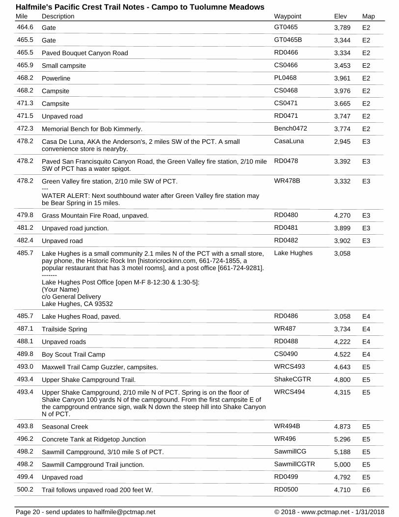
Gate GT0465464.6 3,789 E2
Gate GT0465B465.5 3,344 E2
Paved Bouquet Canyon Road RD0466465.5 3,334 E2
Small campsite CS0466465.9 3,453 E2
Powerline PL0468468.2 3,961 E2
Campsite CS0468468.2 3,976 E2
Campsite CS0471471.3 3,665 E2
Unpaved road RD0471471.5 3,747 E2
Memorial Bench for Bob Kimmerly. Bench0472472.3 3,774 E2
Casa De Luna, AKA the Anderson's, 2 miles SW of the PCT. A smallconvenience store is nearyby.
CasaLuna478.2 2,945 E3
Paved San Francisquito Canyon Road, the Green Valley fire station, 2/10 mileSW of PCT has a water spigot.
RD0478478.2 3,392 E3
Green Valley fire station, 2/10 mile SW of PCT.---WATER ALERT: Next southbound water after Green Valley fire station maybe Bear Spring in 15 miles.
WR478B478.2 3,332 E3
Grass Mountain Fire Road, unpaved. RD0480479.8 4,270 E3
Unpaved road junction. RD0481481.2 3,899 E3
Unpaved road RD0482482.4 3,902 E3
Lake Hughes is a small community 2.1 miles N of the PCT with a small store,pay phone, the Historic Rock Inn [historicrockinn.com, 661-724-1855, apopular restaurant that has 3 motel rooms], and a post office [661-724-9281].-------Lake Hughes Post Office [open M-F 8-12:30 & 1:30-5]:(Your Name)c/o General DeliveryLake Hughes, CA 93532
Lake Hughes485.7 3,058
Lake Hughes Road, paved. RD0486485.7 3,058 E4
Trailside Spring WR487487.1 3,734 E4
Unpaved roads RD0488488.1 4,222 E4
Boy Scout Trail Camp CS0490489.8 4,522 E4
Maxwell Trail Camp Guzzler, campsites. WRCS493493.0 4,643 E5
Upper Shake Campground Trail. ShakeCGTR493.4 4,800 E5
Upper Shake Campground, 2/10 mile N of PCT. Spring is on the floor ofShake Canyon 100 yards N of the campground. From the first campsite E ofthe campground entrance sign, walk N down the steep hill into Shake CanyonN of PCT.
WRCS494493.4 4,315 E5
Seasonal Creek WR494B493.8 4,873 E5
Concrete Tank at Ridgetop Junction WR496496.2 5,296 E5
Sawmill Campground, 3/10 mile S of PCT. SawmillCG498.2 5,188 E5
Sawmill Campground Trail junction. SawmillCGTR498.2 5,000 E5
Unpaved road RD0499499.4 4,792 E5
Trail follows unpaved road 200 feet W. RD0500500.2 4,710 E6
Page 20 - send updates to [email protected] © 2018 - www.pctmap.net - 1/31/2018

DescriptionMile Waypoint Elev MapHalfmile's Pacific Crest Trail Notes - Campo to Tuolumne Meadows
Red Rock Water Tank WR502502.4 5,646 E6
Guzzler behind oak shrubs WR502B502.4 5,616 E6
Unpaved Liebre Mtn Truck Trail 7N23. RD0505504.6 5,554 E6
Guzzler near Liebre Mtn Truck Trail 7N23. WR505504.6 5,494 E6
PCT joins jeep road. RD0506506.5 5,754 E6
PCT departs from jeep road. RD0508507.7 5,028 E6
Horse Camp, picnic table, trail to spring in canyon below. CS0508508.1 4,858 E6
Spring in canyon 2/10 mile W of Horse Camp. WR508508.1 4,699 E6
Unpaved trailhead parking area. TR0510510.0 4,003 E6
Pine Canyon Creek and pond. WR511510.7 3,800 E6
Creek WR511B510.9 3,848 E6
Pine Canyon Road, paved. Private land N of road for 7 miles, No CampingAllowed.
RD0511510.9 3,839 E6
Two trail gates. GT0511511.2 3,858 E6
Seasonal Stream. WR512512.0 3,580 E6
Highway 138 Hwy138B517.6 3,052 E7
Hikertown [hikertown.com], hosts hikers, has water spigots, and accepts hikerresupply packages.-------Send resupply packages by USPS or UPS. Include ETA on your package.(Your Name)c/o Hikertown26803 W. Ave. C-15Lancaster CA 93536
WR518517.6 3,050 E7
Open aqueduct.---WATER ALERT: Next northbound water after the aqueduct may be the faucetnear the Cottonwood Creek bridge in in 16.4 miles.
WR519518.5 2,970 E7
Low voltage powerline PL0528527.6 3,105 E8
Depart Aqueduct Rd on an unpaved road. RD0529529.3 3,109 E9
Powerline PL0532532.3 2,895 E9
Faucet near Cottonwood Creek bridge. Faucet only works when the aqueducthas water, check pctwater.com.---WATER ALERT: Next southbound water after Cottonwood Creek bridge maybe the open aqueduct in 16.4 miles.
WR535534.9 3,086 E9
Iberdrola Renewables, Manzana Wind Project office, 1.3 miles E of the PCT,has faucet near building and a 110 gallon water tank at the south fence if theoffice is closed [nights & weekends].
IberdrolaWF536.9 E10
Tylerhorse Canyon, small creek, campsite.---WATER ALERT: Next northbound water after Tylerhorse Canyon may be OakCreek in 16.6 miles.
WRCS542541.6 4,843 E11
Gate GT0556555.6 4,954 E12
Tiger Tank and shower. Probably dry, no water here the past few years. WR556555.6 4,954 E12
Gate GT0556B556.0 4,920 E12
Page 21 - send updates to [email protected] © 2018 - www.pctmap.net - 1/31/2018
DescriptionMile Waypoint Elev MapHalfmile's Pacific Crest Trail Notes - Campo to Tuolumne Meadows
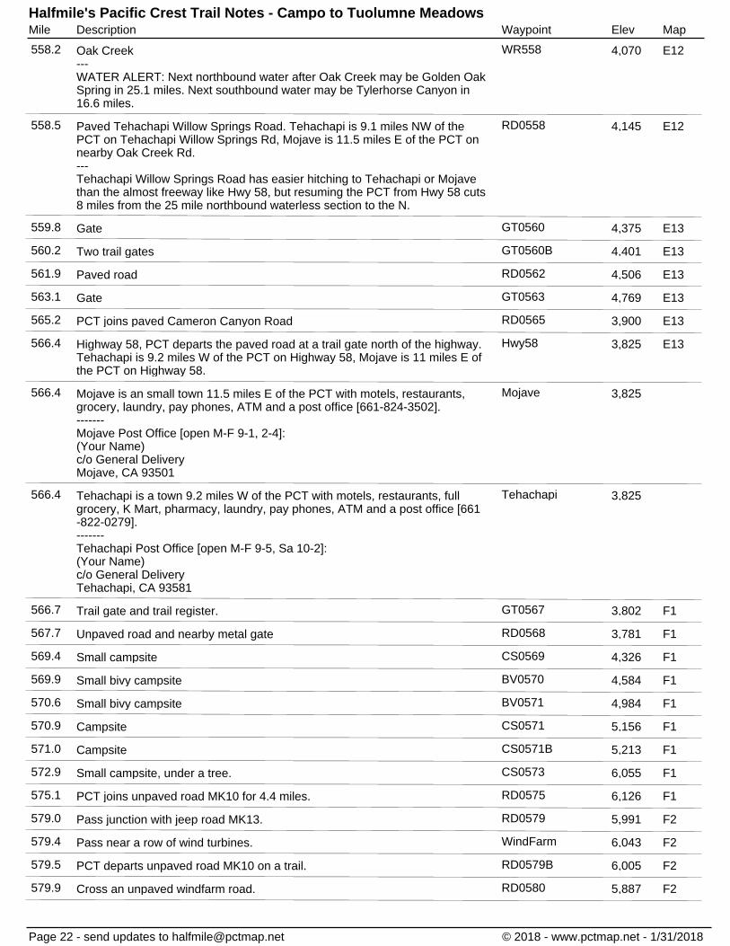
Oak Creek---WATER ALERT: Next northbound water after Oak Creek may be Golden OakSpring in 25.1 miles. Next southbound water may be Tylerhorse Canyon in16.6 miles.
WR558558.2 4,070 E12
Paved Tehachapi Willow Springs Road. Tehachapi is 9.1 miles NW of thePCT on Tehachapi Willow Springs Rd, Mojave is 11.5 miles E of the PCT onnearby Oak Creek Rd.---Tehachapi Willow Springs Road has easier hitching to Tehachapi or Mojavethan the almost freeway like Hwy 58, but resuming the PCT from Hwy 58 cuts8 miles from the 25 mile northbound waterless section to the N.
RD0558558.5 4,145 E12
Gate GT0560559.8 4,375 E13
Two trail gates GT0560B560.2 4,401 E13
Paved road RD0562561.9 4,506 E13
Gate GT0563563.1 4,769 E13
PCT joins paved Cameron Canyon Road RD0565565.2 3,900 E13
Highway 58, PCT departs the paved road at a trail gate north of the highway.Tehachapi is 9.2 miles W of the PCT on Highway 58, Mojave is 11 miles E ofthe PCT on Highway 58.
Hwy58566.4 3,825 E13
Mojave is an small town 11.5 miles E of the PCT with motels, restaurants,grocery, laundry, pay phones, ATM and a post office [661-824-3502].-------Mojave Post Office [open M-F 9-1, 2-4]:(Your Name)c/o General DeliveryMojave, CA 93501
Mojave566.4 3,825
Tehachapi is a town 9.2 miles W of the PCT with motels, restaurants, fullgrocery, K Mart, pharmacy, laundry, pay phones, ATM and a post office [661-822-0279].-------Tehachapi Post Office [open M-F 9-5, Sa 10-2]:(Your Name)c/o General DeliveryTehachapi, CA 93581
Tehachapi566.4 3,825
Trail gate and trail register. GT0567566.7 3,802 F1
Unpaved road and nearby metal gate RD0568567.7 3,781 F1
Small campsite CS0569569.4 4,326 F1
Small bivy campsite BV0570569.9 4,584 F1
Small bivy campsite BV0571570.6 4,984 F1
Campsite CS0571570.9 5,156 F1
Campsite CS0571B571.0 5,213 F1
Small campsite, under a tree. CS0573572.9 6,055 F1
PCT joins unpaved road MK10 for 4.4 miles. RD0575575.1 6,126 F1
Pass junction with jeep road MK13. RD0579579.0 5,991 F2
Pass near a row of wind turbines. WindFarm579.4 6,043 F2
PCT departs unpaved road MK10 on a trail. RD0579B579.5 6,005 F2
Cross an unpaved windfarm road. RD0580579.9 5,887 F2
Page 22 - send updates to [email protected] © 2018 - www.pctmap.net - 1/31/2018

DescriptionMile Waypoint Elev MapHalfmile's Pacific Crest Trail Notes - Campo to Tuolumne Meadows
Golden Oaks Spring, paved road nearby.---WATER ALERT: Next northbound water after Golden Oaks Spring may beRobin Bird Spring in 18.8 miles. Next southbound water may be Oak Creek in25.1 miles.
WR583583.3 5,474 F3
Powerline near windfarm. PL0584584.2 5,288 F3
Gate GT0590590.0 5,103 F3
Campsite CS0593592.9 5,018 F4
Hamp Williams Pass HampWPass596.5 5,521 F4
PCT joins unpaved road 1.1 miles. RD0600599.7 5,633 F5
PCT departs the unpaved road on a trail. RD0601600.9 6,241 F5
Trail junction to Robin Bird Spring TR0602602.0 6,329 F5
Robin Bird Spring, 1/10 mile W of PCT, campsite.---WATER ALERT: Next southbound water after Robin Bird Spring may beGolden Oak Spring in 18.8 miles.
WRCS602602.1 6,334 F5
Unpaved Jawbone Canyon Road RD0602602.5 6,609 F5
Campsite CS0604603.9 6,520 F5
Cottonwood Creek WR604604.0 6,467 F6
Unpaved road 29S19 RD0605605.3 6,717 F6
Concrete dam and spring. WR606605.7 6,750 F6
Landers Creek, often dry. WR607607.1 6,337 F6
Landers Meadow drainage at 1st Piute Mountain Road crossing. WR608608.1 6,203 F6
Piute Mountain Rd, 1st crossing. RD0608608.1 6,211 F6
Unpaved road 29S05 to Landers Camp. RD0609608.9 6,313 F6
Landers Camp, spring, fire tank, 2/10 mile N of PCT.---WATER ALERT: Next northbound water after Landers Camp may be WillowSpring [about 1.4 miles off trail] in 11.1 miles.
WRCS609608.9 6,249 F6
Piute Mountain Road, 2nd crossing at Harris Grade. RD0611611.2 6,611 F6
Kelso Valley Road, paved N of PCT, unpaved S of PCT. WR616616.0 4,954 F7
Unpaved Butterbredt Canyon Road. RD0618617.8 4,551 F7
Willow Spring, 1.6 miles N of PCT, pond, trough.---WATER ALERT: Next northbound water after Willow Spring may be JoshuaTree Spring in 43.7 miles. Next water southbound may be Landers Camp in11.1 miles. See pctwater.com.-------Willow Spring can be reached as a 3.2 mile alternate bypassing 1.9 miles ofthe PCT. Follow the unsigned gully at PCT mile 620 [wooden PCT posts andCarsonite PCT markers are on either side of this gully] for 1.4 miles N tounpaved Dove Spring Canyon Rd [SC103]. The gully is mostly easy walking,but does have 2 or 3 short boulder scrambles that some hikers may finduncomfortable. After reaching SC103, walk right [SE] for 2/10 mile to reachWillow Spring. From WR620 continue 1.6 miles SE on SC103 to rejoin thePCT at mile 621.9. Skillful navigators can walk cross country E toward WR6202/10 mile before the gully reaches SC103, shortening the alternate by about4/10 mile. It can be difficult to find the correct point to exit the gully beforereaching SC103 because your view is blocked in the gully.
WR620620.0 4,533 F8
Page 23 - send updates to [email protected] © 2018 - www.pctmap.net - 1/31/2018

DescriptionMile Waypoint Elev MapHalfmile's Pacific Crest Trail Notes - Campo to Tuolumne Meadows
Gully to Willow Spring. Gully0620620.0 5,222 F8
Unpaved Dove Spring Canyon Road SC103. RD0622621.9 5,285 F8
Junction of unpaved roads SC111 and SC39. RD0624623.6 5,385 F8
Unpaved road SC328 RD0625625.4 5,296 F8
Unpaved road SC47 RD0626625.5 5,286 F8
Junction of unpaved roads SC34 and SC37. RD0628628.4 5,731 F9
Dirt bike road SC42. RD0630630.0 5,498 F9
Bird Spring Pass, unpaved road SC120. RD0631630.9 5,355 F9
Small campsite CS0634634.2 6,885 F9
Campsite CS0635635.3 6,713 F10
Trail junction to Yellow Jacket Spring. TR0637637.0 6,257 F10
Yellow Jacket Spring, 7/10 mile NW of PCT. WR637637.0 6,124 F10
PCT joins unpaved road to the NE for 2.3 miles. RD0641641.5 6,681 F10
PCT departs an unpaved road. RD0644643.8 6,692 F11
McIvers Spring, 2/10 mile E of PCT. WR644643.8 6,678 F11
Walker Pass Campground, with picnic tables, and outhouse. Thiscampground usually does not have water.---Spring-fed cisterns 2/10 mile NW of the campground may have water. FollowHwy 178 for 250 yards W from the campground entrance and look to the left.Check pctwater.com.
CS0651651.3 5,068 F11
Highway 178. Onyx is 17.7 miles W of the PCT, the town of Lake Isabella is37 miles W of the PCT on Hwy 178.
Hwy178652.0 5,264 G11
Lake Isabella is a small town 37 miles W of the PCT on Hwy 178 with motels,large grocery, pharmacy, laundry, restaurants, pay phones, ATM and a postoffice [760-379-2553]. For many hikers, Lake Isabella is the last grocery storefor more than 250 miles [except possibly the small grocery in Lone Pine or thetrip out to Bishop]. Bus service runs between Onyx and Lake Isabella and Wto the city of Bakersfield.-------Lake Isabella Post Office [open M-F 10-4](Your Name)c/o General DeliveryLake Isabella, CA 93240---In the past, some hikers have reported bad experiences at the Kern Motel.The Lake Isabella Motel [760-379-2800] may be the better place to stay.
Lake Isabella652.0
Onyx is a very small community 17.7 miles W of the PCT on Hwy 178 with apost office [760-378-2121], and the Onyx store [oldonyxstore.com, 760-378-3299] with sandwiches, snacks, and drinks, no overnight stays allowed.-------Onyx store closes at 6 pm, food service may close earlier.---Onyx Post Office [open M-F 9-12 & 1-4]:(Your Name)c/o General DeliveryOnyx, CA 93255
Onyx652.0
Campsite CS0654654.3 6,167 G1
Campsite CS0656656.0 6,579 G1
Campsite CS0657656.9 6,509 G1
Page 24 - send updates to [email protected] © 2018 - www.pctmap.net - 1/31/2018

DescriptionMile Waypoint Elev MapHalfmile's Pacific Crest Trail Notes - Campo to Tuolumne Meadows
Stream past a dirt road. WR664663.5 5,615 G2
Trail junction to Joshua Tree Spring. TR0664663.8 5,481 G2
Joshua Tree Spring---WATER ALERT: Next southbound water after Joshua Tree Spring may beWillow Spring in 43.7 miles.
WR664B663.8 5,280 G2
Spanish Needle Creek, first crossing. WR669668.7 5,105 G2
Another crossing of Spanish Needle Creek. WR669B669.4 5,269 G2
Another crossing of Spanish Needle Creek. WA0670670.0 5,557 G2
Spanish Needle Creek, forth crossing. WR670B670.2 5,637 G2
Small campsite CS0673672.8 6,761 G2
Several small campsites along a ridge. CS0676676.1 6,899 G3
Chimney Creek, seasonal spring nearby. WR681680.8 5,539 G3
Unpaved Canebreak Road to Chimney Creek campground 2/10 mile to the E. RD0681680.9 5,560 G3
Fox Mill Spring and trough. WR683683.1 6,517 G4
Unpaved Fox Mill Road RD0683683.2 6,581 G4
Unpaved Chimney Basin Road. RD0689689.1 7,226 G4
Manter Creek, 1st Creek in Rockhouse Basin. WR694693.5 5,846 G5
South Fork Kern River WR699697.9 5,750 G6
Trail Gate GT0701701.4 5,968 G6
Kennedy Meadows is a small hiker-friendly community 1/2 mile E of the PCT.Kennedy Meadows has a restaurant and a small general store [559-850-5647]with a grill, laundry, showers, pay phone, and they allow hikers to camp outback. The store accepts hiker resupply packages [$].-------Send resupply packages by USPS or UPS Include ETA on your package.(Your Name)c/o Kennedy Meadows General Store96740 Beach Meadow RoadInyokern, CA 93527
KMStore702.2 6,149 G6
Sherman Pass Road, paved, bridge near Kennedy Meadows Store. RD0702702.2 6,009 G6
Paved Kennedy Meadows Road to campground. RD0704704.0 6,083 G7
Second crossing of paved Kennedy Meadows Road. RD0704B704.5 6,122 G7
Kennedy Meadows Campground, paved parking area, outhouse, water fromspigot or nearby creek, trail register on a post at the road.
KennedyMdwCG704.7 6,146 G7
Gate GT0705704.8 6,174 G7
South Sierra Wilderness boundary SSierraWild704.8 6,184 G7
South Fork of Kern River, wooden bridge. WA0707706.6 6,288 G7
Seasonal Crag Creek WA0709708.6 6,815 G8
Campsite 200 feet W of trail. CS0710709.5 7,026 G8
Haiwee Trail Junction HaiweeTR712.3 8,070 G8
Campsite in the trees 500 feet E of PCT near small seasonal creek. CS0713713.4 7,996 G9
Use trail to spring. TR0714713.7 7,972 G9
Page 25 - send updates to [email protected] © 2018 - www.pctmap.net - 1/31/2018

DescriptionMile Waypoint Elev MapHalfmile's Pacific Crest Trail Notes - Campo to Tuolumne Meadows
Spring, trough, near Beck Meadow. WA0714713.7 7,921 G9
Gate GT0714714.3 8,164 G9
South Fork Kern River, steel bridge, campsite. WACS0716716.5 7,832 G9
Campsite CS0719719.1 8,274 G10
Cow Creek, campsite. WA0719719.2 8,321 G10
Cow Creek WACS0720719.8 8,620 G10
Monache Meadow Trail junction MonacheMdwTr720.2 8,916 G10
Olancha Pass Trail junction OlanchaPassTr720.6 9,106 G10
Olancha Pass 2nd trail junction OlanchaPassTr2720.7 9,189 G10
Cow Creek WA0722721.6 9,707 G10
Seasonal Creek WA0727726.9 9,416 G11
Seasonal creek WA0728728.1 9,045 G11
Death Canyon Creek, large camping area. WACS0731730.8 8,948 G11
Trail junction to a spring. TR0731730.8 8,951 G11
Spring, 2/10 mile NE of PCT [often better water than Death Canyon Creek]. WA0731B730.8 9,023 G11
Use trail to a seasonal spring. TR0736736.4 10,364 G12
Seasonal spring, 3/10 mile N of PCT WA0736736.4 10,299 G12
Trail junction to Diaz Creek, large campsites nearby. TR0742741.7 9,672 G13
Diaz Creek, campsite, 1/10 mile E of PCT. WACS0742741.7 9,628 G13
Dutch Meadow, spring. WA0743743.0 9,952 G13
Horseshoe Meadow, 1.7 miles N of the PCT, campground, water, toilet, trash,paved road.
HorseshoeMdw744.5 9,940 G13
Lone Pine is a small town 22 miles E of the PCT with a grocery store, motels,restaurants, laundry, payphones, ATM, pharmacy, outfitter and a post office[760-876-5681]. Lone Pine is accessible either from Mulkey Pass, Trail Pass,Cottonwood Pass or Crabtree Meadow.-------Lone Pine Post Office [open M-F 9:30-12:30 & 1:30-4:30]:(Your Name)c/o General DeliveryLone Pine, CA 93545
Lone Pine744.5 10,394
Mulkey Pass and Horseshoe Meadow Trail junctions. Horseshoe Meadow,1.7 miles N of the PCT, campground, water, toilet, trash, paved road.
TR0745744.5 10,394 G13
Second Mulkey Pass and Horseshoe Meadow Trail junctions. TR0745B745.3 10,492 G13
Poison Meadow Spring WA0747746.8 10,738 G13
Cottonwood Pass and Horseshoe Meadow Trail junction. Bear canisters arerequired in most areas from Cottonwood Pass to the northern border ofYosemite National Park. For most hikers, this means carrying a bear canisterfrom Kennedy Meadows to Sonora Pass. See sierrawild.gov/bears/
CottonwoodPass750.2 11,132 G14
Page 26 - send updates to [email protected] © 2018 - www.pctmap.net - 1/31/2018

DescriptionMile Waypoint Elev MapHalfmile's Pacific Crest Trail Notes - Campo to Tuolumne Meadows
Chicken Spring Lake outlet, in dry years the outlet may be dry but the nearbylake will have water.---Water is usually plentiful in the Sierra Nevada sections of the Pacific CrestTrail. Water sources listed here were all checked in July and again lateAugust 2012 (a very dry year). PCT hikers entering the Sierra earlier in theseason will find more water sources that what is listed on Halfmile apps ormaps.
WA0751750.8 11,213 G14
Sequoia National Park boundary SequoiaNP753.9 11,361 G14
Rock Creek and Siberian Pass Trail junctions. TR0755754.8 11,083 G15
New Army Pass and Lower Rock Creek Trail junctions TR0759759.3 9,940 G15
Good creek before Rock Creek. WA0759759.4 9,825 G15
Large campsite CS0760760.0 9,633 G15
Rock Creek, several campsites, bear box. WACSBB0760760.5 9,518 G15
Guyot Creek WA0762761.8 10,363 G15
Several campsites, bear locker, creek nearby. WACSBB0766766.3 10,321 G16
Campsite, water, bear box, Crabtree Ranger, 1 mile NE of PCT. WACSBB0767B766.3 10,640 x
John Muir Trail junction, PCT joins the JMT north from this point. JMT0767767.0 10,779 G16
Mount Whitney, 8.4 miles E of the PCT on the John Muir Trail. MTWhitney767.0 14,480 H2
Seasonal stream WA0770769.8 10,650 H1
Wallace Creek ford, water, campsites, bear locker S of creek. WACSBB0770B770.3 10,392 H1
Junction Meadow Trail junction JunctionMdwTR770.3 10,409 H1
Wright Creek ford, water, campsite. WACS0771771.0 10,700 H1
Campsite CS0771B771.2 10,745 H1
Campsite CS0771C771.4 10,833 H1
Water, several campsites, bear box, near the Tyndall Frog Ponds. WACSBB0774774.1 11,042 H2
Trail to Tyndall Creek Ranger Station. TyndallRngrTR774.5 10,877 H2
Tyndall Creek, campsite, bear box. WACSBB0774B774.5 10,875 H2
Shepherd Pass Trail junction ShepherdPassTR774.6 10,923 H2
Tyndall Creek ford [sometimes difficult]. WA0775774.7 10,934 H2
Campsite, water, bear locker, Tyndall Creek nearby. WACSBB0775B774.7 10,977 H2
Lake South America Trail. TR0775774.9 11,049 H2
Creek WA0775C775.2 11,201 H2
Creek WA0777777.0 11,911 H2
Stream WA0778778.5 12,495 H3
Several small exposed campsites below Forester Pass, water nearby. WACS0779778.6 12,502 H3
Forester Pass, highest point on the Pacific Crest Trail, 13,200 feet. ForesterPass779.5 13,118 H3
Water, several small exposed campsites at the lake outlet. WACS0781780.7 12,258 H3
Creek WA0781B781.4 11,834 H3
Creek WA0781C781.7 11,664 H3
Page 27 - send updates to [email protected] © 2018 - www.pctmap.net - 1/31/2018

DescriptionMile Waypoint Elev MapHalfmile's Pacific Crest Trail Notes - Campo to Tuolumne Meadows
Campsite, water from creek south of trail. WACS0783782.5 11,234 H3
Several small campsites. CS0783B783.1 10,900 H3
Bubbs Creek ford WA0784784.0 10,536 H3
Campsite, bear box, water from nearby Bubbs Creek. WACSBB0784B784.3 10,480 H3
Campsite, water from nearby Bubbs Creek. WACS0785784.6 10,401 H3
Wire gate GT0786785.7 10,111 H4
Upper Vidette Meadow, large campsite, water, bear box. WACSBB0786786.1 9,912 H4
Middle Vidette Meadow, large campsites, bear locker, water from BubbsCreek, more campsites 1/10 mi N or S of the bear locker.
WACSBB0787787.0 9,554 H4
Campsite, water nearby. WACS0787B787.3 9,564 H4
Cedar Grove Trail junction to Road's End. CedarGroveTR787.3 9,562 H4
Stream WA0788787.9 10,071 H4
Stream, campsite. WACS788B788.3 10,372 H4
Bullfrog Lake Trail junction, joins the Onion Valley trail near Kearsarge Pass. BullFrogLkTR788.5 10,525 H4
Campsite CS0788C788.5 10,530 H4
Kearsarge Pass, 2.8 miles E of PCT. KearsargePass788.9 11,790 H4
Onion Valley Trailhead, parking, bear boxes, outhouse, water spigon, trashcans, 7.6 miles E of PCT mile 788.9.
OnionValley788.9 9,204 H4
Junction with spur trail to PCT, 2/10 mile E of PCT. TR0789788.9 10,802 H4
Charlotte Lake Trail junction CharlotteLkTR788.9 10,746 H4
Independence is a small town 20.6 miles E of the PCT with a gas station mini-mart, motels, restaurants, pay phone, and post office [760-878-2210].Independence is accessible by hiking 7.6 miles E over Kearsarge Pass[11,712 feet] to Onion Valley, then take the paved road 13 miles E toIndependence.---Bishop is a large town on Highway 395, 42 miles N of Independence, with afull grocery, outfitter, pharmacy, laundry, motels, ATMs, restaurants andanything else a hiker might need. Bus service [weekdays only] runs from LonePine and Independence to Bishop.-------Independence Post Office [open M-F 9:30-12:45 & 1:15-4]:(Your Name)c/o General DeliveryIndependence, CA 93526
Independence789.1 10,775
Onion Valley Trail junction to Kearsarge Pass. OnionValleyTR789.1 10,775 H4
Campsite CS0790789.8 11,013 H4
Small campsite CS0790B790.0 11,094 H4
Glen Pass GlenPass791.1 11,946 H5
Creek WA0792792.1 11,088 H5
Sixty Lakes Basin Trail junction. SixtyLkBasinTR792.9 10,563 H5
Upper Rae Lakes outlet WA0793793.0 10,550 H5
Trail junction to bear locker and campsite. TR0793793.5 10,619 H5
Middle Rae Lake, campsite, bear locker. WACSBB0793B793.5 10,570 H5
Page 28 - send updates to [email protected] © 2018 - www.pctmap.net - 1/31/2018

DescriptionMile Waypoint Elev MapHalfmile's Pacific Crest Trail Notes - Campo to Tuolumne Meadows
Creek WA0794793.7 10,578 H5
Rae Lakes Ranger RaeLkRanger793.9 10,604 H5
Lower Rae Lake, campsite, bear locker. WACSBB0794B794.3 10,564 H5
Arrowhead Lake, large campsite, bear locker. WACSBB0795795.2 10,315 H5
Dollar Lake, campsite. WACS0796795.8 10,222 H6
Baxter Pass Trail junction BaxterPassTR795.9 10,217 H6
Stream WA0797797.1 9,523 H6
Fence, wire gate. GT0797B797.1 9,532 H6
Wooden boardwalk, water is probably stagnant late season. WA0797C797.5 9,470 H6
Woods Creek, suspension bridge, campsites, bear locker. WACSBB0800799.8 8,532 H6
Paradise Valley Trail junction ParadiseValTR799.8 8,537 H6
Creek WA0800B800.4 8,840 H6
Stream WA0801801.2 9,103 H6
Campsite CS0801801.5 9,245 H6
Stream WA0802802.2 9,619 H7
Campsite CS0803802.6 9,799 H7
Stream WA0803B803.3 10,266 H7
Sawmill Pass Trail junction, trail not maintained. SawmillPassTR803.4 10,369 H7
Stream below a small pond. WA0806806.0 11,461 H7
Pinchot Pass PinchotPass807.1 12,142 H7
Lake Marjorie, campsite. WACS0809808.6 11,158 H7
Lake Marjorie, small campsites. WACS0808B808.9 11,137 H7
Stream WA0809809.2 11,045 H7
Stream WA0809B809.3 11,036 H7
Stream WA0810809.7 10,973 H8
Campsite WACS0810B809.9 10,868 H8
Stream near the Bench Lake Trail junction WA0810C810.1 10,770 H8
Taboose Pass Trail TaboosePassTR810.2 10,778 H8
Large stream WA0811811.1 10,141 H8
Campsite CS0811811.3 10,062 H8
South Fork of the Kings River ford [a large river, sometimes difficult], areaclosed to camping.
WA0811B811.4 10,039 H8
Campsite, water, along South Fork of Kings River. WACS0812811.7 10,189 H8
Creek WA0812B812.2 10,372 H8
Trailside creek WA0812C812.4 10,408 H8
Stream, several campsites. WACS0813813.2 10,666 H8
Stream WA0814813.7 10,835 H8
Ford a stream WA0815814.5 11,132 H8
Page 29 - send updates to [email protected] © 2018 - www.pctmap.net - 1/31/2018

DescriptionMile Waypoint Elev MapHalfmile's Pacific Crest Trail Notes - Campo to Tuolumne Meadows
Small stream WA0815B815.2 11,440 H9
Mather Pass MatherPass816.9 12,097 H9
Stream WA0818818.1 11,237 H9
Small campsite CS0819819.2 10,865 H9
Palisade Creek WA0819B819.3 10,842 H9
Several small campsites CS0819C819.4 10,854 H9
Small stream, small campsites 100 feet S of the stream crossing. WACS0820819.7 10,777 H9
Stream, small campsites. WACS0820B819.8 10,750 H9
Lower Palisade Lake, exposed campsites. WACS0821820.5 10,608 H9
Stream WA0821B820.7 10,578 H9
Trailside water, Palisade Creek. WA0823822.6 9,308 H10
Campsite, Palisade Creek nearby. WACS0823B823.2 8,977 H10
Campsite, water. WACS0823C823.5 8,913 H10
Glacier Creek WA0824823.6 8,880 H10
Large campsite, 200 feet S of trail, toward Palisade Creek. WACS0824B824.0 8,843 H10
Trailside creek WA0824B824.2 8,795 H10
Campsite, water, along Palisade Creek. WACS0825824.7 8,685 H10
Fence, wire gate. GT0825B825.5 8,561 H10
Campsite near Palisade Creek, also several other campsites 1/10 mile E. WACS0826826.3 8,425 H10
Simpson Meadow Trail junction SimpsonMdwTR827.4 8,038 H10
Campsite, Middle Fork Kings River nearby. WACS0827827.4 8,037 H10
Campsite, Middle Fork Kings River nearby. WACS0828827.5 8,091 H10
Campsite along the Middle Fork Kings River. WACS0828B828.0 8,243 H10
Campsite, water. WACS0828C828.4 8,242 H11
Grouse Meadow, campsite, water. WACS0828D828.5 8,244 H11
Fence, wire gate. GT0830829.6 8,365 H11
Campsite, water, along Middle Fork Kings River. WACS0831830.5 8,648 H11
Campsite, water, along Middle Fork Kings River. WACS0831B830.6 8,651 H11
Campsite, water, along Middle Fork Kings River. WACS0831C830.8 8,693 H11
Creek, steel bridge. WA0831D830.9 8,710 H11
Several campsites WACS0831E831.0 8,723 H11
Bishop Pass, 6.5 miles E of PCT. BishopPass831.0 11,981 H11
Bishop Pass Trail Junction BishopPassTR831.0 8,751 H11
Campsite WACS0831F831.5 8,870 H11
Several campsites WACS0832831.7 8,880 H11
Small campsite WACS0832B831.7 8,880 H11
Campsite near a creek WACS0832C831.8 8,886 H11
Page 30 - send updates to [email protected] © 2018 - www.pctmap.net - 1/31/2018

DescriptionMile Waypoint Elev MapHalfmile's Pacific Crest Trail Notes - Campo to Tuolumne Meadows
Fence, wire gate. GT0832D832.3 9,188 H11
Big Pete Meadow, campsites, creek. WACS0833832.6 9,250 H11
Creek WA0833B832.7 9,245 H11
Large campsites, Middle Fork Kings River nearby. WACS0833C833.0 9,310 H12
Large campsite along Middle Fork Kings River. WACS0833D833.3 9,381 H12
Large campsite along the Middle Fork Kings River. WACS0834833.6 9,488 H12
Campsite along the Middle Fork Kings River. WACS0835834.8 10,328 H12
Creek WA0835B834.9 10,396 H12
Campsite along the Middle Fork Kings River. WACS0835C835.0 10,482 H12
Middle Fork Kings River WA0835D835.5 10,697 H12
Middle Fork Kings River, inlet to small lake, camping not permitted in thisarea.
WA0836835.9 10,866 H12
Stream WA0836B836.3 11,008 H12
Lake outlet WA0837836.8 11,316 H12
Middle Fork Kings River WA0837B837.0 11,318 H12
Helen Lake outlet WA0837C837.4 11,631 H12
Inflow to Helen Lake WA0838837.9 11,640 H12
Muir Pass, stone hut. MuirPass838.6 11,974 H12
Stream WA0839839.3 11,573 H12
Outflow from Lake McDermand WA0840839.6 11,542 H12
Wanda Lake midpoint. WA0840B840.1 11,434 H13
Wanda Lake, several small campsites. WACS0840C840.5 11,443 H13
Campsites WACS0841840.6 11,435 H13
Headwaters of Evolution Creek. WA0841B840.8 11,372 H13
Evolution Basin, water. WA0841C841.1 11,320 H13
Sapphire Lake WA0842842.1 11,033 H13
Evolution Creek, inflow to Evolution Lake. WA0843843.1 10,866 H13
Evolution Lake, campsite. WACS0844843.5 10,877 H13
Evolution Lake, campsite. WACS0844B844.4 10,870 H13
Creek WA0845845.3 10,464 H13
Campsite CS0845B845.4 10,404 H13
Campsite CS0846845.8 10,020 H13
Stream, campsite nearby. WACS0846B846.0 9,942 H13
Several campsites W of trail. WACS0847846.6 9,814 H13
Creek WA0847B847.5 9,725 H14
Campsite near Evolution Creek WACS0848847.6 9,691 H14
McClure Meadow, campsite, water. WACS0848B848.1 9,649 H14
Creek WA0848848.2 9,651 H14
Page 31 - send updates to [email protected] © 2018 - www.pctmap.net - 1/31/2018

DescriptionMile Waypoint Elev MapHalfmile's Pacific Crest Trail Notes - Campo to Tuolumne Meadows
McClure Meadow ranger cabin. McClureRanger848.2 9,652 H14
McClure Meadow, campsite, water. WACS0848C848.4 9,642 H14
Evolution Creek, campsite. WACS0849848.7 9,555 H14
Fence, wood gate. GT0849B848.8 9,531 H14
Creek WA0849C849.1 9,486 H14
Alternate route across Evolution Creek during high water. TR0850850.1 9,236 H14
Evolution Meadow, campsite, water. WACS0850B850.2 9,242 H14
Evolution Creek ford, campsites, can be a dangerous crossing early seasonduring high water.
WACS0851850.9 9,201 H14
Fence, wire gate. GT0851B851.0 9,211 H14
Large campsite. CS0852852.2 8,480 H14
South Fork San Joaquin River, wood bridge, several campsites, water,Goddard Canyon Trail junction.
WACS0852B852.4 8,482 H14
Campsite CS0853852.5 8,481 H14
Creek WA0853B852.6 8,471 H14
Several campsites CS0853C853.1 8,426 H14
Fence, wire gate. GT0853D853.3 8,401 H14
South Fork San Joaquin River, steel bridge, large campsite nearby. WACS0853E853.3 8,375 H14
Aspen Meadow, stream. WA0854854.5 8,249 H15
Campsite in Aspen Meadow, water, another campsite 1/10th mile S. WACS0855854.6 8,207 H15
Campsite, water. WACS0856855.5 8,107 H15
Large campsite along the South Fork San Joaquin River. WACS0856B855.7 8,073 H15
Large campsite, near Piute Creek. WACS0856C855.9 8,077 H15
Piute Creek, steel bridge, Piute Pass Trail junction, John Muir Wildernessboundary nearby.
WA0856D855.9 8,072 H15
Florence Lake Trail junction to Muir Ranch. FlorenceLakeTR857.7 7,889 H15
Muir Trail Ranch [muirtrailranch.com/resupply.html], 1.5 miles NW of PCT onFlorence Lake Trail, is a private guest ranch that accepts hiker resupplypackages [$] and sells a few emergency supplies. Packages are delivered tothe ranch via pack animals and have detailed shipping requirements.-------The package fee for 2018 is $80.00 for 25 pounds.
MuirRanch857.7 7,759 H15
Campsite along the South Fork San Joaquin River, 4/10 mile NW of PCT. WACS0858857.7 7,789 H15
Trail to Florence Lake and Muir Ranch FlorenceLakeTR2859.5 8,411 H15
Senger Creek WACS0862861.6 9,748 H16
Several campsites near a seasonal creek CS0862B862.4 10,091 H16
Seasonal water, may not be flowing late season in dry years. WA0862C862.4 10,093 H16
Large campsite near seasonal creek. CS0863D862.6 10,111 H16
Sallie Keyes Lake outlet, campsites nearby. WACS0864863.7 10,200 H16
Sallie Keyes Creek WA0864B864.0 10,194 H16
Heart Lake WA0865864.8 10,571 H16
Page 32 - send updates to [email protected] © 2018 - www.pctmap.net - 1/31/2018

DescriptionMile Waypoint Elev MapHalfmile's Pacific Crest Trail Notes - Campo to Tuolumne Meadows
Sallie Keyes Creek WA0865B865.0 10,599 H16
Selden Pass SeldenPass865.6 10,910 H16
Marie Lake, campsite. WACS0866866.3 10,582 H16
Marie Lake, campsite. WACS0866B866.3 10,568 H16
Marie Lake, campsite. WACS0866C866.5 10,576 H16
Rose Lake Trail junction RoseLakeTR867.9 10,037 H17
Campsite CS0868868.1 10,018 H17
West Fork Bear Creek, campsite S of the creek. WACS0868B868.2 10,009 H17
Bear Creek ford, WA0869, can be a difficult ford. WA0869869.1 9,574 H17
Seven Gables Lake Trail junction 7GablesLakeTR869.2 9,578 H17
Hilgard Branch ford WA0870870.4 9,345 H17
Lake Italy Trail junction LakeItalyTR870.4 9,328 H17
Bear Creek, several campsites WACS0871870.9 9,236 H17
Bear Creek, campsite. WACS0871B871.4 9,144 H17
Bear Creek, several campsites. WACS0872871.8 9,081 H17
Bear Creek, large campsite. WACS0872B872.3 8,955 H18
Bear Creek Trail junction BearCreekTR872.4 8,944 H18
Creek WA0873873.0 9,011 H18
Campsite CS0873B873.1 9,021 H18
Seasonal stream, campsite. WACS0873C873.2 9,093 H18
Campsite CS0873D873.5 9,184 H18
Small campsite near seasonal water. WACS0874873.6 9,302 H18
Creek WA0874B874.0 9,527 H18
Creek WA0874C874.3 9,751 H18
Bear Ridge Trail junction TR0875874.5 9,874 H18
Vermilion Valley Resort [edisonlake.com, 559-259-4000] is a hiker-friendlyresort 6 miles W of the PCT with a small store, restaurant, tent cabins,showers, and laundry. You can reach VVR by a ferry boat [$, 9am & 4pm, ifthe lake is not too low] that lands 1.5 miles SW of the PCT or hike 5 milesalong the N shore of Lake Edison to VVR or via the Bear Ridge Trail. VVRaccepts hiker resupply packages [$].-------Ship UPS or Fed-X ONLY, $27-$65 fee, allow extra time for delivery to VVR,include ETA:UPS Address:Vermilion Valley Resortc/o Rancheria Garage62311 Huntington Lake RoadLakeshore, CA 93634
VVR874.5 7,687 H18
Seasonal water near trail switchback. WA0877877.0 9,039 H18
Stream WA0878878.5 7,859 H18
Mono Creek, steel bridge, several campsites on either side of the bridge. WACS0879878.7 7,877 H18
Lake Edison Ferry Trail junction to Vermilion Valley Resort. VVRFerryTR878.7 7,899 H18
Page 33 - send updates to [email protected] © 2018 - www.pctmap.net - 1/31/2018

DescriptionMile Waypoint Elev MapHalfmile's Pacific Crest Trail Notes - Campo to Tuolumne Meadows
North Fork Mono Creek ford, campsites at the ford and 400 feet E. WACS0879B879.4 7,972 H18
North Fork Mono Creek, campsite. WACS0880880.0 8,329 H18
Mono Pass Trail junction, campsites nearby. MonoPassTR880.1 8,356 H18
North Fork Mono Creek, near Pocket Meadow, campsite. WACS0881881.1 8,922 H19
Mott Lake Trail junction MottLakeTR881.5 9,008 H19
North Fork Mono Creek, second ford, campsites nearby. WACS0882881.5 8,993 H19
Stream WA0882B881.7 9,231 H19
Silver Pass Creek WA0883882.6 9,694 H19
Campsite along Silver Pass Creek WACS0883B882.8 9,792 H19
Campsite CS0883C882.9 9,907 H19
Silver Pass SilverPass884.9 10,747 H19
High point above Silver Pass, the pass is actually 2/10 mi S, campsite nearby. SilverPass2885.1 10,937 H19
Campsite CS0886885.5 10,694 H19
Chief Lake WA0886B885.7 10,580 H19
Goodale Pass Trail junction GoodalePassTR886.0 10,538 H19
Campsite CS0886C886.1 10,503 H19
Squaw Lake outlet WA0886D886.5 10,289 H19
Campsite CS0887887.3 9,873 H19
Stream, wood bridge. WA0887B887.5 9,729 H19
Ford a stream WA0888887.6 9,712 H19
Cascade Valley Trail CascadeValTR888.5 9,204 H20
Campsite CS0888B888.5 9,197 H20
Campsite CS0889888.5 9,211 H20
Fish Creek, steel bridge. WA0889B888.6 9,249 H20
Campsite, near Fish Creek. WACS0889C889.2 9,508 H20
Campsite, near Fish Creek. WACS0889D889.4 9,506 H20
Campsite, near Fish Creek. WACS0890889.5 9,510 H20
McGee Pass Trail junction McGeePassTR889.5 9,524 H20
Creek WA0890B889.8 9,723 H20
Campsite CS0891890.9 10,432 H20
Campsite CS0891B891.1 10,414 H20
Lake Virginia inflow WA0892891.6 10,350 H20
Several campsites near Lake Virginia. CS0892B891.8 10,372 H20
Purple Lake outlet, wood bridge. No camping within 300 feet of the outlet ofPurple Lake.
WA0893893.5 9,917 H20
Fish Creek Trail junction FishCrkTR2893.5 9,936 H20
Campsite near Purple Lake WACS0894893.6 9,971 H20
Ram Lake Trail junction RamLakeTR893.6 9,979 H20
Page 34 - send updates to [email protected] © 2018 - www.pctmap.net - 1/31/2018

DescriptionMile Waypoint Elev MapHalfmile's Pacific Crest Trail Notes - Campo to Tuolumne Meadows
Duck Lake Trail junction. No camping within 300 feet of the outlet of DuckLake.
DuckLakeTR895.7 10,174 H20
Stream, double log crossing, campsite nearby. WACS0896895.9 10,023 H20
Deer Creek, double log crossing, large campsite. WACS0901901.0 9,115 H21
Stream WA0902901.7 9,179 H21
Crater Creek, bridge. WA0903902.9 8,955 H22
Crater Creek, bridge. WA0903B903.2 8,917 H22
Horseshoe Lake Trail junction HorseshoeLkTR903.3 8,923 H22
Crater Creek WA0904903.5 8,849 H22
Crater Creek, campsite WACS0904B903.9 8,655 H22
Horseshoe Lake trail junction MammothPassTR903.9 8,660 H22
Small creek WA0905905.2 8,207 H22
Red's Meadow Campground, water, hot spring bath house, 6/10 mi N of PCT. RedsMdwCG906.6 7,657 H22
Trail junction to Red's Meadow Store and campground, 3/10 mile NE of PCT. TR0907906.6 7,718 H22
Red's Meadow [Redsmeadow.com, 760-934-2345] is a pack station 3/10 mileNE of the PCT with a small store, restaurant, cabins, laundry, pay phone,nearby campground with free hot spring showers. A shuttle to the town ofMammoth Lakes stops at the store. Red's Meadow is open from about 6/15 -10/1. Snow may delay the opening.-------$40 fee for resupply package, see Redsmeadow.com for detailed instructions.
RedsMdwStore906.6 7,709 H22
Mammoth Lakes is a large town 16 miles E of the PCT with motels,restaurants, laundry, ATM, outfitters, pharmacies, groceries, natural foodstore, campgrounds and a post office [760-934-2205]. Bus service [$7 roundtrip] runs between Red's Meadow and the Mammoth Mountain ski area.-------Mammoth Lakes Post Office [open M-F 8-4]:(Your Name)c/o General DeliveryMammoth Lakes, CA 93546
Mammoth Lakes906.6 7,718
Rainbow Falls Trail junction, trailhead parking 1/10 mile N. RainbowFallsTR906.8 7,629 H22
Alternate route through Devils Postpile. DevilsPostTR907.2 7,480 H22
Middle Fork San Joaquin River, bridge. WA0907907.3 7,478 H22
Pacific Crest Trail and John Muir Trail diverge to the north. JMT0909909.0 7,681 H22
Middle Fork San Joaquin River, bridge. WA0911911.0 7,690 H23
Soda Springs Campground, bear box. WACSBB0911911.0 7,688 H23
Agnew Meadow Trailhead AgnewMdwTR914.8 8,311 H23
Mammoth Mountain Ski Lodge, 4.2 miles SE of PCT on Minaret SummitRoad.
MMSkiLodge914.8 8,903 H22
High Trail Trailhead, faucet, toilet, trash, Mammoth shuttle 3/10 mi SE at theMinaret Summit Road.
HighTrailTH915.0 8,335 H23
Campsite CS0920920.0 9,677 H24
Agnew Pass Trail junction AgnewPassTR921.0 9,507 H24
John Muir Trail rejoins PCT. No camping within 1/4 mile of the outlet ofThousand Island Lake.
JMT0923922.9 9,846 H24
Page 35 - send updates to [email protected] © 2018 - www.pctmap.net - 1/31/2018

DescriptionMile Waypoint Elev MapHalfmile's Pacific Crest Trail Notes - Campo to Tuolumne Meadows
Island Pass IslandPass924.6 10,227 H25
Small pond WA0925925.0 10,135 H25
Davis Lakes Trail junction DavisLakesTR925.6 9,699 H25
Stream WA0926925.8 9,677 H25
Rush Creek Trail junction RushCreekTR925.9 9,645 H25
Stream WA0926B926.0 9,651 H25
Marie Lakes Trail MarieLakeTR926.9 10,062 H25
Rush Creek ford, small campsite nearby. WACS0927926.9 10,069 H25
Small lake WA0927B927.4 10,155 H25
Stream WA0928927.9 10,341 H25
Stream WA0928B928.0 10,356 H25
Stream WA0929928.7 10,498 H25
Donohue Pass DonohuePass929.5 11,073 H25
Small bivy campsite BV0930930.2 10,696 H25
Small lake outlet WA0931930.5 10,476 H25
Stream WA0931B930.8 10,490 H25
Stream WA0931C931.0 10,373 H25
Lyell Fork ford, several campsites. WACS0931D931.2 10,186 H25
Stream WA0932931.7 9,884 H25
Lyell Fork, bridge, several campsites. WACS0932B932.1 9,651 H25
Small stream, campsite nearby. WACS0934933.6 8,992 H26
Ireland Creek WA0936936.0 8,927 H26
Evelyn Lake Trail junction EvelynLakeTR936.1 8,888 H26
No camping northbound until four miles N of Tuolumne Meadows. NoCamping937937.0 8,842 H26
Seasonal Rafferty Creek, bridge. WA0940940.1 8,723 H27
Vogelsang Trail junction VogelsangTR940.2 8,722 H27
Tuolumne Campground Trail junction TR0941940.8 8,669 H27
Lyell Fork, bridge. WA0941940.9 8,665 H27
Dana Fork, bridge. WA0941B941.5 8,688 H27
Tuolumne Meadows Lodge Trail junction TuolumneLdgTR941.7 8,671 H27
Highway 120 Hwy120942.5 8,596 I27
Tuolumne Meadows Campground, walk-in sites, water, 3/10 mile SW of PCT. TuolumneCG942.5 8,624 I27
Page 36 - send updates to [email protected] © 2018 - www.pctmap.net - 1/31/2018

DescriptionMile Waypoint Elev MapHalfmile's Pacific Crest Trail Notes - Campo to Tuolumne Meadows
Tuolumne Meadows has a nearby campground with backpacker sites, store[3/10 mile W of the PCT, surprisingly well stocked], snack bar, outfitter [in thegas station], and a post office [209-372-8236]. The store and post office maynot be open early season due to snow.-------Tuolumne Meadows Post Office [Open M-F 9-5, Sa 9-12]:(Your Name)c/o General DeliveryTuolumne MeadowsYosemite National Park, CA 95389
TuolumneStore942.5 8,577 I27
Page 37 - send updates to [email protected] © 2018 - www.pctmap.net - 1/31/2018


![Halfmile's Pacific Crest Trail Notes - Ashland, OR to ... · 2/23/2020 · 1802.1 850.5 Honeymoon Creek, often muddy, water is often better 1.1 mile S. [HoneymoonCreek] 5,992 1005p8](https://static.fdocuments.us/doc/165x107/5f90f6fa0d5a7f065b38fde6/halfmiles-pacific-crest-trail-notes-ashland-or-to-2232020-18021-8505.jpg)


