Habitat Assessment Report, Fraser Grain Terminal
69
Habitat Assessment Report Fraser Grain Terminal Prepared for: Fraser Grain Terminal Ltd. 355 Burrard St, Suite 640 Vancouver, BC V6C2G8 Prepared by: Hemmera Envirochem Inc. 18 th Floor, 4730 Kingsway Burnaby, BC V5H 0C6 File: 2191-001.01 May 2018
Transcript of Habitat Assessment Report, Fraser Grain Terminal
Habitat Assessment Report Fraser Grain Terminal Prepared for: Fraser Grain Terminal Ltd. 355 Burrard St, Suite 640 Vancouver, BC V6C2G8 Prepared by: Hemmera Envirochem Inc. 18th Floor, 4730 Kingsway Burnaby, BC V5H 0C6 File: 2191-001.01 May 2018
Fraser Grain Terminal Ltd. Hemmera Habitat Assessment Report - i - May 2018
TABLE OF CONTENTS
1.0 INTRODUCTION .............................................................................................................................. 1
2.0 PROJECT OVERVIEW .................................................................................................................... 1
2.1 PROJECT LOCATION .............................................................................................................. 1
2.2 PROJECT DATES ................................................................................................................... 2
3.0 PROJECT DESCRIPTION .............................................................................................................. 2
3.1 PROJECT DESCRIPTION ......................................................................................................... 2
3.2 PROJECT COMPONENTS AND ACTIVITIES ................................................................................ 3
3.3 PROJECT STAGING AND SCHEDULE ........................................................................................ 5
4.0 EXISTING ENVIRONMENT ............................................................................................................. 6
4.1 TERRESTRIAL ENVIRONMENT ................................................................................................. 6
4.1.1 Methods ................................................................................................................. 6
4.1.2 Results ................................................................................................................... 8
4.2 AQUATIC ENVIRONMENT ...................................................................................................... 11
4.2.1 Methods ............................................................................................................... 12
4.2.2 Results ................................................................................................................. 13
4.3 SPECIES AT-RISK ................................................................................................................ 16
4.3.1 Plant Species at-Risk ........................................................................................... 16
4.3.2 Wildlife Species at-Risk ....................................................................................... 17
4.3.3 Fish ...................................................................................................................... 17
5.0 ASSESSMENT OF PROJECT-RELATED EFFECTS AND MITIGATION ................................... 21
6.0 VEGETATION REMOVAL AND REPLANTING PLAN ................................................................ 30
6.1 INVASIVE PLANT MANAGEMENT ............................................................................................ 30
6.2 CLEARING AND GRUBBING ................................................................................................... 30
6.3 REVEGETATION ................................................................................................................... 30
7.0 SUMMARY AND CONCLUSIONS ................................................................................................ 32
8.0 CLOSURE ...................................................................................................................................... 33
9.0 REFERENCES ............................................................................................................................... 34
10.0 PERSONAL COMMUNICATION ................................................................................................... 38

Fraser Grain Terminal Ltd. Hemmera Habitat Assessment Report - ii - May 2018
List of Tables
Table 1 Plant Communities in the Project Site................................................................................. 8
Table 2 Invasive and Noxious Herbaceous Plant Species in the Study Area ................................. 9
Table 3 At-risk Plant Species with Potential to Occur on the Site ................................................. 16
Table 4 Potential Occurrence of At-Risk Wildlife and Fish Species in the Study Area.................. 18
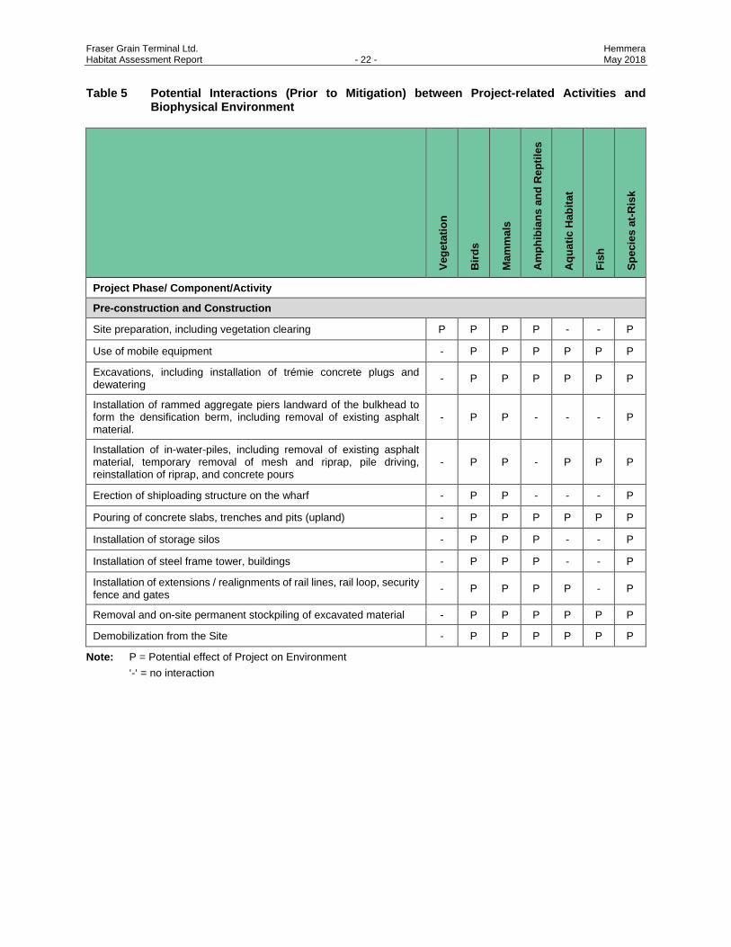
Table 5 Potential Interactions (Prior to Mitigation) between Project-related Activities and
Biophysical Environment ................................................................................................... 22
Table 6 Summary of Potential Effects and Mitigation .................................................................... 23
Table 7 Suggested Native Shrubs for Revegetation ...................................................................... 31
List of Figures
Figure 1 Project Location and Construction Boundary
Figure 2 Watercourse Classification Map
Figure 3 Vegetation and Site Cover
List of Appendices
Appendix A Proposed Construction Schedule
Appendix B Photos
Appendix C Bird Species Documented Within and in Vicinity of Project Site
Appendix D Fish Species Documented within the Lower Fraser River
Appendix E Species at Risk Documented Within the Metro Vancouver Regional District
Fraser Grain Terminal Ltd. Hemmera Habitat Assessment Report - 1 - May 2018
1.0 INTRODUCTION
Hemmera was retained by Fraser Grain Terminal Ltd.1 (the “Proponent”) to prepare a Habitat Assessment
Report for the property located on 11041 Elevator Road in Surrey, BC (the “Site”), in accordance with the
Project and Environmental Review Submission Requirements dated 24 March 2017. The Proponent is
proposing to develop the Fraser Grain Terminal Export Facility (the “Project”) on land adjacent to the Fraser
Surrey Docks (FSD) facility.
The majority of the Site is leased from Vancouver Fraser Port Authority (VFPA) by the Proponent, and was
formerly leased by Bekaert Canada Ltd. (Bekaert). The Project will serve as a trans-shipment storage
location for bulk grain products, and will include loading and unloading infrastructure, storage silos, a
transfer tower and gallery, and ancillary works. The Site has operated as a port terminal for many years
and is therefore fully developed. It is located adjacent to the main arm of the Fraser River.
This report addresses VFPA requirements for vegetation, habitat and species-at-risk for the Project’s
construction permit application. This report provides:
• A description of existing conditions, species and habitats potentially affected by Project activities such as in-water works, vegetation removal and earthworks, including effects to riparian vegetation;
• A description of existing vegetation types, characteristics, and relative abundance, including native, listed and invasive species;
• Review of all federal and provincial listed species-at-risk that may be affected by the proposed Project; and
• Potential effects resulting from Project construction, and recommendations for mitigation and monitoring.
2.0 PROJECT OVERVIEW
2.1 PROJECT LOCATION
The Project site is located on VFPA property located along the Fraser River, at 11041 Elevator Road in
Surrey, British Columbia. The Project is situated in an urban area between the Fraser River and Highway 17
(South Fraser Perimeter Road or SFPR) within the City of Surrey and adjacent to the Corporation of Delta.
The City of New Westminster is located on the east bank of the Fraser River directly across from the Project
(Figure 1).
1 Fraser Grain Terminal Ltd. is a Canadian family-owned and operated grain company with more than 100 years of experience in
agribusiness and locations across Canada. Serving more than 10,000 Canadian farmers and producers, we market grain to over 40 countries.
Fraser Grain Terminal Ltd. Hemmera Habitat Assessment Report - 2 - May 2018
The 10.3 ha Project site is located entirely on federal lands. Majority of the land has been leased directly
by the Proponent while a small portion of the land has been leased from FSD. The Project will be accessed
via an access road that is permitted for development by FSD on a right-of-way over VFPA land.
2.2 PROJECT DATES
Construction of the Project is scheduled to begin following receipt of Project approvals and after demolition
of the existing Bekaert Production Building and will take approximately two years to complete. Proposed
construction works may overlap with time periods for environmentally sensitive life history stages. For
instance, sensitive life history stages for fish (e.g., spawning, egg incubation) and the breeding bird window
are typical time periods that can influence construction plans. Potentially applicable environmental work
windows for construction projects of this type will be contingent on consideration of the actual risks of
potential effects and the ability to apply alternate mitigation approaches. Dependent on the timing of specific
aspects of construction, environmental work windows that may apply are:
• Least risk window for the protection of fish and fish habitat in the Fraser River Estuary is June 16 to February 28 (DFO 2015).
• Least risk work window for breeding birds protected by the Migratory Birds Convention Act is between September 1 and February 28 (EC 2015, MoE 2014).
• Least risk work window for raptors is September 15 to December 31 (MoE 2013).
3.0 PROJECT DESCRIPTION
3.1 PROJECT DESCRIPTION
The Proponent, in partnership with FSD, have been operating a port terminal facility that has been handling
agri-products at FSD since 2011 (JV Facility). This consists of a small rail unloading facility, a 18,000 t
storage shed, portable conveyors to load vessels and a shiploader. In 2015, selected as the baseline year
for the environmental assessment, this existing JV Facility handled in excess of 800 000 t of agri-products.
The Project proposes to trans-ship approximately 3.5 million tonnes per annum (Mt/a) of grain products
including wheat, barley, oil seeds, and pulses. The Project will make use of some existing FSD facilities for
the incoming and outgoing product:
• FSD portion of Berth #3 and Berth #4 to locate three new stationary shiploader towers and associated feed conveyors
• Portion of FSD trackage at the Port Authority Rail Yard (PARY)
The existing FSD terminal will continue to operate with its own existing receiving, storage and reclaim
system, but will integrate with the new vessel loading facilities by means of the new stationary shiploader
towers. This method offers the opportunity to allow the existing facility to be decommissioned in the future
Fraser Grain Terminal Ltd. Hemmera Habitat Assessment Report - 3 - May 2018
if so desired. The existing bathymetric profiles will limit the maximum useable draft at the FSD berth. As a
result, some of the vessels will be only partly loaded at the Project and then will be topped up at other
terminals in Vancouver Harbour (most likely the AGT Terminal which is partly owned by the partners of
Fraser Grain Terminal Export Facility).
3.2 PROJECT COMPONENTS AND ACTIVITIES
A Site layout is provided in the Overall Site General Arrangement Drawing 08-17-075CP001RA (see
Attachment 4A of the Application). Attachment 5 provides a detailed description of each component. Of
relevance to the habitat assessment, the proposed Project includes the following components:
• Semi-loop rail track and loading track connected to the adjacent PARY.
• Rail unloading station and transfer tower with fully-enclosed conveying equipment and a built-in dust suppression system.
• Three (3) fixed tower shiploaders with telescoping spouts, each with dust reducing features during vessel loading, replacing existing shiploader mobile conveyors. Each tower will be supported on steel piles in the foreshore and land side shore area.
• 25 above-ground steel storage bins (20 x 3,500 MT, 4 x 400 MT and 1 x 700 MT)
• Ground densification for the silo and shiploader foundations using Rammed Aggregate Pier (RAP) densification. The foundation densification program for the silo area was developed to minimize potential movement of in-situ contamination plumes.
• Single integrated container, bulk truck, and rail loading facility
• Container storage yard.
• An administration building and maintenance shop, two control rooms, electrical rooms and container preparation area with fabric rain cover.
In general, construction of the above-described Project components will include site preparation activities
(e.g., clearing and grubbing), excavation, slab removal, concrete works, pile driving, erection of buildings,
and assembly of the grain handling facility.
The Site is a flat, industrial, disturbed site with little native vegetation. Some clearing will be required to
accommodate certain temporary Project components (e.g., detention pond) and permanent components
(e.g., semi-loop rail track, roads). Approximately 9,500 m2 (0.95 ha) of vegetation will be removed during
site preparation. Site clearing is described in more detail in Section 5.0. The locations of the areas to be
cleared are shown in Figure 3. No excavation is planned in areas that are currently vegetated.
An approximately 35 m long section of Ditch N (see Section 4.2.2.1) will be infilled as part of construction
to accommodate a portion of the container yard footprint.
Fraser Grain Terminal Ltd. Hemmera Habitat Assessment Report - 4 - May 2018
The entire existing concrete slab under the Bekaert building will be removed, including any underground
utilities, pits, and tanks. Removed concrete will be processed and either beneficially used on-site or taken
offsite for re-use or disposal.
Ground densification activities will occur in the footprint of the storage silos before the new foundation slab
is poured. A 1 m thick foundation slab will be constructed to support all silos. Ground densification is also
planned on the landward side of the shiploader towers. Additional concrete slabs will be poured to support
the truck loading, maintenance shop, and administration buildings. Concrete will be batched offsite and
transported to the Project site using concrete trucks.
Due to existing underground contaminated soil and water, the construction of foundations for all structures
located above the contaminated area and soil excavation work will be planned and managed as indicated
in the Soil and Groundwater Management Plan (see Appendix C of Attachment 20) and geotechnical
requirements (Attachment 7). Where possible, subsurface structures requiring excavation work have been
placed away from areas of identified contamination. The Soil and Groundwater Management Plan also
outlines a process to follow if unforeseen contamination is encountered.
The construction methodology for the unloading pit and leg pit consists of the following:
• Drive sheet pile around the unloading pit perimeter
• Excavate area inside sheet piles
• Pour tremie concrete
• Pump water out
• Construct concrete walls and slabs to define unloading pit.
Three new foundations will be provided for the shiploader towers. Each of the foundations will consist of
steel pipe with cast-in-place concrete pile caps. The construction of the two outermost shiploader towers
will include a densification berm, 10 m wide and extending 10 m beyond the edge of the shiploader towers,
consisting of rammed aggregate piers on the “land side” of the shiploader towers.
Construction of the above-listed elements will require the following:
• Saw-cutting and removal of several areas of existing asphalt and gravel ballast in the wharf area.
• Protection/relocation of any exposed services.
• Coring/saw-cutting through the haunched slabs to create the openings required for pile driving.
• Burning back of exposed strand and re-bar, followed by cleaning and patching with grout.
• Preparation of the seabed for water-side pile driving, including:
▫ Divers will mark the limits of slope protection material to be cleared. ▫ Containment wire mesh will then be cut, folded back, and secured.
Fraser Grain Terminal Ltd. Hemmera Habitat Assessment Report - 5 - May 2018
▫ A barge-mounted long-reach excavator with conventional bucket or small clamshell will remove the coarse slope protection material.
▫ Excavated material will be temporarily stored on a barge before being re-installed.
• Pile driving of 31 steel pipe piles (914 mm diameter) for the shiploader foundations. Two of the shiploaders will each be supported on a foundation consisting of 10 steel pipes (three piles on each waterside corner and two on each land side corner). The third shiploader will have an additional waterside pile. Installation of the 19 waterside piles will involve the following activities:
▫ The crane-mounted pile driving equipment will either be floating (i.e., barge-based) or land-based and working from on the deck.
▫ The contractor may start pile installation with a vibratory (vibro) hammer, but will be required to finish driving with a diesel or similar impact hammer to prove the capacity for each pile.
▫ Each of the piles will receive a concrete pile cap following installation.
• Following water-side pile installation, barge-mounted equipment will reinstate the riprap. Once the riprap is confirmed to be installed correctly, the divers will trim and reinstall the wire mesh.
• Duration of In-water work is expected to be approximately five weeks.
The proposed locations of the new piles are shown in the WorleyParsons Pile Plan and List 307071-01159-
00-MA-DSK-1505.
All buildings and grain-handling components (e.g., silos, shiploader, conveyors, transfer tower, etc.) will be
fabricated offsite and transported to the Project site for final assembly and connection.
3.3 PROJECT STAGING AND SCHEDULE
Project construction will commence upon completion of site demolition activities and receipt of all applicable
regulatory and permitting approvals. Construction is anticipated to take approximately two years to
complete. The proposed construction schedule and estimated duration of activities are shown in
Appendix A. Project activities relevant to changes in terrestrial habitat are development of the main rail
loop and spur line, which are scheduled for Fall 2019.
Staging for the marine components of the Project is planned generally as follows:
• Begin wharf foundation
• Begin shiploader installation.
Fraser Grain Terminal Ltd. Hemmera Habitat Assessment Report - 6 - May 2018
4.0 EXISTING ENVIRONMENT
In general, the terrestrial and aquatic habitat within and surrounding the Project Site has been highly
modified from its pre-development setting (~c1930) by industrial and transportation activities (such as filling
and paving), as well as urbanization. The Fraser River foreshore, patches of vegetation around the Site,
and Gunderson Slough (to the south of the Site) have potential to provide habitat for fish and wildlife
species. Drainage within the Site has been generally channelized or culverted and isolated from fish-
bearing habitat. These habitats and their respective values are described below.
The Site was investigated for environmental values (Figures 2 and 3) through desktop review and site
reconnaissance. Special attention was paid to areas where site preparation (i.e., clearing and grubbing)
and new construction (e.g. in areas that were not previously built) are planned. The study area, as defined
by a 25 m buffer around the Site, was considered in the literature review to include assessment of important
environmental components (e.g., Fraser River, Gunderson Slough) that influence the value of habitat and
risk of impacts in the Site. The temporal boundary was defined as the construction phase.
Hemmera biologists visited the Site on September 30, 2015 to conduct a field reconnaissance and ground-
truth the information obtained from the literature review.
4.1 TERRESTRIAL ENVIRONMENT
4.1.1 Methods
4.1.1.1 Vegetation
Background information used to obtain terrestrial vegetation information for the study area, included:
• Published and unpublished government reports for the areas
• Published scientific reports for the areas
• Hectares BC
• BC Species and Ecosystem Explorer (BC CDC 2015)
• Committee on the Status of Endangered Wildlife in Canada (COSEWIC)
• Species at Risk Act (SARA) Registry
• iMapBC
• eFlora
• Other supporting studies for nearby projects
• Engineering drawings (Attachment 4A)
Review of background information considered ecological sensitivity, rarity on the landscape, Project-related
effects, regulatory triggers, and identification by the scientific community.

Fraser Grain Terminal Ltd. Hemmera Habitat Assessment Report - 7 - May 2018
Vegetation resources assessed included at-risk plant species, including red or blue-list species as defined by the BC Conservation Data Centre (BC CDC), and at-risk plant communities (ecosystems) as defined by regulations under SARA. Potential effects to federally (i.e., SARA) and provincially-listed at-risk plant species and communities were considered. Databases (i.e., BC CDC) were searched for potentially occurring, and confirmed present, at-risk species within the Project footprint.
Terrestrial Ecosystem Mapping (TEM) for the Project Site was conducted using British Columbia Resources Information Standards Committee (RISC) Standards for Terrestrial Ecosystem Mapping (1998) to delineate vegetated polygons. A modified TEM was required, as the Site is already developed as a Port industrial facility, and existing vegetation is characteristic of disturbed, urban environments.
Due to the small number of vegetated polygons, field data collection was performed to Level 2 survey intensity, which requires 50 to 75% of polygons to be field-checked (RISC 1998).
At-risk plant species data collection to investigate the presence of at-risk plants listed provincially (by the BC CDC; blue- or red-listed) and federally (vascular plants on Schedule 1 of SARA or under consideration by COSEWIC in July 2010) followed the Alberta Native Plant Council guidelines (2012)2. Special consideration was given to surveys for streambank lupine, a Schedule 1 at-risk plant species with historical occurrences adjacent to the Site (iMap 2015). The Project is located within identified critical habitat for streambank lupine (ECCC 2017).
Field data collection for at-risk plants focused on areas where vegetation was present. At each location, a visual estimate of combined cover and abundance was provided for each species encountered.
4.1.1.2 Wildlife
Desktop methods used to determine potential wildlife species occurring in the Site included:
• Online Databases (BC CDC, WiTS, EFauna, eBird)
• Background documents and previous reports from studies within the surrounding area (RESL 2006, SNC Lavalin 2013, CoD 2003)
Field activities conducted to determine potential presence of wildlife, particularly species at-risk included:
• Checking vegetated areas for evidence of bird nesting activity;
• Checking riparian areas for use by small and medium-sized mammals;
• Observing bird species flying overhead or using the riverine habitat adjacent to the Project Site;
• Observing wildlife sign, such as scat and tracks.
2 In the absence of BC standards for at-risk plant surveys, the Alberta Native Plant Council Guidelines are accepted as a suitable
protocol.
Fraser Grain Terminal Ltd. Hemmera Habitat Assessment Report - 8 - May 2018
4.1.2 Results
4.1.2.1 Vegetation
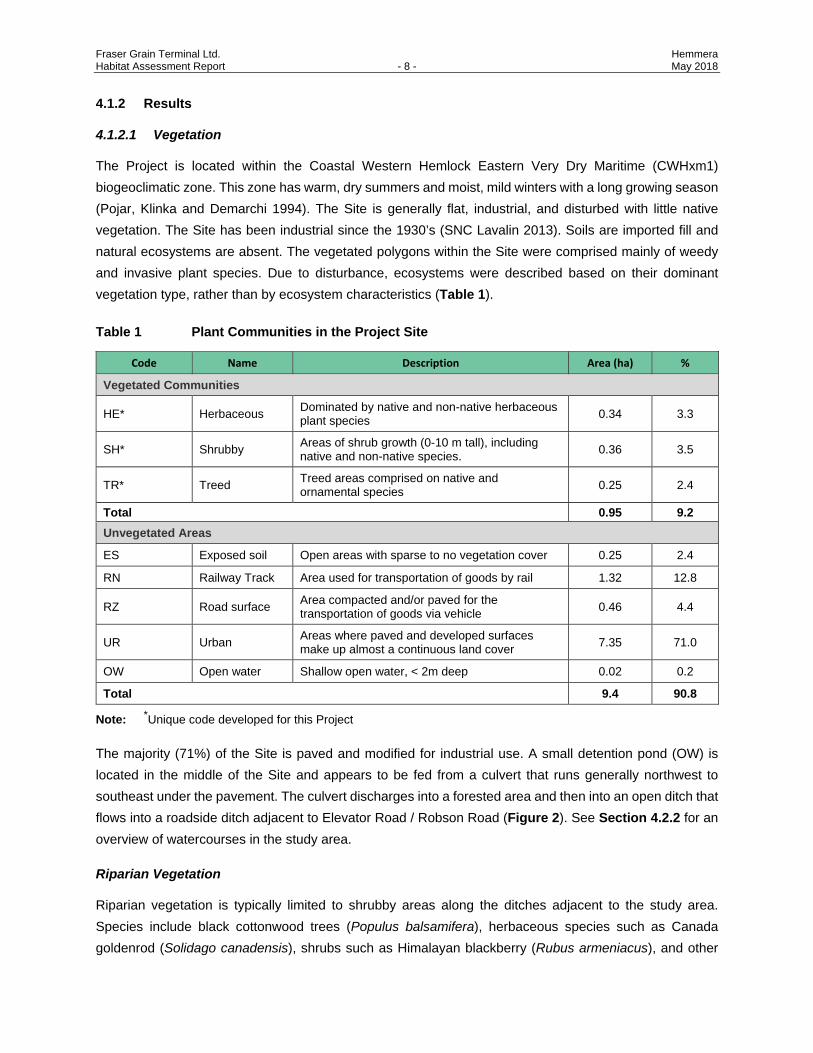
The Project is located within the Coastal Western Hemlock Eastern Very Dry Maritime (CWHxm1) biogeoclimatic zone. This zone has warm, dry summers and moist, mild winters with a long growing season (Pojar, Klinka and Demarchi 1994). The Site is generally flat, industrial, and disturbed with little native vegetation. The Site has been industrial since the 1930’s (SNC Lavalin 2013). Soils are imported fill and natural ecosystems are absent. The vegetated polygons within the Site were comprised mainly of weedy and invasive plant species. Due to disturbance, ecosystems were described based on their dominant vegetation type, rather than by ecosystem characteristics (Table 1).
Table 1 Plant Communities in the Project Site
Code Name Description Area (ha) %
Vegetated Communities
HE* Herbaceous Dominated by native and non-native herbaceous plant species 0.34 3.3
SH* Shrubby Areas of shrub growth (0-10 m tall), including native and non-native species. 0.36 3.5
TR* Treed Treed areas comprised on native and ornamental species 0.25 2.4
Total 0.95 9.2 Unvegetated Areas
ES Exposed soil Open areas with sparse to no vegetation cover 0.25 2.4
RN Railway Track Area used for transportation of goods by rail 1.32 12.8
RZ Road surface Area compacted and/or paved for the transportation of goods via vehicle 0.46 4.4
UR Urban Areas where paved and developed surfaces make up almost a continuous land cover 7.35 71.0
OW Open water Shallow open water, < 2m deep 0.02 0.2
Total 9.4 90.8
Note: *Unique code developed for this Project
The majority (71%) of the Site is paved and modified for industrial use. A small detention pond (OW) is located in the middle of the Site and appears to be fed from a culvert that runs generally northwest to southeast under the pavement. The culvert discharges into a forested area and then into an open ditch that flows into a roadside ditch adjacent to Elevator Road / Robson Road (Figure 2). See Section 4.2.2 for an overview of watercourses in the study area.
Riparian Vegetation
Riparian vegetation is typically limited to shrubby areas along the ditches adjacent to the study area. Species include black cottonwood trees (Populus balsamifera), herbaceous species such as Canada goldenrod (Solidago canadensis), shrubs such as Himalayan blackberry (Rubus armeniacus), and other

Fraser Grain Terminal Ltd. Hemmera Habitat Assessment Report - 9 - May 2018
species such as sword fern (Polystichum munitum), and horsetails (Equisetum sp.). See Section 4.2.2 for a discussion on riparian vegetation in the study area.
Herbaceous Vegetation
Herbaceous vegetation is predominantly located on the edges of the Site, adjacent to the fenceline where substrates were unpaved and gravelly. The paved areas and lack of suitable growing medium prevents establishment of most native plant species. These communities are comprised mainly of invasive and non-native plant species such as tansy ragwort (Senecio jacobeae), common tansy (Tanacetum vulgare), and common plantain (Plantago major) (Appendix B, Photo 1; Table 2). Several species defined as noxious by the BC Weed Control Act are present in these communities (Table 2).
Table 2 Invasive and Noxious Herbaceous Plant Species in the Study Area
Common name Latin Name Status
Hound’s-tongue Cynoglossum grande Invasive
White sweetclover Melilotus alba Invasive
Tansy ragwort Senecio jacobeae Noxious
Common tansy Tanacetum vulgare Invasive
Shrubby Vegetation
Shrubby plant communities are spread throughout the Site, generally on hummocks of fill. Dominant shrub species are the invasive species Himalayan blackberry and Scotch broom (Cytisus scoparius) (Appendix B, Photo 2).
Treed Communities
Several larger diameter (30 – 40 cm) cottonwood trees are found along the eastern edge of the Site, outside of the clearing boundaries. These are structural stage 4 and 5 (i.e. pole sapling or young forest as per BC Ministry of Forests Describing Terrestrial Ecosystems in the Field, 2010), that are less than 60 years old. Several cottonwood trees are also located within the clearing boundaries at the eastern edge of the property (Appendix B, Photo 3) and northeast corner (approx. 6 trees) (Appendix B, Photo 4).
A few larger trees are also present adjacent to the office building at the south end of the Site. These trees are mostly shrubby coniferous ornamentals, with an average diameter of 10 to 20 cm (DBH).
Proposed clearing and grubbing is shown in Figure 3. Trees proposed to be removed include:
• Two to three smaller trees in polygon 9.
• All the trees in polygon 16, the hedgerow of trees between the lumber yard and the study area.
• Most of the trees in polygon 3 at the northeast side of the study area adjacent to the lumber yard.
• Two to three trees in polygon 18, but the majority will remain.
Fraser Grain Terminal Ltd. Hemmera Habitat Assessment Report - 10 - May 2018
4.1.2.2 Wildlife
Due to past and present land uses within the Site, habitat values for wildlife are limited, except for relatively
mobile species and species with high tolerance for human-related activities. This section reviews birds,
mammals, herptiles and invertebrates observed or potentially occurring in the area. Species at-risk are
considered in a separate section.
Birds
Waterbirds, such as gulls, terns, ducks, grebes, herons, and cormorants, may use shoreline areas within this section of the Fraser River and Gunderson Slough for roosting and feeding (FREMP 2006). The series of pilings located within the Fraser River approximately 100 m from the site’s foreshore provide perches and roosts for many of these species. Sections of deeper water in the Fraser River may also be used by diving ducks for foraging (FREMP 2006).
Vegetation on Site, in particular the forested portion, is suitable habitat for songbirds, raptors and waders. Robertson Environmental Services Ltd. (RESL 2006) conducted point count observations and winter bird surveys within the treed portion of the study area and areas adjacent (Delta Ravines area) for the SFPR project. Thirty-five songbird species were documented during breeding season, and 34 species of passerines, woodpeckers, raptors, and waders were documented during the winter (Appendix C) (RESL 2006), a list which is not considered exhaustive. During the site visit in September 2015, seven bird species were documented, including two species not observed by RESL (Appendix C). An inactive red-tailed hawk nest was found by RESL (2006) within the forested area at the south end of the study area however none were found during the 2015 field visit . No other raptor nests have been detected within the study area (WiTS 2015, RESL 2006).
Mammals
RESL (2006) concluded that habitat along the SFPR corridor could support up to 13 species of medium and large mammals, and 29 species of small mammals (e.g., rodents, insectivores, bats, and squirrels). However, the number of mammals that use the terrestrial habitat in the vicinity of the Project is lower; limited to relatively common and widespread species suited to disturbed habitats. Four wildlife crossings (culverts) provide habitat connectivity between the Site and forest patches on the southeast side of the SFPR (MoTI 2015). These crossings may be more heavily used by large mammals rather than small mammals due to culvert length. A previous assessment of habitat available considered the riparian habitat within the study area to be “sink” habitat for small mammals (SNC Lavalin 2013); meaning that it attracts animals whose survival is consequently adversely affected. A small mammal habitat assessment conducted in the treed area in the southeastern portion of the study area (RESL 2006) concluded that this area provided nil to low value habitat for the following species: Pacific water shrew (Sorex bendirii), Trowbridge’s shrew (Sorex trowbridgii), Keen’s long-eared myotis (Myotis keenii), snowshoe hare (Lepus americanus washingtonii), Southern red-backed vole (Myodes gapperi occidentalis), and long-tailed weasel (Mustela frenata altifrontalis).
Fraser Grain Terminal Ltd. Hemmera Habitat Assessment Report - 11 - May 2018
During the 2015 site visit, mammal sign observed included coyote (Canis latrans) scat and raccoon (Procyon lotor) prints.
Marine mammals, including California sea lion (Zalophus californianus), Steller sea lion (Eumetopias jubatus), and harbour seal (Phoca vitulina) may use Fraser River for foraging and as a movement corridor (Bigg 1985, COSEWIC 2003, FREMP 2006, Page 2012). Other aquatic mammals such as American river otter (Lontra canadensis), muskrat (Ondatra zibethicus), beaver (Castor canadensis), and American mink (Neovison vison) have the potential to occur in the study area but none are likely to use aquatic and riparian habitat for foraging or resting due to intensive human activity and the presence of only sub-optimal habitat on Site.
Reptiles and Amphibians
Four species of reptiles have potential to occur within the Surrey and Delta area, including three garter snake species (Thamnophis spp.) and alligator lizard (Elgaria coerulea)(Gebauer 1999, Knopp and Larkin 1999, RESL 2006). The snake species could use riparian areas and areas of roadside vegetation on Site (Reptiles of BC 2015). Habitat features, such as rock outcrops, grassy openings and abundant debris for shelter essential for alligator lizards, (Reptiles of BC 2015), are absent from the study area. Therefore, this species is not expected to be found on Site.
Ten species of amphibians could occur within the Surrey and Delta area, including four salamander, five frog, one toad, and one newt species (Gebauer 1999, Knopp and Larkin 1999, CoD 2003, RESL 2006). Two of these species, the bull frog (Rana catesbeina) and green frog (Rana clamitans), are introduced species generally tolerant of human disturbance and poor water quality. These two species, along with the native northwestern salamander (Ambystoma gracile), are commonly found in roadside ditches in the Lower Mainland, and likely occur in the ditches on Site. Amphibians are not expected to be found in the Fraser River adjacent to the Site due to lack of suitable habitat (FREMP 2006).
Invertebrates
Many species of invertebrates, including aerial insects, gastropods, and bivalves, could occur within the study area. Surveys conducted along the SFPR alignment in 2004 documented over 100 species of insects alone (RESL 2006), a list which is not considered exhaustive.
4.2 AQUATIC ENVIRONMENT
This section considers existing aquatic (instream) and riparian (terrestrial) fish habitats within the study area, primarily associated with the Fraser River, Gunderson Slough, and minor tributary streams and ditches that drain into the Fraser River.
The Project is located approximately 34 km upstream of the mouth of the Fraser River, within the Lower Fraser Watershed. The Lower Fraser Watershed has the densest human population area in the Fraser River drainage, containing all communities within the Fraser Valley and Metro Vancouver Regional Districts (Fraser Basin Council 2015).
Fraser Grain Terminal Ltd. Hemmera Habitat Assessment Report - 12 - May 2018
4.2.1 Methods
Information on aquatic habitat classifications and associated fish species likely to use aquatic environments
within the study area were gathered from the following sources:
• Fish species distribution from iMap BC;
• Riparian habitat mapping in the study area from FREMP; and
• Fisheries and aquatic information contained in previous documents and reports.
Foreshore classification mapping (FREMP 2015) was used to classify foreshore and riparian habitats
adjacent to the Site. The FREMP foreshore classifications are colour-coded and defined as follows:
• Green-coded: habitat with low productivity shorelines where fish habitat features and functions are limited due to existing conditions (e.g., shoreline has been altered or “hardened” for port or other urbanized uses).
• Yellow-coded: habitats with features that are of moderate value in structure or diversity due to existing conditions (e.g. surrounding land uses or productivity) and support moderate fish and wildlife functions.
• Red-coded: habitats with productive and diverse habitat features that support critical fish and wildlife functions and/or areas where habitat compensation has been previously constructed.
The City of Surrey maintains a Watercourse Classification Map online of all city watercourses (including
ditches) based on their value as fish habitat for salmonids and regionally significant fish. The classification
identifies whether the watercourse is inhabited by fish or whether it contributes food/nutrient value to
downstream populations of fish. The classification coding as available in the City of Surrey Mapping Online
System (COSMOS is as follows:
• Red-coded (Class A): watercourses inhabited by fish year-round, or potentially inhabited year-round with access enhancement.
• Dashed Red-coded (Class AO): watercourses inhabited by fish primarily during the overwintering period, or potentially inhabited during the overwintering period with access enhancement.
• Yellow-coded (Class B): non-fish-bearing watercourses that contribute or potentially contribute significant food/nutrient inputs to downstream fish populations (based on connectivity).
• Green-coded (Class C): non-fish-bearing watercourses that do not contribute significant food/nutrient value to downstream fish populations.
Hemmera conducted a site visit September 30, 2015 to ground-truth the desktop research findings and
data gaps.

Fraser Grain Terminal Ltd. Hemmera Habitat Assessment Report - 13 - May 2018
4.2.2 Results
The location of watercourses in relation to the Site is shown in Figure 2. The watercourses adjacent to the Site are all minor tributary streams that drain into the Fraser River by way of Gunderson Slough. The lower reaches of these watercourses have been highly modified from their natural channels through the diversion of flow by means of culverts, ditches, and drainage channels. Runoff patterns and water quality within these systems have also experienced substantial alteration due to urbanization as well as surface runoff from roadways becoming a major contributor to flow.
Tributaries to and habitat features of the Fraser River that are adjacent to the Site include, Gunderson Slough, Shadow Brook, Armstrong Creek, Colliers Canal, an unnamed Class AO ditch, and an unnamed Class B ditch. Three Class C (i.e., non-fish-bearing) ditches also directly overlap with the Project Site: Ditch N, Ditch S, and the Robson Road ditch. COSMOS (2016) does not identify any hydraulic connection between these ditches and other fish-bearing watercourses; however, FSD staff have identified a culvert that runs under Elevator Road at the west end of Ditch S, which drains these ditches into Gunderson Slough (A. Ekkert, pers.comm.). The culvert characteristics (e.g., length, material, fish-passability) are unknown; however, based on the COSMOS classification, these ditches are assumed to be impassible to fish from Gunderson Slough and unlikely to provide significant nutrient input to downstream fish habitat/populations.
A description of fish species presence as well as the aquatic and riparian habitats associated with each watercourse that could be affected by the Project is provided in the sections below. Species at-risk are described in Section 4.3.
4.2.2.1 Aquatic Features within the Site
Fraser River
The Fraser River is a regionally-important, fish-bearing waterbody. Forty-six species of fish have been documented within the Lower Fraser River (McPhail and Carveth 1994, iMap BC 2015, FISS 2015) several of which support commercial, recreational and/or Aboriginal (CRA) fisheries (Appendix C). Fraser River habitat for CRA species in the study area acts as a migratory corridor for eulachon, adult and juvenile salmonids, and provides year-round values for white sturgeon. The Fraser River shoreline bordering the Project, however, is classified by FREMP as green-coded or low productivity for fish habitat (FREMP 2015; Figure 2). The shoreline adjacent to the Site is characterized by a sheet pile wall that extends the length of the FSD berthing area and a riprap armoured slope covered with wire mesh (Appendix B, Photo 6).
Class C Ditches
Other than the Fraser River, watercourses within the Site are Class C ditches and include Ditch N, Ditch S,
and the Robson Road ditch, described in detail below.
Fraser Grain Terminal Ltd. Hemmera Habitat Assessment Report - 14 - May 2018
The Class C ditch N (Ditch N) is fed by surface water drainage from the Site, as well as a constructed pond
that collects surface water runoff and drain water from the existing Production Building. The ditch originates
near the on-Site detention pond and flows in a southwest direction into the two other Class C ditches that
parallel Robson Road. Given the gradient, flow direction may be dependent on rain runoff volumes. Ditch N
is approximately 2 m wide and 150 m long (Appendix B, Photo 14). The ditch was dry at the time of the
site visit, and is expected to be wetted only during sustained periods of rainfall during fall and winter months.
Riparian vegetation around the ditch consists mainly of Himalayan blackberry and black cottonwood
(Populus trichocarpa). The ditch has no instream vegetation, or other forms of instream cover. The northern
portion of this ditch (approximately 35 m) will be infilled as a part of Project site preparation for the container
yard. The remaining portion of the ditch is likely to be affected by clearing and grubbing activities, laydown,
and material stockpiling.
The Class C ditch S (Ditch S) roughly parallels Elevator Road and connects with Ditch N and the Robson
Road ditch via culverts at its east end. The ditch channel is approximately 2.5 m wide and 175 m long
(Appendix B, Photo 15). The ditch was wetted at the time of the site visit, and contains abundant instream
vegetation, including reed canary grass, red osier dogwood, cattail, and willow shrubs (Salix spp.).
This ditch is anticipated to receive water discharged from the temporary construction sedimentation pond.
According to COSMOS, this ditch does not hydraulically connect to Gunderson Slough; however, a culvert
apparently connects the south end of the ditch to Gunderson Slough (Ekkert, pers.comm). This ditch will
be affected by rail development activities during construction (see Section 5.0).
The Robson Road ditch, also Class C, is a 2 m wide and 350 m long ditch that parallels the east side of
Robson Road and is connected by culverts to Ditch S and Ditch N (Appendix B, Photo 13). During the site
visit in September 2015, some surface water and abundant vegetation was observed within the channel
including reed canary grass and cattail (Typha latifolia).
4.2.2.2 Fish-bearing Aquatic Features Adjacent to the Project Site
Gunderson Slough
Gunderson Slough is a large backwater feature in the Fraser River connected on its downstream end to
Annieville Channel (Appendix B, Photo 7) and located approximately 40 m south of the Site. During wetter
periods of the year, Gunderson Slough could receive flows from the Project Site via Shadow Brook. The
shoreline at the outlet of Shadow Brook into Gunderson Slough is characterized by FREMP as red-coded,
which indicates productive and diverse habitat features that support critical fish and wildlife functions on
Site or as part of a more regional context, and areas where habitat compensation has been previously
constructed to offset habitat losses (FREMP 2015).
Fraser Grain Terminal Ltd. Hemmera Habitat Assessment Report - 15 - May 2018
Aquatic and riparian habitats of Gunderson Slough are considered to be of high value and very sensitive.
As a tidal feature that is fully connected to the Fraser River, the slough and its tidal marshes and other
backwater instream habitats provide high value rearing habitat for out-migrating juvenile Pacific salmon.
All five species of Pacific salmon may be encountered seasonally within this area, with juvenile coho
(Oncorhynchus kisutch), chum (O. keta), and chinook (O. tshawytscha) being most likely present given their
ecology and life history traits.
Shadow Brook
Shadow Brook is a Class A watercourse that flows under Robson Road and Elevator Road via a series of
culverts, draining into Gunderson Slough approximately 30 m downstream of Elevator Road. Shadow Brook
provides year-round salmonid habitat (CoD 2003, CoD 2015, COSMOS 2015) and is fed by two fish-bearing
watercourses (creeks in Townline and Kendale Ravines) from the east side of SFPR (CoD 2003, CoD 2015,
COSMOS 2015). Two reaches of Shadow Brook were identified during the site visit:
Upstream of Elevator Road: The channel here is approximately 1 m wide, and contains abundant instream
vegetation composed mainly of exotic species (reed canary grass (Phalaris arundinacea) and Himalayan
blackberry (Rubus armeniacus)) (Appendix A, Photo 8). Substrates are predominantly sand and fines.
Downstream of Elevator Road: Channel width is approximately 3 m (Appendix A, Photo 9). Channel
substrates consist of angular cobble and sand. Some instream cover is present in the form of undercut
banks, overhanging vegetation, and pools.
Both reaches of Shadow Brook represent migration habitat to fish-bearing watercourses upstream. Rearing
habitat value is considered to be high downstream of Elevator Road, and moderate upstream. Due to the
lack of suitable substrate, neither of these reaches represent spawning habitat. Cutthroat trout (O. clarki)
and coho salmon have been previously documented within Shadow Brook and its tributaries (iMap BC
2015). Two unidentified sculpins (Cottus sp.) were also observed in the reach upstream of Elevator Road
during the site visit.
Armstrong Creek/Colliers Canal
Armstrong Creek and Colliers Canal in the vicinity of the Project are Class A habitat which is f a continuous
ditch approximately 2.5 m wide that parallels the southeast side of the Burlington Northern Santa Fe (BNSF)
Railway tracks (Appendix B, Photo 10). This ditch flows under the BNSF tracks and Elevator Road via
consecutive culverts, and discharges to Shadow Brook on the south side of Elevator Road (COSMOS
2015). Abundant reed canary grass was observed in the ditch at the site of the site visit. Channel substrates
are predominantly fines and sands. These watercourses provide no spawning habitat but provide moderate
rearing and migration habitat to upstream fish-bearing watercourses. Stickleback (Gasterosteidae sp.) and
cutthroat trout have been documented in these waterbodies, east of the study area (iMap BC 2015).
Fraser Grain Terminal Ltd. Hemmera Habitat Assessment Report - 16 - May 2018
Unnamed Class AO ditch
An unnamed ditch (~ 2 m wide) flows for roughly 100 m along the southeast side of the Canadian National
(CN) Railway tracks (Appendix B, Photo 11). According to COSMOS (2015), this ditch is classified as
Class AO habitat. During the September site visit, the ditch was dry with no surface flow connection to fish-
bearing watercourses. Vegetation observed in the channel (reed canary grass and red osier dogwood
(Cornus sericea), species that are indicative of moist areas), suggests that the ditch is seasonally wetted.
The BNSF access road off of Robson Road at the southern end of the ditch is not culverted and therefore
prevents connection to the fish-bearing Shadow Brook to the south (Figure 2).
4.3 SPECIES AT-RISK
For this report, species at-risk are defined as species designated as extirpated, endangered, threatened,
or of special concern in Appendices 1 through 3 of the federal Species at Risk Act (SARA). Hemmera
conducted a search of the BC Species and Ecosystem Explorer (BC CDC 2015) to identify species at-risk
and provincially listed species with the potential to occur within Metro Vancouver (Appendix E). This list
was then refined based on habitat conditions available in the Site, known occurrences from previous studies
and inventories in the study area, and known habitat associations of each at-risk species. The potential for
each species to occur was ranked (i.e., low, medium, or high).
4.3.1 Plant Species at-Risk
The at-risk plant survey assessed the Site for at-risk plants with the greatest potential to occur. No listed
plant communities or wetlands or at-risk plant species were encountered during the survey of the study
area. Two species (green-sheathed sedge and streambank lupine) had the greatest potential for occurrence
(Table 3).
Table 3 At-risk Plant Species with Potential to Occur on the Site
English Name Scientific Name SARA Schedulea COSEWIC BC LIST
Green-sheathed sedge Carex feta -- -- Blue
Streambank lupine Lupinus rivularis 1-E (Jan 2005) E (Nov 2002) Red
Notes: a Federal designation of a species to Schedule 1, 2, or 3 with an associated status code: (Extinct (XX), Extirpated (XT), Endangered (E), Threatened (T), Special Concern (SC), or Not at Risk (NAR). Species listed on Schedule 2 or 3 are not officially protected under SARA.
Fraser Grain Terminal Ltd. Hemmera Habitat Assessment Report - 17 - May 2018
The only federally at-risk species that may occur on Site was streambank lupine. Streambank lupine is a perennial, herbaceous plant that ranges in height from 0.3 to 1.0 m (COSEWIC 2002a, SLRT 2014, eFlora 2015) which is found along the Pacific coast from B.C. to northern California. In BC, streambank lupine occurs in the Coastal Douglas-fir (CDFmm) and the Western Hemlock (CWH) biogeoclimatic zones (COSEWIC 2002a) where it is restricted to southwestern B.C. All but one known population are found within the Lower Mainland region (COSEWIC 2002a, SLRT 2014). It grows in open, nutrient-poor, sandy or gravelly, river or creek bank sites at low elevations close to coastal regions with little surrounding vegetation and is often found in disturbed habitats, including rights-of-way, railway tracks, and roadsides (COSEWIC 2002a). The provincial recovery strategy for this species suggests that it may occur in highly disturbed habitat where it is not subject to competitive exclusion (SLRT 2014). An extant population that is associated with railway ballast exists approximately 250 m to the southwest of the Project Site (ECCC 2017).
Streambank lupine has been previously documented in a vegetated area north of Elevator Road (Figure 3) (ECCC 2017, eFlora 2015, iMap 2015, SNC Lavalin 2013). The last observed occurrence recorded at Fraser Surrey Docks was in 2013 (ECCC 2017), on a location that is now heavily vegetated with Himalayan blackberry and Canada goldenrod (Solidago canadensis). This observation was of one juvenile/seedling. No plants were found in this area during the 2015 site visit. The precise longevity of streambank lupine seeds in the seedbank is unknown (ECCC 2017) but due to a hard seed coat and ability to produce dormant seeds, they are assumed to be long-lived (Maron and Simms, 1997). However, if the current vegetation community persists, it is unlikely that sufficient suitable growing habitat will be available in the future. Construction of the semi-loop rail track, which will require clearing of existing vegetation and replacement with ballast rock, may represent an improvement in the existing sub-optimal habitat conditions for streambank lupine at this location through the removal of competition and an increase in light.
Given the overlap of the rail loop with critical habitat for this species, a permit application under Section 73 of SARA has been submitted to Environment and Climate Change Canada for the Project and is included in Appendix F. This SARA application addresses the effects of railway development due to the Project and proposed mitigation for streambank lupine.
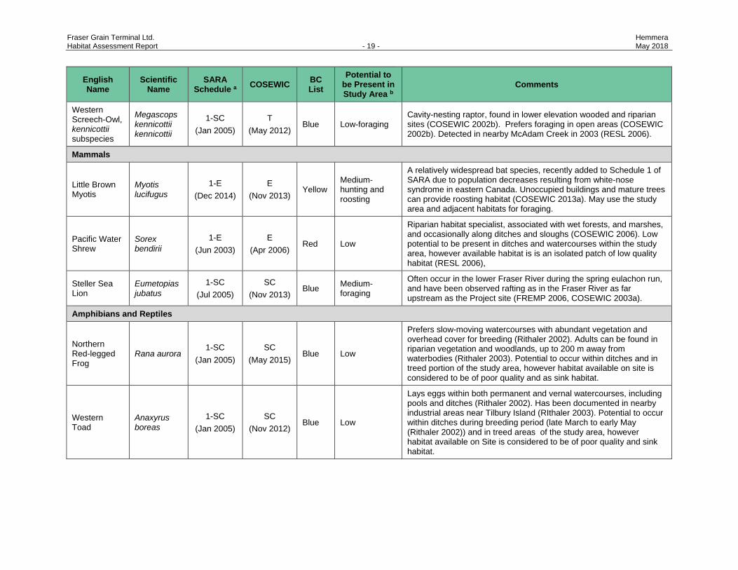
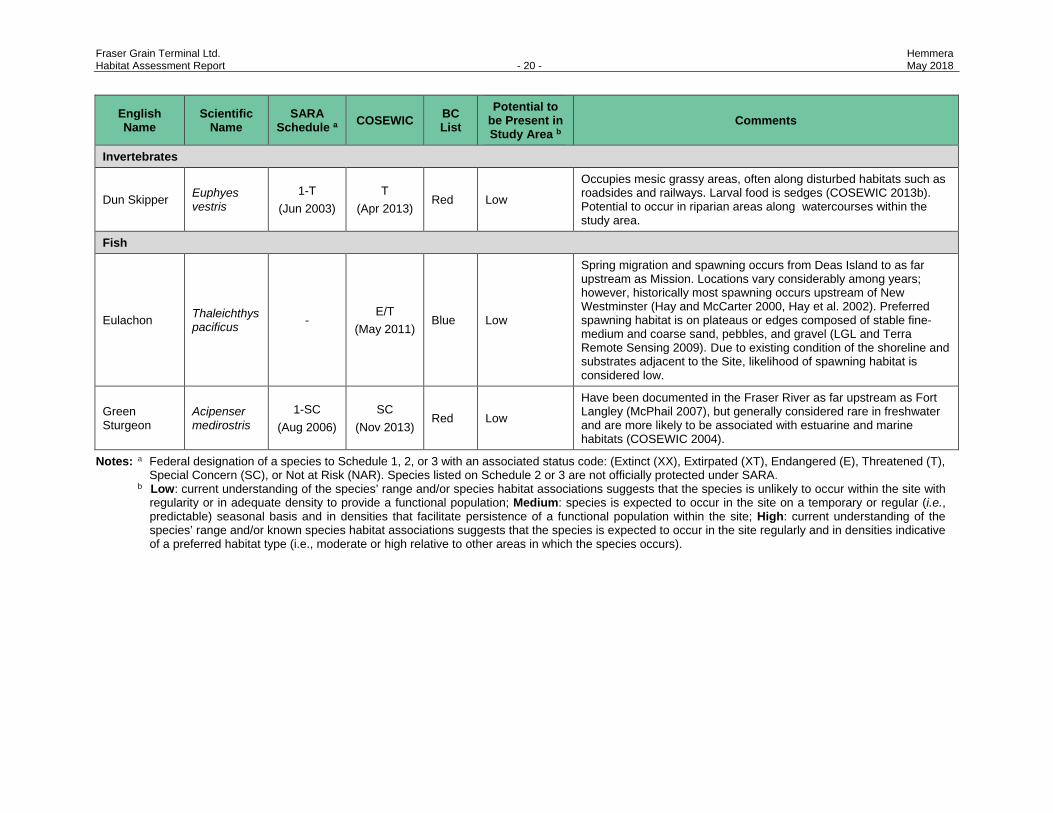
4.3.2 Wildlife Species at-Risk
Thirteen wildlife species at-risk are considered to have potential to occur within the study area. The general
ecology and potential occurrence of each species is detailed in Table 4 below.
4.3.3 Fish
Two at-risk fish species, the green sturgeon (Acipenser medirostris) and eulachon (Thaleichthys pacificus),
are considered to have low potential to occur in the study area (Table 4).
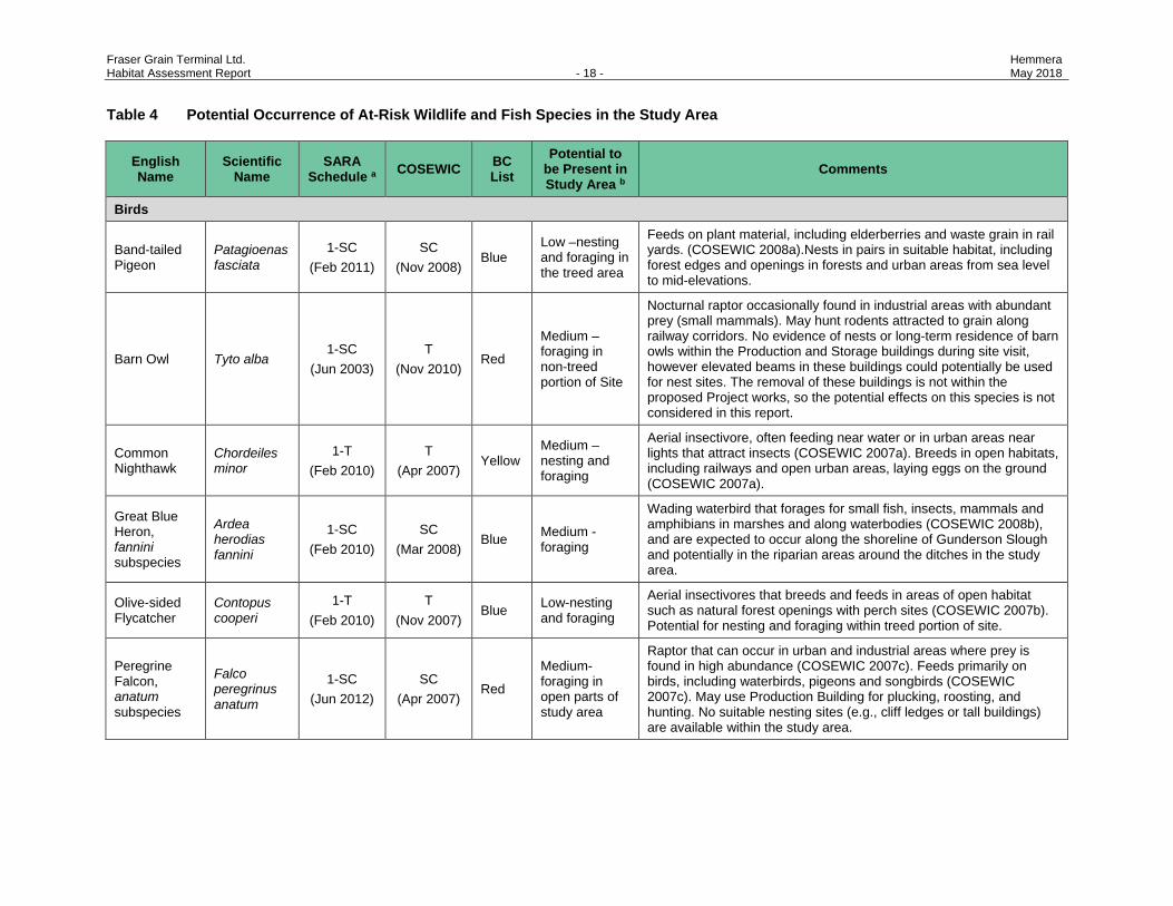
Fraser Grain Terminal Ltd. Hemmera Habitat Assessment Report - 18 - May 2018
Table 4 Potential Occurrence of At-Risk Wildlife and Fish Species in the Study Area
English Name
Scientific Name
SARA Schedule a COSEWIC BC
List Potential to
be Present in Study Area b
Comments
Birds
Band-tailed Pigeon
Patagioenas fasciata
1-SC (Feb 2011)
SC (Nov 2008)
Blue Low –nesting and foraging in the treed area
Feeds on plant material, including elderberries and waste grain in rail yards. (COSEWIC 2008a).Nests in pairs in suitable habitat, including forest edges and openings in forests and urban areas from sea level to mid-elevations.
Barn Owl Tyto alba 1-SC
(Jun 2003) T
(Nov 2010) Red
Medium – foraging in non-treed portion of Site
Nocturnal raptor occasionally found in industrial areas with abundant prey (small mammals). May hunt rodents attracted to grain along railway corridors. No evidence of nests or long-term residence of barn owls within the Production and Storage buildings during site visit, however elevated beams in these buildings could potentially be used for nest sites. The removal of these buildings is not within the proposed Project works, so the potential effects on this species is not considered in this report.
Common Nighthawk
Chordeiles minor
1-T (Feb 2010)
T (Apr 2007)
Yellow Medium – nesting and foraging
Aerial insectivore, often feeding near water or in urban areas near lights that attract insects (COSEWIC 2007a). Breeds in open habitats, including railways and open urban areas, laying eggs on the ground (COSEWIC 2007a).
Great Blue Heron, fannini subspecies
Ardea herodias fannini
1-SC (Feb 2010)
SC (Mar 2008)
Blue Medium - foraging
Wading waterbird that forages for small fish, insects, mammals and amphibians in marshes and along waterbodies (COSEWIC 2008b), and are expected to occur along the shoreline of Gunderson Slough and potentially in the riparian areas around the ditches in the study area.
Olive-sided Flycatcher
Contopus cooperi
1-T (Feb 2010)
T (Nov 2007)
Blue Low-nesting and foraging
Aerial insectivores that breeds and feeds in areas of open habitat such as natural forest openings with perch sites (COSEWIC 2007b). Potential for nesting and foraging within treed portion of site.
Peregrine Falcon, anatum subspecies
Falco peregrinus anatum
1-SC (Jun 2012)
SC (Apr 2007)
Red
Medium-foraging in open parts of study area
Raptor that can occur in urban and industrial areas where prey is found in high abundance (COSEWIC 2007c). Feeds primarily on birds, including waterbirds, pigeons and songbirds (COSEWIC 2007c). May use Production Building for plucking, roosting, and hunting. No suitable nesting sites (e.g., cliff ledges or tall buildings) are available within the study area.
Fraser Grain Terminal Ltd. Hemmera Habitat Assessment Report - 19 - May 2018
English Name
Scientific Name
SARA Schedule a COSEWIC BC
List Potential to
be Present in Study Area b
Comments
Western Screech-Owl, kennicottii subspecies
Megascops kennicottii kennicottii
1-SC (Jan 2005)
T (May 2012)
Blue Low-foraging Cavity-nesting raptor, found in lower elevation wooded and riparian sites (COSEWIC 2002b). Prefers foraging in open areas (COSEWIC 2002b). Detected in nearby McAdam Creek in 2003 (RESL 2006).
Mammals
Little Brown Myotis
Myotis lucifugus
1-E (Dec 2014)
E (Nov 2013)
Yellow Medium- hunting and roosting
A relatively widespread bat species, recently added to Schedule 1 of SARA due to population decreases resulting from white-nose syndrome in eastern Canada. Unoccupied buildings and mature trees can provide roosting habitat (COSEWIC 2013a). May use the study area and adjacent habitats for foraging.
Pacific Water Shrew
Sorex bendirii
1-E (Jun 2003)
E (Apr 2006)
Red Low
Riparian habitat specialist, associated with wet forests, and marshes, and occasionally along ditches and sloughs (COSEWIC 2006). Low potential to be present in ditches and watercourses within the study area, however available habitat is is an isolated patch of low quality habitat (RESL 2006),
Steller Sea Lion
Eumetopias jubatus
1-SC (Jul 2005)
SC (Nov 2013)
Blue Medium- foraging
Often occur in the lower Fraser River during the spring eulachon run, and have been observed rafting as in the Fraser River as far upstream as the Project site (FREMP 2006, COSEWIC 2003a).
Amphibians and Reptiles
Northern Red-legged Frog
Rana aurora 1-SC
(Jan 2005) SC
(May 2015) Blue Low
Prefers slow-moving watercourses with abundant vegetation and overhead cover for breeding (Rithaler 2002). Adults can be found in riparian vegetation and woodlands, up to 200 m away from waterbodies (Rithaler 2003). Potential to occur within ditches and in treed portion of the study area, however habitat available on site is considered to be of poor quality and as sink habitat.
Western Toad
Anaxyrus boreas
1-SC (Jan 2005)
SC (Nov 2012)
Blue Low
Lays eggs within both permanent and vernal watercourses, including pools and ditches (Rithaler 2002). Has been documented in nearby industrial areas near Tilbury Island (RIthaler 2003). Potential to occur within ditches during breeding period (late March to early May (Rithaler 2002)) and in treed areas of the study area, however habitat available on Site is considered to be of poor quality and sink habitat.
Fraser Grain Terminal Ltd. Hemmera Habitat Assessment Report - 20 - May 2018
English Name
Scientific Name
SARA Schedule a COSEWIC BC
List Potential to
be Present in Study Area b
Comments
Invertebrates
Dun Skipper Euphyes vestris
1-T (Jun 2003)
T (Apr 2013)
Red Low
Occupies mesic grassy areas, often along disturbed habitats such as roadsides and railways. Larval food is sedges (COSEWIC 2013b). Potential to occur in riparian areas along watercourses within the study area.
Fish
Eulachon Thaleichthys pacificus -
E/T (May 2011)
Blue Low
Spring migration and spawning occurs from Deas Island to as far upstream as Mission. Locations vary considerably among years; however, historically most spawning occurs upstream of New Westminster (Hay and McCarter 2000, Hay et al. 2002). Preferred spawning habitat is on plateaus or edges composed of stable fine-medium and coarse sand, pebbles, and gravel (LGL and Terra Remote Sensing 2009). Due to existing condition of the shoreline and substrates adjacent to the Site, likelihood of spawning habitat is considered low.
Green Sturgeon
Acipenser medirostris
1-SC (Aug 2006)
SC (Nov 2013)
Red Low
Have been documented in the Fraser River as far upstream as Fort Langley (McPhail 2007), but generally considered rare in freshwater and are more likely to be associated with estuarine and marine habitats (COSEWIC 2004).
Notes: a Federal designation of a species to Schedule 1, 2, or 3 with an associated status code: (Extinct (XX), Extirpated (XT), Endangered (E), Threatened (T), Special Concern (SC), or Not at Risk (NAR). Species listed on Schedule 2 or 3 are not officially protected under SARA.
b PLow: current understanding of the species’ range and/or species habitat associations suggests that the species is unlikely to occur within the site with regularity or in adequate density to provide a functional population; Medium: species is expected to occur in the site on a temporary or regular (i.e., predictable) seasonal basis and in densities that facilitate persistence of a functional population within the site; High: current understanding of the species’ range and/or known species habitat associations suggests that the species is expected to occur in the site regularly and in densities indicative of a preferred habitat type (i.e., moderate or high relative to other areas in which the species occurs).
Fraser Grain Terminal Ltd. Hemmera Habitat Assessment Report - 21 - May 2018
5.0 ASSESSMENT OF PROJECT-RELATED EFFECTS AND MITIGATION
This report considers potential changes to the biophysical environment and focuses on those environmental
components and features with the potential to be affected by the Project. Components and features were
selected based on ecological importance and/or conservation status, and relative sensitivity of
environmental components to Project influences. The following components were assessed:
• Vegetation
• Birds
• Mammals
• Amphibians and Reptiles
• Aquatic habitat
• Fish
• Species at Risk
The potential for Project interaction with the environmental components was then analyzed based on
Project-related activities and other information provided by FWS, and assessment of the environmental
setting and temporal and/or spatial conflict, knowledge of the Site, and professional judgment. Potential
interactions (prior to implementation of mitigation measures) between Project components/activities and
the environment are described in Table 5. Detailed descriptions of the identified interactions and measures
to mitigate potential adverse effects are provided in Table 6.
Fraser Grain Terminal Ltd. Hemmera Habitat Assessment Report - 22 - May 2018
Table 5 Potential Interactions (Prior to Mitigation) between Project-related Activities and Biophysical Environment
Vege
tatio
n
Bird
s
Mam
mal
s
Am
phib
ians
and
Rep
tiles
Aqu
atic
Hab
itat
Fish
Spec
ies
at-R
isk
Project Phase/ Component/Activity
Pre-construction and Construction
Site preparation, including vegetation clearing P P P P - - P
Use of mobile equipment - P P P P P P
Excavations, including installation of trémie concrete plugs and dewatering - P P P P P P
Installation of rammed aggregate piers landward of the bulkhead to form the densification berm, including removal of existing asphalt material.
- P P - - - P
Installation of in-water-piles, including removal of existing asphalt material, temporary removal of mesh and riprap, pile driving, reinstallation of riprap, and concrete pours
- P P - P P P
Erection of shiploading structure on the wharf - P P - - - P
Pouring of concrete slabs, trenches and pits (upland) - P P P P P P
Installation of storage silos - P P P - - P
Installation of steel frame tower, buildings - P P P - - P
Installation of extensions / realignments of rail lines, rail loop, security fence and gates - P P P P - P
Removal and on-site permanent stockpiling of excavated material - P P P P P P
Demobilization from the Site - P P P P P P
Note: P = Potential effect of Project on Environment ‘-‘ = no interaction

Fraser Grain Terminal Ltd. Hemmera Habitat Assessment Report - 23 - May 2018
Table 6 Summary of Potential Effects and Mitigation
Environmental Component
Potential Project Interaction with
Environment Mitigation Residual Effects
Vegetation
Permanent and temporary loss of vegetation in Project footprint during clearing and grubbing Introduction of invasive species through increasing areas of exposed soil, or vectored through imported soil and/or equipment. Potential impact to at-risk vegetation species (streambank lupine) and/or critical habitat during construction and operations.
Limit areas of vegetation clearing and flag clearing boundaries. Revegetate disturbed areas with appropriate seed mix and native plant species as soon as feasible or as a temporary invasive species control measure (see Section 6.0). Implement an invasive species management plan (see Section 6.0), with the following general parameters:
• Dispose of invasive plant material appropriately. • Remove invasive plant species prior to fruit / seed pod
development to prevent spread and regrowth of seeds. • Inspect vehicles for plant material prior to entering site and use
truck wash station to prevent the spread of invasive plant species.
• Ensure any soil or fill coming onto the site is free of noxious weeds.
See “Species at Risk” below for measures specific to streambank lupine.
Permanent loss of 0.95 ha of predominantly invasive and non-native species vegetation. Effects are expected to be very localized. Insignificant residual effects expected with appropriate mitigation measures in place.
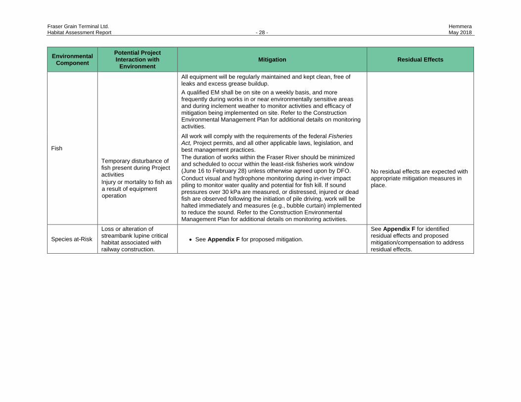
Birds
If clearing is required in the period when bird nesting could occur: Destruction of active nests or breeding areas Temporary disturbance of birds present during Project activities Injury or mortality to birds as a result of equipment operation
Comply with the requirements of the Species at Risk Act, the Migratory Birds Convention Act, Wildlife Act and all other applicable laws, legislation, and best management practices (BMPs) provided at the MoE’s Guidelines and BMPs website including Best Management Practices for Raptor Conservation During Urban and Rural Land Development in BC (MoE 2013). Schedule vegetation removal to occur within the least risk work window for breeding birds (September 1 to February 28). If this is not possible, conduct a pre-clearing survey using a qualified environmental professional (QEP) in advance of any works. If clearing is required during the nesting period and evidence of active bird nests is detected during the pre-clearing survey, the QEP shall propose appropriate measures (e.g., suitable buffers around nests). Work areas will be kept clear of all wildlife attractants (i.e. garbage). Food and food waste will be removed from the Site at the end of each day. Implement a wildlife education program as part of worker orientation.
No residual effects are expected with appropriate mitigation measures in place.
Fraser Grain Terminal Ltd. Hemmera Habitat Assessment Report - 24 - May 2018
Environmental Component
Potential Project Interaction with
Environment Mitigation Residual Effects
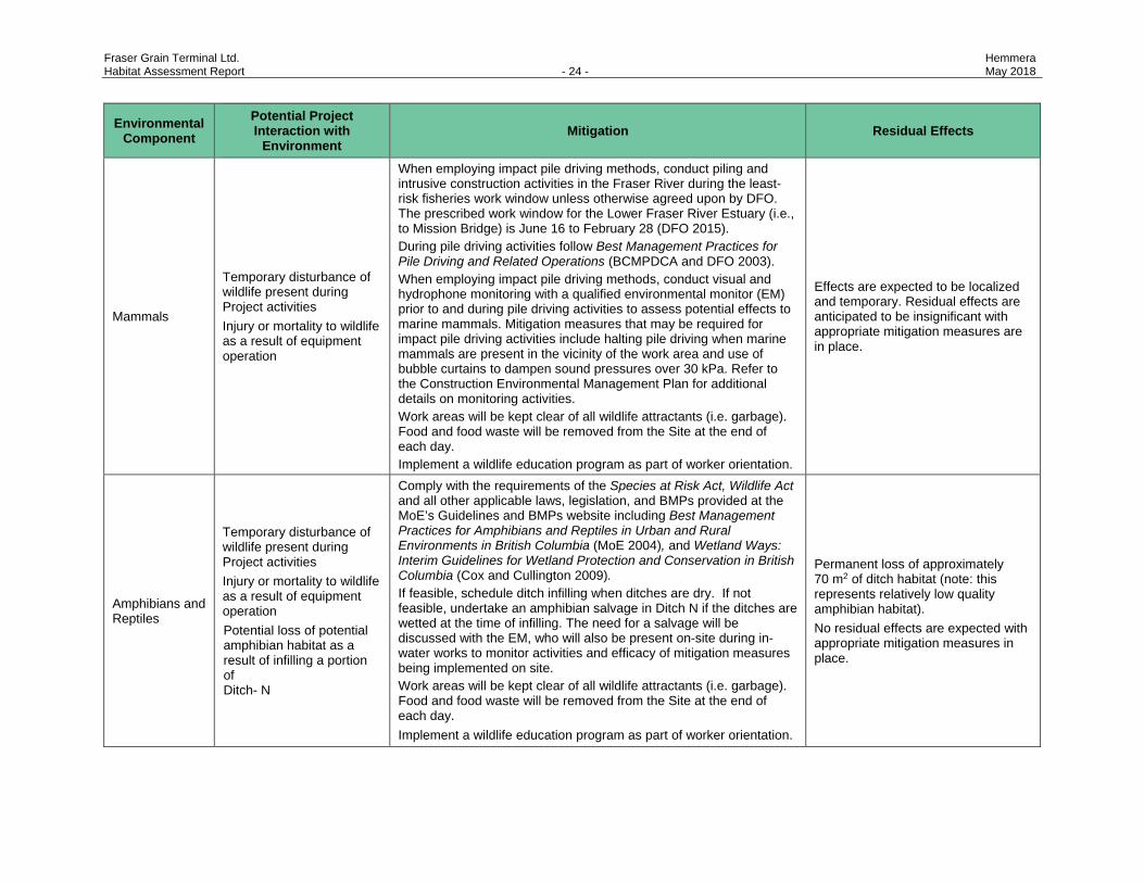
Mammals
Temporary disturbance of wildlife present during Project activities Injury or mortality to wildlife as a result of equipment operation
When employing impact pile driving methods, conduct piling and intrusive construction activities in the Fraser River during the least-risk fisheries work window unless otherwise agreed upon by DFO. The prescribed work window for the Lower Fraser River Estuary (i.e., to Mission Bridge) is June 16 to February 28 (DFO 2015). During pile driving activities follow Best Management Practices for Pile Driving and Related Operations (BCMPDCA and DFO 2003). When employing impact pile driving methods, conduct visual and hydrophone monitoring with a qualified environmental monitor (EM) prior to and during pile driving activities to assess potential effects to marine mammals. Mitigation measures that may be required for impact pile driving activities include halting pile driving when marine mammals are present in the vicinity of the work area and use of bubble curtains to dampen sound pressures over 30 kPa. Refer to the Construction Environmental Management Plan for additional details on monitoring activities. Work areas will be kept clear of all wildlife attractants (i.e. garbage). Food and food waste will be removed from the Site at the end of each day. Implement a wildlife education program as part of worker orientation.
Effects are expected to be localized and temporary. Residual effects are anticipated to be insignificant with appropriate mitigation measures are in place.
Amphibians and Reptiles
Temporary disturbance of wildlife present during Project activities Injury or mortality to wildlife as a result of equipment operation Potential loss of potential amphibian habitat as a result of infilling a portion of Ditch- N
Comply with the requirements of the Species at Risk Act, Wildlife Act and all other applicable laws, legislation, and BMPs provided at the MoE’s Guidelines and BMPs website including Best Management Practices for Amphibians and Reptiles in Urban and Rural Environments in British Columbia (MoE 2004), and Wetland Ways: Interim Guidelines for Wetland Protection and Conservation in British Columbia (Cox and Cullington 2009). If feasible, schedule ditch infilling when ditches are dry. If not feasible, undertake an amphibian salvage in Ditch N if the ditches are wetted at the time of infilling. The need for a salvage will be discussed with the EM, who will also be present on-site during in-water works to monitor activities and efficacy of mitigation measures being implemented on site. Work areas will be kept clear of all wildlife attractants (i.e. garbage). Food and food waste will be removed from the Site at the end of each day. Implement a wildlife education program as part of worker orientation.
Permanent loss of approximately 70 m2 of ditch habitat (note: this represents relatively low quality amphibian habitat). No residual effects are expected with appropriate mitigation measures in place.
Fraser Grain Terminal Ltd. Hemmera Habitat Assessment Report - 25 - May 2018
Environmental Component
Potential Project Interaction with
Environment Mitigation Residual Effects
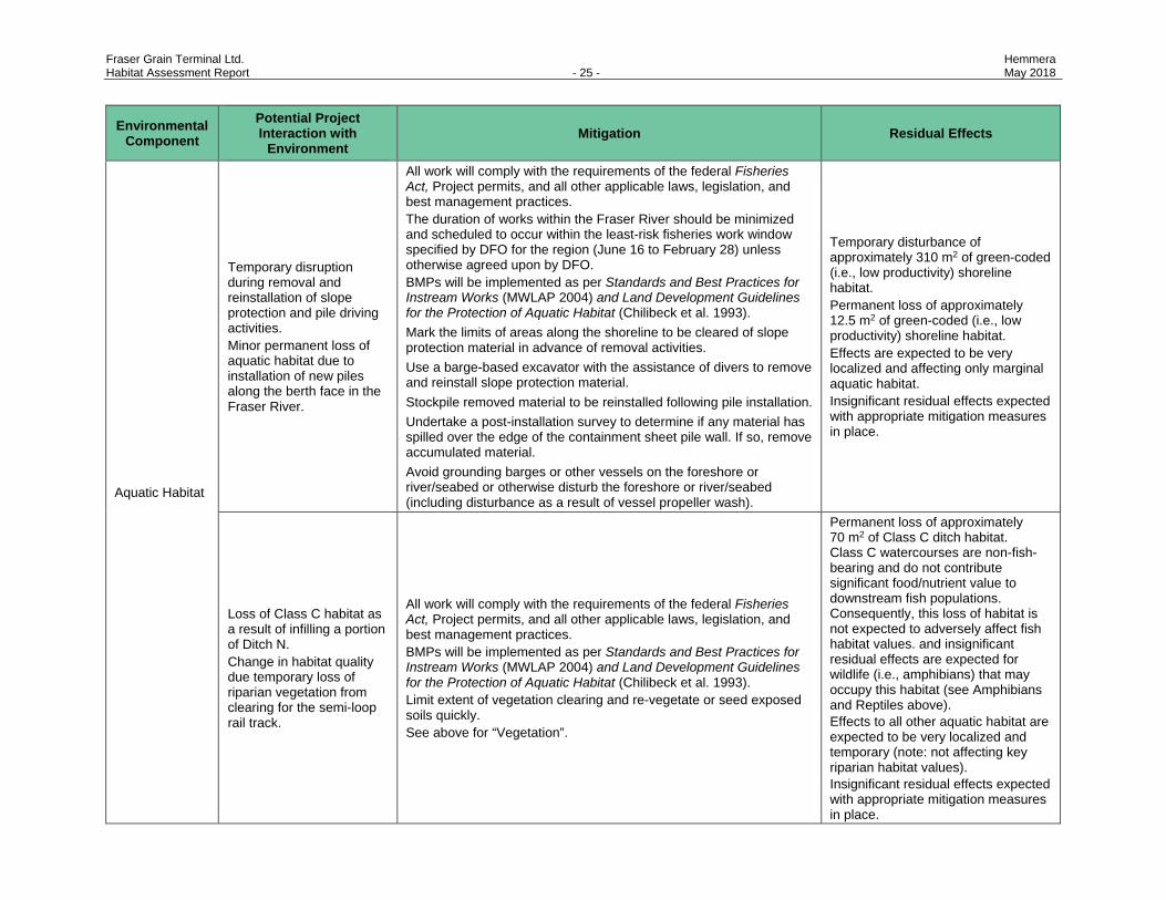
Aquatic Habitat
Temporary disruption during removal and reinstallation of slope protection and pile driving activities. Minor permanent loss of aquatic habitat due to installation of new piles along the berth face in the Fraser River.
All work will comply with the requirements of the federal Fisheries Act, Project permits, and all other applicable laws, legislation, and best management practices. The duration of works within the Fraser River should be minimized and scheduled to occur within the least-risk fisheries work window specified by DFO for the region (June 16 to February 28) unless otherwise agreed upon by DFO. BMPs will be implemented as per Standards and Best Practices for Instream Works (MWLAP 2004) and Land Development Guidelines for the Protection of Aquatic Habitat (Chilibeck et al. 1993). Mark the limits of areas along the shoreline to be cleared of slope protection material in advance of removal activities. Use a barge-based excavator with the assistance of divers to remove and reinstall slope protection material. Stockpile removed material to be reinstalled following pile installation. Undertake a post-installation survey to determine if any material has spilled over the edge of the containment sheet pile wall. If so, remove accumulated material. Avoid grounding barges or other vessels on the foreshore or river/seabed or otherwise disturb the foreshore or river/seabed (including disturbance as a result of vessel propeller wash).
Temporary disturbance of approximately 310 m2 of green-coded (i.e., low productivity) shoreline habitat. Permanent loss of approximately 12.5 m2 of green-coded (i.e., low productivity) shoreline habitat. Effects are expected to be very localized and affecting only marginal aquatic habitat. Insignificant residual effects expected with appropriate mitigation measures in place.
Loss of Class C habitat as a result of infilling a portion of Ditch N. Change in habitat quality due temporary loss of riparian vegetation from clearing for the semi-loop rail track.
All work will comply with the requirements of the federal Fisheries Act, Project permits, and all other applicable laws, legislation, and best management practices. BMPs will be implemented as per Standards and Best Practices for Instream Works (MWLAP 2004) and Land Development Guidelines for the Protection of Aquatic Habitat (Chilibeck et al. 1993). Limit extent of vegetation clearing and re-vegetate or seed exposed soils quickly. See above for “Vegetation”.
Permanent loss of approximately 70 m2 of Class C ditch habitat. Class C watercourses are non-fish-bearing and do not contribute significant food/nutrient value to downstream fish populations. Consequently, this loss of habitat is not expected to adversely affect fish habitat values. and insignificant residual effects are expected for wildlife (i.e., amphibians) that may occupy this habitat (see Amphibians and Reptiles above). Effects to all other aquatic habitat are expected to be very localized and temporary (note: not affecting key riparian habitat values). Insignificant residual effects expected with appropriate mitigation measures in place.
Fraser Grain Terminal Ltd. Hemmera Habitat Assessment Report - 26 - May 2018
Environmental Component
Potential Project Interaction with
Environment Mitigation Residual Effects
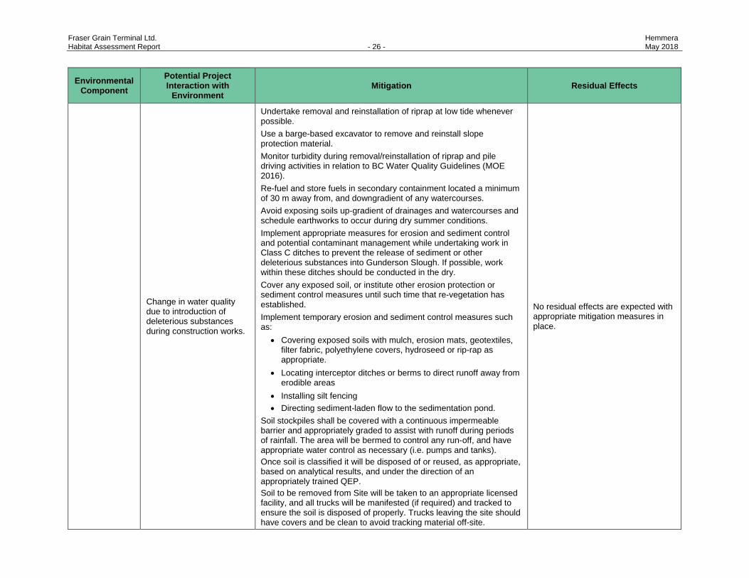
Change in water quality due to introduction of deleterious substances during construction works.
Undertake removal and reinstallation of riprap at low tide whenever possible. Use a barge-based excavator to remove and reinstall slope protection material. Monitor turbidity during removal/reinstallation of riprap and pile driving activities in relation to BC Water Quality Guidelines (MOE 2016). Re-fuel and store fuels in secondary containment located a minimum of 30 m away from, and downgradient of any watercourses. Avoid exposing soils up-gradient of drainages and watercourses and schedule earthworks to occur during dry summer conditions. Implement appropriate measures for erosion and sediment control and potential contaminant management while undertaking work in Class C ditches to prevent the release of sediment or other deleterious substances into Gunderson Slough. If possible, work within these ditches should be conducted in the dry. Cover any exposed soil, or institute other erosion protection or sediment control measures until such time that re-vegetation has established. Implement temporary erosion and sediment control measures such as:
• Covering exposed soils with mulch, erosion mats, geotextiles, filter fabric, polyethylene covers, hydroseed or rip-rap as appropriate.
• Locating interceptor ditches or berms to direct runoff away from erodible areas
• Installing silt fencing • Directing sediment-laden flow to the sedimentation pond.
Soil stockpiles shall be covered with a continuous impermeable barrier and appropriately graded to assist with runoff during periods of rainfall. The area will be bermed to control any run-off, and have appropriate water control as necessary (i.e. pumps and tanks). Once soil is classified it will be disposed of or reused, as appropriate, based on analytical results, and under the direction of an appropriately trained QEP. Soil to be removed from Site will be taken to an appropriate licensed facility, and all trucks will be manifested (if required) and tracked to ensure the soil is disposed of properly. Trucks leaving the site should have covers and be clean to avoid tracking material off-site.
No residual effects are expected with appropriate mitigation measures in place.
Fraser Grain Terminal Ltd. Hemmera Habitat Assessment Report - 27 - May 2018
Environmental Component
Potential Project Interaction with
Environment Mitigation Residual Effects
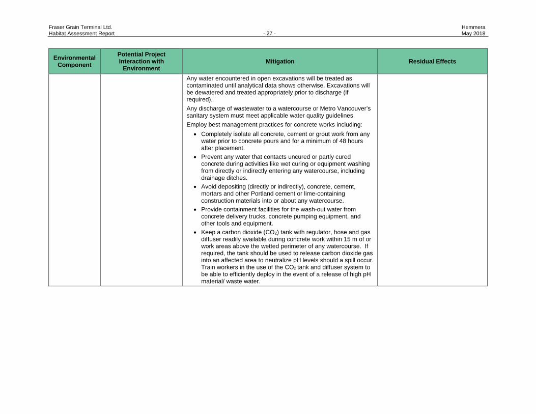
Any water encountered in open excavations will be treated as contaminated until analytical data shows otherwise. Excavations will be dewatered and treated appropriately prior to discharge (if required). Any discharge of wastewater to a watercourse or Metro Vancouver’s sanitary system must meet applicable water quality guidelines. Employ best management practices for concrete works including:
• Completely isolate all concrete, cement or grout work from any water prior to concrete pours and for a minimum of 48 hours after placement.
• Prevent any water that contacts uncured or partly cured concrete during activities like wet curing or equipment washing from directly or indirectly entering any watercourse, including drainage ditches.
• Avoid depositing (directly or indirectly), concrete, cement, mortars and other Portland cement or lime-containing construction materials into or about any watercourse.
• Provide containment facilities for the wash-out water from concrete delivery trucks, concrete pumping equipment, and other tools and equipment.
• Keep a carbon dioxide (CO2) tank with regulator, hose and gas diffuser readily available during concrete work within 15 m of or work areas above the wetted perimeter of any watercourse. If required, the tank should be used to release carbon dioxide gas into an affected area to neutralize pH levels should a spill occur. Train workers in the use of the CO2 tank and diffuser system to be able to efficiently deploy in the event of a release of high pH material/ waste water.
Fraser Grain Terminal Ltd. Hemmera Habitat Assessment Report - 28 - May 2018
Environmental Component
Potential Project Interaction with
Environment Mitigation Residual Effects
Fish
All equipment will be regularly maintained and kept clean, free of leaks and excess grease buildup. A qualified EM shall be on site on a weekly basis, and more frequently during works in or near environmentally sensitive areas and during inclement weather to monitor activities and efficacy of mitigation being implemented on site. Refer to the Construction Environmental Management Plan for additional details on monitoring activities.
Temporary disturbance of fish present during Project activities Injury or mortality to fish as a result of equipment operation
All work will comply with the requirements of the federal Fisheries Act, Project permits, and all other applicable laws, legislation, and best management practices. The duration of works within the Fraser River should be minimized and scheduled to occur within the least-risk fisheries work window (June 16 to February 28) unless otherwise agreed upon by DFO. Conduct visual and hydrophone monitoring during in-river impact piling to monitor water quality and potential for fish kill. If sound pressures over 30 kPa are measured, or distressed, injured or dead fish are observed following the initiation of pile driving, work will be halted immediately and measures (e.g., bubble curtain) implemented to reduce the sound. Refer to the Construction Environmental Management Plan for additional details on monitoring activities.
No residual effects are expected with appropriate mitigation measures in place.
Species at-Risk
Loss or alteration of streambank lupine critical habitat associated with railway construction.
• See Appendix F for proposed mitigation.
See Appendix F for identified residual effects and proposed mitigation/compensation to address residual effects.
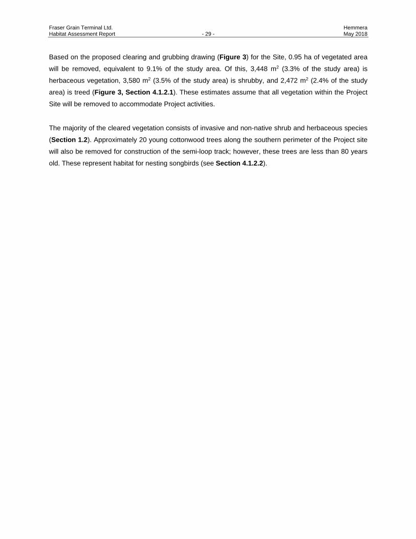
Fraser Grain Terminal Ltd. Hemmera Habitat Assessment Report - 29 - May 2018
Based on the proposed clearing and grubbing drawing (Figure 3) for the Site, 0.95 ha of vegetated area
will be removed, equivalent to 9.1% of the study area. Of this, 3,448 m2 (3.3% of the study area) is
herbaceous vegetation, 3,580 m2 (3.5% of the study area) is shrubby, and 2,472 m2 (2.4% of the study
area) is treed (Figure 3, Section 4.1.2.1). These estimates assume that all vegetation within the Project
Site will be removed to accommodate Project activities.
The majority of the cleared vegetation consists of invasive and non-native shrub and herbaceous species
(Section 1.2). Approximately 20 young cottonwood trees along the southern perimeter of the Project site
will also be removed for construction of the semi-loop track; however, these trees are less than 80 years
old. These represent habitat for nesting songbirds (see Section 4.1.2.2).
Fraser Grain Terminal Ltd. Hemmera Habitat Assessment Report - 30 - May 2018
6.0 VEGETATION REMOVAL AND REPLANTING PLAN
As the majority of the Site is paved, and vegetation communities are comprised of predominantly invasive
and non-native species, the replanting plan focuses on use of native species for revegetation, and use of
native flowering and fruiting plant species beneficial to local bird and invertebrate species and prevention
of spread of noxious plant species.
General guidelines for vegetation removal and replanting are as follows:
6.1 INVASIVE PLANT MANAGEMENT
• Dispose of invasive plant species material appropriately: bag and/or designated green waste bin and remove material off-site to a landfill location. Do not compost invasive plant material on site.
• Remove blackberry prior to fruit development to prevent spread of seeds, ideally before late July:
▫ A preclearing nest survey may be required if removal takes place after March 1. ▫ All plant material should be disposed of off-site. ▫ Root wads should be removed during grubbing and disposed of off-site.
• Remove Scotch broom during flowering and prior to seed pod development to prevent regrowth and spread of seeds, ideally in late spring:
▫ Cut shrubs larger than 1.5 cm in diameter below ground level, smaller shrubs can be hand-pulled (ISC 2014).
▫ Replant or pave the area as quickly as possible to prevent germination of seeds in the seed bank.
• Prevent the spread of invasive plant species on and off site by using truck wash station and inspecting vehicles for plant material prior to entering site.
• Ensure any soil or fill coming into the site comes from a location that is free of noxious weeds, specifically Japanese knotweed (Fallopia japonica).
6.2 CLEARING AND GRUBBING
• Clearing should take place within the least risk work window for breeding birds (September 1 to February 28).
• If clearing is required during this time, a pre-clearing nest survey may be required.
• Limit areas of vegetation clearing and flag clearing boundaries.
6.3 REVEGETATION
Revegetation of areas surrounding office buildings and temporarily disturbed areas may incorporate the
use of native, drought-tolerant species. General revegetation guidelines are:
• Replant or reseed areas with native plant species, and/or an approved seed mix.
• Plant shrub stock that is at least 1.5 m tall.

Fraser Grain Terminal Ltd. Hemmera Habitat Assessment Report - 31 - May 2018
• Replant with a mix of fruiting and flowering native species (Table 7).
• Retained and replanted areas of vegetation should be fenced to prevent encroachment of equipment during construction.
• Newly replanted areas should be monitored annually for a minimum of two years to ensure that invasive plants, such as Himalayan blackberry, are not out-competing the new plant stock.
• Once plants have been established, regular weeding and maintenance (three years minimum) will prevent re-sprouting and colonization of blackberry and other weedy plant species.
Once the Contractor has been selected, opportunities and needs for revegetation will be planned through
discussion with VFPA and the Proponent.
Table 7 Suggested Native Shrubs for Revegetation
Latin Name Common Name Ratio
Symphoricarpos albus Snowberry 2
Rubus spectabilis Salmonberry 1
Rosa nutkana Nootka rosa 3
Ribes sanguineum Red-flowering currant 1
Arctostaphylos uva-ursi Kinnikinnick 2
Fraser Grain Terminal Ltd. Hemmera Habitat Assessment Report - 32 - May 2018
7.0 SUMMARY AND CONCLUSIONS
The Project may result in temporary construction disturbances and 0.95 ha permanent loss of vegetated
area (predominantly invasive and non-native species). With appropriate mitigation in place and good work
practices, most construction effects on vegetation and terrestrial habitat associated with the Project are
likely to be of short duration and the potential zone of influence likely localized to the immediate vicinity of
the work. The proposed semi-loop railway track overlaps with critical habitat for streambank lupine, and as
such, a permit under SARA is anticipated to be required for construction in this area. The Proponent and
other FSD business stakeholders will work with FSD and an environmental consultant to prepare an
application to Environment and Climate Change Canada for permitting the use of SARA-designated critical
habitat for streambank lupine in the Project areas adjacent to Elevator Road. This application is intended
to address the effects of railway development from proposed projects currently in the VFPA PER process
on the FSD lands.
Construction of the Project has the potential to result in temporary disturbances to wildlife, including birds
and aquatic species, from such activities as vegetation clearing, construction activities around ditches, and
pile driving. Adherence to least risk timing windows (or completion of pre-clearing surveys), along with the
implementation of other appropriate mitigation and best management practices is anticipated to result in
insignificant residual adverse effects.
Effects to aquatic organisms and habitat in the Fraser River could occur during temporary removal of
shoreline protection material and pile driving required along the existing berth face. Installation of the
shiploader foundation piles will result in a permanent loss of approximately 12.5 m2 of green-coded (i.e.,
low productivity) shoreline habitat under the existing dock. An additional approximately 310 m2 of shoreline
will experience temporary disturbance as a result of shoreline protection material removal and replacement.
With mitigation as recommended above for this shoreline work, no significant residual effects are
anticipated to the aquatic species that may potentially use this habitat. The infilling of Ditch N will result in
the permanent loss of approximately 70 m2 of Class C aquatic habitat (i.e., non-fish-bearing aquatic habitat,
no significant food/nutrient input). No significant residual effects are anticipated to the aquatic species that
may potentially use this ditch. Temporary changes in riparian habitat and water quality in one Class C ditch
due to construction activities in the upland area are expected to be of short duration and localized to this
ditch. In summary, with the application of appropriate mitigation and adherence to water quality guidelines
and best management practices, construction of the Project is unlikely to cause significant adverse effects
to aquatic organisms and habitat.
Fraser Grain Terminal Ltd. Hemmera Habitat Assessment Report - 33 - May 2018
8.0 CLOSURE
This Work was performed in accordance with the Professional Services Agreement between Hemmera
Envirochem Inc. (“Hemmera”) and Parrish and Heimbecker Ltd., c/o FWS Industrial Projects Canada Ltd.
(“Client”), dated December 8, 2017 (“Contract”). This Report has been prepared by Hemmera, based on
fieldwork and desktop work conducted by Hemmera, for sole benefit and use by Parrish and Heimbecker
Ltd. In performing this Work, Hemmera has relied in good faith on information provided by others, and has
assumed that the information provided by those individuals is both complete and accurate. This Work was
performed to current industry standard practice for similar environmental work, within the relevant
jurisdiction and same locale. The findings presented herein should be considered within the context of the
scope of work and project terms of reference; further, the findings are time sensitive and are considered
valid only at the time the Report was produced. The conclusions and recommendations contained in this
Report are based upon the applicable guidelines, regulations, and legislation existing at the time the Report
was produced; any changes in the regulatory regime may alter the conclusions and/or recommendations.
Report prepared by: Hemmera Envirochem Inc. Report prepared by: Hemmera Envirochem Inc.
ORIGINAL SIGNED ORIGINAL SIGNED Sarah Bowie, R.P.Bio. Caroline Astley, R.P.Bio. Senior Specialist Senior Specialist Reviewed by:
ORIGINAL SIGNED Robin Taylor, EP Senior Environmental Assessment Manager
Fraser Grain Terminal Ltd. Hemmera Habitat Assessment Report - 34 - May 2018
9.0 REFERENCES
Alberta Native Plant Council. 2012. Guideline for Rare Vascular Plant Surveys in Alberta – 2012 update. Alberta Native Plant Council, Edmonton, AB. Available on-line at: http://www.anpc.ab.ca/content/resources/php
BC Conservation Data Centre (BC CDC). 2016. BC Species and Ecosystems Explorer. Available at: http://www.env.gov.bc.ca/atrisk/toolintro.html . Accessed August 2016.
BC Marine Pile Divers Contractors Association (BCMPDCA) and Fisheries and Oceans Canada (DFO). 2003. DFO Best Management Practices for Pile Driving and Related Operations.
Bigg, M. A. 1985. Status of the Steller sea lion (Eumetopias jubatus) and California sea lion (Zalophus californianus) in British Columbia. Canadian Special Publication of Fisheries and Aquatic Sciences
Chilibeck, B., G. Chislett, and G. Norris. 1993. Land development guidelines for the protection of aquatic habitat. Vancouver, B.C.: Fisheries and Oceans Canada (DFO) and Ministry of Environment, Land and Parks (MELP). Available at: http://www.dfo-mpo.gc.ca/Library/165353.pdf
Corporation of Delta (CoD). 2003. Delta timing windows for in-stream works. Second Edition. The Corporation of Delta, Delta, B.C. Available at: http://www.corp.delta.bc.ca/assets/Environment/PDF/fish_amphib_delta_timing.pdf. Accessed October 2015.
Corporation of Delta (CoD). 2015. Corporation of Delta - DeltaMap. iVAULT MapGuide 4.3. Municipal Website. Available at: http://www.delta.ca/EN/main/residents/deltamap.html. Accessed October 2015.
Committee on the Status of Endangered Wildlife in Canada (COSEWIC). 2002a. COSEWIC assessment and status report on the streambank lupine Lupinus rivularis in Canada. Committee on the Status of Endangered Wildlife in Canada. Ottawa. vi + 36 pp.
Committee on the Status of Endangered Wildlife in Canada (COSEWIC). 2002b. COSEWIC assessment and update status report on the Western Screech-owl Otus kennicottii in Canada. Committee on the Status of Endangered Wildlife in Canada. Ottawa. vi + 31 pp.
Committee on the Status of Endangered Wildlife in Canada (COSEWIC). 2003. COSEWIC assessment and update status report on the Steller sea lion Eumetopias jubatus in Canada. Committee on the Status of Endangered Wildlife in Canada. Ottawa. vii + 47 pp.
Committee on the Status of Endangered Wildlife in Canada (COSEWIC). 2004. COSEWIC assessment and update status report on the green sturgeon Acipenser medirostris in Canada. Committee on the Status of Endangered Wildlife in Canada. Ottawa. vii + 31 pp.
Fraser Grain Terminal Ltd. Hemmera Habitat Assessment Report - 35 - May 2018
Committee on the Status of Endangered Wildlife in Canada (COSEWIC). 2006. COSEWIC assessment and update status report on the Pacific water shrew Sorex bendirii in Canada. Committee on the Status of Endangered Wildlife in Canada. Ottawa. vi + 28 pp.
Committee on the Status of Endangered Wildlife in Canada (COSEWIC). 2007a. COSEWIC assessment and status report on the Common Nighthawk Chordeiles minor in Canada. Committee on the Status of Endangered Wildlife in Canada. Ottawa. vi + 25 pp.
Committee on the Status of Endangered Wildlife in Canada (COSEWIC). 2007b. COSEWIC assessment and status report on the Olive-sided Flycatcher Contopus cooperi in Canada. Committee on the Status of Endangered Wildlife in Canada. Ottawa. vii + 25 pp.
Committee on the Status of Endangered Wildlife in Canada (COSEWIC). 2007c. COSEWIC assessment and status report on the Peregrine Falcon Falco peregrinus (pealei subspecies – Falco peregrinus and pealei anatumétundrius – Falco peregrinus anatum tundrius) in Canada. Committee on the Status of Endangered Wildlife in Canada. Ottawa. vii + 45 pp.
Committee on the Status of Endangered Wildlife in Canada (COSEWIC). 2008a. COSEWIC assessment and status report on the Band-tailed Pigeon Patagioenas fasciata in Canada. Committee on the Status of Endangered Wildlife in Canada. Ottawa. vii + 42 pp.
Committee on the Status of Endangered Wildlife in Canada (COSEWIC). 2008b. COSEWIC assessment and update status report on the Great Blue Heron fannini subspecies Ardea herodias fannini in Canada. Committee on the Status of Endangered Wildlife in Canada. Ottawa. vii + 39 pp.
Committee on the Status of Endangered Wildlife in Canada (COSEWIC). 2013a. COSEWIC assessment and status report on the Little Brown Myotis Myotis lucifugus, Northern Myotis Myotis septentrionalis and Tri-colored Bat Perimyotis subflavus in Canada. Committee on the Status of Endangered Wildlife in Canada. Ottawa. xxiv + 93 pp.
Committee on the Status of Endangered Wildlife in Canada (COSEWIC). 2013b. COSEWIC assessment and status report on the Dun Skipper, Euphyhes vestris vestris in Canada. Committee on the Status of Endangered Wildlife in Canada. Ottawa. xi + 69 pp.
COSMOS. 2015. City of Surrey Mapping Online System. Available at: http://www.surrey.ca/city-services/665.aspx. Accessed October 2015.
Cox, R. K. and J. Cullington, 2009. Wetland Ways: Interim Guidelines for Wetland Protection and Conservation in British Columbia. Vancouver, BC; Kamloops, BC: Wetland Stewardship Partnership. Available at: http://www.env.gov.bc.ca/wld/documents/bmp/wetlandways2009/wetlandways_docintro.html
Fraser Grain Terminal Ltd. Hemmera Habitat Assessment Report - 36 - May 2018
Fisheries and Oceans Canada (DFO). 2015. British Columbia Marine/Estuarine Timing Windows for the Protection of Fish and Fish Habitat – Couth Coast and Lower Fraser Areas. Available at: http://www.dfo-mpo.gc.ca/pnw-ppe/timing-periodes/bc-s-eng.html#area-29. Accessed October 2015.
Environment Canada (EC). 2015. General Nesting Periods for Migratory Birds in Canada. Available at: https://www.ec.gc.ca/paom-itmb/default.asp?lang=En&n=4F39A78F-1#_04. Accessed October 2015
Environment and Climate Change Canada (ECCC). 2017. Recovery Strategy for the Streambank Lupine (Lupinus rivularis) in Canada. Species at Risk Act Recovery Strategy Series. Environment Canada, Ottawa. 13 pp. + Annex.
eBird. 2015. Cornell Lab of Ornithology. Species Maps. Available at: http://ebird.org/ebird/map/. Accessed October 2015.
EFauna BC. 2015. Electronic Atlas of the Wildlife of British Columbia. Available at: http://ibis.geog.ubc.ca/biodiversity/efauna/ . Accessed October 2015.
eFlora BC. 2015. Streambank lupine. On-line resource available at: http://ibis.geog.ubc.ca/biodiversity/eflora/. Accessed November 2015.
Fisheries Information Summary System (FISS). 2015. On-line resource available at: http://www.env.gov.bc.ca/fish/fiss/#. Accessed October 2015.
Fraser Basin Council. 2013. Fraser Basin Watersheds. Available at: http://www.fraserbasin.bc.ca/basin_watersheds.html#lower.
Fraser River Estuary Management Program (FREMP). 2006. Environmental management strategy for dredging in the Fraser River estuary. Available at: http://www.portmetrovancouver.com/docs/default-source/projects-dredging/FREMP_BEAP_Env_Mgt_Strategy_for_Dredging_FINAL-_February_2006.pdf?sfvrsn=0
Fraser River Estuary Management Program (FREMP). 2015. Burrard Inlet Environmental Action Program – Fraser River Estuary Management Program. FREMP – BIEAP Habitat Atlas. Available at: http://www.cmnbc.ca/atlas_gallery/fremp-bieap-habitat-atlas. Accessed October 2015.
Gebauer, M. 1999. Status of Wildlife in Burns Bog, Delta - 1999. Late Summer/Early Fall 1999 Survey Results and Review of Existing Information. Enviro-Pacific Consulting, Surrey, BC.
Hay, D. and P. B. McCarter. 2000. Status of the eulachon Thaleichthys pacificus in Canada. Canadian Stock Assessment Secretariat, Research Document 2000/145, Fisheries and Oceans Canada, Nanaimo, B.C.
Fraser Grain Terminal Ltd. Hemmera Habitat Assessment Report - 37 - May 2018
Hay, D. E., P. B. McCarter, R. Joy, M. Thompson, and K. West. 2002. Fraser River eulachon biomass assessments and spawning distribution: 1995-2002. Canadian Science Advisory Secretariat, Research Document 2002/117, Fisheries and Oceans Canada, Nanaimo, B.C.
Hectares BC. 2015. On-line resource available at: http://hectaresbc.ca/app/habc/HaBC.html. Accessed November 2015.
Hemmera Envirochem Inc. (Hemmera). 2014. FINAL REPORT Detailed Site Investigation - 11041 Elevator Road, Surrey, BC, March 27, 2014.
iMap BC. 2015. Available at: http://maps.gov.bc.ca/ess/sv/imapbc/ . Accessed October 2015.
Invasive Species Council (ISC). 2014. TIPS Fact Sheet: Scotch Broom. Available at: http://bcinvasives.ca/documents/Scotch_Broom_TIPS_Final_08_06_2014.pdf.
Knopp, D. H., and L. K. Larkin. 1999. Burns Bog and Adjacent Areas - Amphibian and Reptile. Prepared for Delta Fraser Properties Partnership and the Environmental Assessment Office In Support of the Burns Bog Ecosystem Review.
LGL, and Terra Remote Sensing. 2009. Fraser River, Port Mann Bridge-Douglas Island eulachon study, 2009. Prepared by LGL Limited and Terra Remote Sensing Incorporated. Prepared for Kwikwetlem First Nation and Watershed Watch Salmon Society, Sidney, B.C.
Maron, J.L. and E.L. Simms. 1997. Effect of Seed Predation on Seed Bank Size and Seedling Recruitment of Bush Lupin (Lupinus arboreus). In: Oecologica (997) 111 76-83.
McPhail, J.D. 2007. Freshwater Fishes of British Columbia. The University of Alberta Press. Edmonton, Alberta.
McPhail, J. D., and R. Carveth. 1994. Field key to the freshwater fishes of British Columbia. Resources Inventory Committee, Victoria, B.C.
Ministry of Environment (MoE). 2004. Best Management Practices for Amphibians and Reptiles in Urban and Rural Environments in British Columbia. Available at: http://www.env.gov.bc.ca/wld/BMP/herptile/HerptileBMP_final.pdf.
Ministry of Environment (MoE). 2013. Guidelines for Raptor Conservation during Urban and Rural Land Development in British Columbia. A companion document to Develop with Care 2012. British Columbia Ministry of Environment (MoE). Available at: http://www.env.gov.bc.ca/wld/documents/bmp/raptor_conservation_guidelines_2013.pdf
Ministry of Environment (MoE). 2014. Develop with Care 2014. Environmental Guidelines for Urban and Rural Land Development in British Columbia. British Columbia Ministry of Environment (MoE). Available at: http://www.env.gov.bc.ca/wld/documents/bmp/devwithcare/DWC-Section-4.pdf
Ministry of Environment (MoE). 2016. British Columbia Approved Water Quality Guidelines: Aquatic Life, Wildlife & Agriculture: Summary Report. Water Protection & Sustainability Branch. Available at:
Fraser Grain Terminal Ltd. Hemmera Habitat Assessment Report - 38 - May 2018
http://www2.gov.bc.ca/assets/gov/environment/air-land-water/water/waterquality/wqgs-wqos/approved-wqgs/final_approved_wqg_summary_march_2016.pdf.
Ministry of Transportation and Infrastructure (MoTI). 2015. South Fraser Perimeter Road Alignment Maps. Available at: http://www.sfprhighway17.ca/maps/alignment-maps/. Accessed November 2015.
Ministry of Water, Land and Air Protection (MWLAP). 2004. Standards and Best Practices for Instream Works. Available at: http://www.env.gov.bc.ca/wld/documents/bmp/iswstdsbpsmarch2004.pdf.
Page, N. 2012. Mammals of Vancouver and Point Grey: Summary of Historical and Current Occurrence Records. Available at: http://www.raincoastappliedecology.ca/wp-content/uploads/2011/09/Mammals-of-City-of-Vancouver-2012-draft.pdf
Pojar, J., K. Klinka, and D.A. Demarchi. 1994. Coastal Western Hemlock Zone. In: Ecosystems of British Columbia. D. Meidinger and J. Pojar, eds. Ministry of Forests. pp. 81-94.
Reptiles of BC. 2015. Thompson Rivers University and BC Ministry of Environment. Available at: http://www.bcreptiles.ca. Accessed October 2015.
Robertson Environmental Services Limited (RESL). 2006. Vegetation and Wildlife Impact Assessment, Technical Volume 12 of the Environmental Assessment Application for South Fraser Perimeter Road. Prepared for the Ministry of Transportation.
Resource Information Standards Committee (RISC). 1998. Standard for Terrestrial Ecosystem mapping in British Columbia. Ecosystems Working Group. BC Ministry of Forests.
Rithaler, R.C. 2002. Fish and Amphibian Spawning Timing in Delta, British Columbia. Environmental Services Scientific/Technical Series, Corporation of Delta.
Rithaler, R.C. 2003. Amphibians in Delta, British Columbia – Status & Species Distribution by Watershed (distribution map). Environmental Services, Corporation of Delta.
SNC Lavalin. 2013. Environmental Impact Assessment for the Direct Transfer Coal Facility. Prepared for Port Metro Vancouver.
Streambank Lupine Recovery Team (SLRT). 2014. Recovery plan for streambank lupine (Lupinus rivularis) in British Columbia. Prepared for the B.C. Ministry of Environment, Victoria, BC. 24 pp.
Wildlife Tree Stewardship (WiTs). 2015. WiTs Program Atlas. 2. Available at: http://www.cmnbc.ca/atlas_gallery. Accessed October 2015.
10.0 PERSONAL COMMUNICATION
Ekkert, Andre. Fraser Surrey Docks Limited Partnership, Project Manager. Email Correspondence November 4, 2016.

FIGURES
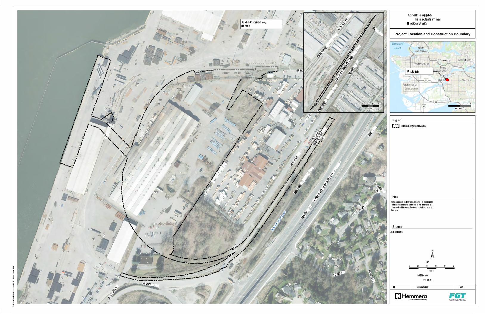
Path: S:\Geomatics\Projects\989456\01\mxd\HabitatAssessment\Fig1_2191_001_01_SiteLocation_Construction_180514.mxd
P rod uction Date: May 14, 2018
P a ge S ize: 11" x 17"
2191-001.01 Figure 1
NAD 1983 UTM Zone 10N
±
1. This m a p is not inte nd e d to be a “sta nd -a lone ” d ocum e nt, but a vis ua l a idof the inform a tion conta ine d within the re fe re nce d Re port. It is inte nd e d tobe us e d in conjunction with the s cope of s e rvice s a nd lim itations d e s cribe dthe re in.
- Ae ria l Im age: City of S urre y, 2014
S ite Bound a ry for Cons truction Works
S outh Fra s er Pe rime ter Roa d -
Ad d itiona l P roject Bound a ry 570 m e tre s
Armstro
ng Cree
k
TownlineDiv
Ele va tor Rd
Rega l Dr
Alas ka Way
Rege nt P l
Rive r Rd
Robs on Rd
Roya l Cr
Highway 17
P lywood Rd
Cana dia n
Nationa l(SWM)
Rwy
Burl North (S WM) Rwy
1:2,500
Lege nd
Note s
S ource s
0 20 40 60 80 100Me tre s
Project Location and Construction Boundary
Cons truction P e rm it ApplicationFra s e r Gra in Te rm ina l
11041 Ele va tor Roa d , S urrey, BC
P roje ct Location
0 5 10Kilom etre s
103A Ave
Timbe rla nd Rd
Bc Hydro (S WM) Rwy
Highway 17
Burl North (S WM) RwyCana dia n Nationa l(SWM) Rwy
0 50 100 150Me tre s
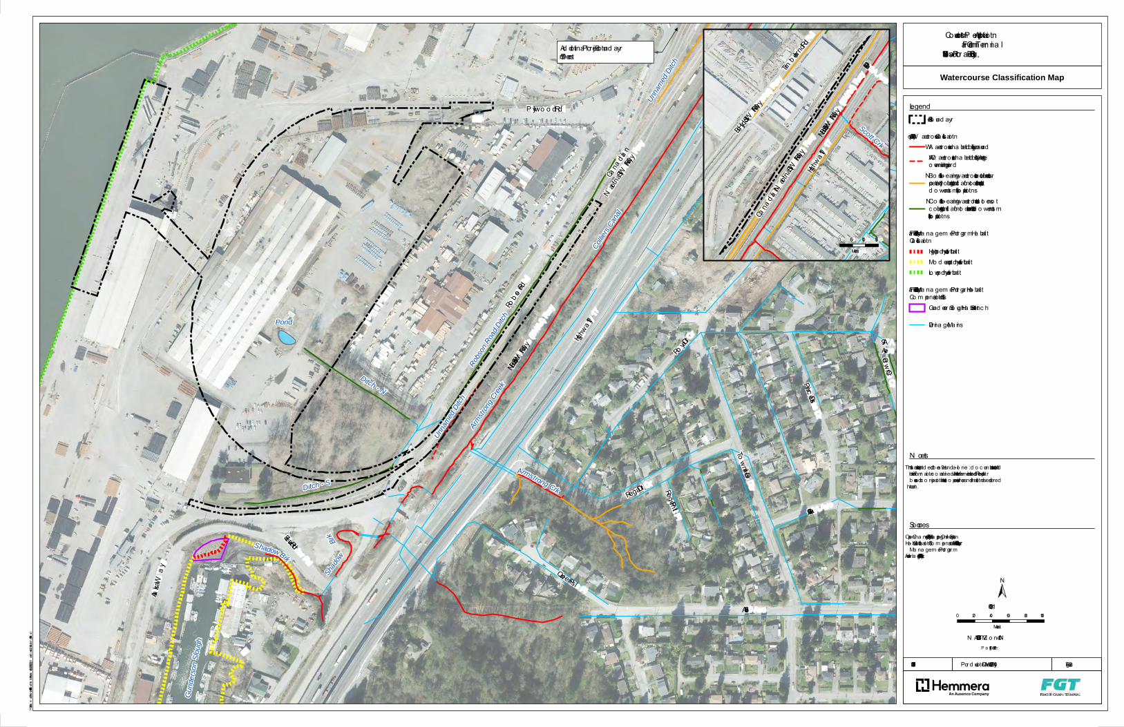
Path: S:\Geomatics\Projects\989456\01\mxd\HabitatAssessment\Fig2_2191_001_01_WatercourseClassification_180514.mxd
P ro d uctio n Da te: Ma y 14, 2018 Figure 2
Site Bo und a ry
City o f Surrey W a terc o urse Cla ssific a tio nA: W a terc o urse inha b ited b y fish yea r ro undAO: W a terc o urse inha b ited b y fish d uring theo verwintering perio dB: N o n-fish-b ea ring wa terc o urse but c o ntributes o rpo tentia lly c o ntributes signific a nt fo o d /nutrient inputs tod o wnstrea m fish po pula tio nsC: N o n-fish-b ea ring wa terc o urse tha t d o es no tc o ntribute signific a nt fo o d /nutrient va lue to d o wnstrea mfish po pula tio ns
Fra ser River Estua ry Ma na gem ent P ro gra m Ha b ita tCla ssific a tio n
High pro d uc tivity ha b ita tMo d era te pro d uc tivity ha b ita tLo w pro d uc tivity ha b ita t
Fra ser River Estua ry Ma na gem ent P ro gra m - Ha b ita tCo m pensa tio n Sites
Gund erso n Slo ugh Ha b ita t Benc h
Dra ina ge Ma ins
Gund
erson
Slou
gh
Ditch - N
Armstro
ng Cree
kDitch - S
Shado
wBrk
Pond
Robso
n Road
Ditch
Unnam
ed Dit
ch
Unnam
ed Dit
ch
Ad d itio na l P ro jec t Bound a ry570 m etres
Armstrong Crk
ShadowBrk
Collie
rs Cana
l
97AAveCro wn Cr
Regent P l 96A Ave
Milla r Rd
Eleva to r Rd
Rob son Rd
Queens P l
To wnline Div
Alaska Wa y
Highwa y 17
Regal Dr
96 Ave
P lywo o d Rd
P rinc ess Dr
Ro ya l Cr
River Rd
Cana dia n
N atio na l(SW M) Rwy
Burl No rth (SWM) Rwy
Legend
Watercourse Classification Map
Co nstructio n P erm it Applic a tio nFra ser Gra in Term ina l
11041 Eleva to r Ro a d , Surrey, BC
Scott Crk
103A Ave
Timb erla nd Rd
Bc Hydro (SWM) Rwy
Highwa y 17Burl No rth (SWM) Rwy
Cana dia n N atio na l(SW M) Rwy
0 50 100 150Metres
2191-001.01
P a ge Size: 11" x 17"N AD 1983 UTM Z o ne 10N
±
1. This m a p is no t intend ed to b e a “sta nd -a lo ne” d o c um ent, but a visua l a ido f the info rm a tio n c o nta ined within the referenc ed Repo rt. It is intend ed tob e used in c o njunc tio n with the sc o pe o f servic es a nd lim ita tio ns d esc rib edtherein.
- Open Cha nnels: City o f Surrey Ma pping Online System- Ha b ita t Cla ssific a tio n & Co m pensa tio n Sites: Fra ser River Estua ryMa na gem ent P ro gra m- Aeria l Im a ge: City o f Surrey, 2014
1:3,000
N o tes
So urc es
0 20 40 60 80 100Metres
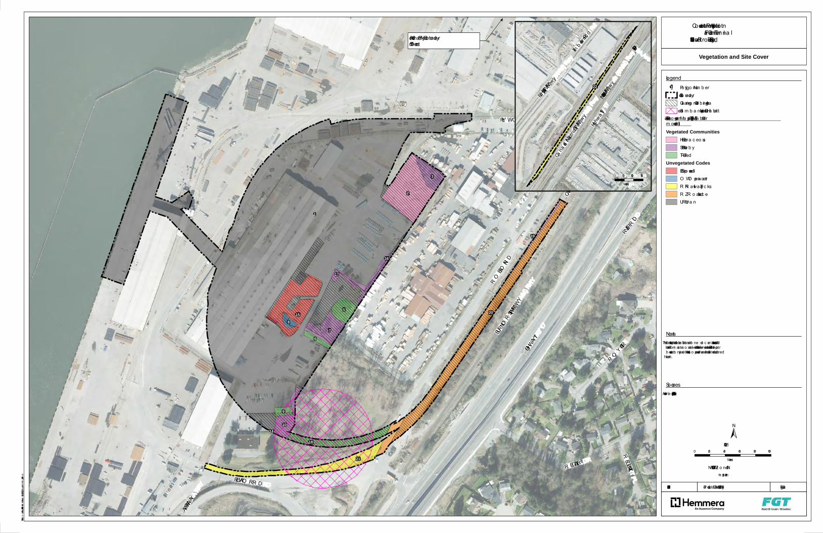
Path: S:\Geomatics\Projects\989456\01\mxd\HabitatAssessment\Fig3_2191_001_01_VegetationMap_180514.mxd
Pro ductio n Da te: Ma y 14, 2018
Pa ge Size: 11" x 17"
2191-001.01 Figure 3
NAD 1983 UTM Z o ne 10N
±
- Aeria l Im a ge: City o f Surrey, 2014.
Po lygo n Num b erSite Bo unda ryClea ring a nd Grub b ing AreaStrea m b a nk Lupine Critic a l Ha b ita t
Terrestria l Ec o system Ma pping (TEM) (See Ta b le 1 fo rm o re deta il)Vegetated Communities
HE Herb a c eo usSH Shrub b yTR Treed
Unvegetated CodesES Expo sed so ilO W O pen wa terR N R a ilwa y Tra c ksR Z R o a d surfa c eUR Urb a n
Additio na l Pro jec t Bounda ry 570 m etres
ELEVATO R R D
R EGAL DR
ALASKA WAY
R EGENT PL
R IVER R D
R OBSO N R D
R OY AL CRHIGHWAY 17
PLY WO O D R D
CANADIAN NATIO NAL(SWM) R WY
BUR L NOR TH (SWM) R WY
3
2
1
815 20
19
21
18
10
9
67
5
17
16
14
1:2,500
Legend
So urc es
0 20 40 60 80 100Metres
Vegetation and Site Cover
Co nstructio n Perm it Applic a tio nFra ser Gra in Term ina l
11041 Eleva to r R o a d, Surrey, BC
1
103A Ave
Timb erla nd Rd
Bc Hydro (SWM) R wy
Highwa y 17
Burl No rth (SWM) R wy
Cana dia n Natio na l(SWM) Rwy
22
0 50 100 150Metres
1. This m a p is no t intended to b e a “sta nd-a lo ne” do c um ent, but a visua l a ido f the info rm a tio n c o nta ined within the referenc ed R epo rt. It is intended tob e used in c o njunc tio n with the sc o pe o f servic es a nd lim ita tio ns desc rib edtherein.
No tes

APPENDIX A Proposed Construction Schedule

ID Task
Mode
Task Name Duration Start Finish
1 FGT Facility 1 day? Fri 06/01/18 Fri 06/01/18
2 Project Permit Approval and Sanction 0 days Mon 06/04/18Mon 06/04/18
3 On-Site Construction 10 days Mon 06/18/18Fri 06/29/18
4 Mobilize to site 0 days Mon 06/18/18Mon 06/18/18
5 Establish Temp services & Power 10 days Mon 06/18/18Fri 06/29/18
6 Phase 1 - Demolition 85 days Mon 06/18/18Fri 10/12/18
7 Demo Shed 4 34 days Mon 06/18/18Thu 08/02/18
8 Demo Substation 33 days Mon 07/02/18Wed 08/15/18
9 Demo Slab 75 days Mon 07/02/18Fri 10/12/18
10 Construct new access road 57 days Mon 07/02/18Tue 09/18/18
11 Main Construction - FGT Site 541 days Fri 09/28/18 Fri 10/23/20
12 Civil Services 76 days Mon 10/15/18Mon 01/28/19
13 Remove Existing Utilities 30 days Mon 10/15/18Fri 11/23/18
14 Establish Permanent Storm Sewer
& Interceptor
10 days Mon
10/15/18
Fri 10/26/18
15 Underground Services (Water,
storm, sewer, electrical, gas)
66 days Mon
10/29/18
Mon
01/28/19
16 Roads and Site development 30 days Mon 12/10/18Fri 01/18/19
17 Building Permit 0 days Fri 09/28/18 Fri 09/28/18
18 Building Permit Approval 0 days Fri 09/28/18 Fri 09/28/18
19 Main Plant 500 days Mon 11/26/18Fri 10/23/20
20 Densification 30 days Mon 11/26/18Fri 01/04/19
21 Receiving & Unload Pit 250 days Mon 02/04/19Fri 01/17/20
22 Reclaim/Transfer Tunnel 90 days Mon 01/07/19Fri 05/10/19
06/04
06/18
09/28
09/28
Jun Jul Aug Sep Oct Nov Dec Jan Feb Mar Apr May Jun Jul Aug Sep Oct Nov Dec Jan Feb Mar Apr May Jun Jul Aug Sep Oct Nov
2019 2020
Task
Split
Milestone
Summary
Project Summary
External Tasks
External Milestone
Inactive Task
Inactive Milestone
Inactive Summary
Manual Task
Duration-only
Manual Summary Rollup
Manual Summary
Start-only
Finish-only
Deadline
Progress
Manual Progress
FRASER GRAIN TERMINAL
CONCEPT SCHEDULE
Page 1 of 2
Project: FGT CONCEPT SCHEDULE
Date: Sun 05/13/18
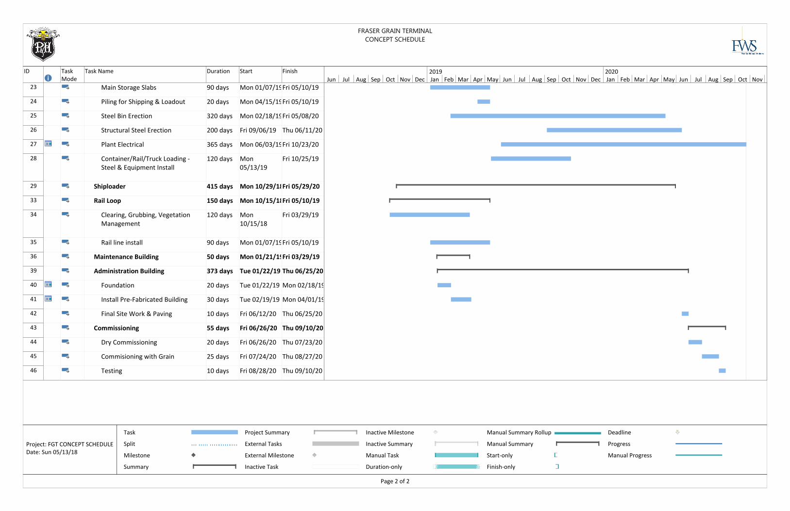
ID Task
Mode
Task Name Duration Start Finish
23 Main Storage Slabs 90 days Mon 01/07/19Fri 05/10/19
24 Piling for Shipping & Loadout 20 days Mon 04/15/19Fri 05/10/19
25 Steel Bin Erection 320 days Mon 02/18/19Fri 05/08/20
26 Structural Steel Erection 200 days Fri 09/06/19 Thu 06/11/20
27 Plant Electrical 365 days Mon 06/03/19Fri 10/23/20
28 Container/Rail/Truck Loading -
Steel & Equipment Install
120 days Mon
05/13/19
Fri 10/25/19
29 Shiploader 415 days Mon 10/29/18Fri 05/29/20
33 Rail Loop 150 days Mon 10/15/18Fri 05/10/19
34 Clearing, Grubbing, Vegetation
Management
120 days Mon
10/15/18
Fri 03/29/19
35 Rail line install 90 days Mon 01/07/19Fri 05/10/19
36 Maintenance Building 50 days Mon 01/21/19Fri 03/29/19
39 Administration Building 373 days Tue 01/22/19 Thu 06/25/20
40 Foundation 20 days Tue 01/22/19 Mon 02/18/19
41 Install Pre-Fabricated Building 30 days Tue 02/19/19 Mon 04/01/19
42 Final Site Work & Paving 10 days Fri 06/12/20 Thu 06/25/20
43 Commissioning 55 days Fri 06/26/20 Thu 09/10/20
44 Dry Commissioning 20 days Fri 06/26/20 Thu 07/23/20
45 Commisioning with Grain 25 days Fri 07/24/20 Thu 08/27/20
46 Testing 10 days Fri 08/28/20 Thu 09/10/20
Jun Jul Aug Sep Oct Nov Dec Jan Feb Mar Apr May Jun Jul Aug Sep Oct Nov Dec Jan Feb Mar Apr May Jun Jul Aug Sep Oct Nov
2019 2020
Task
Split
Milestone
Summary
Project Summary
External Tasks
External Milestone
Inactive Task
Inactive Milestone
Inactive Summary
Manual Task
Duration-only
Manual Summary Rollup
Manual Summary
Start-only
Finish-only
Deadline
Progress
Manual Progress
FRASER GRAIN TERMINAL
CONCEPT SCHEDULE
Page 2 of 2
Project: FGT CONCEPT SCHEDULE
Date: Sun 05/13/18

APPENDIX B Photographs
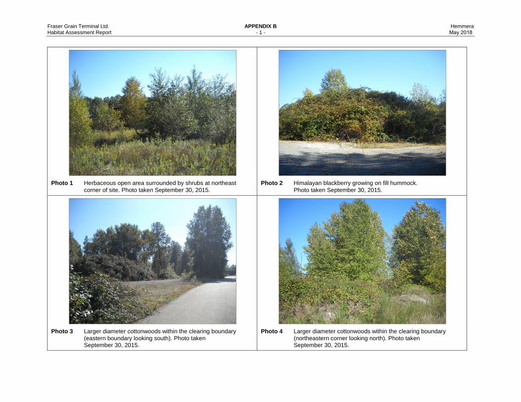
Fraser Grain Terminal Ltd. APPENDIX B Hemmera Habitat Assessment Report - 1 - May 2018
Photo 1 Herbaceous open area surrounded by shrubs at northeast corner of site. Photo taken September 30, 2015.
Photo 2 Himalayan blackberry growing on fill hummock. Photo taken September 30, 2015.
Photo 3 Larger diameter cottonwoods within the clearing boundary (eastern boundary looking south). Photo taken September 30, 2015.
Photo 4 Larger diameter cottonwoods within the clearing boundary (northeastern corner looking north). Photo taken September 30, 2015.
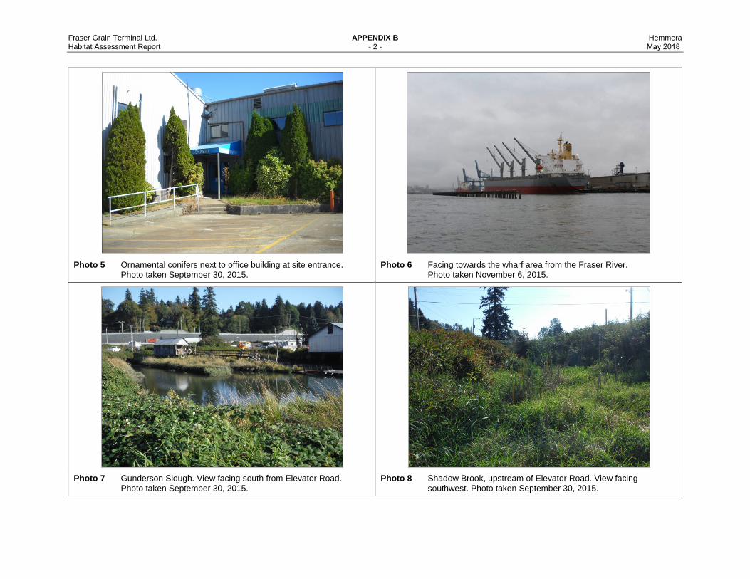
Fraser Grain Terminal Ltd. APPENDIX B Hemmera Habitat Assessment Report - 2 - May 2018
Photo 5 Ornamental conifers next to office building at site entrance. Photo taken September 30, 2015.
Photo 6 Facing towards the wharf area from the Fraser River. Photo taken November 6, 2015.
Photo 7 Gunderson Slough. View facing south from Elevator Road. Photo taken September 30, 2015.
Photo 8 Shadow Brook, upstream of Elevator Road. View facing southwest. Photo taken September 30, 2015.

Fraser Grain Terminal Ltd. APPENDIX B Hemmera Habitat Assessment Report - 3 - May 2018
Photo 9 Shadow Brook, downstream of elevator road. View facing upstream (southeast). Photo taken September 30, 2015.
Photo 10 Armstrong Creek/Colliers Canal. View facing upstream (northeast). Photo taken September 30, 2015.
Photo 11 Unnamed dashed red-coded Ditch. View facing upstream (northeast). Photo taken September 30, 2015.
Photo 12 Unnamed yellow-coded ditch. View facing northeast. Photo taken September 30, 2015.
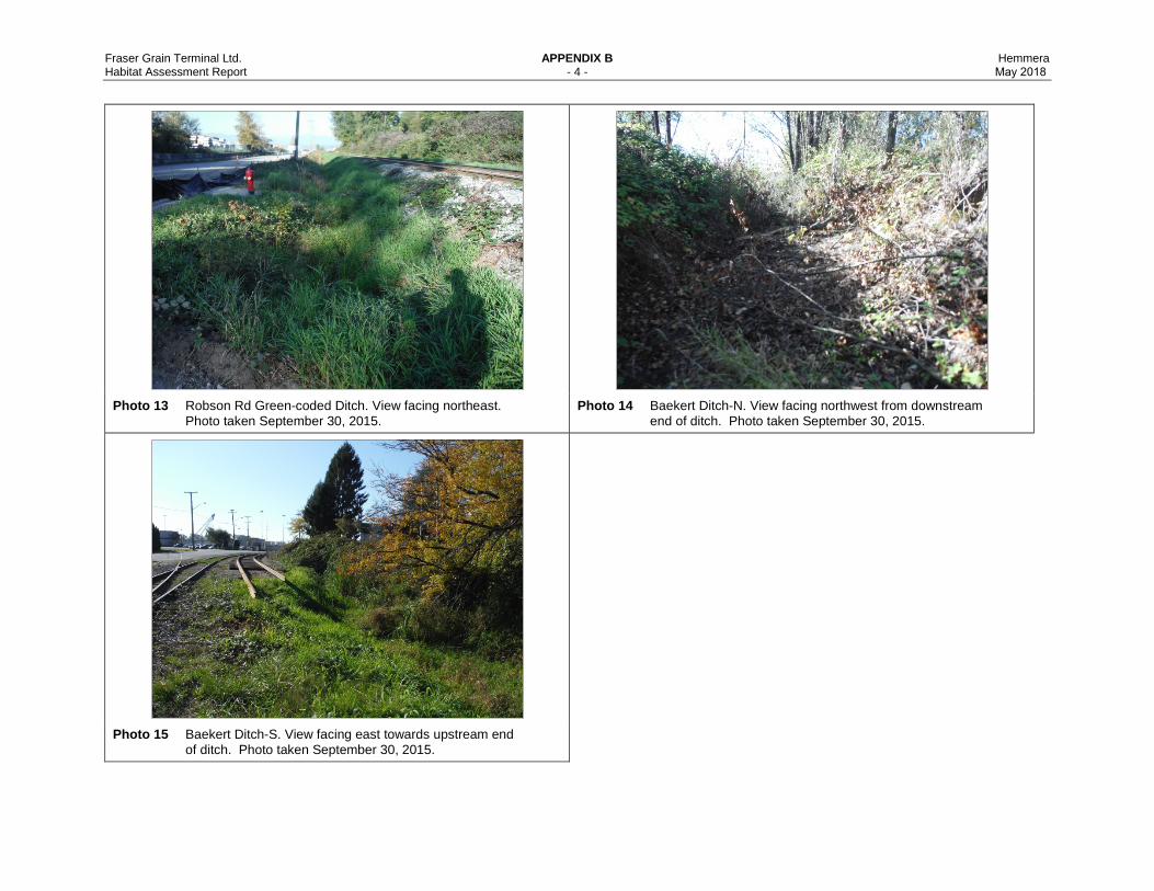
Fraser Grain Terminal Ltd. APPENDIX B Hemmera Habitat Assessment Report - 4 - May 2018
Photo 13 Robson Rd Green-coded Ditch. View facing northeast. Photo taken September 30, 2015.
Photo 14 Baekert Ditch-N. View facing northwest from downstream end of ditch. Photo taken September 30, 2015.
Photo 15 Baekert Ditch-S. View facing east towards upstream end of ditch. Photo taken September 30, 2015.

APPENDIX C Bird Species Documented within
and in Vicinity of Project Site

Fraser Grain Terminal Ltd. Appendix C Hemmera Habitat Assessment Report - 1 - May 2018
APPENDIX C BIRD SPECIES DOCUMENTED WITHIN AND IN VICINITY OF PROJECT SITE
Common Name Scientific Name Breeding Season (2003)*
Winter Period (2003-2006)*
September 2015**
American Robin Turdus migratorius x x
Anna's Hummingbird Calypte anna x
Bewick's Wren Thryomanes bewickii x x
Black-capped Chickadee Poecile atricapillus x x
Black-headed Grosbeak Pheucticus melanocephalus x
Brewer's Blackbird Euphagus cyanocephalus x
Brown Creeper Certhia americana x x
Brown-headed Cowbird Molothrus ater x
Cassin's Vireo Vireo cassinii x
Chestnut-backed Chickadee Poecile rufescens x
Common Redpoll Acanthis flammea x
Common Yellowthroat Geothlypis trichas x
Dark-eyed Junco Junco hyemalis x x x
Downy Woodpecker Picoides pubescens x x
European Starling Sturnus vulgaris x x
Fox Sparrow Passerella iliaca x
Golden-crowned Kinglet Regulus satrapa x x
Golden-crowned Sparrow Zonotrichia atricapilla x
Great Blue Heron, fannini subspecies Ardea herodias fannini x
Hairy Woodpecker Picoides villosus x x
House Finch Haemorhous mexicanus x x
House Sparrow Passer domesticus x x
Hutton's Vireo Vireo huttoni x x
Merlin Falco columbarius x
Northern Flicker Colaptes auratus x x
Northern Pygmy-Owl Glaucidium gnoma x
Northwestern Crow Corvus caurinus x x x
Pacific-slope Flycatcher Empidonax difficilis x
Pileated Woodpecker Dryocopus pileatus x
Pine Siskin Spinus pinus x x
Red-breasted Nuthatch Sitta canadensis x x
Red-breasted Sapsucker Sphyrapicus ruber x x
Red-tailed Hawk Buteo jamaicensis x
Fraser Grain Terminal Ltd. Appendix C Hemmera Habitat Assessment Report - 2 - May 2018
Common Name Scientific Name Breeding Season (2003)*
Winter Period (2003-2006)*
September 2015**
Rock Dove Columba livia x
Ruby-crowned Kinglet Regulus calendula x
Rufous Hummingbird Selasphorus rufus x
Song Sparrow Melospiza melodia x x
Spotted Towhee Pipilo maculatus x x
Steller's Jay Cyanocitta stelleri x x
Swainson's Thrush Catharus ustulatus x
Varied Thrush Ixoreus naevius x
Violet-green Swallow Tachycineta thalassina x
Warbling Vireo Vireo gilvus x
Western Tanager Piranga ludoviciana x
Western Wood-Pewee Contopus sordidulus x
White-crowned Sparrow Zonotrichia leucophrys x x x
Willow Flycatcher Empidonax traillii x
Wilson's Warbler Cardellina pusilla x
Winter Wren Troglodytes hiemalis x x
Yellow Warbler Setophaga petechia x
Sources: *=RESL 2006, **=Hemmera Surveys
APPENDIX D Fish Species Documented
within the Lower Fraser River
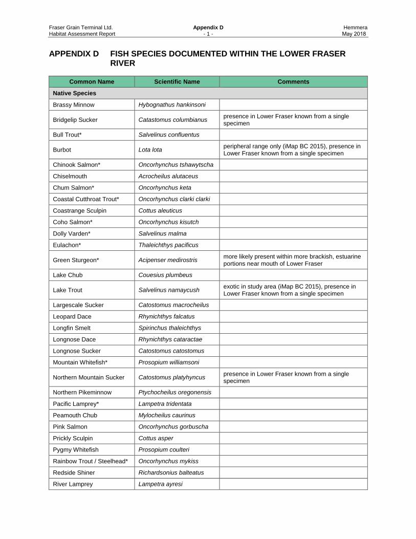
Fraser Grain Terminal Ltd. Appendix D Hemmera Habitat Assessment Report - 1 - May 2018
APPENDIX D FISH SPECIES DOCUMENTED WITHIN THE LOWER FRASER RIVER
Common Name Scientific Name Comments
Native Species
Brassy Minnow Hybognathus hankinsoni
Bridgelip Sucker Catastomus columbianus presence in Lower Fraser known from a single specimen
Bull Trout* Salvelinus confluentus
Burbot Lota lota peripheral range only (iMap BC 2015), presence in Lower Fraser known from a single specimen
Chinook Salmon* Oncorhynchus tshawytscha
Chiselmouth Acrocheilus alutaceus
Chum Salmon* Oncorhynchus keta
Coastal Cutthroat Trout* Oncorhynchus clarki clarki
Coastrange Sculpin Cottus aleuticus
Coho Salmon* Oncorhynchus kisutch
Dolly Varden* Salvelinus malma
Eulachon* Thaleichthys pacificus
Green Sturgeon* Acipenser medirostris more likely present within more brackish, estuarine portions near mouth of Lower Fraser
Lake Chub Couesius plumbeus
Lake Trout Salvelinus namaycush exotic in study area (iMap BC 2015), presence in Lower Fraser known from a single specimen
Largescale Sucker Catostomus macrocheilus
Leopard Dace Rhynichthys falcatus
Longfin Smelt Spirinchus thaleichthys
Longnose Dace Rhynichthys cataractae
Longnose Sucker Catostomus catostomus
Mountain Whitefish* Prosopium williamsoni
Northern Mountain Sucker Catostomus platyhyncus presence in Lower Fraser known from a single specimen
Northern Pikeminnow Ptychocheilus oregonensis
Pacific Lamprey* Lampetra tridentata
Peamouth Chub Mylocheilus caurinus
Pink Salmon Oncorhynchus gorbuscha
Prickly Sculpin Cottus asper
Pygmy Whitefish Prosopium coulteri
Rainbow Trout / Steelhead* Oncorhynchus mykiss
Redside Shiner Richardsonius balteatus
River Lamprey Lampetra ayresi

Fraser Grain Terminal Ltd. Appendix D Hemmera Habitat Assessment Report - 2 - May 2018
Common Name Scientific Name Comments
Slimy Sculpin Cottus cognatus
Sockeye Salmon* Oncorhynchus nerka
Staghorn Sculpin Leptocottus armatus estuarine or tidal
Starry Flounder Platichths stellatus estuarine or tidal
Surf Smelt Hypomesus pretiosus estuarine or tidal
Threespine Stickleback Gasterosteus aculeatus
Torrent Sculpin Cottus rhotheus
Western Brook Lamprey Lampreta richardsoni
Westslope Cutthroat Trout* Oncorhynchus clarki lewisi Range does not overlap with study area (iMap BC 2015)
White Sturgeon* Acipenser transmontanus
White Sucker Catostomus commersoni
Exotic Species
American Shad Alosa sapidissima
Black Crappie Pomoxis nigromaculatus
Brook Trout Salvelinus fontinalis
Brown Catfish Ameiurus nebulosus
Carp Cyprinus carpio
Fathead Minnow Pimephales promelas
Golden Trout Oncorhynchus mykiss aguabonita
Range does not overlap with study area (iMap BC 2015)
Goldfish Carassius auratus
Lake Whitefish Coregonus clupeaformis
Largemouth Bass Micropterus salmoides
Pumpkinseed Lepomis gibbosus
Notes: * Species expected to represent a CRA fishery Source: FISS 2015, iMap BC 2015, McPhail and Carveth 1994
APPENDIX E Species at-Risk Documented
within the Metro Vancouver Regional District
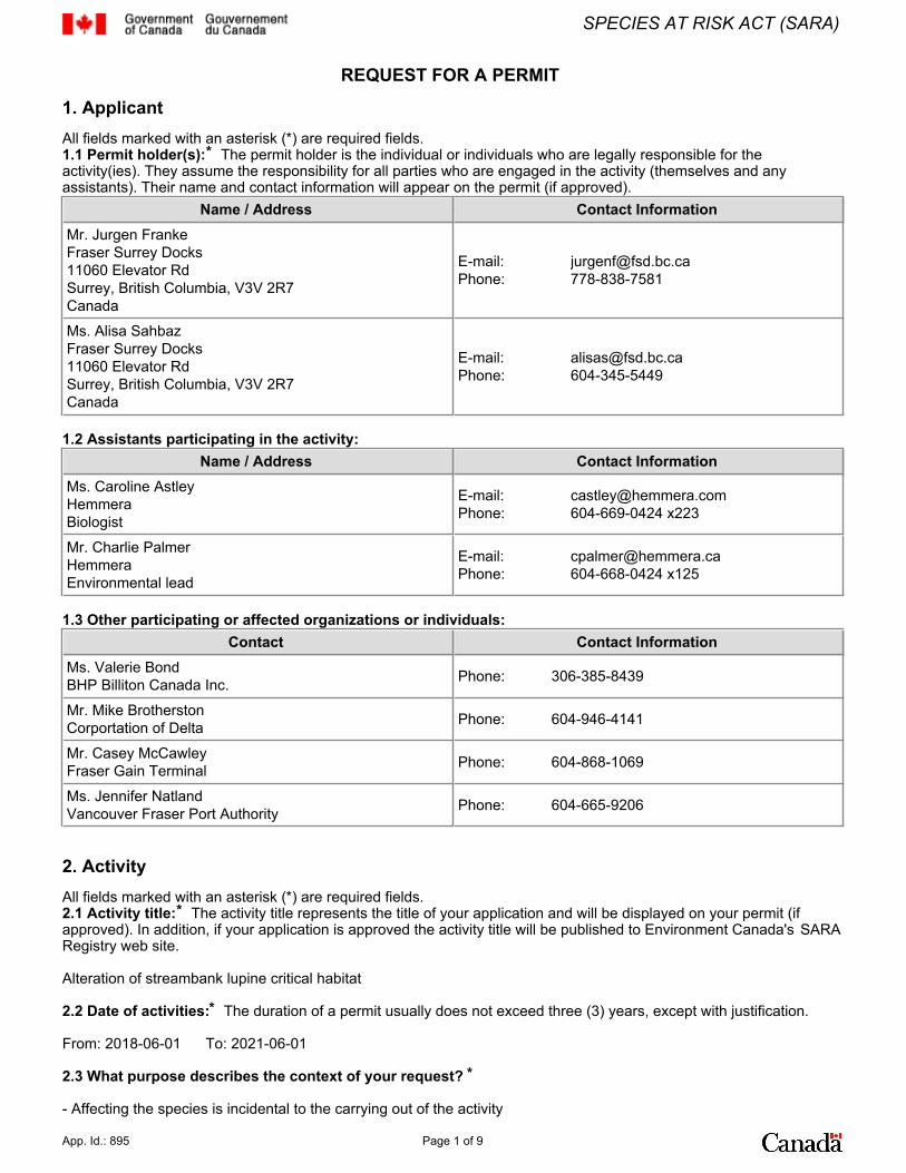
REQUEST FOR A PERMIT
1. ApplicantAll fields marked with an asterisk (*) are required fields. 1.1 Permit holder(s):* The permit holder is the individual or individuals who are legally responsible for theactivity(ies). They assume the responsibility for all parties who are engaged in the activity (themselves and anyassistants). Their name and contact information will appear on the permit (if approved).
Name / Address Contact Information Mr. Jurgen Franke Fraser Surrey Docks 11060 Elevator Rd Surrey, British Columbia, V3V 2R7 Canada
E-mail: [email protected] Phone: 778-838-7581
Ms. Alisa SahbazFraser Surrey Docks11060 Elevator RdSurrey, British Columbia, V3V 2R7 Canada
E-mail:Phone:
1.2 Assistants participating in the activity: Name / Address Contact Information
Ms. Caroline Astley Hemmera Biologist
E-mail: [email protected] Phone: 604-669-0424 x223
Mr. Charlie Palmer Hemmera Environmental lead
E-mail: [email protected] Phone: 604-668-0424 x125
1.3 Other participating or affected organizations or individuals: Contact Contact Information
Ms. Valerie Bond BHP Billiton Canada Inc. Phone: 306-385-8439
Mr. Mike Brotherston Corportation of Delta Phone: 604-946-4141
Mr. Casey McCawley Fraser Gain Terminal Phone: 604-868-1069
Ms. Jennifer Natland Vancouver Fraser Port Authority Phone: 604-665-9206
2. ActivityAll fields marked with an asterisk (*) are required fields. 2.1 Activity title:* The activity title represents the title of your application and will be displayed on your permit (ifapproved). In addition, if your application is approved the activity title will be published to Environment Canada's SARARegistry web site.
Alteration of streambank lupine critical habitat
2.2 Date of activities:* The duration of a permit usually does not exceed three (3) years, except with justification.
From: 2018-06-01 To: 2021-06-01
2.3 What purpose describes the context of your request? *
- Affecting the species is incidental to the carrying out of the activity
App. Id.: 895 Page 1 of 9
SPECIES AT RISK ACT (SARA)
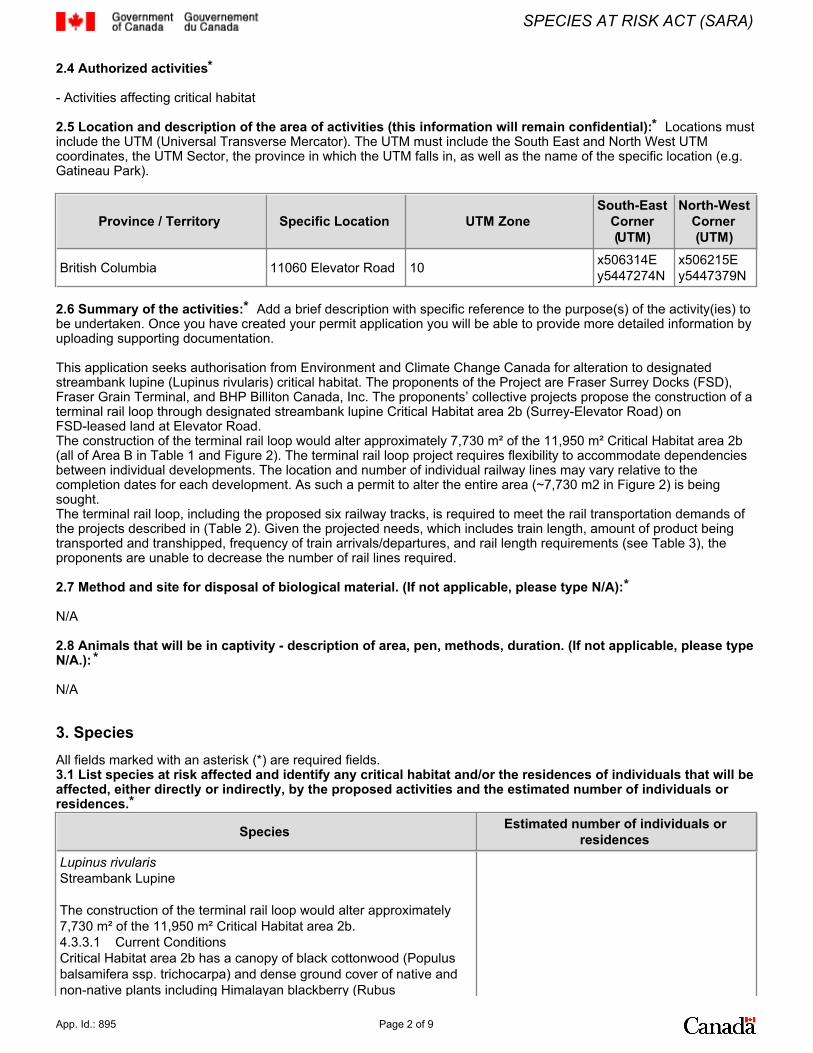
2.4 Authorized activities*
- Activities affecting critical habitat
2.5 Location and description of the area of activities (this information will remain confidential):* Locations mustinclude the UTM (Universal Transverse Mercator). The UTM must include the South East and North West UTMcoordinates, the UTM Sector, the province in which the UTM falls in, as well as the name of the specific location (e.g.Gatineau Park).
Province / Territory Specific Location UTM Zone South-East
Corner(UTM)
North-WestCorner(UTM)
British Columbia 11060 Elevator Road 10 x506314Ey5447274N
x506215Ey5447379N
2.6 Summary of the activities:* Add a brief description with specific reference to the purpose(s) of the activity(ies) tobe undertaken. Once you have created your permit application you will be able to provide more detailed information byuploading supporting documentation.
This application seeks authorisation from Environment and Climate Change Canada for alteration to designatedstreambank lupine (Lupinus rivularis) critical habitat. The proponents of the Project are Fraser Surrey Docks (FSD),Fraser Grain Terminal, and BHP Billiton Canada, Inc. The proponents’ collective projects propose the construction of aterminal rail loop through designated streambank lupine Critical Habitat area 2b (Surrey-Elevator Road) onFSD-leased land at Elevator Road.The construction of the terminal rail loop would alter approximately 7,730 m² of the 11,950 m² Critical Habitat area 2b(all of Area B in Table 1 and Figure 2). The terminal rail loop project requires flexibility to accommodate dependenciesbetween individual developments. The location and number of individual railway lines may vary relative to thecompletion dates for each development. As such a permit to alter the entire area (~7,730 m2 in Figure 2) is beingsought.The terminal rail loop, including the proposed six railway tracks, is required to meet the rail transportation demands ofthe projects described in (Table 2). Given the projected needs, which includes train length, amount of product beingtransported and transhipped, frequency of train arrivals/departures, and rail length requirements (see Table 3), theproponents are unable to decrease the number of rail lines required.
2.7 Method and site for disposal of biological material. (If not applicable, please type N/A):*
N/A
2.8 Animals that will be in captivity - description of area, pen, methods, duration. (If not applicable, please typeN/A.): *
N/A
3. SpeciesAll fields marked with an asterisk (*) are required fields. 3.1 List species at risk affected and identify any critical habitat and/or the residences of individuals that will beaffected, either directly or indirectly, by the proposed activities and the estimated number of individuals orresidences.*
Species Estimated number of individuals orresidences
Lupinus rivularisStreambank Lupine
The construction of the terminal rail loop would alter approximately7,730 m² of the 11,950 m² Critical Habitat area 2b.4.3.3.1 Current ConditionsCritical Habitat area 2b has a canopy of black cottonwood (Populusbalsamifera ssp. trichocarpa) and dense ground cover of native andnon-native plants including Himalayan blackberry (Rubus
App. Id.: 895 Page 2 of 9
SPECIES AT RISK ACT (SARA)
armeniacus), Canada goldenrod (Solidago canadensis) and otherspecies, e.g., agronomic and non-native grasses (Figure 5). Denseand continuing growth of these species at the site is consideredinimical to the germination, growth and survival of streambank lupine(Hemmera 2016). The Streambank Lupine Recovery Team discussedthe vegetation succession issue at Critical Habitat area 2b in 2012(following site visits in 2011), noting that shade from the cottonwoodtrees and competition from invasive species threatened the long-termviability of the population (K Keskinen pers. comm.).Critical Habitat area 2b is not optimal streambank lupine habitat.There are no nutrient-poor and dry river or creek banks composed ofgravel, cobble, riprap, sand or silt, or artificial surrogates, that throughnatural events (floods) or human activities provide the disturbancesthat give streambank lupine a competitive advantage over other plants(Environment Canada 2016). In disturbed areas streambank lupinecan germinate and grow despite these stochastic disturbances(Envirowest 2006, Ministry of Environment 2014) because, like otherlupines, it does not require nitrogen, allowing it to outcompete otherplants in a post-disturbance situation. Disturbed railbeds and roadverges, locations where streambank lupine is now frequently found,can offer an artificial surrogate for natural habitat with the requisitefree-draining low fertility substrate that is free from vegetativecompetition. Critical Habitat area 2b does not have thesecharacteristics, and dense vegetation has proliferated as a result. 4.3.3.2 Historic ContextTo better understand streambank lupine Critical Habitat area 2b andits value for the species, an analysis of the site history wasconducted. Historical aerial photographs of Critical Habitat area 2band 2a, were obtained from the University of British Columbia andgeotechnical studies were reviewed. Fourteen aerial photographsspanning the period from 1932 to 2016 were obtained, scanned andgeoreferenced. The resulting images are in Appendix C.The aerial photograph analysis was interpreted as follows. 1. The landform at Critical Habitat area 2b is not of a type that hasoptimal habitat characteristics for streambank lupine. A forestedfloodplain with no evidence of a watercourse or river banks (asshown in 1932 – 1952 images of Appendix C) some hundreds ofmetres from active river or creek areas is not consistent with thedescribed and defined biophysical attributes of critical habitat forstreambank lupine (Environment Canada 2016). Prior to 1932 and upto 1952 the aerial photograph evidence does not suggest anypresence of streambank lupine is possible. The “Ecosystemprocesses that occur on banks that support Streambank Lupine areintegral to the production and maintenance of suitable microhabitatconditions” (Environment Canada 2016); in the absence of riverbanklandforms the processes supporting streambank lupine are absent.2. Suitably free-draining substrate conditions for streambank lupineappear to have been introduced to the site (in or before 1963). Theaddition of sand for converting the site to industrial land may haveintroduced streambank lupine, explaining how a ruderal species ofriverbanks appears in an area of floodplain forest. Vegetationclearing and the introduction of a sand substrate replaced the densefloodplain forest formerly present at Critical Habitat area 2b, and seedin the sand introduced the species.3. However, the establishment and growth of seral trees and shrubssince about mid-1970, after this part of the site was abandoned forindustrial use, has prevented the maintenance of a strongstreambank lupine population in what might otherwise be considereda suitable substrate. Such growth is the natural progression of anundisturbed floodplain site, but development of dense ground cover
0
App. Id.: 895 Page 3 of 9
SPECIES AT RISK ACT (SARA)
and a canopy of trees since about 1970, plus the lack ofriver-mediated disturbance, is not consistent with the described anddefined biophysical attributes of critical habitat for streambank lupine(Environment Canada 2016). Critical Habitat area 2b does not have low-intensity and frequentdisturbance events to maintain a vegetation-free state for streambanklupine (Ministry of Environment 2014). No other land clearingactivities have taken place within Critical Habitat area 2b since 1974,so the streambank lupine seed that was likely introduced to the sitewith reclamation in the 1960s is not in an optimal site for continuedgrowth. Sub-population 2b does not, unlike other non-natural siteswith streambank lupine, have artificial disturbances that mobilise thesubstrate allowing seed to germinate, and concurrently acting toremove the competing vegetation that then allows streambank lupineseedlings to grow to maturity. 4.3.4 Streambank Lupine Occurrence at Population 24.3.4.2 Critical Habitat Area 2bSince records began in 2005 only 1 mature plant has been recordedat Critical Habitat area 2b (in 2008). At most 13 seedlings have beenrecorded. From this perspective, and given the strong vegetationcompetition, lack of disturbance and unsuitable substrate,Sub-population 2b is not considered a viable and persistentsub-population. The first record for Sub-population 2b was in 2008, one plant.Thereafter the almost-annual surveys have failed to find any matureplants, with seedlings only being observed. The highest number ofseedlings seen was 13 in 2010 (Terry McIntosh). Since 2013 whenone seedling was observed (Terry McIntosh), no seedlings have beenobserved despite almost annual surveys by qualified botanists. The list of streambank lupine observations below is an extract fromthe Conservation Data Centre (CDC) record (Figure 6), with additionsfrom the notes of Kim Keskinen (Vancouver Fraser Port Authority(VFPA) and former Streambank Lupine Recovery Team member)and reports held by VFPA. • 2005, nil (Envirowest 2006, Mark Adams, R.P.Bio.)• 2008, 1 plant (CDC: pers comm Terry McIntosh)• 2009, 3 seedlings/juveniles (CDC: pers comm Terry McIntosh)• 2010, 13 seedlings/juveniles (CDC: pers comm Terry McIntosh)• 2011, no CDC record. Kim Keskinen (VFPA) with Sylvia Letayfound 1 seedling• 2012, nil (Triton 2013 report: Karla Graf) • 2012, probably nil. • 2013 1 seedling/juvenile (CDC: pers comm Terry McIntosh)• 2013 (May), nil (Triton 2013 report: Karla Graf)• 2016 (15 June), nil (Hemmera 2016 report: Caroline Astley,R.P.Bio.)• 2016 (30 September), nil (Hemmera 2016 report: Caroline Astley,R.P.Bio.)• 2017 (19 May and 5 June), nil (Micaele Florendo, R.P.Bio.)Compared to nearby sites with populations of streambank lupine(e.g., Sub-population 2a) regular monitoring at the Sub-population 2bCritical Habitat site since 2005 by qualified botanists shows a poorrecord of presence. This trend is likely due to the absence of both ofthe key biophysical attributes required for streambank lupine atCritical Habitat area 2b; (i) no disturbed sand, silt or cobble areas(river or creek banks or road/rail verges) and (ii) too much vegetativecompetition. The growth and survival of any streambank lupineseedlings that do germinate is not assured at Critical Habitat area 2b,possibly due to the combined effects of the organic peat substrateunderlying the sand at about -2 m depth and the water table at
App. Id.: 895 Page 4 of 9
SPECIES AT RISK ACT (SARA)

between -1.5 and -2 m (MEG 2015) not being free-draining andcontaining too many nutrients, and the shade and competition fromother plants.
3.2 To assist us in monitoring other wildlife species, please identify any other species affected and theestimated number of individuals (Scientific and common names).
Species Estimated number of individuals orresidences
4. Background All fields marked with an asterisk (*) are required fields. 4.1 Have you received a SARA permit before?* No
4.2 Provide complete answers to all four questions. You must establish that your activity meets the basicrequirements of the Species At Risk Act for the issuance of permits as outlined in Section 73 of the Act, andrelevant policy.
a) Did you consider all reasonable alternatives to the proposed activity that would reduce the impact on the species?Elaborate.*
Six alternative configurations and designs have been considered, including not building the terminal rail loop, using railladder track configuration, sharing rail tracks, elevating the rail loop, moving the rail loop south, and the currentalignment.
7.1 NO RAILWAY CONSTRUCTIONAs required in the ECCC guidelines for a SARA permit application, not advancing the Project (i.e., no rail construction)was considered as an alternative. The projects require rail to transport products to the terminal from various sources(e.g., mine sites and grain fields). Without rail access, the projects are not feasible. Given the critical importance of railto the projects, this alternative was not selected.
7.2 RAIL LADDER (INSTEAD OF RAIL LOOP)A railway ladder track option was considered. This option requires entire trains to be broken into rail car segments forunloading, with each segment being shunted onto its own portion of the ladder track. During this process, moreroad-rail traffic impacts are generated as well as increased noise and air quality emissions from multiple shuntingoperations required to break the trains. Ladder tracks require more space than a rail loop as each train segment is stored on its own parallel track and wouldtherefore have a larger footprint effect. Given the proximity of the Project to sensitive noise and air quality receptors(e.g., houses) and the limited space on the FSD site, a rail ladder layout was not selected.
7.3 SHARED RAILWAY LOOP TRACKSThe three proponents requiring the terminal rail loop considered sharing railway tracks within a loop to minimize thetotal number of tracks required and therefore, overall footprint. This alternative is considered unfeasible for thefollowing reasons:• Expected frequency of trains for each project, • Overlap in time for deliveries to each project, • Location of rail unload facilities within the terminal, • Required track length to process these trains, and• Adverse impacts on terminal access. Sharing railway tracks would not only restrict or limit access to the PARY, where most of the unit train will be storedwhile blocks of rail cars are processed, but it could result in blockages to vehicle use of Robson Road. Sharing railwaytracks between proponents was rejected as an alternative to the Project considering the rail requirements for eachproject.
7.4 ELEVATED TERMINAL RAIL LOOPElevating the terminal rail loop over Critical Habitat area 2b with a clear span overpass, was considered as a railalignment alternative. The elevated terminal rail loop was not considered further for the following reasons:• Economically unfeasible,• Rail grade requirements (5% or less) would necessitate grade changes beginning just south of King GeorgeBoulevard (approximately 3.5 km from the Project). • The overpass would likely shade Critical Habitat area 2b, thus affecting the growing conditions of the streambanklupine in this area.
7.5 MOVING THE TERMINAL RAIL LOOP SOUTH INTO GUNDERSON SLOUGH
App. Id.: 895 Page 5 of 9
SPECIES AT RISK ACT (SARA)
7.5 MOVING THE TERMINAL RAIL LOOP SOUTH INTO GUNDERSON SLOUGHMoving the terminal rail loop south to avoid the critical streambank lupine habitat area was considered as analternative for the rail alignment. For this alternative, Elevator Road would be realigned to the south, necessitatinginfilling valuable fish habitat in Shadow Brook and Gunderson Slough (Figure 7). Further, this alternative createsunfeasible rail alignment geometry and requires the removal of two buildings on VFPA land leased to non-FSD tenants.Shadow Brook’s confluence with Gunderson Slough is characterized by the Fraser River Estuary ManagementProgram (FREMP) as red-coded, which indicates productive and diverse habitat features that support critical fish andwildlife functions on site or as part of a more regional context, and areas where habitat compensation has beenpreviously constructed to offset habitat losses (FREMP 2015). Aquatic and riparian habitats of Gunderson Slough areconsidered to be of high value and very sensitive. All five species of Pacific salmon may be encountered seasonallywithin this area. Shadow Brook also provides year-round salmonid habitat (CoD 2003, CoD 2015, COSMOS 2015).Rearing habitat value is high downstream of Elevator Road, and moderate upstream of Elevator Road. Approximately 2,000 m² of productive fish habitat and 4,100 m² of riparian vegetation would be destroyed if thisalternative was selected. A Fisheries Act Authorization would be required for this alternative. In addition, this alternative would require 13º rail curvatures on some of the tracks within the terminal rail loop,exceeding the maximum curvature specified in the CN Engineering Specifications for Industrial Tracks, and requiressome alignments to utilize reverse curve geometry. These rail curvatures would create a fatal flaw preventing some ofthe projects proceeding. In summary, re-aligning the terminal rail loop to the east was rejected as an alternative rail alignment option for thefollowing reasons:• Approximately 2,000 m² of productive fish habitat and 4,100 m² of riparian vegetation would be destroyed, • Neighbouring tenancies would be disrupted due to removal of two of their existing buildings, and • The tight rail curvatures create a fatal flaw preventing some of the projects proceeding.
b) Explain why you consider that your proposal is the best solution.*
Selection of the current proposed terminal rail loop alignment:• Allows the Project to proceed and to deliver the proponent’s targeted throughputs;• Efficiently uses the limited-space available at FSD, both terminal and PARY;• Allows for the rail curvature to be within tolerance of CN’s Engineering Track Standards;• Is economically feasible;• Minimizes noise, and air quality effects to neighbouring communities and avoids physical disruption to tenants; and • Minimizes disturbance to productive, red-coded fish habitat and important riparian areas.Given these reasons, the current proposed terminal rail loop alignment was selected as the preferred approach.
c) What measures to minimize the impact of the activity on the species, its critical habitat or the residences of itsindividuals will be taken?*
The hierarchical of mitigation steps (avoid, minimise and offset (enhance)) will be used to address the critical habitateffects at Sub-population 2b. The effect that will be mitigated is the potential loss of future streambank lupinegermination at Critical Habitat area 2b.
9.3.1 Enhancement Area SelectionBiophysical, financial and practical considerations used for selecting streambank lupine management and enhancementareas to address project effects are as follows:1. Proximity to an extant population (seed source)2. Substrate suitability (well-drained, mobile sand and gravel)3. Competing vegetation (minimal overhead shade and limited competing ground vegetation)4. Management costs (for enhancement and long-term maintenance)5. Ownership (potential for protective covenant or management agreement in perpetuity)6. Future use (potential for future use and the ability to provide physical protection)Given the above characteristics, the naturalised areas within Critical Habitat area 2a and 2b that are clearly or possiblyincluded in the definition of critical habitat in the SARA Recovery Strategy were surveyed as candidates for potentialenhancement sites. Areas that are currently paved, or with buildings were excluded as unsuitable (as per ECCC 2017).Figure 8 shows the locations of the candidate sites described below:Management and enhancement activities in Areas B and C (the Interfor railway spur and the Corporation of Delta roadverge) are considered to have the most potential to successfully establish a stable population. The current population(2 mature plants, 6 -8 seedlings) is down from that recorded in previous years, but in general the population variesyear to year in respect of the level of disturbance and the extent of monitoring efforts. The extant population in Areas Band C is mostly physically protected, but not managed for long-term maintenance of the population. With modestefforts to remove ground cover and overhead tree cover, supported by an adaptive management approach to test theoptimal management regime, success is considered likely. The presence of a strong seed bank has been proved inboth areas after disturbance by Metro Vancouver in 2005 created conditions for upwards of 500 seedlings to establish(Figure 8). Area C is managed by the Corporation of Delta as a portion of their road right-of-way, and a portion of thearea overlaps a Metro Vancouver water main. As such a legal restrictive covenant for conservation purposes in Area Cis not possible, but a maintenance agreement is possible. Adaptive management and maintenance activities are proposed within Areas B and C as a means of improving the
App. Id.: 895 Page 6 of 9
SPECIES AT RISK ACT (SARA)
Adaptive management and maintenance activities are proposed within Areas B and C as a means of improving thehabitat conditions for streambank lupine, and increasing the chances of survival for the Sub population at CriticalHabitat area 2a. The maintenance activities are not only designed to improve the environment for streambank lupine togrow, but to learn what management techniques are required for maintenance of populations because such knowledgeis lacking. The activities described below are proposed to occur over a five-year period in Areas B and C, where thereare existing streambank lupine plants. The information gained from the activities would be used to inform and adaptthe activities in Critical Habitat area 2a for best efficacy, and could have utility for the actions of other parties inmanaging streambank lupine in other populations.9.3.2.1 Legal Protection9.3.2.2 Nested Plot Study and Implementation9.3.2.3 Vegetation Management9.3.2.4 Tree Removal9.3.2.5 Garbage Removal9.3.2.6 Watering9.3.2.7 Physical Protection9.3.2.8 Substrate Amelioration and Augmentation 9.3.2.9 Monitoring 9.3.3 Timing of Maintenance and Enhancement Activities9.3.4 Anticipated Success and Contingency Measures
d) Why do you consider that this activity will not jeopardize the survival or recovery of the species?*
The Sub-population of streambank lupine at Critical Habitat area 2b is not viable, and as such survival and recovery ofthe species at this location is not assured under current or future management scenarios. In reaching this conclusionfollowing factors were considered:1. Historical observations of individuals in the sub-population have not exceeded 13 (in 2010 and seedlings only), andonly one mature plant has ever been recorded present (in 2008). Since 2013 (1 seedling only) no individuals have beenrecorded (survey data from 2015, 2016, and 2017).2. The habitat conditions are unsuitable for streambank lupine establishment, germination and growth. There are nomobile substrates, vegetation competition is high, and there is much shading.3. The landform and underlying geology is not indicative of natural streambank lupine habitat, and may be an activeimpediment to establishment and survival (see Section 4.3.4).While streambank lupine does survive in non-natural habitats (e.g., railway line verges) it only does so where theestablishment and growing conditions are suitable. At Critical Habitat area 2b the conditions required for survival areabsent. So despite the assumed presence of a seedbank, the lack of disturbance and mobile substrates and theshading and competition from other plants act in concert to prevent germination (establishment) and then growth.Sub-population 2b does not, unlike other non-natural sites with streambank lupine, have artificial disturbances thatmobilise the substrate allowing seed to germinate, and concurrently acting to remove the competing vegetation thatthen allows streambank lupine seedlings to grow to maturity.Alteration of streambank lupine Critical Habitat 2b by the Project will not affect Population #2 (ECCC 2017) becauseneither individuals nor viable habitat will be affected. The value of Critical Habitat area 2b for streambank lupinesurvival and recovery lies in the seedbank that is assumed to be present. Mitigation in association with the Project hasbeen designed to maintain, salvage, and use the seedbank at Sub-population 2b for use in survival and recovery ofPopulation #2 at the only location of extant plants – in Sub-population 2a at Alaska Way. Further, active managementof the extant streambank lupine Sub-population 2a in advance of the effects from the Project on Sub-population 2b willadvance knowledge of the management requisites such that survival and recovery management can be effectivelyimplemented.Critical Habitat area 2a, the site of proposed enhancement activities, is the only viable part of Population #2. There areextant plants, the substrate is relatively mobile, and infrequent and low intensity disturbances appear to mobilise seedand allow it to germinate. Vegetation cover at ground and canopy levels is becoming dense, but is currently openenough to allow germination and growth (Figure 9, Figure 11, Figure 12, and Figure 17).Critical Habitat at Sub-population 2a is, however, sub-optimal in respect of the ideal conditions for streambank lupine,despite the presence of extant plants. No targeted and species-specific maintenance is undertaken, and thepersistence of Sub-population 2a is mostly left to chance and previously enacted barrier fencing. Because thisSub-population represents 100% of the extant individuals in Population #2, and the area is small, there is a risk to thepopulation from any number of the threats listed in the Recovery Strategy; competing vegetation, trampling, lack ofdisturbance (ECCC 2017). Modest maintenance activities in the parts of Sub-population 2a with extant plants willincrease the survival and recovery of Population #2. Further, proposed enhancement activities in the parts ofSub-population 2a that are suitable but have no plants will increase the area available for streambank lupine and willutilise the seedbank salvaged from the non-viable portion of Population #2 (i.e., Critical Habitat area 2b).Sub-population 2a at Alaska Way has at its peak had ~500 seedlings (Figure 8), an anomalously high count that wasthe result of disturbance in the water main right-of-way during 2005. Prior to this disturbance Sub-population 2a had 50flowering plants and 100 seedlings (ECCC 2017). Since the 2005 disturbance Sub-population 2a has had at its peak in2103 had 75 flowering plants and ~120 seedlings spread across the Corporation of Delta road verge (Area C) andInterfor railway spur (Area B) portions (ECCC 2017). Current population estimates (2017) are much lower; 2 floweringplants and ~10 seedlings (Maddison 2017 and pers. obs.), all in Area C within and on the edge of the Corporation of
App. Id.: 895 Page 7 of 9
SPECIES AT RISK ACT (SARA)
Delta Jersey barriers. The mitigation proposed in association with the Project has as its objective the provision ofconditions that will result in the establishment of 50 to 75 mature plants and associated seedlings at the end of fiveyears of operations. Legal protection in association with the maintenance and enhancement activities will provide thelegal framework for similar future activities to provide for the perpetuation of Population #2. This assessment concludes that the terminal rail loop development proposed in Critical Habitat area 2b will notjeopardise streambank lupine Population #2. In reaching this conclusion the efficacy of active and scientifically-testedmanagement operations that are deliberately applied to the extant Sub-population at 2a have been considered. Suchactivities will provide better chances of survival and recovery of Population #2 because, based on the biology of lupinesand evidence of streambank lupine reactions to such species-specific maintenance, the actions lead to greaterproduction of streambank lupine than the current situation where there is no species-specific management andpersistence is left to chance. Further, the threat of extirpation will be reduced because there will be more individuals,and a larger area – both factors that reduce the effects of major perturbations and accidents. The above conclusion also considers that other than the value of Sub-population 2b as a reservoir of seeds, there isno foreseeable situation where Critical Habitat area 2b, where the Project activities are proposed, can provide anyvalue for the survival and recovery of streambank lupine. As described above, the geological, biological, financial andpractical limitations are too great for functioning habitat to develop in situ. However, mitigation to salvage the seedbankand using it to augment the viable Sub-population at Critical Habitat area 2a is a sensible and scientifically defensiblemeans to ensure the survival of Population #2, as per the objectives of the Recovery Strategy (ECCC 2017).
4.3 Is this application a result of an Environmental Assessment?* Yes
The three projects that require the terminal rail loop are at various stages of the Vancouver Fraser Port AuthorityProject and Environmental Review process.
5. Supporting Documents All fields marked with an asterisk (*) are required fields. 5.1 Please attach supporting documents.* You must demonstrate that your application meets all the pre-conditionsin SARA section 73(3). Supporting documents are required to provide sufficient information to process and approveyour application. Supporting documents should include a detailed description of the activities, including methods.Applications should stand alone and not require the reader to look beyond the application package for documents.Animal care committee approval documents should be included where applicable. Refer to the "Attachment Type" dropdown menu for a list of potential attachments. A lack of supporting documentation may result in delays or rejection ofyour application.
Title / Attachment Type Uploaded By
Compiled SARA Permit Application with Figures Other (compiled SARA permit appliction withfigures)
Smulders, Mary 2017-08-31
Appendix B - CVs Resume – Section 1.1
Smulders, Mary 2017-08-31
Appendix D - Independent Monitor CV Resume – Section 1.1
Smulders, Mary 2017-08-31
6. Signature MANDATORY CONDITIONS FOR PERMITS AND AGREEMENTS (Section 73)
(1) The competent minister may enter into an agreement with a person, or issue a permit to a person, authorizing theperson to engage in an activity affecting a listed wildlife species, any part of its critical habitat or the residences of itsindividuals.
(2) The agreement may be entered into, or the permit issued, only if the competent minister is of the opinion that(a) the activity is scientific research relating to the conservation of the species and conducted by qualified persons;(b) the activity benefits the species or is required to enhance its chance of survival in the wild; or(c) affecting the species is incidental to the carrying out of the activity.
(3) The agreement may be entered into, or the permit issued, only if the competent minister is of the opinion that(a) all reasonable alternatives to the activity that would reduce the impact on the species have been considered andthe best solution has been adopted;(b) all feasible measures will be taken to minimize the impact of the activity on the species or its critical habitat or the
App. Id.: 895 Page 8 of 9
SPECIES AT RISK ACT (SARA)