Gendering Land Tools: Achieving Secure Tenure for - UN-Habitat
Bridging the Gaps, Naturally 267 Transportation and Conservation Planning
Chapter
Habitat Analysis Tools
EffEcts of thE configuration of road nEtworks on LandscapE connEctivity
Jochen A.G. Jaeger (+41-44-632-0826, [email protected]), Research Associate, Swiss Federal Institute of Technology ETH Zurich, Department of Environmental Sciences, Ecosystem Management, Universitaetstrasse 22, CHN F 73.2, CH-8092 Zurich, Switzerland
Abstract: Wildlife biologists, traffic planners, and decision makers are increasingly concerned about the effects of landscape fragmentation caused by transportation infrastructure. Data on the degree of landscape fragmentation are urgently needed for monitoring environmental change, identification of trends, and as a basis for investigating the effects of fragmentation on larger scales. The method of effective mesh size is currently used in several countries for national environmental reporting, e.g., as one of 24 core indicators in Germany. The objectives of this paper are to develop a new method for the quantification of landscape connectivity that incorporates variable barrier strengths into the effective mesh size, and to apply it to the question of how the configuration of transportation networks affects landscape connectivity, using empirical data on ungulates and amphibians. The paper also addresses the question of how crossing structures can enhance landscape connectivity most efficiently depending on their placement and spatial arrangement. The outcomes include the following principles: (1) The more crossing structures were implemented, the higher the resulting landscape connectivity. (2) The higher traffic volume, the larger the difference between the configuration with and without crossing structures, and the more pronounced the differences among the various configurations with crossing structures. (3) The more patches can be accessed from any patch by few road crossings (i.e., high number of nearest neighbours and next nearest neighbours), the higher the degree of landscape connectivity. (4) The closer to each other the roads are (i.e., the more bundled the roads are), the higher the degree landscape connectivity. (5) However, putting all traffic on one road can be better or worse for landscape connectivity, depending on how quickly crossing success decreases with increasing traffic volume. (6) The number and quality of crossing structures are highly relevant. Wildlife passages that are not satisfactorily functional provide little benefit to landscape connectivity. (7) Large patches should be connected first. Only once the large patches are well enough connected does the additional connection with smaller patches provide higher additional connectivity than an improvement of the connectivity between the large patches. The results demonstrate that the topology-sensitive effective mesh size is a suitable tool to study the effects of road network configuration and wildlife passage location on landscape connectivity. Because traffic volume may vary over time, landscape connectivity can vary over a day, week, or year. This new method will probably be applied widely in the future as the current lack of quantitative empirical data on the barrier strength as a function of road type, traffic volume, and animal species is currently addressed more and more systematically by wildlife biologists.
Introduction
Landscape fragmentation caused by transportation infrastructure is a serious threat to the sustainability of human land uses because it has a number of detrimental effects on the environment including spread of noise and pollution from traffic, effects on local climate, reducing the size and persistence of wildlife populations (e.g., by the dissection of populations and the isolation of habitats), and impairing the scenery and recreational quality of the landscape (Underhill and Angold 2000, Jaeger 2002, Forman et al. 2003). Data on the increasing degree of landscape fragmenta-tion are urgently needed for monitoring environmental change, identification of trends, and as a basis for investigating the effects of fragmentation on a regional and national scale (Jaeger 2002, Heinz Center 2002, Kupfer 2006, Jaeger et al. 2007).
The scientific literature offers a number of metrics to measure the degree of landscape fragmentation (e.g., Hargis et al. 1998, Gustafson 1998, Jaeger 2000, Riitters et al. 2000, Rutledge and Miller 2006). However, few of them have been developed in a form that can be easily applied to transportation infrastructure. For example, it is notoriously difficult to use raster-based metrics since the resolution of raster images of the landscape is often too course to depict smaller roads correctly. Even with larger roads, there can be problems when the size of the raster cells is in the order of the width of the roads. Consequently, the lines of raster cells representing roads may be discontinuous, i.e., may have holes, which can lead to flawed results when the patches on either side of the roads appear to be connected through these “holes”. For this reason, vector data should be used preferably, and therefore, metrics should be chosen that are applicable to vector data.
In most cases, former methods to quantify the degree of landscape fragmentation have based the decision of whether or not to include roads as barriers on the road’s category (e.g., include district roads but exclude municipal roads) or on a minimum amount of traffic (e.g., include only roads with >1000 vehicles/day, BfN 1999, Gawlak 2001). Therefore, these methods do not take into account the varying degree of a road’s barrier strength that depends on traffic volume, on several characteristics of the road itself (e.g., width, type of surface), and on the surrounding landscape (e.g., slope). For example, the effective mesh size (see below) is based on the ability of two animals – placed in different areas
Chapter 6 268 ICOET 2007 Proceedings
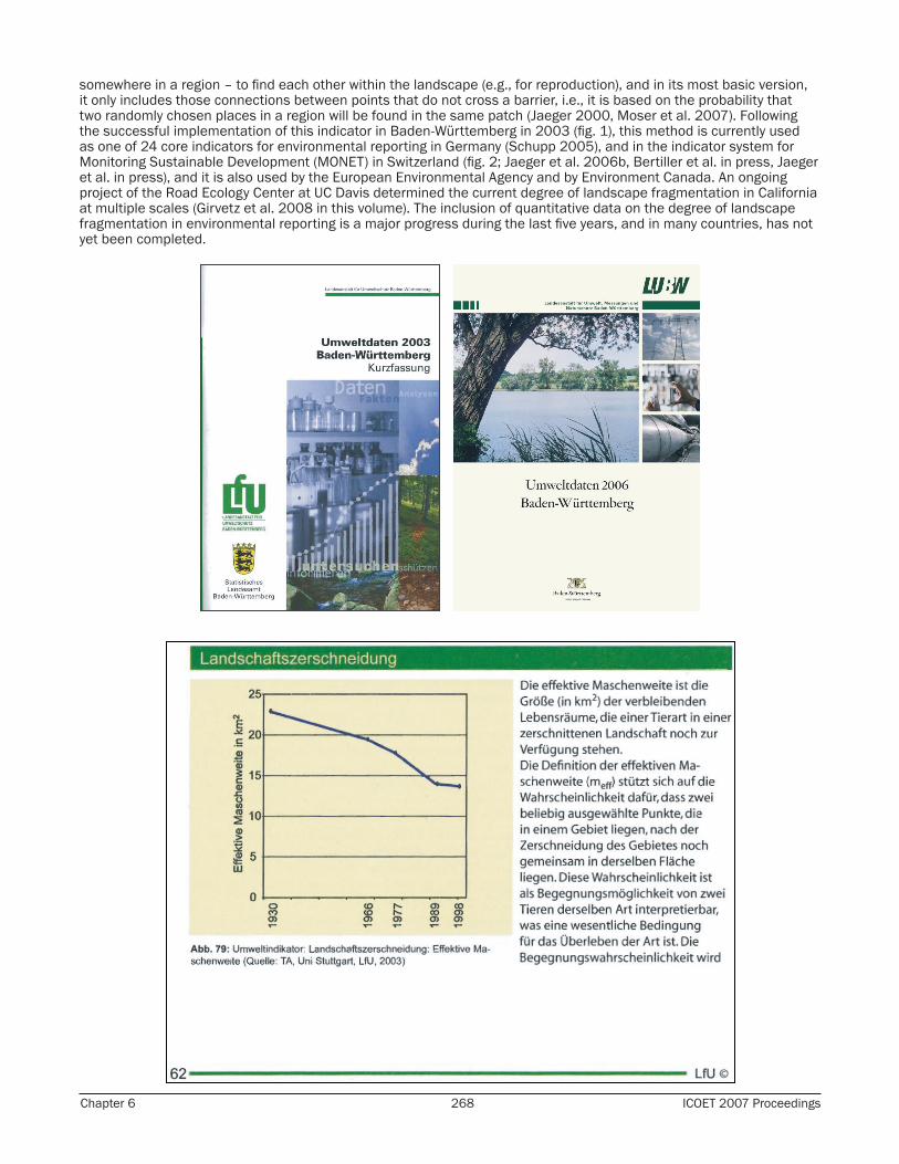
somewhere in a region – to find each other within the landscape (e.g., for reproduction), and in its most basic version, it only includes those connections between points that do not cross a barrier, i.e., it is based on the probability that two randomly chosen places in a region will be found in the same patch (Jaeger 2000, Moser et al. 2007). Following the successful implementation of this indicator in Baden-Württemberg in 2003 (fig. 1), this method is currently used as one of 24 core indicators for environmental reporting in Germany (Schupp 2005), and in the indicator system for Monitoring Sustainable Development (MONET) in Switzerland (fig. 2; Jaeger et al. 2006b, Bertiller et al. in press, Jaeger et al. in press), and it is also used by the European Environmental Agency and by Environment Canada. An ongoing project of the Road Ecology Center at UC Davis determined the current degree of landscape fragmentation in California at multiple scales (Girvetz et al. 2008 in this volume). The inclusion of quantitative data on the degree of landscape fragmentation in environmental reporting is a major progress during the last five years, and in many countries, has not yet been completed.

Bridging the Gaps, Naturally 269 Transportation and Conservation Planning
Figure 1. Time series on the degree of landscape fragmentation in the Environmental Report of Baden-Württemberg, Germany, using the effective mesh size (Landesanstalt für Umweltschutz Baden-Württemberg &
Statistisches Landesamt Baden-Württemberg 2003; data from Esswein et al. 2002, Jaeger et al. 2006a, Jaeger et al. 2007). A: Title page of the report of 2003. B: Text and diagram for the indicator “Landschaftszerschneidung” [landscape dissection] when it was reported for the first time in 2003 (from p. 62 of the report). C. Title page of the report of 2006. D. Text and diagram for the updated indicator “Landschaftszerschneidung” in the 2006 report (p. 12). (Reprinted with permission from the State Institute for Environment, Measurements and Nature
Conservation Baden-Württemberg.)
Landscape fragmentation can be understood as a reduction in landscape connectivity. Landscape connectivity is defined as “the degree to which the landscape facilitates or impedes movement among resource patches” (Taylor et al. 1993, Tischendorf and Fahrig 2000; for a discussion of different interpretations of the term see Fischer and Lindenmayer 2007). Landscape connectivity is species-specific and landscape-specific, i.e., it is a characteristic of a landscape and depends on the movement behaviour of the species. When landscapes become more and more fragmented then the movement of animals among their resource patches is increasingly impeded. Consequently, the degree of landscape fragmentation increases.
The degree to which transportation infrastructure reduces landscape connectivity depends not only on the location of each road and railroad in the landscape, but also on their spatial arrangement in relation to each other, on their traffic

Chapter 6 270 ICOET 2007 Proceedings
volumes, and on their design (e.g., width, shape of the embankment, presence of jersey barriers). This paper addresses the question of how landscape connectivity is affected by the configuration of road networks and traffic volume on the roads. This requires the following questions to be answered:
1. How can the differing barrier strengths of roads be included in monitoring and reporting on the degree of landscape fragmentation?
2. In relation to what processes should the differing barrier strengths be defined? a. In relation to animal species? Which ones? i. as a function of traffic volume? ii. as a function of other road/traffic variables? b. In relation to other effects of fragmentation? Which ones?
The reference to the movement of some species, or to some other landscape process, makes the resulting values of the degree of fragmentation species-specific, or process-specific, respectively. I developed a new method for the quantification of landscape connectivity that incorporates variable barrier strengths into the effective mesh size. The connections across linear barriers are included by introducing additional terms in the formula of the effective mesh size (see below). This new method can also be applied to investigate how the placement of crossing structures affects the degree to which crossing structures enhance landscape connectivity. This paper presents some illustrative examples of how to apply the new method using empirical data on ungulates and amphibians. In these examples, the barrier strength depends on traffic volume (increasing barrier strength with increasing traffic volume).
Figure 2. Time series on the degree of landscape fragmentation caused by transportation infrastructure and urban development in the Swiss Environmental Statistics, using the effective mesh size (SFSO/FOEN 2006;
data from Jaeger et al. 2006b, Bertiller et al. in press, Jaeger et al. in press). A: Title page of the report. B: Text and diagram for the indicator “landscape fragmentation” when it was reported for the first time in Switzerland
in 2006 (p. 10 of the report). (Reprinted with permission from the Swiss Federal Statistical Office and the Swiss Federal Office for the Environment.)
Bridging the Gaps, Naturally 271 Transportation and Conservation Planning
Methods
Effective Mesh Size and Effective Mesh Density
To capture the effect that road construction and road improvement reduce the connectivity of the landscape, the effective mesh size meff is an expression of the probability that any two points chosen randomly in a region will be connected, i.e., not separated by barriers such as roads, railroads, or urban areas (Jaeger 2000, 2002). It can also be interpreted as the ability of two animals of the same species – placed randomly in a region – to find each other. Therefore, the effective mesh size corresponds nicely with the suggestion by Taylor et al. (1993) that “landscape connectivity can be measured for a given organism using the probability of movement between all points or resource patches in a landscape.” The more barriers in the landscape, the lower the probability that the two points will be con-nected, and the lower the effective mesh size. If a landscape is fragmented evenly into patches all of size meff, then the probability of being connected is the same as for the fragmentation pattern under investigation.
This method aggregates the information on landscape fragmentation into a single value that can be easily obtained and interpreted. The method has several advantages over other methods used in surveys. It encompasses all the patches remaining in the “network” of transportation infrastructure and urban zones, according to patch size. The effective mesh size is suitable for comparing the fragmentation of regions with differing total area and with differing portions occupied by housing, industry, and transportation structures. This measure can be applied to both vector data and raster data.
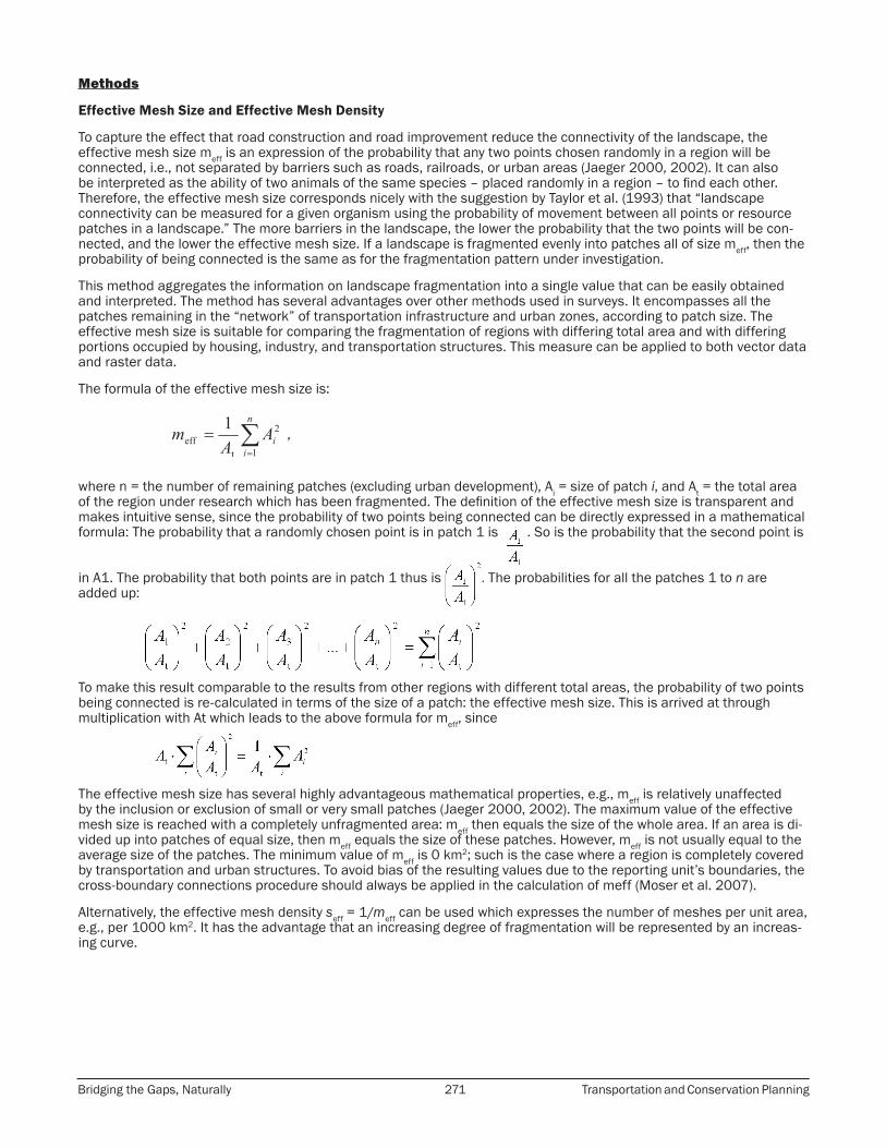
The formula of the effective mesh size is:
,
where n = the number of remaining patches (excluding urban development), Ai = size of patch i, and At = the total area of the region under research which has been fragmented. The definition of the effective mesh size is transparent and makes intuitive sense, since the probability of two points being connected can be directly expressed in a mathematical formula: The probability that a randomly chosen point is in patch 1 is . So is the probability that the second point is
in A1. The probability that both points are in patch 1 thus is . The probabilities for all the patches 1 to n are added up:
To make this result comparable to the results from other regions with different total areas, the probability of two points being connected is re-calculated in terms of the size of a patch: the effective mesh size. This is arrived at through multiplication with At which leads to the above formula for meff, since
The effective mesh size has several highly advantageous mathematical properties, e.g., meff is relatively unaffected by the inclusion or exclusion of small or very small patches (Jaeger 2000, 2002). The maximum value of the effective mesh size is reached with a completely unfragmented area: meff then equals the size of the whole area. If an area is di-vided up into patches of equal size, then meff equals the size of these patches. However, meff is not usually equal to the average size of the patches. The minimum value of meff is 0 km2; such is the case where a region is completely covered by transportation and urban structures. To avoid bias of the resulting values due to the reporting unit’s boundaries, the cross-boundary connections procedure should always be applied in the calculation of meff (Moser et al. 2007).
Alternatively, the effective mesh density seff = 1/meff can be used which expresses the number of meshes per unit area, e.g., per 1000 km2. It has the advantage that an increasing degree of fragmentation will be represented by an increas-ing curve.

Chapter 6 272 ICOET 2007 Proceedings
The New Method: Topology-sensitive Effective Mesh Size and Mesh Density
The method can be refined in such a way that it includes the varying barrier strengths of roads and railways. This is achieved at by including additional terms in the formula of the effective mesh size. They have the form
,
where Ai and Aj are adjacent patches and B is the strength of the barrier between them, 0 < B < 1 (Jaeger 2002, chapter 6.5; Fig. 3A). When the strength of the barrier is 100% (B = 1), then this term is 0 and meff is as before. When the barrier is 0 (B = 0), then Ai and Aj are not separated from each other but just form one patch size of (Ai + Aj), cor-rectly taken into account in meff because
.
In addition, the animals may be able to cross a suite of barriers in sequence, and the barriers can have differing barrier strengths Bi (i = 1, …, n; n = total number of barriers crossed). In this case, the additional terms have the form
. This situation is illustrated in fig. 4.
The addition of crossing structures can be taken into account by terms the form of
,
where D is the perforation of the road as determined by the number of crossing structures and N is the acceptance (likelihood of use) of the crossing structure by the species of interest (fig. 3B).
Figure 3. Illustration of the barrier strength B of a road and potential crossings of the road by animals that accept crossing structures. A. The animals can cross from A1 to A2 with a likelihood of (1-B). B. The animals can cross
the road using a crossing structure with a likelihood of D·N where D is the perforation of the road barrier by crossing structures and N is the willingness of the species to use crossing structures.

Bridging the Gaps, Naturally 273 Transportation and Conservation Planning
Figure 4. Example of a landscape where the animals have to cross two roads to move from patch 1 to patch 3. A1 = 10 km2, A2 = 20 km2, A3 = 30 km2, At = 60 km2.
In the refined version of the effective mesh size, the relative position of the patches matters (see example below, fig. 7). In mathematical language, the study of the relative positioning of objects is called “topology”. Therefore, the refined version of meff is called “topology-sensitive effective mesh size”.
The formula of the topology-sensitive effective mesh size can be written in matrix form:
.
For example, for the configuration of three patches as shown in Fig. 7B, the matrix and the vector would look like this (while assuming for the sake of simplicity that the likelihood of successful crossing is the same from either side of the road and is a function of traffic volume Vij, i.e.,
,
whereas in the configuration shown in Fig. 7A, looks like this:
.
Examples of Application of the New Method
I applied the topology-sensitive effective mesh size to several road network configurations using data on the likelihood of successful crossings as functions of traffic volume for amphibians (Hels and Buchwald 2001) and moose (Seiler and Helldin 2005) (fig. 5). Landscape connectivity can be reduced for differing reasons. For amphibians, the reason for the decreasing success ratio is traffic mortality. For moose, the reason for the decrease in success ratio is a combination of traffic mortality and traffic avoidance. At traffic volumes > 20,000 veh. per day, moose almost entirely avoid the road and consequently, very few individuals are killed, whereas amphibians try to cross the road at any traffic volume and consequently, a high percentage of them are killed.

Chapter 6 274 ICOET 2007 Proceedings
Figure 5. Likelihood of successful road crossings (Q) as a function of traffic volume; based on data from Seiler and Helldin (2005) for moose and from Hels and Buchwald (2001) for the Grass Frog Rana temporaria.
Using these data, the topology-sensitive effective mesh size for the road configuration shown in fig. 4 becomes a function of the two traffic volumes V12 and V23. The resulting values of meff are between 60 km2 when there is no traffic on the roads, and 23.33 km2 when both roads are complete barriers (fig. 6).
How does the configuration of transportation networks affect landscape connectivity, and what configurations are less detrimental to landscape connectivity than others based on the calculated species-specific degrees of connectivity?
Figure 6. Values of the topology-sensitive version of the effective mesh size as a function of the traffic volumes on the road between patch 1 and 2 (V12) and the road between patch 2 and 3 (V23) in Fig. 4 based on the barrier strength of roads for moose (from Fig. 5). The line indicates the values of meff in the case that V12 = V23. (Traffic
volumes in veh. per day.)
I used seven road configurations to evaluate the effect of road network configuration on landscape connectivity (fig. 7), and seven configurations of crossing structures to study the effect of crossing structure location on landscape con-nectivity (fig. 8). In particular, I was interested in the effects of road bundling and of putting all traffic on one road rather than on several roads (as discussed in Jaeger et al. 2006c). I also asked if a configuration where a patch has only two neighbouring patches has a lower connectivity than one where most patches have three or more neighbouring patches, i.e., a crossed vs. parallel pattern (fig. 7, as in Jaeger et al. 2006c).

Bridging the Gaps, Naturally 275 Transportation and Conservation Planning
Figure 7. Comparison of road network configurations (parallel configuration vs. Y-configuration, bundling, and combined traffic on one road; gridded pattern vs. parallel configuration). The roads are indicated by black lines.
(A-B) Comparing configurations where A1 and A3 are separated by two roads with a configuration where all patches are direct neighbors of each other. (E-F) Comparing configurations with the same number of roads (L =
4), and smaller number of patches; (E-G) comparing configurations with the same number of patches (n = 9), and increased number of roads (extended after Jaeger et al. 2006c).
The effect of crossing structures on meff depends on how strongly adding crossing structures increases the value of D in the formula. Future research is needed to determine these values from empirical data. For the calculations, I used the following assumptions: N = 0.95 (i.e., acceptance of crossing structures by the animals is 95%), D1 = 0.4 (perfora-tion of a road by the first crossing structure), D2 = 0.6 (perforation of a road by two crossing structures), D3 = 0.75 (perforation of a road by three crossing structures). The more crossing structures are put along the road, the higher the value of D, approaching 1 for high numbers of crossing structures: When the entire road is covered by overpasses, the situation would be equivalent to the road being located in a tunnel, and D would be 1.
Figure 8. Comparison of the positioning of crossing structures (see text). The arrows indicate the locations of the crossing structures.
Chapter 6 276 ICOET 2007 Proceedings
Results
Road Network Configuration
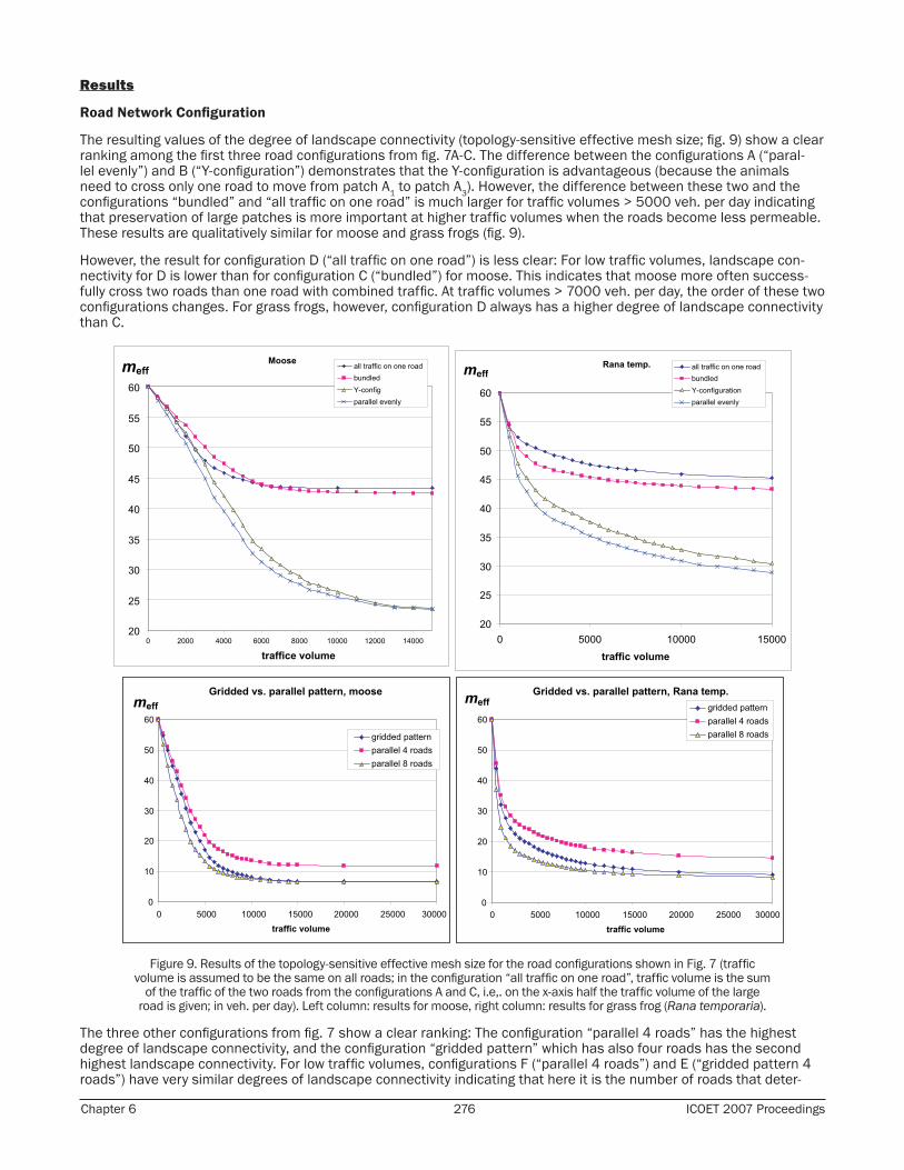
The resulting values of the degree of landscape connectivity (topology-sensitive effective mesh size; fig. 9) show a clear ranking among the first three road configurations from fig. 7A-C. The difference between the configurations A (“paral-lel evenly”) and B (“Y-configuration”) demonstrates that the Y-configuration is advantageous (because the animals need to cross only one road to move from patch A1 to patch A3). However, the difference between these two and the configurations “bundled” and “all traffic on one road” is much larger for traffic volumes > 5000 veh. per day indicating that preservation of large patches is more important at higher traffic volumes when the roads become less permeable. These results are qualitatively similar for moose and grass frogs (fig. 9).
However, the result for configuration D (“all traffic on one road”) is less clear: For low traffic volumes, landscape con-nectivity for D is lower than for configuration C (“bundled”) for moose. This indicates that moose more often success-fully cross two roads than one road with combined traffic. At traffic volumes > 7000 veh. per day, the order of these two configurations changes. For grass frogs, however, configuration D always has a higher degree of landscape connectivity than C.
Figure 9. Results of the topology-sensitive effective mesh size for the road configurations shown in Fig. 7 (traffic volume is assumed to be the same on all roads; in the configuration “all traffic on one road”, traffic volume is the sum
of the traffic of the two roads from the configurations A and C, i.e,. on the x-axis half the traffic volume of the large road is given; in veh. per day). Left column: results for moose, right column: results for grass frog (Rana temporaria).
The three other configurations from fig. 7 show a clear ranking: The configuration “parallel 4 roads” has the highest degree of landscape connectivity, and the configuration “gridded pattern” which has also four roads has the second highest landscape connectivity. For low traffic volumes, configurations F (“parallel 4 roads”) and E (“gridded pattern 4 roads”) have very similar degrees of landscape connectivity indicating that here it is the number of roads that deter-
Bridging the Gaps, Naturally 277 Transportation and Conservation Planning
mines the degree of landscape connectivity rather than the number of patches that are created. However, for higher traffic volumes, the effective mesh size depends only on the number of patches, regardless of what their configuration is. Therefore, the difference between “gridded pattern 4 roads” and “parallel 8 roads” vanishes for high traffic volumes (both creating 9 patches). Again, these results are qualitatively similar for moose and grass frogs (fig. 9).
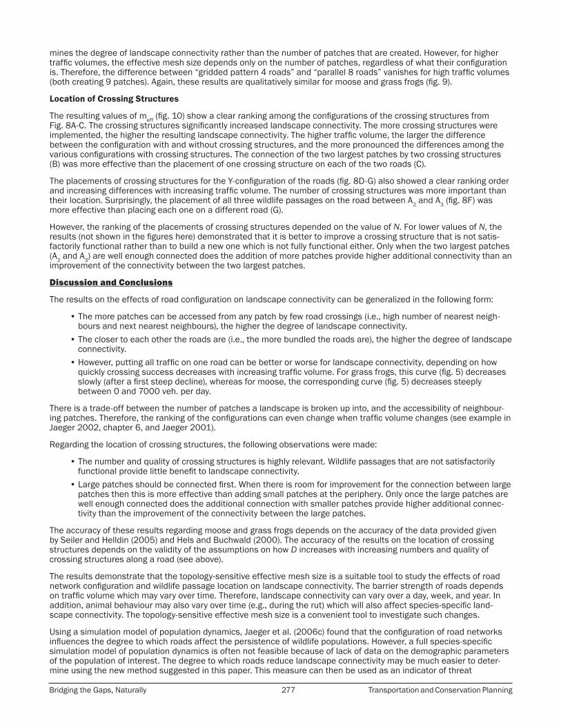
Location of Crossing Structures
The resulting values of meff (fig. 10) show a clear ranking among the configurations of the crossing structures from Fig. 8A-C. The crossing structures significantly increased landscape connectivity. The more crossing structures were implemented, the higher the resulting landscape connectivity. The higher traffic volume, the larger the difference between the configuration with and without crossing structures, and the more pronounced the differences among the various configurations with crossing structures. The connection of the two largest patches by two crossing structures (B) was more effective than the placement of one crossing structure on each of the two roads (C).
The placements of crossing structures for the Y-configuration of the roads (fig. 8D-G) also showed a clear ranking order and increasing differences with increasing traffic volume. The number of crossing structures was more important than their location. Surprisingly, the placement of all three wildlife passages on the road between A2 and A3 (fig. 8F) was more effective than placing each one on a different road (G).
However, the ranking of the placements of crossing structures depended on the value of N. For lower values of N, the results (not shown in the figures here) demonstrated that it is better to improve a crossing structure that is not satis-factorily functional rather than to build a new one which is not fully functional either. Only when the two largest patches (A2 and A3) are well enough connected does the addition of more patches provide higher additional connectivity than an improvement of the connectivity between the two largest patches.
Discussion and Conclusions
The results on the effects of road configuration on landscape connectivity can be generalized in the following form:
• The more patches can be accessed from any patch by few road crossings (i.e., high number of nearest neigh-bours and next nearest neighbours), the higher the degree of landscape connectivity.
• The closer to each other the roads are (i.e., the more bundled the roads are), the higher the degree of landscape connectivity.
• However, putting all traffic on one road can be better or worse for landscape connectivity, depending on how quickly crossing success decreases with increasing traffic volume. For grass frogs, this curve (fig. 5) decreases slowly (after a first steep decline), whereas for moose, the corresponding curve (fig. 5) decreases steeply between 0 and 7000 veh. per day.
There is a trade-off between the number of patches a landscape is broken up into, and the accessibility of neighbour-ing patches. Therefore, the ranking of the configurations can even change when traffic volume changes (see example in Jaeger 2002, chapter 6, and Jaeger 2001).
Regarding the location of crossing structures, the following observations were made:
• The number and quality of crossing structures is highly relevant. Wildlife passages that are not satisfactorily functional provide little benefit to landscape connectivity.
• Large patches should be connected first. When there is room for improvement for the connection between large patches then this is more effective than adding small patches at the periphery. Only once the large patches are well enough connected does the additional connection with smaller patches provide higher additional connec-tivity than the improvement of the connectivity between the large patches.
The accuracy of these results regarding moose and grass frogs depends on the accuracy of the data provided given by Seiler and Helldin (2005) and Hels and Buchwald (2000). The accuracy of the results on the location of crossing structures depends on the validity of the assumptions on how D increases with increasing numbers and quality of crossing structures along a road (see above).
The results demonstrate that the topology-sensitive effective mesh size is a suitable tool to study the effects of road network configuration and wildlife passage location on landscape connectivity. The barrier strength of roads depends on traffic volume which may vary over time. Therefore, landscape connectivity can vary over a day, week, and year. In addition, animal behaviour may also vary over time (e.g., during the rut) which will also affect species-specific land-scape connectivity. The topology-sensitive effective mesh size is a convenient tool to investigate such changes.
Using a simulation model of population dynamics, Jaeger et al. (2006c) found that the configuration of road networks influences the degree to which roads affect the persistence of wildlife populations. However, a full species-specific simulation model of population dynamics is often not feasible because of lack of data on the demographic parameters of the population of interest. The degree to which roads reduce landscape connectivity may be much easier to deter-mine using the new method suggested in this paper. This measure can then be used as an indicator of threat
Chapter 6 278 ICOET 2007 Proceedings
Figure 10. Results of the effective mesh size for the placement of crossing structures as shown in Figure 5.
to the viability of populations due to landscape fragmentation, and as a proxy for assessing and comparing different locations of crossing structures. The more species-specific data are available, the more liable and useful the measure. The results from this paper correspond generally well with the results on the probability of population persistence from the population model. For example, the outcomes of the model demonstrated that the bundling of roads was almost always beneficial (and never detrimental). However, the effect of putting all traffic on one road also was often beneficial (and never detrimental) which was not in agreement with the degree of landscape connectivity for moose for low traffic volumes (see above). This raises interesting questions for future research.
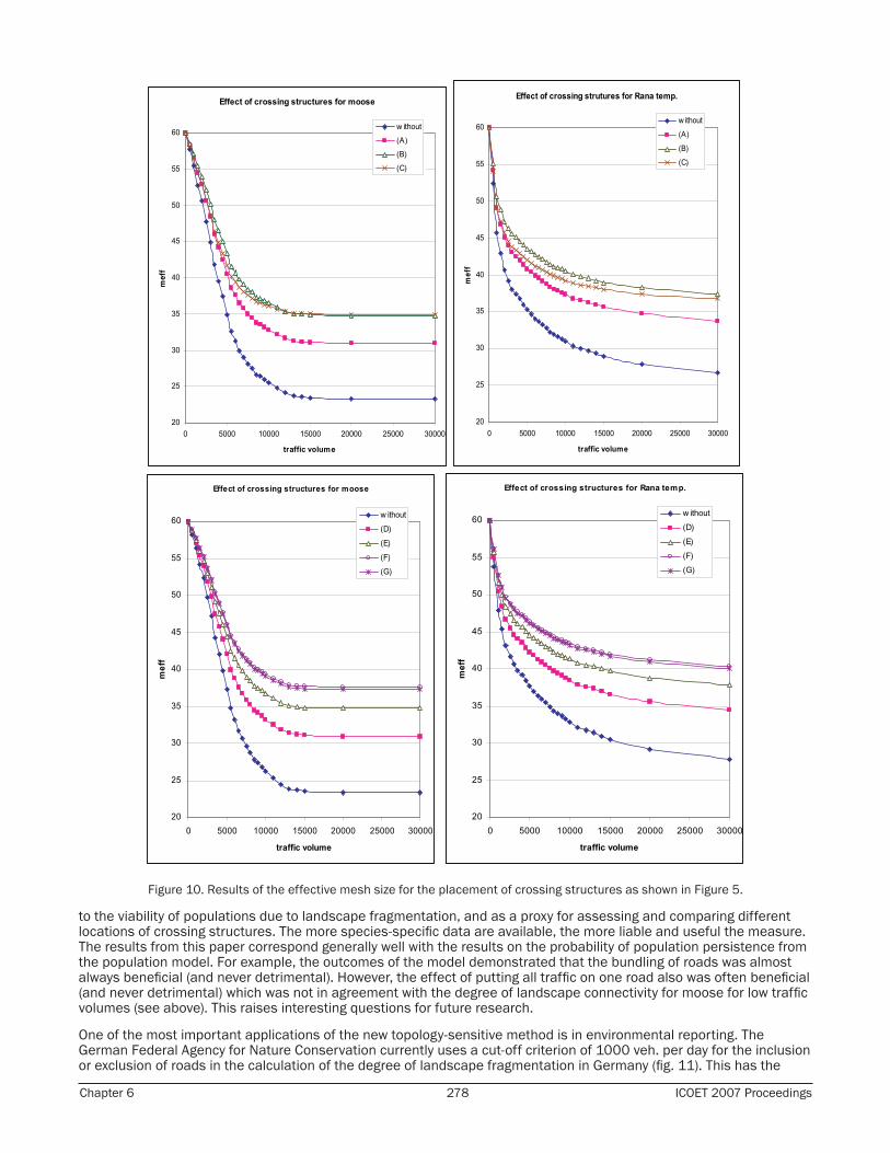
One of the most important applications of the new topology-sensitive method is in environmental reporting. The German Federal Agency for Nature Conservation currently uses a cut-off criterion of 1000 veh. per day for the inclusion or exclusion of roads in the calculation of the degree of landscape fragmentation in Germany (fig. 11). This has the
Bridging the Gaps, Naturally 279 Transportation and Conservation Planning
major disadvantage that many roads are not “visible” any more when they branch and the two branches both have less than 1000 veh. per day. I suggest solving this problem by using barrier strength as a function of traffic volume as shown in Fig. 11.
As landscape connectivity is species-specific (because every species has differing crossing success ratios as a func-tion of traffic volume), the resulting time series on the degree of landscape fragmentation will differ. Inclusion of time series for all species in environmental reporting (Fig. 1 and 2) is not practical. Therefore, a small number of representa-tive species should be chosen. However, for investigating the effects of reduced landscape connectivity on animal populations, the new species-specific method is an appropriate tool and should allow for more detailed investigations and hopefully, more accurate results than former methods. To apply this new method to real landscapes, develop it to its full potential, and explore further options, I am currently combining it with graph-theoretical methods (e.g., Urban and Keitt 2001), least-cost analysis (e.g., Adriaensen et al. 2003), and circuit theory (McRae 2006).
Figure 11. Suggestion of how the cut-off criterion of the German Federal Agency for Nature Conservation for the inclusion or exclusion of roads in the determination of landscape fragmentation in Germany (BfN 1999, Gawlak
2001) (shown in A) should be replaced by a more consistent criterion (B) that can be implemented in the topology-sensitive effective mesh size. Instead of just a linear decreasing line, the curve could also have a different shape.
This new method is likely to be applied widely in the future as the current lack of quantitative empirical data on the values of Bi as species-specific functions of road type and traffic volume is currently addressed more and more systematically by wildlife biologists.
Biographical Sketch: Jochen A. G. Jaeger is a research associate in the Department of Environmental Sciences at the Swiss Federal Institute of Technology Zurich (ETH Zurich), Switzerland with Prof. Dr. Jaboury Ghazoul (Group for Ecosystem Management). He studied physics at the Christian-Albrecht University in Kiel, Germany and at the ETH Zurich, and received his Ph.D. from the Department of Environmental Sciences at the ETH Zurich. He held a position at the Center of Technology Assessment in Baden-Württemberg in Stuttgart, Germany, and lectured at the University of Stuttgart, Germany. In 2001, he won a two-year research grant from the German Academy of Natural Scientists Leopoldina and went to Carleton University in Ottawa, Ontario, Canada as a postdoctoral fellow and work with Prof. Dr. Lenore Fahrig in her Landscape Ecology Laboratory (Department of Biology). In 2003, he returned to the ETH in Zurich, funded by a two-year research fellowship from the German Research Foundation (DFG) to work with Prof. Dr. K.C. Ewald. During the time April-June 2007 he was a visiting scholar at the Road Ecology Center at the University of California at Davis, U.S.A. His publications include one book titled Landschaftszerschneidung (2002). His research interests are in landscape ecology, quantification and assessment of landscape change, assessment of the suitability of landscape metrics, environmental indicators, road ecology, modelling, environmental impact assessment, urban sprawl, and novel concepts of problem-oriented transdisciplinary research.
References
Adriaensen, F., J. P. Chardon, G. De Blust, E. Swinnen, S. Villalba, H. Gulinck and E. Matthysen. 2003. The application of ‘least-cost’ model-ling as a functional landscape model. Landscape and Urban Planning 64, 233-247.
Bertiller, R., C. Schwick and J. Jaeger. (2007). Landschaftszerschneidung Schweiz: Zerschneidungsanalyse 1885-2002 und Folgerungen für die Verkehrs- und Raumplanung. ASTRA-Bericht. Swiss Federal Roads Authority (Bundesamt für Strassen), editor, Berne, Switzerland, in press. 229 pp.
BfN (Bundesamt für Naturschutz), editor. 1999. Daten zur Natur 1999. Landwirtschaftsverlag, Bonn, Germany.Esswein, H., J. Jaeger, H.-G. Schwarz-von Raumer, and M. Müller. 2002. Landschaftszerschneidung in Baden-Württemberg.
Zerschneidungsanalyse zur aktuellen Situation und zur Entwicklung der letzten 70 Jahre mit der effektiven Maschenweite. Arbeitsbericht der Akademie für Technikfolgenabschätzung Nr. 214 (Selbstverlag), Stuttgart. ISBN 3-934692-69-5 / ISSN 0945-9553. 124 pp.
Chapter 6 280 ICOET 2007 Proceedings
Fischer, J., and D.B. Lindenmayer. 2007. Landscape modification and habitat fragmentation: a synthesis. Global Ecology and Biogeography 16: 265-280.
Forman, R. T. T., D. Sperling, J. A. Bissonette, A. P. Clevenger, C. D. Cutshall, V. H. Dale, L. Fahrig, R. France, C. R. Goldman, K. Heanue, J. A. Jones, F. J. Swanson, T. Turrentine, and T. C. Winter. 2003. Road Ecology. Science and Solutions. Island Press, Washington, DC.
Gawlak, C. 2001. Unzerschnittene verkehrsarme Räume in Deutschland 1999. Natur und Landschaft 76:481-484.Girvetz, E.H., J.A.G. Jaeger, J.H. Thorne, and A.M. Berry. 2008. Integrating habitat fragmentation analysis into transportation planning using
the effective mesh size landscape metric. In: Irwin, C.L., Garrett, P., McDermott, K.P. (eds.): Proceedings of the 2007 International Conference on Ecology and Transportation (ICOET). Center for Transportation and the Environment, North Carolina State University, Raleigh, NC, in this volume.
Gustafson, E. 1998. Quantifying landscape spatial pattern: What is the state of the art? Ecosystems 1, 143-156.Hargis, C.D., J.A. Bissonette, and J.L. David. 1998. The behavior of landscape metrics commonly used in the study of habitat fragmenta-
tion. Landscape Ecology 13: 167-186.Heinz Center (The John Heinz III Center for Science, Economics and the Environment). 2002. The State of the Nation’s Ecosystems:
Measuring the Lands, Waters, and Living Resources of the United States. Cambridge University Press, New York (available online at http://www.heinzctr.org/ecosystems/report.html).
Hels, T., and E. Buchwald. 2001. The effect of road kills on amphibian populations. Biological Conservation 99: 331-340.Jaeger, J.A.G. 2000. Landscape division, splitting index, and effective mesh size: New measures of landscape fragmentation. Landscape
Ecology 15(2): 115–130.Jaeger, J. 2001. Ansätze zur Quantifizierung der Landschaftszerschneidung und die Einbeziehung räumlich-funktionaler Zusammenhänge.
– In: Jopp, F., and G. Weigmann (Eds.): Rolle und Bedeutung von Modellen für den ökologischen Erkenntnisprozeß. Peter Lang, Frankfurt/Main, pp. 115-126.
Jaeger, J. 2002. Landschaftszerschneidung. Eugen Ulmer, Stuttgart (Germany). 447 pp.Jaeger, J., H. Esswein, and H.-G. Schwarz-von Raumer. 2006a. Landschaftszerschneidung in Baden-Württemberg: Fortschreibung zeigt
weitere starke Zunahme der Zerschneidung an. - In: Zerschnitten, zerstückelt – oder vernetzt? Landschaftszerschneidung contra Lebensraumverbund. Bad Boller Skripte 3/2006, ISSN 1860-0859 (Tagungsband zum Forum Naturschutz vom 22.10.2005 im Haus der Wirtschaft in Stuttgart), pp. 17-48.
Jaeger, J., R. Bertiller, and C. Schwick. 2006b. Umweltindikator Landschaftszerschneidung in der Schweiz: Zeitreihen zum Monitoring der Nachhaltigen Entwicklung (MONET). Naturschutz und Landschaftsplanung 38(10-11), 347-350.
Jaeger, J.A.G., L. Fahrig, and K.C. Ewald. 2006c. Does the configuration of road networks influence the degree to which roads affect wildlife populations? – In: IRWIN, C.L., GARRETT, P., MCDERMOTT, K.P. (eds.): Proceedings of the 2005 International Conference on Ecology and Transportation (ICOET). Center for Transportation and the Environment, North Carolina State University, Raleigh, NC, pages 151-163.
Jaeger, J. A. G., H. G. Schwarz-von Raumer, H. Esswein, M. Müller, and M. Schmidt-Lüttmann. 2007. Time series of landscape fragmenta-tion caused by transportation infrastructure and urban development: a case study from Baden-Württemberg (Germany). Ecology and Society, in press.
Jaeger, J. A. G., R. Bertiller, C. Schwick, K. Müller, C. Steinmeier, K. C. Ewald, and J. Ghazoul. (in press). Implementing landscape fragmenta-tion as an indicator in the Swiss Monitoring System of Sustainable Development (MONET). Journal of Environmental Management.
Kupfer, J.A. 2006. National assessments of forest fragmentation in the US. Global Environmental Change 16: 73-82.Landesanstalt für Umweltschutz Baden-Württemberg & Statistisches Landesamt Baden-Württemberg. 2003. Umweltdaten 2003 Baden-
Württemberg. Kurzfassung und Langfassung. Karlsruhe and Stuttgart. ISSN 1612-801X. Greiserdruck, Rastatt, Germany.McRae, B. 2006. Isolation by resistance. Evolution 60(8): 1551-1561.Moser, B., J.A.G. Jaeger, U. Tappeiner, E. Tasser, and B. Eiselt. 2007. Modification of the effective mesh size for measuring landscape
fragmentation to solve the boundary problem. Landscape Ecology 22, 447-459. doi: 10.1007/s10980-006-9023-0.Riitters, K., J. Wickham, R. O’Neill, B. Jones, and E. Smith. 2000. Global-scale patterns of forest fragmentation. Conservation Ecology 4(2):
3. [online] URL: http://www.consecol.org/vol4/iss2/art3/Rutledge, D.T., and C.J. Miller. 2006. The use of landscape indices in studies of the effects of habitat loss and fragmentation. Naturschutz
und Landschaftsplanung 38(10-11): 300-307.Schupp, D. 2005. Umweltindikator Landschaftszerschneidung – Ein zentrales Element zur Verknüpfung von Wissenschaft und Politik. GAIA
14 (2): 101-106.Seiler, A., and J.-O. Helldin. 2005. Mortality in wildlife due to transportation. - In: Davenport J. & Davenport J. L. (eds.). The ecology of
transportation: Managing mobility for the environment. Springer, Dorecht, The Netherlands, pp. 165-190.Swiss Federal Statistical Office (SFSO) and Swiss Federal Office for the Environment (FOEN). 2006. Swiss Environmental Statistics – A
Brief Guide 2006. Berne, Switzerland. Taylor, P.D., L. Fahrig, K. Henein, and G. Merriam. 1993. Connectivity is a vital element of landscape structure. Oikos 68: 571-573.Tischendorf, L., and L. Fahrig. 2000. On the usage and measurement of landscape connectivity. Oikos 90: 7-19.Underhill, J. E., and P. G. Angold. 2000. Effects of roads on wildlife in an intensively modified landscape. Environmental Reviews 8: 21-39.Urban, D., and T. Keitt. 2001. Landscape connectivity: a graph-theoretic perspective. Ecology 82(5): 1205-1218.
Bridging the Gaps, Naturally 281 Transportation and Conservation Planning
intEgrating habitat fragmEntation anaLysis into transportation pLanning using thE EffEctivE mEsh sizE LandscapE mEtric
Evan H. Girvetz (530-752-0225, [email protected]) and Alison M. Berry, Road Ecology Center, University of California at Davis, 107 Huerta Place, Davis, CA 95616 USA
James H. Thorne, Information Center for the Environment, University of California at Davis, One Shields Avenue, Davis, CA 95616 USA
Jochen A.G. Jaeger, Swiss Federal Institute of Technology ETH Zurich, Department of Environmental Sciences, Institute for Terrestrial Ecosystems, Group of Ecosystem Management, Universitätstr. 22, CHN F 73.2, CH-8092 Zurich, Switzerland
Abstract: Habitat fragmentation due to transport infrastructure and other human development poses a threat to many wildlife species. This threat may differ depending on the species and types of fragmenting elements. There is a need to quantify the level of habitat fragmentation and the impact of habitat fragmentation on different wildlife species for use in transportation planning. Such measures would be useful in assessing the cumulative impacts of multiple road projects on wildlife connectivity and habitat suitability, for long-range wildlife impact mitigation planning for transporta-tion projects, and as an indicator for the environmental monitoring of habitat fragmentation due to roads. Effective mesh size (meff) is a biologically relevant landscape metric that quantifies the degree of landscape fragmenta-tion. The definition of the effective mesh size is based on the probability that two randomly chosen points in a region will be located in the same non-fragmented area of land. We calculated effective mesh size to assess the level of land-scape fragmentation in the State of California, USA, based on four fragmentation geometries defined by a combination of highways, minor roads, urbanized areas, agricultural areas, and natural fragmenting features (e.g., rivers, lakes, and alpine areas). The effective mesh size for these four fragmenting geometries were calculated for the entire State of California using eight sets of planning units: 1) transportation planning districts, 2) municipal county boundaries, and 3) six levels of watersheds. To demonstrate the methodology, we examined how effective mesh size may impact two species important to transportation planning in California: mule deer (Odocoileus hemionus) and mountain lion (Puma concolor). The calculated effective mesh sizes were compared with the home range sizes and daily movement distances of the selected focal species to determine the potential impacts of habitat fragmentation and to identify areas where transportation projects will potentially impact these focal species.Based on the results of this analysis, we suggest that integrating an effective mesh size-based tool into transportation planning frameworks would be valuable to improve identification of potential landscape level impacts early in the plan-ning process. The calculation of effective mesh size will give transportation planners a way to analyze the cumulative impacts of roads in districts, counties, and watersheds and can be used as an environmental indicator for ecological assessment of transportation system impacts.
Introduction
Overview
The impact of landscape fragmentation due to roads, urbanization, and other land uses has been identified as a major impact to wildlife and species of concern (Forman 1995; Forman et al. 2003). Impacts to wildlife include direct mortal-ity (Mazerolle 2004; Riley et al. 2003), behavioral changes (Mazerolle et al. 2005), reduced dispersal abilities (Forman & Alexander 1998), and impediment to gene flow (Riley et al. 2006). Transportation planners have recognized the need to assess landscape fragmentation as a part of the environmental planning process. Recent changes in transportation planning regulations (Federal Transportation HR 3, SAFETEA-LU, Congress 2005) mandate that transportation planning incorporate considerations of wildlife conservation. This is due in part to the economies of scale that may be available through integrated regional planning, and to recognition that roads have cumulative impacts on the ecosystems they pass through that may not be correctly identified if planning and environmental assessment are done on a case by case basis.
There is a need for tools and analyses to assess habitat fragmentation at multiple spatial scales that can be easily used by transportation and land use planners. This is particularly the case in the State of California, a globally ranked hotspot of biodiversity, which is currently undergoing a rapid increase in human population density, urban growth and development of transportation infrastructure. This report presents the first results from applying a custom tool for calculating the effective mesh size to assesses the level of habitat fragmentation due to highways, local roads, rail, urban areas, agricultural areas, and natural fragmenting elements (i.e., rivers, lakes, and high alpine areas) in the State of California. By spatially overlaying different combinations of these fragmenting features, four “fragmentation geom-etries” were analyzed relative to boundaries relevant to planners: twelve Caltrans districts, 58 counties, and six nested spatial scales of watershed ranging from 9 to 6998 watersheds in the State.
We then examined how landscape fragmentation might impact two focal species that are important in California transportation planning: mule deer (Odocoileus hemionus) and mountain lion (Puma concolor). Deer are of concern in many states because they are often hit by traffic, making them a high-profile species for transportation planners. Mountain lion are of interest due to their large area requirements, which make them sensitive to ongoing landscape fragmentation. Mountain lion have been used as a focal species for modeling in the identification of important wilder-ness corridors in California (Beier et al. 2006; Hunter et al. 2003; Shilling et al. 2002; Thorne et al. 2006), and efforts are underway to preserve or restore some of these modeled wildlife corridors in Southern California (Beier et al. 2006).

Chapter 6 282 ICOET 2007 Proceedings
Landscape Fragmentation Metrics: Effective Mesh Size
The scientific literature suggests a variety of landscape metrics for quantifying landscape fragmentation (e.g., Gustafson 1998; Haines-Young & Chopping 1996; Jaeger 2000; Riitters et al. 2005; Rutledge & Miller 2006). However, few methods have been developed for practical and intuitive assessment of landscape fragmentation by transporta-tion and other land use planners, since most of these metrics can only be applied to specific aspects of landscape fragmentation. Li and Wu (2004) point out that the behaviors of many landscape metrics are not understood in sufficient detail, which may compromise their suitability for planning purposes. Jaeger (2002) compared 22 metrics with regard to their reliability for quantifying landscape fragmentation, and systematically investigated the eight most promising measures based on eight suitability criteria (intuitive interpretation, mathematical simplicity, modest data requirements, low sensitivity to small patches, monotonous reaction to different fragmentation phases (Forman 1995), detection of structural differences, mathematical homogeneity, and additivity). According to these criteria, only the effective mesh size (meff)was unreservedly appropriate as a fragmentation measure, while the suitability of the other measures was more or less severely limited (Jaeger 2000).
Effective mesh size is an expression of the probability that any two randomly chosen points in a region may be con-nected, i.e., not separated by barriers such as transportation infrastructure or urban areas (figure 1, Jaeger 2000). This measure has been widely applied in Europe and in several other countries. This includes many states in Germany such as Baden-Wuerttemberg (Esswein et al. 2004; Jaeger 2001; Jaeger et al. in press-b) where the resulting time series (1930-2004) have been used for environmental reporting (Ministerium für Umwelt und Verkehr Baden-Württemberg & Landesanstalt für Umweltschutz Baden-Württemberg 2003), Saxony (Walz 2005), Thuringia (Geologie 2004), Hesse (Roedenbeck et al. 2005), and Bavaria (Esswein et al. 2004). The effective mesh size metric was recently selected as one of 24 national core indicators for environmental reporting in the context of sustainability in Germany (Schupp 2005), and the corresponding calculations for the remaining states of Germany are under way. The German Federal Environment Agency has suggested tentative limits to the increase of landscape fragmentation in Germany based on the effective mesh size to start a discussion about environmental goals for the future degree of landscape fragmenta-tion (Penn-Bressel 2005; UBA 2003). The effective mesh size has also been applied in South Tyrol (Italy) for environ-mental reporting on the level of municipalities (Moser et al. 2007), in Lombardy (Italy) (Padoa-Schioppa et al. 2006), and in Switzerland where it is used as an environmental indicator for monitoring sustainable development (Bertiller et al. 2007; Jaeger et al. 2006; Jaeger et al. in press-a). The European Environment Agency applied the effective mesh size to all European countries, preliminary results are presented in Bertiller et al. (2007), and is planning a more detailed investigation. The method has also been applied outside of Europe (Baldi et al. 2006). Environment Canada uses this measure for environmental reporting in their national report titled “Environmental Signals” (K. Lindsay, pers. comm.).
To analyze landscape fragmentation, it is first necessary to identify which landscape elements are relevant to frag-mentation. The specific choice of fragmenting elements defines a so-called “fragmentation geometry”. We selected landscape elements shown to impede the movement of animal species, act as sources of emissions, or represent matrix, i.e., non-habitat (Forman et al. 2003; Trombulak & Frissell 2000). These included motorways, roads, railroads, areas of urban development, industrial zones, and agricultural fields. Large rivers and other water bodies also act as barriers to animal movement (Gerlach & Musolf 2000). Therefore, we included rivers and lakes in some fragmentation geometries.
The question of what is an appropriate way of accounting for mountain barriers (which include steep cliffs, rubble slopes, and glaciers) in the effective mesh size was first addressed in Switzerland by Jaeger et al. (in press-a). Holzgang et al. (2001), who in their study of wildlife corridors in Switzerland, considered large areas of rock impassable. This is particularly relevant for species that move along valleys where human activities are focussed. All areas above 2100 m were selected as high mountains (the treeline is between 1600 m and 2300 m in the Swiss Alps, Veit 2002), and this contour applied was applied as a fragmenting element in fragmentation geometries 2 and 3. Here, we present four different fragmentation geometries to allow for various interpretations of landscape fragmentation from different perspectives, and to illustrate the differences and implications of the various assumptions. The four fragmentation geometries were developed by combining highways, local roads, urbanized areas, agricultural lands, and natural fragmenting features (table 1).
The effective mesh size of these four fragmentation geometries is measured relative to different planning units, which may be at different spatial scales. The planning unit boundaries could be political boundaries or they could be based on ecological criteria such as ecoregions, dominant land cover, and watersheds. Planning units occur at a range of spatial scales, and are often hierarchically organized. For example, California Department of Transportation (Caltrans) districts are formulated along county boundaries, and contain from one to several counties. Thus, counties are nested within Caltrans districts, which are nested within the State of California. Similarly, watersheds are nested hierarchical entities with major watersheds containing multiple sub watersheds, which themselves nest watersheds at finer spatial scales, and so on. In California, six nested scales of watersheds have been identified (figure 2).

Bridging the Gaps, Naturally 283 Transportation and Conservation Planning
Methods
Effective Mesh Size Landscape Metric
The meff expresses the possibility that any two randomly chosen points in the region under observation may or may not be connected. The more barriers (e.g., roads, railroads, urban areas) erected in the landscape, the less chance that the two points will be connected. It can also be interpreted as the ability of two animals of the same species – placed randomly in a region – to find each other (figure 1). The encountering probability is converted into the size of an area called the effective mesh size. The more barriers in the landscape, the lower the probability that the two points will be connected, and the lower the effective mesh size. If a landscape is fragmented evenly into patches all of size meff, then the probability of being connected is the same as for the fragmentation pattern under investigation.
Figure 1. Two randomly chosen points are connected if and only if there are no barriers (e.g., roads, railroads, urban areas) between them (modified after Jaeger et al. in press-b).
One problem with this landscape metric, as pointed out by Moser et al. (2007), is that it assumes the unfragmented patches of land stop at the boundary of the planning unit (i.e. county, Caltrans district, or watershed), when in fact, the unfragmented area may extend far beyond the boundary of the planning unit. The effective mesh size described above uses the “CUT” procedure. An alternative implementation of the effective mesh size calculation to account for this is the effective mesh size based on the cross boundary connection (CBC) procedure, which accounts for the area of connected unfragmented areas that extend beyond the boundaries of a given planning unit that the effective mesh size is being calculated for.
Figure 2. Administrative and watershed boundaries used as planning units to calculate effective mesh size for the State of California. Two spatial scales of administrative boundaries are shown on the left: counties (thin grey lines) nested within Caltrans districts (dark lines). Six spatial scales of watershed used in this analysis are shown
on the right: hydrologic regions (thick black lines) and hydrologic units (thinner grey lines) zoomed-in to show hydrologic areas (medium thickness grey lines) and hydrologic sub-areas (thin grey lines), and zoomed-in finer to
show super-planning watersheds (thin grey lines) and planning watersheds (dashed lines).
Chapter 6 284 ICOET 2007 Proceedings
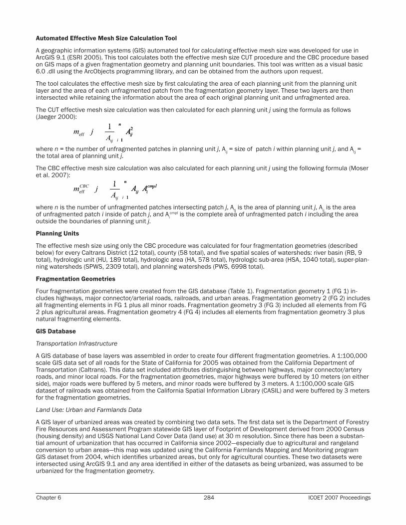
Automated Effective Mesh Size Calculation Tool
A geographic information systems (GIS) automated tool for calculating effective mesh size was developed for use in ArcGIS 9.1 (ESRI 2005). This tool calculates both the effective mesh size CUT procedure and the CBC procedure based on GIS maps of a given fragmentation geometry and planning unit boundaries. This tool was written as a visual basic 6.0 .dll using the ArcObjects programming library, and can be obtained from the authors upon request.
The tool calculates the effective mesh size by first calculating the area of each planning unit from the planning unit layer and the area of each unfragmented patch from the fragmentation geometry layer. These two layers are then intersected while retaining the information about the area of each original planning unit and unfragmented area.
The CUT effective mesh size calculation was then calculated for each planning unit j using the formula as follows (Jaeger 2000):
where n = the number of unfragmented patches in planning unit j, Aij = size of patch i within planning unit j, and Atj = the total area of planning unit j.
The CBC effective mesh size calculation was also calculated for each planning unit j using the following formula (Moser et al. 2007):
where n is the number of unfragmented patches intersecting patch j, Atj is the area of planning unit j, Aij is the area of unfragmented patch i inside of patch j, and Ai
cmpl is the complete area of unfragmented patch i including the area outside the boundaries of planning unit j.
Planning Units
The effective mesh size using only the CBC procedure was calculated for four fragmentation geometries (described below) for every Caltrans District (12 total), county (58 total), and five spatial scales of watersheds: river basin (RB, 9 total), hydrologic unit (HU, 189 total), hydrologic area (HA, 578 total), hydrologic sub-area (HSA, 1040 total), super-plan-ning watersheds (SPWS, 2309 total), and planning watersheds (PWS, 6998 total).
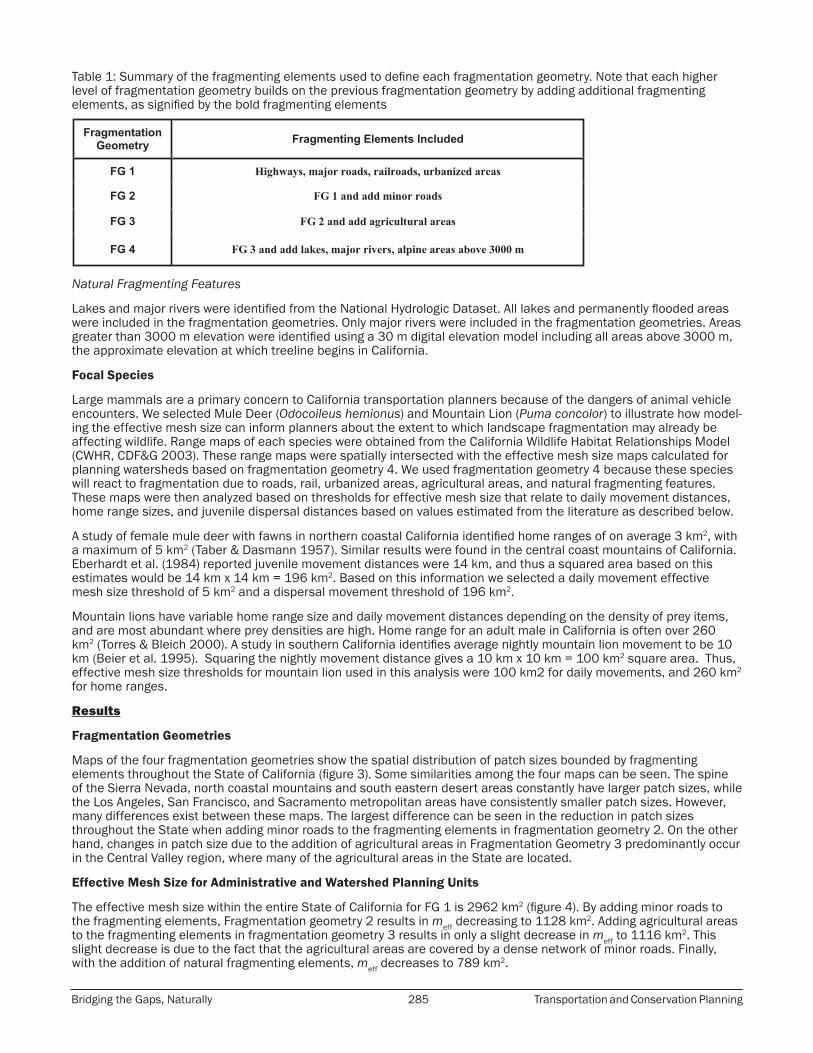
Fragmentation Geometries
Four fragmentation geometries were created from the GIS database (Table 1). Fragmentation geometry 1 (FG 1) in-cludes highways, major connector/arterial roads, railroads, and urban areas. Fragmentation geometry 2 (FG 2) includes all fragmenting elements in FG 1 plus all minor roads. Fragmentation geometry 3 (FG 3) included all elements from FG 2 plus agricultural areas. Fragmentation geometry 4 (FG 4) includes all elements from fragmentation geometry 3 plus natural fragmenting elements.
GIS Database
Transportation Infrastructure
A GIS database of base layers was assembled in order to create four different fragmentation geometries. A 1:100,000 scale GIS data set of all roads for the State of California for 2005 was obtained from the California Department of Transportation (Caltrans). This data set included attributes distinguishing between highways, major connector/artery roads, and minor local roads. For the fragmentation geometries, major highways were buffered by 10 meters (on either side), major roads were buffered by 5 meters, and minor roads were buffered by 3 meters. A 1:100,000 scale GIS dataset of railroads was obtained from the California Spatial Information Library (CASIL) and were buffered by 3 meters for the fragmentation geometries.
Land Use: Urban and Farmlands Data
A GIS layer of urbanized areas was created by combining two data sets. The first data set is the Department of Forestry Fire Resources and Assessment Program statewide GIS layer of Footprint of Development derived from 2000 Census (housing density) and USGS National Land Cover Data (land use) at 30 m resolution. Since there has been a substan-tial amount of urbanization that has occurred in California since 2002—especially due to agricultural and rangeland conversion to urban areas—this map was updated using the California Farmlands Mapping and Monitoring program GIS dataset from 2004, which identifies urbanized areas, but only for agricultural counties. These two datasets were intersected using ArcGIS 9.1 and any area identified in either of the datasets as being urbanized, was assumed to be urbanized for the fragmentation geometry.
Bridging the Gaps, Naturally 285 Transportation and Conservation Planning
Table 1: Summary of the fragmenting elements used to define each fragmentation geometry. Note that each higher level of fragmentation geometry builds on the previous fragmentation geometry by adding additional fragmenting elements, as signified by the bold fragmenting elements
Natural Fragmenting Features
Lakes and major rivers were identified from the National Hydrologic Dataset. All lakes and permanently flooded areas were included in the fragmentation geometries. Only major rivers were included in the fragmentation geometries. Areas greater than 3000 m elevation were identified using a 30 m digital elevation model including all areas above 3000 m, the approximate elevation at which treeline begins in California.
Focal Species
Large mammals are a primary concern to California transportation planners because of the dangers of animal vehicle encounters. We selected Mule Deer (Odocoileus hemionus) and Mountain Lion (Puma concolor) to illustrate how model-ing the effective mesh size can inform planners about the extent to which landscape fragmentation may already be affecting wildlife. Range maps of each species were obtained from the California Wildlife Habitat Relationships Model (CWHR, CDF&G 2003). These range maps were spatially intersected with the effective mesh size maps calculated for planning watersheds based on fragmentation geometry 4. We used fragmentation geometry 4 because these species will react to fragmentation due to roads, rail, urbanized areas, agricultural areas, and natural fragmenting features. These maps were then analyzed based on thresholds for effective mesh size that relate to daily movement distances, home range sizes, and juvenile dispersal distances based on values estimated from the literature as described below.
A study of female mule deer with fawns in northern coastal California identified home ranges of on average 3 km2, with a maximum of 5 km2 (Taber & Dasmann 1957). Similar results were found in the central coast mountains of California. Eberhardt et al. (1984) reported juvenile movement distances were 14 km, and thus a squared area based on this estimates would be 14 km x 14 km = 196 km2. Based on this information we selected a daily movement effective mesh size threshold of 5 km2 and a dispersal movement threshold of 196 km2.
Mountain lions have variable home range size and daily movement distances depending on the density of prey items, and are most abundant where prey densities are high. Home range for an adult male in California is often over 260 km2 (Torres & Bleich 2000). A study in southern California identifies average nightly mountain lion movement to be 10 km (Beier et al. 1995). Squaring the nightly movement distance gives a 10 km x 10 km = 100 km2 square area. Thus, effective mesh size thresholds for mountain lion used in this analysis were 100 km2 for daily movements, and 260 km2 for home ranges.
Results
Fragmentation Geometries
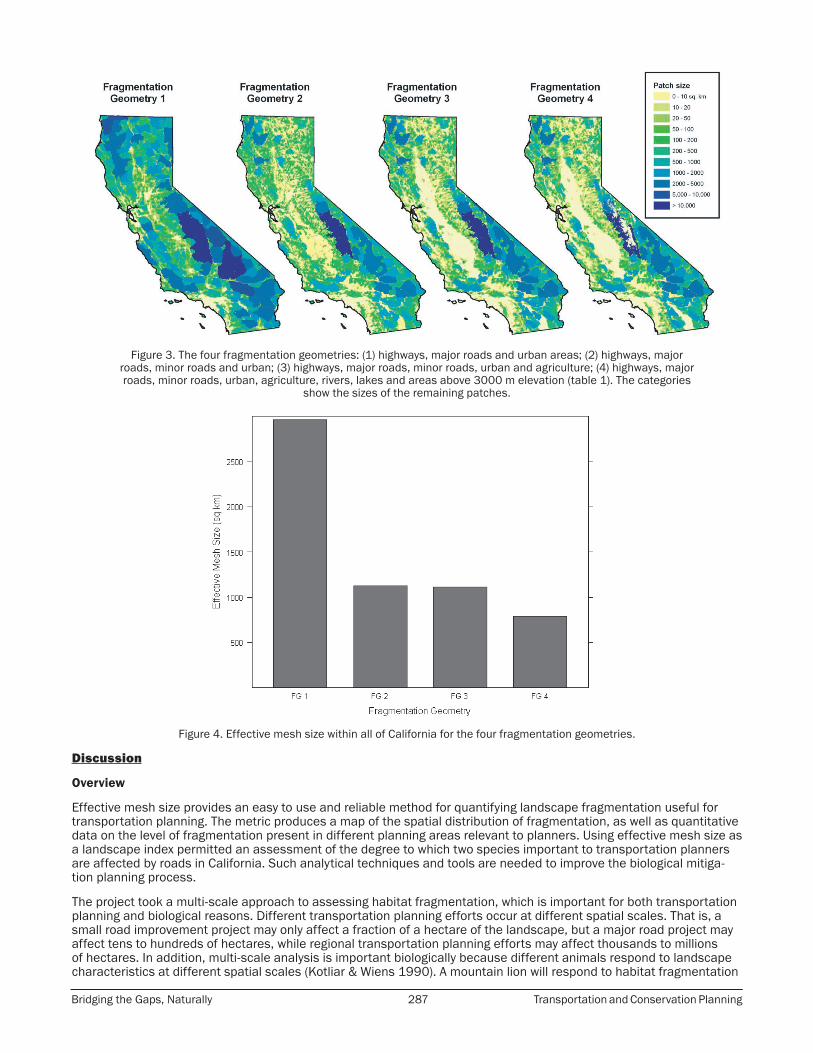
Maps of the four fragmentation geometries show the spatial distribution of patch sizes bounded by fragmenting elements throughout the State of California (figure 3). Some similarities among the four maps can be seen. The spine of the Sierra Nevada, north coastal mountains and south eastern desert areas constantly have larger patch sizes, while the Los Angeles, San Francisco, and Sacramento metropolitan areas have consistently smaller patch sizes. However, many differences exist between these maps. The largest difference can be seen in the reduction in patch sizes throughout the State when adding minor roads to the fragmenting elements in fragmentation geometry 2. On the other hand, changes in patch size due to the addition of agricultural areas in Fragmentation Geometry 3 predominantly occur in the Central Valley region, where many of the agricultural areas in the State are located.
Effective Mesh Size for Administrative and Watershed Planning Units
The effective mesh size within the entire State of California for FG 1 is 2962 km2 (figure 4). By adding minor roads to the fragmenting elements, Fragmentation geometry 2 results in meff decreasing to 1128 km2. Adding agricultural areas to the fragmenting elements in fragmentation geometry 3 results in only a slight decrease in meff to 1116 km2. This slight decrease is due to the fact that the agricultural areas are covered by a dense network of minor roads. Finally, with the addition of natural fragmenting elements, meff decreases to 789 km2.
Chapter 6 286 ICOET 2007 Proceedings
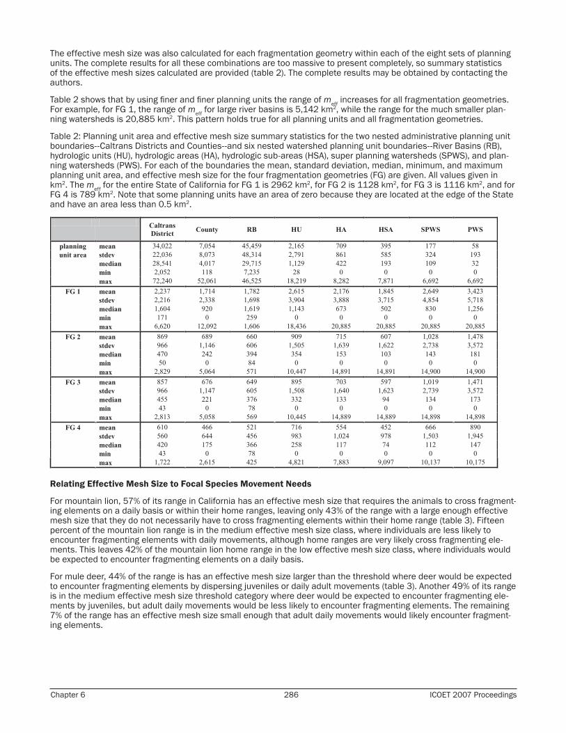
The effective mesh size was also calculated for each fragmentation geometry within each of the eight sets of planning units. The complete results for all these combinations are too massive to present completely, so summary statistics of the effective mesh sizes calculated are provided (table 2). The complete results may be obtained by contacting the authors.
Table 2 shows that by using finer and finer planning units the range of meff increases for all fragmentation geometries. For example, for FG 1, the range of meff for large river basins is 5,142 km2, while the range for the much smaller plan-ning watersheds is 20,885 km2. This pattern holds true for all planning units and all fragmentation geometries.
Table 2: Planning unit area and effective mesh size summary statistics for the two nested administrative planning unit boundaries--Caltrans Districts and Counties--and six nested watershed planning unit boundaries--River Basins (RB), hydrologic units (HU), hydrologic areas (HA), hydrologic sub-areas (HSA), super planning watersheds (SPWS), and plan-ning watersheds (PWS). For each of the boundaries the mean, standard deviation, median, minimum, and maximum planning unit area, and effective mesh size for the four fragmentation geometries (FG) are given. All values given in km2. The meff for the entire State of California for FG 1 is 2962 km2, for FG 2 is 1128 km2, for FG 3 is 1116 km2, and for FG 4 is 789 km2. Note that some planning units have an area of zero because they are located at the edge of the State and have an area less than 0.5 km2.
Relating Effective Mesh Size to Focal Species Movement Needs
For mountain lion, 57% of its range in California has an effective mesh size that requires the animals to cross fragment-ing elements on a daily basis or within their home ranges, leaving only 43% of the range with a large enough effective mesh size that they do not necessarily have to cross fragmenting elements within their home range (table 3). Fifteen percent of the mountain lion range is in the medium effective mesh size class, where individuals are less likely to encounter fragmenting elements with daily movements, although home ranges are very likely cross fragmenting ele-ments. This leaves 42% of the mountain lion home range in the low effective mesh size class, where individuals would be expected to encounter fragmenting elements on a daily basis.
For mule deer, 44% of the range is has an effective mesh size larger than the threshold where deer would be expected to encounter fragmenting elements by dispersing juveniles or daily adult movements (table 3). Another 49% of its range is in the medium effective mesh size threshold category where deer would be expected to encounter fragmenting ele-ments by juveniles, but adult daily movements would be less likely to encounter fragmenting elements. The remaining 7% of the range has an effective mesh size small enough that adult daily movements would likely encounter fragment-ing elements.
Bridging the Gaps, Naturally 287 Transportation and Conservation Planning
Figure 3. The four fragmentation geometries: (1) highways, major roads and urban areas; (2) highways, major roads, minor roads and urban; (3) highways, major roads, minor roads, urban and agriculture; (4) highways, major roads, minor roads, urban, agriculture, rivers, lakes and areas above 3000 m elevation (table 1). The categories
show the sizes of the remaining patches.
Figure 4. Effective mesh size within all of California for the four fragmentation geometries.
Discussion
Overview
Effective mesh size provides an easy to use and reliable method for quantifying landscape fragmentation useful for transportation planning. The metric produces a map of the spatial distribution of fragmentation, as well as quantitative data on the level of fragmentation present in different planning areas relevant to planners. Using effective mesh size as a landscape index permitted an assessment of the degree to which two species important to transportation planners are affected by roads in California. Such analytical techniques and tools are needed to improve the biological mitiga-tion planning process.
The project took a multi-scale approach to assessing habitat fragmentation, which is important for both transportation planning and biological reasons. Different transportation planning efforts occur at different spatial scales. That is, a small road improvement project may only affect a fraction of a hectare of the landscape, but a major road project may affect tens to hundreds of hectares, while regional transportation planning efforts may affect thousands to millions of hectares. In addition, multi-scale analysis is important biologically because different animals respond to landscape characteristics at different spatial scales (Kotliar & Wiens 1990). A mountain lion will respond to habitat fragmentation
Chapter 6 288 ICOET 2007 Proceedings
at a much broader scale than will a small mammal. We recommend that tools developed for environmental assessment be flexible enough to allow for the analysis of potential impacts at a range of spatial scales (Thorne et al. 2007). The method described here allows for the flexibility to identify and analyze habitat fragmentation at scales that are relevant to a wide range of transportation planning efforts and animals that may be impacted.
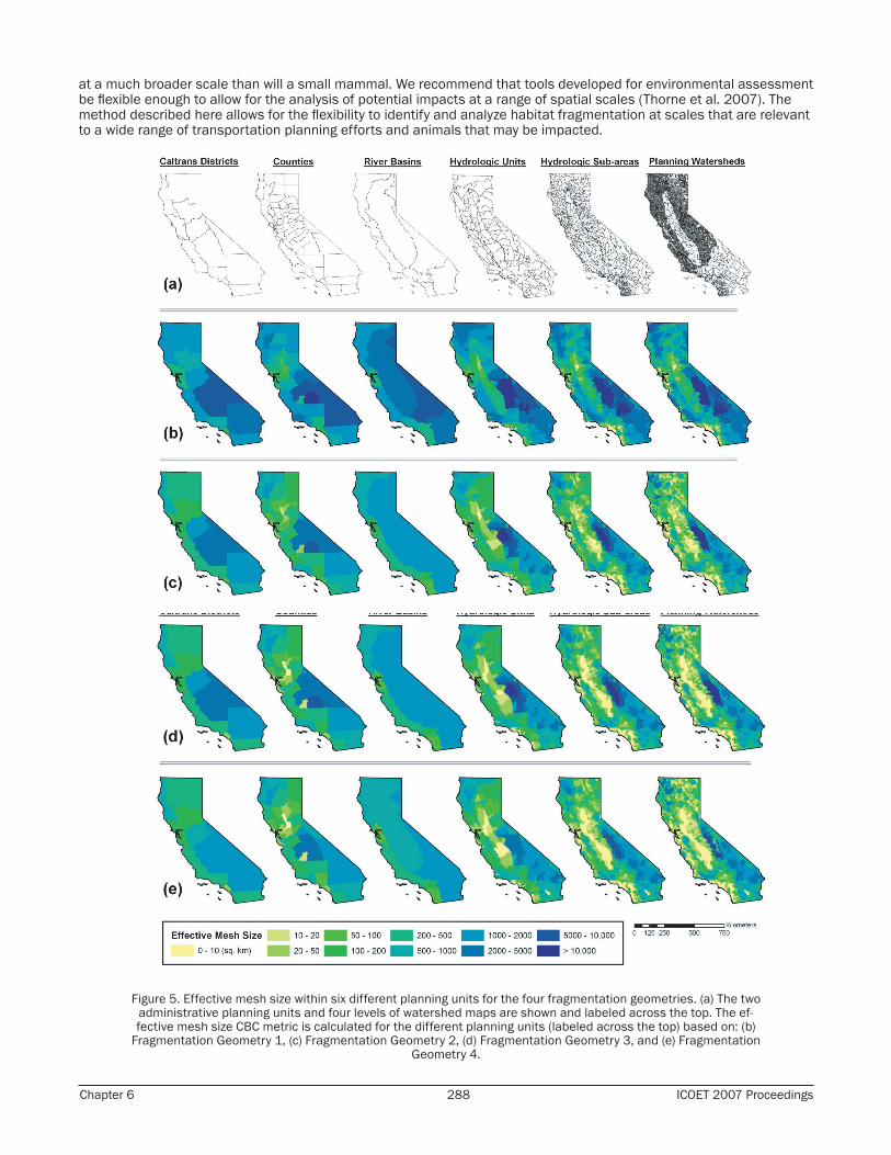
Figure 5. Effective mesh size within six different planning units for the four fragmentation geometries. (a) The two administrative planning units and four levels of watershed maps are shown and labeled across the top. The ef-fective mesh size CBC metric is calculated for the different planning units (labeled across the top) based on: (b)
Fragmentation Geometry 1, (c) Fragmentation Geometry 2, (d) Fragmentation Geometry 3, and (e) Fragmentation Geometry 4.

Bridging the Gaps, Naturally 289 Transportation and Conservation Planning
Figure 6. Mule deer range map overlaid with planning watershed level of effective mesh size (Fragmentation Geometry 4), show areas deer are more or less likely to encounter fragmenting elements (see also table 3).
Figure 7. Mountain lion range map overlaid with planning watershed level of effective mesh size (Fragmentation Geometry 4), show areas mountain lion are more (0 - 100 km2) or less likely (> 260 km2) to encounter fragment-
ing elements (see also table 3).
Table 3: Effective mesh size suitability for mountain lion and mule deer ranges in the State of California. The area within and percent of the total range area for each of the suitability categories are given for each species. For mountain lion, high suitability has an effective mesh size greater than 260 km2, medium is 100 – 260 km2, and low is less than 100 km2. For mule deer high suitability has an effective mesh size greater than 196 km2, medium is 5 – 196 km2, and low is less than 5 km2. For these species high suitability relates to dispersal distances, medium relates to daily move-ment requirements, and low is generally unsuitable for the species.

Chapter 6 290 ICOET 2007 Proceedings
Relating meff to Focal Species
Once landscape fragmentation has been quantified, any species for which there is a range map, and for which move-ment patterns can be obtained, can be assessed in similar fashion to the two presented here. The effective mesh size can be used to classify the landscape into regions where particular species are no longer able to move without encoun-tering a fragmenting element. Depending on the species being studied, a different fragmentation geometry may be the most appropriate to use. In California, there are 294 terrestrial vertebrate species excluding birds, for which range maps are available (CDF&G 2003) and which can now be analyzed from the perspective of the landscape fragmenta-tion indices, a future research goal of this group.
Animals exhibit different movement patterns, which can coarsely be classed into four categories: daily movement, home range, seasonal movement, and juvenile dispersal. We used this information to assess the “effective mesh size suitability” which relates meff to the movement patterns for a particular species (table 3). In this case the daily (nightly) movement of mountain lion in southern California had been measured using radio collars, and the home range size estimate came from a study of desert mountain lion (Beier et al. 1995), which was potentially a larger estimate of area needed, and therefore a more conservative one. By classing the effective mesh sizes calculated for nearly 7000 water-sheds in California into those below the daily movement patterns, those above the home range, and those in between, we were able to determine the level of habitat degradation imparted to mountain lion by roads in California. The results showed that 42% of the entire range is now below the threshold for daily movement patterns for this animal. We would expect mountain lion populations in this part of their California range to be in decline due to the necessity of frequent road crossings (table 3).
Effective mesh size could be used to identify areas that are prone to wildlife/vehicle collisions. Areas with very high meff would be expected to exhibit no fragmentation effects on deer populations, and not be prone to wildlife/vehicle collisions. Areas within the deer range that have very low meff (< 5km2) are likely to have low deer populations because the level of fragmentation is so high, and may be less prone to collisions. However, the areas with moderate levels of fragmentation (5 – 225 km2) are likely to support viable deer populations, but these population are more likely to encounter roads. Thus, it is the areas that are large enough for the daily movement, but smaller than the dispersal movement requirements where there will be the highest possibility for wildlife collisions, and of greatest concern to transportation planners.
Another set of biological questions arises around a species’ response to roads. Some species may have stronger road avoidance behavior, or may be less sensitive than others to roads (Jaeger et al. 2005). Many roads have some drainage structures, which may permit some species to move while the surface level roads prevent others from using the same landscape. Now that methods for quantifying effective mesh size have been developed, many road ecology research questions can be revisited using this landscape fragmentation index.
Population viability as impacted by increasing fragmentation exhibits critical thresholds, below which populations are prone to a much higher risk of extinction (Jaeger & Holderegger 2005; With & King 1999). As a consequence, better policies, decision-making procedures, and planning tools are needed that are based on the precautionary principle and on prospective simulation models, e.g., quantitative environmental standards limiting the degree of landscape fragmentation and precautionary assessment criteria.
Once the thresholds are crossed and the populations are declining, in most cases it is in practical terms impossible to return to the situation before the thresholds were crossed. Even in cases when it is in principle possible to reverse the trend and return to the situation before the thresholds were crossed, this is typically very difficult and much more expensive to implement the measures necessary for a recovery than before the thresholds were crossed.
Implications of meff for Transportation Planners
The results illustrate the utility of the effective mesh size metric, and raise questions about how to incorporate esti-mates of habitat degradation into transportation planning. This type of analysis can potentially be useful to identify contiguous suitable habitats split by roads which could become candidate locations for crossing structures. The data presented here represent an important step forward in analyzing and interpreting the current situation in California and other states, especially for comparative analyses of similar types of ecoregions. The results of this research are being provided to Caltrans for incorporation into a statewide database being developed to identify potential biological impacts due to planned future transportation projects (Thorne et al. 2007). This would then provide another metric for assessing the impact of these future transportation projects on habitat fragmentation and connectivity.
The long-term goal is to create comparative data for the whole of North America. These would serve as a basis for drawing up agreements about environmental standards such as limits, norms, and targets, and for creating measures towards limiting landscape fragmentation (Jaeger 2001; Penn-Bressel 2005; SRU 1994; UBA 2003). For this purpose, it is useful to establish time series for making comparisons with previous conditions, including comparisons with/with-out increase in traffic volume, and to identify changes in trends. The method used here is well suited for this purpose.
Incorporation of environmental indicators into environmental impact reports is potentially a major application for the type of data we report. A noteworthy example is the report on “The State of the Nation’s Ecosystems – Measuring the
Bridging the Gaps, Naturally 291 Transportation and Conservation Planning
Lands, Waters, and Living Resources of the United States” which aims at using seven indicators of fragmentation and landscape pattern but suffers from the lack of data on these indicators (Center 2002; O’Malley et al. 2003), which could be partially addressed using meff. Assessing landscape fragmentation through time using meff is another applica-tion, and has already been implemented in the state of the environment report by the State Institute for Environmental Protection Baden-Württemberg (Ministerium für Umwelt und Verkehr Baden-Württemberg & Landesanstalt für Umweltschutz Baden-Württemberg, 2003) and in the report on the status of sustainable development in Baden-Württemberg (Renn et al. 2000), providing examples of how to measure and interpret time series of landscape frag-mentation.
Conclusions
Analyses of correlations between the degree of fragmentation and the presence of species can provide valuable infor-mation on the effects of transportation infrastructure. In the future, relationships with the absence or decreasing ten-dencies of species, especially listed species, may indicate to what degree the amount and loss of unfragmented areas reflect the situation of a species. Further refinements of the effective mesh size method should include the potential of mitigating fragmentation effects by crossing structures (Forman et al. 2003; Jaeger 2007; van der Grift 2005).
It has been called a cruel irony in road ecology that “the more important the question, the more uncertainty is associ-ated with the answers that road science will be able to provide” (Roedenbeck et al. 2007). That is, while there is a large body of experience on how to study the project level effects, the effects on the larger scales are much more difficult to analyze and assess. The methods and results presented in this report provide a tool that is convenient to use for an assessment of the effects of road network on landscape fragmentation and connectivity on the regional and state scale, which can be applied in different places.
Acknowledgements: This research was supported by a UC Davis Sustainable Transportation Center faculty grant (A.M.B.). We thank Katie Benouar (Road Ecology Center, UC Davis) for project coordination and Mike McCoy (Information Center for the Environment, UC Davis) for technical support.
Biographical Sketches: Evan Girvetz is a doctoral student in the Graduate Group in Ecology at the University of California (UC) Davis (degree expected December 2007). His research focuses on using geographic information systems (GIS) integrated with quantitative analysis techniques to provide decision-support for answering real-world questions faced by land use planners and decision makers. He is currently a graduate student research fellow at the Road Ecology Center (UC Davis), and at the Information Center for the Environment (UC Davis).Jochen A. G. Jaeger is a research associate in the Department of Environmental Sciences at the Swiss Federal Institute of Technology Zurich (ETH Zurich), Switzerland with Prof. Dr. Jaboury Ghazoul (Group for Ecosystem Management). He studied physics at the Christian-Albrecht University in Kiel, Germany and at the ETH Zurich, and received his Ph.D. from the Department of Environmental Sciences at the ETH Zurich. He held a position at the Center of Technology Assessment in Baden-Württemberg in Stuttgart, Germany. In 2001, he went to Carleton University in Ottawa, Ontario, Canada as a postdoctoral fellow with Prof. Dr. Lenore Fahrig. In 2003, Dr. Jaeger came back to ETH Zurich to work with Prof. Dr. K.C. Ewald. During the time April-June 2007 he worked as a visiting scholar at the Road Ecology Center at the University of California at Davis, U.S.A. His publications include the book Landschaftszerschneidung (2002). His research interests are in landscape ecology, quantification and assessment of landscape change, assessment of the suitability of landscape metrics, environ-mental indicators, road ecology, modeling, environmental impact assessment, urban sprawl, and novel concepts of problem-oriented transdisciplinary research.James Thorne is a research scientist at the Information Center for the Environment, UC Davis. He got his PhD in Ecology at UC Davis in 2003, and has a masters in Geography from the UC Santa Barbara. His research interests include the integration of ecological data into planning, development and deployment of large datasets, and estimating the impacts of climate change.Alison M. Berry is a plant scientist and Professor in the Department of Plant Sciences, and the director of the Road Ecology Center at UC Davis. As director of the Road Ecology Center she develops key research issues in road ecology, and builds graduate education and train-ing opportunities. The UC Davis Road Ecology Center aims to facilitate interactions among UC Davis researchers and agency stakeholders that will lead to a new framework for research and technology transfer in road ecology.
References
Baldi, G., J. P. Guerschman, and J. M. Paruelo. 2006. Characterizing fragmentation in temperate South America grasslands. Agriculture Ecosystems & Environment 116:197-208.
Beier, P., D. Choate, and R. H. Barrett. 1995. Movement Patterns of Mountain Lions During Different Behaviors. Journal of Mammalogy 76:1056-1070.
Beier, P., K. L. Penrod, C. Luke, W. D. Spencer, and C. Cabanero. 2006. South Coast Missing Linkages: restoring connectivity to wildlands in the largest metropolitan area in the USA. Pages 555 - 586 in K. R. Crooks, and M. Sanjayan, editors. Connectivity Conservation. Cambridge University Press, New York, NY.
Bertiller, R., C. Schwick, and J. Jaeger. 2007. Landschaftszerschneidung Schweiz: Zerschneidungsanalyse 1885-2002 und Folgerungen für die Verkehrs- und Raumplanung. ASTRA-Bericht. 229 pp. The Swiss Federal Roads Authority, Bundesamt für Strassen, ASTRA, Bern, Switzerland.
CDF&G. 2003. Caliornia Wildlife Habitat Relationship Database. California Department of Fish & Game, Sacramento, CA.Congress, U. S. 2005. Safe, Accountable, Flexible, Efficient Transportation Equity Act: A Legacy for Users (SAFETEA-LU).Eberhardt, L. E., E. E. Hanson, and L. L. Cadwell. 1984. Movement and Activity Patterns of Mule Deer in the Sagebrush-Steppe Region.
Journal of Mammalogy 65:404-409.ESRI. 2005. ArcGIS 9.1. Environmental Systems Research Institute, Redlands, CA.

Chapter 6 292 ICOET 2007 Proceedings
Esswein, H., J. Jaeger, and H.-G. Schwarz-von Raumer. 2004. Landschaftszerschneidung in Baden-Württemberg, Bayern und Hessen – Ein Ländervergleich. Pages 49-70 in A. f. Natur, and U. Baden-Württemberg, editors. Geografische Informationssysteme im Naturschutz und in der Planung. , Tagungsdokumentation.
Forman, R. T. T. 1995. Land mosaics: the ecology of landscapes and regions. Cambridge University Press, Cambridge, MA.Forman, R. T. T., and L. E. Alexander. 1998. Roads and their major ecological effects. Annual Review of Ecology and Systematics 29:207-
231.Forman, R. T. T., D. Sperling, J. A. Bissonette, A. P. Clevenger, C. D. Cutshall, V. H. Dale, L. Fahrig, R. France, C. R. Goldman, K. Heanue, J. A.
Jones, F. J. Swanson, T. Turrentine, and T. C. Winter 2003. Road ecology: science and solutions. Island Press, Washington, DC.Geologie, T. L. f. U. u., editor. 2004. Landchaftszerchneidung in Thuringen. Schriftenreihe der Thuringer Landesanstalt fur Umwelt und
Geologie Nr. 66.Gerlach, G., and K. Musolf. 2000. Fragmentation of landscape as a cause for genetic subdivision in bank voles. Conservation Biology
14:1066-1074.Gustafson, E. J. 1998. Quantifying landscape spatial pattern: What is the state of the art? Ecosystems 1:143-156.Haines-Young, R., and M. Chopping. 1996. Quantifying landscape structure: A review of landscape indices and their application to forested
landscapes. Progress in Physical Geography 20:418-445.Heinz Center. 2002. State of the Nation’s Ecosystems: Measuring the Lands, Waters, and Living Resources of the United States.
Cambridge University Press, New York.Holzgang, O., H. P. Pfister, D. Heynen, M. Blant, A. Righetti, G. Berthoud, P. Marchesi, T. Maddalena, H. Muri, M. Wendelspiess, G. Dandliker,
P. Mollet, and U. Bornhauser-Sieber. 2001. Korridore fur Wildtiere in der Schweiz - Grundlagen zur Uberregionalen Vernetzung von Lebensraumen. BUWAL, SGW und Vogelwarte Sempach, Schriftenreihe Umwelt Nr. 326, Bern.
Hunter, R. D., R. N. Fisher, and K. R. Crooks. 2003. Landscape-level connectivity in coastal Southern California, USA, as assessed through carnivore habitat suitability. Natural Areas Journal 23:302-314.
Jaeger, J. 2002. Landschaftszerschneidung. Eine transdisziplinäre Studie gemäß dem Konzept der Umweltgefährdung. Verlag Eugen Ulme, Stuttgart.
Jaeger, J., R. Bertiller, and C. Schwick. 2006. Umweltindikator Landschaftszerschneidung in der Schweiz: Zeitreihen zum Monitoring der Nachhaltigen Entwicklung (Monet) Naturschutz und Landschaftsplanung 38:347-350.
Jaeger, J., Esswein, H., Schwarz-von Raumer, H.-G., Müller, M. 2001. Landschaftszerschneidung in Baden-Württemberg - Ergebnisse einer landesweiten räumlich diffe¬renzierten quantitativen Zustandsanalyse. . Naturschutz und Landschaftsplanung 33:305-317.
Jaeger, J., and R. Holderegger. 2005. Thresholds of landscape fragmentation (in German: Schwellenwerte der Landschaftszerschneidung). GAIA 14:113-118.
Jaeger, J. A. G. 2000. Landscape division, splitting index, and effective mesh size: new measures of landscape fragmentation. Landscape Ecology 15:115-130.
Jaeger, J. A. G. 2007. Effects of the configuration of road networks on landsacpe connectivity. Page in this volume in C. L. Irwin, P. Garrett, and K. P. McDermott, editors. Proceedings of the 2007 International Conference on Ecology and Transportation (ICOET). Center for Transportation and the Environment, North Carolina State University., Raleigh, NC.
Jaeger, J. A. G., R. Bertiller, C. Schwick, K. Müller, C. Steinmeier, K. C. Ewald, and J. Ghazoul. in press-a. Implementing landscape fragmen-tation as an indicator in the Swiss Monitoring System of Sustainable Development (MONET). Journal of Environmental Management.
Jaeger, J. A. G., J. Bowman, J. Brennan, L. Fahrig, D. Bert, J. Bouchard, N. Charbonneau, K. Frank, B. Gruber, and K. T. von Toschanowitz. 2005. Predicting when animal populations are at risk from roads: an interactive model of road avoidance behavior. Ecological Modelling 185:329-348.
Jaeger, J. A. G., H. G. Schwarz-von Raumer, H. Esswein, and M. Müller, Schmidt-Lüttmann, M. . in press-b. Time series of landscape fragmentation caused by transportation infrastructure and urban development: a case study from Baden-Württemberg (Germany). Ecology and Society.
Kotliar, N. B., and J. A. Wiens. 1990. Multiple Scales of Patchiness and Patch Structure - a Hierarchical Framework for the Study of Heterogeneity. Oikos 59:253-260.
Li, H. B., and J. G. Wu. 2004. Use and misuse of landscape indices. Landscape Ecology 19:389-399.Mazerolle, M. J. 2004. Amphibian road mortality in response to nightly variations in traffic intensity. Herpetologica 60:45-53.Mazerolle, M. J., M. Huot, and M. Gravel. 2005. Behavior of amphibians on the road in response to car traffic. Herpetologica 61:380-388.Ministerium für Umwelt und Verkehr Baden-Württemberg & Landesanstalt für Umweltschutz Baden-Württemberg, editors. 2003.
Umweltdaten 2003 Baden-Württemberg. ISSN 0938-2178. Selbstverlag, Karlsruhe, Germany.Moser, B., J. A. G. Jaeger, U. Tappeiner, E. Tasser, and B. Eiselt. 2007. Modification of the effective mesh size for measuring landscape
fragmentation to solve the boundary problem. Landscape Ecology 22:447-459.O’Malley, R., K. Cavender-Bares, and W. C. Clark. 2003. Providing “better” data: Not as simple as it might seem. Environment 45:8-18.Padoa-Schioppa, E., M. C. Poggesi, and L. Bottoni. 2006. River basins as ecological units to evaluate landscape fragmentation. Pages 77-
84. in B. Davies, and S. Thompson, editors. Water and the Landscape – The Landscape Ecology of Freshwater Ecosystems. IALE-UK.Penn-Bressel , G. 2005. Begrenzung der Landschaftszerschneidung bei der Planung von Verkehrs¬wegen. GAIA 14:130-134.Renn, O., C. Leon, and G. Clar. 2000. Nachhaltige Entwicklung in Baden-Wurttemberg. Center for Technology Assessment in Badeen-
Werttemberg, Stuttgart, Germany.Riitters, K., J. Wickham, R. O’Neill, B. Jones, and E. Smith. 2005. Global-scale patterns of forest fragmentation. Conservation Ecology 4:3.Riley, S. P. D., J. P. Pollinger, R. M. Sauvajot, E. C. York, C. Bromley, T. K. Fuller, and R. K. Wayne. 2006. A southern California freeway is a
physical and social barrier to gene flow in carnivores. Molecular Ecology 15:1733-1741.

Bridging the Gaps, Naturally 293 Transportation and Conservation Planning
Riley, S. P. D., R. M. Sauvajot, T. K. Fuller, E. C. York, D. A. Kamradt, C. Bromley, and R. K. Wayne. 2003. Effects of urbanization and habitat fragmentation on bobcats and coyotes in southern California. Conservation Biology 17:566-576.
Roedenbeck, I. A., H. Esswein, and W. Köhler. 2005. Landschaftszerschneidung in Hessen – Entwicklung, Vergleich zu Baden-Württemberg und Trendanalyse als Grundlage für ein landesweites Monitoring. Naturschutz und Landschaftsplanung 37:293-300.
Roedenbeck, I. A., L. Fahrig, C. S. Findlay, J. E. Houlahan, J. A. G. Jaeger, N. Klar, S. Kramer-Schadt, and E. A. Van der Grift. 2007. The Rauischholzhausen agenda for road ecology. Ecology and Society 12:11.
Rutledge, D. T., and C. J. Miller. 2006. The use of landscape indicies in studies of the effects of habitat loss and fragmentation. Naturschutz und Landschaftsplanung 38:300-307.
Schupp, D. 2005. Umweltindikator Landschaftszerschneidung – Ein zentrales Element zur Verknüpfung von Wissenschaft und Politik. GAIA 14:101-106.
Shilling, F. M., E. H. Girvetz, C. Erichsen, and B. Johnson 2002. A guide to wildlands conservation in the greater Sierra Nevada bioregion. California Wilderness Coalition, Davis, CA, USA.
SRU. 1994. Umweltgutachten. Sachverstandigenrat fur Umweltfragen, Metzler-Poeschel, Stuttgart, Germany.Taber, R. D., and R. F. Dasmann. 1957. The Dynamics of 3 Natural-Populations of the Deer Odocoileus-Hemionus-Columbianus. Ecology
38:233-246.Thorne, J. H., D. Cameron, and J. F. Quinn. 2006. A conservation design for the central coast of California and the evaluation of mountain
lion as an umbrella species. Natural Areas Journal 26:137-148.Thorne, J. H., E. H. Girvetz, and M. C. McCoy. 2007. A multi-scale and context sensitive state-wide environemtal mitigation planning tool for
transportation projects in California. International Conference on the Environment and Transportation, Little Rock, AR.Torres, S. G., and V. C. Bleich. 2000. Mountain lions: California’s elusive predator. Outdoor California 6:4-6.Trombulak, S. C., and C. A. Frissell. 2000. Review of ecological effects of roads on terrestrial and aquatic communities. Conservation
Biology 14:18-30.UBA 2003. Reduzierung der Flächeninanspruchnahme durch Siedlung und Verkehr. Umweltbundesamt, Materialienband, UBA-Texte
90/03, Berlin, Germany.van der Grift, E. A. 2005. Defragmentation in the Netherlands: A success story? Gaia-Ecological Perspectives for Science and Society
14:144-147.Veit, H. 2002. Die Alpen Geookologie und Landschaftsentwicklung, Stuttgart.Walz, U. 2005. Landschaftszerschneidung in Grenzräumen – Sachsen und die Sächsisch-Böhmische Schweiz. GAIA 14:171-174.With, K. A., and A. W. King. 1999. Extinction thresholds for species in fractal landscapes. Conservation Biology 13:314-326.
Chapter 6 294 ICOET 2007 Proceedings
is stratEgic EnvironmEntaL assEssmEnt (sEa) an EffEctivE tooL to consErvE biodivErsity against transport infrastructurE dEvELopmEnt?
Csaba Varga (00-36-30-238-5646, [email protected]), Land Stewardship Advisory Service of BirdLife Hungary, Loportar u. 16., Budapest, H-1134 Hungary
Abstract: The European Union is at the threshold of a new development period. Hungary as a Member State of the EU was given an opportunity to frame its comprehensive development programs for the next seven years (2007-2013). One of these programs is the Transport Operative Program, which focuses on large-scale, large-volume national trans-port infrastructure developments including road, air, inland water, rail, and combined transport. The Program cover a defined period, however, it will assign the direction of developments for a longer time and foreshadow the vision of the whole transport system in future.Under the related EU legislation a Strategic Environmental Assessment (SEA) must be accomplished for these kinds of programs. SEA is a specific procedure to identify and control environmentally harmful processes at the earliest and highest level of planning. SEA covers all fields of environmental issues including wildlife conservation and biodiversity maintenance.In the course of the present research we examined the opportunities the SEA’s institutionalized framework (regulations as well as measures) offers or might offer to mitigate the direct and indirect impacts of transportation via the nascent Hungarian Transport Operative Program. The half-year-long study conducted between June and December, 2006 primarily aims at exploring opportunities lying in strategic-level assessment to conserve biodiversity at national and regional level and to treat habitat fragmenta-tion.. Our study focused on determining what are the main issues that can be handled by the SEA and which ecological conflicts can be – at least partly - resolved at this level.During the course of the research we used experience gathered by older EU Member States like the UK, Italy and Spain that have been formulated in the form of guidelines. The significance of our research is strengthened by fact that the overwhelming majority of one out of the nine European eco-regions (called Pannonian Biogeographical Region) can be found in Hungary. It is a great challenge for the country to meet Europe’s controversial expectations: how to conserve this valuable area but at the same time carry out a large transport infrastructural development.The results gained suggest that SEA is a satisfactory tool to indicate large-scale harmful processes, however, it does not guarantee certain and sizable mitigation of effects unless the its methodology will be developed further and it will be integrated more efficiently in the implementation process of the transportation strategies in future.
Introduction
The European Union is at the threshold of a new development period. Hungary as a Member State of the European Union was also given an opportunity to frame its comprehensive development programs for the next seven years (2007-2013). One of these programs is the Transport Operative Program (TOP), which includes large-scale, large-volume nationwide transport infrastructure developments including road, air, inland water, rail, and combined transportation systems for the period marked above.
A primary concern during the elaboration of TOP was to ensure its conformity with the current Hungarian transportation policy as well as with the EU’s official White Book on Transportation Policy, which was issued in 2001 and has once been revised since then. In practice, each Member State has the right to form their own strategy on the basis of their needs, however, the strategy has to fit to the current transportation and environmental policy trends. Environmental issues caused by transportation increasingly gain importance in European Union related policies and the White Book apparently also reflects this trend.
Strategic Environmental Assessment (SEA) is a relatively new procedure applied for certain development programs that should comply with the environmental requirements. The European Commission agreed Directive 2001/42/EC “on the assessment of the effects of certain plans and programs on the environment” – the ‘SEA Directive’ - on 27 June 2001. Since that date, the Directive has been adopted in the national legislation of the Member States, among them in that of Hungary. The objective of the Directive is: ‘to provide for a high level of protection of the environment and to contribute to the integration of environmental considerations into the preparation and adoption of plans and programmes with a view to promoting sustainable development, by ensuring that an environmental assessment is carried out of certain plans and programmes which are likely to have significant effects on the environment’ (EC, 2001; Article 1).
Biodiversity has been decreasing steeply over a decade in several European countries. As a consequence, the con-servation of biodiversity became an issue of high priority in the EU’s environmental policy. EU Strategy for Sustainable Development (2001) set out a target by 2010: to halt the loss of biodiversity. Successful implementation of many of the priority objectives defined in the EU Biodiversity Strategy need sectoral considerations and the integration of biodiver-sity issues in other policies (EU Progress Report 2006). Beside the agriculture, transportation does not yet have a key role in the Strategy, although its fixed infrastructure might have a long-time effect on the affected habitats and wildlife.
The Conflict
Transportation development has always been a major driving force as well as an important target for SEA. Not surpris-ingly, as transportation has serious impacts on the environment that have been widely known for a long time. At a regional and global scale these effects on ecosystems, on the nature reserves as well as on other protected nature values is being increasingly recognized among the other environmental concerns (TERM report 2002). This can only

Bridging the Gaps, Naturally 295 Transportation and Conservation Planning
partly be put down to the generally growing endangerment of biodiversity, as underlying, there is fundamental dilemma: A primary objective of the European integration is the creation of a common market, which is in turn based on four guaranteed franchises: the free movement of goods, services, capital and workforce is greatly dependent on the existence of a highly developed and sophisticated transportation network that encompasses and interconnects the whole continent. At the same time, by creating the Natura 2000 network, the European Union has declared that the conservation of the common European natural heritage is also of key importance. Natura 2000 is Europe’s ecological network, which connects all valuable nature areas all over the continent. As the pan-European transportation and ecological network necessarily cross each other, one of them has to be favored at their junctures. Unfortunately, the EU Biodiversity Strategy does not give feasible and executable propositions to resolve of the foreseeable conflicts. The related chapter of the document is not very specific, all it contains is that protected areas (with Natura 2000 areas), valuable but not protected nature areas as well as animals’ migration routes have to be avoided by the transportation corridors. If the latter is not possible, at the crossing points of migration routes, conditions of safe passing of animals should be ensured. While the former suggestion for avoidance of vulnerable areas is often simply unfeasible, the latter cannot be translated into design terms at the level of strategies and thus it cannot be taken into consideration at the beginning of designing.
In the preparing phase of TOP, we examined what tools are at disposal to implement these propositions and to con-serve biodiversity, and we also attempted to identify situations when the territorial overlaps are regarded as accept-able solution to the conflict between transportation corridors and nature.
Methodology
This paper summarizes the findings of a half-year-long survey that was conducted between June and December, 2006. We primarily aimed at exploring theoretical and practical opportunities lying in strategic-level assessments to avoid further loss of biodiversity at national and regional level and also focused on managing habitat fragmentation. In this study several SEAs featuring transportation development and ecological assessments have been reviewed. As it turned out from the statements, the thematics of SEAs are similar to that of our research target, but the assessments have not a uniform and clear-cut methodology yet. The European countries adopted numerous different methods, among them qualitative analysis, ranking models, comparison of external expenses, risk assessment, multi-criteria assess-ment, matrices of impacts, cost-benefit analysis and the DPSIR model. Uniform methodology, however, exists neither at the same level of the assessment hierarchy, nor in the group of similar fields. Policies, programs and plans for different fields also prepared in different ways. Standalone strategic ecological assessments are relatively rare and information is hard to find on how the few exceptions are taken into account and how they are integrated (if ever) into the design process. If it functions, it functions on a non-systematic, case-by-case basis.
DPSIR model is listed among the SEA-related propositions issued by the EU as the most appropriate approach towards structuring and managing information on the environment. Consequently, the Hungarian SEA carried out for TOP also used a method based on the DPSIR model; a method called Strategic Assessment Methodological Principle. The en-vironmental specialists examined to what extent the sustainability principles function at the different levels of interac-tion. The interactions include driving forces, pressures, state, impacts and lastly, responses. A complete environmental assessment has been implemented for the TOP, whose chapter on biodiversity and conservation of nature resources chapters are structured similarly in the SEA statement, according to the interactions. Apart from the ecology-specific findings and suggestions, this way we had an opportunity to review the specificities of the DPSIR model. Our primary concern was to find what is the scale and the depth of ecological processes that can be identified by this model. It was also important to find out what special tools are available for preventing and/or mitigating undesired changes, and how effective these are in practice. The study also aimed at learning how the most significant problems and conflict situations that are well-known and are listed in the SEA statement can be managed in the course of the professional consultation between designers and environmental specialists. We used the relatively unsophisticated cost-benefit analysis and a qualitative-type analysis as the main method of the research. The choice has proven adequate for draw-ing attention to the opportunities lying in the examined phenomena while at the same time it was sensitive enough to identify any specialties and difficulties in practice.
Discussions
Approaches
In practice, there are two conceptions of the role SEA plays in the design process. These are not in conflict but they are essentially different from each other. The first approach emphasizes SEA’ similarities to environmental impact assessments (EIA) and considers SEA as the first step of a series of assessments, which is thus suitable for the geographic localization and prompt identification of problems right from the outset. This view is in line with the defini-tion of SEA formulated by Sadler and Verheem in 1996, according to which “SEA is a systematic process for evaluating the environmental consequences of proposed policy, plan or programme initiatives in order to ensure they are fully included and appropriately addressed at the earliest appropriate stage of decision making on par with economic and social considerations”.

Chapter 6 296 ICOET 2007 Proceedings
The greatest advantage of this conception lies in its insistence that SEA precedes the environment impact assessment phase and thus it draws attention to conflict points even before the design of the given infrastructure elements pertain-ing to the policy, program or plan. This provides an opportunity for solving the problem in time.
According to the other approach, SEA is wholly new and independent form of supervision, and only its origin links it to EIA. Its tools are primarily suitable for seizing problems that can be interpreted predominantly at that strategic level. Consequently, environmental assessments following this conception are clearly biased towards processes present at landscape level, regional and global scale. These studies ascribe a relatively high relevance to impacts that are either indirect, synergistic or trans-boundary. Additional habitat loss along the transportation corridors caused by other infrastructure (industrial estates, warehouses, shopping centers etc.) is ranked as a critical issue, a major object of an SEA in this approach.
On the basis of the related literature it can be claimed that the first conception is much more widespread in practice. Presently, the transformation of a landscape in a smaller region is primarily determined by the development of the transportation network, most importantly roads and major ship-canals or other waterways. In a fragmented landscape connectivity will become a limiting factor for conserving biodiversity. We have increasingly more extensive knowledge on both habitat changes at landscape level and their significance in nature protection, thus the first approach is expected to gain more weight in future.
The scaling is apparently two central question of SEA: what processes can be managed by the SEA and which ecologi-cal conflicts can be – at least partly - resolved at this level. Two fields deserve our special attention which can hardly (or not at all) be treated at a lower level of design: the large-scale and longer ecological processes on the one hand, and the responsible planning process (implementation of transport policy that is more sensitive to wildlife conservation issues), on the other.
Accordingly, two features of SEA have to be highlighted from the perspective of this examination:
• It identifies the indirect and cumulative impacts of a planned strategy, program, plan prepared for a sizeable region – for a region or a whole country;
• Its findings can influence not only the program’s implementation but – optimally – its content and logical structure, i. e. the direction of the development.
Evaluation of Tools
Every examined SEA used common tools or a combination of these for assessing the expected impacts on nature and on biodiversity. Methods can be classified on the basis of their similarity with each other and on the basis of their distinctive features. Theoretical toolkit that might be employed could be much larger than that is used in practice. In the research we collected the most frequently used tools, as well as we summarized their advantages and disadvan-tages. In the evaluation process we took into consideration the general methodological guidelines for SEA proposed by the EU, together with the methods featuring in sustainability assessments that are somewhat similar in nature to SEA.
1. Habitat Analysis
In the literature review preceding the research we found that it is the most popular and, in case of conservation issues, often exclusively used measure in SEA assessments. All methods classified as habitat analysis center around the comparison of the spatial distribution of vulnerable natural values with that of the designed infrastructure develop-ments, and draft propositions for overlapping areas, be these plans for avoidance or – incidentally - for crossing. There are several methods for preparing a biodiversity map and also for confronting it against development plans. In a previous Hungarian strategic environmental assessment carried out for the development of national motorway system four alternatives were compared by measuring the length of road segments that cross national reserves and Natura 2000 areas for each alternative plan.
Identifying biodiversity hotspots requires a more refined method, but in most cases the results reflect the distribution of only a few, but veritably keystone species or habitats. For a complex evaluation of affected ecosystems enormous amount of data is needed. In the lack of available data everyday experience of field ecologists is usually ranked above the available methods.
As this tool has been used for a long time and in many forms in assessments at different levels, its advantages and disadvantages have become clear by now.

Bridging the Gaps, Naturally 297 Transportation and Conservation Planning
Table 1: Habitat Analysis Tool
2. Modifying the Strategy by Changing the Share of Various Transportation Sectors
It has been well-known long ago that different transportation sectors have different ecological impacts and endanger wildlife to a different extent. Roads not only occupy huge strips of land from the landscape, but they are known to have several impacts that seriously damage the integrity and connectivity of habitats, moreover, even the life of certain ani-mals (Trombulak and Frissell 2000). Generally, the least damage is assumed to be caused by railway and other means of fixed-line transportation. The various existing technical solutions are judged differently in any given transportation sector: a good example for this is the construction of high-speed railways especially in areas rich in natural resources.
Despite the hypothetically enormous advantages in exploiting the opportunities lying in strengthening the presence of more environment-friendly transportation sectors and technical solutions, this is a quite rarely used measure for economic reasons. It is obvious that in case of huge complex designs, the chances of shifting the emphasis on the basis of solely ecological considerations are very low. The success of the measure is also challenged by the fact that the most popular way of transport is usually the least nature-friendly, e.g. traveling by automobile. Well-founded propos-als, however, play an enormous part in environmental consciousness-raising and in enlightening the interrelatedness of seemingly independent issues. In the process of TOP, nature conservation and environmental concerns emerging in connection with the plan of the Hungary’s largest river, the Danube’s transformation into a ship-canal can serve as a very good example for the role of consciousness-raising. The easement of shipping that has already been carried out in other countries in the planned way and that is otherwise rightly regarded as environment-friendly would presumably seriously imperil nature here due to the specific geomorphological characteristics of the Danube’s Hungarian section. Although the decision not to canalize the river is presently questionable, the risk was mentioned in the final version of documents, and further measures have been taken to explore risk-related issues.
Table 2: Transportation Sector Tool
3. Evolving and Applying Sustainability Criteria
Sustainability criteria include among others the conditions for the conservation of the natural environment and the preservation of biodiversity. Sustainability helps to decide among different values and the criteria draw attention to issues that might stir conflicts and mark areas that are especially sensitive.

Chapter 6 298 ICOET 2007 Proceedings
Another opportunity lying in employing sustainability criteria is that with their aid, environmental and conservation principles can be integrated directly into the design process. The criteria most frequently feature in distinct planning and so-called Good Practice guidelines. These guidelines are able to exercise strict control from the first planning phase to the implementation and maintenance phase (i. e. monitoring and indicators?)?. In the Hungarian SEA, mini-mum sustainability criteria have been determined concerning development priorities, but unfortunately, these have not been included in TOP.
Table 3: Sustainability
4. Indicators
In theory, indicators are indispensable elements of any strategy. They can play an important role in the comparison of various alternatives, or of similar indicators reported by other countries, and also in the evaluation of programs by comparing status indicators measured before and after a given program. In the field of nature conservation, effect indicators are supposed to be the most expedient, but at present these are not yet available. The European Environmental Agency have developed some result-type indicators that reflect nature-related effects of transportation and transportation infrastructure development’. These can be used comparatively on larger (European or regional) scales. However, indicators for areas destroyed by roads, for the fragmentation of nature areas and for the proximity of protected nature reserves are not yet veritably expedient in comparing a whole country’s alternative development programs and thus they do not facilitate the decision among them. The key problem lies in the enormous data input required for the calculation of the indicators, as well as in the simplifying nature of calculation that masks qualitative differences. Consequently, indicators do not feature in the Hungarian SEA for TOP.
Special issues in the Hungarian Case Study
Hungary is struggling to make up a considerable leeway in economy and infrastructure development. This effort is subsidized by the EU, among other supporting the transportation development. At the same time Hungary (partly due to the leeway) has still significantly more natural values than the older Member States. With the accession the country en-riched EU’ natural heritage with the majority of an additional biogeographical region, the Pannonian region. Maintaining and conserving the values of this region are also subsidized by European funds.
There are two remarkable special issues worth mentioning from our case study. In Hungary, areas located closely around settlements are in many cases of high, sometimes European-level ecological value. In the past, these areas were inappropriate for house-building or cultivation and served as a boundary for the settlement’s further expansion, while nowadays these are - in many cases – the last natural values within the settlement’s authority. By-pass roads built primarily for environmental reasons (in order to decrease noise and air pollution, high risk of accident inside the settlements) effect just these areas the most fatally. Balancing environmental protection and conservation objectives does not yet seem to be manageable in the framework of the strategic analysis as the settlements’ interests is also inevitably justified. Decisions made at lower levels of design – again drawing on the Hungarian experience – have given rise to many conflicts.
Compensation could be offered in cases where damaging nature areas is inevitable. Application of compensation in Hungary is regulated by a decree on Natura 2000. Practically, the decree adopts the „no net effect” principle of the EU’s biodiversity strategy for the affected areas. Still, compensation is a highly disputed measure among ecologists and conservationists, as the criteria for inevitability of natural damage are not defined in an exact and transparent way. Western European examples show that compensation can easily become a simple economic consideration (i. e. it is „cheaper” to compensate for than to avoid damage), and this practice can in turn cause serious damage to nature. In the final analysis, compensation does not create new value, all it tries to do is to substitute - with more or less success - an existing value doomed to devastation. The main impediment of realizing the modern “dynamic” conservation paradigm is also closely connected to the institution of compensation: there are very limited space for the creation of sizeable and valuable new habitats, Hungarian land use suits no longer the natural dynamics of ecological processes.
Conclusions
We have to come to terms with the fact that major developments of transportation networks will necessarily affect negatively the natural environment to be protected. In most cases of a well-thought design, there are environmentally acceptable solutions, but even these are compromises at the best that result in only a moderate” degradation of the of habitats. Apart from gaining much more thorough scientific knowledge about the phenomena, the theoretical
Bridging the Gaps, Naturally 299 Transportation and Conservation Planning
guidelines will have to be clarified in order to elaborate solutions that would keep damages done to the wildlife at a still tolerable level in the long run. The first step would be the clear and unambiguous articulation of different policies, and as concerns the professional fields themselves, coordination and cooperation should be heightened. Developing compromises, cooperation and dialog is declared and intended to be SEA’s key responsibility. As concerns the policies, conservationists necessarily have to establish a realistic, an optimistic and a pessimistic vision about the transporta-tion networks. These visions will have to determine those target states of damaged or endangered habitats similarly positioned by the transportation lines whose evolution is acceptable for conservationists. In current practice, it too often occurs that two significantly different propositions are worked out for the same issue, where the conditions are completely alike in both cases. Without setting target states and delineating the appropriate method to reach these, different and in many cases, ad-hoc solutions will continue to be given to current and future conflicts, depending on the knowledge and jurisdiction of the commissioned expert of exert group. This, as we have experienced many times, has already undermined the trust of designers in conservation experts.
In the field of transportation development, the lack of standalone and unified environmental policy could also be felt in the reviewed documents, as well as in the argumentation supporting the TOP.
This is well reflected in the wording of TOP: there are contradictory environmental and sustainability targets and unrealistic, and hence not too detailed commitments. Presenting by-pass roads as a progressive step „successfully” masks the fact that probably conservation areas are being damaged, while the amount of emitted pollutants and noise will even grow due to the increasing traffic and speed on that road – the only thing that will change is the location of the emission.
Transport infrastructure generates regional development, moreover, this is one of its major objectives. Regional development requires additional areas, often in the zone of newly built roads and railways. Facilities directly linked to transportation infrastructure are intrinsically inseparable from them, and amplify their negative effects on the environment. As at the level of EIA the permitting procedure of roads and that of other facilities are separated in time and in administrative process, this relationship has to be taken into consideration and their synergistic impacts has to be handled in SEAs. For the time being, this important objective is not being attained by the predominantly adopted approach of regarding SEA as one form of impact assessment.
Concluding, we can claim that SEA in its present form is yet a weak tool for conservation biodiversity. The study has revealed that theoretically, SEA offers many opportunities, while in practice only some of them have proven really ef-fective. Consequently, it is imperative to improve its methodology and to widen its usability, and it should be integrated more efficiently in the whole implementation process of the transportation strategies in future.
Acknowledgments: The author thanks Katalin Gyertyán and Kornél Nádas (Hungarian Ministry of Economy and Transport) for their admin-istrative support, Zsolt Szilvacsku (BirdLife Hungary Land Stewardship Advisory Service), Ágnes Mészárosné Kiss (Hungarian Institute of Transportation Science) for their advice and suggestions.
Biographical Sketch: Csaba Varga is a conservation consultant for BirdLife Hungary Land Stewarship Advisory Service and coordinator of projects including ecological impacts of transportation. He obtained M.Sc. in ecology in 1994, and he has been involved in environmental impact studies ever since. Csaba’s current research focus include scaling issues of ecological impacts of transportation and implementa-tion of adaptive management of roadside habitats.
References
Trombulak, S. and Frissell, C.A. 2000. Review of ecological effects of roads on terrestrial and aquatic communities. Conservation Biology Vol. 14: 18–30.
Sadler, B. and Verheem, R.1996, Strategic Environmental Assessment – status, challenges and future directions. Ministry of Housing, Spatial Planning and the Environment of the Netherlands, The Hague, The Netherlands.
Bibliography
Byron, H. J., Treweek, J. R., Sheate, W. R., Thompson, S. 2000. Road developments in the UK: an analysis of Ecological Assessments in Environmental Impact Statements produced between 1993 and 1997.
Geneletti, D. 2003. Biodiversity Impact Assessment of roads: an approach based on ecosystem rarity. Environmental Impact Assessment Review Vol. 23: 343 -365.
Treweek, J. R., Hankard, P., Roy, D. B., Arnold, H. and Thompson, S. 1998. Scope for strategic ecological assessment of trunk-road development in England with respect to potential impacts on lowland heathland, the Dartford warbler (Sylvia undata) and the sand lizard (Lacerta agilis). Journal of Environmental Management Vol. 53: 147-163.
Sheate, W. R. 1995. Transport policy: a critical role for strategic environmental assessment. World Transport Policy & Practice, Vol. 1: 17-24.
Venturelli, R. C., Galli, A. 2006. Integrated indicators in environmental planning: Methodological considerations and applications. Ecological Indicators Vol. 6: 228–237.
Gyorsforgalmi úthálózat és a f?úthálózat kiemelt beruházásainak hosszú távú közúthálózat-fejlesztési programjának környezeti vizsgálata [Strategic Environmental Assessment of longer-scale development of motorway and highway network in Hungary]. 2005. Prepared by UVATERV Ltd. and KTI, Budapest.
Strategic Environmental Assessment for the Hungarian Transport Operative Program. 2006. Prepared by Respect Co.Hungarian Transport Operative Program. 2006. Ministry of Economy and Transport, Budapest.

Chapter 6 300 ICOET 2007 Proceedings
A sustainable Europe for a better world: A European Union Strategy for Sustainable Development. 2001. Published by: Commission of the European Communities, Brussels.
European Directive 2001/42/EC “on the assessment of the effects of certain plans and programmes on the environment”. 2001. Published by: Commission of the European Communities, Brussels.
Europe’s biodiversity - biogeographical regions and seas. Published by: EEA (European Environment Agency). http://reports.eea.europa.eu/ [consulted in 07/10/2007]
Keep Europe moving - Sustainable mobility for our continent. Mid-term review of the European Commission’s 2001 Transport White Paper. 2006. Published by: Commission of the European Communities, Brussels.
Paving the way for EU enlargement. Indicators of transport and environment integration. TERM 2002, Environmental issue report. Published by EEA 2002. Copenhagen. http://reports.eea.europa.eu/ [consulted in 04/18/2007]
Progress towards halting the loss of biodiversity by 2010. EEA Report, No 5/2006. Published by EEA. 2006. Copenhagen. http://reports.eea.europa.eu/ [consulted in 04/20/2007]
The SEA manual. A sourcebook on strategic environmental assessment of transport infrastructure plans and programmes. 2005. Published by European Commission, DG TREN, Brussels.
White paper. European transport policy for 2010: time to decide. 2001. Published by: Commission of the European Communities, Brussels.

Bridging the Gaps, Naturally 301 Transportation and Conservation Planning
patch occupancy modELs and bLack bEar managEmEnt in thE southEastErn coastaL pLain: a potEntiaL tooL?
Jay E. Clark (931-308-7570, [email protected]), Department of Forestry, Wildlife and Fisheries, University of Tennessee, Knoxville, TN 37996 USA
Frank T. van Manen, U.S. Geological Survey, Southern Appalachian Field Branch, Knoxville, TN 37996 USA
Joseph D. Clark, U.S. Geological Survey, Southern Appalachian Field Branch, Knoxville, TN 37996 USA
Abstract
Habitat fragmentation in the southeastern Coastal Plain is widely regarded as a central issue in the management of black bear (Ursus americanus) populations. Further habitat loss and fragmentation, and increases in human density, may influence the persistence of black bears throughout this region. Therefore, tools to evaluate these impacts are needed to encourage and allow for an integrated, regional-scale approach to management. Stochastic patch occu-pancy models (SPOMs) represent a group of metapopulation models that are based only on the occupancy status and size and distribution (i.e., connectivity) of habitat patches. Application of such models may provide wildlife managers and landscape planners with useful tools to evaluate the potential impacts of future land-use changes (e.g., construc-tion of new highways) on the persistence of wildlife populations at a regional scale and to determine how those impacts may be mitigated (e.g., establishing corridors). We developed a SPOM for the area encompassing the entire range of the Florida black bear (U. a. floridanus) and applied the model to quantify colonization and extinction rates of habitat patches across the network. We adjusted interpatch distances using least-cost distance analyses to account for char-acteristics of the landscape (i.e., roads and land-cover types) and their potential effects on dispersal among patches. The best-fitting model incorporated effects of land-cover type and roads, including type of road. Using the parameter estimates of the best model, we performed a 25-year simulation of patch incidence to assess the potential for natural recolonization of unoccupied patches and to identify patches that may become extinct over the 25-year period. The simulation predicted only limited population expansion but also predicted low potential for extinction, thus occupancy patterns exhibited high stability. To demonstrate the potential utility of our model to managers and landscape planners, we applied our models to hypothetical management scenarios. We demonstrated how our model could be used to guide restoration efforts by identifying those patches within an assemblage that, if restocked, would maximize recolo-nization potential for surrounding patches. We also demonstrated how our model could be used to assess impacts on connectivity among existing bear populations resulting from changes in landscape structure and composition (e.g., highway upgrades). Additionally, we applied the parameter estimates of the best model, tested the validity of its ap-plication, and performed simulations for the area encompassing the entire range of the federally threatened Louisiana black bear (U. a. luteolus) and populations of the American black bear (U. a. americanus) in Arkansas. Although SPOMs may prove to be a valuable tool for regional-scale management of black bears in the southeastern Coastal Plain, we caution that the methodology used to develop our model has not been attempted for large carnivores and the reliability of our predictions has not been thoroughly tested. Thus, we emphasize that our model should be used in conjunction with other available information and not provide the sole basis for making management decisions.

Chapter 6 302 ICOET 2007 Proceedings
thE usE of habitat suitabiLity indicEs (hsis) for EvaLuating impacts to, and assEssing mitigation for, tErrEstriaL wiLdLifE habitat for transportation projEcts
Rick Black (801-743-7831, [email protected]), Senior Environmental Scientist, HDR Engineering, Inc., 3995 South 700 East, Suite 100, Salt Lake City, UT 84107, Fax: 801-743-7878 USA
Abstract
Habitat Suitability Indices were used to evaluate terrestrial wildlife habitat impacts for a newly proposed 35-mile highway that runs through five different habitat types.
Typically for transportation projects, detailed impact analysis of terrestrial wildlife is limited to federally listed Threatened and Endangered species, or even State sensitive species. Terrestrial wildlife habitats are usually addressed by acreage of impacts, at best, but often only qualitatively. The quality of the habitat or the importance of the habitat is often not addressed. However, if mitigation is required for the identified impacts to these habitats, it is often difficult to quantify appropriate mitigation measures for ambiguous impacts.
For the Mountain View Corridor EIS, Habitat Suitability Indices (HSIs) were used to help quantify and qualify the ter-restrial wildlife habitat the proposed 35-mile highway might impact. Utah State Division of Wildlife Resource Agency personnel and United States Fish and Wildlife Agency personnel were consulted with at the onset of the analysis to properly identify analytical methods. Together with environmental scientists, habitat types and species to represent these habitat types were identified and agreed upon.
The model provided a quick and efficient means of data collection, leading to an index of wildlife habitat quality within the project corridor. Output results were then used by the NEPA team (including agency personnel) to help shape alternatives and select alternatives to be carried through the NEPA analysis process.
If through the NEPA process, mitigation for non-federally-listed terrestrial wildlife habitat is proposed or required, this model will help establish the proper mitigation for the impacts.

Bridging the Gaps, Naturally 303 Transportation and Conservation Planning
using tooLs to support dEcision-making for muLtipLE bEnEfits in transportation and consErvation
Shara Howie (703-797-4811, [email protected]), Sector Relations Manager, NatureServe, 4001 Discovery Drive, Suite 2110, Boulder, CO 80303 USA
Kimberly Majerus (708-283-4346, [email protected]), Natural Resource and GIS Analyst, FHWA-Resource Center, 19900 Governors Drive, #301, Olympia Fields, IL 60461 USA
Shari Schaftlein (202-366-5570, [email protected]), Team Leader, FHWA Project Development and Environmental Review Office, Washington, DC USA
Abstract: One of the challenges faced by transportation and environmental practitioners is to keep pace with policy and technology advancements and capitalize upon new tools and methods as they become available. Several existing efforts and new initiatives are underway to improve practices in the use of tools within transportation program delivery. For example, the FHWA Headquarters Project Development and Environmental Review Office, FHWA Division Offices, state departments of transportation, NatureServe, and Defenders of Wildlife hosted workshops in Arizona, Arkansas, and Colorado to bring together transportation and environmental practitioners to discuss ways to link efforts for conservation and transportation planning. One result from the workshops is an expanded awareness of available information, data, and tools that can support the integration of conservation and transportation efforts and transpor-tation program and project delivery. Another result from the workshops is evidence of the importance of face-to-face interactions between professionals in transportation and environmental and resource agencies. This paper includes a discussion of the approaches used in the workshops and successes and lessons learned. Several other existing efforts and new advancements that are moving forward to expand the use of data and tools in transportation decision-making are also discussed. The purpose of this paper is to highlight examples of specific types of expertise, data, and tools that can immediately be used to assist transportation and environmental practitioners achieve their goals and meet their requirements.
Introduction
Transportation programs and projects include many environmental responsibilities. It is an on-going challenge to harmonize long-standing federal, state, and local requirements with emerging requirements and best available science and technology. During the past years, several Congressional Directives, FHWA initiatives, and Presidential Executive Orders have emerged to support environmental efforts and improve timely delivery of transportation projects. Examples include: Eco-Logical: An Ecosystem Approach to Infrastructure, Environmental Streamlining and Stewardship, Context Sensitive Solutions, and Planning and Environment Linkages. Various other complimentary initiatives are underway at the federal, state, and local levels, for example, Cooperative Conservation and watershed management. Transportation legislation, the Safe, Accountable, Flexible, Efficient Transportation Equity Act: A Legacy for Users (SAFETEA-LU), includes changes in environmental review processes at both the long-range transportation planning and project levels (SAFETEA-LU 2005).
As background material for this paper, the following summary highlights some of the content for SAFETEA-LU and the Code of Federal Regulations (CFR 2007) for long-range transportation planning and the content of the plan as:
• Develop the long-range statewide transportation plan, as appropriate, in consultation with State, tribal, and local agencies responsible for land use management, natural resources, environmental protection, conserva-tion, and historic preservation
• Include a discussion of potential environmental mitigation activities (at the policy and/or strategic-levels). [23 CFR 450.214(j) and 450.322(f)(7)], developed in consultation with Federal, State and Tribal wildlife, land management, and regulatory agencies
• Compare transportation plans to State/Tribal conservation plans or maps, and to inventories of natural or historic resources, if available [23 CFR 450.214(i)]
• Fulfill the long-range planning factor to: “protect and enhance the environment, promote energy conservation and improve quality of life” expanded to also include “promote consistency between transportation improve-ments and State and local planned growth and economic development patterns” [23 CFR 450.206 and 450.306]
Several benefits arise from meeting these requirements and improving practices for the use of information and tools to support transportation decision-making. Throughout all stages of transportation program delivery, transportation and environmental practitioners are benefiting from interdisciplinary approaches to decision-making that support transpor-tation activities as well as environmental goals. These integrated approaches provide benefits for:
• Compliance with existing and new requirements• Better outcomes and results• Avoidance of late-process surprises and engineering re-work • Better interaction between environmental and transportation offices• Facilitation of multi-purpose goals• Improved mitigation and demonstration of sequencing (avoid, minimize, compensate for unavoidable impacts)
Chapter 6 304 ICOET 2007 Proceedings
• Larger scale mitigation strategies developed in advance of projects • Reduced duplication of efforts, including information and data sets• Fewer delays in environmental reviews to support streamlining of efforts • Reduced costs
These benefits can be accomplished through improved practices in the use of information, expertise, and tools to integrate environmental information and expertise more fully into transportation program delivery.
Expertise, Data and Tools
Many sources of expertise, data, and tools can be utilized to support existing and new efforts for transportation. The Transportation Research Board (TRB) suggests that in order to meet environmental requirements, transportation and natural resource agencies will have to rely on advanced geospatial tools and a more collaborative approach to all transportation activities (Transportation Research Board 2006). Computer tools, GIS, and maps are particularly power-ful tools for facilitating integration of information, people, and decision-making for planning and projects.
Expertise
Transportation decision-making relies upon various experts working together. Transportation and environmental ex-pertise is available at the national, Tribal, state, and local levels within both the public and private sectors. An ongoing challenge is to identify the expertise that is needed and use interdisciplinary approaches to coordinate expertise into the decision-making process.
Including expertise in the selection and use of information and data helps ensure the credibility of the decision-making process and the outcomes. In fact, with the Internet providing a conduit for vast quantities of unfiltered information, the need for knowledgeable people to select what information is credible and to make the best use of this information will continue to increase. The assistance of transportation and environmental experts can help define information needs as well as information sources.
Using appropriate experts for interpretation and analysis of data can be critical for ensuring successful planning and project outcomes. For example, a coordinated examination of the methods used to assess the sensitivity of an ecologi-cal feature could reveal that the potential for an adverse impact is much lower than originally thought and options to avoid an adverse impact become available. Interdisciplinary approaches can help clarify how to develop and deliver information with the most useful content and format to be shared with the diversity of individuals involved in all as-pects of transportation decision-making. Agreements on methods for analyzing data in planning will aid in downstream agreements on methods to be used in NEPA and project delivery and to meet the requirements of SAFETEA-LU Section 6002, Environmental Process Provisions.
Some information is most usable in computer format as data. Some information is most useful in other formats such as hardcopy maps or reports or photographs. Several types of analyses, maps, inventories, surveys, aerial photo-graphs, plans, and reports exist and are available. The following section focuses on examples of environmental data that have been identified as useful for transportation practitioners and their responsibilities.
Data and Methods
Although many sources of data exist, it is essential that data is selected and used based on how well the data matches information needs within the decision process. It is important to include the proper expertise in data selection and use. Some data can be useful at a broad-brush scale for some screening and scoping decisions, while other data needs to be at a finer scale for use in detailed design tasks. The scale, quality, and credibility of data are important so that data can be used effectively by the experts participating in the planning and decision-making processes.
Prior to developing new environmental data, a worthwhile step is to conduct a review of already existing data. There are some excellent sources of environmental data that are directly relevant to the needs of transportation and environmen-tal practitioners. The following sections describe examples of sources for environmental data and uses of the data.
In some cases, environmental practitioners and the staff of transportation agencies and their consultants have already compiled environmental data from various existing data sources (such as environmental agencies) and they can also be “data producers.” In other cases, coordination with environmental agencies and organizations reveals other avail-able data sources and “data producers.” Examples of coordinated efforts to develop and share data as well as the use of data “clearinghouses” are highlighted in later sections of this paper.
Data and inventories on threatened and endangered species, ecological resources, and environmentally sensitive areas are available and in use to support transportation responsibilities at the project level. The data includes informa-tion about the species and habitats that exist in a region, their condition or conservation status, the location of sensi-tive or other important features, and how these resources are likely to be affected by proposed activities. This type of data exists in every state in the state natural heritage programs and in a centralized national database managed by NatureServe, a conservation non-profit organization that provides coordination for the network of state natural heritage
Bridging the Gaps, Naturally 305 Transportation and Conservation Planning
programs. For more than 30 years, NatureServe has worked in partnership with its international network of member programs (known in the U.S. as state natural heritage programs) toward its joint mission of collecting, managing, and applying data on rare and endangered species, and threatened ecosystems. NatureServe provides national coordina-tion and technical support for the development and use of scientifically-based standards, data and tools that are used by the member programs and integrates these data into a national view. The data is updated continually and is acces-sible to federal and state agencies, as well as private and non-governmental organizations and the public.
The state natural heritage programs locally collect, analyze and distribute their data, and provide local expertise to local, state, and region-wide efforts. Today, the data housed at NatureServe’s central database along with data aggre-gated from the individual state natural heritage programs’ databases collectively is the most comprehensive, standard-ized inventory on at-risk species and ecosystems that exists for North America. Transportation offices in many states are benefiting from the use of this data and expertise. The state natural heritage programs function by carrying out field inventories, collaborating with federal and state agencies, and others to collect data in the state, and manage their data according to consistent national standards. They serve as a ‘clearinghouse’ of data on plants, animals and eco-logical communities that are legally protected, or otherwise of conservation concern. Since the mission of NatureServe and its member programs is to maintain and expand this database over time, inventories and results of studies done across the state can be integrated into their data management system, and therefore be easily utilized by all.
A keystone of the natural heritage data includes the conservation rank. Using expert methodology, each species and ecological community is assigned a conservation rank that reflects its rarity at a global, national, and state scale. For example, if a species was ranked G1 after evaluating all defined factors, it would indicate that the species is critically imperiled across its entire range (i.e., globally). For species, the factors that are considered in assessing conservation status include:
• total number and condition of occurrences (e.g., populations) • population size • range extent and area of occupancy • short- and long-term trends in the above factors
• scope, severity, and immediacy of threats • number of protected and managed occurrences • intrinsic vulnerability • environmental specificity
This standardized method of ranking species has been developed in collaboration with many conservation organiza-tions including the International Union for the Conservation of Nature (IUCN) Species Survival Commission (http://www.iucnredlist.org). The conservation status ranks for species and ecological communities are utilized by many federal agencies as a tool to prioritize conservation activities and assist in identifying actions that could prevent at-risk spe-cies from becoming listed for protection under the Endangered Species Act. In fact, a majority of the methodologies developed and utilized by NatureServe and its member programs is created in close collaboration with other partners including federal and state agencies, and other conservation organizations.
The following summary describes ways to access online data developed by NatureServe and its network of member programs.
• Access to generalized data for species and ecological data across North America is available on NatureServe Explorer (www.natureserve.org/explorer). Precise species locations are also available by contacting NatureServe directly. NatureServe is in the process of rolling out newly developed web services that will provide on-line access to more precise species and ecological data at a national scale.
• An increasing number of natural heritage programs are developing analytical products that map out environ-mentally sensitive areas, and provide other web-based conservation services such as environmental review tools. Access to local web portals for individual natural heritage programs is available at: (http://www.nature-serve.org/visitLocal/index.jsp).
Activities for federal, state, and regional conservation plans have been a particular focus in recent years. These plans can be used to provide important environmental and ecological data and an ecological context for the transportation community. A few types of plans and efforts are summarized below.
The Endangered Species Act directs the U.S. Fish and Wildlife Service (USFWS), Department of Interior; and the National Marine Fisheries Service (NMFS), National Oceanic and Atmospheric Administration (NOAA) to develop and implement recovery plans to promote the recovery and conservation of threatened and endangered species. These agencies support several other efforts as well. These recovery plans are available from the USFWS at: http://www.fws.gov/en-dangered/recovery/index.html and the NMFS at: http://www.nmfs.noaa.gov/pr/recovery. The goal of the Endangered Species Act is the recovery of listed species to levels where protection under the Act is no longer necessary.
Chapter 6 306 ICOET 2007 Proceedings
Another important effort has been The Nature Conservancy’s work to identify and map priority biodiversity areas within each ecoregion of the country. These “ecoregional plans” summarize conservation priorities, and include information on both plants and animals that are legally protected or are of conservation concern (http://www.nature.org/tncscience/). Still another regional planning approach focuses on what is variously termed green space, open space, or green infrastructure. A strategy, plan, or map for high priority areas for environmental values and conserva-tion is developed as a “greenprint.” Approaches to greenprints often focus on connecting existing green space and environmental and habitat areas together with new locations by identifying potential locations for connections and including these in the greenprint and strategy. Greenprints can extend across a geographic area of any size. A state-wide example is Maryland (www.dnr.state.md.us/greenways/greenprint/). An example that includes multiple states is the U.S. Environmental Protection Agency’s Southeastern Ecological Framework (http://www.geoplan.ufl.edu/epa/). At the state level, each state has completed a State Wildlife Action Plan (http://www.wildlifeactionplans.org/). All of these plans identify species in need of special attention, and many include maps of priority habitats or areas for wildlife conservation, and can help chart the course for wildlife conservation at local, state, and national levels.
In addition to environmental information and plans, a variety of other data sources exist in online data clearinghouses at the national, regional, state, and local levels. Environmental agencies are commonly data producers and data sources for environmental data. Geo-spatial datasets for transportation, infrastructure, and environmental topics can be accessed through the National Spatial Data Infrastructure (NSDI). This is a nationwide GIS data clearinghouse of free, downloadable data from federal, state, and local sources at: www.geodata.gov.
Links to other examples of state-based sources of information and data can be found through Defenders of Wildlife’s Biodiversity Partners website (www.biodiversitypartners.org). Many other online data clearinghouses and data sets are available. The U.S. Geological Survey provides several types of data and also sponsors the National Biological Information Infrastructure (www.nbii.gov).
This paper illustrates that several existing sources of information and data are available to transportation and environ-mental practitioners. Proper use of environmental data can be highly beneficial to support the integration of the infor-mation and people that are part of the transportation decision process. Using data in combination with software tools can be powerful since it can support the use of available data and provide a framework to guide the decision-making process. The discussion below summarizes how demonstrations of computer tools were included in the workshop setting as a way to show tools in action and facilitate discussion about how to use tools to support transportation decision-making. The discussion also highlights several topics and insights about advancements in tools and their use.
Tools
A variety of tools, some generic and some custom-built, are now available to transportation agencies. These tools make environmental and ecological data, analyses, and expertise more accessible than ever before. Expertise is needed to effectively define the need for tools and select tools that best match processes and decisions.
Several important concepts emerge in considering how technology can enable the integration of environmental and natural resource information and data into transportation planning and project delivery processes and vice versa. Transparency and accountability are keys for information and analyses to be credible and to stand-up to legal and po-litical scrutiny. Such transparency can be supported by the use of analytical tools and can thereby assist in facilitating trust between a diversity of participants involved in an interdisciplinary process. In contrast, “black box” approaches to using computer tools can sometimes trigger mistrust between participants.
Because planning and project delivery involves a balance among multiple values, use of analytical tools should be based on clearly defined assumptions and values. A whole class of optimization techniques that are embodied in tools are becoming available to vastly improve the efficiency of evaluating various ‘what-if’ scenarios, and help practitioners decide among them. Using an iterative process for using tools and identifying alternative scenarios for meeting multiple goals has been found to be worthwhile. Examples of tools and their uses are provided below.
NatureServe Vista is an example of a decision-support tool specifically designed to help to integrate various types of data, and conduct evaluations of planning and project delivery scenarios (www.natureserve.org/prodServices/vista/overview.jsp). This GIS-based software supports the creation and use of maps of environmental, infrastructure, socio-economic, biological and non-biological features in a selected area of interest. Maps can be used individually or combined within GIS analyses. Based on the distribution and characteristics of mapped features, a “value map” can be generated from GIS analyses depicting areas of greater and lesser importance or sensitivity.
An option within the tool allows the selection and assignment of different scores and weights for features within maps that can be used in calculations using GIS analyses. An example of a credible and scientifically based environmental scoring system was previously described as the conservation ranking system. These options and tools assist with deci-sion-making for particular interests, requirements, or priorities, and with integrating these together to support multi-purpose goals. Use of tools and maps can be focused on an individual feature or resource such as a legally protected species or can be expanded to integrate with any other features that can be mapped such as streams, wildlife areas, wetlands, historic resources, and socio-economic factors.

Bridging the Gaps, Naturally 307 Transportation and Conservation Planning
The map outputs can show high priority locations for conservation. Areas that are considered irreplaceable can also be shown. Early awareness of these priorities can support the selection of the best locations to serve the purposes of development and conservation. Maps can also be used to help accomplish mitigation to avoid adverse impacts to priority areas and avoid high compensatory mitigation costs.
In addition, NatureServe Vista supports an iterative decision-making process because many different scenarios can be analyzed and compared by using the tool. Evaluation of scenario results can help inform planning and project level decisions. The system also supports an open, transparent decision-making process with tools that can be used to document and report on the assumptions made at every decision point. Figure 1 below illustrates the type of results produced after running a specific scenario using NatureServe Vista to support analyses and decision-making toward defined goals.
Figure 1. Results from NatureServe Vista Scenario Evaluation Analysis. (Source: Comer 2006)
The map output in figure 1 and various types of alternative scenarios that generated map outputs using NatureServe Vista were demonstrated and discussed in the workshop setting. Workshop demonstrations also showed how data outputs from one tool can be used as inputs to other tools as a “toolbox approach.” A toolbox approach matches data and tools to individual needs and also supports interdisciplinary approaches. Computer advancements have pursued a toolbox approach so that decision support systems can support multiple goals for environmental and infrastructure and mission priorities (Goran et al. 1999, Majerus and Rewerts 1994, Sydelko and Majerus 1999).
One of the purposes of the workshop was to demonstrate a “toolbox” approach by using several example tools including NatureServe Vista, CommunityViz (www.communityviz.com/), and Quantm (http://www.quantm.net/). Demonstrations of a toolbox approach highlighted that CommunityViz is a GIS-based tool that provides a means to visualize analyses of land use alternatives and understand their potential impacts from environmental, economic, and social perspectives. Through the use of 3-D simulation, scenarios can be visualized from different angles. This feature supports decision-processes and enables citizen participation in planning processes. Quantm is a planning system for corridor and route Optimization. Quantm addresses complex route planning issues, transportation route alignment op-tions, and consideration of alternatives. The workshop demonstrations showed that it is possible to utilize results from NatureServe Vista, Quantm and CommunityViz as data flows between tools. This approach leverages the uniqueness of data outputs generated from each tool to support evaluations of alternative land use and transportation scenarios. A toolbox approach maximizes flexibility in the use of tools by offering options to support decision-making for particular interests, requirements, or priorities as well as interdisciplinary approaches to balancing multi-purpose goals.
Other example tools were researched and discussed as part of the workshops. Details are summarized in the ‘other tools’ presentations and handouts for Day 2 for each state’s workshop at: http://www.defenders.org/habitat/high-ways/workshops/home.html. Case studies illustrating other successes in the use of GIS tools are documented in the Transportation Research Board’s Circular on ‘Environmental GeoSpatial Information for Transportation’ (Transportation Research Board, 2006).

Chapter 6 308 ICOET 2007 Proceedings
The use of computer tools and GIS continues to advance at the national, state, and local levels. The following sec-tion offers a few examples of state natural heritage programs working with transportation agencies to support state, regional, and local planning and project efforts:
1. Colorado a. The Colorado Department of Transportation (DOT) partnered with The Nature Conservancy, U.S. Fish
and Wildlife Service, Colorado Division of Wildlife (CDOW), and the Colorado Natural Heritage Program on a range-wide impact analysis on short-grass prairie. Impact analysis utilized the Gap Analysis Project (GAP) vegetation layer, predictive habitat layer (source: CDOW), nesting sites, and element occurrences. Breeding bird atlas data and expert opinion were utilized to develop ‘presumed presence’ maps of federally listed and potentially federally listed species. These maps were used to determine areas of impact or potential impact based on proposed transportation routes and plans. For unavoidable adverse impacts, the maps were the basis of developing recommendations for habitat areas as compensatory mitigation. Colorado DOT worked with the U.S. Fish and Wildlife Service on the mitigation effort, and the Conservancy helped purchase or conserve these lands through easements. See figure 2 below for an illustration of the type of analysis done for the shortgrass prairie in Colorado.
b. Pikes Peak Council of Governments is working with the Colorado Natural Heritage Program and others on the use of the NatureServe Vista decision support tool to assist in transportation planning activities with a focus on two counties in Colorado.
2. Nevada – Nevada Natural Heritage Program supplies Nevada DOT with sensitive species data for all DOT projects and efforts, such as gravel pit operations, bridge widening, and new construction. Turn around time in answering Nevada DOT requests is usually hours. In exchange, Nevada DOT provides funding to the Nevada Natural Heritage Program.
3. Virginia – Virginia DOT has a cooperative agreement with the Virginia Natural Heritage Program for the sharing and use of natural heritage data. In addition, the Virginia Natural Heritage Program staff works with Virginia DOT staff to address the effects of storm water runoff, sinkhole filling and collapse, surveys along roads to assist in protection efforts, and habitat fragmentation and management of habitat corridors.
Figure 2. Analysis for shortgrass prairie in Colorado. (Source: Rondeau 2007)
One example of efforts underway by FHWA is the Planning and Environment Linkages (PEL) initiative. The PEL initiative represents an approach to transportation decision-making that considers environmental, community, and economic goals during the long-range transportation planning stage and carries them through to project implementation. An FHWA website offers a summary of PEL as well as links to information, case studies, and research findings available at: http://www.environment.fhwa.dot.gov/integ/index.asp.
Bridging the Gaps, Naturally 309 Transportation and Conservation Planning
Conclusions/Next Steps
Expertise and data and tools are readily available and can immediately assist transportation and environmental prac-titioners meet their requirements and accomplish multiple goals. Interdisciplinary approaches are highly beneficial to supporting both existing practices and advancements underway for the use of tools in transportation decision-making. Transportation practitioners are already experiencing the benefits of integrating environmental information and exper-tise into long-range transportation planning and project delivery. Benefits include: 1) improved planning and project decisions and outcomes; 2) more effective environmental mitigation; 3) selection of sites for compensatory mitigation in advance before they are converted to other purposes or before land costs increase; 4) improved processes for environmental approvals and permits; and 6) savings in cost and time.
To achieve these benefits, some recommended next steps to both support and improve decision-making include:
• Initiate workshops and coordination between transportation and environmental and conservation practitioners to move forward to support an informed process for defining collective goals and outcomes in planning, project development, design, construction, operations, and maintenance.
• Identify and implement a process for tracking identified environmental and conservation priorities and commit-ments and ensuring the priorities are taken into account at all levels of transportation decision-making.
• Demonstrate and promote successes in interdisciplinary and collaborative processes and projects, and in use of data and tools.
• Work with local, state, and federal agencies and conservation organizations toward identification and develop-ment and use of key environmental and biological datasets needed to inform transportation planning and project delivery.
• Develop guidance on how to coordinate with local agencies and organizations to develop and supply standard-ized data on endangered and imperiled natural resources in order to compile best available data.
• Initiate effort to develop toolkits and question and answer (Q&A) summaries on how to meet SAFETEA-LU provi-sions for long-range transportation planning.
• Encourage and pursue efforts to integrate transportation and conservation planning. (For example, conduct annual statewide interdisciplinary planning meetings.)
• Develop or refine standards and methods for sharing of data to support long-range planning processes and implementation of projects.
• Evaluate the need for tools, and apply the use of tools to both support and document transportation decision-making processes.
• Promote and implement the multi-agency initiative for ‘Eco-Logical: An Ecosystem Approach to Developing Infrastructure Projects’ (Eco-Logical 2006) within planning and project delivery.
• Participate in the FHWA Eco-Logical grant solicitation available at: http://www.environment.fhwa.dot.gov/eco-logical/eco_index.asp. Supported by FHWA with seed funding to implement Eco-Logical efforts at the planning and project levels.
Biographical Sketches:Shara Howie is currently a Sector Relations Manager for NatureServe’s Conservation Services Division and works out of the Western Regional Office of NatureServe located in Boulder, Colorado. Shara has over 12 years of experience supporting the development and maintenance of conservation data and data management systems. Shara has years of experience as a project manager supplying U.S. and Canadian federal agencies and other organizations with conservation data, analyses and other conservation services in collaboration with NatureServe’s international network of member programs (Natural Heritage Programs). Shara is currently working on projects with Parks Canada, the Canadian Wildlife Service, Federal Highway Administration, the National Park Service, and The Nature Conservancy. In the past, Shara worked extensively with the Department of Defense, USEPA and other federal agencies, and she specializes in the facilitation of data sharing between organizations. Before joining NatureServe in 2001, Shara worked for The Nature Conservancy’s Science Division for 10 years and the Smithsonian’s Botany Department for 3 years. Shara has a Bachelor’s Degree in Biology from George Mason University.Kimberly Majerus is a natural resource and GIS analyst with the FHWA-Resource Center near Chicago, Illinois. She partners with FHWA Divisions and HQ to deliver technical assistance and customized sessions to support transportation state and environmental offices nationwide. A 20 year career includes the Illinois Department of Transportation and Corps of Engineers and University of Illinois as project manager, environmental unit head, and GIS lab coordinator as well as President of the Illinois Environmental Council (IEC), not-for-profit organization. Kimberly’s experience includes 10 years of participation in nationwide, multi-agency programs and projects toward inte-grated efforts and decision support systems for multi-purpose goals and benefits. B.S. and M.S. degrees earned at University of Illinois at Urbana-Champaign. Shari Schaftlein has been the Team Lead for Program/Policy Development in FHWA’s Project Development and Environmental Review Office in Washington, D.C. for the past 3 ½ years. Activities that she champions include: the Context Sensitive Solutions (CSS) Program, the Center for Environmental Excellence, the National Liaisons, the Executive Order on Streamlining and Stewardship, SAFETEA-LU Rollout, the Green Highways Partnership, and Linking Planning and NEPA. She serves as the FHWA representative on the NCHRP 25-25 Panel on AASHTO Standing Committee on Environment (SCOE) Quick Response Research and is a Member of Transportation Research Board (TRB) ADC10-Environmental Analysis Committee. Prior to FHWA, she worked in the Washington State Department of Transportation, Environmental Office for 11 years, where she held the positions of Water Quality Program Manager, Streamlining Initiatives Manager, and Deputy Director. She has also held environmental management positions with the West Michigan Environmental Action Council in Grand Rapids, and the Quileute Tribe in La Push, WA. Degrees include a B.S. and M.S. in Environmental Science from Indiana University.
Chapter 6 310 ICOET 2007 Proceedings
References
Code of Federal Regulations (CFR) 2007. Title 23: Highways. Available at: http://ecfr.gpoaccess.gov/cgi/t/text/text-idx?&c=ecfr&tpl=/ecfrbrowse/Title23/23tab_02.tpl
Comer, Pat, Ph.D. 2006. Approaches to Biodiversity Conservation Planning. Presented at Arizona Linking Transportation and Conservation Planning Workshop, slide 24. Available at: http://www.defenders.org/habitat/highways/workshops/az/presentationsday1/ap-proaches-to-biodiversity-conservation-planning.pdf
Eco-Logical 2006. Eco-Logical: An Ecosystem Approach to Developing Infrastructure Projects. Multi-agency initiative and guide. DOT-VNTSC-FHWA-0601. FHWA-HEP-06-011. 83 pages. Available at: http://www.environment.fhwa.dot.gov/ecological/eco_index.asp
Goran, William D. and Jeffery P. Holland, John W. Barko, and Andrew J. Bruzewicz .1999. Plans for the Land Management System (LMS) Initiative. ERDC/CERL Technical Report 99/60. 75 pages
Majerus, Kimberly A. and Chris C. Rewerts. 1994. PRISM Decision Support System for Integrated Natural and Cultural Resource Management at Fort Polk, Louisiana. In proceedings: GRASS GIS User’s Conference. Work sponsored by Legacy Resource Management Program
Rondeau, Renee. 2007. Scorecard for Matrix Ecological Systems in Colorado. Presented to Colorado Department of Transportation in follow-up meeting to Colorado Linking Transportation and Conservation Planning Workshop (August 2006). Available at: https://trans-fer.natureserve.org/download/longterm/Measures-Scorecards/
Safe, Accountable, Flexible, Efficient Transportation Equity Act: A Legacy for Users (SAFETEA-LU) 2005. Links to information on SAFETEA-LU Sections 6001 and 6002: http://www.environment.fhwa.dot.gov/integ/related.asp
Sydelko, Pamela J. and Kimberly A. Majerus, Jayne E. Dolph, & Tom N. Taxon. 1999. A Dynamic Object-Oriented Architecture Approach to Ecosystem Modeling and Simulation. In Proceedings of the 1999 American Society of Photogrammerty and Remote Sensing (ASPRS) Annual Conference. pages 410-421. Work sponsored by Strategic Environmental Research and Development Program (SERDP)
Transportation Research Board (TRB) 2006. TRB of The National Academies. Environmental Geospatial Information for Transportation. Transportation Research Circular, Number E-C106, November 2006. Available at: http://onlinepubs.trb.org/onlinepubs/circulars/ec106.pdf