H. Transportation Infrastructure Transportation - Looking Back
19
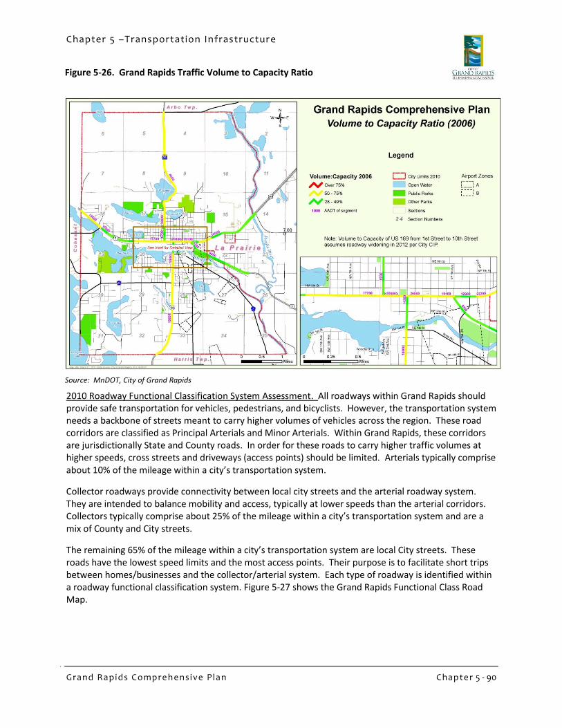
Chapter 5 – Transportation Infrastructure Grand Rapids Comprehensive Plan Chapter 5 - 89 H. Transportation Infrastructure Transportation - Looking Back The City of Grand Rapids recognizes that the transportation system within the City needs to serve the mobility and accessibility needs of all of its residents, businesses, and visitors. This includes pedestrians, bicyclists, snowmobiles, and ATVs in addition to automobiles, trucks, trains, airplanes, and buses. The City also recognizes the need to provide safe mobility for people of all ages and abilities within the City limits. To meet these needs, this section of the Comprehensive Plan presents the City’s plan for developing a comprehensive, integrated, connected network for all modes of transportation. The 2003 Comprehensive Plan included an extensive discussion of transportation planning concepts and how these might be applied in Grand Rapids, including functional classification of roads, walkability and pedestrian interaction with roads and automobile traffic, access management, and traffic forecasts. The Transportation section of the 2003 Plan also included descriptions of and recommendations for rail, air, and transit modes. These concepts are still relevant, and have been incorporated into much of the road and transportation planning since 2003. Roadways and Motorized Vehicles Since 2003 new traffic counts have been completed and MnDOT released a new traffic forecast for 2030. These data were analyzed and the results are presented below. Daily Automobile Traffic Volumes and Corridor Capacity, 2006. In 2006 daily traffic volumes were measured on roads within Grand Rapids. Based on planning level calculations from the Highway Capacity Manual the following capacity thresholds are identified for roadways (the boundary between Level of Service D and E): 5 Lane Capacity – 27,000 vehicles per day 4 Lane Capacity – 20,000 vehicles per day 3 Lane Capacity – 13,500 vehicles per day 2 Lane Capacity – 8,500 vehicles per day Although local two lane roads have a theoretical capacity of 8,500 vehicles per day, researchers at the University of California at Berkley found the quality of life along a residential street significantly degrades if the street carries more than 1,000 vehicles per day. For local, residential streets it is recommended the City attempt to maintain daily traffic volume levels lower than 1,000 vehicles per day. The 2006 daily traffic volumes were divided by their theoretical capacities to calculate a volume to capacity ratio. Figure 5-26 shows annual average daily traffic volumes and the volume to capacity ratio for each corridor. In 2006 no corridors had traffic volumes that consumed more than 75% of the corridor’s capacity.
Transcript of H. Transportation Infrastructure Transportation - Looking Back

Chapter 5 –Transportation Infrastructure
Gra nd Ra pids C ompre hensive Pla n Chapte r 5 - 89
H. Transportation Infrastructure Transportation - Looking Back The City of Grand Rapids recognizes that the transportation system within the City needs to serve the mobility and accessibility needs of all of its residents, businesses, and visitors. This includes pedestrians, bicyclists, snowmobiles, and ATVs in addition to automobiles, trucks, trains, airplanes, and buses. The City also recognizes the need to provide safe mobility for people of all ages and abilities within the City limits. To meet these needs, this section of the Comprehensive Plan presents the City’s plan for developing a comprehensive, integrated, connected network for all modes of transportation.
The 2003 Comprehensive Plan included an extensive discussion of transportation planning concepts and how these might be applied in Grand Rapids, including functional classification of roads, walkability and pedestrian interaction with roads and automobile traffic, access management, and traffic forecasts. The Transportation section of the 2003 Plan also included descriptions of and recommendations for rail, air, and transit modes. These concepts are still relevant, and have been incorporated into much of the road and transportation planning since 2003.
Roadways and Motorized Vehicles
Since 2003 new traffic counts have been completed and MnDOT released a new traffic forecast for 2030. These data were analyzed and the results are presented below. Daily Automobile Traffic Volumes and Corridor Capacity, 2006. In 2006 daily traffic volumes were measured on roads within Grand Rapids. Based on planning level calculations from the Highway Capacity Manual the following capacity thresholds are identified for roadways (the boundary between Level of Service D and E):
5 Lane Capacity – 27,000 vehicles per day
4 Lane Capacity – 20,000 vehicles per day
3 Lane Capacity – 13,500 vehicles per day
2 Lane Capacity – 8,500 vehicles per day Although local two lane roads have a theoretical capacity of 8,500 vehicles per day, researchers at the University of California at Berkley found the quality of life along a residential street significantly degrades if the street carries more than 1,000 vehicles per day. For local, residential streets it is recommended the City attempt to maintain daily traffic volume levels lower than 1,000 vehicles per day.
The 2006 daily traffic volumes were divided by their theoretical capacities to calculate a volume to capacity ratio. Figure 5-26 shows annual average daily traffic volumes and the volume to capacity ratio for each corridor. In 2006 no corridors had traffic volumes that consumed more than 75% of the corridor’s capacity.
Chapter 5 –Transportation Infrastructure
Gra nd Ra pids C ompre hensive Pla n Chapte r 5 - 90
2010 Roadway Functional Classification System Assessment. All roadways within Grand Rapids should provide safe transportation for vehicles, pedestrians, and bicyclists. However, the transportation system needs a backbone of streets meant to carry higher volumes of vehicles across the region. These road corridors are classified as Principal Arterials and Minor Arterials. Within Grand Rapids, these corridors are jurisdictionally State and County roads. In order for these roads to carry higher traffic volumes at higher speeds, cross streets and driveways (access points) should be limited. Arterials typically comprise about 10% of the mileage within a city’s transportation system.
Collector roadways provide connectivity between local city streets and the arterial roadway system. They are intended to balance mobility and access, typically at lower speeds than the arterial corridors. Collectors typically comprise about 25% of the mileage within a city’s transportation system and are a mix of County and City streets.
The remaining 65% of the mileage within a city’s transportation system are local City streets. These roads have the lowest speed limits and the most access points. Their purpose is to facilitate short trips between homes/businesses and the collector/arterial system. Each type of roadway is identified within a roadway functional classification system. Figure 5-27 shows the Grand Rapids Functional Class Road Map.
Source: MnDOT, City of Grand Rapids
Figure 5-26. Grand Rapids Traffic Volume to Capacity Ratio

Chapter 5 –Transportation Infrastructure
Gra nd Ra pids C ompre hensive Pla n Chapte r 5 - 91
The functional classification system attempts to balance resident needs for access and mobility. Figure 5-28 shows the conceptual relation of access and mobility along each classification of
roadway. To protect the mobility of arterials and collectors, access is limited along the corridors dependent on their classification. Grand Rapids is aware both Mn/DOT and Itasca County have access management guidelines for their roadways. The City acknowledges these guidelines and will work with these agencies to support access management within Grand Rapids. This includes facilitating cross access agreements and other cooperative measures along arterials.
Limiting driveways and public intersections provides a safer system for pedestrians and bicyclists. The City follows generally accepted spacing guidelines for its roadways and attempts to minimize the size and number of driveways along collectors and local streets within its jurisdiction.
Based on historical traffic data trends, Mn/DOT's State Aid Office has assigned a 20 Year growth factor of 1.2 to Itasca County. This represents a 0.92% annual compounded growth rate, which was applied to the 2006 AADTs in order to forecast 2030 AADTs. These forecasts along with their associated volume to capacity ratios are shown in Figure 5-29. Based on these forecasts, it is recommended the following corridors be monitored for possible improvements:
Figure 5-27. Grand Rapids Functional Road Classification
Figure 5-28. Access/Mobility Diagram
Source: MnDOT, City of Grand Rapid

Chapter 5 –Transportation Infrastructure
Gra nd Ra pids C ompre hensive Pla n Chapte r 5 - 92
Figure 5-29. Projected Volume to Capacity, 2030
Highway 169 east of the junction with Highway 2,
Highway 169 south of County Road 23/10th Street, and
The Highway 38 corridor near McKinney Lake.
No corridors are forecast to have a volume to capacity ratio greater than 100% in 2030, meaning transportation improvements may not be necessary in Grand Rapids to fix systemic capacity problems. In fact, a few of the road corridors appear to be wider than they need to be. In the future, prioritizing streetscaping and bicycle/pedestrian improvements on such segments could be accomplished without adverse impacts to vehicle flow. Furthermore, before contemplating any road widening projects to add additional capacity, the City should consider possible improvements to the traffic signal systems along those road corridors.
The City is currently undertaking a “Complete Streets” study in conjunction with the Minnesota Department of Transportation and the University of Minnesota. The Complete Streets goal is to create integrated multi-modal design of streets and creation of policies that place appropriate value on motorized and non-motorized access to public right-of-ways. The Complete Streets study will reference and be consistent with Comprehensive Plan goals and objectives, and should provide tools for addressing the capacity opportunities in road corridors as noted above.
In 2009 the signals along Highway 2 from Highway 38 to First Avenue East were connected and synchronized. New innovations in updating traffic signal timing plans, additional interconnecting with communications cables, and making minor modifications to the signals left turn phasing indications are proven to be effective means of adding capacity to roadway corridors.
Source: MnDOT, City of Grand Rapids

Chapter 5 –Transportation Infrastructure
Gra nd Ra pids C ompre hensive Pla n Chapte r 5 - 93
Figure 5-30. Grand Rapids Sidewalks
Pedestrians and Bicycles
The overall transportation goal of the Grand Rapids 2003 Comprehensive Plan was to improve the walkability of the City. That goal of promoting pedestrian activity as a viable alternative to automobile use remains a key element of this Comprehensive Plan. Residents need to get from one place to another, and yet some do not have access to automobiles, cannot use automobiles, or prefer the healthier option of bicycling or walking. Transportation planning should consider the needs of bicyclists, pedestrians, transit riders, and automobiles recognizing that all forms of transportation must be intermodal. Almost every trip includes a pedestrian component between its origin and destination.
Historic transportation planning recognized that an efficient transportation infrastructure must include an integrated system of roadways, but the importance of providing infrastructure for alternative modes of transportation including bicycle lanes, trails and sidewalks, was rarely given the same importance. Yet the safety and mobility of pedestrians and bicyclists is dependent upon well-designed and well-planned facilities. The City can create safe, comfortable and inviting pedestrian and bicycling environments by integrating walking and biking facilities into all appropriate roadway construction and reconstruction projects. Encouraging residents to choose walking as a mode of transportation has the additional benefits of improving individual health and vitality.
Though automobile dependent developments have affected walkability in some areas of the City, the downtown area is walkable, and the City has improved pedestrian access since 2003. A map of sidewalks in the City is shown in Figure 5-30, showing the older sections of town to have sidewalks, but other areas to be largely bereft of sidewalks.
Source: MnDOT, City of Grand Rapids

Chapter 5 –Transportation Infrastructure
Gra nd Ra pids C ompre hensive Pla n Chapte r 5 - 94
Figure 5-31. Parks and Trails 2030
The confluence of highways and rail corridors in the downtown continue to present pedestrian challenges including Highways 169 and 2 and the railroad right-of-way that serves the Blandin/UPM plant. The community survey and focus groups identified that people perceive the downtown to be fragmented from the standpoint of pedestrian access.
Other areas of the City have varying levels of pedestrian access and walkability. Sidewalks are required in new developments and are common in traditional neighborhoods near to the downtown and River. A number of neighborhoods and neighborhood extensions developed in the last 40 years are less likely to have sidewalks or other pedestrian and bicycle infrastructure. Specific improvements for pedestrian and bicycle use are planned for Golf Course Road, SE 4th Street, and along the Mississippi River. Figure 5-31 shows the existing and proposed trails. Proposed trails are approximate, actual alignments will vary.
The physical beauty of Grand Rapids makes it a great city for bicycling. The Mesabi Trail is the city’s well-known connection to regional bicycle trails. Grand Rapids also has a City trail system that is being expanded, a planned designated route along the Mississippi River, and planned connections to the trail system in and around the Forest History Center.
In order to have a usable bicycle system, Grand Rapids must integrate bicycle facilities with roadway design whenever appropriate. Bicycle facilities include both on-road and off-road components. The on-street facilities are located along arterial and other selected corridors and are located in the right-of-way or along easements. The off-street facilities are located off the right-of-way and near residential areas or natural areas.
Source: MnDOT, City of Grand Rapids

Chapter 5 –Transportation Infrastructure
Gra nd Ra pids C ompre hensive Pla n Chapte r 5 - 95
The City is currently conducting a Complete Streets study funded by the U.S. Transportation Research Boards that will guide the City in accommodating all travel modes within the public right-of-way. The Complete Streets study will integrate the Comprehensive Plan visions for an expanded multi-modal transportation network and provide recommendations for planning, design, and policy.
As part of the Complete Streets process, the City is considering general guiding principles in developing bikeways and pedestrian connections. Design parameters for bikeways favor direct, flat routes with adequate lane width, lower traffic volumes, and controlled speed of motorized vehicles. Bicycle routes should have adequate road markings, signage, and be sufficiently maintained.
Source: 2001 Park Facilities and Recreation Programming Analysis, P. 9

Chapter 5 –Transportation Infrastructure
Gra nd Ra pids C ompre hensive Pla n Chapte r 5 - 96
Figure 5-32. Grand Rapids Airport
Aviation
The Grand Rapids/Itasca County Airport is a general aviation airport that is open to the public 24 hours a day and used for corporate and private air traffic. It has about 15,000 aircraft operations per year. The Airport is primarily used for general and transient aviation flights. The facility has the capability to serve executive and private transportation needs benefiting the community, as well as the materials and delivery needs of the city’s industries.
The Grand Rapids Airport is located 2.5 miles southeast of downtown on 1,400 acres. The Village of Grand Rapids opened the airport in 1933 with a single grass strip runway. Since that time there have been many improvements and added amenities including paving and construction of hangars and other buildings. Since 2003 improvements have included:
• Lighting upgrades in 2005 • Paving of a second runway (a crosswind runway) and
associated lighting upgrades in 2008 • Updated Airport Overlay Zoning to correspond with
runway/lighting changes Currently the airport supports a variety of uses including military, government (forestry, DNR, State of MN, FAA, etc.), flight training, air charter service, corporate traffic, daily UPS delivery, medical transport, fire fighting, search and rescue, and private pleasure operations. There are approximately 65 aircraft based locally, which includes privately owned float and ski planes which are located primarily at private properties. There are approximately 15,000 annual aircraft arrivals and departures, down from the 21,000 reported in 2003.
At the time of the 2003 Comprehensive Plan Grand Rapids was being served by Mesaba Airlines with twice daily flights to St. Cloud and on to Minneapolis/St. Paul on planes with 30-34 seats. In March of 2004 Northwest, Mesaba Airlines’ owner, chose to discontinue service to Grand Rapids due to financial constraints. Passenger numbers had dropped significantly since the 2001 terrorist attacks and a subsequent change in flights which added a stop in St. Cloud, making flights less convenient for travelers. Since that time Mesaba service to St. Cloud has also been discontinued. Because of the loss of commercial passenger service, the Grand Rapids –Itasca County Airport chose not to renew its certification under Title 14 Code of Federal Regulations Part 139 (Certification for airports serving scheduled and unscheduled aircraft of greater than 9 seats) because the cost of maintaining the certification standard was not appropriate with the types of operations taking place. The airport maintains its GPZ designation on the National Plan of Integrated Airport Systems (NPIAS), making it eligible for passenger service if an airline is interested in providing such service. Certification could be reinstated within 90 days.
The loss of passenger service constitutes a significant change in transportation options for Grand Rapids residents. The nearest airport with passenger service is now the Chisholm-Hibbing Airport

Chapter 5 –Transportation Infrastructure
Gra nd Ra pids C ompre hensive Pla n Chapte r 5 - 97
Figure 5-33. Airport Zoning
approximately 40 miles northeast of Grand Rapids. As of August 2010 there were three daily trips scheduled from Chisholm-Hibbing to and from the Minneapolis St. Paul International Airport. The Grand Rapids airport continues to be an important part of the local and regional transportation system providing travel opportunities through charter, corporate and government flights. DLH, for instance, makes non-stop connecting flights to Duluth, Chicago O’Hare, Las Vegas, and Orlando International.
Despite the loss of commercial air service, the airport still sees over 15,000 annual aircraft operations and has nearly 65 aircraft based in Grand Rapids. The airport’s annual budget is over $220,000 with half that coming from tenant and user fees.
Rail Infrastructure and Operations
The State of Minnesota developed a State Rail Plan in 2010. The State Plan encompassed both passenger and freight rail service. Because there is no current passenger rail service to Grand Rapids, and the Plan did not plan for any future service, this section of the Comprehensive Plan will only address freight rail service. Regarding rail freight movement, the State Plan recommended the development of a “balanced multimodal freight system which can respond to increased regional and international economic competition, constrained highway capacity, environmental challenges, a diverse customer base and rising energy costs.” The State Plan sought to achieve this goal through infrastructure upgrades, expanded intermodal service options, planning and policy development, and enhance existing rail programs.
Source: MnDOT, City of Grand Rapids

Chapter 5 –Transportation Infrastructure
Gra nd Ra pids C ompre hensive Pla n Chapte r 5 - 98
Freight movement is important to the transportation system as well as to the economy of the area. Second only to St. Louis County in originating freight rail tonnage, rail lines in Itasca County moved 6.6 million tons in 2007. This is primarily due to the iron mining industry. A main line of the Burlington Northern/Santa Fe (BSNF) Railroad extends through Grand Rapids providing freight service. The BSNF line runs northwest to southeast, connecting North Dakota and Canada to the Duluth/Superior Port. The BNSF is the major transporter of finished products from Blandin Paper in Grand Rapids. The BNSF line carries grain, coal, and wood products and has an average of four trains per day according to MnDOT’s Freight Railroad Map. Another BNSF line connects Grand Rapids to the Iron Range and carries similar cargoes. This line sees an average of one train per day.
The Comprehensive Plan recognizes that the importance of rail service as a viable transportation mode and supports the continued maintenance of existing and potential industrial rail access to Grand Rapids designated industrial sites. Rail activities should be monitored in an effort to determine the impact of potential service or design changes in the City.
The City is in the process of completing the recommended rail crossing improvements from the 2003 Comprehensive Plan. This includes the closures of at-grade rail crossings at 12th Avenue NW and 5th Avenue NE along with the implementation of signals and cross arms at 19th Avenue NW and 3rd Avenue NW. These improvements will result in head end train speeds increasing from 12 mph to 30 mph, reducing closure times of at-grade rail crossings along with the ability to create a “quiet zone” through town so that trains will no longer blow their horns.
Transit
Transit is an important component of the transportation network in Grand Rapids and Itasca County. The primary transit provider for Grand Rapids is Arrowhead Transit, which operates in the seven county region of northeast Minnesota. The agency provides coordinated public transportation service with several flexible routes to choose from by using Dial-A-Ride. Transit connects residential areas with major shopping areas, public buildings, employment centers, health care facilities, and tourist attractions. Funding for the system comes through the Arrowhead Economic and Opportunities Agency. No significant changes in the transit systems have been implemented since the 2003 Comprehensive Plan.
Itasca County Area Transportation Study. In 2009 the University of Minnesota’s Humphrey Institute of Public Affairs conducted an intensive attitudinal study about transportation needs and priorities for Itasca County. A number of Grand Rapids institutions and organizations were involved in the study.

Chapter 5 –Transportation Infrastructure
Gra nd Ra pids C ompre hensive Pla n Chapte r 5 - 99
The investigators held a series of focus groups, listening sessions, and one-on-one interviews, and also conducted background research that included demographic analysis, mapping of the “mis-match” between the location of jobs and where the workers lived, and a national scan of best practices in providing rural transportation. The study made a number of recommendations ranging from improving bike routes and awareness of public transportation, to improving bus service linking Itasca County to Duluth and launching an online carpool service. The recommendations fall into five functional categories:
1. Policy and Administrative changes 2. Communications, Education and Outreach changes 3. Opportunities for Coordination and Cooperation 4. Operations, Maintenance and/or Service Improvements 5. Cost Sharing or Saving Opportunities
Some of these recommendations are part of the ongoing Complete Streets study, and others are being adopted as elements of this Comprehensive Plan update.
Source: Itasca County Transportation Study, p.5
Figure 5-34. Residential Patterns of Low-Wage Workers Whose Jobs are Located in Itasca County

Chapter 5 –Transportation Infrastructure
Gra nd Ra pids C ompre hensive Pla n Chapte r 5 - 100
Transportation – Looking Forward Based on a review of the transportation infrastructure and issues that remain from the 2003 Comprehensive Plan, there are a number of issues that Grand Rapids faces as it looks to the future. The 2010 Plan process included significant public outreach in which transportation priorities were discussed by residents and businesses. Issues identified in public meetings, the community survey, the focus group process, and the engagement of stakeholders in the Steering committee are listed below. Pedestrian/bicycle
Responses from the community survey and focus groups indicated a strong interest in expanding bicycle and pedestrian access throughout the City’s urbanized area. The City has paid considerable attention to building multi-modal infrastructure in recent years, but perceptions remain that non-motorized access is limited.
Residents and business owners expressed a need for safer and more welcoming pedestrian access, while maintaining traffic flow. Neighborhoods need to be linked with activity centers and schools, and safer crossings for pedestrians in the downtown will add value to the downtown economic cluster.
Transit
Current funding structures and fare levels are unlikely to sustain extension of transit service to more locations in the face of increased need as the population ages. Creative solutions, including those recommended in the 2009 Itasca County Transportation Study and other alternatives to auto dependency need further investigation.
Aviation
Lack of regularly scheduled commercial passenger air service limits access and opportunity, but the airport remains an important asset and transportation link for private business travel, cargo, and charter flights. Recognizing the infrastructural value of the airport and fully utilizing this asset remains a high priority.
Roadways
Several Trunk Highways converge in downtown, along with the active rail line. Balancing pedestrian flow, traffic and truck flow, and at grade rail crossings creates conflicts between different transportation goals. Balancing these goals and finding win-win solutions continues to be a significant challenge.
Maintaining and enhancing street connectivity is a challenge in some areas of the City where historic development patterns did not accommodate extension of the street grid. Creating connections after the fact is both controversial and expensive. Opportunities to make connections are present during development or redevelopment, but such opportunities are ad hoc and not in the optimal locations.
Better enforcement of traffic laws could be effective in keeping the streets safe for children and pedestrians.

Chapter 5 –Transportation Infrastructure
Gra nd Ra pids C ompre hensive Pla n Chapte r 5 - 101
Rail
Working with the BNSF railroad is an ongoing process in addressing train speed, safety, noise pollution, and emergency access. Yet rail access is a critical component of Grand Rapids’ economic competitiveness and sustaining existing businesses.
Land use/transportation integration
Coordinating origins and destinations in land use planning. Land use planning and transportation planning are not coordinated well through market mechanisms. After the fact fixes, such as instituting and maintaining transit or para-transit service, are rarely financially self-sustaining. Creating a better mix of complementary land uses will better connect people to destinations.
The ability to move more people without costly expansion of roadway capacity can be achieved by reducing travel demand by encouraging rideshare, walking, bicycling, and carpooling.
Shifting demographics. Another challenge is that the City is faced increasing needs for mobility and accessibility for an aging population that will likely have less access to automobiles. The disparate relationship between housing and commercial and service destinations in some parts of the City could create problems in the future.
The 2003 Comprehensive Plan Transportation section included seven goals:
Goal 1: Maintain a safe and efficient city wide transportation system that meets the local and regional
access needs of Grand Rapids citizens, industries, and visitors.
Goal 2: Strive to become a “walkable” city.
Goal3: Provide a safe, convenient, efficient, continuous, and aesthetically pleasing transportation
environment that is conducive to both recreational bicycling and using the bicycle for a
commuting purpose
Goal 4: Work with Arrowhead transit to continue to maintain, and enhance the transit system
Goal 5: Provide an aviation facility to meet the needs of passengers, the City, commercial airlines, and
general aviation in a safe and efficient manner
Goal 6: Maintain the function of the street system for current users, emergency response efforts and for
use by future generations
Goal 7: Promote safe and efficient rail service to Grand Rapids
Each Goal had between one and four objectives. These goals, and many of the transportation associated objectives, are still consistent with the City’s Community Vision, Values, and Guiding Principles. The 2010 Plan incorporates these goals and objectives into a new goal hierarchy.
Transportation Goals The Comprehensive Plan update looks at the goals and objectives for transportation recognizing that these cannot be considered in isolation from the rest of the city’s vision, values, and guiding principles. Although several transportation system improvements have occurred since the 2003 Comprehensive Plan, the City’s commitment to providing transportation options for all residents and visitors means that many of the 2003 transportation goals are retained for this Comprehensive Plan update.

Chapter 5 –Transportation Infrastructure
Gra nd Ra pids C ompre hensive Pla n Chapte r 5 - 102
Transportation Goal #1: Maintain a safe and efficient city-wide transportation system The local transportation infrastructure meets local and regional access and mobility needs for Grand Rapids citizens, industries, and visitors. Public right-of-ways are designed for efficient and safe movement for all modes and economic purposes.
a) Incorporate the results of the Complete Streets study to better create and retain streets that promote a mix of uses such as car travel, transit, and bicycling. The Complete Streets study will assist in making design and policy recommendations for the full range of travel modes.
b) Promote land use policies that limit access as necessary to maintain safe and efficient operation of the existing road system. Access management includes both road design issues (spacing of curb cuts and access points) and thoughtful land use planning that does not create the need for access at inappropriate locations.
c) The street layout of new developments shall continue to be coordinated with the streets and parking of surrounding areas, including Suburban Residential and Highway Commercial areas. The City should continue to require new development to ensure connectivity with existing and future surrounding areas and consider alternatives to cul-de-sacs that improve connectivity while retaining privacy characteristics of cul-de-sacs.
d) Protect road system investments and ensure efficient use of the road system by giving high priority to operational maintenance, safety improvements, and capacity improvements that are cost-effective and improve the level of service. Prioritizing maintenance and enhancements of the existing road systems is a fiscally responsible path.
Transportation Goal #2: Strive to become a Walkable City Properly planned and designed pedestrian facilities allow Grand Rapids residents and visitors to walk rather than drive for short trips. Promoting walking as a transportation mode contributes to better personal health and increases the capacity of the city’s transportation infrastructure by taking vehicles off the road.
a) Construct and maintain facilities, services, and programs that encourage walking. Grand Rapids is building both pedestrian infrastructure and programmatic efforts through organizations such as “Get Fit Itasca” to encourage walking and biking. Continue to build more inviting pedestrian environments with benches, trashcans, planters and other streetscape amenities.
b) Educate the general public on the importance of the sidewalk and bikeway system and its safe use. Transforming driving habits to increase the number of trips by walking and bike will maximize the value of both roads and pedestrian infrastructure.
Guiding Principles
Principle 5. Enhance healthy lifestyles, families, and community.
Direct public and private investment to create opportunities for healthy choices. Physical systems such as designing complete streets and programmatic development such as social services and educational programs can be designed to make healthy choices easier.
Community Values
Sustainable Built Infrastructure
The provision and maintenance of high-quality grey infrastructure is necessary to foster investment in a sustainable economy and maintain a high quality of life. Grey infrastructure includes: drinking water and wastewater utilities; energy systems; technology infrastructure; and surface and air transportation systems.

Chapter 5 –Transportation Infrastructure
Gra nd Ra pids C ompre hensive Pla n Chapte r 5 - 103
Transportation Goal #3: Promote bicycling for commuters and recreational riders A safe, convenient, efficient, continuous, and aesthetically pleasing transportation environment is conducive to encouraging bicycle use for recreational and work-related purposes.
a) Improve pedestrian and bicycle access to and between local destinations, including public facilities, schools, parks, open space, employment districts, and shopping centers. Creating access is the first step to enabling more bicycle use.
b) Promote bicycling as an alternative mode of transportation. Encourage wide use of bike-walkways and educate cyclists, pedestrians, and motorists about safe use of bicycles.
c) Maintain existing trails and bike routes. Trails and bike routes have maintenance needs that may be distinct from maintenance needs of automobile lanes. Conduct regular safety assessments to better address barriers, perceived and real, that limit use of bicycles.
Transportation Goal #4: Maintain, expand and enhance the transit system Travel by transit is part of an overall system that recognizes the multi-modal nature of travel where all transit trips begin and end with a walking trip. As the population ages, people will seek alternatives such as transit to using private automobiles. Ensuring that the City is prepared to creatively expand transit options will help meet future demand for alternatives other than the automobile.
a) Work with Arrowhead Transit and other transit or para-transit organizations to expand and improve service. In response to community growth and to enhance transit accessibility and convenience, maintain a dialogue with transit providers to strategically expand service and co-promote transit options. Education efforts can include items suggested in the 2009 Itasca County Transportation Study.
b) Consider strategic investments or pilot programs to test alternatives to existing transit systems. The Itasca County Transportation Study recommended a number of potential alternatives to traditional transit services including car-sharing and bike-sharing programs.
c) Consider transportation criteria for standards in land use regulations. Transit friendly infrastructure and programs can be encouraged through use of Travel Demand Management (TDM) plans for new or expanded facilities that create jobs. Direct assistance with such TDM plans and implementation can create competitive advantages for employers and the City in attracting outside investment.
Transportation Goal #5: Provide an airport that safely and efficiently meets local and regional demands The Grand Rapids-Itasca County airport is an economic development generator that meets the needs of passengers, the City, charter airlines, airport-dependent businesses, and general aviation flyers. The airport needs to be treated as long-term economic and transportation infrastructure that has inter-generational value.
Community Values
Accessible Movement
We understand and support the need for residents and visitors to move around our City with equal ease by car, bicycle, or on foot. Streets design should accommodate all modes of transportation and public transportation provides mobility to those without cars.
Community Vision
“Residents and visitors can move around the City with equal ease by car, bicycle, walking, or other mode of transportation.”

Chapter 5 –Transportation Infrastructure
Gra nd Ra pids C ompre hensive Pla n Chapte r 5 - 104
a) Guide future airport development so that it will satisfy aviation demand. Work with the airport to create new value in the existing airport facilities.
b) Support airport economic development activities. Economic development in and around the airport will support the long-term viability of airport infrastructure.
c) Create infill development around the airport that is compatible with airport use. A number of sites are available for development in the “B” airport zone. Work with the Airport authority to maximize value such that airport uses are supported in the long-term.
Transportation Goal #6: Promote safe and efficient rail service to Grand Rapids Overall, the state of Minnesota continues to move more freight tonnage than the national average. Continued uncertainty regarding future petroleum prices makes rail capacity an excellent transportation hedge, as rail is an energy efficient means of transporting the area’s extracted natural resources and industrial outputs. Integrating the rail system safely into the City’s street, highway, and pedestrian systems provides a challenge that can be met through careful planning and investment.
a) Protect the existing railroad system and encourage improvements that could benefit potential industrial development. Access to rail is a key advantage in sustaining existing industrial capacity and attracting new industrial investment.
b) Continue to work with BNSF and rail users to integrate rail operations with the rest of the City’s transportation infrastructure. Rail access and use can conflict with some land uses and other transportation modes. Resolving or minimizing those conflicts is necessary to sustaining rail access over time.

Chapter 5 –Transportation Infrastructure
Gra nd Ra pids C ompre hensive Pla n Chapte r 5 - 105
Implementation Priorities To advance the goals of the Transportation Plan, the Comprehensive Plan recommends the following action steps, organized by Transportation Goal. Maintain a safe and efficient city-wide transportation system
Continue to implement the five-year Capital Improvement Plan projects (2009 – 2013).
Continue to maintain roadways to allow for the planned functionality and performance at reasonable levels of service.
Improve road access to allow for multiple routes or access points into developed areas of the City. In particular, areas in the southeast quadrant of the City around Horseshoe Lake have limited or circuitous access that creates potential problems for emergency access and potential congestion. Identify potential problems and start drafting long-term solutions.
Take advantage of street resurfacing projects as an opportunity to install or enhance sidewalks, bicycle lanes, raised medians, and painted crosswalks, where feasible.
Implement the recommendations of the Complete Streets Study.
Use traffic calming design, where appropriate, to promote transportation choice, to reduce the negative impacts of car travel, alter driver behavior, and improve conditions for non-motorized street users.
Figure 5-35. Planned Road Changes and Improvements
Source: MnDOT, City of Grand Rapids

Chapter 5 –Transportation Infrastructure
Gra nd Ra pids C ompre hensive Pla n Chapte r 5 - 106
Increase street tree plantings and landscaping in medians and along arterials to calm traffic, soften the effects of arterial streets, and where appropriate, provide separation between pedestrians and other modes of transportation.
Consider creating standards for residential development that distinguish the road connectivity options for Suburban Residential and Traditional Neighborhood areas, consistent with the Future Land Use Map categories.
Consider standards (in addition to the existing subdivision standards) for development or redevelopment that enhance connectivity of streets, sidewalks, and trails.
Strive to become a Walkable City
Continue to require the inclusion of sidewalks in all new development. Require a variance from the sidewalk requirement for those cases where sidewalk requirements are not feasible. Sidewalks should be placed near property lines with space for a boulevard where grass and trees planted in regular intervals can be planted.
Create maintenance standards for bike lanes and City-maintained pedestrian ways that recognize and address the barriers to use that are maintenance related. Consider regular maintenance such as sweeping, snow removal, and safety assessments of existing sidewalks, trails, and bicycle lanes.
Work with property owners to maintain walkways with surfaces free of obstructions and trash, gravel, snow, and other hazards. Consider special tools such as Special Assessment Districts for critical areas with multi-modal transportation infrastructure such as the downtown.
Continue to plan for bicycle lanes and sidewalks or off-road non-motorized trails when new roads are planned and in all reconstruction plans for city streets.
Continue to connect sidewalks to create direct paths to destinations.
Continue to monitor traffic and pedestrian patterns to determine needs.
Create trail ROW requirements for Suburban Residential land use areas Promote bicycling for commuters and recreational riders
Extend the separated trail system into new neighborhoods as the city grows. Connections should be made to schools, parks, and other activity areas.
Link existing trails to form a continuous network, especially when new development occurs. While trail systems are usually implemented one section at a time, long-range planning should be emphasized so continuous corridors are eventually created.
Maintain, expand and enhance the transit system
Work with transit providers to promote transit services and educate the public about transit options, including the specific recommendations in the 2009 Itasca County Transportation Study.
Incorporate transit considerations into “complete streets” designs and policies.
Investigate options for working with new large employers or in the development or expansion of job centers through Travel Demand Management planning.

Chapter 5 –Transportation Infrastructure
Gra nd Ra pids C ompre hensive Pla n Chapte r 5 - 107
Provide an airport that safely and efficiently meets local and regional demands
Enforce airport safety zone restrictions through the zoning ordinance to prevent hazards or obstructions to planned air space and citizens.
Support efforts to enhance the airport’s revenue stream through new or expanded services.
Encourage public use of the airport terminal for meetings, informational gatherings, and special events.
Encourage airport attractions to increase tourism in Grand Rapids and enable the town to be a frequent stop for small plane travel.
Expand and improve airport facilities to better serve existing users and attract new users. Promote safe and efficient rail service to Grand Rapids
Review the land use plan, zoning and subdivision standards along the existing rail corridor to ensure appropriate land uses and site design to avoid encroachment and noise issues.
Minimize at-grade crossings of the track for new projects.
Continue to coordinate with the railroad companies to provide appropriate signage, traffic controls and public education to minimize train crossing accidents in the community.
Develop a long-range railroad crossing master plan.