Gypsum Deposits Near Iyoukeen Cove - Alaska...
16
Gypsum Deposits Near Iyoukeen Cove Chichagof Island Southeastern Alaska By G. M. FLINT, jr., und E. H. CORB MINERAL RESOURCES OF ALASKA, 1951 GEOLOGICAL SURVEY BUZLETJN 989-I3 UNITED STATES GOVERNMENT PRINTING OFFICE, WASHINGTON : 1953
Transcript of Gypsum Deposits Near Iyoukeen Cove - Alaska...

Gypsum Deposits Near Iyoukeen Cove Chichagof Island Southeastern Alaska By G. M. FLINT, jr., und E. H. CORB
MINERAL RESOURCES OF ALASKA, 1951
G E O L O G I C A L S U R V E Y B U Z L E T J N 989-I3
UNITED STATES GOVERNMENT PRINTING OFFICE, WASHINGTON : 1953

W E D STATES DEPARTMENT OF 'SHE INTERIOR
dough^ McKay, .Secretary
GEOLOGICAL SURVEY
W. 39.. Wrethw, &kctor

Abstract,,-,-.---,,,,----------------------------------------------- Introduotion----------- ,----------------------- ,------------------ History of investigation, development, and mining ------ ------------ ---
P ~ i f i ~ Coact Grp~urn Company property - - - - - -+ - - - - - - - - , - - - - * - - - -
Gypsum-Camel p r o m y ,--, ----------------------------------- Geolog~*,----~---.---.,------------------------------------------
Generd. , , . , , - - - - , - - . - - - - , , - - - - - - - - - - - - - - - - - - - - - - - - - - - - - - - - - - Origin of the ggpsum. - - - - - , - - - - - - - - - - - - - - - - - - - - - - - - I - -L- - - - - - - -
Eoonornic oonelder&tiom -,---- - -- -- - + -- - - - - - ------ --- - -- - --- - -- Referenm~ited- , , . , - - . - - - , , - - - -~- - - - - - - - - - - - - - - - - - - - - - - - - - - - - - - - - Zndex-- , , . , - . , . , , , - ---- , , - -----------------------------------------
mm PLATE 3. Topgraphia and geolodc m p of G ypum-Camel property and
vicinity, Iyo~tkeen Cove, Chichagof Idand, southemtern A b k a , - - . - - - , , , , , , ~ - - - - - ~ - - - - - - - - - - - - - - - In pocket
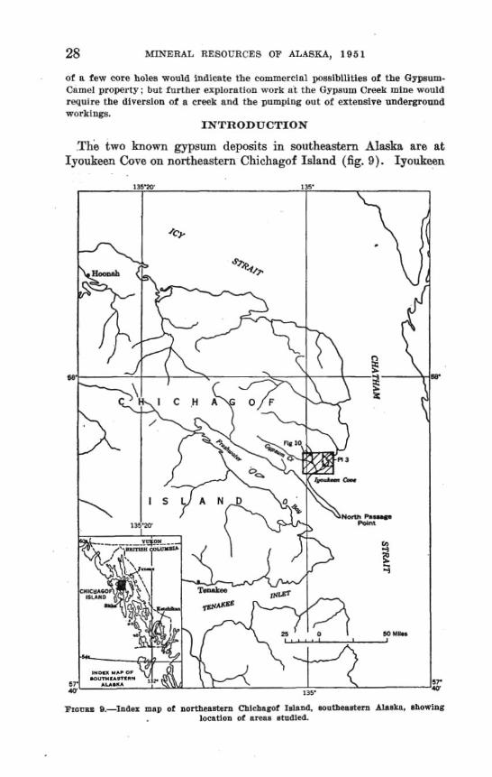
FIUUAU 9. Index map of northmtern Chichwof b!snd, southeastern ALaeka----,,-,.--,..,----,--------------,----,------- 28
10. Map of Iyoukeen Cove area, C h i c b p f Island,- - - -- - ----- -- 30 E 1. Geologic map, main workirlep, Cypum-Camel property, - - - -- A 33


MINERAL RESOURCES OF ALASKA .
GYPSUM DEPOSITS NEAR IYOUKEEN COVE, CHfCHAGOF ISLAND, SOUTHEASTERN ALASKA
By G. M. FLINT, JR, and E. H. COBB
ABSTRACT
Two demita of Ugh-grade gypsum are located near tidewater at Xyoukeen Cove, on the northeastern pnrt of Chidragof Island, southeastern Alaska. A group of Clnlma, formt!rly operated by t h e Pacific Coast Gypsum Go., wan ncquird by the Kaiaer aypmrn Division of Kaiser Industriw, Tnc., during World War ZI. Clalma at the other f l e ~ s i t are held by Dave Ftouwl of Juneau and Seattle, Washington, in the name of the Gypom-Camel group,
Ojpl lrn waa arslt reported in the arw in 19M, and bg the end of lk tbe Pacific Coant G m u m Co, bad ~0mtJletPd a moslderable amount of development work on their d q u i t at G-rn Greek. Development an@ prodactlon waa efIwnti4lly contlnuona until 1$23. Undsrgronnd workings are now caved or tloodetl and the mlne and hullding are in ruins. Production totalled ahout MKl,tMO toaa
Clnlms at the O m u m C n m r l promrty wrre first sttak& In 1912 bnt I t was not until about 1925 that any apprwleble development took pIace. In 1946 them were about e.50 feet of acrnsihle underground workinge and an additional 100 feet of AFletl or floded wnrkinm, A few tons of gypsum rwovcred during explorator~ work were stacked on the bmch but there has 'been no commercial production.
The oldest rwh In the area are predominantly gray, mraely crgstallfne limestone^ believed to be of Carhoniferma age. Except an ridges and In a few cr& W s , the older mcks are topered by Quaternary marine, flovlatile, and glacial depo~im. The llme~tone at places is cut by lamprophyric dikes with no a m r e n t mgulsritg. A breccia, composed of angular and aubangolar i r a ~ - ments of limwtone arhlch ran- from 1/1 Inch to 3 feet in Iongat dimension in a matriz of cream or buff I l m ~ s t o n ~ , mny IIF an intmformational b w i n at the tap of the limestone or map he a h u l t breccia. Tbe only other igneous rork known lo the rlclnlty la a p ~ n i t i c m k remrtdly pxposed In a monntain north 05 the deposlta.
Gypsum from both depositR la translumut Rne-gmIned white rock gypmrn with irreffnlar narrow graF ban&. Sorution cavities and drainage channeh m a r In both deposits. Past wrlters have fnvored a sedbentary origin but the pomfblllty e1i~t.s that the Clypsnm may have b w n deposited from wlntionn along a innlt zone or nones marked by ltmwtane breccia.
No valid estimnte of fcYpeurn reserves can be made for either depostt from available data on undergrorind workings or Prom ~urface expolsnrm. The drllling
28 MINERAL RESOCBCEB OF AWGK.4, 1951
of a few core h o b won1d indicate the commercial poaslbllitkes of the Gypmm- Camel property; but further exploration work at the Gypaam Creek mine would require me diveraion of a c m k and the pumping out of extensive underground workings.
mTRODnCTXON
The two known mum deposits in southastern Alaska are at Iyoukeen CoPe on northeastern michagof Island (fig. 9). lysukeen
Wema B.-lndez map of nortlmnt~flt Chlclmwf 1- ~~ dlamlta, mhowlnr locatlon of areaa rrtadled.

GYPSDM DEPOSITS NEAR *OWKEEN COVE 29
Cove js about 35 air miles southwed of Juneau and is on the airline ronta beheen Junerru and S i h . The property which was first de- veloped and for a tima worked by the Pwific Coast Gypsum Co. is approximately 1 mile apstream from the mouth of Gypsum Creek at sn altitude of about 70 feet above sea level A mond depmit, h o w n as the Gypsum-Camel property, is on tidewater 1lh miles northeast of the mouth of Gyp- Creek.
Topographic and geologic maps of these deposits (fig. 10 and pl. 3) were prepred in the course of an examination by a Gsological Survey party during the summer of 1946. Accessible underground workings at the Gppswn-Camel property were mapped. (See fig. 11.)
The history of the Pacific Coast Gypsum property and the Gypsum- Cmel property involves the period 190248. Brief reports, published
, by the I;)eologiuI Survey and the Territorial Mine Inspector during this interval, are scattered through numerous publications, many of which are available only at libraries. This report records and con- msolidatea for f u t m reference the signscant highlights as gleaned from personal communications with owners and former operators, in- spection of the propertjes by the authors in 1946, and data matted through the following repork: 1, h n m l Report of the Territorial Mlne Inspectar, 1920: p. 22, Juneau1 2. Annual Repart d the Territorial Mine Inspeetor, 1921: p. 45, Juneau, 1922 3. Annual Report of the Terrltorlnl Mine h s m o r , 1922: p. 85, Jmean. 19!B. 4. Anonymous, 1939, Game1 Gypsum-A new mine project In southeast Alaska:
Mining World, AUK., p. 22. 6. Brooks, A. IT., IOn, The Alaskan Mlnlng Industry In 1920: U. S. Gmt 8-
vey Rull. -A, p. &?. 6. Bmoka, A. El., and othem, 1908, Ptogress of Invmttgations of mineral re-
sources of Alaska In 1903: U. 8, Cfeo1. S m e y BuIL 284, pp. 5869. 7. Honsel, Dave, 1946, 18rmnal cornmnnIcatlon. 8. Hadmon, N. S., 1946, Peraonal communlcatlon. B, Martin, G. C., 1020. The klnskan Mining Indastry in 1918: TJ. S. Oeol. Etnr-
vey Bull. n2-A, p. 27. 10. W i n g md sdentiflc Press, 1902, vol. 84, no. 20, May 17, p. 274. IL Momt, P. B., 1927, Mineral Induetry of Alaska in 1925 and Admb&tratI.ve . Report: U. 8. GeoL Rnrvey Ball. 792-6, p. 38. ' I 2 Mosler, b B., I W , Personal communIeatlon. 1%. Reprt of the Mine Inspetor for the Territory of Alaska for the &a1 year
ending June 30,1912, p. 18. 24. Regort of the M h e Inwector for the Territory o t Alaska for the flwal gear
ending June 30,1917, p. 18. 15. Stewart, B. D.. 1931, The occurrence of maurn at Iyonkeen W e , michagof
Island, Mmka : U, &. Qeol. 8urvey Boll. 824-H1, pp. 173-177. 16. Stone, B. W., 1914, Ggpst~rn: U. 9, Geol. Slrmey, Mineral Resources U. 8.,
Pt. 2, m. 863464.


GYPSUM DEWSETG NEAR ITOFKEEN COVE 31
17. Stone. R W., and otbera, lm, G m u m deposits d the United States : U. 8. GeoL Snrvep EuII. 697, pp. 4148.
18. TwenhoM, W. S . , Iteel. J. C.. and Gates, G. 0.. 1M9, Some mineral invmffga- Uons In southeastern Alaska: U. 8. Geot Sntvey Bull. -A, pp. 2-
19. Wright, C. W., 1907, Non-meCalllieroas mInerar reeoorces of mutheftstern Alaska : W. S. Geol. 8 u m g Rnll. 31443, pp. M.
20. - 1908, The butldlng staneu and materials of muthemsatem Alaska: U. S. Geal. Survey Butt. 3 4 5 4 , yp. 124-1Z5.
Between 1902 and 1905 the Pacific Coast Gypsum Go. began develop- ment of the newly discovered deposit nt Gypsum Creek. Two adits approximately 600 feet apart were driven and two shafts 65 and 75 feet deep were sunk almost entirely in gypsum. A 90-foot crosscut was driven from the bottmm of the east or 65-foot shaft. Development was rapid. By the end of 1906 the east shaft had been extended to a depth of 190 feet and DO-foot and 160-foot levels had been opened. A total of 600 feet of drifts were driven on the two levels, exposing gypsum over an area having a maximum length of 200 feet and a maximum width of 150 feet. By the end of 1907,1,2M) feet of work- ings on the 160-foot level exposed gypsum on that l e d in a. block 430 by 225 feet. In 1952 a, raise was put tIaorrgll to the surface. In 1913 the 160-foot leveI had an east-west extent of 750 feet, a north- muth extent of 270 faat, and the total langth of underground workings was estimated as approximately 1 mile. During 1917, the east shaft was extended to a depth of 315 f e t and the 300-foot level was opened. When operationa ceased in 1924, workings on the 160-foot level were reported to have opened up an area of more than 1,000 by 500 feet, while those on the 300-foot level meamred 800 by 600 feet.
Apparently the west sdit and shaft were not worked until near f i e close of operations when "one small cargo" was gouged out from what appeared to be insignificant fingers of gypsum. In 1905 the Pacific Coast Gypsum Co. built a shaft house and m k
bins with a capacity of about 1,500 tons. A railmad 1 mile long was Itlid from the mine to a 2,000-foot dock on ~ h i c h was locatad a 1,000- ton bunker. The firrrt shipment to the companyis pl-r mill at Ta- coma, Washington, was made in May 1906. The dock and bunker collapsed in 1912, but were r e p l a ~ d and production was only tempor- - arily curtailed. Zn 1917 the capacity of tbe rock bin a t the mine was increased to 2,500 bns. Cars carrying 1,000 pot~nds of gvpsum were used underground, hand-trammed ta the shaft, hoisted to the surface, and dumped in the rock bin. Gypsum was hauled in 10-ton cars by ateam engine to the dock. DXculties m u d by water in the lower levels were first recorder1 in 1917. In 1918 procIuction was tempor- arily halted by the burning of thb mine buildings. In 1920 the mine

was flooded for the second time and, in 1921, the operators planned to sink B new 8h&f t and to make other ch.ngw t.a prevent recurrenb flooding by surface waters and underground springs. Electric and. sham pumps with an ag-h capacitg of 2,800 gpm wem in op- eration, although average demands required only 1,000 gpm.
During much of its operation the plant employed 20 te 25 men who were quartad at the mmp-any vlllage at the month of Gypsum Creek It is estimated that when the operations m d in Dewmber 1923, the property had pmducad about 500,000 tons of gypsum. In August 1924, the Standard G y p m Co. took over ths mine and
made plans for a new mill and development work ; but myaltg dscul- ties a m and the project was abandoned and the equipment removed. IJnderground workings are now caved or flooded and the mine and buildings are in ruina.
Whether recurrent flooding of the workings or exhaustion of the deposit caused the Pncific Co& Gypsum Co. to cease mining is not known. The intamat shown by the Standard Gypsum Co., Inc., sug- gests the former to b the reason. Before 1958 =me diamond drilling was undertaken in the smdl creek north of the mine, but poor drilling clonditiona made the m l t s unsatisfactory.
Patent number 488220 was issued an August 27,1915, to HsrrJr L Johnson, President, Pacific Coast Omsum Manufacturing Co. and in- eluded six daims on Gypsum Creek; tha Bell .hy, BeBell Boy No. 3, Gypsum, Gypsum No. 1, Gypsum No. 2, nnd Gypmm No, 3. During l170r1d War XI the Kaiser Gypsum Division of Kaiser Industries, In&, acquired all of the assets of the Standard Qypsum Co., Inc., w h m major stackholders at one time were the o m e m of the Pacific Coast Gypsum Co.
CtmmcAXEL PaOPERTP
AB emly as O&br 1918, claims wera staked on reporkd depsits of gypmm to the east of the Pacific Coast Gypsum Co. mine and axtending to the shore of Chatham Strait. But i t was not until sev- eral yeam after the close of o@rations a t the Gypsum Cmek mine that any appreciable development took place. By the time of Stewart's examination in 1929, this second property wnsiskd of eight claims owned by L a m & Anderson and Amiate s of Juneau, and the de- velopment comprised three adits and other workings totaling 825 feet. Development carrid on in 1939, prior tu the visit by Reed and Coats of the GeologicaI Survey, was said to have hen undert&en by the Camel Gypsum Mining Co., made up principally of a group of California men, with ownership of the claims remaining with Davs House1 and Amid Anderson. No detrdopment work has been under- taken since World W a r IX. The claims are not patentad. In 1946 the: writers mapped about 85Q f feet of underground worbgs . The

GYPSUM DEPOSITS HEAR IYOTKEEN COVE 33
additional 150 feet of drifts and a 40-foot winza reported by Stewart were inrtcessible; they were either fl mded or filled. In August 1946, the Fir-Tex Insulating Board Go. of St. Helm,
Oregon, obhined ztn option on the property from Mr. Housel. A field examination was made in September by company engineers.
T h e workings consisted, of five adits (pl. 3) driven from the beach about 16-feet above the high-tide mark. The adits extend under a gently sloping bench which is approximately 100 feet above &a level at the =%ward edge. Adits 1 and 5 do not penetrate gypsum. Adits 2,3, and 4 expose gypsum between 100 and 160 feet from the portals (fig. 11). A winee and an incline in Adit 3 are now inaccessible, but
Fr~nnm ll.*1oglc mag. main aorkinm, Qpenm-Camel, provertj, Imukten Cove, Chiehagof Idand, noutheastern Alaakn.
are reported by House1 to have exposed gypsum. Tbe property never p ~ a ~ commercially, hut development work was camied an inhr- mittenfly over a period of 15 years prior to World War I1 and the

34 MINERAL RESO'IJRCEB OF ALASKA, 195 1
few tons af gypsum recovered during exploratory work are stacked on the beach.
Two log cabins, a cookhousese, land several smal t buildings are on the property and still usable. A pier which was never completed is now jn bad condition.
QEOLOQY
GENERA&
The oldest rocks in the area are predominantly gray, coarsely crystaIline limestone% contnining some blnck chert. Wright (1908, p. 124) and Burchard (Stane, 1920, p. 47) considered them to be of Car- boniferous age, and Kindle (1907, pp. 330-331) more preciwly detar- mined that the limestone of North Passage Point are of Misissippian age. A small group of fossils collected by the writters in 1946 from the ridge north of Gypsum Creek was examined by J. S. Williams and J. Brookes Knight of the Geological Survey and identified as prob- ably of Carboniferous age.
The youngest sediments are Quaternary marine, fluviatile, and glacial deposits which cover the older m k s exc~pt on ridges and in a few creek beds.
Dikes intrude the limestones with no ~ p p ~ r e n t regularity. C. S. ROBS of the Geological Survey identified a ~pecirnen from one of the dikes as altered lamprophyre. In a rnount~in to tl10 nortl~, near the head of Gypsum Creek, a granitic rock is reportedly expmd. Them are the only igneous rocks known in the vicinity of the gvpsurn deposita,
A breccia wmposed of angular and subangtllnr fragments of lime- stone from % inch to 3 feet in longest dimension in a mntrix of cream or buff limestom may be intmformrttional breccia a t the top of the limestone section or may be a fault b m i a . I n arens where gypsum occurs the limestone breccia has a predominentl y buff color. In areas away from h o r n murrenws af gypurn the lirnmtone breccia is a crem color. Poor exposures and the complete lack of oltter~p in criticd areas make it impossible to state definitely the mode of origin of the breccia.
Gypsum was first reported in 1W2 in association wit11 cherty lime- stone in a small bluff in the broad dnt valley of Gypslim Creek wl~ich is covered with vegetation (Brooks, 1906, p. 59) . The only exposum of ppsnrn accessible in 1946 irr the area of the deposit on Gypsum ~ l r e i l r were three srnrrll outcrops neur the old workings and in the un- flooded upper 20 feet of the main shaft. On the Gypsum-Camel prop- erty gpstim is exposed only in the underground workinm. On the basis that gypsum apparently overlies the limestone, earlier investi- gators considemd the gypsum to have been formed during Permian or Triassic time, Jthough the actual contact relation between the gyp- sum and the Gal boniferous Iimestone could not be determined. All

GYPSUM DEPOSITS NEAR IYOUKEEN COPE 35
outcrops within 1 mile of both deposits and all accessible underground workings were carefully examined by the writers and as many other exposures as could be reached in the time available were visited in 1 The investigation, however, developed no new evidence bar- ing on a determination of the age of the gypsum.
Gypsum from tl~a'deposit on Gypsum Creek is similar to t h ~ t at the Gypsum-Camel property. The material is translucent, he-gained, white rock gtypsum wit11 irregular narmw gray bands, and much of it approaches alabaster in grade. Old drainage channels and sinks, most of which are filled with p a w l identical with tlle.modern stream p v e l s nearby, occur in the deposits. At the deposit on Gypsum Creek solution cavities and channels were reported below the 160-foot level. One of these channels was tunnelled for 35 feet without en- countering bedrmk in place. Burchnrd reported that a few thin basaltic dikes cut the gypstim and that one vein of anhydrite ranging from 6 inches to 10 feet in thickness was found on the 160-foot level (Stone, 1920, p. 47).
Althoug1l Wright stated that "the gypsum bed. iwe folded and steeply tilted and were probably laid down previous to the granitic invasion" (Wright, 1908, p. 124), the writers feel that a sedimentary origin of the gypsum has been assumed rather than proved. The pas- sibility that the gypsum may have been deposited from hydrothermal solutions spreading out from a fault zone or mnes marked by lime- stone breccia should be considered in any future work on the deposits, Information necessary to reach definite conclusions probably couild not be obtained without a major exploratory program involving both diamond drilling and trenching.
The top few feet of the =sum at the Gypsum-Camel property is f rac tud and solution-pitted and consists of partially dissolved blocks of gypsum separated by day. The fact that bedding is not apparent in exposures accessible in 1946 seems to lend some slight support to the theory of a hydrothermal origin. Wright (1901, p. 79) s h t d , however, that in the lower working8 of the deposit a t Gypsum Creek, the gypsum beds dip 20" to 60° north and the strike ranges fram east-west to N. 70" E.
If the limestone breccia i s intraformational, then the gypsum ir; probably also sedimentary and overlies the brmia, If the limestone 6mocilt is a fault breccia, then the gypsum is possibly hydrotgermal in origin.
ECONOMIC CONBIDERATION&
No valid estimate of gypsum reserves can be made for either deposit from available data on underground workings or from surface exposures.

36 MINERAL R E B O ~ C E S OF k ~ b 8 ~ ~ , 195 t
Future development work on the deposit on Gypsum C m k would probably entail the diversion of the meek, as the flume p m v i d g used for this purpose is no longer serviceable, and dewatering at least part of the d d workings.
The U. S. Bureau of Mines drilled two vertical drill holes at the Gypsum-Camel property in the spring ltnd s m e r of 1948. =ole I is at an elevation of 25 feet and is located 37 feet S. 70" EL of the porhl of Adit 3. It passed thraugh three kfmt lay-srs of gypsum before entering the brecciated limestone in which the hole was hrmi- nated a t 63 feet, Hole 2 js at an elevation of 74 feet and is lowtad 320 feet N. 38" W. of the; portal at Adit 4. No ggpsum was en- countered and the hole was terminated in "limestone and brown clay" at 105% feet.
Further drilling with both vertical and horizontal holes from pinb near the faces of Adits 2 and 3 (fig. 11) might determine whether there is enough gypsum to justify commercial operation. No esti- mate of the extent of the deposit can be made lwmuse of the lack of exposures away from the beach, but vertical drill holes fmm the bench (pl. 0) shouId reveal the lateraI extent of the deposit. The outcrops of limestone breccia near Adits 1 snd 5 probably mark ths limita of this deposit along the shoreline. Timber required for development is availrtble from the ~ h n d s of
hemlock and Sjtka spruce in the area. Shams in the vicinity of the Gypsum-Came1 property are not adequate as a source of power.
Iyoukeen Cove near the mouth of Gypsum Creek ia slightly pro- tected from storms by North Passage Point; but h a u s e of the gently ~Ioping tidal flats, a pier over 2,000 feet long wo~rld be necessary to permit docking of ocean-going vessels. The small point south of the Gypsum-Carnal property affords some protection and the water is deep enough to require only a relatively shod pier.
REFERENCE8 CITED
Brook% A. H., and omera, IMR3, Progx=as of fnveRt1gatlons of mineral resour- of Alaska in 1WY5 : U. 8. Geol. 8urrey Bull. 284. p. 59.
Klndle, E. M., lBM, Notea on the Paleo&olc iaunaa and stratigraphy of south- eastern Alaska : Jour. Geology, vol. 15, pp. 33-1.
Eltone, R. W., and others, 1920, G-m deposit# OF the United BtateS: U. 8. W L 8urvey Bun. 697. p. 47.
Wrlrht., C. W., 1907, Nm-metallifemus mineral mmurte8 of soothmrn Alaska: rJ. S. a-I, Survey BOIL 31?, p. m. - 1Q#, The bulldlog EItOnM and matwlala of mutheaah A l a : a. 3. Wl. Suwep Bull. 34:)1B, p 124.

INDEX
Page Page .................................... Anhydrlta 35
B-u of Mhw. d r u b --.........------.... 38 Csmal Ospsom M h h g Ca. ................. $2 Carbwiremus rocks, oceurrmm of ............ 31 Enmornkc possibilltiw---. .................... 3+38 Flr-Tex hsulatlrrg Bmrd Co ................. 33
......... Cfeohgy, gmml m-. S m , f l ~ . 10, pl. 3 msh workinp ol Oypmm-Game1 prop- eriy ................................... fir. 11
Gypsum, general ...................... 34-35, Ag. 10 ...... location 01 dewits. 284. Em. s,z0, 01.3
origla. ................................... a5 Gypsum-Csmel property, development.. .... 3!!
m l o ~ i a map of.-. ....................... fig. I1 previous Investlgatha .._.2...-.--! ...... 2%81 pdudlon ............................ 5 2 , 3 3 4 4
Omsum C m k mhe, dev&pmmt and pn* ductton ---........--..-................. 8158
previous lnv~tbt loas . .................. 29,31 Heusel, Dave. --......----..........-----.... a233 Igneous mka, dikes... ....................... 3446
granite. .................................. aP .............................. tampropbm 34
Introduction. ............................... 28-a8 ........... TyOfIkQen C6ve a m , lomtlon 25-X3,fig. @
........................ Kaiser Indnrrtriea. b e B .......... h m n & Anderson &d ksmbtes. az
Origtn. 8ee Gypsum. ... Paclflc Ccarnt C)ypwm Go., opetstlons by. 31-32
.................................... ReYerenw 36 Reserves. See Emnomlc possiblllbles.
................... Bbnderd Gmmm Co., Inc 32