
GUNNISON COUNTY Oliver Coal Mine Fire -...
17
38 STATUS OF FIRES AT ABANDONED UNDERGROUND COAL MINES IN COLORADO Oliver Mine Fire.View toward Southeast. Locations of active Oliver Mine Fire, and Dormant Oliver Number 2 Mine Fire. North at top. GUNNISON COUNTY Oliver Coal Mine Fire An active mine fire has been observed at a location which is presumed to be that of the Oliver Mine. Rushworth et al, 1989, indicates that the Oliver Number 2 Mine had, at one time, been burning, but mapped it as a dormant fire. The Oliver Number 2 Mine, as described by Carroll and Bauer, 2002, is located well north of the fire described here. Evidence suggests that the observed fire involves the Oliver Mine. This evidence is based upon an underground mine map of the Oliver Mine, which appears to be situated in the location of the observed fire. To eliminate confusion, the fire described here will be referred to as the Oliver Mine fire. The approximate center of the fire detailed in this report is located at 38° 55’ 29.2”; 107° 25’ 54.1”. There is some potential that this is the fire that was mapped as being dormant by Rushworth in 1989. Assuming this is correct, it is apparent that the fire has become active since that investigation. This change in condition is not atypical of the cyclic nature of underground fires at abandoned mines. In fact, it would not be unusual if some of the fires described as active in this investiga- tion became dormant, or vice versa, over the next decade. For this reason, periodic field evaluations of underground fires are important to undertake. The surface expression of the Oliver Mine fire occurs on a hillside on the south side of Highway 133 about five miles east of the town of Somerset. The fire zone is located at the mouth of a small canyon that trends approximately north to south. The fire is on the east side of the canyon, on a ridge that separates the canyon from the east to westerly trending hills that parallel Highway 133. The fire is readily visible during cold weather from the highway, as venting steam is a common occurrence. Steam vents from altered shale and sandstone outcrops located about 25 to 30 feet above the elevation of the highway.The vents that appear in this material are very small, usually less than four inches in diameter, and are discontinuous. Each small vent gener- ally displays a moderately significant growth of moss on adjacent rock particles and overhangs.These vents, which can be seen to exhaust small amounts of steam even during warm weather, display ground temperatures in the range of 80° to 100°.The vents occur along this scoria-like crop for a distance of perhaps 80 feet, moving from the canyon mouth towards the canyon head. After approximately 80 feet, colluvial slump material and the rising canyon floor cover the outcrop, eliminating observable venting. The most significant feature at this fire is a large, relatively recent subsidence feature that is located on the ridge top at 38° 55’ 29.2”; 107° 25’ 54.1”. This feature is horseshoe shaped, open at the northwesterly or downhill, margin. The feature is
Transcript of GUNNISON COUNTY Oliver Coal Mine Fire -...

38 STATUS OF FIRES AT ABANDONED UNDERGROUND COAL MINES IN COLORADO
Oliver Mine Fire. View toward Southeast.
Locations of active Oliver Mine Fire, and Dormant Oliver Number 2 Mine Fire. North at top.
GUNNISON COUNTY Oliver Coal Mine Fire
An active mine fire has been observed at a location which is presumed to be that of the Oliver Mine. Rushworth et al, 1989, indicates that the Oliver Number 2 Mine had, at one time, been burning, but mapped it as a dormant fire. The Oliver Number 2 Mine, as described by Carroll and Bauer, 2002, is located well north of the fire described here. Evidence suggests that the observed fire involves the Oliver Mine. This evidence is based upon an underground mine map of the Oliver Mine, which appears to be situated in the location of the observed fire. To eliminate confusion, the fire described here will be referred to as the Oliver Mine fire. The approximate center of the fire detailed in this report is located at 38° 55’ 29.2”; 107° 25’ 54.1”.
There is some potential that this is the fire that was mapped as being dormant by Rushworth in 1989. Assuming this is correct, it is apparent that the fire has become active since that investigation.
This change in condition is not atypical of the cyclic nature of underground fires at abandoned mines. In fact, it would not be unusual if some of the fires described as active in this investiga-tion became dormant, or vice versa, over the next decade. For this reason, periodic field evaluations of underground fires are important to undertake.
The surface expression of the Oliver Mine fire occurs on a hillside on the south side of Highway 133 about five miles east of the town of Somerset. The fire zone is located at the mouth of a small canyon that trends approximately north to south. The fire is on the east side of the canyon, on a ridge that separates the canyon from the east to westerly trending hills that parallel Highway 133. The fire is readily visible during cold weather from the highway, as venting steam is a common occurrence.
Steam vents from altered shale and sandstone outcrops located about 25 to 30 feet above the elevation of the highway. The vents that appear in this material are very small, usually less than four inches in diameter, and are discontinuous. Each small vent gener-ally displays a moderately significant growth of moss on adjacent rock particles and overhangs. These vents, which can be seen to exhaust small amounts of steam even during warm weather, display ground temperatures in the range of 80° to 100°. The vents occur along this scoria-like crop for a distance of perhaps 80 feet, moving from the canyon mouth towards the canyon head. After approximately 80 feet, colluvial slump material and the rising canyon floor cover the outcrop, eliminating observable venting.
The most significant feature at this fire is a large, relatively recent subsidence feature that is located on the ridge top at 38° 55’ 29.2”; 107° 25’ 54.1”. This feature is horseshoe shaped, open at the northwesterly or downhill, margin. The feature is

39
approximately 70 feet long in the southeast to northwest direc-tion, by about 40 feet in width. The head scarp shows vertical displacement of approximately four feet, with internal vertical displacement estimated at six feet or greater. The interior is hummocky, and does not present ground surface temperatures above ambient conditions of 65° to 75°.
The possible location of a mine entry was observed at the base of the hill within the canyon. Landslide activity, and possibly earthmoving activities related to highway construction, may have obscured the area, but the shape of the hill at this area suggests that this may have been where the entry was located. This area, located at 38° 55’ 30.1”; 107° 25’ 54.7”, is located on strike with the large subsidence feature observed on the hill to the southeast.
The surface expression of the fire extends in a southerly direction from the subsidence feature, approximately parallel with the strike of the adjacent canyon, but on the side of the hill. Low diffuse heating and sparse vegetation characterize this area, estimated at about one to one and one half acres in size. No distinct vents were observed on the hillside above the scoria outcrop lower in the canyon.
Adjacent to the Oliver Mine is an active, permitted under-ground coal mine. Coal is reportedly extracted predominately by longwall mining techniques at this site from a coal seam that underlies the seam burning at the Oliver. Because longwall production facilitates subsidence of the overlaying strata, frac-turing from the underlying operation into the Oliver could occur should extraction operations approach the footprint of the Oliver. Many factors bear upon the situation, however it is possible that combustion products could be drawn into the longwall operation if an interconnection between the two mines is established. Such a circumstance could potentially impact the health and safety of miners in the longwall operation. Therefore, fire delineation and abatement activities at the Oliver have received a high priority for future funding opportunities.
This fire, which has been casually and periodically observed since 1999, appears to be of low intensity, and not extremely active. There is some potential that the large subsided area may be helpful in controlling this fire in the future. If this feature is located in the main entry, it could be useful in helping to seal the mine along that corridor. It may be feasible to pressure grout the subsided material within the mine via holes drilled from the ground surface, then inject materials to smother or suffocate fire inby this location. Some degree of underground investigation will need to be accomplished in order to determine whether a two step approach to fire control is appropriate.
General Observations:This appears to be a relatively low temperature fire, as evidenced by the low ground temperatures observed.
The fire appears to parallel the outcrop within the north / south trending canyon, and appears to have not developed very far to the southeast.
It may be possible to obtain some degree of control by smoth-ering or suffocating the fire, particularly if it is a relatively near-surface event.
Public health and safety hazard is low, due to the lack of surface features, and the lack of significantly elevated heat values.
Wildfire risk is low, also as a result of relatively low surface temperatures, and due to a paucity of overlying vegetation.
Oliver Coal Mine
Years Operated
Formation / Mined Seams
Strike Dip Mining Method
Total Production
Not Reported Mesaverde / * N 90 W 3 N Not Reported Not Reported
* Not Reported
GUNNISON COUNTY

40 STATUS OF FIRES AT ABANDONED UNDERGROUND COAL MINES IN COLORADO
Vents at the Riach Coal Mine Fire. View toward Southeast.
Locations of the active Riach Mine Fire, and nearby dormant mine fires. North at top.
JACKSON COUNTYRiach Coal Mine Fire
The Riach Coal Mine fire is located approximately 16 miles south and west of Walden in west central North Park. The site can be accessed from Colorado Highway 14 by turning west on Jackson County Road 26 and traveling approximately 1.5 miles to an unimproved dirt road on a prominent ridgeline that over-looks the former town site of Coalmont. The dirt road is located opposite Jackson County Road 26A. Travel north on the unim-proved dirt road approximately one quarter mile. The remnants of the Riach Coal Mine will be visible downslope to the west. The mine from this vantage point looks very similar to a surface strip coal mining operation. The area looks like a very large open pit with cut operation remnants visible as benches located on the west-facing slope. Rushworth et al, 1989, reports that this was an extensive room and pillar operation that caught fire in 1915 or 1916. The fire apparently burned for decades, causing massive subsidence, which has resulted in formation of a large subsid-
ence pit. Surface sealing was undertaken in 1974 by the Bureau of Mines, when cut and fill operations were used to place four to eight feet of cover over the fire zone (see Table 4, Status of Sites Where Underground Fire Control Work Has Been Accomplished) (Shellenberger, date unknown). This cut and fill operation resulted in slight enlargement of the pit to its approximately 12.5 acre configuration, and the creation of the many benches visible on the west-facing slope.
The fire was visited in June and in October of 2002. The October visit revealed that a fire is expressing itself on the west-facing margin of the pit.
Feature 1Feature 1 consists of two vents located near the southeast margin on the west-facing slope of the large depression. The vents are located within about 30 feet of each other at 40° 33’37.4” 106° 26’22.5”. The northerly vent is four feet by three feet, with a blockage at a depth of about three feet. Fractures within the sides of the vent trend nearly north to south, directly in-line with the southerly vent. The north vent exhibits substantial moss growth. The ground temperature within the vent was measured at 110°. Geotextile fabric, a remnant of a past slope stabilization project, drapes into the vent. This feature is situated on a bench created as part of the surface seal cut and fill activities. The second, or southerly, vent is situated in a small gully, also within the cut and fill area. It measures four feet by two feet by three feet in depth. Again, open interior fractures are visible. These trend north to south, and form a pattern toward the south that is expressed as a series of small, discontinuous open fractures that extend for at least 30 feet uphill toward the south.

41
The southerly feature and the fractures that extend from it toward the south are likely an extension of the northerly vent system along a subsidence fracture. The southerly feature, located within a gully, was probably encouraged to develop as a result of erosional processes prevalent during gully development.
Feature 2Feature 2 is a 20 feet long by six feet wide by three feet deep depression located immediately uphill of Feature 1. This feature is likely a closed subsidence feature and, although not exhibiting elevated temperatures at the time of the site visit, could provide an indication of the direction of advance of the underlying fire.
Feature 3Feature 3 is a series of lineal vents located approximately 100 feet south of Feature 1 on a cut terrace at about the same elevation as Feature 1. It is likely that this is another expression of the fracture system that the Feature 1 vents are using to communicate with the atmosphere.
Feature 3 is an approximately 12 feet long by eight to 18 inches wide, mostly discontinuous series of three vents located at 40° 33’ 36.7”, 106° 26’ 22.5”. The ground temperature at these vents varied from 65° to 75°.
Two closed subsidence features were observed in the immediate vicinity of Feature 3. One measured 40 feet in diameter by four feet depth, and one was approximately 20 feet in diameter. This second feature was located on the side of a terrace, so the low interior point was open to the west. No other fire features were observed on the west facing cut slope of the pit.
The crest of the west slope of the Riach Mine depression is at lower elevation than the east side, and exhibits much less terracing than that which is observed on the opposite wall. Great quantities of clinker were found throughout the west side area. Evidence suggests that at least a portion of this material is in place, but due to the great amount of earth moving that has occurred at the site, mechanical placement of this material cannot be ruled out. In any case, no evidence of fire related features was observed on the west side of the pit. However, the slight, periodic smell of burning coal and intermittent ground temperatures that vary from 80° to 90° indicate that some underlying heating may be occurring. The approximate center of the west side of the pit is located at 40° 33’ 37.2”, 106° 26’ 26.9”.
At least four large subsidence features are located on the mesa top, north east of the Riach Mine depression. These features are very large, varying in diameter from 20 to 75 feet. The depth of
each is estimated to be approximately 20 feet; however, three of the features are filled with debris, so the bottom is not visible. No elevated heat values were detected in any of these features.
General Observations:This is likely a low activity fire. No smoke or fire by-product was observed, only steam was emitted from vents.
The fire expresses itself over a relatively small area on the east side of the large pit, however, it may be more aerially extensive than the limited venting indicates, possibly evidenced by the degree of heat related vegetation present.
Possibly some low grade fire activity occurs on the west side of the Riach Mine; however, minimal evidence of such activity was observed.
Wildfire hazard is low, due to the low heat values that were observed at the vents, and due to a lack of significant vegeta-tive cover.
Human health and safety hazard is moderate, as the vents at Feature 1 are large enough to possibly cause injury should someone come into contact with them. The remoteness of the site however, mitigates this concern.
Riach Coal Mine
Years Operated
Formation / Mined Seams
Strike Dip Mining Method
Total Production
1911–1912 Coalmont / * Unknown Unknown Slope 30,475
* Not Reported
JACKSON COUNTY

42 STATUS OF FIRES AT ABANDONED UNDERGROUND COAL MINES IN COLORADO
Morley Waste Dump Fire. View to West.
Location of the Morley Waste Dump Fire. North at top.
LAS ANIMAS COUNTY Morley Waste Dump Fire
The Morley Waste Dump fire is somewhat unique because it occurs in a large coal refuse pile, rather than in an underground mine. A few other small coal refuse pile fires have been identified in the State, all in South Canyon, near Glenwood Springs, Garfield County. None of these approaches the size of the Morley Waste Dump. The South Canyon refuse fires were extinguished in 2002 and 2003.
The Morley waste dump fire was visited in June 2002. To reach the site, travel south from Trinidad on Interstate 25 for a distance of about 11 miles. Travel north on an improved dirt road to the old Morley town site. The site consists of one large coal refuse pile, or waste dump, and two smaller waste dumps.
The dump has a footprint of about five acres, and is approximately 30 feet tall. The waste material is red, black and white in color. The red and white indicate past heating. The northerly portion of the dump has been excavated to a flat lying bench, and exhibits little vegetation except
some pine trees near the base of the dump in this location. The south-erly portion of the dump supports some tree and brush growth. No vegetation exists on most of the north and central portions of the dump.
Coal combustion can be smelled when walking the northern and southern sides of the dump. No cracks, vents, smoke or areas exhibiting ground instability were observed. Ground temperatures on the north side of the dump varied from 92° to 110°. The ground surface in this area is light red in color, with periodic areas exhibiting white rock ash. A few small, isolated areas, generally less than 20 square feet in area, on the eastern side of the dump exhibited ground temperatures from about 90° to 99°. Temperatures slightly higher, at 110°, were observed at isolated areas near the southeastern portion of the dump. The central portion of the dump did not exhibit elevated temperatures. The two smaller dumps, situated southwest of the large dump, exhibited temperatures that varied between 80° and 116°.
General Observations:This is a very low activity fire, perhaps more similar to coal oxidation, than to combustion.
Many refuse piles will burn at high temperatures, due to the unconfined nature of the pile and the availability of oxygen. Perhaps as combustion occurs, the pile collapses on itself, reducing oxygen availability.
Human health and safety risk is low, given the apparent strength of the pile, and lack of fire related surface features. Construction of a fence may be prudent in the event that the fire were to become more active.
Wildfire hazard is low, given the low surface temperatures and lack of combustible vegetation on the pile.

43
Go Boy Coal Mine Fire. North to Left.
Location of the active Go Boy Mine Fire, and the dormant Palisade Mine Fire. North at top.
MESA COUNTY Mesa County coal mines extracted coal from the Mesaverde Group, a sequence of sandstone, shale and coal seams. The Mesaverde Group forms the caprock of the Bookcliffs mountain range, which is visible north of Interstate 70. The Mesaverde Group typically dips gently to the north / northwest. Most mining was accomplished using room and pillar methods, with 50 percent extraction being common.
Go Boy Coal Mine FireThe Go Boy Mine fire is located east of Palisade near the base of the Grand Mesa. This site had been the subject of a drilling and instrumentation program conducted by the Division in 1984 (see Table 4, Status of Sites Where Underground Fire Control Work Has Been Accomplished).
The site was accessed on June 13, 2002, by walking up a box canyon and climbing up a coal waste pile located at the head of the canyon and below the mine entry area.
During the site visit, the entire area overlying the mine was walked to evaluate the surface expression of the underlying fire. Observations of the area overlying the mine did not yield any indication of active combustion. No subsidence features were observed, the smell of coal combustion could not be detected, and no indications of sulfur, creosote or alteration minerals were observed. No vent features of any type were observed to overlay the mine.
A number of cased boreholes were encountered during the site visit. These were installed by the Division as part of a 1984 inves-tigation of the site. Many of the boreholes have been fitted with thermocouples for the purpose of evaluating subsurface tempera-tures. Records indicate that the drill holes were completed above the mined interval. No heat values were measured as it is unclear how the information is relevant.
General Observations:Surface evidence suggests that the fire is either dormant or close to it at this time. The lack of surficial fire indicators strongly suggests that this is the case. Subsurface information is required to make a definitive determination.
Go Boy Coal Mine
Years Operated
Formation / Mined Seams
Strike Dip Mining Method
Total Production
1911–1968 Mesaverde / Cameo N 65 W 2 N Slope 22,765
MESA COUNTY

44 STATUS OF FIRES AT ABANDONED UNDERGROUND COAL MINES IN COLORADO
Garfield Coal Mine Fire. North to Left.
Garfield Mine Fire location. North at top.
Garfield Coal Mine FireThe Garfield Mine fire was visited on June 14, 2002. The site was accessed by driving west from Cameo up Coal Canyon to near the south facing edge of the Bookcliffs overlooking Palisade. A fence installed by the Division prevents vehicular access to the area overlying the mine.
The area is characterized by many deep, parallel fractures. These fractures begin well into the sandstone member that overlies the mined coal seam, and generally trend parallel to each other and the cliff face of the Bookcliffs. The fracture system begins at the cliff face, and can be observed to occur at more than 75 feet north of the cliff face. Some depression-like subsidence features are also observable near the more northerly fractures.
It has been assumed that the parallel fractures are a result of underground subsidence. This may be the case; however, the influence of assumed pre-existing jointing within the overlying sandstone member may be a significant factor in the depth,
orientation and spacing of the fractures. Possibly, subsidence as a result of mining has triggered stress releases, causing the joint controlled features observable at the surface today.
The entire area within the fence line to the cliff face was evalu-ated during the field visit. The central portion of the area is located at about 39° 07’ 37.8”; 108° 22’ 52.7”. The majority of the site assessment was spent observing individual fractures. This evaluation did not produce evidence of creosote, sulfur, moss, condensation or the smell of combustion at any location. Elevated heat values were not observed. No indication of fire activity was observed on the ground surface away from the fracture area.
General Observations:Surface evidence suggests that the fire is either dormant or close to it at this time. The lack of surficial fire indicators strongly suggests that this is the case. Subsurface information is required to make a definitive determination.
The fracture system is a public health and safety hazard due to the potential for falling into one of the features. The perim-eter fence surrounding the area, and periodic warning signs, should discourage the public from entering the site. Additional downslope hazards from rock fall may also exist, but were not evaluated at this time.
Wildfire hazard is low as a result of the lack of surface heat and fire related features.
Garfield Coal Mine
Years Operated
Formation / Mined Seams
Strike Dip Mining Method
Total Production
1907–1948 Mesaverde / Palisade N 70 W 11 N Drift 288,097

45
Farmers Mutual Coal Mine Fire. North to left.
Farmers Mutual Mine Fire location. North at top.
Farmers Mutual Coal Mine FireThe Farmers Mutual Mine fire has been visited on a number of occasions in 2001, 2002 and 2003. The site is reached by traveling north from Grand Junction on 27 Road to its terminus at the base of the Bookcliffs. The canyon within which the Farmers Mutual mine entry is located hosted at least two other coal mines, and as a result, a fair amount of coal waste and mining related debris is found in the canyon.
The Farmers Mutual site is characterized by a rock fall over the presumed location of the mine entry area. To the south east of the rock fall area is a relatively steep colluvial slope covered in annual weeds and grasses. An old road remnant traverses a portion of this slope.
During the first site visit, the smell of coal combustion and sulfur was apparent at the rock fall area. However, patches of snow existed on many of the rocks. No steam or smoke was observed to emanate from the rock or surrounding areas. Elevated temper-atures were not observed.
The ridgeline overlying the rock fall / mine entry area was walked. No evidence of underlying fire, such as vents, fractures or mineral deposition or alteration was observed to occur.
On subsequent visits to the site, no further indication of fire could be found. In fact, the combustion smell detected on the first site visit was not apparent; however, this could be attributed to atmospheric pressure differences between visits. During one visit, a hiker who described himself as a frequent visitor to the canyon was interviewed. He stated that he had never smelled coal combustion, nor had he ever seen smoke or steam rising from the Farmers Mutual location.
The vegetation on the colluvial slope south east of the presumed mine entry area is noteworthy, however. The vegetation in this area appears to be slightly stressed. The growth is an uncharacter-istic gray color, and has noticeably less shrub growth than nearby slopes of similar aspect. These factors may be an indication of an underlying heat source; however, no other definitive fire evidence has been recorded. Subsurface data is required in order to deter-mine whether this fire is actively burning or not.
General Observations:Other than the smell of coal combustion noticed during one visit, no specific surface indicators of an underground fire were observed.
MESA COUNTY

46 STATUS OF FIRES AT ABANDONED UNDERGROUND COAL MINES IN COLORADO
A slight vegetative change on a slope southeast of the presumed mine entry area may signal an underlying heat source.
If there is a fire at the Farmers Mutual, it is likely of low heat and low activity.
Public health and safety hazard is low due to the lack of surface indicators of a mine fire.
Wildfire hazard is low due to the lack of surficial heat and overlying vegetation.
Farmers Mutual Coal Mine
Years Operated
Formation / Mined Seams
Strike Dip Mining Method
Total Production
1908–1951 Mesaverde / Cameo N 65 W 3 N Slope 46,782
* Not Reported
Moffat County
There are two known coal mine fires burning in Moffat County. Both of these fires are very active, and both are located near active or recently active coal mining operations. The mine fires are burning in mines that extracted coal from the Williams Fork Formation. Records indicate that room and pillar methods were used to extract coal from each location.
Streeter / Collom Coal Mine FireThe Streeter / Collom, or Axial, Mine Fire is located near the old mining town of Axial, immediately adjacent to Colorado Highway 13 / 789 in southern Moffat County. The site is reached by driving either north from Meeker approximately 19 miles, or south from Craig, approximately 27 miles. The fire is situated mid-slope on an east-facing hillside just north of an excess overburden disposal area operated by the adjacent Colowyo Coal Mine.
The fire is immediately adjacent to the now abandoned Redwing underground coal mine, and is relatively close to the active Colowyo open pit coal mine. This fire is generally very active, and has been the focus of a number of abatement activities (see Table 4, Status of Sites Where Underground Fire Control Work Has Been Accomplished). Early abatement activity included the installa-tion, maintenance and additional installation of a surface seal. This work occurred between 1962 and 1972 (Rushworth, et al, 1989). In the fall of 1998, the Division of Minerals and Geology accom-plished subsurface investigations and limited grout injection. The Division completed a number of monitoring drill holes into the Redwing Mine in 2001, in order to determine whether the fire had migrated into that mine. Temperature data indicates that the fire had not progressed into the Redwing.
The surface expression of the fire is evident on the steep hillslope that overlooks Good Spring Creek and Highway 13 / 789. Steam plumes are visible from the highway during cold weather. Because the fire is extremely active near the ground surface, surfi-cial sloughing, fracturing and failures are prevalent throughout the area.
The surface features of the fire are generally accessible via an abandoned drill rig access road that bisects the face of the hillslope and the fire zone. The lower portion of the road was reclaimed in the fall of 2001; however, the upper portion of the road is still in existence, and will likely remain so as it is too unstable to route reclamation equipment across. Because the features occur in close proximity to one another, individual numbers were not assigned to the features.

47
Streeter/Collom Coal Mine Fire. View toward East.
Streeter/Collom Mine Fire location. North at top.
The area where the underground fire expresses itself on the surface begins at the lower most extension of the remaining drill access road, and extends uphill in a south / southwesterly direction for an estimated distance of 250 feet. A large, circular, approximately 20 feet diameter, subsidence-like feature defines the lower portion of the zone. The base of the depression is closed. The feature is located on a hillside, so the lower portion is open to the down-slope side. The temperature of this feature is generally just above ambient conditions; however, this feature is significant because it denotes the furthest northeasterly extension of surface impacts from underground mining. From this point, the road traverses northward to a switchback, and then across the face of the hill in a southerly direction. Walking the road from north to south, beginning at the switchback a number of fire related features are encountered. The outside, or fill slope, of the switchback displays several short, north to south trending fractures that have ground temperatures of about 115° to 160°.
The inside, or cut slope of the switchback, displays several small venting fractures that display ground surface temperatures of 140°.
Immediately south is an area that displays massive fracturing on a scale significant enough to potentially cause localized slope fail-ures. This area displays ground temperatures that vary from 100° to 315°. On the inside of the road immediately opposite of the potential ground failure area, is an approximately two feet diam-eter circular vent. This vent displays minor creosote deposition around its perimeter. Ground temperatures within the vent were measured at 530° to 560°. A fracture zone located about five feet east of the vent also displays creosote deposition and exhibits ground temperatures of 400°. The road cut immediately above these features displays significant creosote and sulfur deposition at a significantly reduced ground surface temperature of 125°.
Numerous fractures that intersect the road surface can be observed from the location of the circular vent to near the south-erly extent of the road. In some places the fractures are limited to the road surface and the cut slope, but in some areas they are visible in the downslope fill area as well. Temperatures on the road surface and in the cut slope are generally in the range of 220° to 270°, while the fill slope temperatures are more typically in the 110° to 150° range.
Ground surface temperatures dissipate as the road ends about 200 feet south of the circular vent. At the end of the road, ground surface temperatures were not observed to exceed 90°.
MOFFAT COUNTY

48 STATUS OF FIRES AT ABANDONED UNDERGROUND COAL MINES IN COLORADO
A large fracture located near the crest of the hill immediately west of the fire features noted on the previous page is visible from the air. This 200 feet long feature is likely a subsidence related phenomenon, and could very well supply oxygen to the underlying fire.
General Observations:This is a very active fire, as evidenced by substantial fracturing, slope instability and high near surface temperatures.
The fire is generally very efficient; few combustion by-prod-ucts are observed across the site. However, near surface fire activity may be somewhat less efficient as a result of local ground (roof) failures, causing periodic oxygen starvation, and subsequent creosote and limited sulfur deposition.
The fire is probably well developed at depth within the aban-doned mine.
Wildfire hazard is relatively low, as a result of the paucity of available fuels within the surface expression of the fire.
Human health and safety hazard is low due to the fence erected between the highway and the fire zone. Without this safeguard, the safety hazard would be rated as moderate to high.
Axial / Streeter / Collom Coal Mine
Years Operated
Formation / Mined Seams
Strike Dip Mining Method
Total Production
1914–1944 Williams Fork Unknown 2 Slope 3,475,360
Wise Hill Number 3 / Hart Coal Mine FireThe Wise Hill Number 3 Coal Mine fire is located about five miles south of Craig adjacent to Highway 13 / 789 in Moffat County. This site appears on topographic maps as the Hart Mine. The site has been visited numerous times since 2001 as part of this evaluation, and as part of other on-going investigations.
A number of fire suppression activities have been accomplished at this site since 1976. Rushworth, et. al., 1989, reports that these activities included surface sealing efforts in 1976 and again in 1987 (see Table 4, Status of Sites Where Underground Fire Control Work Has Been Accomplished). Drilling for purposes of monitoring the fire was accomplished in 1986. Drilling and grouting was accomplished about 1995. An attempt to flood the fire was initi-ated in 2004. None of the abatement activities has extinguished the fire. The Wise Hill Number 3 / Hart Mine fire is currently one of the more active fires in northwest Colorado.
For discussion purposes, the fire can be divided into four distinct zones. From north to south, these zones are north / highway, central/ ridgeline, central/ bench and south. These areas are described as distinct zones based upon observations of fire characteristics. The ground surface, bore holes and fractures that separate the north / highway zone from the central / ridgeline are cool, and show no signs of active burning. It is possible that these locations are stratigraphically disparate; or if the same seam, they may be separated by mine collapse features or a large block of un-mined coal. Similarly, surficial evidence suggests a block of ground not involved in combustion between the central / ridgeline area and the central / bench area.
North / Highway Zone This area is located adjacent to Highway 13 / 789, about eight feet above the highway elevation. This area is characterized by small slumps that open scarp-like fractures that vent the underlying fire. These venting fractures, located at 40° 25’54”; 107° 38’ 45.6”, produce small plumes of steam that are readily apparent in the winter months. Ground temperatures at the vents vary from about 102° to 125°. Carbon monoxide content immediately within the vents varies from 200 to 300 parts per million. Fractures and fracture remnants can be traced up the hill to just above mid-slope where a drill road crosses the slope. The fractures generally trend between north, 10° west and north, 20° east. None of the fractures above the lower set of vents exhibits elevated temperatures or other fire related characteristics. Drilling conducted by the Division in 1995 indicates that the fire in this area is relatively contained, and does not threaten the highway.
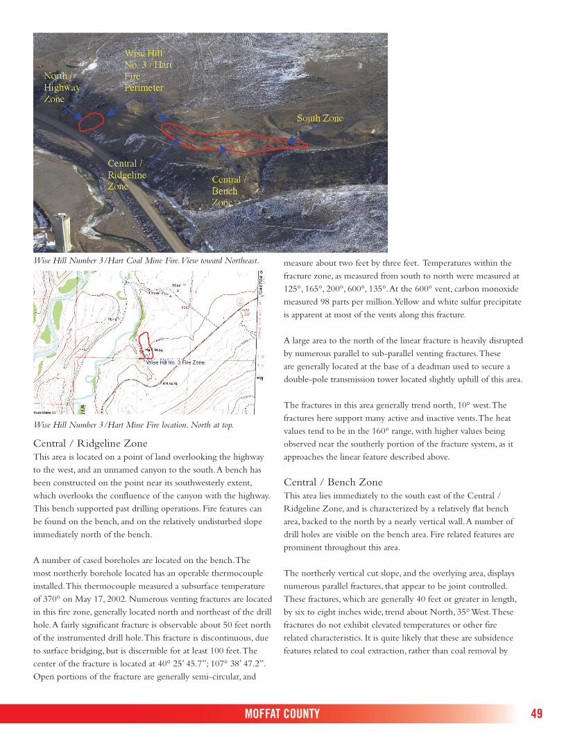
49
Wise Hill Number 3/Hart Coal Mine Fire. View toward Northeast.
Wise Hill Number 3/Hart Mine Fire location. North at top.
Central / Ridgeline ZoneThis area is located on a point of land overlooking the highway to the west, and an unnamed canyon to the south. A bench has been constructed on the point near its southwesterly extent, which overlooks the confluence of the canyon with the highway. This bench supported past drilling operations. Fire features can be found on the bench, and on the relatively undisturbed slope immediately north of the bench.
A number of cased boreholes are located on the bench. The most northerly borehole located has an operable thermocouple installed. This thermocouple measured a subsurface temperature of 370° on May 17, 2002. Numerous venting fractures are located in this fire zone, generally located north and northeast of the drill hole. A fairly significant fracture is observable about 50 feet north of the instrumented drill hole. This fracture is discontinuous, due to surface bridging, but is discernible for at least 100 feet. The center of the fracture is located at 40° 25’ 45.7”; 107° 38’ 47.2”. Open portions of the fracture are generally semi-circular, and
measure about two feet by three feet. Temperatures within the fracture zone, as measured from south to north were measured at 125°, 165°, 200°, 600°, 135°. At the 600° vent, carbon monoxide measured 98 parts per million. Yellow and white sulfur precipitate is apparent at most of the vents along this fracture.
A large area to the north of the linear fracture is heavily disrupted by numerous parallel to sub-parallel venting fractures. These are generally located at the base of a deadman used to secure a double-pole transmission tower located slightly uphill of this area.
The fractures in this area generally trend north, 10° west. The fractures here support many active and inactive vents. The heat values tend to be in the 160° range, with higher values being observed near the southerly portion of the fracture system, as it approaches the linear feature described above.
Central / Bench ZoneThis area lies immediately to the south east of the Central / Ridgeline Zone, and is characterized by a relatively flat bench area, backed to the north by a nearly vertical wall. A number of drill holes are visible on the bench area. Fire related features are prominent throughout this area.
The northerly vertical cut slope, and the overlying area, displays numerous parallel fractures, that appear to be joint controlled. These fractures, which are generally 40 feet or greater in length, by six to eight inches wide, trend about North, 35° West. These fractures do not exhibit elevated temperatures or other fire related characteristics. It is quite likely that these are subsidence features related to coal extraction, rather than coal removal by
MOFFAT COUNTY

50 STATUS OF FIRES AT ABANDONED UNDERGROUND COAL MINES IN COLORADO
combustion. If these features are connected to the underlying mine, they may become important ventilation pathways in the future as the fire approaches this portion of the abandoned mine.
Immediately adjacent to, and south of the vertical cut slope, is a bench from which at least eight boreholes were drilled. The surface expression of the fire is intermittent in this area, with only small vents observable. These vents are typically seen near the southern margin of the area, and exhibit low temperatures, generally less than 140°.
Ground surface temperatures near the eastern portion of the Central / Bench Zone have been measured in the 200° range. The bench area is well used by wintering cattle, as evidenced by an ample supply of cow manure covering the area. In June 2002, some of the manure on the bench area was smoldering in response to elevated ground surface temperatures.
Due to the fire hazard presented by the smoldering cow manure, the Division hired a contractor to scrape the manure from the Central / Bench Zone. The manure was removed from the area, soaked with water and mixed with dirt to eliminate the fire potential.
The northeastern most extent of the Central / Bench area exhibits a single vent located at 40° 25’ 40.6”, 107° 38’ 43.2”. This vent is small, measuring about four by eight inches, but exhibits temperatures measured at 525°. Oxygen emissions from the vent were measured at 11.2%, and carbon monoxide was measured at 435 parts per million.
The ground surface in the vicinity of the smoldering manure feels and sounds hollow when struck with a heavy object. This, in conjunction with the broad surface area of elevated temperatures gives the impression that the underlying fire is relatively near to the ground surface, and that it has significantly weakened the overlying rock.
South ZoneThis area is south east of the Central / Bench Zone. The area consists of a bench sloping upward toward the east, and the remnants of two mine access roads. The roads are located on a cut slope below the elevation of the sloping bench, overlooking the adjacent canyon. The southerly burn zone is characterized by a few small vents located on the sloping bench, and a large, open vent located on the upper access road remnant. The cut slope between the large open vent and the smaller bench vents exhibits numerous conchoidal fractures, many of which vent the fire.
The cut slope venting fracture area, located at 40° 25’ 37.0” 107° 38’ 42.8”, is about 40 feet in length, by about 12 feet high. The area exhibits ground surface temperatures of 125° to 160°. It is likely that the coal outcrop is involved in the fire at and near this location.
A large vent, measuring three and one half feet by two and one half feet is located on the road remnant about 25 feet due east of the slope fracture zone noted above. This vent exhausts visibly blue smoke, and is the site of significant creosote deposition. The ground temperature at the vent was measured at 225°, with oxygen content of the exhaust measured at 12.6% and carbon monoxide measured at 375 parts per million.
Significant conchoidal fracturing is observable in the road cut slope immediately south of this feature. These fractures vent combustion gasses, and exhibit temperatures of about 225°.
The large vent was backfilled by the Division of Minerals and Geology in June 2002 due to the safety hazard presented by the feature. It will be interesting to note how the adjacent fracture sets react to closure of the vent.
General Observations:There appears to be as many as four distinct burn zones. These may be discontinuous as a result of the combustion of more than one coal seam, or as a result of roof falls or other under-ground impediments.
Alternatively, the appearance of discontinuity may be the result of surface venting rather than of actual spatial separation of underground burn zones.
Portions of this fire appear to be amenable to abatement activities.
The Central / Bench and South zones easterly areas may involve combustion of near surface rider seams.
The Highway zone appears to vent a relatively deeper fire than the more southerly areas. Drill data indicates that the fire does not present a hazard to the highway.
The Central / Ridge area appears to be the hottest and most active fire zone. This area is well vented and apparently burning rather vigorously as evidenced by the significantly elevated surface temperatures.

51
Wildfire hazard is variable because of the winter use of the Central / Bench Zone by wintering cattle. The manure left behind can combust, potentially resulting in an off-site wild-fire. Other areas are generally barren of significant vegetation, resulting is a reduced fire hazard.
Public health and safety hazard of the area is moderate to high, due to the presence of elevated surface temperatures at some of the venting fractures, the potential of large vents opening, and due to apparently unstable ground at a portion of the Central / Bench Zone. An existing barbed wire fence constructed around the site ameliorates the hazard.
Wise Hill Coal (Silengo) Mine
Years Operated
Formation / Mined Seams
Strike Dip Mining Method
Total Production
1940–1970 Williams Fork / * N 30 E 8 Drift 1,232,699
* Not Reported
MOFFAT COUNTY

52 STATUS OF FIRES AT ABANDONED UNDERGROUND COAL MINES IN COLORADO
McElmo Coal Mine Fire. View toward East.
McElmo Mine Fire location. North at top.
MONTEZUMA COUNTY McElmo Coal Mine Fire
The McElmo fire is located south of Cortez in McElmo Canyon, just north of the city sewage treatment plant. The site is located about 200 yards south of the point where the sewage disposal facility access road drops into McElmo Canyon.
Rushworth, el al, 1989, indicates that the mine fire is located within the west-facing wall of McElmo Canyon. During the site visit of June 27, 2002, the entire west facing coal outcrop was inspected, as was the overlying mesa top. Very minor indications of past mining operations in this area were observed. Small quan-tities of coal were observed on the ground, and only intermittent debris was located. A portion of the overlying mesa top has been cleared of vegetation and has been graded, apparently in prepara-tion for housing or other development.
The overlying mesa top is generally composed of a Dakota Formation sandstone member. This material is well jointed, displaying parallel fractures near the canyon edge. These fractures appear to be joint controlled, rather than being subsidence related phenomena.
No indications of an underlying fire were observed either along the outcrop, or on the mesa. No sulfur deposition, creosote, or other visual evidence of an underlying fire was observed. Because venting, if present, would likely occur from the frac-tures, temperature measurements were made at various fractures. Typically, temperatures varied from 80° to 85°. No anomalous measurements were made. Interestingly, a small area overlying the site does support a somewhat increased cover of annual grasses, as compared to surrounding areas. However, the cover difference is somewhat subtle, and is not by itself considered conclusive evidence of an underlying fire.
The west side of the canyon was also evaluated, as the Division had previously closed at least two abandoned mines in that area. These closed mine entries were easily located on the outcrop. No indication of a coal fire was observed at either entry area. The mesa overlying the top of these two mines was also evaluated. Portions of this area have been heavily disturbed by land clearing operations, apparently in preparation for housing or other development. No indication of an underlying fire was observed at either the disturbed or undisturbed area; however, the degree of disturbance was significant enough that earth work activities could have effectively buried fire indicators, if any.

53
General Observations:The fire has been reported to occur on the east side of McElmo Canyon.
Few, if any, mining related artifacts were observed on the east side of the canyon.
No conclusive indications of an underlying fire were observed on the east side of the canyon.
Two closed mine entries were observed on the west side of the canyon, however no mining related features were observed on the overlying mesa.
If a fire is still burning in McElmo Canyon, it is of low intensity.
This fire may be dormant. However, subsurface data is required in order to accurately assess fire activity.
Public health and safety hazard at this site is low, due to the lack of fire related features.
Wildfire hazard is also low, again due to the apparent lack of elevated surface temperatures, lack of surface fuels and lack of fire related features.
McElmo Coal Mine
Years Operated
Formation / Mined Seams
Strike Dip Mining Method
Total Production
1914–1924 Dakota / * 4 Drift 7,124
* Not Reported
MONTEZUMA COUNTY

54 STATUS OF FIRES AT ABANDONED UNDERGROUND COAL MINES IN COLORADO
Slagle/Bright Diamond Coal Mine Fire. North to top.
Location of the Slagle/Bright Diamond Coal Mine Fire. North at top.
OURAY COUNTY Slagle/Bright Diamond Coal Mine Fire,
Ouray CountyThe Slagle Mine, also known as the Bright Diamond, had been evaluated by Rushworth et al as inactive, or dormant. As with the other coal mine fires thought to be dormant, the Slagle site was initially evaluated from the air. The aerial inspection revealed a steep hillside relatively barren of snow cover, while surrounding areas held snow. Generally, this pattern is a good indicator of underlying heat; however, a southerly aspect on a steep, dark colored slope can also display the same pattern.
The Slagle has been documented to be burning between 1939 and 1954. The U. S. Bureau of Mines constructed a surface seal over the fire by placing approximately eight feet of dirt over the fire area in 1954 (Shellenberger, date unknown).
An attempt to visit the site was made in the fall of 2003. The landowner was contacted by phone, and indicated that he has observed smoke and steam issuing from the ground surface for some period of time. Unfortunately, the landowner did not allow access to the site at that time, so an on-site evaluation of the Slagle Mine has not been made. However, given the aerial obser-vations, and the landowner account of smoke and steam issuing from the site, the Slagle Mine is classified as an active fire.
Years Operated
Formation / Mined Seams
Strike Dip Mining Method
Total Production
1931–1938 Mesaverde / * Unknown Unknown Drift 1,443
* Not Reported