Gulf of the Farallones National Marine - Microsoft · of outflow from San Francisco Bay and...
100
August 2010 Gulf of the Farallones CONDITION REPORT 2010 National Marine Sanctuary Office of National Marine Sanctuaries National Oceanic and Atmospheric Administration
Transcript of Gulf of the Farallones National Marine - Microsoft · of outflow from San Francisco Bay and...

August 2010
Gulf of the FarallonesCONDITION REPORT 2010
National Marine Sanctuary
Office of National Marine SanctuariesNational Oceanic and Atmospheric Administration
U.S. Department of CommerceGary Locke, Secretary
National Oceanic and Atmospheric AdministrationJane Lubchenco, Ph.D., Administrator Under Secretary of Commerce for Oceans and Atmosphere
National Ocean ServiceDavid M. Kennedy, Acting Assistant Administrator
Office of National Marine SanctuariesDaniel J. Basta, Director
National Oceanic and Atmospheric AdministrationOffice of National Marine Sanctuaries SSMC4, N/ORM621305 East-West HighwaySilver Spring, MD 20910301-713-3125http://sanctuaries.noaa.gov
Gulf of the Farallones National Marine Sanctuary991 Marine Dr., The PresidioSan Francisco, CA 94129415-561-6622http://farallones.noaa.gov
Report Preparers:
Gulf of the Farallones National Marine Sanctuary:Jan Roletto
Office of National Marine Sanctuaries:Kathy Broughton, Stephen R. Gittings
Office of National Marine Sanctuaries West Coast Regional Office:Robert Schwemmer
Clancy Environmental Consultants, Inc.Karen Fox
Copy Editor: Matt Dozier, NOAA ONMS
Layout: Matt McIntosh, NOAA ONMS
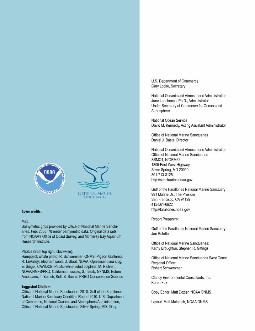
Cover credits:
Map: Bathymetric grids provided by Office of National Marine Sanctu-aries. Feb. 2003. 70 meter bathymetric data. Original data sets from NOAA’s Office of Coast Survey, and Monterey Bay Aquarium Research Institute.
Photos (from top right, clockwise):Humpback whale photo, R. Schwemmer, ONMS; Pigeon Guillemot, R. LeValley; Elephant seals, J. Stout, NOAA; Opalescent sea slug, E. Siegel, CAWQCB; Pacific white-sided dolphins, M. Richlen, NOAA/NMFS/PRD; California mussels, S. Tezak, GFNMS; Estero Americano, T. Yarrish; Krill, B. Saenz, PRBO Conservation Science
Suggested Citation:Office of National Marine Sanctuaries. 2010. Gulf of the Farallones National Marine Sanctuary Condition Report 2010. U.S. Department of Commerce, National Oceanic and Atmospheric Administration, Office of National Marine Sanctuaries, Silver Spring, MD. 97 pp.

1
About This Report ........................................................................................................2Summary and Findings ................................................................................................2National Marine Sanctuary System and System-Wide Monitoring ..............................3Coastal and Offshore Environment Condition Summary Table ....................................5Estuarine and Lagoon Environment Condition Summary Table ...................................8Site History and Resources.........................................................................................11
Overview .......................................................................................................................11Regional Cultural History ..............................................................................................12Designation of the Sanctuary........................................................................................14Geology ........................................................................................................................14Water ............................................................................................................................15Habitat ..........................................................................................................................15Living Resources ..........................................................................................................16Maritime Archaeological Resources .............................................................................21
Pressures on the Sanctuary ........................................................................................22Vessel Traffic ................................................................................................................22Marine Debris ...............................................................................................................23Dredged Material ..........................................................................................................24Radioactive Waste ........................................................................................................25Non-Indigenous Species...............................................................................................25Fishing ..........................................................................................................................26Nonpoint Source Pollution ............................................................................................26Wildlife Disturbance ......................................................................................................27
State of Sanctuary Resources: Coastal and Offshore Environment ............................29Water Quality ................................................................................................................29Habitat ..........................................................................................................................32Living Resources ..........................................................................................................38Maritime Archaeological Resources .............................................................................46
State of Sanctuary Resources: Estuarine and Lagoon Environment ...........................49Water Quality ................................................................................................................49Habitat ..........................................................................................................................52Living Resources ..........................................................................................................55Maritime Archaeological Resources .............................................................................58
Response to Pressures ...............................................................................................60Jurisdictional Authorities of the Sanctuary ....................................................................60Vessel Traffic ................................................................................................................62Marine Debris ...............................................................................................................63Dredged Material ..........................................................................................................64Radioactive Waste ........................................................................................................65Non-Indigenous Species...............................................................................................65Fishing ..........................................................................................................................66Nonpoint Source Pollution ............................................................................................66Wildlife Disturbance ......................................................................................................67Maritime Archaeological Resources .............................................................................69
Concluding Remarks ..................................................................................................70Acknowledgements ....................................................................................................71Cited Resources..........................................................................................................72Additional Resources .................................................................................................82Appendix A: Rating Scheme for System-Wide Monitoring Questions ........................84Appendix B: Consultation with Experts and Document Review .................................94
Table of Contents

Gulf of the Farallones National Marine Sanctuary
2 Gulf of the Farallones CONDITION REPORT 2010
About this Report This “condition report” provides a summary of resources in the Na-
tional Oceanic and Atmospheric Administration’s Gulf of the Farallones National Marine Sanctuary (sanctuary), pressures on those resources, current conditions and trends, and management responses to the pres-sures that threaten the integrity of the marine environment. Specifically, the document includes information on the status and trends of water quality, habitat, living resources and maritime archaeological resources, and the human activities that affect them. It presents responses to a set of questions posed to all sanctuaries (Appendix A). Resource status of Gulf of the Farallones is rated on a scale from good to poor, and the timelines used for comparison vary from topic to topic. Trends in the sta-tus of resources are also reported, and are generally based on observed changes in status over the past five years, unless otherwise specified.
Sanctuary staff consulted with a group of outside experts familiar with the resources and with knowledge of previous and current scien-tific investigations in the sanctuary. Evaluations of status and trends are based on interpretation of quantitative and, when necessary, non-quantitative assessments, and the observations of scientists, managers and users. The ratings reflect the collective interpretation of the status of local issues of concern among sanctuary program staff and outside experts based on their knowledge and perception of local problems. The final ratings were determined by sanctuary staff. This report has been peer reviewed and complies with the White House Office of Man-agement and Budget’s peer review standards as outlined in the Final Information Quality Bulletin for Peer Review.
This is the first attempt to comprehensively describe the status, pressures and trends of resources at Gulf of the Farallones National Marine Sanctuary. Additionally, the report helps identify gaps in current monitoring efforts, as well as causal factors that may require monitoring and potential remediation in the years to come. The data discussed will enable us to not only acknowledge prior changes in resource status, but will provide guidance for future management challenges.
Summary and FindingsLocated off the Central California coast and encompassing 966
square nautical miles, Gulf of the Farallones National Marine Sanc-tuary protects a diversity of highly productive marine habitats and supports an abundance of species. It is a complex system of bays, estuaries, mudflats, marsh and intertidal, coastal and oceanic wa-ters, and is influenced by the highly urbanized San Francisco Bay area populated by nearly 8 million people. The sanctuary has one of the world’s most significant populations of white sharks, in addition to one of the largest concentrations of breeding seabirds. It is a destina-tion feeding ground for endangered blue and humpback whales, and is one of the most important areas along the West Coast for marine commerce such as fishing, shipping, whale watching and tourism.
Because of the considerable differences in environmental pres-sures and responses between the coastal/offshore and estuarine/lagoon zones, this document addresses status and trends to repre-sent these two environment types separately. The following is a brief summary of findings for each zone.
Coastal and Offshore EnvironmentBased on available data and observations, overall, the
resources of the sanctuary’s outer coastal and offshore areas appear to be in relatively good condition. However, water qual-ity parameters are of some concern, primarily due to impacts of outflow from San Francisco Bay and agricultural runoff from surrounding rural areas. Little is known about the eutrophic con-ditions of the sanctuary; however, new data may reveal improv-ing water quality. Pressures that threaten the integrity of coastal and offshore habitat include trampling, extraction along the in-tertidal areas, and bottom trawling, yet overall the outer coast and offshore habitats are improving due to increased manage-ment actions. Living resources have experienced some loss of biodiversity and increased extraction: however, the sanctuary is
Gulf of the Farallones National Marine Sanctuary
• 1,279squarestatutemiles(966squarenauticalmiles)encompassingrichanddiversemarinelife• Congressionallydesignatedin1981asanationalmarinesanctuary• Includesbays,estuaries,coastalandoceanicwaters• LargestconcentrationofbreedingseabirdsinthecontiguousUnitedStates• HometooneofthelargestconcentrationsofadultwhitesharksintheworldaroundtheFarallonIslands• Adestinationfeedinggroundforendangeredblueandhumpbackwhales

Gulf of the Farallones National Marine Sanctuary
3CONDITION REPORT 2010 Gulf of the Farallones
one of the few places in the world where endangered blue and humpback whale populations are increasing. Information gaps exist for maritime archaeological resources. Based on available information, there may be some threats to maritime archaeologi-cal resources that could reduce their historical, scientific or edu-cational value and may affect eligibility for listing in the National Register of Historic Places.
Estuarine and Lagoon EnvironmentOverall, resources of the sanctuary’s estuarine and lagoon
areas appear to be in good/fair to fair/poor condition. Land use pressures have caused changes to sediment and freshwater regimes. However, water quality may possibly improve due to implementation of best management practices, cleanup of min-ing pollutants, and removal of derelict vessels. Pressures on habitat that have caused key habitat loss or alteration include decades of poor watershed practices resulting in water diver-sion, in-flow of heavy metals from abandoned mines, pollutants from dairy ranches, and increased sedimentation resulting in loss of ecologically important eelgrass beds (a key species of the sanctuary). Living resources have experienced a loss of biodiversity, causing declines in some, but not all, ecosystem components. Non-indigenous species are a threat to the health of the sanctuary, but while most of these 143 species are located in the estuarine and lagoon environment, there is little data on their abundance and distribution. Little is known about the integ-rity of maritime archaeological resources in the estuarine and lagoon zone; however, based on available information, there are no known threats at this time. More data collection and targeted data analyses are needed for determining status and trends in water quality, living resources (particularly non-indigenous spe-cies), and especially maritime archaeological resources. More information is also needed regarding the effects that restoration actions have had on sanctuary resources.
In November 2008, the sanctuary completed a final draft of its newest management plan. This plan was developed as a joint plan in conjunction with the contiguous Cordell Bank and Monterey Bay sanctuaries. The new management plan considers the ecological linkages and uses ecosystem based-management actions to pro-tect the sanctuary from human pressures including vessel traffic, marine debris, radioactive waste, dredged material, non-indigenous species, activities from fishing, nonpoint source pollution, and wildlife disturbance. The plan outlines strategies to fill data gaps through monitoring water quality, eutrophic conditions, key species and habitats, and conducting complete site characterization. Moni-toring will be increased to identify areas of ecological significance,
National Marine Sanctuary System and System-Wide Monitoring
The Office of National Marine Sanctuaries manages marine areas in both nearshore and open ocean waters that range in size from less than one to almost 140,000 square miles. Each area has its own concerns and requirements for environmental monitoring. Nevertheless, ecosys-tem structure and function in all these areas have similarities and are influenced by common factors that interact in comparable ways. Fur-thermore, the human influences that affect the structure and function of these sites are similar in a number of ways. For these reasons, in 2001 the program began to implement System-Wide Monitoring. The moni-toring framework (NMSP 2004) facilitates the development of effective, ecosystem-based monitoring programs that address management infor-mation needs using a design process that can be applied in a consistent way at multiple spatial scales and to multiple resource types. It identifies four primary components common among marine ecosystems: water, habitats, living resources, and maritime archaeological resources.
By assuming that a common marine ecosystem framework can be applied to all places, the Office of National Marine Sanctuaries developed a series of questions that are posed to every sanctuary and used as evaluation criteria to assess resource condition and trends. The questions, which are shown on the following page and explained in Appendix A, are derived from both a generalized eco-system framework and from the Office of National Marine Sanctuar-
In addition to the area within the boundaries of thesanctuary,theGulfoftheFarallonessanctuaryisalsoresponsibleforadministrationandmanagementofthenorthernareaoftheMontereyBaysanctuaryextendingfromtheSanMateo-SantaCruzcountylinenorthwardtotheexistingboundarybetweenthetwosanctuaries.SomeareasoftheGulfoftheFarallonessanctuaryareinfluencedbyconditionsandfeatureswithinthenorth-ernportionoftheMontereyBaysanctuary;therefore,thisdocumentconsiders these influenceswhendeter-mining the statusof thewaterquality,habitat, livingandmaritimearchaeologicalresourceswithintheGulfoftheFarallonessanctuary.
areas of highest and most persistent biological densities and ar-eas of greatest productivity, effectiveness of marine zones, early detection of non-indigenous species, and detection of wildlife dis-turbance. Increased stewardship is also planned to help decrease disturbance events.

Gulf of the Farallones National Marine Sanctuary
4 Gulf of the Farallones CONDITION REPORT 2010
Sou
rce:
ON
MS
The Gulf of the Farallones National Marine Sanctuary protects the wildlife and habitats of one of the most diverse and bountiful marine environments in the world, an area of 966 square miles off the northern and central California coast. Located just a few miles from San Francisco, the waters within Gulf of the Farallones National Marine Sanctuary are part of a nationally significant marine ecosystem. Encompassing a diversity of highly productive marine habitats, the sanctuary supports an abundance of life, including many threatened or endangered species.
ies mission. They are widely applicable across the system of areas managed by the sanctuary program and provide a tool with which the program can measure its progress toward maintaining and improving natural and archaeological resource quality throughout the system.
Similar reports summarizing resource status and trends will be prepared for each marine sanctuary approximately every five years
and updated as new information allows. Although this report follows a new Gulf of the Farallones management plan, the information is intended to help set the stage for management plan reviews at each site. The report also helps sanctuary staff identify monitoring, characterization and research priorities to address gaps, day-to-day information needs and new threats.

Gulf of the Farallones National Marine Sanctuary
5CONDITION REPORT 2010 Gulf of the Farallones
Coastal and Offshore Environment
The following table summarizes the “State of Sanctuary Resourc-es” section of this report. The first column lists 17 questions used to rate the condition and trends for qualities of water, habitat, living re-sources and maritime archaeological resources. The Rating column consists of a color, indicating resource condition, and a symbol, indi-cating trend (see key for definitions). The Basis for Judgment column provides a short statement or list of criteria used to justify the rating. The Description of Findings column presents the statement that best characterizes resource status, and corresponds to the assigned color rating. The Description of Findings statements are customized for all possible ratings for each question. Please see Appendix A for further clarification of the questions and the Description of Findings state-ments. The Response column provides a summary of existing and proposed responses to pressures on marine resources of the Gulf
# Questions/Resources Rating Basis for Judgment Description of Findings Sanctuary Response
WATER
1Are specific or multiple stressors, including changing oceanograph-ic and atmospheric conditions, affecting water quality?
–
Decreased oil pollution, decreased sediment spills from barges, few harmful algal blooms, continued nonpoint source dis-charges from San Francisco Bay and Russian River, and coastal 303(d) listings.
Selected conditions may preclude full development of living resource assemblages and habitats, but are not likely to cause substantial or persistent declines.
Regulations and enforcement prohibit, detect and prosecute illegal dumping and discharge of substances, with the exception of deck wash and fish parts related to commercial fishing activities. Several new regulations went into effect in 2009 for increased protection from discharges, including discharges initiating from outside the sanctuary boundary that may cause injury, discharge of introduced species from ballast water, and discharge from cruise ships. Increased sampling is planned to detect harmful algal blooms. Increased access to data sets of oil pollution and resources at risk. Complete site habitat characterization for improved identification of resources at risk, damage assessment protocols, restoration planning, and improved understanding of sediment transport. Develop research to assess extent and trend of accumulated pollutants through the food chain and commercial fish. Work with USGS and other Central & Northern California Ocean Observing System (CeNCOOS) partners for ad-ditional modeling of processes and fate of sedimentation and pollutants. Out-reach and education programs improve stewardship of marine resources.
2What is the eutrophic condition of sanctuary waters and how is it changing?
?No obvious problems, healthy phytoplankton constituents; only 15 years of monitoring for phyto-plankton so trend undetermined.
Conditions do not appear to have the potential to negatively affect living resources or habitat quality.
3 Do sanctuary waters pose risks to human health? –
Coastal 303(d) listings for discharges and beach closures; offshore dilution.
Selected conditions that have the potential to affect human health may exist, but human impacts have not been reported.
4What are the levels of human activities that may influence water quality and how are they changing?
p
Increasing vessel traffic (dis-charges and noise) and increas-ing urbanization are of concern, but decrease in acute and chronic oil pollution, decreasing sediment discharge; increasing manage-ment and enforcement actions.
Selected activities have resulted in measurable resource impacts, but evi-dence suggests effects are localized, not widespread.
of the Farallones National Marine Sanctuary. Because of the consid-erable differences within the sanctuary between the environmental pressures and responses affecting the coastal and offshore zone and the estuarine and lagoon zone, this document breaks out status and trends to represent these two regions. The below table reflects the state of the coastal and offshore environment of the sanctuary. Note that the impacts from the Cosco Busan oil spill in November 2007 are in process of being evaluated and are not part of this assessment.
Status: Good Good/Fair Fair Fair/Poor Poor Undet.
Trends: Conditions appear to be improving ................................ p Conditions do not appear to be changing ...................... – Conditions appear to be declining ................................. q Undetermined trend. ...................................................... ? Question not applicable ................................................. N/A
Table is continued on the following page.
Gulf of the Farallones National Marine Sanctuary Condition Summary Table

Gulf of the Farallones National Marine Sanctuary
6 Gulf of the Farallones CONDITION REPORT 2010
Table is continued on the following page.
Gulf of the Farallones National Marine Sanctuary Condition Summary TableCoastal and Offshore Environment (Continued)
# Questions/Resources Rating Basis for Judgment Description of Findings Sanctuary Response
HABITAT
5What are the abundance and distribution of major habitat types and how are they changing?
p
Some benthic habitat loss from localized pressures related to in-creased human activities, reduced trawling impacts and improved enforcement of dredge disposal practices.
Selected habitat loss or alteration has taken place, precluding full develop-ment of living resource assemblages, but it is unlikely to cause substantial or persistent degradation in living resources or water quality.
Regulations prohibit disturbance of the seabed, including placement of rip-rap, laying of cables and pipelines, or construction on the seabed. Outreach and education programs improve stewardship of marine resources. Increased monitoring of priority habitats such as rocky inter-tidal communities. Plans to increase integration of data sets for improved site characterization including benthic mapping, oceanographic features, ecological linkages, and to determine if further assessment of the radioac-tive waste dump site is warranted. Convert archived photos document-ing beach erosion to digital format.
6What is the condition of biologi-cally structured habitats and how is it changing?
?Prior alteration and loss due to trawling; substantial data gaps for a number of habitat types, including drift algae and beach wrack.
Selected habitat loss or alteration has taken place, precluding full development of living resources, but it is unlikely to cause substantial or persistent degrada-tion in living resources or water quality.
7What are the contaminant con-centrations in sanctuary habitats and how are they changing?
pNew but limited data indicates re-duction of persistent contaminants and no obvious problems.
N/A
8What are the levels of human activities that may influence habitat quality and how are they changing?
–
Activities relating to increased urbanization, visitation and shipping; decrease in trawling and chronic oil pollution, cessation of discharging of radioactive waste, increased regula-tions to prevent introduced species.
Some potentially harmful activities ex-ist, but they do not appear to have had a negative effect on habitat quality.
LIVING RESOURCES
9 What is the status of biodiversity and how is it changing? –
Changes in relative abundance, particularly in targeted, by-catch, and sensitive species (e.g., Steller sea lions, northern fur seals, sea-birds, rockfish and sea otters).
Selected biodiversity loss has taken place, precluding full community devel-opment and function, but it is unlikely to cause substantial or persistent degradation of ecosystem integrity.
Current regulations prohibit distur-bance to seabird and pinniped colo-nies and to white sharks. Increased monitoring to detect persistent and ephemeral areas of ecological significance and trends. Sampling for planktonic, non-indigenous species is planned. Partnership with NOAA National Marine Fisheries Service to assess acoustic levels within the region. Increased vigilance for ecological hotspots, non-point source pollution and persistent pollutants within the benthic habitats. Species inventory and mapping the abun-dance and distribution of introduced species will occur within the next five years. Increased sampling is planned to determine trend in prey-base biomass. Increased monitoring of key species such as seabirds, marine mammals and prey species. Work with USGS and other CeNCOOS partners for additional modeling of chemical, biological, and physical processes. Plans to increase integra-tion of data sets for improved site characterization including benthic mapping, oceanographic features and ecological linkages. Outreach and education programs improve steward-ship of marine resources and prevent disturbance and illegal extraction of living resources.
10What is the status of environ-mentally sustainable fishing and how is it changing?
pHistorical fishing impacts; recent improvements in some populations due to take reductions.
Extraction may inhibit full community development and function, and may cause measurable but not severe degradation of ecosystem integrity.
11What is the status of non-indigenous species and how is it changing?
–
Non-indigenous species are pres-ent (e.g. green crabs, plankton and striped bass), but there are no known ecosystem impacts; monitoring is required.
Non-indigenous species are not suspected or do not appear to affect ecosystem integrity (full community development and function).
12 What is the status of key species and how is it changing? ?
Among sanctuary’s list of 49 key species, populations are in vary-ing states of integrity.
The reduced abundance of selected keystone species may inhibit full com-munity development and function, and may cause measurable but not severe degradation of ecosystem integrity; or selected key species are at reduced levels, but recovery is possible.
13What is the condition or health of key species and how is it changing?
p
Underweight gray whales; reduced Steller sea lion health and pupping rates; removal of oil from S/S Jacob Luckenbach has reduced seabird and marine mammal oiling incidents.
The condition of selected key resources is not optimal, perhaps precluding full ecological function, but substantial or persistent declines are not expected.
14What are the levels of human activities that may influence liv-ing resource quality and how are they changing?
–
Impacts from human population in-creases, urbanization and increased use of coastal areas. Increasing vessel traffic (discharges and noise) and increased documented dis-turbances to seabirds and marine mammals are of concern, perhaps offset by reductions in trawling and fishing pressure, and establishment of new marine zones.
Selected activities have resulted in measurable living resource impacts, but evidence suggests effects are localized, not widespread.

Gulf of the Farallones National Marine Sanctuary
7CONDITION REPORT 2010 Gulf of the Farallones
# Questions/Resources Rating Basis for Judgment Description of Findings Sanctuary Response
MARITIME ARCHAEOLOGICAL RESOURCES
15What is the integrity of known maritime archaeological re-sources and how is it changing?
?
Sanctuary inventory contains information on known vessel losses; archaeological survey and monitoring needs to be conducted to determine status and trend.
N/A
Regulations prohibit disturbance or removal of archaeological resources. Increased outreach to improve awareness of cultural resources and prevent illegal removal of archaeo-logical resources.
16Do known maritime archaeo-logical resources pose an environmental hazard and how is this threat changing?
qDeterioration of offshore wrecks could result in the release of hazardous cargo or bunker fuel.
Selected maritime archaeological resources may cause measurable, but not severe, impacts to certain sanctu-ary resources or areas, but recovery is possible.
17
What are the levels of human activities that may influence maritime archaeological resource quality and how are they changing?
?
Trawling, anchoring or dragging of anchors, diving; lack of monitoring to determine trend; regulations to prohibit trawling in some areas; regulations to prohibit laying of cables.
Some potentially relevant activities exist, but they do not appear to have had a negative effect on maritime archaeological resource integrity.
Gulf of the Farallones National Marine Sanctuary Condition Summary TableCoastal and Offshore Environment (Continued)

Gulf of the Farallones National Marine Sanctuary
8 Gulf of the Farallones CONDITION REPORT 2010
Estuarine and Lagoon Environment
The following table summarizes the “State of Sanctuary Resources” section of this report. The first column lists 17 questions used to rate the condition and trends for qualities of water, habitat, living resources, and maritime archaeological resources. The Rating column consists of a color, indicating resource condition, and a symbol, indicating trend (see key for definitions). The Basis for Judgment column provides a short statement or list of criteria used to justify the rating. The Descrip-tion of Findings column presents the statement that best characterizes resource status, and corresponds to the assigned color rating. The Description of Findings statements are customized for all possible rat-ings for each question. Please see Appendix A for further clarification
# Questions/Resources Rating Basis for Judgment Description of Findings Sanctuary Response
WATER
1
Are specific or multiple stressors, including chang-ing oceanographic and atmospheric conditions, affecting water quality?
?
Land use pressures have caused changes to sediment and freshwater regimes; increased restoration activities and best management practices may offset water quality problems that have historically resulted in loss of eelgrass beds.
Selected conditions may inhibit the development of assemblag-es, and may cause measurable but not severe declines in living resources and habitats.
Regulations and enforcement prohibit, detect and prosecute illegal dumping and discharge of substances, with the exception of deck wash and fish parts related to commercial fishing activities. Increased sampling is planned to detect harmful algal blooms. New regulations prohibit anchoring a vessel in designated seagrass zones in Tomales Bay. Wetland restoration is planned for Tomales Bay and Bolinas Lagoon, including reduction of upland practices causing sedimenta-tion, increased runoff and fresh water diversion. Update characterization of Esteros Americano and de San Antonio is planned, including better understand-ing of sediment transport. Develop monitoring to assess extent and trend of accumulated pollutants through the food chain and commercial fish. Outreach and education programs are planned to in-crease stewardship of marine resources and prevent non-point source pollution. Need improved control and understand-ing of introduced species.
2What is the eutrophic condi-tion of sanctuary waters and how is it changing?
?
High levels of nutrient input have caused eutrophication, severe oxygen depletion, and shellfish contamination in the Tomales Bay watershed. However, there have not been associated problems or reported loss of fish populations.
Selected conditions may preclude full development of living resource assemblages and habitats, but are not likely to cause substantial or persistent declines.
3 Do sanctuary waters pose risks to human health? ?
Nonpoint source contamination has resulted in aquaculture and shellfish closures in Tomales Bay; two Norovirus outbreaks in Tomales Bay. Best management practices have been implemented and further studies are required to determine their success.
Selected conditions have caused or are likely to cause severe impacts, but cases to date have not suggested a pervasive problem.
4What are the levels of human activities that may influence water quality and how are they changing?
p
Land use pressures have caused changes to sediment and freshwater regimes; loss of ee-lgrass beds; increased restoration activities, increased regulations, and best management practices may allow for improvements.
Selected activities have caused or are likely to cause severe impacts, and cases to date sug-gest a pervasive problem.
of the questions and the Description of Findings statements. Because of the considerable differences within the sanctuary between the envi-ronmental pressures and responses affecting the coastal and offshore zone and the estuarine and lagoon zone, this document breaks out sta-tus and trends to represent these two regions. The below table reflects the state of the estuarine and lagoon environment of the sanctuary.
Status: Good Good/Fair Fair Fair/Poor Poor Undet.
Trends: Conditions appear to be improving ................................ p Conditions do not appear to be changing ...................... – Conditions appear to be declining ................................. q Undetermined trend. ...................................................... ? Question not applicable ................................................. N/A
Table is continued on the following page.
Gulf of the Farallones National Marine Sanctuary Condition Summary Table

Gulf of the Farallones National Marine Sanctuary
9CONDITION REPORT 2010 Gulf of the Farallones
# Questions/Resources Rating Basis for Judgment Description of Findings Sanctuary Response
HABITAT
5What are the abundance and distribution of major habitat types and how are they changing?
– Habitat loss due to erosion, habitat conversion, and sedimentation.
Selected habitat loss or alteration has caused or is likely to cause severe declines in some but not all living resources or water quality.
Regulations prohibit disturbance of the seabed, including placement of rip-rap, laying of cables and pipe-lines, or construction on the seabed. New regulations prohibit anchoring a vessel in designated seagrass protection zones in Tomales Bay. New regulations for increased protection from discharges initiating from outside the sanctuary boundary that may cause injury and to prevent discharge of introduced species from ballast water. Wetland restoration is planned for Tomales Bay and Boli-nas Lagoon, including reduction of upland practices causing sedimenta-tion, increased runoff and fresh water diversion. Update characterization of Esteros Americano and de San Antonio is planned, including better understanding of sediment transport. Assess impacts from boat-works operation on Tomales Bay. Outreach and education programs improve stewardship of marine resources.
6What is the condition of bio-logically structured habitats and how is it changing?
q
Loss of eelgrass in Bolinas Lagoon due to watershed issues causing sedimentation and elevation of mudflats. Loss of native oyster beds in Tomales Bay due to sedimentation, roadside maintenance activities, anchoring and mooring.
Selected habitat loss or alteration may inhibit the development of living resources, and may cause measurable but not severe declines in living resources or water quality.
7What are the contaminant concentrations in sanctuary habitats and how are they changing?
?Limited data, though bird studies in other estua-rine areas strongly suggest the need for increased monitoring.
N/A
8What are the levels of hu-man activities that may in-fluence habitat quality and how are they changing?
–
Impacts from continued land use, urbaniza-tion, erosion, pollutants from closed mines, and vessel activities may be offset by reduced mining activities, restoration activities and new regulations.
Selected activities have resulted in measurable habitat impacts, but evidence suggests effects are localized, not widespread.
LIVING RESOURCES
9What is the status of biodiversity and how is it changing?
q Species diversity changes due to eelgrass loss in Bolinas Lagoon and invasive species.
Selected biodiversity loss has caused or is likely to cause severe declines in some but not all ecosystem components and reduce ecosystem integrity.
Regulations prohibit disturbance to seabird and pinniped colonies. Increased monitoring is planned to detect persistent and ephemeral ecological hotspots and trends. New regulations prevent impacts to eelgrass beds. Wetland restora-tion is planned for Tomales Bay and Bolinas Lagoon, including reduction of upland practices causing sedimentation, increased runoff and fresh water diver-sion. Characterization of Esteros Americano and de San Antonio is planned. Habitat characterization will occur within the next five years. New regulations for increased protection from discharges initiating from outside the sanctu-ary boundary that may cause injury and to prevent discharge of introduced species from ballast water. Sampling for planktonic and intertidal non-indigenous species is planned Increased vigilance of eco-logical hotspots, non-point source pollution and persistent pollutants within the benthic habitats. Species inventory will occur within the next five years. Outreach and education programs improve stewardship of marine resources.
10What is the status of environmentally sustain-able fishing and how is it changing?
– Minimal extraction.Extraction does not appear to affect ecosystem integrity (full community development and function).
11What is the status of non-indigenous species and how is it changing?
?
High numbers of invasive species including European green crabs, Japanese mud snails and smooth cordgrass. Limited data are avail-able on the density or geographic extent of most non-indigenous species.
Non-indigenous species have caused or are likely to cause severe declines in some but not all ecosystem components and reduce ecosystem integrity.
12What is the status of key species and how is it changing?
q
Keystone and some key species are at reduced levels; eelgrass decline in Bolinas Lagoon is likely to diminish recovery potential; abundance of the tidewater goby has declined substantially due to habitat loss and degradation; brant populations had been on the decline and are now increasing, but recovery is slow.
The reduced abundance of select-ed keystone species may inhibit full community development and function, and may cause measur-able but not severe degradation of ecosystem integrity; or selected key species are at reduced levels, but recovery is possible.
13What is the condition or health of key species and how is it changing?
?Insufficient data. Some fish have high mercury levels; it is unknown how this may impact fish populations. Disturbance to harbor seals may impact their health.
N/A
14
What are the levels of human activities that may influence living resource quality and how are they changing?
q
Impacts resulting from urbanization, changing uses that affect watersheds, and wildlife distur-bance caused by visitor activities; manage-ment activities to increase monitoring of and outreach about introduced species are needed; restoration planning needs to be implemented in Bolinas Lagoon and completed for vessel activities in Tomales Bay.
Selected activities have caused or are likely to cause severe im-pacts, and cases to date suggest a pervasive problem.
Gulf of the Farallones National Marine Sanctuary Condition Summary TableEstuarine and Lagoon Environment (Continued)
Table is continued on the following page.

Gulf of the Farallones National Marine Sanctuary
10 Gulf of the Farallones CONDITION REPORT 2010
# Questions/Resources Rating Basis for Judgment Description of Findings Sanctuary Response
MARITIME ARCHAEOLOGICAL RESOURCES
15What is the integrity of known maritime archaeo-logical resources and how is it changing?
? No wreck sites have been visited or investigated. N/A
Regulations prohibit disturbance or removal of archaeological resources. Increased outreach to improve awareness of cultural re-sources and prevent illegal removal of archaeological resources.
16
Do known maritime archaeological resources pose an environmental hazard and is this threat changing?
– Unlikely that the wrecks (mostly wooden schoo-ners) contain hazardous cargo.
Selected maritime archaeological resources may pose isolated or limited environmental threats, but substantial or persistent impacts are not expected.
17
What are the levels of human activities that may influence maritime archaeo-logical resource quality and how are they changing?
?Bottom fishing, aquaculture and habitat and living resource restoration activities could affect resources.
Some potentially relevant activi-ties exist, but they do not appear to have had a negative effect on maritime archaeological resource integrity.
Gulf of the Farallones National Marine Sanctuary Condition Summary TableEstuarine and Lagoon Environment (Continued)

Site History and Resources
11CONDITION REPORT 2010 Gulf of the Farallones
Gulf of the Farallones National Marine Sanctuary protects an area of 1,279 square statute miles (966 square nautical miles) off the north-central California coast. The sanctuary was designated in 1981 because of its national significance as an area that encom-passes a diversity of highly productive marine habitats and supports an abundance of species. The sanctuary is administered by
the National Oceanic and Atmospheric Administration (NOAA), within the Department of Commerce.
Site History and Resources
Figure 1. Computer imagery shows the topography of the seafloor of Gulf of the Farallones National Marine Sanctuary and the steep drop-off of the continental slope west of the Faral-lon Islands.
Imag
e: U
SG
S W
oods
Hol
e
The Gulf of the Farallones sanctuary comprises a wide spec-trum of marine habitats including sandy beaches, estuaries, rocky intertidal zones, and deep-ocean environments. The sanctuary is marked by a gently sloping seafloor extending for nearly 35 miles (30 nautical miles) from the mainland before dropping off steeply at the Farallon Escarpment beyond the Farallon Islands, and lies within the widest portion of the continental shelf along the California coast (Figure 1).
The Farallon Islands (Figure 2) are located in the south-central part of the sanctuary, 27 miles west of the Golden Gate Bridge. The islands are a national wildlife refuge administered by the U.S. Fish and Wildlife Service. They offer resting and breeding sites for pin-nipeds and seabirds that are lured to the region by waters rich in
plankton and fish. The sanctuary is home to thousands of seals and sea lions, and the largest concentration of breeding seabirds in the contiguous United States.
Several coastal embayments including Bolinas Lagoon, Bodega Bay, Drakes Bay, Estero Americano, Estero de San Antonio and Tomales Bay (Figure 3) are located within the Gulf of the Farallones sanctuary. Bolinas Bay, Drakes Bay, Tomales Bay and Bodega Bay are open to the ocean, but are somewhat protected from prevailing southward moving coastal currents by Duxbury Point, Point Reyes Headlands and Bodega Head, respectively, and are important plank-ton retention areas. Tomales Bay and Bolinas Lagoon, which occupy valleys directly on the San Andreas Fault, have been designated by the United Nations as “Wetlands of International Significance.”
Figure 2. A view of the sanctuary from the Farallon National Wildlife Refuge.
Pho
to: J
. Hal
l, G
FNM
S
Figure 3. The wetlands of the sanctuary, like Es-tero Americano, stretch up to nine miles inshore and provide important habitat for birds on the Pacific flyway.
Pho
to: T
. Yar
rish
04080120160200

Site History and Resources
12 Gulf of the Farallones CONDITION REPORT 2010
The shoreline along the mainland coast is characterized by sandy beaches and rocky cliffs.
In addition to the area within the boundaries of the sanctuary, the Gulf of the Farallones sanctuary is responsible for administration and management of the northern area of the Monterey Bay sanctuary extending from the San Mateo/Santa Cruz county line northward to the existing boundary between the two sanctuaries (Figure 4). Some areas of the Gulf of the Farallones sanctuary are influenced by con-ditions and features within the northern portion of the Monterey Bay sanctuary; therefore, this document considers these influences when determining the status of the water quality, habitat, living resources and maritime archaeological resources within the Gulf of the Faral-lones sanctuary.
Regional Cultural HistoryDuring the Pleistocene/Holocene Epoch, about 11,000 years ago,
the Central California coast was inhabited by the Paleo-Indian peo-ple at coastal sites that have long since been inundated by rising sea level. By about 8,000 years ago, the Archaic cultural shift occurred in which people became less migratory and settled in established vil-lages. Archaeological evidence (e.g., fishbone and shellfish remains)
from this time period indicates that some coastal groups relied more on resources of lagoon marine environments, and hunting of marine mammals declined in importance. Between 5,500 and 1,000 years ago, intense harvesting and processing of shellfish became more important as a food-gathering activity (Terrell 2007).
The indigenous people who lived in the Marin County and coastal Monterey Bay regions about 4,000 years ago were of the Penutian linguistic group, related to the Inland Miwok. The Miwok lived along the coast of San Francisco Bay to about five miles north of Bodega Bay, near the coast and along the lagoons in conical, thatched huts that could hold as many as 10 people. The 18th-century encroach-ment of the Spanish into the region, who set up missions to Chris-tianize the natives, radically changed the native people’s culture (Terrell 2007).
The Spanish first explored Central California’s coast in 1542. Thirty-seven years later, England’s Sir Francis Drake challenged Spanish authority in the Pacific as he explored the coast and raided Spanish possessions. Upon stopping to careen1 his ship, Golden Hind, on the beach that research suggests is now known as Drakes Bay, the natives greeted the scurvy-ridden crew with gifts of salmon, sturgeon and mussels. Drakes Bay has a rich maritime heritage, most significantly the 1595 Manila galleon San Agustín, the oldest known shipwreck on the West Coast and one of the earliest points of European contact with indigenous populations (Terrell 2007).
By the 1770s, the Spanish had realized the importance of occu-pying California and had established a presidio and three missions around San Francisco Bay. In 1775, Lt. Francisco de La Bodega y Quadra found and named Bodega and Tomales Bays.
The Russians provided the greatest immediate threat to the Spanish empire in California. Hunting otter for furs in Alaska in the early 1700s, Russian trappers gradually worked their way down the northwest coast, and by 1812 they had established a permanent base north of San Francisco (Terrell 2007).
Mexico’s independence from Spain, won in 1821, altered Cali-fornia’s social and economic landscape. While many Spanish and Mexican nationals settled into the privileged life of ranch owners (ran-cheros), many foreigners — especially Yankee traders and American expatriates — settled in the community that formed in Yerba Buena, which later became known as San Francisco. The Mexican govern-ment temporarily opened California’s ports to foreign vessels in hopes of generating revenue from import duties, and foreign fur traders were soon joined by hide and tallow traders and whalers (Terrell 2007).
San Francisco became a preferred base for whaling ships. The Orion was the first of these to arrive in San Francisco Bay in 1822, and soon dozens of whaling ships were plying the Pacific, using San
Figure 4. The Gulf of the Farallones is one of three contiguous national marine sanctuaries located along California’s northern and central coast. The Gulf of the Farallones sanctuary is responsible for administration and management of the northern area of the Monterey Bay sanctuary extend-ing from the San Mateo/Santa Cruz county line northward to the existing boundary between the two sanctuaries.
Map
: T. R
eed,
GFN
MS
1Turningashiphulltoremovemarinegrowth.

Site History and Resources
13CONDITION REPORT 2010 Gulf of the Farallones
Francisco as a provision and rest stop. The whalers also stopped at the Farallon Islands to obtain fresh water and meat (Figure 5), and it is likely that the islands served as the whalers’ base for smuggling and illegal trade. The abuse of trading privileges prompted the Mexi-can officials to reinstate trade restrictions in the 1830s and threaten more vigorous enforcement during the 1840s.
By the 1830s and 1840s, the United States, England and France held a strong interest in the purchase of San Francisco Bay. A large American force remained in what was then known as Alta California until early 1843, and warships visited the Bay Area between 1844 and 1845. In 1846, war with Mexico brought about a bloodless conquest of Alta California by Commodore John B. Montgomery of the USS Ports-mouth. In spring 1847, three U.S. military transports carrying nearly 600 volunteers passed through the Golden Gate to colonize the new territory. The American territory did not have to wait long for the popu-lation to grow. Following news of the gold strike at Sutter’s Mill on the American River, thousands arrived to seek their fortune in the gold fields. After the 1848 gold strike, hundreds of vessels of varying size, rig and registry sailed or steamed into San Francisco Bay (Figure 6).
Several other economic activities developed in the wake of the Gold Rush. During the Native American (approximately 10,000 years before present to the 18th century), Spanish (late 18th century to early 19th century), and Mexican (1821 – 1846) periods, fishing was small-scale and usually conducted by Indians for personal consump-tion. Following the Gold Rush, the fishing industry grew rapidly along the coast in order to feed a growing population. The first to become involved in an intensive fishing industry in Central California, the Chi-nese established fishing villages and camps at Point San Pedro (San Pablo Bay), Rincon Point (San Francisco Bay), and Tomales Bay. By the end of the 19th century, Genovese fishermen from San Fran-cisco commercially fished at Drakes Bay for herring, oysters (native
and introduced), salmon, crab, perch, striped bass (introduced), rock cod, tuna and sardines. Other immigrants who fished out of the San Francisco region included Italians, Greeks, Portuguese and Yugo-slavians. San Francisco, and smaller coastal harbor towns to the north, developed through fishing, shipping and economic exchange. As San Francisco grew, an inter-coastal trade grew between the bay communities and other coastal regions such as Bodega and Tomales Bays and Point Reyes. Dairy ranches replaced Mexican ranchos north of San Francisco, while privately owned ranches on Tomales Point and Point Reyes produced butter and hogs for San Francisco’s population (Terrell 2007).
By 1935, San Francisco was the home port of 20 American steamship lines, with more than 40 foreign lines also maintaining of-fices and agents in the city. More than 500 ships called every month of the year, and the majority of those ships purchased supplies from San Francisco merchants. The Port of San Francisco’s Fisherman’s Wharf soon became the center of Northern California’s commercial and sport fishing fleets. Today, the wharf’s Pier 45 houses the West Coast’s largest concentration of commercial fish processors and distributors. The most important commercial harvests include Pa-cific herring, salmon, rockfish, flatfish, albacore tuna and Dungeness crab. Most of the commercial catches are landed in Bodega Harbor, San Francisco, Oakland, Sausalito and Half Moon Bay. A number of mariculture operations in Tomales and Drakes bays raise native and non-native oysters.
The population around San Francisco Bay has grown rapidly and now exceeds 7 million people. The Bay Area’s economy ranks as one of the largest in the world, larger than that of many countries. More than 10 million tourists visit the Bay Area each year (Chin et al. 2004). The Presidio is now home to the main offices of the Gulf of the Farallones sanctuary staff.
Figure 5. An aerial view of the South Farallon Islands, surrounded by Gulf of the Farallones National Marine Sanctuary. In 1909, the Farallon Islands were designated as the Farallon National Wildlife Refuge, with the excep-tion of the Southeast Farallones, which were added in 1969.
Figure 6. Ships in Yerba Buena Cove, San Francisco during the gold rush, photo circa 1849-1850.
Imag
e: L
ibra
ry o
f Con
gres
s
Pho
to: J
. Rol
etto
, GFN
MS
Site History and Resources
14 Gulf of the Farallones CONDITION REPORT 2010
Designation of the SanctuaryIn 1981, the Gulf of the Farallones sanctuary was designated in
response to the concerns of local environmentalists, fishermen and researchers about oil drilling in the Gulf. Of particular concern was the threat of major oil spills polluting the waters and damaging the resources on and around the Farallon Islands and Point Reyes (a peninsula located north of San Francisco Bay), which are home to or migratory feeding grounds for more than 500,000 coastal birds and seabirds and thousands of marine mammals. The sanctuary was originally designated as the Farallon Islands-Point Reyes Na-tional Marine Sanctuary, and later the name was changed to Gulf of the Farallones National Marine Sanctuary to reflect the body of water it protects.
In 1992 the Monterey Bay sanctuary was designated. It is locat-ed immediately south of the Gulf of the Farallones sanctuary and covers 6,094 square statute miles (4,602 square nautical miles) of ocean and coastal waters (see Figure 4). The Gulf of the Farallones sanctuary is responsible for administration and management of the northern area of the Monterey Bay sanctuary extending from the San Mateo-Santa Cruz county line northward to the existing boundary between the two sanctuaries.
Sharing BoundariesThreeofthe13marinesanctuarieshavecontiguousboundaries.CordellBank,GulfoftheFarallonesand Monterey Bay national marine sanctuariesallaresituatedwithinacoastalmarineecosystemdominatedby theCaliforniaCurrent (seeFigure4).Whileeachhasdistinct featuresandsettings,some resources are similar and move freely be-tweenthesanctuaries.Therefore,sitemanagementisnotalwaysdeterminedbysiteboundaries.Staffof the threesanctuariesshareresponsibilities forresearch, monitoring, education, enforcement,managementplandevelopmentandotheractivitiesrequiredtoprotecttheregion’snaturalandcultur-alheritageresources.Formoreinformationonthestatusand trendsof resourceswithin theCordellBankandMontereyBaysanctuaries,pleasevisittheOfficeofNationalMarineSanctuariesWebsiteathttp://sanctuaries.noaa.gov.
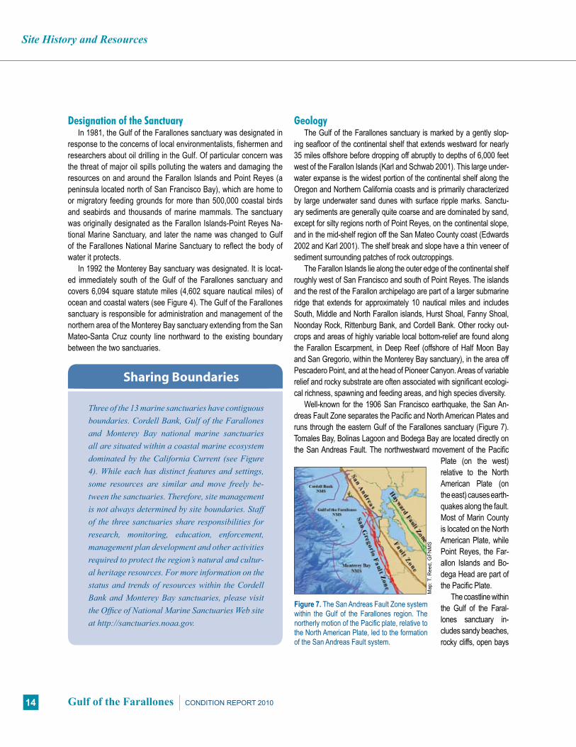
Figure 7. The San Andreas Fault Zone system within the Gulf of the Farallones region. The northerly motion of the Pacific plate, relative to the North American Plate, led to the formation of the San Andreas Fault system.
Map
: T. R
eed,
GFN
MS
GeologyThe Gulf of the Farallones sanctuary is marked by a gently slop-
ing seafloor of the continental shelf that extends westward for nearly 35 miles offshore before dropping off abruptly to depths of 6,000 feet west of the Farallon Islands (Karl and Schwab 2001). This large under-water expanse is the widest portion of the continental shelf along the Oregon and Northern California coasts and is primarily characterized by large underwater sand dunes with surface ripple marks. Sanctu-ary sediments are generally quite coarse and are dominated by sand, except for silty regions north of Point Reyes, on the continental slope, and in the mid-shelf region off the San Mateo County coast (Edwards 2002 and Karl 2001). The shelf break and slope have a thin veneer of sediment surrounding patches of rock outcroppings.
The Farallon Islands lie along the outer edge of the continental shelf roughly west of San Francisco and south of Point Reyes. The islands and the rest of the Farallon archipelago are part of a larger submarine ridge that extends for approximately 10 nautical miles and includes South, Middle and North Farallon islands, Hurst Shoal, Fanny Shoal, Noonday Rock, Rittenburg Bank, and Cordell Bank. Other rocky out-crops and areas of highly variable local bottom-relief are found along the Farallon Escarpment, in Deep Reef (offshore of Half Moon Bay and San Gregorio, within the Monterey Bay sanctuary), in the area off Pescadero Point, and at the head of Pioneer Canyon. Areas of variable relief and rocky substrate are often associated with significant ecologi-cal richness, spawning and feeding areas, and high species diversity.
Well-known for the 1906 San Francisco earthquake, the San An-dreas Fault Zone separates the Pacific and North American Plates and runs through the eastern Gulf of the Farallones sanctuary (Figure 7). Tomales Bay, Bolinas Lagoon and Bodega Bay are located directly on the San Andreas Fault. The northwestward movement of the Pacific
Plate (on the west) relative to the North American Plate (on the east) causes earth-quakes along the fault. Most of Marin County is located on the North American Plate, while Point Reyes, the Far-allon Islands and Bo-dega Head are part of the Pacific Plate.
The coastline within the Gulf of the Faral-lones sanctuary in-cludes sandy beaches, rocky cliffs, open bays

Site History and Resources
15CONDITION REPORT 2010 Gulf of the Farallones
(Bodega Bay and Drakes Bay), enclosed bays or estuaries (Bolinas Lagoon, Tomales Bay and Bodega Harbor), and seasonally closed lagoons (Estero Americano and Estero de San Antonio). Sediment washed into the sanctuary by rivers and from shoreline erosion pre-dominantly during the winter storm season is distributed throughout the sanctuary by currents year-round. Beach sand is moved down-coast from beach to beach by the process of longshore drift, with seasonal deposition and erosion changing the width and steepness of beaches, winter to summer. The two Esteros become closed off from the ocean during summer and fall by seasonally formed sand bars. Tomales, Bolinas and Bodega, however, remain open to the ocean year-round.
WaterThe Gulf of the Farallones sanctuary is located in the Califor-
nia Current, one of the world’s four major wind-driven upwelling systems, the other three systems being located along the west coasts of South America, southern and northern Africa (Gross 1972 and GFNMS 2008b) (Figure 8). Northerly winds drive a shallow surface layer that moves offshore due to the Coriolis ef-fect. This offshore (Ekman) transport of surface waters results in the upwelling of cold, nutrient-rich waters from depth into sunlit surface waters to support a food-rich environment and promote the growth of organisms at all levels of the marine web. Upwell-ing may be widespread at times, or localized at upwelling centers (e.g., Point Arena). In addition to upwelling, San Francisco Bay may be an important source of nutrients and organic matter in the Gulf of Farallones. The result is that high concentrations of phyto-plankton are observed in the Gulf of the Farallones near the water surface, making them available to zooplankton and higher trophic prey species such as krill, whales, fish and birds. In addition to upwelling-driven productivity in bays, estuaries and other near-shore environments during spring and summer, seasonal blooms may occur in response to rainfall and runoff in other seasons.
HabitatWithin the Gulf of the Farallones sanctuary is a wide spectrum
of marine habitats including sandy beaches, estuaries, bays, rocky intertidal zones, shallow continental shelf (consisting of hard and soft bottom habitats), islands, deep slopes and offshore waters. While the nearshore habitats are fairly well characterized, offshore habitats are not.
Many sandy beaches are found along the coastal border of the Gulf of the Farallones sanctuary. Numerous invertebrate communities can be found in these habitats, which are used as breeding grounds by many birds and pinnipeds. Sandy beaches are dynamic environ-ments, constantly changing under the influence of ocean waves. De-
tached plant and algal debris and corpses of fishes, seabirds, and marine mammals influence the structure of sandy beach communi-ties by providing food and shelter that are otherwise not available.
Small sandbar-built estuaries with seasonal inflow dominate the California coast due to the steep coastal topography, seasonal rainfall and seasonal higher wave energy conditions. However, one major estuary is found adjacent to the sanctuary: San Francisco Bay, consisting of Suisun Bay, Suisan Marsh, San Pablo Bay (west of Carquinez Strait), Central Bay and South Bay (Cohen 2000). Tomales Bay, a moderately sized estuary, is within the boundaries of the sanctuary and includes the small tributary estuaries of Lagunitas
Figure 8. Schematic of major oceanographic features off the north-central California coast: Blue zones indicate upwelling centers that may be localized at capes (Point Arena, Pigeon Point) or expand along much of the coast), while blue arrows indicate plumes of upwelled waters moving south and offshore from upwelling centers. Green arrows indicate plumes of San Francisco Bay outflow, moving either south (during upwelling) or north (during weak winds or winter). Strong winter outflow from rivers like the Russian and Gualala is demarcated by brown arrows. Not shown is the retention zone in Drakes Bay and smaller zones in Bodega Bay and Half Moon Bay. These schematic patterns change with the wind, land runoff, seasons and years.
Sou
rces
: MLP
A R
egio
nal P
rofil
e: J
. Lar
gier
, Bod
ega
Mar
ine
Lab,
and
The
Oce
an C
onse
rvan
cy 2
007
Schematic of Major Oceanographic Features

Site History and Resources
16 Gulf of the Farallones CONDITION REPORT 2010
and Walker Creeks. Other smaller estuaries occur along the open coast, including Estero Americano, Estero de San Antonio, Abbott’s Lagoon, Drakes Estero, Limantour Estero, Bolinas Lagoon and Pes-cadero Marsh. Abbotts Lagoon, Drakes and Limantour Esteros, San Francisco Bay and Pescadero Marsh are not within the boundaries of the sanctuary, but they do influence conditions of the sanctuary. Bays and estuaries provide a variety of different habitats, including shallow regions such as flats, brackish water, eelgrass beds, salt marshes and tidal creeks. Lagoons and estuaries are among the most productive natural systems, due to the availability of protected, shallow, warm water, abundant light and high nutrient input. Anthro-pogenic stressors to the estuaries include habitat loss through fill, sedimentation from upland sources, the building of piers, docks and marinas, agricultural waste runoff, leaking septic tanks in the water-sheds, vessel abandonment and introduced invasive species.
Rocky intertidal marine life communities are found between the high and low tide water levels and are exposed to a wide range of conditions. These rocky shores comprise 22% of the sanctuary shoreline. Distribution of organisms is strongly influenced by the amount of tidal inundation and wave exposure, which control the degree of exposure to air and the intensity of disturbance. Rocky headlands and the exposed coast are subjected to high wave action, and organisms there must be capable of surviving extreme condi-tions. Wave shock is reduced in areas that are protected by offshore rocks, reefs or islands. Organisms in rocky intertidal habitats are also exposed to drying and heating or cooling during low tide.
The Farallon Islands are located near the edge of the continental shelf within the California Current (see Figure 4). The high marine pro-ductivity of this region attracts a diverse assemblage of invertebrates, fish, seabirds and marine mammals. The Farallon Islands are the most important area for nesting seabirds within the contiguous United States, with over 300,000 adult birds nesting on the islands in May through July, during the height of the breeding season (GFNMS 2008b).
Offshore ocean environments include pelagic communities, ben-thic communities on the continental shelf and slope, and submarine canyon habitats. The vast majority of the sanctuary consists of open ocean habitats (pelagic habitats) that support a diverse and complex food web of plankton, invertebrates, fishes, sea turtles, birds and mammals. Pelagic habitats include newly upwelled waters, warmer waters in retention zones (e.g., Drakes Bay), plume influenced wa-ters (immediately offshore of the Golden Gate) and surf zone waters. Benthic habitats consist primarily of soft bottom with small rocky outcroppings and areas of locally high relief. Shelf communities are subjected to shifting sediments due to wave action and subsurface currents. Organisms living on the slope must be extremely special-ized for deepwater life in darkness, high hydrostatic pressure, and zones of low oxygen. The head of Pioneer Canyon, a small subma-
rine canyon that cuts into the shelf of the Farallon Escarpment about 25 miles offshore from Half Moon Bay, supports deep-sea communi-ties relatively close to shore. Canyon walls are often steep and rocky, with complex physical structures that provide shelter for various spe-cies. Canyon bottoms tend to slope gently and accumulate finer sedi-ments such as silt and mud, providing habitat for species such as flatfishes (Noble and Kinoshita 1992, Airamé et al. 2003).
Living ResourcesThe Gulf of the Farallones is a complex region with high biological
diversity. It is a nationally significant wildlife breeding and foraging area, home to 27 endangered or threatened species. The high diver-sity and abundance of birds, fish, marine mammals, invertebrates, algae and plants are due in part to the variety of island, coastal and subtidal habitats, and the highly variable physical processes affect-ing the area (e.g., localized upwelling).
Intertidal mudflats along the coast support high concentrations of burrowing organisms (clams, snails, worms and crabs) that are a main food source for shorebirds and wading birds. Invertebrates, birds (in-cluding the slowly recovering Brant Goose), Pacific herring and the juvenile stages of many coastal fish, depend on eelgrass beds in the estuaries to spawn and feed. In their journey from the ocean through bays and estuaries (e.g., Lagunitas Creek in Tomales Bay, Redwood Creek, Pescadero Marsh), the federally listed, threatened coho salm-on depend on clear, cool water, riparian vegetative cover and drowned logs, and specific gravel size to complete their reproductive process.
Different invertebrate species are found along the exposed rocky coasts of the sanctuary in places like the Farallon Islands, Duxbury Reef and Fitzgerald Marine Reserve. These include the coralline algae that dominates the Farallon Islands rocky intertidal communities (Capi-tolo 2009), providing cover and food for a diverse population of marine invertebrates (Figure 9). Nearshore kelp beds, an important haven for congregations of fish, pinnipeds and birds, occur near Bodega Head,
Figure 9. The sanctuary meets the land in the rocky intertidal zone. High-energy waves are often present along shoreline areas of the Gulf of the Farallones.
Pho
to: J
. Rol
etto
, GFN
MS

Site History and Resources
17CONDITION REPORT 2010 Gulf of the Farallones
Point Reyes, Duxbury Reef, Point Bonita, Point San Pedro, Fitzgerald Marine Reserve, Pescadero and Pigeon Point (Figures 10 and 11).
Information is limited regarding the deeper, subtidal habitats of the sanctuary. At depths of about 60 feet, the lack of adequate light penetration limits kelp growth. Many organisms that live on the con-tinental slope and in the deep sea depend on primary production oc-curring in surface waters, and produce their own light through biolu-minescence, which is used to find or attract potential food or mates.
InvertebratesInvertebrates can be found in most habitat types, from rocky shores
and mudflats to deep benthic and pelagic habitats throughout the sanctuary. The intertidal community contains a diverse array of inverte-brates including barnacles, limpets, black turban snails, mussels, sea anemones and sea urchins. At depths of about 60 feet (20 meters), en-crusting coralline algae, brittle stars and serpulid worms are dominant
among the life forms found. The invertebrate infaunal and epifaunal communities along the continental slope vary with depth and depend on specialized adaptations for life in the dark and under pressure. Nu-merous organisms can be found along the slope, including polychaete worms, pelecypod and scaphopod mollusks, shrimp and brittle stars.
Because of extreme conditions (low light, cold temperatures and high pressure), organisms found in the deep-sea environment eat less frequently and grow more slowly than species in surface waters (Airamé et al. 2003). The deep-sea pelagic invertebrate fauna of the sanctuary is dominated by the following phyla: Cnidaria, including hy-droids (Hydrozoa), jellies (Scyphozoa), and sea anemones (Figure 12) and corals (Anthozoa); Ctenophora, including ctenophores (Nuda); Nemertea, including ribbon worms (Enopla); Chaetognatha, includ-ing arrow worms (Archisagittoidea); Annelida, including marine worms (Polychaeta); Mollusca, including chitons (Polyplacophora), snails and nudibranchs (Gastropoda), clams (Bivalvia), and squids (Figure 13)
Figure 10. Schools of rockfish congregate in forests of nearshore kelp.
Pho
to: T
. Che
ss, N
MFS
Pho
to: J
. Rol
etto
, GFN
MS
Figure 12. A fully opened solitary anemone, Anthopleura sola, in a tidepool in Mussel Flat on Southeast Farallon Island.
Pho
to: P
. Pyl
e
Figure 11. In the open waters of the sanctuary, kelp rafts form an important floating habitat for congregations of fish, pinnipeds and birds.
Pho
to: J
. Hal
l, G
FNM
S
Figure 13. Immature squid abound in plankton tows collected during spring SEA Surveys in the Gulf of the Farallones sanctuary.

Site History and Resources
18 Gulf of the Farallones CONDITION REPORT 2010
and octopuses (Cephalopoda); and Arthropoda, including barnacles and copepods (Maxillopoda), and isopods, amphipods, shrimp and crabs (Malacostraca). Little information is available regarding the species, status, or trends of deep-sea corals and sponges within the sanctuary.
Krill are keystone invertebrate species in the Gulf of the Faral-lones region, with Thysanoessa spinifera and Euphausia pacifica being the most common krill species found within the sanctuary. The California Current and localized upwelling zones provide condi-tions conducive for E. pacifica (the more oceanic species) to move onto to the continental shelf, where they become abundant and available to predators during late winter and spring. As the upwell-ing relaxes into the summer, E. pacifica moves offshore, where it is less available to predators, and T. spinifera (the more coastal species) becomes the dominant krill in shelf waters and predator diets (Edgar 1997, Sydeman et al. 2001, Abraham 2007, Elliott et al. 2009).
FishThe sanctuary’s diverse habitats contribute to a region of high pro-
ductivity, and fish are an abundant resource. While bays and estuar-ies are important as feeding, spawning, and nursery areas, the con-tinental shelf and slope are highly productive areas for commercial fisheries. The comparatively wide continental shelf and configuration of the coastline is vital to the health and existence of salmon (chinook and coho), northern anchovy, rockfish and flatfish populations. The extension of Point Reyes and the resulting current patterns tend to retain larval and juvenile forms of these and other species within the sanctuary, thereby easing recruitment pressures and helping to ensure continuing populations. The composition of fish species in the pelagic zone varies throughout the year with migration and spawn-ing, and sanctuary waters surrounding the Farallon Islands (26 miles from the mainland) serve as an offshore location for shallow and in-tertidal fishes that further enhance finfish populations.
Juvenile planktivores or low-level carnivores of infaunal inver-tebrates are the most abundant estuarine fish in sanctuary waters (Yoklavich et al. 1991). Also common within the bays and estuar-ies that are within and adjacent to the sanctuary are Pacific her-ring (Clupea pallasii), smelt, starry flounder (Platichthys stellatus), surfperch, sharks and rays. Fish assemblages exhibit higher abun-dance and species richness during the summer with the invasion of young-of-the-year marine species (Allen and Horn 1975, Hoff and Ibara 1977, Allen 1982, Onuf and Quammen 1983, Yoklavich et al. 1991). There are a specialized group of fish adapted for life in tide pools found in the rocky intertidal zone, including monkey-face pricklebacks (Cebidichthys violaceus), rock eels (Pholis gun-nellus), dwarf surfperch (Micrometrus minimus), sculpins including
juvenile cabezon (Scorpaenichthys marmoratus), and blennies. Many of these species are important food sources for shorebirds and seabirds.
Rockfish, cabezon and small surfperches are commonly found in the rocky habitats of the continental shelf. Some of the common species include schools of black rockfish (Sebastes melanops) that frequently occur 10 to 20 feet above shallow rocky reefs. Shortbelly rockfish (S. jordani) are found in greatest abundances near the Far-allon Islands, adults found in peak abundance over the bottom at depths of 400 to 700 feet. Cabezon are found on hard bottoms in shallow water from intertidal pools to depths of 250 feet. Subtidal habitats support large populations of juvenile finfish (e.g., flatfish, rockfish, etc.) and cabezon are also common in these zones, in and around rocky reefs and kelp beds.
Large predatory finfish such as sharks, tunas and mackerel are found in nearshore pelagic areas. Northern anchovy (Engraulis mordax), Pacific mackerel (Scomber japonicas) and market squid are common in this region and can be commercially valuable. Pe-lagic fish resources generally parallel species living in the nearshore subtidal zone. At the mid-depth or meso-pelagic range over sand and mud bottoms, chilipepper rockfish (S. goodie), widow rockfish (S. entomelas) and Pacific hake (Merluccius productus) are com-mon. Kelp beds substantially increase the useable habitat for pe-lagic and demersal species and offer protection to juvenile finfish. Large populations of rockfish — more than 48 species — inhabit rocky banks in sanctuary waters deeper than 180 feet. Sablefish and flatfish such as sole, sanddab and halibut are found on nearshore and offshore soft-bottom habitats. Concentrations of sardines, north-ern anchovies and Pacific herring are a critical food source for birds and marine mammals. A small number of migratory pelagic species dominate the fisheries of Central and Northern California, including northern anchovy, Pacific sardine (Sardinops sagax), Pacific hake and jack mackerel (Trachurus symmetricus). These pelagic species spawn in the Southern California Bight and migrate into waters off Central and Northern California. However, the composition of larval fish species off Central and Northern California varies with oceano-graphic conditions.
Productive commercial fisheries for deep-sea fish operate on the continental slope. The species targeted include deep-sea rockfishes such as blackgill rockfish (Sebastes melanostomus), thornyheads (Sebastolobus sp.), sablefish (Anoplopoma fimbria) and Dover sole (Microstomus pacificus). Many of these species occupy similar habi-tats and generally are caught together (Love et al. 2002).
White SharksThe sanctuary is home to one of the largest known concentrations of
adult and sub-adult white sharks (Carcharodon carcharias) in the world

Site History and Resources
19CONDITION REPORT 2010 Gulf of the Farallones
(Figure 14). White sharks are seasonal visitors to the Gulf of the Faral-lones region, arriving during the summer months to nearshore areas in the vicinity of large pinniped haul-out and breeding colonies between Año Nuevo, the Farallon islands, Tomales Point at the north end of the Point Reyes peninsula and Bodega Headlands in Marin and Sonoma Counties. From August through November, white sharks have been seen feeding in the area, most notably at the Farallon Islands (Long et al. 1996, Pyle et al. 2002, Weng et al. 2007). The sharks leave the sanc-tuary every winter and migrate to the central Pacific and Hawaii (Jor-gensen et al. 2009). The sanctuary population of white sharks appears to be genetically isolated (Jorgensen et al. 2009), with the number of adults in the range of 175 to 299 individuals (Chapple et al. 2010). Little is known regarding where sanctuary white sharks breed and pup. Cur-rent research findings indicate a stable population (Weng et al. 2007). White sharks are a key species in the marine ecosystem and removal of this apex predator could have cascading tropic impacts on the popu-lation dynamics of their prey (e.g., California sea lions and elephant seals). The California Fish and Game Commission passed a bill in 1994 (made permanent in 1997) protecting white sharks from “take” in Cali-fornia and mandating a long-term assessment of the population (Hene-man and Glazer 1996). The Monterey Bay and Gulf of the Farallones sanctuaries promulgated regulations in 2009 for additional white shark protection from human disturbance by attraction and approach.
Turtles
Sea turtles in the northeastern Pacific typically follow warmer wa-ters found in the higher latitudes during the summer and fall months. There are three species of sea turtle that are rarely found within the sanctuary (green sea turtle, Chelonia mydas; Olive Ridley, Lepi-dochelys olivacea; and loggerhead sea turtle, Caretta caretta) and one species, the leatherback turtle (Dermochelys coriacea), that is observed there annually, but in very low numbers. While in the sanc-
tuary, they forage on gelatinous species from the class Scyphozoa (e.g., jellyfish) (Benson et al. 2007). Each of these species is listed as endangered or threatened under the Endangered Species List. The odds of sea turtles occurring in the cooler, temperate waters of the sanctuary are low and are greatly influenced by the relaxation of upwelling winds from Point Reyes south to Monterey Bay during the summer and fall months. Leatherback turtles are the largest of the sea turtles, weighing up to 1,500 pounds. Sea turtles are primarily threatened by habitat loss at their nesting areas in Mexico, Central America, South America and Indonesia, where egg harvesting and entanglement in nets and trawls from commercial and artisan fisher-ies are also greatly impacting the survival of these species. Within the past four years (2005-2009), three leatherback turtles known to have been hit by boat and ship propellers have been found along the Gulf of the Farallones shoreline.
Marine MammalsThirty-six marine mammal species have been observed in the Gulf
of the Farallones sanctuary: six species of pinnipeds (seals and sea lions), 28 species of cetaceans (whales, dolphins and porpoises) and two species of otter. The sanctuary serves as a nursery for harbor seals (Phoca vitulina), northern elephant seals (Mirounga angustirostris), harbor porpoises (Phocoena phocoena) and Pacific white-sided dol-phins (Lagenorhynchus obliquidens). The sanctuary also serves as a breeding ground for 20 percent of California’s harbor seals (estimated at 32,000 in 2005). It also contains one of the last populations in Cali-fornia of the threatened Steller sea lion (Eumetopias jubatus) (Figure 15). The sanctuary is a destination feeding ground for endangered blue whales (Balaenoptera musculus) and humpback whales (Megaptera novaeangliae) and is a major migration route for gray whales (Es-chrichtius robustus). The Farallon Islands provide habitat for breeding populations of five species of pinnipeds, including the once-extirpated
Figure 14. A large white shark swimming nears the Farallon Islands. Figure 15. Steller sea lions are one of several threatened species in the Gulf of the Farallones.
Pho
to: S
. And
erso
n
Pho
to: B
. Wils
on, G
FNM
S

Site History and Resources
20 Gulf of the Farallones CONDITION REPORT 2010
populations of northern fur seals and northern elephant seals. Breeding colonies of northern elephant seals, harbor seals, Cali-
fornia sea lions (Zalophus californianus), and Steller sea lions are found on the coast and at the Farallon and Año Nuevo islands. A small colony of about 90 northern fur seals have recently resumed breeding on the South Farallon Islands during the summer. For more than 170 years prior to 1996, fur seals had not been known to breed on the Farallon Islands. From November through June, thousands of female and immature fur seals migrate through the western edge of the sanctuary along the continental shelf. Depending largely on their fur for insulation, fur seals and sea otters would be the most sensitive of all marine mammals to an oil spill.
Steller sea lions appear year-round throughout the sanctuary. This threatened population has decreased dramatically in the south-ern part of its range, which includes the Farallon Islands. The popula-tion in the Gulf of the Farallones region has declined by 80 percent compared to population numbers from 50 years ago (Rowley 1929, Bonnot and Ripley 1948, Ainley et al. 1977).
The California sea lion is the most conspicuous and widely dis-tributed pinniped in the sanctuary. It is found year-round in the Gulf of the Farallones, with the population increasing at about 8 to 12 percent each year (Carretta et al. 2007). The northern elephant seal is the largest pinniped species in the sanctuary, with a total breeding population of about 13,000. They are primarily found at Point Reyes, the South Farallon Islands, Point Año Nuevo and Año Nuevo Island.
Twelve cetacean species are seen regularly in the sanctuary, and of these, the minke whale (Balaenoptera acutorostrata), harbor porpoise (Phocoena phocoena), Dall’s porpoise (Phocoenoides dalli) and Pacific white-sided dolphin (Lagenorhynchus obliquidens) (Fig-ure 16) are considered year-round residents. The harbor porpoise is the most abundant small cetacean in the Gulf of the Farallones, with 16,000 residing throughout Northern and Central California.
Gray whales migrate from Alaska southward through the sanc-
tuary from December through February. Their northward migration through the sanctuary begins at the end of February and peaks in March. A few gray whales remain in the sanctuary year round. The gray whale population has recovered to the point that it was recently removed from the Endangered Species List. Other large baleen and toothed whales migrate to the sanctuary to feed in its nutrient-rich waters during the summer and fall months. The numbers of hump-back and blue whales (estimated at 1,400 and 1,700 individuals, re-spectively, for California, Oregon and Washington waters) that feed in the sanctuary between April and November represent one of the largest concentrations of these whales in the Northern Hemisphere. They also represent two of the few recovering populations of baleen whales found throughout the world.
SeabirdsOne of the most spectacular components of the sanctuary’s
abundant and diverse marine life is the large number nesting and migratory seabirds, comprising more than 500,000 birds of many dif-ferent species. These birds are highly dependent on the sanctuary’s productive waters. At least 19 marine and coastal bird species that are federally listed as threatened, endangered or species of concern can be found here, including the Marbled Murrelet (Brachyramphus marmoratus) and the Western Snowy Plover (Charadrius alexan-drines). The sanctuary is also home to aquatic birds such as water-fowl, shorebirds like Black Oystercatchers (Haematopus bachmani), pelicans, loons and grebes. More than 160 species use the sanctu-ary for shelter, food or as a migration corridor. Of these, 57 species are known to use the sanctuary during their breeding season.
The Farallon Islands are home to the largest concentration of breeding seabirds in the contiguous United States. Eleven of the 16 species of seabird known to breed along the U.S. Pacific Coast have breeding colonies on the Farallon Islands and feed in the sanctu-ary. These include Ashy and Leach’s Storm-Petrels (Oceanodroma
Figure 16. Pacific white-sided dolphins can often be seen by the thou-sands in sanctuary waters.
Figure 17. Common Murres in their chaotic rookery preparing for mating.
Pho
to: A
. Sch
mid
t, P
RB
O C
onse
rvat
ion
Sci
ence
Pho
to: N
OA
A N
MFS
SW
FSC

Site History and Resources
21CONDITION REPORT 2010 Gulf of the Farallones
homochroa, O. leucorhoa); Brandt’s, Pelagic and Double-crested Cormorants (Phalacrocorax penicillatus, P. kenyoni, P. auritus); Western Gulls (Larus occidentalis); Common Murres (Uria aalge) (Figure 17); Pigeon Guillemots (Cepphus Columba); Cassin’s Auk-lets (Ptychoramphus aleuticus); Tufted Puffins (Fratercula cirrhata); and Rhinoceros Auklets (Cerorhinca monocerata).
ShorebirdsThe sanctuary includes crucial habitat for numerous shorebird
species. Approximately 80 of the more than 400 shorebird species are found within sanctuary boundaries, 27 of which are regularly seen, such as the Black Oystercatcher, two species of dowitcher and several species of sandpiper. Generally, these birds probe about the shores, feeding on buried clams, worms, crustaceans and small fishes. A notable “prober,” the Long-billed Curlew (Numenius ameri-canus), has the longest beak (up to 23 centimeters, or nine inches) of any shorebird in the world. Easily recognizable shorebirds also in-clude the Willet (Tringa semipalmata), Sanderling (Calidris alba), and Marbled Godwit (Limosa fedoa). Shorebirds can be seen at Bodega Bay, Esteros Americano and de San Antonio, Tomales Bay and Boli-nas Lagoon, as well as many areas along the shore, such as Doran, Bolinas and Stinson beaches.
Other Coastal and Aquatic BirdsHerons, ducks and rails are seen in the sanctuary region. The
Black Rail (Laterallus jamaicensis), listed as threatened on Califor-nia’s endangered species list, can be found in Tomales Bay and Bo-linas Lagoon. Faced with rapidly diminishing habitat, rails are now rarely seen in the salt marshes of bay and coastal communities. At least seven species of heron, egret and bittern live in the sanctuary and adjacent wetlands. These long-necked wading birds are found in wetlands and along the shoreline.
More than 20 species of waterfowl inhabit the Gulf of the Far-allones and surrounding waters, with many of them present year-round. Canada Goose (Branta canadensis), Surf Scoter (Melanitta perspicillata), Red-breasted Merganser (Mergus serrator) and North-ern Pintail (Anas acuta) are examples of seasonal visitors to the area. Diversity is quite strong in these waterfowl, with species displaying great variation in color, size, shape and feeding behavior.
Maritime Archaeological ResourcesThe area encompassed by Gulf of the Farallones National Marine
Sanctuary is rich in cultural and historical resources, and has a long and interesting maritime history. The seafloor preserves remnants of the sites where people lived and the vessels they used to conduct trade and combat. Ships, boats, wharves, lighthouses, lifesaving sta-tions, whaling stations, prehistoric sites and a myriad of other heri-tage treasures lie covered by water, sand and time.
The history of California’s central coast is predominantly a maritime one. From the days of the early Miwok inhabitants, throughout the ex-ploration and settlement of California and up to the present day, coastal waterways have been a main route of travel, subsistence and supply. Ocean-based commerce and industries (e.g., fisheries, shipping, military, recreation, tourism, extractive industries, exploration and re-search) are an important part of the maritime history, modern economy and social character of this region. These constantly changing human uses define the maritime heritage of the sanctuary and help us to inter-pret our evolving relationship with maritime archaeological resources. Ports such as San Francisco, and smaller coastal harbor towns, devel-oped through fishing, shipping and economic exchange. Today many of these have become major urban areas, bringing millions of people in proximity to the national marine sanctuaries of Central California. Many of these people are connected to the sanctuaries through commercial and recreational activities such as surfing, boating and diving.
Historical research suggests that nearly 180 vessel and aircraft losses occurred between 1595 and 1957 in the waters of what is now the sanctuary. The sanctuary has collaborated with state and federal agencies and the private sector to gather resource documentation and to create opportunities to locate and record submerged archaeo-logical resources. Some of these archaeological resources have been located and inventoried by the National Park Service (NPS). Existing databases, a review of primary and secondary resource documenta-tion, and two reports by the NPS published in 1984 and 1989 provided the framework for the sanctuary to create a shipwreck inventory and site assessment (Murphy 1984, Delgado and Haller 1989). The Miner-als Management Service and the California State Lands Commission shipwreck databases have also contributed to the overall resource in-ventory. Research continues today by NOAA and NPS to expand the inventory and make recommendations for future survey opportunities.

Pressures on Sanctuary Resources
22 Gulf of the Farallones CONDITION REPORT 2010
Figure 18. Three major West Coast shipping lanes (seen in light green and dark orange) converge in the Gulf of the Farallones sanctuary within the Pre-cautionary Area (light orange).
Map
: T. R
eed,
GFN
MS
Vessel Year Estimate of Spills
S/S Jacob Luck-enbach
sank 1953
No known estimate is available for amount that initially leaked after colliding with another ship; chronic leaks are estimated to be more than 300,000 gallons from 1953-2002.
T/V Puerto Rican 1984Release of at least 5.4 million liters of oil (365,500 gallons of bunker fuel); leaked for several years after an explosion.
T/B Apex Houston 1986 Release of an estimated 97,600 liters of crude oil after an accident while under tow.
S/S Cape Mohican-SF Drydock
1996 Release of an estimated 151,500 liters of heavy bunker fuel oil.
T/V Command 1998 Release of an estimated 3,000 gallons of intermediate bunker fuel while in transit.
S/S Jacob Luck-enbach --related pollution episodes
1989-2002Greater than 85,000 liters of bunker fuel oil leaked sporadically for several years and during the clean-up process.
S/S Cosco Busan November 2007
An estimate of the amount of oil spilled and subsequent impacts from the S/S Cosco Busan strike are in the process of being evaluated (therefore, this event is not part of this assessment).
Table 1. Major and moderate oil spills causing significant oil pollution in the Gulf of the Farallones, since designation in 1981.
Sou
rce:
Car
ter a
nd G
olig
htly
200
3 an
d H
ampt
on e
t al.
2003
a
Pressures on the Sanctuary
Numerous human activities and natural events and processes affect the condition of natural and archaeological resources in marine sanctuaries. This section describes the nature and extent of the most prominent human induced pressures in the Gulf of the Faral-lones National Marine Sanctuary.
Vessel TrafficImpacts from vessels, including oil pollution, disturbances to
certain living resources, sunken vessels, ship strikes of wildlife, and dredged material resulting from maintenance of shipping channels, are a significant threat to the protection and health of the sanctu-ary. Three major shipping lanes converge in the sanctuary just west of the Golden Gate Bridge at the entrance to San Francisco Bay (Figure 18). The volume of traffic in and out of San Francisco Bay is large. In 2008, nearly 4,000 tank and non-tank vessels made this transit (see Table 3, page 32). Approximately half of these vessels transit south off the coast of California, while the other half transit north or west of San Francisco (HSCSFBR 2008) (Figure 19).
Crude oil production in California averaged 731,150 barrels per day in 2004, ranking the state fourth in the nation among oil-produc-ing states (Sheridan 2006). California is also a major refining center for West Coast petroleum markets, with a combined crude oil distil-lation capacity totaling more than 1.9 million barrels per day – third highest in the nation. California’s oil production and distillation activi-ties, and status as the nation’s greatest gasoline consumer, provide a high level of risk from oil tankers moving up and down the coast.
Historically, the total number of spills from transiting vessels is small, but the potential impacts may be enormous given the number and volume of vessels, and their proximity to the Farallon Islands and major seabird and marine mammal populations (Table 1). In 2007, in a report from the Harbor Safety Committee, the U.S. Coast Guard documented 868 tank vessels and 2,787 deep-draft non-tank vessels that transited San Francisco Bay. Large commercial vessels are of particular concern for spills, since they can carry up to one million gallons of bunker fuel, a heavy, viscous fuel similar to crude oil. Examples of two oil spills that impacted sanctuary re-sources include the S/S Jacob Luckenbach in 1953 and the T/V Puerto Rican in 1984.
T/V Puerto RicanIn November 1984, the tanker vessel (T/V) Puerto Rican explod-
ed in the Gulf of the Farallones and eventually released about 5.4 million liters of oil into the Gulf of the Farallones sanctuary over a two-week period (Figure 20). The back half of the tanker eventu-ally sank with 365,500 gallons of bunker fuel that leaked for several years (Hampton et al. 2003a).

Pressures on Sanctuary Resources
23CONDITION REPORT 2010 Gulf of the Farallones
Figure 19. Cargo ships transporting goods through San Francisco Bay.
Pho
to: N
OA
A
Figure 20. In 1984 the tanker vessel Puerto Rican exploded and released 5.4 million gallons of oil into the Gulf of the Farallones sanctuary.
Pho
to: G
FNM
S
Figure 21. In 1953, the S/S Jacob Luckenbach (pictured here moored in San Francisco) collided with another vessel and sank in the Gulf of the Farallones. An estimated 300,000 gallons of bunker fuel oil were released from the sunken vessel over more than 48 years and killed at least eight sea otters and over 51,000 birds (Luckenbach Trustee Council 2006).
Pho
to: S
an F
ranc
isco
Mar
itim
e N
atio
nal H
isto
ric P
ark
Neg
ativ
e N
o. P
82-0
19A
0739
The long-term impact of the bunker fuel in the sunken stern is unknown. However, it was estimated by the state and federal trustee agencies that 26 bird species were directly affected by the incident, kill-ing at least 2,874 individual birds (Ford et al. 1987). Also affected were elephant seals, northern fur seals, shrimp, krill, crabs and rockfish.
S/S Jacob LuckenbachIn 1953, a 468-foot freighter, the S/S Jacob Luckenbach, left San
Francisco bound for Korea (Figure 21). It collided with another ship and sank in 180 feet of water. The wreck came to rest 17 miles west-south-west of San Francisco and contained 457,000 gallons of bunker fuel (Hampton et al. 2003b). The sunken ship leaked oil sporadically for many years, but was not initially linked to a major wildlife disaster. However, in 2002, researchers investigating a large concentration of tarballs and oiled seabirds at Point Reyes and along the San Mateo County coast deter-mined that the chemical signature of oiled feathers matched the oil in the S/S Jacob Luckenbach. It was estimated that from August 1990 through December 2003, 51,000 birds and eight sea otters were oiled and killed. Of these, approximately 85 percent of the deaths are attributed to the oil leaking from the S/S Jacob Luckenbach. More than 50 species of birds were impacted; with the greatest numbers being Common Murres, Red Phalaropes, Northern Fulmars, Rhinoceros Auklets, Cassin’s Auklets and Western Grebes. Four federally and state-listed species, the Brown Peli-can, Western Snowy Plover, Marbled Murrelet and California sea otter, were impacted as well. Ashy Storm-Petrels were also impacted in signifi-cant numbers, relative to their population size (Hampton et al. 2003b).
In addition to the threat of oil spills, many vessels, some dating as far back as the 17th century, litter the sea floor of the sanctuary. Among these are the many vessels deliberately sunk between 1951 and 1987. Included in the inventory of sunken vessels is the highly radioactive World War II aircraft carrier USS Independence, which was exposed to atomic tests and sunk by the U.S. Navy in 1951 at an unspecified loca-tion off the California coast, possibly in the Gulf of the Farallones.
Marine DebrisHundreds of millions of tons of waste have been dumped into
the Gulf of the Farallones since the mid-1800s (Chin and Ota 2001). Since the 1940s, this has included waste from oil refineries and fruit canneries, acids from steel production, and ships from World War II and other unwanted vessels. From 1958 to 1969, the U.S. military disposed of chemical and conventional munitions at several sites in the Gulf of the Farallones, mostly by scuttling World War II-era cargo vessels (Chin and Ota 2001).
Plastic waste also threatens sanctuary resources. Sources of plastic waste are both land and ocean-based. Land-based sources of marine debris include: litter washed into the bay through storm drains and outflow from combined sewer treatment systems; garbage from landfills; shoreline recreational activities; improper handling of

Pressures on Sanctuary Resources
24 Gulf of the Farallones CONDITION REPORT 2010
garbage in transport and on-site storage; and plastic resin pellets discharged from plastics manufacturing facilities into storm drains and nearby waterways (Gordon 2006, International Pellet Watch Web site). Ocean-based sources generally include lost fishing gear and dumping of garbage at sea by vessels and oil platforms (UNEP 1995, NOAA Office of Public and Constituent Affairs 1999).
Plastic waste is a worldwide problem. There are many potential sourc-es of plastic debris, and it can remain in the marine environment for a very long time before fully degrading. Plastic particles may be ingested by both marine organisms that select food by sight and filter feeders that do not. Plastic waste has also been shown to entangle marine wildlife in the Gulf of the Farallones and elsewhere. From 2001 to 2005, the cause of death for 0.7 percent (n = 8,475) of the bird carcasses documented during sanc-tuary Beach Watch surveys was entanglement in marine debris (Moore et al. 2009) (Figure 22). Based on Beach Watch surveys of dead sea-birds, an estimated 200 birds are killed every year in the Gulf of the Faral-lones due to entanglement in fishing gear and other plastic debris. Small plastic fragments and pellets in the ocean and inland waterways have been found to adsorb pollutants from the marine environment – most notably, persistent organic pollutants (Karapanagioti and Klontza 2007). When marine life mistake these pellets for food, they are likely to ingest a wide array of contaminants, posing the threat of PCB accumulation and the increased likelihood of starvation (Ryan et al. 1988). Another negative consequence of plastic fragments in the marine environment is that they have been found to attract marine organisms such as bacteria, diatoms, algae, barnacles, hydroids, tunicates and bryozoans that attach to and “raft” on them, which can contribute to the spread of invasive species.
Beach WatchBeachWatch is a long-term, shorelinemonitoringpro-gramthathasprovidedtrainingtoover500volunteersandhasprovideddataforvariousinvestigationssuchas:
• Marinedebrisandentanglement
• Trendsinhuman-recreationaluse,dogsandshore-birdinteractions
• Speciesabundanceandgeographictrends
• Speciesinventoriesanddistributionfornationalandstateparks
• Predator-preyabundanceandgeographictrendsforSnowyPloversandCommonRaven
• Speciesinventoriesforspecificbeachesandlargerregionaltrends
• Oilspillresponseandrestorationefficacy.
Figure 22. Many seabirds, such as this gull, die from entanglement in fishing gear.
Pho
to: J
. Hal
l, G
FNM
S
Figure 23. The San Francisco Deep Ocean Disposal Site (red oval) is the deepest ocean dredged material disposal site in the United States. Also depicted in map are the general locations of the radioactive waste dump-sites (orange stars) and a mapped area (10% of known dumpsite) using side-scan sonar in 1990-1994 (grey shading).
Sou
rce:
Kar
l 200
1; M
ap: T
. Ree
d, G
FNM
S
Dredged Material San Francisco Bay’s 85 miles of navigable waterways require
annual maintenance dredging (Chin and Ota 2001). Oil tankers and container vessels require 40 to 60 feet of water for safe transit. Chan-nel dredging is necessary to prevent deep-draft vessels from running aground or rupturing their hulls, which could cause millions of dollars in environmental damage to the bay’s fragile habitats. Environmental concerns and limited disposal capacity for dredged material in the Bay have made it necessary to find a suitable dumping site. As such, the San Francisco Deep Ocean Disposal Site (SF-DODS) was designated and is located 55 miles beyond the Golden Gate Bridge and outside of the Gulf of the Farallones sanctuary’s western boundary (Figure 23)

Pressures on Sanctuary Resources
25CONDITION REPORT 2010 Gulf of the Farallones
(Chin and Ota 2001).The ocean disposal site off San Francisco is the farthest offshore and in the deepest water of any ocean disposal site in the United States. The dredged sediment is clean, containing no toxic levels of chemicals (LTMS 1998). However, dumping even clean sedi-ment creates environmental concerns. First, it can change the charac-ter of the seafloor habitat and directly smother bottom dwelling organ-isms. Second, it can affect water clarity. The high productivity of the Gulf of the Farallones is based on phytoplankton blooms that require light. Discharging sediment blocks sunlight, restricts the growth of plankton and disrupts the feeding of fish, birds and marine mammals. While the dump site is located outside the boundaries of the sanctuary, currents could possibly carry sediment particles into the sanctuary, so additional monitoring within the sanctuary remains prudent.
Radioactive WasteBetween 1946 and 1970, approximately 47,800 containers of low-
level radioactive waste were dumped into the Gulf south and west of the Farallon Islands (Chin and Ota 2001). The 55-gallon drums litter a 540-square-mile area of seafloor, much of it in the Gulf of the Farallones sanctuary at depths ranging from 300 to more than 6,000 feet (Figures 23 and 24). The containers were to be dumped at three sites designated by the Navy, but many were not dropped on target, probably due to inclement weather and navigational uncertainties. Therefore, assessing any potential environmental hazard from radia-tion or contamination has been difficult (Karl 2001). In addition, evi-dence suggests that several other types of wastes were dumped, in-cluding cyanides, mercury, beryllium and other heavy metals, dredge
spoils, explosives, and garbage, although available documentation does not specify an origin (Jones et al. 2001b).
Questions also exist on the condition of the barrels and whether or not it is more beneficial for the health of the sanctuary to leave the containers on the seabed or attempt to remove them. Personnel changes in all involved agencies have led to institutional knowledge loss. Additionally, questions regarding agency role and responsibility need to be addressed (Chin and Ota 2001, Karl 2001).
Non-Indigenous SpeciesSan Francisco Bay, adjacent to the Gulf of the Farallones sanctu-
ary, is considered the most invaded aquatic ecosystem in the world (Cohen and Carlton 1998), with more than 255 introduced species. The Bay’s close proximity to the sanctuary elevates the risk of new introductions to Gulf of the Farallones estuaries. Indications are that introduced species are a great threat to rare, threatened or en-dangered species in the U.S., second only to habitat destruction (Brynes et al. 2007). In general, introduced species in the marine and estuarine environment alter species composition, threaten the abundance and diversity of native marine species, interfere with the ecosystem’s function and disrupt commercial and recreational ac-tivities (GFNMS 2008a). Of the highest concern to sanctuary man-agement are the following species: wakame (Undaria pinnatifida), green crab (Carcinus maenas), Japanese false cerith, or mudsnail (Batillaria attramentaria), and Atlantic smooth cordgrass (Spartina alterniflora) and its hybrids with the native cordgrass Spartina fo-liosa (Byrnes et al. 2007).
Nearshore discharge of ballast water from large vessels is a com-mon source of introduced species. Most organisms carried in ballast water are in the larval stage of their life cycle, and estuaries and harbors can provide optimal environments for the growth of some of these organisms. Viruses, bacteria and other pathogens have also been identified in ballast water. The discharge of ballast water into California waters or a marine sanctuary from a vessel with sufficient holding tank capacity is prohibited.
Introduced species may also be transported on commercial and recreational vessel hulls, rudders, propellers, intake screens, bal-last pumps and sea chests. Other vectors for the spreading of intro-duced species include recreational and research equipment, debris, dredging and drilling equipment, dry docks, and buoys. Organisms transported or used for research, restoration, educational activities, aquarium activities, live bait, aquaculture, biological control, live sea-food, and rehabilitated and released organisms also have the po-tential for accidental or intentional release into marine and estuarine environments. Of additional concern are genetically modified spe-cies that either escape or are released into the ocean (Cohen 1997, Cohen and Carlton 1998, GFNMS 2008b).
Figure 24. A 55-gallon drum thought to contain low-level radioactive waste is located on the continental slope in the Gulf of the Farallones sanctuary at a depth of approximately 2,000 feet.
Pho
to: U
.S. G
eolo
gica
l Sur
vey

Pressures on Sanctuary Resources
26 Gulf of the Farallones CONDITION REPORT 2010
FishingA variety of recreational (Figure 25) and commercial fishing ac-
tivities occur in the sanctuary. Salmon, California halibut, albacore, rockfish, lingcod, sanddabs, surfperch, striped bass and Dungeness crab are the primary target species for sport fishing in the Gulf of the Farallones sanctuary. Northern anchovy and Pacific sardine are also targeted for bait. On weekend days with low tides, especially during summer vacation months, clam diggers harvest gaper clams, geo-ducks, littlenecks, basket cockles and Washington clams (T. Moore, CDFG, pers. comm.). Some intertidal organisms are harvested for sustenance or by small commercial operations. These organisms in-clude barnacles, limpets, black turban snails, mussels, abalone and sea urchins. The most important commercial harvests include Pacific herring, salmon, rockfish, halibut and other flatfishes, and Dunge-ness crab. Most of the commercial catches harvested in Gulf of the Farallones sanctuary are landed in Bodega Bay, Bolinas, San Fran-cisco, Oakland, Sausalito and Half Moon Bay (Scholz et al. 2004).
Fishing GearGear types used in the sanctuary include diving equipment, hook-
and-line, set and vertical long lines, troll, gillnets, seines, mid-water and bottom trawls, various traps, and miscellaneous gear such as cast net, hoop net, pelagic trawl, spear fishing, dredging and fish pumps (Scholz et al. 2004). Hook-and-line and long lines are gener-ally used to catch rockfish, flatfish and lingcod. Gillnets are used in Tomales Bay to catch Pacific herring. Seines are primarily used for market squid harvesting, which has traditionally taken place in the area, although squid is currently not a major target species (Leet et al. 2001). Typical market squid fishing gear includes high-wattage squid attraction lights, which have been restricted in sanctuary wa-ters by the state because of the potential to cause disturbance to
and increased predation of nocturnal seabirds. Since 2005, Califor-nia has prohibited bottom trawling within three miles of shore, and the National Marine Fisheries Service has designated several areas within the sanctuary as Essential Fish Habitat, where no trawling is allowed (see Figure 34, page 34). Although bottom trawling activities have decreased markedly in the sanctuary in recent years, this activ-ity still occurs within sanctuary waters. Traps are primarily used to catch Dungeness crab. There is currently no limit on the number of traps that can be set in sanctuary waters. It is estimated that approxi-mately 50,000 to 100,000 traps are set each year within the sanctu-ary. According to surveys of fishermen, approximately 10 percent of all set traps are not recovered, resulting in a substantial amount of debris in the form of derelict trap gear (traps and lines) within sanctu-ary waters (Z. Grader, Pacific Coast Federation of Fisherman’s As-sociations, pers. comm.).
Nonpoint Source PollutionCoastal and Offshore Environments
Open coastal and offshore areas of the sanctuary are also threatened by nonpoint source pollution. However, the threat is gen-erally considered to be less for open-water areas than for estuar-ies because they are somewhat protected by their distance from the sources of pollutants and land-based runoff and by more active circulation and mixing that dilutes pollutants with offshore waters. Nevertheless, the coastal and offshore regions of the sanctuary are threatened by acute events (large ship-based spills) and on-going chronic sources (San Francisco outflow). In addition to cur-rent threats, persistent organic pollutants such as DDT and PCBs were widely used nationwide before the mid-1970s and residuals of these chemicals still remain in sediments and organisms within the sanctuary. Elevated levels of pollutants have been reported for fish, seabirds and marine mammals, and are suspected to have caused and sustained in part the decline of pupping rates in Steller sea lions (Sydeman and Jarman 1998).
When precipitation falls over the land, it follows various routes. Some of it evaporates, returning to the atmosphere, some seeps into the ground, and the remainder becomes surface water, traveling to oceans and lakes by way of rivers and estuaries. Impervious surfaces associated with urbanization and runoff alter the natural amount of water that takes its typical route into storm drains. The consequences of this change are a decrease in the volume of water that percolates into the ground, thus resulting in an increase in the volume and decrease in quality of surface water. These hydrological changes have significant implications for the quantity of fresh, clean water that is available for use by humans, fish and wildlife. Outflow from San Francisco Bay carries pollution from the 8 million people living in the Bay Area, including sewage outfalls, combined sewage overflows, agricultural waste products from the Central Valley,
Figure 25. The commercial fishery for herring is not always opened in Tomales Bay and is regulated by the California Department of Fish and Game.
Pho
to: R
. Alle
n

Pressures on Sanctuary Resources
27CONDITION REPORT 2010 Gulf of the Farallones
and residual sediments and metals from historical mining. The Bay has been identified by the California State Water Resources Control Board as being out of compliance with state water quality standards for several pesticides, metals, sedimentation, PCBs and exotic species (California State Waters Resources Control Board 303(d) list Web site). In addition, treated wastewater discharges from the city of San Francisco and San Mateo County are located to the southeast of the sanctuary.
Estuarine and Lagoon EnvironmentsThreats to nearshore areas include aspects of livestock grazing,
agricultural activities, derelict vessels (Figure 26), past mining activi-ties, small marinas and boat work operations (often having highly con-taminated sediments), and aging and undersized septic systems. Of special concern are the estuarine habitats of Estero Americano, Estero de San Antonio, Tomales Bay and Bolinas Lagoon, where circulation is more restricted than along the open coast and where organisms that rely on estuarine conditions are exposed to less diluted runoff, which may be polluted. Further, due to long residence time and weak flushing, the estuarine environments are threatened by small-scale accidental spills from vessels, land-based tanks or other sources, and small-scale discharges such as oily bilge water, detergents from deck wash, runoff from small boat works or sewage from boats, septic sys-tems, leaking sewers, or agricultural runoff. Residual pollutants from past practices such as mining operations and diversion of fresh water have the greatest potential to impact more narrow and shallow water-ways, such as creeks and the estuaries into which they flow.
Wildlife DisturbancePressure on marine resources continues to grow as the human
population increases around coastal areas and access to the off-shore environment becomes easier. With the multitude of opportuni-ties for harvesting, observing and interacting with nature comes the potential for wildlife disturbance (Figure 27).
Wildlife disturbance may be caused by direct and indirect factors. Disturbance is often caused by natural events such as storms, mud slides and cliff erosion, fluctuations in water temperature, and physi-cal/chemical changes to water. It can also be the result of human activities, including observing and feeding wild animals, encroach-ment on breeding areas and rookeries, collecting tidepool inhabit-ants, light and noise from recreation and commercial activities, and trampling intertidal habitats (Figure 28). Of specific concern to the Gulf of the Farallones sanctuary are negative impacts associated with: trampling and collecting in the intertidal; deliberate interactions with white sharks; disturbances from low-flying aircraft, boaters and hikers; noise transmitted through the water from seismic exploration, vessel and military activities; and shark, seabird, marine mammal and sea turtle entanglements and ingestion of fishing gear.
Figure 27. Harbor seals disperse into the waters of Tomales Bay after disturbance from a kayaker.
Pho
to: J
. Tho
mps
on, M
ojos
coas
t.com
Figure 26. Derelict vessels on the shore and sinking within Tomales Bay can cause increased pollution and invasive species.
Pho
to: G
FNM
S
Figure 28. Visitors to the intertidal zones can cause trampling and extrac-tion impacts to rocky reefs.
Pho
to: J
. Rol
etto
, GFN
MS

State of Sanctuary Resources
28 Gulf of the Farallones CONDITION REPORT 2010
This section provides summaries of the condition and trends within four resource areas: water, habitat, living resources, and maritime archaeological resources. For each resource area, sanctuary staff and selected outside experts considered a series of questions. The set of questions were derived from the National Marine Sanctuary System’s mission, and a system-wide monitoring framework
(NMSP 2004) developed to ensure the timely flow of data and information to those responsible for managing and protecting resources in the ocean and coastal zone, and to those that use, depend on, and study the ecosystems encompassed by the sanctuaries. Appendix A (Rating Scheme for System-Wide Monitoring Questions) clarifies the set of questions and presents statements that were used to judge the status and assign a corresponding color code on a scale from “good” to “poor.” These statements are customized for each question. In addition, the following options are available for all questions: “N/A” – the question does not apply; and “undetermined” – resource status is undetermined. In addition, symbols are used to indicate trends: “▲” – conditions appear to be improving; “—” – conditions do not appear to be changing; “▼” – conditions appear to be declining; and “?” – the trend is undetermined.
This section of the report provides answers to the set of questions. Due to the diversity of habitat types and communities within the Gulf of the Farallones sanctuary, it is difficult to provide a single sanctuary-wide status and trend rating for each. A primary aspect is the difference between open coastal and sheltered waters – therefore, this section of the report divides sanctuary resources into two groups: 1) those found in the exposed coastal and offshore environments, and 2) those found in the sheltered environments of estuaries and lagoons. The estuarine and lagoon environments considered in the sanctuary condition report include Bolinas Lagoon, Tomales Bay, Estero Americano and Estero de San Antonio. Answers are supported by specific examples of data, investigations, monitoring and observations, and the basis for judgment is provided in the text and summarized in the table for each resource area. Where published or additional information exists, the reader is provided with appropriate references and Web links.
When answering the set of questions, sanctuary staff and consulted experts did not consider the impacts from global climate changes. The Gulf of the Farallones sanctuary staff have developed a separate document, titled Climate Change Impacts: Gulf of the Farallones and Cordell Bank National Marine Sanctuaries, 2010 (available at http://farallones.noaa.gov). This document identifies observed and predicted effects of global climate change on sanctuary resources. This document serves as the foundation for the sanctuary’s future climate change action plan, which will outline strategies to reduce carbon emissions at the site, change community behavior, manage for increased ecosystem resilience and protection, and monitor the effects of climate change.
Judging an ecosystem as having “integrity” implies the relative wholeness of ecosystem structure and function, along with the spatial and temporal variability inherent in these characteristics, as determined by the ecosystem’s evolutionary history. Ecosystem integrity is reflected in the system’s ability to produce and maintain adaptive biotic elements. Fluctuations of a system’s natural characteristics, including abiotic drivers, biotic composition, complex relationships, and functional processes and redundancies are unaltered and are either likely to persist or be regained following natural disturbance.
State of Sanctuary Resources

Water QualityThe following information summarizes an assessment,
made by sanctuary staff and experts in the field, of the status and trends pertaining to water quality and its effects on the environment of the coastal and offshore zone in the Gulf of the Farallones sanctuary.
1. Are specific or multiple stressors, includingchanging oceanographic and atmospheric con-ditions, affecting water quality and how arethey changing? Stressors on water quality in the near-shore environment, particularly impacts from oil pollution, sediment spills, and non-point source pollution from San Francisco Bay and the Russian River, may preclude full development of living resource assemblages and habi-tats, but are not likely to cause substantial or persistent declines. For this reason, the response to this question is rated “good/fair.” The overall trend is considered to be “sta-ble” because of a mix of improving conditions from some stressors and worsening conditions from other stressors.
Oil pollution from chronic sources, such as illegal dis-charges and leaks from sunken vessels, and from acute sources (moderate to large oil spills) has decreased since designation of the sanctuary in 1981. Increased enforce-ment, inspection of cargo and tanker vessels for compliance, and monitoring efforts by state and federal agencies have led to a decrease in tarballs observed on sanctuary shorelines (Figure 29). Additionally, beach seabird and tarball data from the Sanctu-ary Beach Watch Program (Roletto et al. 2003, FMSA 2006) has shown a decrease in chronic oil pollution since the removal of oil from the sunken ship S/S Jacob Luckenbach. Sanctuary staff also suspect that outreach efforts informing the public to not wash drive-way oil or discard waste-oil down storm drains have also helped to reduce oil pollution (FMSA 2006).
According to NOAA Office of Law Enforcement case tracking software, illegal spillage and discharges from barges transporting dredge spoil-sediment across the sanctuary have also decreased. Increased compliance is, in large part, due to the discovery that a large dredging company had dumped dredged material from its disposal vessels into the Gulf of the Farallones over 200 times from 1999 through 2006. After settling with the U.S. Environmental Pro-tection Agency and NOAA in 2006, the agencies have worked with the dredging company to improve monitoring systems and increase
reporting requirements to minimize such violations (USEPA 2006).Populations of naturally occurring toxic algae occasionally
grow to very high concentrations and produce extremely potent biotoxins. These events are termed harmful algal blooms. The California Department of Public Health and the State Water Resources Control Board’s Preharvest Shellfish Protection and Marine Biotoxin Monitoring Program has found few harmful algal blooms within the Gulf of the Farallones region in recent years (although highest levels of amnesic shellfish poisoning were ob-served in the 1980s and can be expected to occur again).
Increased development and urbanization in San Francisco Bay Area counties and within Sonoma County along the Russian River are of concern. There continue to be non-point source dis-charges of contaminants including persistent organic pollutants (e.g., DDT, PAHs, PCBs), pesticides, chemicals, heavy metals (e.g., nickel, cadmium) and sediments from outside sanctuary boundaries including San Francisco Bay, the Russian River, and Campbell Cove at the mouth of Bodega Harbor, but measurable impacts are not apparent (SFPUC 2006).
State of Sanctuary Resources: Coastal and Offshore Environment
Map
: T. R
eed,
GFN
MS
Figure 29. Prior to the Cosco Busan oil spill in November 2007, the numbers of tarballs and oiled birds were decreasing throughout the region (FMSA 2006).
State of Sanctuary Resources: Coastal and Offshore Environment
29CONDITION REPORT 2010 Gulf of the Farallones

State of Sanctuary Resources: Coastal and Offshore Environment
30 Gulf of the Farallones CONDITION REPORT 2010
Additionally, the state has listed two coastal beaches as im-paired bodies of water on the 303(d) listing2, temporarily closing Muir Beach and Stinson-Bolinas Beaches due to high coliform counts and unsafe swimming conditions (see Table 2; SWRCB 2006).
2. Whatistheeutrophicconditionofsanctuarywatersandhowisitchanging?This response to this question is rated “good” because there are no known eutrophication problems in the offshore and nearshore zones of the sanctuary; therefore, conditions do not ap-pear to have the potential to negatively affect living resources or habitat quality. In addition, the phytoplankton assemblage in the sanctuary is typical of surrounding coastal areas (G. Langlois, CA Dept. of Public Health, unpubl. data). However, a trend is “undetermined” with pro-ductivity largely affected by upwelling events (Falkowsi et al. 1998). Domoic acid, a potent neurotoxin that can cause neural damage, dis-orientation, short-term memory loss and even seizures and brain dam-age in vertebrates, has caused problems for seabirds and pinnipeds in other areas along the coast, primarily between Monterey Bay and Los Angeles. Despite this, domoic acid has not yet been the source of similar impacts within the Gulf of the Farallones sanctuary. However, the causative species – a diatom called Pseudo-nitzschia australis – has often been observed in sanctuary waters, and low levels of domoic acid have been detected in shellfish samples from the region by the California Department of Public Health (G. Langlois, CA Dept. of Public Health, unpubl. data). Furthermore, there have only been 15 years of monitoring for precursors of phytoplankton known to produce biotoxins. Since 2007, the sanctuary has been working with the California Depart-ment of Public Health to monitor the pelagic zones of the sanctuary for the biotoxin-producing phytoplankton Alexandrium catenella and P. australis. Recent work has shown that anthropogenic inputs of urea (a waste product of mammals, found in fertilizer and sewage systems) and possibly iron and copper (byproducts from agricultural runoff and dairy ranching) may promote the growth of biotoxin-producing phyto-plankton (Armstrong et al. 2007, Scholin et al. 1999).
3. Dosanctuarywatersposeriskstohumanhealthandhoware they changing? Due to large inputs from urbanization, the coastal and offshore waters of the sanctuary have the potential to affect human health, although no incidences of disease have been reported. Therefore, the response to this question is rated “good/fair.” In Califor-nia, harmful algal bloom problems are dominated by two organisms, Alexandrium catenella, which produces a toxin that causes paralytic shellfish poisoning (PSP) and Pseudo-nitzchia australis, which produc-
es the neurotoxin domoic acid (Scholin et al. 1999 and Anderson et al. 2008). Over the past 15 years the San Francisco and Marin County coasts have infrequently experienced harmful algal blooms (including both toxin-producing phytoplankton and oxygen-deplet-ing red tides). The Marin County coast is impacted on an annual basis by elevated levels of PSP toxins. The nerve toxins can reach dangerous levels even when only a small number of the causative phytoplankton species are present (i.e., during non-bloom condi-tions). On occasion there have been low-levels of domoic acid de-tected in shellfish (G. Langlois, CA Dept. of Public Health, unpubl. data). In contrast, there have been significant levels of domoic acid detected annually in the Southern California Bight and Monterey Bay, with significantly higher corresponding numbers of mortality events of marine mammals and seabirds (G. Langlois, CA Dept. of Public Health, unpubl. data). Strong mixing caused by upwelling
2Territoriesandauthorizedtribesarerequiredtodevelopalistofwaterqualitylimitedsegments.Thesewatersonthelistdonotmeetwaterqualitystandards,evenafterpointsourcesofpollutionhaveinstalledtheminimumrequiredlevelsofpollutioncontroltechnology.Federallawrequiresthatthesejurisdictionsestablishpriorityrankingsforwateronthelistanddevelopactionplanstosettotalmaximumdailyloads(TMDLs)toimprovewaterquality.
Map
: NO
AA
Coa
stW
atch
Figure 30. Satellite image of sea surface temperatures, showing multiple upwelling centers and cold filaments north and south of Point Reyes, Drakes and Bolinas Bays, and Point Año Nuevo. Upwelling, along with tidal and current patterns, mix coastal and offshore waters which declines human health risks posed by HABs.
Pt Reyes
Drakes Bay San Francisco Bay
Pt Año Nuevo
SST During Upwelling Season
Monterey Bay

State of Sanctuary Resources: Coastal and Offshore Environment
31CONDITION REPORT 2010 Gulf of the Farallones
(Figure 30), tides and local currents mitigates the risk to human health posed by harmful algal blooms; therefore, this question is rated with a stable trend, or “not changing.”
Two localized stormwater-related beach closures at Stinson and Bolinas Beaches occurred in the past decade due to septic overflow. The state has listed Muir Beach as being an impaired body of water on its 303(d) listing (Table 2; SWRCB 2006) due to concentrations of fecal indicator bacteria exceeding standards. These standards are also exceeded regularly at San Mateo County, Stinson, Bolinas and Bodega Harbor beaches. Hartwell (2007, 2008) notes that levels of contaminants including DDT, PAHs and PCBs are not deposited in sediment at alarming lev-els, but expressed concern that these pollutants may accumulate over time in the upper trophic levels (such as in large pelagic fishes that make up the commercial fishery), creating the poten-tial for impacts to human health. While DDT, PAHs and PCBs are not accumulating in most regions of the sanctuary, there is some accumulation at depth relative to the shallower areas. A comparison of DDT, PAH, and PCB concentrations in sediment samples from the shelf, slope and submarine canyons between Point Reyes and the Big Sur coast found the highest levels in the canyons, including Pioneer and Bodega Canyons, and the lowest concentrations on the shelf (Hartwell 2008) (Figure 31). Normalizing data for total organic carbon content of the sediment shows where concentrations are elevated after adjusting for the affinity of the sediment to accumulate organic contaminants. For the PAH and PCB data, this procedure illustrates that the sedi-ments in the Gulf of the Farallones appear to receive PAHs and PCBs from San Francisco Bay through tidal exchange through
the Golden Gate and the offshore sewer outfall more than from longshore drift up the coast. The concentrations of contaminants are below National Status & Trends Sediment Quality Guidelines, but the nature of the chlorinated compounds will cause them to accumulate in the food chain at some level (Hartwell 2008).
Table 2. Impaired bodies of water in the sanctuary outer coast habitat as listed under the State 303(d) list. 303(d) lists are prepared as part of the Water Quality Assessment of the State’s major water bodies, and meet a requirement of section 303(d) of the federal Clean Water Act..
Sou
rce:
Har
twel
l 200
8
Figure 31. Relative concentration of total DDTs, PAHs and PCBs, normalized for sediment total organic carbon content. Contaminant concentrations are the highest in the canyons and lowest on the shelf.
Water Segment Source of Impairment Weight of EvidenceBolinas Beach Indicator Bacteria Source unknown.
Muir Beach Indicator Bacteria Source unknown.
4. What are the levels of human activities that may influencewater quality andhow are they chang-ing? The levels of human activities that influence water quality in the coastal and offshore areas of the sanctuary have resulted in measurable impacts to the ocean. However, although selected activities have resulted in measurable re-source impacts, evidence suggests effects are localized and not widespread, and therefore the response to this question is rated as “fair.” The levels of many human polluting activities are decreasing due to increased management and enforce-ment efforts since establishment of the sanctuary, thus, the trend rating is “improving.”
SWR
CB
2006

State of Sanctuary Resources: Coastal and Offshore Environment
32 Gulf of the Farallones CONDITION REPORT 2010
Vessel traffic in the sanctuary has grown over the past 10 years (Table 3), increasing the impact from noise, discharges of ballast and wastewater from cargo vessels and cruise ships, and the potential for large oil spills (HSCSFBR 2008). However, there has also been an in-crease in management and enforcement activities to help reduce the amount of acute and chronic oil pollution from sunken vessels and ille-gal discharges of oily bilge water, through increased regulatory actions and increased inspections of tank vessels by the state’s Office of Spill Prevention and Response. In 2002, state and federal resource trustee agencies began the removal of oil and oil products from the sunken vessel S/S Jacob Luckenbach. Since the removal of over 60,000 gal-lons of oil, the sanctuary has detected a decrease in the number of oiled wildlife and tarballs along sanctuary outer coast beaches. Increased reporting and enforcement actions regarding illegal discharges of dredge spoil-sediment has also reduced impacts to the marine environ-ment. Management efforts to implement best management practices to curtail non-point source pollution due to increased development and urbanization may also have helped show a decrease in pollutants in the coastal and offshore areas of the sanctuary. Increased urbanization and increased anthropogenic inputs of urea and possibly iron and cop-per may promote the growth of biotoxin-producing phytoplankton, thus increasing potential for paralytic shellfish poisoning and domoic acid toxicity (Armstrong et al. 2007, Scholin et al. 1999). Leaky septic tanks resulting from failing infrastructure at Muir and Stinson-Bolinas Beach-es have led to closure of these beaches due to high coliform counts and unsafe swimming conditions (see Table 2 and Boehm 2009). But even with the increases in coastal use and urban areas along the coast, accumulation of non-point source pollutants have been seen only in the deeper regions of the sanctuary, Pioneer and Bodega Canyons. However, there is a concern that pollutants (DDT, PAHs and PCBs) may accumulate over time in commercial fish.
Table 3. Vessel traffic in the sanctuary has increased from 1999 to 2008. “Tank” vessels carry oil as cargo and “Non-Tank” vessels are cargo vessels and barges that do not carry oil as cargo.
Deep Draft Vessel Arrivals - San FranciscoYear Tank Non-Tank Total
2008 1354 2597 3951
2007 854 2740 3594
2006 868 2789 3657
2005 787 2527 3314
2004 760 2415 3175
2003 763 2370 3133
2002 757 2274 3031
2001 784 2360 3144
2000 707 2479 3186
1999 771 2428 3199
Coastal and Offshore Environment Water Quality Status & Trends
# Issue Rating Basis for Judgment Description of Findings
1 Stressors –
Decreased oil pollution, decreased sediment spills from barges, few harmful algal blooms, continued nonpoint source discharges from San Francisco Bay and Russian River, and coastal 303(d) listings.
Selected conditions may preclude full development of living resource assem-blages and habitats, but are not likely to cause substantial or persistent declines.
2 Eutrophic Condition ?
No obvious problems, healthy phytoplankton constituents; only 15 years of monitoring for phytoplankton so trend undetermined.
Conditions do not appear to have the potential to nega-tively affect living resources or habitat quality.
3 Human Health –
Coastal 303(d) list-ings for discharges and beach closures; offshore dilution.
Selected conditions that have the potential to affect human health may exist but human impacts have not been reported.
4 Human Activities p
Increasing vessel traffic (discharges and noise) and increasing urbaniza-tion are of concern, but decrease in acute and chronic oil pollution, decreasing sediment discharge; increasing management and enforcement actions.
Selected activities have resulted in measurable resource impacts, but evidence suggests effects are localized, not widespread.
Status: Good Good/Fair Fair Fair/Poor Poor Undet.
Trends: Improving (p), Not Changing (–), Declining (q), Undetermined Trend (?), Question not applicable (N/A)
HabitatThe following information summarizes an assessment, made by
sanctuary staff and experts in the field, of the status and trends per-taining to the current state of the coastal and offshore habitat in the Gulf of the Farallones sanctuary.
5. What are the abundance and distribution of major habitattypesandhowaretheychanging?The abundance and distribution of major habitat types in the coastal and offshore zones of the sanctuary are rated “good/fair,” as selected habitat loss or alteration has taken place, precluding full development of living resource assemblages, but it is unlikely to cause substantial or per-sistent degradation in living resources or water quality. The condition is rated as “improving,” because although human population growth continues to have localized impacts, these may be offset by the re-cent reduction in trawling that impacts biologically structured habi-tats and the improved enforcement of dredge disposal practices.S
ourc
e: H
SC
SFB
R 2
008
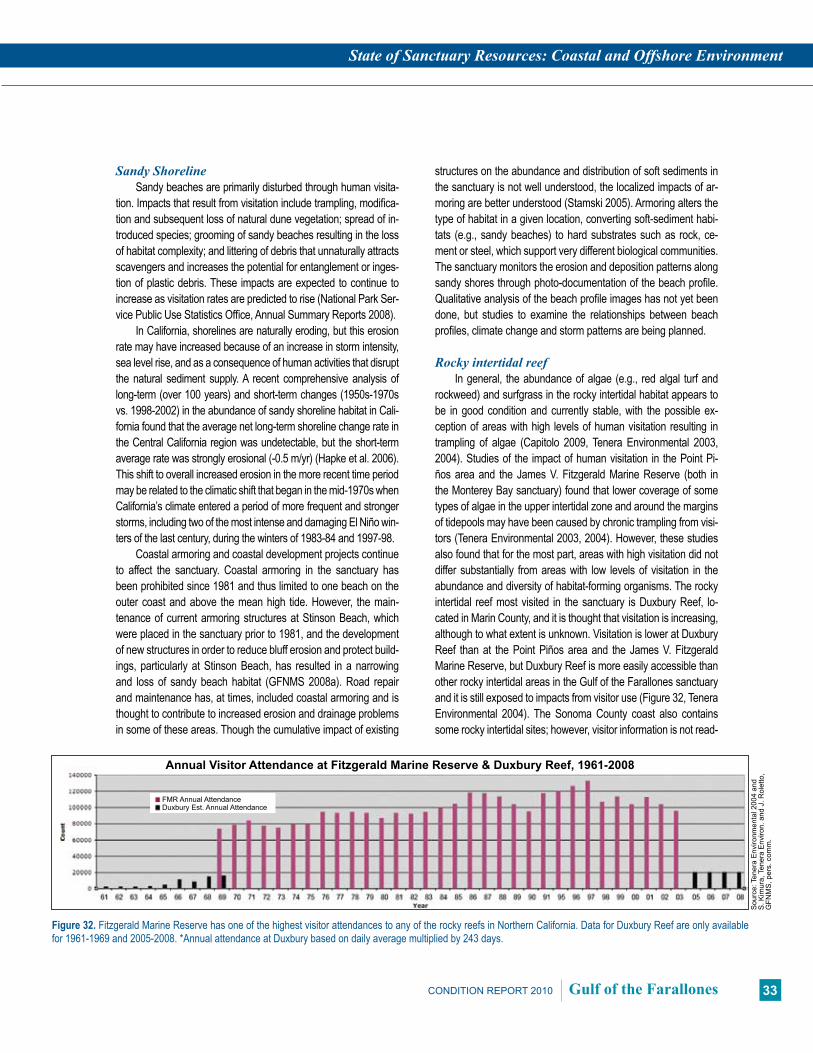
State of Sanctuary Resources: Coastal and Offshore Environment
33CONDITION REPORT 2010 Gulf of the Farallones
Sandy ShorelineSandy beaches are primarily disturbed through human visita-
tion. Impacts that result from visitation include trampling, modifica-tion and subsequent loss of natural dune vegetation; spread of in-troduced species; grooming of sandy beaches resulting in the loss of habitat complexity; and littering of debris that unnaturally attracts scavengers and increases the potential for entanglement or inges-tion of plastic debris. These impacts are expected to continue to increase as visitation rates are predicted to rise (National Park Ser-vice Public Use Statistics Office, Annual Summary Reports 2008).
In California, shorelines are naturally eroding, but this erosion rate may have increased because of an increase in storm intensity, sea level rise, and as a consequence of human activities that disrupt the natural sediment supply. A recent comprehensive analysis of long-term (over 100 years) and short-term changes (1950s-1970s vs. 1998-2002) in the abundance of sandy shoreline habitat in Cali-fornia found that the average net long-term shoreline change rate in the Central California region was undetectable, but the short-term average rate was strongly erosional (-0.5 m/yr) (Hapke et al. 2006). This shift to overall increased erosion in the more recent time period may be related to the climatic shift that began in the mid-1970s when California’s climate entered a period of more frequent and stronger storms, including two of the most intense and damaging El Niño win-ters of the last century, during the winters of 1983-84 and 1997-98.
Coastal armoring and coastal development projects continue to affect the sanctuary. Coastal armoring in the sanctuary has been prohibited since 1981 and thus limited to one beach on the outer coast and above the mean high tide. However, the main-tenance of current armoring structures at Stinson Beach, which were placed in the sanctuary prior to 1981, and the development of new structures in order to reduce bluff erosion and protect build-ings, particularly at Stinson Beach, has resulted in a narrowing and loss of sandy beach habitat (GFNMS 2008a). Road repair and maintenance has, at times, included coastal armoring and is thought to contribute to increased erosion and drainage problems in some of these areas. Though the cumulative impact of existing
structures on the abundance and distribution of soft sediments in the sanctuary is not well understood, the localized impacts of ar-moring are better understood (Stamski 2005). Armoring alters the type of habitat in a given location, converting soft-sediment habi-tats (e.g., sandy beaches) to hard substrates such as rock, ce-ment or steel, which support very different biological communities. The sanctuary monitors the erosion and deposition patterns along sandy shores through photo-documentation of the beach profile. Qualitative analysis of the beach profile images has not yet been done, but studies to examine the relationships between beach profiles, climate change and storm patterns are being planned.
Rocky intertidal reefIn general, the abundance of algae (e.g., red algal turf and
rockweed) and surfgrass in the rocky intertidal habitat appears to be in good condition and currently stable, with the possible ex-ception of areas with high levels of human visitation resulting in trampling of algae (Capitolo 2009, Tenera Environmental 2003, 2004). Studies of the impact of human visitation in the Point Pi-ños area and the James V. Fitzgerald Marine Reserve (both in the Monterey Bay sanctuary) found that lower coverage of some types of algae in the upper intertidal zone and around the margins of tidepools may have been caused by chronic trampling from visi-tors (Tenera Environmental 2003, 2004). However, these studies also found that for the most part, areas with high visitation did not differ substantially from areas with low levels of visitation in the abundance and diversity of habitat-forming organisms. The rocky intertidal reef most visited in the sanctuary is Duxbury Reef, lo-cated in Marin County, and it is thought that visitation is increasing, although to what extent is unknown. Visitation is lower at Duxbury Reef than at the Point Piños area and the James V. Fitzgerald Marine Reserve, but Duxbury Reef is more easily accessible than other rocky intertidal areas in the Gulf of the Farallones sanctuary and it is still exposed to impacts from visitor use (Figure 32, Tenera Environmental 2004). The Sonoma County coast also contains some rocky intertidal sites; however, visitor information is not read-
Sou
rce:
Ten
era
Env
ironm
enta
l 200
4 an
d S
. Kim
ura,
Ten
era
Env
iron.
and
J. R
olet
to,
GFN
MS
, per
s. c
omm
.
Figure 32. Fitzgerald Marine Reserve has one of the highest visitor attendances to any of the rocky reefs in Northern California. Data for Duxbury Reef are only available for 1961-1969 and 2005-2008. *Annual attendance at Duxbury based on daily average multiplied by 243 days.
Annual Visitor Attendance at Fitzgerald Marine Reserve & Duxbury Reef, 1961-2008
FMR Annual AttendanceDuxbury Est. Annual Attendance

State of Sanctuary Resources: Coastal and Offshore Environment
34 Gulf of the Farallones CONDITION REPORT 2010
Sou
rce:
Cal
iforn
ia F
ishe
ries
Info
rmat
ion
S
yste
m 2
007
Trawling Effort in the Sanctuary (number of vessels per year
Figure 33. Trawling effort and catches per trawl have declined over the past 10 years.
Figure 34. Fisheries closure areas as designated by the Pacific Fisheries Management Council, March 2008. Note that Rockfish Conservation Areas change seasonally and annually, therefore are not shown on this map.
Map
: T. R
eed,
GFN
MS
)
ily available for these areas. The sanctuary is currently evaluating the extent of trampling impacts at Duxbury Reef and developing outreach programs to minimize potential trampling impacts.
Large-scale climate and oceanographic changes also influ-ence the composition, abundance and distribution of intertidal or-ganisms. Shifts in the composition of the Central California rocky intertidal zone may be attributed to climate changes in recent de-cades (Barry et al. 1995, Sagarin et al. 1999, Pearse 1998). Sanc-tuary staff continue to monitor abundance and range extensions for species in the rocky intertidal habitat (Airamé et al. 2003).
Offshore Benthic ZoneThe majority of the physical habitat in the offshore
zone is composed of soft sediments with various mix-tures of sand, mud and silt. Under natural conditions, these soft-bottom habitats are structured by both physical processes, such as currents, and the activities of animals that increase the physical complexity of the habitat by creating mounds, burrows and depressions. This struc-ture is in turn used by fishes and other marine life as refu-gia from predation and currents.
A number of studies have shown that mobile, bottom-contact fishing gear (e.g., trawl nets) can alter seafloor habitats and associated biota (NRC 2002). Mobile fishing gear reduces seafloor complexity through the removal of attached and emergent fauna that provide structure (e.g., corals and sponges), the removal of other sediment-associated megafauna that produce pits and burrows (e.g., crabs, fish), and the smoothing of bedforms (e.g., sand waves; Lindholm et al. 2004). In addition to the removal of targeted spe-cies, such operations can cause a variety of incidental biological impacts to non-targeted benthic organisms including changes in population densities, species di-versity, community structure and composition, trophic structure, and productivity (Thrush and Dayton 2002). The impact from trawling and any recovery will vary depending on substrate and the associated commu-nity (NRC 2002). Data indicate that communities as-sociated with hard substrates may require a decade or more to show any recovery (e.g., Collie et al. 2000), while other data suggest that recovery in soft-sediment communities may occur more rapidly depending on water depth (e.g., Lindholm et al. 2004, de Marignac et al. 2009).
When gillnets were banned in the late 1980s, an alternate gear program was developed which allowed
experimental use of other gears, such as otter trawls. California halibut were the target of an experimental alternative gear near-shore fishery, which ended in the 1990s. Trawling activities in the Gulf of the Farallones sanctuary have been substantially re-duced from historic levels because of area closures (Figures 33 and 34), specifically due to designation of Essential Fish Habi-tats and establishment of Rockfish Conservation Areas (RCA). RCAs were initially established in 2002 by the National Marine Fisheries Service to allow for recovery of certain over-fished rockfish species. RCAs change annually, between gear types
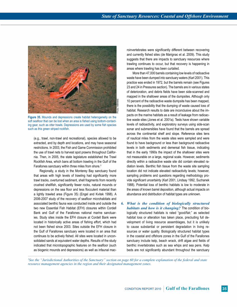
State of Sanctuary Resources: Coastal and Offshore Environment
35CONDITION REPORT 2010 Gulf of the Farallones
(e.g., trawl, non-trawl and recreational), species allowed to be extracted, and by depth and locations, and may have seasonal restrictions. In 2003, the Fish and Game Commission prohibited the use of trawl nets to harvest spot prawns throughout Califor-nia. Then, in 2005, the state legislature established the Trawl Rockfish Area, which bans all bottom trawling in the Gulf of the Farallones sanctuary within three miles from shore.3
Regionally, a study in the Monterey Bay sanctuary found that areas with high levels of trawling had significantly more trawl tracks, overturned sediment, shell fragments from recently crushed shellfish, significantly fewer rocks, natural mounds or depressions on the sea floor and less flocculent material than a lightly trawled area (Figure 35) (Engel and Kvitek 1998). A 2006-2007 study of the recovery of seafloor microhabitats and associated benthic fauna was conducted inside and outside the two new Essential Fish Habitat (EFH) closures within Cordell Bank and Gulf of the Farallones national marine sanctuar-ies. Study sites inside the EFH closure at Cordell Bank were located in historically active areas of fishing effort, which had not been fished since 2003. Sites outside the EFH closure in the Gulf of Farallones sanctuary were located in an area that continues to be actively fished. All sites were located in uncon-solidated sands at equivalent water depths. Results of the study indicated that microtopographic features on the seafloor (such as biogenic mounds and depressions) as well as infaunal mac-
roinvertebrates were significantly different between recovering and currently fished sites (de Marignac et al. 2009). This study suggests that there are impacts to sanctuary resources where trawling continues to occur, but that recovery is happening in areas where trawling has been curtailed.
More than 47,000 barrels containing low levels of radioactive waste have been dumped into sanctuary waters (Karl 2001). This practice was ended in 1972, but the barrels remain (see Figures 23 and 24 in Pressures section). The barrels are in various states of deterioration, and debris fields have been side-scanned and mapped in the shallower areas of the dumpsites. Although only 10 percent of the radioactive waste dumpsite has been mapped, there is the possibility that the dumping of waste caused loss of habitat. Research results to date are inconclusive about the im-pacts on the marine habitats as a result of leakage from radioac-tive waste sites (Jones et al. 2001a). Tests have shown variable levels of radioactivity, and exploratory surveys using side-scan sonar and submersibles have found that the barrels are spread across the continental shelf and slope. Reference sites tens of nautical miles from the waste sites were sampled and were found to have background or less than background radioactive levels in both sediments and demersal fish tissue, indicating that in the early 1990s the impact of the shallower sites were not measurable on a large, regional scale. However, sediments directly within a radioactive waste site did contain elevated ra-diation levels. Benthic fish tissue from the waste site sampling location did not indicate elevated radioactivity levels; however, sampling problems and questions regarding methodology pro-vide significant uncertainty (Karl 2001, Lindsay 1992, Suchanek 1988). Potential loss of benthic habitats is low to moderate in the areas of known barrel deposition, although actual impacts on abundance and distribution of habitat types are unknown.
6. What is the condition of biologically structured habitatsandhowisitchanging?The condition of bio-logically structured habitats is rated “good/fair,” as selected habitat loss or alteration has taken place, precluding full de-velopment of living resource assemblages, but it is unlikely to cause substantial or persistent degradation in living re-sources or water quality. Biologically structured habitat types in the coastal and offshore zones in the Gulf of the Farallones sanctuary include kelp, beach wrack, drift algae and fields of benthic invertebrates such as sea whips and sea pens. Kelp beds are not significantly abundant throughout the sanctuary
3Seethe“JurisdictionalAuthoritiesoftheSanctuary”sectiononpage60foracompleteexplanationofthefederalandstateresourcemanagementagenciesintheregionandtheirdesignatedmanagementzones.
Figure 35. Mounds and depressions create habitat heterogeneity on the soft seafloor that can be lost when an area is fished using bottom-contact-ing gear, such as otter trawls. Depressions are used by some fish species such as this green striped rockfish.
Pho
to: M
BN
MS
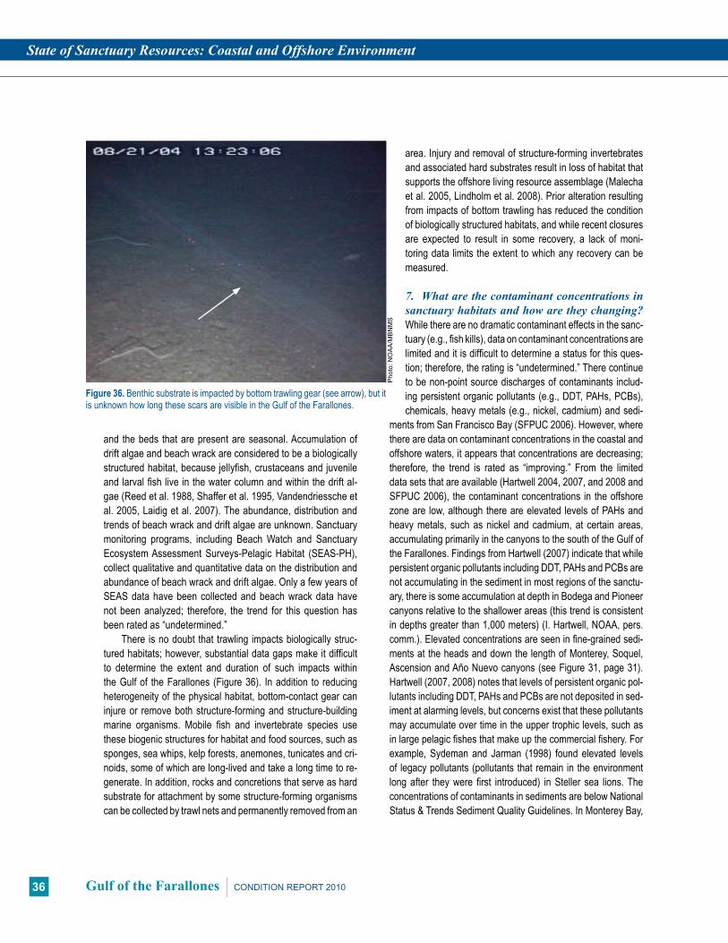
State of Sanctuary Resources: Coastal and Offshore Environment
36 Gulf of the Farallones CONDITION REPORT 2010
and the beds that are present are seasonal. Accumulation of drift algae and beach wrack are considered to be a biologically structured habitat, because jellyfish, crustaceans and juvenile and larval fish live in the water column and within the drift al-gae (Reed et al. 1988, Shaffer et al. 1995, Vandendriessche et al. 2005, Laidig et al. 2007). The abundance, distribution and trends of beach wrack and drift algae are unknown. Sanctuary monitoring programs, including Beach Watch and Sanctuary Ecosystem Assessment Surveys-Pelagic Habitat (SEAS-PH), collect qualitative and quantitative data on the distribution and abundance of beach wrack and drift algae. Only a few years of SEAS data have been collected and beach wrack data have not been analyzed; therefore, the trend for this question has been rated as “undetermined.”
There is no doubt that trawling impacts biologically struc-tured habitats; however, substantial data gaps make it difficult to determine the extent and duration of such impacts within the Gulf of the Farallones (Figure 36). In addition to reducing heterogeneity of the physical habitat, bottom-contact gear can injure or remove both structure-forming and structure-building marine organisms. Mobile fish and invertebrate species use these biogenic structures for habitat and food sources, such as sponges, sea whips, kelp forests, anemones, tunicates and cri-noids, some of which are long-lived and take a long time to re-generate. In addition, rocks and concretions that serve as hard substrate for attachment by some structure-forming organisms can be collected by trawl nets and permanently removed from an
area. Injury and removal of structure-forming invertebrates and associated hard substrates result in loss of habitat that supports the offshore living resource assemblage (Malecha et al. 2005, Lindholm et al. 2008). Prior alteration resulting from impacts of bottom trawling has reduced the condition of biologically structured habitats, and while recent closures are expected to result in some recovery, a lack of moni-toring data limits the extent to which any recovery can be measured.
7. What are the contaminant concentrations in sanctuaryhabitatsandhowaretheychanging?While there are no dramatic contaminant effects in the sanc-tuary (e.g., fish kills), data on contaminant concentrations are limited and it is difficult to determine a status for this ques-tion; therefore, the rating is “undetermined.” There continue to be non-point source discharges of contaminants includ-ing persistent organic pollutants (e.g., DDT, PAHs, PCBs), chemicals, heavy metals (e.g., nickel, cadmium) and sedi-
ments from San Francisco Bay (SFPUC 2006). However, where there are data on contaminant concentrations in the coastal and offshore waters, it appears that concentrations are decreasing; therefore, the trend is rated as “improving.” From the limited data sets that are available (Hartwell 2004, 2007, and 2008 and SFPUC 2006), the contaminant concentrations in the offshore zone are low, although there are elevated levels of PAHs and heavy metals, such as nickel and cadmium, at certain areas, accumulating primarily in the canyons to the south of the Gulf of the Farallones. Findings from Hartwell (2007) indicate that while persistent organic pollutants including DDT, PAHs and PCBs are not accumulating in the sediment in most regions of the sanctu-ary, there is some accumulation at depth in Bodega and Pioneer canyons relative to the shallower areas (this trend is consistent in depths greater than 1,000 meters) (I. Hartwell, NOAA, pers. comm.). Elevated concentrations are seen in fine-grained sedi-ments at the heads and down the length of Monterey, Soquel, Ascension and Año Nuevo canyons (see Figure 31, page 31). Hartwell (2007, 2008) notes that levels of persistent organic pol-lutants including DDT, PAHs and PCBs are not deposited in sed-iment at alarming levels, but concerns exist that these pollutants may accumulate over time in the upper trophic levels, such as in large pelagic fishes that make up the commercial fishery. For example, Sydeman and Jarman (1998) found elevated levels of legacy pollutants (pollutants that remain in the environment long after they were first introduced) in Steller sea lions. The concentrations of contaminants in sediments are below National Status & Trends Sediment Quality Guidelines. In Monterey Bay,
Figure 36. Benthic substrate is impacted by bottom trawling gear (see arrow), but it is unknown how long these scars are visible in the Gulf of the Farallones.
Pho
to: N
OA
A/M
BN
MS

State of Sanctuary Resources: Coastal and Offshore Environment
37CONDITION REPORT 2010 Gulf of the Farallones
concentrations of the legacy pesticide DDT do not appear to be declining due to continuing watershed inputs (Hartwell 2004, 2007, 2008), but there are no trend data for the Gulf of the Far-allones. Runoff from watersheds in agricultural areas, such as Monterey Bay, may influence the Gulf of the Farallones region as northward flows are common in winter, however, a tracer study would be necessary to evaluate the importance of this.
8. What are the levels of human activities that may influencehabitatqualityandhoware theychang-ing? The level of human activities in the coastal and offshore zone of the sanctuary is rated “good/fair” and “not changing” because some potentially harmful human activities exist, includ-ing shipping, increased urbanization and visitation, but they do not appear to have had a significant negative effect on habitat quality. Sandy beaches and rocky shores are primarily disturbed through human visitation and extraction. Impacts that result from visitation include: (i) trampling, modification, and subse-quent loss of natural dune vegetation; (ii) spread of introduced species; (iii) grooming of sandy beaches resulting in the loss of habitat complexity; and (iv) littering of debris that unnaturally at-tracts scavengers and increases the potential for entanglement or ingestion of plastic debris. These impacts are expected to continue to increase as visitation rates are expected to increase (National Park Service Public Use Statistics Office, Annual Sum-mary Reports). Increased urbanization could also contribute to increases in pollutants, but there are no obvious contaminant problems in the sanctuary and it appears that contaminant con-centrations are decreasing in the coastal and offshore waters of the sanctuary.
Vessel traffic has also increased (see Table 3, page 32), thus increasing the impacts from noise, dredging of shipping lanes, discharges of ballast and wastewater from cargo vessels and cruise ships (e.g., invasives), and increased potential for large oil spills (HSCSFBR 2008). However, there has also been an increase in management and enforcement activities to help reduce the amount of chronic oil pollution from sunken vessels and illegal discharges of oily bilge water. Trawling activity levels have also been reduced by recent area closures that should al-low recovery of many of the impacted habitats located offshore (see Figure 34, page 34). A recent study strongly suggests that there are impacts to sanctuary resources where trawling con-tinues to occur, but that recovery is happening in areas where trawling has been curtailed (de Marignac et al. 2009).
Roadside maintenance activities and coastal armoring placed prior to sanctuary designation continue to be localized problems that are clustered near population centers, such as near Stinson Beach and along sections of the coastal highway. Both activities can convert habitat type and increase erosion rates. Although these activities continue to occur in or adjacent to the sanctuary, they have not increased in intensity or frequency.
Coastal and Offshore Environment Habitat Status & Trends
# Issue Rating Basis for Judgment Description of Findings
5 Abundance/Distribution p
Some benthic habitat loss from localized pressures related to increased human ac-tivities, reduced trawling impacts and improved enforcement of dredge disposal practices.
Selected habitat loss or alteration has taken place, precluding full development of living resource assemblages, but it is unlikely to cause substantial or persistent degradation in living resources or water quality.
6 Structure ?
Prior alteration and loss due to trawling; sub-stantial data gaps for a number of habitat types, including drift algae and beach wrack
Selected habitat loss or alteration has taken place, precluding full de-velopment of living re-sources, but it is unlikely to cause substantial or persistent degradation in living resources or water quality.
7 Contami-nants p
New but limited data indicates reduction of persistent contami-nants and no obvious problems.
N/A
8 Human Activities –
Activities relating to increased urbanization, visitation and shipping; decrease in trawling and chronic oil pollution, cessation of discharging of radioactive waste, increased regulations to prevent introduced species.
Some potentially harmful activities exist, but they do not appear to have had a nega-tive effect on habitat quality.
Status: Good Good/Fair Fair Fair/Poor Poor Undet.
Trends: Improving (p), Not Changing (–), Declining (q), Undetermined Trend (?), Question not applicable (N/A)
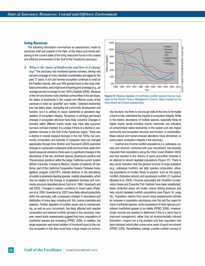
State of Sanctuary Resources: Coastal and Offshore Environment
38 Gulf of the Farallones CONDITION REPORT 2010
Living ResourcesThe following information summarizes an assessment, made by
sanctuary staff and experts in the field, of the status and trends per-taining to the current state of the living resources found in the coastal and offshore environment of the Gulf of the Farallones sanctuary.
9. Whatisthestatusofbiodiversityandhowisitchang-ing? The sanctuary has monitored species richness, density and percent coverage of rocky intertidal invertebrates and algae for the past 17 years. A rich and diverse ecosystem continues to exist on the Farallon Islands, with over 500 species found in the rocky inter-tidal communities, and a high level of layering and coverage (e.g., an average percent coverage of over 150% (Capitolo 2009)). Because of the rich and diverse rocky intertidal communities in the sanctuary, the status of biodiversity in the coastal and offshore zones of the sanctuary is rated as “good/fair” and “stable.” Selected biodiversity loss has taken place, precluding full community development and function, but it is unlikely to cause substantial or persistent deg-radation of ecosystem integrity. Temporary or perhaps permanent changes in ecosystem structure have likely occurred. Changes in biomass within different trophic levels may have also occurred, but have not been tracked. It is unclear if there is a decline in zoo-plankton biomass in the Gulf of the Farallones region. There was a decline in overall copepod biomass in the mid 1970s, but com-munity composition and diversity of copepods have not changed appreciably through time. Brinton and Townsend (2003) examined changes in euphausiid crustaceans (krill) and found that, aside from typical seasonal variations, there were no significant changes in the abundance of the two dominant species (Euphausia pacifica and Thysanoessa spinifera) within the larger California current system (British Columbia, Canada to Mexico). Studies of seabirds off Cali-fornia, part of the California Cooperative Oceanic Fisheries Inves-tigations program (CalCOFI), indicate declines in the abundance of certain zooplankton-feeding species, notably shearwaters, which may be related to the change in zooplankton biomass and com-munity structure described above (Veit et al. 1996, Hyrenbach and Veit 2003). Changes in oceanic conditions in recent years (Peter-son et al. 2006, Goericke et al. 2007) have likely altered productivity within the sanctuary, with consequent changes in abundance and distribution of many taxa, including krill, fish, marine mammals and seabirds. Further, depletion of rockfish stocks due to overharvest-ing, as well as poor recruitment, has likely affected both species composition and reduced rockfish biomass in the sanctuary; how-ever, recent stock assessments suggest that many populations of overfished species are increasing (PFMC 2006). In addition, the range expansion and recent addition of Humboldt squid to the ma-rine ecosystem in this area could have a large impact on commu-
nity structure, but there is not enough data at this time to formulate a trend or fully understand the impacts to ecosystem integrity. Shifts in the relative abundance of multiple species, especially those at higher trophic levels including marine mammals, are indicators of compromised native biodiversity in the system and can impact community and ecosystem structure and function. In combination, these natural and human-induced alterations have diminished, to some extent, ecosystem integrity in the sanctuary.
Overharvest of some rockfish populations (i.e. yelloweye, ca-nary and cowcod), combined with poor recruitment, has severely impacted their populations along the West Coast (Ralston 2002) and has resulted in the closure of some groundfish fisheries in an attempt to rebuild depleted populations (Figure 37). There is also some indication that the general removal of large predators (e.g., yelloweye rockfish) can alter species composition, allow-ing populations of smaller fishes to expand, such as the pygmy rockfish (Sebastes wilsoni) and squarespot rockfish (S. hopkinsi) (Baskett et al. 2006). Closures associated with Rockfish Conser-vation Areas and Essential Fish Habitats have been established; these protected areas will locally reduce fishing pressure and help rebuild depleted rockfish populations (see Figure 34, page 34). Population metrics from recent stock assessments indicate an increase in population abundance over the last five years for many overfished species, while populations of other species con-sidered overfished appear to be stable (PFMC 2006). However, longer records are needed to determine if this is a trend due to improved management, rather than an environmentally induced fluctuation. Lingcod are a top predator and their population has been declared rebuilt after consecutive years of good recruitment (PFMC 2006). Nevertheless, pelagic juvenile rockfish surveys in
Figure 37. Relative depletion of overfished rockfish species that are man-aged by the Pacific Fishery Management Council. Data is based on the most recent set of stock assessments.
Sou
rce:
S. R
alst
on, N
OA
A N
MFS
-SW
FSC
, unp
ubl.
data

State of Sanctuary Resources: Coastal and Offshore Environment
39CONDITION REPORT 2010 Gulf of the Farallones
2005 within the Northern California region indicated an all-time low in catch (for a 23-year data set) (Figure 38) and an apparent shift in distribution of fish to the north and the south of the Central California region (Peterson et al. 2006, S. Ralston, NOAA NMFS Southwest Fisheries Science Center, unpubl. data). Finally, a combination of instream pressures such as water diversion, de-graded spawning habitat and poor ocean conditions have taken a toll on populations of Chinook and coho salmon. Poor spawn-ing escapement and record low numbers in the ocean elicited an unprecedented closure of the commercial and recreational fall run Chinook salmon fishery in 2008.
A decline in productivity of krill and fish may be associ-ated with long-term variations in climate. Populations of some species, including Pacific sardine and northern anchovy, vary widely with decadal oscillations and climate fluctuations. Data indicate that sardine populations typically fluctuate between abundant and scarce over periods of 60 years, and somewhat in accordance with the Pacific Decadal Oscillation. Data also sug-gest that these species occupy similar ecological niches; as the sardine population increases, the northern anchovy population typically decreases (Takasuka et al. 2008, Chavez et al. 2003). As another example of linkages to climate variability, the entire shortbelly rockfish decline can only be attributed to natural en-vironmental fluctuations (S. Ralston, NOAA NMFS Southwest Fisheries Science Center, pers. comm.). Only very minor land-ings of shortbelly rockfish have been reported in California over the last 20 years (10 – 70 mt/yr), amounting to less than 1 per-cent of the estimated optimum yield (13,900 mt/yr).4
Changes in fish and krill abundance can have cascading trophic effects on other species, including seabirds. For example,
within the Gulf of the Farallones, Common Murres used to feed their chicks mostly juvenile shortbelly rockfish, but turned to an-chovies and sardines after rockfish became scarce (Edgar 1997, Sydeman et al. 2001). As another example, local Cassin’s Auk-lets did not breed in 2006 and had very poor breeding success in 2005 due to low productivity and severely reduced biomass of krill within the Gulf of the Farallones region (Abraham 2007).
Abundance of non-resident species, such as Sooty Shear-waters and Black-footed Albatrosses, has also declined within the waters of Northern California (Ainley and Hyrenbach unpubl. data), potentially due to pressures from human impacts in their breeding areas. In addition, the Central California population of Marbled Murrelets, a seabird that forages in sanctuary waters and nests in old growth forests adjacent to the sanctuary, was recently estimated between 122 and 225 individuals, which rep-resents a 54-55% decline since 2007 and 71-80% decline since 2003 (Peery et al. 2008). This decline is attributed in large part to terrestrial human activities that result in the degradation or loss of breeding habitat (Peery et al. 2008).
Significant changes in abundance and distribution of sea otters, Steller sea lions and northern fur seals can be attributed to human activities including hunting that drove these popula-tions in California to near extinction. All three taxa are carnivores that can have considerable influence on lower levels of the food chain, and their removal can greatly affect community structure. Pupping rates and general population health of Steller sea lions in California have decreased since the 1950s (Sease and Mer-rick 1997, Sydeman and Allen 1999). The breeding population at the Farallon Islands has stabilized in recent years, but re-mains depressed (Sydeman and Allen 1997 and 1999). North-ern fur seals, extirpated from the Farallon Islands in the late 1800s, began breeding again on the Farallon Islands in 1996 (Pyle et al. 2001). Sea otters in particular are a well-document-ed keystone species that influence sea urchin populations and, in turn, kelp forest density (Kvitek and Oliver 1988). Historically, in the early 1800s otters were abundant in nearshore areas in the region of the sanctuary; however, they were nearly hunted to extinction. Following the otters’ demise, the sea urchin popu-lation exploded, leading to severe reductions in kelp, and con-sequently significant biodiversity declines among species that depend on kelp habitats (Kvitek and Oliver 1988). However, the commercial sea urchin fishery has mitigated the absence of sea otters and subsequently has prevented continued reductions in kelp on the north and north-central coast (P. Reilly, CA DFG,
Sou
rce:
S. R
alst
on, N
OA
A N
MFS
-SW
FSC
, un
publ
. dat
a
Figure 38. Pelagic juvenile rockfish abundance from midwater trawl sur-veys conducted from Bodega Bay to Carmel, Calif. Note that the y-axis is a logarithmic scale.
4Althoughlawsdonotspecificallypreventfishingforshortbellyrockfish,fishingwithtrawlsthathaveastretchedmeshsizelessthan4.5inchesisprohibited.Becauseshortbellyrockfisharesmalltheycanfreelyescapethroughtrawlswithlegalmeshsize.

State of Sanctuary Resources: Coastal and Offshore Environment
40 Gulf of the Farallones CONDITION REPORT 2010
pers. comm.) The protection and active management of marine mammal populations by state, federal and international entities has allowed the recovery to some extent of sea otter, Steller sea lion and northern fur seal populations, and these species could regain a measure of control in the ecosystem over the resources that support them.
10. What is the status of environmentally sustainable fishing andhow is it changing?The status and trend ratings for this question are based on the available scientific knowledge (e.g., published studies, unpublished data and ex-pert opinion) of targeted and non-targeted living resources that are directly and indirectly affected by fishing. Due to historical fishing impacts and recent regulatory actions to restore some fish populations, the status of sustainable fishing is rated “fair” and the trend is “improving.” Experts speculate that fishing ac-tivities may inhibit full community development and function, and may cause measurable but not severe degradation of ecosys-tem integrity. Because this is the first sanctuary condition report, the rating reflects a more historical view of the potential effects of fishing activity on biological community development, func-tion and ecosystem integrity over the last two to three decades. Subsequent reports will take a more contemporary view of the ecosystem-level impacts of fishing. The rating does not serve as an assessment of the status of current fisheries manage-ment practices in the region. However, the determination of an increasing trend for this question does reflect recent changes in fisheries management practices and their positive effects on living resources in the sanctuary.
For this report, environmentally sustainable fishing or eco-logically sustainable fishing is defined as fishing at a level that the ecosystem can sustain without shifting to an alternative or undesirable state. To determine if environmentally sustainable fishing is occurring, one has to simultaneously consider the im-pacts of all harvested species on an ecosystem, and commu-nity stability and resilience (Zabel et al. 2003). Environmentally sustainable fishing is designed to consider fishery yield and the integrity of ecosystem structure, productivity, and function and biodiversity, including habitat and associated biological commu-nities. Recent amendments to the Magnuson-Stevens Act have prescribed a more holistic consideration of sustaining fisheries by stipulating that yields from a fishery must take into account the protection of marine ecosystems (NMFS 2007).
In the late 1970s and 1980s there was a significant gillnet fishery in the nearshore areas of Central California targeting California halibut (Paralichthys californicus) and soupfin shark (Galeorhinus galeus). Harvest levels were substantial for a short
period of time and by-catch levels were high. However, man-agement regimes for commercial fishing are currently more risk-averse than in prior decades, and some measures are proving successful in allowing over-fished stocks to recover. Trawling for spot prawns was prohibited in 2003 in Central California. Bottom trawling was prohibited in all state waters in 2005, with the ex-ception of the halibut trawl grounds in Southern California. The number of active trawlers in the region has declined as prohibi-tions, quotas and gear restrictions have made it less profitable to trawl. In 2006, there were six commercial fisheries (Dungeness crab (Metacarcinus magister), California halibut (Paralichthys californicus), Chinook salmon (Oncorhynchus tshawytscha), Pacific herring (Clupea pallasii), sablefish (Anoplopoma fimbria) and petrale sole (Eopsetta jordani)), each with over $100,000 in annual landings value in the ports of San Francisco and/or Half Moon Bay (P. Reilly, CA DFG, pers. comm.).
Recreational fishing primarily targets rockfish species, ling-cod (Ophiodon elongates), California halibut, striped bass (Mo-rone saxatilis), salmon species, albacore (Thunnus alalunga), surfperch species and Dungeness crab. A recreational fishery for Humboldt squid (Dosidicus gigas) has begun, but the levels of take and impacts from the recreational take of squid have not yet been assessed. The California Recreational Fisheries Survey provides the best estimates available on recreational catch of finfish by geographical area. Overall, recreational fish-ing effort appears to have stabilized for at least two reasons: fishing regulations have become more restrictive by depth and season, and some bag limits have been reduced in the past decade. Commercial passenger fishing vessels (party boats) have responded to increased interest in ecotourism by directing more effort toward whale watching, seabird and shark ecotour-ism trips.
Gillnetting can impact other living resources. For example, since the late 1970s, Common Murres declined 50 percent in Central California. Some populations were even depleted or ex-tirpated, partly due to gillnetting, oil pollution and environmental factors (Manuwal et al. 2001). Sea otters were also impacted by gillnets, as were harbor porpoises during the 1970s and 1980s (Forney 1999, Carretta et al. 2005a). The gillnet fishery was se-verely restricted in 1989 in the Gulf of the Farallones and a few years later in Monterey Bay (NMFS 1999).
In the past, there was significant depletion of certain rock-fish populations in the Gulf of the Farallones. The National Ma-rine Fisheries Service conducts an annual survey to estimate the distribution and abundance of pelagic juvenile rockfish in the immediate region of the sanctuary (see Figure 38, page 39). Results show that during the late 1980s catches averaged 10

State of Sanctuary Resources: Coastal and Offshore Environment
41CONDITION REPORT 2010 Gulf of the Farallones
to 100 fish per trawl, but during the 1990s there was a general decline in abundance, falling to 0.2 fish per trawl in 1998. In the early 2000s, seven species of rockfish (bocaccio, cowcod, wid-ow, yelloweye, canary, darkblotched and Pacific ocean perch) were formally declared overfished throughout their range by the National Marine Fisheries Service; all but the latter species are relatively common within the sanctuary (see Figure 37, page 38). Subsequently catches increased to around 10 fish per trawl from 2001 to 2004, but dropped abruptly to the lowest value in the time series in 2005 (0.1 fish per trawl). Since then, catches have increased slightly, but still remain low (0.4 fish per trawl in 2007). Trends in abundance of exploited and unexploited spe-cies are very similar, implying that variation in the environment is largely responsible for these trends (S. Ralston, NOAA NMFS Southwest Fisheries Science Center, unpubl. data). Preliminary trends indicated that there are increasing numbers of groundfish (S. Ralston, NOAA NMFS Southwest Fisheries Science Center, unpubl. data). Future Gulf of the Farallones sanctuary Condition Reports will reflect these latest trends.
Fishing for rockfish is prohibited within the Rockfish Conser-vation Areas, established in 2002. Rockfish Conservation Areas are modified annually and can vary by season, depth and fishing gear types. Recovery of overfished species is expected to take some time due to their slow maturity rates. Lingcod was previ-ously declared overfished but has now recovered (PFMC 2006) after harvest restrictions proved successful, as the rapid growth and maturity of this species resulted in more rapid population in-creases than the overfished rockfish species. The prohibition of bottom trawling in state waters in 2005 and Essential Fish Habi-tat designations in 2006 in some offshore areas are expected to increase habitat protection (see Figure 34, page 34).
Of the 30 groundfish species stocks, four species stocks (cowcod, petrale sole, yelloweye rockfish and canary rockfish) are at or below the minimum stock size threshold for overfish-ing, which is 25 percent or less. Eighteen species stocks are considered not depleted by the Pacific Fisheries Management Council (Table 4).
At one time, five species of abalone (red, pink, green, black and white) supported recreational and commercial fisheries in California. Of these five species, only red and black (Haliotis rufescens and H. cracherodii) occur in any abundance within the sanctuary (Leet et al 2001). By 1997, Central and Southern California abalone had experienced stock collapse from both natural and human-related causes, resulting in the closure of all commercial abalone fishing in those areas. The only abalone fishery currently open in the state is the red abalone sport fishery in the Northern California region, from Marin County northward.
The five formerly fished species in the central and Southern California regions are at risk of further population declines and white abalone are near extinction. In 2009, the black abalone was listed as an endangered species under the federal Endan-gered Species Act (NMFS 2009).
Table 4. Status of groundfish stocks in 2005, 2007 and 2009. Depletion is the estimated fraction of unexploited stock size, with the seven rockfishes in bold currently under rebuilding. Pink shading indicates species that are at or below the minimum stock size threshold (0.25); yellow shading indi-cates species that are in the precautionary zone (0.25-0.40); green shad-ing indicates species that are above the target biomass level (0.40).
Groundfish Species Year DepletionCowcod 2009 0.045
Petrale Sole 2009 0.116
Yelloweye Rockfish 2009 0.203
Canary Rockfish 2009 0.237
Darkblotched Rocfish 2009 0.275
Bocaccio 2009 0.281
Pacific Ocean Perch 2007 0.286
Blue Rockfish 2007 0.299
Cabezon (CA) 2009 0.340
Pacific Whiting 2007 0.362
Sablefish 2007 0.383
Widow Rockfish 2009 0.385
Kelp Greenling 2005 0.488
Starry Flounder 2005 0.497
Blackgill Rockfish 2005 0.524
Black Rockfish (WA) 2007 0.552
Yellowtail Rockfish 2005 0.595
Shortspine Thorneyhead 2005 0.629
Dover Sole 2005 0.632
Longnose Skate 2007 0.659
Splitnose Rockfish 2009 0.660
Black Rockfish (OR/CA) 2007 0.705
Chilipepper 2007 0.710
Longspine Thorneyhead 2005 0.714
Lingcod (CA) 2009 0.737
Arrowtooth Flounder 2007 0.788
Greenstriped Rockfish 2009 0.814
California Scorpionfish 2005 0.798
Gopher Rockfish 2005 0.968
English Sole 2007 1.164
Sou
rce:
S. R
alst
on, N
OA
A N
MFS
-SW
FSC
, unp
ubl.
data

State of Sanctuary Resources: Coastal and Offshore Environment
42 Gulf of the Farallones CONDITION REPORT 2010
11.Whatisthestatusofnon-indigenousspeciesandhowis it changing? Non-indigenous species are not suspected or do not appear to affect ecosystem integrity (full community devel-opment and function) in the sanctuary; therefore, the response to this question is rated “good” and the trend is “not changing.” Non-indigenous planktonic species (e.g. copepods Oithona davisae and possibly Pseudodiaptomus marinus) do occur in offshore waters, but little assessment or monitoring of their occurrence or impacts has been conducted (pers. comm. W. Kimmerer, San Francisoc State University). Of what little is known about non-indigenous planktonic species, there are no apparent ecosystem impacts. Striped bass occur offshore, but are very rare overall. Nonethe-less, there is concern about the potential impacts of striped bass on tidewater gobies, salmon and anchovies, but results are not conclusive. It is unlikely that striped bass impact salmon offshore to any significant extent (S. Bennett, NMFS, pers. comm.). European green crabs (Carcinus maenas) are a threat in nearshore environ-ments. They can prey on and compete for resources with native crabs, such as Dungeness crabs, and as such may have profound impacts on the commercial fishery (Cohen 1997). The sanctuary has limited data on non-indigenous species in the rocky intertidal habitats — data sets are available from the Farallon Islands and the mainland, dating from the 1990s. A species inventory suggests that some non-indigenous algal species (e.g., Sargassum muticum and Codium fragile tomentosoides) do occur in the rocky intertidal habitats of sanctuary, but the extent and impacts are not known.
12.Whatisthestatusofkeyspeciesandhowisitchang-ing? Changes in oceanic conditions in recent years have altered productivity within the sanctuary, with changes in abundance and distribution of many taxa, including indicator species such as krill, fish, marine mammals (Carretta et al. 2005b) and seabirds (Ainley et al. 1993, Miller and Sydeman 2004). Furthermore, depletion of rockfish stocks due to overharvesting, and poor recruitment is suspected to have caused an overall decline in the rockfish bio-mass and altered species composition in the sanctuary (PFMC 2006), although stock assessments suggest that many popula-tions of overfished species are increasing (S. Ralston, NOAA NMFS Southwest Fisheries Science Center, unpubl. data). Sev-eral of the indicator species appear to have been negatively im-pacted by the combination of natural and human-caused forces, such as overfishing during El Niño conditions (Baskett et al. 2006). Substantial or persistent declines, however, are not expected for most of these species, and several of the indicator species that feed within the sanctuary exhibit healthy populations that are in-creasing. Because selected key species are at reduced levels but recovery is possible, the status of key species is rated “fair.” How-
ever, because there is considerable variability in trends for these species, an overall trend has been rated as “undetermined.”
The staff of the Gulf of the Farallones sanctuary has identi-fied 49 species that are considered to be key species (Table 5). Some of the species were selected because they are keystone species, while others were selected for their value in monitoring (e.g., significance in the food web or have a special manage-ment/regulatory status), their susceptibility to acute events such as oil spills, or because they are charismatic or iconic.
The status of the 49 species varies significantly, and while it can be confidently stated that the reduced abundance of certain species, such as rockfish, sea palms, sea turtles, abalone, etc., has altered the ecosystem to some extent, the overall trend is unclear. Some species are clearly in decline, while others have been increasing in abundance over recent years (e.g., humpback and gray whales, coralline algae, fur seals, Common Murres and several other species of seabirds). The following section focuses on a few examples from each of the major groups.
Rocky Intertidal Species: Large-scale climate and oceanographic changes also influence
the composition, abundance and distribution of intertidal organisms. Shifts in the composition of the Central California rocky intertidal zone may be attributed to climate changes in recent decades (Barry et al. 1995, Sagarin et al. 1999, Pearse 1998). Sanctuary staff con-tinues to monitor abundance and range extensions for species in the rocky intertidal habitat (Helmuth et al. 2002, Airamé et al. 2003).
Sardine and Northern Anchovy: Populations of some species, including the Pacific sardine and
northern anchovy, vary widely with climate fluctuations. Data indi-cate that sardine populations typically fluctuate between abundant and scarce over periods of 60 years, and somewhat in accordance with the Pacific Decadal Oscillation. After a collapse of the sardine fishery in the 1950s, northern anchovy populations increased dra-matically, suggesting that these species occupy similar ecological niches. As large populations of sardines reappeared in the early 1970s, the northern anchovy population declined steadily (Taka-suka et al. 2008, Chavez et al. 2003, Airamé et al. 2003).
Rockfish:Rockfish are one of the most ecologically important species
groups in the sanctuary, and status varies by species. In the early 2000s, seven species of rockfish – widow (Sebastes entomelas), yelloweye (S. ruberrimus), canary (S. pinniger), darkblotched (S. crameri), bocaccio (S. paucispinis), cowcod (S. levis) and Pa-cific ocean perch (S. alutus) — were formally declared overfished

State of Sanctuary Resources: Coastal and Offshore Environment
43CONDITION REPORT 2010 Gulf of the Farallones
all-time low in catch (for a 23-year data set) (see Figure 38, page 39) and an apparent shift in distribu-tion of fish both to the north and the south of the Central Califor-nia region (Peterson et al. 2006). There is also some indication that the general removal of large preda-tors such as yelloweye rockfish can alter species composition, allowing populations of smaller fishes such as pygmy and squarespot rockfish to increase (Baskett et al. 2006).
Leatherback Turtle: Since 1980, the population of
leatherback sea turtles in the Pacific Ocean has declined by 95 percent (Benson et al. 2007). Leatherback sea turtles are killed accidentally during gillnet and longline fishing activities, many are hunted for food on their breeding beaches in the Western South Pacific, and they may also die when they ingest ma-rine debris. The status and trend of leatherback turtle populations in the Gulf of the Farallones region are poorly understood. Prelimi-nary findings from the sanctuary’s monitoring programs and other researchers indicate that although turtles are not common throughout the year they are seen in sanctuary waters during the summer and fall months (Benson et al. 2007).
Marine Mammals: Numerous factors have con-
tributed to historical declines of ma-rine mammals, and some continue to affect populations. Though marine mammals were fully protected from hunting in 1972 with the passage of the Marine Mammal Protection Act, some are killed incidentally by entanglement in fishing gear, particularly set and drift gillnets. Restrictions on these fisheries have reduced the rate of entanglement, but some animals are injured or killed each year during routine fishing operations when they become caught in ma-
throughout their range by the NOAA National Marine Fisheries Ser-vice. Population metrics from recent stock assessments indicate an increase in abundance over the last five years for many overfished species, while populations of other species considered overfished appear to be stable (see Figure 37, page 38; PFMC 2006). Never-theless, pelagic juvenile rockfish surveys in 2005 within the Central and Northern California region (Carmel to Bodega Bay) indicated an
Key SpeciesBIRD
Pigeon Guillemot Cepphus columba
Rhinoceros Auklet Cerorhinca monocerata
Snowy Plover Charadrius alexandrinus
Ashy Storm-Petrel Oceanodroma homochroa
Brandt's Cormorant Phalacrocorax penicillatus
Black-footed Albatross Phoebastria nigripes
Cassin’s Auklet Ptychoramphus aleuticus
Sooty Shearwater Puffinus griseus
Common Murre Uria aalge
INVERTEBRATE
Dungeness Crab Cancer magister
Strawberry Anemone Corynactis californica
Krill (shelf break) Euphausia pacifica
Black Abalone Haliotis cracherodii
Red Abalone Haliotis rufescens
California Mussels Mytilus californianus
Red Sponge Ophlitaspongia pennata
Red Sea Urchin Strongylocentrotus franciscanus
Krill (shelf) Thysanoessa spinifera
Horseneck Clam Tresus capax
Common Little Neck Clam Prothaca staminea
PLANT/ALGAE
Eelgrass Zostera marina
Surf Grass Phyllospadix scoleri
Coralline Algae Corallina vancouveriensis
Nail Brush Algae Endocladia muricata
Sea Palm Postelsia palmaeformis
MAMMAL
Minke Whale Balaenoptera acutorostrata
Blue Whale Balaenoptera musculus
Pacific White-sided Dolphin Lagenorhynchus obliquidens
Humpback Whale Megaptera novaeangliae
Harbor Porpoise Phocoena phocoena
Gray Whale Eschrichtius robustus
Northern Fur Seal Callorhinus ursinus
Steller Sea Lion Eumetopius jubatus
Northern Elephant Seal Mirounga angustirostris
Harbor Seal Phoca vitulina
FISH
White Shark Carcharodon carcharias
Pacific Herring Clupea pallasii
Northern Anchovy Engraulis mordax
Coho/Silver Salmon Oncorhynchus kisutch
Steelhead/Rainbow Trout Oncorhynchus mykiss
Chinook Salmon Oncorhynchus tshawytscha
California Halibut Paralichthys californicus
Pacific Sardine Sardinops sagax
Starry Rockfish Sebastes constellatus
Widow Rockfish Sebastes entomelas
Yellowtail Rockfish Sebastes flavidus
Bocaccio Sebastes paucispinis
Rosy Rockfish Sebastes rosaceus
REPTILE
Leatherback Turtle Dermochelys coriacea
Table 5. Key species list (organized by taxonomic order) for both the coastal/offshore zones and the estuarine/lagoon zones in Gulf of the Farallones National Marine Sanctuary. Key species were selected based on the following sensitivity of the species: listing as endangered, threatened, or recovering by state or federal agencies; species that are abundant within the sanctuary; species with a significant proportion of the overall range or population that occurs in the sanctuary; keystone species that provide significant habitat or prey base; and species that rely on the sanctu-ary during their breeding season. All of these species are being monitored at some level through various state and federal natural resource management agencies, as well as private and academic institutions.
Sour
ce: G
FNM
S 20
08b

State of Sanctuary Resources: Coastal and Offshore Environment
44 Gulf of the Farallones CONDITION REPORT 2010
rine debris. The Steller sea lion population has declined over the last 30 years, in part due to a decline in sardine populations (which have since rebounded), entanglement in fishing gear, deliberate culling of the sea lions to protect salmon and herring fisheries and for dressings (genital parts), and possibly disruption of reproduc-tive capabilities owing to chemical pollution (Sydeman and Jar-man 1998). The Steller sea lion population in California is listed as a state and federally threatened species. The breeding population at the Farallon Islands has stabilized in recent years, but remains depressed (Sydeman and Allen 1997). Blue, humpback and fin whales were hunted to near extinction during the last two centu-ries. These species are recovering under international protection; however, all three are currently listed as endangered.
Seabirds: Many bird species in the sanctuary have declined during the
last 150 years due to egg collection on the Farallon Islands, fishing techniques such as gillnetting in waters less than 60 meters, and disturbance by other human activities such as close approach by boats, low-flying aircraft and people on foot (Rojek et al. 2007 and Leet et al. 2001). However, some of the pressures were reduced when the Farallon Islands became a national wildlife refuge in 1969, and when Gulf of the Farallones National Marine Sanctuary was established in 1981. Under protection, many seabird popula-tions have increased or recovered (Luckenbach Trustee Council 2006). However, unusually high mortality of Common Murres from November 1997 to March 1998 was associated with oil spilled from the S/S Jacob Luckenbach, and chronic oil pollution by illegal dis-charges from vessels is still a major concern. Typically, 30 to 90 percent of seabirds killed in moderate to large oil spills in the Gulf of the Farallones are Common Murres (Roletto et al. 2003). Inciden-tally, Common Murres appear to be improving as threats from gill-nets and chronic spills have been reduced (Manuwal et al. 2001). On the contrary, Cassin’s Auklets have been declining over the last few decades (Abraham 2007). This may be related to declines in krill, which are heavily influenced by environmental factors. Birds that prey on juvenile rockfish (e.g., Pelagic Cormorant, Pigeon Guil-lemot) have also been undergoing long-term declines as a result of decreased rockfish stocks (Sydeman et al. 2001). As rockfish recover following fishing restrictions, this trend could reverse.
Sooty Shearwaters, which consume small schooling fish, squid and zooplankton in the North Pacific from March through November, have exhibited a dramatic decline in abundance in the waters of the California Current (BirdLife International 2009, Veit et al. 1996). The decline in productivity of the California Current system may be associated with long-term variation in climate.
Other factors can also affect the recovery potential for many
species, particularly among birds. These include increasing nest disturbance, oil pollution and marine debris. Small pieces of plastic among marine debris are an increasing concern, be-cause plastic is slow to break down in the environment. Birds ingest plastic, mistaking it as a food item. Plastic can be deadly for birds and their chicks, clogging their digestive tract and even-tually causing starvation.
13. What is the condition or health of key species and howisitchanging?The condition of selected key resources is not optimal, perhaps precluding full ecological function, but sub-stantial or persistent declines are not expected. Therefore, with a few exceptions, the health of key species in the offshore and coastal zone of the sanctuary is rated “good/fair” and the overall trend is “improving.” Pinnipeds and seabirds are vulnerable to accumulation of toxins such as organochlorines and domoic acid (the latter is a potent neurotoxin produced during harmful algal blooms that can cause neural damage, disorientation, short-term memory loss and even seizures and brain damage in verte-brates). These toxins are filtered from the water by plankton and various filter-feeding invertebrates, from which point they move up the food chain and become concentrated in organisms such as marine mammals and seabirds. In the offshore zone, domoic acid events have not been documented in the Gulf of the Faral-lones region, and many animals whose condition changes with time appear to be responding to natural environmental variation (e.g., oceanographic changes that seasonally affect krill abun-dance, and changes in prey abundance that affect fecundity and juvenile survival rates of seabirds and salmon health).
There are some resources in the sanctuary that do not ap-pear to be in optimal condition. Recent observations of gray whales in their breeding areas suggest declining weights may be due to poor food conditions and climatic changes influenc-ing ice cover in the Bearing Sea, or the population has attained maximum carrying capacity (Moore et al. 2001, Perryman et al. 2002). Pupping rates and general population health of Steller sea lions in California have decreased since the 1950s. The breeding population at the Farallon Islands has stabilized in re-cent years, but remains depressed (Sydeman and Allen 1997). Other key resources do not seem to be in diminished condition. This may be attributable, in part, to management actions that have reduced oil pollution from chronic sources (e.g., illegal dis-charges and leaks from sunken vessels) and from acute sources (moderate to large oil spills) since designation of the sanctuary in 1981 (see Figure 29, page 29). These management actions have been followed by a stabilization or increase of some ma-rine mammals (elephant seals and other seals), and an appar-

State of Sanctuary Resources: Coastal and Offshore Environment
45CONDITION REPORT 2010 Gulf of the Farallones
ent improvement in seabird populations in the sanctuary. For ex-ample, the number of oiled, beached seabirds in the sanctuary has decreased since the removal of oil from the sunken ship S/S Jacob Luckenbach, which in the past had negatively affected the health of seabirds and marine mammals (Roletto et al. 2003, FMSA 2006). Nevertheless, oil from chronic, illegal discharges continues to impact 2 to 8 percent of seabirds within the Gulf of the Farallones region (Roletto et al. 2003).
14. What are the levels of human activities that may influence livingresourcequalityandhoware theychanging? Selected activities have resulted in measurable living resource impacts, but evidence suggests effects are lo-calized, not widespread. Therefore, the level of human activities impacting living resources in the offshore and coastal zone of the sanctuary is rated “fair” and the overall trend is “not changing.” While numerous human activities in the offshore and coastal ar-eas of the Gulf of the Farallones sanctuary are known to affect marine resources, overall the levels of activities appear to be fair-ly stable. Continued human population increases, urbanization and increased use of coastal areas and resources are known to affect living resources. For example, in California many intertidal invertebrates, including crabs, snails, mussels, barnacles and some seaweeds, are harvested for commercial and recreational use. Studies of the intertidal zone have also detected changes in density and species composition resulting from trampling (Van De Werfhorts and Pearse 2007). Trampled communities can be slow to recover. For example, recovery of fast-growing algal and small invertebrate species can take one to three years, while larger invertebrate species or annual algal species may take seven to 15 years (Tenera Environmental 2003, 2004). Human trampling has also been shown to have a major effect on reduc-ing the cover of mussels and rockweeds, increasing the propor-tion of bare rock (Van De Werfhorts and Pearse 2007).
Compounding impacts, such as trampling, extraction, en-vironmental changes in ocean temperatures, and oil pollution, can cause large swings in density and recovery for some spe-cies. For example, after the Exxon Valdez oil spill, the intertidal algae Fucus sp. recovered, increasing in density for five to seven years after shoreline treatments. After seven years, den-sity greatly dropped due to senescence of aging plants (Coats et al. 1999). The sanctuary is monitoring for recovery after oil spills at two highly visited rocky reefs, Duxbury Reef in the Gulf of the Farallones sanctuary and Fitzgerald Marine Reserve in the northern portion of the Monterey Bay sanctuary. Preliminary data suggest an initial increase in Fucus sp. after the Cape Mohican oil spill. Detection of recovery has been complicated
by several subsequent spills, the most recent being the Cosco Busan spill in 2007.
Seabird species like the Common Murre that nest or roost on cliffs or offshore rocks, areas that have been historically inac-cessible to most land predators, are now highly susceptible to human disturbances. Monitoring efforts at colonies within and adjacent to the sanctuary have shown that low-flying aircraft, boats, and humans on foot have all impacted seabird breeding and roosting activities (Rojek et al. 2007). These disturbances are currently stable or increasing at certain colonies.
Increased shipping (see Table 3, page 32) has resulted in an increase in flushing of waste and ballast water from vessels. Disturbance to seabirds and marine mammals by vessel noise is also likely to be on the rise, though no recent data exist for comparison. However, vessel strikes of whales do not appear to be increasing within the Gulf of the Farallones region (Jensen and Silber 2003). The effects of lights from squid fishing boats have been eliminated, since the use of squid-attracting lights has been banned within the sanctuary by the state of California. The trend of the effects of spotlights and deck lights from crab fishing boats is not known. The frequency of illegal discharges (e.g., dredged material and oily bilge water) is probably remain-ing stable. Over the past 10 years, there has been an increase in the popularity of tourism vessels venturing to the Farallon Islands to view white shark activity during the fall. Trawling is decreasing due to harvest and area restrictions, attrition, and higher operating costs. Oil spills are one of the key threats to birds and marine mammals, and have been reduced in part due to the removal of leaking oil from the sunken vessel S/S Jacob Luckenbach.
Management and regulatory actions have been implement-ed to address declines in various living resource populations. For example, the establishment of restrictive commercial and sport fishing regulations and the establishment of Essential Fish Habitats by state and federal fisheries agencies has, in many cases, allowed for some recovery (e.g., rockfish species). At one time, five species of abalone supported recreational and com-mercial fisheries in California. However, by 1997 abalone had experienced stock collapse from both natural and human-relat-ed causes, resulting in the closure of all abalone fishing south of Marin County. The black abalone population was the most recent to collapse, and in March 2009 it was added to the Endangered Species List. The only abalone fishery currently open in the state is the red abalone sport fishery in the Northern California region, from Marin County northward. Some commercial and passenger fishing vessels (e.g., party boats) have responded to increased regulatory actions by converting to ecotourism, directing more

State of Sanctuary Resources: Coastal and Offshore Environment
46 Gulf of the Farallones CONDITION REPORT 2010
effort toward whale and other marine animal watching. Seabirds and ma-rine mammals have also benefited from the establishment of national ma-rine sanctuaries (Calambokidis et al. 2001) and national wildlife refuges (Ainley et al. 1977).
Maritime Archaeological Resources The following information summarizes an assess-
ment, made by sanctuary staff and experts in the field, of the status and trends pertaining to the current state of maritime archaeological resources in the coastal and offshore zone in the Gulf of the Farallones sanctuary.
15. What is the integrity of maritime heritage resources and how is it changing? Little is known about all of the cultural resources of the sanctuary, so there is uncertainty about the integrity of submerged maritime archaeological resources in the offshore environment. Therefore, the re-sponse to this question is rated as “undetermined.” The sanctuary’s inventory contains information on known vessel losses, with little to no verified location information, and few visited sites. To date, only one offshore non-archaeological site location assess-ment has been conducted in the sanctuary by Titan Maritime Inc. (S/S Jacob Luckenbach in 2002). No other offshore site evaluations have been conducted by other federal, state or private resource manage-ment agencies. Although anecdotal information is available, there is no baseline monitoring informa-tion available to detect a change or impact to the re-sources; therefore, a trend is also “undetermined.”
Some archaeological sites are regularly visited by divers and beachcombers, and in some cases ar-tifacts have been removed from accessible sites like the Gold Rush-era passenger steamer S/S Lewis, lost in 1853, which is now on display at the San Francisco Maritime National Historical Park’s Visitors Center and Interactive Museum (Schwemmer 2006). It is as-sumed there is less relic hunting occurring today due to education, and most of the accessible sites have already been pilfered. Yet some of the less impacted sites are becoming well-known due to an increase in information exchange among enthusiasts.
Recreational divers have located at least nine shipwrecks in the Gulf of the Farallones sanctuary. Most of these nearshore sites are in less than 100 feet (30 meters) of water and are reported in various stag-es of degradation due to their close proximity to shore. Sites in shallow-water environments within higher en-ergy zones are more likely to be subjected to degra-dation by waves, shifting sands and strong currents. Submerged cultural material associated with Native
Coastal and Offshore Environment Living Resources Status & Trends
# Issue Rating Basis for Judgment Description of Findings
9 Biodiversity –
Changes in relative abun-dance, particularly in targeted, by-catch, and sensitive spe-cies (e.g., Steller sea lions, northern fur seals, seabirds, rockfish and sea otters).
Selected biodiversity loss has taken place, precluding full community development and function, but it is unlikely to cause substantial or persistent degrada-tion of ecosystem integrity.
10 Extracted Species p
Historical fishing impacts; recent improvements in some populations due to take reductions.
Extraction may inhibit full com-munity development and function, and may cause measurable but not severe degradation of ecosystem integrity.
11Non-indigenous Species
–
Non-indigenous species are present (e.g. green crabs, plankton and striped bass), but there are no known eco-system impacts; monitoring is required.
Non-indigenous species are not suspected or do not appear to affect ecosystem integrity (full community development and function).
12 Key Species ?
Among sanctuary’s list of 49 key species, populations are in varying states of integrity.
The reduced abundance of selected keystone species may inhibit full community develop-ment and function, and may cause measurable but not severe degradation of ecosystem integ-rity; or selected key species are at reduced levels, but recovery is possible.
13Health of Key Species
p
Underweight gray whales; reduced Steller sea lion health and pupping rates; removal of oil from S/S Jacob Luck-enbach has reduced seabird and marine mammal oiling incidents.
The condition of selected key resources is not optimal, perhaps precluding full ecological function, but substantial or persistent declines are not expected.
14 Human Activities –
Impacts from human popula-tion increases, urbanization and increased use of coastal areas. Increasing vessel traffic (discharges and noise) and increased documented distur-bances to seabirds and marine mammals are of concern, perhaps offset by reductions in trawling and fishing pressure, and establishment of new marine zones.
Selected activities have resulted in measurable living resource impacts, but evidence sug-gests effects are localized, not widespread.
Status: Good Good/Fair Fair Fair/Poor Poor Undet.
Trends: Improving (p), Not Changing (–), Declining (q), Undetermined Trend (?), Question not applicable (N/A)

State of Sanctuary Resources: Coastal and Offshore Environment
47CONDITION REPORT 2010 Gulf of the Farallones
American terrestrial sites is likely to be exposed in the nearshore environment as a result of coastal land erosion (Terrell 2007).
The high level of uncertainty surrounding offshore wreck sites is primarily because the majority of sites have not been visited or investigated. Sites in deep water are assumed to be in better con-dition than those in shallow water, because they are not impacted by strong currents and the cold, deepwater environment tends to have fewer biological processes accelerating ship degradation. One probable impact in offshore waters is from bottom trawling, but the majority of wreck locations are unknown, so the impacts from historical and recent trawling are therefore unknown.
However, some archaeological documentation exists of submerged maritime archaeological resources in the coastal environment of the sanctuary. To date, a few archaeological surveys have been conducted in the nearshore environment of the sanctuary. The National Park Service surveyed the steam-schooner Pomo, lost in 1913, the cargo steamer Hartwood, lost in 1929, and the cargo steamer Munleon, lost in 1931 (Murphy 1984). Remote sensing surveys have been conducted by the National Park Service, working in collaboration with the Califor-nia State Lands Commission and the sanctuary, in an effort to locate the remains of the Spanish Manila-galleon San Agustin, lost in 1595. No other complete site surveys have been con-ducted by other federal, state or private resource management agencies in the nearshore environment.
16. Do maritime heritage resources pose an environ-mental hazard and is this threat changing? Gulf of the Farallones National Marine Sanctuary’s inventory of known maritime archaeological resources suggests there are ship-wrecks offshore that have the potential to pose an environmen-tal hazard to sanctuary resources due to deterioration that would result in the release of hazardous cargo or bunker fuel. Exam-ples include the U.S. Navy aircraft carrier USS Independence, scuttled in 1951, the C-3 Freighter S/S Jacob Luckenbach, lost in 1953, and partial remains of the tanker Puerto Rican, lost in 1984. After military service, the USS Independence became a target vessel for the Bikini Atoll atomic bomb tests known as Operation Crossroads in 1946. The ship was positioned within one-half mile of ground zero for the July 1 explosion, but the In-dependence did not sink. She took part in another explosion on July 25, then was taken to Kwajalein Atoll (part of the Republic of the Marshall Islands) to be decommissioned. The highly ra-dioactive hulk was later taken to San Francisco via Pearl Harbor for further tests and was finally sunk in weapons tests off the Farallon Islands on Jan. 27, 1951. After sand blasting the hulk, the radioactive sand and protective clothing was put into 55 gal-
lons drums and sunk with the ship. It is unknown whether other contaminants or munitions were sunk with the ship.
The Puerto Rican, with a cargo of 91,984 barrels of lubrica-tion oil and additives, took on 8,500 barrels of bunker fuel de-parting from San Francisco for New Orleans on Oct. 31, 1984. An explosion occurred that day which blew flames several hun-dred feet into the air, knocking the pilot and two crew members into the water. The U.S. Coast Guard responded, and the burn-ing tanker was towed to sea in order to minimize the chance of a disastrous oil spill in the sensitive areas of San Francisco Bay, the adjacent ocean shoreline, and the sanctuary. The fires were extinguished the following afternoon but the tanker, with her hull weakened by fire and the explosion, broke in two sections on Nov. 3, releasing 30,000 barrels of oil into the water. The stern section, containing 8,500 barrels of fuel oil, sank within in the boundaries of the sanctuary (Delgado and Haller 1989).
Therefore, it can be said that selected maritime archaeo-logical resources may cause measurable, but not severe, im-pacts to certain sanctuary resources or areas, but recovery is possible, therefore this question is rated “fair” with a “declining” trend. Other threats to sanctuary resources include shipwrecks located just outside the sanctuary boundary, like the freighter Fernstream, lost in 1952, and other vessels such as the John F. Shaforth, scuttled by the military in 1964 to dispose of weapons. Prevailing currents have a high likelihood of carrying hazardous materials released from these sources into the Gulf of the Faral-lones sanctuary. The shipwreck S/S Jacob Luckenbach (Figure 39) has been located, and in 2002 more than 100,000 gallons of bunker C fuel was removed from its wreckage. While the structural integrity of the hull still provides the capacity to hold bunker fuel in the lower forward deep-tanks estimated at 29,000
Figure 39. Bridge of the S/S Jacob Luckenbach, which sank after colliding with the S/S Hawaiian Pilot in 1953.
Pho
to: K
. Eva
ns fo
r US
CG
State of Sanctuary Resources: Coastal and Offshore Environment
48 Gulf of the Farallones CONDITION REPORT 2010
gallons (Hughes 2003, Luckenbach Trustee Council 2006), the trustee agencies and U.S. Coast Guard have determined that the lower forward deep-tanks have been sufficiently buried and the likelihood of oil escaping is low. With the exception of the partial bunker fuel removal from the S/S Jacob Luckenbach, no efforts have been undertaken to locate and investigate other off-shore sites. The structural integrity of steel and iron shipwrecks will deteriorate over time in a corrosive ocean environment and eventually collapse.
Based on the sanctuary’s inventory of known maritime archaeological resources in shallow water (50 feet or less), it is unlikely that the remains of shipwrecks in the coastal envi-ronment hold hazardous cargos or bunker fuels. This is also true for shipwrecks located near the entrance to San Francisco Bay (just beyond the sanctuary boundary) that were either dy-namited as a hazard to navigation or were part of the city of San Francisco’s efforts to clear wrecks above the waterline that were considered unsightly.
17. What are the levels of human activities that may influence maritime heritage resource quality andhowaretheychanging? It is probable that bottom trawl-ing is impacting resources, and archaeological resources are permanently damaged once trawling impacts a site. However, the numbers of trawlers and areas available to trawling have decreased recently due to management regulations. Therefore, some potentially relevant activities exist, but they do not ap-pear to have had a negative effect on maritime archaeological resource integrity, and this question is rated “good/fair.” With the recent trawl closures in state waters, the shift of fishing ef-fort offshore may increase risk to resources that have not been impacted in the past. Because the majority of wreck locations are unknown, the trend of the impacts from historical and recent trawling is “undetermined.”
The development of underwater technologies now affords the public the opportunity to locate and visit deepwater archaeo-logical resources in the offshore environment. The diving com-munity must be educated on the regulations in place in order to protect these non-renewable resources.
Archaeological resources in deeper and calmer offshore waters are generally in a more stable environment, limiting phys-ical impacts. Cold, deepwater environments tend to have fewer biological processes accelerating ship degradation compared to nearshore sites. The laying of new submerged cables is no longer a threat to archeological resources within the sanctuary due to strong regulations prohibiting disturbance of the seabed or the marine archeological resources.
Several human activities may influence the quality of mari-time archeological resources in the coastal environment, includ-ing the removal of artifacts from archeological sites, diving, an-choring and fishing activities (e.g., trawling, other gear impacts). Bottom trawling is currently prohibited in California state waters, but historically, trawling may have impacted resources. Local museums and historical societies exhibit artifacts that were re-moved from archaeological resources prior to the establishment of Gulf of the Farallones National Marine Sanctuary. Site looting (where objects are intentionally pilfered from submerged sites) may pose a major threat to submerged archaeological resourc-es. Divers visiting sites may cause injury through poor diving techniques, inadvertently holding onto fragile artifacts or striking them with scuba tanks. Vessel activity, such as anchor drags or modern ship groundings, can also cause serious injury to sub-merged archaeological resources. These potential impacts have not been measured, but for the known archeological sites, cur-rent human activities do not appear to have a significant nega-tive impact on the integrity of these resources.
Coastal and Offshore Environment Maritime Archaeological Resources Status & Trends
# Issues Rating Basis for Judgment Description of Findings
15 Integrity ?
Sanctuary inventory contains information on known vessel losses; ar-chaeological survey and monitoring needs to be conducted to determine status and trend.
The diminished condi-tion of selected ar-chaeological resources has reduced, to some extent, their historical, scientific or educa-tional value, and may affect the eligibility of some sites for listing in the National Register of Historic Places.
16 Threat to Environment q
Deterioration of offshore wrecks could result in the release of hazardous cargo or bunker fuel.
Selected maritime ar-chaeological resources may cause measurable, but not severe, impacts to certain sanctuary resources or areas, but recovery is possible.
17 Human Activities ?
Trawling, anchoring or dragging of anchors, diving; lack of monitor-ing to determine trend; regulations to prohibit trawling in some areas; regulations to prohibit laying of cables.
Some potentially rel-evant activities exist, but they do not appear to have had a negative effect on maritime ar-chaeological resource integrity.
Status: Good Good/Fair Fair Fair/Poor Poor Undet.
Trends: Improving (p), Not Changing (–), Declining (q), Undetermined Trend (?), Question not applicable (N/A)

Water QualityThe following information summarizes an assessment, made
by sanctuary staff and experts in the field, of the status and trends pertaining to the current state of water quality in the estuarine and lagoon habitats in the Gulf of the Farallones sanctuary.
1. Arespecificormultiplestressors,includingchang-ingoceanographicandatmosphericconditions,af-fectingwaterquality?Stressors on water quality, including sedimentation in the estuarine and lagoon areas of the sanctu-ary, may inhibit the development of the full diversity of species assemblages and may cause measurable but not severe de-clines in living resources and habitats. For this reason, this ques-tion is rated as “fair.” There is a trend to reduced erosion and nutrient fluxes in the watershed, but there is a lag before reduced fluxes of nutrients and organic material reach the estuaries and ocean. There is also a lag in changes in estuary morphology fol-lowing reduction in sedimentation. Overall, it is “undetermined” if there is a detectable trend or change in the number of stres-sors, although there are signs of hope. Land use pressures have impacted water quality in some of the estuaries in the sanctuary, resulting in changes to sediment and freshwater regimes.
In the case of Estero Americano and Estero de San An-tonio, prior sedimentation from erosion in the watersheds has increased the duration of mouth closures in the esteros. Further, the reduced tidal prism (the volume of water covering an area be-tween a low tide and the subsequent high tide) results in reduced flushing and reduced scour of the mouth when it does open. As a result, the esteros may be hypersaline at times (Hickey 2007) or evolve into low-salinity “lakes” if they remain closed for more than a year (J. Largier, Bodega Marine Lab and The Ocean Con-servancy, pers.comm.). Similar problems occur in the watershed of Bolinas Lagoon, where diversion of freshwater inputs from creeks and streams flowing into the lagoon and increased sedimentation from natu-ral and anthropogenic sources have reduced the tidal prism of the lagoon (Leet et al. 2001, SWRCB 2006, GF-NMS 2008a). The delta near the mouth of Pine Gulch Creek has broadened over the past 20 years, resulting in a loss of tidal prism and accelerated rate of siltation and fill of the lagoon (GF-
NMS 2008a). Increased sedimentation has also led to the loss of eelgrass beds in Bolinas Lagoon. Measures to help protect and enhance the eelgrass beds in Tomales Bay include establishing no-anchor zones and developing a vessel management plan that addresses illegal and un-permitted moorings. Eelgrass beds have a positive impact on water quality conditions because they sequester nutrients, stabilize sediment and trap pollutants.
Watershed stressors from mining, municipal dumps, leak-ing septic tanks, livestock grazing, agricultural runoff (primarily
State of Sanctuary Resources: Estuarine and Lagoon Environment
Water Segment Source of Impairment Weight of EvidenceBodega Harbor (adjacent to the sanctuary)
Exotic Species Source unknown.
Estero Americano and Estero de San Antonio
Nutrients, Sedimentation/Siltation, Total and Fecal Coliform Bacteria, and Indicator Bacteria
Pasture and range grazing (riparian and upland); intensive animal feeding operations; manure lagoons and dairies in watershed; hydromodification and streambank modification or destabilization; removal of riparian vegetation; nonpoint source for some coliform bacteria.
Tomales Bay: Lawson’s Landing, Lagunitas Creek, and Walker Creek and Delta
Mercury, Nutrients, Sedimentation/Siltation, and Indicator Bacteria
Past surface mining and mine tailings in watershed (leftover substrate); agriculture; upstream impoundment; urban runoff and storm sewers; unknown sources.
Sou
rce:
SW
RC
B 2
006
Table 6. Impaired bodies of water in the sanctuary estuarine habitat as listed under the State 303(d) list. 303(d) lists are prepared as part of the Water Quality Assessment of the state’s major water bodies, and meet a requirement of section 303(d) of the federal Clean Water Act.
Growing Area
Days Closed (July 2007- February 10, 2008) Total Rainfall 21.30” (2/7/2008)
Days Closed (July 2006-July 2007) Total Rainfal 20.03”
Days Closed (July 2005-July 2006) Total Rainfal 45.20”
Days Closed (July 2004-July 2005) Total Rainfal 31.42”
Days Closed (July 2003-July 2004) Total Rainfal 22.01”
A 63 75 116 105 83
B 59 61 100 89 78
C 66 70 106 103 88
D 72 94 125 127 99
Table 7. The number of rainfall closure days, by zone, in Tomales Bay, 2003-2008. See Figure 40 for corresponding map of Growing Area locations, A-D and rainfall closure sections.
Sou
rce:
CD
PH
State of Sanctuary Resources: Estuarine and Lagoon Environment
49CONDITION REPORT 2010 Gulf of the Farallones
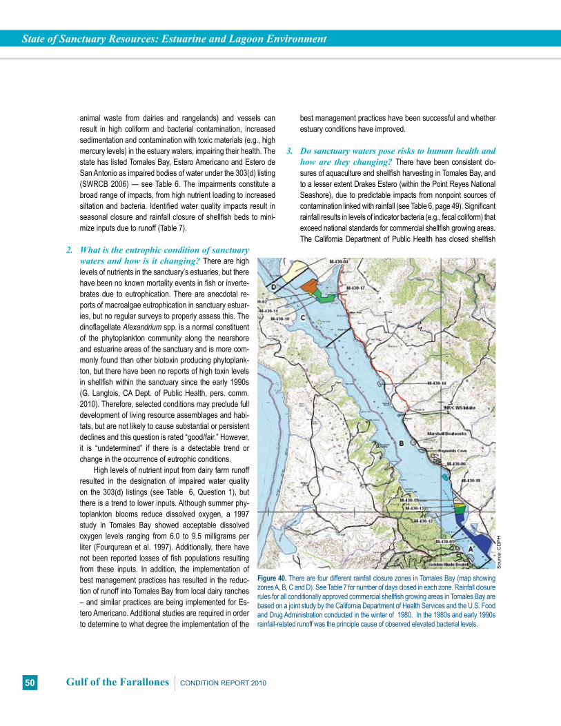
State of Sanctuary Resources: Estuarine and Lagoon Environment
50 Gulf of the Farallones CONDITION REPORT 2010
animal waste from dairies and rangelands) and vessels can result in high coliform and bacterial contamination, increased sedimentation and contamination with toxic materials (e.g., high mercury levels) in the estuary waters, impairing their health. The state has listed Tomales Bay, Estero Americano and Estero de San Antonio as impaired bodies of water under the 303(d) listing (SWRCB 2006) — see Table 6. The impairments constitute a broad range of impacts, from high nutrient loading to increased siltation and bacteria. Identified water quality impacts result in seasonal closure and rainfall closure of shellfish beds to mini-mize inputs due to runoff (Table 7).
2. What is the eutrophic condition of sanctuary watersandhowisitchanging?There are high levels of nutrients in the sanctuary’s estuaries, but there have been no known mortality events in fish or inverte-brates due to eutrophication. There are anecdotal re-ports of macroalgae eutrophication in sanctuary estuar-ies, but no regular surveys to properly assess this. The dinoflagellate Alexandrium spp. is a normal constituent of the phytoplankton community along the nearshore and estuarine areas of the sanctuary and is more com-monly found than other biotoxin producing phytoplank-ton, but there have been no reports of high toxin levels in shellfish within the sanctuary since the early 1990s (G. Langlois, CA Dept. of Public Health, pers. comm. 2010). Therefore, selected conditions may preclude full development of living resource assemblages and habi-tats, but are not likely to cause substantial or persistent declines and this question is rated “good/fair.” However, it is “undetermined” if there is a detectable trend or change in the occurrence of eutrophic conditions.
High levels of nutrient input from dairy farm runoff resulted in the designation of impaired water quality on the 303(d) listings (see Table 6, Question 1), but there is a trend to lower inputs. Although summer phy-toplankton blooms reduce dissolved oxygen, a 1997 study in Tomales Bay showed acceptable dissolved oxygen levels ranging from 6.0 to 9.5 milligrams per liter (Fourqurean et al. 1997). Additionally, there have not been reported losses of fish populations resulting from these inputs. In addition, the implementation of best management practices has resulted in the reduc-tion of runoff into Tomales Bay from local dairy ranches – and similar practices are being implemented for Es-tero Americano. Additional studies are required in order to determine to what degree the implementation of the
Figure 40. There are four different rainfall closure zones in Tomales Bay (map showing zones A, B, C and D). See Table 7 for number of days closed in each zone. Rainfall closure rules for all conditionally approved commercial shellfish growing areas in Tomales Bay are based on a joint study by the California Department of Health Services and the U.S. Food and Drug Administration conducted in the winter of 1980. In the 1980s and early 1990s rainfall-related runoff was the principle cause of observed elevated bacterial levels.
Sou
rce:
CD
PH
best management practices have been successful and whether estuary conditions have improved.
3. Dosanctuarywatersposeriskstohumanhealthandhoware they changing?There have been consistent clo-sures of aquaculture and shellfish harvesting in Tomales Bay, and to a lesser extent Drakes Estero (within the Point Reyes National Seashore), due to predictable impacts from nonpoint sources of contamination linked with rainfall (see Table 6, page 49). Significant rainfall results in levels of indicator bacteria (e.g., fecal coliform) that exceed national standards for commercial shellfish growing areas. The California Department of Public Health has closed shellfish

State of Sanctuary Resources: Estuarine and Lagoon Environment
51CONDITION REPORT 2010 Gulf of the Farallones
harvesting in Tomales Bay approximately 80 to 110 days per year for the past 10 years as a result of these impacts. There have been two outbreaks of Norovirus in Tomales Bay within the past 10 years, causing gastrointestinal illness in over 170 people (Langlois et al. 1998). For these reasons, this response to this question is rated “fair/poor” because selected conditions have caused or are likely to cause severe impacts, but cases to date have not suggested a pervasive problem. Water quality monitoring in the commercial shellfish growing areas by the state health department since the mid-1980s indicates that there is no discernible improvement or degradation with respect to fecal coliform levels, and therefore, the trend is rated as “undetermined.”
Only within the past seven years has water quality moni-toring been conducted within swimming areas in the sanctuary. Currently there are several water bodies in the sanctuary region that have been identified as impaired bodies of water on the 303(d) listing (see Table 7, page 49) as a result of water quality monitoring (SWRCB 2006). The initial data appear to show a slight improvement of water quality for swimming, but more data are needed to determine a trend.
4. What are the levels of human activities that may in-
fluencewaterqualityandhowaretheychanging?Hu-man activities influencing water quality in the estuarine and lagoon areas of the sanctuary have caused or are likely to cause severe impacts, and cases to date suggest a pervasive problem. There-fore this question is rated “fair/poor”; however, conditions are “im-proving.” Federal and state restoration activities have targeted the removal of landfills and have restored, or are in the process of restoring, large portions of mudflats and diked marshes in Bolinas Lagoon and Tomales Bay. Water quality improvements of the Bo-linas Lagoon restoration project are expected to include restora-tion of natural sediment transport and ecological functions of the lagoon, and identification and management of introduced species (GFNMS 2008a). Water quality improvements of the Tomales Bay restoration project are expected to include ongoing monitoring of the bay and tributary streams for pollutants of concern, and moni-toring of land use practices and other human influences (Tomales Bay Watershed Council 2007). The education of local agriculture interests by local agencies and institutions has resulted in the im-plementation of best management practices, which have reduced impacts from nutrient loads and sedimentation, although problems still exist in some areas along both of the esteros and Tomales Bay (GFNMS 2008a). However, it remains to be seen if there is a re-sulting improvement in water quality in the sanctuary’s estuaries.
There continue to be freshwater diversions, resulting in en-hanced hypersaline conditions, slower circulation and persistent
sand bars across the mouths of the esteros. Freshwater diver-sions, increased sedimentation and loss of the tidal prism in Bo-linas Lagoon have led to the burial and loss of eelgrass beds in the lagoon. Urbanization and increased development within the watershed areas continue to be of concern. It is expected that increased regulation of discharge from vessels, ballast water and aging septic systems will reduce some impacts. Closures of shellfish beds due to polluted runoff will also reduce impacts on humans (but not the impacts on ecological health).
Estuarine and Lagoon Environment Water Quality Status & Trends
# Issue Rating Basis for Judgment Description of Findings
1 Stressors ?
Land use pressures have caused changes to sediment and freshwa-ter regimes; increased restoration activities and best management practices may offset water quality problems that have historically resulted in loss of eelgrass beds.
Selected conditions may inhibit the development of assemblages, and may cause measurable but not severe declines in living resources and habitats.
2Eutrophic Condition ?
High levels of nutrient input have caused eutrophica-tion, severe oxygen depletion, and shellfish contamination in the Tomales Bay watershed. However, there have not been associated problems or reported loss of fish populations.
Selected conditions may preclude full development of living resource assemblages and habitats, but are not likely to cause sub-stantial or persistent declines.
3 Human Health ?
Nonpoint source con-tamination has resulted in aquaculture and shellfish closures in Tomales Bay; two Norovirus outbreaks in Tomales Bay. Best management practices have been implemented and further studies are required to determine their success.
Selected conditions have caused or are likely to cause severe impacts, but cases to date have not suggested a pervasive problem.
4 Human Activities p
Land use pressures have caused changes to sediment and freshwater regimes; loss of eelgrass beds; increased restoration activities, increased regula-tions, and best manage-ment practices may allow for improvements.
Selected activities have caused or are likely to cause severe impacts, and cases to date suggest a perva-sive problem.
Status: Good Good/Fair Fair Fair/Poor Poor Undet.
Trends: Improving (p), Not Changing (–), Declining (q), Undetermined Trend (?), Question not applicable (N/A)

State of Sanctuary Resources: Estuarine and Lagoon Environment
52 Gulf of the Farallones CONDITION REPORT 2010
HabitatThe following information summarizes an assessment, made by
sanctuary staff and experts in the field, of the status and trends per-taining to the current state of the estuarine and lagoon habitat in the Gulf of the Farallones sanctuary.
5. What are the abundance and distribution of major habitattypesandhowaretheychanging?Overall, the status and trend of habitat abundance and distribution in the estuarine environment of the sanctuary is rated “fair/poor” and “not changing” because selected habitat loss or alteration has caused or is likely to cause severe declines in some but not all living resources or water quality. Substantial levels of habitat loss have occurred due to erosion, accretion and habitat conversion. Past human activities, such as diking, mining, dredging, filling and reclamation, have substantially reduced the area of coastal wetlands. Sedimentation has increased in estuaries and bays from activities upstream, such as logging, ranching and agricul-ture. In Bolinas Lagoon, many historical human activities have caused increased sediment delivery and deposition, which, in turn, have affected some of the physical processes that drive the natural evolution of the lagoon (Leet et al. 2001, Hickey 2007). For example, the results of adding fill for the Seadrift housing development, Highway 1 and Wharf Road directly impact the lagoon, increasing sediment availability and altering the physical processes, thus reducing the tidal prism by as much as 25 per-cent (Leet et al. 2001). Construction in the floodplains and the rerouting and channelization of creeks has resulted in impaired
floodplain functions, in some instances increasing the amount of sediment deposited in the lagoon and reducing the tidal prism (Figure 41). Restoration activities have been planned and some have been implemented, such as the removal or reduction of several invasive species (GFNMS 2008a).
In general, the abundance of eelgrass beds, eelgrass wracks and marsh vegetation is in decline. Increased sedimen-tation has lead to the loss of eelgrass beds in Bolinas Lagoon and reduction of some eelgrass beds in the esteros. In addition, the diversion and channelization of streams to control floods and retain water for upland uses has altered the flow of fresh water into Bolinas Lagoon and Tomales Bay. The decreased freshwa-ter input has impacted the conditions in salt marshes, brackish water and eelgrass meadows, causing increased sedimentation and loss of the tidal prism (Airamé et al. 2003, GFNMS 2008a).
There is also the potential for habitat loss at harbor seal haul-out areas. Studies have shown that a combination of distur-bance and aquaculture activities have reduced haul-out space available for harbor seals in Tomales Bay and Drakes Estero (in the Point Reyes National Seashore) (Figure 42). Educational programs such as the use of docents and interpretational rang-ers have reduced disturbance from recreational boaters and clam diggers, which in turn has improved the quality of haul-out areas for harbor seals within these areas (Tezak et al. 2004).
6. What is the condition of biologically structured hab-itatsandhowisitchanging?The two native species that form biogenic habitat in the estuaries of the sanctuary, eelgrass
Figure 41. Aerial view of Bolinas Lagoon. The greatest change to Bolinas Lagoon has been the addition of fill to form the Seadrift community and artifical lagoon seen in the lower portion of the image.
Pho
to: G
FNM
S
Bolinas Lagoon
Seadrift Lagoon, manmade
Bolinas Bay
Seadrift communityFigure 42. The mean rate of harbor seal flush events (flushes per hour). Flush events can be characterized as disturbances to wildlife resulting from human contact and loss of haul-out spaces. This graph shows that harbor seal flushing event rates in Tomales Bay were reduced after the implemen-tation of a stewardship program in 1996. This program, which was called SEALS, was developed to educate clam diggers on how to avoid acciden-tal flushing of seals while clam digging near their haul-outs.
Sou
rce:
Tez
ak e
t al.
2004
Harbor Seal Disturbance
Flushes from Other Sources
Clam Diggers
Motor Boats
Kayaks
Mea
n Fl
ush
Rat
e
Year

State of Sanctuary Resources: Estuarine and Lagoon Environment
53CONDITION REPORT 2010 Gulf of the Farallones
(Zostera marina) and native oyster (Ostreola conchaphila), have experienced a reduction in abundance from historic levels (Kim-bro and Grosholtz 2006). Therefore, selected habitat loss or alteration may inhibit the development of living resources, and may cause measurable but not severe declines in living resourc-es or water quality. For these reasons, this question is rated as “fair” and in “declining” condition.
Studies have shown that Estero Americano and Bolinas Lagoon have suffered substantial loss of eelgrass due to con-tinuing sedimentation causing elevation of substrate and burial of eelgrass beds and root systems (Hickey 2007, Leet et al. 2001). In the case of Bolinas Lagoon, the development that has taken place both upland and around the estuary has severely impacted the system’s ability to discharge its sediments into the ocean and scour deeper channels. Bolinas Lagoon has also undergone increased urbanization and fill, sedimentation from roadside and coastal armoring, diversion of freshwater, reduc-tion of the tidal prism and a subsequent decrease in scouring effect (Figure 43) (GFNMS 2008a). Such sedimentation can bury eelgrass and oyster beds, although rates are improving in Tomales Bay due to recent restoration efforts (Kimbro and Grosholtz 2006). Tomales Bay has also shown substantial loss of native oyster beds. Such problems are largely the result of human-caused impacts, such as past coastal armoring, in-creased moorings, anchoring and abandoned vessels impact-ing the benthic habitat, and roadside maintenance activities that result in increased sediment discharges, causing a decline or change of the tidal prism.
7. What are the contaminant concentrations in sanc-
tuaryhabitatsandhowaretheychanging?There is limited contaminant monitoring work taking place in the estuar-ies of the sanctuary. Therefore, the status and trend rating for contaminant concentrations are both “undetermined” until fur-ther monitoring can be conducted. Studies on benthic clams in Walker Creek in Tomales Bay have shown high levels of mer-cury, most likely resulting from impacts of past mining opera-tions. The nearby Gambonini mercury mine was in operation in the 1960s and early 1970s (USEPA 2001, SFBRWQCB 2005). Mine tailings (leftover substrate) were stored on-site, but a major storm event in 1982 resulted in the release of tailings into Walker Creek, the second largest tributary in Tomales Bay. Water qual-ity studies suggest that hundreds to thousands of kilograms of mercury were discharged from the mine site into downstream waters. In 1998, the U.S. Environmental Protection Agency initi-ated a Superfund cleanup action at the site in order to eliminate (to the maximum extent feasible) the discharge of mercury-lad-en soil and sediments from the 12-acre mining waste pile, ulti-mately reducing the impacts from past mining activities (Gassel et al. 2004). The discharge from the mine has been halted and restoration of the mine has been completed, but contaminants in the Walker Creek delta continue to be of concern.
NOAA’s Mussel Watch program, a long-term monitoring program of pollutants in the marine environment, has stations in Bodega Bay and Tomales Bay. Contaminants tested include persistent organic pollutants (e.g., butyltin, chlordane, DDT, diel-drin, PAHs and PCBs) and trace metals (e.g., arsenic, cadmium, copper, mercury, nickel, lead tin, and zinc). Monitoring data indi-cates that there is no upward or downward trend for persistent organic pollutants or trace metals at these two stations. Con-centrations for almost all of these contaminants in mussels were either low or medium level (comparable to nationwide results). The one exception was cadmium at the Bodega station, which was relatively high. However, cadmium is naturally occurring in seawater and has been known to be elevated in upwelling areas along the West Coast, so this may reflect a natural occurrence (Kimbrough et al. 2008).
Limited data show elevated levels of contamination in har-bors and marinas of San Francisco Bay and may indicate a need to assess impacts from the small marinas and boat-work op-erations within Tomales Bay and Bolinas Lagoon. The degree of contamination of these sites relates to the density of vessel traffic, the intensity of boat-works (e.g., scraping and painting), and the extent of flushing of the water bodies concerned. Flush-ing is often poor in harbors and marinas, permitting a build-up of contaminants (Phillips 1987).
Figure 43: Sedimentation from culverts draining into Bolinas Lagoon for roadside maintenance can cause burial of seagrass and marsh plants.
Pho
to: C
. Mor
ton,
Cal
Tran
s
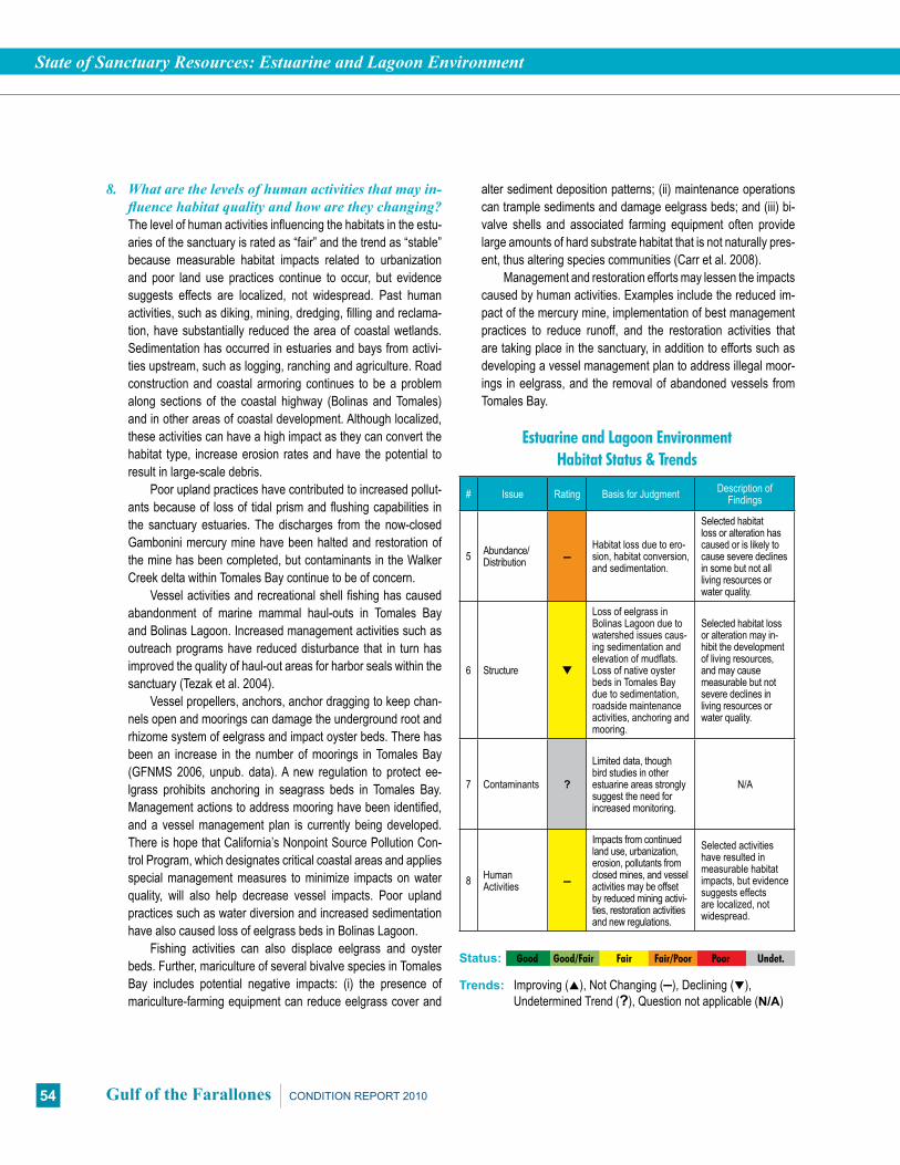
State of Sanctuary Resources: Estuarine and Lagoon Environment
54 Gulf of the Farallones CONDITION REPORT 2010
8. What are the levels of human activities that may in-fluencehabitatqualityandhowaretheychanging?The level of human activities influencing the habitats in the estu-aries of the sanctuary is rated as “fair” and the trend as “stable” because measurable habitat impacts related to urbanization and poor land use practices continue to occur, but evidence suggests effects are localized, not widespread. Past human activities, such as diking, mining, dredging, filling and reclama-tion, have substantially reduced the area of coastal wetlands. Sedimentation has occurred in estuaries and bays from activi-ties upstream, such as logging, ranching and agriculture. Road construction and coastal armoring continues to be a problem along sections of the coastal highway (Bolinas and Tomales) and in other areas of coastal development. Although localized, these activities can have a high impact as they can convert the habitat type, increase erosion rates and have the potential to result in large-scale debris.
Poor upland practices have contributed to increased pollut-ants because of loss of tidal prism and flushing capabilities in the sanctuary estuaries. The discharges from the now-closed Gambonini mercury mine have been halted and restoration of the mine has been completed, but contaminants in the Walker Creek delta within Tomales Bay continue to be of concern.
Vessel activities and recreational shell fishing has caused abandonment of marine mammal haul-outs in Tomales Bay and Bolinas Lagoon. Increased management activities such as outreach programs have reduced disturbance that in turn has improved the quality of haul-out areas for harbor seals within the sanctuary (Tezak et al. 2004).
Vessel propellers, anchors, anchor dragging to keep chan-nels open and moorings can damage the underground root and rhizome system of eelgrass and impact oyster beds. There has been an increase in the number of moorings in Tomales Bay (GFNMS 2006, unpub. data). A new regulation to protect ee-lgrass prohibits anchoring in seagrass beds in Tomales Bay. Management actions to address mooring have been identified, and a vessel management plan is currently being developed. There is hope that California’s Nonpoint Source Pollution Con-trol Program, which designates critical coastal areas and applies special management measures to minimize impacts on water quality, will also help decrease vessel impacts. Poor upland practices such as water diversion and increased sedimentation have also caused loss of eelgrass beds in Bolinas Lagoon.
Fishing activities can also displace eelgrass and oyster beds. Further, mariculture of several bivalve species in Tomales Bay includes potential negative impacts: (i) the presence of mariculture-farming equipment can reduce eelgrass cover and
alter sediment deposition patterns; (ii) maintenance operations can trample sediments and damage eelgrass beds; and (iii) bi-valve shells and associated farming equipment often provide large amounts of hard substrate habitat that is not naturally pres-ent, thus altering species communities (Carr et al. 2008).
Management and restoration efforts may lessen the impacts caused by human activities. Examples include the reduced im-pact of the mercury mine, implementation of best management practices to reduce runoff, and the restoration activities that are taking place in the sanctuary, in addition to efforts such as developing a vessel management plan to address illegal moor-ings in eelgrass, and the removal of abandoned vessels from Tomales Bay.
Estuarine and Lagoon Environment Habitat Status & Trends
# Issue Rating Basis for Judgment Description of Findings
5 Abundance/Distribution –
Habitat loss due to ero-sion, habitat conversion, and sedimentation.
Selected habitat loss or alteration has caused or is likely to cause severe declines in some but not all living resources or water quality.
6 Structure q
Loss of eelgrass in Bolinas Lagoon due to watershed issues caus-ing sedimentation and elevation of mudflats. Loss of native oyster beds in Tomales Bay due to sedimentation, roadside maintenance activities, anchoring and mooring.
Selected habitat loss or alteration may in-hibit the development of living resources, and may cause measurable but not severe declines in living resources or water quality.
7 Contaminants ?
Limited data, though bird studies in other estuarine areas strongly suggest the need for increased monitoring.
N/A
8 Human Activities –
Impacts from continued land use, urbanization, erosion, pollutants from closed mines, and vessel activities may be offset by reduced mining activi-ties, restoration activities and new regulations.
Selected activities have resulted in measurable habitat impacts, but evidence suggests effects are localized, not widespread.
Status: Good Good/Fair Fair Fair/Poor Poor Undet.
Trends: Improving (p), Not Changing (–), Declining (q), Undetermined Trend (?), Question not applicable (N/A)

State of Sanctuary Resources: Estuarine and Lagoon Environment
55CONDITION REPORT 2010 Gulf of the Farallones
Living ResourcesThe following information summarizes an assessment, made by
sanctuary staff and experts in the field, of the status and trends per-taining to the current state of the living resources found in the estua-rine and lagoon environment of the Gulf of the Farallones sanctuary.
9.Whatisthestatusofbiodiversityandhowisitchang-ing? Biodiversity in the estuaries of the Gulf of the Farallones sanctuary is rated “fair/poor” and “declining,” because it is probable that selected habitat loss or alteration has caused or is likely to cause severe declines in some but not all ecosystem components and reduce ecosystem integrity. The principal reason for the low rat-ing is the loss of eelgrass (Zostera marina), a key habitat for estua-rine species, particularly in Bolinas Lagoon (T. Moore, CDFG, pers. comm.). The main cause of this loss appears to be sedimentation caused by human activities (see Question 6). Eelgrass is important in that it provides refuge, food source and nursery space that sup-ports a rich diversity of fish and wildlife, including many commercial-ly and recreationally important fish species, shorebirds, waterfowl, crabs, shrimp and many other invertebrates. The loss of eelgrass beds has a cascading affect on the countless other species that depend on this habitat for survival. Ten to 100 times more animals can be found in eelgrass beds compared to adjacent sandy and muddy habitats (Olyarnik 2007). In addition, the establishment of invasive species, such as green crabs and mud snails, is expected to continue to impact these relatively small ecosystems. In general, introduced species in the marine and estuarine environment alter species composition, threaten the abundance and/or diversity of native marine species, interfere with the ecosystem’s function and disrupt commercial and recreational activities (GFNMS 2008a).
10. What is the status of environmentally sustainable fishingandhowisitchanging?Currently, there is limited commercial fishing in the estuaries of the sanctuary. Extraction does not appear to affect ecosystem integrity (full community development and function) and, therefore, this question is rated “good” and “not changing.” Fishing in the estuaries includes com-mercial harvest of oysters in aquaculture facilities, sport take of clams, and some fishing for herring, rock crab, perch and halibut, all in Tomales Bay. Generally, however, there is not a great deal of commercial or recreational extraction in the estuaries, and tar-geted species are highly variable depending on environmental conditions (e.g., El Niño influences and sedimentation shifts). Further, there is little information on the changes in these and other estuarine populations that could result from fishing.
The productivity of estuaries and lagoons may change with large-scale fluctuations in climate. Populations of some species,
including salmonids, vary with climate fluctuations and changes to migration corridors and spawning habitats. For example, in the mid-1970s, the Pacific changed from a cool water regime where anchovy dominated to a warm water regime where sar-dine dominated. A shift back to an anchovy regime occurred in the middle to late 1990s (Chavez et al. 2003). These changes in salmonid forage fish may have cascading trophic impacts.
The disturbance and destruction of upland salmon spawning habitat has resulted in declines of all populations of salmon. Sev-eral subpopulations of Chinook salmon (Figure 44), Coho salm-on, and steelhead trout in Central California are extinct, and the remaining populations have been listed as federally endangered and threatened. A significant percentage of salmon remaining in California waters are raised in hatcheries. Salmon habitat resto-ration projects are helping to restore a few of these populations.
11.Whatisthestatusofnon-indigenousspeciesandhowis it changing? There is a high number of non-indigenous spe-cies in the estuarine zones of the sanctuary. Because non-indige-nous species have caused or are likely to cause severe declines in some but not all ecosystem components and reduce ecosystem integrity, this question is rated “fair/poor.” There is little monitoring data to determine the trend, therefore this question is rated as “un-determined.” There are significantly higher numbers of non-indige-nous species in the estuaries of the sanctuary in comparison to the offshore zone. It is estimated that about 143 species of invasives are present in the sanctuary, most of which exist in the estuarine zone (Byrnes et al. 2007), the most potentially harmful being Euro-pean green crabs (Carcinus maenas), Japanese mud snails (Ba-tillaria attramentaria) and smooth cordgrass (Spartina alterniflora) and its hybridization with the native cordgrass, Spartina foliosa.
Figure 44. Annual counts of Chinook salmon in the Russian River. The adult run begins in late August, although relatively few fish are observed prior to October. Typically, the run peaks October through mid-November, and continues through the end of December.
Sou
rce:
Son
oma
Cou
nty
Wat
er A
genc
y
2000 2001 2002 2003 2004 2005 2006 2007 20080
1000
2000
3000
4000
5000
6000
7000
8000
Year
Stee
lhea
d M
igra
tion
Cou
nt

State of Sanctuary Resources: Estuarine and Lagoon Environment
56 Gulf of the Farallones CONDITION REPORT 2010
The extent, geographical coverage and ecosystem impacts of non-indigenous species within the sanctuary are currently un-known. European green crabs are a threat because they can prey on and compete for resources with native crabs, such as rock crabs and Dungeness crabs, and as such may have profound impacts on the commercial fishery (Cohen 1997). Japanese mud snails reach extraordinary densities over significant areas of high intertidal mudflats, suggesting the potential for substantial impacts to sedimentary environments as well as both infaunal and epifau-nal communities (Dewar et al. 2008). As recently as 2003, smooth cordgrass has invaded many acres of mudflat habitat in San Francisco Bay, resulting in loss of habitat for salmon and oysters, and economic losses for those who rely on these species (Brusati 2008). On a smaller scale, smooth cordgrass has appeared in Tomales Bay and Bolinas Lagoon, but is under control.
There is also concern about the proliferation of the gem clam (Gemma gemma) in Bolinas Lagoon and Tomales Bay (Byrnes 2007, USFWS 2005). The success of the gem clam has been triggered by the invasion of the European green crab that thrives on native clams in the central and Northern California estuaries. Historically, native clams have kept the gem clam sta-bilized. With the invasion of the green crab, gem clams are now becoming a potential threat to the ecosystem (Milius 2005). The sanctuary, along with partners from UC Davis and the Smithso-nian, are attempting to control green crabs in Bodega Harbor and a manmade lagoon adjacent to Bolinas Lagoon.
12.What is the status of key species and how is itchanging?5 In estuaries, the reduced abundance of selected keystone species may inhibit full community development and function, and may cause measurable but not severe degradation of ecosystem integrity. Therefore, key species are considered to be in “fair” condition, but with a “declining” trend. Key species particularly important to these habitats include eelgrass, tidewater goby and Brant. There are many other key species located in the estuarine and lagoon zones of the sanctuary, including herring, leopard shark, bat ray, harbor seal, Snowy Plover and Brandt’s Cormorant.
Eelgrass (Zostera marina) is a keystone species that has shown signs of decline in some estuaries, including nearly extinct levels in Bolinas Lagoon (Leet et al. 2001, GFNMS 2008a). How-ever, further analysis is necessary to confirm the decline – includ-ing determining the amount of eelgrass that is currently in the sanctuary. The greatest limiting factor for eelgrass populations in the bays and estuaries of the sanctuary is water clarity and water quality. Turbidity from sediment runoff and in-water construction
activities inhibits eelgrass from receiving sunlight, which in turn reduces its ability to photosynthesize. An increase in sedimenta-tion also forces the eelgrass to grow closer to the surface, thus exposing the beds to increases in temperature. Also, decreases in water quality promote algal growth, which increases epiphytes (plants that grow on other plants) on eelgrass, weighs down the leaves and shades the plants from receiving sunlight. Other phys-ical disturbance such as scars from boat propellers and anchor chains also degrade the integrity of the beds. The loss of eelgrass has the possibility to instigate the decline of a number of species that depend on it, thus prompting ecosystem-level changes.
Although the endangered tidewater goby (Eucyclogobius newberryi) appears to be stable and locally abundant in some sanctuary estuaries, including Estero Americano and Estero de San Antonio, in general their abundance has declined substantially due to habitat loss and degradation and poor salinity and other water quality conditions (USFWS 2005). Brant (Branta bernicla) population levels are increasing, but recovery is slow because they are affected by climatic changes in their northern breeding areas and by increased frequency and severity of El Niños (Reed et al. 1998, Schuchat 2006). In 1987, these geese were noted in the first sanctuary management plan (GFNMS 1987) as a species of con-cern and in decline. Today, the Brant population has increased and many are seen foraging on seagrass and algae in Tomales Bay.
13. What is the condition or health of key species and howisitchanging?Insufficient data exist on the health of key species in the estuarine zone of the sanctuary (see Table 5, page 43); therefore, the status and trend are considered “un-determined” at this time. Some fish have been found to exhibit high levels of mercury, but this relates more to their suitability for human consumption than to their overall health. Methylmer-cury can be passed up the food chain to piscivorous (fish-eating) birds and mammals (Weiner et al. 2003, Bond and Diamond 2009). However, it is thought that humans are not at risk from eating fish from Tomales Bay because, in general, most fish are not feeding solely within the bay. The EPA recommends that the state uses a screening level of 0.3 mg/kg when measuring methylmercury levels in fish (SFBRWQCB 2005, USEPA 2001). Of the 14 fish samples tested in the sanctuary in 2001, 12 were over the recommended limit of 0.3 mg/kg (SFBRWQCB 2007). Harbor seals appear to be doing well in both Tomales Bay and Bolinas Lagoon, but disturbance levels may be increasing in Tomales Bay, which could eventually affect their health (Tezak et al. 2005). Unfortunately, data on condition do not exist for
5SeeTable5(page43)foracompletelistingofkeyspeciesinthesanctuary.

State of Sanctuary Resources: Estuarine and Lagoon Environment
57CONDITION REPORT 2010 Gulf of the Farallones
most other estuarine species. Additional testing of higher trophic levels of birds, mammals and fish in Tomales Bay are needed in order to determine trends and impacts on sanctuary estuarine resources in Tomales Bay.
14. What are the levels of human activities that may influence living resource quality and how arethey changing? In estuaries, human activities influenc-ing living resource quality are primarily past impacts caused by runoff and illegal discharges, wildlife disturbance, and ur-banization. Therefore, selected activities have caused or are likely to cause severe impacts, and cases to date suggest a pervasive problem, and the response for this question is rated “fair/poor.” Although some detrimental activities are decreasing in intensity, others known to be harmful are in-creasing; therefore, the overall trend is rated as “declining.” A number of management actions are underway to minimize impacts, but their success remains to be determined.
The frequency of oil spills has decreased in recent years, but some activities that cause wildlife disturbance (e.g., boating and excessive visitation) are increasing. Illegal discharges associated with higher visitation are also likely increasing. There has also been an increased loss of bio-diversity due to increased sedimentation caused by human activities such as poor upland practices and vessel activities. The disturbance and destruction of upland salmon spawning habitat has resulted in declines of all populations of salmon. Levels of anchoring, runoff from agricultural or developed lands, and trampling of intertidal communities are all prob-ably not changing at present. Levels of recreational clam digging, kayaking and motor boating are variable and these activities sometimes causes disturbance to harbor seals on their haul-outs (Tezak 2005). Unfortunately, for other po-tentially damaging activities, the trends are unknown. Two of these include poaching and upland hydro-modification caused by agricultural practices and urbanization.
A decline in the productivity of estuaries and lagoons may be associated with long-term variation in climate. Populations of some species, including salmonids, vary with climate fluctuations and changes to migration cor-ridors and spawning habitats.
Introduced species have caused a loss of biodiversity. A species inventory of the introduced and invasive spe-cies within the sanctuary’s estuarine habitats has been compiled, but there are no formal monitoring programs or formal plans to control or eliminate the most destructive species or new invaders. Presently, there are attempts by
Estuarine and Lagoon Environment Living Resources Status & Trends
# Issue Rating Basis for Judgment Description of Findings
9 Biodiversity qSpecies diversity changes due to eelgrass loss in Bolinas Lagoon and invasive species.
Selected biodiversity loss has caused or is likely to cause se-vere declines in some but not all ecosystem components and reduce ecosystem integrity.
10 Extracted Species – Minimal extraction.
Extraction does not appear to affect ecosystem integrity (full community development and function).
11Non-indigenous Species
?
High numbers of invasive species including European green crabs, Japanese mud snails and smooth cordgrass. Limited data are available on the density or geographic extent of most non-indigenous species.
Non-indigenous species have caused or are likely to cause severe declines in some but not all ecosystem compo-nents and reduce ecosystem integrity.
12 Key Species q
Keystone and some key species are at reduced levels; eelgrass decline in Bolinas Lagoon is likely to diminish recovery potential; abundance of the tidewater goby has declined substantially due to habitat loss and degradation; brant populations had been on the decline and are now in-creasing, but recovery is slow.
The reduced abundance of selected keystone species may inhibit full community development and function, and may cause measurable but not severe degradation of ecosys-tem integrity; or selected key species are at reduced levels, but recovery is possible.
13Health of Key Species
?
Insufficient data. Some fish have high mercury levels; it is unknown how this may impact fish populations. Disturbance to harbor seals may impact their health.
N/A
14 Human Activities q
Impacts resulting from urbanization, changing uses that affect watersheds, and wildlife disturbance caused by visitor activities; management activities to increase monitor-ing of and outreach about intro-duced species are needed; restoration planning needs to be implemented in Bolinas La-goon and completed for vessel activities in Tomales Bay.
Selected activities have caused or are likely to cause severe impacts, and cases to date suggest a pervasive problem.
Status: Good Good/Fair Fair Fair/Poor Poor Undet.
Trends: Improving (p), Not Changing (–), Declining (q), Undetermined Trend (?), Question not applicable (N/A)
Marin County and the University of California to control cordgrass on the mud flats of Tomales Bay, and county management controls have eradicated it in Bolinas Lagoon. Attempts are also currently underway to control green crabs in Seadrift Lagoon and Bodega Harbor, both of which are adjacent to the sanctu-ary. There is a need for heightened outreach programs to prevent accidental releases of non-native species within the sanctuary’s estuaries.

State of Sanctuary Resources: Estuarine and Lagoon Environment
58 Gulf of the Farallones CONDITION REPORT 2010
Maritime Archaeological ResourcesThe following information summarizes an assessment, made by
sanctuary staff and experts in the field, of the status and trends per-taining to the current state of maritime archaeological resources in the estuarine and lagoon zone in the Gulf of the Farallones sanctuary.
15. What is the integrity of maritime heritage resources andhowisitchanging?The only known archaeological resources in the estuarine environment of the sanctuary are
contained in Tomales Bay (Figure 45). There are seven wrecks in Tomales Bay, five of which are schooners (Anglo-American, Marin and European6 were lost in 1861, the H. Caroline in 1874, and the Hannah B. Bourn in 1868). The Hayes7 , an unknown rig, was lost in 1869. Finally, a salmon trawler was reported lost at a reef near Dillon Beach in 1929. The integrity and trend of these resources is “undetermined,” because these sites have not been visited or investigated by federal, state or private re-source management agencies.
6Europeanwasprobablyasmall,two-mastedschoonerinvolvedintheearlycoastaltrade.Shedoesnotappearinanyvesselregistriesaroundthetimeofherloss.TheBancroftLibraryholdsacitationfromtheCongressionalRecord,inwhichitisstatedthattheschoonerEuropeanwasapartiallossatBodegaBayinOctober1861.InMitchell’sTheCommerceoftheNorthPacificCoast,EuropeanismentionedashavingbeenlostwhileboundforTimberCove,andashavingbeenworth$5,000.Tothecon-trary,however,anothersourceclaimsthatavesselnamedEuropeanwaswreckedatTomalesBayin1861.Delgado,JamesP.&Haller,StephenA.,1989,SubmergedCulturalResourcesAssessment:GoldenGateNationalRecreationalArea,GulfofTheFarallonesNationalMarineSanctuaryandPointReyesNationalSeashore,NationalParkService,SantaFe,NM
7HayesisthenameofavesselreportedwreckedatTomalesBayin1869.Novesselofthisnameappearsintheregistersaroundthattime,andnofurtherinformationabouttheincidenthassurfacedduringthisresearch.Delgado,JamesP.&Haller,Ste-phenA.,1989,SubmergedCulturalResourcesAssessment:GoldenGateNationalRecreationalArea,GulfofTheFarallonesNationalMarineSanctuaryandPointReyesNationalSeashore,NationalParkService,SantaFe,NM
Figure 45. More than 30 shipwrecks have occurred at Duxbury Reef (located seaward, outside of the sanctuary’s estuarine zone), so named for the sailing ship Duxbury that struck the reef in 1849 but later was floated off and saved. Two more victims that became stranded on the reef in close proximity were the four-masted schooner Polaris (1914; background) and steam schooner R. D. Inman (1909; forefront).
Pho
to: J
ames
Shu
ttlew
orth
Col
lect
ion

State of Sanctuary Resources: Estuarine and Lagoon Environment
59CONDITION REPORT 2010 Gulf of the Farallones
Estuarine and Lagoon Environment Maritime Archaeological Resources
# Issue Rating Basis for Judgment Description of Findings
15 Integrity ?No wreck sites have been visited or investigated.
N/A
16Threat to Environ-ment
—
Unlikely that the wrecks (mostly wooden schooners) contain hazardous cargo.
Selected maritime archaeo-logical resources may pose isolated or limited environmental threats, but substantial or persistent impacts are not expected.
17 Human Activities ?
Bottom fishing, aquaculture and habitat and living resource restora-tion activities could affect resources.
Some potentially relevant activities exist, but they do not appear to have had a negative effect on maritime archaeological resource integrity.
Status: Good Good/Fair Fair Fair/Poor Poor Undet.
Trends: Improving (p), Not Changing (–), Declining (q), Undetermined Trend (?), Question not applicable (N/A)
16. Do maritime heritage resources pose an environmen-
tal hazard and is this threat changing? Because the ma-jority of the wrecks in the estuarine environment of the sanctuary are schooners and it is unlikely that they were carrying hazardous cargo, there is very little chance that they pose an environmental hazard. It is possible, however, that the salmon trawler could poten-tially pose a threat, releasing pollutants if it is disturbed. Therefore, selected maritime archaeological resources may pose isolated or limited environmental threats, but substantial or persistent impacts are not expected, and this question is rated “good/fair” with an “un-changing” trend.
17. What are the levels of human activities that may influence maritime heritage resource quality andhow are they changing? Several human activities may influence the quality of maritime archeological resources in the estuarine environment, including bottom fishing (primarily from the herring fishery), aquaculture activities, anchoring and moor-ing. Although piers are not currently being constructed in the estuaries in the sanctuary, such an activity could disturb and possibly damage submerged archaeological resources. Envi-ronmental restoration, such as oyster recovery programs, could also impact the maritime archeological resources by disturbing or burying them. Current restoration plans for habitats and living resources do not consider integration of impacts on the sub-merged maritime and other cultural resources. Because some potentially relevant activities exist (e.g., restoration of oysters
and seagrass beds, establishment of long-term mooring areas, and removal of derelict vessels), but do not appear to have had a negative effect on maritime archaeological resource integrity, this question is rated “good/fair.” A trend cannot be determined due to a lack of monitoring data.

Response to Pressures
60 Gulf of the Farallones CONDITION REPORT 2010
This section summarizes the collaboration among numerous authorities that contrib-ute to the management of the sanctuary,
and also provides a summary of regulations and other management responses to pressures on ma-rine resources of the sanctuary.
Jurisdictional Authorities of the Sanctuary Gulf of the Farallones National Marine Sanctuary
overlaps and borders the jurisdictions of several other state and federal agencies. Two other national ma-rine sanctuaries share boundaries with the Gulf of the Farallones sanctuary: to the north and west is Cordell Bank National Marine Sanctuary, and to the south and east is Monterey Bay National Marine Sanctuary.
The National Park Service is a significant col-laborator with the sanctuary. The Golden Gate Na-tional Recreation Area and Point Reyes National Seashore work closely with the sanctuary on the protection and management of natural and cultural marine resources (Figure 46). Golden Gate Nation-al Recreation Area includes an extensive network of recreational and historic sites. The sanctuary coor-dinates and cooperates with Point Reyes National Seashore and Golden Gate National Recreation Area in the areas of resource protection, enforce-ment, interpretation, administrative support, wildlife protection, oil spill preparedness and natural re-source damage assessment and restoration. Point Reyes National Seashore represents the largest stretch of shoreline adjacent to the sanctuary, with a small portion of the national seashore overlapping the sanctuary boundary within Tomales Bay. It includes certain state tide and sub-merged lands that have been conveyed to the national seashore. The national seashore’s management plan defines “natural zones” that are to remain unaltered by human activity. Portions of the Gold-en Gate National Recreation Area shoreline, from the mean high tide out to 400 feet offshore, overlap jurisdiction with the sanctuary. These areas are along the Marin Headlands, Stinson Beach, Bolinas Lagoon and Tomales Bay.
The U.S. Fish and Wildlife Service manages the Farallon National Wildlife Refuge (Figure 46) at the Farallon Islands to protect migra-tory birds, pinnipeds, an endemic species of amphibian, and cultural resources. Other federal agencies with management responsibility in
the sanctuary include the National Marine Fisheries Service (marine fisheries, marine mammals, sea turtles and habitats), the U.S. Coast Guard (marine safety, oil spill response), and the U.S. Environmental Protection Agency (ocean dumping).
NOAA’s National Marine Fisheries Service,(NOAA Fisheries) the Pacific Fisheries Management Council, the U.S. Fish and Wildlife Service, and the California Department of Fish and Game jointly manage fish, fisheries, marine mammals, seabirds and sea turtles. NOAA Fisheries and the Pacific Fisheries Management Council con-duct the stock assessments and set fisheries regulations for federally managed fish populations. NOAA Fisheries has established Essential Fish Habitat (see Figure 34, page 34) and Rockfish Conservation Ar-eas to protect critical habitat and overfished species. The Department
Response to Pressures
Figure 46. State and federal marine protected areas (MPA) and management zones within the Gulf of the Farallones region. State designated MPAs on the north-central California coast went into effect on May 1, 2010. These new state MPAs will restrict either all or some extrac-tion of fish and other natural resources, and around the North Farallon Islands, Double Point/Stormy Stack and Point Resistance Rock (not shown on map), are no-access zones.
Map
: T. R
eed,
GFN
MS

Response to Pressures
61CONDITION REPORT 2010 Gulf of the Farallones
of Fish and Game is responsible for the management of living marine resources in California, including fish populations that are not feder-ally managed, and has the authority to establish ecological reserves, marine reserves, game refuges and marine life refuges in state wa-ters. Within these areas, the agency has the authority to prohibit or restrict activities that may harm the resources, including fishing, col-lecting, swimming, boating and public entry. The Department of Fish and Game works closely with the sanctuary in oil spill response, dam-age assessment and restoration through its Office of Spill Prevention and Response.
As part of the Marine Life Protection Act Initiative, the California De-partment of Fish and Game embarked on a process to establish and modify state-designated marine protected areas (MPAs) along Califor-nia’s north-central coast in 2007. On Aug. 5, 2009, the California Fish and Game Commission approved 21 new MPAs, three state marine recreational management areas, and six special closures that cover 153 square miles of ocean from Alder Creek near Point Arena in Mendocino County to Pigeon Point in San Mateo County, including the waters around the Farallon Islands8 (Figure 46). Gulf of the Farallones National Marine Sanctuary and the northern portion of Monterey Bay National Marine Sanctuary encompass well over half of this newly protected area.
Nine MPAs, two state marine recreational management areas, and five special closures are located within Gulf of the Farallones National Marine Sanctuary, resulting in a total of 16 new protections for sanc-tuary waters. MPAs include areas that are closed to all extraction, which are known as no-take marine reserves; marine conservation ar-eas, which are closed to most types of fishing; and marine parks that are only open to recreational fishing. The state marine recreational management areas prohibit fishing, but allow for waterfowl hunting. Special closure areas restrict all human activities (no-access zones) in order to predominantly protect breeding and resting seabirds and pinnipeds. This new classification of marine protected areas marks the first time breeding and resting seabirds and marine mammals are protected as part of the California MPA process. All new regulations for the new state MPAs went into effect May 1, 2010.
The California State Water Resources Control Board has desig-nated the following locations within the waters of the sanctuary as Areas of Special Biological Significance: Bird Rock at Tomales Point, Point Reyes Headlands, Double Point, Duxbury Reef and the Faral-lon Islands. These areas are designated to preserve and maintain high water quality in special biological communities by prohibiting
discharges of elevated temperature wastes and point-source sew-age of industrial wastes.
Other agencies with management responsibility in the sanctuary or in coastal areas adjacent to the sanctuary include the California State Lands Commission, the California Department of Parks and Recreation and the counties of San Francisco, Marin and Sonoma. All of these counties have Local Coastal Plans certified by the Cali-fornia Coastal Commission.
Also important to the sanctuary is California’s Coastal Ocean Cur-rent Monitoring Program, a state-supported, interagency collabora-tion with the goal of integrated monitoring of currents in the coastal ocean. The program has been a highly collaborative partnership of academic and government institutions working with industry and non-governmental organizations to design a real-time monitoring system of ocean currents along California’s coastline. This priority rests on the recognition that most management issues are affected by processes in surface waters, that effective technology is available to map and moni-tor surface currents, and that the program would serve as a focus for integrating existing observation efforts. By understanding environmen-tal variability in ocean currents, resource managers will be better able to predict and determine areas of contamination and pollutant transport in coastal waters, mitigate hazards, and manage California’s living ma-rine resources. The sanctuary works with these and other research institutions to better integrate research and monitoring findings, in or-der to assess effectiveness of sanctuary regulations, zones and pro-tection plans (Figure 47). Sanctuary Ecosystem Assessment Surveys integrates biological and physical monitoring programs. The sanctuary also uses the Sanctuary Integrated Monitoring Network (http://sanctu-arysimon.org/) as a directory of non-sanctuary monitoring programs.
8Inordertoaddressthesetof17questionsrelatedtothestatusandtrendsofsanctuaryresourcesinthisconditionreport,aworkshopwithlocalsubjectmatterexpertswasconvenedinAugust2007.Thecommentsandrecommendationsoftheworkshopparticipantswerereviewedbysanctuarystaffandincorporated,asappropriate,intoadraftdocument.BecauseinputfromsubjectmatterexpertswasreceivedbeforetheMPAsweredesignated,thisconditionreportdoesnotincludeaconsiderationofthisrecentprotection.However,futureiterationsoftheconditionreportwilltaketheseregulationsintoconsideration.
Figure 47. Farallon scientist readies a hoop net to sample for plankton near the South Farallon Islands.
Pho
to: J
. Hal
l, G
FNM
S

Response to Pressures
62 Gulf of the Farallones CONDITION REPORT 2010
Vessel TrafficThe Oil Pollution Act is a federal act that regulates discharges of
oil or oily mixtures from vessels. Under this act, the Office of Spill Prevention and Response was created in 1990 within the California Department of Fish and Game to be the lead agency charged with oil spill prevention and response. Although it is the lead state agency for oil spill prevention and response, this responsibility is shared with 22 agencies represented on the State Interagency Oil Committee. The Office of Spill Prevention and Response is involved in a variety of programs to prevent spills, including the harbor safety committee process established to reduce risk of marine vessel accidents within or on approach to major harbor facilities. In conjunction with naviga-tion safety, the Office of Spill Prevention and Response is also work-ing with the U.S. Coast Guard regarding evaluation of vessel traffic routing and other safety measures to reduce pollution incidents off the coast of California.
The sanctuary has also increased its management and enforce-ment activities to help reduce the amount of chronic oil pollution from sunken vessels and illegal discharges of oily bilge water. The sanctu-ary’s Beach Watch program continues to track oil pollution and detect illegal discharges of oil and impacts to wildlife (Figure 48). In 2002, state and federal resource trustee agencies began the removal of oil and oil products from the sunken vessel S/S Jacob Luckenbach. Since the removal of over 85,000 gallons of oil, the sanctuary has detected a decrease in the number of oiled wildlife and tarballs along sanctuary outer coast beaches. Through the Long-Term Management Strategy for ports maintenance, barges transporting dredged spoils across sanctuary waters are required to have an on-board, comput-erized recording system that notes location of accidental spillage or premature dumping of materials (LTMS 1998). The sanctuary has
also increased enforcement of its no-discharge regulation and de-creased the amount of sediment discharges from barges transporting sediment to an offshore dumpsite west of the sanctuary boundary.
Recognizing the continuing risk of vessel spills that could im-pact marine mammals, seabirds and other natural resources in and around the sanctuary, plans are being developed by sanctuary staff to enhance prevention and improve response efforts to offset im-pacts from potential cumulative and catastrophic events, and to im-prove or expand restoration programs resulting from damage settle-ments from oil spills (Figure 49). Sanctuary objectives (described in more detail in the Gulf of the Farallones National Marine Sanctuary Management Plan) that address the risk of vessel spills are:
■ Assess level of risk from vessel traffic and determine whether im-provements can be made to reduce risk.
■ Develop long-term monitoring programs within the sanctuary to identify trends and take proactive measures to reduce risk from vessel spills.
■ Review current response programs and identify areas for im-provement, focusing on sanctuary resources at risk.
■ Develop an outreach program for maritime industry, fishing and recreational boating communities based on risk assessment and long-term monitoring results.
■ Provide for continuous evaluation and leverage opportunities for improvement in coordination with partners.
The Ports and Waterways Safety Act is designed to promote navigation and vessel safety and the protection of the marine envi-ronment. The act authorizes the U.S. Coast Guard to establish ves-sel traffic services and systems for ports, harbors and other waters
Figure 48. An oiled Western Grebe found during a sanctuary Beach Watch survey, conducted for the Cosco Busan oil spill.
Figure 49. Biologists from the U.S. Fish and Wildlife Service work to rees-tablish a colony of Common Murres in a nearshore area of the Monterey Bay sanctuary. This colony of murres was depleted by oil spills and gillnet-ting in the 1980s, but recovery efforts are showing positive results.
Pho
to: J
. Rol
etto
, GFN
MS
Pho
to: J
. Rol
etto
, GFN
MS

Response to Pressures
63CONDITION REPORT 2010 Gulf of the Farallones
subject to congested vessel traffic. The San Francisco Vessel Traffic Separation Schemes consist of two mile-wide inbound and outbound vessel traffic lanes divided by a separation zone. The lanes are de-signed to prevent vessel collisions by separating vessels going in opposite directions (see Figure 18, page 22).
Gulf of the Farallones sanctuary regulations that address poten-tial hazards of vessel traffic within the sanctuary are:
“Except to transport persons or supplies to or from islands or mainland areas adjacent to sanctuary waters, within an area ex-tending 2 NM from the Farallon Islands, Bolinas Lagoon, or any Area of Special Biological Significance, operating any vessel en-gaged in the trade of carrying cargo, including but not limited to tankers and other bulk carriers and barges, or any vessel engaged in the trade of servicing offshore installations is prohibited (this does not limit access for fishing, recreational, or research vessels).”
“Operation of motorized personal watercraft, except for the op-eration of motorized personal watercraft for emergency search and rescue mission or law enforcement operations (other than routine training activities) carried out by the National Park Service, U.S. Coast Guard, Fire or Police Departments or other Federal, State or local jurisdictions, is prohibited (Office of the Federal Register).”
New sanctuary regulations instituted in 2009 protect seagrass beds within Tomales Bay by establishing seven zones that prohibit anchoring and mooring. These new seagrass protection areas cover approximately 20 percent of Tomales Bay (Figure 50). The sanctuary is currently work-ing with local agencies and stakeholders to develop defined areas for long-term vessel moorings, outside of the seagrass protection zones.
New regulations instituted in 2009 that address potential hazards of vessels and vessel traffic prohibit:
■ Deserting a vessel aground, at anchor, or adrift in the sanctuary. ■ Leaving harmful matter aboard a grounded or deserted vessel in
the sanctuary.■ Mooring or anchoring vessels in seagrass beds.
Marine DebrisThrough its coastal management efforts, NOAA’s Office of Ocean
and Coastal Resource Management addresses marine debris in a number of ways. The office’s Coastal Zone Management Program works with state coastal zone management programs on developing marine debris projects at the state and local levels. NOAA’s Marine Debris Program is a cross-NOAA collaboration that is undertaking a national and international effort focusing on identifying, removing, re-ducing and preventing debris in the marine environment. The Office
of Ocean and Coastal Resource Management also administers the Coastal Nonpoint Pollution Control Program. This joint program be-tween NOAA and the U.S. Environmental Protection Agency ensures that coastal states have the tools to address polluted runoff. Under the program, states must implement measures to promote recycling and proper waste disposal at marinas and encourage litter control to reduce the amount of trash that enters our coastal waters. NOAA’s Clean Marina Initiative is a voluntary, incentive-based program that encourages marina operators and recreational boaters to engage in environmentally sound operating and maintenance procedures, such as recycling and proper waste disposal that will reduce the amount of marine debris.
Gulf of the Farallones sanctuary regulations prohibit the discharge or deposit of any material or other matter within the sanctuary except:
■ Fish or fish parts and chumming materials (bait).■ Water (including cooling water) and other biodegradable effluents
incidental to vessel use of the sanctuary generated by: marine sanitation devices; routine vessel maintenance, e.g., deck wash down; engine exhaust; or meals on board vessels.
Figure 50. New sanctuary regulations instituted in 2009 prohibit anchoring or mooring within seven seagrass zones within Tomales Bay. The sanctu-ary is currently working with local agencies and stakeholders to develop defined areas for long-term vessel moorings, outside of the seagrass pro-tection zones.
Map
: T. R
eed,
GFN
MS
Response to Pressures
64 Gulf of the Farallones CONDITION REPORT 2010
The discharge or deposit of any material or other matter from be-yond the boundary of the sanctuary that enters and injures a sanctuary resource or quality, with the exceptions similar to the ones listed above.
The Gulf of the Farallones sanctuary has outlined an initiative to develop a water quality working group as part of the sanctuary adviso-ry council. The working group can provide advice on current, new and emerging water quality issues. One objective of the working group can be to develop specific action plans for issues that include marine de-bris, as well as agriculture, urban areas, boating and marinas, offshore impacts (radioactive materials, shipping, etc.), mining facilities and mariculture. Additionally, the sanctuary’s Resource Protection Action Plan details that the sanctuary will work in collaboration with federal, state and local agencies and the local community to restore the natural ecological processes of Bolinas Lagoon (GFNMS 2008b). The Bolinas Lagoon project aims to protect, enhance and restore the lagoon. One of the better examples of restoring eelgrass to impaired estuaries is the model created by NOAA and Merkel and Associates (a San Diego-based biological consulting firm), which predicts that through habitat improvements and restoration, it is possible to increase the popula-tion level of eelgrass beds in San Francisco Bay from 3,000 acres to 33,000 acres (Merkel & Associates 2004). A community-based plan has been developed in 2008 and focuses on reducing or slowing the direct and indirect human impacts affecting the lagoon (Bolinas Lagoon Ecosystem Restoration Project website). Overall, the recom-mendations focus on reestablishing impaired floodplains, reducing the dam-like effects of bordering roadways, and implementing best man-agement practices throughout the Bolinas Lagoon watershed.
The sanctuary is leading a multi-agency effort to identify ways to improve ecosystem protection in Tomales Bay by assessing ves-sel use, storage, anchoring, mooring, and removal of abandoned vessels. Eleven local, state and federal agencies with jurisdiction over boating, parks, waters, submerged lands, and shore areas of Tomales Bay make up an interagency committee that jointly devel-oped a document for public input, titled Protecting Tomales Bay by Managing Vessel Usage. The document was released for public comment, during which time three public workshops were held. The sanctuary is committed to continuing to engage boaters and the local community in providing input on the development of a draft vessel management plan for Tomales Bay. To that end, in 2008 the sanctu-ary advisory council initiated a working group for Tomales Bay ves-sel management. The working group consisted of representatives of boating associations, shellfish growers, commercial fishermen, boat services operations, conservation organizations, shore-side property
owners, and state and federal agencies with jurisdiction in Tomales Bay. The plan is expected to be completed in 2010 or 2011.
The sanctuary is seeking funds to remove marine debris in the form of derelict fishing gear. The state has a similar program currently removing derelict fishing gear in Southern California. This future pro-gram will address abandoned and derelict crab pots in the sanctuary. Estimates show that approximately 30,000 crab pots are abandoned or lost in the sanctuary each year (Z. Grader, Pacific Coast Federa-tion of Fisherman’s Associations, pers. comm.). This derelict gear impacts sanctuary resources by altering the seabed and continues to unintentionally ensnare marine life in the trap in perpetuity. The project will consist of two main tasks: 1) identification and removal of crab pots; and 2) location and removal of gear without surface buoys. The identification tasks are two-fold. In phase one of the project, vari-ous techniques will be used to identify and map the location of derelict crab pots. Sanctuary Ecosystem Assessment (SEA) Surveys9 will vi-sually identify the location of crab pot buoys during open season to locate denser concentrations of gear and track movements after the close of the season, and locate gear remaining after the close of crab season. In a second phase of the project, side-scan sonar will be tested as a tool for identifying crab pots on the seafloor that are no longer attached to a buoy marker. Retrieval efforts will then follow.
Dredged MaterialIn recent years, there has been improved enforcement and vigilance
of the transportation of dredge waste materials through sanctuary wa-ters. The Long-Term Management Strategy, a federal-state partnership produced in the early 1990s, outlines the preferred disposal of dredge waste materials from San Francisco Bay, particularly the Port of Oak-land (LTMS 1998). Clean waste materials tested by the Environmental Protection Agency, which are not used in upland or restoration activities, are barged to the Long-Term Management Strategy offshore disposal site, outside of the sanctuary, approximately 55 miles offshore (see Fig-ure 23, page 24). The site has been designated as the San Francisco Deep-Ocean Disposal Site, and is five miles outside of the Gulf of the Farallones sanctuary in 8,200 to 9,800 feet of water. All barges transiting the sanctuary must have monitoring equipment placed within the bins containing the dredge waste materials while en route to the offshore dis-posal site. These have shown that several transport barges were leaking and spilling dredge waste materials into the sanctuary. Sanctuary staff worked with the Environmental Protection Agency and barge companies to improve compliance with sanctuary regulations, resulting in the vast reduction of spill and leaking incidents (Chin and Ota 2001).
9SEASurveysisacompilationofsanctuarymonitoringprogramsthatprovidethebiologicalobservationsandhabitatcharacterizationfortheGulfoftheFarallonesregion.

Response to Pressures
65CONDITION REPORT 2010 Gulf of the Farallones
Radioactive WasteUntil 1970, ocean disposal of both radioactive and non-radioac-
tive waste was acceptable under government policy (Karl 2001). That year, the United States terminated all ocean disposal of radioactive waste materials. In 1972, Congress passed the Marine Protection, Research, and Sanctuaries Act prohibiting dumping of wastes into sanctuary waters. In 1988, Congress passed the Ocean Dumping Ban Act, which gives the U.S. Environmental Protection Agency the responsibility of regulating the dumping of wastes into ocean waters.
The San Francisco area public has voiced concern regarding the ra-dioactive wastes dumped in the Gulf of the Farallones between 1946 and 1970, particularly because major commercial fishing, sport fishing and other recreational activities take place in the area in and above the dump site. Although the sanctuary is not a public health agency and lacks the expertise and removal jurisdiction regarding radioactive waste, the Gulf of the Farallones sanctuary has a congressional mandate and public responsibility to address this potentially significant resource threat.
In order to address the impacts of the waste on sanctuary re-sources, the Gulf of the Farallones sanctuary partnered with the U.S. Geological Survey, the California Department of Fish and Game, NOAA-Hazmat, the U.S. Navy and the U.S. Environmental Protec-tion Agency in the early 1990s to determine locations of the barrels and sample nearby sediments and benthic marine life. Over $2 mil-lion was spent on this research, which allowed for approximately 15 percent of the entire disposal area to be evaluated (mapped, viewed by camera or submersible, or sampled).
The sanctuary intends to develop a working group to resume in-vestigation of the site. The group will develop a strategy for complet-ing the characterization and mapping of the site to determine threats, and plan how best to convey information to the public.
Non-Indigenous SpeciesVarious international, federal and state laws are in place aimed
at detecting, preventing and eradicating non-indigenous species. Hundreds of federal, state, international and non-profit organiza-tions have established databases, community outreach, monitoring, eradication, research and education programs. Additionally, industry is working on a number of physical, biological and chemical means of treating or controlling organisms in ballast water.
At the federal level, the National Invasive Species Act reauthorizes and amends the Non-indigenous Aquatic Nuisance Prevention and Control Act of 1990, requiring open-water exchange of ballast water and mandatory ballast management plans and reporting. The U.S. Fish and Wildlife Service enforces Title 50, U.S. Code 58976-58981 of 1993, which prohibits importation of specific disease agents of sal-monid fish. Under the Federal Noxious Weed Act of 1974 (amended 1990), the Federal Plant Pest Act of 1957 and the Plant Quarantine
Act of 1912, the U.S. Department of Agriculture has the authority to regulate the movement of plants, plant products, plant pests and their vectors, and also has the authority to regulate the introduction of genetically engineered organisms.
Administered by the State Lands Commission, California’s Ma-rine Invasive Species Act requires mid-ocean ballast water exchange in waters more than 200 nautical miles from land and in water at least 2,000 meters deep, or retention of all ballast water on board the ves-sel for all U.S. and foreign vessels that enter California waters after operating outside the U.S. Exclusive Economic Zone. “Good house-keeping” practices must be observed, which include the avoidance of discharge or uptake near marine sanctuaries, reserves, parks, coral reefs and other areas. Sanctuary prohibition of introducing or releas-ing exotic species provides a greater impetus for vessels to comply with the Marine Invasive Species Act, as the sanctuary may enforce civil penalties up to $130,000 per violation per day. The sanctuary prohibition is applicable to federal as well as state waters.
The potential for introduced species to cause degradation to sanctuary resources has prompted sanctuary staff to develop plans for implementing strategies that address four primary objectives:
■ Understanding of the current extent of introduced species in the
sanctuary.■ Creation of a new program and/or coordination with existing pro-
grams to detect and monitor new introductions.■ Development of management actions to eradicate and/or control
existing and new introductions.■ Identification and control of current and potential pathways to pre-
vent new introductions.
These objectives are meant to work toward a goal of prevent-ing future introductions of introduced species in the sanctuary, and also detecting, managing and, where feasible, eradicating new and established introduced species.
In addition, the sanctuary has a new regulation that prohibits in-troducing or otherwise releasing from within or into the sanctuary an introduced species, except:
■ Striped bass (Morone saxatilis) released during catch and release fishing activity; and
■ Species cultivated by mariculture activities in Tomales Bay pursu-ant to a valid lease, permit, license or other authorization issued by the state of California.
The sanctuary, in partnership with the Marin County Open Space District and the U.S. Army Corps of Engineers, has led a public pro-cess to develop a restoration plan that addresses impacts to Bolinas

Response to Pressures
66 Gulf of the Farallones CONDITION REPORT 2010
Lagoon’s. The plan has outlined over 30 actions to restore the lagoon by addressing the sources of human-caused accumulated sediment, invasive species, and impacts from climate change. Additionally, there are attempts to control the invasive cordgrass (Spartina alterni-flora) (Figure 51) and its hybrid with the native cordgrass, Spartina foliosa, in the mud flats of Tomales Bay. Control efforts have eradi-cated it in Bolinas Lagoon. Additionally, the sanctuary has partnered with project leads UC Davis and the Smithsonian to control green crabs in Bodega Harbor and at a manmade lagoon that is part of the residential community Seadrift (adjacent to Bolinas Lagoon).
FishingThe California Department of Fish and Game and the NOAA
National Marine Fisheries Service enforce laws and regulations concerning commercial and recreational fisheries. Fisheries man-agement plans may cover both state and federal waters. For state managed species, the California Fish and Game Commission adopts fishing regulations, and the California State Legislature enacts fish-ing laws. For federally managed species, the Pacific Fishery Man-agement Council recommends regulations to be implemented by the National Marine Fisheries Service. In contrast, the Gulf of the Farallones sanctuary does not manage fisheries, but it does have a mandate to protect the entire sanctuary ecosystem and has authority to manage human uses that may impact sanctuary resources. Since 2005, California has prohibited bottom trawling within three miles from shore, and the National Marine Fisheries Service has desig-nated several areas within the sanctuary as Essential Fish Habitat, where no trawling is allowed (see Figure 34, page 34), and Rockfish Conservation Areas that vary between years, locations, depths and gear types. The state has also restricted large-wattage squid attrac-
tion light use in the sanctuary because of their potential to cause disturbance to and increased predation of nocturnal seabirds.
Under a licensing system, the California Department of Fish and Game regulates the taking of tidal invertebrates for commercial pur-poses. The Department of Fish and Game also regulates sport fish-ing through license and bag limit systems. A sport fishing license is required for the taking and possession of fish for any non-commer-cial purpose. The California Fish and Game Commission also leases state water bottom lands for the purpose of mariculture.
Although fishing activities may have impacts on living marine re-sources, habitats and ecosystem dynamics, specific impacts from fishing activities in and around sanctuary waters are not well under-stood. Goals of sanctuary staff are to better understand the impacts from fishing activities on sanctuary resources, and also to allow for fishing that is compatible with sanctuary goals and ecosystem pro-tection. To meet these goals, plans have been developed for imple-menting strategies to achieve the following objectives:
■ Based on the best available scientific and socioeconomic infor-mation, the sanctuary will facilitate the evaluation of the status and trends of marine populations (and their causes) in sanctuary waters, and identify and evaluate impacts on sanctuary resources from fishing activities.
■ The sanctuary will seek to facilitate the management of fisheries resources within its boundaries in order to protect cultural resourc-es, to protect important natural resources, and to maintain biodi-versity and the health and balance of the sanctuary ecosystem.
■ The sanctuary will identify and develop appropriate actions to ad-dress any negative impacts from fishing activities on sanctuary resources.
■ The sanctuary will develop a resource and physical processes characterization of the sanctuary to better understand types and distributions of habitats, species and processes, in order to better assess fish and fisheries impacts.
Nonpoint Source Pollution The coastal waters of the sanctuary, particularly the estuarine
habitats of Bolinas Lagoon, Tomales Bay, Estero Americano and Es-tero de San Antonio, are vulnerable to land-based nonpoint source pollution from outside the sanctuary. Sources of concern include runoff, agriculture, boating, past mining activities, and aging and un-dersized septic systems.
In 1999, the state adopted the Plan for California’s Nonpoint Source Pollution Control Program. The plan is focused on imple-menting management measures by the year 2013. Implementation of the program is carried out by the State Water Resources Control Board, the nine Regional Water Quality Control Boards, the Cali-
Figure 51. Invasive cordgrass, Spartina alterniflora, is currently under con-trol and possibly eradicated in Bolinas Lagoon.
Pho
to: N
atio
nal A
quar
ium
in B
altim
ore
Response to Pressures
67CONDITION REPORT 2010 Gulf of the Farallones
fornia Coastal Commission, and the participating Nonpoint Source Interagency Coordinating Committee. Two primary federal statutes establish a framework for addressing nonpoint source pollution: Sec-tion 319 of the 1987 Clean Water Act and Section 6217 of the 1990 Coastal Zone Act Reauthorization Amendments. The U.S. Environ-mental Protection Agency oversees the nonpoint source program and provides program funding to the state (SWRCB and California Coastal Commission 2000).
Effects on water quality within the sanctuary from both point and nonpoint source pollution has prompted sanctuary staff to develop plans for implementing strategies that address two primary objectives:
1) Develop a regionally based, cooperative water quality protection plan to address point and nonpoint source water quality impacts.
2) Emphasize a watershed and ecosystem approach and address the range of water quality threats, from chronic land-based runoff to catastrophic offshore events.
These objectives work toward a primary goal of engaging in correc-tive and proactive measures to protect and enhance water quality in the estuarine, nearshore and offshore environments of the sanctuary.
The regulations highlighted in the Marine Debris section described earlier can also be applied to pollution impacts to water quality.
Wildlife DisturbanceThere are four federal acts that protect specific species in the
sanctuary: the Endangered Species Act, the Marine Mammal Protec-tion Act, the Migratory Bird Treaty Act, and the Magnuson-Stevens Fishery Conservation Act. The Endangered Species Act of 1973 pro-vides for the conservation of species at risk of extinction throughout all or a significant portion of their range, and the conservation of the ecosystems on which they depend. The Marine Mammal Protection Act of 1972 established a moratorium, with certain exceptions, on the taking of marine mammals in U.S. waters and by U.S. citizens on the high seas, and on the importing of marine mammals and marine mammal products into the United States. The Migratory Bird Treaty Act of 1918 implements various treaties and conventions between the United States and Canada, Japan, Mexico and the former Soviet Union for the protection of migratory birds. The Magnuson-Stevens Fishery Conservation Act provides for conservation and management of fishery resources off the coast of the United States; encourages the implementation and enforcement of international fishery agree-ments; provides for fishery management plans; and establishes re-gional fishery management councils.
The definitions of endangered and threatened species under the California Endangered Species Act parallel those of the federal En-dangered Species Act. Proposed species are candidate species for
which the California Department of Fish and Game has sufficient information on biological vulnerability and threats to support propos-als to list them as endangered or threatened. The Department of Fish and Game is also responsible for assigning the designation of California Species of Special Concern to plants and animals that are thought to be at a preliminary stage of risking extinction. The goal of designating species as Species of Special Concern is to halt or reverse their decline by calling attention to these threats and ad-dressing the issues of concern early enough to secure the species’ long-term viability.
In the 1960s, the Department of Fish and Game was given the au-thority to classify an animal as a Fully Protected Species to provide additional protection to those animals that are rare or face possible extinction. Today, most fully protected species have also been listed as threatened or endangered species under the more recent endan-gered species laws and regulations. Fully Protected Species may not be taken or possessed at any time and no licenses or permits may be issued for their take, except for collecting these species for necessary scientific research and management actions.
Gulf of the Farallones sanctuary regulations that address wildlife disturbance within the sanctuary are:
■ Disturbing seabirds or marine mammals by flying motorized air-craft at less than 1,000 feet over the waters within one nautical mile of the Farallon Islands, Bolinas Lagoon or any Area of Special Biological Significance, except to transport persons or supplies to or from the islands or for enforcement purposes, is prohibited.
■ Operation of motorized personal watercraft is prohibited, except for the operation of motorized personal watercraft for emergency search and rescue missions or law enforcement operations (other than routine training activities) carried out by the National Park Service, U.S. Coast Guard, fire or police departments, or other federal, state or local jurisdictions.
■ Taking any marine mammal, sea turtle, or bird within or above the sanctuary, except as permitted by regulations, as amended, pro-mulgated under the Marine Mammal Protection Act, as amended, (MMPA), 16 U.S.C. 1362 et seq., the Endangered Species Act, as amended, (ESA), 16 U.S.C. 1531 et seq., and the Migratory Bird Treaty Act, as amended, (MBTA), 16 U.S.C. 703 et seq.
■ Possessing within the sanctuary (regardless of where taken, moved or removed from) any marine mammal, sea turtle, or bird taken, except as authorized under the MMPA, ESA or MBTA, un-der any regulation, as amended, promulgated under these acts, or as necessary for valid law enforcement purposes.
■ Attracting a white shark in the sanctuary; or approaching within 50 meters (164 feet) of any white shark within the line approximat-ing two nautical miles (2.3 miles or 3.7 km) around the Farallon

Response to Pressures
68 Gulf of the Farallones CONDITION REPORT 2010
Islands. This regulation increases the protection of the white sharks known to make an annual migration to the Farallon Islands to feed and prevents disturbances and alterations in their natural behaviors, including feeding, breeding, aggregating and migrating. Elsewhere in the sanctuary, outside the two-nautical-mile radius around the Farallon Islands, the prohibition re-garding “approaching” does not apply. The regulation to prohibit attracting white sharks and limiting approach distance is expected to have a beneficial impact on this species, since it would curtail existing attraction activities that may interfere with or disrupt natural shark behaviors.
Wildlife disturbances associated with increasing human populations around coastal areas and easier access to nearshore and offshore environments have prompted sanctuary staff to develop plans for implementing strategies that ad-dress two primary objectives: 1) continually evaluate levels and sources of impacts on wildlife habitats through monitoring pristine areas such as the Farallon Islands (Figure 52) and impacted areas such as Duxbury Reef (see text box); and 2) ad-
dress human behavior that is impacting wildlife habitats. These objectives are meant to work toward a primary goal, which is to lessen or eliminate future impacts, and remedy existing impacts on the living marine resources of the sanctuary and their habitats by encouraging responsible human behavior and reducing user conflicts.
The sanctuary has identified three main sources of wild-life disturbances: low-flying aircraft, boats, and humans on foot. These types of disturbances have been shown to have an impact on marine mammals and seabirds, although the impacts to seabirds tend to be more severe. To address these disturbances, the sanctuary has created the Seabird Protection Network, an organized education and outreach program coupled with enforcement, management and monitoring that aims to improve the survival and recruit-ment of seabird colonies. The network has been in effect since November 2005 and is funded for the next 20 years through oil spill restoration funds. Also, in an effort to curtail trampling impacts to the Duxbury Reef, the sanctuary has initiated a reef protection program through the M/V Cape Mohican Oil Spill Restoration Program (Figure 53). More
Rocky Shore PartnershipTheRockyShorePartnershipispartoftheDuxburyReefRockyIntertidal Restoration Project supported by the Cape MohicanTrusteeCouncilwithfundsrecoveredfromtheS/SCape Mohicanoilspillin1996.GulfoftheFarallonesNationalMarineSanctu-ary,theCaliforniaAcademyofSciencesandTeneraEnvironmen-talInc.areworkingtogethertoreducetrampling,extractionandotherdisturbancestothisrockyreefbyincreasingpublicaware-ness of our intertidal habitat through environmental education,science and stewardship. The California Academy of Sciences’docentsandGulfoftheFarallonessanctuaryvolunteersserveascitizen-scientistsandasRockyShoreNaturalists.ThesevolunteersworkatDuxburyReefStateMarineConservationAreainBolinas,Calif.,asroving,interpretivenaturalists.Theyalsocontributeto-wardongoingintertidalmonitoringresearch(inconjunctionwithassessmentsconductedbyTeneraEnvironmentalInc.).Oneoftheobjectivesof thisproject is todocumentspeciesandcommunitychangesbeforeandaftertheimplementationofaself-guidedtrailsystemmappedforprotectionofhigherimpactedareaswhilere-tainingaestheticstovisitors.Whileoutonthereef,RockyShoreNaturaliststeachvisitorstidepooletiquetteandnaturalhistoryofintertidalanimalsandalgae.ThenaturalistsalsoworkintheCali-forniaCoastexhibitattheAcademyofSciencesandhelpvisitorsmakeconnectionsbetweentheDiscoveryTidepoolintheCalifor-niaCoastExhibitandourlocalnationalmarinesanctuaries.
Figure 52. Sanctuary researchers routinely survey rocky intertidal sites on the Farallones to keep track of the health of the sanctuary.
Pho
to: J
. Rol
etto
, GFN
MS
Figure 53. Visitors learning about the intertidal communities of the sanctuary.
Pho
to: G
FNM
S

Response to Pressures
69CONDITION REPORT 2010 Gulf of the Farallones
than $430,000 has been allocated to determine the extent of visitor use at the reef, determine the areas most impacted and provide alter-native visitor use patterns using a docent-guided trail system.
Maritime Archaeological ResourcesA number of established laws govern the protection and manage-
ment of maritime heritage resources. The Abandoned Shipwreck Act of 1987 charges each state with preservation management for “cer-tain abandoned shipwrecks, which have been deserted and to which the owner has relinquished ownership rights with no retention.” For NOAA, preservation mandates for maritime heritage resources derive directly from elements of the Federal Archaeology Program, including the National Historic Preservation Act of 1966. Section 110 of the Na-tional Historic Preservation Act states that each federal agency shall establish a preservation program for the protection of historic proper-ties. Other relevant preservation guidelines include the Antiquities Act of 1906, Archaeological Resources Protection Act of 1979, National Environmental Policy Act of 1982, Preserve America Executive Order (EO 13287 2003) and Sunken Military Craft Act of 2004. These laws codify the protection of heritage sites from illegal salvage and looting. NOAA’s Maritime Heritage Program is specifically designed to ad-dress these preservation mandates and to both inventory and protect these special resources for the benefit of the public.
California state regulations also prohibit the unpermitted distur-bance of submerged archaeological and historical resources. Ad-ditionally, the Office of National Marine Sanctuaries and California State Lands Commission have an archaeological resource recovery permit system in place. Protection and monitoring of these sites will become a more pronounced responsibility in the sanctuaries’ heri-tage resources management program.
Under Office of National Marine Sanctuaries regulations, remov-ing or damaging any historical or cultural resource is prohibited within the Gulf of the Farallones sanctuary. Additionally, the National Marine Sanctuaries Act requires each sanctuary to inventory and document its maritime heritage resources. Given the existence of historically important shipwrecks in the Gulf of the Farallones sanc-tuary, the likelihood of finding more, and the keen public interest in these resources, it is a priority for the sanctuary to continue its efforts to inventory and document archaeological resources.
Maritime heritage has been identified as a “cross-cutting” issue by Gulf of the Farallones, Cordell Bank and Monterey Bay national ma-rine sanctuaries. These three adjacent Central California sanctuaries are now collaborating to identify historic and non-historic shipwrecks, and to monitor those that may pose environmental threats to sanctu-ary resources. Deep on the ocean floor are hazardous cargos, aban-doned fuel, and unexploded ordnance inside sunken vessels that are slowly deteriorating in the corrosive saltwater environment.
The following strategies have been recommended by the three sanctuaries to address the inventory process and further protect Central California’s maritime heritage resources:
■ Establishment of a maritime heritage resources program.■ Inventory and assessment of submerged sites.■ Assessment of shipwrecks and submerged structures for hazards.■ Protection and management of submerged archaeological resources.■ Development of public outreach activities with traditional user and
ocean-dependent groups and communities.■ Establishment of maritime heritage focused educational and out-
reach programs.

Concluding Remarks
70 Gulf of the Farallones CONDITION REPORT 2010
This initial condition report on re-source status and trends for Gulf of the Farallones National Marine
Sanctuary indicates the need for man-agement actions that address degraded conditions of some key habitats and living resources in the sanctuary. It is clear that the outer coast and offshore areas are in good to fair health, but some resources are in need of further investigation — for example, maritime archaeological resources and monitoring of pollutants, benthic habitats and species, and non-indigenous species. Most of the catego-ries for the outer coast and offshore areas (15 of 17) had fair or better ratings, and two were undetermined due to lack of information. The estuarine resources of the sanctuary are in much greater need for investigation and management, particularly in the investigation of non-indigenous species, water quality and pollutants, and maritime archaeological resources. More than half of the categories for the estuarine and lagoon areas (10 of 17) had fair to fair/poor ratings, and three were unknown due to the lack of information. The general trend for living resources in the outer coast and offshore areas is stable or not changing, while the trend within the estuarine and lagoon areas is unclear or declining. The trend for habitat condition in the outer coast and offshore areas is either stable or improving, but there are some areas in need of investigation and monitoring, including the condition of biogenic habitats such as deep-sea corals and drift algae. Trend for habitat condition within the sanctuary’s estuaries are stable or in decline. It is clear that data for water quality in both the estuarine and outer coastal areas is in need of analysis, and additional data collection is war-ranted. Maritime archaeological resources in all areas of the sanctuary are also in need of investigation.
The sanctuary has worked with local communities and other resource management agencies to implement best management practices, but it is still too soon to determine if the implementation of these stewardship programs and new regulations have made positive impacts on the estuarine areas of the sanctuary. The sanctuary works well with federal and state agencies to improve reporting and cleanup of oil pollu-tion and works with local research institutions on the assessment of point and non-point source pollutants. The management plan identifies multiple efforts to enhance stewardship and awareness of sensitive marine resources. Specifically, among many other initiatives, the plan identifies education programs aimed at reducing wildlife disturbance and wildlife interactions with marine debris, detection and prevention of non-indigenous species, and strengthening of enforcement and community-based vigilance to reduce violations (Figure 54).
Research and monitoring programs will continue to be essential precursors to management at Gulf of the Farallones National Marine Sanctu-ary. Through its management plan and reports like this, the site and its partners will continue to protect and preserve our marine and estuarine resources through restoration, enforcement, enhancing stewardship and raising public awareness about sanctuary resources.
Concluding Remarks
Figure 54. The Office of National Marine Sanctuaries new 67-foot R/V Fulmar is being used to greatly expand and enhance research, education and emergency response programs for the West Coast region. The vessel serves Gulf of the Farallones, Monterey Bay and Cordell Bank national marine sanctuaries.
Pho
to: J
. Rol
etto
, GFN
MS

Acknowledgements
71CONDITION REPORT 2010 Gulf of the Farallones
Acknowledgements
GulfoftheFarallonesNationalMarineSanctuarywouldliketoacknowledgetheassistanceofClancyEnvironmentalConsultants,Inc.whowasinstrumentalindevelopingthetemplateandinitialmaterialforthisdocumentandforprovidingeditsandreviewsundercontracttoNOAA.
WewouldadditionallyliketothanktheparticipantsintheAugust2007workshopwhopro-videdexpertassistancetositestaffinansweringthesetof17questions:JulieBarrow(retired,GFNMS),AndrewDeVogelaere(MBNMS),JoeDillon(NMFS),LisaEtherington(CBNMS),DarrenFong(NPS),TobyGarfield(SFSU),KathleenJennings(DFG),MikeKellogg(SF-PUC),BillKier(KierAssociates),DavidLewis(UCDavis),GerryMcChesney(USFWS),TomMoore(DFG),SaraRandall(InstituteforFisheriesResources),PaulReilly(DFG),andRobertSchwemmer(ONMSWestCoastRegion).
Thereportbenefitedsignificantly fromthefollowingindividualswhoeitherprovidedapre-liminaryreviewof thereportorprovidedcommentsand/ordata:SarahAllen(PointReyesNationalSeashore),LorraineAnglin(ONMSWestCoastRegion),BenBecker(PointReyesNationalSeashore),MartineBoswell(ONMS),JenniferBrown(MBNMS),NatalieCosentino-Manning(NOAANMFS),MeganForbes(NOAAMarineDebrisProgram),DominicGregorio(StateWaterResourcesControlBoard),TedGrosholz(UniversityofCalifornia,Davis),Kath-leenJennings(CAOfficeofSpillPreventionandResponse),MichelleA.Johnston(ONMS), Ian Hartwell (NOAA), Scott Kimura (Tenera Environmental), Gregg Langlois (CaliforniaDepartmentofPublicHealth),JamesLindholm(CaliforniaStateUniversityMontereyBay),SteveRalston(NOAANMFS-SWFSC),FrankSchwing(NOAANMFS),BruceTerrell(ONMS),MaryYoklavich(NOAANMFS-SWFSC),andmembersoftheGulfoftheFarallonesSanctuaryAdvisoryCouncil.StaffattheGulfoftheFarallonesNationalMarineSanctuaryalsoprovidedvaluable input, reviews,data,maps,and/or images:KateBrimrose,MariaBrown,MiriamGordon,JamieHall,IrinaKogan,TimReed,KarenReyna,MaryJaneSchramm,SageTezak,andChristyWalker.
OurgratefulthanksarealsoextendedtotheInfluentialScientificInformationreviewersofthis document: JamesAllan (WilliamSelfAssociates, Inc.),Rebecca Johnson (CaliforniaAcademyofSciences),andJohnLargier(UniversityofCalifornia,Davis).

Cited Resources
72 Gulf of the Farallones CONDITION REPORT 2010
Abraham, C. 2007. Relative contribution of Euphausiid prey species and timing of breeding to auklet growth: within-season effects. Abstract in Proceedings of the Thirty-fourth Annual Meeting of the Pacific Seabird Group, Asilomar, CA, 2007.
Ainley, D.G., W.J. Sydeman, R.H. Parrish, and W. Lenarz. 1993. Oceanic factors influencing the distribution of young rockfish (Sebastes) in Central California: a predator’s perspective. Cal-COFI Report 34:133-139.
Ainley, D.G., H.R. Huber, R.P. Henderson, T.J. Lewis. 1977. Studies of marine mammals at the Farallon Islands, California, 1970-1975. Final report to the Marine Mammal Commission, Washington D.C. NTIS publication number PB274046. Available from Point Reyes Bird Observa-tory, 4990 Stinson Beach, CA 94970.
Airamé, S., S. Gaines, C. Caldow. 2003. Ecological linkages: marine and estuarine ecosystems of central and Northern California. NOAA, National Ocean Service. Silver Spring, MD. 172pp. Electronic document available from: http://aquacomm.fcla.edu/2152/1/Ecological_Link-ages.pdf
Allen, L.G. 1982. Seasonal abundance, composition, and productivity of the littoral fish assemblage in upper Newport Bay, California. Fishery Bulletin 80:769-790.
Allen, L.G. and M.H. Horn. 1975. Abundance, diversity, and seasonality of fishes in Colorado Lagoon, Alamitos Bay, California. Estuarine and Coastal Marine Science 3:371-380.
Armstrong M.A., N. Ladizinsky, W.P. Cochlan, R.M. Kudela. 2007. Nitrogenous preference of toxigenic Pseudo-nitzschia australis (Bacillario-phyceae) from field and laboratory experiments. Harmful Algae 6:206-217.
Anderson, M.A., J.M. Burkholder, W.P. Cochlan, P.M. Glibert, C.J. Gober, C.A. Heil, R. Kudela, M.S. Parsons, J.E. Rensel, D.W. Townsend, V.L. Trainer, G.A. Vargo. 2008. Harmful algal blooms and eutrophication: Examining linkages from selected coastal regions of the United States. Harmful Algae 8(1):39-53. Electronic document available from: http://www.ncbi.nlm.nih.gov/pmc/articles/PMC2677713/
Barry, J.P., C.H. Baxter, R.D., Sagarin, S.E. Gilman. 1995. Climate-related, long-term faunal changes in a California rocky intertidal com-munity. Science 267(5198):672-675.
Baskett, M., M. Yoklavich and M. Love. 2006. Predation, competition, and the recovery of overexploited fish stocks in marine reserves. Ca-nadian Journal of Fisheries and Aquatic Science 63:1214-1229.
Benson, S.R., K.A Forney, J.T. Harvey, J.V. Carretta, P.H. Dutton. 2007. Abundance, distribution, and habitat of leatherback turtles (Dermo-chelys coriacea) off California, 1990-2003. Fish. Bull. 105:337-347.
BirdLife International. 2009. Rare Birds Yearbook: the world’s 190 most threatened birds. Hirchfeld, E. (ed.). 274 pp.
Boehm, A. 2009. Septic tanks affect coastal water quality. California SeaGrant Online newsletter. Electronic document available from: http://www-csgc.ucsd.edu/NEWSROOM/NEWSRELEASES/2009/CoastalWaterQuality.html
Bond, A.L. and A.W. Diamond. 2009. Total and methyl mercury concentrations in seabird feathers and eggs. Archives of Environmental Contamination and Toxicology 56(2): 286-291.
Bonnot, P. and W.E. Ripley. 1948. The California sea lion census for 1947. Calif. Fish Game 34:89-92.
Brinton, E and A., Townsend. 2003. Decadal variability in abundances of the dominant euphausiid species in the southern sectors of the California Current. Deep Sea Research II 50:2449-2472.
Brusati, E. 2008. Smooth cordgrass (Spartina alterniflora) newsletter. Plant Conservation Alliance’s Alien Plant Working Group. California Invasive Plant Council. Electronic document available from: http://www.nps.gov/plants/alien/fact/spal1.htm
Cited Resources

Cited Resources
73CONDITION REPORT 2010 Gulf of the Farallones
Byrnes, J.E., P.L. Reynolds, J.J. Stachowicz. 2007. Invasions and extinctions reshape coastal marine food webs. PLoS ONE 2(3): e295. Electronic document available from: http://www.plosone.org/article/fetchArticle.action?articleURI=info:doi/10.1371/journal.pone.0000295
Calambokidis, J., T. Chandler, L. Schlender, K. Rasmussen, G.H. Steiger, and N. Black. 2001. Abundance and movements of humpback and blue whales off California using photographic identification. Unpublished Report: Proceedings of the Sixth Biennial Workshop on Research in the Gulf of the Farallones. Gulf of the Farallones National Marine Sanctuary. San Francisco, CA. 25 October 2001.
Capitolo, P. 2009. Farallon Islands. In Encyclopedia of Islands. University of California Press, Berekeley, CA. pp 287-290.
Carr, M. and SAT support staff. 2008. Potential impacts of mariculture activities in the MLPA North Central Coast Study Region. Prepared for the MLPA Master Plan Science Advisory Team. Revised January 4, 2008. Summary electronic document available from: http://www.dfg.ca.gov/mlpa/pdfs/agenda_012308a4d.pdf
Carretta, J.V., K.A. Forney, M.M. Muto, J. Barlow, J. Baker, B. Hanson, M.S. Lowry. 2007. U.S. Pacific marine mammal stock assessments: 2006. NOAA Technical Memorandum NOAA-TM-NMFS-SWFSC-398, La Jolla, CA, 312pp. Electronic document available from: http://www.nmfs.noaa.gov/pr/pdfs/sars/po2006.pdf
Carretta, J.V., K.A. Forney, M.M. Muto, J. Barlow, J. Baker, B. Hanson, M.S. Lowry. 2005a. U.S. Pacific marine mammal stock assessments: 2004. NOAA Technical Memorandum NOAA-TM-NMFS-SWFSC-375, La Jolla, CA, 322pp. Electronic document available from: http://www.nmfs.noaa.gov/pr/pdfs/sars/po2004.pdf
Carretta, J.V., T. Price, D. Peterson, R. Read. 2005b. Estimates of marine mammal, sea turtle, and seabird mortality in the California drift gillnet fishery for swordfish and thresher shark, 1996-2002. Marine Fish. Rev. 66(2):21-24.
Carter, H.R. and R.T. Golightly (eds.) 2003. Seabird injuries from the 1997-1998 Point Reyes tarball incidents. Unpublished report, Humboldt State University, Department of Wildlife, Arcata, California, 215pp. Electronic document available from: http://www.dfg.ca.gov/ospr/report/point_reyes_tarball_incidents.pdf
Chapple, T.K. 2010. A first estimate of white shark, Carcharodon carcharias, abundance off Central California using photo-identity marking. International White Shark Symposium, February 7-10, 2010, Honolulu, HI.
Chavez, F. P., J. Ryan, S. E. Lluch-Cota, M. Niquen C. 2003. From anchovies to sardines and back: multidecadal change in the Pacific Ocean. Science 299:217-221.
Chin, J., F. Wong, P. Carlson. 2004. Shifting shoals and shattered rocks—how man has transformed the floor of west-central San Francisco Bay. USGS Circular 1259, Reston VA, 38pp. Electronic document available from: http://pubs.usgs.gov/circ/2004/c1259/
Chin, J.L. and A. Ota. 2001. Disposal of dredged materials and other wastes on the continental shelf and slope. In: Karl, H.A., J.L. Chin, E. Ue-ber, P.H. Stauffer, J.W. Hendley, J.W. (eds.) 2001. Beyond the golden gate—oceanography, geology, biology, and environmental issues in the Gulf of the Farallones. U.S. Geological Survey Circular 1198. 84 pp. Electronic document available from: http://pubs.usgs.gov/circ/c1198/
Coats, D.A., A.K. Fukuyama, J.R. Skalski, S. Kimura. 1999. Monitoring of biological recovery of Prince William Sound intertidal sites impacted by the Exxon Valdez oil spill. NOAA Tech. Memo. NOS OR&R 1, February, 1999.
Cohen, A. 1997. The exotic species threat to California’s coastal resources. Proc. Calif. and World Ocean ‘97 Conf., Mar. 24-27, 1997, San Diego CA. Electronic document available from: http://www.sfei.org/bioinvasions/Reports/1998-ExoticSpeciesThreat386.pdf
Cohen, A. 2000. An introduction to the San Francisco estuary. Save the Bay, San Francisco Estuary Project, San Francisco Estuary Institute. Third Edition. 44pp. Electronic document available from: http://www.sfei.org/bioinvasions/Reports/2000Dec_EcoIntroFINAL.pdf
Cohen A. and J. Carlton. 1998. Accelerating invasion rate in a highly invaded estuary. Science. 279:555-558. Electronic document available from: http://www.sfei.org/bioinvasions/Reports/2000Dec_EcoIntroFINAL.pdf
Collie, J., S. Hall, M. Kaiser, I. Poiner. 2000. A quantitative analysis of fishing impacts on shelf-sea benthos. Journal of Animal Ecology. 69:785-798.

Cited Resources
74 Gulf of the Farallones CONDITION REPORT 2010
de Marignac, J., J. Hyland, J. Lindholm, A. DeVogelaere, W.L. Balthis, D. Kline. 2009. A comparison of seafloor habitats and associated ben-thic fauna in areas open and closed to bottom trawling along the Central California continental shelf. Marine Sanctuaries Conservation Series ONMS-09-02. U.S. Department of Commerce, National Oceanic and Atmospheric Administration, Office of National Marine Sanctuaries, Silver Spring, MD. 44 pp. Electronic document available from: http://sanctuaries.noaa.gov/science/conservation/benthic_trawling.html
Delgado, J.P. and S.A. Haller. 1989. Submerged cultural resources assessment: Golden Gate National Recreational Area, Gulf of the Faral-lones National Marine Sanctuary and Point Reyes National Seashore, National Park Service, Santa Fe, NM. Electronic document available from: http://www.archive.org/details/submergedcultura00delgrich
Dewar, J. C. Bowles, H. Weiskel, E. Grosholz. 2008. The impacts of an invasive gastropod Batillaria attramentaria on benthic habitats in a Central California bay. American Geophysical Union, Fall meeting, abstract #OS41E-1273. Electronic document available from: http://adsabs.harvard.edu/abs/2008AGUFMOS41E1273D
Edgar, B. 1997. On the Farallones: where seabirds live in a world apart. California Wild. 50:2. Electronic document available from: http://research.calacademy.org/calwild/1997spring/stories/Farallones.html
Edwards, B.D. 2002. Variations in sediment texture on the northern Monterey Bay National Marine Sanctuary continental shelf. Marine Geol-ogy 181:83-100.
Elliott, M.L., J. Jahncke, B.L. Saenz, P. Warzybok, R. Bradley, N.J. Karnovsky. 2009. Climate variability and its effects on the marine ecosystem off Central California. In: Proceedings of the Annual meeting of the International Marine Conservation Congress, George Madison University, Fairfax, Virginia. Electronic document available from: http://www2.cedarcrest.edu/imcc/Program_Abstracts/data/documents/p296378.pdf
Engel, J. and R. Kvitek. 1998. Effects of otter trawling on a benthic community in Monterey Bay National Marine Sanctuary. Conservation Biology 12:1204-1214.
Falkowsi, P.G., R.T. Barber, V. Smetacek. 1998. Biogeochemical controls and feedbacks on ocean primary production. Science (282)200-206.
FMSA (Farallones Marine Sanctuary Association). 2006. Beach Watch 2006 Annual Report. 20pp. Electronic document available from: http://www.farallones.org/volunteer/documents/BeachWatch2006_AP.pdf
Ford, R.G., G.W. Page, H.R. Carter. 1987. Estimating mortality of seabirds from oil spills. In: Proceedings for the 1987 Oil Spill Confer-ence, American Petroleum Institute, Washington, D.C. pp 547-551. Electronic document available from: http://www.prbo.org/cms/docs/oilspill/Ford1987.pdf
Forney, KA. 1999. Trends in harbour porpoise abundance off Central California, 1986-95: evidence for interannual changes in distribution? J Cetacean Res. Manage. 1:73-80.
Fourqurean, J.W., K.L. Webb, J.T. Webb, J.T. Hollibaugh, S.V. Smith, SV. 1997. Contributions of the plankton community to ecosystem res-piration, Tomales Bay, California. Estuarine, Coastal, and Shelf Science 44:493-505.
Gassel, M., S. Klasing, and R.K. Brodberg. 2004. Health advisory: Guidelines for consumption of fish and shellfish from Tomales Bay (Marin County). California Environmental Protection Agency. 55pp. Electronic document available from: http://www.oehha.ca.gov/fish/pdf/Tomales-BayGuidef.pdf
GFNMS (Gulf of the Farallones National Marine Sanctuary). 1987. Gulf of the Farallones National Marine Sanctuary Management Plan. Prepared by Dobbins Associates, Inc., NOAA, GFNMS, San Francisco, CA 84pp. Electronic document available from: http://sanctuaries.noaa.gov/jointplan/current/mp/GFCover.pdf
GFNMS (Gulf of the Farallones National Marine Sanctuary). 2008a. Bolinas Lagoon ecosystem restoration project: recommendations for restoration and management. Unpublished report, prepared by the Working Group of the Sanctuary Advisory Council for the Gulf of the Faral-lones National Marine Sanctuary, San Francisco, CA, 101pp. Electronic document available from:. http://farallones.noaa.gov/eco/bolinas/pdf/finalplanoptnov.pdf

Cited Resources
75CONDITION REPORT 2010 Gulf of the Farallones
GFNMS (Gulf of the Farallones National Marine Sanctuary). 2008b. Gulf of the Farallones National Marine Sanctuary: Final Management Plan. Prepared as part of the Joint Management Plan Review (JMPR). 460pp. Electric document available from: http://sanctuaries.noaa.gov/jointplan/fmp/101508gfnmsfmp.pdf
Gordon, M. 2006. Eliminating land-based discharges of marine debris in California: a plan of action from the plastic debris project. Produced by the Plastic Debris, Rivers to Sea Project. 91pp. Electronic document available from: http://www.plasticdebris.org/CA_Action_Plan_2006.pdf
Goericke, R., E. Venrick, T. Koslow, W.J. Sydeman, F.B. Schwing, S.J. Bograd, W.T. Peterson, R.L. Emmett, J.R. Lara, G. Gaxiola Castro, J. Gómez Valdez, K.D. Hyrenbach, R.W. Bradley, M.J. Weise, J.T. Harvey, C. Collins, N.C.H. Lo. 2007. The state of the California current, 2006-2007: Regional and local processes dominate. CalCOFI Reports 48:33-66.
Gross, M.G. 1972. Oceanography: A view of the earth. Prentice-Hall, Inc., Englewood Cliffs, New Jersey. 581pp.
Hampton, S., P.R. Kelly, H.R. Carter. 2003a. Tank vessel operations, seabirds and chronic oil pollution in California. Marine Ornithology. 31:29-34. Electronic document available from: http://www.marineornithology.org/PDF/31_1/31_1_4_hampton.pdf
Hampton, S., R.G. Ford, H.R. Carter, C. Abraham, D. Humple. 2003b. Chronic oiling and seabird mortality from the sunken vessel S/S Jacob Luckenbach in Central California. Marine Ornithology 31:35-41.
Hapke, C.J., D. Reid, B.M. Richmond, P. Ruggiero, J. List. 2006. National assessment of shoreline change: part 3: historical shoreline change and associated coastal land loss along sandy shorelines of the California Coast: U.S. Geological Survey Open-file Report 2006-1219. Elec-tronic document available from: http://pubs.usgs.gov/of/2006/1219
Hartwell, S.I. 2004. Distribution of DDT in sediments off the Central California coast. Marine Pollution Bull. 49:299-305.
Hartwell, S.I. 2007. Distribution of persistent organic contaminants in canyons and on the continental shelf off Central California. NOAA Technical Memorandum NOS NCCOS CCMA 58. 67pp.
Hartwell, S.I. 2008. Distribution of DDT and other persistent organic contaminants in canyons and on the continental shelf off the Central California coast. Marine Environ. Res. 65:199-217.
Helmuth, B., C. Harley, P. Halpin, M. O’Donnell, G. Hofmann, C. Blanchette. 2002. Climate change and latitudinal patterns of intertidal thermal stress. Science. 298:1015-1017.
Heneman, B. and M. Glazer. 1996. More rare than dangerous: A case study of white shark conservation in California. pp481-491. In: A.P. Klimley and D.G. Ainley (Eds.). The Ecology and Behavior of the White Shark. Academic Press, San Diego.
Hickey, P. 2007. The Estero Americano Wastershed Management Plan, Version 1. Gold Ridge Resource Conservation District. 158pp. Elec-tronic document available from: http://www.goldridgercd.org/pdfs/esteroamericanowmp_final.pdf
Hoff, J.G. and R.M. Ibara. 1977. Factors affecting the seasonal abundance, composition, and diversity of fishes in a southeastern New Eng-land estuary. Estuarine and Coastal Marine Science 5: 665-678.
HSCSFBR (Harbor Safety Committee of the San Francisco Bay Region). 2008. 1998-2008 Harbor Safety Plans. San Francisco, San Pablo and Suisun Bays Harbor Safety Plan. Electronic documents available from: http://www.sfmx.org/support/hsc/hscplan.php
Hughes, R. 2003. S/S Jacob Luckenbach oil removal project completed. The OSPR News, California Office of Spill Prevention and Response 1(10):2-5. Electronic document available from: http://www.dfg.ca.gov/ospr/news/osprnews/2003_spring_osprnews.pdf
Hyrenbach, K.D. and R.R. Veit. 2003. Ocean warming and seabird assemblages of the California Current System (1987-1998): response at multiple temporal scales. Deep Sea Research II 50: 2537-2565.
Jensen, A.S. and G.K. Silber. 2003. Large Whale Ship Strike Database. (Unpublished Report) U.S. Department of Commerce, NOAA Techni-cal Memorandum. NMFS-OPR-25 , 37 pp. Electronic document available from: http://www.nmfs.noaa.gov/pr/pdfs/shipstrike/lwssdata.pdf
Cited Resources
76 Gulf of the Farallones CONDITION REPORT 2010
Jones, D.G., P.D. Roberts, and J. Limburg. 2001a. Measuring Radioactivity from Waste Drums on the Sea Floor. In: Karl, H.A., J.L. Chin, E. Ueber, P.H. Stauffer, J.W. Hendley, J.W. (eds.). Beyond the golden gate—oceanography, geology, biology, and environmental issues in the Gulf of the Farallones. U.S. Geological Survey Circular 1198. 84 pp. Electronic document available from: http://pubs.usgs.gov/circ/c1198/
Jones, D.G., P.D. Roberts, J. Limburg, H. Karl, J.L. Chin, W.C. Shanks, R. Hall, D. Howard. 2001b. Measurement of seafloor radioactivity at the Farallon Islands radioactive waste dump site, California. U.S. Geological Survey Report 01-62. Electronic document available from: http://pubs.usgs.gov/of/2001/of01-062/
Jorgensen, S. J., Reeb, C.A., Chapple, T.K., Anderson, S., Perle, C., Van Sommeran, S.R., Fritz-Cope, C., Brown, A.C., Klimley, A.P., Block, B.A. 2009. Philopatry and migration of Pacific white sharks. Proceedings of the Royal Society B doi:10.1098/rspb.2009.1155. Electronic docu-ment available from: http://dx.doi.org/10.1098/rspb.2009.1155
Karapanagioti, H.K. and I Klontza. 2007. Investigating the properties of plastic resin pellets found in the coastal areas of Lesvos Island. Global NEST J. 9(1): 71-76 Electronic document available from: http://community.plastopedia.com/media/document/508.pdf
Karl, H.A. 2001. Search for containers of radioactive waste on the sea floor. In: Karl, H.A., J.L. Chin, E. Ueber, P.H. Stauffer, J.W. Hendley, J.W. (eds.) 2001. Beyond the golden gate—oceanography, geology, biology, and environmental issues in the Gulf of the Farallones. U.S. Geological Survey Circular 1198. 84 pp. Electronic document available from: http://pubs.usgs.gov/circ/c1198/
Karl, H.A. 2001. Sediment of the Sea Floor. In: Karl, H.A., J.L. Chin, E. Ueber, P.H. Stauffer, J.W. Hendley, J.W. (eds.) 2001. Beyond the golden gate—oceanography, geology, biology, and environmental issues in the Gulf of the Farallones. U.S. Geological Survey Circular 1198. 84 pp. Electronic document available from: http://pubs.usgs.gov/circ/c1198/
Karl, H.A. and W.C. Schwab. 2001. Landscape of the seafloor. In: Karl, H.A., J.L. Chin, E. Ueber, P.H. Stauffer, J.W. Hendley, J.W. (eds.) 2001. Beyond the golden gate—oceanography, geology, biology, and environmental issues in the Gulf of the Farallones. U.S. Geological Survey Circular 1198. 84 pp. Electronic document available from: http://pubs.usgs.gov/circ/c1198/
Kimbro, D.L. and E.D. Grosholz. 2006. Disturbance influences richness, evenness, but not diversity in a native California oyster community. Ecology 87(9):2378–2388.
Kimbrough, K.L., W.E. Johnson, G.G. Lauenstein, J.D. Christensen D.A. Apeti. 2008. An assessment of two decades of contaminant monitor-ing in the nation’s coastal zone. Silver Spring, MD. NOAA Technical Memorandum NOS NCCOS 74. 105pp. Electronic document available from: http://ccma.nos.noaa.gov/about/coast/nsandt/welcome.html
Kvitek, R.G. and J.S. Oliver. 1988. Sea otter foraging habits and effects on prey populations and communities in soft-bottom environments. In: G.R. VanBlaricom and J.A. Estes (eds). The community ecology of sea otters: ecological studies. Spriner-Verlag New York, NY. pp22-47.
Laidig, T.E., J.R. Chess, D.F. Howard. 2007. Relationship between abundance of juvenile rockfishes and environmental variables docu-mented off Northern California and potential mechanisms for covariation. Fishery Bulletin, 2007. Electronic document available from: http://fishbull.noaa.gov/1051/laidig.pdf
Langlois, G., R. Blood, J. McGurk, S.B. Werner, R. Schechter, S. Abbott, L. Oshiro, D. Schnurr, M. Hernandez. 1998. Gastroenteritis associ-ated with Tomales Bay oysters: investigation, prevention, and control. California Morbidity. 4pp.
Leet, W., C. Dewees, R. Klingbeil, E. Larson, eds. 2001. California’s Living Marine Resources: A Status Report. California Department of Fish and Game. ANR Publication #SG01-11. 593pp. Electronic document available from: http://www.dfg.ca.gov/marine/status/status2001.asp
Lindholm, J., P. Auster and P. Valentine. 2004. Role of a large marine protected area for conserving landscape attributes of sand habitats on Georges Bank (Northwest Atlantic). Marine Ecology Progress Series 269:61-68.
Lindholm, J., M. Kelly, D. Kline and J. de Margnac. 2008. Patterns in the local distribution of the sea whip, Halipteris willemoesi, in an area impacted by mobile fishing gear. MTS Journal 42: 64-68.
Lindsay, J. 1992. DRAFT Summary report on the NOAA cruises in the Gulf of the Farallones, November 1991 and June 1992 for submission to the EPA. Prepared for the Environmental Protection Agency, San Francisco, CA.

Cited Resources
77CONDITION REPORT 2010 Gulf of the Farallones
Long, D.J, K.D. Hanni, P. Pyle, J. Roletto, R.E. Jones, R. Bandar. 1996. White shark predation on four pinniped species in Central California waters: geographic and temporal patterns inferred from wounded carcasses. In: A.P. Klimley and D.G Ainley (eds.) Great White Sharks: The Biology of Carcharodon carcharias. Academic Press, San Diego, CA. pp263-274.
Love, M.S., M. Yoklavich, L.K. Lyman (eds). 2002. The Rockfishes of the Northeast Pacific. University of California Press, Berkeley, CA. 404pp.
LTMS (Long-Term Management Strategy). 1998. Long-term management strategy for bay area dredged material final environmental impact statement/environmental impact report. Prepared by Ogden Beeman & Associates with Jones & Stokes Associates, Inc. and Moffatt & Nichol Engineers, Inc.
Luckenbach Trustee Council. 2006. S/S Jacob Luckenbach and Associated Mystery Oil Spills Final Damage Assessment and Restoration Plan/Environmental Assessment. Prepared by California Department of Fish and Game, National Oceanic and Atmospheric Administration, United States Fish and Wildlife Service, National Park Service. Electronic document available from: http://www.dfg.ca.gov/ospr/spill/nrda/luckenbach_final_darp.pdf
Malecha, P., R Stone, J. Heifetz. 2005. Living substrates in Alaska: distribution, abundance and species associations. In: American Fisheries Society Symposium—Benthic Habitats and the Effects of Fishing. American Fisheries Society, 890pp.
Manuwal, D.A., H.R. Carter, T.A. Zimmerman, D.L. Orthmeyer Editors. 2001. Biology and Conservation of the Commonn Murre in California, Oregon, Washington, and British Columbia: Vol. 1 Natural History and Trends. US Geological Surevy, Biological Resources Division, Informa-tion Technology Report USGS/BRD/ITR-2000-0012, Washington, DC 13pp.
Merkel & Associates. 2004. Baywide eelgrass (Zostera marina L.) inventory in San Francisco Bay: pre-survey screening model and eelgrass survey report. Prepared for California Department of Transportation and NOAA National Marine Fisheries Service. April 2004.
Milius, S. 2005. Bivalve takeover: once benign clam booms after crab influx. Science News. 167:52-53.
Miller, A. and W.J. Sydeman. 2004. Rockfish response to low-frequency ocean climate change as revealed by the diet of a seabird over multiple temporal scales. Marine Ecology Progress Series 281:207-216.
Moore, M. , C. Miller, M. Morss, R. Arthr, W. Lange, K. Prada, M. Marx, E. Frey. 2001. Ultrasonic measurement of blubber thickness in right whales. J. Cetacean Research and Management Spec. Iss. 2:301-309.
Moore, E, S. Lyday, J. Roletto, K. Litle, J. Parrish, H. Nevins, J.T. Harvey, J. Mortenson, D. Greig, M. Piazza, A. Hermance, D. Lee, D. Adams, S. Allen, and S. Kell. 2009. Entanglements of marine mammals and seabirds in Central California and the northwest coast of the United States 2001–2005. Mar. Poll. Bull. Vol. 58(7): 1045-1051
Murphy, Larry E. (ed.). 1984. Submerged cultural resources survey: portions of Point Reyes National Seashore and Point Reyes-Farallon Is-lands National Marine Sanctuary. Submerged Resources Center Professional Report No. 2, National Park Service, Santa Fe, New Mexico.
NMFS (National Marine Fisheries Service). 1999. Our Living Oceans. Report on the status of U.S. living marine resources, 1999. U.S. Dep. Commer., NOAA Tech. Memo. NMFS-F/SPO-41. Electronic document available from: http://spo.nwr.noaa.gov/olo99.htm.
NMFS (National Marine Fisheries Service). 2007. Magnuson-Stevens Fishery Conservation and Management Act. Public Law 94-265. As amended by the Magnuson-Stevens Fishery Conservation and Management Reauthorization Act (P.L. 109-479. 178pp. Electronic document available from: http://www.nmfs.noaa.gov/msa2005/docs/MSA_amended_msa%20_20070112_FINAL.pdf
NMFS (National Marine Fisheries Service). 2009. Endangered and Threatened Wildlife and Plants; Endangered Status for Black Abalone. Federal Register. Vol.74 No. 9. Docket No. 071128765–81658–02. Electronic document available from: http://frwebgate3.access.gpo.gov/cgi-bin/PDFgate.cgi?WAISdocID=27422225148+0+2+0&WAISaction=retrieve
NMSP (National Marine Sanctuary Program). 2004. A monitoring framework for the National Marine Sanctuary System. U.S. Dept. of Com-merce, National Oceanic and Atmospheric Administration, National Ocean Service. Silver Spring, MD. 22 pp. Electronic document available at: http://sanctuaries.noaa.gov/library/national/swim04.pdf
Cited Resources
78 Gulf of the Farallones CONDITION REPORT 2010
NOAA Office of Public and Constituent Affairs. 1999. Turning to the sea: America’s ocean future. 64pp. Electronic document available from: http://www.publicaffairs.noaa.gov/oceanreport/
Noble, M. and Kinoshita K. 1992. Currents over the Slope off San Francisco, California. USGS Open-file report 92-555. 6pp. Electronic docu-ment available from: http://walrus.wr.usgs.gov/reports/ofr92-555/
NRC (National Research Council). 2002. Effects of trawling and dredging on seafloor habitat. National Academy Press, Washington, D.C. 136 pp. Electronic document available at: http://www.nap.edu/catalog.php?record_id=10323
Onuf, C.P. and M.L. Quammen. 1983. Fishes in a California coastal lagoon: Effects of major storms on distribution and abundance. Marine Ecology Progress Series 12:1-14.
Olyarnik, S. 2007. Seagrasses in Tomales Bay: the unsung heroes of the habitat. Upwelling: the newsletter of the Farallones Mary Sanctuary Association. February. Electronic document available from: http://www.farallones.org/e_newsletter/2007-02/Seagrass.htm
PFMC (Pacific Fishery Management Council). 2006. Status of the pacific coast groundfish fishery through 2005; stock assessment and fishery evaluation: stock assessments and rebuilding analysis. Volumes I-VII. Electronic document available at: http://www.pcouncil.org/groundfish/stock-assessments/
Pearse, J. 1998 Biodiversity of the Rocky Intertidal Zone in the Monterey Bay National Marine Sanctuary: A 24-year Comparison. California Sea Grant: Report of Completed Projects 1994-97. Publication No. R-044:57-60. Electronic document available at: http://montereybay.noaa.gov/research/techreports/trpearse.html
Peery, M.Z., L.A. Hall, J.T. Harvey, L.A. Henkel. 2008. Abundance and productivity of Marbled Murrelets off Central Callifornia During the 2008 Breeding Season. Final Report Submitted to California State Parks, 95 Kelly Avenue, Half Moon Bay, CA 94019. Electronic document available from: http://www.dfg.ca.gov/ospr/spill/nrda/monitoring_rpts/2008_final_report_MAMU_at_sea_surveys.pdf
Perryman, W.L., M.A. Donahue, P.C. Perkins, S.B. Reilly. 2002. Gray whale calf production 1994-2000: are observed flucuations related to changes in seasonal ice cover? Mar. Mamm. Sci. 18(1):121-144.
Peterson, W.T., R. Emmet, R. Goerick, E. Venrick, A. Mantyla, S.J. Bograd, F.B. Schwing, R. Hewitt, N. Lo, W. Watson, J. Barlow, M. Lowry, S. Ralston, K. Forney, B.E. Lavaniegos, W.J. Sydeman, D. Hyrenback, R.W. Bradley, P. Warzybok, F. Chavez, K. Hunter, S. Benson, M. Weise, J. Harvey. 2006. The state of the California current 2005-2006: warm in the North, cool in the South. In: CalCOFI Report, Vol 47. 45 pp. Elec-tronic document available from: http://www.calcofi.org/newhome/publications/CalCOFI_Reports/v47/CalCOFI_Rpt_Vol_47_2006.pdf
Phillips, D. 1987. Toxic contaminants in the San Francisco Bay-Delta and their possible biological effects. San Francisco Bay-Delta Aquatic Habitat Institute, prepared for the California State Water Resources Control Board.
Pyle, P., A. Brown, S. Anderson. 2002. White shark research at South Farallon Island. Report to the U.S. Fish and Wildlife Service, Farallon National Wildlife Refuge. 9pp. Electronic document available from: http://www.prbo.org/cms/docs/marine/wsrep02.pdf
Pyle, P., D. L. Long, J. Schonewald. 2001. Historical and recent colonization of the Farallon Islands, California, by Northern fur seals (Cal-lorhinus ursinus). Journal of Marine Mammal Science 17:2, pp. 397-402. Electronic document available from: http://research.calacademy.org/files/Departments/om/Pyle_2001_MarMamSci_grantgeneral_ST.pdf
Ralston, S. 2002. West coast groundfish harvest policy. North American Journal of Fisheries Management 22:249-250.
Reed, A., D. H. Ward, D. V. Derksen and J. S. Sedinger. 1998. Brant (Branta bernicla), The Birds of North America Online (A. Poole, Ed.). Ithaca: Cornell Lab of Ornithology; Retrieved from the Birds of North America Online. Electronic document available from: http://bna.birds.cornell.edu/bna
Reed, D.C., M. Neushul, A.W. Ebeling. 1988. Variation in algal dispersal and recruitment: the importance of episodic events. Ecology 58(4): 321-335.
Rojek, N.A., M.W. Parker, H.R. Carter, and G.J. McChesney. 2007. Aircraft and vessel disturbances to Common Murres, Uria aalge, at breed-ing colonies in Central California, 1997–1999. Marine Ornithology 35(1): 67–75.

Cited Resources
79CONDITION REPORT 2010 Gulf of the Farallones
Roletto, J., J. Mortenson, I. Harrald, J. Hall, L. Grella. 2003. Beached bird surveys to detect chronic oil pollution. Marine Ornithology 31(1):21-28.
Rowley, J. 1929. Life history of the Steller sea lions on the California coast. J. of Mammalogy. 10:1-36.
Ryan, P.G., A.D. Connell, and B.D. Gardner. 1988. Plastic ingestion and PCBs in seabirds: Is there a relationship? Marine Pollution Bulletin 19(4): 174-176.
Sagarin, R.D., J.P. Barry, S.E. Gilman, C.H. Baxter. 1999. Climate-related change in an intertidal community over short and long time scales. Ecological Monographs 69(4):465-490.
Scholin, C.A., F. Gulland, G.J. Douette, S. Benson, M. Busman, F.P. Chavez, J. Cordaro, R. DeLong, A. DeVogelaere, J. Harvey, M. Haulena, K. Lefebvre, T. Lipscomb, S. Loscutoff, L.J. Lowenstine, R. Marin, P.E. Miller, W.A. McLellan, P.D.R. Moeller, C.L. Powell, T. Rowles, P. Sil-vagni, M. Silver, T. Spraker, V. Trainer, F.M. VanDolah. 1999. Mortality of sea lions along the Central California coast linked to a toxic diatom bloom. Nature 403:80-84.
Scholz, A., C. Steinbeck, S. Klain, A. Boone. 2004. Socioeconomic profile of fishing communities associated with the Gulf of the Farallones and Cordell Bank National Marine Sanctuaries. Administrative Report to NOAA, Office of National Marine Sanctuaries, San Francisco, CA. pp122. Electronic document available from: http://www.ecotrust.org/jmpr/JMPRsocioeco_final.pdf
Schuchat, S. 2006. Reprieve for Black Brant. Calif. Coast Ocean 22:2 Electronic document available from: http://www.coastandocean.org/coast_summer2006/articles/sams_black_brant_sum06.htm
Schwemmer, R. 2006. California Gold Rush Steamers Shipwrecked In California’s National Marine Sanctuaries, Society for Historical Archae-ology, Sacramento, California.
Sease, J.L. and R.L. Merrick. 1997. Status and population trends of Steller sea lions. In: Pinniped Populations, Eastern North Pacific: Status, Trends and Issues. Proceedings of the Symposium of the American Fisheries Society 127th Annual Meeting, Monterey CA.
SFBRWQCB (San Francisco Bay Regional Water Quality Control Board). 2005. Chemical concentrations in fish tissues from selected res-ervoirs and coastal areas. Final Report. University of California Davis, California Department of Fish and Game, Surface Water Ambient Monitoring Program (SWAMP) San Francisco Bay Region. pp5., Appendix III. Electronic document available from: http://www.waterboards.ca.gov/water_issues/programs/swamp/docs/reglrpts/rb2_finalfishreport.pdf
SFBRWQCB (San Francisco Bay Regional Water Quality Control Board). 2007. Total maximum daily load for mercury in the Walker Creek Watershed – Staff Report. San Francisco CA. 119pp.
SFPUC (San Francisco Public Utilities Commission). 2006. Southwest Ocean Outfall Regional Monitoring Program Eight-Year Summary Report 1997 – 2004. Electronic document available from: http://sfwater.org/detail.cfm/MC_ID/20/MSC_ID/198/MTO_ID/515/C_ID/3102
Shaffer, J.A., D.C. Doty, R.M. Buckley, J.E. West. 1995. Crustacean community composition and trophic use of the drift vegetation habitat by juvenile splitnose rockfish, Sebastes diploroa. Marine Ecology Progress Series 123:13-21.
Sheridan, M. 2006. California Crude Oil Production and Imports. California Energy Commission, Fuels and Transportation Division, Fossil Fuels Office. Staff Paper # CEC-600-2006-006. Electronic document available from: http://www.energy.ca.gov/2006publications/CEC-600-2006-006/CEC-600-2006-006.PDF
Stamski, R. 2005. The impacts of coastal protection structures in California’s Monterey Bay National Marine Sanctuary. Marine Sanctuaries Conservation Series. MSD-05-3. U.S. Department of Commerce, National Oceanic and Atmospheric Administration, Marine Sanctuaries Divi-sion, Silver Spring, MD. Electronic document available from: http://www.sanctuaries.noaa.gov/special/con_coast/stamski.pdf
Suchanek, T.H. 1988. Summary of Farallon Islands nuclear waste dump site project. Unpublished manuscript prepared for United States Environmental Protection Agency’, San Francisco, CA.
Cited Resources
80 Gulf of the Farallones CONDITION REPORT 2010
State Water Resources Control Board (SWRCB) and California Coastal Commission. 2000. Nonpoint source program strategy program, strategy and implementation plan, 1998-2013, Volume I. Report to SWRCB and California Coastal Commission, Sacramento, CA. pps 231. Electronic document available from: http://www.coastal.ca.gov/nps/prosipv1.pdf
SWRCB (State Water Resources Control Board). 2006. Clean Water Act Section 303(d) List of Water Quality Limited Segments Requiring TMDLs. Electronic document available from: http://www.swrcb.ca.gov/water_issues/programs/tmdl/303d_lists2006_approved.shtml
Sydeman, W.J. and S.A. Allen. 1999. Pinniped population dynamics in Central California: correlations with sea surface temperature and upwelling indices. Marine Mammal Science 15:446-461.
Sydeman, W.J. and S.G. Allen. 1997. Trends and oceanographic correlates of pinniped populations in the Gulf of the Farallones, California. Administrative Report to NOAA, National Marine Fisheries Service, La Jolla, CA.
Sydeman, W.J. and W.M. Jarman. 1998. Trace metals in seabirds, Steller sea lion, and forage fish and zooplankton from Central California. Mar. Poll. Bull. 36:828-832.
Sydeman, W.J., M.M. Hester, J.A. Thayer, F. Gress, P. Martin, J. Buffa. 2001. Climate change, reproductive performance and diet composition in the Southern California Current system, 1969-1997. Prog. Oceanog. 49:309-329.
Takasuka, A., Y. Oozeki, H. Kubota, S. Lluch-Cota. 2008. Contrasting spawning temperature optima: why are anchovy and sardine regime shifts synchronos across the North Pacific? Progress in Oceanography 77:225-232.
Tenera Environmental. 2003. A comparative intertidal study and user survey, Point Pinos, California. Submitted to the Monterey Bay Sanctu-ary Foundation, Monterey, California. Electronic document available from: http://montereybay.noaa.gov/research/techreports/pointpinos.pdf
Tenera Environmental. 2004. James V. Fitzgerald Marine Reserve: resource assessment. Submitted to the San Mateo County Environ-mental Services Agency. San Mateo, California. Electronic document available from: http://www.co.sanmateo.ca.us/vgn/images/portal/cit_609/38/2/245088843resource_assessment_1.pdf
Terrell, B.G. 2007. Fathoming our past – historical contexts of the National Marine Sanctuaries. National Marine Sanctuary Program, Silver Spring, MD. Electronic document available from: http://sanctuaries.noaa.gov/maritime/welcome.html
Tezak, S., J. Mortenson, J. Roletto. 2004. SEALS Annual Report—Sanctuary Education, Awareness and Long-term Stewardship. Unpub-lished report to Gulf of the Farallones National Marine Sanctuary, San Francisco, CA. 28pp.
Thrush, S. and P. Dayton. 2002. Disturbance to marine benthic habitats by trawling and dredging: implications of marine biodiversity. Annual Review of Ecology and Systematics. 33:449-473.
Tomales Bay Watershed Council. 2007. Tomales Bay integrated coastal watershed management plan. Tomales Bay Watershed Council, Point Reyes Station, California. 416pp. Electronic document available from: http://www.tomalesbaywatershed.org/informationreports.html
UNEP (United National Environment Programme. 1995. Global programme of action for the protection of the marine environment from land-based activities. Note by the secretariat. UNEP (OCA)/LBA/IG.2/7. Electronic document available from: http://www.natural-resources.org/minerals/law/docs/int_law/gpa_en.pdf
USEPA (U.S. Environmental Protection Agency). “U.S. EPA, NOAA fine dredging company $375,000 for ocean dumping violations off North-ern California coast,” news release August 16, 2006.
USEPA (U.S. Environmental Protection Agency). 2001. Water quality criterion for the protection of human health: methylmercury, EPA-823-R-01-001. Washington, DC.: Office of Water. Electronic document available from: http://www.epa.gov/waterscience/criteria/methylmercury/document.html
USFWS (U.S. Fish and Wildlife Service). 2005. Recovery Plan for the Tidewater Goby (Eucyclogobius newberryi). U.S. Fish and Wildlife Service, Portland, Oregon. vi + 199 pp. Electronic document available from: http://www.fws.gov/Pacific/ecoservices/endangered/recovery/documents/TidewaterGobyFinalRecoveryPlan.pdf

Cited Resources
81CONDITION REPORT 2010 Gulf of the Farallones
Van De Werfhorts, L.C. and J.S. Pearse. 2007. Trampling in the rocky intertidal of Central California: a follow-up study. Bulletin of Marine Science 81(2):245-254(10).
Vandendriessche, S., M. Vincx, S. Degraer. 2005. Floating seaweed in the neustonic environment: A case study from Belgian coastal waters. Journal of Sea Research 55(2)103-112.
Veit, R.R., P Pyle and J.A. McGowan. 1996. Ocean warming and long-term change in pelagic bird abundance within the California Current system. Marine Ecology Progress Series 139:11-18
Weiner JG, D.P. Krabbemhoft, G.H. Heinz, and A.M. Scheuhammer. 2003. Ecotoxicology of mercury. In: Hoffman DJ, Rattner BA, Burton GA Jr, Cairns J Jr (eds) Handbook of ecotoxicology. 2nd edn. CRC Press, New York, pp 409–463
Weng, K.C., A.M. Boustany, P. Pyle, S.D. Anderson, A. Brown, B.A. Block. 2007. Migration and habitat of white sharks (Carcharodon carcha-rias) in the eastern Pacific Ocean. Marine Biology 152(4)877-894.
Yoklavich, M.M., G.M. Caillet, J.P. Barry, D.A. Ambrose, B.S. Antrim. 1991. Temporal and spatial patterns in abundance and diversity of fish assemblages in Elkhorn Slough, California. Estuaries 14(4): 465-480.
Zabel, R. W., C. J. Harvey, S. L. Katz, T. P. Good, P. S. Levin. 2003. Ecologically Sustainable Yield. American Scientist 91:150-157.
Additional Resources
82 Gulf of the Farallones CONDITION REPORT 2010
Additional Resources Antiquities Act: http://www.nps.gov/history/history/hisnps/npshistory/antiq.htm
Archaeological Resources Protection Act: http://archnet.asu.edu/Topical/CRM/usdocs/arpa79.html
Beach Watch: http://farallones.noaa.gov/research/beachwatch.html
Bolinas Lagoon Ecosystem Restoration: http://www.bolinaslagoon.org
California Academy of Sciences: http://www.calacademy.org
California Cooperative Oceanic Fisheries Investigations (CalCOFI): http://www.calcofi.org
California Department of Fish and Game: http://www.dfg.ca.gov
California Department of Public Health (CDPH): http://www.cdph.ca.gov
California Energy Commission: http://www.energy.ca.gov
California Fish and Game Commission: http://www.prbo.org
California Marine Life Protection Act Initiative: http://www.dfg.ca.gov/mlpa
California Ocean Protection Council: http://www.resources.ca.gov/copc
California Office of Environmental Health Hazard Assessment: http://www.oehha.org
California Recreational Fisheries Survey: http://www.recfin.org/crfs.htm
California SeaGrant: http://www-csgc.ucsd.edu
California State Water Resources Control Board 303(d) list: http://www.swrcb.ca.gov/water_issues/programs/tmdl/303d_lists2006_approved.shtml
California State Water Resources Control Board: http://www.swrcb.ca.gov
CDPH Preharvest Shellfish Protection and Marine Biotoxin Monitoring Program: http://www.cdph.ca.gov/HealthInfo/environhealth/water/Pages/Shellfish.aspx
Channel Islands National Marine Sanctuary: http://channelislands.noaa.gov
Coastal Ocean Currents Monitoring Program: http://www.cocmp.org
Cordell Bank National Marine Sanctuary: http://cordellbank.noaa.gov
Endangered Species Act: http://www.nmfs.noaa.gov/pr/laws/esa
Farallones Marine Sanctuary Association: http://farallones.org
Gulf of the Farallones National Marine Sanctuary: http://farallones.noaa.gov
International Pellet Watch: http://www.tuat.ac.jp/~gaia/ipw/en/map.html
Magnuson-Stevens Fishery Conservation and Management Act: http://www.nmfs.noaa.gov/sfa/magact/magnuson_stevens2007.htm
Marine Exchange of the San Francisco Bay Region: http://www.sfmx.org
Marine Mammal Protection Act: http://www.nmfs.noaa.gov/pr/laws/mmpa

Additional Resources
83CONDITION REPORT 2010 Gulf of the Farallones
Migratory Bird Treaty Act: http://www.fws.gov/laws/lawsdigest/migtrea.html
Monterey Bay National Marine Sanctuary: http://montereybay.noaa.gov
National Environmental Policy Act: http://ceq.hss.doe.gov/nepa/regs/nepa/nepaeqia.htm
National Historic Preservation Act: http://www.nps.gov/history/local-law/nhpa1966.htm
National Park Service Public Use Statistics Office, Annual Summary Reports: http://www.nature.nps.gov/stats/viewReport.cfm
National Park Service: http://www.nps.gov
NOAA Center for Coastal Monitoring and Assessment: http://ccma.nos.noaa.gov
NOAA Marine Debris Program: http://marinedebris.noaa.gov
NOAA Mussel Watch Program: http://ccma.nos.noaa.gov/about/coast/nsandt/musselwatch.html
NOAA National Centers for Coastal and Ocean Science: http://coastalscience.noaa.gov
NOAA National Marine Fisheries Service: http://www.nmfs.noaa.gov
NOAA NMFS Southwest Fisheries Science Center: http://swfsc.noaa.gov
NOAA Office of Law Enforcement: http://www.nmfs.noaa.gov/ole
NOAA Office of National Marine Sanctuaires: http://sanctuaries.noaa.gov
NOAA Office of Ocean and Coastal Resource Management: http://coastalmanagement.noaa.gov
Pacific Fishery Management Council http://www.pcouncil.org
Partnership for Interdisciplinary Studies of Coastal Oceans http://www.piscoweb.org
Point Reyes Bird Observatory: http://www.prbo.org
Preserve America: http://www.preserveamerica.gov/EO.html
Rocky Shore Partnership: http://www.calacademy.org/blogs/rockyshore/?page_id=2
Sanctuary Ecosystem Assessment (SEA) Surveys: http://farallones.noaa.gov/science/seas.html
San Francisco Maritime National Historical Park’s Visitors Center and Interactive Museum: http://www.maritime.org/index.htm
San Francisco Public Utilities Commission: http://sfwater.org
Sanctuary Integrated Monitoring Network: http://sanctuarysimon.org
Seabird Protection Network: http://farallones.noaa.gov/eco/seabird/welcome.html
Sonoma County Water Agency: http://www.scwa.ca.gov
Sunken Military Craft Act: http://www.history.navy.mil/branches/org12-12a.htm
Tenera Environmental: http://www.tenera.com
U.S. Fish and Wildlife Service: http://www.fws.gov
U.S. Geological Survey: http://www.usgs.gov
Appendix A: Rating Scheme for System-Wide Monitoring Questions
84 Gulf of the Farallones CONDITION REPORT 2010
The purpose of this appendix is to clarify the 17 questions and possible responses used to report the condition of sanctuary resources in “Condition Reports” for all national marine sanctuaries. Individual staff and partners utilized this guidance, as well as their own informed and detailed understanding of the site to make judgments about the status and trends of sanctuary resources.
The questions derive from the National Marine Sanctuary System’s mission, and a system-wide monitoring framework (NMSP 2004) developed to ensure the timely flow of data and information to those responsible for managing and protecting resources in the ocean and coastal zone, and to those that use, depend on and study the ecosystems encompassed by the sanctuaries. They are being used to guide staff and partners at each of the 14 sites in the sanctuary system in the development of this first periodic sanctuary condition report. Evaluations of status and trends may be based on interpretation of quantitative and, when necessary, non-quantitative assessments and observations of scientists, managers and users.
Judging an ecosystem as having “integrity” implies the relative wholeness of ecosystem structure and function, along with the spatial and temporal variability inherent in these characteristics, as determined by the ecosystem’s natural evolutionary history. Ecosystem integrity is reflected in the system’s ability to produce and maintain adaptive biotic elements. Fluctuations of a system’s natural characteristics, including abiotic drivers, biotic composition, complex relationships, and functional processes and redundancies are unaltered and are either likely to persist or be regained following natural disturbance. Following a brief discussion about each question, statements are presented that were used to judge the status and assign a corresponding color code. These statements are customized for each question. In addition, the following options are available for all questions: “ N/A” - the question does not apply; and “Undet.” - resource status is undetermined.
Symbols used to indicate trends are the same for all questions: “▲” - conditions appear to be improving; “▬” - conditions do not appear to be changing; “▼” - conditions appear to be declining; and “?” – trend is undetermined.
This is meant to capture shifts in condition arising from certain changing physical processes and anthropogenic inputs. Factors resulting in regionally accelerated rates of change in water temperature, salinity, dissolved oxygen, or water clarity, could all be judged to reduce water quality. Localized changes in circulation or sedimentation resulting, for example, from coastal construction or dredge spoil disposal, can affect light penetration, salinity regimes, oxygen levels, productivity, waste transport, and other factors that influence habitat and living resource quality. Human inputs, generally in the form of contaminants from point or non-point sources, including fertilizers, pesticides, hydrocarbons, heavy metals, and sewage, are common causes of environmental degradation, often in combination rather than alone. Certain biotoxins, such as domoic acid, may be of particular interest to specific sanctuaries. When present in the water column, any of these contaminants can affect marine life by direct contact or ingestion, or through bioaccumulation via the food chain.
[Note: Over time, accumulation in sediments can sequester and concentrate contaminants. Their effects may manifest only when the sediments are resuspended during storm or other energetic events. In such cases, reports of status should be made under Question 7 – Habitat contaminants.]
Good Conditions do not appear to have the potential to negatively affect living resources or habitat quality. Good/Fair Selected conditions may preclude full development of living resource assemblages and habitats, but are not likely to cause
substantial or persistent declines. Fair Selected conditions may inhibit the development of assemblages, and may cause measurable but not severe declines in
living resources and habitats. Fair/Poor Selected conditions have caused or are likely to cause severe declines in some but not all living resources and habitats. Poor Selected conditions have caused or are likely to cause severe declines in most if not al, living resources and habitats.
Appendix A: Rating Scheme for System-Wide Monitoring Questions
WaterStressors
1. Are specific or multiple stressors, including changing oceanographic and atmospheric conditions, affecting water quality and how are they changing?

Appendix A: Rating Scheme for System-Wide Monitoring Questions
85CONDITION REPORT 2010 Gulf of the Farallones
Nutrient enrichment often leads to planktonic and/or benthic algae blooms. Some affect benthic communities directly through space com-petition. Overgrowth and other competitive interactions (e.g., accumulation of algal-sediment mats) often lead to shifts in dominance in the benthic assemblage. Disease incidence and frequency can also be affected by algae competition and the resulting chemistry along competi-tive boundaries. Blooms can also affect water column conditions, including light penetration and plankton availability, which can alter pelagic food webs. Harmful algal blooms often affect resources, as biotoxins are released into the water and air, and oxygen can be depleted.
Good Conditions do not appear to have the potential to negatively affect living resources or habitat quality. Good/Fair Selected conditions may preclude full development of living resource assemblages and habitats, but are not likely to cause
substantial or persistent declines. Fair Selected conditions may inhibit the development of assemblages, and may cause measurable but not severe declines in
living resources and habitats. Fair/Poor Selected conditions have caused or are likely to cause severe declines in some but not all living resources and habitats. Poor Selected conditions have caused or are likely to cause severe declines in most if not all living resources and habitats.
Human health concerns are generally aroused by evidence of contamination (usually bacterial or chemical) in bathing waters or fish in-tended for consumption. They also emerge when harmful algal blooms are reported or when cases of respiratory distress or other disorders attributable to harmful algal blooms increase dramatically. Any of these conditions should be considered in the course of judging the risk to humans posed by waters in a marine sanctuary.
Some sites may have access to specific information on beach and shellfish conditions. In particular, beaches may be closed when criteria for safe water body contact are exceeded, or shellfish harvesting may be prohibited when contaminant loads or infection rates exceed certain levels. These conditions can be evaluated in the context of the descriptions below. Good Conditions do not appear to have the potential to negatively affect human health. Good/Fair Selected conditions that have the potential to affect human health may exist but human impacts have not been reported. Fair Selected conditions have resulted in isolated human impacts, but evidence does not justify widespread or persistent concern. Fair/Poor Selected conditions have caused or are likely to cause severe impacts, but cases to date have not suggested a pervasive
problem. Poor Selected conditions warrant widespread concern and action, as large-scale, persistent, and/or repeated severe impacts are
likely or have occurred.
WaterEutrophic Condition
2. What is the eutrophic condition of sanctuary waters and how is it changing?
3. Do sanctuary waters pose risks to human health and how are they changing?Water
Human Health
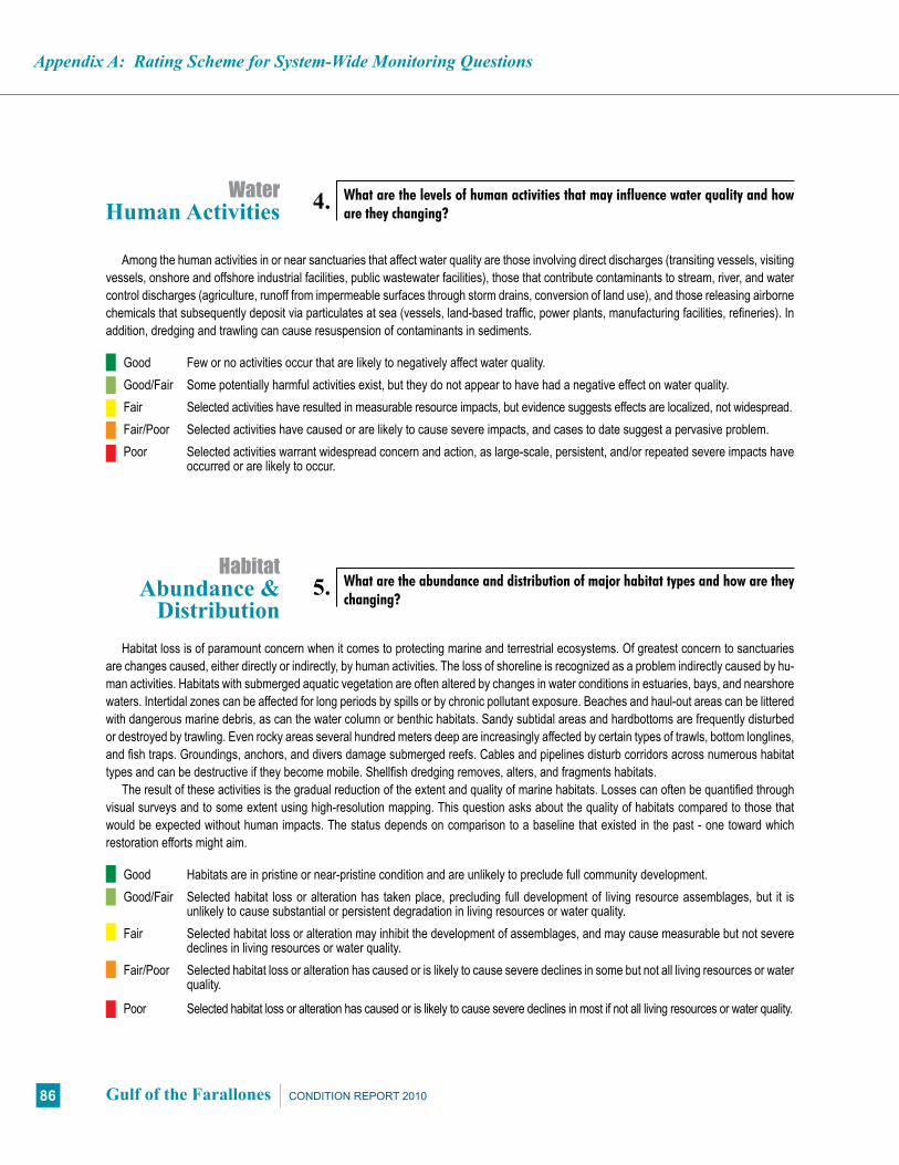
Appendix A: Rating Scheme for System-Wide Monitoring Questions
86 Gulf of the Farallones CONDITION REPORT 2010
Among the human activities in or near sanctuaries that affect water quality are those involving direct discharges (transiting vessels, visiting vessels, onshore and offshore industrial facilities, public wastewater facilities), those that contribute contaminants to stream, river, and water control discharges (agriculture, runoff from impermeable surfaces through storm drains, conversion of land use), and those releasing airborne chemicals that subsequently deposit via particulates at sea (vessels, land-based traffic, power plants, manufacturing facilities, refineries). In addition, dredging and trawling can cause resuspension of contaminants in sediments.
Good Few or no activities occur that are likely to negatively affect water quality. Good/Fair Some potentially harmful activities exist, but they do not appear to have had a negative effect on water quality. Fair Selected activities have resulted in measurable resource impacts, but evidence suggests effects are localized, not widespread. Fair/Poor Selected activities have caused or are likely to cause severe impacts, and cases to date suggest a pervasive problem. Poor Selected activities warrant widespread concern and action, as large-scale, persistent, and/or repeated severe impacts have
occurred or are likely to occur.
Habitat loss is of paramount concern when it comes to protecting marine and terrestrial ecosystems. Of greatest concern to sanctuaries are changes caused, either directly or indirectly, by human activities. The loss of shoreline is recognized as a problem indirectly caused by hu-man activities. Habitats with submerged aquatic vegetation are often altered by changes in water conditions in estuaries, bays, and nearshore waters. Intertidal zones can be affected for long periods by spills or by chronic pollutant exposure. Beaches and haul-out areas can be littered with dangerous marine debris, as can the water column or benthic habitats. Sandy subtidal areas and hardbottoms are frequently disturbed or destroyed by trawling. Even rocky areas several hundred meters deep are increasingly affected by certain types of trawls, bottom longlines, and fish traps. Groundings, anchors, and divers damage submerged reefs. Cables and pipelines disturb corridors across numerous habitat types and can be destructive if they become mobile. Shellfish dredging removes, alters, and fragments habitats.
The result of these activities is the gradual reduction of the extent and quality of marine habitats. Losses can often be quantified through visual surveys and to some extent using high-resolution mapping. This question asks about the quality of habitats compared to those that would be expected without human impacts. The status depends on comparison to a baseline that existed in the past - one toward which restoration efforts might aim.
Good Habitats are in pristine or near-pristine condition and are unlikely to preclude full community development. Good/Fair Selected habitat loss or alteration has taken place, precluding full development of living resource assemblages, but it is
unlikely to cause substantial or persistent degradation in living resources or water quality. Fair Selected habitat loss or alteration may inhibit the development of assemblages, and may cause measurable but not severe
declines in living resources or water quality. Fair/Poor Selected habitat loss or alteration has caused or is likely to cause severe declines in some but not all living resources or water
quality.
Poor Selected habitat loss or alteration has caused or is likely to cause severe declines in most if not all living resources or water quality.
4. What are the levels of human activities that may influence water quality and how are they changing?
WaterHuman Activities
5. What are the abundance and distribution of major habitat types and how are they changing?
HabitatAbundance &
Distribution
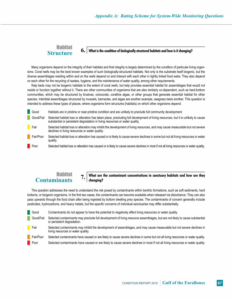
Appendix A: Rating Scheme for System-Wide Monitoring Questions
87CONDITION REPORT 2010 Gulf of the Farallones
Many organisms depend on the integrity of their habitats and that integrity is largely determined by the condition of particular living organ-isms. Coral reefs may be the best known examples of such biologically-structured habitats. Not only is the substrate itself biogenic, but the diverse assemblages residing within and on the reefs depend on and interact with each other in tightly linked food webs. They also depend on each other for the recycling of wastes, hygiene, and the maintenance of water quality, among other requirements.
Kelp beds may not be biogenic habitats to the extent of coral reefs, but kelp provides essential habitat for assemblages that would not reside or function together without it. There are other communities of organisms that are also similarly co-dependent, such as hard-bottom communities, which may be structured by bivalves, octocorals, coralline algae, or other groups that generate essential habitat for other species. Intertidal assemblages structured by mussels, barnacles, and algae are another example, seagrass beds another. This question is intended to address these types of places, where organisms form structures (habitats) on which other organisms depend.
Good Habitats are in pristine or near-pristine condition and are unlikely to preclude full community development. Good/Fair Selected habitat loss or alteration has taken place, precluding full development of living resources, but it is unlikely to cause
substantial or persistent degradation in living resources or water quality. Fair Selected habitat loss or alteration may inhibit the development of living resources, and may cause measurable but not severe
declines in living resources or water quality. Fair/Poor Selected habitat loss or alteration has caused or is likely to cause severe declines in some but not all living resources or water
quality. Poor Selected habitat loss or alteration has caused or is likely to cause severe declines in most if not all living resources or water quality.
This question addresses the need to understand the risk posed by contaminants within benthic formations, such as soft sediments, hard bottoms, or biogenic organisms. In the first two cases, the contaminants can become available when released via disturbance. They can also pass upwards through the food chain after being ingested by bottom dwelling prey species. The contaminants of concern generally include pesticides, hydrocarbons, and heavy metals, but the specific concerns of individual sanctuaries may differ substantially.
Good Contaminants do not appear to have the potential to negatively affect living resources or water quality. Good/Fair Selected contaminants may preclude full development of living resource assemblages, but are not likely to cause substantial
or persistent degradation. Fair Selected contaminants may inhibit the development of assemblages, and may cause measurable but not severe declines in
living resources or water quality. Fair/Poor Selected contaminants have caused or are likely to cause severe declines in some but not all living resources or water quality. Poor Selected contaminants have caused or are likely to cause severe declines in most if not all living resources or water quality.
6. What is the condition of biologically structured habitats and how is it changing?Habitat
Structure
7. What are the contaminant concentrations in sanctuary habitats and how are they changing?
HabitatContaminants

Appendix A: Rating Scheme for System-Wide Monitoring Questions
88 Gulf of the Farallones CONDITION REPORT 2010
Human activities that degrade habitat quality do so by affecting structural (geological), biological, oceanographic, acoustic, or chemical char-acteristics. Structural impacts include removal or mechanical alteration, including various fishing techniques (trawls, traps, dredges, longlines, and even hook-and-line in some habitats), dredging channels and harbors and dumping spoil, vessel groundings, anchoring, laying pipelines and cables, installing offshore structures, discharging drill cuttings, dragging tow cables, and placing artificial reefs. Removal or alteration of critical biological components of habitats can occur along with several of the above activities, most notably trawling, groundings, and cable drags. Marine debris, par-ticularly in large quantities (e.g., lost gillnets and other types of fishing gear), can affect both biological and structural habitat components. Changes in water circulation often occur when channels are dredged, fill is added, coastal areas are reinforced, or other construction takes place. These activities affect habitat by changing food delivery, waste removal, water quality (e.g., salinity, clarity and sedimentation), recruitment patterns, and a host of other factors. Acoustic impacts can occur to water column habitats and organisms from acute and chronic sources of anthropogenic noise (e.g., shipping, boating, construction). Chemical alterations most commonly occur following spills and can have both acute and chronic impacts.
Good Few or no activities occur that are likely to negatively affect habitat quality. Good/Fair Some potentially harmful activities exist, but they do not appear to have had a negative effect on habitat quality. Fair Selected activities have resulted in measurable habitat impacts, but evidence suggests effects are localized, not widespread. Fair/Poor Selected activities have caused or are likely to cause severe impacts, and cases to date suggest a pervasive problem. Poor Selected activities warrant widespread concern and action, as large-scale, persistent, and/or repeated severe impacts have
occurred or are likely to occur.
This is intended to elicit thought and assessment of the condition of living resources based on expected biodiversity levels and the interac-tions between species. Intact ecosystems require that all parts not only exist, but that they function together, resulting in natural symbioses, competition, and predator-prey relationships. Community integrity, resistance and resilience all depend on these relationships. Abundance, relative abundance, trophic structure, richness, H’ diversity, evenness, and other measures are often used to assess these attributes.
Good Biodiversity appears to reflect pristine or near-pristine conditions and promotes ecosystem integrity (full community develop-ment and function).
Good/Fair Selected biodiversity loss has taken place, precluding full community development and function, but it is unlikely to cause substantial or persistent degradation of ecosystem integrity.
Fair Selected biodiversity loss may inhibit full community development and function, and may cause measurable but not severe degradation of ecosystem integrity.
Fair/Poor Selected biodiversity loss has caused or is likely to cause severe declines in some but not all ecosystem components and reduce ecosystem integrity.
Poor Selected biodiversity loss has caused or is likely to cause severe declines in ecosystem integrity.
8. What are the levels of human activities that may influence habitat quality and how are they changing?
HabitatHuman Activities
9. What is the status of biodiversity and how is it changing?Living Resources
Biodiversity

Appendix A: Rating Scheme for System-Wide Monitoring Questions
89CONDITION REPORT 2010 Gulf of the Farallones
Commercial and recreational harvesting are highly selective activities, for which fishers and collectors target a limited number of species, and often remove high proportions of populations. In addition to removing significant amounts of biomass from the ecosystem, reducing its availability to other consumers, these activities tend to disrupt specific and often critical food web links. When too much extraction occurs (i.e. ecologically unsustainable harvesting), trophic cascades ensue, resulting in changes in the abundance of non-targeted species as well. It also reduces the ability of the targeted species to replenish populations at a rate that supports continued ecosystem integrity.
It is essential to understand whether removals are occurring at ecologically sustainable levels. Knowing extraction levels and determining the impacts of removal are both ways that help gain this understanding. Measures for target species of abundance, catch amounts or rates (e.g., catch per unit effort), trophic structure, and changes in non-target species abundance are all generally used to assess these conditions.
Other issues related to this question include whether fishers are using gear that is compatible with the habitats being fished and whether that gear minimizes by-catch and incidental take of marine mammals. For example, bottom-tending gear often destroys or alters both ben-thic structure and non-targeted animal and plant communities. “Ghost fishing” occurs when lost traps continue to capture organisms. Lost or active nets, as well as lines used to mark and tend traps and other fishing gear, can entangle marine mammals. Any of these could be considered indications of environmentally unsustainable fishing techniques.
Good Extraction does not appear to affect ecosystem integrity (full community development and function). Good/Fair Extraction takes place, precluding full community development and function, but it is unlikely to cause substantial or persis-
tent degradation of ecosystem integrity. Fair Extraction may inhibit full community development and function, and may cause measurable but not severe degradation of
ecosystem integrity. Fair/Poor Extraction has caused or is likely to cause severe declines in some but not all ecosystem components and reduce ecosystem
integrity. Poor Extraction has caused or is likely to cause severe declines in ecosystem integrity.
Non-indigenous species are generally considered problematic, and candidates for rapid response, if found, soon after invasion. For those that become established, their impacts can sometimes be assessed by quantifying changes in the affected native species. This question allows sanctuaries to report on the threat posed by non-indigenous species. In some cases, the presence of a species alone constitutes a significant threat (certain invasive algae). In other cases, impacts have been measured, and may or may not significantly affect ecosystem integrity.
Good Non-indigenous species are not suspected or do not appear to affect ecosystem integrity (full community development and function).
Good/Fair Non-indigenous species exist, precluding full community development and function, but are unlikely to cause substantial or persistent degradation of ecosystem integrity.
Fair Non-indigenous species may inhibit full community development and function, and may cause measurable but not severe degradation of ecosystem integrity.
Fair/Poor Non-indigenous species have caused or are likely to cause severe declines in some but not all ecosystem components and reduce ecosystem integrity.
Poor Non-indigenous species have caused or are likely to cause severe declines in ecosystem integrity.
10. What is the status of environmentally sustainable fishing and how is it changing?Living Resources
Extracted Species
11. What is the status of non-indigenous species and how is it changing?Living Resources
Non-Indigenous Species

Appendix A: Rating Scheme for System-Wide Monitoring Questions
90 Gulf of the Farallones CONDITION REPORT 2010
Certain species can be defined as “key” within a marine sanctuary. Some might be keystone species, that is, species on which the persistence of a large number of other species in the ecosystem depends - the pillar of community stability. Their functional contribution to ecosystem function is disproportionate to their numerical abundance or biomass and their impact is therefore important at the community or ecosystem level. Their removal initiates changes in ecosystem structure and sometimes the disappearance of or dramatic increase in the abundance of dependent species. Keystone species may include certain habitat modifiers, predators, herbivores, and those involved in criti-cal symbiotic relationships (e.g. cleaning or co-habitating species).
Other key species may include those that are indicators of ecosystem condition or change (e.g., particularly sensitive species), those targeted for special protection efforts, or charismatic species that are identified with certain areas or ecosystems. These may or may not meet the definition of keystone, but do require assessments of status and trends.
Good Key and keystone species appear to reflect pristine or near-pristine conditions and may promote ecosystem integrity (full community development and function).
Good/Fair Selected key or keystone species are at reduced levels, perhaps precluding full community development and function, but substantial or persistent declines are not expected.
Fair The reduced abundance of selected keystone species may inhibit full community development and function, and may cause measurable but not severe degradation of ecosystem integrity; or selected key species are at reduced levels, but recovery is possible.
Fair/Poor The reduced abundance of selected keystone species has caused or is likely to cause severe declines in some but not all ecosystem components, and reduce ecosystem integrity; or selected key species are at substantially reduced levels, and prospects for recovery are uncertain.
Poor The reduced abundance of selected keystone species has caused or is likely to cause severe declines in ecosystem integrity; or selected key species are a severely reduced levels, and recovery is unlikely.
For those species considered essential to ecosystem integrity, measures of their condition can be important to determining the likelihood that they will persist and continue to provide vital ecosystem functions. Measures of condition may include growth rates, fecundity, recruit-ment, age-specific survival, tissue contaminant levels, pathologies (disease incidence tumors, deformities), the presence and abundance of critical symbionts, or parasite loads. Similar measures of condition may also be appropriate for other key species (indicator, protected, or charismatic species). In contrast to the question about keystone species (#12 above), the impact of changes in the abundance or condition of key species is more likely to be observed at the population or individual level, and less likely to result in ecosystem or community effects.
Good The condition of key resources appears to reflect pristine or near-pristine conditions. Good/Fair The condition of selected key resources is not optimal, perhaps precluding full ecological function, but substantial or persis-
tent declines are not expected. Fair The diminished condition of selected key resources may cause a measurable but not severe reduction in ecological function,
but recovery is possible. Fair/Poor The comparatively poor condition of selected key resources makes prospects for recovery uncertain. Poor The poor condition of selected key resources makes recovery unlikely.
12. What is the status of key species and how is it changing?Living Resources
Key Species
Living ResourcesHealth of Key
Species 13. What is the condition or health of key species and how is it changing?

Appendix A: Rating Scheme for System-Wide Monitoring Questions
91CONDITION REPORT 2010 Gulf of the Farallones
Human activities that degrade living resource quality do so by causing a loss or reduction of one or more species, by disrupting critical life stages, by impairing various physiological processes, or by promoting the introduction of non-indigenous species or pathogens. (Note: Activities that impact habitat and water quality may also affect living resources. These activities are dealt with in Questions 4 and 8, and many are repeated here as they also have direct effect on living resources).
Fishing and collecting are the primary means of removing resources. Bottom trawling, seine-fishing, and the collection of ornamental species for the aquarium trade are all common examples, some being more selective than others. Chronic mortality can be caused by marine debris derived from commercial or recreational vessel traffic, lost fishing gear, and excess visitation, resulting in the gradual loss of some species.
Critical life stages can be affected in various ways. Mortality to adult stages is often caused by trawling and other fishing techniques, cable drags, dumping spoil or drill cuttings, vessel groundings, or persistent anchoring. Contamination of areas by acute or chronic spills, discharg-es by vessels, or municipal and industrial facilities can make them unsuitable for recruitment; the same activities can make nursery habitats unsuitable. Although coastal armoring and construction can increase the availability of surfaces suitable for the recruitment and growth of hard bottom species, the activity may disrupt recruitment patterns for other species (e.g., intertidal soft bottom animals) and habitat may be lost.
Spills, discharges, and contaminants released from sediments (e.g., by dredging and dumping) can all cause physiological impairment and tissue contamination. Such activities can affect all life stages by reducing fecundity, increasing larval, juvenile, and adult mortality, reducing disease resistance, and increasing susceptibility to predation. Bioaccumulation allows some contaminants to move upward through the food chain, disproportionately affecting certain species.
Activities that promote introductions include bilge discharges and ballast water exchange, commercial shipping and vessel transportation. Releases of aquarium fish can also lead to species introductions.
Good Few or no activities occur that are likely to negatively affect living resource quality. Good/Fair Some potentially harmful activities exist, but they do not appear to have had a negative effect on living resource quality. Fair Selected activities have resulted in measurable living resource impacts, but evidence suggests effects are localized, not
widespread. Fair/Poor Selected activities have caused or are likely to cause severe impacts, and cases to date suggest a pervasive problem. Poor Selected activities warrant widespread concern and action, as large-scale, persistent, and/or repeated severe impacts have
occurred or are likely to occur.
14. What are the levels of human activities that may influence living resource quality and how are they changing?
Living ResourcesHuman Activities

Appendix A: Rating Scheme for System-Wide Monitoring Questions
92 Gulf of the Farallones CONDITION REPORT 2010
The condition of archaeological resources in a marine sanctuary significantly affects their value for science and education, as well as the resource’s eligibility for listing in the National Register of Historic Places. Assessments of archaeological sites include evaluation of the ap-parent levels of site integrity, which are based on levels of previous human disturbance and the level of natural deterioration. The historical, scientific and educational values of sites are also evaluated, and are substantially determined and affected by site condition.
Good Known archaeological resources appear to reflect little or no unexpected disturbance. Good/Fair Selected archaeological resources exhibit indications of disturbance, but there appears to have been little or no reduction in
historical, scientific, or educational value. Fair The diminished condition of selected archaeological resources has reduced, to some extent, their historical, scientific, or
educational value, and may affect the eligibility of some sites for listing in the National Register of Historic Places. Fair/Poor The diminished condition of selected archaeological resources has substantially reduced their historical, scientific, or educa-
tional value, and is likely to affect their eligibility for listing in the National Register of Historic Places. Poor The degraded condition of known archaeological resources in general makes them ineffective in terms of historical, scientific,
or educational value, and precludes their listing in the National Register of Historic Places.
The sinking of a ship potentially introduces hazardous materials into the marine environment. This danger is true for historic shipwrecks as well. The issue is complicated by the fact that shipwrecks older than 50 years may be considered historical resources and must, by federal mandate, be protected. Many historic shipwrecks, particularly early to mid-20th century, still have the potential to retain oil and fuel in tanks and bunkers. As shipwrecks age and deteriorate, the potential for release of these materials into the environment increases.
Good Known maritime archaeological resources pose few or no environmental threats. Good/Fair Selected maritime archaeological resources may pose isolated or limited environmental threats, but substantial or persistent
impacts are not expected. Fair Selected maritime archaeological resources may cause measurable, but not severe, impacts to certain sanctuary resources
or areas, but recovery is possible. Fair/Poor Selected maritime archaeological resources pose substantial threats to certain sanctuary resources or areas, and prospects
for recovery are uncertain. Poor Selected maritime archaeological resources pose serious threats to sanctuary resources, and recovery is unlikely.
15. What is the integrity of known maritime archaeological resources and how is it changing?
Maritime Archaeological Resources
Integrity
16. Do known maritime archaeological resources pose an environmental hazard and how is this threat changing?
Maritime Archaeological Resources
Threat to Environment

Appendix A: Rating Scheme for System-Wide Monitoring Questions
93CONDITION REPORT 2010 Gulf of the Farallones
Some human maritime activities threaten the physical integrity of submerged archaeological resources. Archaeological site integrity is compromised when elements are moved, removed, or otherwise damaged. Threats come from looting by divers, inadvertent damage by scuba diving visitors, improperly conducted archaeology that does not fully document site disturbance, anchoring, groundings, and commer-cial and recreational fishing activities, among others.
Good Few or no activities occur that are likely to negatively affect maritime archaeological resource integrity. Good/Fair Some potentially relevant activities exist, but they do not appear to have had a negative effect on maritime archaeological
resource integrity. Fair Selected activities have resulted in measurable impacts to maritime archaeological resources, but evidence suggests effects
are localized, not widespread. Fair/Poor Selected activities have caused or are likely to cause severe impacts, and cases to date suggest a pervasive problem. Poor Selected activities warrant widespread concern and action, as large-scale, persistent, and/or repeated severe impacts have
occurred or are likely to occur.
17. What are the levels of human activities that may influence maritime archaeological resource quality and how are they changing?
Maritime Archaeological Resources
Human Activities

AppendixB:ConsultationwithExpertsandDocumentReview
94 Gulf of the Farallones CONDITION REPORT 2010
The Delphi Method relies on repeated interactions with experts who respond to questions with a limited number of choices to arrive at the best supported answers. Feedback to the experts allows them to refine their views, gradually moving the group toward the most agreeable judgment. For condition reports, the Office of National Ma-rine Sanctuaries uses 17 questions related to the status and trends of sanctuary resources, with accompanying descriptions and five possible choices that describe resource condition (Appendix A).
In order to address the 17 questions, sanctuary staff selected and consulted outside experts familiar with water quality, living resources, habitat, and maritime archaeological resources. A small workshop (15 participants) was convened in August 2007 where experts participated in facilitated discussions about each of the 17 questions. Experts rep-resented various affiliations including California Department of Fish and Game and Office Spill Prevention and Response, Cordell Bank National Marine Sanctuary, Golden Gate National Recreation Area, Monterey Bay National Marine Sanctuary, National Park Service, Point Reyes National Seashore, NOAA National Marine Fisheries Service, Office of National Marine Sanctuaries West Coast Region, San Francisco Public Utilities Commission, San Francisco State Uni-versity, The Institute for Fisheries Resources, U.S. Fish and Wildlife Service, Kier Associates, and the University of California Davis.
At the workshop each expert was introduced to the questions, was then asked to provide recommendations and supporting argu-ments, and the group supplemented the input with further discussion. When answering the set of questions, sanctuary staff and consulted experts did not consider the impacts from global climate changes. The Gulf of the Farallones sanctuary staff developed a separate site scenario document on the observed effects and predicted effects of global climate change on sanctuary resources. The site scenario served as the foundation for the site’s climate change action plan which outlines strategies to reduce carbon emissions at the site, change community behavior, manage for increased ecosystem resil-iency and protection, and monitor the effects of climate change. Both documents are available at www.farrallones.noaa.gov.
In order to ensure consistency with Delphic methods, during the discussion a critical role of the facilitator was to minimize dominance
of the discussion by a single individual or opinion (which often leads to “follow the leader” tendencies in group meetings) and to encour-age the expression of honest differences of opinion. As discussions progressed, the group converged in their opinion of the rating that most accurately describes the current resource condition. After an appropriate amount of time, the facilitator asked whether the group could agree on a rating for the question, as defined by specific lan-guage linked to each rating (see Appendix A). If an agreement was reached, the result was recorded and the group moved on to consid-er the trend in the same manner. If agreement was not reached, the facilitator instructed sanctuary staff to consider all input and decide on a rating and trend at a future time, and to send their ratings back to workshop participants for individual comment.
The first draft of the document summarized the opinions and un-certainty expressed by the experts, who based their input on knowl-edge and perceptions of local conditions. Comments and citations received from the experts were included, as appropriate, in text sup-porting the ratings.
The first draft of the document was sent to the workshop invi-tees (including those who attended and those who had been invited to the workshop but could not attend) and representatives from the California Department of Public Health, California State University Monterey Bay, Gulf of the Farallones Sanctuary Advisory Council, NOAA Office of Response and Restoration, NOAA Marine Debris Program, NOAA National Marine Fisheries Service, ONMS West Coast Region, Tenera Environmental, and staff members from the Gulf of the Farallones National Marine Sanctuary for what was called an Initial Review, a four-week period that allows them to ensure that the report accurately reflected their input, identify information gaps, provide comments or suggest revisions to the ratings and text. Upon receiving those comments, the writing team revised the text and rat-ings as they deemed appropriate.
In September 2009 a draft final report was sent to James Allan (William Self Associates, Inc.), Rebecca Johnson (California Acad-emy of Sciences), and John Largier (University of California, Da-vis, Bodega Marine Laboratory) for final review. This External Peer Review is a requirement that started in December 2004, when the
Appendix B:Consultation with Experts and Document Review
The process for preparing condition reports involves a combination of accepted techniques for collecting and interpreting information gathered from subject matter experts. The approach varies somewhat from sanctuary to sanctuary, in order to accommodate differing styles for working with partners. The Gulf of the Farallones National Marine Sanctuary approach was closely related to the Delphi
Method, a technique designed to organize group communication among a panel of geographically dispersed experts by using questionnaires, ultimately facilitating the formation of a group judgment. This method can be applied when it is necessary for decision-makers to combine the testimony of a group of experts, whether in the form of facts or informed opinion, or both, into a single useful statement.

AppendixB:ConsultationwithExpertsandDocumentReview
95CONDITION REPORT 2010 Gulf of the Farallones
White House Office of Management and Budget (OMB) issued a Final Information Quality Bulletin for Peer Review (OMB Bulletin) es-tablishing peer review standards that would enhance the quality and credibility of the federal government’s scientific information. Along with other information, these standards apply to Influential Scientific Information, which is information that can reasonably be determined to have a “clear and substantial impact on important public policies or private sector decisions.” The Condition Reports are considered Influential Scientific Information. For this reason, these reports are subject to the review requirements of both the Information Quality Act and the OMB Bulletin guidelines. Therefore, following the comple-tion of every condition report, they are reviewed by a minimum of three individuals who are considered to be experts in their field, were not involved in the development of the report, and are not ONMS employees. Comments from these peer reviews were incorporated into the final text of the report. Furthermore, OMB Bulletin guidelines require that reviewer comments, names, and affiliations be posted
on the agency website: http://www.osec.doc.gov/cio/oipr/pr_plans.htm. Reviewer comments, however, are not attributed to specific in-dividuals. Comments by the External Peer Reviewers are posted at the same time as the formatted final document.
The reviewers were asked to review the technical merits of re-source ratings and accompanying text, as well as to point out any omissions or factual errors. Following the External Peer Review the comments and recommendations of the reviewers were considered by sanctuary staff and incorporated, as appropriate, into a final draft document. In some cases sanctuary staff reevaluated the status and trend ratings and when appropriate, the accompanying text in the document was edited to reflect the new ratings. The final interpreta-tion, ratings, and text in the draft condition report were the respon-sibility of sanctuary staff, with final approval by the sanctuary man-ager. To emphasize this important point, authorship of the report is attributed to the sanctuary alone. Subject experts were not authors, though their efforts and affiliations are acknowledged in the report.
Gulf of the Farallones National Marine Sanctuary
96 Gulf of the Farallones CONDITION REPORT 2010
Notes
Gulf of the Farallones National Marine Sanctuary
97CONDITION REPORT 2010 Gulf of the Farallones

The National Marine Sanctuary SystemThe Office of National Marine Sanctuaries, part of the National Oceanic and Atmospheric Administration, serves as the trustee for a system of 14 marine protected areas encompassing more than 150,000 square miles of ocean and Great Lakes waters. The 13 national marine sanctuaries and one marine national monument within the National Marine Sanctuary System represent areas of America’s ocean and Great Lakes environment that are of special national significance. Within their waters, giant humpback whales breed and calve their young, coral colonies flourish, and shipwrecks tell stories of our maritime history. Habitats include beautiful coral reefs, lush kelp forests, whale migrations corridors, spectacular deep-sea canyons, and underwater archaeological sites. These special places also provide homes to thousands of unique or endangered species and are important to America’s cultural heritage. Sites range in size from less than one to almost 140,000 square miles and serve as natural classrooms, cherished recreational spots and are home to valuable commercial industries. The sanctuary system represents many things to many people and each place is unique and in need of special protections.
The Office of National Marine Sanctuaries is part of NOAA’s National Ocean Service.
Vision - People value marine sanctuaries as treasured places protected for future generations.
Mission - To serve as the trustee for the nation’s system of marine protected areas to con-serve, protect and enhance their biodiversity, ecological integrity and cultural legacy.
National Marine Sanctuary System