Guidelines for the management of groundwater to maintain ... · These kinds of impacts may alter...
38
9th Meeting of the Conference of the Parties to the Convention on Wetlands (Ramsar, Iran, 1971) “Wetlands and water: supporting life, sustaining livelihoods” Kampala, Uganda, 8-15 November 2005 Guidelines for the management of groundwater to maintain wetland ecological character (Resolution IX.1 Annex C ii) Contents 1. Background 2. Introduction 3. An overview of groundwater-related wetlands 3.1 Types of groundwater and groundwater-related wetlands 3.2 Functional links between groundwater and wetlands 3.3 Groundwater quality and wetlands 4. Understanding groundwater-related wetlands 4.1 Assessing the potential for groundwater-wetland connectivity 4.2 Understanding hydrological links between wetlands and groundwater 4.3 Quantifying water transfer mechanisms 4.4 Testing understanding through water balances 4.5 Uncertainty in understanding use of the water balance equation 4.6 Defining boundaries for the water balance 4.7 Choice of time step in the water balance 4.8 Period of record 4.9 Predicting hydrological impacts through modelling 5. Towards a framework for the development of groundwater management strategies to maintain wetlands 6. Glossary 7. References Annex 1 Water transfer mechanisms in groundwater-related wetlands Annex 2 Linking landscape location and water transfer mechanisms Annex 3 Water balance example 1. Background 1. At Ramsar’s 8 th meeting of the Conference of the Parties (COP8, Spain, 2002) Contracting Parties recognised the need to improve understanding of the relationships between wetland and groundwater. Specifically, Resolution VIII.1 requested the Convention’s Scientific and Technical Review Panel (STRP) to “review and prepare guidelines, as appropriate, on the role of wetlands in groundwater recharge and storage and of groundwater in maintaining the ecological character of wetlands, and on the impacts of groundwater abstraction on
Transcript of Guidelines for the management of groundwater to maintain ... · These kinds of impacts may alter...

9th Meeting of the Conference of the Parties to the Convention on Wetlands (Ramsar, Iran, 1971)
“Wetlands and water: supporting life, sustaining livelihoods”
Kampala, Uganda, 8-15 November 2005
Guidelines for the management of groundwater to maintain
wetland ecological character
(Resolution IX.1 Annex C ii)
Contents 1. Background 2. Introduction 3. An overview of groundwater-related wetlands
3.1 Types of groundwater and groundwater-related wetlands 3.2 Functional links between groundwater and wetlands 3.3 Groundwater quality and wetlands
4. Understanding groundwater-related wetlands 4.1 Assessing the potential for groundwater-wetland connectivity 4.2 Understanding hydrological links between wetlands and groundwater 4.3 Quantifying water transfer mechanisms 4.4 Testing understanding through water balances 4.5 Uncertainty in understanding use of the water balance equation 4.6 Defining boundaries for the water balance 4.7 Choice of time step in the water balance 4.8 Period of record 4.9 Predicting hydrological impacts through modelling
5. Towards a framework for the development of groundwater management strategies to maintain wetlands
6. Glossary 7. References Annex 1 Water transfer mechanisms in groundwater-related wetlands Annex 2 Linking landscape location and water transfer mechanisms Annex 3 Water balance example
1. Background
1. At Ramsar’s 8th meeting of the Conference of the Parties (COP8, Spain, 2002) Contracting Parties recognised the need to improve understanding of the relationships between wetland and groundwater. Specifically, Resolution VIII.1 requested the Convention’s Scientific and Technical Review Panel (STRP) to “review and prepare guidelines, as appropriate, on the role of wetlands in groundwater recharge and storage and of groundwater in maintaining the ecological character of wetlands, and on the impacts of groundwater abstraction on

Guidelines on groundwater management, page 2
wetlands.” In addition, Action 3.4.5 of the Convention’s Strategic Plan 2003-2008 (Annex to Resolution VIII.25) requested the STRP to “prepare guidance, as appropriate, on sustainable use of groundwater to maintain wetland ecosystem functions”. Parties at COP8 also adopted Resolution VIII.40 concerning “Guidelines for rendering the use of groundwater compatible with the conservation of wetlands”.
2. These calls for technical advice reflect the fact that the roles of groundwater in maintaining
wetlands, and of wetlands in recharging groundwater, are less well understood than those of surface waters, yet it is vital for wetland managers and others to understand how the management of groundwater as well as surface waters affects wetlands if management planning is to deliver the maintenance of wetland ecological character.
3. Existing information and guidelines on the linkages between groundwater and wetlands are
based on conceptual understanding that is largely outdated. Although this is still a topic which is poorly understood, there has been new research over the past 20 years which could provide more relevant and accurate technical guidance on:
i) the role of groundwater in maintaining wetland character and functions; ii) the role of wetlands in groundwater recharge and discharge; and iii) the management of the impacts on wetlands of changes in groundwater quality and
quantity. 4. In particular, new knowledge and techniques (such as the advanced use of isotope tracers)
have become available that can support improved quantification of the hydrological and ecological links between groundwater bodies and associated wetland ecosystems. These issues will be addressed in future technical papers proposed for preparation by the STRP:
i) a detailed technical paper providing a review of hydrological and ecological aspects
of interactions between groundwater and wetlands; and ii) a detailed technical paper providing practical guidance for the use and management
of groundwater resources/aquifers in order to maintain ecosystem functions. 5. The present document provides general guidelines for Parties for the management of
groundwater to maintain wetland ecosystem functions. It is designed to provide guidance both to those responsible for managing water resources (groundwater and surface water) and to those responsible for wetland management. It is recommended that once the additional guidance in the two proposed technical papers has been prepared, the present guidelines should be reviewed and, as appropriate, updated.
2. Introduction
The importance of groundwater
6. In many countries, particularly in arid areas, groundwater is vital to the livelihoods and health of the majority of the people, since it provides almost the entire water resource for domestic, agricultural and industrial use.
7. Ecosystem processes that help maintain groundwater supplies must be protected and
restored where degraded. Groundwater also supports many ecosystems that provide a wide

Guidelines on groundwater management, page 3
range of benefits/services to people. Integrated management of ecosystems and natural resources is therefore an essential element in maintaining our planet.
8. Many wetlands worldwide have close associations with groundwater. For example, a
wetland may depend on the outflow from an aquifer1 as a water source or the downward seepage of water from the wetland may replenish an aquifer. In such cases, the hydrology of the aquifer and the health of the wetland ecosystem are closely connected. Importantly, this relationship can be disrupted by changes either to the aquifer, such as by groundwater abstraction, or to the wetland, for example by reduced natural inundation of wetlands overlying aquifers.
9. Water resources (both surface water and groundwater) and wetlands must thus be managed
in an integrated manner to ensure the sustainability of the ecosystem and the water it provides. Wise use of water and wetland resources is particularly important in arid lands where water is often the limiting factor for human and ecosystem health.
10. Existing or potential impacts on either the wetland or the aquifer must be assessed and
mitigation options pursued wherever significant degradation of the system is found or predicted to occur. Such impacts may range from regional and global scale climate change to local scale management of wetland water levels. These kinds of impacts may alter the linkages between groundwater and wetlands and hence the ecological character of the wetland. Where wetlands are sources of groundwater recharge for aquifers, wetland conservation is an essential element in maintaining water resources.
11. Water inputs to wetlands often include both surface runoff and groundwater inflow in
various combinations. Hence, ensuring the successful delivery of allocated water to a wetland will require integrated management of associated surface and groundwater resources. This in turn will require a sound quantitative understanding of the origins (surface and/or sub-surface), pathways and variability of water flows in and out of the wetland in order to develop water abstraction strategies that minimise or prevent unacceptable levels of change in ecological character of the wetland.
12. Many aquifers around the world are currently heavily or over-exploited for water (Custodio
2002), particularly in Mexico, China, the Middle East and Spain (Morris et al. 2003). Some exploitation is clearly unsustainable and has led to alteration of the hydrological regime of wetlands associated with the aquifers and significant degradation of their ecological character – examples include the Azraq wetlands, Jordan (Fariz & Hatough-Bouran 1998) and Las Tablas de Daimiel, Spain (Fornés & Llamas 2001).
13. In some cases, such as in Western Australia, rising groundwater, caused by removal of
eucalyptus trees that evaporate large volumes of water, has led to salinisation of soils and consequential degradation of wetland and other ecosystems.
14. The management of groundwater-associated wetlands, like other wetland types, must be
closely linked to the management of water resources. The river or catchment basin provides the fundamental unit of management for rivers and other surface water systems. However, in cases where groundwater dominates the hydrological regime, the most
1 Aquifer: a geological formation or structure that stores and/or transmits water, such as to wells,
springs and other wetlands (USGS: http://ga.water.usgs.gov/edu/dictionary.html#A).

Guidelines on groundwater management, page 4
appropriate management unit will be the aquifer unit, particularly where the aquifer boundaries do not coincide with surface river basin boundaries.
Purpose of these guidelines
15. This document provides general guidance to assist Contracting Parties to understand the
interaction between wetlands and groundwater and thereby to develop strategies for impact assessment and sustainable groundwater management that can help to ensure maintenance of wetland ecological character. It focuses primarily on water quantity issues and does not address water quality issues in detail.
16. The contents of this document are as follows:
A general overview of groundwater-related wetlands and the linkages which exist between groundwater and wetland ecosystems,
A more detailed section on characterising, understanding and quantifying linkages between groundwater and wetlands at the site level,
General guidance on developing strategies for integrated management of groundwater resources and associated wetlands, with the aim of maintaining wetland ecosystem functions,
Concluding remarks and recommendations. 17. The complexity of the issues means that some parts of the guidelines contain technical
content aimed at readers with some knowledge of groundwater hydrology. A glossary of terms is provided to assist non-specialists.
18. The guidelines should be read in the context of the Convention’s Integrated Framework for
Ramsar’s water-related guidance (Resolution IX.1 Annex C) and in conjunction with other Ramsar guidance related to the determination and implementation of water allocations for maintaining wetland ecosystem functions (Resolution VIII.1 (Ramsar Wise Use Handbook 12, “Water allocation and management”), [and Resolution IX.1 Annex C i “River basin management: additional guidance and framework for analysis of case studies”, as well as Ramsar Technical Reports on the determination and implementation of environmental water requirements for wetlands”.
3. An Overview of groundwater-related wetlands 3.1 Types of groundwater and groundwater-related wetlands
Groundwater is the water held in permeable rocks, such as limestone, and unconsolidated sediments, such as sand and gravel.
19. The level of the groundwater, below which the rocks or sediments are saturated, is called
the water table (Figure 1). Water also occurs above the water table, in the unsaturated zone e.g. as soil water, but this water is not normally abstracted for human use and is usually not referred to as groundwater. Consequently, water in wetland soils is referred to as groundwater if the soil is almost permanently saturated.

Guidelines on groundwater management, page 5
20. All rocks, sediments and soils can hold and transmit water, but the rate of movement of water is slow (often only metres per year - m yr-1) compared to flow in rivers (normally metres per second - m s-1). This leads to slower responses of groundwater to recharge or abstraction.
21. Water movement in rocks and sediments can vary over many orders of magnitude and
three broad types can be distinguished:
i) those that have large pore spaces (voids) or fissures (cracks) - these are called aquifers and include chalk, limestone, sandstone and gravel;
ii) those that contain small amounts of water and allow water to pass through them slowly - these are called aquitards and include coarse mudstones;
iii) those that contain very little water and stop the movement of groundwater - these are called aquicludes and include clay and unfractured granite.
Figure 1. Definition of groundwater
22. However, where high permeability aquifers (e.g., chalk or limestone) do not occur, water is
sometimes abstracted commercially from low permeability rocks (e.g., fractured granites in Africa), and these may thus also be referred to as aquifers.
23. Surface springs issuing from aquifers are the visible water sources for many rivers and
other kinds of wetlands. The base of a wetland, such as a river bed, may be in contact with an aquifer and hidden from view. Virtually all of the Ramsar wetland types, including even coastal lagoons, may have significant exchange of water with aquifers. However, some types are more likely to be closely linked to groundwater – these include underground wetlands (in cave systems), freshwater springs, and desert oases. In contrast, hill-top blanket bogs, waste-water treatment ponds, and reservoirs are unlikely to be strongly associated with groundwater.
Guidelines on groundwater management, page 6
24. The precise nature of interactions between groundwater and wetlands will depend on local geological conditions. Just because an aquifer is shown on a geological map, it does not mean that any wetlands which overlie it will necessarily be fed by groundwater or will be able to recharge the aquifer. The extent of interaction depends on the permeability of any rocks or sediments that lie between the wetland and the aquifer
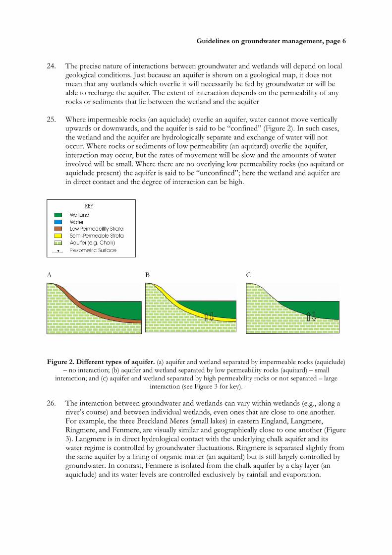
25. Where impermeable rocks (an aquiclude) overlie an aquifer, water cannot move vertically
upwards or downwards, and the aquifer is said to be “confined” (Figure 2). In such cases, the wetland and the aquifer are hydrologically separate and exchange of water will not occur. Where rocks or sediments of low permeability (an aquitard) overlie the aquifer, interaction may occur, but the rates of movement will be slow and the amounts of water involved will be small. Where there are no overlying low permeability rocks (no aquitard or aquiclude present) the aquifer is said to be “unconfined”; here the wetland and aquifer are in direct contact and the degree of interaction can be high.
A
B
C
Figure 2. Different types of aquifer. (a) aquifer and wetland separated by impermeable rocks (aquiclude)
– no interaction; (b) aquifer and wetland separated by low permeability rocks (aquitard) – small interaction; and (c) aquifer and wetland separated by high permeability rocks or not separated – large
interaction (see Figure 3 for key).
26. The interaction between groundwater and wetlands can vary within wetlands (e.g., along a river’s course) and between individual wetlands, even ones that are close to one another. For example, the three Breckland Meres (small lakes) in eastern England, Langmere, Ringmere, and Fenmere, are visually similar and geographically close to one another (Figure 3). Langmere is in direct hydrological contact with the underlying chalk aquifer and its water regime is controlled by groundwater fluctuations. Ringmere is separated slightly from the same aquifer by a lining of organic matter (an aquitard) but is still largely controlled by groundwater. In contrast, Fenmere is isolated from the chalk aquifer by a clay layer (an aquiclude) and its water levels are controlled exclusively by rainfall and evaporation.

Guidelines on groundwater management, page 7
Figure 3. Geological cross-section through the Breckland Meres, UK
3.2 Functional links between groundwater and wetlands
27. The movement of water between aquifers and wetlands can be expressed as one of two
principle hydrological functions, depending on the direction of water movement. Upward flow of water from the aquifer to the wetland is termed groundwater discharge and downward from the wetland to the aquifer is called groundwater recharge (Figure 4).
28. Discharge occurs when the groundwater level (or the piezometric head2) is above the water
level of the wetland. Recharge occurs when the wetland water level is higher than the groundwater level. Functional links between groundwater and wetlands are thus dependent on the geology (i.e., the presence of an aquiclude or aquitard) and relative water levels in the wetland and in the aquifer.
29. The interaction can also vary over time and space, so site-specific investigations are always
needed to identify and confirm local interactions. Groundwater levels vary naturally in time depending on previous rainfall. Additionally, management of water levels in either the wetland or the aquifer, such as abstraction, can alter the relative water levels. Both these factors can change the functional relationship, as is shown in the following three examples:
A
B
Figure 4. Groundwater discharge and recharge. (a) groundwater discharge – when the aquifer water table is above the wetland water level; and (b) groundwater recharge – when the wetland water level is
above the aquifer water table (see Figure 2 for key).
2 The piezometric head is the level that groundwater would reach if not impeded by a low permeability
layer above the aquifer (an aquclude or aquitard) or depleted by, for example, evaporation or abstraction.

Guidelines on groundwater management, page 8
i) In the Azraq basin of Jordan, up-welling groundwater is the water source for the Azraq Oasis wetlands (a Ramsar site), i.e. the aquifer discharges to the wetland (Fariz & Hatough-Bouran 1998). Pumping of water from the aquifer for public supply to the capital Amman has reduced groundwater levels, which has reduced discharge of water to the wetland, resulting in changes to the ecological character of the wetland.
ii) In the Hadejia-Jamare River basin in Nigeria, natural river-induced inundation of the
Hadejia-Nguru floodplain wetlands induces groundwater recharge through downward movement of water into the underlying aquifer, which provides water resources for people living outside the floodplain (Thompson & Hollis 1995). Reduction in river flows, due to impoundment of water in dams upstream, has led to decreased inundation of the wetlands and correspondingly less groundwater recharge to the aquifer.
iii) Las Tablas de Daimiel wetlands in central Spain are fed by the upper Guadiana river and
water discharging from the La Mancha aquifer when groundwater levels are high; but when groundwater levels are low the direction of groundwater flow is reversed and water moves downwards from the wetlands to recharge the aquifer (Llamas, 1989). Until the 1970s the functional relationship was predominantly discharge (Figure 5a). However low rainfall and pumping of the aquifer for irrigated agriculture has caused groundwater levels to drop, and recharge to the aquifer dominated during the 1990s (Figure 5b). This led to severe desiccation of the wetlands. In recent years, water has been transferred to Las Tablas de Daimiel from the Tagus River basin as an emergency plan. However, this has led to some physio-chemical and ecological changes to the wetland due to different characteristics of the transferred water (Cirujano et al. 1996).
30. In many wetlands, water levels depend on a combination of direct rainfall, surface runoff
and groundwater discharge/recharge. Groundwater often becomes more important in the dry season and may be the only source of wetland water. Thus even small inputs of groundwater may be crucial for maintaining the ecological character of the wetland.
31. Additionally, in regions of the world where rainfall is very low, such as the Tempisque river
basin in Costa Rica, groundwater may be the only source of water for wetlands: recharge of the aquifer may occur many kilometres away, such as in mountainous areas, where the climate is wetter.
(a)

Guidelines on groundwater management, page 9
(b)
Figure 5 Block diagram showing the upper Guadiana River and Las Tablas de Daimiel wetlands. (a) in 1960s with little the groundwater abstraction, high water table levels and groundwater discharge to the wetland; and (b) in the 1990s with low rainfall, considerable groundwater abstraction, low water table
levels, reduced wetland area and groundwater recharge from the wetland to the aquifer.
32. Subterranean karst and cave hydrological systems were added as specific wetlands types in
Resolution VI.5, Brisbane, 1996. These underground wetlands are intimately linked to groundwater.
33. The Škocjanske jame (cave) Ramsar site in Slovenia (Figure 6) provides an excellent example of
the linkage between underground wetlands and groundwater. The system lies in the Kras/Karst area that provides the name for the karst phenomena worldwide. Škocjanske jame is exceptional in its dimensions and it exhibits three dominant hydrological characteristics:
i) water moving as an underground river fed by rainwater; ii) pools of stagnant water in the cave system; and iii) large groundwater level fluctuation of more than 130 metres in the parts of the cave
system that have been studied. 34. Understanding hydrological processes in the Škocjanske jame has provided generic
knowledge of hydrological phenomena in karst areas. The catchment area of the cave system covers 337 km2. The surface flow of the Reka river varies between 0.12 and 400 m3s-1 with a mean of 8.32 m3s-1. After sinking in Škocjanske jame, water flows underground for some 41 km and reappears on the surface in Italy as the Timavo River. Within the Škocjanske jame, the River Reka can be traced underground for 2.4 km, from an altitude of 317 metres to 214 metres above sea level at the terminal sump or siphon. Some 900 m to the northwest, in Kačja jama (Kačja cave), the Reka River flows in galleries at 182 m (the inflow siphon is at the altitude of 204 metres) and disappears into the final sump at 156 m above sea level.

Guidelines on groundwater management, page 10
Figure 6. The Škocjanske jame (cave) system Ramsar site in Slovenia
35. The main hydrological value of this wetland system is its capacity to store water: its waters
are used for public supply in urban areas in Italy. The hydrogeological, hydrogeomorphological and hydrological values (including benefits/services) can be summarised as follows:
karstic and surface water drainage from the catchment area;
formation of characteristic underground karst features;

Guidelines on groundwater management, page 11
karst ponors (“swallow-holes”) and springs;
water storage; and
drinking water supply for urban areas (e.g., Trieste and its urban area).
3.3 Groundwater quality and wetlands
36. As water flows through an aquifer it dissolves minerals in the rock, such as calcium, sodium, bicarbonate and chloride, and the temperature becomes equal to that of the rocks. As a result, the chemical and thermal properties of groundwater are often quite different from those of surface water. Thus groundwater-fed wetlands often have different floral and faunal communities than those fed purely by surface water. Indeed, in some cases the presence or absence of particular species known to be groundwater-reliant can be an indicator of whether or not a wetland is strongly dependent on groundwater.
37. Furthermore, although groundwater may be volumetrically a minor source of water for
some wetlands, even a small quantity of groundwater can have a significant impact on water quality and hence on ecological processes and biota in the wetland. For example, at Wicken Fen in England, changes in ecological character were first attributed to the drying out of the wetland. However, hydrological analysis showed that reduced inundation from the groundwater-fed high alkalinity river due to flood management activities had altered the acidity of the wetland.
4. Understanding groundwater-related wetlands 4.1 Assessing the potential for groundwater-wetland connectivity 38. Many wetlands are hydrologically and ecologically linked to adjacent groundwater bodies,
but the degree of interaction can vary greatly. Some wetlands may be completely dependent on groundwater discharge under all climatic conditions, whilst others may have very limited dependence such as only under very dry conditions – and some may have no connection with groundwater at all. Some aquifers are dependent almost entirely on recharge from wetlands, for example, the Kuiseb aquifer in Namibia; other aquifers may receive no recharge from wetlands.
39. It is essential that wetland managers and those agencies concerned with protection and
maintenance of the ecological character of wetlands should be able to influence and make input to groundwater management plans and strategies. It is also necessary, however, to identify what level of technical input into water resources management is needed from wetland managers. There may be cases where the wetland-groundwater interaction is very limited or absent altogether, and abstraction of groundwater from local aquifers may have very little, if any, impact on wetlands. On the other hand, there are cases when abstraction of groundwater from a deep aquifer at a considerable distance from the wetland can have unforeseen but very significant impacts on the hydrology and hence the ecological character of a wetland.
40. Both wetland managers and groundwater managers should undertake screening studies at a river basin or regional aquifer scale, to assess the potential for interaction between wetlands and groundwater. The degree of connectivity will largely be determined by a combination of geology, regional hydrology, and topography.

Guidelines on groundwater management, page 12
41. A screening study at river basin or regional scale, undertaken by a team of specialists with
geological, hydrological and ecological expertise, should allow wetland and water resources managers to identify areas where there is high potential for wetlands to be dependent to some degree on groundwater, and hence where more detailed studies or field assessments might be necessary in order to ensure that the groundwater needs of wetlands in these areas are accounted for in any groundwater management plan.
42. Typically, this kind of screening study lends itself to a GIS-based approach, possibly with
the complementary use of remote sensing tools, to provide an indication of the potential risk to wetlands of regional groundwater abstraction or other forms of exploitation such as artificial recharge with wastewater. Much of the analysis can be desk-based, although at best, at that level of resolution, it can only provide “red flags” as to the location of high-risk areas where extensive groundwater exploitation should not be considered without additional studies to ascertain the potential impact on wetlands in the region. Desk-based studies require maps of geology, land use, and vegetation and broad data on aquifer properties and groundwater use, which should be available in water resources ministries. Additional studies should then include wetland-specific investigations as described in more detail in the following sections.
4.2 Understanding hydrological links between wetlands and groundwater 43. A prerequisite to assessing the implications for a wetland of any external hydrological
impacts is to understand the ways in which water enters and leaves the wetland (termed water transfer mechanisms) and to quantify the associated rates of water movement.
44. Most wetland managers are very familiar with geographical (horizontal or plan-form)
analysis of wetlands, using maps of open water bodies and vegetation zonation. However, understanding interactions with groundwater requires a geological view in a third dimension, i.e. looking at vertical sections through the soils and rocks that lie beneath the wetland. Annex 1 provides details of the 14 different types of water transfer mechanisms, depicted schematically in the form of vertical sections. They show that groundwater can enter a wetland directly from a spring (spring flow), by lateral movement from an adjacent aquifer (seepage), or by upward movement from an underlying aquifer (discharge). Water usually moves from a wetland to an aquifer by downward movement (recharge).
45. The first step in understanding wetland hydrology involves identifying which water transfer
mechanisms are present in a wetland and which of these are the most important. Whether movement of groundwater to or from a wetland is an important mechanism depends not only on the presence of an aquifer, but also on the nature of the soils and rocks between the aquifer and the wetland. If the wetland is in direct contact with the aquifer, exchange of water is very likely. However, if there is a low permeability layer (an aquitard or aquiclude) between the wetland and the underlying aquifer, there may be little or no exchange of groundwater.
46. To aid the user in identifying the water transfer mechanisms, a hydrological typology of
wetlands has been developed by Acreman (2004), based on landscape location. This is described in Annex 2 and is complementary to other classifications such as for vegetated peatlands (“mires”) (Steiner 1992).

Guidelines on groundwater management, page 13
47. It is important to keep in mind that the wetland under study is unlikely to be precisely like any one of the wetland types shown: many wetlands can exhibit characteristics of more than one type. Nevertheless, the typology provides an indication of most common situations.
48. The outcome of a hydrological investigation should be a cross-sectional diagram of the
wetland under study showing water transfer mechanisms (see Annex 1) and the soils and rocks underlying the wetland. Real wetlands are often complex, exhibiting many water transfer mechanisms simultaneously, although certain mechanisms will often dominate in different zones of an individual wetland.
49. Figure 7 shows a cross-section of a hypothetical wetland where different water transfer
mechanisms dominate in different zones of the wetland. Hydrological inputs to Zone A are dominated by spring flow (S) and outputs by pumping (PU), whereas in Zone B over-bank flow from the river (OB) dominates. Zone C is an area of exchange with groundwater (GD, GR), whilst the hydrology of Zone D is dominated by precipitation (P) and evaporation (E). In Zone E inputs come from groundwater seepage (GS) and runoff from the adjacent slopes (R). Cross-section diagrams will probably need to be produced for different periods (most notably for wet or dry seasons) since the water transfer mechanism may change: for example, the interaction between the aquifer and wetland may alter discharge and recharge as water table levels change.

Guidelines on groundwater management, page 14
Figure 7. Block diagram of a hypothetical wetland, showing water transfer mechanisms in
different zones.

Guidelines on groundwater management, page 15
4.3 Quantifying water transfer mechanisms
50. Because aquifers are hidden from view, it is very difficult to measure accurately the nature
and extent of any groundwater interaction with wetlands. However, there are various ways in which information can be gathered. The intensity and scope of information-gathering activities will depend on the confidence in results and degree of quantification required.
51. A scoping study to identify the potential (presence/absence) for significant connectivity
between a wetland and related groundwater bodies may only require an initial desktop assessment (see Section 4.1). However, determining the sustainable yield and permitted abstraction from an aquifer is likely to require intensive specialist field studies and monitoring over time.
52. In general, there are three levels of assessment that can contribute to understanding and
quantifying water transfer mechanisms:
i) Desk based information. Investigations normally start with information available in the office. Spatial data will often include topographical, land use/vegetation, and geological maps and photographs taken from aircraft or satellites. Old photos have proved to be very useful in explaining hydrological links with wetlands in Costa Rica, where restoration practices benefit from historical knowledge. Geological maps can reveal the proximity of aquifers to the wetlands. However, these maps are generally drawn by extrapolating information from limited geological data (such as cores) – hence in parts of these maps the presence and thickness of impermeable strata lying between a wetland and an aquifer may be very uncertain. In addition, the permeability (or hydraulic conductivity) of the strata will not be evident from the map.
ii) Field visits. Field visits should be undertaken at an early stage in any investigation.
Where possible the field team should be multi-disciplinary, including a hydrologist, hydro-geologist, and botanist. Botanists may be able to identify plants that may indicate groundwater discharge to the site; however, this assumes that the present vegetation truly reflects the current wetland hydrology. It is particularly advisable to try and visit the wetland (a) after prolonged rainfall to see if springs or ephemeral water courses can be identified and (b) after a prolonged dry spell when vegetation patterns may indicate areas where the wetland is reliant on groundwater during the dry season or droughts. Photographs should be taken to record specific features, such as weirs or sluices, vegetation distribution, and channel networks. Auger3 holes should be dug to investigate soil properties of the wetland, particularly to identify areas of permanent water-logging in the dry season that may reflect reliance on groundwater. Where possible, local people such as farmers should be interviewed to gain anecdotal information about potential water transfer mechanisms or changes to the site – for example, are there springs feeding the wetland and are these perennial? This information should provide an on-the-ground check of the office-based conceptual model or identify new aspects that have not been covered.
3 An auger is a hand-held device, often in the form of a screw, for removing small (<5 cm diameter, 30
cm long) soil cores.

Guidelines on groundwater management, page 16
iii) Field measurement and monitoring programmes. The quantification of groundwater exchanges with wetlands requires field data. Whilst some data, such as groundwater levels, may be available from hydrometric services, most wetland studies require the collection of field data for the site in question. These data may include dip well or piezometer levels from the wetland soil or the underlying aquifer and soil properties, such as specific yield or hydraulic conductivity. Based on initial understanding, field monitoring programmes will need to be established to collect the necessary data, i.e., over a specific time period rather than a once-off assessment. The data will support the generation of more detailed understanding and construction of associated numerical models.
53. Although these three levels of information collection are presented as sequential steps, it is
not always the case that they must be followed in this order. Furthermore, the process may be cyclical. For example, it may be recognised at an early stage in a wetland impact assessment that a detailed model will be required, so collection of appropriate data and model development can start. Later anecdotal information could be collected that refines or changes previous understanding, e.g., the identification of springs during a wet season visit.
4.4 Testing understanding through water balances
54. Once an understanding of how a wetland works hydrologically has been established in
principle and a cross-section diagram like that in Figure 7 has been produced, the understanding needs to be tested and confirmed or refined. Estimating a water balance, which involves quantifying water transfer rates, provides a means of testing hydrological understanding. The principle of balancing inputs, storage and outputs provides a check that all water transfers have been correctly accounted for and quantified.
Water transfer mechanism inputs to the
wetland
P: precipitation (rainfall, snow, dew etc)
directly on the wetland +
R: surface and shallow subsurface inflow
to the wetland +
L: lateral inflow +
OB: over-bank inflow +
PUi: water pumped into the wetland +
S: spring flow +
GD: groundwater discharge into the
wetland +
GS: groundwater seepage into the wetland
+
TI tidal inflow from the sea to the
wetland
=
Water transfer mechanism outputs from the
wetland
E: evaporation from the wetland +
V: change in volume of water stored within
the wetland +
D: drainage +
OF: overland outflow +
PUo: water pumped out of the wetlands +
GR: groundwater recharge to aquifers +
TO tidal outflow from the wetland to the sea
Where V may be positive or negative

Guidelines on groundwater management, page 17
Figure 8. Balancing potential water transfer mechanism inputs to and outputs from a wetland
(Figure 7 provides a schematic representation).
55. The water balance is a key quantitative test of hydrological understanding, but it is normally
only a first step because it deals with bulk water volume transfers and not with hydrological processes per se. Thus, it may not in itself provide full answers to assessments of impacts of regime changes on wetlands.
56. Although simple in principle, quantifying a water balance is not always straightforward in
practice. Many wetlands have a multitude of natural and human-made surface channels providing links to water courses or have a complex association with an underlying aquifer, all of which need to be taken into account in the water balance.
57. The water balance of a wetland is based on comparing the total quantity of water
transferred into a wetland with the total quantity of water transferred out (see Figure 8). By using the list of water transfer mechanisms in Annex 1, the water balance of a wetland can be summarised by a simple addition of inputs to and outputs from the wetlands (see Figure 7 for schematic representation of inputs and outputs). The elements of Figure 8 can be expressed as the following equation:
(P + R + L + OB + PUi + S + GD + GS + TI) – (E + D + OF + PUo + GR + TO) = V [1]
inputs to the wetland outputs from the wetland
58. Thus, if inputs exceed outputs, storage (V) will increase and the water level in the wetland
will rise. If inputs are less than outputs, storage (V) will decline and the water level in the wetland will fall.
59. Some water transfer mechanisms may not occur in any particular wetland and thus will
have a zero value in the water balance. If the total inputs of a water balance are not approximately equal to the total outputs, this may indicate that a potentially significant water transfer mechanism either has been omitted or not measured accurately. Hence the water balance can help to identify specific areas where additional or more detailed investigations are required.
4.5 Uncertainty in understanding use of the water balance equation
60. It is not possible to measure any rates of water transfer exactly, and thus it is inevitable that
quantification of the water balance will not be precise. Although uncertainty is often perceived as a negative issue (often associated in people’s minds with user error), it is a fact of life, especially when dealing with natural systems, and should be presented explicitly rather than hidden. Where possible, the uncertainty (or level of confidence) associated with any water transfer mechanism should be estimated. Future effort can then be focused on the better measurement of the most uncertain mechanisms. One approach to the estimation of uncertainty is to quantify the rate of flow in each water transfer mechanism using various different methods. The range in results generated using different methods helps define the certainty with which the water transfer mechanism has been defined. If it is not possible to choose between different estimates of water transfer mechanisms, a mean value can be adopted but the range in values is useful when testing the water balance.

Guidelines on groundwater management, page 18
61. The water balance is tested by comparing the volume of inputs with the volume of outputs.
If the volumes match approximately, then the water balance is said to be “closed”. However, since all measurements of water transfer mechanisms have some uncertainty, the water balance will never close exactly. In practice, the balance is thought to be satisfactory if the imbalance is within the uncertainty of the measurements.
62. There is often a temptation in water balance studies to assume that any residual (or unaccounted-for volume of) water must be equal to a particular water transfer mechanism that is thought to occur, but for which data are not available. For example, if in a wetland that is thought to be fed by groundwater, the precipitation is less than outflow, it is tempting to conclude that the groundwater discharge must be equal to the difference between precipitation and outflow. However, this apparently unaccounted-for water may be a result of inaccurate rainfall or outflow data, or input from another mechanism, such as a spring which has not been recognised. Consequently, every water transfer mechanism must be estimated independently, however uncertain this may be, and checked using the water balance. Defining a water balance can thus be an iterative process, in common with developing the whole conceptual understanding of the wetland.
63. An example of a water balance is given in Annex 3. 4.6 Defining boundaries for the water balance
64. Where possible, the water balance should be undertaken for the wetland itself as a single
hydrological unit. However, where it is appropriate to subdivide the wetland into hydrologically distinct units, water balances should be calculated separately for the different hydrological units. This would be the case where, for example, a weir controls water levels in different parts of a wetland. It may also be prudent to divide the wetland into different hydrological units if different water transfer mechanisms are evident, such as is shown for the zones in Figure 7.
65. In some situations, hydrological units larger than the wetland itself have been adopted and
a regional or large-scale water balance has been developed for the whole aquifer within which the wetland is located, rather than for the wetland itself. This is often justified on the basis of the known strong hydraulic connectivity between the aquifer and the wetlands. This approach avoids the need to measure or estimate the water transfer mechanisms between the wetland itself and the aquifer. However, this approach should be avoided wherever possible, since the relationship between wetlands and the aquifer may be complex and impacts of abstraction from this aquifer on the wetland cannot be determined using a regional or large scale approach.
4.7 Choice of time step in the water balance
66. The time step (e.g., monthly, seasonal, annual) that is used for the water balance is normally
chosen to suit the information needs and the objectives of the study. If results are needed rapidly, data that are readily available must be used. Rainfall data are widely available as daily values, whereas groundwater data tends to be recorded monthly. Dip wells in wetlands, which monitor water table levels, are normally read at fortnightly or monthly intervals. This is because the relatively low hydraulic conductivity of some wetland soils
Guidelines on groundwater management, page 19
means that well levels only change significantly over these intervals and hence daily or higher resolution measurements are often not essential.
67. In some cases, the objectives for management of a wetland may be focused on part of the
life cycle of a particular species. Even so, the general ecosystem and its needs for water throughout the year must be considered. For example, even though the primary objective may be to conserve waders (shorebirds) during their breeding season, the overall vegetation structure is also important for maintenance of bird habitat and so the water regime during the entire year must be addressed.
4.8 Period of record
68. There is no simple answer to the question of what length of record is required for a water
balance assessment. 69. In general the period analysed should be as long as possible and should include wet, dry,
and more ‘normal’ periods that cover the basic variability of climate at the site. Clearly where long records exist, it may be possible to undertake analysis of the impacts of climate fluctuations or change, but such data sets are rare. Where only short records are available for the wetland site of interest, the period of record should be classified as dry, wet, or normal by reference to other longer term rainfall, river flow, or groundwater level data.
70. Whatever the record length used, it is always advisable to continue or undertake monitoring
after the assessment has been undertaken to allow later appraisal of the results when more data have been collected and to refine the water balance at that time.
4.9 Predicting hydrological impacts through modelling
71. The water balance approach described above can assist with testing understanding of which
water transfer mechanisms are present and the volume of water movement involved in each. However, the water balance cannot provide definitive determination and prediction of the implications for the wetland of hydrological impacts, such as groundwater abstraction. It also does not contain information about timing and frequency of hydrological events. To define these hydrological properties, a more detailed modelling approach is required.
72. Various types of model have been employed to study wetlands and groundwater
interactions. For example, where soils are permeable (e.g., peat fens), soil water table behaviour has been modelled using land drainage and soil physics theory. Models range from analytical solutions to complex multi-dimension finite element models.
73. It is not within the scope of this guidance to advise on specific modelling types: specialist
modelling experts should be consulted. In general, the more complex the model, the more aspects of the system can be represented and the more confidence there can be in the results. As a rule, for general scoping studies simple methods can be used, whereas for environmental impact studies detailed modelling may be required.
74. Nevertheless, it is important to note that merely collecting more data and using a more
complex model does not in itself guarantee that understanding will be improved. Even where it is anticipated that a complex model will be required eventually, analysis should

Guidelines on groundwater management, page 20
always start with a simple conceptual picture of the wetland that becomes more complex as understanding develops. It is essential that there is first a correct conceptual understanding of the water transfer mechanisms. Then modelling can be used:
to generate quantitative information about the processes that drive the water transfer mechanisms;
to understand temporal and spatial variability of the processes; and
to predict what will happen under climatic or water management scenarios beyond the range of data that are available for the wetland.
75. Wetland hydrology is a relatively new science and no models have yet been developed that
explicitly address both the hydrological processes within wetlands and the water transfer mechanisms to and from the wetland. Instead, models developed for analysis of river floods, soil drainage, and groundwater resources have been adapted to assess hydrological processes in and impacts on wetlands.
76. Models such as MODFLOW have been used worldwide for modelling groundwater
systems, in some cases including a representation of a local wetland. Details are given in textbooks such as Fetter (1994). Various modules have been written for these groundwater models that allow the inclusion of rivers, drainage channels, and some wetland features. Consequently, they provide a means of detailed analysis that can be applied to assess impacts of groundwater management. Some studies (e.g., Thompson et al. 2004) have coupled surface and groundwater models to assess wetlands, but such applications are still at the research stage. Details of such modelling techniques are given in textbooks such as Kirby et al. (1994); MODFLOW is available free of charge from http://water.usgs.gov/ nrp/gwsoftware/modflow.html.
5. Towards a framework for the development of groundwater management strategies to maintain wetlands
77. Once it has been possible for the STRP to prepare the technical reviews referred to in section 1 of these guidelines, the Panel intends to revise and update these guidelines in order to provide more detailed technical guidance on developing groundwater management strategies that are aimed at maintaining wetland ecosystems, and also endeavouring to minimise or mitigate the impacts of groundwater abstraction for commercial, domestic, or agricultural use.
78. For the present, the preliminary seven-step framework has been developed (Table 1). This
contains key issues or areas of concern where wetland managers should communicate and collaborate with water resources managers in order to ensure that the protection and maintenance of wetland ecosystems is taken into account in groundwater and surface water management planning.
79. The seven-step framework for groundwater is essentially a series of technical activities,
nested within the larger Critical Path for river basin management (see Resolution IX.1 Annex C i.), and intended to provide the relevant groundwater-related information and knowledge to support integration of groundwater into wetland management at river basin level.

Guidelines on groundwater management, page 21
80. Table 1 indicates the correspondence between the groundwater steps and the River Basin Management (RBM) Critical Path steps.
81. Where a step extends across both the groundwater column (left hand side) and the RBM
column (right hand side), for example as in RBM Steps 1 and 2, this means that the RBM Critical Path step in question implicitly includes groundwater aspects, and no separate groundwater-related guidance is provided.
82. Where a distinct step exists on the groundwater side, for example Step A, this means that
specific groundwater-related guidance is provided, and activities described in this groundwater step should be integrated with activities being undertaken as part of the corresponding RBM Critical Path step. So, as an illustration, when carrying out Step 3(i) of the RBM Critical Path framework (inventory of wetlands in a basin), it is essential to include groundwater Step A (screening) to identify potential groundwater-associated wetlands in the basin inventory.
83. The seven steps (A to G) are described further below. Table 1. Correspondence, in relation to the maintenance of the ecological character of wetlands, between steps in the groundwater management framework and steps in the River Basin Management (RBM) Critical Path (from Resolution IX.1 Annex C i.).
Groundwater management framework (Steps A to G)
RBM Critical Path (Steps 1 to 9)
Step 1: Policy, regulatory and institutional contexts
Step 2: Design stakeholder participation process
Step A: Screening to identify wetlands potentially associated with groundwater
Step 3(i): Inventory of wetlands in the basin
Step 3(ii): Assessment of current status and trends
Step B: Conceptual model of groundwater-wetland interactions.
Step 3(iii): Determine water resource function of wetlands
Step C: Situation assessment of combined impacts, status and trends, with focus on groundwater-wetland interface
Step 4: Set relative priorities for wetlands in the basin
Step D: Determine groundwater requirements of wetlands
Step 5: Set quantitative management objectives for wetlands
Step E: Agree on and set groundwater allocation for wetlands, and limits on groundwater exploitation.
Step F: Specify groundwater-related management actions and strategies for wetlands in the basin, and include these in the land and water management plan for the basin.
Step 6: Water and land use management plan for the basin
Step 7a: Implementation at wetland level Step 7b: Implementation at basin level
Step G: Monitoring and evaluation related to groundwater
Step 8: Monitor and report at basin and wetland level
Step 9: Review, reflect and revisit priorities

Guidelines on groundwater management, page 22
Step A: Screening to identify wetlands potentially associated with groundwater 84. Wetlands in the landscape should be considered in three dimensions: the more commonly
understood lateral shape and size of a wetland, and its morphology, are influenced most strongly by topography and hydrology. However, no understanding of a wetland’s water-related functions can be complete without also considering the geological setting of a wetland. Depending on the underlying and surrounding geology, a wetland will be more or less strongly associated with and dependent on groundwater. Screening at river basin level should indicate the likelihood of wetlands in the basin being strongly associated with groundwater, and may indicate the kinds of interactions that can be expected. However, more detailed studies, possibly including field visits, would be needed to confirm these associations in the case of individual wetlands.
85. Screening will involve overlaying maps of geology, vegetation and land use. In addition,
general figures on recharge and abstraction rates should be assembled (these will probably be available from existing water resource management plans) to determine where groundwater resources are exploited. The outcome of the exercise will be to identify wetlands that are linked to groundwater (either as recharge or discharge sites) and that require further detailed study.
Step B: Development of a conceptual model of groundwater-wetland interactions for
wetlands in the basin 86. For each wetland identified in the screening exercise that may be impacted by current or
future groundwater exploitation, a conceptual model should be developed. This could be a simple desktop exercise or might involve detailed field surveys and numerical modelling. The conceptual model development should begin by defining water transfer mechanisms through which water moves into and out of each wetland. Calculating a water balance can help to quantify the contributions of water from various sources and any groundwater recharge to aquifers. The water balance should be calculated for different seasons and for wet and drought conditions. Uncertainty in estimating the magnitude of water transfer mechanisms should be made explicit to provide a risk context.
87. This information is necessary to quantify a wetland’s dependence on groundwater, and
conversely an aquifer’s potential dependence on associated wetlands, so that the groundwater requirements of associated wetlands can be quantified, and conversely so that the water requirements of wetlands for the purpose of groundwater recharge can be quantified as well.
Step C: Situation assessment of combined impacts, status and trends 88. In most river basins containing exploitable groundwater resources, there may be numerous
individuals and/or companies abstracting water from boreholes, and this abstraction may not be adequately controlled, especially when groundwater is considered to be private water in law. Additional surface water abstractions may or may not be known and controlled.
89. It is vital that any assessment of the current status of groundwater-associated wetlands also
include assessment of the separate and combined impacts of both abstraction from and discharge to groundwater and surface water bodies in the basin.

Guidelines on groundwater management, page 23
90. It is equally important to consider how changing surface land cover and soil characteristics can affect the recharge of an aquifer and hence the water supply to the wetland. For example, it is thought that in the episodic Kuiseb River which flows through the Namib Desert (Africa), vegetation in the river bed plays a key role in retarding surface flows under flood conditions, and hence encourages local recharge of the vitally important Kuiseb aquifer. Wider scenarios of climate or land use change for the catchment or aquifer unit should be used to assess how groundwater-wetland interactions may change in the future.
Step D: Determination of groundwater requirements of wetlands 91. Quantifying water transfer mechanisms provides the hydrological component of assessing
the interactions between wetlands and groundwater. In general, the wetland ecosystem (including its components, e.g., its soils, plants and animals, functions, e.g., groundwater recharge or nutrient cycling, and attributes, e.g., biodiversity) will be adapted to the hydrological regime, including magnitude, frequency, duration, and timing of water transfer mechanisms. Although major changes to wetland hydrology will normally lead to significant change in ecological character, some minor changes in hydrology may not result in ecological alteration.
92. Step D requires determination of the preferred water needs of the wetland ecosystem and
its sensitivity to hydrological change, its resilience, and its adaptive capacity. This enables the implications of hydrological change for the wetland ecosystem to be defined. Further guidance on water requirements of wetlands will be provided in Ramsar Technical Reports prepared by the STRP.
Step E: Agreement and setting of groundwater allocations for wetlands 93. The groundwater requirements of wetlands should be made explicit so that they can be
included when determining the sustainable yield of the aquifer and subsequent allocation of available water resources to different uses. In this way the implications for wetland health of different groundwater allocation options can be seen by water managers and society at large and included within basin water allocation plans. In many cases there will not be sufficient water available to satisfy all demands. However, if the implications for ecological character and dependent livelihoods are known to decision-makers, wetland water needs can be considered along with other water uses.
94. Sufficient water should be allocated for surface or subterranean wetlands which are
dependent on the aquifer, in order to maintain desired ecological character, although this may require a trade-off with abstraction being permitted for industrial, domestic or agricultural purposes. Bulk water allocations from groundwater, including allocations for the maintenance of wetlands, should be determined concurrently at the basin or aquifer unit scale and at the individual wetland scale.
Step F: Inclusion of groundwater-related management actions and strategies in the land
and water management plan for the basin 95. Some strategies specifically related to groundwater may be included in the land and water
management plan for the basin, in order to minimise the impacts of groundwater exploitation on associated wetlands. For example:
Guidelines on groundwater management, page 24
Groundwater may be the most important water source for a wetland at particular times of the year, such as the dry season or during periods of drought, so higher abstraction may be permitted during wet periods when the wetland is not at risk, in order to offset reduced abstraction when the wetland is in critical need.
Boreholes should not be located close to the wetland where the cone of depression would reduce water levels in the wetland and cause degradation of ecological character.
Where wetlands are fed jointly by surface and groundwater, potential exists for meeting water needs in different seasons from different sources (i.e., conjunctive management). For example, a wetland previously fed by groundwater could be sustained or rehabilitated by surface flow releases from an upstream dam. However, it is also vital that the water quality needs of the wetland be considered, as surface water quality may be quite different from the quality of the groundwater.
Step G: Monitoring and evaluation related to groundwater 96. Especially in the case where wetlands are associated with large regional aquifers, whose
boundaries may extend beyond the watershed, it is necessary to monitor the status of the groundwater resource and demands on groundwater, concurrently with monitoring of the status and response of wetlands to changes in groundwater availability.
97. There should also be long-term monitoring of trends in groundwater levels at sites or in
regions where intensive exploitation of the resource occurs, or is likely to occur in future, including instances of wide adoption of small-scale groundwater harvesting methods (e.g., multiplicative effects of use of groundwater treadle pumps by small-scale farmers for agriculture).
98. Wetland vegetation can provide an early warning indicator (e.g., for water stress) of over-
abstraction in the short term. This is being used successfully by a major mining company to regulate its groundwater abstraction along the Limpopo River in southern Africa. However, monitoring of piezometers is the preferred method of assessing the impacts of abstraction in most cases.
99. Long-term data sets on groundwater characteristics and variability are generally limited,
partly because groundwater is difficult to measure, partly because groundwater level and quality tend to vary slowly in response to climatic or other forcing, and hence measuring periods need to be significantly longer in order to establish natural spatial and temporal patterns of groundwater variability. The general lack of data means that an adaptive approach to setting and implementation of objectives is essential. An appropriate monitoring programme should be implemented to feed back information in order to refine the conceptual model, and subsequently to refine the determinations of groundwater requirements of wetlands and refine or review the actual groundwater allocations made for wetlands as a form of adaptive management.
100. Further guidance on wetland monitoring can be found in the Convention’s framework for
designing an effective monitoring programme (Resolution VI.1; Ramsar Wise Use Handbook 8, Section D).
Guidelines on groundwater management, page 25
6. Glossary auger a hand-held device for removing small (<5 cm diameter, 30 cm
long) soil cores, often taking the form of a screw aquiclude rocks and sediments that contain small amounts of water and allow
water to pass through them slowly, e.g., coarse mudstone aquifer rocks and sediments that hold and transmit water, e.g., limestone,
chalk aquitard rocks and sediments that contain very little water and stop
groundwater movement, e.g., clay confined aquifer an aquifer that lies beneath a low permeability layer (an aquitard or
aquiclude) which restricts water movement into and out of the aquifer
dip well a perforated metal or plastic tube placed vertically in the groundwater (like a miniature water supply well) for measuring water table level
groundwater water held in permeable rocks, such as limestone or unconsolidated sediments like sand and gravel
groundwater recharge movement of water into an aquifer, such as downward percolation of water from a wetland
groundwater abstraction removal of water from an aquifer, usually by pumping for agriculture, industrial or public supply
hydraulic conductivity the rate at which water can move through rocks or sediments permeability the degree to which water can move through rocks or sediments piezometer a plastic or metal pipe placed vertically in the ground such that the
lower end is located in an aquifer for which the piezometric head is to be measured
piezometric head the level that groundwater would reach if not impeded by a low permeability layer above the aquifer (an aquiclude or aquitard) or not depleted by, for example, evaporation or abstraction
saturated zone layer of rock or sediment where all spaces and cracks are filled with water
sustainable yield the rate at which water can be abstracted from an aquifer without long-term degradation
unconfined aquifer an aquifer that does not have an overlying low permeability layer (an aquitard or aquiclude)
unsaturated zone layer of rock or sediment where not all spaces and cracks are filled with water
water balance comparison of the volumes of water entering and leaving a wetland, taking account of change in storage of water within the wetland
water table the level of water in an unconfined aquifer, e.g., the water level in a well
water transfer mechanisms ways in which water enters and leaves a wetland.
7. References Acreman, M.C. 2003 Wetlands and hydrology. MedWet Publication 9. Tour du Valat, France.

Guidelines on groundwater management, page 26
Acreman, M.C. 2004 Impact assessment of wetlands: focus on hydrological and hydrogeological issues. Phase 2 report. Environment Agency, Bristol (W6-091) and Centre for Ecology and Hydrology, Wallingford (C01996)
Acreman, M.C. and José, P. 2000 Wetlands. In: Acreman, M.C. (ed) The hydrology of the UK – a study of change. Routledge, London.
Cirujano, S., Casado, C., Bernués, M., Camargo, J.A. 1996 Ecological study of Las Tablas de Daimiel National Park (Ciudad Real, Central Spain). Differences in water physico-chemistry and vegetation between 1974 and 1989. Botanical Conservation, 75 211-215.
Custodio, E. 2002 Aquifer over-exploitation; what does it mean? Hydrogeology Journal, 10, 254-277 Fariz, G.H., Hatough-Bouran, A. 1998 Population dynamics in arid regions: the experience of
Azraq Oasis Conservation Project. In: de Sherbinin, Alex & Dompka, V. (eds) Water and population dynamics. Case studies and policy implications. American Association for the Advancement of Science, Washington D.C.
Fetter, C.W. 1994 Applied Hydrogeology. 3rd Edition, Prentice-Hall, New Jersey. Fornés, J.M. and Llamas, M.R. (2001). Conflicts between Groundwater Abstraction for irrigation
and Wetland Conservation: Achieving Sustainable Development in the La Mancha Húmeda Biosphere reserve (Spain). In: Groundwater ecology. A tool for management of water resources. Griebler, C., danielopol, D., Gibert, J., Nachtnebel, H.P. and Notenboom, J. (eds) European Commission. Environment and Climate Programme - Austrian Academy of Sciences (Institute of Limnology). EUR 19887. pp. 263-275.
Kirkby, M.J., Naden, P.S., Burt, T.P. & Butcher, D.P. (1993), Computer Simulation in Physical Geography Second edition, John Wiley & Sons, Chichester. pp. 190.
Llamas, M.R. 1989 Wetlands and groundwater, new constraints in groundwater management. In: Groundwater Management: Quantity and Quality. International Association Hydrological Sciences, Publ. num. 188, pages: 595-604.
Morris, B.L., Lawrence, A., Chilton, P.J., Adams, B., Calow, R.C., Klink, B.A. 2003 Groundwater and its susceptibility to degradation; a global assessment of the problem and options for management. Report RS033 to UNEP, British Geological Survey, Wallingford, UK.
Steiner, G.M. 1992 Ősterreichischer Moorschutzkatalog. Styria Medien Service. Bundesministerium für Umwelt, Jugend und Familie, Wien.
Thompson, J.R., Hollis, G.E. 1995 Hydrological modelling and the sustainable development of the Hadejia-Nguru wetlands, Nigeria. Hydrological Sciences Journal 40, 1, 97-116
Thompson, J.R., Refstrup Sørenson, H., Gavin, H. and Refsgaard A. 2004 Application of the coupled MIKE SHE / MIKE 11 modelling system to a lowland wet grassland in Southeast England. Journal of Hydrology. 293, 151-179.

Guidelines on groundwater management, page 27
Annex 1
Water transfer mechanisms in groundwater-related wetlands The ways in which water can move into or out of a wetland are called water transfer mechanisms. Figure A1 (a to n) presents a list of possible water transfer mechanisms together with their association to aquifers and less permeable strata. These mechanisms do not necessarily dictate the distribution of water within a wetland or the rate of movement, but rather define the hydrological interface with the surrounding environment. Any particular wetland will only be influenced by a subset of these mechanisms. Identification of the key mechanisms can be made by collecting information about the wetland’s hydrology and geology.
Key for Figures
Geological strata vary considerably in their permeability, or the rate at which water can pass through (also called hydraulic conductivity). Low permeability strata includes clay, whilst semi-permeable strata include sand. The piezometric head is the level that groundwater would reach if not impeded by a low permeability layer above the aquifer (an aquiclude or aquitard) or depleted by, for example, evaporation or abstraction. In unconfined aquifers the piezometric head may be equal to the observed water table.

Guidelines on groundwater management, page 28
A
P precipitation. Rain, sleet or snow falling directly
onto the wetland and intercepted mist and
condensation.
B
E evaporation. Water moving from the soil, open
water or plant surfaces in the wetland to the
atmosphere. It includes transpiration.
C
R runoff. Water moving down-slope across the
land surface, in streams or through shallow layers
of the soil into the wetland.
D
L lateral inflow. Water moving laterally through
the soil from a ditch, river or lake into the wetland.
The wetland water table level is lower than that in
the issuing water body.
E
D drainage. Water moving laterally through the
soil from the wetland to a ditch, river or lake. This
may be natural or enhanced by artificial tile or mole
drains. The wetland water table level is higher than
that in the receiving water body.
F
OB over-bank flow. Water moving from a ditch,
river or lake onto the wetland’s surface. The water
level in the issuing body is higher than the ground
level of the wetland.
G
OF out flow. Water moving from a wetland down
slope into a water course. This includes water
flowing back to a river after over-bank flooding
when the river level has dropped. The water course
may start within the wetland.
Figure A1. Wetland water transfer mechanisms

Guidelines on groundwater management, page 29
H
PU pumping. Water moved between a wetland
and a river, lake, ditch or the sea by a mechanical
pump. Water may be pumped into or out of the
wetland
I
TI tidal inflow. Saline water entering a wetland
from the sea as the tide rises
J
TO tidal outflow. Saline water moving from the
wetland to the sea as the tide falls
K
S spring. Water issuing from an aquifer onto the
surface of a wetland. Often this is associated with
the location of an aquiclude beneath the aquifer.
L
GD groundwater discharge. Water moving
vertically upwards into a wetland from an
underlying aquifer. The piezometric head/water
level of the aquifer is higher than the water level in
the wetland. There may or may not be a lower
permeability layer between the wetland and the
aquifer that could limit water flow.
M
GR groundwater recharge. Water moving
vertically downwards from a wetland to an
underlying aquifer. The piezometric head/water
level of the aquifer is lower than the water level in
the wetland. There may or may not be a lower
permeability layer between the wetland and the
aquifer that could limit water flow.
N
GS groundwater seepage. Water moving laterally
into a wetland from an adjacent aquifer. There may
or may not be a lower permeability layer between
the wetland and the aquifer that could limit water
flow.
Figure A1(continued). Wetland water transfer mechanisms

Guidelines on groundwater management, page 30
Annex 2
Linking landscape location and water transfer mechanisms
The hydrological wetland typology used in these guidelines is based on landscape location and water transfer mechanisms. Landscape location produces seven types within the Ramsar definition of wetlands (Figure A2.1). These can be further subdivided on the basis of dominant water transfer mechanisms to produce 15 subtypes (Table A2.1). In particular, the subtypes are based on whether the likely dominant water transfer mechanism in each type is surface water or groundwater or a combination of the two. Figure A2.2 to A2.7 show diagrams of some example hypothetical wetlands in each subtype. For wetlands in topographically flat areas, only the surface water subtype is relevant. Clearly, the subtype may not be known at the outset of the study, as the contribution of groundwater to the wetland is difficult to determine. However, the typology can be used to guide understanding of hydrological mechanisms that can be tested by data.
Table A2.1 Wetland landscape location types and hydrological subtypes
Landscape location Subtype based on water transfer mechanism
Flat upland wetlands Upland surface water fed
Slope wetlands Surface water-fed
Surface and groundwater-fed
Groundwater-fed
Valley bottom wetlands Surface water-fed
Surface and groundwater-fed
Groundwater-fed
Underground wetlands Groundwater-fed
Depression wetlands Surface water-fed
Surface and groundwater-fed
Groundwater-fed
Flat lowland wetlands Lowland surface water fed
Coastal wetlands Surface water-fed
Surface and groundwater-fed
Groundwater-fed

Guidelines on groundwater management, page 31
Figure A2.1. Landscape locations of wetlands [Note. It is intended to include boxes with suitable
photographs of each type]

Guidelines on groundwater management, page 32
Upland flat area wetlands Surface water-fed: Wetland underlain by impermeable strata. Input dominated by precipitation. Output by evaporation and surface outflow. Example: upland blanket bogs
Lowland flat area wetlands Surface water-fed: Wetland underlain by impermeable strata. Input dominated by precipitation. Output by evaporation and surface outflow. Example: rain-fed domed mires.
Figure A2.2. Flat area wetlands (see Annex 1 for key to abbreviations)
Slope wetlands Surface water-fed: Wetland underlain by impermeable strata. Input dominated by precipitation, surface runoff and possible spring flow. Output by evaporation and surface outflow
Slope wetlands Surface and groundwater-fed: Wetland separated from underlying aquifer by lower permeability layer. Input from groundwater seepage, precipitation and surface runoff. Groundwater input may be restricted by lower permeability layer. Output by evaporation and surface outflow. Example:
Slope wetlands Groundwater-fed: Wetland in direct contact with underlying aquifer. Input dominated by groundwater seepage, supplemented by precipitation and surface runoff. Output by evaporation and surface outflow. Example:
Figure A2.3. Slope wetlands

Guidelines on groundwater management, page 33
Depression wetlands Surface water-fed: Wetland underlain by impermeable strata. Input dominated by precipitation, surface runoff and possible spring flow. Output by evaporation only. Example:
Depression wetlands Surface and groundwater-fed: Wetland separated from underlying aquifer by lower permeability layer. Input from groundwater discharge, when groundwater table is high, precipitation, surface runoff and possibly spring flow. Groundwater input may be restricted by lower permeability layer. Output by evaporation and groundwater recharge when groundwater table low. Example:
Depression wetlands Groundwater-fed: Wetland in direct contact with underlying aquifer. Input dominated by groundwater discharge when groundwater table is high, supplemented by precipitation, surface runoff and spring flow. Output by evaporation and groundwater recharge when groundwater table low.
Figure A2.4. Depression wetlands

Guidelines on groundwater management, page 34
Valley bottom wetland Surface water-fed: Wetland underlain by impermeable strata. Input dominated by over-bank flow and lateral flow, supplemented by precipitation and surface runoff. Output by drainage, surface outflow and evaporation. Inflows and outflows are controlled largely by water level in the river or lake. Example: alluvial floodplains
Valley bottom wetland Surface and groundwater-fed: Wetland separated from underlying aquifer by lower permeability layer. Input from over-bank flow and groundwater discharge, supplemented by runoff and precipitation. Groundwater flow may be restricted by intervening low permeability layer. Output by drainage, surface outflow, evaporation and groundwater recharge. Example: floodplains on sandy substrate
Valley bottom wetland Groundwater-fed: Wetland in direct contact with underlying aquifer. Input dominated by over-bank flow and groundwater discharge, when groundwater table is high, supplemented by runoff and precipitation. Output by groundwater recharge when water table is low, drainage, surface outflow and evaporation. Example: floodplains in karst systems
Figure A2.5. Valley bottom wetlands

Guidelines on groundwater management, page 35
Coastal wetlands Surface water-fed: Wetland underlain by impermeable strata. Input dominated by tidal flow, precipitation, surface runoff and possible spring flow. Output by evaporation and surface outflow
Coastal wetlands Surface and groundwater-fed: Wetland separated from underlying aquifer by lower permeability layer. Input from tidal flow, groundwater seepage, precipitation and surface runoff. Groundwater input may be restricted by lower permeability layer. Output by evaporation and surface outflow. Example:
Coastal wetlands Groundwater-fed: Wetland in direct contact with underlying aquifer. Input dominated by groundwater seepage and tidal flow, supplemented by precipitation and surface runoff. Output by evaporation and surface outflow. Example:
Figure A2.6. Coastal wetlands
Underground wetlands Groundwater-fed: Wetlands formed with solution caves in permeable rocks. Input dominated by spring flow and groundwater discharge. Output by groundwater recharge. Example:
Figure A2.7. Underground wetlands

Guidelines on groundwater management, page 36
Annex 3
Water balance example
At Sheringham and Beeston Regis Commons, UK, the main hydrological inputs to the wetland were considered to be rainfall (P), inflow from a stream that runs through the site (R) and discharge from the sand and gravel aquifer (GDs&g). It is also possible that small quantities of water enter the wetland from the Chalk aquifer (GDChalk), though the initial understanding to be tested was that this was negligible. The main outputs are evaporation (E) and outflow to the brook (OF). Change in storage of water within the wetland was also thought to be negligible. The water balance used takes the form: (net rain (P-E) + stream inflow (R) + GDs&g + GDChalk) = (stream outflow (OF)) [A3.1] inputs outputs
Under current conditions (with groundwater abstraction from the chalk aquifer), the annual mean water balance is (Ml/d):
(0.112 + 0.110 + 0.423 + 0.0) = (0.6) [A3.2] inputs outputs
This leaves a residual of 0.045 Ml/d (Table A3.1), which is very small compared to the volume of the inputs and outputs. The residual may be due to errors in estimation of each component or to an increase in storage of water within the wetland, but there are no data available to test this. The water balance confirmed the assumption that groundwater discharge from the chalk aquifer was negligible under current conditions. Water balances were also calculated for the long term average natural conditions and for droughts (Figure A3.1). Groundwater discharge from the chalk is 1% of total inputs under natural conditions, but 4% in droughts. Effective rainfall (P-E) provides 25% of total input in drought conditions compared to only 17% in average natural conditions. Hence in dry years, chalk groundwater and effective rainfall are more important in the water balance, which changes depending on climatic conditions. This enhanced understanding of the relationship between the wetland and associated groundwater can be used to design a water abstraction plan that is better suited to the wetland’s water needs under different climatic conditions.
Table A3.1. Water balance for Sheringham and Beeston Regis Commons, UK
Mechanism Long term current Drought
Inputs P-E 0.112 0.112 0.070
R stream 0.110 0.110 0.030
GD drift 0.450 0.423 0.170
GD Chalk 0.003 0 0.010
total inputs 0.675 0.645 0.280
Outputs OF stream -0.600 -0.600 -0.400
Residual 0.075 0.045 -0.120
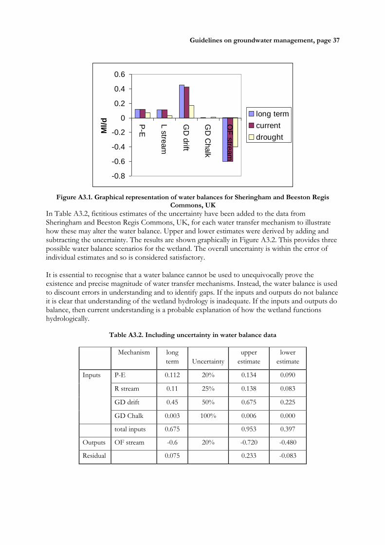
Guidelines on groundwater management, page 37
-0.8
-0.6
-0.4
-0.2
0
0.2
0.4
0.6
P-E
L s
tream
GD
drift
GD
Chalk
OF
stre
am
Ml/
d
long term
current
drought
Figure A3.1. Graphical representation of water balances for Sheringham and Beeston Regis Commons, UK
In Table A3.2, fictitious estimates of the uncertainty have been added to the data from Sheringham and Beeston Regis Commons, UK, for each water transfer mechanism to illustrate how these may alter the water balance. Upper and lower estimates were derived by adding and subtracting the uncertainty. The results are shown graphically in Figure A3.2. This provides three possible water balance scenarios for the wetland. The overall uncertainty is within the error of individual estimates and so is considered satisfactory. It is essential to recognise that a water balance cannot be used to unequivocally prove the existence and precise magnitude of water transfer mechanisms. Instead, the water balance is used to discount errors in understanding and to identify gaps. If the inputs and outputs do not balance it is clear that understanding of the wetland hydrology is inadequate. If the inputs and outputs do balance, then current understanding is a probable explanation of how the wetland functions hydrologically.
Table A3.2. Including uncertainty in water balance data
Mechanism long
term Uncertainty
upper
estimate
lower
estimate
Inputs P-E 0.112 20% 0.134 0.090
R stream 0.11 25% 0.138 0.083
GD drift 0.45 50% 0.675 0.225
GD Chalk 0.003 100% 0.006 0.000
total inputs 0.675 0.953 0.397
Outputs OF stream -0.6 20% -0.720 -0.480
Residual 0.075 0.233 -0.083

Guidelines on groundwater management, page 38
-150
-100
-50
0
50
100
150
P-E R stream GD drift GD Chalk OF stream
% t
ota
l in
pu
t
Figure A3.2. Hypothetical uncertainty estimates added to a water balance